Embed Size (px)
Citation preview

1Delphi vision for geo-imaging research
DelphiConsortium
Towards a new role of geo-physics in the energy indus-try and beyond

New role for geophysics in the 21st centuryThe Delphi Consortium was founded back in the early 1980s. It focused on research to improve the seismic imaging method and it targeted sponsors from the oil & gas industry. Of course the world has changed since then. In particular, over the years there has been an increasing awareness of the impact of fossil fuels on the environment. The fact that the rising concentration of carbon dioxide (CO2) in the air is due to anthropo-genic emission and is contributing to the global temperature increase, see the graph in Figure 1, is hardly questioned anymore.
To avoid a future where the global temperature becomes too high, in the year 2015 175 parties signed the so-called Paris agreement, in which CO2 reduction is considered to be a key goal. Climate action is also one of the Sustainable Development Goals of the United Nations. Inspired by initiatives such as these, Delft Univer-sity of Technology, DELPHI ’s ‘alma mater’, came up with a climate action mission, stating that it ‘will harness its innovative powers to support the world-wide transition to non-fossil energy’.
Within DELPHI we have decided to no longer focus exclusively at oil &gas applications, but to broaden the scope to other geophysical and geotechnical applications in the geo-energy sector, as similar type of technol-ogies, methods and algorithms are applicable in all these fields.
3
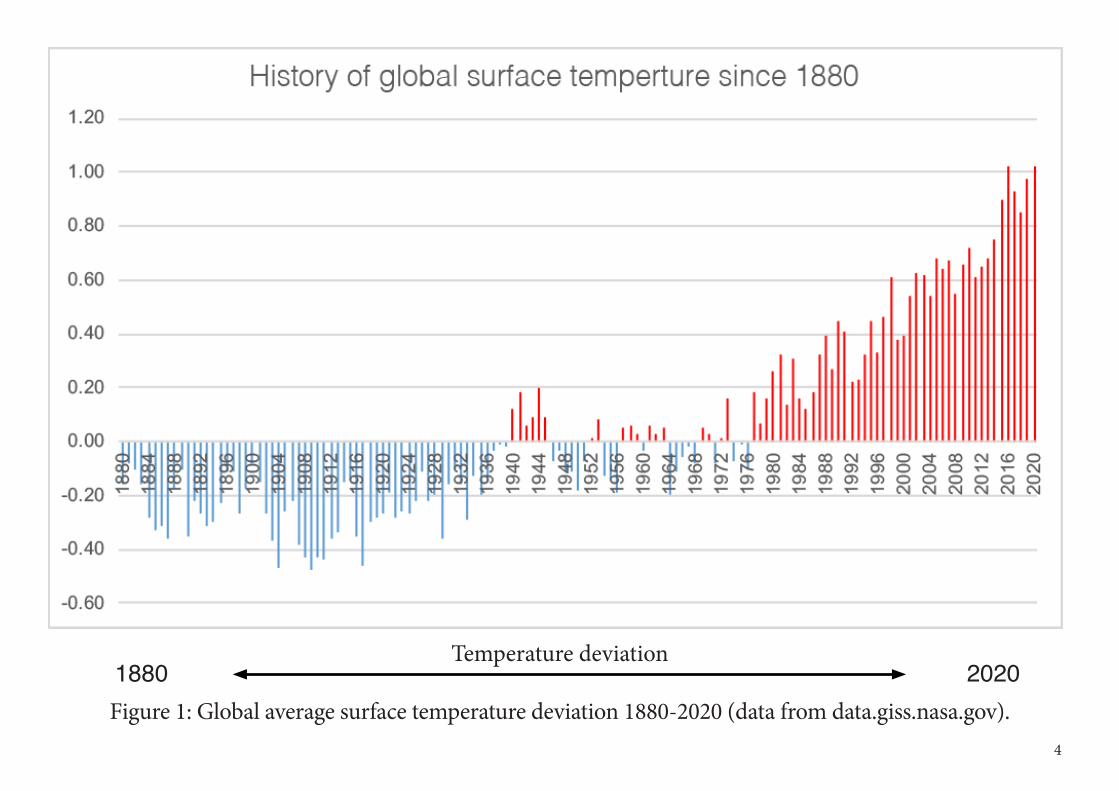
Figure 1: Global average surface temperature deviation 1880-2020 (data from data.giss.nasa.gov).
Temperature deviation1880 2020
4
Vision for application of Delphi technologyTraditionally, seismic imaging has been largely developed to explore the subsurface in the search for oil & gas. Over the years, the seismic method has been improved tremendously with respect to resolution, struc-tural accuracy, signal-to-noise ratio, etc. To search for hydrocarbons is not the only activity related to the subsurface though. In particular, in recent years the number of applications making use of the (near) sub-surface has increased considerably. Many of these aim at the development of a sustainable energy system (see also Figure 2): • Energy storage - Instead of extracting natural gas (mainly methane, CH4) from the subsurface, one could
alternatively store gas (in empty fields) in the subsurface. That gas could be CH4, e.g., as reserve stock to supplement regular production. However, it could also be green hydrogen (H2) produced from electrici-ty, e.g., from intermittent solar/wind energy that is not immediately needed, as a large battery.
• CCS (carbon capture and storage/sequestration) - Apart from storing energy in the subsurface, also CO2 could be stored in empty reservoirs. This storage is meant to be permanent and it would prevent the CO2 from being released in the atmosphere. This application is considered to be one of the candidates for mitigating climate change, particularly in the first couple of decades of the energy transition.
• Mining activities – Geophysical methods are increasingly used to detect and characterize deposits in the subsurface that can be exploited by mining, as the world’s economy still will depend on the Earth’s re-sources in terms of minerals and (rare) metals.
5
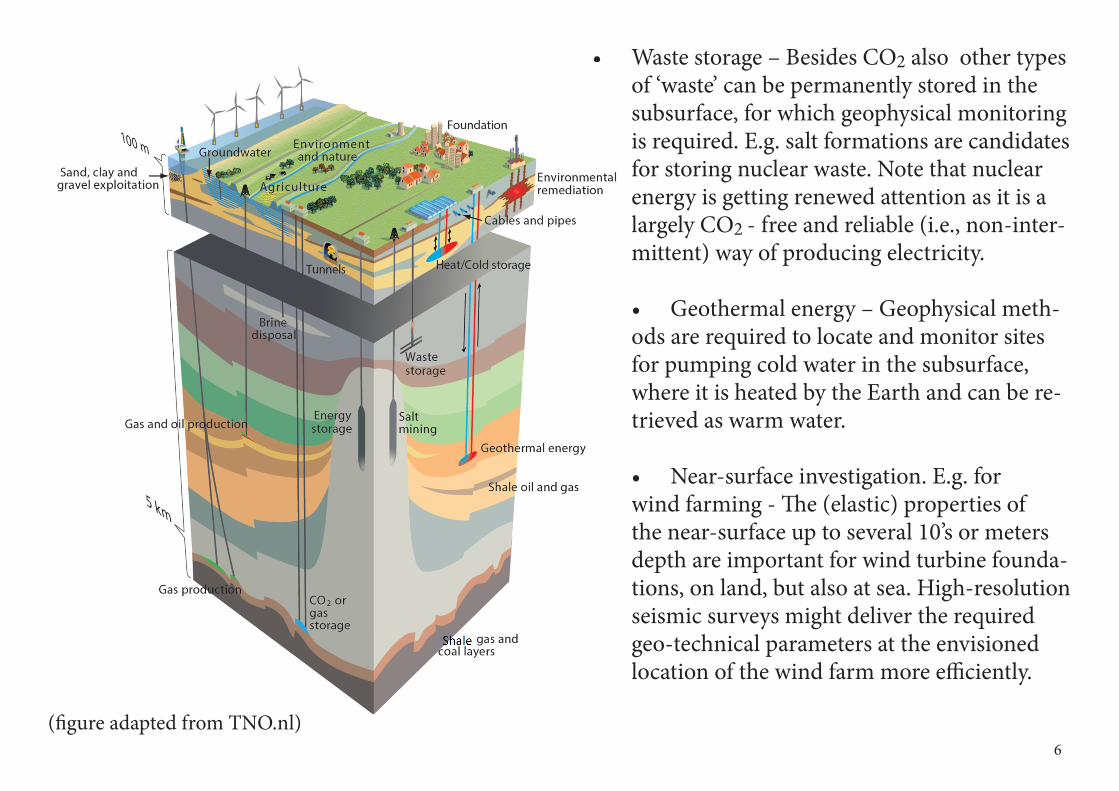
• Waste storage – Besides CO2 also other types of ‘waste’ can be permanently stored in the subsurface, for which geophysical monitoring is required. E.g. salt formations are candidates for storing nuclear waste. Note that nuclear energy is getting renewed attention as it is a largely CO2 - free and reliable (i.e., non-inter-mittent) way of producing electricity.
• Geothermal energy – Geophysical meth-ods are required to locate and monitor sites for pumping cold water in the subsurface, where it is heated by the Earth and can be re-trieved as warm water.
• Near-surface investigation. E.g. for wind farming - The (elastic) properties of the near-surface up to several 10’s or meters depth are important for wind turbine founda-tions, on land, but also at sea. High-resolution seismic surveys might deliver the required geo-technical parameters at the envisioned location of the wind farm more efficiently.
6(figure adapted from TNO.nl)
Importance of Machine Learning (ML) The research within Delphi is based on maximizing the information from geophysical measurements and optimally making use of prior knowledge in terms of gravity data, EM and geologic information. Within this framework the topics of acquisition, processing, imaging and characterization of geophys-ical measurements are fully inter-connected, where the resolution require-ments in the characterization phase drive the innovations in acquisition, with-in the given economic and practical constraints.
The full wavefield approach ensures that all higher-order scattering in the measurements are considered as part of the total illumination of the subsur-face. In this way, all ‘noise’ in the data becomes ‘signal’ and multi-scattering problems become opportunities for additional illumination! Furthermore, the strategic use of Artificial Intelligence (AI) and Machine Learning (ML)technology provides a great support to our physics-based solutions. Many of our processes are based on convolution or correlation, which perfectly fits the convolutional neural network architecture.
However, we believe that ML algorithms should not replace the current de-terministic methods, but should augment our current methodologies. From training data ML algorithm can deduct certain data relationships that often are not deterministically written. Especially when solving inverse problems with multi-physics approaches, the use of more stochastically-oriented ap-proaches is required, for which ML can offer great help.
7
2Delphi Consortium Membership
DelphiConsortium
From written reports, pro-totype software to confer-ence-style meetings
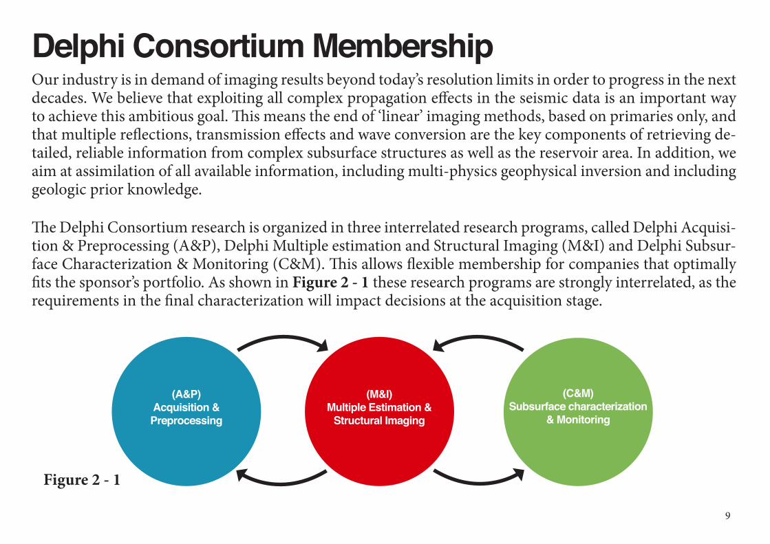
Delphi Consortium MembershipOur industry is in demand of imaging results beyond today’s resolution limits in order to progress in the next decades. We believe that exploiting all complex propagation effects in the seismic data is an important way to achieve this ambitious goal. This means the end of ‘linear’ imaging methods, based on primaries only, and that multiple reflections, transmission effects and wave conversion are the key components of retrieving de-tailed, reliable information from complex subsurface structures as well as the reservoir area. In addition, we aim at assimilation of all available information, including multi-physics geophysical inversion and including geologic prior knowledge.
The Delphi Consortium research is organized in three interrelated research programs, called Delphi Acquisi-tion & Preprocessing (A&P), Delphi Multiple estimation and Structural Imaging (M&I) and Delphi Subsur-face Characterization & Monitoring (C&M). This allows flexible membership for companies that optimally fits the sponsor’s portfolio. As shown in Figure 2 - 1 these research programs are strongly interrelated, as the requirements in the final characterization will impact decisions at the acquisition stage.
9
(A&P) Acquisition & Preprocessing
(M&I) Multiple Estimation &
Structural Imaging
(C&M) Subsurface characterization
& Monitoring
Figure 2 - 1
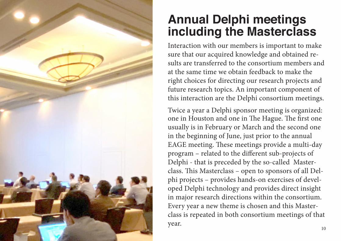
Annual Delphi meetings including the MasterclassInteraction with our members is important to make sure that our acquired knowledge and obtained re-sults are transferred to the consortium members and at the same time we obtain feedback to make the right choices for directing our research projects and future research topics. An important component of this interaction are the Delphi consortium meetings.
Twice a year a Delphi sponsor meeting is organized: one in Houston and one in The Hague. The first one usually is in February or March and the second one in the beginning of June, just prior to the annual EAGE meeting. These meetings provide a multi-day program – related to the different sub-projects of Delphi - that is preceded by the so-called Master-class. This Masterclass – open to sponsors of all Del-phi projects – provides hands-on exercises of devel-oped Delphi technology and provides direct insight in major research directions within the consortium. Every year a new theme is chosen and this Master-class is repeated in both consortium meetings of that year.
10
Reports and presentationsWithin Delphi research is mostly conducted by Ph.D. students and Post-Docs, supervised by staff mem-bers. Once a year, a written report is provided to the sponsors, with contributions from all Delphi research-ers. The Delphi programs (A&P, M&I, C&M) produce their own reports that are available as PDF files to the sponsoring companies via our private ftp-site. In addition, the PDFs are presented to all consortium meeting participants on a USB drive.
In addition, all presentations (PDF’s, Powerpoint files) from each consortium meeting are made available to all members via the Delphi website.
11
DelphiConsortium
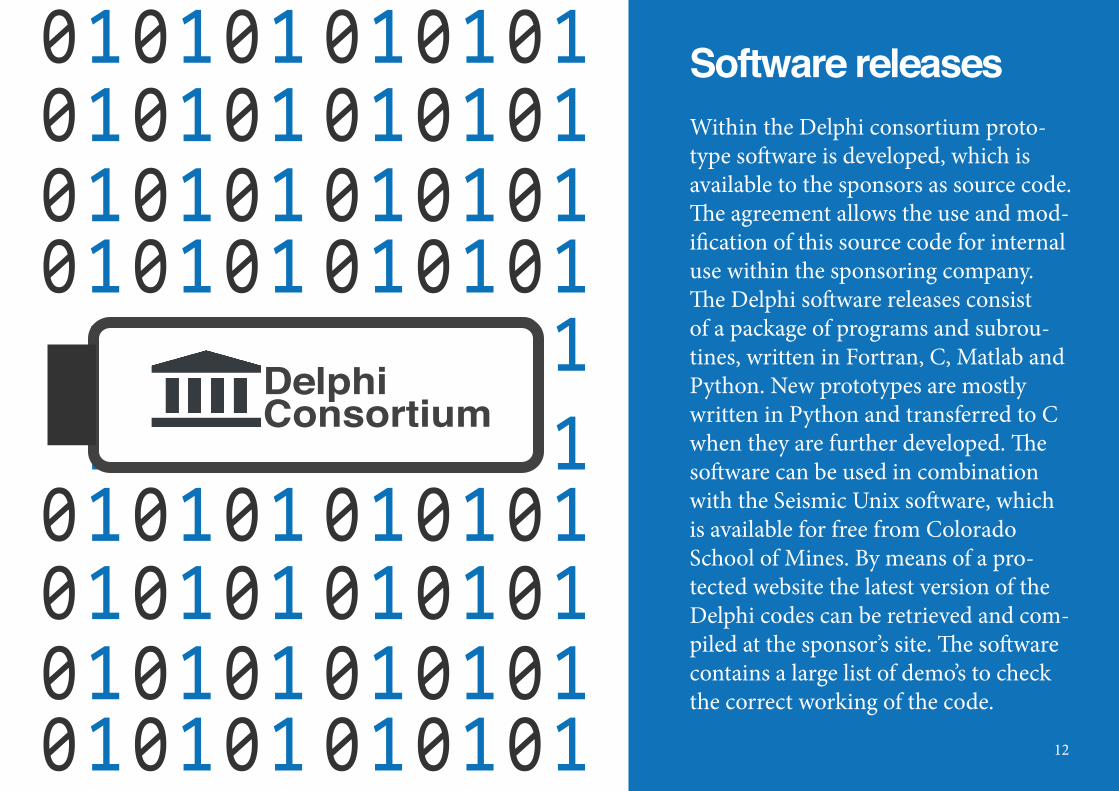
Software releasesWithin the Delphi consortium proto-type software is developed, which is available to the sponsors as source code. The agreement allows the use and mod-ification of this source code for internal use within the sponsoring company. The Delphi software releases consist of a package of programs and subrou-tines, written in Fortran, C, Matlab and Python. New prototypes are mostly written in Python and transferred to C when they are further developed. The software can be used in combination with the Seismic Unix software, which is available for free from Colorado School of Mines. By means of a pro-tected website the latest version of the Delphi codes can be retrieved and com-piled at the sponsor’s site. The software contains a large list of demo’s to check the correct working of the code.
12
The basic Delphi software package available to all sponsors consists of:• Various modeling tools (finite difference, wavenumber-domain, one-way wave propagation,
Eikonal solver, ray-based modeling);
• Various wavefield transforms, like wavelet transform, Fourier transforms, (sparse) Radon transforms;
• Various (pre)processing tools, like least-squares matching/adaptive subtraction, near-offset
interpolation, file manipulation programs.
The Delphi A&P project contains:• 3D acquisition geometry analysis using focal beams;
• Seismic reconstruction algorithms (Fourier, Radon, focal transform);
• Seismic deblending algorithms (Focal transform-based, sparse inversion-based);
• Realistic ghost modeling and deghosting algorithms that can handle a dynamic sea-surface;
• Adaptive deghosting via sparse inversion and Machine Learning;
• Land data residual statics estimation and interpolation using low-rank data approximations.
13
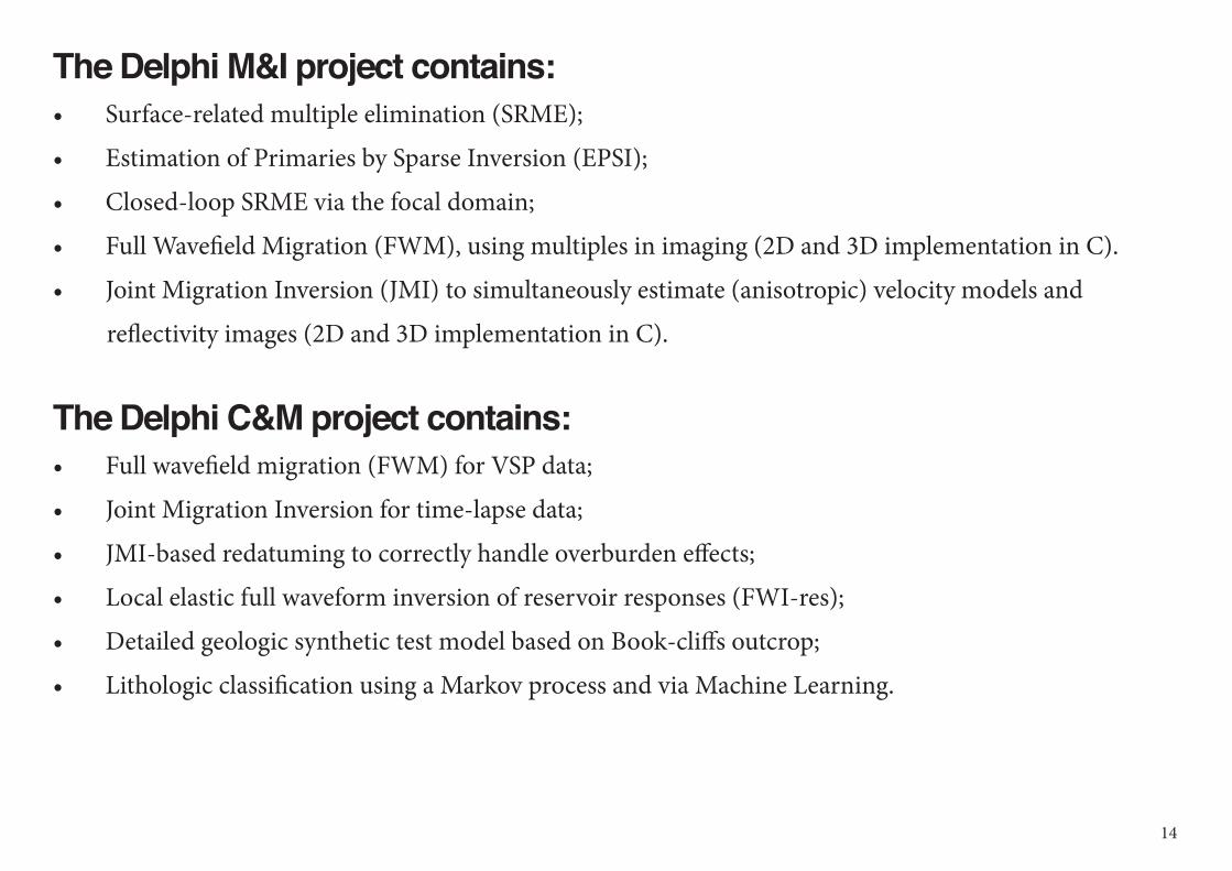
The Delphi M&I project contains:• Surface-related multiple elimination (SRME);
• Estimation of Primaries by Sparse Inversion (EPSI);
• Closed-loop SRME via the focal domain;
• Full Wavefield Migration (FWM), using multiples in imaging (2D and 3D implementation in C).
• Joint Migration Inversion (JMI) to simultaneously estimate (anisotropic) velocity models and
reflectivity images (2D and 3D implementation in C).
The Delphi C&M project contains:• Full wavefield migration (FWM) for VSP data;
• Joint Migration Inversion for time-lapse data;
• JMI-based redatuming to correctly handle overburden effects;
• Local elastic full waveform inversion of reservoir responses (FWI-res);
• Detailed geologic synthetic test model based on Book-cliffs outcrop;
• Lithologic classification using a Markov process and via Machine Learning.
14
Sponsoring Companies A&P M&I C&M Sponsoring Companies A&P M&I C&M
BGP Petrobras
BHP Billiton Petronas
BP Petro-China
CGG PSS-Geo
ConocoPhillips Saudi Aramco
Delft Inversion Shearwater
Down Under Geosolutions (DUG) Sinopec
Equinor (Statoil) TEEC
Fugro TGS
INPEX TNO
ION/GX Technology WesternGeco
Neptune Energy Wintershall
OMV Woodside
15
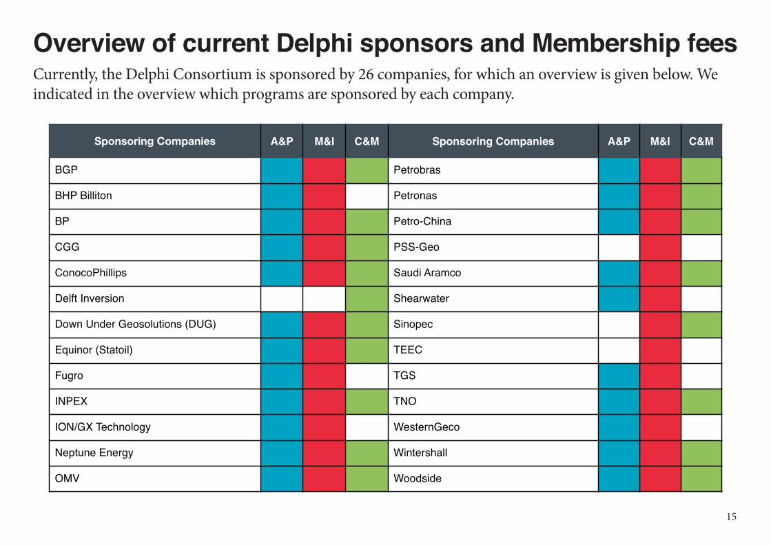
Overview of current Delphi sponsors and Membership feesCurrently, the Delphi Consortium is sponsored by 26 companies, for which an overview is given below. We indicated in the overview which programs are sponsored by each company.

The overview of the yearly sponsor fees - de-pending on sponsoring one, two or three proj-ects – is given in the table below. The sponsor-
ship is valid for one calendar year and will be renewed automatically each year, unless the
sponsor wishes to terminate it. Furthermore, by entering Delphi the sponsor gets access to
all previously developed software (source code) and Delphi reports of the last 20 years. Each
new sponsor pays a one-time late entry fee to access this material. The software can be used
for evaluating the Delphi algorithms, for in-house processing and for conducting services to the industry. However, the Delphi software cannot be sold or distributed to third parties
SPONSOR FEES• One Project: US$ 30.000 per year U S $ 1 5 . 0 0 0 l a t e e n t r y f e e
• Two Projects: US$ 45.000 per year U S $ 2 2 . 5 0 0 l a t e e n t r y f e e
• Three Projects: US$ 55.000 per year U S $ 2 7 . 5 0 0 l a t e e n t r y f e e
16
Background and Organization
3 DelphiConsortium
Almost 40 years of conduct-ing leading edge research.
Historic background of DelphiInspired by the success of John Claerbout’s consortium at Stanford in the seventies, professor Guus Berkhout decided in the early eighties to set up a seismic consortium at the Delft University of Technology (TU Delft). Particularly with the help of one of his students, Paul van Riel (co-founder of Jason Geosystems), he started in 1982 the so-called PRINCEPS-consortium. The objective was estimation of acoustic impedance from seismic data by constrained trace inversion. PRINCEPS started with 5 sponsoring companies.
From the research in the PRINCEPS-consortium it became clear that the extraction of in-situ rock informa-tion beyond acoustic impedance would require analysis of pre-stack seismic data, preferably after removal of the overburden propagation effects. Therefore, it was decided to set up a second consortium in Delft that was aiming at distortion-free, angle-dependent input for PRINCEPS. Particularly with the help of Kees Wapenaar (who had just successfully completed his Ph.D. thesis), professor Berkhout founded in 1987 the so-called TRITON-consortium. The objective was target-oriented pre-stack migration, using multiple removal and true-amplitude redatuming as preprocessing steps. TRITON started with 13 sponsoring companies.
From the inversion research in PRINCEPS and the migration research in TRITON it became readily clear that both consortia would significantly benefit from a closer interaction. In 1989 it was decided to merge PRINCEPS and TRITON into one consortium: Delphi. The objective of Delphi was an integrated approach to multiple removal, pre-stack migration and reservoir characterization. Delphi started with 21 sponsoring com-panies.
From the integrated research in Delphi it emerged that the success of seismic imaging is largely determined by the way data acquisition is carried out. This particularly applies to the geometry of the sources and the detectors. Therefore, it was decided to start a new initiative aiming for an acquisition consortium that would investigate the influence of source and detector geometries on the quality of imaging and characterization results.
18
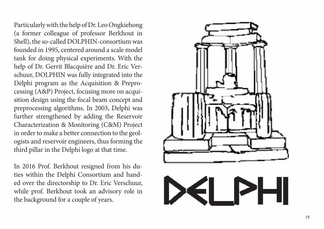
Particularly with the help of Dr. Leo Ongkiehong (a former colleague of professor Berkhout in Shell), the so-called DOLPHIN-consortium was founded in 1995, centered around a scale model tank for doing physical experiments. With the help of Dr. Gerrit Blacquière and Dr. Eric Ver-schuur, DOLPHIN was fully integrated into the Delphi program as the Acquisition & Prepro-cessing (A&P) Project, focusing more on acqui-sition design using the focal beam concept and preprocessing algorithms. In 2003, Delphi was further strengthened by adding the Reservoir Characterization & Monitoring (C&M) Project in order to make a better connection to the geol-ogists and reservoir engineers, thus forming the third pillar in the Delphi logo at that time.
In 2016 Prof. Berkhout resigned from his du-ties within the Delphi Consortium and hand-ed over the directorship to Dr. Eric Verschuur, while prof. Berkhout took an advisory role in the background for a couple of years.
1919
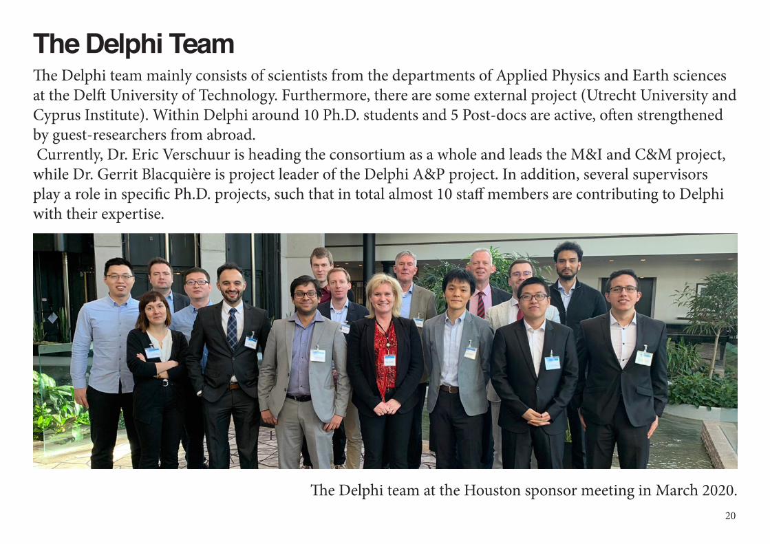
The Delphi TeamThe Delphi team mainly consists of scientists from the departments of Applied Physics and Earth sciences at the Delft University of Technology. Furthermore, there are some external project (Utrecht University and Cyprus Institute). Within Delphi around 10 Ph.D. students and 5 Post-docs are active, often strengthened by guest-researchers from abroad. Currently, Dr. Eric Verschuur is heading the consortium as a whole and leads the M&I and C&M project, while Dr. Gerrit Blacquière is project leader of the Delphi A&P project. In addition, several supervisors play a role in specific Ph.D. projects, such that in total almost 10 staff members are contributing to Delphi with their expertise.
The Delphi team at the Houston sponsor meeting in March 2020.20

The Delphi Advisory BoardTo facilitate effective communication with the sponsors, the Delphi Advisory Board (DAB) has been
founded. The DAB consists of senior members of the sponsoring companies and assists the project direc-tors on matters that are at the interface of science and industry. The DAB also advises in efforts to maintain a healthy membership of the consortium.
Today, the Delphi Advisory Board consists of the following industry members:
Members:• Roald van Borselen – Saudi Aramco• Todd Bredbeck – Wintershall• Gary Hampson - DUG• Walter Rietveld – BP
Honorary members:• Craig Beasley - retired Schlumberger• Mohamed Hadidi - retired Exxon Mobil• Panos Kelamis – retired Saudi Aramco• Paul Meldahl – retired Statoil (Equinor)• Bruce VerWest - retired CGG• David Wilkinson – retired Chevron
DABSINCE 2001
21
The Delphi Studio for ImagingThe objective of Delphi is to develop new concepts in seismic acquisition and preprocessing, full wavefieldmi-gration (FWM), joint migration-inversion (JMI) and reservoir-oriented inversion (JMI-res) to decrease the uncertainties in subsurface models. So far, algorithms have been developed on the topics of acquisition design for coherent and incoherent shooting, deblending, near-surface preprocessing, data-driven primary-multiple separation (closed-loop SRME), automatic velocity estimation combined with full wavefield migration (JMI) for surface and VSP data.
In Delphi, new concepts are tested on synthetic and / or field data (‘proof of principle’), but execution of pro-cessing jobs – how useful they may be for giving practical experience to our students – is not aimed for. In the consortium we prefer to keep the focus on developing and testing new concepts.Over the years, however, we obtained an increasing number of requests to apply Delphi algorithms to the data of our sponsors. This is particularly the case for complex situations in land and marine, where current tech-nology does not give satisfactory answers. Actually, many of the new sponsors inquire whether Delphi can provide specialized processing services. It makes the membership more attractive. In addition, some sponsors would like to have dedicated help in transferring the Delphi software to their in-house environment.
To support these needs, we have established a company ‘Delphi Studio for Imaging’ that is specialized in pro-cessing field data with Delphi technology. This spin-off of the consortium is headed by Dr. Eric Verschuur and Bouchaib El-Marhfoul, with the help of Delphi alum-ni and has already carried more than 10 such dedi-cated application and implementation projects over the years.
22
4Delphi : Acquisition & Preprocessing
DelphiConsortium
In A&P new concepts and algorithms in geophysical acquisition and process-ing are developed aiming at high-resolution subsurface information
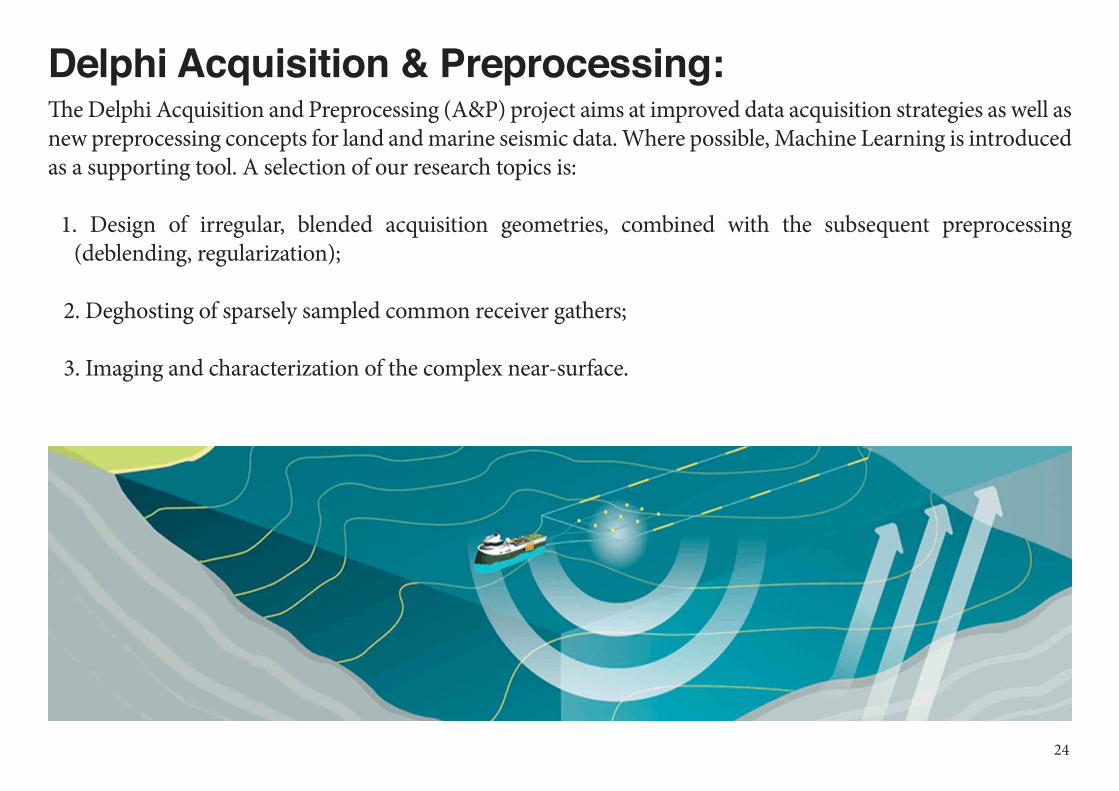
Delphi Acquisition & Preprocessing:The Delphi Acquisition and Preprocessing (A&P) project aims at improved data acquisition strategies as well as new preprocessing concepts for land and marine seismic data. Where possible, Machine Learning is introduced as a supporting tool. A selection of our research topics is:
1. Design of irregular, blended acquisition geometries, combined with the subsequent preprocessing (deblending, regularization);
2. Deghosting of sparsely sampled common receiver gathers;
3. Imaging and characterization of the complex near-surface.
24
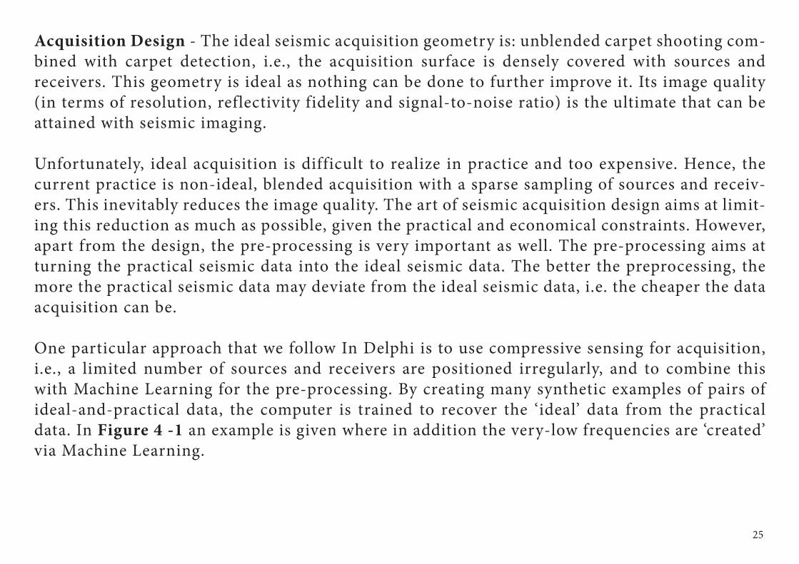
Acquisition Design - The ideal seismic acquisition geometry is: unblended carpet shooting com-bined with carpet detection, i.e., the acquisition surface is densely covered with sources and receivers. This geometry is ideal as nothing can be done to further improve it. Its image quality (in terms of resolution, reflectivity fidelity and signal-to-noise ratio) is the ultimate that can be attained with seismic imaging.
Unfortunately, ideal acquisition is difficult to realize in practice and too expensive. Hence, the current practice is non-ideal, blended acquisition with a sparse sampling of sources and receiv-ers. This inevitably reduces the image quality. The art of seismic acquisition design aims at limit-ing this reduction as much as possible, given the practical and economical constraints. However, apart from the design, the pre-processing is very important as well. The pre-processing aims at turning the practical seismic data into the ideal seismic data. The better the preprocessing, the more the practical seismic data may deviate from the ideal seismic data, i.e. the cheaper the data acquisition can be.
One particular approach that we follow In Delphi is to use compressive sensing for acquisition, i.e., a limited number of sources and receivers are positioned irregularly, and to combine this with Machine Learning for the pre-processing. By creating many synthetic examples of pairs of ideal-and-practical data, the computer is trained to recover the ‘ideal’ data from the practical data. In Figure 4 -1 an example is given where in addition the very-low frequencies are ‘created’ via Machine Learning.
25
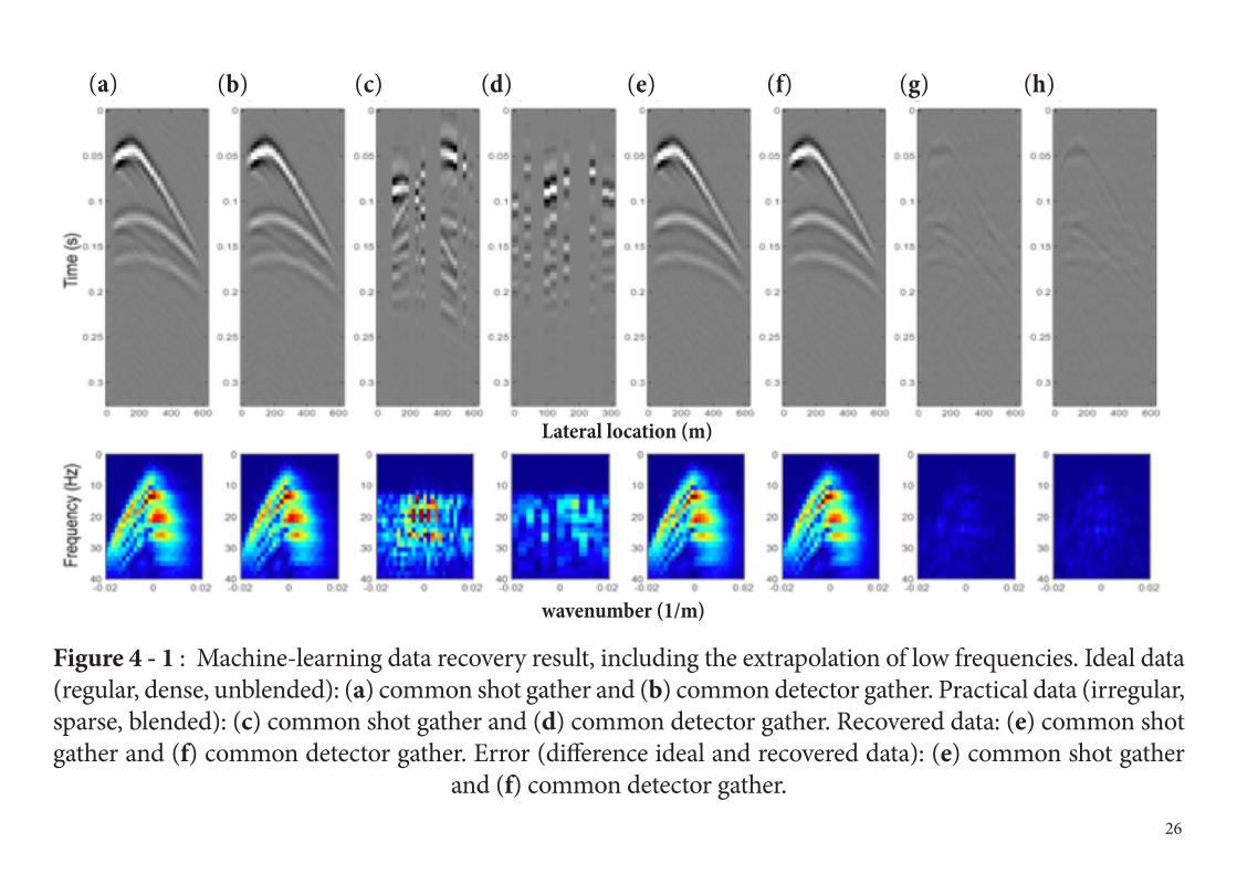
Figure 4 - 1 : Machine-learning data recovery result, including the extrapolation of low frequencies. Ideal data (regular, dense, unblended): (a) common shot gather and (b) common detector gather. Practical data (irregular, sparse, blended): (c) common shot gather and (d) common detector gather. Recovered data: (e) common shot gather and (f) common detector gather. Error (difference ideal and recovered data): (e) common shot gather
and (f) common detector gather. 26
wavenumber (1/m)
Lateral location (m)
(a) (b) (c) (d) (e) (f) (g) (h)
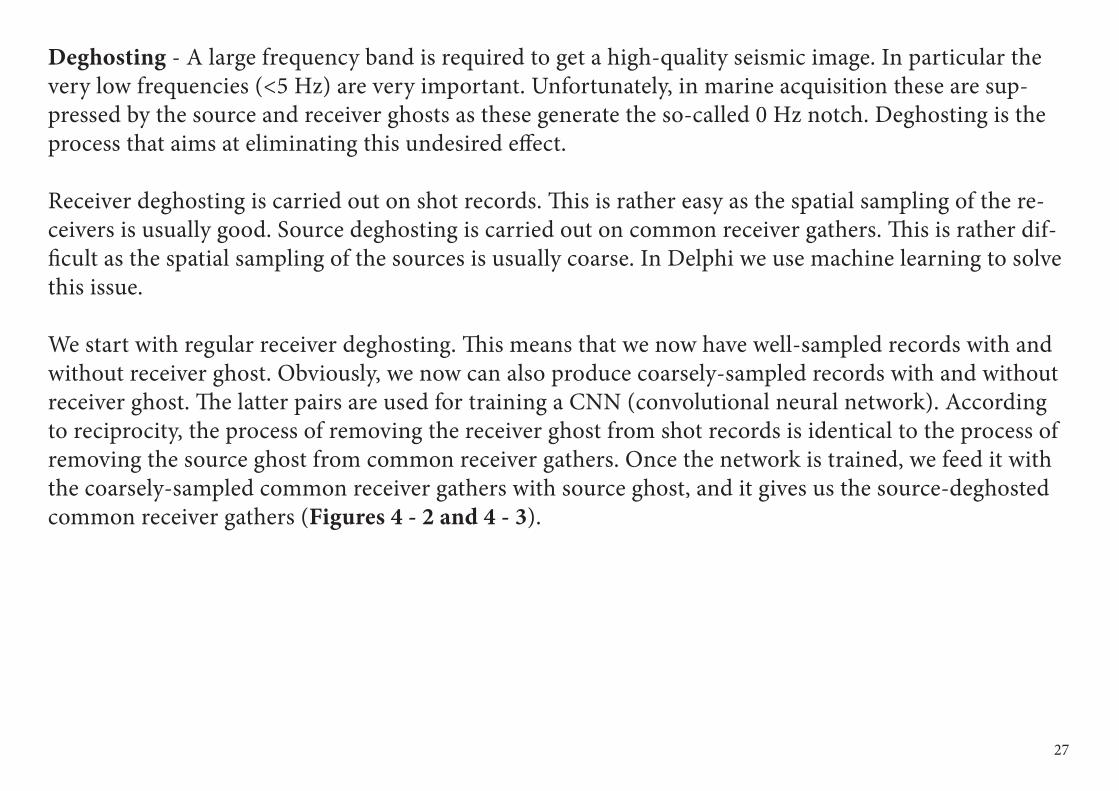
Deghosting - A large frequency band is required to get a high-quality seismic image. In particular the very low frequencies (<5 Hz) are very important. Unfortunately, in marine acquisition these are sup-pressed by the source and receiver ghosts as these generate the so-called 0 Hz notch. Deghosting is the process that aims at eliminating this undesired effect.
Receiver deghosting is carried out on shot records. This is rather easy as the spatial sampling of the re-ceivers is usually good. Source deghosting is carried out on common receiver gathers. This is rather dif-ficult as the spatial sampling of the sources is usually coarse. In Delphi we use machine learning to solve this issue.
We start with regular receiver deghosting. This means that we now have well-sampled records with and without receiver ghost. Obviously, we now can also produce coarsely-sampled records with and without receiver ghost. The latter pairs are used for training a CNN (convolutional neural network). According to reciprocity, the process of removing the receiver ghost from shot records is identical to the process of removing the source ghost from common receiver gathers. Once the network is trained, we feed it with the coarsely-sampled common receiver gathers with source ghost, and it gives us the source-deghosted common receiver gathers (Figures 4 - 2 and 4 - 3).
27
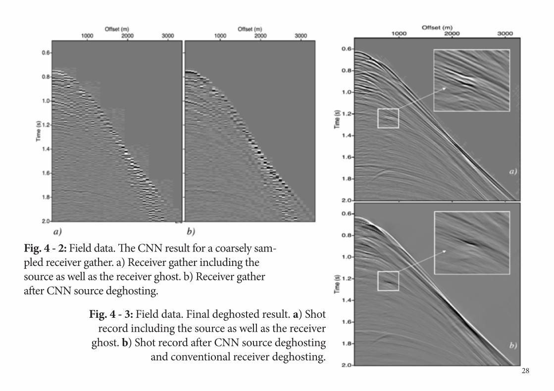
Fig. 4 - 2: Field data. The CNN result for a coarsely sam-pled receiver gather. a) Receiver gather including the source as well as the receiver ghost. b) Receiver gather after CNN source deghosting.
Fig. 4 - 3: Field data. Final deghosted result. a) Shot record including the source as well as the receiver
ghost. b) Shot record after CNN source deghosting and conventional receiver deghosting.
28
Complex Near Surface - As seismic waves travel through the near surface at least twice, once at transmis-sion and once at reception, the near-surface clearly leaves its imprint on the seismic data. Because of its low velocities, this imprint is relatively large and may distort the reflections from deeper target zones. To be able to eliminate the near-surface imprint in a pre-processing step, a proper knowledge of the near surface is im-portant. Only then, deeper targets may be imaged properly. This is why the near-surface and its properties has always been one of the traditional topics of the Delphi A&P program, such as the low-rank based residual statics estimation demonstrated in Figure 4 - 4.
However, as Delphi is moving away from being exclusively focused on oil & gas applications to doing re-search related to geo energy in general, the near surface becomes even more important.
For example, a proper characterization of the near-surface is important for the design of wind-turbine foun-dations. In particular this is the case for windfarms at sea (Figure 4 - 5). We recently started a new PhD project related to the near surface in marine scenarios, which is targeted to this new, broader scope of applications.
Obviously, also the many ‘deep’ applications related to geo-energy, such as geothermal energy, waste storage, CO2 storage, etc. will benefit from this project.
29
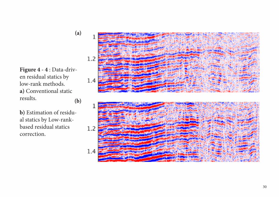
Figure 4 - 4 : Data-driv-en residual statics by low-rank methods. a) Conventional static results.
b) Estimation of residu-al statics by Low-rank-based residual statics correction.
(a)
(b)
30
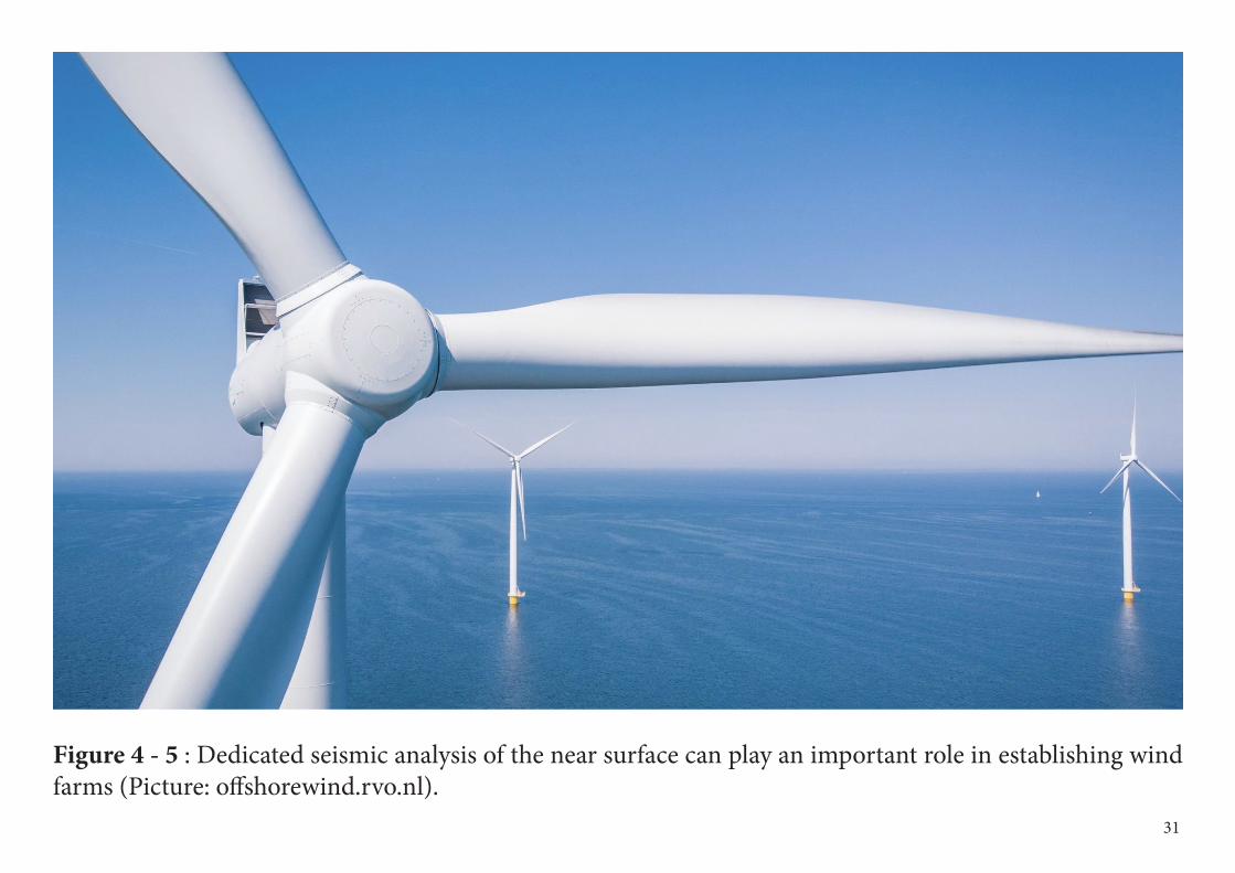
Figure 4 - 5 : Dedicated seismic analysis of the near surface can play an important role in establishing wind farms (Picture: offshorewind.rvo.nl).
31
5Delphi : Multiple Estimation and Structural Imaging
DelphiConsortium
In M&I new concepts and algorithms are developed, related to utilizing multiple scattering in imaging and integrated full wavefield ve-locity estimation.
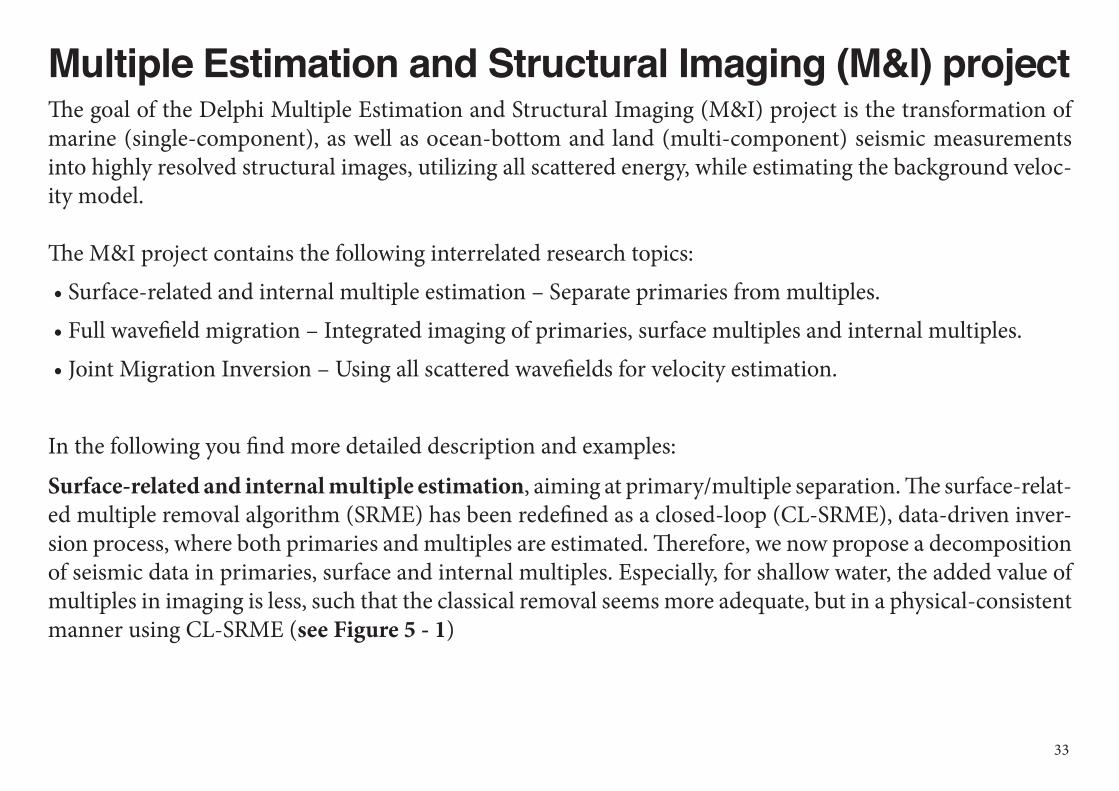
Multiple Estimation and Structural Imaging (M&I) projectThe goal of the Delphi Multiple Estimation and Structural Imaging (M&I) project is the transformation of marine (single-component), as well as ocean-bottom and land (multi-component) seismic measurements into highly resolved structural images, utilizing all scattered energy, while estimating the background veloc-ity model.
The M&I project contains the following interrelated research topics: • Surface-related and internal multiple estimation – Separate primaries from multiples. • Full wavefield migration – Integrated imaging of primaries, surface multiples and internal multiples. • Joint Migration Inversion – Using all scattered wavefields for velocity estimation.
In the following you find more detailed description and examples:
Surface-related and internal multiple estimation, aiming at primary/multiple separation. The surface-relat-ed multiple removal algorithm (SRME) has been redefined as a closed-loop (CL-SRME), data-driven inver-sion process, where both primaries and multiples are estimated. Therefore, we now propose a decomposition of seismic data in primaries, surface and internal multiples. Especially, for shallow water, the added value of multiples in imaging is less, such that the classical removal seems more adequate, but in a physical-consistent manner using CL-SRME (see Figure 5 - 1)
33
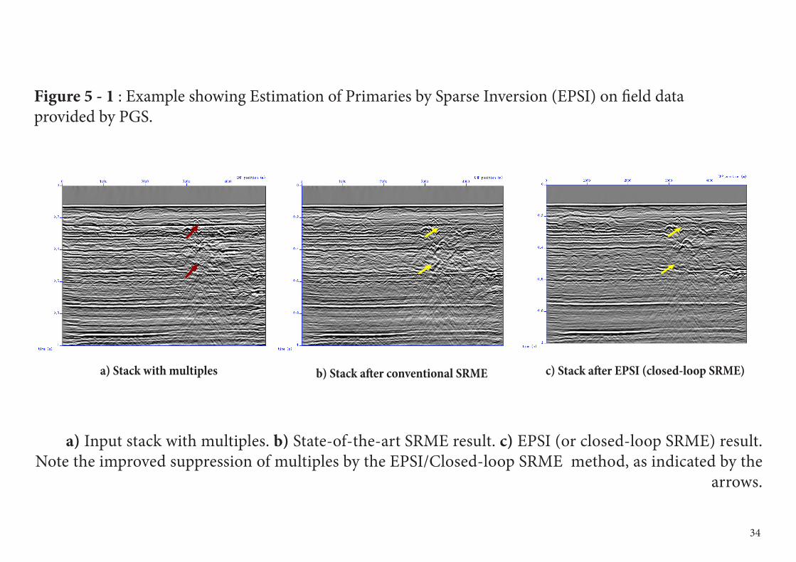
a) Stack with multiples b) Stack after conventional SRME c) Stack after EPSI (closed-loop SRME)
a) Input stack with multiples. b) State-of-the-art SRME result. c) EPSI (or closed-loop SRME) result. Note the improved suppression of multiples by the EPSI/Closed-loop SRME method, as indicated by the
arrows.
34
Figure 5 - 1 : Example showing Estimation of Primaries by Sparse Inversion (EPSI) on field data provided by PGS.
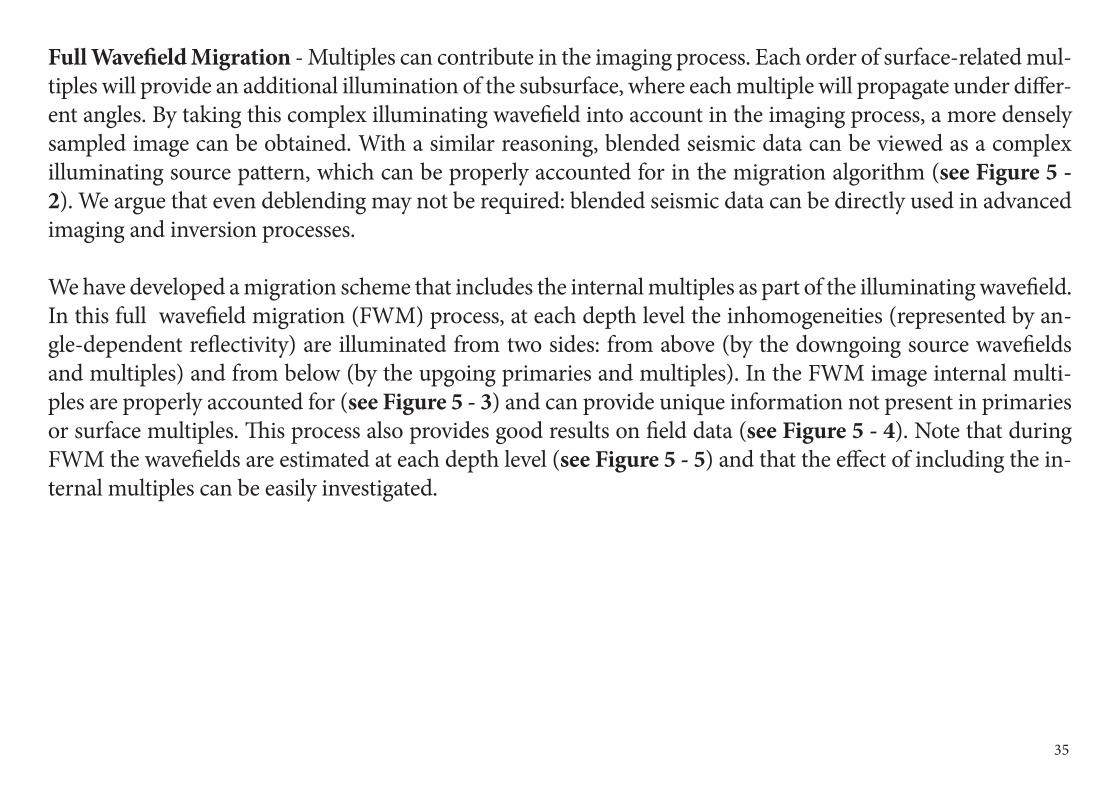
Full Wavefield Migration - Multiples can contribute in the imaging process. Each order of surface-related mul-tiples will provide an additional illumination of the subsurface, where each multiple will propagate under differ-ent angles. By taking this complex illuminating wavefield into account in the imaging process, a more densely sampled image can be obtained. With a similar reasoning, blended seismic data can be viewed as a complex illuminating source pattern, which can be properly accounted for in the migration algorithm (see Figure 5 - 2). We argue that even deblending may not be required: blended seismic data can be directly used in advanced imaging and inversion processes.
We have developed a migration scheme that includes the internal multiples as part of the illuminating wavefield. In this full wavefield migration (FWM) process, at each depth level the inhomogeneities (represented by an-gle-dependent reflectivity) are illuminated from two sides: from above (by the downgoing source wavefields and multiples) and from below (by the upgoing primaries and multiples). In the FWM image internal multi-ples are properly accounted for (see Figure 5 - 3) and can provide unique information not present in primaries or surface multiples. This process also provides good results on field data (see Figure 5 - 4). Note that during FWM the wavefields are estimated at each depth level (see Figure 5 - 5) and that the effect of including the in-ternal multiples can be easily investigated.
35
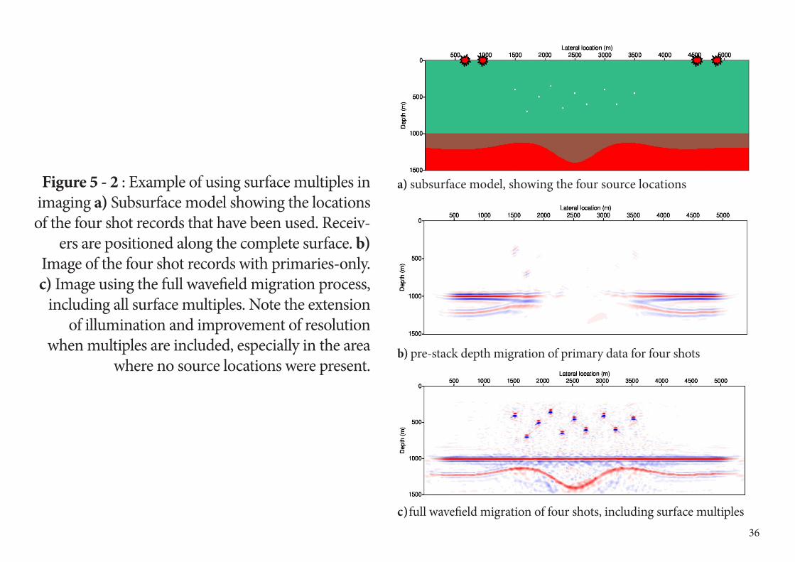
Figure 5 - 2 : Example of using surface multiples in imaging a) Subsurface model showing the locations of the four shot records that have been used. Receiv-
ers are positioned along the complete surface. b) Image of the four shot records with primaries-only. c) Image using the full wavefield migration process,
including all surface multiples. Note the extension of illumination and improvement of resolution
when multiples are included, especially in the area where no source locations were present.
36
a) subsurface model, showing the four source locations
b) pre-stack depth migration of primary data for four shots
c ) full wavefield migration of four shots, including surface multiples
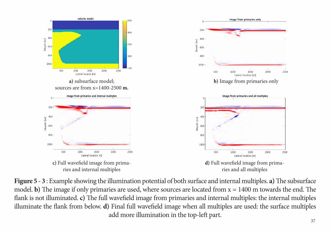
Figure 5 - 3 : Example showing the illumination potential of both surface and internal multiples. a) The subsurface model. b) The image if only primaries are used, where sources are located from x = 1400 m towards the end. The flank is not illuminated. c) The full wavefield image from primaries and internal multiples: the internal multiples illuminate the flank from below. d) Final full wavefield image when all multiples are used: the surface multiples
add more illumination in the top-left part.
a) subsurface model; sources are from x=1400-2500 m.
c) Full wavefield image from prima-ries and internal multiples
d) Full wavefield image from prima-ries and all multiples
b) Image from primaries only
37
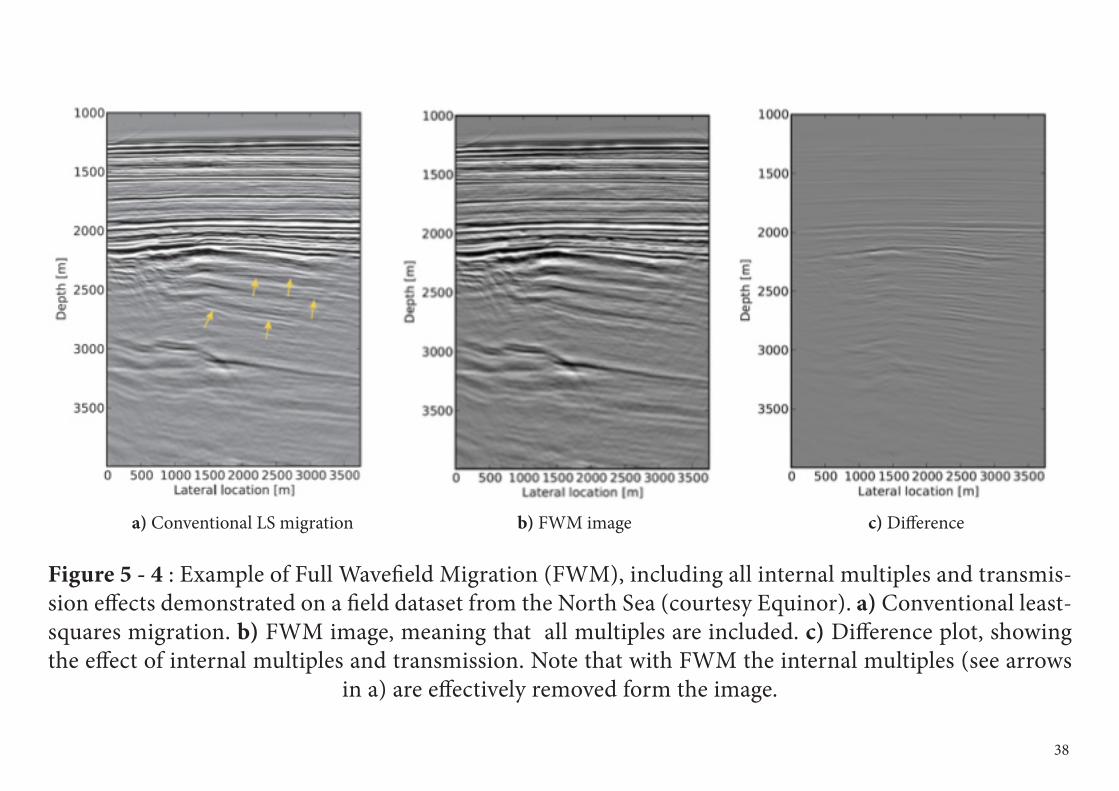
Figure 5 - 4 : Example of Full Wavefield Migration (FWM), including all internal multiples and transmis-sion effects demonstrated on a field dataset from the North Sea (courtesy Equinor). a) Conventional least-squares migration. b) FWM image, meaning that all multiples are included. c) Difference plot, showing the effect of internal multiples and transmission. Note that with FWM the internal multiples (see arrows
in a) are effectively removed form the image.
a) Conventional LS migration b) FWM image c) Difference
38
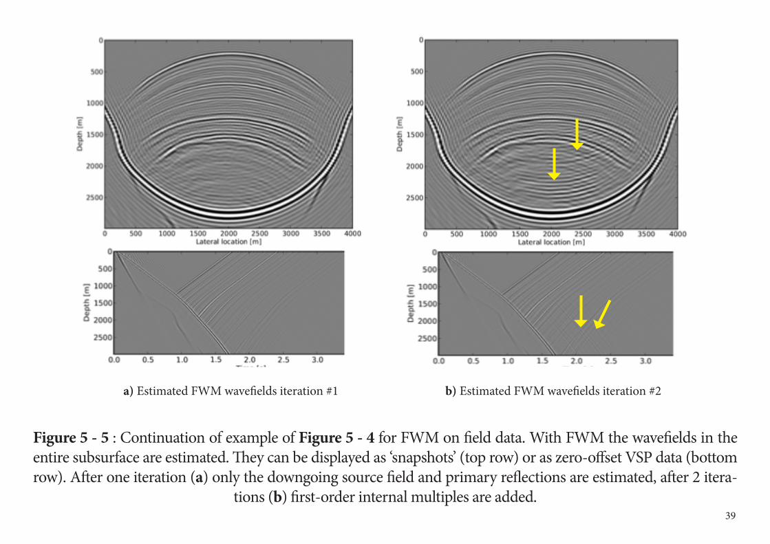
Figure 5 - 5 : Continuation of example of Figure 5 - 4 for FWM on field data. With FWM the wavefields in the entire subsurface are estimated. They can be displayed as ‘snapshots’ (top row) or as zero-offset VSP data (bottom row). After one iteration (a) only the downgoing source field and primary reflections are estimated, after 2 itera-
tions (b) first-order internal multiples are added.
a) Estimated FWM wavefields iteration #1 b) Estimated FWM wavefields iteration #2
39
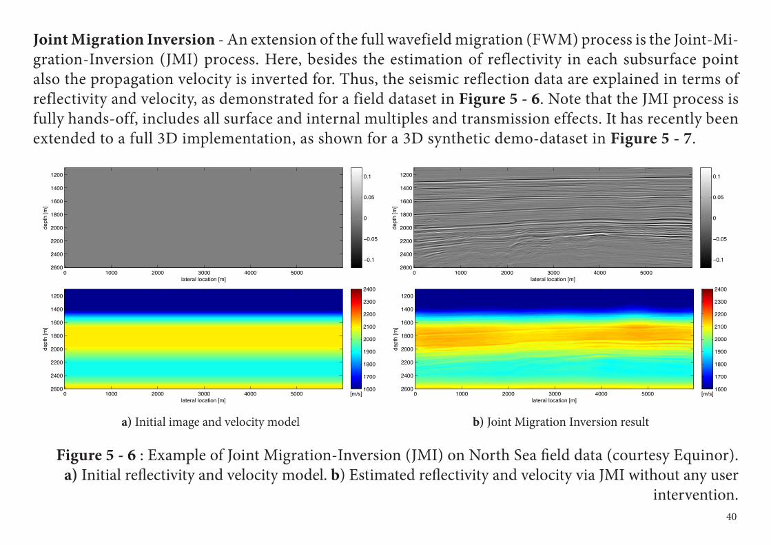
Joint Migration Inversion - An extension of the full wavefield migration (FWM) process is the Joint-Mi-gration-Inversion (JMI) process. Here, besides the estimation of reflectivity in each subsurface point also the propagation velocity is inverted for. Thus, the seismic reflection data are explained in terms of reflectivity and velocity, as demonstrated for a field dataset in Figure 5 - 6. Note that the JMI process is fully hands-off, includes all surface and internal multiples and transmission effects. It has recently been extended to a full 3D implementation, as shown for a 3D synthetic demo-dataset in Figure 5 - 7.
Figure 5 - 6 : Example of Joint Migration-Inversion (JMI) on North Sea field data (courtesy Equinor). a) Initial reflectivity and velocity model. b) Estimated reflectivity and velocity via JMI without any user
intervention.
a) Initial image and velocity model b) Joint Migration Inversion result
40
lateral location [m]
dept
h [m
]
0 1000 2000 3000 4000 5000
1200
1400
1600
1800
2000
2200
2400
2600−0.1
−0.05
0
0.05
0.1
lateral location [m]de
pth
[m]
0 1000 2000 3000 4000 5000
1200
1400
1600
1800
2000
2200
2400
2600[m/s]
1600
1700
1800
1900
2000
2100
2200
2300
2400
lateral location [m]
dept
h [m
]
0 1000 2000 3000 4000 5000
1200
1400
1600
1800
2000
2200
2400
2600−0.1
−0.05
0
0.05
0.1
lateral location [m]
dept
h [m
]
0 1000 2000 3000 4000 5000
1200
1400
1600
1800
2000
2200
2400
2600[m/s]
1600
1700
1800
1900
2000
2100
2200
2300
2400
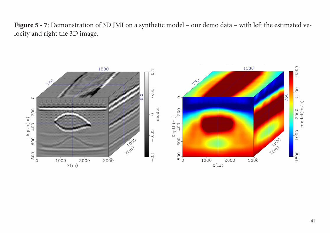
Figure 5 - 7: Demonstration of 3D JMI on a synthetic model – our demo data – with left the estimated ve-locity and right the 3D image.
41
6Subsurface Character-ization and Monitoring
In C&M new concepts and algorithms are developed for geology-aided subsurface characterization and mon-itoring using multi-physics surface and borehole mea-surements
DelphiConsortium
Subsurface Characterization and Monitoring (C&M)The Delphi Subsurface Characterization and Monitoring (C&M) project aims at bridging the gap between seismic imaging and subsurface engineering/monitoring. Time-lapse seismic plays a key role, as it brings the three Delphi projects together in one double-loop interaction cycle, while borehole-related data can provide a strong connection from surface to target area.
Joint Migration-Inversion (JMI) is an excellent way to estimate the full wavefields in the reservoir, being required for local Full Waveform Inversion (FWI-res) to start the inversion process in the target area. The output of FWI-res equals the elastic layer properties. This inversion process can be repeated at any desired moment for monitoring purposes.
In addition to the non-linear inversion work, we focus on the processing and imaging of borehole data in order to get the maximum information from our target area. In Figure 6-1 an example is given on using surface-related and internal multiples for accurate target-oriented 3D VSP imaging and velocity estimation. Note the extension of the illumination area and proper definition of the velocities when multiples are included.
43
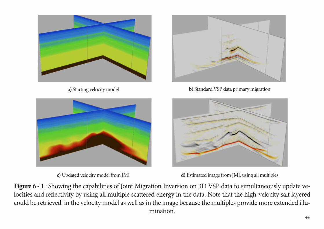
Figure 6 - 1 : Showing the capabilities of Joint Migration Inversion on 3D VSP data to simultaneously update ve-locities and reflectivity by using all multiple scattered energy in the data. Note that the high-velocity salt layered could be retrieved in the velocity model as well as in the image because the multiples provide more extended illu-
mination.
a) Starting velocity model
c) Updated velocity model from JMI
b) Standard VSP data primary migration
d) Estimated image from JMI, using all multiples
44
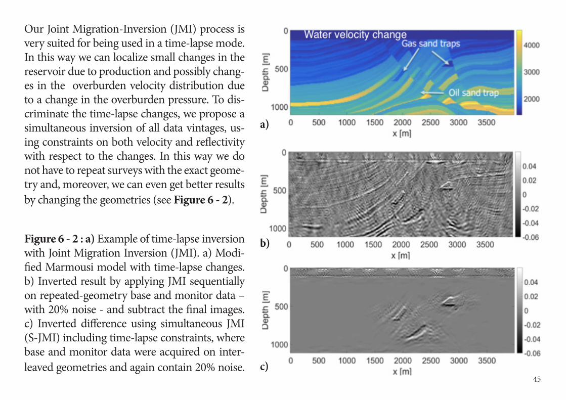
Our Joint Migration-Inversion (JMI) process is very suited for being used in a time-lapse mode. In this way we can localize small changes in the reservoir due to production and possibly chang-es in the overburden velocity distribution due to a change in the overburden pressure. To dis-criminate the time-lapse changes, we propose a simultaneous inversion of all data vintages, us-ing constraints on both velocity and reflectivity with respect to the changes. In this way we do not have to repeat surveys with the exact geome-try and, moreover, we can even get better results by changing the geometries (see Figure 6 - 2).
Figure 6 - 2 : a) Example of time-lapse inversion with Joint Migration Inversion (JMI). a) Modi-fied Marmousi model with time-lapse changes. b) Inverted result by applying JMI sequentially on repeated-geometry base and monitor data – with 20% noise - and subtract the final images. c) Inverted difference using simultaneous JMI (S-JMI) including time-lapse constraints, where base and monitor data were acquired on inter-leaved geometries and again contain 20% noise.
a)
b)
c) 45
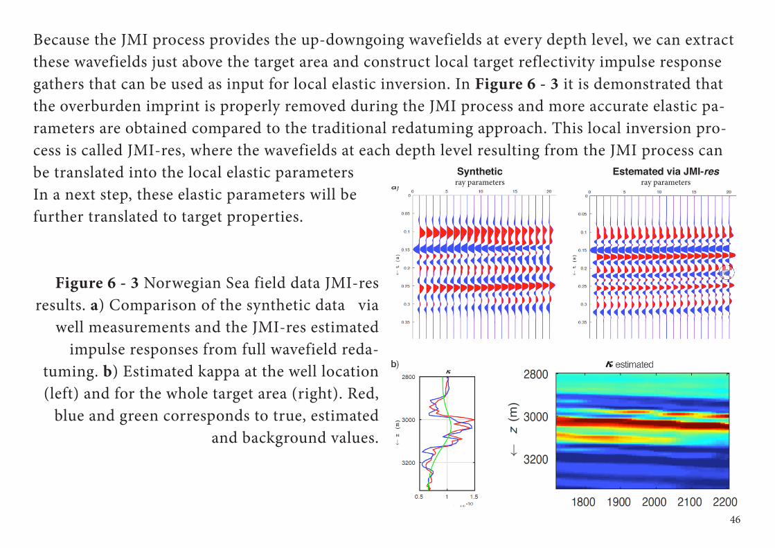
Because the JMI process provides the up-downgoing wavefields at every depth level, we can extract these wavefields just above the target area and construct local target reflectivity impulse response gathers that can be used as input for local elastic inversion. In Figure 6 - 3 it is demonstrated that the overburden imprint is properly removed during the JMI process and more accurate elastic pa-rameters are obtained compared to the traditional redatuming approach. This local inversion pro-cess is called JMI-res, where the wavefields at each depth level resulting from the JMI process can be translated into the local elastic parameters In a next step, these elastic parameters will be further translated to target properties.
Figure 6 - 3 Norwegian Sea field data JMI-res results. a) Comparison of the synthetic data via
well measurements and the JMI-res estimated impulse responses from full wavefield reda-
tuming. b) Estimated kappa at the well location (left) and for the whole target area (right). Red,
blue and green corresponds to true, estimated and background values.
46
Syntheticray parameters
Estemated via JMI-resray parameters
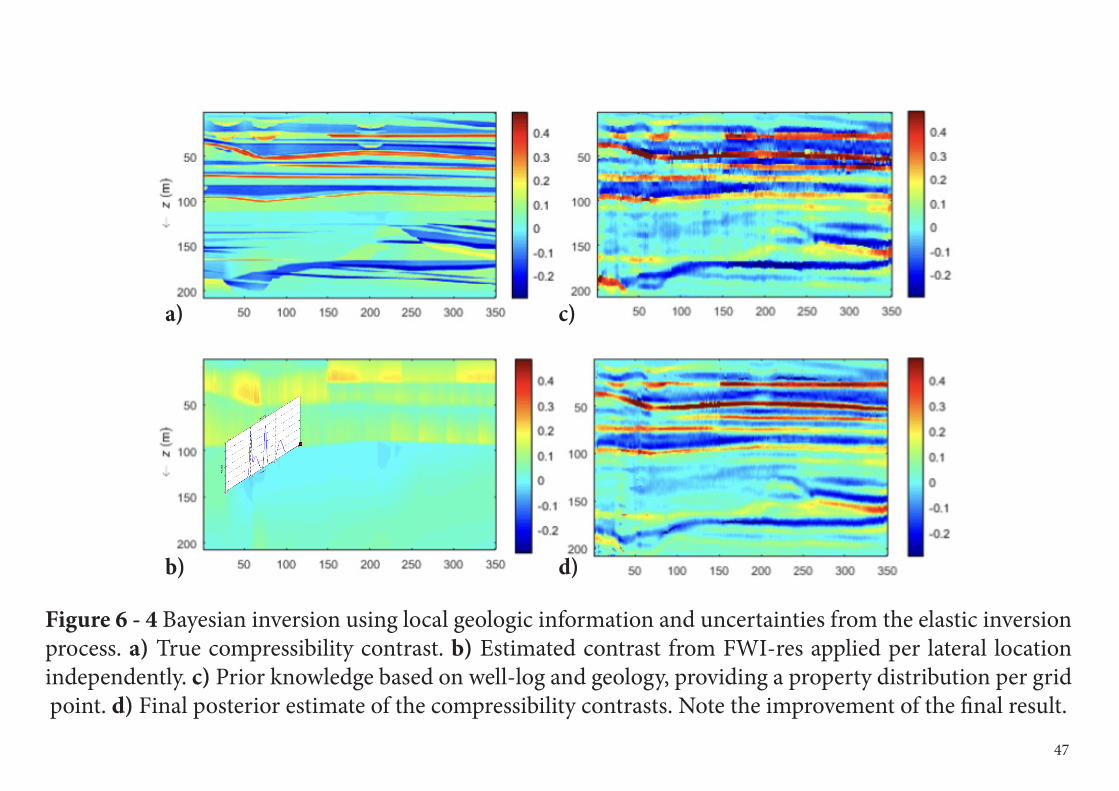
Figure 6 - 4 Bayesian inversion using local geologic information and uncertainties from the elastic inversion process. a) True compressibility contrast. b) Estimated contrast from FWI-res applied per lateral location independently. c) Prior knowledge based on well-log and geology, providing a property distribution per grid point. d) Final posterior estimate of the compressibility contrasts. Note the improvement of the final result.
a) c)
b) d)
47
To improve the quality of the inversion results, prior knowledge taken from geology and well-log informa-tion can be incorporated in a separate Bayesian inversion process (Figure 6 - 4), thus improving the final estimate without re-running the inversion itself.
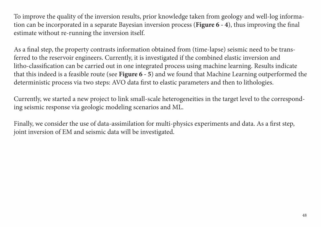
As a final step, the property contrasts information obtained from (time-lapse) seismic need to be trans-ferred to the reservoir engineers. Currently, it is investigated if the combined elastic inversion and litho-classification can be carried out in one integrated process using machine learning. Results indicate that this indeed is a feasible route (see Figure 6 - 5) and we found that Machine Learning outperformed the deterministic process via two steps: AVO data first to elastic parameters and then to lithologies.
Currently, we started a new project to link small-scale heterogeneities in the target level to the correspond-ing seismic response via geologic modeling scenarios and ML.
Finally, we consider the use of data-assimilation for multi-physics experiments and data. As a first step, joint inversion of EM and seismic data will be investigated.
48
Figure 6 - 5 Litho-classification directly from the seismic angle-gathers, applied to synthetic data generated from the realistic Book Cliff model (see also Figure 6 - 4). Left we see the litho-classes for four “well-logs” of the true
model and on the right hand side we see the estimated classes from the machine learning algorithm.
True Classes Predicted Classes
49

7Publications and Inter-national Recognition
Over the years Delphi has received recognition based on its innovative develop-ments and publications.
DelphiConsortium
International recognition1981 - Schlumberger Award EAGE (Dr. A.J. Berkhout)The Schlumberger Award is presented to a member of the EAGE who has made an outstanding contribu-tion over a period of time to the scientific and technical advancement of the geosciences, particularly geo-physics.
1993 - Honorary Membership SEG (Dr. A.J. Berkhout)Honorary Membership is conferred to a person who made distinguished contributions, which warrants exceptional recognition to exploration geophysics or a related field or to the advancement of the profession of exploration geophysics through service to the Society.
1997 - J. Clarence Karcher Award (Dr. D.J. Verschuur)The J. Clarence Karcher Award is given by the SEG in recognition of significant contributions to the science and technology of exploration geophysics by a young geophysicist of outstanding abilities.
2001 - Distinguished Achievement Award (Delphi team)This SEG award is given for continuous outstanding achievements in Geophysics by an organization.
2003 - Maurice Ewing Medal (Dr. A.J. Berkhout)The Maurice Ewing Medal is the highest award of the Society of the Exploration Geophysicists presented to a person who has made major contributions to the advancement of the science and profession of explora-tion geophysics.
51
2006 - EAGE Honorary Membership (Dr. A.J. Berkhout)Honorary Membership is conferred upon a person who has made a highly significant and distinguished technical and/or non-technical contribution to the geoscience community at large or to the EAGE in par-ticular.
2006 - Erasmus Award (Dr. A.J. Berkhout)The Desiderius Erasmus Award is the highest award of the European Association of Geoscientists and En-gineers and is presented in recognition of his outstanding and lasting achievements in the field of resource exploration and development.
2006 - Virgil Kauffman Gold Medal (Dr. D.J. Verschuur) The Kauffman Gold Medal is awarded by the Society of the Exploration Geophysicists to a person who has made an outstanding contribution to the advancement of the science of geophysical exploration as mani-fested during the previous five years.
52
Key Delphi-related publicationsThe research results of the Delphi consortium are written in a yearly report, one for the A&P project, one for the M&I and one for the C&M project. These reports are only available to the sponsors and such writ-ten information remains confidential for one year. Below a list of key Delphi publications is given that have appeared in the open literature, sorted by topic.
General Wave TheoryBerkhout, A.J., 1982, Seismic migration, imaging of acoustic energy by wave field extrapolation (2nd edi-tion): Elsevier, Amsterdam, p.151-198.
Berkhout, A.J., 1987, Applied Seismic Wave Theory: Elsevier, Amsterdam.Wapenaar, C.P.A, and A.J. Berkhout, 1989, Elastic wave field extrapolation: Redatuming of single- and mul-ticomponent seismic data: Elsevier, Amsterdam
Rietveld, W. E. A., and A. J. Berkhout, 1994, Prestack depth migration by means of controlled illumination: Geophysics, 59, 801-809.
Berkhout, A. J., 1997, Pushing the limits of seismic imaging, part I: Prestack migration in terms of double dynamic focusing: Geophysics, 62, 937 953.
Berkhout, A. J., 1997, Pushing the limits of seismic imaging, part II: Integration of prestack migration, ve-locity, estimation, and AVO analysis: Geophysics, 62, 954- 969.
Gisolf, A., and D.J. Verschuur, 2010, The principles of quantitative acoustical imaging, EAGE Publications, BV, Houten,The Netherlands.
53
Acquisition Design (A&P)Berkhout, A. J., L. Ongkiehong, A.W.F. Volker, and G. Blacquiere, 2001, Comprehensive assessment of seis-mic acquisition geometries by focal beams—Part I: Theoretical considerations: Geophysics, 66, 911-917.
Volker, A.W.F., G. Blacquiere, A. J. Berkhout, and L. Ongkiehong, 2001, Comprehensive assessment of seis-mic acquisition geometries by focal beams -- Part II: Practical aspects and examples: Geophysics, 66, 918-931.
Kumar, A., G. Blacquière, M.W. Pederson and A. Goertz, 2016, Full-wavefield marine survey design using all multiples: Geophysics, 81, P1-P12
Preprocessing (A&P)Schalkwijk, K. M., C. P. A. Wapenaar, and D. J. Verschuur, 2003, Adaptive decomposition of multicom-ponent ocean-bottom seismic data into downgoing and upgoing P - and S - waves: Geophysics, 68, 1091-1102.
Berkhout, A. J., and D.J. Verschuur, 2006, Focal Transformation, an imaging concept for signal restoration and noise removal: Geophysics, 71.
Berkhout, A. J., 2006, Seismic processing in the inverse data space: Geophysics, 71, A29-A33.Zwartjes, P.M., and A. Gisolf, 2007, Fourier reconstruction with sparse inversion: Geophysical Prospecting, 55, 199-221.
Kutscha, H., and D.J. Verschuur, 2012, Data reconstruction via sparse double focal transformation, IEEE Signal Proc. Magazine, July 2012, 9p.
54
Blended acquisition and deblending (A&P)Berkhout, A.J., 2008, Changing the mindset in seismic data acquisition, The Leading Edge, 27, 924-938.A. J. Berkhout, G. Blacquière, and D. J. Verschuur, 2009, The concept of double blending: Combining inco-herent shooting with incoherent sensing: Geophysics, 74, A59 – A62Berkhout, A.J. , G. Blacquiere and D.J. Verschuur, 2012, Multiscattering illumination in blended acquisi-tion: Geophysics, 77, P23-P31.Mahdad, A., P. Doulgeris and G. Blacquière, 2011, Separation of blended data by iterative estimation and subtraction of blending interference noise: Geophysics, 76, Q9–Q17.Berkhout, A.J., D.J. Verschuur and , G. Blacquière, 2012, Illumination properties and imaging promises of blended, multiple-scattering seismic data: a tutorial: Geophysical Prospecting, 60, 713-732.
Dispersed Source arrays, Ghost effects and deghosting (A&P)Berkhout, A.J. , 2012, Blended acquisition with dispersed source arrays: Geophysics, 77, A19-A23.Caporal, M. and G. Blacquière and M. Davydenko, 2018, Broadband imaging via direct inversion of blend-ed dispersed source array data, Geoph. Prosp., 66, 942 – 953.Blacquière, G. and H.O. Sertlek, 2019, Modeling and assessing the effects of the sea surface, from being flat to being rough and dynamic: Geophysics, 84, T31-T27.Vrolijk, J.W. and G. Blacquière, 2020, Adaptive estimation of the upgoing wavefield from a variable-depth recording in the case of a dynamic sea surface: Geophysics, 85, V45–V56.Vrolijk, J.W. and G. Blacquière, 2021, Source deghosting of coarsely sampled common-receiver data using a convolutional neural network: Geophysics.
55
Near-surface effects (A&P)Al-Ali, M.N., and D. J. Verschuur, 2006, An integrated method for resolving the seismic complex near-sur-face problem: Geophysical Prospecting, 54, no.6, 739- 750.
Sun, Y. , and D.J. Verschuur, 2013, A Self-Adjustable Input Genetic Algorithm for the Near-Surface Prob-lem in Geophysics: IEEE Transactions on Evolutionary Computation, 18, 309-325.
T. Ishiyama, G. Blacquière, D.J. Verschuur and W.A. Mulder, 2016, 3-D surface-wave estimation and sepa-ration using a closed-loop approach, Geophysical Prospecting, 64, 1413-1427.
Multiple Estimation and Removal (M&I)Verschuur, D. J., A. J. Berkhout, and C. P. A. Wapenaar, 1992, Adaptive surface-related multiple elimination: Geophysics, 57, 1166-1177.
Berkhout, A. J., and D. J. Verschuur, 1997, Estimation of multiple scattering by iterative inversion, part I: Theoretical considerations: Geophysics, 62, 1586-1595.
Verschuur, D. J., and A. J. Berkhout, 1997, Estimation of multiple scattering by iterative inversion, part II: Practical aspects and examples: Geophysics, 62, 1596- 1611.
Kelamis, P. G., and D. J. Verschuur, 2000, Surface-related multiple elimination on land seismic data—Strat-egies via case studies: Geophysics, 65, 719 734.
Berkhout, A. J., and D.J. Verschuur, 2005, Removal of internal multiples with the common-focus-point (CFP) approach: Part 1 — Explanation of the theory: Geo- physics, 70, V45-V60.
56
Verschuur, D.J., and A. J. Berkhout, 2005, Removal of internal multiples with the common-focus-point (CFP) approach: Part 2 — Application strategies and data examples: Geophysics, 70, V61-V72.
van Dedem, E.J., and D.J. Verschuur, 2005, 3D surface-related multiple prediction: A sparse inversion ap-proach: Geophysics, 70, V31-V43.
Verschuur, D.J., 2006, Seismic multiple removal techniques: past, present and future, EAGE Publications, BV, Houten, The Netherlands. (Second revised edition in 2013)
van Groenestijn, G.J.A. and D.J. Verschuur, 2009, Estimating primaries by sparse inversion and application to near-offset data reconstruction: Geophysics, 74, A23-A28.
van Groenestijn, G.J.A. and D.J. Verschuur, 2011, Estimation of primaries by sparse inversion from passive seismic data: Geophysics, 74, A23-A28.
Verschuur, D.J. and A.J. Berkhout, 2011, Seismic migration of blended shot records with surface-related multiple scattering: Geophysics, 76, SA61-SA69.
Ypma, F.H.C. and D.J. Verschuur, 2013, Estimating primaries by sparse inversion, a generalized approach: Geophysical Prospecting, 61, 94-108.
Verschuur, D.J. and A.J. Berkhout, 2015, From removing to using multiples in closed-loop imaging: The Leading Edge, 34, 744-759.
Lopez, G.A., and D.J. Verschuur, 2015, Closed-loop surface-related multiple elimination and its application to simultaneous data reconstruction, Geophysics, 80,V189-V199.
Berkhout, A.J., 2017, Utilization of multiple scattering: the next big step forward in seismic imaging, Geo-physical Prospecting, 65, 106-145.
57
Vrolijk, J.W., D.J. Verschuur and G.A. Lopez, 2017, Integrated receiver deghosting and closed-loop sur-face-multiple elimination, Geophysics, 82, T133-T141.
Full Wavefield Migration & Joint Migration Inversion (M&I)Berkhout, A. J., and D.J. Verschuur, 2006, Imaging of multiple reflections: Geophysics, 71, SI209-SI220.Berkhout, A.J., 2012, Combining full wavefield migration and full waveform inversion, a glance into the fu-ture of seismic imaging: Geophysics, 77, S43-S50.Berkhout, A.J., 2014, Review Paper: An outlook on the future of seismic imaging, Part I: forward and reverse modelling: Geoph. Prosp., 62, 911 930.Berkhout, A.J., 2014, Review Paper: An outlook on the future of seismic imaging, Part II: Full-Wavefield Mi-gration, Geoph. Prosp., 62, 931-949.Berkhout, A.J., 2014, Review Paper: An outlook on the future of seismic imaging, Part III: Joint Migration-In-version, Geoph. Prosp., 62, 950-961.Soni, A.K. and D.J. Verschuur, 2014, Full-wavefield migration of vertical seismic profiling data: using all mul-tiples to extend the illumination area: Geoph. Prosp., 62, 740-759.Verschuur, D.J., X.R. Staal and A.J. Berkhout, 2016, Joint migration inversion: Simultaneous determination of velocity fields and depth images using all orders of scattering, The Leading Edge, 35, 1037–1046.Davydenko, M. and D.J. Verschuur, 2017, Full-wavefield migration: using surface and internal multiples in imaging, Geophysical Prospecting, 65,7-21.Masaya, S., and D.J. Verschuur, 2018, Iterative reflectivity-constrained velocity estimation for seismic imaging: Geophys. J. Int., 214, 1-13.
58
Davydenko, M. and D.J. Verschuur, 2018, Including and using internal multiples in closed-loop imaging — Field data examples, Geophysics, 83, R297-R305.
Alshuhail, A. A. and D.J. Verschuur, 2019, Robust estimation of vertical symmetry axis models via joint mi-gration inversion: Including multiples in anisotropic parameter estimation, Geophysics, 84, C57-C74.
Characterization & Monitoring (C&M)de Bruin, C. G. M., C. P. A. Wapenaar, and A. J. Berkhout, 1990, Angle-dependent reflectivity by means of prestack migration: Geophysics, 55, 1223 1234.
Lörtzer, G. J. M., and A. J. Berkhout, 1992, An integrated approach to lithologic inversion - Part I: Theory: Geophysics, 57, 233-244.
Berkhout, A. J., 1999, Seismic inversion in steps: The Leading Edge, 18, 933-939.
Jansen, J.D., D.R. Brouwer, G. Naevdal, and C.P.J.W. Van Kruijsdijk, 2005, Closed-loop reservoir manage-ment: First Break, 23, 43-48.
Dey, A., and A. Gisolf, 2007, Wide angle linear forward modelling of synthetic seismograms: Geophysical Prospecting, 55, 707-718.
Gisolf, A., 2009, On the Shortcomings of Linear AVP (AVA, AVO) Inversion: EAGE, Expanded Abstracts, S021.Gisolf, A., and P.M. van den Berg, 2010, Target-oriented nonlinear inversion of time-lapse seismic data, SEG, Expanded abstracts SI P1.7.
59
Haffinger, P., F. Jedari Eyvazi, P. Doulgeris, P. Steeghs, A. Gisolf and D.J. Verschuur, 2017, Quantitative pre-diction of injected CO2 at Sleipner using wave-equation based AVO, First Break, 35, 65-70.Feng, R., S. M. Luthi, A. Gisolf and E. Angerer, 2018, Reservoir lithology classification based on seismic inversion results by Hidden Markov Models: Applying prior geological information: Marine and Petroleum Geology, 93, 218-229.Feng, R., S. M. Luthi and A. Gisolf, 2018, Simulating reservoir lithologies by an actively conditioned Mar-kov chain model: J. Geophys. Eng., 15, 800-815.M. S. Albannagi, B. EL-Marhfoul, and D. J. Verschuur, 2018, Joint-velocity model building and high-resolu-tion depth imaging of full-wavefield 3D VSP data: SEG extended abstracts.Garg, A. and D.J. Verschuur, 2020, From surface seismic data to reservoir elastic parameters using a full-wavefield redatuming approach: Geophys. J. Int., 221, 115-128.
Qu S. and D.J. Verschuur, 2020, Simultaneous joint migration inversion for high-resolution imaging/inver-sion of time-lapse seismic datasets: Geophysical Prospecting, 68, 1167–1188.
60

Email: [email protected] Url : www.delphi-consortium.com Address: Eric Verschuur, Lorentzweg 1, 2628 CJ, Delft, The Netherlands
Delphi Consortium 2021
BGP, BHP Billiton, BP, CGG, ConocoPhillips, Delft Inversion, Down Under Geosolutions (DUG), Equinor, INPEX, ION/GX Technology, Neptune Ener-gy, OMV, Petrobras, Petronas, PSS-Geo, Saudi Aramco, Shearwater, Sinopec, TEEC, TGS, TNO, Total, Western Geco / Schlumberger, Wintershall, Woodside.
We thank our consortium members for their continuing support and valuable con-tributions during the sponsor meetings: