Embed Size (px)
Citation preview
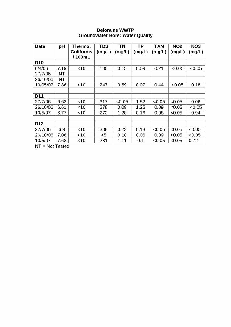
Deloraine WWTPGroundwater Bore: Water Quality
Date pH Thermo.Coliforms/ 100mL
TDS(mg/L)
TN(mg/L)
TP(mg/L)
TAN(mg/L)
NO2(mg/L)
NO3(mg/L)
D106/4/06 7.19 <10 100 0.15 0.09 0.21 <0.05 <0.0527/7/06 NT26/10/06 NT10/05/07 7.86 <10 247 0.59 0.07 0.44 <0.05 0.18
D1127/7/06 6.63 <10 317 <0.05 1.52 <0.05 <0.05 0.0626/10/06 6.61 <10 278 0.09 1.25 0.09 <0.05 <0.0510/5/07 6.77 <10 272 1.28 0.16 0.08 <0.05 0.94
D1227/7/06 6.9 <10 308 0.23 0.13 <0.05 <0.05 <0.0526/10/06 7.06 <10 <5 0.18 0.06 0.09 <0.05 <0.0510/5/07 7.68 <10 281 1.11 0.1 <0.05 <0.05 0.72NT = Not Tested
Meander Valley Council
Report for Deloraine WWTPUpgrade
Mixing Zone Study
April 2009
61/23783/86684 Deloraine WWTP ExpansionMixing Zone Study
Contents
1. Mixing Zone Analysis 3
1.1 Mixing Zone Definition 3
1.2 Water Quality Parameters 3
1.3 Dilution Requirements 4
1.4 Spatial Extent of the Mixing Zone 6
1.5 Conclusions and Recommendations 9
2. References 10
Table IndexTable 1 80th percentile values (adopted mixing zone edge criteria)
compared with the ANZECC & ARMCANZ (2000) defaulttrigger values 4
Table 2 Current licence limits and the Emission Limits Guidelines forthe new and updated outfall recommended by theEnvironmental Protection Authority. Shading demarcateswastewater treatment effluent concentration used in themixing zone analysis. 5
Table 3 Required dilution to achieve concentrations at the edge ofthe mixing zone 6
Table 4 Model input data. 7
Figure IndexFigure 1 Illustration of the mixing zone. 3Figure 2 Mixing zone extent, discharge 1m from bank. 8Figure 3 Mixing zone extent, discharge 5m from bank. 8Figure 4 Mixing zone extent, discharge 10m from bank 8
361/23783/86684 Deloraine WWTP ExpansionMixing Zone Study
1. Mixing Zone Analysis
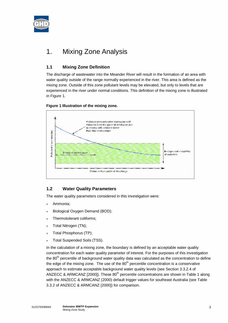
1.1 Mixing Zone DefinitionThe discharge of wastewater into the Meander River will result in the formation of an area withwater quality outside of the range normally experienced in the river. This area is defined as themixing zone. Outside of this zone pollutant levels may be elevated, but only to levels that areexperienced in the river under normal conditions. This definition of the mixing zone is illustratedin Figure 1.
Figure 1 Illustration of the mixing zone.
1.2 Water Quality ParametersThe water quality parameters considered in this investigation were:
» Ammonia;
» Biological Oxygen Demand (BOD);
» Thermotolerant coliforms;
» Total Nitrogen (TN);
» Total Phosphorus (TP);
» Total Suspended Soils (TSS).
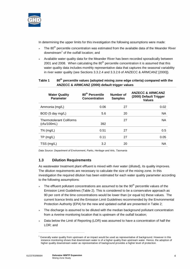
In the calculation of a mixing zone, the boundary is defined by an acceptable water qualityconcentration for each water quality parameter of interest. For the purposes of this investigationthe 80th percentile of background water quality data was calculated as the concentration to definethe edge of the mixing zone. The use of the 80th percentile concentration is a conservativeapproach to estimate acceptable background water quality levels (see Section 3.3.2.4 ofANZECC & ARMCANZ [2000]). These 80th percentile concentrations are shown in Table 1 alongwith the ANZECC & ARMCANZ (2000) default trigger values for southeast Australia (see Table3.3.2 of ANZECC & ARMCANZ [2000]) for comparison.
461/23783/86684 Deloraine WWTP ExpansionMixing Zone Study
In determining the upper limits for this investigation the following assumptions were made:
» The 80th percentile concentration was estimated from the available data of the Meander Riverdownstream1 of the outfall location; and
» Available water quality data for the Meander River has been recorded sporadically between2001 and 2008. When calculating the 80th percentile concentration it is assumed that thiswater quality data includes monthly representative data that captures the seasonal variabilityin river water quality (see Sections 3.3.2.4 and 3.3.2.6 of ANZECC & ARMCANZ [2000]).
Table 1 80th percentile values (adopted mixing zone edge criteria) compared with theANZECC & ARMCANZ (2000) default trigger values
Water QualityParameter
80th PercentileConcentration
Number ofSamples
ANZECC & ARMCANZ(2000) Default Trigger
Values
Ammonia (mg/L) 0.06 27 0.02
BOD (5 day mg/L) 5.6 20 NA
Thermotolerant Coliforms(cfu/100mL) 392
27 NA
TN (mg/L) 0.51 27 0.5
TP (mg/L) 0.11 27 0.05
TSS (mg/L) 3.2 20 NA
Data Source: Department of Environment, Parks, Heritage and Arts, Tasmania
1.3 Dilution RequirementsAs wastewater treatment plant effluent is mixed with river water (diluted), its quality improves.The dilution requirements are necessary to calculate the size of the mixing zone. In thisinvestigation the required dilution has been estimated for each water quality parameter accordingto the following assumptions:
» The effluent pollutant concentrations are assumed to be the 90th percentile values of theEmission Limit Guidelines (Table 2). This is considered to be a conservative approach as90 per cent of the time concentrations would be lower than (or equal to) these values. Thecurrent licence limits and the Emission Limit Guidelines recommended by the EnvironmentalProtection Authority (EPA) for the new and updated outfall are presented in Table 2;
» The discharge is assumed to be diluted with the median background pollutant concentrationfrom a riverine monitoring location that is upstream of the outfall location;
» Data below the Limit of Reporting (LOR) was assumed to have a concentration of half theLOR; and
1 Generally water quality from upstream of an impact would be used as representative of background. However in thisinstance monitoring shows that downstream water is of a higher quality than upstream water. Hence, the adoption ofhigher quality downstream water as representative of background provides a higher level of protection.

561/23783/86684 Deloraine WWTP ExpansionMixing Zone Study
» The target pollutant concentration (or edge of the mixing zone) is given by the 80th percentilebackground pollutant concentration downstream of the outfall.
The required dilution to define the edge of the mixing zone was estimated with the followingequation:
Dilution = (CEFF – CT) / (CT – CBG)
where:
CEFF is the concentration of the effluent;
CT is the target concentration; and
CBG is the background concentration.
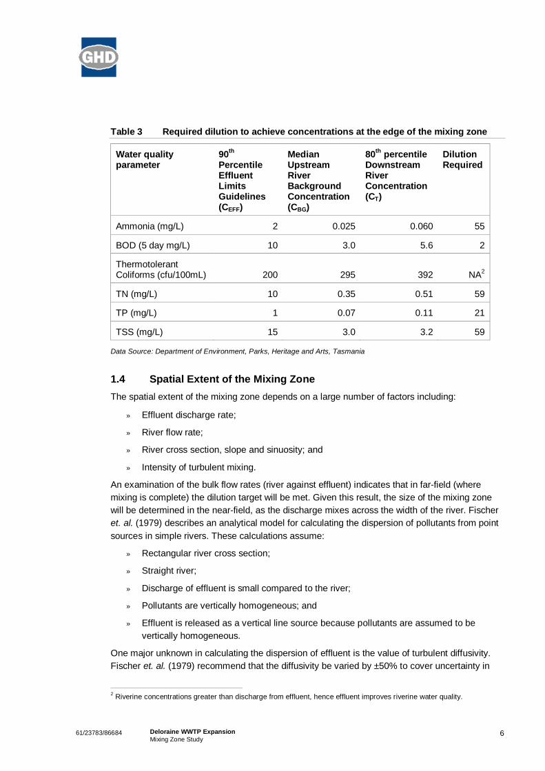
Table 3 shows the inputs and required dilution to define the edge of the mixing zone for eachwater quality parameter. Greater dilution is required for Total Nitrogen (TN) and Total SuspendedSolids (TSS) (59-fold), followed closely by ammonia (55-fold). For the purpose of thisinvestigation a target dilution of 60-fold was adopted to define the edge of the mixing zone.
Table 2 Current licence limits and the Emission Limits Guidelines for the new andupdated outfall recommended by the Environmental Protection Authority.Shading demarcates wastewater treatment effluent concentration used in themixing zone analysis.
Current Licence LimitsEmission Limits Guidelines forNew and Upgraded Plants
Median90th
percentile Max Median90th
percentile Max
Ammonia (mg/L) 2 3 5 1 2 5
BOD (5 day mg/L) 10 15 20 5 10 15
TN (mg/L) 7 10 15 7 10 15
TP (mg/L) 3 5 8 0.5 1 3
TSS (mg/L) 15 20 30 10 15 20
ThermotolerantColiforms (cfu/100mL) 200 200
661/23783/86684 Deloraine WWTP ExpansionMixing Zone Study
Table 3 Required dilution to achieve concentrations at the edge of the mixing zone
Water qualityparameter
90th
PercentileEffluentLimitsGuidelines(CEFF)
MedianUpstreamRiverBackgroundConcentration(CBG)
80th percentileDownstreamRiverConcentration(CT)
DilutionRequired
Ammonia (mg/L) 2 0.025 0.060 55
BOD (5 day mg/L) 10 3.0 5.6 2
ThermotolerantColiforms (cfu/100mL) 200 295 392 NA2
TN (mg/L) 10 0.35 0.51 59
TP (mg/L) 1 0.07 0.11 21
TSS (mg/L) 15 3.0 3.2 59
Data Source: Department of Environment, Parks, Heritage and Arts, Tasmania
1.4 Spatial Extent of the Mixing ZoneThe spatial extent of the mixing zone depends on a large number of factors including:
» Effluent discharge rate;
» River flow rate;
» River cross section, slope and sinuosity; and
» Intensity of turbulent mixing.
An examination of the bulk flow rates (river against effluent) indicates that in far-field (wheremixing is complete) the dilution target will be met. Given this result, the size of the mixing zonewill be determined in the near-field, as the discharge mixes across the width of the river. Fischeret. al. (1979) describes an analytical model for calculating the dispersion of pollutants from pointsources in simple rivers. These calculations assume:
» Rectangular river cross section;
» Straight river;
» Discharge of effluent is small compared to the river;
» Pollutants are vertically homogeneous; and
» Effluent is released as a vertical line source because pollutants are assumed to bevertically homogeneous.
One major unknown in calculating the dispersion of effluent is the value of turbulent diffusivity.Fischer et. al. (1979) recommend that the diffusivity be varied by ±50% to cover uncertainty in
2 Riverine concentrations greater than discharge from effluent, hence effluent improves riverine water quality.
761/23783/86684 Deloraine WWTP ExpansionMixing Zone Study
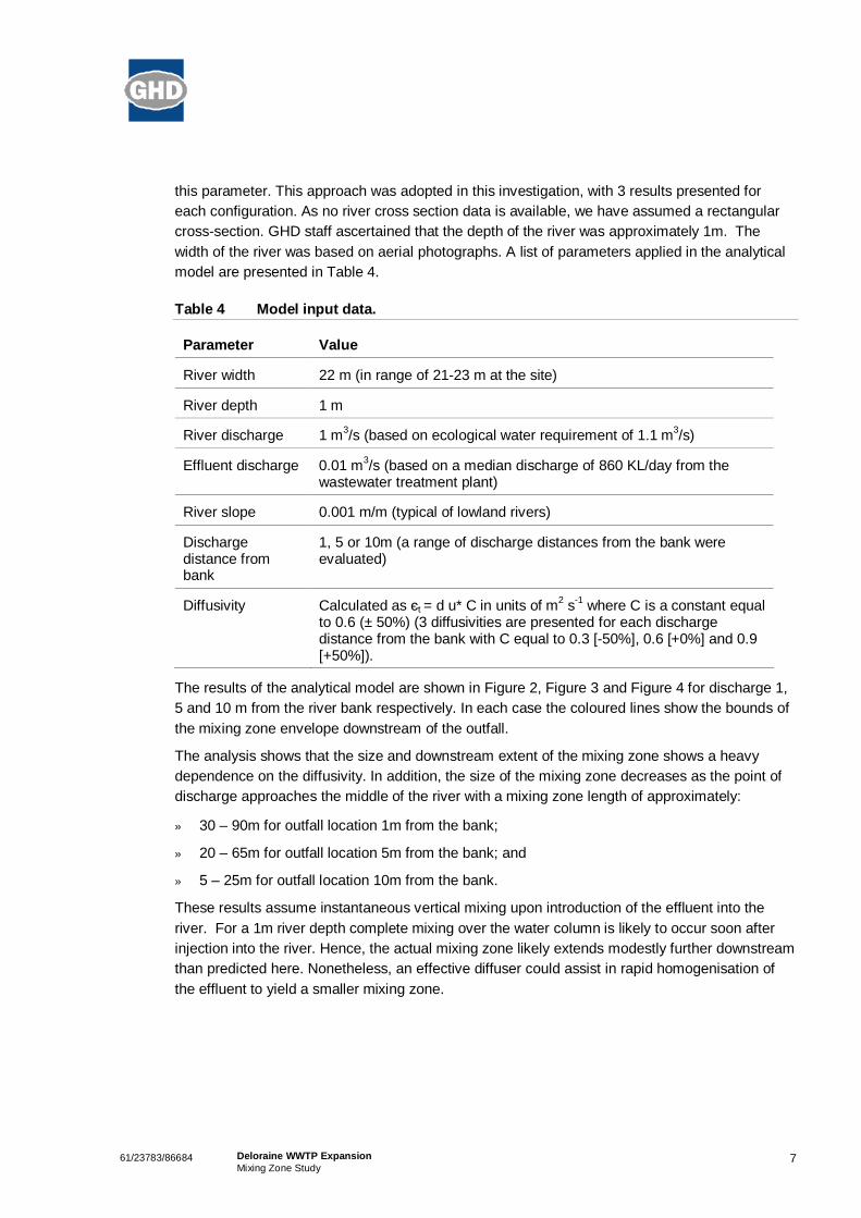
this parameter. This approach was adopted in this investigation, with 3 results presented foreach configuration. As no river cross section data is available, we have assumed a rectangularcross-section. GHD staff ascertained that the depth of the river was approximately 1m. Thewidth of the river was based on aerial photographs. A list of parameters applied in the analyticalmodel are presented in Table 4.
Table 4 Model input data.
Parameter Value
River width 22 m (in range of 21-23 m at the site)
River depth 1 m
River discharge 1 m3/s (based on ecological water requirement of 1.1 m3/s)
Effluent discharge 0.01 m3/s (based on a median discharge of 860 KL/day from thewastewater treatment plant)
River slope 0.001 m/m (typical of lowland rivers)
Dischargedistance frombank
1, 5 or 10m (a range of discharge distances from the bank wereevaluated)
Diffusivity Calculated as t = d u* C in units of m2 s-1 where C is a constant equalto 0.6 (± 50%) (3 diffusivities are presented for each dischargedistance from the bank with C equal to 0.3 [-50%], 0.6 [+0%] and 0.9[+50%]).
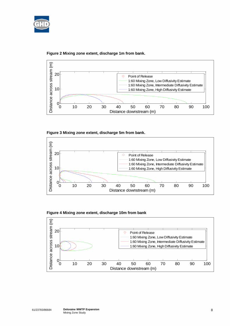
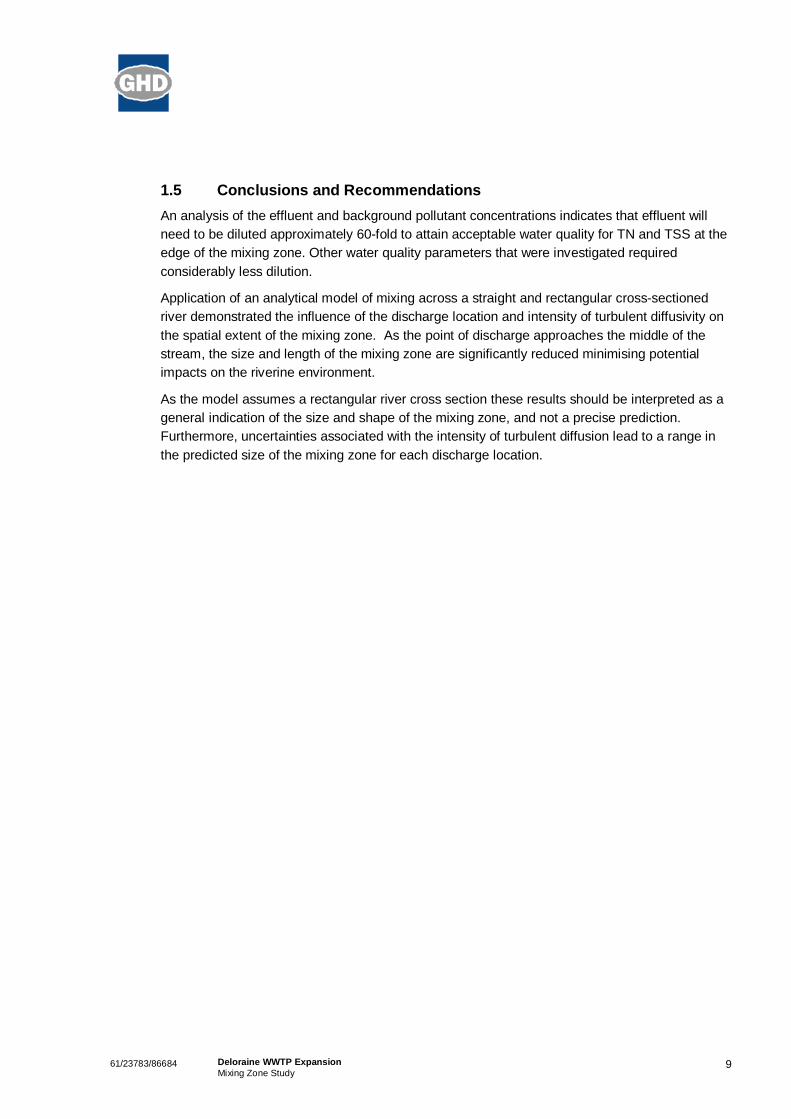
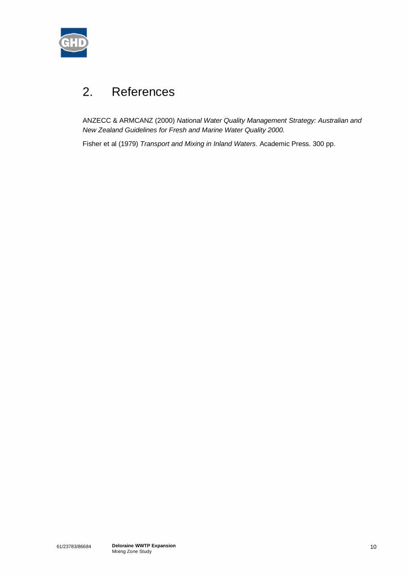
The results of the analytical model are shown in Figure 2, Figure 3 and Figure 4 for discharge 1,5 and 10 m from the river bank respectively. In each case the coloured lines show the bounds ofthe mixing zone envelope downstream of the outfall.
The analysis shows that the size and downstream extent of the mixing zone shows a heavydependence on the diffusivity. In addition, the size of the mixing zone decreases as the point ofdischarge approaches the middle of the river with a mixing zone length of approximately:
» 30 – 90m for outfall location 1m from the bank;
» 20 – 65m for outfall location 5m from the bank; and
» 5 – 25m for outfall location 10m from the bank.
These results assume instantaneous vertical mixing upon introduction of the effluent into theriver. For a 1m river depth complete mixing over the water column is likely to occur soon afterinjection into the river. Hence, the actual mixing zone likely extends modestly further downstreamthan predicted here. Nonetheless, an effective diffuser could assist in rapid homogenisation ofthe effluent to yield a smaller mixing zone.
861/23783/86684 Deloraine WWTP ExpansionMixing Zone Study
Figure 2 Mixing zone extent, discharge 1m from bank.
0 10 20 30 40 50 60 70 80 90 1000
10
20
Distance downstream (m)Dis
tanc
e ac
ross
stre
am (m
)
Point of Release1:60 Mixing Zone, Low Diffusivity Estimate1:60 Mixing Zone, Intermediate Diffusivity Estimate1:60 Mixing Zone, High Diffusivity Estimate
Figure 3 Mixing zone extent, discharge 5m from bank.
0 10 20 30 40 50 60 70 80 90 1000
10
20
Distance downstream (m)Dis
tanc
e ac
ross
stre
am (m
)
Point of Release1:60 Mixing Zone, Low Diffusivity Estimate1:60 Mixing Zone, Intermediate Diffusivity Estimate1:60 Mixing Zone, High Diffusivity Estimate
Figure 4 Mixing zone extent, discharge 10m from bank
0 10 20 30 40 50 60 70 80 90 1000
10
20
Distance downstream (m)Dis
tanc
e ac
ross
stre
am (m
)
Point of Release1:60 Mixing Zone, Low Diffusivity Estimate1:60 Mixing Zone, Intermediate Diffusivity Estimate1:60 Mixing Zone, High Diffusivity Estimate
961/23783/86684 Deloraine WWTP ExpansionMixing Zone Study
1.5 Conclusions and RecommendationsAn analysis of the effluent and background pollutant concentrations indicates that effluent willneed to be diluted approximately 60-fold to attain acceptable water quality for TN and TSS at theedge of the mixing zone. Other water quality parameters that were investigated requiredconsiderably less dilution.
Application of an analytical model of mixing across a straight and rectangular cross-sectionedriver demonstrated the influence of the discharge location and intensity of turbulent diffusivity onthe spatial extent of the mixing zone. As the point of discharge approaches the middle of thestream, the size and length of the mixing zone are significantly reduced minimising potentialimpacts on the riverine environment.
As the model assumes a rectangular river cross section these results should be interpreted as ageneral indication of the size and shape of the mixing zone, and not a precise prediction.Furthermore, uncertainties associated with the intensity of turbulent diffusion lead to a range inthe predicted size of the mixing zone for each discharge location.
1061/23783/86684 Deloraine WWTP ExpansionMixing Zone Study
2. References
ANZECC & ARMCANZ (2000) National Water Quality Management Strategy: Australian andNew Zealand Guidelines for Fresh and Marine Water Quality 2000.
Fisher et al (1979) Transport and Mixing in Inland Waters. Academic Press. 300 pp.
61/23783/86684 Deloraine WWTP ExpansionMixing Zone Study
GHD
GHD House, 239 Adelaide Tce. Perth, WA 6004P.O. Box Y3106, Perth WA 6832T: 61 8 6222 8222 F: 61 8 6222 8555 E: [email protected]
© GHD 2009
This document is and shall remain the property of GHD. The document may only be used for the purposefor which it was commissioned and in accordance with the Terms of Engagement for the commission.Unauthorised use of this document in any form whatsoever is prohibited.
Document Status
Reviewer Approved for IssueRevNo. Author
Name Signature Name Signature Date
Final F. Esszig J. Romero J. Romero 20-Mar-09


Ben Lomond Water
Report for Deloraine WWTPHistoric Heritage Assessment
June 2010
32/152910/1/50999 Deloraine WWTFPreliminary Historic Heritage Assessment
Contents
1. Introduction 1
1.1 Project Background 1
1.2 Background to the Heritage Assessment 1
2. Method 2
3. Heritage Listings and Approvals 3
3.1 Meander Valley Planning Scheme 1995 3
3.2 Tasmanian Heritage Register 3
3.3 Register of the National Trust 4
3.4 Development Proposal and Environmental Management PlanGuidelines 4
4. Historical Overview 5
4.1 Early Development of the Deloraine District 5
4.2 Deloraine Town 5
4.3 Horse Racing at Deloraine 7
5. Site Inventory and Assessment 15
5.1 Assessing Significance 15
6. Assessment of the Proposal 23
6.1 Proposal Description 23
6.2 Assessment Requirements 23
6.3 Impacts and Mitigation 24
6.4 Conclusion 25
7. Bibliography 26
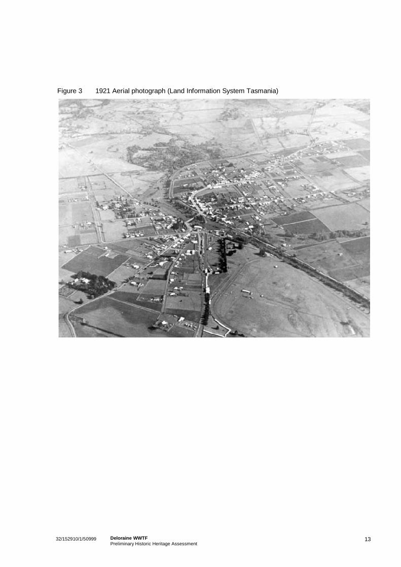
Figure IndexFigure 1 c. 1845 (?) 1885 plan – CPO 1A/241 11Figure 2 c. 1885 plan – CPO 88741, 14th May 1885 12Figure 3 1921 Aerial photograph (Land Information
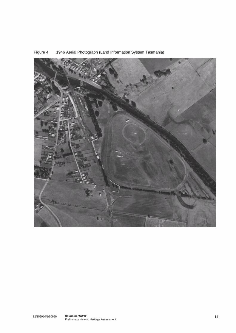
System Tasmania) 13Figure 4 1946 Aerial Photograph (Land Information
System Tasmania) 14
32/152910/1/50999 Deloraine WWTFPreliminary Historic Heritage Assessment
AppendicesA Proposed Upgrade PlansB Landscape Character Assessment and Schematic Landscape
Plan ReportC THR DatasheetD DPEMP Guidelines and Excerpt
132/152910/1/50999 Deloraine WWTFPreliminary Historic Heritage Assessment
1. Introduction
1.1 Project BackgroundBen Lomond Water has engaged GHD Pty Ltd (GHD) to prepare a heritage impact assessment of theproposed upgrade to the Deloraine Wastewater Treatment Plant (WWTP). The WWTP is situated on theDeloraine Racecourse, which is a heritage listed site.
The proposed upgrade is required as the existing facility is operating close to its design capacity. Plantperformance has been variable since the last process upgrade and the recent improvement of the WestDeloraine wastewater pump station. These factors have created additional stress on the plant andsubsequently reduced its overall performance. It is therefore intended to expand the Deloraine WWTP tosuccessfully maintain design effluent quality objectives and to meet projected influent flows and loads.The proposed Stage 1 and Stage 2 upgrades involve an extension to the existing raised area toaccommodate the following:
An overflow storage basin adjacent to the two existing IDEALs;
Two new sludge drying pans adjacent to the two existing;
Two small buildings (Chemical dosing- Stage 1 and filters/UV system – Stage 2); and
Two tanks (Anaerobic Tank – Stage 1 and Balance Tank – Stage 2).
1.2 Background to the Heritage AssessmentThe WWTP is located within the Deloraine Racecourse, which is a heritage listed site at both State andlocal levels. The Deloraine Turf Club is the oldest (1853) continually licensed racing club in Australia. Ithas operated from the Deloraine Racecourse since 1890. Further, the racecourse is the only one in theSouthern Hemisphere with a live planted steeple course. It presents as a largely intact early countryracecourse, with associated infrastructure. Deloraine races have been important community eventssince the early days of the district’s development. However, no races have been held at the racecoursein recent years and the track is unlikely to be used again for race meetings due to safety concerns andthe high cost of upgrading the track to current standards. Current usage of the facility is as a trainingtrack only.
As a heritage listed site, it is necessary to obtain relevant approvals. Heritage Tasmania identified that aheritage assessment, consistent with their Pre-Development Guidelines be prepared for the DeloraineWWTP proposal. In addition to this requirement, Heritage Tasmania highlighted the need to undertake aLandscape Plan consistent with a permit condition of an earlier Council approval for the WWTP.Heritage approvals for works at the racecourse are also required from the Meander Valley Council.
This report provides an assessment of the importance of the site from a heritage perspective, andassesses the impact of the proposal on site values. A Landscape Plan, in line with Council’s originalcondition and the findings of this report, has been prepared by GHD’s heritage landscape architects(attached at Appendix B to this document).
232/152910/1/50999 Deloraine WWTFPreliminary Historic Heritage Assessment
2. Method
This report has been prepared as a desktop heritage assessment complemented by field work.
The assessment follows the process of the Australia ICOMOS Burra Charter 1999 (the Burra Charter)and the Pre-Development Assessment Guidelines (November 2009), issued by Heritage Tasmania. TheBurra Charter has been broadly adopted in Australia as a standard for practice in relation to historicalcultural heritage. It advocates a method of understanding the place, assessing of the significance, andbased on that significance, assessing impacts of the proposed works and establishment of mitigationmeasures for ongoing conservation.
This report has been structured to provide:
1. An overview of the heritage management system as applicable to the Study Area;
2. A broad contextual and summary site history;
3. A site description and assessment of significance against the criteria in the Historic Cultural HeritageAct 1995; and
4. Assessment of heritage impact.
Specific tasks undertaken to support the production of this report include:
Searches on relevant statutory and non-statutory heritage lists to identify surrounding heritageplaces;
Primary and secondary research to obtain an understanding of the history of the site and level ofsignificance. Particular attention has been given to historical plans, charts and surveys, and aerialphotographs;
Site work to identify sites of potential significance and to better understand the place;
Mapping to understand the location of historical sites in relation to the proposal;
An assessment of the significance of features; and
An assessment of heritage impact of the proposal.
332/152910/1/50999 Deloraine WWTFPreliminary Historic Heritage Assessment
3. Heritage Listings and Approvals
3.1 Meander Valley Planning Scheme 1995A separate planning report has been developed for the proposed WWTP upgrade. This report considersthe degree of impact of the proposal on the heritage values of the site.
Part 7 of the Meander Valley Planning Scheme is entitled Items of Cultural Significance. Clause 7.2.1stipulates that “all places of cultural significance that are on the Register of the National Trust of Australia(Tasmania), or Register of the National Estate are listed places and subject to the provisions of this Part”.
Advice from Council and the National Trust is to refer to the Tasmanian Heritage Register (THR). TheDeloraine Racecourse is listed on the THR and the relevant datasheet for the site is attached asAppendix C to this report.
Under Part 7 of the Planning Scheme, an application for development on the listed racecourse site isdiscretionary. The Scheme includes the requirement for consideration of specific matters such asdemolition, painting of significant fabric and modification to windows and so on, which are not consideredrelevant to this proposal. The Scheme also includes reference to the need to consider impacts of thedevelopment of a new building, which will form part of the proposed upgrade.
The general heritage impact of use and development on a listed site is also controlled through thissection of the Scheme. Specifically, Clause 7.2.4 states that:
(1) Where Council considers a proposed use or development may affect a listed place, it shallrequire the applicant to submit an assessment of the significance of the use or development of theplace, including the:
(a) Level of impact; and
(b) Procedures to be carried out to mitigate adverse impacts.
(2) As the circumstances require an assessment under clause 7.2.4(1) shall:
(a) For standing structures be in accordance with the principles of the Australian ICOMOS(Burra) Charter for the Conservation of Places of Cultural Significance; and
(b) For sub-surface remains, include an archaeological predictive study to recover historicevidence.
For this development, Council has considered it appropriate for a Landscape Plan to be developed forthe proposed upgrade and this is attached at Appendix B to this report.
3.2 Tasmanian Heritage RegisterThe racecourse is permanently entered on the Tasmanian Heritage Register for its significant historical,representative and social values.
As reflected in the listing datasheet, the Deloraine Racecourse is considered to be of value because ofits ability to demonstrate the history and development of the horse racing industry in Tasmania. Itprovides an example of a racing facility from the Victorian period, and it is also considered to be of socialvalue for its association with community recreational activity.
432/152910/1/50999 Deloraine WWTFPreliminary Historic Heritage Assessment
Under the Historic Cultural Heritage Act 1995, a person must not carry out any works in relation to aregistered place or a place within a heritage area which may affect the historic cultural significance of theplace unless the works are approved by the Heritage Council. As the racecourse site is permanentlyentered in the Heritage Register, the proposed development will require the approval of the HeritageCouncil.
This proposal has been discussed with Heritage Tasmania, who requested that a general heritageassessment be undertaken to consider the impact of the proposal on the significant values of the place.This report fulfils that requirement.
3.3 Register of the National TrustThe racecourse is included on the Register of the National Trust. While this register has no statutorystanding, the planning scheme requires impacts on places included on the list to be considered prior toapproval.
3.4 Development Proposal and Environmental Management Plan GuidelinesThe proposal to upgrade the WWTP is a Level 2 activity. Therefore, a Development Proposal andEnvironmental Management Plan (DPEMP) is required. The DPEMP General Guidelines include variousrequirements for a range of environmental assessments. From a heritage perspective, the guidelinesrequire consideration of potential impacts on heritage listed places, or other values. In addition, theguidelines also require consultation with Heritage Tasmania, which has occurred for this project.
Consideration of the proposal against the guidelines is included in the main DPEMP document. Therelevant guidelines and heritage sections of the DPEMP are attached at Appendix D to this report.
532/152910/1/50999 Deloraine WWTFPreliminary Historic Heritage Assessment
4. Historical Overview
The following section aims to provide an overview of the European development of the site and broaderregion. The key purpose of this historical overview is to:
Identify the principal themes in the history of the area;
Identify the major historical phases or events; and
Contribute to the understanding of the heritage value of the site.
The overview is for contextual purposes only and is not intended to provide a comprehensive site history.
4.1 Early Development of the Deloraine DistrictThe first Europeans in the Deloraine area were most likely convicts from the settled districts aroundLaunceston - either stockmen searching for strayed cattle, or assigned servants who had escaped fromtheir masters. Indeed, the district has a rich history of bushranger activity.
In 1823, Lieutenant Governor Sorrell dispatched Captain John Rolland with a party to explore the districtwest of Norfolk Plains, or the ‘westward country’. The aim of the expedition was to find suitable land forsettlement and agriculture. Rolland and his group travelled up the First Western River (now the MeanderRiver) and the Second Western River (Mersey River). The group thrashed through thick forest on thefoothills of what is now known as Mt Rolland, but were unable to go further. Their difficulty negotiatingthe area led to the initial naming of the mountain as ‘Rolland’s Repulse’.
The party found good grazing land along the First Western River and settlers followed quickly. By 1825settlers had arrived in Deloraine district. Early investigation of the area in 1826 by the Van Diemen’sLand Company led to the development of large, yet modest tracks and roadways through the district.1
For the first 30 years of settlement in the district, the area had been characterised by the dominance oflarge estates. Grazing was the main industry, though agriculture was steadily increasing with the verygradual clearing of the heavily vegetated fertile land, although this was a difficult and costly process.
4.2 Deloraine TownThe Deloraine town was relatively slow in its development, with the first sale of town blocks not occurringuntil 1846.2 The reason for this is two-fold. In 1825, Lieutenant Governor Arthur appointed aCommissioner to assess the use of land for future Crown land leases and grants however, Deloraine’snew settlers were among the first required to pay to take up their leases. These laws were later changedto encourage development and as little as one pound per acre was charged for purchase of land in thearea. 3
1Skemp, J.R, 1964: A history of Deloraine: from the earliest settlement to the present day, pp. 5-62Ibid, p.6
3 http://www.regional.org.au/au/countrytowns/ideas/pyke.htm
632/152910/1/50999 Deloraine WWTFPreliminary Historic Heritage Assessment
The second reason for the slow establishment of the area was the existence of the convict probationstation in the town, which most likely deterred potential settlers. At one stage there were forty convicts atlarge in the broader area. Interestingly, an increased sale of land in the town coincided with the removalof the probation station the same year.
For some time the only business within the town was a public house located close to the bridge.However, during her stay in 1844 at the Inn, Lousia Meredith, on her way to Port Sorrell noted buildingactivity in the area on the southern side of the River. J. McArthur was constructing houses to lease onthis land purchased from Pearson Foote. This land was mainly leased to people working in theneighbouring estates. Shops, public houses and a post office were soon constructed, thus establishingthe area as a small village known at the time as Alveston. While removal of the probation station in 1846resulted in a lack of trade, it did allow the village to grow, with the number of houses and shopsbeginning to increase.
In the 1850s, the town experienced major growth, with businesses established to process local produceand provide services to the townspeople and surrounding rural properties. Along with local shops,butcher shops, public houses and other commercial activities, numerous local industries wereestablished including for example, flour mills, bakeries, breweries, limekilns, sawmills, blacksmiths,stonemasons and tinsmiths. One factor that supported growth this growth the location of the town on themain transport route to the rapidly developing north west region. Deloraine became the centre of a richagricultural and pastoral district. The discovery of gold in Victoria in the 1850s further supported thedevelopment of the area, as the discovery assisted in supplying the demand for timber, food and otherprovisions.4
By the late 1860s Deloraine had become an important commercial centre and had a daily coach toLaunceston. The town was proclaimed in 1866, and a major survey was undertaken in 1886. 5
Given the important role of the town in agricultural and other production, Tasmania’s first rail link wasestablished between Deloraine and Launceston. A substantial period of growth in the region followedafter the Launceston and Western Railway Company established a rail link between Launceston andDeloraine in 1871. However, the establishment of the rail also facilitated the importation of goods fromoutside of Deloraine and reducing support in some agricultural areas. Establishment of the rail thereforehad mixed results on the growth and development of the area.6 Given the location of the railway lineadjacent to the Deloraine racecourse, it provided an important transport method to the racetrack when apassenger service was available.
The Cyclopedia of Tasmania (1900) describes Deloraine as one of the largest agricultural and pastoralcentres in the colony. The population had increased from 4900 to 5800 in a ten year period and thisgrowth was attributed to the ease of transport of goods to outlying areas via the Western Line Railway.Transport was expanded by lines to Hobart, Ulverstone, Burnie and all important towns on the north-westcoast. The Cyclopedia makes reference to the aesthetics of the Alveston Racecourse and notes the useof another racecourse by the Deloraine Turf Club, which held meetings every Easter.7
4 Skemp, op. Cit, p.205 Latona Masterman and Associates, 1986: Deloraine Conservation Study, pp.1-56 Alexander, A, 2005: The companion to Tasmanian history, p.102.7 Cyclopedia of Tasmania, p. 230.
732/152910/1/50999 Deloraine WWTFPreliminary Historic Heritage Assessment
4.3 Horse Racing at DeloraineHorse racing has played an important role in Tasmanian history from the earliest days of the colony.From earliest European settlement, informal tracks and gambling arrangements were set up to satisfy therecreational needs of populations. With the establishment of more formal tracks in the major regions,races within the colony began to attract national and international attention. The races were an importantevent for many, providing opportunities for communities to come together, and for the upper classes toshowcase the latest fashions.
Like many country areas, sport in Deloraine developed in association with local work, with timbermenparticipating in wood chopping events, and stockmen racing their horses as a recreational activity. 8
Informal galloping races were taking place in the district by the mid nineteenth century.9
The first formally organised race meeting was held in the Deloraine district in Easter 1853, on a track atthe Alveston Estate, at the time owned by James McArthur and situated a quarter of a mile south ofpresent course. The meet was organised by W.A. Gardener.
John Field constructed a private racecourse at Calstock, and some of the early race fixtures were heldthere.10 John Field was, at that time, already a big bloodstock breeder. He had purchased the CalstockEstate in 1854 and finished building the Victorian-style homestead in 1860 and constructed the stablesover the following two years. After a transfer of his thoroughbred stud to Calstock, John Field played asignificant role in establishing Deloraine as a racing (as well as a breeding) centre.
While a prominent event in Deloraine, the races were somewhat overshadowed by larger events inareas, notably Longford, Carrick and Campbell Town, which were well established by 1845. Howeverthe Deloraine races had always been highly valued for their picnic atmosphere, and considered to be animportant community event.11
The Deloraine Turf Club (DTC) was formed in 1874, with John Field and J.L. Smith as President andSecretary respectively.12 In 1875, races took place at a new course at Mile End and in 1877, the EasterMonday meeting took place at the Keanefield Course. The first Deloraine Handicap, which was laterrenamed the Cup, was won by W. H. Mence’s Venus. 13
In 1882 the DTC. Secretary, Mr D Griffin, used his wide knowledge of racing and journalistic experienceto provide Deloraine racing much favourable publicity prior to the event. The Easter meeting of that yearwas the most successful event up to that time. 14
The land on which the current Deloraine racecourse is situated is located on land originally held byLieutenant Pearson Foote, one of Deloraine’s first settlers in 183715. Foote was the first owner ofCalstock and Harwood, both of which he named after the estates of the Footes in Devonshire England.16
8 Skemp, op. Cit, p.209 Oliver, C.S: 1987 From then until now, p. 8610 Ibid, p.1953; Skemp, op. Cit, p.1011 Skemp, op. Cit, p. 1112 DTC Race records 1890 – 199713 Ibid, 199714DTC, 1997 op. Cit15 Deloraine Turf Club (DTC), Official programme, Vol 1/6, April 6th 195316 Meredith, L & Griffith, D, 1983, Early Deloraine, pp. 39
832/152910/1/50999 Deloraine WWTFPreliminary Historic Heritage Assessment
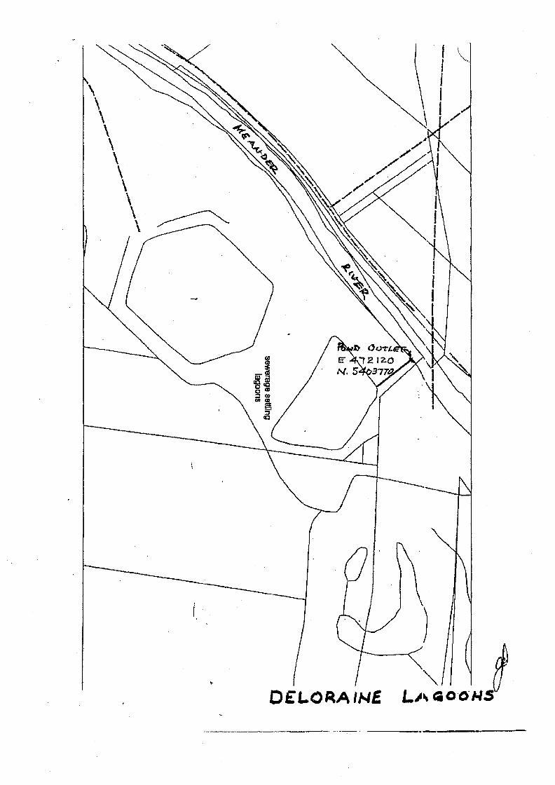
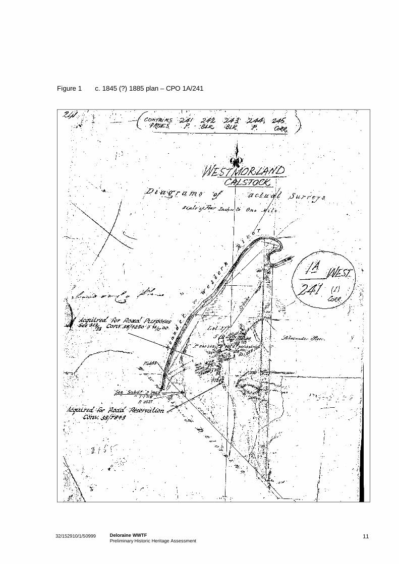
In c.1845, a survey (Figure 1) was prepared of this property, at that time containing 510 acres of land.The diagram does not provide an indication of any buildings on the site, but does include a laterreference to the railway, running along the southern boundary of the racetrack. The diagram suggeststhat the site has always been on the outskirts of the town, and had not been substantially developed priorto the establishment of the racecourse.
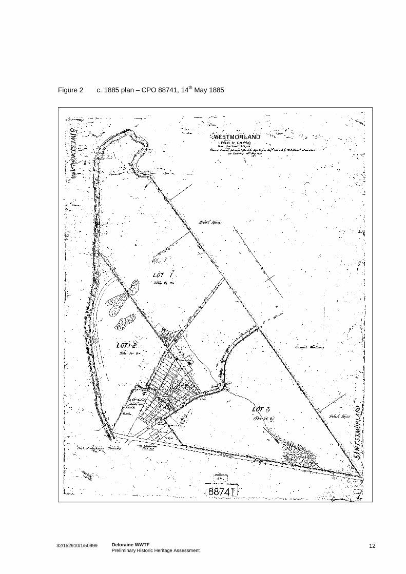
In 1885, a second survey (Figure 2) was prepared of the site of the current racecourse following thedecision to subdivide the 510 acres into three main lots. The survey diagram shows at least the partialformation of the race track, and there is an indication of a small structure on the outside of the track. Thebuilding is adjacent to the Meander River, in the vicinity of the present day football oval and stables andis visible on the 1921 aerial photograph of the site (Figure 3).
The diagram also shows the presence of two swampy areas in the centre of the racecourse, indicating itwas of low value for residential development. These swampy areas approximate the location of thecurrent WWTP. Indeed, flooding affected the course a number of times throughout the track’s earlyhistory, namely 1895, 1906, 1909 and again in 1929. After previous unsuccessful attempts to purchaseand lease other land, the club arranged its first lease of the present racecourse property from theDeloraine Municipal Council in 1889.17 A condition of the lease was that £500 be spent on making acourse and construction of a suitable grandstand and other buildings. The lease also provided the rightto two race meetings per year. A timber grandstand was built that year, and the DTC first used thecurrent track at Easter 1890.18 The lease was extended in 1910 and 1922 for fifty years. At some earlyDeloraine meetings, the ‘straight’ was located on the river side of the course.19
In the 1880s the first Deloraine Scratching Board was established and Council contributed to extendingthe boundary fencing to enclose the racecourse reserve.
The appointment of Mr. Richard Learoyd as secretary in 1896 was a major milestone in the Club’shistory. This represented a period of substantial growth and progression for the DTC.
In 1900, the course proper was double fenced, the track was sewn with English grasses and the trainingtrack was moved from outside the main course to the inner area. 20 1921 aerial photography shows thatby this time, plantings aligning the main entrance to the track were well established.
The Deloraine Handicap was renamed the Deloraine Cup in 1904 and the first running of the TasmanianGrand National Steeple took place in 1905. The height of the posts were reduced in line with AustralianStandards during 1909. The steeple race required construction of post and rail obstacles inside theDeloraine course, and the outer area of the course was also partly fenced at this time. While someauthors indicate that the posts were replaced by gorse in 1906,21 other commentators report theestablishment of live gorse bushes in 1928. Indeed, a 1921 aerial of the course shows that gorseobstacles existed at this time. It is therefore possible that multiple plantings were established as postson the course.22
17 Skemp, op. Cit, p42; DTC, 1997 Op. Cit, 195318 DTC, 1997 op. Cit19 DTC, 1953 op. Cit20 DTC, 1997 op. Cit21 Skemp, op. Cit, p42; Examiner, 04/04/96, p. 2622 DTC, 1997 op. Cit
932/152910/1/50999 Deloraine WWTFPreliminary Historic Heritage Assessment
The National Steeple was so popular that the order for Easter Monday race books increased from 700 to3500 within only ten years. With the growth in attendance, the club extended the Birdcage and Totehouse. They also improved facilities on the flat and laid water onto various parts of the course. TheGrand National Hurdle was run in 1914 and continued until 1935, and was revived again in 1946 (Figure5).
The work being carried out at the course, as well as the promotion undertaken by the committee duringthe early twentieth century further reinforced racing as an important social and sporting occasion. The1919 annual Easter Carnival was regarded as a great success. The Weekly Courier reported that 'neverin the history of the meeting has there been such a crowd on the picturesque course on the banks of theMeander'23. It was estimated that the event attracted the largest crowd ever gathered at the meeting,with gate returns of £1248 24
A fire destroyed the original timber grandstand in 1915, and this was replaced with the present dayconcrete structure. A 1921 aerial photograph shows that the new grandstand had been constructed atthat time, along with the stable, hall and public bar/hotel structure. Additions had been made to thebuilding series in the vicinity of the grandstand by 1949, some of which appear to have been demolishedsince.
In 1928, permanent new fences of sod and live gorse were constructed, these were first of their kindused in the Commonwealth. These were used as a model for to those used at the Flemington steeplefences, as well as several others in Australia. The steeples are clearly apparent on the 1946 aerial. 25
Notes in the Club’s records indicate that the DTC extended their lease of the land for a further 50 yearsin 1922. A 1944 diagram notes the Deloraine Racing Club as owners of the land. At this time, theracecourse site was 76 acres, a minor reduction in overall land size due to the acquisition of the land forrailway infrastructure. A 1946 aerial photograph of the site sows that the sporting oval had beendeveloped by this time within the racecourse. The clubrooms are also apparent on the photograph and itis possible that the clubrooms were built making use of a building apparent on the 1921 aerialphotograph.
In 1953, Deloraine was considered to be the ‘home of Tasmanian cross country racing and the centre ofsome of Australia’s most colourful thoroughbred breeding history’, celebrating one hundred years ofracing within ‘its picturesque agricultural district’.26
Racing in Deloraine has been supported by the long service of numerous community membersthroughout its history. Numerous riders, owners and breeders associated with Deloraine racing went onto have considerable success elsewhere in the state, Australia more broadly and in some cases,internationally.
4.3.1 Recent History
A series of maintenance activities at the Deloraine Race Club have taken place more recently. In the1990s, changes were made to the club’s dining and public bar facilities, and new seating was installed inthe grandstand. 27 In addition, a community project led to the beautification of the course entrance.
23 Weekly Courier, 24/04/19 p.1024 Ibid, p.1025 DTC, 1997 op. Cit26 DTC, 1953 op. Cit27 Examiner, 04/04/96, p. 26; Western Tiers, 30/11/92.
1032/152910/1/50999 Deloraine WWTFPreliminary Historic Heritage Assessment
In the 2000s, articles relating to the Deloraine races and racecourse complex demonstrated the ongoingimportance of the place and its associated events.28 Reports of a lack of funding for maintenance and thepossibility of meet cancellations met with community disapproval. Articles relating to the track reflectconcern of the loss of what was considered to be a nationally important race. The heritage significance ofthe track was often acknowledged in the articles, with the racecourse considered to be one of the mostimportant country tracks in Australia, associated with the oldest continually licensed turf club in thecountry. In addition, the track is reported to have the only live gorse fences in Australia and morebroadly in the southern hemisphere. Broader recreational use of the track throughout history is alsoreferred to, with people recalling activities such as sideshows, picnicking and betting rings in the spacewithin the centre of the track. 29
As previously noted, no races have been held at the racecourse in recent years and the track is unlikelyto be used again for race meetings due to safety concerns and the high cost of upgrading the track tocurrent standards. Current usage of the facility is as a training track only. However, the Examinernewspaper makes reference to the establishment of a lake island which was created to beautify thetrack. The lake is a runoff water storage dam constructed in 2002 and is not part of the sewage treatmentplant.30
28 Examiner, 17/10/2006, p. 2329 Advocate, 3/11/98, p.6; Advocate, 7/3/00; Advocate, 16/7/01 p. 4; Examiner, 17/4/01; Examiner, 30/5/01;30 The Examiner, 15/04/03
1132/152910/1/50999 Deloraine WWTFPreliminary Historic Heritage Assessment
Figure 1 c. 1845 (?) 1885 plan – CPO 1A/241
1232/152910/1/50999 Deloraine WWTFPreliminary Historic Heritage Assessment
Figure 2 c. 1885 plan – CPO 88741, 14th May 1885
1332/152910/1/50999 Deloraine WWTFPreliminary Historic Heritage Assessment
Figure 3 1921 Aerial photograph (Land Information System Tasmania)
1432/152910/1/50999 Deloraine WWTFPreliminary Historic Heritage Assessment
Figure 4 1946 Aerial Photograph (Land Information System Tasmania)
1532/152910/1/50999 Deloraine WWTFPreliminary Historic Heritage Assessment
5. Site Inventory and Assessment
5.1 Assessing SignificanceHeritage places have differing levels of significance. Heritage Tasmania’s Pre-Development AssessmentGuidelines specify that places are to be assessed against the criteria of the Historic Cultural Heritage Act1995 (HCHA), rating places as having nil/negligible, Local or State levels of significance.
It has been established that the Deloraine Racecourse meets the State threshold of heritage significanceas the site is permanently listed, but the actual values of the racecourse are not well articulated. It istherefore the purpose of this section to elaborate on the value of the course, in order to assess theimpacts of the proposed WWTP upgrade. Articulating the value and significance of a place as a first stepin assessing impacts is a process that is consistent with the Burra Charter.
The following table provides a description of the main component parts of the site to assist in defining thevarious aspects of significance. A statement of significance against the HCHA criteria is then provided.
Deloraine Racecourse
Heritage Listings
Tasmanian Heritage Register (THR) and MeanderValley Planning Scheme
Location: East Westbury Place, Deloraine
Land Status: Owned by Local Government
Historical Information
Refer to Section 2.
Site Description
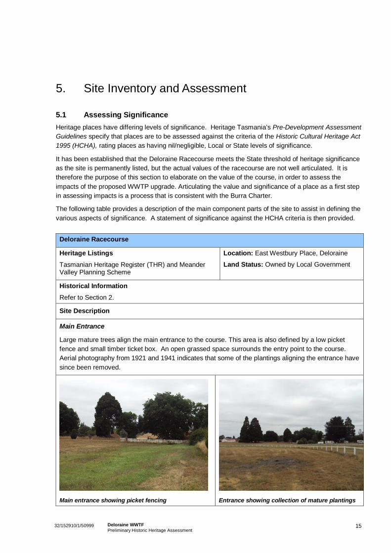
Main Entrance
Large mature trees align the main entrance to the course. This area is also defined by a low picketfence and small timber ticket box. An open grassed space surrounds the entry point to the course.Aerial photography from 1921 and 1941 indicates that some of the plantings aligning the entrance havesince been removed.
Main entrance showing picket fencing Entrance showing collection of mature plantings
1632/152910/1/50999 Deloraine WWTFPreliminary Historic Heritage Assessment
Deloraine Racecourse
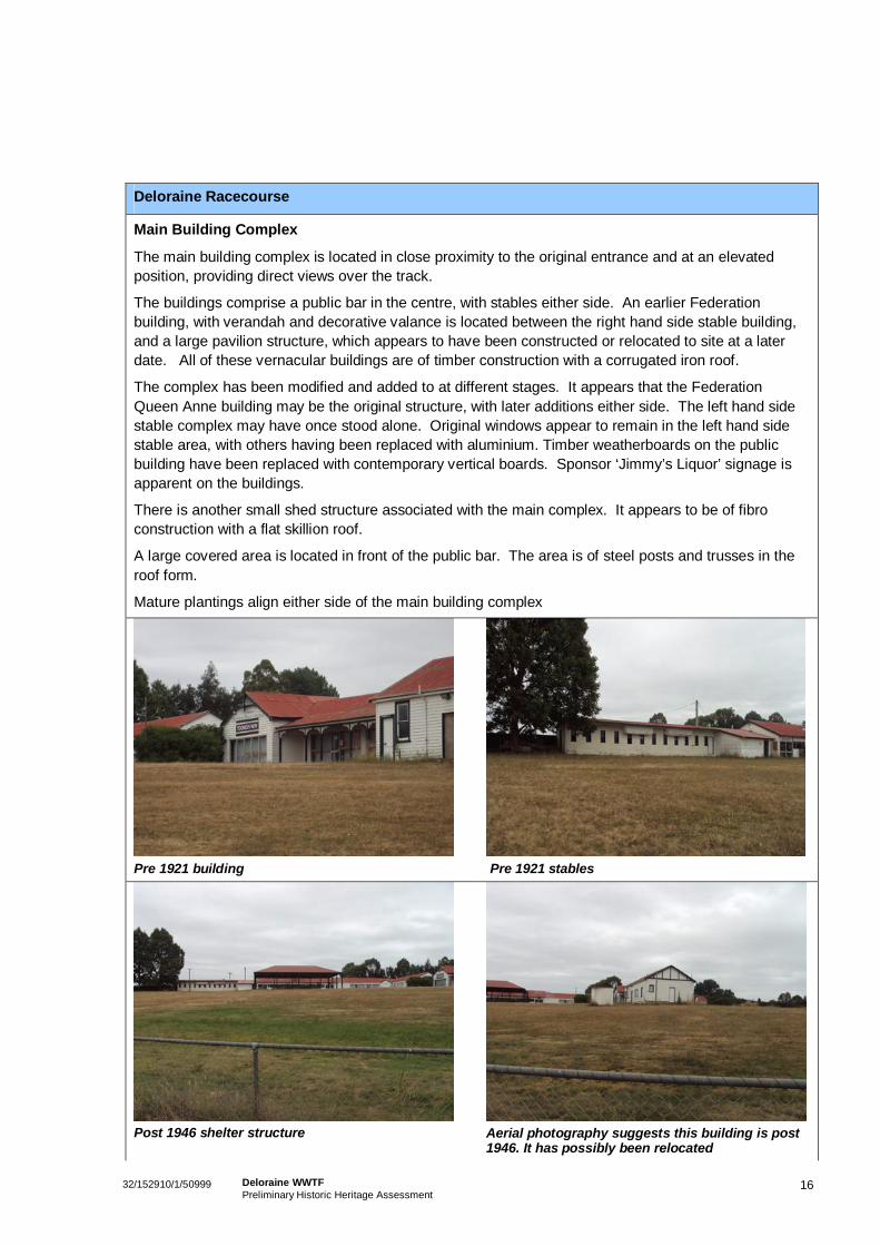
Main Building Complex
The main building complex is located in close proximity to the original entrance and at an elevatedposition, providing direct views over the track.
The buildings comprise a public bar in the centre, with stables either side. An earlier Federationbuilding, with verandah and decorative valance is located between the right hand side stable building,and a large pavilion structure, which appears to have been constructed or relocated to site at a laterdate. All of these vernacular buildings are of timber construction with a corrugated iron roof.
The complex has been modified and added to at different stages. It appears that the FederationQueen Anne building may be the original structure, with later additions either side. The left hand sidestable complex may have once stood alone. Original windows appear to remain in the left hand sidestable area, with others having been replaced with aluminium. Timber weatherboards on the publicbuilding have been replaced with contemporary vertical boards. Sponsor ‘Jimmy’s Liquor’ signage isapparent on the buildings.
There is another small shed structure associated with the main complex. It appears to be of fibroconstruction with a flat skillion roof.
A large covered area is located in front of the public bar. The area is of steel posts and trusses in theroof form.
Mature plantings align either side of the main building complex
Pre 1921 building Pre 1921 stables
Post 1946 shelter structure Aerial photography suggests this building is post1946. It has possibly been relocated
1732/152910/1/50999 Deloraine WWTFPreliminary Historic Heritage Assessment
Deloraine Racecourse
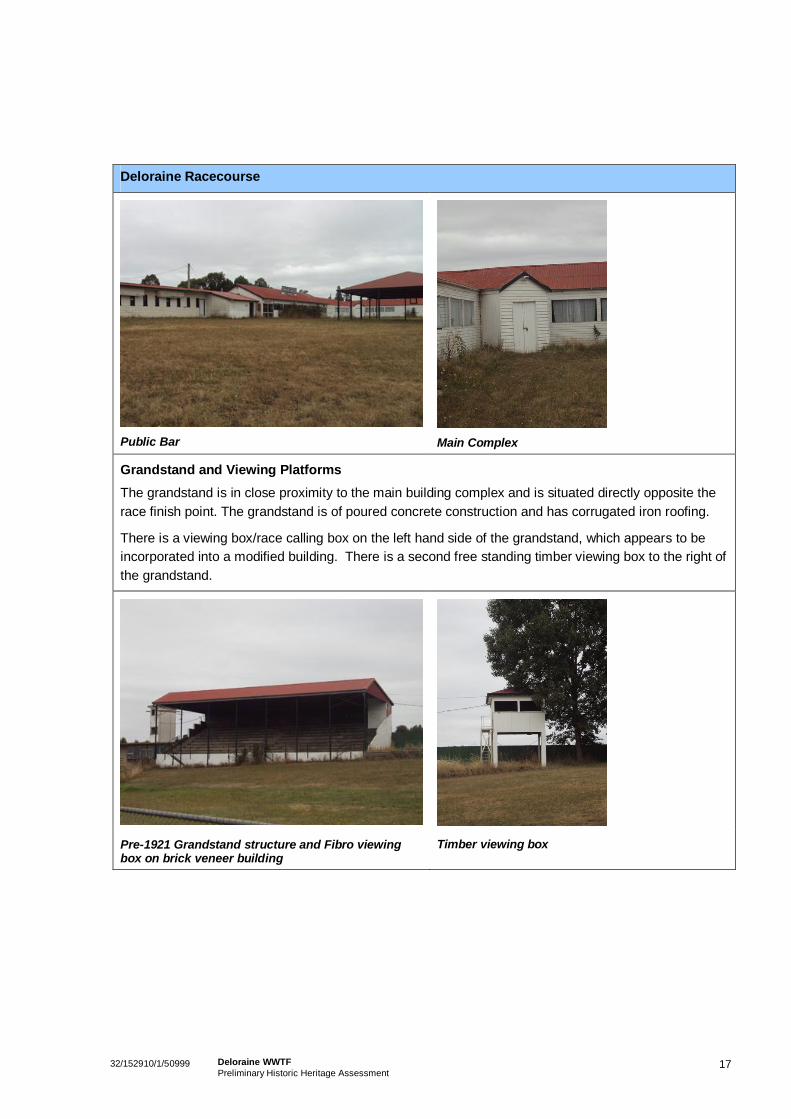
Public Bar Main Complex
Grandstand and Viewing PlatformsThe grandstand is in close proximity to the main building complex and is situated directly opposite therace finish point. The grandstand is of poured concrete construction and has corrugated iron roofing.
There is a viewing box/race calling box on the left hand side of the grandstand, which appears to beincorporated into a modified building. There is a second free standing timber viewing box to the right ofthe grandstand.
Pre-1921 Grandstand structure and Fibro viewingbox on brick veneer building
Timber viewing box
1832/152910/1/50999 Deloraine WWTFPreliminary Historic Heritage Assessment
Deloraine Racecourse
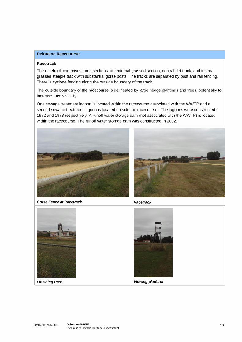
Racetrack
The racetrack comprises three sections: an external grassed section, central dirt track, and internalgrassed steeple track with substantial gorse posts. The tracks are separated by post and rail fencing.There is cyclone fencing along the outside boundary of the track.
The outside boundary of the racecourse is delineated by large hedge plantings and trees, potentially toincrease race visibility.
One sewage treatment lagoon is located within the racecourse associated with the WWTP and asecond sewage treatment lagoon is located outside the racecourse. The lagoons were constructed in1972 and 1978 respectively. A runoff water storage dam (not associated with the WWTP) is locatedwithin the racecourse. The runoff water storage dam was constructed in 2002.
Gorse Fence at Racetrack Racetrack
Finishing Post Viewing platform
1932/152910/1/50999 Deloraine WWTFPreliminary Historic Heritage Assessment
Deloraine Racecourse
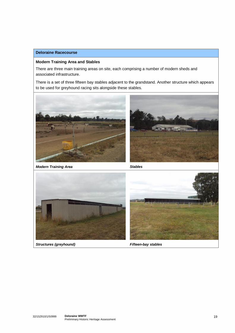
Modern Training Area and Stables
There are three main training areas on site, each comprising a number of modern sheds andassociated infrastructure.
There is a set of three fifteen bay stables adjacent to the grandstand. Another structure which appearsto be used for greyhound racing sits alongside these stables.
Modern Training Area Stables
Structures (greyhound) Fifteen-bay stables
2032/152910/1/50999 Deloraine WWTFPreliminary Historic Heritage Assessment
Deloraine Racecourse
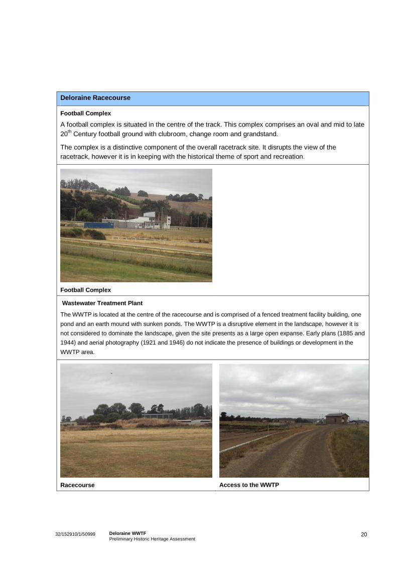
Football Complex
A football complex is situated in the centre of the track. This complex comprises an oval and mid to late20th Century football ground with clubroom, change room and grandstand.
The complex is a distinctive component of the overall racetrack site. It disrupts the view of theracetrack, however it is in keeping with the historical theme of sport and recreation.
Football Complex
Wastewater Treatment Plant
The WWTP is located at the centre of the racecourse and is comprised of a fenced treatment facility building, onepond and an earth mound with sunken ponds. The WWTP is a disruptive element in the landscape, however it isnot considered to dominate the landscape, given the site presents as a large open expanse. Early plans (1885 and1944) and aerial photography (1921 and 1946) do not indicate the presence of buildings or development in theWWTP area.
Racecourse Access to the WWTP
2132/152910/1/50999 Deloraine WWTFPreliminary Historic Heritage Assessment
Significance Assessment
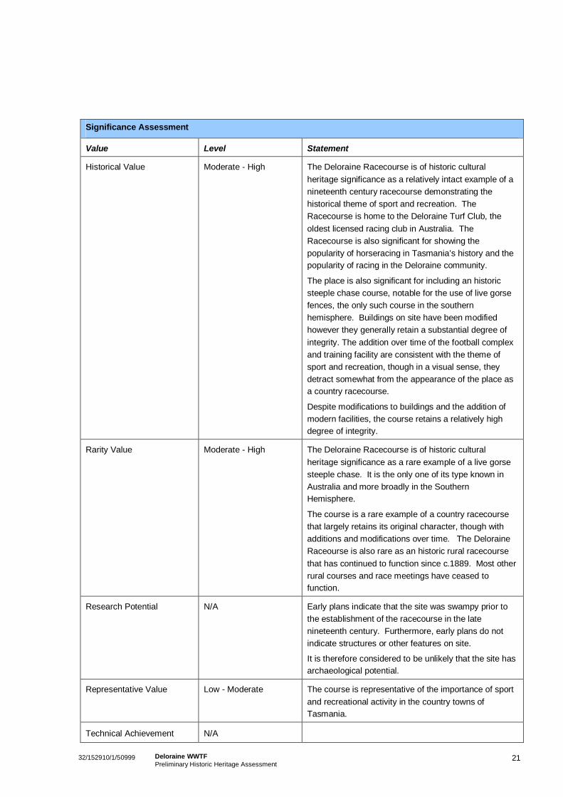
Value Level Statement
Historical Value Moderate - High The Deloraine Racecourse is of historic culturalheritage significance as a relatively intact example of anineteenth century racecourse demonstrating thehistorical theme of sport and recreation. TheRacecourse is home to the Deloraine Turf Club, theoldest licensed racing club in Australia. TheRacecourse is also significant for showing thepopularity of horseracing in Tasmania’s history and thepopularity of racing in the Deloraine community.
The place is also significant for including an historicsteeple chase course, notable for the use of live gorsefences, the only such course in the southernhemisphere. Buildings on site have been modifiedhowever they generally retain a substantial degree ofintegrity. The addition over time of the football complexand training facility are consistent with the theme ofsport and recreation, though in a visual sense, theydetract somewhat from the appearance of the place asa country racecourse.
Despite modifications to buildings and the addition ofmodern facilities, the course retains a relatively highdegree of integrity.
Rarity Value Moderate - High The Deloraine Racecourse is of historic culturalheritage significance as a rare example of a live gorsesteeple chase. It is the only one of its type known inAustralia and more broadly in the SouthernHemisphere.
The course is a rare example of a country racecoursethat largely retains its original character, though withadditions and modifications over time. The DeloraineRaceourse is also rare as an historic rural racecoursethat has continued to function since c.1889. Most otherrural courses and race meetings have ceased tofunction.
Research Potential N/A Early plans indicate that the site was swampy prior tothe establishment of the racecourse in the latenineteenth century. Furthermore, early plans do notindicate structures or other features on site.
It is therefore considered to be unlikely that the site hasarchaeological potential.
Representative Value Low - Moderate The course is representative of the importance of sportand recreational activity in the country towns ofTasmania.
Technical Achievement N/A
2232/152910/1/50999 Deloraine WWTFPreliminary Historic Heritage Assessment
Significance Assessment
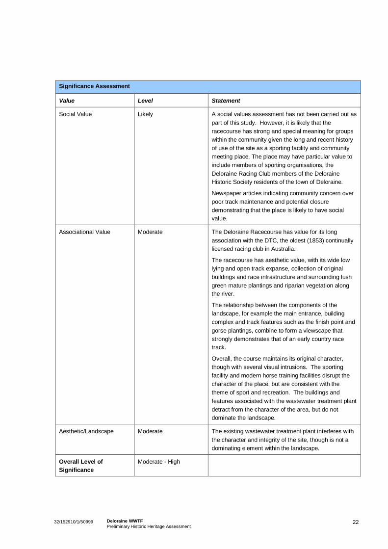
Value Level Statement
Social Value Likely A social values assessment has not been carried out aspart of this study. However, it is likely that theracecourse has strong and special meaning for groupswithin the community given the long and recent historyof use of the site as a sporting facility and communitymeeting place. The place may have particular value toinclude members of sporting organisations, theDeloraine Racing Club members of the DeloraineHistoric Society residents of the town of Deloraine.
Newspaper articles indicating community concern overpoor track maintenance and potential closuredemonstrating that the place is likely to have socialvalue.
Associational Value Moderate The Deloraine Racecourse has value for its longassociation with the DTC, the oldest (1853) continuallylicensed racing club in Australia.
The racecourse has aesthetic value, with its wide lowlying and open track expanse, collection of originalbuildings and race infrastructure and surrounding lushgreen mature plantings and riparian vegetation alongthe river.
The relationship between the components of thelandscape, for example the main entrance, buildingcomplex and track features such as the finish point andgorse plantings, combine to form a viewscape thatstrongly demonstrates that of an early country racetrack.
Overall, the course maintains its original character,though with several visual intrusions. The sportingfacility and modern horse training facilities disrupt thecharacter of the place, but are consistent with thetheme of sport and recreation. The buildings andfeatures associated with the wastewater treatment plantdetract from the character of the area, but do notdominate the landscape.
Aesthetic/Landscape Moderate The existing wastewater treatment plant interferes withthe character and integrity of the site, though is not adominating element within the landscape.
Overall Level ofSignificance
Moderate - High
2332/152910/1/50999 Deloraine WWTFPreliminary Historic Heritage Assessment
6. Assessment of the Proposal
6.1 Proposal DescriptionAs indicated on the plan attached at Appendix A to this report, the proposed works will involve thefollowing:
An overflow storage basin adjacent to the two existing IDEALs;
Two new sludge drying pans adjacent to the two existing;
Two small buildings (Chemical dosing- Stage 1 and filters/UV system – Stage 2); and
Two tanks (Anaerobic tank – Stage 1 and Balance Tank – Stage 2).
6.2 Assessment RequirementsThe Meander Valley Planning Scheme includes the requirement for consideration of impacts of thedevelopment of a new building or modifications to a listed site. Assessment of the general heritageimpact of use and development on a listed site is also required, and it is necessary to consider the levelof impact of the proposal and procedures to be carried out to mitigate impacts.
The Historic Cultural Heritage Act 1995 establishes that approval may only be given for works which arelikely to reduce the significance of a place if it is evident that there are no prudent and feasiblealternatives to carrying out the works. This test requires consideration of alternatives, as well as anassessment of the level of impact of proposed works on the significance of the place.
The DPEMP Guidelines require consideration of impacts on listed heritage sites and values, as well asconsideration of any other heritage values (See Appendix D).
6.2.1 Alternatives to the Proposal
Alternatives to the proposal to update the WWTP have been discussed with GHD’s Civil Engineer.31 Thefollowing points were made.
Need for Facility UpgradeThe existing facility is operating close to its design capacity and there needs to be increased capacity toservice the town in light of projected influent flows and loads into the future. If the facility is not upgraded,it will be unable to meet future demand and will be unable to meet the effluent quality requirements of itscurrent licence.
Relocating the WWPTRelocating the WWTP to avoid upgrading at the existing site would require full system redevelopmentelsewhere. Substantial changes to town infrastructure would need to follow any relocation of the facility,as services currently discharge at the existing WWTP site, resulting in a substantial financial cost andinconvenience to the local community due to service disruptions.
31 Wright, S., pers comm. 2010.
2432/152910/1/50999 Deloraine WWTFPreliminary Historic Heritage Assessment
Current Site CharacteristicsThe current facility is well located in comparison to other alternatives given the following considerations:
The site is located close enough to the town to allow efficient servicing, but far enough away to avoidimpacting on residential amenity.
Location is to east side of the town which results in a very low risk of odour issues in the town giventhe prevailing winds from the west; and
Topographic characteristics are hydrologically efficient.
6.3 Impacts and Mitigation
6.3.1 Summary of SignificanceThe racecourse has been registered on the THR for its historical, representative, and social heritagevalue. The THR notes that these values are demonstrated by the ability of the site to demonstrate theprincipal characteristics of a Victorian racecourse.
In summary, this assessment has found that the values of the place relate to:
The historical importance of horseracing in Tasmania as a significant recreational and social activitywith a long association with the site;
The ability of the site to demonstrate the characteristics of a late nineteenth/early twentieth centurycountry racecourse;
The rarity of steeple chase courses, in particular live gorse fences; and
Associational and aesthetic value.
6.3.2 Assessment of Impacts
The proposal does not involve removal, alteration or addition to the main building complex or race courseinfrastructure. Nor will it involve the removal of any mature plantings on site, or impacts to the trackcomplex and steeple. The potential impacts will be largely visual and relate to the extension of apreviously constructed embankment to cater for new infrastructure.
The setting of the racecourse, including the open racecourse space, contributes to the significance of theplace. However, the existing raised embankment does not dominate the racecourse aesthetic oroverwhelm the strong sporting character of the place. The racecourse includes steeple chases of sodand gorse, which breaks up the openness of the landscape in certain areas and assists somewhat indetracting from the raised WWTP embankment. It is not anticipated that an extension to the embankmentfor the new infrastructure will contribute substantially to the existing impact.
A Character Assessment and Schematic Landscape Plan Report has been produced as part of thebackground assessments for this project and in fulfilment of previous conditional approvals for furtherdevelopment. The aim of the plan is to minimise the existing WWTP impact on the landscape and helpprevent further disruption to the racecourse aesthetic.
The proposed building will sit alongside an existing building. The existing building is considerably out ofcharacter with the overall racecourse context and this is caused by the use of colour and material(orange brick). Development of a new building on the embankment is likely to also detract to somedegree from the openness of the racecourse. However, considering the development of the site as atraining area, there is an opportunity to establish future buildings in a way that blends somewhat with itssurrounds.
2532/152910/1/50999 Deloraine WWTFPreliminary Historic Heritage Assessment
The landscape assessment has recommended that the new building be constructed from galvanisedcorrugated iron to be consistent with the existing training facilities on site and the broader rural characterof the site surrounds. It is considered that implementing this recommendation will allow for theestablishment of a new building with minimal overall impact to the heritage values.
It is therefore not anticipated that the extension to the embankment and new building will provide anunacceptable heritage impact.
6.4 ConclusionIt is considered that on balance, the proposed works will not have an adverse impact on the heritagesignificance of the site. A key to minimising these impacts will be the implementation of therecommendations of the Character Assessment and Schematic Landscape Plan Report, attached atAppendix B to this document.
2632/152910/1/50999 Deloraine WWTFPreliminary Historic Heritage Assessment
7. Bibliography
PrimaryAOT: MCC42/1AOT: MCC42/2
AOT: TC10/1/1736
AOT: HSD1/1/489
AOT:DSD1/1/1158
AOT: HSD1/1/487
AOT: HSD1/1/489
CPO: 1A/241 c.1845 (?)
CPO: 88741, 14th May 1885
CPO: 28/10, 18th January 1944
Deloraine Turf Club, Official programme, Vol 1/6, April 6th 1953Deloraine Turf Club Race records 1890 – 1997
Aerial Photography: 1921 and 1949: Land Information System Tasmania
NewspapersDeloraine community news 16/02/99: Race fever to hit town.Advocate, 3/11/98, p.6;
Advocate, 7/03/00, p. 16: Uncertain future for historic Deloraine track.
Advocate, 16/07/01 p. 4: Guarantee sought on turf club.
Advocate, 23/10/01, 48: Rescued by sponsor: backing for Deloraine meet.
Advocate coast to coast news 17/04/2001, p.16: Racing clubs future hangs in the balance.
Advocate coast to coast news 17/04/2001, p.16: Record at the double over jumps.
Examiner, 12/04/04, p. 5: Volunteers get steeplechase up and racing.
Examiner, 04/04/96, p. 26Examiner, 17/04/01;
Examiner, 11/02/06, p. 5 ‘Grand race could be scrapped
Examiner, 30/05/01;
Examiner, 15/04/03, p. 24: Town comes alive for annual race festivities.
Examiner, 04/04/96,
Examiner, 17/10/2006, p. 23: racecourse is getting back on right track
Examiner, 15/04/96, p. 26: Rich history for oldes club.
Weekly Courier, 24/04/1919
Western Tiers, 30/11/92.
Western Tiers, 01/04/03, p.10: Races-History in making
Western Tiers, 20/05/97, p.3: Racecourse closure?
Western Tiers, 01/05/03: Racing celebration; 9000 attend turf club’s annuel race.
Western Tiers, 30/04/03, p.22: Historic Easter Meet: Turf Club celebrates 15 years.
2732/152910/1/50999 Deloraine WWTFPreliminary Historic Heritage Assessment
SecondaryAlexander, A, 2005: The companion to Tasmanian history, Eds Cassidy, J, Petrow, P, University of
Tasmania, Hobart.
Cyclopedia of Tasmania, Maitland and Krone, Hobart.
Griffith, D., Deloraine Past and Present, the Daily Telegraph, September 1893.
Oliver, C.S., 1987: From then until now,
Skemp, J.R., 1964: A history of Deloraine: from the earliest settlement to the present day. Foot &
Playsted, Launceston, Tas.
Meredith, L & Griffith, D, 1983, Early Deloraine, the writings of Louisa Meredith and Daniel Griffith,
selection of photographs from 1850 to 1919.
Young, D., 2005: Sporting Island: a History of Sport and Recreation in Tasmania, Sport and Recreation
Tasmania, Hobart.

32/152910/1/50999 Deloraine WWTFPreliminary Historic Heritage Assessment
Appendix A
Proposed Upgrade Plans
Refer to main DPEMP document
32/152910/1/50999 Deloraine WWTFPreliminary Historic Heritage Assessment
Appendix B
Landscape Character Assessment andSchematic Landscape Plan Report
Refer to Appendix K of main DPEMP document
32/152910/1/50999 Deloraine WWTFPreliminary Historic Heritage Assessment
Appendix C
THR Datasheet
Deloraine Racecourse Listing
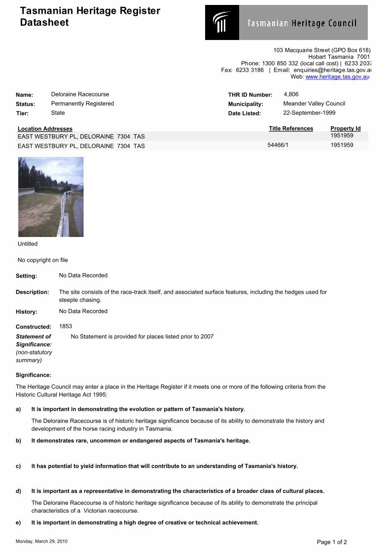
Tasmanian Heritage Register Datasheet
103 Macquarie Street (GPO Box 618) Hobart Tasmania 7001
Phone: 1300 850 332 (local call cost) | 6233 2037 Fax: 6233 3186 | Email: [email protected]
Web: www.heritage.tas.gov.au
Name: Deloraine Racecourse THR ID Number: 4,806
Status: Permanently Registered Municipality: Meander Valley Council
Location Addresses Title References Property Id1951959EAST WESTBURY PL, DELORAINE 7304 TAS
54466/1 1951959EAST WESTBURY PL, DELORAINE 7304 TAS
Tier: State Date Listed: 22-September-1999
Untitled
No copyright on file
Setting: No Data Recorded
Description: The site consists of the race-track itself, and associated surface features, including the hedges used for
steeple chasing.
History: No Data Recorded
Constructed: 1853
Statement of
Significance:
(non-statutory
summary)
No Statement is provided for places listed prior to 2007
The Heritage Council may enter a place in the Heritage Register if it meets one or more of the following criteria from the
Historic Cultural Heritage Act 1995:
Significance:
The Deloraine Racecourse is of historic heritage significance because of its ability to demonstrate the history and
development of the horse racing industry in Tasmania.
It is important in demonstrating the evolution or pattern of Tasmania's history.a)
b) It demonstrates rare, uncommon or endangered aspects of Tasmania's heritage.
c) It has potential to yield information that will contribute to an understanding of Tasmania's history.
d)
The Deloraine Racecourse is of historic heritage significance because of its ability to demonstrate the principal
characteristics of a Victorian racecourse.
It is important as a representative in demonstrating the characteristics of a broader class of cultural places.
e) It is important in demonstrating a high degree of creative or technical achievement.
Monday, March 29, 2010 Page 1 of 2
f)
This site is of historic heritage significance because its social and recreational associations are regarded as
important to the community's sense of place.
It has strong or special meaning for any group or community because of social, cultural or spiritual
associations.
g) It has a special association with the life or work of a person, a group or an organisation that was important
in Tasmania's history.
PLEASE NOTE This datasheet is intended to provide sufficient information and justification for listing the place on the
Heritage Register. It is not intended to be a comprehensive historical record or inventory of the heritage
Monday, March 29, 2010 Page 2 of 2

32/152910/1/50999 Deloraine WWTFPreliminary Historic Heritage Assessment
Appendix D
DPEMP Guidelines and Excerpt
32/152910/1/50999 Deloraine WWTFPreliminary Historic Heritage Assessment
General Guidelines for the preparation of a Development Proposal and EnvironmentalManagement Plan
Heritage
This section should identify potential effects of the proposal, including the development of infrastructuredirectly related to the proposal, on Aboriginal and non-Aboriginal cultural heritage sites and areas. Itshould identify recommended measures to avoid or mitigate any potential adverse effects on culturalheritage sites and assess the overall effects of the proposal on cultural heritage sites followingimplementation of the proposed avoidance and mitigation measures.
General
Potential effects on the following should be addressed (where relevant):
a) Declared World Heritage Area properties and values.
b) Any places listed on the National Heritage List and values.
c) Any places listed or interim listed on the Register of the National Estate and values.
d) Any places listed on the Tasmanian Heritage Register (maintained by the Tasmanian HeritageCouncil), including consideration of cultural landscapes.
e) Any places on the Tasmanian Historic Places Inventory (maintained by the Tasmanian HeritageOffice).
f) Any places on the Tasmanian Aboriginal Site Index (maintained by the Tasmanian Heritage Office),including consideration of cultural landscapes.
g) Local government planning scheme heritage schedules.
h) Any other places of heritage significance.
Historic HeritageThe advice of the Tasmanian Heritage Office should be sought with regard to effects on places listed onthe Tasmanian Heritage Register and to establish regulatory requirements for heritage values, placesand landscapes. Any approvals required under the Historic Cultural Heritage Act 1995 should beidentified.
32/152910/1/50999 Deloraine WWTFPreliminary Historic Heritage Assessment
Excerpt from DPEMP document
Historic Heritage
The Site itself is permanently entered in the Tasmanian Heritage Register for its significant historical,representative and social values. The racecourse is also included on the Register of the National Trustof Australia (Tasmania).
Consideration of the potential effects of the proposal on the racecourse will be separately reported andsubject to approval from the Tasmanian Heritage Council and Meander Valley Council.
Heritage places in proximity to the Site have also been previously identified. This includes 12 buildings,primarily housing, located on Grigg and Railway Street in the Meander Valley Heritage Study. Theidentified buildings are located to the south of the Site and are primarily orientated towards the publicroads. These places have been identified as having both State and Local heritage significance. Theseplaces vary in distance from the proposed development area, ranging from approximately 400-600metres for proposed development.
The Railway Platforms & Weighbridge have been identified as having State level significance and isadjacent to the Deloraine Racecourse. This site is located approximately 550 metres to the south of theproposed development area.
None of the places identified in the Meander Valley Heritage Study have been included in the TasmanianHeritage Register, the Meander Valley Planning Scheme, or the draft Meander Valley Planning Scheme2007.
4.10 Heritage
4.10.1 Legislative and Policy Requirements
The key legislation and policy relating to heritage and of relevance to the site are:
The Aboriginal Relics Act 1975 – which governs the treatment of Aboriginal relics and protected sitesin Tasmania. It is an offence to destroy, damage, deface, conceal or otherwise interfere with a relic.If any Aboriginal Heritage sites, relics or features are identified during the construction phase, worksshall cease and advice will be sought from Aboriginal Heritage Tasmania prior to re-commencementof works;
The Historic Cultural Heritage Act 1995 – which establishes the Tasmanian Heritage Council, theTasmanian Heritage Register and the processes for considering works to heritage listed places;
Part 7: Meander Valley Planning Scheme 1995 – which applies to the use and development ofplaces of cultural significance that are on the Register of the National Trust of Australia (Tasmania),or Register of the National Estate; and
The DPEMP General Guidelines – which refer to identifying potential effects of the proposal onHeritage Sites and Areas.
4.10.2 Performance Requirements
As highlighted above, under the Aboriginal Relics Act 1975, a permit is required for the destruction,damage, defacement, concealment or otherwise interference of a relic. Although no relics have beenlocated at the site, the provisions of the Aboriginal Relics Act 1975 remain applicable if relics areidentified during site works.
32/152910/1/50999 Deloraine WWTFPreliminary Historic Heritage Assessment
Under the Historic Cultural Heritage Act 1995, a person must not carry out any works in relation to aregistered place or a place within a Heritage Area which may affect the historic cultural significance ofthe place unless the works are approved by the Heritage Council. As the Racecourse site ispermanently entered in the Heritage Register, the proposed development will require the approval of theHeritage Council.
The Racecourse is also included on the Register of the National Trust, and as such the use anddevelopment of this place will require the approval of the MVC. Consideration of the potential effects ofthe proposal on the racecourse will be separately reported and subject to approval from the TasmanianHeritage Council and MVC.
Neither the Historic Cultural Heritage Act 1995 nor the Meander Valley Planning Scheme 1995 createprovisions for consideration of potential impacts from development adjacent to a Heritage place.
4.10.3 Background Heritage Values
No Aboriginal Heritage Sites were located at the development site in the 2002 survey.
The site itself is permanently included in the Tasmanian Heritage Register and on the Register of theNational Trust.
Numerous built heritage places were identified in the Meander Valley Heritage Study, varying in distancefrom the proposed development area, from approximately 400 m to 600 m away.
4.10.3 Construction Impacts and Mitigation
As already indicated, if any Aboriginal Heritage sites, relics or features are identified during theconstruction phase, works shall cease and advice will be sought from Aboriginal Heritage Tasmania priorto re-commencement of works.
As the Deloraine Racecourse is a heritage area and the development includes a change to the natural orexisting condition or topography of land, it therefore requires approval by the Tasmanian HeritageCouncil under Part 6 of the Historic Cultural Heritage Act 1995. The potential construction impacts onthe historical significant racecourse site have been considered with the findings being presented in theHeritage Impact Assessment Report (Appendix J).
The Heritage Council assessing the Deloraine Waste Water Treatment Plant have also recommendedthat a Landscape Plan be prepared for the affected area which minimises the visual impact on theheritage site and existing landscape character to assist in assessing the impact of the development. ALandscape Character Assessment and Schematic Landscape Plan Report (Appendix K) has beenprepared to assist in mitigating the visual impact on the heritage site and existing landscape characterfrom the development.
4.10.3 Operational Impacts and Mitigation
No adverse impacts are anticipated from the operations of the proposed development on eitherAboriginal or historic heritage. Accordingly, no specific mitigation measures are necessary.
Consideration of potential operational impacts on the historic cultural heritage significance of theRacecourse will be separately reported.
Ben Lomond Water
Report for Deloraine WasteWater Treatment Plant
Landscape Character Assessment andSchematic Landscape Plan Report
June 2010
32/15291/50950 Deloraine Waste Water Treatment PlantLandscape Character Assessment and Schematic Landscape Plan Report
Contents
1. Introduction 1
1.1 Purpose of report 1
2. Existing Landscape Character 2
2.1 Context 2
2.2 Deloraine Racecourse 2
2.3 Summary of landscape character 7
2.4 Site Analysis (following page) 7
3. Impact of WWTP Upgrade on Landscape Character 9
4. Recommendations 10
5. Schematic Landscape Plan 11
132/15291/50950 Deloraine Waste Water Treatment PlantLandscape Character Assessment and Schematic Landscape Plan Report
1. Introduction
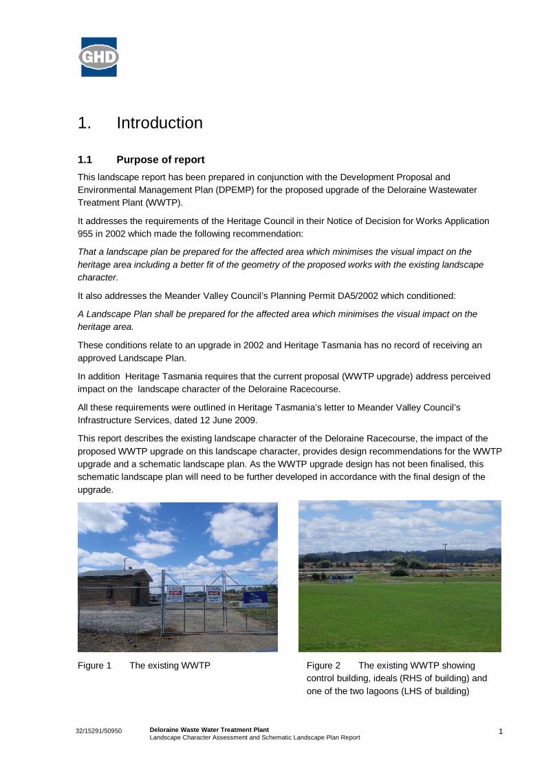
1.1 Purpose of reportThis landscape report has been prepared in conjunction with the Development Proposal andEnvironmental Management Plan (DPEMP) for the proposed upgrade of the Deloraine WastewaterTreatment Plant (WWTP).
It addresses the requirements of the Heritage Council in their Notice of Decision for Works Application955 in 2002 which made the following recommendation:
That a landscape plan be prepared for the affected area which minimises the visual impact on theheritage area including a better fit of the geometry of the proposed works with the existing landscapecharacter.
It also addresses the Meander Valley Council’s Planning Permit DA5/2002 which conditioned:
A Landscape Plan shall be prepared for the affected area which minimises the visual impact on theheritage area.
These conditions relate to an upgrade in 2002 and Heritage Tasmania has no record of receiving anapproved Landscape Plan.
In addition Heritage Tasmania requires that the current proposal (WWTP upgrade) address perceivedimpact on the landscape character of the Deloraine Racecourse.
All these requirements were outlined in Heritage Tasmania’s letter to Meander Valley Council’sInfrastructure Services, dated 12 June 2009.
This report describes the existing landscape character of the Deloraine Racecourse, the impact of theproposed WWTP upgrade on this landscape character, provides design recommendations for the WWTPupgrade and a schematic landscape plan. As the WWTP upgrade design has not been finalised, thisschematic landscape plan will need to be further developed in accordance with the final design of theupgrade.
Figure 1 The existing WWTP Figure 2 The existing WWTP showingcontrol building, ideals (RHS of building) andone of the two lagoons (LHS of building)
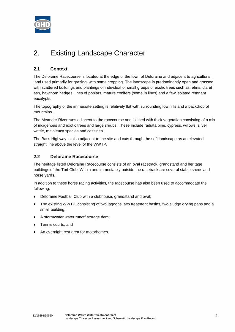
232/15291/50950 Deloraine Waste Water Treatment PlantLandscape Character Assessment and Schematic Landscape Plan Report
2. Existing Landscape Character
2.1 ContextThe Deloraine Racecourse is located at the edge of the town of Deloraine and adjacent to agriculturalland used primarily for grazing, with some cropping. The landscape is predominantly open and grassedwith scattered buildings and plantings of individual or small groups of exotic trees such as: elms, claretash, hawthorn hedges, lines of poplars, mature conifers (some in lines) and a few isolated remnanteucalypts.
The topography of the immediate setting is relatively flat with surrounding low hills and a backdrop ofmountains.
The Meander River runs adjacent to the racecourse and is lined with thick vegetation consisting of a mixof indigenous and exotic trees and large shrubs. These include radiata pine, cypress, willows, silverwattle, melaleuca species and cassinea.
The Bass Highway is also adjacent to the site and cuts through the soft landscape as an elevatedstraight line above the level of the WWTP.
2.2 Deloraine RacecourseThe heritage listed Deloraine Racecourse consists of an oval racetrack, grandstand and heritagebuildings of the Turf Club. Within and immediately outside the racetrack are several stable sheds andhorse yards.
In addition to these horse racing activities, the racecourse has also been used to accommodate thefollowing:
Deloraine Football Club with a clubhouse, grandstand and oval;
The existing WWTP, consisting of two lagoons, two treatment basins, two sludge drying pans and asmall building;
A stormwater water runoff storage dam;
Tennis courts; and
An overnight rest area for motorhomes.
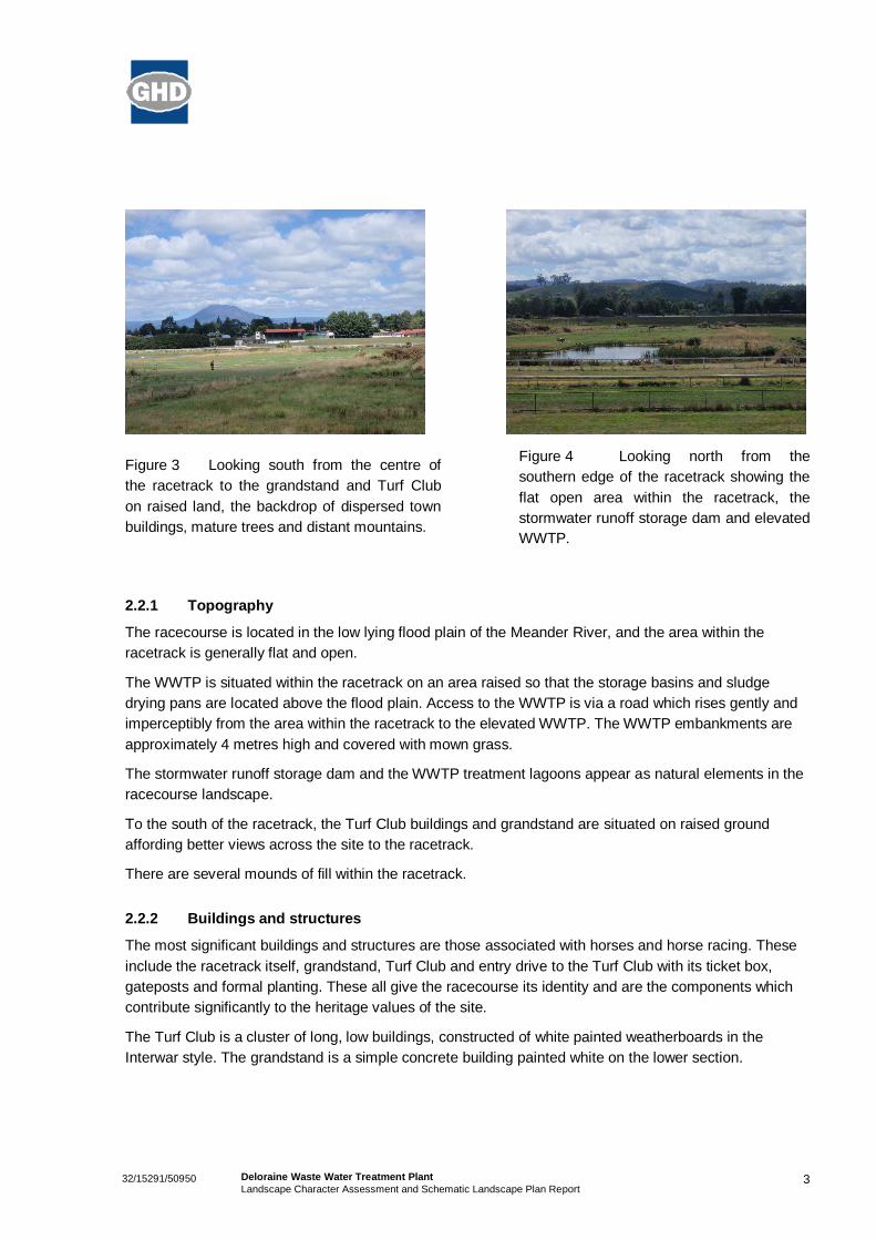
332/15291/50950 Deloraine Waste Water Treatment PlantLandscape Character Assessment and Schematic Landscape Plan Report
Figure 3 Looking south from the centre ofthe racetrack to the grandstand and Turf Clubon raised land, the backdrop of dispersed townbuildings, mature trees and distant mountains.
Figure 4 Looking north from thesouthern edge of the racetrack showing theflat open area within the racetrack, thestormwater runoff storage dam and elevatedWWTP.
2.2.1 Topography
The racecourse is located in the low lying flood plain of the Meander River, and the area within theracetrack is generally flat and open.
The WWTP is situated within the racetrack on an area raised so that the storage basins and sludgedrying pans are located above the flood plain. Access to the WWTP is via a road which rises gently andimperceptibly from the area within the racetrack to the elevated WWTP. The WWTP embankments areapproximately 4 metres high and covered with mown grass.
The stormwater runoff storage dam and the WWTP treatment lagoons appear as natural elements in theracecourse landscape.
To the south of the racetrack, the Turf Club buildings and grandstand are situated on raised groundaffording better views across the site to the racetrack.
There are several mounds of fill within the racetrack.
2.2.2 Buildings and structures
The most significant buildings and structures are those associated with horses and horse racing. Theseinclude the racetrack itself, grandstand, Turf Club and entry drive to the Turf Club with its ticket box,gateposts and formal planting. These all give the racecourse its identity and are the components whichcontribute significantly to the heritage values of the site.
The Turf Club is a cluster of long, low buildings, constructed of white painted weatherboards in theInterwar style. The grandstand is a simple concrete building painted white on the lower section.
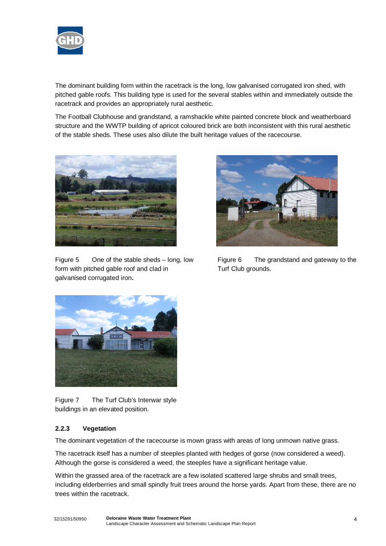
432/15291/50950 Deloraine Waste Water Treatment PlantLandscape Character Assessment and Schematic Landscape Plan Report
The dominant building form within the racetrack is the long, low galvanised corrugated iron shed, withpitched gable roofs. This building type is used for the several stables within and immediately outside theracetrack and provides an appropriately rural aesthetic.
The Football Clubhouse and grandstand, a ramshackle white painted concrete block and weatherboardstructure and the WWTP building of apricot coloured brick are both inconsistent with this rural aestheticof the stable sheds. These uses also dilute the built heritage values of the racecourse.
Figure 5 One of the stable sheds – long, lowform with pitched gable roof and clad ingalvanised corrugated iron.
Figure 6 The grandstand and gateway to theTurf Club grounds.
Figure 7 The Turf Club’s Interwar stylebuildings in an elevated position.
2.2.3 Vegetation
The dominant vegetation of the racecourse is mown grass with areas of long unmown native grass.
The racetrack itself has a number of steeples planted with hedges of gorse (now considered a weed).Although the gorse is considered a weed, the steeples have a significant heritage value.
Within the grassed area of the racetrack are a few isolated scattered large shrubs and small trees,including elderberries and small spindly fruit trees around the horse yards. Apart from these, there are notrees within the racetrack.
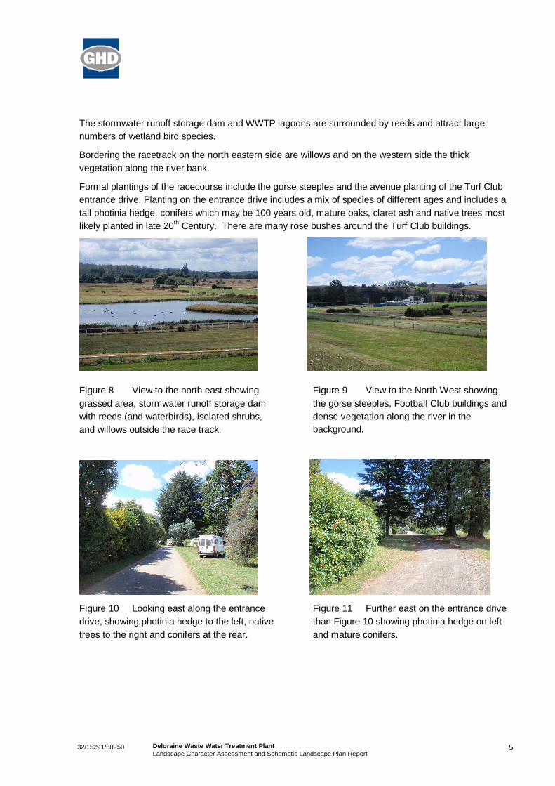
532/15291/50950 Deloraine Waste Water Treatment PlantLandscape Character Assessment and Schematic Landscape Plan Report
The stormwater runoff storage dam and WWTP lagoons are surrounded by reeds and attract largenumbers of wetland bird species.
Bordering the racetrack on the north eastern side are willows and on the western side the thickvegetation along the river bank.
Formal plantings of the racecourse include the gorse steeples and the avenue planting of the Turf Clubentrance drive. Planting on the entrance drive includes a mix of species of different ages and includes atall photinia hedge, conifers which may be 100 years old, mature oaks, claret ash and native trees mostlikely planted in late 20th Century. There are many rose bushes around the Turf Club buildings.
Figure 8 View to the north east showinggrassed area, stormwater runoff storage damwith reeds (and waterbirds), isolated shrubs,and willows outside the race track.
Figure 9 View to the North West showingthe gorse steeples, Football Club buildings anddense vegetation along the river in thebackground.
Figure 10 Looking east along the entrancedrive, showing photinia hedge to the left, nativetrees to the right and conifers at the rear.
Figure 11 Further east on the entrance drivethan Figure 10 showing photinia hedge on leftand mature conifers.
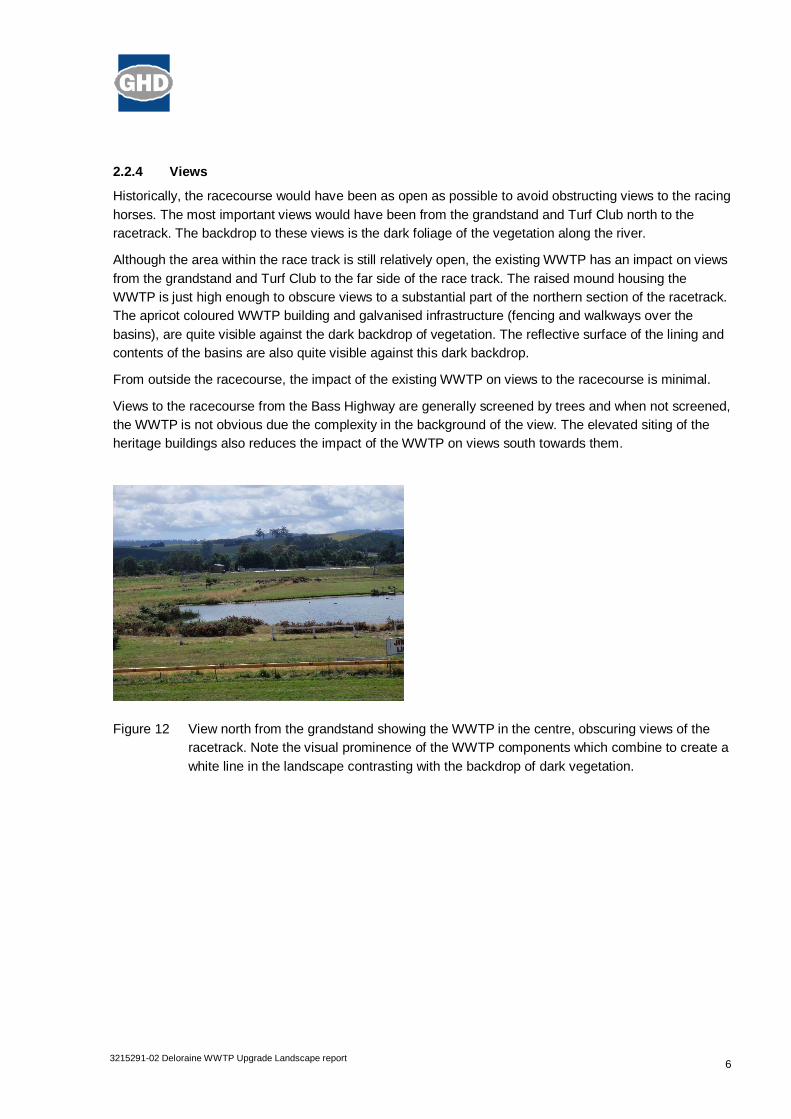
63215291-02 Deloraine WWTP Upgrade Landscape report
2.2.4 Views
Historically, the racecourse would have been as open as possible to avoid obstructing views to the racinghorses. The most important views would have been from the grandstand and Turf Club north to theracetrack. The backdrop to these views is the dark foliage of the vegetation along the river.
Although the area within the race track is still relatively open, the existing WWTP has an impact on viewsfrom the grandstand and Turf Club to the far side of the race track. The raised mound housing theWWTP is just high enough to obscure views to a substantial part of the northern section of the racetrack.The apricot coloured WWTP building and galvanised infrastructure (fencing and walkways over thebasins), are quite visible against the dark backdrop of vegetation. The reflective surface of the lining andcontents of the basins are also quite visible against this dark backdrop.
From outside the racecourse, the impact of the existing WWTP on views to the racecourse is minimal.
Views to the racecourse from the Bass Highway are generally screened by trees and when not screened,the WWTP is not obvious due the complexity in the background of the view. The elevated siting of theheritage buildings also reduces the impact of the WWTP on views south towards them.
Figure 12 View north from the grandstand showing the WWTP in the centre, obscuring views of theracetrack. Note the visual prominence of the WWTP components which combine to create awhite line in the landscape contrasting with the backdrop of dark vegetation.
73215291-02 Deloraine WWTP Upgrade Landscape report
2.3 Summary of landscape characterThe existing landscape character can be summarised as follows:
Rural context;
Flat landscape surrounded by hills;
Site is in a low lying flood plain;
Character related to horses and racing gives identity to the site and contributes to heritage values;
Racecourse character is exemplified by the racetrack, grandstand, Turf Club, formal entry, opennessof the site with views to the racetrack;
Dominant and most appropriate building form is the low corrugated iron shed with a pitched roof,contributing to the rural aesthetic;
Vegetation within the racetrack is generally grass, either mown or unmown native grass, includingreeds around the lagoons;
Taller vegetation within the racetrack is scarce and consists of isolated large shrubs and a few smalltrees;
Open character of racecourse allows clear sightlines to racing horses and is a major contributor tothe landscape character; and
Existing raised WWTP obstructs views across the racecourse.
2.4 Site Analysis (following page)
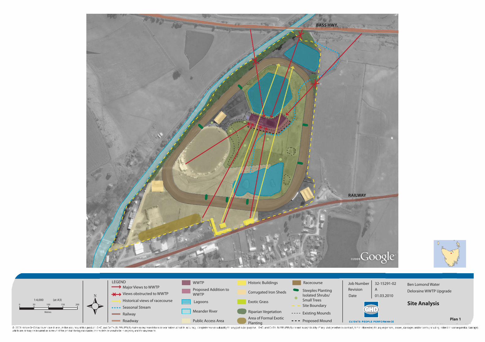
LEGENDMajor Views to WWTP
Historical views of racecourse
Views obstructed to WWTP
Roadway
Railway
Site Boundary
Existing Mounds
Proposed Mound
Seasonal Stream Lagoons
Meander River
Racecourse
Public Access Area
Corrugated Iron Sheds
Exotic Grass
Proposed Addition toWWTP
Riparian Vegetation
Area of Formal Exotic Planting
WWTP Historic Buildings
Isolated Shrubs/ Small Trees
Steeples PlantingBen Lomond Water
Deloraine WWTP Upgrade
Job Number 32-15291-02A
01.03.2010
Revision
Date
Plan 1
Site Analysis500 100
Metres
1:4,000 (at A3)150 200
BASS HWY.
RAILWAY
93215291-02 Deloraine WWTP Upgrade Landscape report
3. Impact of WWTP Upgrade on Landscape Character
The design of the proposed upgrade is not yet final, but at this stage the upgrade is likely to consist of:
Extension to the raised area, creating an embankment approximately 4 metres high (similar to theexisting embankment) and accommodating the following:
– 2 new ideals adjacent to the 2 existing
– 2 new sludge drying pans adjacent to the 2 existing
– 1 to 2 small buildings
– 1 to 2 tanks
– Associated infrastructure such as fencing.
These upgrade works will effectively double the size of the existing WWTP, ideals and sludge dryingpans.
Because the views to the WWTP are generally not close range views, it is considered that the upgradewill not significantly alter the existing impact of the WWTP on the landscape character.
However, the existing WWTP does have an impact particularly when viewed from the south. Analysis ofthe impact of the existing WWTP can assist in developing recommendations to mitigate further impactcaused by the upgrade. It is apparent that the factors contributing to the impact on landscape characterinclude:
Shape, orientation and colour of the buildings;
Height and colour of the tanks;
Colour of fencing and other associated infrastructure;
Reflectivity of basin lining and contents; and
Embankment shape and planting.
103215291-02 Deloraine WWTP Upgrade Landscape report
4. Recommendations
To minimise the impacts of the proposed WWTP upgrade works on the landscape character of theDeloraine Racecourse, it is recommended that the final design incorporate the following:
Shape, orientation and colour of the buildings
The proposed buildings should be as small as possible and oriented to have their shortest sidesfacing south to reduce impact on the most significant views within the racecourse from thegrandstand complex.
The form and materials of the proposed buildings should be similar to the stable buildings to reinforcethe rural aesthetic and racecourse identity. Although this means the buildings will be a light colourwhich increases visibility, it is considered that relating to the rural shed aesthetic is more importantthan reduced visibility.
Height and colour of the tanks
The proposed tank form is not related to the character of the racecourse. They should be locatedunderground if possible to render them invisible. If this is not possible, they should be a dark colour(eg black or dark grey) to reduce their visibility against the backdrop of dark vegetation when viewedfrom the southern end of the racecourse.
Colour of fencing and other associated infrastructure
The existing fencing and walkways are highly visible due to their light colour. These structures do notrelate to the character of the racecourse and need to have minimal visual impact. The most effectivecolour for reducing visibility of any structure is black. It is recommended that any infrastructure andstructural forms not associated with the racecourse is coloured black or dark grey. Green is notrecommended as it is more highly visible.
Signage should be minimised and located facing east or west.
Reflectivity of basin lining and contents
Raise the top of the embankment slightly to provide additional screening of basin contents. Note thatdrainage should be provided from the inside of the embankments to the outer slopes.
Investigate lining material which is non reflective and will not hold sediment which can be reflective.
Embankment shape and planting
Embankment shape should avoid defined corners and be rounded at corners to reflect the softnessof the landscape.
Embankments should be planted with similar plant types to the existing vegetation within theracetrack ie grasses and occasional large shrubs or small trees. Whilst dense planting on theembankment would visually screen the WWTP, it would also be inconsistent with the existingpredominant landscape character of openness.
Planting layout should break up the definitive edges of the embankment.
113215291-02 Deloraine WWTP Upgrade Landscape report
5. Schematic Landscape Plan
The schematic landscape plan includes the above recommendations for materials, colour and forms ofthe building and infrastructure.
It shows a slightly raised embankment edge to assist with screening the basins and shaping of theembankment at the corner to avoid defined lines.
The planting on the embankment is all native grasses with isolated large shrubs to maintain the opencharacter of the racecourse. This type of planting also has advantages that, once established, there willbe lower maintenance requirements than mown grass and the use of native grasses is moreenvironmentally sustainable.
The layout of the planting uses overlapping lines of plants to help break up the definitive edges of theembankment.
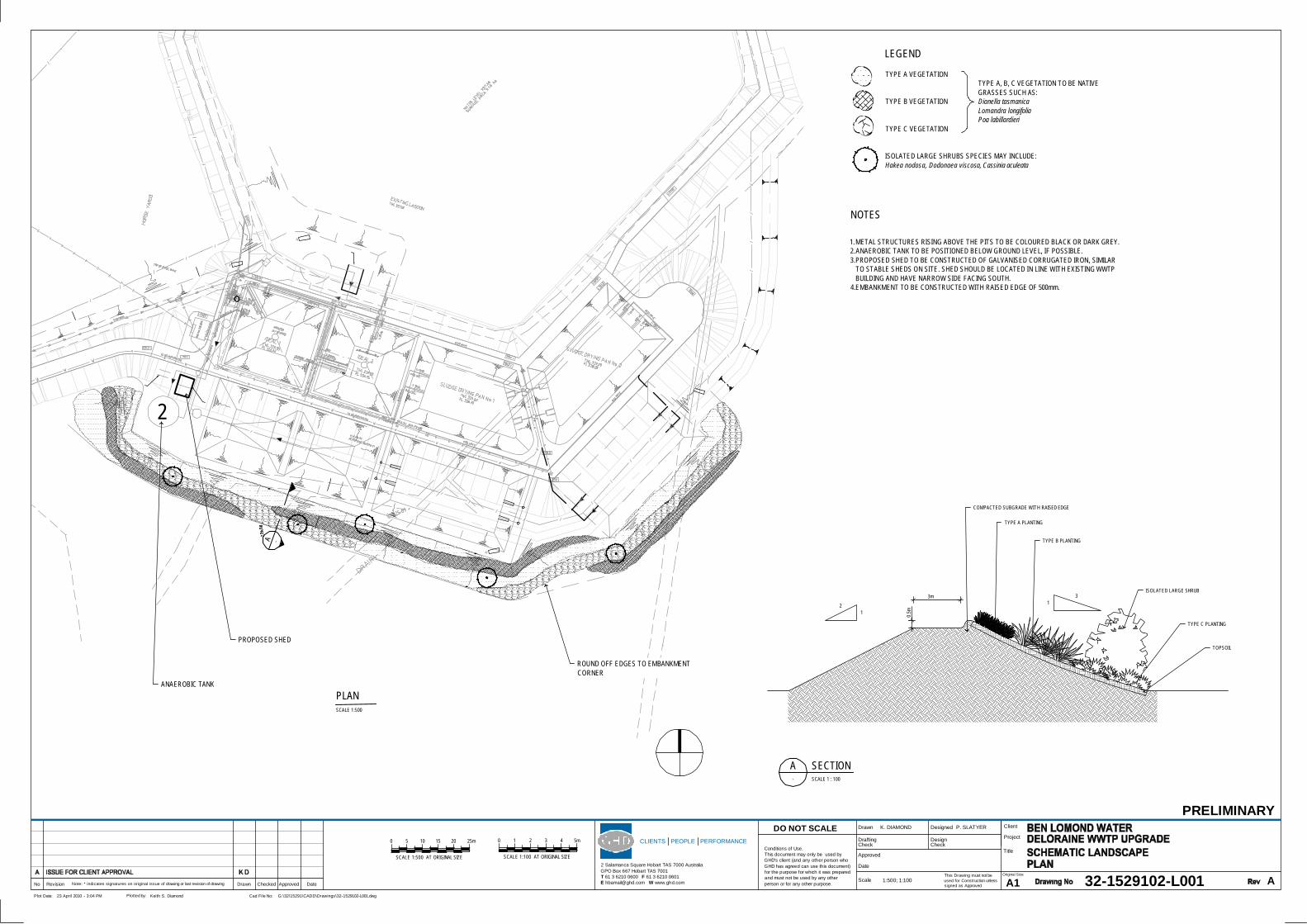
A -
2
PROPOSED SHED
ANAEROBIC TANK
ROUND OFF EDGES TO EMBANKMENTCORNER
3m
0.5m
21
31
TYPE A PLANTING
TYPE B PLANTING
ISOLATED LARGE SHRUB
TOPSOIL
COMPACTED SUBGRADE WITH RAISED EDGE
TYPE C PLANTING
LEGEND
TYPE A VEGETATION
TYPE B VEGETATION
TYPE C VEGETATION
ISOLATED LARGE SHRUBS SPECIES MAY INCLUDE:Hakea nodosa, Dodonaea viscosa, Cassinia aculeata
TYPE A, B, C VEGETATION TO BE NATIVEGRASSES SUCH AS:Dianella tasmanicaLomandra longifoliaPoa labillardieri
NOTES
1.METAL STRUCTURES RISING ABOVE THE PITS TO BE COLOURED BLACK OR DARK GREY.2.ANAEROBIC TANK TO BE POSITIONED BELOW GROUND LEVEL, IF POSSIBLE.3.PROPOSED SHED TO BE CONSTRUCTED OF GALVANISED CORRUGATED IRON, SIMILAR
TO STABLE SHEDS ON SITE. SHED SHOULD BE LOCATED IN LINE WITH EXISTING WWTPBUILDING AND HAVE NARROW SIDE FACING SOUTH.
4.EMBANKMENT TO BE CONSTRUCTED WITH RAISED EDGE OF 500mm.
This Drawing must not beused for Construction unlesssigned as Approved
Date
CheckDrafting
DateApprovedCheckedDrawnRevisionNo A1Original Size
Title
Project
Client
Check
Designed
Approved
Drawn
Scale
DesignConditions of Use.This document may only be used byGHD's client (and any other person whoGHD has agreed can use this document)for the purpose for which it was preparedand must not be used by any otherperson or for any other purpose.
DO NOT SCALE
Note: * indicates signatures on original issue of drawing or last revision of drawing
CLIENTS PEOPLE PERFORMANCE
2 Salamanca Square Hobart TAS 7000 AustraliaGPO Box 667 Hobart TAS 7001T 61 3 6210 0600 F 61 3 6210 0601E [email protected] W www.ghd.com
Plot Date: Cad File No:23 April 2010 - 3:04 PM G:\32\15291\CADD\Drawings\32-1529102-L001.dwgPlotted by: Keith S. Diamond
PRELIMINARY
32-1529102-L001 A
K. DIAMOND P. SLATYER
1:500; 1:100
SECTIONA- SCALE 1 : 100
0 5 20 25m1510
SCALE 1:500 AT ORIGINAL SIZE
0 1 4 5m32
SCALE 1:100 AT ORIGINAL SIZE
PLANSCALE 1:500
32/15291/50950 Deloraine Waste Water Treatment PlantLandscape Character Assessment and Schematic Landscape Plan Report
GHD
2 Salamanca Square Hobart 7000GPO Box 667 Hobart 7001T: 03 6210 0600 F: 03 6210 0601 E: [email protected]
© GHD 2010
This document is and shall remain the property of GHD. The document may only be used for the purposefor which it was commissioned and in accordance with the Terms of Engagement for the commission.Unauthorised use of this document in any form whatsoever is prohibited.
Document Status
Reviewer Approved for IssueRevNo. Author
Name Signature Name Signature Date
0 P. Slatyer K. Diamond J. Woodworth 02.06.10