Embed Size (px)
Citation preview

Collaborative Project
GeoKnow - Making the Web an Exploratory forGeospatial KnowledgeProject Number: 318159 Start Date of Project: 2012/12/01 Duration: 36 months
Deliverable 7.1.5GeoKnow Show CaseDissemination Level Public
Due Date of Deliverable Month 32, 31/07/2015
Actual Submission Date Month 32, 31/07/2015
Work Package WP 7
Task T 7.1
Type Report
Approval Status Approved
Version 1.0
Number of Pages 25
Filename D7.1.5 GeoKnow Show Case.pdf
Abstract: In this document we report the collected Use Cases that were accomplished thanks to theGeoKnow tools and datasets. Besides the official GeoKnow use cases, additional ones are also reported.
The information in this document reflects the author’s views and the European Community is not liable for any use that may be made of the
information contained therein. The information in this document is provided ”as is” without guarantee or warranty of any kind, express or
implied, including but not limited to the fitness of the information for a particular purpose. The user thereof uses the information at his/ her
sole risk and liability.
Project funded by the European Commission within the Seventh Framework Programme (2007 - 2013)

D7.1.5 - v. 1.0. . . . . . . . . . . . . . . . . . . . . . . . . . . . . . . . . . . . . . . . . . . . . . . . . . . . . . . . . . . . . . . . . . . . . . . . . . . . . . . . . . . . . . . . . . . . . . . . . . . .
History
Version Date Reason Revised by
0.1 01/06/2015 Draft of this document Alejandra Garcia Rojas M.
0.2 15/06/2015 Use Cases call for contribution Alejandra Garcia Rojas M.
0.5 20/07/2017 Compilation of Use Cases Alejandra Garcia Rojas M.
0.7 21/02/2013 Internal and Peer Review Andreas Both
0.8 22/02/2013 Address comments from reviews Alejandra Garcia Rojas M. andGiorgos Giannopoulos
1.0 29/02/2013 Approval Daniel Hladky
Author List
Organization Name Contact Information
Ontos Alejandra Garcia Rojas M. [email protected]
Athena Giorgos Giannopoulos [email protected]
Unister Matthias Wauer [email protected]
IMP Valentina Janev [email protected]
IMP Uroš Miloševic [email protected]
InfAI Claus Stadler [email protected]
Brox Robert Isele [email protected]
. . . . . . . . . . . . . . . . . . . . . . . . . . . . . . . . . . . . . . . . . . . . . . . . . . . . . . . . . . . . . . . . . . . . . . . . . . . . . . . . . . . . . . . . . . . . . . . . . . . .
Page 1

D7.1.5 - v. 1.0. . . . . . . . . . . . . . . . . . . . . . . . . . . . . . . . . . . . . . . . . . . . . . . . . . . . . . . . . . . . . . . . . . . . . . . . . . . . . . . . . . . . . . . . . . . . . . . . . . . .
Executive Summary
This report aims to provide a summarised overview of GeoKnow software tools and datasets created during theproject. Then, a collection of ten use cases where these tools and datasets are used. These use cases includethe official ones: Tourism e-Comerce from Unister and Supply Chain by Brox. The rest of the use cases reportedare from different partners in the consortium. These include e-government, industry, creative commons andcrisis management use cases.
. . . . . . . . . . . . . . . . . . . . . . . . . . . . . . . . . . . . . . . . . . . . . . . . . . . . . . . . . . . . . . . . . . . . . . . . . . . . . . . . . . . . . . . . . . . . . . . . . . . .
Page 2

D7.1.5 - v. 1.0. . . . . . . . . . . . . . . . . . . . . . . . . . . . . . . . . . . . . . . . . . . . . . . . . . . . . . . . . . . . . . . . . . . . . . . . . . . . . . . . . . . . . . . . . . . . . . . . . . . .
Table of Contents
1 Introduction 5
2 GeoKnow Software Stack 6
3 Public Datasets 8
3.1 LinkedGeoData . . . . . . . . . . . . . . . . . . . . . . . . . . . . . . . . . . . . . . . . . . . 8
3.2 Wikimapia . . . . . . . . . . . . . . . . . . . . . . . . . . . . . . . . . . . . . . . . . . . . . . 8
3.3 Seven Greek INSPIRE-compliant data themes of Annex I . . . . . . . . . . . . . . . . . . . . . 9
4 Use Cases 11
4.1 Tourism E-Commerce . . . . . . . . . . . . . . . . . . . . . . . . . . . . . . . . . . . . . . . . 11
4.2 Supply Chain . . . . . . . . . . . . . . . . . . . . . . . . . . . . . . . . . . . . . . . . . . . . 12
4.3 Exposing INSPIRE SDI as RDF . . . . . . . . . . . . . . . . . . . . . . . . . . . . . . . . . . . . 12
4.4 LINDAS : e-Government Services . . . . . . . . . . . . . . . . . . . . . . . . . . . . . . . . . 14
4.5 Statistical Data in the Serbian CKAN . . . . . . . . . . . . . . . . . . . . . . . . . . . . . . . . 15
4.6 Spatio-temporal analysis for the SBRA . . . . . . . . . . . . . . . . . . . . . . . . . . . . . . . 16
4.7 Continental Automotive GmbH . . . . . . . . . . . . . . . . . . . . . . . . . . . . . . . . . . . 17
4.8 Tourist Guides . . . . . . . . . . . . . . . . . . . . . . . . . . . . . . . . . . . . . . . . . . . . 18
4.9 Crisis Management and Semantic Routing . . . . . . . . . . . . . . . . . . . . . . . . . . . . . 18
4.10 Validating Geospatial coordinates in DBpedia . . . . . . . . . . . . . . . . . . . . . . . . . . . 21
5 Conclusions 23
6 References 24
. . . . . . . . . . . . . . . . . . . . . . . . . . . . . . . . . . . . . . . . . . . . . . . . . . . . . . . . . . . . . . . . . . . . . . . . . . . . . . . . . . . . . . . . . . . . . . . . . . . .
Page 3

D7.1.5 - v. 1.0. . . . . . . . . . . . . . . . . . . . . . . . . . . . . . . . . . . . . . . . . . . . . . . . . . . . . . . . . . . . . . . . . . . . . . . . . . . . . . . . . . . . . . . . . . . . . . . . . . . .
List of Figures
1 Linked Data Lyfecicle . . . . . . . . . . . . . . . . . . . . . . . . . . . . . . . . . . . . . . . . 5
2 Transformation flow of INSPIRE data . . . . . . . . . . . . . . . . . . . . . . . . . . . . . . . . 11
3 The supply chain dashboard . . . . . . . . . . . . . . . . . . . . . . . . . . . . . . . . . . . . 12
4 Transformation flow of INSPIRE data . . . . . . . . . . . . . . . . . . . . . . . . . . . . . . . . 13
5 Data provider- LINDAS-plattform - data user . . . . . . . . . . . . . . . . . . . . . . . . . . . 14
6 Publishing Linked Open Data . . . . . . . . . . . . . . . . . . . . . . . . . . . . . . . . . . . . 15
7 Assessing quality of the dataset with the RDF Data Cube Validation Tool . . . . . . . . . . . . 16
8 Visualising spatio-temporal data with ESTA-LD . . . . . . . . . . . . . . . . . . . . . . . . . . 17
9 Facete within the data generation process at Continental . . . . . . . . . . . . . . . . . . . . 18
10 Interactive maps with Mappify . . . . . . . . . . . . . . . . . . . . . . . . . . . . . . . . . . . 19
11 Mobile tourist guide, GEM . . . . . . . . . . . . . . . . . . . . . . . . . . . . . . . . . . . . . 19
12 Semantic routing architecture . . . . . . . . . . . . . . . . . . . . . . . . . . . . . . . . . . . 20
13 Routing visualisation in GEM . . . . . . . . . . . . . . . . . . . . . . . . . . . . . . . . . . . . 20
14 Flowchart showing the test-driven data quality methodology. The left part displays the inputsources of our pattern library. In the middle part the different ways of pattern instantiation areshown which lead to the Data Quality Test Cases on the right. . . . . . . . . . . . . . . . . . 21
List of Tables
1 GeoKnow Generator Stack of tools . . . . . . . . . . . . . . . . . . . . . . . . . . . . . . . . . 6
2 Greek INSPIRE Datasets in RDF . . . . . . . . . . . . . . . . . . . . . . . . . . . . . . . . . . . 10
. . . . . . . . . . . . . . . . . . . . . . . . . . . . . . . . . . . . . . . . . . . . . . . . . . . . . . . . . . . . . . . . . . . . . . . . . . . . . . . . . . . . . . . . . . . . . . . . . . . .
Page 4
D7.1.5 - v. 1.0. . . . . . . . . . . . . . . . . . . . . . . . . . . . . . . . . . . . . . . . . . . . . . . . . . . . . . . . . . . . . . . . . . . . . . . . . . . . . . . . . . . . . . . . . . . . . . . . . . . .
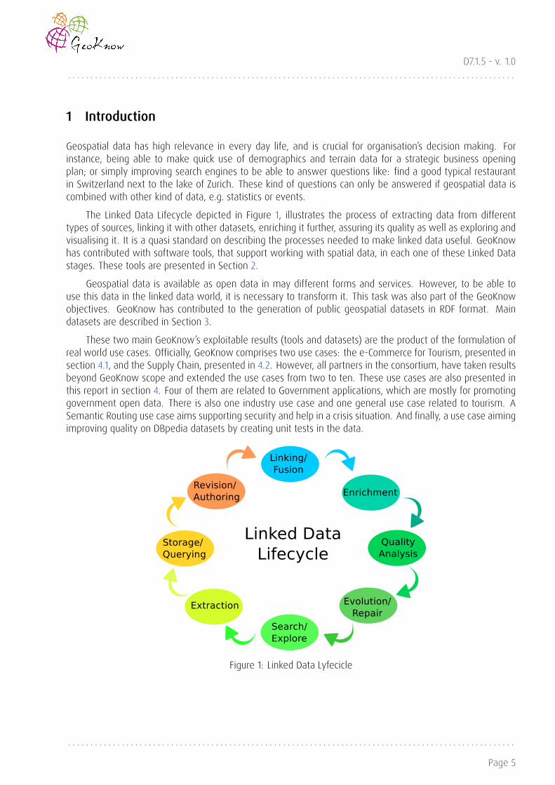
1 Introduction
Geospatial data has high relevance in every day life, and is crucial for organisation’s decision making. Forinstance, being able to make quick use of demographics and terrain data for a strategic business openingplan; or simply improving search engines to be able to answer questions like: find a good typical restaurantin Switzerland next to the lake of Zurich. These kind of questions can only be answered if geospatial data iscombined with other kind of data, e.g. statistics or events.
The Linked Data Lifecycle depicted in Figure 1, illustrates the process of extracting data from differenttypes of sources, linking it with other datasets, enriching it further, assuring its quality as well as exploring andvisualising it. It is a quasi standard on describing the processes needed to make linked data useful. GeoKnowhas contributed with software tools, that support working with spatial data, in each one of these Linked Datastages. These tools are presented in Section 2.
Geospatial data is available as open data in may different forms and services. However, to be able touse this data in the linked data world, it is necessary to transform it. This task was also part of the GeoKnowobjectives. GeoKnow has contributed to the generation of public geospatial datasets in RDF format. Maindatasets are described in Section 3.
These two main GeoKnow’s exploitable results (tools and datasets) are the product of the formulation ofreal world use cases. Officially, GeoKnow comprises two use cases: the e-Commerce for Tourism, presented insection 4.1, and the Supply Chain, presented in 4.2. However, all partners in the consortium, have taken resultsbeyond GeoKnow scope and extended the use cases from two to ten. These use cases are also presented inthis report in section 4. Four of them are related to Government applications, which are mostly for promotinggovernment open data. There is also one industry use case and one general use case related to tourism. ASemantic Routing use case aims supporting security and help in a crisis situation. And finally, a use case aimingimproving quality on DBpedia datasets by creating unit tests in the data.
Figure 1: Linked Data Lyfecicle
. . . . . . . . . . . . . . . . . . . . . . . . . . . . . . . . . . . . . . . . . . . . . . . . . . . . . . . . . . . . . . . . . . . . . . . . . . . . . . . . . . . . . . . . . . . . . . . . . . . .
Page 5

D7.1.5 - v. 1.0. . . . . . . . . . . . . . . . . . . . . . . . . . . . . . . . . . . . . . . . . . . . . . . . . . . . . . . . . . . . . . . . . . . . . . . . . . . . . . . . . . . . . . . . . . . . . . . . . . . .
2 GeoKnow Software Stack
GeoKnow generator has contributed to the Linked Data Stack¹ with several components for the different dataprocessing and management stages. Table 1 presents GeoKnow software tools within its lifecycle stage andlists the use cases where tool are used. Section 4 describe such use cases.
Table 1: GeoKnow Generator Stack of tools
Name Description Usecase
Extraction and Loading
TripleGeo Tool for converting data in geospatialformats into RDF triples [9]
e-Commerce, INSPIRE to RDF
TripleGeoService A web service for TripleGeo e-Commerce
Sparqlify SPARQL to SQL rewriter [12] e-Commerce, Supply Chain
Storage and Querying
Virtuoso RDF Triple store e-Commerce, Supply Chain, IN-SPIRE to RDF, LINDAS, SerbianCKAN
Interlinking and Fusing
LIMES Link discovery framework [8] part of LIMES-Service
LIMES-Service A web service for Limes e-Commerce, Supply Chain
FAGI-gis Tool for fusing geospatial features ofRDF data [3]
e-Commerce, INSPIRE to RDF
Classification and Enrichment
DEER Framework to enrich geographic con-tent in the Semantic Web [10]
e-Commerce
Deer-Service A web service for Deer e-Commerce
Manual Revision and Authoring
REX RDF Edit eXtension system. Allows thegeneration of dynamic HTML forms forRDF data.
e-Commerce, and is part ofFacete
Quality Analysis
rdfunit-webdemo Test driven data-debugging framework[5]
Validating DBpedia
RDF Data Cube Validation Tool Quality Analysis and Repair of RDF DataCubes
Serbian CKAN
¹http://stack.linkeddata.org/
. . . . . . . . . . . . . . . . . . . . . . . . . . . . . . . . . . . . . . . . . . . . . . . . . . . . . . . . . . . . . . . . . . . . . . . . . . . . . . . . . . . . . . . . . . . . . . . . . . . .
Page 6

D7.1.5 - v. 1.0. . . . . . . . . . . . . . . . . . . . . . . . . . . . . . . . . . . . . . . . . . . . . . . . . . . . . . . . . . . . . . . . . . . . . . . . . . . . . . . . . . . . . . . . . . . . . . . . . . . .
Coevolution Service Storing graph sets, managing and ap-plying change requests, change re-quest synchronization
e-Commerce
Search Browsing and Exploration
Facete2 Geospatial RDF browser [11] e-Commerce, Supply Chain, Se-mantic Routing
Mappify Js snippet generator Tourist Guide, Semantic Routing
ESTA-LD Exploratory Spatiotemporal Analysis[13]
Serbian CKAN, SBRA
GEM Mobile spatial-semantic visualization,exploration and authoring tool [7]
Tourist Guide, Semantic Routing
Integration Workbench
GeoKnowGeneratorUI An integration platform of severalLinked Data tools can be accessed. Itprovides enterprise ready features suchas authentication, dataset and tool con-trol access, batch processing and dataprovenance [2].
e-Commerce, Supply Chain, LIN-DAS
. . . . . . . . . . . . . . . . . . . . . . . . . . . . . . . . . . . . . . . . . . . . . . . . . . . . . . . . . . . . . . . . . . . . . . . . . . . . . . . . . . . . . . . . . . . . . . . . . . . .
Page 7

D7.1.5 - v. 1.0. . . . . . . . . . . . . . . . . . . . . . . . . . . . . . . . . . . . . . . . . . . . . . . . . . . . . . . . . . . . . . . . . . . . . . . . . . . . . . . . . . . . . . . . . . . . . . . . . . . .
3 Public Datasets
3.1 LinkedGeoData
Size: 177GB zipped turtle file
URL: http://linkedgeodata.org/
LinkedGeoData is the RDF version of Open Street Map (OSM), which covers the entire planet geospatialdata information. As of September 2014 the zipped xml file from OSM had 36GB of data, while the size ofzipped LGD files in turtle format is 177GB. The detailed description of the dataset can be found in the D1.3.2Continuous Report on Performance Evaluation².
Technically, LinkedGeoData is set of SQL files, database-to-rdf (RDB2RDF) mappings, and bash scripts.The actual RDF conversion is carried out by the SPARQL-to-SQL rewriter Sparqlify. You can view the SparqlifyMappings for LinkedGeoData here. Within The maintenance and improvement of the Mappings required totransform OSM data to RDF has being done during all the project. This dataset has being used in several usecases, but specially for all benchmarking tasks within GeoKnow.
3.2 Wikimapia
URL: http://wikimapia.org/api/
Wikimapia³ is a crowdsourced, open-content, collaborative mapping initiative, where users can contributemapping information. This dataset existed already before the project started. However it was only accessiblethrough Wikimapia’s API⁴ and provided in XML or JSON formats. Within GeoKnow, we downloaded severalsets of geospatial entities from Wikimapia, including both spatial and non-spatial attributes for each entity andtransformed them into RDF data. The process we followed is described next.
We considered a set of cities throughout the world (Athens, London, Leipzig, Berlin, New York) and down-loaded the whole content provided by Wikimapia regarding the geospatial entities included in those geograph-ical areas. These cities where preferred since they are the base cities of several partners in the project, whilethe rest two cities were randomly selected, with the aim to reach our target of more than 100000 spatialentities from Wikimapia. Apart from geometries, Wikimapia provided a very rich set of metadata (non-spatialproperties) for each entity (e.g. tags and categories describing the geospatial entities, topological relationswith nearby entities, comments of the users, etc.).
The aforementioned dumps were transformed into RDF triples in a straightforward way: (a) definingintermediate resources (functioning as blank nodes) where information was organized in more than one levels,(b) flattening the information of deeper levels where possible in order to simplify the structure of the datasetand (c) transforming tags into OWL classes.
Specifically, we developed a parsing tool to communicate with theWikimapia API and construct appropriaten-triples from the dataset. The tool takes as input a bounding box in the form of wgs84 coordinates (min long,min lat, max long, max lat). We chose five initial bounding boxes: one for each of the cities mentionedabove. The bounding box was defined in such way so that it covered the whole area of the selected city. Eachbounding box was then further divided by the tool into a grid of smaller bounding boxes in order to overcome
²http://svn.aksw.org/projects/GeoKnow/Public/D1.3.2_Continuous_Report_on_Performance_Evaluation.pdf³http://wikimapia.org/⁴http://wikimapia.org/api/
. . . . . . . . . . . . . . . . . . . . . . . . . . . . . . . . . . . . . . . . . . . . . . . . . . . . . . . . . . . . . . . . . . . . . . . . . . . . . . . . . . . . . . . . . . . . . . . . . . . .
Page 8

D7.1.5 - v. 1.0. . . . . . . . . . . . . . . . . . . . . . . . . . . . . . . . . . . . . . . . . . . . . . . . . . . . . . . . . . . . . . . . . . . . . . . . . . . . . . . . . . . . . . . . . . . . . . . . . . . .
the upper limit per area of the returned entities from Wikimapia API. For each place returned, we transformedall properties into RDF triples.
Every tag was assigned an OWL class and an appropriate label, corresponding to the textual description inthe initial Wikimapia XML file. Each place became an instance of the classes provided by its tags. For the restof the returned Wikimapia attributes, we created a custom property in a uniform way for each attribute of thereturned Wikimapia XML file. The properties resulting from the Wikimapia XML attributes point to their literalvalues. For example, we construct properties about each place’s language id, Wikipedia link, URL link, title,description, edit info, location info, global administrative areas, available languages and geometry information.If these attributes follow a deeper tree structure, we assign the properties at intermediate custom nodes byconcatenating the property with the place ID; these nodes function as blank nodes and connect the initial entitywith a set of properties and the respective values.
This process resulted to creating an initial geospatial RDF dataset containing, for each entity, the polygongeometry that represents it, along with a wealth of non-spatial properties of the entity. The dataset contains102,019 geospatial entities and 4,629,223 triples.
Upon that, in order to create a synthetically interlinked pair of datasets, we split the Wikimapia RDFdataset, duplicating the geometries and dividing them into the two datasets in the following way. For eachpolygon geometry, we created another point geometry located in the centroid of the polygon and then shiftedthe point by a random (but bounded) factor⁵. The polygon was left in the first dataset where the point wastransferred to the second dataset. The rest of the properties where distributed between the two datasets asfollows: The first dataset consists of metadata containing the main information about the Wikimapia places andedit information about users, timestamps, deletion state and editors. The second dataset consists of metadataconcerning basic info, location and language information.
This way, the two sub-datasets essentially refer to the sameWikimapia entities, differing only in geometricand metadata information. Each of the two sub-datasets contains 102,019 geospatial entities and the first onecontains 1,225,049 triples while the second one 4,633,603 triples.
3.3 Seven Greek INSPIRE-compliant data themes of Annex I
URL: http://geodata.gov.gr/sparql/
For the INSPIRE to RDF use case, we selected seven data themes from Annex I,that are describes in theTable below. Although all metadata in geodata.gov.gr is fully compatible with INSPIRE regulations, data is notbecause it has been integrated from several diverse sources, which have rarely followed the proper standards.Thus, due to data variety, provenance, and excessive volume, its transformation into INSPIRE-compliant datasetsis a time-consuming and demanding task.
The first step was the alignment of the data to INSPIRE Annex I. To this goal, we utilised the HumboldtAlignment Editor, a powerful open-source tool with a graphical interface and a high-level language for ex-pressing custom alignments. Such transformation can be used to turn a non-harmonised data source to anINSPIRE-compliant dataset. It only requires a source schema (an .xsd for the local GML file) and a target one(an .xsd implementing an INSPIRE data schema). As soon as the schema mapping was defined, the sourceGML data was loaded, and the INSPIRE-aligned GML file was produced.
The second step was the transformation into RDF. This process was quite straightforward, provided theset of suitable XSL stylesheets. We developed all these transformations in XSLT 2.0, implementing oneparametrised stylesheet per selected data theme. By default, all geometries were encoded in WKT serial-
⁵Specifically, a random shift ranging from 20 to 200 meters in the geometry’s lat coordinate was performed.
. . . . . . . . . . . . . . . . . . . . . . . . . . . . . . . . . . . . . . . . . . . . . . . . . . . . . . . . . . . . . . . . . . . . . . . . . . . . . . . . . . . . . . . . . . . . . . . . . . . .
Page 9

D7.1.5 - v. 1.0. . . . . . . . . . . . . . . . . . . . . . . . . . . . . . . . . . . . . . . . . . . . . . . . . . . . . . . . . . . . . . . . . . . . . . . . . . . . . . . . . . . . . . . . . . . . . . . . . . . .
isations according to GeoSPARQL.The produced RDF triples were finally loaded and made available in bothVirtuoso and Parliament RDF stores, in http://geodata.gov.gr/sparql, as a proof of concept.
INSPIRE Data Theme Greek dataset Number of features Number of triples
[GN] Geographical names Settlements, towns, and localities inGreece.
13259 304957
[AU] Administrative units All Greek municipalities after the mostrecent restructuring (”Kallikratis”).
326 9454
[AD] Addresses Street addresses in Kalamaria munici-pality.
10776 277838
[CP] Cadastral parcels The building blocks in Kalamaria areused. Data from the official GreekCadastre are not available through geo-data.gov.gr.
965 13510
[TN] Transport networks Urban road network in Kalamaria. 2584 59432
[HY] Hydrography All rivers and waterstreams in Greece. 4299 120372
[PS] Protected sites All areas of natural preservation inGreece according to the EU Natura 2000network.
419 10894
Total 32627 796457
Table 2: Greek INSPIRE Datasets in RDF
. . . . . . . . . . . . . . . . . . . . . . . . . . . . . . . . . . . . . . . . . . . . . . . . . . . . . . . . . . . . . . . . . . . . . . . . . . . . . . . . . . . . . . . . . . . . . . . . . . . .
Page 10

D7.1.5 - v. 1.0. . . . . . . . . . . . . . . . . . . . . . . . . . . . . . . . . . . . . . . . . . . . . . . . . . . . . . . . . . . . . . . . . . . . . . . . . . . . . . . . . . . . . . . . . . . . . . . . . . . .
Figure 2: Transformation flow of INSPIRE data
4 Use Cases
4.1 Tourism E-Commerce
The Tourism e-Commerce use case by Unister⁶, aims at improving the user experience when searching for aperfect holiday staying, trying to cover several specific user needs. Suggestions from selling applications needto be provided to the user as convincing and appealing as possible. Including geospatial features and semanticknowledge is vital in order to answer user needs like “I am looking for a snorkelling holiday anywhere at theMediterranean sea” or “I need a hotel where I can go hiking and swimming”. This use case extends the existinginternal data with public datasets in order to understand user needs, and translate them to pertinent vacationpackages. Geospatial information supports the ability of the search engine to understand descriptive featuresthe user may request, such as mountains close to a given city, or a restaurant close to the river. The datahas to support geospatial queries. Hence, the engine is able to understand distances, areas and locations, andperform some logic around them.
The GeoKnow Generator has been used to generate an interlinked dataset used in the implementationand evaluation of a motive-based search infrastructure, as depicted in Figure 2. To integrate external datasets(i.e. DBpedia and Wikimapia) some transformation to internal data to RDF was performed using TripleGeo, andSparqlify. The linking of external data and internal data was performed using LIMES. Besides integration ofstructured data, unstructured data such as hotel reviews can be processed using DEER. Moreover, geospatialregions have being improved by fusing internal and external datasets using FAGI-gis. Other tools like Faceteand Mappify were used for the data exploration, visualisation and analysis. That way, we can identify relatedentities and integrate their attributes (such as locations), which can be used for further analysis of places and
⁶http://www.unister.de/
. . . . . . . . . . . . . . . . . . . . . . . . . . . . . . . . . . . . . . . . . . . . . . . . . . . . . . . . . . . . . . . . . . . . . . . . . . . . . . . . . . . . . . . . . . . . . . . . . . . .
Page 11

D7.1.5 - v. 1.0. . . . . . . . . . . . . . . . . . . . . . . . . . . . . . . . . . . . . . . . . . . . . . . . . . . . . . . . . . . . . . . . . . . . . . . . . . . . . . . . . . . . . . . . . . . . . . . . . . . .
provides useful information for a search engine. The resulting data was the capability of having related non-existing attributes (such locations) to some entities that could be used to analyse data and provide useful hintsto the search engine. A detailed information about integrated GeoKnow stack is available in the Deliverable6.2.1 Integration component model for the e-Commerce use case⁷
4.2 Supply Chain
The Supply Chain Dashboard (see Figure 3), developed in the scope of the GeoKnow use cases, offers a unifiedspatial view on the logistics in the supply chain by connecting information from supply chain transactions tothe Data Web. As a result, the flow of material and accompanying information can be observed in real-time,bottlenecks can be identified early, media breaks in the information flows are minimised. Companies canbenefit from the Supply Chain Dashboard by gaining a better picture of the current state of the supply chainand the spatial distribution of goods and products in the supply chain.
This use case incorporates traffic, weather and transport information, and links it to the supply chaininformation. These data integration and linking were able thanks to the Sparqlify and LIMES components. Thisinformation allows a live visualisation of orders and shipments status in the Dashboard. Circulated messagesand a supplier scorecard allows live analytics of the supply chain based on user-defined metrics. Experiencesmade with the supply chain infrastructure will generate business value for Brox⁸ at the late stages of theproject. It is certain that some results will flow into Brox’s Xybermotive offer⁹.
Figure 3: The supply chain dashboard
4.3 Exposing INSPIRE SDI as RDF
In August 2010 the web service geodata.gov.gr was exposed by IMIS “Athena” RC under the sponsorship ofthe Prime Minister’s eGovernment Task Force. This effort had two goals: to promote open governmental dataand assist in the technical implementation of the INSPIRE Directive in Greece. Before offering this service,Greece lacked a national SDI despite the INSPIRE Directive’s mandates. As a result, data sharing agreements
⁷http://svn.aksw.org/projects/GeoKnow/Deliverables/D6.2.1/D6.2.1_Integration_component_model.pdf⁸http://brox.de/⁹http://www.xybermotive.com/
. . . . . . . . . . . . . . . . . . . . . . . . . . . . . . . . . . . . . . . . . . . . . . . . . . . . . . . . . . . . . . . . . . . . . . . . . . . . . . . . . . . . . . . . . . . . . . . . . . . .
Page 12

D7.1.5 - v. 1.0. . . . . . . . . . . . . . . . . . . . . . . . . . . . . . . . . . . . . . . . . . . . . . . . . . . . . . . . . . . . . . . . . . . . . . . . . . . . . . . . . . . . . . . . . . . . . . . . . . . .
Figure 4: Transformation flow of INSPIRE data
between Greek public authorities were scarce, and the same spatial datasets were procured multiple times.This effort has led to direct savings of e20 million for the public sector alone, and is actively used by about1000 users/day. It offers open geospatial data provided by the public sector, across diverse thematic domains(e.g., protected sites, census, place names, water quality, etc.).
Although all metadata in geodata.gov.gr is fully compatible with INSPIRE regulations, data is not. Dueto their variety, provenance, and excessive volume, their transformation into INSPIRE-compliant datasets is atime-consuming and demanding task. Therefore, we have chosen to expose indicative datasets for seven datathemes of Annex I, described in section 3.3.
Within GeoKnow it was possible to align this data to INSPIRE specifications by transforming this INSPIRE-compliant data and metadata into RDF and exposing them through GeoSPARQL and SPARQL endpoints. Theapproach used, is based on translating semantic GeoSPARQL queries to corresponding OGC WFS/Filter queries,as depicted in the Figure 4. This mapping makes possible to semantically wrap standard INSPIRE downloadservices exposing them as SPARQL endpoints. The tools developed for this use case can not only be used bydata owners in order to make their SDI contents accessible in RDF, but also for discovering third-party data viaSPARQL requests against Catalogue Services in the Web.
An application profile for INSPIRE metadata was created as a set of templates used in XSLT transformation.The custom XSL stylesheet accepts an XML file with INSPIRE-compliant metadata records, then, it maps theminto suitable RDF statements according to the mapping. The result is an RDF/XML representation of INSPIRE-aligned metadata records, which can be readily loaded into a triple store. The XSL stylesheet is generic, coversall elements, and can be reused against any metadata conforming to INSPIRE specifications.
Therefore, the main objective is to expos the OGC Catalogue Services for the Web through a CSW-to-RDFmiddleware[1], which acts as a virtual SPARQL endpoint and can discover metadata from existing catalogues.This middleware undertakes to request any related information from several CSWs, collect the partial results,and finally return any qualifying metadata as RDF triples. The SPARQL endpoint to query for this INSPIRE datais available at http://geodata.gov.gr/sparql/.
. . . . . . . . . . . . . . . . . . . . . . . . . . . . . . . . . . . . . . . . . . . . . . . . . . . . . . . . . . . . . . . . . . . . . . . . . . . . . . . . . . . . . . . . . . . . . . . . . . . .
Page 13

D7.1.5 - v. 1.0. . . . . . . . . . . . . . . . . . . . . . . . . . . . . . . . . . . . . . . . . . . . . . . . . . . . . . . . . . . . . . . . . . . . . . . . . . . . . . . . . . . . . . . . . . . . . . . . . . . .
Figure 5: Data provider- LINDAS-plattform - data user
4.4 LINDAS : e-Government Services
Ontos AG¹⁰ has developed the Linked Data Information Workbench (OntosLDIW), a generic, enterprise-readyworkbench supporting the LD Lifecycle. The OntosLDIW, used as a foundation the GeoKnow Generator Work-bench, which already provided enterprise-ready features such as authentication, access control, role manage-ment and data provenance. The OntosLDIW was extended with more functionalities such as localisation, inter-nationalization and ontology management. This workbench is now being used for a real world e-governmentscenario for the State Secretariat for Economic Affairs (SECO) in Switzerland¹¹. The Linked Data Service¹² (LIN-DAS) has as objective to provide information about authorities, their services and software solutions are col-lected decentralised by the Swiss Confederation, the cantons or communes. The service gathers, homogenises,and publishes authority data using Semantic Web standard.
The overview of LINDAS system is depicted in Figure 5. Currently LINDAS integrates essential componentsfrom the Generator such RDF Import, CSV2RDF, and it has also integrated other components from the LD Stack,such as D2RQ.
¹⁰http://ontos.com/¹¹http://www.seco.admin.ch/?lang=en¹²http://lindas-data.ch/
. . . . . . . . . . . . . . . . . . . . . . . . . . . . . . . . . . . . . . . . . . . . . . . . . . . . . . . . . . . . . . . . . . . . . . . . . . . . . . . . . . . . . . . . . . . . . . . . . . . .
Page 14

D7.1.5 - v. 1.0. . . . . . . . . . . . . . . . . . . . . . . . . . . . . . . . . . . . . . . . . . . . . . . . . . . . . . . . . . . . . . . . . . . . . . . . . . . . . . . . . . . . . . . . . . . . . . . . . . . .
Figure 6: Publishing Linked Open Data
4.5 Statistical Data in the Serbian CKAN
The goal of this e-government use case was to use the Linked Data Stack to publish statistical data from theStatistical Office of the Republic of Serbia (SORS) in Linked Data format via the Serbian CKAN¹³. The StatisticalOffice of the Republic of Serbia is in the process of adopting the Linked Data Stack for automatic publishingdata of data to the Serbian CKAN. The Serbian CKAN is a metadata repository to be used by Serbian nationalinstitutions for dissemination purposes. This data publication flow to the Serbian CKAN is depicted in Figure 6.
The standard model (vocabulary) for publishing multi-dimensional data on the Web in Linked Data formatis the Data Cube RDF vocabulary¹⁴. Prior to publishing RDF data on an existing CKAN and thus enabling otherusers to download and exploit the data for various purposes, every dataset should be validated to ensure itconforms to the RDF Data Cube model.
This use case made use of the RDF Data Cube Validation Tool, which helps users to understand publisheddata/metadata and automatic repair of identified errors. The tool points out resources that violate the constraint,provides an explanation about the problem, and if possible, offers a quick solution to the problem. Once anRDF Data Cube satisfies the standard integrity constraints, it can be visualised with the ESTA-LD or CubeViz [6]tool.
A detailed scenario explaining how to use the tool is given in Deliverable D4.6.1¹⁵. Quality AssessmentServices for the GeoKnow Prototype for Exploratory Spatiotemporal Analysis. Prior to validating the dataset,the user has to specify / configure the SPARQL endpoint that is used. After running the integrity constraintchecking, the user will get info the outcomes of the evaluation in the left side on the screen, see Figure 7.The tool provides quick fix options for most of the integrity constraints. The user have to select the integrityconstraints that is violated (presented with red icon), apply the quick fixes and repair the RDF Data Cube.
¹³http://rs.ckan.net¹⁴http://publishing-statistical-data.googlecode.com/svn/trunk/specs/src/main/html/cube.html¹⁵http://svn.aksw.org/projects/GeoKnow/Public/D4.6.1_Quality_assessment_services_for_ESTA-LD.pdf
. . . . . . . . . . . . . . . . . . . . . . . . . . . . . . . . . . . . . . . . . . . . . . . . . . . . . . . . . . . . . . . . . . . . . . . . . . . . . . . . . . . . . . . . . . . . . . . . . . . .
Page 15

D7.1.5 - v. 1.0. . . . . . . . . . . . . . . . . . . . . . . . . . . . . . . . . . . . . . . . . . . . . . . . . . . . . . . . . . . . . . . . . . . . . . . . . . . . . . . . . . . . . . . . . . . . . . . . . . . .
Figure 7: Assessing quality of the dataset with the RDF Data Cube Validation Tool
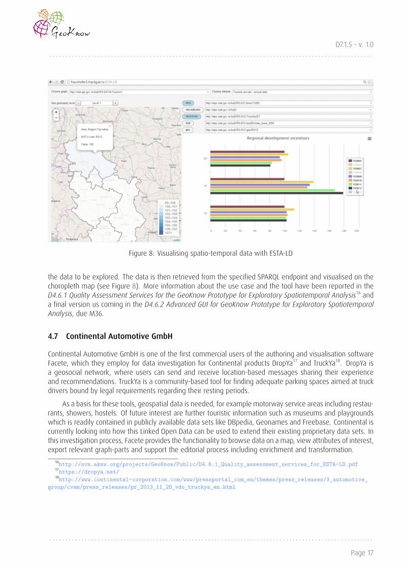
4.6 Spatio-temporal analysis for the SBRA
The goal of this e-government use case was to use the Linked Data Stack to explore statistical data published inLinked Data format. Data can be exposed via SPARQL endpoint, uploaded to a government portal or registeredwith open data catalogue, e.g. build on top of CKAN software. In the GeoKnow framework, we have studiedthe possibilities for using ESTA-LD for analysis of data from the Serbian Register of the Regional DevelopmentMeasures and Incentives maintained by Serbian Business Registers Agency (SBRA) [4]. Published in LinkedData format, the data was registered with the Serbian CKAN. Instead of the current way of collecting andvisualising data, the Linked Data Stack offers innovative approaches for:
• extending the existing public service provided by SBRA and standardise the data collection process;
• ensuring interoperability (e.g. integration of data from the Register with data from the Disseminationdatabase of the Statistical Office of the Republic of Serbia, SORS) and improve transparency of data onEuropean level;
• allowing advanced spatio-temporal analysis of available indicators;
• offering user-friendly services in a secure and flexible manner allowing personalisation for different typesof users (public administration, businesses and citizens).
Statistical indicators stored in the SBRA Regional Development Measures and Incentives database haveattributes related to both space and time, thus imposing challenges for visualising both dimensions on a geo-graphical map. Moreover, these datasets are often multi-dimensional originally, meaning that the informationcan be represented on different granularity levels in space and time, as well as the type of information. Whenlaunching the ESTA-LD component, the user specifies the SPARQL endpoint, and selects the graph that contains
. . . . . . . . . . . . . . . . . . . . . . . . . . . . . . . . . . . . . . . . . . . . . . . . . . . . . . . . . . . . . . . . . . . . . . . . . . . . . . . . . . . . . . . . . . . . . . . . . . . .
Page 16
D7.1.5 - v. 1.0. . . . . . . . . . . . . . . . . . . . . . . . . . . . . . . . . . . . . . . . . . . . . . . . . . . . . . . . . . . . . . . . . . . . . . . . . . . . . . . . . . . . . . . . . . . . . . . . . . . .
Figure 8: Visualising spatio-temporal data with ESTA-LD
the data to be explored. The data is then retrieved from the specified SPARQL endpoint and visualised on thechoropleth map (see Figure 8). More information about the use case and the tool have been reported in theD4.6.1 Quality Assessment Services for the GeoKnow Prototype for Exploratory Spatiotemporal Analysis¹⁶ anda final version us coming in the D4.6.2 Advanced GUI for GeoKnow Prototype for Exploratory SpatiotemporalAnalysis, due M36.
4.7 Continental Automotive GmbH
Continental Automotive GmbH is one of the first commercial users of the authoring and visualisation softwareFacete, which they employ for data investigation for Continental products DropYa¹⁷ and TruckYa¹⁸. DropYa isa geosocial network, where users can send and receive location-based messages sharing their experienceand recommendations. TruckYa is a community-based tool for finding adequate parking spaces aimed at truckdrivers bound by legal requirements regarding their resting periods.
As a basis for these tools, geospatial data is needed, for example motorway service areas including restau-rants, showers, hostels. Of future interest are further touristic information such as museums and playgroundswhich is readily contained in publicly available data sets like DBpedia, Geonames and Freebase. Continental iscurrently looking into how this Linked Open Data can be used to extend their existing proprietary data sets. Inthis investigation process, Facete provides the functionality to browse data on a map, view attributes of interest,export relevant graph-parts and support the editorial process including enrichment and transformation.
¹⁶http://svn.aksw.org/projects/GeoKnow/Public/D4.6.1_Quality_assessment_services_for_ESTA-LD.pdf¹⁷https://dropya.net/¹⁸http://www.continental-corporation.com/www/pressportal_com_en/themes/press_releases/3_automotive_
group/cvam/press_releases/pr_2013_11_28_vdo_truckya_en.html
. . . . . . . . . . . . . . . . . . . . . . . . . . . . . . . . . . . . . . . . . . . . . . . . . . . . . . . . . . . . . . . . . . . . . . . . . . . . . . . . . . . . . . . . . . . . . . . . . . . .
Page 17

D7.1.5 - v. 1.0. . . . . . . . . . . . . . . . . . . . . . . . . . . . . . . . . . . . . . . . . . . . . . . . . . . . . . . . . . . . . . . . . . . . . . . . . . . . . . . . . . . . . . . . . . . . . . . . . . . .
Figure 9: Facete within the data generation process at Continental
4.8 Tourist Guides
A typical tourist scenario is hard to picture without a map. Yet, such a scenario implies you are not familiarwith your surroundings and, therefore, often not sure how to find the things that are of interest to you. Typicalgeospatial browsers will provide you with common exploration tools that will most often include a slippy mapcombined with keyword search, categorised points of interest (POIs) and a fixed set of filters. But all of theseimply either that you know what it is you are looking for, or that the preset collection of POIs and criteria willbe enough to satisfy your needs. In real life, however, those needs will often be affected by the given context,which is, in turn, dependent on multiple, dynamic factors, such as the place you are visiting, your mood,interests, background etc. Imagine using your favourite geospatial browser to answer the following question:“Where are the nearest buildings designed by Frank Lloyd Wright, typical of the Prairie School movement?”.
In GeoKnow a couple of applications have being developer to fulfil visualization of RDF data on a map. Onone hand the desktop-based application, Mappify¹⁹ offers a facet-based exploration of the SPARQL endpoint athand, Mappify provides controls to define complex concepts describing sets of resources with certain propertyvalues that can be displayed on a map (see Figure 10). This map is further constrained to a certain geospatialarea of interest for the considered application context. On the other hand a mobile-based application, GEM²⁰,offers a rich mobile experience and overcomes the above mentioned limitations of conventional solutions byexploiting all strengths of the Linked Open Data paradigm, such as built-in semantics in open, crowd-sourcedknowledge found in publicly available sources, such as DBpedia (i.e. Wikipedia), loaded and filtered on-demand,according to user’s needs, in order to prevent maps from overpopulating (see Figure 11).
4.9 Crisis Management and Semantic Routing
To help reduce exposure to potential threats and ensure personnel, asset and mission safety while trackingpeople and resources in hostile environments, both the mission Command and Control center, and the fieldoperatives must be truly aware of their surroundings. Conventional tracking solutions are often ignorant whenit comes to the semantics behind the points and areas of significance along the tracked route, providing littleto no data apart from the closed knowledge bases and live sensors readings.
¹⁹http://svn.aksw.org/projects/GeoKnow/Deliverables/D4.1.1/D4.1.1_Initial_release_spatial_semantic_exploration_component_public.pdf
²⁰http://svn.aksw.org/projects/GeoKnow/Deliverables/D4.2.1/Final-D4.2.1_Spatial_authoring_widget_Set.pdf
. . . . . . . . . . . . . . . . . . . . . . . . . . . . . . . . . . . . . . . . . . . . . . . . . . . . . . . . . . . . . . . . . . . . . . . . . . . . . . . . . . . . . . . . . . . . . . . . . . . .
Page 18

D7.1.5 - v. 1.0. . . . . . . . . . . . . . . . . . . . . . . . . . . . . . . . . . . . . . . . . . . . . . . . . . . . . . . . . . . . . . . . . . . . . . . . . . . . . . . . . . . . . . . . . . . . . . . . . . . .
Figure 10: Interactive maps with Mappify
Figure 11: Mobile tourist guide, GEM
. . . . . . . . . . . . . . . . . . . . . . . . . . . . . . . . . . . . . . . . . . . . . . . . . . . . . . . . . . . . . . . . . . . . . . . . . . . . . . . . . . . . . . . . . . . . . . . . . . . .
Page 19

D7.1.5 - v. 1.0. . . . . . . . . . . . . . . . . . . . . . . . . . . . . . . . . . . . . . . . . . . . . . . . . . . . . . . . . . . . . . . . . . . . . . . . . . . . . . . . . . . . . . . . . . . . . . . . . . . .
Figure 12: Semantic routing architectureFigure 13: Routing visualisa-tion in GEM
Enriching the tracking feed with Linked Open Data would bring one missing, yet crucial element to theCommand and Control center mission overview screen. Instead of mere coordinates, semantic informationdriven guidance would provide the field personnel with knowledge that could easily prove vital to ensuringsafety and, ultimately, mission success. Understanding the surroundings in an environment ruled by conflictwould help secure higher levels of anticipation, smarter decisions and faster response times in unexpectedsituations, and steer the tracked operatives and assets on to safer routes, on demand.
As depicted in Figure 12, the application back-end relies on Jassa for Linked Data retrieval and Facete forsemantic filtering. The front-end delivers such filtered geospatial information through a Leaflet.js poweredslippy map. Moreover, the Leaflet Routing Machine can take any of the retrieved geospatial resources asinput/waypoints and query an online routing service, such as the OSRM server for an optimal route to a desireddestination. Thus, the Geospatial-semantic Exploration on the Move, GEM, offers a rich mobile experience byexploiting all strengths of the Linked Open Data paradigm. The entire application relies on the Apache Cordova /Adobe Phonegap framework which enables cross-platform application compatibility, covering all major mobileoperating systems.
An EU The Common Security and Defence Policy (CSDP) mission in the Middle East aiming to deliver reliefgoods to endangered Shia-inhabited towns and villages might need to avoid Sunni-populated regions or citieswith a population greater than 50,000 (i.e. “large urban environments”), while ensuring availability of criticalPOIs, such as hospitals or shelters, in checkpoint vicinity along the entire route depicted in Figure 13.
The application will draw a clear line between traditional GIS-based and semantic, LOD-powered, Se-curity and Emergency Management systems. What Linked Data brings to the table is effortless integrationof heterogeneous background knowledge sources. It provides the means to exploit the existing, open (e.g.crowdsourced) information on the Middle East’s demographics (e.g. “Sunni-populated regions” or “large urbanenvironments”), history, politics, roads, terrain, weather (etc.) and create ad-hoc mashups, overlaying the mapand the data feed with semantics, and providing a bigger picture to the overall situation awareness and analysisacross multiple dimensions and factors, none of which is currently possible with conventional alternatives.
. . . . . . . . . . . . . . . . . . . . . . . . . . . . . . . . . . . . . . . . . . . . . . . . . . . . . . . . . . . . . . . . . . . . . . . . . . . . . . . . . . . . . . . . . . . . . . . . . . . .
Page 20

D7.1.5 - v. 1.0. . . . . . . . . . . . . . . . . . . . . . . . . . . . . . . . . . . . . . . . . . . . . . . . . . . . . . . . . . . . . . . . . . . . . . . . . . . . . . . . . . . . . . . . . . . . . . . . . . . .
Figure 14: Flowchart showing the test-driven data quality methodology. The left part displays the input sourcesof our pattern library. In the middle part the different ways of pattern instantiation are shown which lead tothe Data Quality Test Cases on the right.
4.10 Validating Geospatial coordinates in DBpedia
DBpedia is a community effort to extract structured data from Wikipedia. Among other information, DBpediaextracts geospatial data from related articles, limited at the moment to place coordinates. Depending onthe user experience, wrong values may be provided by the users that go beyond the [-90,90] for latitude or[-180,180] for longitude. The goal is to identify invalid coordinates and report them to the Wikipedia community.
The architecture of RDFUnit allows to associate test cases to vocabularies and thus these tests can beavailable to everyone who uses these vocabularies. Our methodology is illustrated in Figure 14. As shown inthe figure, there are two major sources for creating tests. One source is stakeholder feedback from everyoneinvolved in the usage of a dataset and the other source is the already existing RDFS/OWL schema of a dataset.Based on this, there are several ways in which tests can be created:
• Using RDFS/OWL constraints directly
• Enriching the RDFS/OWL constraints
• Re-using tests based on common vocabularies
• Instantiate existing Data Quality Test Pattern
• Write own Data Quality Test Pattern
In this case three test cases were created for geo²¹: two tests that check the respective range of geo:latand geo:long that report errors and another test the reports if two geo:geometry are equal, a warning is raisedand reports a warning that the two resources might be the same. As a result of this use case, we hope that
²¹http://www.w3.org/2003/01/geo/wgs84_pos
. . . . . . . . . . . . . . . . . . . . . . . . . . . . . . . . . . . . . . . . . . . . . . . . . . . . . . . . . . . . . . . . . . . . . . . . . . . . . . . . . . . . . . . . . . . . . . . . . . . .
Page 21

D7.1.5 - v. 1.0. . . . . . . . . . . . . . . . . . . . . . . . . . . . . . . . . . . . . . . . . . . . . . . . . . . . . . . . . . . . . . . . . . . . . . . . . . . . . . . . . . . . . . . . . . . . . . . . . . . .
test-driven data quality can contribute to solve one of the most pressing problems of the Data Web - theimprovement of data quality and the increase of Linked Data fitness for use.
. . . . . . . . . . . . . . . . . . . . . . . . . . . . . . . . . . . . . . . . . . . . . . . . . . . . . . . . . . . . . . . . . . . . . . . . . . . . . . . . . . . . . . . . . . . . . . . . . . . .
Page 22

D7.1.5 - v. 1.0. . . . . . . . . . . . . . . . . . . . . . . . . . . . . . . . . . . . . . . . . . . . . . . . . . . . . . . . . . . . . . . . . . . . . . . . . . . . . . . . . . . . . . . . . . . . . . . . . . . .
5 Conclusions
In this document we have reported ten use cases as the GeoKnow Show Case. These use cases have beingdeveloped by several partners in the consortium and disseminated as GeoKnow results.
GeoKnow software tools were influenced by described real world use cases, and demonstrated theirusability. Some use cases have produced datasets (i.e. Greek INSPIRE data to RDF) which is available via publicendpoints. All GeoKnow software tools presented in this report are publicly available in the Linked Data Stack²²repository.
²²http://stack.linkeddata.org/
. . . . . . . . . . . . . . . . . . . . . . . . . . . . . . . . . . . . . . . . . . . . . . . . . . . . . . . . . . . . . . . . . . . . . . . . . . . . . . . . . . . . . . . . . . . . . . . . . . . .
Page 23

D7.1.5 - v. 1.0. . . . . . . . . . . . . . . . . . . . . . . . . . . . . . . . . . . . . . . . . . . . . . . . . . . . . . . . . . . . . . . . . . . . . . . . . . . . . . . . . . . . . . . . . . . . . . . . . . . .
6 References
References
[1] Spiros Athanasiou, Nikos Georgomanolis, Kostas Patroumpas, Michalis Alexakis, and Thodoris Stratiotis.Triplegeo-csw: A middleware for exposing geospatial catalogue services on the semantic web. In Peter M.Fischer, Gustavo Alonso, Marcelo Arenas, and Floris Geerts, editors, EDBT/ICDT Workshops, volume 1330 ofCEUR Workshop Proceedings, pages 229–236. CEUR-WS.org, 2015.
[2] Alejandra Garcia-Rojas, Daniel Hladky, Matthias Wauer, Robert Isele, Claus Stadler, and Jens Lehmann. Thegeoknow generator workbench: An integration platform for geospatial data. In Proceedings of the 3rdInternational Workshop on Semantic Web Enterprise Adoption and Best Practice, 2015.
[3] Giorgos Giannopoulos, Dimitrios Skoutas, Thomas Maroulis, Nikos Karagiannakis, and Spiros Athanasiou.Fagi: A framework for fusing geospatial rdf data. In Robert Meersman, Hervé Panetto, Tharam Dillon,Michele Missikoff, Lin Liu, Oscar Pastor, Alfredo Cuzzocrea, and Timos Sellis, editors, On the Move toMeaningful Internet Systems: OTM 2014 Conferences, volume 8841 of Lecture Notes in Computer Science,pages 553–561. Springer Berlin Heidelberg, 2014.
[4] Valentina Janev, Vuk Mijovic, Dejan Paunovic, and Uroš Milošvic. Modeling, fusion and exploration ofregional statistics and indicators with linked data tools. In Andrea K� and Enrico Francesconi, editors, Elec-tronic Government and the Information Systems Perspective, volume 8650 of Lecture Notes in ComputerScience, pages 208–221. Springer International Publishing, 2014.
[5] Dimitris Kontokostas, Patrick Westphal, Sören Auer, Sebastian Hellmann, Jens Lehmann, Roland Cornelis-sen, and Amrapali Zaveri. Test-driven evaluation of linked data quality. In Proceedings of the 23rdInternational Conference on World Wide Web, WWW ’14, pages 747–758, New York, NY, USA, 2014. ACM.
[6] Michael Martin, Konrad Abicht, Claus Stadler, Sören Auer, Axel-C. Ngonga Ngomo, and Tommaso Soru.Cubeviz – exploration and visualization of statistical linked data. In Proceedings of the 24th InternationalConference on World Wide Web, WWW 2015, 2015.
[7] Uroš Miloševi� and Claus Stadler. Mobile semantic geospatial visualization and exploration. In Proceedingsof the 5th International Conference on Information Society Technology. Information Society of the Republicof Serbia, 2015.
[8] Axel-Cyrille Ngonga Ngomo. Orchid - reduction-ratio-optimal computation of geo-spatial distances for linkdiscovery. In Proceedings of ISWC 2013, 2013.
[9] Kostas Patroumpas, Michalis Alexakis, Giorgos Giannopoulos, and Spiros Athanasiou. Triplegeo: an etl toolfor transforming geospatial data into rdf triples. 2014.
[10] Mohamed Ahmed Sherif, Axel-Cyrille Ngonga Ngomo, and Jens Lehmann. Automating RDF dataset trans-formation and enrichment. In 12th Extended Semantic Web Conference, Portoroz, Slovenia, 31st May -4th June 2015. Springer, 2015.
[11] Claus Stadler, Michael Martin, and Sören Auer. Exploring the web of spatial data with facete. In Proceedingsof the companion publication of the 23rd international conference on World wide web companion, pages175–178, 2014.
[12] Claus Stadler, Joerg Unbehauen, Patrick Westphal, Mohamed Ahmed Sherif, and Jens Lehmann. SimplifiedRDB2RDF mapping. In Proceedings of the 8th Workshop on Linked Data on the Web (LDOW2015), Florence,Italy, 2015.
. . . . . . . . . . . . . . . . . . . . . . . . . . . . . . . . . . . . . . . . . . . . . . . . . . . . . . . . . . . . . . . . . . . . . . . . . . . . . . . . . . . . . . . . . . . . . . . . . . . .
Page 24

D7.1.5 - v. 1.0. . . . . . . . . . . . . . . . . . . . . . . . . . . . . . . . . . . . . . . . . . . . . . . . . . . . . . . . . . . . . . . . . . . . . . . . . . . . . . . . . . . . . . . . . . . . . . . . . . . .
[13] Mijovic Vuk, Janev Valentina, and Paunovic Dejan. Esta-ld: Enabling spatio-temporal analysis of linkedstatistical data. In Proceedings of the International Conference on Information Society Technology andManagement. Information Society of the Republic of Serbia, 2015.
. . . . . . . . . . . . . . . . . . . . . . . . . . . . . . . . . . . . . . . . . . . . . . . . . . . . . . . . . . . . . . . . . . . . . . . . . . . . . . . . . . . . . . . . . . . . . . . . . . . .
Page 25