Embed Size (px)
Citation preview
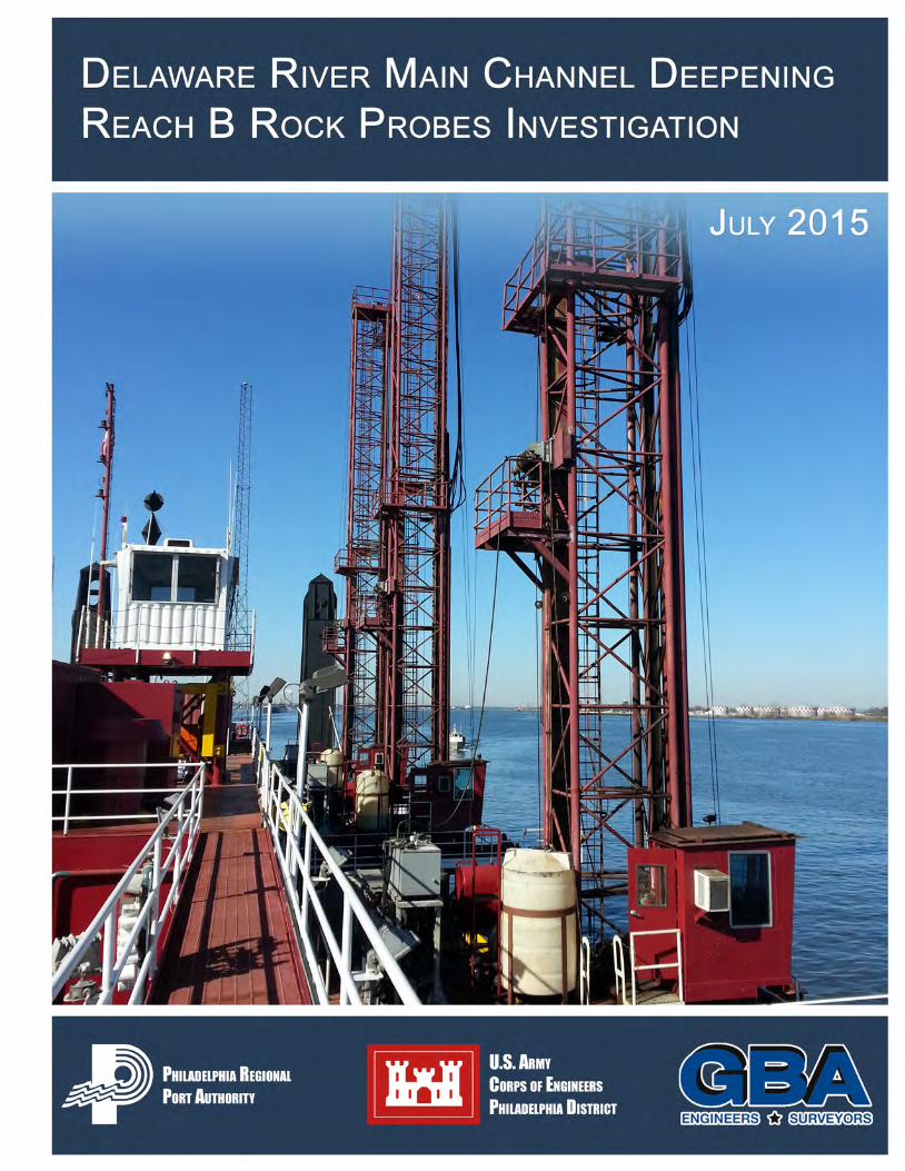

Delaware River Main Channel Deepening Project Reach B Rock Probes Investigation
GBA Gahagan and Bryant Associates, Inc. – July 2015 P a g e | i
TABLE OF CONTENTS
INTRODUCTION ....................................................................................................................... 1
PURPOSE ................................................................................................................................. 1
PROJECT OBJECTIVE/GOAL .................................................................................................. 1
PROJECT LOCATION .............................................................................................................. 2
PREVIOUS INVESTIGATIONS ................................................................................................. 2
1996 ACOUSTIC DATA .............................................................................................................. 2 1996 GEOACOUSTIC STUDY ..................................................................................................... 3 1996 USACE ROCK INVESTIGATION ......................................................................................... 3 2010 USACE ROCK INVESTIGATION ......................................................................................... 3 2010 USACE VIBRACORE INVESTIGATION ................................................................................ 3 2012 USACE ROCK INVESTIGATION ......................................................................................... 3 DEMCO RESISTIVITY STUDY .................................................................................................... 3
EQUIPMENT ............................................................................................................................. 3
GLDD DRILLBOAT APACHE ...................................................................................................... 3 POSITIONING ........................................................................................................................... 4 ELEVATION MEASUREMENTS .................................................................................................... 4 THUNDERBIRD MINING SYSTEMS DRILLING EFFICIENCY PLUS SYSTEM ........................................ 5
METHODS ................................................................................................................................. 6
PROJECT LAYOUT .................................................................................................................... 6 HORIZONTAL CONTROL ............................................................................................................ 6 VERTICAL CONTROL ................................................................................................................. 6 DRILLING PROCEDURE ............................................................................................................. 7 TEST PROGRAM ....................................................................................................................... 8 TEST PROGRAM RESULTS .......................................................................................................10 PROBING INVESTIGATION .........................................................................................................13 POST INVESTIGATION TOP OF ROCK QUALITY CONTROL............................................................16 TOP OF ROCK SELECTION PROCEDURES ..................................................................................16 TOP OF ROCK QUALITY CONTROL PROCEDURES ......................................................................18
RESULTS .................................................................................................................................18
TABLES
Table 1 – Rock Test Area TOR Elevations Compared to Boring TOR Elevations ......................11 Table 2 – Weathered Rock Test Area TOR Elevations Compared to Boring TOR Elevation .....12 Table 3 – Probe Area Dates ......................................................................................................13 Table 4 – Probing Production ....................................................................................................14 Table 5 – Post-Investigation TOR Quality Control .....................................................................16

Delaware River Main Channel Deepening Project Reach B Rock Probes Investigation
GBA Gahagan and Bryant Associates, Inc. – July 2015 P a g e | ii
FIGURES
Figure 1 – Project Location ........................................................................................................ 2 Figure 2 – GLDD Drillboat Apache ............................................................................................. 4 Figure 3 – Monitoring of the Three Drill Frames in the Survey Office ......................................... 5 Figure 4 – Schematic Drawing “Apache” Showing Vertical Measurements ................................ 8 Figure 5 – Test Program Probing Locations ............................................................................... 9 Figure 6 – Field Recorded TOR Elevations ...............................................................................15 Figure 7 – Typical ROP Curve ..................................................................................................17
APPENDICES
Appendix A – Project Drawings Appendix B – Test Program Boring Logs Appendix C – Field Production Logs Appendix D – Top of Rock XYZ files
Delaware River Main Channel Deepening Project Reach B Rock Probes Investigation
GBA Gahagan and Bryant Associates, Inc. – July 2015 P a g e | ii
LIST OF ABBREVIATIONS AND ANCRONYMS APACHE Great Lakes Dredge & Dock Company drillboat Apache
ft./min. Rate of penetration units, feet per minute
GBA Gahagan and Bryant Associates, Inc.
GLDD Great Lakes Dredge & Dock Company
GPR Ground Penetrating Radar
GPS Global Positioning System
MLLW Mean Lower Low Water
NOAA National Oceanic and Atmospheric Administration
OVERBURDEN Gravel, sand, clay, and broken, weathered, unconsolidated rock
PROBE Straight drilling without sampling until certain conditions to mark the end of the hole are met
PRPA Philadelphia Regional Port Authority
QC Quality Control
RTK Real Time Kinematic
ROP Rate of Penetration
SPT Standard Penetration Test
SWIFTRUNNER Great Lakes Dredge and Dock crewboat Swiftrunner
TMS Thunderbird Mining Systems
TOR Top of Competent Bedrock
USACE U.S. Army Corps of Engineers, Philadelphia District
USCG United States Coast Guard
WOB Weight On Bit

Delaware River Main Channel Deepening Project Reach B Rock Probes Investigation
GBA Gahagan and Bryant Associates, Inc. – July 2015 P a g e | 1
INTRODUCTION
As part of the development of the information necessary to determine the quantity and location of rock in Reach B, for the Delaware River Main Channel Deepening Project (Deepening Project), the need to conduct a supplemental geotechnical investigation of rock outcrop areas in Reach B (see Figure 1) was identified. The United States Army Corps of Engineers-Philadelphia District (USACE) coordinated with the Philadelphia Regional Port Authority (PRPA) to perform the investigation. The investigation utilized industry equipment to cost effectively, better define the known rock areas. PRPA requested that Gahagan & Bryant Associates, Inc. (GBA) provide the required services. The investigation was to be undertaken in rock areas that were identified from prior USACE studies. This report outlines the methodologies used, results obtained, and conclusions drawn. The data collected is complex, extensive and subject to interpretation. Relative rock hardness evaluations and ease or difficulty of excavation, necessity (or not) of drilling and blasting, will differ amongst experts and intended excavation techniques and equipment. Users of this report and the information contained should form their own judgments based upon the data provided. The work was accomplished under the direction of GBA, USACE, and PRPA.
PURPOSE
USCACE has conducted prior geophysical and geotechnical investigations to characterize the material within the dredging template. However, in order to further quantify the volume and location of rock within the dredging template in Reach B, and to aid in reducing contractors’ uncertainty and risk in estimating dredging costs an additional investigation was deemed necessary. The investigation was focused within the rock outcrops areas from Stations 97+000 to 141+000. The dredging template for Reach B calls for deepening the existing grade to the authorized depth of -45 feet Mean Lower Low Water (MLLW) plus one foot of allowable pay over-depth, a required depth of -47 feet MLLW in rock areas and a required depth of -46 feet MLLW in specified areas adjacent to the rock areas.
PROJECT OBJECTIVE/GOAL
The objective of this investigation was to physically document the depth to the top of competent bedrock that is found above a depth of -55 feet MLLW within the dredging boundaries of Reach B, with a desired precision of +/- 0.5 feet. In order to achieve this purpose, GBA proposed straight drilling, without sampling, until certain conditions indicate contact with Top of Rock (TOR) were met. The primary goal was to first develop the criteria and then to record evidence that either showed that each probe penetrated through all overburden material, including broken, weathered and unconsolidated rock, and effectively measured the top of bedrock or did not encounter bedrock at all. GBA contracted the use of the Great Lakes Dredge & Dock (GLDD) drillboat “Apache” and in coordination with USACE used objective methodology to gather data pertinent to estimating the TOR. The compiled data from this investigation will be furnished by USACE to prospective bidders as part of future rock dredging project solicitations to supplement existing geophysical and geotechnical data.

Delaware River Main Channel Deepening Project Reach B Rock Probes Investigation
GBA Gahagan and Bryant Associates, Inc. – July 2015 P a g e | 2
PROJECT LOCATION
The area for this investigation is shown on Figure 1 and extends from Station 97+000 to 141+000. This portion of the channel is 800 feet wide and is bordered by the states of New Jersey, Delaware and the Commonwealth of Pennsylvania.
Figure 1 – Project Location
PREVIOUS INVESTIGATIONS
Previous geotechnical and geophysical investigations have been conducted within Reach B dating back to the 1960’s, and include test pits, vibracores, rock cores, SPT borings, and resistivity and acoustic surveys. From these past investigations, substantial data has been compiled, where geotechnical data i.e. rock cores, vibracores, and Standard Penetration Test (SPT) borings have been correlated to geophysical data. Previous investigations undertaken by the USACE in Reach B as part of the Deepening Project are listed below.
1996 Acoustic Data
Phase 1 Report Phase 2 Report Rock Quantity Estimates Sheets Top of Acoustic Basement Sheets Above 50 feet
Top of Acoustic Basements Sheets Phase 3 Report Hydrographic Chart Sheet Ground Penetrating Radar (GPR)
Survey Results
Delaware River Main Channel Deepening Project Reach B Rock Probes Investigation
GBA Gahagan and Bryant Associates, Inc. – July 2015 P a g e | 3
1996 Geoacoustic Study
Geoacoustic Study of the Delaware Main Channel, 1996
1996 USACE Rock Investigation
Core Boring Data Core Boring Report
2010 USACE Rock Investigation
Geotechnical Investigation Report, 2010: Proposed Rock Cut Areas, Delaware River Tinicum to Marcus Hook, Pennsylvania, New Jersey, & Delaware
2010 USACE Vibracore Investigation
Geotechnical Sediment Investigation, September 2010
2012 USACE Rock Investigation
Supplemental Geotechnical Subsurface Investigation, July 2012
DEMCO Resistivity Study
Reach B Resistivity Survey July 2012 Final Resistivity Report, October. 2009
EQUIPMENT
GLDD Drillboat Apache
GBA contracted GLDD’s drill boat Apache to conduct the investigation by performing a series of probes utilizing a specified methodology geared towards determining the top of competent bedrock. The Apache is 210 feet long, 60 feet wide, and has a drilling space on deck of 170 feet. The Apache’s hull depth is 10.5 feet and the draft is five feet as shown in Figure 2. The Apache is a USCG inspected vessel with load line certified for operations on inshore and offshore waters. The Apache is held in position during drilling operations by four six-foot square spuds. Four 184,000 pound line pull winches coupled to 2.75 inch diameter wire rope create a lifting force of 1,250 tons which can lift the barge 3.5 feet to ensure a stable platform during drilling operations. The Apache was assisted by a 24 hour tug, the Layla Renee, as well as a crew boat, the Swiftrunner
The Apache utilizes three separate drill frames with Atlas Copco 1838 Series single pass drilling systems. Each frame operates independently of one another and is entirely self-contained with power units and fuel. The drill hole diameter is 4.5 inches.

Delaware River Main Channel Deepening Project Reach B Rock Probes Investigation
GBA Gahagan and Bryant Associates, Inc. – July 2015 P a g e | 4
Figure 2 – GLDD Drillboat Apache
Positioning
The Apache was equipped with dual Trimble real time kinematic (RTK) global positioning system (GPS) receivers that provided a real time display of the Apache’s horizontal position on a positioning computer in the survey office. The horizontal location of each drill frame was also displayed on the positioning computer. The individual frame locations were determined by horizontal offsets along the barge and then translated into Northing and Easting coordinates. A Trimble R8 global navigation satellite system (GNSS) RTK Rover was used to perform periodic horizontal and vertical quality control checks onboard the Apache. The crew boat Swiftrunner was equipped with a Trimble SPS 855/Zephyr and was used to perform periodic vertical quality control checks to compare to the tide recordings.
Elevation Measurements
The drill bit elevations were recorded using an optical encoder mounted on the drill winch with a chain and sprocket as pictured below to the left. The drill bit was calibrated by positioning it at the water surface (see photo below to the right) and setting the encoder recording to zero at the beginning of each probe hole. Drill bit elevations were subsequently adjusted using water surface tide readings as described in the “vertical control” section.
Delaware River Main Channel Deepening Project Reach B Rock Probes Investigation
GBA Gahagan and Bryant Associates, Inc. – July 2015 P a g e | 5
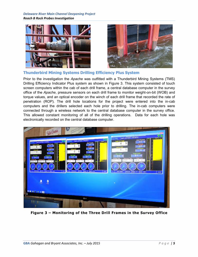
Thunderbird Mining Systems Drilling Efficiency Plus System
Prior to the investigation the Apache was outfitted with a Thunderbird Mining Systems (TMS) Drilling Efficiency Indicator Plus system as shown in Figure 3. This system consisted of touch screen computers within the cab of each drill frame, a central database computer in the survey office of the Apache, pressure sensors on each drill frame to monitor weight-on-bit (WOB) and torque values, and an optical encoder on the winch of each drill frame that recorded the rate of penetration (ROP). The drill hole locations for the project were entered into the in-cab computers and the drillers selected each hole prior to drilling. The in-cab computers were connected through a wireless network to the central database computer in the survey office. This allowed constant monitoring of all of the drilling operations. Data for each hole was electronically recorded on the central database computer.
Figure 3 – Monitoring of the Three Drill Frames in the Survey Office

Delaware River Main Channel Deepening Project Reach B Rock Probes Investigation
GBA Gahagan and Bryant Associates, Inc. – July 2015 P a g e | 6
METHODS
Project Layout
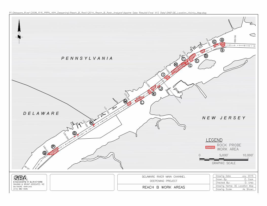
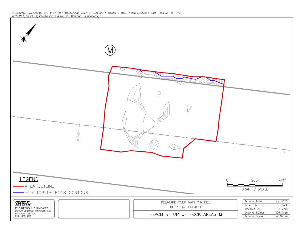
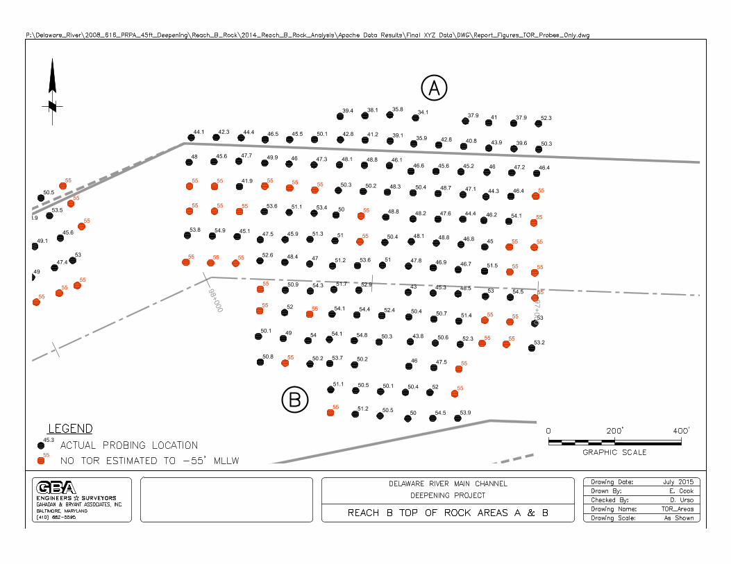
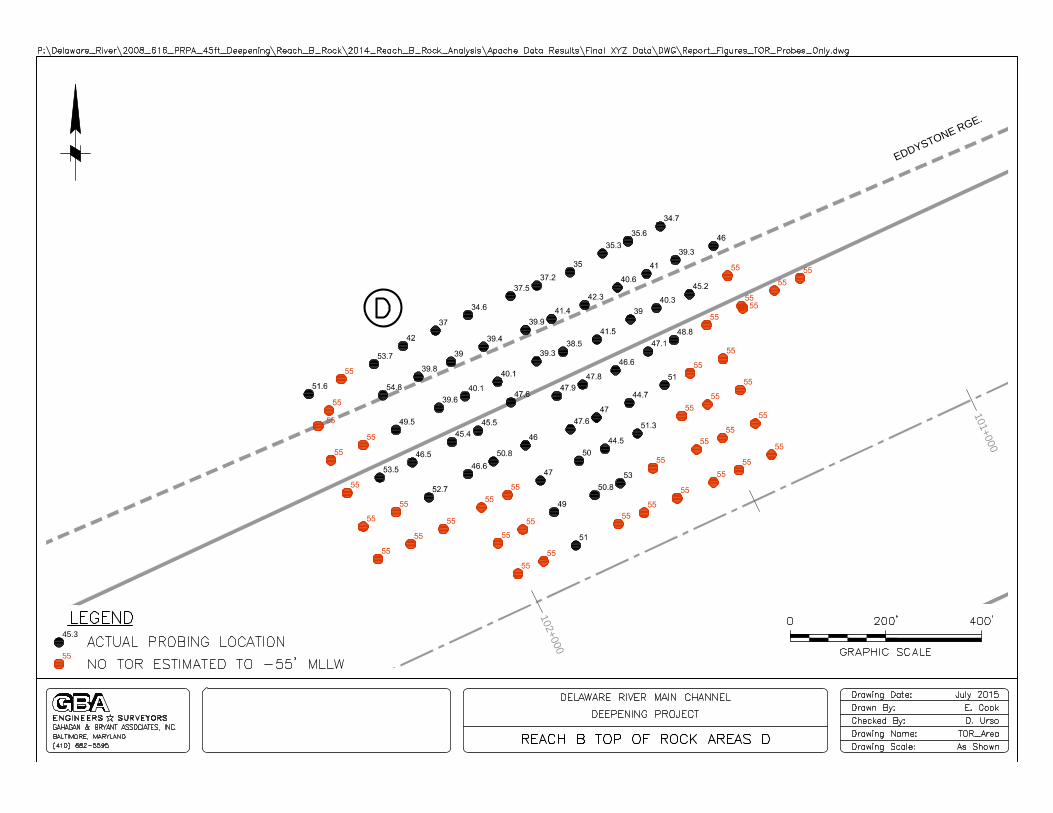
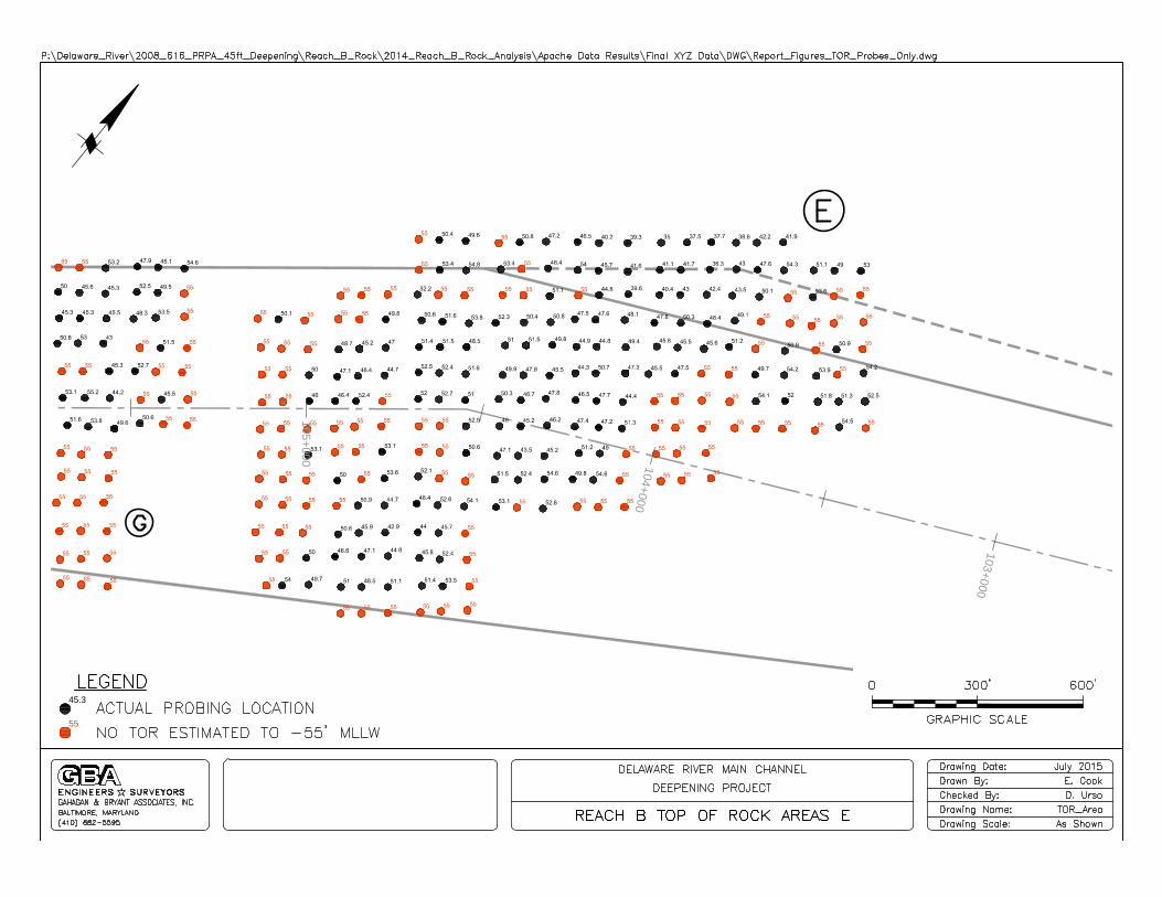
Probing investigation areas were developed and laid out by GBA and the USACE after thorough analysis of all the existing data within Reach B. Seventeen areas that could potentially contain rock based on this data and within the dredging template were outlined and labeled A through Q. In addition, drilling pattern files were developed for each area and loaded into the TMS system. The layout of the probing areas can be seen in the drawings contained in Appendix A. The spacing and final depth of the probes were developed around an anticipated required dredging depth of -47 feet MLLW in rock areas. Spacing between probes was set at 75 feet, with a horizontal tolerance for each location of 10 feet. The probes were to extend to a depth of -55 feet MLLW or until the TOR was encountered, whichever came first. If TOR was encountered above -50 feet MLLW on the outside edge of a probing area, an additional line of probes would be performed outside the area until TOR was not encountered above -50 feet MLLW.
Horizontal Control
Horizontal and Vertical controls for the probing project were based off of three monuments: JU0786 served as the primary, JU4112 as a horizontal check and JU0832 as vertical check.
1. Primary: “PRINTZ” / PID: JU0786 in New Castle County Delaware 39d 47’ 45.21714” (N) 075d 27’ 27.67300” (W) Elevation: 17.5 feet (NAVD88)
2. Horizontal Check: “HAR 2” / PID: JU4112 in New Castle County Delaware 39d 48’ 12.02442” (N) 075d 28’ 48.97020” (W)
3. Vertical Check: “Q 276” / PID: JU0832 in Delaware County Pennsylvania 39d 49’ 12.0” (N) 075d 25’ 49.8” (W) Elevation: 47.69 feet (NAVD88)
Horizontal checks with a Trimble R8 GNSS System on the upper deck of the Apache were performed twice a week and more often when operating near cable or pipeline crossings. Before startup, two quality control (QC) points were marked on the upper deck of the drillboat at known offsets from the two GPS antennas. The location of these QC points were selected for their distance from the tallest vertical structures on the Apache (drill frames, spuds and GPS towers) to improve line of sight to satellites and to allow for fixed RTK quality positioning accuracy. The Apache’s positioning software displays the Northing/Easting of these two QC points at all times. Whenever a surveyor performed a check with the rover GPS system, the values were checked against each other. Throughout the entire probing investigation, each time this was performed, the rover was shown to be within 2.0 feet of the value shown by the positioning software on the drillboat. Because Northings/Eastings of the drill frames are determined by an analogous procedure, this procedure served as a reliable check on horizontal control.
Vertical Control
The primary source of vertical control were tide recordings from the Marcus Hook and Philadelphia National Oceanic and Atmospheric Administration (NOAA) gauges which are on either side of the project limits, i.e. upstream side and downstream side. Tides used for each probing location were determined using a straight line interpolation between the tide values at
Delaware River Main Channel Deepening Project Reach B Rock Probes Investigation
GBA Gahagan and Bryant Associates, Inc. – July 2015 P a g e | 7
these two gauges based on the drillboat’s horizontal distance between them. These values were broadcast in MLLW and were checked against RTK tide readings on the Swiftrunner. Vertical checks on the Swiftrunner were performed at least twice per 12-hour shift.
In order to quality control check the tidal readings and procedures utilized by GLDD for the project, GBA used a representative data set of tide/time corrections from the NOAA Marcus Hook, PA gage that occurred during the project and calculated tides using a historic USACE procedure.. This historic USACE procedure was utilized prior to the District’s implementation of the RTK GPS methodology and involved subtracting or adding a one minute correction for every 1,000 feet that the sample barge and/or survey vessel was upstream or downstream from the primary tide gage station. If the operation requiring the tide was upstream of the primary tide gage station, the time was subtracted from the gage to obtain the corrected tide reading. If the barge/vessel was downstream, the time was added to obtain the correct tidal reading.
A total of 294 sample tide readings were evaluated as part of GBA's quality control check. Approximately 12.6% of the total number of readings utilized for the drilling of +/- 2,326 holes. The result of this QC check showed that the USACE time/tide corrections procedure matched the GLDD tides within +/- 0.10 feet for all 294 samples evaluated.
Drilling Procedure
The typical drilling procedure employed for the investigation was as follows:
1. Driller logs on to the TMS system at the beginning of each shift 2. Driller completes pre-shift inspection 3. Driller selects and confirms the area pattern from the list on the display 4. Driller selects the hole from a dropdown list of all the holes within the area pattern 5. Once the Apache has been moved within the horizontal tolerance of the hole location,
the driller lowers the drill bit to the waterline and presses the “start” of hole button on the screen. The driller then enters the tide value, provided by the survey crew, into a pop-up menu on the screen
6. Once the tide is entered the driller is given a target depth (-55 feet MLLW adjusted for the tide)
7. The hole is drilled following the instructions given in the Drilling Protocol and all data is recorded on the central database
8. Driller ends hole location 9. Once all holes for that setup have been completed, the drillboat is moved to the next
location
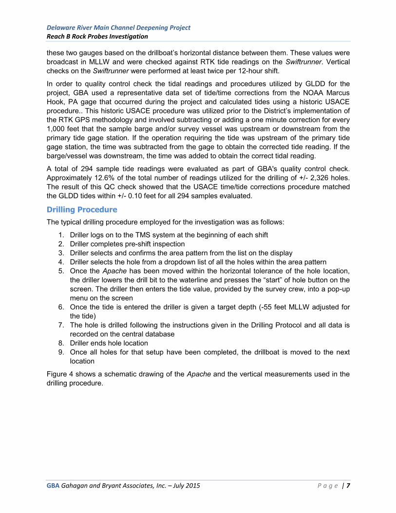
Figure 4 shows a schematic drawing of the Apache and the vertical measurements used in the drilling procedure.
Delaware River Main Channel Deepening Project Reach B Rock Probes Investigation
GBA Gahagan and Bryant Associates, Inc. – July 2015 P a g e | 8
Figure 4 – Schematic Drawing “Apache” Showing Vertical Measurements
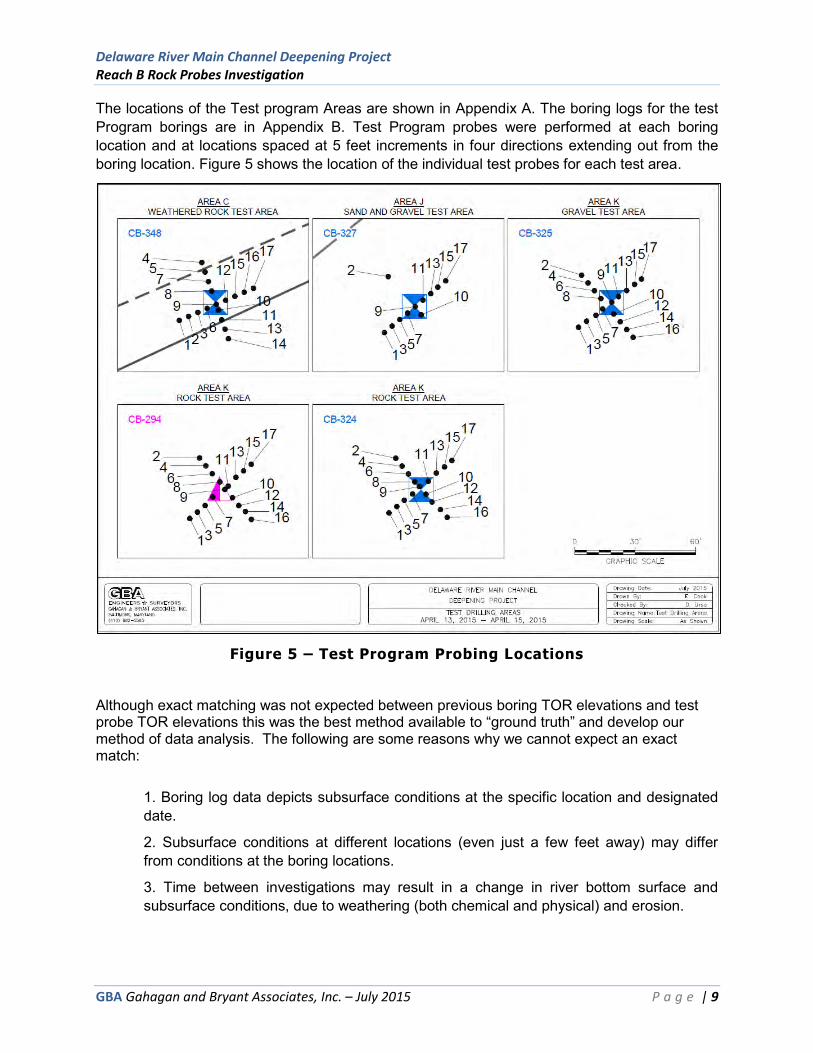
Test Program
Prior to commencing probing operations GBA conducted a three day Test Program from April 13, 2015 through April 15, 2015. A total of 79 probes were performed at previously taken boring locations to analyze how the drilling rate of penetration varied in known material types.
Drilling ROP data was monitored during the test program in different material types (rock, weathered rock, gravel, sand and gravel). The TOR elevations obtained during the Test Program were compared to the TOR elevations from the boring logs. The Test Program also monitored repeatability of the TOR results by multiple measurements at locations within close proximity, which provided a determination of vertical and horizontal positioning precision for TOR. From the data obtained during the test program a drilling protocol was developed for the remainder of the probing investigation.
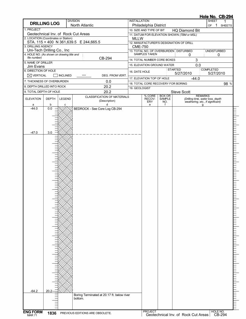
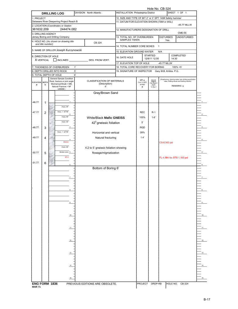
Five Rock Core boring locations were selected for the Test Program:
1. Rock Test Area (CB-294, CB-324)- borings with rock at or near the surface 2. Weathered Rock Test Area (CB-348)- boring with a large amount of weathered rock 3. Gravel Test Area (CB-325)- boring with a large amount of gravel and no rock 4. Sand and Gravel Test Area (CB-327)- boring with a large amount of sand and gravel
and no rock
Delaware River Main Channel Deepening Project Reach B Rock Probes Investigation
GBA Gahagan and Bryant Associates, Inc. – July 2015 P a g e | 9
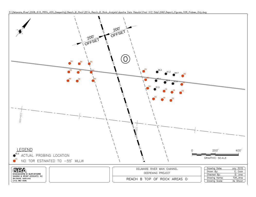
The locations of the Test program Areas are shown in Appendix A. The boring logs for the test Program borings are in Appendix B. Test Program probes were performed at each boring location and at locations spaced at 5 feet increments in four directions extending out from the boring location. Figure 5 shows the location of the individual test probes for each test area.
Figure 5 – Test Program Probing Locations
Although exact matching was not expected between previous boring TOR elevations and test probe TOR elevations this was the best method available to “ground truth” and develop our method of data analysis. The following are some reasons why we cannot expect an exact match:
1. Boring log data depicts subsurface conditions at the specific location and designated date.
2. Subsurface conditions at different locations (even just a few feet away) may differ from conditions at the boring locations.
3. Time between investigations may result in a change in river bottom surface and subsurface conditions, due to weathering (both chemical and physical) and erosion.
Delaware River Main Channel Deepening Project Reach B Rock Probes Investigation
GBA Gahagan and Bryant Associates, Inc. – July 2015 P a g e | 10
4. Other factors, including drilling equipment, positioning technology, and driller’s interpretations may cause slight differences in subsurface conditions at the same boring location.
5. The TOR surface in the project area is highly irregular and because of this TOR elevations may vary at locations within close proximity.
Test Program Results
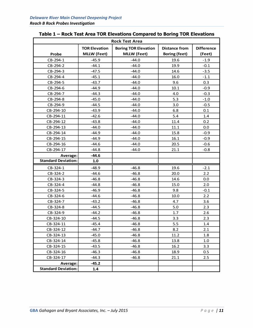
Probing results in the Rock Test Area showed that drilling ROP in competent rock, using four feet per minute (ft./min), with the hammer on as the standard for establishing TOR, provided reliable correlation to borehole data. Comparisons of the TOR elevations obtained in the Rock Test Area to the TOR elevations in borings showed the average of the test probes to be within 1-2 feet of the borings (0.6 feet for CB-294 and 1.6 feet for CB-324). TOR elevations obtained during the test probes had a standard deviation of 1.0-1.4 feet (1.0 feet. for CB-294 and 1.4 feet. for CB-324). The data obtained in the Rock Test Area is shown in Table 1.
Delaware River Main Channel Deepening Project Reach B Rock Probes Investigation
GBA Gahagan and Bryant Associates, Inc. – July 2015 P a g e | 11
Table 1 – Rock Test Area TOR Elevations Compared to Boring TOR Elevations
Probe
TOR Elevation
MLLW (Feet)
Boring TOR Elevation
MLLW (Feet)
Distance from
Boring (feet)
Difference
(Feet)
CB-294-1 -45.9 -44.0 19.6 -1.9
CB-294-2 -44.1 -44.0 19.9 -0.1
CB-294-3 -47.5 -44.0 14.6 -3.5
CB-294-4 -45.1 -44.0 16.0 -1.1
CB-294-5 -43.7 -44.0 9.6 0.3
CB-294-6 -44.9 -44.0 10.1 -0.9
CB-294-7 -44.3 -44.0 4.0 -0.3
CB-294-8 -45.0 -44.0 5.3 -1.0
CB-294-9 -44.5 -44.0 3.0 -0.5
CB-294-10 -43.9 -44.0 6.8 0.1
CB-294-11 -42.6 -44.0 5.4 1.4
CB-294-12 -43.8 -44.0 11.4 0.2
CB-294-13 -44.0 -44.0 11.1 0.0
CB-294-14 -44.9 -44.0 15.8 -0.9
CB-294-15 -44.9 -44.0 16.1 -0.9
CB-294-16 -44.6 -44.0 20.5 -0.6
CB-294-17 -44.8 -44.0 21.1 -0.8
Average: -44.6Standard Deviation: 1.0
CB-324-1 -48.9 -46.8 19.6 -2.1
CB-324-2 -44.6 -46.8 20.0 2.2
CB-324-3 -46.8 -46.8 14.6 0.0
CB-324-4 -44.8 -46.8 15.0 2.0
CB-324-5 -46.9 -46.8 9.8 -0.1
CB-324-6 -44.6 -46.8 10.0 2.2
CB-324-7 -43.2 -46.8 4.7 3.6
CB-324-8 -44.5 -46.8 5.0 2.3
CB-324-9 -44.2 -46.8 1.7 2.6
CB-324-10 -44.5 -46.8 3.3 2.3
CB-324-11 -45.4 -46.8 5.5 1.4
CB-324-12 -44.7 -46.8 8.2 2.1
CB-324-13 -45.0 -46.8 11.2 1.8
CB-324-14 -45.8 -46.8 13.8 1.0
CB-324-15 -43.5 -46.8 16.2 3.3
CB-324-16 -46.3 -46.8 18.9 0.5
CB-324-17 -44.3 -46.8 21.1 2.5
Average: -45.2
Standard Deviation: 1.4
Rock Test Area

Delaware River Main Channel Deepening Project Reach B Rock Probes Investigation
GBA Gahagan and Bryant Associates, Inc. – July 2015 P a g e | 12
Probing results in the Weathered Rock Test Area showed that drilling ROP in weathered rock was in the 6-12 ft. /min range with the hammer on. Comparisons of the TOR elevations obtained in the Weathered Rock Test Area to the TOR elevation in the boring showed the average of the test probes to be within 2 feet of the TOR determined from the CB-348 boring log. TOR elevations obtained during the test probes had a standard deviation of 1.2 feet. The data obtained in the Weathered Rock Test area is shown in Table 2.
Table 2 – Weathered Rock Test Area TOR Elevations Compared to Boring TOR Elevation
Probe
TOR Elevation
MLLW (feet)
Boring CB-348 TOR
Elevation MLLW (feet)
Distance from
Boring (feet)
Difference
(feet)
CB-348-1 -47.6 -48.3 19.9 0.7
CB-348-2 -47.1 -48.3 14.9 1.2
CB-348-3 -44.6 -48.3 9.9 3.7
CB-348-4 -45.5 -48.3 20.9 2.8
CB-348-5 -48.3 -48.3 15.9 0.0
CB-348-6 -46.8 -48.3 5.0 1.5
CB-348-7 -46.8 -48.3 10.9 1.5
CB-348-8 -46.1 -48.3 5.9 2.2
CB-348-9 -47.6 -48.3 1.1 0.7
CB-348-10 -45.0 -48.3 4.1 3.3
CB-348-11 -45.6 -48.3 9.2 2.7
CB-348-12 -46.9 -48.3 5.2 1.4
CB-348-13 -46.9 -48.3 14.1 1.4
CB-348-14 -46.8 -48.3 19.1 1.5
CB-348-15 -45.8 -48.3 10.2 2.5
CB-348-16 -43.8 -48.3 15.2 4.5
CB-348-17 -45.1 -48.3 20.2 3.2
Average: -46.3
Standard Deviation: 1.2
Weathered Rock Test Area
Probing Results in the Gravel test area showed erratic rates of penetration. When encountering gravel the ROP would drop for a few seconds and then quickly rise again. The ROP would jump between 5 and 25 ft. /min while penetrating gravel. Probing results in the Sand and Gravel Test Area showed rates of penetration ranging from 12 to 25 ft/min while penetrating sand and gravel, with more uniform ROP.
Based on the Test Program results, a drilling protocol was prepared for the remainder of the project. This protocol was agreed upon by the USACE and distributed to all the drillers. An ROP of 4 was chosen as a stopping point to ensure we reached the top of competent bedrock.
Drilling Protocol Lower the drill string until the river bottom is encountered, and then pause Drill without the hammer until there is no advancement When a Rate of Penetration, with the hammer on, of less than or equal to 4 is
achieved this will mark the top of rock. Drill 1 foot into the rock or drill until -55 feet MLLW is reached
Delaware River Main Channel Deepening Project Reach B Rock Probes Investigation
GBA Gahagan and Bryant Associates, Inc. – July 2015 P a g e | 13
Probing Investigation
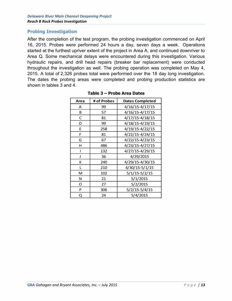
After the completion of the test program, the probing investigation commenced on April 16, 2015. Probes were performed 24 hours a day, seven days a week. Operations started at the furthest upriver extent of the project in Area A, and continued downriver to Area Q. Some mechanical delays were encountered during this investigation. Various hydraulic repairs, and drill head repairs (breaker bar replacement) were conducted throughout the investigation as well. The probing operation was completed on May 4, 2015. A total of 2,326 probes total were performed over the 18 day long investigation. The dates the probing areas were completed and probing production statistics are shown in tables 3 and 4.
Table 3 – Probe Area Dates
Area # of Probes Dates Completed
A 99 4/16/15-4/17/15
B 57 4/16/15-4/17/15
C 81 4/17/15-4/18/15
D 99 4/18/15-4/19/15
E 258 4/19/15-4/22/15
F 81 4/22/15-4/24/15
G 67 4/22/15-4/23/15
H 486 4/23/15-4/27/15
I 132 4/27/15-4/29/15
J 36 4/29/2015
K 240 4/29/15-4/30/15
L 210 4/30/15-5/1/15
M 102 5/1/15-5/2/15
N 21 5/1/2015
O 27 5/2/2015
P 306 5/2/15-5/4/15
Q 24 5/4/2015

Delaware River Main Channel Deepening Project Reach B Rock Probes Investigation
GBA Gahagan and Bryant Associates, Inc. – July 2015 P a g e | 14
Table 4 – Probing Production
GBA and USACE observers were onboard during the entire drilling operation. While monitoring and directing the investigation, GBA kept detailed daily operations logs as well as drilling production logs with field interpreted TOR elevations based on real time ROP values observed during the drilling of each hole. Figure 6 shows field recorded TOR elevations as recorded by GBA and USACE. Field production logs are included in Appendix C. All fields in the field production logs may not be 100% complete. With three frames drilling at once, 24 hours a day, occasionally direct observation of information was not possible. However, this information was recorded in the database and was analyzed at a later time.
Date # of Probes Performed Hours Worked
4/16/2015 75 17
4/17/2015 122 24
4/18/2015 108 24
4/19/2015 54 24
4/20/2015 98 24
4/21/2015 97 24
4/22/2015 131 24
4/23/2015 125 24
4/24/2015 76 14
4/25/2015 119 24
4/26/2015 136 24
4/27/2015 150 20
4/28/2015 17 1
4/29/2015 175 24
4/30/2015 208 24
5/1/2015 198 24
5/2/2015 212 24
5/3/2015 183 24
5/4/2015 42 6
Total: 2326 394
Avg. Probes/ work day: 142
Avg. Probes/ work hour: 6

Delaware River Main Channel Deepening Project Reach B Rock Probes Investigation
GBA Gahagan and Bryant Associates, Inc. – July 2015 P a g e | 15
Figure 6 – Field Recorded TOR Elevations

Delaware River Main Channel Deepening Project Reach B Rock Probes Investigation
GBA Gahagan and Bryant Associates, Inc. – July 2015 P a g e | 16
Post Investigation Top of Rock Quality Control
After completion of the probing investigation, an additional quality control process was undertaken to verify precision of the drilling protocol. The TOR elevations of probes performed within 20 feet of an existing boring location were compared to the boring TOR elevation. The standard deviation for the differences between the TOR elevations obtained in the probes and the TOR elevations in the borings was 1.1 feet. Table 5 summarizes these comparisons.
Table 5 – Post-Investigation TOR Quality Control
Boring
Top of Rock
Elelvation MLLW
(feet) Probe
Top of Rock
Elelvation MLLW
(feet)
Distance from
Boring (feet)
Difference
(feet)
CB-286 -46.2 A51 -46.2 18 0.0
CB-283 -45.8 C55 -44.5 14 1.3
CB-278 -43.5 E212 -44.0 17 0.5
CB-304 -46.7 E75 -45.2 17 1.5
CB-302 -44.4 H416 -44.1 17 0.3
CB-301 -48.4 H366 -51.1 17 2.7
CB-275 -44.3 H156 -43.5 20 0.8
CB-317 -50.0 P83 -53.9 5 3.9
CB-255 -44.1 P99 -44.5 19 0.4
DRV-7 -48.2 P125 -47.3 10 0.9
CB-254 -43.8 P61 -44.1 16 0.3
Standard Deviation: 1.2
Top of Rock Selection Procedures
During the Test Program, where probes were performed at previous boring locations, results showed that drilling Rate of Penetration in competent rock was in the 0-4 ft. /min range with the hammer on. However, post project ROP data analysis concluded that consistent ROP values as high as 6 ft. /min could also indicate TOR, therefore post project selection of TOR values was based on a ROP of less than 6 ft. /min. When reviewing the data to select a final TOR rock elevation for each hole, GBA and USACE personnel reviewed the data for each hole, and the field recorded TOR elevations. There were also instances where ROP would drop below 6 ft. /min while drilling that were not the TOR. These instances were times when the driller would stop the advancement of the drill string or was reaming the hole. A typical ROP curve with drilling features is shown in Figure 7.

Delaware River Main Channel Deepening Project Reach B Rock Probes Investigation
GBA Gahagan and Bryant Associates, Inc. – July 2015 P a g e | 17
Figure 7 – Typical ROP Curve
TOR Drilled approx. 1’ into rock
Drops in ROP due to hole reaming, stopping advancement
Water Column
River bottom

Delaware River Main Channel Deepening Project Reach B Rock Probes Investigation
GBA Gahagan and Bryant Associates, Inc. – July 2015 P a g e | 18
Top of Rock Quality Control Procedures
1. A geologist, who was onboard the Apache during the probing investigation, went through each hole’s data, compared it to the field interpreted TOR elevation, and selected a TOR elevation
2. An engineer, who was onboard the Apache during the probing investigation, went through each hole’s data, compared it to the field interpreted TOR elevation, and selected a TOR elevation
3. A QC spreadsheet was created for each area, comparing the two TOR elevations selected for each hole
4. A geologist went through the QC spreadsheet for each area and re-evaluated TOR elevations for any hole where the selected elevation was a 0.5 foot or greater difference between the geologist and engineers choice
5. If both the geologist and the engineer felt the data was suspect in some way the hole would be removed from the data set
6. TOR XYZ files were created for each area 7. GBA personnel and USACE personnel met to develop a mutually agreed upon
evaluation and analysis of the XYZ files 8. Contours based upon the agreed upon elevations at each probe for each area,
were created from the XYZ files and plotted in plan-view drawings showing hole #, TOR elevation and TOR contours
9. The plan view drawing for each area was reviewed to look for outliers, and strange patterns in the contours; he TOR outliers that caused any strange contours were reevaluated
Following these QC procedures final TOR XYZ files were created for each probing area.
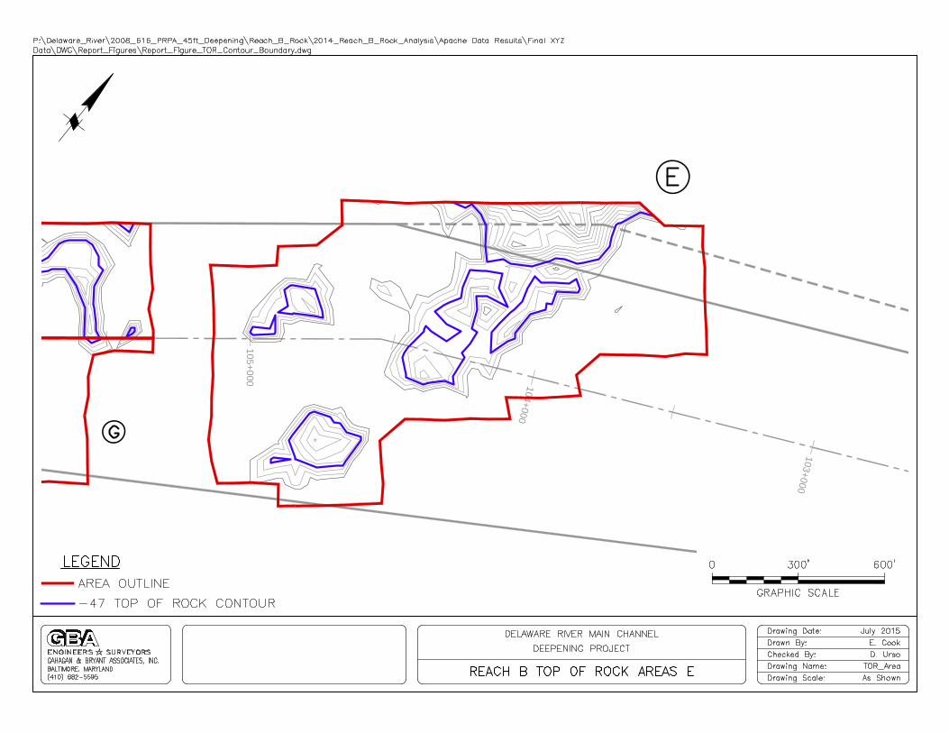
RESULTS
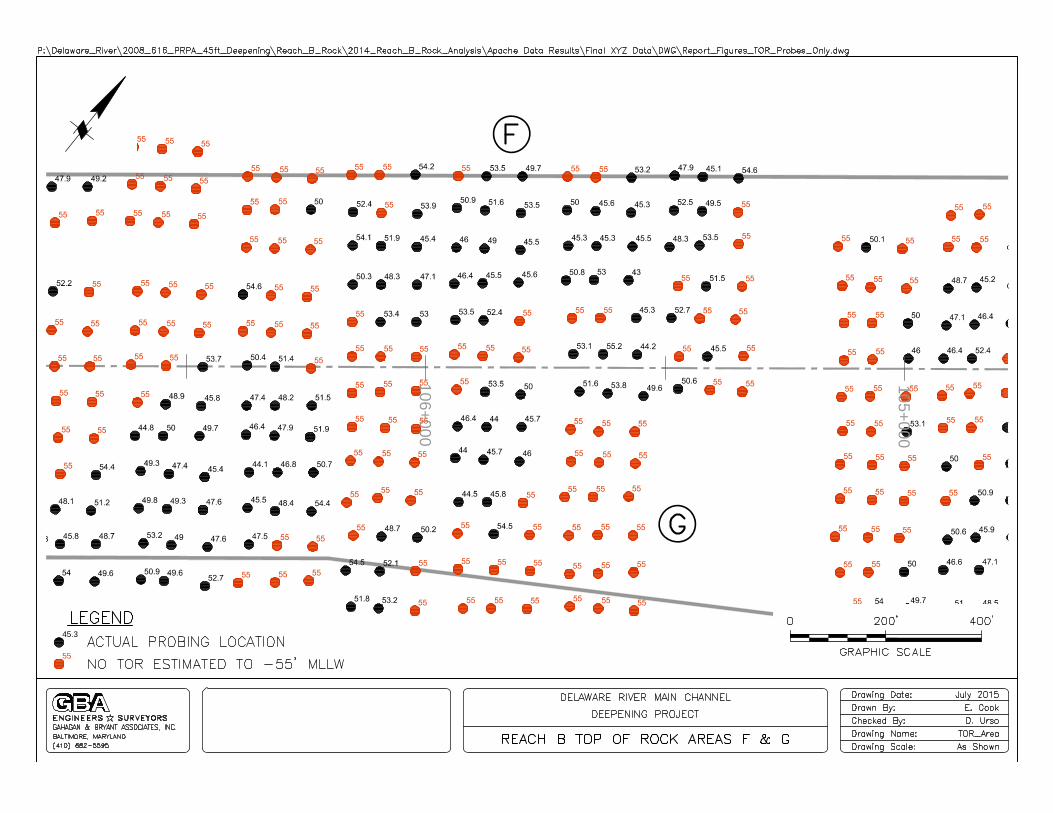
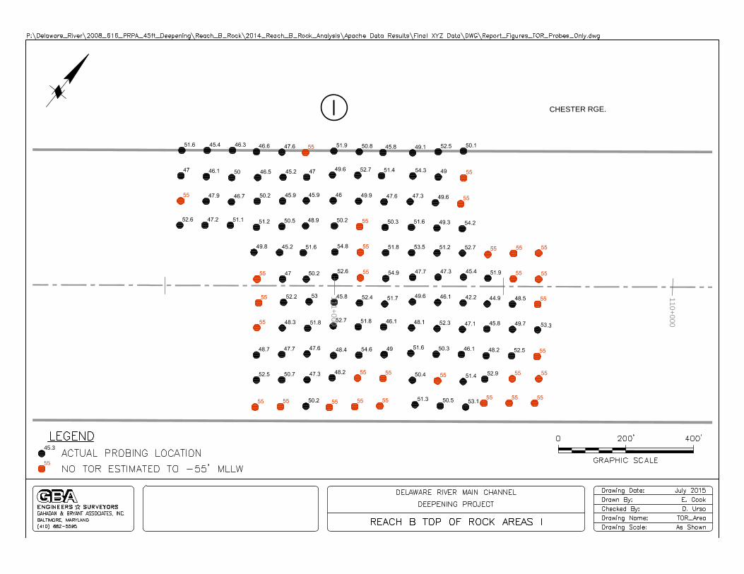
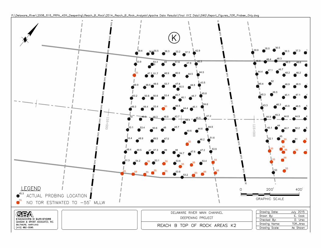
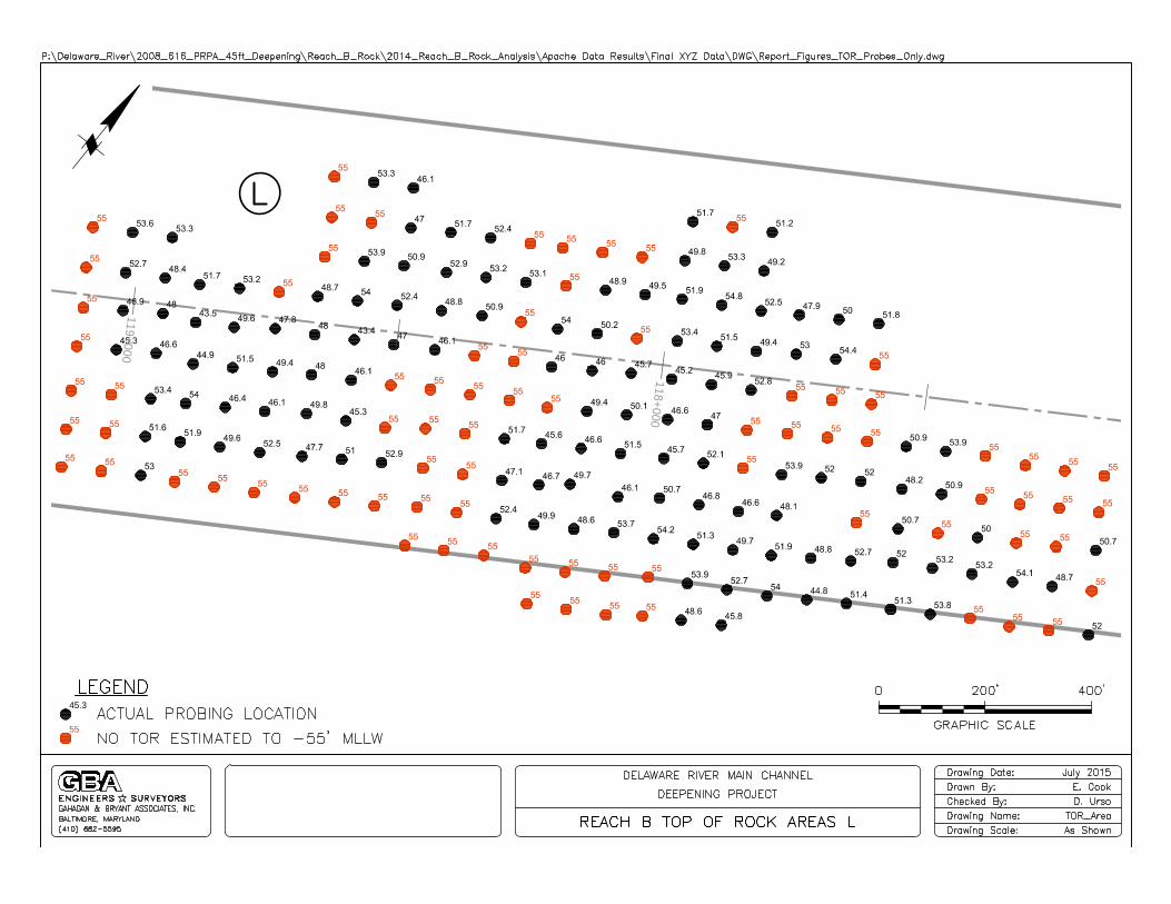
Once the final XYZ files were created, contours were generated for the TOR surface for each probing area. TOR drawings are contained in Appendix A. Test Program boring logs are contained in Appendix B. Field Production Spreadsheets are contained in Appendix C. TOR xyz files are contained in Appendix D.

Delaware River Main Channel Deepening Project Reach B Rock Probes Investigation
GBA Gahagan and Bryant Associates, Inc. – July 2015
APPENDIX A
Project Drawings
1
4
5
+
0
0
0
1
4
0
+
0
0
0
1
3
5
+
0
0
0
1
3
0
+
0
0
0
1
2
5
+
0
0
0
1
2
0
+
0
0
0
1
1
5
+
0
0
0
1
1
0
+
0
0
0
1
0
5
+
0
0
0
1
0
0
+
0
0
0
95+
000

97+
000
9
8
+
0
0
0

9
9
+
0
0
0CB-348

1
0
1
+
0
0
0
1
0
2
+
0
0
0
E
D
D
Y
S
T
O
N
E
R
G
E
.
1
0
3
+
0
0
0
1
0
4
+
0
0
0
105+
000

105+
000
106+
000

106+
000
107+
000
108+
000
109+
000
110+
000
110+
000
111+
000
CHESTER RGE.
113+
000
114+
000
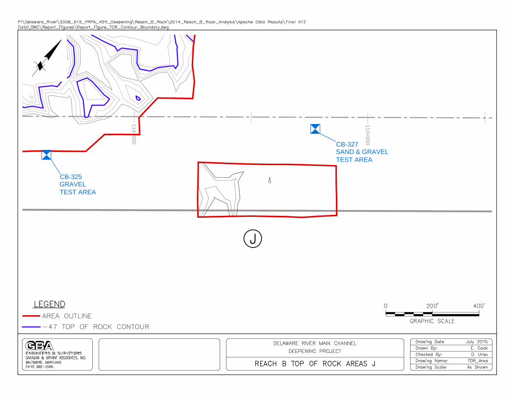
CB-327
SAND & GRAVEL
TEST AREA
GRAVEL
TEST AREA
CB-325
114+
000
115+
000
S
F
O
S
F
O
S
F
O
S
F
O
S
F
O
S
F
O
S
F
O
S
F
O
S
F
O
S
F
O
S
F
O
S
F
O
S
F
O
S
F
O
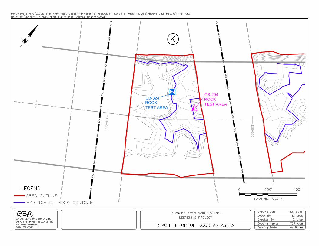
CB-294
GRAVEL
TEST AREA
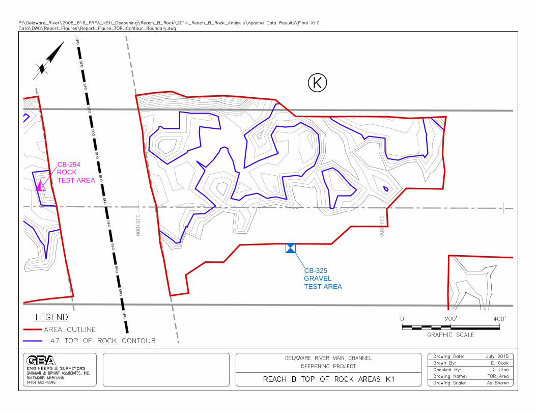
CB-325
ROCK
TEST AREA
115+
000
116+
000
S
F
O
S
F
O
S
F
O
S
F
O
S
F
O
S
F
O
S
F
O
S
F
O
S
F
O
S
F
O
S
F
O
S
F
O
S
F
O
S
F
O
G
AS
G
AS
G
AS
G
AS
G
AS
G
AS
G
AS
G
AS
G
AS
G
AS
G
AS
G
AS
G
AS
G
AS
CB-294
ROCK
TEST AREA

118+
000
119+
000
121+
000

128+
000
129+
000
130+
000
G
A
S
G
A
S
G
A
S
G
A
S
G
A
S
G
A
S
G
A
S
G
A
S
G
A
S
G
A
S
G
A
S
G
A
S
G
A
S
G
A
S
G
A
S
G
A
S
G
A
S
G
A
S
G
A
S
G
A
S
G
A
S
G
A
S
G
A
S
G
A
S
2
0
0
'
O
F
F
S
E
T
2
0
0
'
O
F
F
S
E
T

133+
000
134+
000
G
A
S
G
A
S
G
A
S
G
A
S
G
A
S
G
A
S
G
A
S
G
A
S
G
A
S
G
A
S
G
A
S
G
A
S
G
A
S
G
A
S
2
0
0
'
O
F
F
S
E
T
2
0
0
'
O
F
F
S
E
T

139+
000
140+
000
138+
000

CB-348
1
2
3
4
5
6
7
8
9
10
11
12
13
14
15
16
17
CB-327
1
2
3
5
7
9
10
11
13
15
17
CB-324
2
4
6
8
9
10
12
14
16
1
3
5
7
11
13
15
17
CB-325
1
2
3
4
5
6
7
8
9
10
11
12
13
14
15
16
17
CB-294
2
4
6
8
9
10
12
14
16
17
15
13
11
7
5
3
1
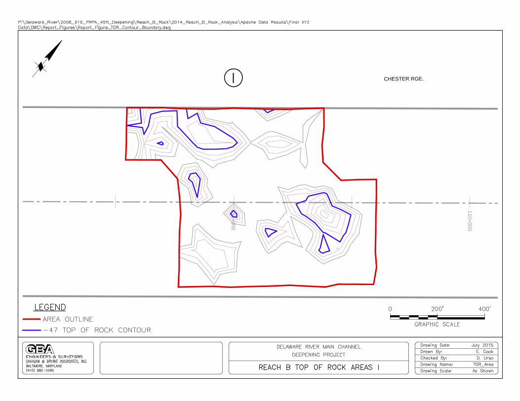
AREA C
WEATHERED ROCK TEST AREA
AREA K
ROCK TEST AREA
AREA J
SAND AND GRAVEL TEST AREA
AREA K
GRAVEL TEST AREA
AREA K
ROCK TEST AREA
97+
000
9
8
+
0
0
0
55
45.3

9
9
+
0
0
0
55
45.3
1
0
1
+
0
0
0
1
0
2
+
0
0
0
E
D
D
Y
S
T
O
N
E
R
G
E
.
55
45.3
1
0
3
+
0
0
0
1
0
4
+
0
0
0
105+
000
55
45.3
105+
000
106+
000
55
45.3

106+
000
107+
000
108+
000
109+
000
110+
000
55
45.3
110+
000
111+
000
CHESTER RGE.
55
45.3

113+
000
114+
000
55
45.3

S
F
O
S
F
O
S
F
O
S
F
O
S
F
O
S
F
O
S
F
O
S
F
O
S
F
O
S
F
O
S
F
O
S
F
O
S
F
O
S
F
O
114+
000
115+
000
55
45.3
S
F
O
S
F
O
S
F
O
S
F
O
S
F
O
S
F
O
S
F
O
S
F
O
S
F
O
S
F
O
S
F
O
S
F
O
S
F
O
S
F
O
G
AS
G
AS
G
AS
G
AS
G
AS
G
AS
G
AS
G
AS
G
AS
G
AS
G
AS
G
AS
G
AS
G
AS
115+
000
116+
000
55
45.3
118+
000
119+
000
55
45.3

121+
000
55
45.3

G
A
S
G
A
S
G
A
S
G
A
S
G
A
S
G
A
S
G
A
S
G
A
S
G
A
S
G
A
S
G
A
S
G
A
S
G
A
S
G
A
S
G
A
S
G
A
S
G
A
S
G
A
S
G
A
S
G
A
S
G
A
S
G
A
S
G
A
S
G
A
S
2
0
0
'
O
F
F
S
E
T
2
0
0
'
O
F
F
S
E
T
128+
000
129+
000
130+
000
55
45.3
G
A
S
G
A
S
G
A
S
G
A
S
G
A
S
G
A
S
G
A
S
G
A
S
G
A
S
G
A
S
G
A
S
G
A
S
G
A
S
G
A
S
2
0
0
'
O
F
F
S
E
T
2
0
0
'
O
F
F
S
E
T
133+
000
134+
000
55
45.3

139+
000
140+
000
138+
000
55
45.3
Delaware River Main Channel Deepening Project Reach B Rock Probes Investigation
GBA Gahagan and Bryant Associates, Inc. – July 2015
APPENDIX B
Test Program Boring Logs
3.0
20.2
BEDROCK - See Core Log CB-294
Boring Terminated at 20.17 ft. below riverbottom.
-47.0
-64.2
REMARKS(Drilling time, water loss, depthweathering, etc., if significant)
BOX ORSAMPLE
NO.LEGEND
% CORERECOV-
ERY
CLASSIFICATION OF MATERIALS(Description)
ELEVATION DEPTH
a fc eb gd
0.0
HQ Diamond Bit
0
North AtlanticINSTALLATION SHEET
Jim Evans
10. SIZE AND TYPE OF BIT
14. TOTAL NUMBER CORE BOXES
16. DATE HOLE
DIVISION
5/27/2010---
12. MANUFACTURER'S DESIGNATION OF DRILL
OF
CB-294 3
19. GEOLOGIST
STA. 115 + 400 N 361,639.5 E 244,665.52. LOCATION (Coordinates or Station)
Steve Scott
0.020.220.2
7. THICKNESS OF OVERBURDEN
8. DEPTH DRILLED INTO ROCK
9. TOTAL DEPTH OF HOLE
17. ELEVATION TOP OF HOLE
15. ELEVATION GROUND WATER
SHEETS
STARTED COMPLETED
Hole No. CB-294
Philadelphia District
11. DATUM FOR ELEVATION SHOWN (TBM or MSL)
DISTURBED
1. PROJECT
MLLW
-44.0
Uni-Tech Drilling Co., Inc UNDISTURBED13. TOTAL NO. OF OVERBURDENSAMPLES TAKEN
18. TOTAL CORE RECOVERY FOR BORING
-44.0 0.0
CME-750
VERTICAL INCLINED
Geotechnical Inv. of Rock Cut Areas
5/27/2010
0
DRILLING LOG 11
3. DRILLING AGENCY
5. NAME OF DRILLER
6. DIRECTION OF HOLE
%98
DEG. FROM VERT.
4. HOLE NO. (As shown on drawing title andfile number)
Hole No. CB-294
PROJECT HOLE NO.Geotechnical Inv. of Rock Cut Areas CB-294PREVIOUS EDITIONS ARE OBSOLETE.1836
MAR 71ENG FORM

10.0,13.1
Joint, horiz. with 55°, joint to0.6'MB, 55°MB, 55°Joint, horiz.MB, 35°Joint, 40°MB, 75°MB, 40°MB, 20°MB, 60°Multiple MB's to 4, 60° to 35°
MB, 45°
Joint, 45°
Joint, 5°
MB, 75°
MB, 45°
MB, horiz.Joint, 35°MB, 25°
Joint, horiz.
MB, 50°MB, 50°MB, 35°
MB, 35°MB, 50°
Joint, 58°
MB, 5 °
MB, 5°MB, 45°
Joint, 60°
Joint, 45°
Joint, horiz.
MB, horiz.
Multiple MBs to 17.9', horiz.to 5°
F - SW
F - SW
F - SW
F - SW
R4
R4
34
40
75
85
3
6
2
3
ModeratelyFractured
ModeratelyFractured
SlightlyFractured
SlightlyFractured
100
100
100
100
HQ
Dia
mon
d Im
preg
nate
d
HQ
RUN #1: GNEISS, finegrained, 60° foliation,black, white, fresh to sl.weathered, mod. hard,mod. fractured; fracturesurfaces are sl. to mod.weathered
RUN #2: GNEISS, Sameas Run #1; fracturesurface at 5' is intenselyweathered
RUN #3: GNEISS, Sameas Run #1, except slightlyfractured
RUN #4: GNEISS, Sameas Run #3
RUN #5: GNEISS, Sameas Run #3, except
Coring Started at 0ft
FILE No.
DISCONTINUITY SPACING
R.Q.D.
Sum core lengths > 4 in.
1
2
3
4
5
6
7
8
9
10
11
12
13
14
15
16
17
Drilling
Details
Cor
eR
ecov
ery
(%
)
Cor
eC
ondi
tion
Dis
cont
inui
tyS
paci
ng
length of core runx 100
R0 Extremely weakR1 Very weakR2 WeakR3 Medium strongR4 StrongR5 Very strongR6 Extremely strong
Hole Orientation VerticalHQ Diamond Drill
Dep
th (
ft)
No. of fractures/Run
46126PREPARED By:
DDWSHEET 1 of 2
CORE RECOVERY
Length of core
core runx 100
ROCK STRENGTH (ksi)
Unc
onf.
Com
p.S
tren
gth
(ksi
)
R.Q
.D. (
%)
Wea
ther
ing
Inta
ct R
ock
Str
engt
h (p
si)
StructuralDiscontinuityDescription
<0.150.15 - 0.70.7 - 3.53.5 - 7.0
7.0 -14.514.5 - 30.0
>30.0
Rock MassDescription
Tes
ts
WEATHERINGFSWMWHWCWRS
FreshSlightlyModeratelyHighlyCompletelyResidual Soil
ROCK CORE LOG TEST HOLE No.
Driller Method
Logged By SRS Date 5/27/10
Project
Location
Geotechnical Inv. of Rock Cut AreasN361,639.500/E244,665.500Jim Evans
Elevation
Dates
CB-294
-44.00ft5/27/10
O'BRIEN & GERER
OC
K C
OR
E L
OG
461
26 U
SA
CE
DE
RIV
ER
CO
RE
LO
GS
.GP
J B
C_M
OT
.GD
T 8
/5/1
0

MB, 60°
F - SW470Ufractured86
HQ
unfractured
RUN #5: GNEISS, Sameas Run #3, exceptunfractured (continued)
Boring Terminated at 20.1ft
FILE No.
DISCONTINUITY SPACING
R.Q.D.
Sum core lengths > 4 in.
19
20
21
22
23
24
25
26
27
28
29
30
31
32
33
34
35
Drilling
Details
Cor
eR
ecov
ery
(%
)
Cor
eC
ondi
tion
Dis
cont
inui
tyS
paci
ng
length of core runx 100
R0 Extremely weakR1 Very weakR2 WeakR3 Medium strongR4 StrongR5 Very strongR6 Extremely strong
Hole Orientation VerticalHQ Diamond Drill
Dep
th (
ft)
No. of fractures/Run
46126PREPARED By:
DDWSHEET 2 of 2
CORE RECOVERY
Length of core
core runx 100
ROCK STRENGTH (ksi)
Unc
onf.
Com
p.S
tren
gth
(ksi
)
R.Q
.D. (
%)
Wea
ther
ing
Inta
ct R
ock
Str
engt
h (p
si)
StructuralDiscontinuityDescription
<0.150.15 - 0.70.7 - 3.53.5 - 7.0
7.0 -14.514.5 - 30.0
>30.0
Rock MassDescription
Tes
ts
WEATHERINGFSWMWHWCWRS
FreshSlightlyModeratelyHighlyCompletelyResidual Soil
ROCK CORE LOG TEST HOLE No.
Driller Method
Logged By SRS Date 5/27/10
Project
Location
Geotechnical Inv. of Rock Cut AreasN361,639.500/E244,665.500Jim Evans
Elevation
Dates
CB-294
-44.00ft5/27/10
O'BRIEN & GERER
OC
K C
OR
E L
OG
461
26 U
SA
CE
DE
RIV
ER
CO
RE
LO
GS
.GP
J B
C_M
OT
.GD
T 8
/5/1
0
Hole No. CB-324 DRILLING LOG DIVISION North Atlantic INSTALLATION Philadelphia District SHEET 1 OF 1
1. PROJECT Delaware River Deepening Project Reach B
10. SIZE AND TYPE OF BIT 2” or 3” SPT 140# Safety hammer 11. DATUM FOR ELEVATION SHOWN (TBM or MSL) -45.77 MLLW 2. LOCATION (Coordinates or Station
361632.209 244474.082 12. MANUFACTURERS DESIGNATION OF DRILL CME-55
3. DRILLING AGENCY Jersey Boring and Drilling Company 13. TOTAL NO. OF OVERBURDEN
SAMPLES TAKEN DISTURBED
Yes UNDISTURBED
4. HOLE NO. (As shown on drawing title and title number) CB-324
14. TOTAL NUMBER CORE BOXES 1
5. NAME OF DRILLER Joseph Kurzynowski 15. ELEVATION GROUND WATER N/A 6. DIRECTION OF HOLE X VERTICAL INCLINED DEG. FROM VERT.
16. DATE HOLE STARTED 12/8/11 12:00
COMPLETED 14:30
17. ELEVATION TOP OF HOLE -45.77 MLLW
7. THICKNESS OF OVERBURDEN 1’ 18. TOTAL CORE RECOVERY FOR BORING 100% =5’ 8. DEPTH DRILLED INTO ROCK 5’ 19. SIGNATURE OF INSPECTOR Gary M.B. Kribbs. P.G. 9. TOTAL DEPTH OF HOLE 6’
ELEVATION a
DEPTH b
General Sample Condition Rock: fracture or joint angle
Mechanical Break = MB, Natural Fracture = NF
LEGEND c
CLASSIFICATION OF MATERIALS (Description)
d
SPT or Core % REC
& RQD e
BOX OR SAMPLE
# or Run # depth
% Rec f
(Weathering, staining water loss drilling penetration rates, drilling issues and testing results)
REMARKS g
Gray/Brown Sand
-46.77
1 1 1
Horiz. NF
-47.77
2 Horiz. + 420 NF REC R-1 2 2
Horiz. NF White/Black Mafic GNEISS
100% 1-6’
Horiz. NF 420 gneissic foliation
5’
-48.77
3 3 RQD 3
Horiz. + 420 NF Horizontal and vertical 28%
-49.77
4 Natural fracturing 1.4’
4 4
CS-3.1 CS-8,563 psi
Horiz. NF
4.2 to 5’ gneissic foliation showing
-50.77 5 Broken zone 5 flowage/migmatization 5
ST-3 FL-4,984 lbs STS-1,100 psi
-51.77
6 6 6
Bottom of Boring 6’
7 7
-
8 8
9 9
10 10
11 11
12 12
13 13
14 14
15 15
ENG FORM 1836 PREVIOUS EDITIONS ARE OBSOLETE. MAR 71
PROJECT DRDP-RB HOLE NO. CB-324
B-17

Hole No. CB-325 DRILLING LOG DIVISION North Atlantic INSTALLATION Philadelphia District SHEET 1 OF 1
1. PROJECT Delaware River Deepening Project Reach B
10. SIZE AND TYPE OF BIT *2” or 3” SPT 140# Safety hammer 11. DATUM FOR ELEVATION SHOWN (TBM or MSL) -44.49 MLLW 2. LOCATION (Coordinates or Station
362091.716 245618.512 12. MANUFACTURERS DESIGNATION OF DRILL CME-55
3. DRILLING AGENCY Jersey Boring and Drilling Company 13. TOTAL NO. OF OVERBURDEN
SAMPLES TAKEN 3 DISTURBED
Yes UNDISTURBED
4. HOLE NO. (As shown on drawing title and title number) CB-325
14. TOTAL NUMBER CORE BOXES N/A
5. NAME OF DRILLER Joseph Kurzynowski 15. ELEVATION GROUND WATER N/A 6. DIRECTION OF HOLE X VERTICAL INCLINED DEG. FROM VERT.
16. DATE HOLE STARTED 12/7/11 12:30
COMPLETED 15:30
17. ELEVATION TOP OF HOLE -44.49 MLLW
7. THICKNESS OF OVERBURDEN 8’ 18. TOTAL CORE RECOVERY FOR BORING N/A 8. DEPTH DRILLED INTO ROCK N/A 19. SIGNATURE OF INSPECTOR Gary M.B. Kribbs P.G. 9. TOTAL DEPTH OF HOLE 8’
ELEVATION a
DEPTH b
General Sample Condition Rock: fracture or joint angle
Mechanical Break = MB, Natural Fracture = NF
LEGEND c
CLASSIFICATION OF MATERIALS (Description)
d
SPT or Core % REC
& RQD e
BOX OR SAMPLE
# or Run # depth
% Rec f
(Weathering, staining water loss drilling penetration rates, drilling issues and testing results)
REMARKS g
Casing embedded 3'
-45.49
1 1 1
Spoon pulled casing up &
-46.49
2 S-1 * Collapsed the hole 2 2
Multi-colored 4-6’ A-1-a (0)
GRAVEL and SAND REC GW
-47.49
3 3 62.5% 3
-48.49
4 4 4
Moderately well sorted 27-36
-49.49 5 5 5
50-53 S-2
-50.49
6 6-8' 6 6
27-36 REC
62.5%
-51.49
7 7 1.25' Casing running 7
27-33
-52.49
8 8 8
Bottom of Boring 8’
9 9 9
10 10
11 11
12 12
13 13
14 14
15 15
ENG FORM 1836 PREVIOUS EDITIONS ARE OBSOLETE. MAR 71
PROJECT DRDP-RB HOLE NO. CB-325
B-18

Hole No. CB-327 DRILLING LOG DIVISION North Atlantic INSTALLATION Philadelphia District SHEET 1 OF 1
1. PROJECT Delaware River Deepening Project Reach B
10. SIZE AND TYPE OF BIT 2” or 3” SPT 140 # Safety Hammer 11. DATUM FOR ELEVATION SHOWN (TBM or MSL) -42.4 MLLW 2. LOCATION (Coordinates or Station
362901.539 246441.847 12. MANUFACTURERS DESIGNATION OF DRILL CME-55
3. DRILLING AGENCY Jersey Boring and Drilling Company 13. TOTAL NO. OF OVERBURDEN
SAMPLES TAKEN 4 DISTURBED
Yes UNDISTURBED
4. HOLE NO. (As shown on drawing title and title number) CB-327
14. TOTAL NUMBER CORE BOXES N.A
5. NAME OF DRILLER Joseph Kurzynowski 15. ELEVATION GROUND WATER N/A 6. DIRECTION OF HOLE X VERTICAL INCLINED DEG. FROM VERT.
16. DATE HOLE STARTED 12/6/11 7:45
COMPLETED 10:00
17. ELEVATION TOP OF HOLE -42.4 MLLW
7. THICKNESS OF OVERBURDEN 10.5' 18. TOTAL CORE RECOVERY FOR BORING N/A 8. DEPTH DRILLED INTO ROCK N/A 19. SIGNATURE OF INSPECTOR Gary M.B. Kribbs P.G. 9. TOTAL DEPTH OF HOLE 10.5'
ELEVATION a
DEPTH b
General Sample Condition Rock: fracture or joint angle
Mechanical Break = MB, Natural Fracture = NF
LEGEND c
CLASSIFICATION OF MATERIALS (Description)
d
SPT or Core % REC
& RQD e
BOX OR SAMPLE
# or Run # depth
% Rec f
(Weathering, staining water loss drilling penetration rates, drilling issues and testing results)
REMARKS g
Very loose Casing embedded into sediment
-43.4
1 1 Casing 3 feet. Due to strong river current 1
Loose gravel and sand in wash
-44.4
2 2 2
S-1
-45.4
3 3 3-5’ 3
Gray 12-27 REC
-46.4
4 GRAVEL and SAND 0% 4 4
36-41 0.0'
S-2
-47.4
5 5 5-7' 5
12-26 REC
-48.4
6 Reddish Gray 40% A-4 (0) 6 6
Micaceous Sandy SILT with 19-28 0.8' ML
rock fragments and gravel S-3 Non-plastic
-49.4
7 7 7-9' 7
Brown/Gray 37-53 REC A-1-a (0)
-50.4
8 GRAVEL and SAND 100% N/A 8 8
2'
Grading down to 54-53 S-4
-51.4
9 9 Medium grained SAND 9-11' 9
With gravel and rock fragments 63-67 REC
-52.4 10 100% 10 10
100/0.5 2'
-53.4 11 11 Bottom of Boring 10.5’ 11
12 12
13 13
14 14
15 15
ENG FORM 1836 PREVIOUS EDITIONS ARE OBSOLETE. MAR 71
PROJECT DRDP-RB HOLE NO. CB-327
B-20

Hole No. CB-348 DRILLING LOG . INSTALLATION Philadelphia District SHEET 1 OF 1
1. PROJECT Delaware River Deepening Project Reach B
10. SIZE AND TYPE OF BIT 2” or 3” SPT or HX Diamond Bit. 11. DATUM FOR ELEVATION SHOWN (TBM or MSL) -44.1 MLLW 2. LOCATION (Coordinates or Station
371156.556 258176.725 12. MANUFACTURERS DESIGNATION OF DRILL CME-55
3. DRILLING AGENCY Jersey Boring and Drilling Company 13. TOTAL NO. OF OVERBURDEN
SAMPLES TAKEN 2 DISTURBED
Yes UNDISTURBED
4. HOLE NO. (As shown on drawing title and title number) CB-348
14. TOTAL NUMBER CORE BOXES 1 5. NAME OF DRILLER Joseph Kurzynowski 15. ELEVATION GROUND WATER N/A 6. DIRECTION OF HOLE X VERTICAL INCLINED DEG. FROM VERT.
16. DATE HOLE STARTED 12/19/11 7:30
COMPLETED 11:30
17. ELEVATION TOP OF HOLE -44.1 MLLW
7. THICKNESS OF OVERBURDEN 5’ 18. TOTAL CORE RECOVERY FOR BORING 79% =6.3’’ 8. DEPTH DRILLED INTO ROCK 8’ 19. SIGNATURE OF INSPECTOR Gary M.B. Kribbs P.G. 9. TOTAL DEPTH OF HOLE 13’
ELEVATION a
DEPTH b
General Sample Condition Rock: fracture or joint angle
Mechanical Break = MB, Natural Fracture = NF
LEGEND c
CLASSIFICATION OF MATERIALS (Description)
d
SPT or Core % REC
& RQD e
BOX OR SAMPLE
# or Run # depth
% Rec f
(Weathering, staining water loss drilling penetration rates, drilling issues and testing results)
REMARKS g
14-18 S-1 Difficulty seating casing
0-2’ A-1-a (0)
-45.1
1 1 REC N/A 1
Black/Gray 8-12 55%
-46.1
2 SAPROLITE 1.1 2 2
Breaks down to Sand & Gravel 34-91 Horizontal fracturing
450 residual foliation Heavy iron staining into rock
-47.1
3 S-2 matrix-ground mass 3
(Breaks down to Silty Gravel and Sand) 50/0.2 3-4.2’ A-2-4 (0)
-48.1
4 92% N/A 4 4
Quartz zone with Pyrite and Biotite
-49.1
5 5 5
Horiz NF-F Very Micaceous
-50.1
6 (F = foliation ) Quartz zone 6 6
45° NF-F Very Micaceous R-1
45° NF-F Black Micaceous Gneissic SCHIST
REC 5-10’
-51.1
7 7 (Biotite) 80% 7
90° NF 4’
-52.1
8
RQD 8 8
0.0%
0.0’
-53.1
9 9 46°foliation 9
-54.1 10 REC 10 10
30° NF-F 77% .
30° NF-F 2.3’ R-2
-55.1 11 45° NF-F 11 RQD 10-13’ 11 450
17%
-56.1 12 0.5’
12 12
20° foliation Core barrel and casing slapping p
Horiz NF 12-12.25’ pyrite crystals Due to tide current. Called hole
-57.1 13 13 13
Bottom of Boring 13'
14 14
15 15
ENG FORM 1836 PREVIOUS EDITIONS ARE OBSOLETE. MAR 71
PROJECT DRDP-RB HOLE NO. CB-348
B-41
Delaware River Main Channel Deepening Project Reach B Rock Probes Investigation
GBA Gahagan and Bryant Associates, Inc. – July 2015
APPENDIX C
Field Production Logs
Date Time Frame Hole Target Depth Initial Depth Rock Final depth Tide Top of Hole Elev. Top of Rock Elev. Notes
4/17/2015 6:41 A 1 55.3 32.7 40.5 48.0 0.3 32.4 40.2
4/17/2015 6:41 B 2 55.3 33.1 39.1 41.2 0.3 32.8 38.8
4/17/2015 6:41 C 3 55.3 33.3 36.9 38.3 0.3 33.0 36.6
4/16/2015 16:02 A 4 57.0 34.2 36.1 2.0 32.2 34.1 REDRILL
4/16/2015 16:00 B 5 57.3 35.1 42.4 42.8 2.3 32.8 40.1
4/16/2015 16:01 C 6 57.1 33.9 40.4 40.4 2.1 31.8 38.3
4/16/2015 15:05 A 7 57.8 37.0 45.4 45.9 2.8 34.2 42.6
4/16/2015 15:05 B 8 57.8 39.8 41.4 43.6 2.8 37.0 38.6
4/17/2015 6:12 A 9 55.8 43.2 44.7 56.1 0.8 42.4 43.9
4/17/2015 6:12 B 10 55.8 39.7 41.4 42.5 0.8 38.9 40.6
4/17/2015 6:12 C 11 55.8 37.1 39.9 41.3 0.8 36.3 39.1
4/16/2015 16:27 A 12 56.5 37.4 37.7 38.8 1.5 35.9 36.2
4/16/2015 16:27 B 13 56.5 43.4 44.4 46.0 1.5 41.9 42.9
4/16/2015 16:27 C 14 56.5 41.8 43.0 43.6 1.5 40.3 41.5
4/16/2015 14:47 A 15 58.1 46.5 47.0 48.6 3.1 43.4 43.9
4/16/2015 14:47 B 16 58.1 42.4 43.0 49.6 3.1 39.3 39.9
4/17/2015 5:40 A 17 56.1 46.5 49.0 56.3 1.1 45.4 47.9
4/17/2015 5:40 B 18 56.1 49.1 N/A 56.4 1.1 48.0
4/17/2015 5:40 C 19 56.1 46.8 47.2 48.4 1.1 45.7 46.1
4/16/2015 17:02 A 20 56.0 47.3 48.6 48.9 1.0 46.3 47.6
4/16/2015 17:02 B 21 56.0 46.3 48.0 49.2 1.0 45.3 47.0
4/16/2015 17:02 C 22 56.0 45.8 46.2 48.0 1.0 44.8 45.2
4/16/2015 14:28 A 23 58.5 49.0 49.5 50.7 3.5 45.5 46.0
4/16/2015 14:28 B 24 58.7 48.4 50.0 58.0 3.7 44.7 46.3
4/17/2015 10:46 A 25 60.3 50.0 N/A 5.3 44.7
4/17/2015 10:46 B 26 60.2 50.3 N/A 5.2 45.1
4/17/2015 10:46 C 27 60.3 44.6 50.4 5.3 39.3 45.1
4/17/2015 10:17 A 28 60.0 50.0 N/A 5.0 45.0
4/17/2015 10:17 B 29 59.8 49.2 N/A 4.8 44.4
4/17/2015 10:17 C 30 59.8 48.8 N/A 4.8 44.0
4/17/2015 5:19 A 31 56.5 48.7 51.9 56.7 1.5 47.2 50.4
4/17/2015 5:19 B 32 56.5 48.1 51.9 52.7 1.5 46.6 50.4
4/17/2015 5:19 C 33 56.5 49.7 1.5 48.2operator ended line too soon, unable to capture
data, had Jimmy talk to him
4/16/2015 17:17 A 34 55.8 50.2 51.9 54.1 0.8 49.4 51.1
4/16/2015 17:17 B 35 55.8 49.5 55.0 56.1 0.8 48.7 54.2
4/16/2015 17:17 C 36 55.8 47.7 49.0 51.3 0.8 46.9 48.2
4/16/2015 14:14 A 37 58.7 47.8 49.1 49.1 3.7 44.1 45.4
4/16/2015 14:14 B 38 58.5 50.6 54.1 59.0 3.5 47.1 50.6
4/17/2015 11:15 A 39 60.7 51.0 N/A 5.70 45.3
4/17/2015 11:15 B 40 60.7 51.5 N/A 5.70 45.8
4/17/2015 11:15 C 41 60.7 51.9 N/A 5.70 46.2
4/17/2015 10:00 A 42 59.3 49.3 N/A 4.3 45.0
4/17/2015 10:00 B 43 59.3 49.0 57.1 4.3 44.7 52.8
4/17/2015 10:00 C 44 59.3 49.5 54.0 4.3 45.2 49.7
4/17/2015 4:57 A 45 56.8 49.5 51.0 57.1 1.8 47.7 49.2possible rock at 48.9, couldn’t tell if hammer was
on
Delaware River Main Channel Deepening Project
AREA AGLDD Drillboat Apache - Field Production Sheet
Date Time Frame Hole Target Depth Initial Depth Rock Final depth Tide Top of Hole Elev. Top of Rock Elev. Notes
Delaware River Main Channel Deepening Project
AREA AGLDD Drillboat Apache - Field Production Sheet
4/17/2015 4:57 B 46 56.8 50.9 n/a 57.1 1.8 49.1
4/17/2015 4:57 C 47 56.7 50.0 50.7 1.7 48.3 49.0
4/16/2015 17:32 A 48 55.7 48.6 49.2 50.3 0.7 47.9 48.5
4/16/2015 17:32 B 49 55.7 48.1 49.4 51.7 0.7 47.4 48.7
4/16/2015 17:32 C 50 55.6 44.8 48.0 49.0 0.6 44.2 47.4
4/16/2015 13:57 A 51 58.9 49.1 50.1 50.1 3.9 45.2 46.2
4/16/2015 13:57 B 52 59.0 55.2 N/A 59.4 4.0 51.2
4/17/2015 11:29 A 54 60.9 52.1 59.8 5.9 46.2 53.9
4/17/2015 11:29 B 55 60.9 52.5 N/A 60.8 5.9 46.6
4/17/2015 11:29 C 56 60.9 50.5 51.0 5.9 44.6 45.1
4/17/2015 9:40 A 57 59.2 49.8 52.5 4.2 45.6 48.3
4/17/2015 9:40 B 58 59.0 49.9 49.9 4.0 45.9 45.9
4/17/2015 9:40 C 59 59.2 51.1 55.5 4.2 46.9 51.3
4/17/2015 4:31 A 60 57.1 48.8 54.8 57.7 2.1 46.7 52.7
4/17/2015 4:31 B 61 57.1 50.3 N/A 58.3 2.1 48.2
4/17/2015 4:31 C 62 57.1 49.7 52.5 53.0 2.1 47.6 50.4
4/16/2015 17:47 A 63 55.4 48.2 49.1 51.3 0.4 47.8 48.7
4/16/2015 17:47 B 64 55.4 47.1 49.4 51.2 0.4 46.7 49.0
4/16/2015 17:47 C 65 55.4 44.6 49.0 49.5 0.4 44.2 48.6
4/16/2015 13:38 A 66 59.2 48.9 51.1 51.1 4.2 44.7 46.9
4/16/2015 13:38 B 67 59.3 51.1 N/A 59.6 4.3 46.8
4/16/2015 13:38 C 68 59.3 48.4 N/A 59.6 4.3 44.1
4/17/2015 11:42 A 69 61.1 52.0 N/A 61.0 6.1 45.9
4/17/2015 11:42 B 70 61.1 55.4 N/A 61.0 6.1 49.3
4/17/2015 11:42 C 71 61.1 53.1 N/A 61.0 6.1 47.0
4/17/2015 9:25 A 72 58.5 50.3 51.7 3.5 46.8 48.2
4/17/2015 9:25 B 73 58.5 51.9 51.9 3.5 48.4 48.4
4/17/2015 9:25 C 74 58.5 49.5 n/a 58.1 3.5 46.0
4/17/2015 3:55 A 75 57.9 48.4 55.6 58.2 2.9 45.5 52.7driller said hammer was not on during low
penetration readings, this can't be rock
4/17/2015 4:10 B 76 57.5 48.5 56.4 57.9 2.5 46.0 53.9
something wrong on first hole, appearing to show
rock at 36' range, moved to 72' on deck and
redrilled
4/17/2015 3:55 C 77 57.9 48.9 53.0 54.1 2.9 46.0 50.1
4/16/2015 18:02 A 78 55.2 45.6 48.0 49.4 0.2 45.4 47.8
4/16/2015 18:02 B 79 55.2 46.7 47.4 52.2 0.2 46.5 47.2
4/16/2015 C 80 55.2 44.7 47.8 48.8 0.2 44.5 47.6
4/16/2015 13:18 A 81 59.6 49.3 N/A 60.0 4.6 44.7
4/16/2015 13:18 B 82 59.7 49.4 N/A 60.0 4.7 44.7
4/16/2015 13:18 C 83 59.6 49.0 N/A 60.0 4.6 44.4
4/16/2015 13:56 C 84 58.9 53.0 N/A 59.4 3.9 49.1
4/16/2015 14:14 C 85 58.7 50.9 N/A 59.0 3.7 47.2
4/16/2015 14:28 C 86 58.5 49.6 N/A 58.7 3.5 46.1
4/16/2015 14:47 C 87 58.1 44.7 53.4 53.4 3.1 41.6 50.3
4/16/2015 15:05 C 88 57.8 41.7 55.3 2.8 38.9 52.5
4/17/2015 16:24 A 1000 57.8 44.7 48 52.0? 2.8 41.9 45.2
4/17/2015 16:24 B 1001 57.8 41.8 n/a 57.8 2.8 39.0
Date Time Frame Hole Target Depth Initial Depth Rock Final depth Tide Top of Hole Elev. Top of Rock Elev. Notes
Delaware River Main Channel Deepening Project
AREA AGLDD Drillboat Apache - Field Production Sheet
4/17/2015 16:24 C 1002 57.8 40.8 47.4 49.5 2.8 38.0 44.6
4/17/2015 15:38 A 1003 58.6 48.5 50.8 54.1 3.4 45.1 47.4
4/17/2015 15:38 B 1004 58.6 48.8 48.8 50.6 3.4 45.4 45.4
4/17/2015 15:38 C 1005 58.6 49.1 53.9 54.9 3.4 45.7 50.5
4/17/2015 15:54 A 1006 58.5 47.9 n/a 58.5 3.2 44.7
4/17/2015 15:54 B 1007 58.5 48.5 48.8 58.5 3.2 45.3 45.6
4/17/2015 15;54 C 1008 58.5 47.9 51.5 53 3.2 44.7 48.3
4/17/2015 14:44 A 1009 59.2 46.8 54.9 4.2 42.6 50.7
4/17/2015 14:44 B 1010 59.2 49.4 56 4.2 45.2 51.8
4/17/2015 14:44 C 1011 59.2 49.4 51.6 4.2 45.2 47.4
Date Time Frame Hole Target Depth Initial Depth Rock Final depth Tide Top of Hole Elev. Top of Rock Elev. Notes
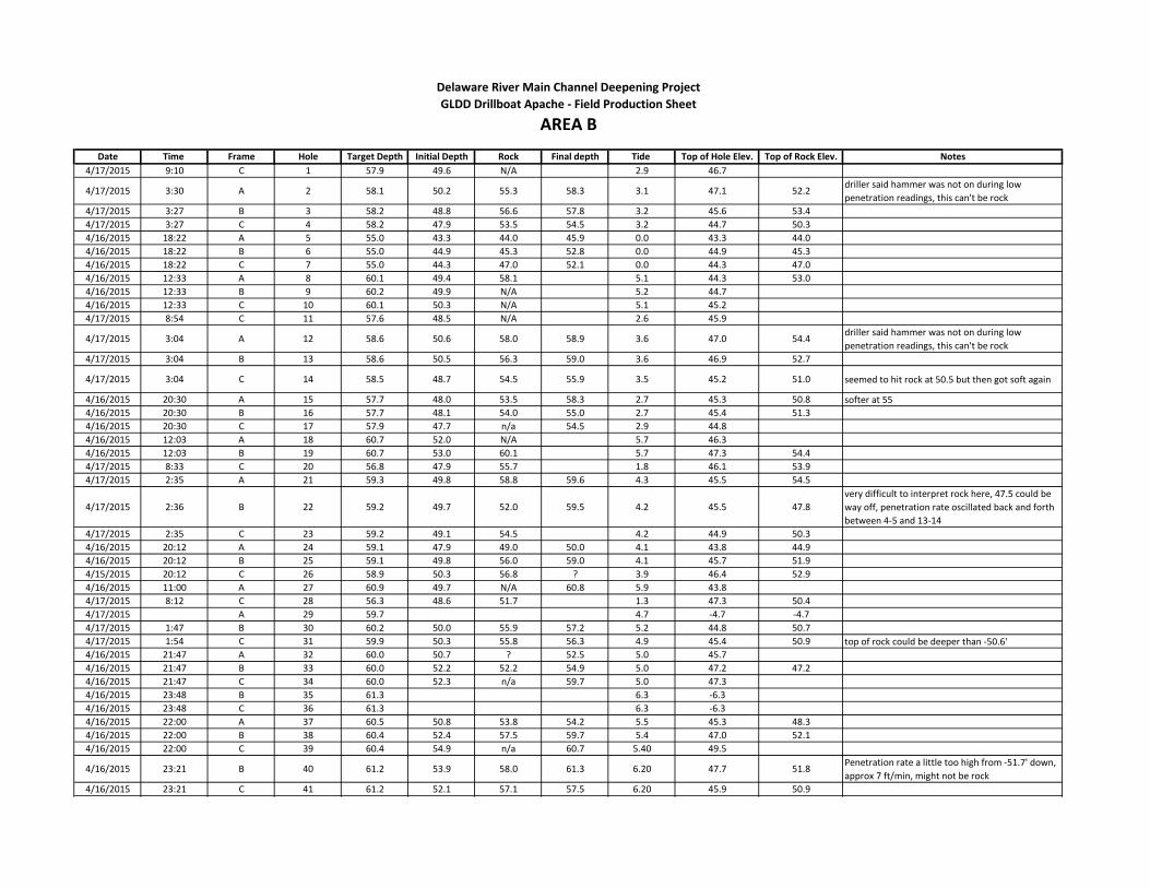
4/17/2015 9:10 C 1 57.9 49.6 N/A 2.9 46.7
4/17/2015 3:30 A 2 58.1 50.2 55.3 58.3 3.1 47.1 52.2driller said hammer was not on during low
penetration readings, this can't be rock
4/17/2015 3:27 B 3 58.2 48.8 56.6 57.8 3.2 45.6 53.4
4/17/2015 3:27 C 4 58.2 47.9 53.5 54.5 3.2 44.7 50.3
4/16/2015 18:22 A 5 55.0 43.3 44.0 45.9 0.0 43.3 44.0
4/16/2015 18:22 B 6 55.0 44.9 45.3 52.8 0.0 44.9 45.3
4/16/2015 18:22 C 7 55.0 44.3 47.0 52.1 0.0 44.3 47.0
4/16/2015 12:33 A 8 60.1 49.4 58.1 5.1 44.3 53.0
4/16/2015 12:33 B 9 60.2 49.9 N/A 5.2 44.7
4/16/2015 12:33 C 10 60.1 50.3 N/A 5.1 45.2
4/17/2015 8:54 C 11 57.6 48.5 N/A 2.6 45.9
4/17/2015 3:04 A 12 58.6 50.6 58.0 58.9 3.6 47.0 54.4driller said hammer was not on during low
penetration readings, this can't be rock
4/17/2015 3:04 B 13 58.6 50.5 56.3 59.0 3.6 46.9 52.7
4/17/2015 3:04 C 14 58.5 48.7 54.5 55.9 3.5 45.2 51.0 seemed to hit rock at 50.5 but then got soft again
4/16/2015 20:30 A 15 57.7 48.0 53.5 58.3 2.7 45.3 50.8 softer at 55
4/16/2015 20:30 B 16 57.7 48.1 54.0 55.0 2.7 45.4 51.3
4/16/2015 20:30 C 17 57.9 47.7 n/a 54.5 2.9 44.8
4/16/2015 12:03 A 18 60.7 52.0 N/A 5.7 46.3
4/16/2015 12:03 B 19 60.7 53.0 60.1 5.7 47.3 54.4
4/17/2015 8:33 C 20 56.8 47.9 55.7 1.8 46.1 53.9
4/17/2015 2:35 A 21 59.3 49.8 58.8 59.6 4.3 45.5 54.5
4/17/2015 2:36 B 22 59.2 49.7 52.0 59.5 4.2 45.5 47.8
very difficult to interpret rock here, 47.5 could be
way off, penetration rate oscillated back and forth
between 4-5 and 13-14
4/17/2015 2:35 C 23 59.2 49.1 54.5 4.2 44.9 50.3
4/16/2015 20:12 A 24 59.1 47.9 49.0 50.0 4.1 43.8 44.9
4/16/2015 20:12 B 25 59.1 49.8 56.0 59.0 4.1 45.7 51.9
4/15/2015 20:12 C 26 58.9 50.3 56.8 ? 3.9 46.4 52.9
4/16/2015 11:00 A 27 60.9 49.7 N/A 60.8 5.9 43.8
4/17/2015 8:12 C 28 56.3 48.6 51.7 1.3 47.3 50.4
4/17/2015 A 29 59.7 4.7 -4.7 -4.7
4/17/2015 1:47 B 30 60.2 50.0 55.9 57.2 5.2 44.8 50.7
4/17/2015 1:54 C 31 59.9 50.3 55.8 56.3 4.9 45.4 50.9 top of rock could be deeper than -50.6'
4/16/2015 21:47 A 32 60.0 50.7 ? 52.5 5.0 45.7
4/16/2015 21:47 B 33 60.0 52.2 52.2 54.9 5.0 47.2 47.2
4/16/2015 21:47 C 34 60.0 52.3 n/a 59.7 5.0 47.3
4/16/2015 23:48 B 35 61.3 6.3 -6.3
4/16/2015 23:48 C 36 61.3 6.3 -6.3
4/16/2015 22:00 A 37 60.5 50.8 53.8 54.2 5.5 45.3 48.3
4/16/2015 22:00 B 38 60.4 52.4 57.5 59.7 5.4 47.0 52.1
4/16/2015 22:00 C 39 60.4 54.9 n/a 60.7 5.40 49.5
4/16/2015 23:21 B 40 61.2 53.9 58.0 61.3 6.20 47.7 51.8Penetration rate a little too high from -51.7' down,
approx 7 ft/min, might not be rock
4/16/2015 23:21 C 41 61.2 52.1 57.1 57.5 6.20 45.9 50.9
Delaware River Main Channel Deepening Project
AREA BGLDD Drillboat Apache - Field Production Sheet

Date Time Frame Hole Target Depth Initial Depth Rock Final depth Tide Top of Hole Elev. Top of Rock Elev. Notes
Delaware River Main Channel Deepening Project
AREA BGLDD Drillboat Apache - Field Production Sheet
4/16/2015 22:35 A 42 60.8 50.8 56.0 57.3 5.8 45.0 50.2
4/16/2015 22:35 B 43 60.8 51.3 N/A 61.0 5.8 45.5
4/16/2015 22:35 C 44 60.8 51.3 60.1 60.8 5.8 45.5 54.3
4/16/2015 11:00 B 45 60.8 47.1 N/A 60.8 5.8 41.3
4/16/2015 11:00 C 46 60.9 52.2 N/A 60.4 5.9 46.3 Stuck
4/16/2015 12:03 C 47 60.7 55.1 59.0 5.7 49.4 53.3
4/16/2015 23:29 A 48 61.2 51.4 n/a 60.2 6.2 45.2
4/16/2015 23:48 A 49 61.3 51.1 55.0 61.6 6.3 44.8 48.7
4/17/2015 8:12 B 50 56.3 46.3 N/A 1.3 45.0
4/17/2015 8:33 B 51 56.6 48.3 51.0 1.6 46.7 49.4
4/17/2015 8:54 B 52 57.6 49.3 55.6 2.6 46.7 53.0
4/17/2015 9:10 B 53 57.9 50.1 53.9 2.9 47.2 51.0
4/17/2015 8:12 A 54 56.3 44.4 52.5 1.3 43.1 51.2
4/17/2015 8:33 A 55 56.8 46.5 52.1 1.8 44.7 50.3
4/17/2015 8:54 A 56 57.6 49.5 N/A 2.6 46.9
4/17/2015 9:10 A 57 57.9 48.9 N/A 2.9 46.0

Date Time Frame Hole Target Depth Initial Depth Rock Final depth Tide Top of Hole Elev. Top of Rock Elev. Notes
1 57.4 2.4 -2.4
2 57.5 2.5 -2.5
3 57.5 2.5 -2.5
4/17/2015 20:55 A 4 57.3 46.0 n/a 58.2 2.3 43.7
4/17/2015 20:25 A 5 56.3 41.8 41.8 43.4 1.3 40.5 40.5
4/17/2015 20:55 B 6 57.3 46.6 55.0 57.9 2.3 44.3 52.7
4/17/2015 20:55 C 7 57.3 46.9 54.8 55.3 2.3 44.6 52.5
4/17/2015 20:25 C 8 56.3 40.7 40.7 41.8 1.3 39.4 39.4
4/17/2015 17:12 B 9 57.3 44.9 45.0 ? 2.0 42.9 43.0
4/17/2015 20:25 B 10 56.1 44.0 44.0 53.6 1.1 42.9 42.9
4/17/2015 17:12 A 11 57.4 39.9 41.5 ? 2.0 37.9 39.5
4/17/2015 17:12 C 12 57.8 45.1 48.5 50.3 1.9 43.2 46.6
13 58.2 3.2 -3.2
14 57.9 2.9 -2.9
15 58.2 3.2 -3.2
4/17/2015 21:21 A 16 58.1 46.8 n/a 58.3 3.1 43.7
4/17/2015 20:00 A 17 55.6 42.5 44.2 46.1 0.6 41.9 43.6
4/17/2015 21:21 B 18 58.1 47.6 n/a 60.6 3.1 44.5
4/17/2015 21:21 C 19 58.1 45.8 46.0 47.9 3.1 42.7 42.9
4/17/2015 20:00 C 20 55.6 39.1 39.2 40.3 0.6 38.5 38.6
4/17/2015 17:15 B 21 56.9 43.0 47.8 48.8 1.9 41.1 45.9 has listed as twelve
4/17/2015 20:00 B 22 55.6 39.9 40.2 41.8 0.6 39.3 39.6
4/17/2015 17:15 A 23 56.9 42.5 43.7 59.5 1.9 40.6 41.8
4/17/2015 17:15 C 24 56.9 47.8 50.0 50.0 1.9 45.9 48.1
25 58.8 3.8 -3.8
26 59.0 4.0 -4.0
27 59.4 4.4 -4.4
4/17/2015 21:45 A 28 58.8 51.5 n/a 59.2 3.8 47.7
4/17/2015 21:45 B 29 58.8 54.1 n/a 59.1 3.8 50.3
4/17/2015 21:45 C 30 58.8 53.8 n/a 59.1 3.8 50.0
4/17/2015 18:22 A 31 55.8 47.3 48.6 52.1 0.8 46.5 47.8
4/17/2015 18:22 B 32 55.8 46.7 46.7 48.3 0.8 45.9 45.9
4/17/2015 18:22 C 33 55.8 45.6 45.6 46.6 0.8 44.8 44.8
4/17/2015 17:30 A 34 56.8 48.6 51.4 52.4 1.7 46.9 49.7
4/17/2015 17:30 B 35 56.7 49.1 52.4 56.8 1.7 47.4 50.7
4/17/2015 17:30 C 36 56.7 49.0 50.3 51.3 1.7 47.3 48.6
37 60.0 5.0 -5.0
38 59.6 4.6 -4.6
39 60.0 5.00 -5.0
4/17/2015 22:00 A 40 59.1 51.5 n/a 59.2 4.10 47.4
4/17/2015 22:00 B 41 59.0 52.5 n/a 59.8 4.00 48.5
4/17/2015 22:00 C 42 59.1 51.5 n/a 59.8 4.1 47.4 no hammer action
4/17/2015 18:00 A 43 56.1 48.3 52.8 53.8 1.1 47.2 51.7
4/17/2015 18:00 B 44 56.1 48.4 49.9 52.5 1.1 47.3 48.8
4/17/2015 0:00 C 45 56.1 49.1 52.0 54.6 1.1 48.0 50.9 very very hard at 51.1 corrected
4/17/2015 17:41 A 46 56.4 50.3 54.7 55.9 1.4 48.9 53.3
4/17/2015 17:41 B 47 56.4 50.0 52.9 54.3 1.4 48.6 51.5
Delaware River Main Channel Deepening Project
AREA CGLDD Drillboat Apache - Field Production Sheet

Date Time Frame Hole Target Depth Initial Depth Rock Final depth Tide Top of Hole Elev. Top of Rock Elev. Notes
Delaware River Main Channel Deepening Project
AREA CGLDD Drillboat Apache - Field Production Sheet
4/17/2015 17:41 C 48 56.4 49.5 51.4 52.4 1.4 48.1 50.0
49 60.4 5.4 -5.4
50 60.5 5.5 -5.5
51 60.5 5.5 -5.5
4/17/2015 22:45 A 52 60.8 5.8 -5.8 A frame down
4/17/2015 22:45 B 53 60.1 53.2 n/a 60.0 5.1 48.1
54 6.1 -6.1
55 5.8 -5.8
56 6.1 -6.1
57 6.2 -6.2
58 6.4 -6.4
59 6.2 -6.2
4/17/2015 22:45 C 60 60.1 52.4 n/a 60.2 5.1 47.3 no hammer action
4/18/2015 11:52 B 1000 60.1 52.1 53.4 5.5 46.6 47.9
4/18/2015 11:52 B 1001 60.2 53.2 54.5 5.6 47.6 48.9
4/18/2015 11:52 C 1002 60.1 50.7 54.6 5.5 45.2 49.1
4/18/2015 11:21 B 1003 59.9 53.3 57.9 5.0 48.3 52.9
4/18/2015 11:21 B 1004 59.7 51.0 55.4 4.8 46.2 50.6
4/18/2015 11:21 C 1005 59.7 53.5 N/A 4.8 48.7
4/18/2015 10:37 B 1006 58.6 42.1 N/A 3.8 38.3
4/18/2015 10:37 B 1007 59.1 55.1 N/A 4.0 51.1
4/18/2015 10:37 C 1008 58.5 56.7 N/A 3.8 52.9
4/18/2015 13:52 C 1009 61.2 51.4 55.0 5.8 45.6 49.2
4/18/2015 13:52 B 1010 61.2 51.6 54.5 5.8 45.8 48.7
4/18/2015 13:52 B 1011 60.9 50.3 N/A 5.7 44.6
4/18/2015 12:32 C 1012 60.9 50.2 51.5 5.9 44.3 45.6
4/18/2015 12:32 B 1013 60.9 50.0 N/A 5.9 44.1
4/18/2015 12:32 B 1014 60.9 51.5 N/A 6.0 45.5
4/18/2015 13:13 B 1015 61.1 49.6 N/A 6.1 43.5
4/18/2015 13:13 B 1016 61.1 50.5 N/A 6.0 44.5
4/18/2015 13:13 C 1017 61.1 51.0 N/A 58.5 6.0 45.0
4/18/2015 14:12 C 1018 60.8 50.3 N/A 5.4 44.9
4/18/2015 14:12 B 1019 60.8 52.5 N/A 5.3 47.2
4/18/2015 14:12 B 1020 60.8 50.4 N/A 5.4 45.0

Date Time Frame Hole Target Depth Initial Depth Rock Final depth Tide Top of Hole Elev. Top of Rock Elev. Notes
4/19/2015 1:58 B 1 61.6 47.1 N/A 61.7 6.5 40.6
4/19/2015 1:29 B 2 61.7 49.7 57.8 58.5 6.4 43.3 51.4
4/19/2015 1:24 C 3 61.7 47.4 59.9 61.0 6.5 40.9 53.4
4/19/2015 0:30 B 4 60.9 40.4 48.1 50.9 6.2 34.2 41.9
Eddie did not go deep enough, I went and spoke to
him and he claimed it was rock, I told him we need
to see 4 ROP or less for 1' so he redrilled this hole
4/19/2015 0:55 B 5 60.9 41.4 43.6 45.5 6.3 35.1 37.3
4/19/2015 0:28 C 6 60.9 39.6 39.6 41.1 6.1 33.5 33.5
4/18/2015 15:14 7 59.2 39.4 42.0 47.1 4.2 35.2 37.8
4/18/2015 15:14 B 8 59.5 40.2 41.7 43.0 4.5 35.7 37.2
4/18/2015 15:14 C 9 59.2 38.2 39.5 4.2 34.0 35.3
4/18/2015 6:20 B 10 57.5 36.4 36.8 1.4 35.0 35.4
4/18/2015 6:30 B 11 57.5 36.6 36.7 37.6 1.1 35.5 35.6
4/18/2015 6:17 C 12 57.5 35.9 36.1 1.4 34.5 34.7
4/19/2015 3:05 B 13 60.6 50.2 N/A 60.6 6.2 44.0 redrilled 3 times
4/19/2015 2:35 C 14 60.9 48.1 N/A 60.9 5.5 42.6
4/19/2015 2:24 C 15 61.3 46.7 61.0 61.3 6.2 40.5 54.8
4/19/2015 0:09 B 16 60.5 43.9 45.5 46.9 5.8 38.1 39.7
4/19/2015 0:02 B 17 60.5 43.7 45.0 46.1 5.0 38.7 40.0
4/19/2015 0:02 C 18 60.5 44.2 44.3 45.3 4.9 39.3 39.4
4/18/2015 15:43 B 19 59.0 43.6 46.9 49.3 4.0 39.6 42.9
4/18/2015 15:40 B 20 58.9 3.9 -3.9 -3.9 Bouy in the way, skipped
4/18/2015 15:42 C 21 58.9 44.2 45.0 47.7 3.9 40.3 41.1
4/18/2015 7:54 B 22 55.6 39.9 41.7 57.8 0.0 39.9 41.7
4/18/2015 7:54 B 23 55.6 36.0 42.5 58.1 0.0 36.0 42.5
4/18/2015 7:54 C 24 55.6 39.1 39.4 58.0 0.0 39.1 39.4
4/19/2015 3:29 B 25 60.1 51.8 N/A 60.5 5.1 46.7
4/19/2015 3:29 C 26 60.1 49.5 N/A 60.3 5.0 44.5
4/19/2015 3:47 C 27 59.7 44.9 49.9 4.6 40.3 45.3
4/18/2015 23:00 B 28 59.5 43.7 44.1 45.7 4.5 39.2 39.6
4/18/2015 23:09 B 29 59.8 44.9 48.1 51.2 4.8 40.1 43.3 mislabled as 28 again
4/18/2015 23:00 C 30 59.5 44.5 44.7 46.1 4.5 40.0 40.2
4/18/2015 15:59 B 31 58.7 42.6 43.5 44.5 3.7 38.9 39.8
4/18/2015 15:55 B 32 58.8 42.7 43.1 46.1 3.8 38.9 39.3
4/18/2015 15:55 C 33 58.8 43.4 45.5 46.9 3.8 39.6 41.7
4/18/2015 8:24 B 34 55.2 40.3 40.9 59.7 0.0 40.3 40.9
4/18/2015 8:24 B 35 55.2 39.0 39.9 0.0 39.0 39.9
4/18/2015 8:24 C 36 55.2 44.5 45.2 0.0 44.5 45.2
4/19/2015 4:18 B 37 59.2 51.5 N/A 59.5 4.1 47.4
4/19/2015 4:24 C 38 59.2 52.9 57.4 58.3 3.9 49.0 53.5
4/19/2015 4:16 C 39 59.2 48.8 50.6 51.9 4.00 44.8 46.6
4/18/2015 22:42 B 40 58.8 48.4 49.7 50.9 3.80 44.6 45.9
4/18/2015 22:33 B 41 58.6 48.8 49.1 50.4 3.60 45.2 45.5
4/18/2015 22:28 C 42 58.6 48.3 52.2 53.1 3.6 44.7 48.6
4/18/2015 16:17 B 43 58.2 49.0 51.0 52.1 3.2 45.8 47.8
4/18/2015 16:20 B 44 58.1 49.0 50.5 52.1 3.1 45.9 47.4
Delaware River Main Channel Deepening Project
AREA DGLDD Drillboat Apache - Field Production Sheet

Date Time Frame Hole Target Depth Initial Depth Rock Final depth Tide Top of Hole Elev. Top of Rock Elev. Notes
Delaware River Main Channel Deepening Project
AREA DGLDD Drillboat Apache - Field Production Sheet
4/18/2015 16:25 C 45 58.2 49.5 49.7 51.1 3.2 46.3 46.5
4/18/2015 8:39 B 46 55.1 45.0 47.3 60.4 0.4 44.6 46.9
4/18/2015 8:39 B 47 55.1 48.6 49.7 0.4 48.2 49.3
4/18/2015 8:39 C 48 55.1 55+ N/A 0.4
4/19/2015 4:43 B 49 58.6 52.2 N/A 58.8 3.7 48.5
4/19/2015 4:51 C 50 58.6 54.2 N/A 58.8 3.4 50.8
4/19/2015 4:43 C 51 58.6 52.3 57.0 58.1 3.7 48.6 53.3
4/18/2015 21:40 B 52 57.0 48.5 48.6 50.0 2.0 46.5 46.6
4/18/2015 21:40 C 53 57.0 51.0 53.6 54.6 2.0 49.0 51.6
4/18/2015 21:55 C 54 57.2 48.2 49.4 51.0 2.2 46.0 47.2
4/18/2015 16:38 B 55 57.9 47.9 50.9 51.8 2.9 45.0 48.0
4/18/2015 16:35 B 56 57.9 48.9 50.4 51.6 2.9 46.0 47.5
4/18/2015 16:35 C 57 57.9 47.3 47.7 50.8 2.9 44.4 44.8
4/18/2015 8:57 B 58 55.5 51.6 52.2 0.8 50.8 51.4
4/18/2015 8:57 B 59 55.5 61.0 N/A 0.9 60.1
4/18/2015 8:57 C 60 55.5 50.1 N/A 0.9 49.2
4/19/2015 5:13 B 61 58.2 N/A N/A 58.9 3.1 most likely clay/silt, bit never hesitated
4/19/2015 5:20 B 62 58.2 N/A N/A 58.3 3.0 most likely clay/silt, bit never hesitated
4/19/2015 5:24 C 63 58.3 N/A N/A 58.7 3.0 most likely clay/silt, bit never hesitated
4/18/2015 21:15 B 64 56.0 42.5 n/a 55.9 1.0 41.5 no hammer engaged
4/18/2015 21:00 B 65 55.8 42.0 n/a 56.3 0.8 41.2
4/18/2015 20:55 C 66 55.8 46.2 47.8 49.0 0.8 45.4 47.0
4/18/2015 16:53 67 57.8 47.0 47.1 48.7 2.8 44.2 44.3
4/18/2015 16:49 B 68 57.7 47.7 52.5 53.5 2.7 45.0 49.8
4/18/2015 16:49 C 69 57.8 51.6 54.1 55.8 2.8 48.8 51.3
4/18/2015 9:17 B 70 56.1 52.9 N/A 1.6 51.3
4/18/2015 9:17 B 71 56.1 53.0 N/A 1.2 51.8
4/18/2015 20:25 72 104.3 49.2 n/a 55.1 -0.1 49.3 sunk to 52.4 no air or rotation
4/18/2015 20:34 B 73 116.9 61.9 n/a 61.0 0.0 61.9 to bottom no air or rotation
4/18/2015 20:22 C 74 102.5 47.4 48.9 50.0 -0.1 47.5 49.0
4/18/2015 17:05 B 75 57.4 50.3 50.4 56.1 2.4 47.9 48.0
4/18/2015 17:05 B 76 57.5 55.4 55.5 57.5 2.5 52.9 53.0
4/18/2015 17:05 C 77 57.5 58.1 n/a 58.1 2.5 55.6
4/18/2015 9:37 B 78 57.0 N/A N/A 1.9
4/18/2015 9:37 B 79 57.0 N/A N/A 2.1
4/18/2015 18:25 B 80 112.2 58.3 n/a 58.3 1.1 57.2
4/18/2015 18:25 B 81 102.8 49.0 n/a 57.1 1.2 47.8
4/18/2015 18:25 C 82 105.8 52.0 52.3 55.1 1.2 50.8 51.1
4/18/2015 17:42 B 83 56.9 57.4 n/a 57.4 1.9 55.5 no hammer engaged
4/18/2015 17:38 B 84 56.9 50.6 n/a 57.6 1.9 48.7
4/18/2015 17:38 C 85 56.9 57.6 n/a 57.6 1.9 55.7 no hammer engaged
4/18/2015 9:57 B 86 57.5 N/A N/A 2.6
4/18/2015 9:57 B 87 57.5 52.3 N/A 2.3 50.0
4/18/2015 9:57 C 88 57.5 N/A N/A 2.6
4/18/2015 9:37 C 89 57.0 N/A N/A 1.9
4/18/2015 9:17 C 90 56.1 N/A N/A 1.2
4/19/2015 15:27 B 1000 61.0 50.0 51.9 5.8 44.2 46.1

Date Time Frame Hole Target Depth Initial Depth Rock Final depth Tide Top of Hole Elev. Top of Rock Elev. Notes
Delaware River Main Channel Deepening Project
AREA DGLDD Drillboat Apache - Field Production Sheet
4/19/2015 15:33 B 1001 60.8 54.7 N/A 60.8 5.7 49.0
4/19/2015 13:15 B 1003 61.0 52.4 N/A 61.0 6.0 46.4
4/19/2015 15:03 B 1006 61.2 56.0 N/A 61.4 6.2 49.8
4/19/2015 13:28 B 1007 61.4 52.2 N/A 61.4 6.3 45.9
4/19/2015 13:28 B 1008 61.4 53.0 N/A 61.5 6.3 46.7

Date Time Frame Hole Target Depth Initial Depth Rock Final depth Tide Top of Hole Elev. Top of Rock Elev. Notes
4/21/2015 5:21 C 1 60.8 38.2 54.0 59.1 5.8 32.4 48.2
4/21/2015 3:21 B 2 62.6 40.8 55.7 57.0 7.6 33.2 48.1
4/21/2015 3:58 C 3 62.3 38.9 58.4 59.7 7.3 31.6 51.1
4/21/2015 3:19 C 4 62.6 39.9 56.0 57.2 7.6 32.3 48.4
4/20/2015 14:10 B 5 62.3 41.5 54.0 56.9 7.3 34.2 46.7
4/20/2015 14:19 C 6 62.3 35.4 47.5 48.3 7.3 28.1 40.2
4/20/2015 13:10 C 7 62.0 39.5 46.0 49.8 7.0 32.5 39.0
4/20/2015 12:28 B 8 61.3 38.9 42.5 6.3 32.6 36.2
4/20/2015 12:43 B 9 61.5 38.3 44.0 48.1 6.5 31.8 37.5
4/20/2015 12:28 C 10 61.3 39.5 44.3 46.6 6.3 33.2 38.0
4/19/2015 23:13 B 11 59.3 38.3 43.7 45.5 4.3 34.0 39.4
4/21/2015 6:32 C 12 59.5 50.9 n/a 59.6 4.5 46.4
4/21/2015 2:56 B 13 62.6 51.3 N/A 62.5 7.6 43.7
4/21/2015 2:43 B 14 62.6 49.8 N/A 62.5 7.6 42.2
4/21/2015 2:43 C 15 62.6 48.4 56.0 59.0 7.6 40.8 48.4
4/20/2015 15:32 B 16 61.6 47.6 N/A 62.7 6.6 41.0
4/20/2015 15:43 B 17 61.5 47.6 52.4 55.5 6.5 41.1 45.9
4/20/2015 15:31 C 18 61.6 45.8 48.3 53.5 6.6 39.2 41.7
4/20/2015 12:16 B 19 60.8 46.7 48.0 53.2 5.8 40.9 42.2
4/20/2015 12:10 B 20 60.8 47.8 49.2 50.6 5.8 42.0 43.4
4/20/2015 12:02 C 21 60.7 41.8 42.0 44.5 5.7 36.1 36.3
4/19/2015 23:40 B 22 59.8 44.0 48.0 55.9 4.8 39.2 43.2
4/19/2015 0:07 B 23 60.6 42.6 53.5 55.7 5.6 37.0 47.9
4/19/2015 0:13 B 24 60.8 43.7 n/a 60.4 5.8 5.3
4/19/2015 21:15 B 25 55.6 38.5 55.1 55.6 0.6 37.9 54.5 side wall collapse difficulty get out.
4/19/2015 21:43 B 26 56.5 38.6 n/a 56.2 1.5 37.1 very little hammer @ 50 to 54.4 uncorr
4/19/2015 21:56 B 27 56.9 41.4 n/a 57.0 1.9 39.5 minimal hammer
4/21/2015 0:33 B 28 57.9 50.6 N/A 58.6 2.9 47.7
4/21/2015 0:26 B 29 58.7 48.9 N/A 58.2 3.7 45.2
4/21/2015 0:26 C 30 58.5 50.5 N/A 58.1 3.5 47.0
4/21/1/5 8:04 B 31 57.9 49.4 54.5 57.0 2.9 46.5 51.6
4/21/1/5 B 32 57.8 49.0 N/A 58.0 2.8 46.2
4/21/2015 8:04 C 33 57.9 49.5 N/A 58.0 2.9 46.6
4/21/2015 2:08 B 34 62.3 53.7 N/A 62.5 7.3 46.4
4/21/2015 2:21 B 35 62.5 53.6 N/A 62.3 7.5 46.1
4/21/2015 2:08 C 36 62.3 52.4 N/A 62.3 7.3 45.1 POSSIBLY top of rock at -59 uncorrected
4/20/2015 15:56 B 37 61.3 52.1 n/a 62.4 6.3 45.8
4/20/2015 15:56 B 38 61.4 51.1 51.4 57.9 6.4 44.7 45.0
4/20/2015 15:56 C 39 61.3 45.5 45.5 48.7 6.30 39.2 39.2
4/20/2015 11:31 B 40 59.7 44.6 46.5 49.3 4.70 39.9 41.8
4/20/2015 11:36 B 41 59.9 45.8 48.0 59.7 4.90 40.9 43.1
4/20/2015 11:42 C 42 60.2 5.2 -5.2 -5.2 Not logged on to view
4/19/2015 1:18 B 43 61.5 46.8 50.3 51.5 6.7 40.1 43.6
4/19/2015 1:00 B 44 61.4 47.0 58.8 59.3 6.4 40.6 52.4
4/19/2015 0:44 B 45 61.3 46.2 n/a 60.6 6.3 39.9 Minimal hammer
4/19/2015 20:51 B 46 55.9 39.9 n/a 55.7 0.9 39.0 no hammer Corrected to hole 46
4/19/2015 20:38 B 47 55.7 41.6 n/a 56.0 0.7 40.9
Delaware River Main Channel Deepening Project
AREA EGLDD Drillboat Apache - Field Production Sheet

Date Time Frame Hole Target Depth Initial Depth Rock Final depth Tide Top of Hole Elev. Top of Rock Elev. Notes
Delaware River Main Channel Deepening Project
AREA EGLDD Drillboat Apache - Field Production Sheet
4/19/2015 20:21 B 48 55.6 42.2 n/a 56.0 0.6 41.6corrected to Hole 48 no hammer, difficulty with
side wall collapse
4/21/2015 1:12 C 49 59.9 52.2 N/A 59.6 4.9 47.3
4/21/2015 1:01 C 50 59.6 50.0 N/A 59.5 4.6 45.4
4/21/2015 0:01 B 51 57.2 see note n/a 57.9 2.2lost computers during hole and screen was
fragmented
4/21/2015 0:07 C 52 57.9 50.3 N/A 57.5 2.9 47.4
4/21/2015 0:01 C 53 57.7 see note 52.3 53.6 2.7 49.6lost computers during hole and screen was
fragmented
4/21/2015 8:39 B 54 57.5 51.0 53.0 57.2 2.5 48.5 50.5
4/21/2015 8:29 B 55 57.6 51.2 54.2 57.7 2.6 48.6 51.6
4/21/2015 8:29 C 56 57.6 48.8 56.5 57.7 2.6 46.2 53.9
4/21/2015 1:40 B 57 62.0 53.0 59.9 61.9 7.0 46.0 52.9
4/21/2015 1:30 B 58 61.9 50.4 N/A 61.7 6.9 43.5
4/21/2015 1:30 C 59 61.9 52.5 N/A 61.7 6.9 45.6
4/20/2015 16:18 B 60 61.0 53.5 54.3 56.2 6.0 47.5 48.3 16:21 done
4/20/2015 16:11 B 61 60.9 52.1 55.4 60.0 5.9 46.2 49.5
4/20/2015 16:14 C 62 61.0 51.2 54.1 57.7 6.0 45.2 48.1
4/20/2015 11:19 B 63 59.4 51.2 52.0 54.9 4.4 46.8 47.6
4/20/2015 11:07 B 64 59.2 50.3 54.5 57.9 4.2 46.1 50.3
4/20/2015 10:58 B 65 59.1 48.6 52.3 55.7 4.1 44.5 48.2
4/20/2015 1:37 B 66 61.6 45.3 57.7 60.5 7.0 38.3 50.7
4/20/2015 3:38 B 67 62.1 46.2 n/a 62.4 6.7 39.5
4/20/2015 3:56 B 68 62.0 46.0 n/a 62.0 6.6 39.4 possible rock at -54' MLLW, ROP in the 6 range
4/19/2015 18:20 B 69 57.6 42.3 n/a 58.0 2.6 39.7 side wall cave in, slow progress.
4/19/2015 18:29 B 70 57.5 43.3 n/a 58.0 2.5 40.8
4/19/2015 18:38 B 71 57.4 42.1 57.5 57.8 2.4 39.7 55.1 difficult near bottom
4/21/2015 1:37 B 72 60.5 54.1 n/a 60.3 5.5 48.6
4/21/2015 1:30 C 73 60.4 52.2 n/a 60.2 5.4 46.8
4/21/2015 23:40 B 74 56.5 48.2 49.8 51.9 1.5 46.7 48.3
4/21/2015 23:45 C 75 57.4 47.3 50.5 51.9 2.4 44.9 48.1
4/21/2015 23:37 C 76 56.9 48.8 50.6 51.9 1.9 46.9 48.7
4/21/2015 8:54 B 77 57.1 51.4 53.4 57.3 2.1 49.3 51.3
4/21/2015 8:58 B 78 57.0 50.2 55.9 57.2 2.0 48.2 53.9
4/21/2015 8:54 C 79 57.1 47.3 50.6 54.0 2.1 45.2 48.5
4/21/2015 0:50 B 80 61.2 51.0 n/a 61.1 6.2 44.8
4/21/2015 1:01 B 81 61.3 52.0 n/a 61.3 6.3 45.7
4/21/2015 0:50 C 82 61.2 51.9 n/a 61.0 6.2 45.7
4/20/2015 16:30 B 83 60.6 50.3 50.3 53.1 5.6 44.7 44.7
4/20/2015 16:35 B 84 60.7 50.7 50.3 57.7 5.7 45.0 44.6 16:40 done
4/20/2015 16:32 C 85 60.7 50.3 55.1 56.6 5.7 44.6 49.4
4/20/2015 10:35 B 86 58.4 49.1 49.8 52.7 3.4 45.7 46.4
4/20/2015 10:41 B 87 58.4 48.7 50.4 51.8 3.4 45.3 47.0
4/20/2015 10:47 B 88 58.6 49.0 50.0 57.7 3.6 45.4 46.4
4/20/2015 5:02 B 89 60.8 50.9 57.4 60.8 5.4 45.5 52.0
4/20/2015 4:54 B 90 61.0 51.7 n/a 61.0 5.5 46.2

Date Time Frame Hole Target Depth Initial Depth Rock Final depth Tide Top of Hole Elev. Top of Rock Elev. Notes
Delaware River Main Channel Deepening Project
AREA EGLDD Drillboat Apache - Field Production Sheet
4/20/2015 4:35 B 91 61.3 51.1 57.4 58.6 5.9 45.2 51.5
4/19/2015 18:10 B 92 57.9 48.6 n/a 58.4 2.9 45.7
4/19/2015 18:04 B 93 57.9 44.9 53.8 58.3 2.9 42.0 50.9
4/19/2015 17:55 B 94 58.1 43.4 n/a 58.3 3.1 40.3 side wall cave in.
4/22/2015 1:51 B 95 61.0 53.4 n/a 60.9 6.0 47.4
4/22/2015 1:51 C 96 60.9 53.6 56.4 58.6 5.9 47.7 50.5
4/21/2015 23:19 B 97 55.5 47.5 48.0 50.0 0.5 47.0 47.5
4/21/2015 23:22 C 98 56.5 46.2 47.8 48.7 1.5 44.7 46.3
4/21/2015 23:19 C 99 56.5 46.1 47.2 48.4 1.5 44.6 45.7
4/21/2015 9:34 B 100 56.6 49.5 55.7 56.7 1.6 47.9 54.1
4/21/2015 9:28 B 101 56.7 49.7 54.0 1.7 48.0 52.3
4/21/2015 9:29 C 102 56.6 47.8 53.2 55.3 1.6 46.2 51.6
4/21/2015 0:28 B 103 60.2 51.7 55.2 60.6 5.2 46.5 50.0
4/21/2015 0:16 B 104 60.7 51.1 56.0 57.7 5.7 45.4 50.3
4/21/2015 0:15 C 105 60.3 50.6 53.5 54.0 5.3 45.3 48.2
4/20/2015 16:48 B 106 60.5 51.8 57.4 60.6 5.5 46.3 51.9
4/20/2015 16:48 B 107 60.5 49.8 50.2 52.0 5.5 44.3 44.7
4/20/2015 16:49 C 108 60.5 50.6 53.0 55.3 5.5 45.1 47.5
4/20/2015 10:26 B 109 58.0 48.3 49.5 57.7 3.0 45.3 46.5
4/20/2015 10:22 B 110 57.9 48.6 53.5 57.5 2.9 45.7 50.6
4/20/2015 10:12 B 111 57.7 48.5 N/A 57.5 2.7 45.8
4/20/2015 5:02 B 112 60.2 50.8 see note 60.2 4.9 -9.4
difficult to interpret, appeared to be hard rock
from 54' down to 60.2' (not tide corrected)
however ROP would occasionally jump to the 10
range, but generally was in the 6ish range
sometimes as low as less than 1
4/20/2015 4:54 B 113 60.0 47.0 54.2 56.9 4.6 -9.9 49.6ROP not less than 4 but close, appeared to be
hardd rock
4/20/2015 4:35 B 114 59.9 48.5 57.8 59.9 4.5 -11.4 53.3
4/19/2015 17:26 B 115 58.5 49.5 n/a 58.7 3.5 46.0
4/19/2015 17:34 B 116 58.4 48.4 n/a 58.1 3.4 45.0
4/19/2015 17:41 B 117 58.2 49.3 n/a 58.1 3.2 46.1
4/22/2015 2:20 B 118 61.3 54.9 n 61.1 6.3 48.6
4/22/2015 2:13 C 119 61.2 51.9 53.1 54.5 6.2 45.7 46.9
4/21/2015 22:22 B 120 55.5 46.7 46.7 48.6 0.5 46.2 46.2
4/21/2015 22:13 B 121 55.7 51.7 53.4 54.7 0.7 51.0 52.7
4/21/2015 22:13 C 122 55.5 49.7 n/a 55.7 0.5 49.2
4/21/2015 9:43 B 123 56.5 49.7 53.9 56.6 1.5 48.2 52.4
4/21/2015 9:49 B 124 56.4 48.8 54.5 56.5 1.4 47.4 53.1
4/21/2015 9:43 C 125 56.4 45.0 52.5 56.5 1.4 43.6 51.1
4/20/2015 23:10 B 126 58.5 50.4 54.7 58.3 3.5 46.9 51.2ROP very low starting at 51.6 (uncorrected), low
the whole way down from there
4/20/2015 23:29 B 127 58.7 49.9 51.6 58.7 3.7 46.2 47.9
4/20/2015 23:10 C 128 58.5 47.1 50.9 52.8 3.5 43.6 47.4
4/20/2015 17:25 B 129 true 59.8 48.2 53.3 57.5 4.8 43.4 48.5 true 129 complete 17:33
4/20/2015 17:15 B 129(130) 59.8 48.1 51.8 55.4 4.8 43.3 47.0 called (129) on drillers log.

Date Time Frame Hole Target Depth Initial Depth Rock Final depth Tide Top of Hole Elev. Top of Rock Elev. Notes
Delaware River Main Channel Deepening Project
AREA EGLDD Drillboat Apache - Field Production Sheet
4/20/2015 17:16 C 131 60.0 47.5 51.2 52.2 5.0 42.5 46.2
4/20/2015 9:49 B 132 57.4 50.2 N/A 57.2 2.4 47.8
4/20/2015 9:53 B 133 57.4 52.4 N/A 57.2 2.4 50.0
4/20/2015 9:57 B 134 57.4 48.6 N/A 57.4 2.4 46.2
4/20/2015 6:42 B 135 59.3 47.2 n/a 59.3 3.9 -12.1
4/20/2015 6:34 B 136 59.3 47.7 58.2 59.4 3.9 -11.7 54.3
4/20/2015 6:20 B 137 59.7 47.7 56.1 59.0 4.2 -11.3 51.9
4/19/2015 17:04 B 138 59.0 55.6 n/a 59.1 4.0 4.1 difficulty with hole caving
4/19/2015 16:53 B 139 59.1 49.8 58.2 59.3 4.1 45.7 54.1
4/19/2015 16:47 B 140 59.3 50.4 n/a 59.2 4.3 46.1
4/22/2015 2:37 B 141 61.6 n/a 61.8 6.6 -6.6
4/22/2015 2:36 C 142 61.5 n/a 62.9 6.5 -6.5
4/21/2015 21:53 B 143 55.8 57.9 n/a 57.9 0.8 57.1 no hammer, rotation or air
4/21/2015 21:58 B 144 55.7 56.8 n/a 56.8 0.7 56.1 no hammer, rotation or air
4/21/2015 21:53 C 145 55.8 52.5 n/a 58.2 0.8 51.7
4/21/2015 10:16 B 146 56.1 52.5 N/A 56.2 1.1 51.4
4/21/2015 10:05 B 147 56.3 51.0 N/A 56.3 1.3 49.7
4/21/2015 10:10 B 148 56.1 47.7 54.0 56.3 1.1 46.6 52.9
4/20/2015 22:50 B 149 57.6 48.4 50.4 55.9 2.6 45.8 47.8 completed 22:53
4/20/2015 22:42 B 150 57.4 47.4 47.4 50.5 2.4 45.0 45.0
4/20/2015 22:42 C 151 57.4 46.7 48.5 49.7 2.4 44.3 46.1
4/20/2015 17:41 B 152 59.4 48.2 51.7 53.2 4.4 43.8 47.3
4/20/2015 B 153 59.3 n/a 51.4 53.8 4.3 47.1
4/20/2015 17:43 C 154 59.4 50.4 55.6 57.2 4.4 46.0 51.2
4/20/2015 9:38 B 155 57.3 51.8 N/A 57.1 2.3 49.5
4/20/2015 9:32 B 156 57.2 48.3 N/A 57.2 2.2 46.1
4/20/2015 8:17 B 157 57.8 49.7 N/A 58.2 2.8 46.9
4/20/2015 8:22 B 158 57.7 52.6 N/A 58.0 2.7 49.9
4/20/2015 8:27 B 159 57.7 49.1 N/A 58.1 2.7 46.4
4/19/2015 16:25 B 160 59.6 50.0 n/a 59.7 4.6 45.4
4/19/2015 16:14 B 161 59.9 50.4 n/a 59.7 4.9 4.7
4/22/2015 3:05 C 162 61.9 60.8 n/a 61.9 6.9 53.9
4/22/2015 3:00 C 163 61.8 58.9 n/a 61.8 6.8 52.1
4/21/2015 21:28 B 164 56.0 55.5 n/a 56.2 1.0 54.5
4/21/2015 21:35 C 165 56.0 54.6 n/a 56.2 1.0 53.6
4/21/2015 21:28 C 166 56.0 52.1 n/a 56.2 1.0 51.1
4/21/2015 10:27 B 167 56.0 51.9 N/A 56.1 1.0 50.9
4/21/2015 10:28 B 168 56.0 52.9 N/A 56.1 1.0 51.9
4/21/2015 10:34 B 169 55.9 47.7 51.7 56.0 0.9 46.8 50.8
4/20/2015 22:05 B 170 56.3 47.2 48.8 50.1 1.3 45.9 47.5
4/20/2015 22:25 B 171 56.8 45.2 46.2 48.8 1.8 43.4 44.4 B frame Screen problem
4/20/2015 22:04 C 172 56.3 46.4 46.6 47.6 1.3 45.1 45.3
4/20/2015 18:04 B 173 59.2 51.4 53.2 54.4 4.2 47.2 49.0
4/20/2015 17:58 B 174 59.1 51.4 55.3 56.6 4.1 47.3 51.2
4/20/2015 17:58 C 175 59.2 50.2 n/a 59.4 4.2 46.0
4/20/2015 9:07 B 176 57.2 54.3 N/A 57.4 2.2 52.1
4/22/2015 3:21 B 177 61.9 56.1 N/A 61.9 6.9 49.2
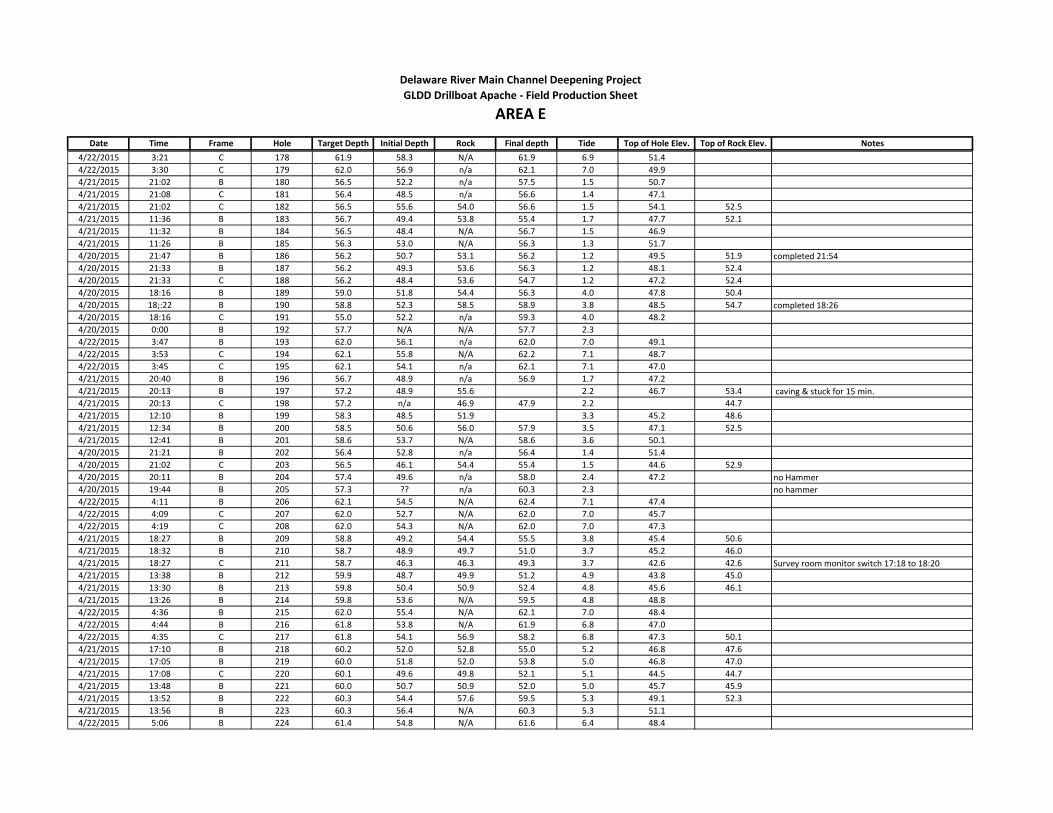
Date Time Frame Hole Target Depth Initial Depth Rock Final depth Tide Top of Hole Elev. Top of Rock Elev. Notes
Delaware River Main Channel Deepening Project
AREA EGLDD Drillboat Apache - Field Production Sheet
4/22/2015 3:21 C 178 61.9 58.3 N/A 61.9 6.9 51.4
4/22/2015 3:30 C 179 62.0 56.9 n/a 62.1 7.0 49.9
4/21/2015 21:02 B 180 56.5 52.2 n/a 57.5 1.5 50.7
4/21/2015 21:08 C 181 56.4 48.5 n/a 56.6 1.4 47.1
4/21/2015 21:02 C 182 56.5 55.6 54.0 56.6 1.5 54.1 52.5
4/21/2015 11:36 B 183 56.7 49.4 53.8 55.4 1.7 47.7 52.1
4/21/2015 11:32 B 184 56.5 48.4 N/A 56.7 1.5 46.9
4/21/2015 11:26 B 185 56.3 53.0 N/A 56.3 1.3 51.7
4/20/2015 21:47 B 186 56.2 50.7 53.1 56.2 1.2 49.5 51.9 completed 21:54
4/20/2015 21:33 B 187 56.2 49.3 53.6 56.3 1.2 48.1 52.4
4/20/2015 21:33 C 188 56.2 48.4 53.6 54.7 1.2 47.2 52.4
4/20/2015 18:16 B 189 59.0 51.8 54.4 56.3 4.0 47.8 50.4
4/20/2015 18;:22 B 190 58.8 52.3 58.5 58.9 3.8 48.5 54.7 completed 18:26
4/20/2015 18:16 C 191 55.0 52.2 n/a 59.3 4.0 48.2
4/20/2015 0:00 B 192 57.7 N/A N/A 57.7 2.3
4/22/2015 3:47 B 193 62.0 56.1 n/a 62.0 7.0 49.1
4/22/2015 3:53 C 194 62.1 55.8 N/A 62.2 7.1 48.7
4/22/2015 3:45 C 195 62.1 54.1 n/a 62.1 7.1 47.0
4/21/2015 20:40 B 196 56.7 48.9 n/a 56.9 1.7 47.2
4/21/2015 20:13 B 197 57.2 48.9 55.6 2.2 46.7 53.4 caving & stuck for 15 min.
4/21/2015 20:13 C 198 57.2 n/a 46.9 47.9 2.2 44.7
4/21/2015 12:10 B 199 58.3 48.5 51.9 3.3 45.2 48.6
4/21/2015 12:34 B 200 58.5 50.6 56.0 57.9 3.5 47.1 52.5
4/21/2015 12:41 B 201 58.6 53.7 N/A 58.6 3.6 50.1
4/20/2015 21:21 B 202 56.4 52.8 n/a 56.4 1.4 51.4
4/20/2015 21:02 C 203 56.5 46.1 54.4 55.4 1.5 44.6 52.9
4/20/2015 20:11 B 204 57.4 49.6 n/a 58.0 2.4 47.2 no Hammer
4/20/2015 19:44 B 205 57.3 ?? n/a 60.3 2.3 no hammer
4/22/2015 4:11 B 206 62.1 54.5 N/A 62.4 7.1 47.4
4/22/2015 4:09 C 207 62.0 52.7 N/A 62.0 7.0 45.7
4/22/2015 4:19 C 208 62.0 54.3 N/A 62.0 7.0 47.3
4/21/2015 18:27 B 209 58.8 49.2 54.4 55.5 3.8 45.4 50.6
4/21/2015 18:32 B 210 58.7 48.9 49.7 51.0 3.7 45.2 46.0
4/21/2015 18:27 C 211 58.7 46.3 46.3 49.3 3.7 42.6 42.6 Survey room monitor switch 17:18 to 18:20
4/21/2015 13:38 B 212 59.9 48.7 49.9 51.2 4.9 43.8 45.0
4/21/2015 13:30 B 213 59.8 50.4 50.9 52.4 4.8 45.6 46.1
4/21/2015 13:26 B 214 59.8 53.6 N/A 59.5 4.8 48.8
4/22/2015 4:36 B 215 62.0 55.4 N/A 62.1 7.0 48.4
4/22/2015 4:44 B 216 61.8 53.8 N/A 61.9 6.8 47.0
4/22/2015 4:35 C 217 61.8 54.1 56.9 58.2 6.8 47.3 50.1
4/21/2015 17:10 B 218 60.2 52.0 52.8 55.0 5.2 46.8 47.6
4/21/2015 17:05 B 219 60.0 51.8 52.0 53.8 5.0 46.8 47.0
4/21/2015 17:08 C 220 60.1 49.6 49.8 52.1 5.1 44.5 44.7
4/21/2015 13:48 B 221 60.0 50.7 50.9 52.0 5.0 45.7 45.9
4/21/2015 13:52 B 222 60.3 54.4 57.6 59.5 5.3 49.1 52.3
4/21/2015 13:56 B 223 60.3 56.4 N/A 60.3 5.3 51.1
4/22/2015 5:06 B 224 61.4 54.8 N/A 61.6 6.4 48.4
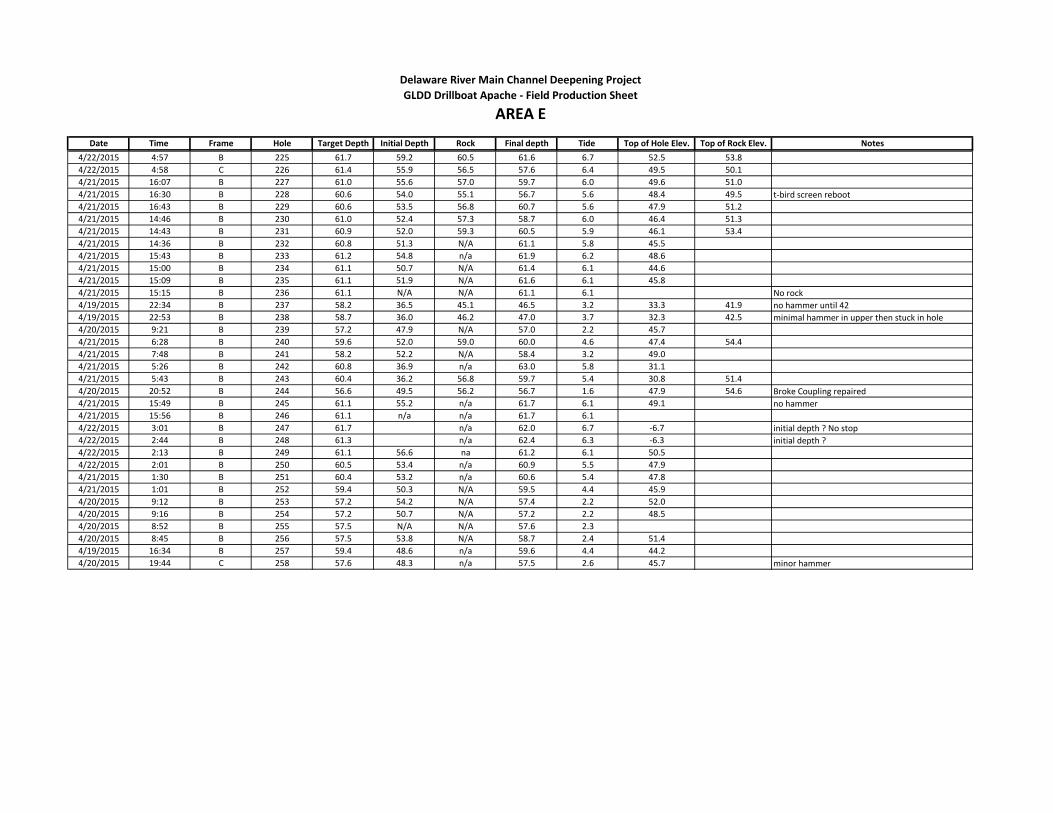
Date Time Frame Hole Target Depth Initial Depth Rock Final depth Tide Top of Hole Elev. Top of Rock Elev. Notes
Delaware River Main Channel Deepening Project
AREA EGLDD Drillboat Apache - Field Production Sheet
4/22/2015 4:57 B 225 61.7 59.2 60.5 61.6 6.7 52.5 53.8
4/22/2015 4:58 C 226 61.4 55.9 56.5 57.6 6.4 49.5 50.1
4/21/2015 16:07 B 227 61.0 55.6 57.0 59.7 6.0 49.6 51.0
4/21/2015 16:30 B 228 60.6 54.0 55.1 56.7 5.6 48.4 49.5 t-bird screen reboot
4/21/2015 16:43 B 229 60.6 53.5 56.8 60.7 5.6 47.9 51.2
4/21/2015 14:46 B 230 61.0 52.4 57.3 58.7 6.0 46.4 51.3
4/21/2015 14:43 B 231 60.9 52.0 59.3 60.5 5.9 46.1 53.4
4/21/2015 14:36 B 232 60.8 51.3 N/A 61.1 5.8 45.5
4/21/2015 15:43 B 233 61.2 54.8 n/a 61.9 6.2 48.6
4/21/2015 15:00 B 234 61.1 50.7 N/A 61.4 6.1 44.6
4/21/2015 15:09 B 235 61.1 51.9 N/A 61.6 6.1 45.8
4/21/2015 15:15 B 236 61.1 N/A N/A 61.1 6.1 No rock
4/19/2015 22:34 B 237 58.2 36.5 45.1 46.5 3.2 33.3 41.9 no hammer until 42
4/19/2015 22:53 B 238 58.7 36.0 46.2 47.0 3.7 32.3 42.5 minimal hammer in upper then stuck in hole
4/20/2015 9:21 B 239 57.2 47.9 N/A 57.0 2.2 45.7
4/21/2015 6:28 B 240 59.6 52.0 59.0 60.0 4.6 47.4 54.4
4/21/2015 7:48 B 241 58.2 52.2 N/A 58.4 3.2 49.0
4/21/2015 5:26 B 242 60.8 36.9 n/a 63.0 5.8 31.1
4/21/2015 5:43 B 243 60.4 36.2 56.8 59.7 5.4 30.8 51.4
4/20/2015 20:52 B 244 56.6 49.5 56.2 56.7 1.6 47.9 54.6 Broke Coupling repaired
4/21/2015 15:49 B 245 61.1 55.2 n/a 61.7 6.1 49.1 no hammer
4/21/2015 15:56 B 246 61.1 n/a n/a 61.7 6.1
4/22/2015 3:01 B 247 61.7 n/a 62.0 6.7 -6.7 initial depth ? No stop
4/22/2015 2:44 B 248 61.3 n/a 62.4 6.3 -6.3 initial depth ?
4/22/2015 2:13 B 249 61.1 56.6 na 61.2 6.1 50.5
4/22/2015 2:01 B 250 60.5 53.4 n/a 60.9 5.5 47.9
4/21/2015 1:30 B 251 60.4 53.2 n/a 60.6 5.4 47.8
4/21/2015 1:01 B 252 59.4 50.3 N/A 59.5 4.4 45.9
4/20/2015 9:12 B 253 57.2 54.2 N/A 57.4 2.2 52.0
4/20/2015 9:16 B 254 57.2 50.7 N/A 57.2 2.2 48.5
4/20/2015 8:52 B 255 57.5 N/A N/A 57.6 2.3
4/20/2015 8:45 B 256 57.5 53.8 N/A 58.7 2.4 51.4
4/19/2015 16:34 B 257 59.4 48.6 n/a 59.6 4.4 44.2
4/20/2015 19:44 C 258 57.6 48.3 n/a 57.5 2.6 45.7 minor hammer

Date Time Frame Hole Target Depth Initial Depth Rock Final depth Tide Top of Hole Elev. Top of Rock Elev. Notes
9:40 C 1 57.0 49.9 n/a 57.4 2.0 47.9
4/23/2015 2:09 B 2 59.1 51.3 N/A 59.0 4.1 47.2
4/23/2015 2:10 C 3 59.3 50.6 N/A 59.0 4.3 46.3
4/23/2015 1:59 C 4 59.0 49.7 N/A 58.7 4.0 45.7
4/23/2015 0:44 B 5 56.9 45.0 N/A 57.0 1.9 43.1
4/23/2015 0:34 B 6 56.6 46.8 55.2 56.3 1.6 45.2 53.6
4/23/2015 0:34 C 7 56.8 46.5 51.7 52.5 1.8 44.7 49.9
4/22/2015 11:38 B 8 55.8 45.9 N/A 56.0 0.8 45.1
4/22/2015 11:33 B 9 55.8 47.0 N/A 55.8 0.8 46.2
4/22/2015 11:36 C 10 55.8 45.9 53.9 55.7 0.8 45.1 53.1
4/22/2015 7:58 B 11 58.1 47.5 53.0 54.5 3.1 44.4 49.9
4/22/2015 8:04 B 12 58.1 48.0 50.0 54.2 3.1 44.9 46.9
4/22/2015 7:58 C 13 58.1 45.0 57.7 58.4 3.1 41.9 54.6
4/23/2015 9:52 B 14 56.8 52.0 n/a 56.9 1.8 50.2
4/23/2015 9:52 15 56.8 n/a n/a 58.9 1.8
4/23/2015 9:52 16 56.8 48.5 51.9 55.9 1.8 46.7 50.1
4/23/2015 2:28 B 17 59.4 51.5 N/A 59.6 4.4 47.1
4/23/2015 2:38 B 18 59.7 51.3 N/A 59.9 4.7 46.6
4/23/2015 2:28 C 19 59.7 50.7 58.5 59.4 4.7 46.0 53.8
4/23/2015 0:05 B 20 55.9 46.8 52.6 55.1 0.9 45.9 51.7
4/23/2015 0:13 B 21 56.0 46.2 52.9 55.9 1.0 45.2 51.9
4/23/2015 0:02 C 22 55.9 47.8 55.2 55.8 0.9 46.9 54.3
4/22/2015 11:52 B 23 56.2 46.1 51.5 55.9 1.2 44.9 50.3 ?
4/22/2015 11:57 B 24 56.3 45.5 47.4 48.9 1.3 44.2 46.1
4/22/2015 11:52 C 25 56.2 45.7 46.7 49.0 1.2 44.5 45.5
4/22/2015 9:00 B 26 56.9 47.9 55.3 57.2 1.9 46.0 53.4
4/22/2015 9:28 B 27 56.8 50.4 55.6 57.3 1.8 48.6 53.8
4/22/2015 9:28 C 28 56.8 47.3 N/A 57.4 1.9 45.4
4/23/2015 10:08 29 56.9 n/a n/a 56.9 1.5 45.4
4/23/2015 10:08 B 30 56.7 53.2 n/a 56.8 1.7 51.5
4/23/2015 10:08 C 31 56.5 52.1 n/a 57.5 1.5 50.6
4/23/2015 3:04 B 32 60.3 53.9 59.6 60.1 5.3 48.6 54.3
4/23/2015 2:56 B 33 60.1 51.4 57.2 58.5 5.1 46.3 52.1
4/23/2015 2:56 C 34 60.3 49.7 50.7 51.8 5.3 44.4 45.4
4/22/2015 23:45 B 35 55.7 46.0 48.3 49.9 0.7 45.3 47.6
4/22/2015 22:36 B 36 55.8 36.1 49.7 55.8 0.8 35.3 48.9
4/22/2015 22:36 C 37 55.7 44.6 46.0 47.1 0.7 43.9 45.3
4/22/2015 12:15 B 38 56.7 47.0 49.0 55.9 1.7 45.3 47.3
4/22/2015 12:11 B 39 56.7 46.6 47.7 55.9 1.7 44.9 46.0
4/22/2015 12:12 C 40 56.7 46.9 50.0 52.1 1.7 45.2 48.3
4/22/2015 9:46 B 41 56.6 47.5 50.3 51.8 1.6 45.9 48.7
4/22/2015 9:51 B 42 56.6 47.6 55.6 56.7 1.6 46.0 54.0
4/22/2015 9:46 C 43 56.6 46.4 N/A 57.8 1.6 44.8
4/23/2015 3:27 B 44 60.7 55.3 56.4 57.8 5.7 49.6 50.7 rock is very hard here
4/23/2015 3:37 B 45 60.8 53.1 53.9 54.9 5.8 47.3 48.1 rock is very hard here
4/23/2015 3:27 C 46 60.7 51.3 52.8 54.3 5.7 45.6 47.1 rock is very hard here
4/22/2015 23:08 B 47 55.9 45.9 47.7 48.8 0.9 45.0 46.8
Delaware River Main Channel Deepening Project
AREA FGLDD Drillboat Apache - Field Production Sheet

Date Time Frame Hole Target Depth Initial Depth Rock Final depth Tide Top of Hole Elev. Top of Rock Elev. Notes
Delaware River Main Channel Deepening Project
AREA FGLDD Drillboat Apache - Field Production Sheet
4/22/2015 23:15 B 48 55.8 46.1 46.9 47.9 0.8 45.3 46.1
4/22/2015 23:08 C 49 55.9 46.5 48.2 49.4 0.9 45.6 47.3
4/22/2015 12:58 B 50 57.8 48.9 53.5 57.6 2.8 46.1 50.7
4/22/2015 13:01 B 51 58.0 48.0 55.0 57.8 3.0 45.0 52.0
4/22/2015 C 52 58.2 46.1 46.4 49.1 3.2 42.9 43.2
4/22/2015 10:04 B 53 56.5 47.7 53.2 54.5 1.5 46.2 51.7
4/22/2015 10:04 B 54 56.3 47.6 N/A 56.9 1.3 46.3
4/22/2015 10:04 C 55 56.5 47.0 N/A 56.7 1.5 45.5
4/22/2015 4:00 B 56 60.9 58.8 N/A 61.4 5.9 52.9
4/22/2015 3:52 B 57 60.9 59.2 59.5 60.8 5.9 53.3 53.6
4/22/2015 3:52 C 58 60.9 55.3 58.7 59.9 5.9 49.4 52.8
4/22/2015 22:46 B 59 56.2 50.3 55.0 56.3 1.2 49.1 53.8
4/22/2015 22:35 B 60 56.3 50.2 54.0 54.0 1.3 48.9 52.7
4/22/2015 22:35 C 61 56.2 49.1 n/a 56.4 1.2 47.9
4/22/2015 13:25 B 62 58.8 49.5 N/A 58.4 3.8 45.7
4/22/2015 13:20 B 63 58.9 48.7 N/A 58.4 3.9 44.8
4/22/2015 13:20 C 64 58.8 47.8 49.3 51.4 3.8 44.0 45.5
4/22/2015 10:20 B 65 56.3 46.4 53.8 55.3 1.3 45.1 52.5
4/22/2015 10:24 B 66 56.2 46.2 N/A 57.1 1.2 45.0
4/22/2015 10:20 C 67 56.3 46.3 N/A 56.3 1.3 45.0
4/23/2015 4:18 B 68 61.1 55.7 N/A 61.5 6.1 49.6
4/23/2015 4:25 B 69 61.1 N/A N/A 61.7 6.1
4/23/2015 4:18 C 70 61.1 N/A N/A 61.3 6.1
4/22/2015 22:20 B 72 56.4 50.4 n/a 56.7 1.4 49.0
4/22/2015 22:10 B 71 56.7 51.6 n/a 57.0 1.7 49.9
4/22/2015 22:10 C 73 56.6 48.6 n/a 56.7 1.6 47.0
4/22/2015 14:19 B 74 60.3 45.3 58.4 60.3 5.3 40.0 53.1
4/22/2015 14:25 B 75 60.3 51.1 N/A 60.1 5.3 45.8
4/22/2015 14:22 C 76 60.3 49.5 49.8 52.1 5.3 44.2 44.5
4/22/2015 10:42 B 77 56.1 47.7 48.0 56.1 1.1 46.6 46.9
4/22/2015 10:38 B 78 56.1 48.4 N/A 56.2 1.1 47.3
4/22/2015 10:38 C 79 56.1 48.9 N/A 56.2 1.1 47.8
4/23/2015 9:40 B 80 56.3 48.7 N/A 57.3 1.9 46.8
4/24/2015 9:40 B 81 56.3 49.1 N/A 57.6 2.0 47.1

Date Time Frame Hole Target Depth Initial Depth Rock Final depth Tide Top of Hole Elev. Top of Rock Elev. Notes
4/23/2015 4:45 B 1 61.2 N/A N/A 61.6 6.2
4/23/2015 4:41 B 2 61.2 56.2 N/A 61.4 6.2 50.0
4/23/2015 4:41 C 3 61.2 57.8 N/A 61.4 6.2 51.6
4/22/2015 21:33 B 4 57.1 51.1 n/a 57.5 2.1 49.0 Switch to F sheet when complete
4/22/2015 21:46 B 5 57.0 50.2 55.5 57.2 2.0 48.2 53.5
4/22/2015 21:33 C 6 57.1 52.0 53.9 55.0 2.1 49.9 51.8
4/22/2015 14:51 B 7 60.8 52.1 60.3 60.6 5.8 46.3 54.5
4/22/2015 14:44 B 8 60.9 52.8 57.6 59.5 5.9 46.9 51.7
4/22/2015 14:49 C 9 60.9 50.8 55.6 57.8 5.9 44.9 49.7
4/22/2015 10:57 B 10 55.9 49.6 52.0 55.9 0.9 48.7 51.1
4/22/2015 11:04 B 11 55.8 N/A N/A 56.1 0.8
4/22/2015 10:57 C 12 55.8 N/A N/A 56.4 0.8 May say "G@", driller typing error
4/23/2015 5:08 B 13 61.1 N/A N/A 62.3 6.1
4/23/2015 5:16 C 14 61.0 56.2 N/A 61.1 6.0 50.2
4/23/2015 5:04 C 15 61.2 54.0 N/A 61.3 6.2 47.8
4/22/2015 21:01 B 16 57.5 47.2 52.3 55.8 2.5 44.7 49.8
4/22/2015 21:10 B 17 57.6 46.4 46.9 47.9 2.6 43.8 44.3
4/22/2015 21:01 C 18 57.5 48.0 48.6 49.6 2.5 45.5 46.1
4/22/2015 15:20 B 19 61.2 53.8 n/a 61.2 6.2 47.6 no hammer
4/22/2015 ?? B 20 61.3 n/a 6.3 -6.3
4/22/2015 15:18 C 21 61.2 53.5 61.3 6.2 47.3 -6.2 no hammer
4/23/2015 5:39 B 22 60.9 58.5 N/A 61.1 5.9 52.6
4/23/2015 5:49 B 23 60.7 54.9 N/A 61.0 5.7 49.2
4/23/2015 5:39 C 24 60.9 58.1 N/A 61.2 5.9 52.2
4/22/2015 20:15 B 25 58.2 47.1 47.2 49.4 3.2 43.9 44.0
4/22/2015 20:32 B 26 58.2 46.5 50.0 52.0 3.2 43.3 46.8
4/22/2015 20:20 C 27 58.2 49.2 49.8 50.9 3.2 46.0 46.6
4/22/2015 15:33 B 28 61.4 56.2 n/a 61.5 6.4 49.8
4/22/2015 15:38 B 29 61.4 55.9 na 61.5 6.4 49.5
4/22/2015 15:33 C 30 61.4 58.0 n/a 61.4 6.4 51.6
4/23/2015 6:09 B 31 60.4 55.5 N/A 60.6 5.4 50.1
4/23/2015 6:02 B 32 60.5 55.9 N/A 60.9 5.5 50.4
4/23/2015 6:02 C 33 60.4 53.5 N/A 61.0 5.4 48.1
4/22/2015 18:26 B 34 60.0 49.2 50.3 50.3 5.0 44.2 45.3
4/22/2015 18:24 B 35 60.1 50.4 50.4 51.9 5.1 45.3 45.3
4/22/2015 18:24 C 36 60.1 54.4 n/a 60.5 5.1 49.3
4/22/2015 15:48 B 37 61.5 57.2 n/a 61.3 6.5 50.7
4/22/2015 15:54 B 38 61.5 58.6 n/a 61.5 6.5 52.1
4/22/2015 15:50 C 39 61.5 55.8 n/a 61.5 6.50 49.3
4/23/2015 7:48 B 40 58.6 54.7 N/A 58.9 3.60 51.1
4/23/2015 7:48 B 41 58.5 51.9 52.3 53.5 3.50 48.4 48.8
4/23/2015 7:48 C 42 58.6 50.0 54.5 56.2 3.6 46.4 50.9
4/22/2015 18:08 B 43 60.5 56.9 n/a 60.8 5.5 51.4
4/22/2015 18:08 B 44 60.5 58.1 n/a 60.7 5.5 52.6
4/22/2015 18:08 C 45 60.5 53.6 n/a 60.7 5.5 48.1
4/22/2015 16:08 B 46 61.5 56.6 n/a 61.9 6.5 50.1
4/22/2015 16:02 B 47 61.6 56.5 n/a 61.4 6.6 49.9
Delaware River Main Channel Deepening Project
AREA GGLDD Drillboat Apache - Field Production Sheet

Date Time Frame Hole Target Depth Initial Depth Rock Final depth Tide Top of Hole Elev. Top of Rock Elev. Notes
Delaware River Main Channel Deepening Project
AREA GGLDD Drillboat Apache - Field Production Sheet
4/22/2015 16:02 C 48 61.6 55.3 n/a 61.6 6.6 48.7 no hammer
4/23/2015 8:12 B 49 58.2 50.9 N/A 57.6 3.2 47.7
4/23/2015 B 50 58.3 54.7 55.3 56.4 3.3 51.4 52.0
4/23/2015 8:12 C 51 58.2 52.2 N/A 58.5 3.2 49.0
4/22/2015 17:58 B 52 60.8 55.8 n/a 61.0 5.8 50.0
4/22/2015 17:53 B 53 60.7 56.8 n/a 61.0 5.7 51.1
4/22/2015 17:53 C 54 60.7 52.2 n/a 61.1 5.7 46.5
4/22/2015 16:20 B 55 61.6 55.1 n/a 61.7 6.6 48.5
4/22/2015 16:20 B 56 61.5 55.8 n/a 61.7 6.5 49.3
4/22/2015 16:20 C 58 61.6 55.7 n/a 61.5 6.6 49.1 no hammer
4/23/2015 8:35 B 59 58.0 50.5 54.8 55.9 3.0 47.5 51.8
4/23/2015 B 60 57.9 54.0 56.2 57.0 2.9 51.1 53.3
4/23/2015 8:35 C 61 58.0 51.4 n/a 58.0 3.0 48.4
4/22/2015 17:17 B 62 61.2 54.2 n/a 61.8 6.2 48.0
4/22/2015 17:36 B 63 61.1 54.2 n/a 61.1 6.1 48.1
4/22/2015 17:17 C 64 61.2 54.0 n/a 61.4 6.2 47.8 no hammer
4/22/2015 16:39 B 65 61.5 55.6 n/a 61.7 6.5 49.1
4/22/2015 16:35 B 66 61.5 55.5 n/a 61.7 6.5 49.0
4/22/2015 16:35 C 67 61.5 58.4 n/a 63.1 6.5 51.9

Date Time Frame Hole Target Depth Initial Depth Rock Final depth Tide Top of Hole Elev. Top of Rock Elev. Notes
4/27/2015 8:33 A 1 61.0 49.8 60.7 61.2 6.0 43.8 54.7
4/27/2015 8:02 B 2 61.1 56.0 N/A 61.2 6.1 49.9
4/27/2015 8:02 C 3 61.2 50.2 54.5 56.2 6.2 44.0 48.3
4/27/2015 5:49 B 4 59.9 47.7 53.7 56.6 4.9 42.8 48.8
4/27/2015 5:36 B 5 59.5 43.7 45.5 49.6 4.5 39.2 41.0
4/27/2015 5:36 C 6 59.5 45.3 47.0 48.3 4.5 40.8 42.5
4/26/2015 23:25 B 7 59.0 45.5 47.8 49.6 4.0 41.5 43.8
4/26/2015 23:33 B 8 58.9 45.1 46.8 49.0 3.9 41.2 42.9
4/26/2015 23:25 C 9 59.0 46.8 52.1 53.6 4.0 42.8 48.1
4/26/2015 23:03 B 10 59.3 45.9 58.6 59.5 4.3 41.6 54.3
4/26/2015 22:51 B 11 59.6 46.8 N/A 59.8 4.6 42.2
4/26/2015 22:51 C 12 59.6 47.2 53.5 55.2 4.6 42.6 48.9
4/26/2015 13:26 B 13 56.2 43.5 44.7 49.7 1.2 42.3 43.5
4/26/2015 13:18 B 14 56.2 43.8 43.8 47.7 1.2 42.6 42.6
4/26/2015 13:18 C 15 56.2 42.0 49.7 51.1 1.2 40.8 48.5
4/26/2015 12:49 B 16 56.6 42.9 56.0 56.8 1.6 41.3 54.4
4/26/2015 12:58 B 17 56.6 43.4 53.0 56.7 1.6 41.8 51.4
4/26/2015 12:49 C 18 56.6 42.3 46.5 52.3 1.6 40.7 44.9
4/26/2015 0:09 B 19 56.7 43.5 N/A 56.8 1.7 41.8
4/25/2015 23:54 B 20 56.8 45.0 N/A 57.3 1.8 43.2
4/25/2015 23:54 C 21 56.8 44.7 N/A 57.1 1.8 42.9
4/25/2015 23:16 B 22 57.4 45.4 57.4 57.7 2.4 43.0 55.0
4/25/2015 23:28 B 23 57.3 44.4 N/A 57.4 2.3 42.1
4/25/2015 23:19 C 24 57.3 43.4 N/A 63.5 2.3 41.1Drilled deeper because they needed to look at
hammer hydraulics
4/25/2015 11:28 B 25 56.7 41.6 53.0 54.9 1.7 39.9 51.3
4/25/2015 11:32 B 26 57.0 41.0 N/A 53.3 2.0 39.0
4/25/2015 11:28 C 27 57.0 39.0 N/A 52.0 2.0 37.0
4/25/2015 10:12 B 28 58.1 40.1 N/A 58.3 3.1 37.0
4/25/2015 10:11 B 29 58.1 41.2 56.4 57.6 3.0 37.0 53.4
4/25/2015 10:12 C 30 58.1 38.3 N/A 50.1 3.1 35.2
4/24/2015 21:00 B 31 58.2 38.5 40.8 49.7 3.2 35.3 37.6
4/24/2015 20:43 B 32 57.9 38.4 54.7 56.1 2.9 35.5 51.8 very hard from 40' uncorrected, but ROP>4 and <9
4/24/2015 20:43 C 33 58.2 missed it 36.0 37.0 3.2 32.8
4/24/2015 17:53 B 34 59.9 46.1 48.7 50.0 4.9 41.2 43.8
4/24/2015 17:59 B 35 59.8 41.0 41.0 42.3 4.8 36.2 36.2
4/24/2015 17:44 C 36 59.8 42.5 45.0 47.3 4.8 37.7 40.2
4/23/2015 23:04 B 37 55.3 38.7 38.8 40.0 0.3 38.4 38.5
4/23/2015 23:09 B 38 55.2 41.6 43.1 44.2 0.2 41.4 42.9
4/23/2015 23:04 C 39 55.3 47.0 47.1 48.4 0.3 46.7 46.8
4/23/2015 22:30 B 40 55.8 56.2 n/a 56.2 0.8 55.4 no hammer
4/23/2015 22:34 C 41 55.7 56.1 n/a 56.1 0.7 55.4 no hammer or air
4/23/2015 22:29 C 42 55.8 52.8 n/a 56.1 0.8 52.0 no hammer
4/27/2015 8:53 A 43 60.9 51.8 61.0 61.2 5.9 45.9 55.1
4/27/2015 8:53 B 44 60.9 51.1 N/A 61.0 5.9 45.2
4/27/2015 8:53 C 45 60.9 50.3 59.0 60.5 5.9 44.4 53.1
Delaware River Main Channel Deepening Project
AREA HGLDD Drillboat Apache - Field Production Sheet
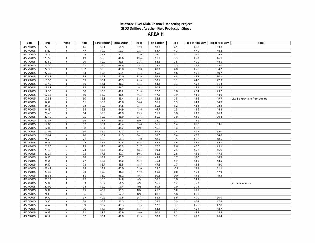
Date Time Frame Hole Target Depth Initial Depth Rock Final depth Tide Top of Hole Elev. Top of Rock Elev. Notes
Delaware River Main Channel Deepening Project
AREA HGLDD Drillboat Apache - Field Production Sheet
4/27/2015 5:13 B 46 59.1 50.9 57.9 58.9 4.1 46.8 53.8
4/27/2015 5:22 B 47 59.3 51.3 52.5 53.7 4.3 47.0 48.2
4/27/2015 5:13 C 48 59.1 51.7 53.0 54.0 4.1 47.6 48.9
4/26/2015 23:56 B 49 58.3 48.6 49.4 51.9 3.3 45.3 46.1
4/26/2015 23:50 B 50 58.5 49.5 51.6 52.2 3.5 46.0 48.1
4/26/2015 23:50 C 51 58.5 48.8 49.1 53.1 3.5 45.3 45.6
4/26/2015 22:33 B 52 59.8 49.8 59.0 60.3 4.8 45.0 54.2
4/26/2015 22:39 B 53 59.8 51.4 54.5 55.6 4.8 46.6 49.7
4/26/2015 22:33 C 54 59.8 52.0 54.9 56.2 4.8 47.2 50.1
4/26/2015 13:38 B 55 56.1 45.9 49.0 50.1 1.1 44.8 47.9
4/26/2015 13:42 B 56 56.1 46.3 52.5 53.8 1.1 45.2 51.4
4/26/2015 13:38 C 57 56.1 46.2 49.4 50.7 1.1 45.1 48.3
4/26/2015 12:36 B 58 56.8 48.2 51.0 52.2 1.8 46.4 49.2
4/26/2015 12:33 B 59 56.9 46.5 46.5 47.6 1.9 44.6 44.6
4/26/2015 12:33 C 60 56.8 45.4 51.5 52.2 1.8 43.6 49.7 May Be Rock right from the top
4/26/2015 0:38 B 61 56.3 45.6 56.0 56.5 1.3 44.3 54.7
4/26/2015 0:51 B 62 56.2 44.6 53.4 55.3 1.2 43.4 52.2
4/26/2015 0:39 C 63 56.3 44.9 45.6 46.7 1.3 43.6 44.3
4/25/2015 22:45 B 64 58.0 46.9 49.3 51.8 3.0 43.9 46.3
4/25/2015 22:45 C 65 58.0 46.9 53.4 56.5 3.0 43.9 50.4
4/25/2015 22:57 C 66 57.7 46.3 N/A 58.0 2.7 43.6
4/25/2015 12:05 B 67 56.4 47.4 55.0 56.5 1.4 46.0 53.6
4/25/2015 12:05 B 68 56.4 48.2 N/A 56.6 1.4 46.8
4/25/2015 12:05 C 69 56.4 47.1 55.4 56.7 1.4 45.7 54.0
4/25/2015 10:01 B 70 58.4 51.3 58.2 58.6 3.4 47.9 54.8
4/25/2015 9:55 B 71 58.5 50.3 52.0 58.9 3.5 46.8 48.5
4/25/2015 9:55 C 72 58.5 47.6 55.6 57.4 3.5 44.1 52.1
4/24/2015 21:29 B 73 57.6 49.2 51.7 57.8 2.6 46.6 49.1
4/24/2015 21:36 C 74 57.4 48.2 48.4 49.4 2.4 45.8 46.0
4/24/2015 21:24 C 75 57.6 47.7 50.1 51.1 2.6 45.1 47.5
4/24/2015 9:47 B 76 56.7 47.7 48.4 49.5 1.7 46.0 46.7
4/24/2015 9:51 B 77 56.7 45.2 45.2 46.4 1.7 43.5 43.5
4/24/2015 9:47 C 78 56.7 45.5 45.7 47.5 1.7 43.8 44.0
4/23/2015 23:42 B 79 54.9 47.0 51.0 55.0 -0.1 47.1 51.1
4/23/2015 23:35 B 80 55.0 46.3 47.9 51.0 0.0 46.3 47.9
4/23/2015 23:35 C 81 55.0 49.1 49.5 50.6 0.0 49.1 49.5
4/23/2015 22:14 B 82 56.0 54.8 n/a 56.6 1.0 53.8
4/23/2015 22:08 B 83 56.2 56.5 n/a 56.5 1.2 55.3 no hammer or air
4/23/2015 22:08 C 84 56.0 56.4 n/a 56.4 1.0 55.4
4/27/2015 9:09 A 85 60.8 51.3 N/A 61.0 5.8 45.5
4/27/2015 9:09 B 86 60.8 52.7 N/A 60.8 5.8 46.9
4/27/2015 9:09 C 87 60.8 50.8 56.4 58.3 5.8 45.0 50.6
4/27/2015 5:00 B 88 58.9 50.3 51.7 58.5 3.9 46.4 47.8
4/27/2015 4:52 B 89 58.7 49.3 51.5 52.8 3.7 45.6 47.8
4/27/2015 4:52 C 90 58.7 48.9 52.4 53.4 3.7 45.2 48.7
4/27/2015 0:09 B 91 58.2 47.9 49.0 50.1 3.2 44.7 45.8
4/27/2015 0:17 B 92 58.1 48.8 49.5 50.9 3.1 45.7 46.4

Date Time Frame Hole Target Depth Initial Depth Rock Final depth Tide Top of Hole Elev. Top of Rock Elev. Notes
Delaware River Main Channel Deepening Project
AREA HGLDD Drillboat Apache - Field Production Sheet
4/27/2015 0:09 C 93 58.2 30.9 31.8 32.8 3.2 27.7 28.6
NO GOOD, driller said there must have been
something wrong for it to show that shallow and
we had moved to the next station before we had a
chance to redrill
4/26/2015 22:16 B 94 60.0 52.2 55.2 56.3 5.0 47.2 50.2
4/26/2015 22:12 B 95 60.2 52.6 56.7 57.7 5.2 47.4 51.5
4/26/2015 22:12 C 96 60.2 49.0 49.5 50.6 5.2 43.8 44.3
4/26/2015 13:59 B 97 55.8 46.4 46.8 47.8 0.8 45.6 46.0
4/26/2015 13:53 B 98 55.9 46.9 N/A 56.1 0.9 46.0 review this one, may be rock
4/26/2015 13:53 C 99 55.9 44.9 47.2 49.0 0.9 44.0 46.3
4/26/2015 12:19 B 100 57.2 46.8 47.2 48.2 2.2 44.6 45.0
4/26/2015 12:24 B 101 57.0 46.6 47.9 49.1 2.0 44.6 45.9
4/26/2015 12:19 C 102 57.2 47.7 47.7 49.3 2.2 45.5 45.5
4/26/2015 1:16 B 103 55.9 43.5 52.9 54.0 0.9 42.6 52.0
4/26/2015 1:10 B 104 56.0 44.2 50.4 51.4 1.0 43.2 49.4
4/26/2015 1:10 C 105 55.9 44.4 44.7 45.5 0.9 43.5 43.8
4/25/2015 22:15 B 106 58.3 46.8 48.0 50.8 3.3 43.5 44.7
4/25/2015 22:23 C 107 58.1 47.7 51.7 54.6 3.1 44.6 48.6
4/25/2015 22:15 C 108 58.2 47.0 48.1 49.1 3.2 43.8 44.9
4/25/2015 12:26 B 109 56.0 44.3 47.3 49.8 1.0 43.3 46.3
4/25/2015 12:32 B 110 56.1 45.3 50.4 52.0 1.1 44.2 49.3
4/25/2015 12:26 C 111 56.0 47.6 55.0 56.2 1.0 46.6 54.0
4/25/2015 9:40 B 112 58.6 52.5 N/A 58.7 3.6 48.9
4/25/2015 9:45 B 113 58.6 51.0 54.3 55.3 3.6 47.4 50.7
4/25/2015 9:39 C 114 58.6 48.9 51.4 3.6 45.3 47.8
4/24/2015 21:58 B 115 57.2 47.7 52.5 56.0 2.2 45.5 50.3
4/24/2015 22:09 B 116 57.0 46.9 47.1 50.2 2.0 44.9 45.1
4/24/2015 21:58 C 117 57.2 46.9 48.0 50.3 2.2 44.7 45.8
4/24/2015 9:35 B 118 56.9 46.6 48.8 50.0 1.9 44.7 46.9
4/24/2015 9:32 B 119 57.0 47.2 47.3 48.6 2.0 45.2 45.3
4/24/2015 9:32 C 120 56.9 49.5 54.9 57.2 1.9 47.6 53.0
4/23/2015 23:57 B 121 54.8 48.8 n/a 54.9 -0.2 49.0
4/24/2015 0:01 B 122 54.7 52.0 n/a 55.8 -0.3 52.3
4/23/2015 23:57 C 123 54.8 48.2 n/a 55.0 -0.2 48.4
4/23/2015 21:44 B 124 56.4 52.7 n/a 57.7 1.4 51.3 no hammer
4/23/2015 21:54 B 125 56.4 56.8 n/a 56.8 1.4 55.4 no hammer or air
4/23/2015 21:44 C 126 56.4 53.7 n/a 56.5 1.4 52.3 no hammer
4/27/2015 9:26 A 127 60.5 52.3 N/A 60.7 5.5 46.8
4/27/2015 9:26 B 128 60.7 52.6 56.7 58.7 5.7 46.9 51.0
4/27/2015 9:26 C 129 60.5 50.4 52.5 54.8 5.5 44.9 47.0 Mis-named hole, will be 165
4/27/2015 4:22 B 130 58.0 48.6 50.9 54.7 3.0 45.6 47.9
4/27/2015 4:22 C 131 58.0 48.7 50.7 51.8 3.0 45.7 47.7
4/27/2015 4:35 C 132 58.3 48.4 51.6 52.6 3.3 45.1 48.3
4/27/2015 0:36 B 133 57.8 48.3 48.6 49.8 2.8 45.5 45.8
4/27/2015 0:31 B 134 57.9 49.5 51.5 52.8 2.9 46.6 48.6
4/27/2015 0:31 C 135 57.9 48.1 51.4 52.4 2.9 45.2 48.5
4/26/2015 21:50 B 136 60.5 52.1 58.8 59.9 5.5 46.6 53.3

Date Time Frame Hole Target Depth Initial Depth Rock Final depth Tide Top of Hole Elev. Top of Rock Elev. Notes
Delaware River Main Channel Deepening Project
AREA HGLDD Drillboat Apache - Field Production Sheet
4/26/2015 21:50 C 137 60.5 51.0 55.1 56.1 5.5 45.5 49.6
4/26/2015 21:58 C 138 60.5 51.6 52.6 53.3 5.5 46.1 47.1
4/26/2015 14:15 B 139 55.8 46.4 48.4 49.9 0.8 45.6 47.6
4/26/2015 14:15 B 140 55.8 45.6 45.6 47.6 0.8 44.8 44.8
4/26/2015 14:11 C 141 55.8 45.3 45.3 47.8 0.8 44.5 44.5
4/26/2015 12:07 B 142 57.3 47.2 48.2 49.3 2.3 44.9 45.9
4/26/2015 12:01 B 143 57.4 46.6 46.6 50.3 2.4 44.2 44.2
4/26/2015 12:02 C 144 57.4 43.2 49.3 51.4 2.4 40.8 46.9
4/26/2015 1:42 B 145 55.8 48.0 54.7 55.8 0.8 47.2 53.9
4/26/2015 1:52 B 146 55.8 47.1 52.2 55.8 0.8 46.3 51.4
4/26/2015 1:44 C 147 55.8 44.7 50.8 51.8 0.8 43.9 50.0
4/25/2015 21:40 B 148 58.8 49.8 58.0 59.0 3.8 46.0 54.2 4s and 5s for several feet towards the bottom
4/25/2015 21:40 C 149 58.7 49.6 50.7 51.7 3.7 45.9 47.0
4/25/2015 21:54 C 150 58.7 48.3 49.5 50.6 3.7 44.6 45.8
4/25/2015 12:47 B 151 55.8 45.3 51.8 52.6 0.8 44.5 51.0
4/25/2015 12:52 B 152 55.8 46.0 54.4 55.8 0.8 45.2 53.6
4/25/2015 12:47 C 153 55.8 46.0 N/A 55.9 0.8 45.2
4/25/2015 9:27 B 154 58.9 53.5 N/A 59.0 3.9 49.6
4/25/2015 9:23 B 155 59.1 49.3 51.0 52.3 4.1 45.2 46.9
4/25/2015 9:23 C 156 58.9 47.2 47.7 50.2 3.9 43.3 43.8
4/24/2015 22:36 B 157 56.6 49.4 53.0 56.7 1.6 47.8 51.4
4/24/2015 22:26 B 158 56.7 48.5 54.2 55.2 1.7 46.8 52.5
4/24/2015 22:26 C 159 56.6 46.8 52.2 53.8 1.6 45.2 50.6
4/24/2015 9:15 B 160 57.4 47.5 49.5 50.6 2.4 45.1 47.1
4/24/2015 9:18 B 161 57.3 49.7 52.2 52.7 2.3 47.4 49.9
4/24/2015 9:15 C 162 57.4 50.1 55.6 57.7 2.4 47.7 53.2
4/27/2015 9:38 A 163 60.3 50.8 58.2 59.3 5.3 45.5 52.9
4/27/2015 9:38 B 164 60.4 51.1 56.8 60.5 5.4 45.7 51.4
4/27/2015 9:38 C 165 60.3 50.4 52.0 56.1 5.3 45.1 46.7
4/27/2015 4:08 C 166 57.8 48.1 49.4 50.5 2.8 45.3 46.6
4/27/2015 4:04 C 167 57.4 48.2 53.5 54.6 2.4 45.8 51.1
4/27/2015 4:04 B 168 57.5 48.3 49.5 50.6 2.5 45.8 47.0
4/27/2015 0:48 B 169 57.6 49.8 51.6 52.7 2.6 47.2 49.0
4/27/2015 0:53 B 170 57.6 49.0 52.0 53.2 2.6 46.4 49.4
4/27/2015 0:48 C 171 57.6 49.3 51.2 52.3 2.6 46.7 48.6
4/26/2015 21:34 B 172 60.7 52.2 52.8 54.0 5.7 46.5 47.1
4/26/2015 21:38 C 173 60.7 51.4 54.4 55.6 5.7 45.7 48.7 very hard
4/26/2015 21:34 C 174 60.8 51.9 52.7 53.8 5.8 46.1 46.9 very hard
4/26/2015 14:32 B 175 55.8 46.6 46.6 48.0 0.8 45.8 45.8
4/26/2015 14:25 B 176 55.8 446.9 46.9 49.2 0.8 446.1 46.1
4/26/2015 14:25 C 177 55.8 44.1 44.1 46.0 0.8 43.3 43.3
4/26/2015 11:45 B 178 57.6 47.7 47.7 48.8 2.6 45.1 45.1
4/26/2015 11:50 B 179 57.5 51.7 52.8 57.9 2.5 49.2 50.3
4/26/2015 11:45 C 180 57.5 49.7 53.5 57.0 2.5 47.2 51.0
4/26/2015 2:18 B 181 56.0 48.1 51.9 55.9 1.0 47.1 50.9
4/26/2015 2:09 B 182 55.9 48.3 51.0 53.5 0.9 47.4 50.1

Date Time Frame Hole Target Depth Initial Depth Rock Final depth Tide Top of Hole Elev. Top of Rock Elev. Notes
Delaware River Main Channel Deepening Project
AREA HGLDD Drillboat Apache - Field Production Sheet
4/26/2015 2:10 C 183 55.9 49.8 N/A 56.2 0.9 48.9engineer wanted him to overdrill to test the
hammer
4/25/2015 21:12 B 184 59.4 50.3 54.9 59.6 4.4 45.9 50.5
4/25/2015 21:24 C 185 59.3 50.3 58.3 59.4 4.3 46.0 54.0
4/25/2015 21:12 C 186 59.4 49.7 missed it missed it 4.4 45.3 missed itthere was rock towards the end, missed elevations,
turned screen off too fast
4/25/2015 13:14 B 187 55.6 47.2 52.0 54.0 0.6 46.6 51.4
4/25/2015 13:05 B 188 55.7 47.5 53.6 56.1 0.7 46.8 52.9
4/25/2015 13:05 C 189 55.7 47.5 N/A 55.9 0.7 46.8
4/25/2015 9:05 B 190 59.2 51.2 58.9 59.5 4.2 47.0 54.7
4/25/2015 9:12 B 191 59.2 50.0 53.5 58.2 4.2 45.8 49.3
4/25/2015 9:05 C 192 59.2 49.2 50.8 54.6 4.2 45.0 46.6
4/24/2015 22:50 B 193 56.5 50.1 55.7 56.7 1.5 48.6 54.2
4/24/2015 23:00 B 194 56.3 48.2 N/A 56.5 1.3 46.9
4/24/2015 22:50 C 195 56.5 47.1 N/A 56.6 1.5 45.6
4/24/2015 9:04 B 196 57.5 49.7 54.7 55.8 2.5 47.2 52.2
4/24/2015 9:00 B 197 57.5 49.8 N/A 57.6 2.5 47.3
4/24/2015 9:00 C 198 57.5 49.5 56.5 57.9 2.5 47.0 54.0
4/24/2015 0:57 B 199 55.1 49.1 n/a 55.0 0.1 49.0
4/24/2015 0:51 B 200 54.9 48.3 52.0 53.0 -0.1 48.4 52.1
bobby started drilling this as hole #121, we had
him restart, hopefully this did not overwrite data
for hole 121
4/24/2015 0:51 C 201 54.9 n/a n/a 55.2 -0.1
screen did not display during this hole (did not
discover this until it was too late), but there was no
rock
4/23/2015 21:20 B 202 56.9 54.1 n/a 57.1 1.9 52.2
4/23/2015 21:26 C 203 56.6 55.2 n/a 57.0 1.6 53.6
4/23/2015 21:20 C 204 56.9 57.3 n/a 57.3 1.9 55.4 no hammer or air
4/23/2015 11:10 B 205 56.2 55.7 n/a 56.5 1.2 54.5
4/23/2015 11:08 B 206 55.7 n/a n/a 55.9 0.7
4/23/2015 11:08 C 207 55.8 48.8 n/a 56.3 0.8 48.0
4/27/2015 9:57 A 208 60.1 50.8 N/A 61.0 5.1 45.7
4/27/2015 9:57 B 209 60.1 51.3 57.9 60.2 5.1 46.2 52.8
4/27/2015 9:57 C 210 60.1 51.8 51.8 53.7 5.1 46.7 46.7
4/27/2015 3:46 B 211 57.2 48.8 52.3 53.4 2.2 46.6 50.1
4/27/2015 3:51 B 212 57.2 46.6 N/A 57.1 2.2 44.4
4/27/2015 3:46 C 213 57.2 48.5 N/A 57.0 2.2 46.3
4/27/2015 1:18 B 214 57.1 49.1 53.8 55.4 2.1 47.0 51.7
4/27/2015 1:11 B 215 57.2 47.5 52.2 53.4 2.2 45.3 50.0
4/27/2015 1:11 C 216 57.2 49.0 52.4 53.9 2.2 46.8 50.2
4/26/2015 21:15 B 217 61.0 51.9 55.3 55.3 6.0 45.9 49.3
4/26/2015 21:20 C 218 61.0 51.9 52.7 53.7 6.0 45.9 46.7
4/26/2015 21:15 C 219 61.0 52.1 52.5 53.6 6.0 46.1 46.5hardest I've seen so far, ROP about 1 the whole
way
4/26/2015 14:56 B 220 56.2 43.7 47.0 48.6 1.2 42.5 45.8
4/26/2015 15:03 B 221 56.2 47.1 49.0 50.3 1.2 45.9 47.8
4/26/2015 14:56 C 222 56.2 44.1 44.1 46.0 1.2 42.9 42.9

Date Time Frame Hole Target Depth Initial Depth Rock Final depth Tide Top of Hole Elev. Top of Rock Elev. Notes
Delaware River Main Channel Deepening Project
AREA HGLDD Drillboat Apache - Field Production Sheet
4/26/2015 11:33 B 223 57.9 47.2 47.6 48.6 2.9 44.3 44.7
4/26/2015 11:27 B 224 58.0 47.9 47.9 49.0 3.0 44.9 44.9
4/26/2015 11:27 C 225 57.9 48.1 N/A 57.4 2.9 45.2
4/26/2015 2:43 B 226 56.5 49.3 N/A 56.2 1.5 47.8
4/26/2015 2:50 C 227 56.7 48.0 50.7 51.8 1.7 46.3 49.0
4/26/2015 2:40 C 228 56.5 47.3 54.4 55.7 1.5 45.8 52.9
4/25/2015 20:43 B 229 59.8 48.0 48.4 50.4 4.8 43.2 43.6
4/25/2015 20:43 C 230 59.8 50.4 N/A 59.5 4.8 45.6
4/25/2015 20:52 C 231 59.6 50.4 N/A 59.8 4.6 45.8
4/25/2015 13:30 B 232 55.5 46.3 N/A 55.6 0.5 45.8
4/25/2015 13:34 B 233 55.5 46.4 N/A 55.6 0.5 45.9
4/25/2015 13:30 C 234 55.5 45.5 N/A 55.9 0.5 45.0
4/25/2015 8:00 B 235 60.4 50.3 59.7 60.6 5.4 44.9 54.3
4/25/2015 7:55 B 236 60.5 50.4 56.3 57.2 5.5 44.9 50.8
4/25/2015 7:55 C 237 60.4 50.0 59.7 60.9 5.4 44.6 54.3
4/24/2015 23:22 B 238 55.9 47.1 N/A 56.4 0.9 46.2
4/24/2015 23:12 B 239 56.1 47.5 N/A 56.4 1.1 46.4
4/24/2015 23:12 C 240 56.1 48.1 N/A 56.3 1.1 47.0
4/24/2015 8:40 B 241 57.7 48.4 57.5 58.4 2.7 45.7 54.8
4/24/2015 8:48 B 242 57.6 47.7 57.4 57.8 2.6 45.1 54.8
4/24/2015 8:40 C 243 57.7 47.1 51.1 53.0 2.7 44.4 48.4
4/24/2015 1:15 B 244 55.6 47.5 n/a 55.0 0.6 46.9
4/24/2015 1:27 B 245 55.9 46.5 n/a 56.1 0.9 45.6
4/24/2015 1:15 C 246 55.7 45.2 n/a 55.4 0.7 44.5
4/23/2015 20:46 B 247 57.1 54.5 n/a 57.4 2.1 52.4
4/23/2015 20:59 C 248 57.0 51.8 n/a 57.2 2.0 49.8
4/23/2015 20:46 C 249 57.2 54.4 n/a 57.5 2.2 52.2
4/23/2015 11:24 B 250 55.6 N/A N/A 56.0 0.6
4/23/2015 11:26 B 251 55.6 N/A N/A 56.3 0.6
4/23/2015 11:24 C 252 55.6 N/A N/A 55.9 0.6
4/27/2015 10:10 A 253 59.8 49.0 54.2 56.4 4.8 44.2 49.4
4/27/2015 10:10 B 254 59.8 50.3 56.4 57.4 4.8 45.5 51.6
4/27/2015 10:10 C 255 59.8 49.2 55.7 57.4 4.8 44.4 50.9
4/27/2015 3:36 B 256 57.0 48.1 n/a 56.8 2.0 46.1
4/27/2015 3:31 B 257 56.9 48.5 54.2 55.2 1.9 46.6 52.3
4/27/2015 3:31 C 258 56.9 48.4 54.4 55.4 1.9 46.5 52.5
4/27/2015 1:33 B 259 57.0 48.8 53.0 54.9 2.0 46.8 51.0
4/27/2015 1:38 C 260 56.9 48.9 50.1 51.1 1.9 47.0 48.2
4/27/2015 1:33 C 261 57.0 49.3 49.4 50.4 2.0 47.3 47.4
4/26/2015 20:50 B 262 61.1 52.1 55.3 56.4 6.1 46.0 49.2
4/26/2015 20:43 B 263 61.2 53.1 59.6 60.8 6.2 46.9 53.4
4/26/2015 20:04 C 264 61.4 53.0 56.3 57.3 6.4 46.6 49.9
4/26/2015 14:18 B 265 56.5 45.9 45.9 50.2 1.5 44.4 44.4
4/26/2015 13:14 B 266 56.4 46.2 46.2 48.0 1.4 44.8 44.8
4/26/2015 13:14 C 267 56.4 46.1 48.3 50.2 1.4 44.7 46.9
4/26/2015 11:08 B 268 58.2 48.1 49.1 52.8 3.2 44.9 45.9
4/26/2015 11:16 B 269 58.1 49.7 51.6 54.5 3.1 46.6 48.5
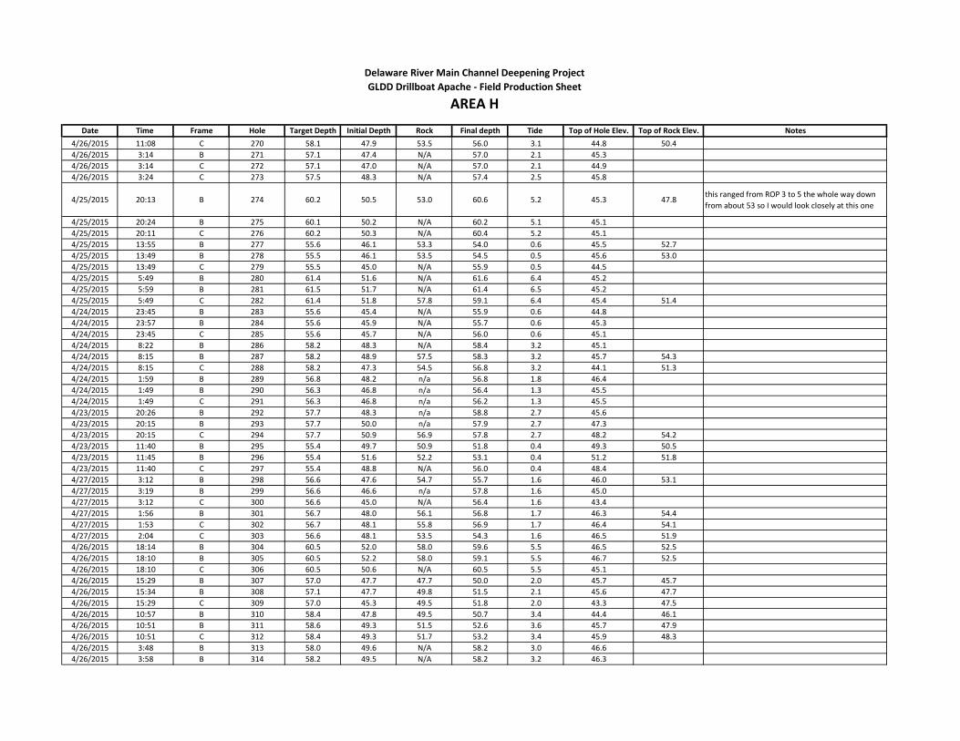
Date Time Frame Hole Target Depth Initial Depth Rock Final depth Tide Top of Hole Elev. Top of Rock Elev. Notes
Delaware River Main Channel Deepening Project
AREA HGLDD Drillboat Apache - Field Production Sheet
4/26/2015 11:08 C 270 58.1 47.9 53.5 56.0 3.1 44.8 50.4
4/26/2015 3:14 B 271 57.1 47.4 N/A 57.0 2.1 45.3
4/26/2015 3:14 C 272 57.1 47.0 N/A 57.0 2.1 44.9
4/26/2015 3:24 C 273 57.5 48.3 N/A 57.4 2.5 45.8
4/25/2015 20:13 B 274 60.2 50.5 53.0 60.6 5.2 45.3 47.8this ranged from ROP 3 to 5 the whole way down
from about 53 so I would look closely at this one
4/25/2015 20:24 B 275 60.1 50.2 N/A 60.2 5.1 45.1
4/25/2015 20:11 C 276 60.2 50.3 N/A 60.4 5.2 45.1
4/25/2015 13:55 B 277 55.6 46.1 53.3 54.0 0.6 45.5 52.7
4/25/2015 13:49 B 278 55.5 46.1 53.5 54.5 0.5 45.6 53.0
4/25/2015 13:49 C 279 55.5 45.0 N/A 55.9 0.5 44.5
4/25/2015 5:49 B 280 61.4 51.6 N/A 61.6 6.4 45.2
4/25/2015 5:59 B 281 61.5 51.7 N/A 61.4 6.5 45.2
4/25/2015 5:49 C 282 61.4 51.8 57.8 59.1 6.4 45.4 51.4
4/24/2015 23:45 B 283 55.6 45.4 N/A 55.9 0.6 44.8
4/24/2015 23:57 B 284 55.6 45.9 N/A 55.7 0.6 45.3
4/24/2015 23:45 C 285 55.6 45.7 N/A 56.0 0.6 45.1
4/24/2015 8:22 B 286 58.2 48.3 N/A 58.4 3.2 45.1
4/24/2015 8:15 B 287 58.2 48.9 57.5 58.3 3.2 45.7 54.3
4/24/2015 8:15 C 288 58.2 47.3 54.5 56.8 3.2 44.1 51.3
4/24/2015 1:59 B 289 56.8 48.2 n/a 56.8 1.8 46.4
4/24/2015 1:49 B 290 56.3 46.8 n/a 56.4 1.3 45.5
4/24/2015 1:49 C 291 56.3 46.8 n/a 56.2 1.3 45.5
4/23/2015 20:26 B 292 57.7 48.3 n/a 58.8 2.7 45.6
4/23/2015 20:15 B 293 57.7 50.0 n/a 57.9 2.7 47.3
4/23/2015 20:15 C 294 57.7 50.9 56.9 57.8 2.7 48.2 54.2
4/23/2015 11:40 B 295 55.4 49.7 50.9 51.8 0.4 49.3 50.5
4/23/2015 11:45 B 296 55.4 51.6 52.2 53.1 0.4 51.2 51.8
4/23/2015 11:40 C 297 55.4 48.8 N/A 56.0 0.4 48.4
4/27/2015 3:12 B 298 56.6 47.6 54.7 55.7 1.6 46.0 53.1
4/27/2015 3:19 B 299 56.6 46.6 n/a 57.8 1.6 45.0
4/27/2015 3:12 C 300 56.6 45.0 N/A 56.4 1.6 43.4
4/27/2015 1:56 B 301 56.7 48.0 56.1 56.8 1.7 46.3 54.4
4/27/2015 1:53 C 302 56.7 48.1 55.8 56.9 1.7 46.4 54.1
4/27/2015 2:04 C 303 56.6 48.1 53.5 54.3 1.6 46.5 51.9
4/26/2015 18:14 B 304 60.5 52.0 58.0 59.6 5.5 46.5 52.5
4/26/2015 18:10 B 305 60.5 52.2 58.0 59.1 5.5 46.7 52.5
4/26/2015 18:10 C 306 60.5 50.6 N/A 60.5 5.5 45.1
4/26/2015 15:29 B 307 57.0 47.7 47.7 50.0 2.0 45.7 45.7
4/26/2015 15:34 B 308 57.1 47.7 49.8 51.5 2.1 45.6 47.7
4/26/2015 15:29 C 309 57.0 45.3 49.5 51.8 2.0 43.3 47.5
4/26/2015 10:57 B 310 58.4 47.8 49.5 50.7 3.4 44.4 46.1
4/26/2015 10:51 B 311 58.6 49.3 51.5 52.6 3.6 45.7 47.9
4/26/2015 10:51 C 312 58.4 49.3 51.7 53.2 3.4 45.9 48.3
4/26/2015 3:48 B 313 58.0 49.6 N/A 58.2 3.0 46.6
4/26/2015 3:58 B 314 58.2 49.5 N/A 58.2 3.2 46.3

Date Time Frame Hole Target Depth Initial Depth Rock Final depth Tide Top of Hole Elev. Top of Rock Elev. Notes
Delaware River Main Channel Deepening Project
AREA HGLDD Drillboat Apache - Field Production Sheet
4/26/2015 3:48 C 315 58.0 48.4 N/A 58.1 3.0 45.4
4/25/2015 18:23 B 316 60.6 50.9 N/A 60.6 5.6 45.3
4/25/2015 18:14 B 317 60.6 51.1 N/A 60.7 5.6 45.5
4/25/2015 18:14 C 318 60.6 49.6 55.1 57.1 5.6 44.0 49.5
4/25/2015 14:08 B 319 55.7 46.1 50.5 51.5 0.7 45.4 49.8
4/25/2015 14:16 B 320 55.8 45.5 N/A 55.7 0.8 44.7
4/25/2015 14:08 C 321 55.8 45.4 N/A 55.9 0.8 44.6
4/25/2015 5:18 B 322 61.2 51.3 N/A 62.1 6.2 45.1
4/25/2015 5:08 B 323 61.0 51.4 55.6 56.8 6.0 45.4 49.6
4/25/2015 5:08 C 324 61.0 51.9 55.5 56.6 6.0 45.9 49.5
4/25/2015 0:28 B 325 55.3 45.9 52.9 53.9 0.3 45.6 52.6
4/25/2015 0:11 B 326 55.4 46.2 54.8 55.5 0.4 45.8 54.4
4/25/2015 0:11 C 327 55.4 43.8 53.3 53.9 0.4 43.4 52.9
4/24/2015 7:50 B 328 58.7 49.7 56.2 57.0 3.7 46.0 52.5
4/24/2015 8:00 B 329 58.4 49.5 57.5 58.6 3.4 46.1 54.1
4/24/2015 7:50 C 330 58.7 47.8 N/A 58.7 3.7 44.1
4/24/2015 2:22 B 331 57.3 47.7 n/a 57.3 2.3 45.4
4/24/2015 2:34 C 332 57.5 47.3 n/a 57.7 2.5 44.8
4/24/2015 2:22 C 333 57.3 47.9 n/a 57.1 2.3 45.6
4/23/2015 16:08 B 334 59.8 50.1 58.2 60.1 4.8 45.3 53.4
4/23/2015 18:20 B 335 59.5 50.0 57.4 58.5 4.5 45.5 52.9
4/23/2015 16:08 C 336 59.9 50.3 51.1 54.9 4.9 45.4 46.2
4/23/2015 11:55 B 337 55.2 47.4 47.4 48.4 0.2 47.2 47.2
4/23/2015 11:53 B 338 55.3 48.3 48.5 49.5 0.3 48.0 48.2
4/23/2015 11:53 C 339 55.3 49.2 51.8 53.5 0.3 48.9 51.5
4/27/2015 2:58 B 340 56.4 46.9 52.8 53.8 1.4 45.5 51.4
4/27/2015 2:51 B 341 56.3 46.2 n/a 56.2 1.3 44.9
4/27/2015 2:51 C 342 56.4 46.9 n/a 56.2 1.4 45.5
4/27/2015 2:18 B 343 56.4 46.7 n/a 56.6 1.4 45.3
4/27/2015 2:23 C 344 56.4 46.4 55.7 56.5 1.4 45.0 54.3
4/27/2015 2:18 C 345 56.4 46.9 54.2 55.2 1.4 45.5 52.8
4/26/2015 17:48 B 347 60.2 50.6 N/A 60.3 5.2 45.4
4/26/2015 17:52 B 348 60.3 50.9 N/A 60.3 5.3 45.6
4/26/2015 17:52 C 349 60.3 50.4 N/A 60.1 5.3 45.1
4/26/2015 15:51 B 350 57.4 48.4 50.8 52.5 2.4 46.0 48.4
4/26/2015 15:48 B 351 57.4 47.8 47.8 51.6 2.4 45.4 45.4
4/26/2015 15:48 C 352 57.4 46.3 46.3 47.8 2.4 43.9 43.9
4/26/2015 10:30 B 353 58.8 50.0 50.1 51.4 3.8 46.2 46.3
4/26/2015 10:36 B 354 58.7 50.1 52.9 53.2 3.7 46.4 49.2
4/26/2015 10:30 C 355 58.8 50.7 53.4 55.0 3.8 46.9 49.6
4/26/2015 4:27 B 356 59.1 50.6 N/A 58.8 4.1 46.5
4/26/2015 4:17 B 357 58.9 50.1 N/A 58.6 3.9 46.2
4/26/2015 4:17 C 358 58.9 49.3 N/A 58.6 3.9 45.4
4/25/2015 17:57 B 359 60.5 51.5 N/A 60.4 5.5 46.0
4/25/2015 18:04 B 360 60.5 51.0 N/A 60.4 5.5 45.5
4/25/2015 17:57 C 361 60.5 49.0 51.8 53.5 5.5 43.5 46.3
4/25/2015 14:28 B 362 56.2 46.2 50.5 51.4 1.2 45.0 49.3

Date Time Frame Hole Target Depth Initial Depth Rock Final depth Tide Top of Hole Elev. Top of Rock Elev. Notes
Delaware River Main Channel Deepening Project
AREA HGLDD Drillboat Apache - Field Production Sheet
4/25/2015 14:28 B 363 56.1 46.3 N/A 56.0 1.1 45.2
4/25/2015 14:28 C 364 56.1 45.5 N/A 56.0 1.1 44.4
4/25/2015 4:17 B 365 60.2 50.5 N/A 60.3 5.2 45.3
4/25/2015 4:35 B 366 60.6 51.0 56.6 58.4 5.6 45.4 51.0
4/25/2015 4:23 C 367 60.4 50.5 54.3 55.8 5.4 45.1 48.9
4/25/2015 0:47 B 368 55.3 46.4 50.6 51.7 0.3 46.1 50.3
4/25/2015 0:58 B 369 55.3 46.5 52.1 53.4 0.3 46.2 51.8
4/25/2015 0:53 C 370 55.3 45.8 N/A 55.5 0.3 45.5
4/24/2015 6:16 B 371 60.0 51.5 56.3 57.6 5.0 46.5 51.3
4/24/2015 6:11 B 372 60.0 51.0 57.7 59.4 5.0 46.0 52.7
4/24/2015 6:11 C 373 60.0 48.6 n/a 60.1 5.0 43.6
4/24/2015 3:06 B 374 58.6 48.0 n/a 58.3 3.6 44.4
4/24/2015 3:21 B 375 58.9 49.1 n/a 59.0 3.9 45.2
4/24/2015 3:06 C 376 58.6 49.2 n/a 58.2 3.6 45.6
4/23/2015 15:49 B 377 59.7 50.6 56.6 57.7 4.7 45.9 51.9
4/23/2015 15:46 B 378 59.7 50.8 54.4 55.4 4.7 46.1 49.7
4/23/2015 15:46 C 379 59.7 48.2 49.6 52.9 4.7 43.5 44.9
4/23/2015 12:19 B 380 55.2 46.3 46.6 48.5 0.2 46.1 46.4
4/23/2015 12:21 B 381 55.3 48.0 48.7 49.7 0.3 47.7 48.4
4/23/2015 12:19 C 382 55.2 48.6 52.0 55.2 0.2 48.4 51.8
4/26/2015 B 383 59.7 51.3 N/A 59.8 4.7 46.6
4/26/2015 17:27 B 384 59.7 50.7 N/A 59.7 4.7 46.0
4/26/2015 17:27 C 385 59.7 49.4 54.6 56.6 4.7 44.7 49.9
4/26/2015 16:04 B 386 57.5 48.6 52.0 52.8 2.5 46.1 49.5
4/26/2015 16:08 B 387 58.0 49.0 53.9 55.0 3.0 46.0 50.9
4/26/2015 16:04 C 388 57.7 48.8 N/A 57.9 2.7 46.1
4/26/2015 10:01 B 389 59.3 50.2 54.3 55.5 4.3 45.9 50.0
4/26/2015 8:46 B 390 60.5 51.8 61.0 61.6 5.5 46.3 55.5
4/26/2015 10:01 C 391 59.3 48.8 57.0 58.5 4.3 44.5 52.7
4/26/2015 4:49 B 392 59.5 50.8 N/A 59.4 4.5 46.3
4/26/2015 4:48 C 393 59.8 49.8 N/A 59.3 4.8 45.0
4/26/2015 4:59 C 394 59.5 50.4 N/A 59.6 4.5 45.9
4/25/2015 17:45 B 395 60.3 50.9 N/A 60.3 5.3 45.6
4/25/2015 17:35 B 396 60.1 50.3 N/A 60.0 5.1 45.2
4/25/2015 17:35 C 397 60.2 49.5 59.5 60.1 5.2 44.3 54.3
4/25/2015 14:47 B 398 56.6 46.8 54.8 56.2 1.6 45.2 53.2
4/25/2015 14:55 B 399 56.8 48.4 N/A 58.1 1.8 46.6
4/25/2015 14:47 C 400 56.6 47.2 N/A 56.6 1.6 45.6
4/25/2015 3:45 B 401 59.5 51.3 N/A 59.5 4.5 46.8
4/25/2015 3:55 C 402 59.7 50.6 N/A 59.5 4.7 45.9
4/25/2015 3:50 C 403 59.5 50.7 N/A 59.5 4.5 46.2
4/25/2015 1:36 B 404 56.1 46.0 54.0 55.3 1.1 44.9 52.9
4/25/2015 1:23 B 405 55.8 45.5 49.0 50.5 0.8 44.7 48.2
4/25/2015 1:23 C 406 55.8 44.2 51.1 53.5 0.8 43.4 50.3
4/24/2015 5:43 B 407 60.2 49.2 n/a 60.2 5.2 44.0
4/24/2015 5:52 B 408 60.1 49.5 n/a 60.2 5.1 44.4
4/24/2015 5:43 C 409 60.2 49.4 n/a 60.5 5.2 44.2
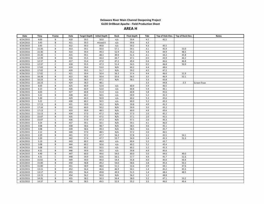
Date Time Frame Hole Target Depth Initial Depth Rock Final depth Tide Top of Hole Elev. Top of Rock Elev. Notes
Delaware River Main Channel Deepening Project
AREA HGLDD Drillboat Apache - Field Production Sheet
4/24/2015 4:00 B 410 59.5 50.0 n/a 59.4 4.5 45.5
4/24/2015 3:43 B 411 59.3 missed it n/a 59.6 4.3
4/24/2015 3:43 C 412 59.3 49.8 n/a 59.2 4.3 45.5
4/23/2015 15:20 B 413 59.1 50.0 57.1 59.1 4.1 45.9 53.0
4/23/2015 15:30 B 414 59.4 49.3 52.9 55.2 4.4 44.9 48.5
4/23/2015 15:20 C 415 59.1 48.3 49.9 51.5 4.1 44.2 45.8
4/23/2015 12:39 B 416 55.5 44.4 44.7 47.1 0.5 43.9 44.2
4/23/2015 12:37 B 417 55.4 47.0 47.2 49.4 0.4 46.6 46.8
4/23/2015 12:37 C 418 55.5 47.3 51.4 54.5 0.5 46.8 50.9
4/26/2015 17:02 B 419 59.4 53.0 N/A 60.2 4.4 48.6
4/26/2015 17:02 B 420 59.5 51.7 N/A 59.2 4.5 47.2
4/26/2015 17:02 C 421 59.4 50.4 56.3 57.4 4.4 46.0 51.9
4/26/2015 16:28 B 422 58.5 50.4 55.6 56.5 3.5 46.9 52.1
4/26/2015 16:23 B 423 58.3 47.1 N/A 58.1 3.3 43.8
4/26/2015 16:23 C 424 58.3 48.1 3.3 44.8 -3.3 Screen froze
4/26/2015 6:03 B 425 60.9 52.4 n/a 60.9 5.9 46.5
4/26/2015 6:13 B 426 60.9 52.0 n/a 60.8 5.9 46.1
4/26/2015 6:03 C 427 60.8 51.4 n/a 60.8 5.8 45.6
4/26/2015 5:22 B 428 60.2 50.5 n/a 59.9 5.2 45.3
4/26/2015 5:30 C 429 60.3 50.9 n/a 60.2 5.3 45.6
4/26/2015 5:22 C 430 60.2 50.5 n/a 60.0 5.2 45.3
4/25/2015 17:13 B 431 59.9 50.2 N/A 59.8 4.9 45.3
4/25/2015 17:16 B 432 60.0 50.2 N/A 59.9 5.0 45.2
4/25/2015 17:13 C 433 59.9 48.5 N/A 60.0 4.9 43.6
4/25/2015 15:13 B 434 57.0 47.2 N/A 57.3 2.0 45.2
4/25/2015 15:07 B 435 57.0 47.5 N/A 57.1 2.0 45.5
4/25/2015 15:07 C 436 57.0 47.3 N/A 57.1 2.0 45.3
4/25/2015 3:24 B 437 59.1 50.1 N/A 59.1 4.1 46.0
4/25/2015 3:08 B 438 58.6 48.7 N/A 58.5 3.6 45.1
4/25/2015 3:08 C 439 58.6 49.3 N/A 58.5 3.6 45.7
4/25/2015 2:12 B 440 57.0 48.5 N/A 57.2 2.0 46.5
4/25/2015 2:29 B 441 57.2 47.7 56.3 57.8 2.2 45.5 54.1
4/25/2015 2:20 C 442 57.4 47.7 53.7 54.9 2.4 45.3 51.3
4/24/2015 5:19 B 443 60.2 48.9 n/a 60.4 5.2 43.7
4/24/2015 5:08 B 444 60.2 50.6 n/a 60.2 5.2 45.4
4/24/2015 5:08 C 445 60.2 50.5 n/a 60.2 5.2 45.3
4/24/2015 4:31 B 446 59.9 50.5 n/a 59.8 4.9 45.6
4/24/2015 4:40 B 447 60.0 49.6 54.0 60.0 5.0 44.6 49.0
4/24/2015 4:31 C 448 59.9 50.6 56.5 57.7 4.9 45.7 51.6
4/23/2015 15:02 B 449 59.0 49.0 54.4 55.8 4.0 45.0 50.4
4/23/2015 15:00 B 450 58.8 49.2 54.0 58.6 3.8 45.4 50.2
4/23/2015 15:00 C 451 58.9 48.0 51.5 53.6 3.9 44.1 47.6
4/23/2015 13:15 B 452 56.4 46.6 46.9 50.1 1.4 45.2 45.5
4/23/2015 13:17 B 453 56.4 49.8 49.9 51.5 1.4 48.4 48.5
4/23/2015 13:15 C 454 56.2 50.0 N/A 56.2 1.2 48.8
4/23/2015 14:35 B 455 58.2 50.3 56.4 58.0 3.2 47.1 53.2
4/23/2015 14:37 B 456 58.5 49.5 52.9 55.2 3.5 46.0 49.4

Date Time Frame Hole Target Depth Initial Depth Rock Final depth Tide Top of Hole Elev. Top of Rock Elev. Notes
Delaware River Main Channel Deepening Project
AREA HGLDD Drillboat Apache - Field Production Sheet
4/23/2015 14:35 C 457 58.2 49.1 50.9 52.6 3.2 45.9 47.7
4/23/2015 13:33 B 458 56.7 49.2 50.0 51.0 1.7 47.5 48.3
4/23/2015 13:31 B 459 56.7 53.0 N/A 56.6 1.7 51.3
4/23/2015 13:31 C 460 56.7 52.7 N/A 56.9 1.7 51.0
4/23/2015 14:18 B 461 57.9 50.6 54.5 57.7 2.9 47.7 51.6
4/23/2015 14:16 B 462 57.9 50.6 52.4 56.3 2.9 47.7 49.5
4/23/2015 14:16 C 463 57.9 50.1 55.8 57.2 2.9 47.2 52.9
4/23/2015 13:47 B 464 57.0 50.3 N/A 56.9 2.0 48.3
4/23/2015 13:49 B 465 57.0 50.8 N/A 56.8 2.0 48.8
4/23/2015 13:47 C 466 57.0 45.9 N/A 56.9 2.0 43.9
4/25/2015 15:52 B 1000 58.1 48.8 53.1 54.6 3.1 45.7 50.0
4/25/2015 15:52 B 1001 58.1 48.9 50.3 52.8 3.1 45.8 47.2
4/25/2015 15:52 C 1002 58.1 49.2 52.9 54.6 3.1 46.1 49.8
4/25/2015 16:34 B 1003 58.8 52.4 56.3 58.9 3.8 48.6 52.5
4/25/2015 16:30 B 1004 59.1 51.3 58.1 58.9 4.1 47.2 54.0
4/25/2015 16:34 C 1005 59.1 48.8 53.3 55.3 4.1 44.7 49.2
4/27/2015 11:00 A 1006 59.4 48.8 51.8 53.3 4.4 44.4 47.4
4/27/2015 11:00 B 1007 59.4 49.2 58.8 59.5 4.4 44.8 54.4
4/27/2015 11:00 C 1008 59.4 48.7 51.4 53.5 4.4 44.3 47.0
4/27/2015 11:40 A 1009 58.3 48.4 56.7 57.7 3.3 45.1 53.4
4/27/2015 11:40 B 1010 58.3 48.6 54.4 55.2 3.3 45.3 51.1
4/27/2015 11:40 C 1011 58.3 47.7 N/A 58.7 3.3 44.4
4/27/2015 12:00 A 1015 58.0 50.8 N/A 58.7 3.0 47.8
4/27/2015 12:00 B 1016 58.0 50.1 N/A 58..3 3.0 47.1
4/27/2015 12:00 C 1017 58.0 47.4 57.3 58.3 3.0 44.4 54.3
4/27/2015 12:19 A 1018 57.7 48..8 N/A 58.1 2.7
4/27/2015 12:19 B 1019 57.7 48.6 N/A 58.5 2.7 45.9
4/27/2015 12:19 C 1020 57.7 46.4 N/A 58.0 2.7 43.7
4/27/2015 12:38 A 1021 57.4 47.6 N/A 57.9 2.4 45.2
4/27/2015 12:38 B 1022 57.4 48.3 N/A 57.7 2.4 45.9
4/27/2015 12:38 C 1023 57.4 47.3 N/A 57.9 2.4 44.9
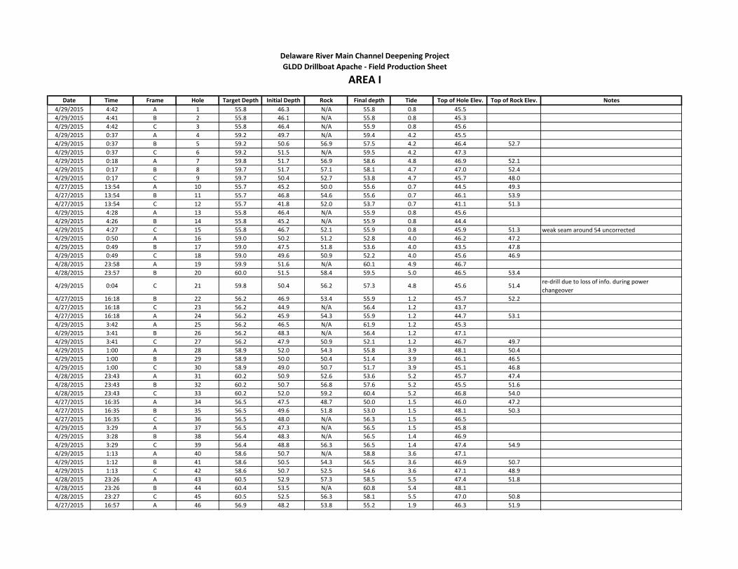
Date Time Frame Hole Target Depth Initial Depth Rock Final depth Tide Top of Hole Elev. Top of Rock Elev. Notes
4/29/2015 4:42 A 1 55.8 46.3 N/A 55.8 0.8 45.5
4/29/2015 4:41 B 2 55.8 46.1 N/A 55.8 0.8 45.3
4/29/2015 4:42 C 3 55.8 46.4 N/A 55.9 0.8 45.6
4/29/2015 0:37 A 4 59.2 49.7 N/A 59.4 4.2 45.5
4/29/2015 0:37 B 5 59.2 50.6 56.9 57.5 4.2 46.4 52.7
4/29/2015 0:37 C 6 59.2 51.5 N/A 59.5 4.2 47.3
4/29/2015 0:18 A 7 59.8 51.7 56.9 58.6 4.8 46.9 52.1
4/29/2015 0:17 B 8 59.7 51.7 57.1 58.1 4.7 47.0 52.4
4/29/2015 0:17 C 9 59.7 50.4 52.7 53.8 4.7 45.7 48.0
4/27/2015 13:54 A 10 55.7 45.2 50.0 55.6 0.7 44.5 49.3
4/27/2015 13:54 B 11 55.7 46.8 54.6 55.6 0.7 46.1 53.9
4/27/2015 13:54 C 12 55.7 41.8 52.0 53.7 0.7 41.1 51.3
4/29/2015 4:28 A 13 55.8 46.4 N/A 55.9 0.8 45.6
4/29/2015 4:26 B 14 55.8 45.2 N/A 55.9 0.8 44.4
4/29/2015 4:27 C 15 55.8 46.7 52.1 55.9 0.8 45.9 51.3 weak seam around 54 uncorrected
4/29/2015 0:50 A 16 59.0 50.2 51.2 52.8 4.0 46.2 47.2
4/29/2015 0:49 B 17 59.0 47.5 51.8 53.6 4.0 43.5 47.8
4/29/2015 0:49 C 18 59.0 49.6 50.9 52.2 4.0 45.6 46.9
4/28/2015 23:58 A 19 59.9 51.6 N/A 60.1 4.9 46.7
4/28/2015 23:57 B 20 60.0 51.5 58.4 59.5 5.0 46.5 53.4
4/29/2015 0:04 C 21 59.8 50.4 56.2 57.3 4.8 45.6 51.4re-drill due to loss of info. during power
changeover
4/27/2015 16:18 B 22 56.2 46.9 53.4 55.9 1.2 45.7 52.2
4/27/2015 16:18 C 23 56.2 44.9 N/A 56.4 1.2 43.7
4/27/2015 16:18 A 24 56.2 45.9 54.3 55.9 1.2 44.7 53.1
4/29/2015 3:42 A 25 56.2 46.5 N/A 61.9 1.2 45.3
4/29/2015 3:41 B 26 56.2 48.3 N/A 56.4 1.2 47.1
4/29/2015 3:41 C 27 56.2 47.9 50.9 52.1 1.2 46.7 49.7
4/29/2015 1:00 A 28 58.9 52.0 54.3 55.8 3.9 48.1 50.4
4/29/2015 1:00 B 29 58.9 50.0 50.4 51.4 3.9 46.1 46.5
4/29/2015 1:00 C 30 58.9 49.0 50.7 51.7 3.9 45.1 46.8
4/28/2015 23:43 A 31 60.2 50.9 52.6 53.6 5.2 45.7 47.4
4/28/2015 23:43 B 32 60.2 50.7 56.8 57.6 5.2 45.5 51.6
4/28/2015 23:43 C 33 60.2 52.0 59.2 60.4 5.2 46.8 54.0
4/27/2015 16:35 A 34 56.5 47.5 48.7 50.0 1.5 46.0 47.2
4/27/2015 16:35 B 35 56.5 49.6 51.8 53.0 1.5 48.1 50.3
4/27/2015 16:35 C 36 56.5 48.0 N/A 56.3 1.5 46.5
4/29/2015 3:29 A 37 56.5 47.3 N/A 56.5 1.5 45.8
4/29/2015 3:28 B 38 56.4 48.3 N/A 56.5 1.4 46.9
4/29/2015 3:29 C 39 56.4 48.8 56.3 56.5 1.4 47.4 54.9
4/29/2015 1:13 A 40 58.6 50.7 N/A 58.8 3.6 47.1
4/29/2015 1:12 B 41 58.6 50.5 54.3 56.5 3.6 46.9 50.7
4/29/2015 1:13 C 42 58.6 50.7 52.5 54.6 3.6 47.1 48.9
4/28/2015 23:26 A 43 60.5 52.9 57.3 58.5 5.5 47.4 51.8
4/28/2015 23:26 B 44 60.4 53.5 N/A 60.8 5.4 48.1
4/28/2015 23:27 C 45 60.5 52.5 56.3 58.1 5.5 47.0 50.8
4/27/2015 16:57 A 46 56.9 48.2 53.8 55.2 1.9 46.3 51.9
Delaware River Main Channel Deepening Project
AREA IGLDD Drillboat Apache - Field Production Sheet
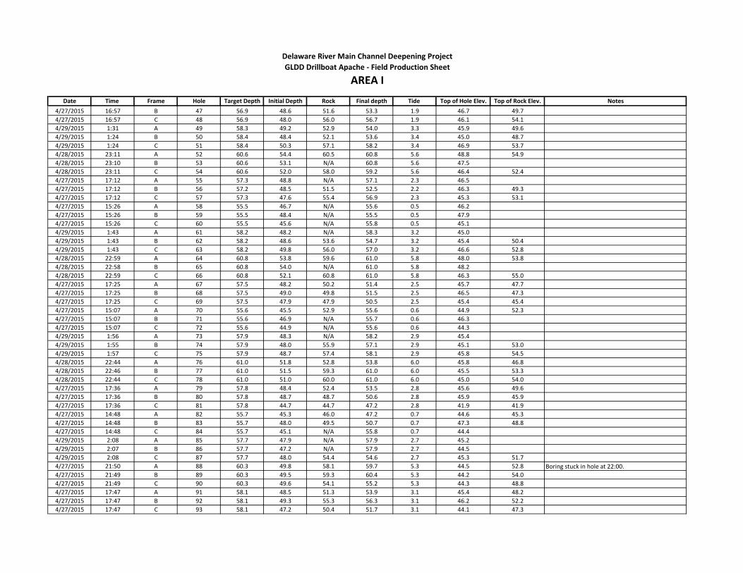
Date Time Frame Hole Target Depth Initial Depth Rock Final depth Tide Top of Hole Elev. Top of Rock Elev. Notes
Delaware River Main Channel Deepening Project
AREA IGLDD Drillboat Apache - Field Production Sheet
4/27/2015 16:57 B 47 56.9 48.6 51.6 53.3 1.9 46.7 49.7
4/27/2015 16:57 C 48 56.9 48.0 56.0 56.7 1.9 46.1 54.1
4/29/2015 1:31 A 49 58.3 49.2 52.9 54.0 3.3 45.9 49.6
4/29/2015 1:24 B 50 58.4 48.4 52.1 53.6 3.4 45.0 48.7
4/29/2015 1:24 C 51 58.4 50.3 57.1 58.2 3.4 46.9 53.7
4/28/2015 23:11 A 52 60.6 54.4 60.5 60.8 5.6 48.8 54.9
4/28/2015 23:10 B 53 60.6 53.1 N/A 60.8 5.6 47.5
4/28/2015 23:11 C 54 60.6 52.0 58.0 59.2 5.6 46.4 52.4
4/27/2015 17:12 A 55 57.3 48.8 N/A 57.1 2.3 46.5
4/27/2015 17:12 B 56 57.2 48.5 51.5 52.5 2.2 46.3 49.3
4/27/2015 17:12 C 57 57.3 47.6 55.4 56.9 2.3 45.3 53.1
4/27/2015 15:26 A 58 55.5 46.7 N/A 55.6 0.5 46.2
4/27/2015 15:26 B 59 55.5 48.4 N/A 55.5 0.5 47.9
4/27/2015 15:26 C 60 55.5 45.6 N/A 55.8 0.5 45.1
4/29/2015 1:43 A 61 58.2 48.2 N/A 58.3 3.2 45.0
4/29/2015 1:43 B 62 58.2 48.6 53.6 54.7 3.2 45.4 50.4
4/29/2015 1:43 C 63 58.2 49.8 56.0 57.0 3.2 46.6 52.8
4/28/2015 22:59 A 64 60.8 53.8 59.6 61.0 5.8 48.0 53.8
4/28/2015 22:58 B 65 60.8 54.0 N/A 61.0 5.8 48.2
4/28/2015 22:59 C 66 60.8 52.1 60.8 61.0 5.8 46.3 55.0
4/27/2015 17:25 A 67 57.5 48.2 50.2 51.4 2.5 45.7 47.7
4/27/2015 17:25 B 68 57.5 49.0 49.8 51.5 2.5 46.5 47.3
4/27/2015 17:25 C 69 57.5 47.9 47.9 50.5 2.5 45.4 45.4
4/27/2015 15:07 A 70 55.6 45.5 52.9 55.6 0.6 44.9 52.3
4/27/2015 15:07 B 71 55.6 46.9 N/A 55.7 0.6 46.3
4/27/2015 15:07 C 72 55.6 44.9 N/A 55.6 0.6 44.3
4/29/2015 1:56 A 73 57.9 48.3 N/A 58.2 2.9 45.4
4/29/2015 1:55 B 74 57.9 48.0 55.9 57.1 2.9 45.1 53.0
4/29/2015 1:57 C 75 57.9 48.7 57.4 58.1 2.9 45.8 54.5
4/28/2015 22:44 A 76 61.0 51.8 52.8 53.8 6.0 45.8 46.8
4/28/2015 22:46 B 77 61.0 51.5 59.3 61.0 6.0 45.5 53.3
4/28/2015 22:44 C 78 61.0 51.0 60.0 61.0 6.0 45.0 54.0
4/27/2015 17:36 A 79 57.8 48.4 52.4 53.5 2.8 45.6 49.6
4/27/2015 17:36 B 80 57.8 48.7 48.7 50.6 2.8 45.9 45.9
4/27/2015 17:36 C 81 57.8 44.7 44.7 47.2 2.8 41.9 41.9
4/27/2015 14:48 A 82 55.7 45.3 46.0 47.2 0.7 44.6 45.3
4/27/2015 14:48 B 83 55.7 48.0 49.5 50.7 0.7 47.3 48.8
4/27/2015 14:48 C 84 55.7 45.1 N/A 55.8 0.7 44.4
4/29/2015 2:08 A 85 57.7 47.9 N/A 57.9 2.7 45.2
4/29/2015 2:07 B 86 57.7 47.2 N/A 57.9 2.7 44.5
4/29/2015 2:08 C 87 57.7 48.0 54.4 54.6 2.7 45.3 51.7
4/27/2015 21:50 A 88 60.3 49.8 58.1 59.7 5.3 44.5 52.8 Boring stuck in hole at 22:00.
4/27/2015 21:49 B 89 60.3 49.5 59.3 60.4 5.3 44.2 54.0
4/27/2015 21:49 C 90 60.3 49.6 54.1 55.2 5.3 44.3 48.8
4/27/2015 17:47 A 91 58.1 48.5 51.3 53.9 3.1 45.4 48.2
4/27/2015 17:47 B 92 58.1 49.3 55.3 56.3 3.1 46.2 52.2
4/27/2015 17:47 C 93 58.1 47.2 50.4 51.7 3.1 44.1 47.3

Date Time Frame Hole Target Depth Initial Depth Rock Final depth Tide Top of Hole Elev. Top of Rock Elev. Notes
Delaware River Main Channel Deepening Project
AREA IGLDD Drillboat Apache - Field Production Sheet
4/27/2015 14:12 A 94 56.1 45.5 46.7 48.3 1.1 44.4 45.6
4/27/2015 14:12 B 95 56.1 47.7 51.1 54.1 1.1 46.6 50.0
4/27/2015 14:12 C 96 56.1 47.2 54.4 56.3 1.1 46.1 53.3
4/29/2015 2:26 A 97 57.5 46.8 50.6 52.6 2.5 44.3 48.1
4/29/2015 2:25 B 98 57.5 45.9 52.5 53.5 2.5 43.4 50.0
4/29/2015 2:25 C 99 57.5 46.6 50.0 52.6 2.5 44.1 47.5
4/27/2015 21:32 A 100 60.4 49.4 53.9 57.6 5.4 44.0 48.5
4/27/2015 21:28 B 101 60.4 49.6 60.1 60.6 5.4 44.2 54.7
4/27/2015 21:30 C 102 60.4 50.2 58.7 60.3 5.4 44.8 53.3
4/27/2015 18:03 A 103 58.5 47.9 54.9 56.7 3.5 44.4 51.4
4/27/2015 18:03 B 104 58.5 48.8 54.2 55.2 3.5 45.3 50.7
4/27/2015 18:03 C 105 58.5 48.9 50.5 52.3 3.5 45.4 47.0
4/27/2015 13:58 A 106 56.3 46.5 51.5 52.9 1.3 45.2 50.2
4/27/2015 13:58 B 107 56.3 48.7 54.9 56.1 1.3 47.4 53.6
4/27/2015 13:58 C 108 56.3 48.2 N/A 56.5 1.3 46.9
4/29/2015 2:38 A 109 57.2 51.1 56.7 57.4 2.2 48.9 54.5
4/29/2015 2:36 B 110 57.2 48.0 57.1 57.4 2.2 45.8 54.9
4/29/2015 2:37 C 111 57.2 47.6 50.1 51.0 2.2 45.4 47.9
4/27/2015 21:12 A 112 60.6 50.8 53.6 55.7 5.6 45.2 48.0
4/27/2015 21:11 B 113 60.5 51.8 N/A 60.6 5.5 46.3
4/27/2015 21:09 C 114 60.6 ? N/A 60.5 5.6 initial depth not recorded
4/27/2015 18:15 A 115 58.7 50.0 54.8 57.5 3.7 46.3 51.1
4/27/2015 18:15 B 116 58.5 50.9 N/A 58.3 3.5 47.4
4/27/2015 18:15 C 117 58.7 50.7 55.6 57.0 3.7 47.0 51.9
4/27/2015 13:45 A 118 56.5 50.4 54.7 56.9 1.5 48.9 53.2
4/27/2015 13:45 B 119 56.5 53.3 N/A 57.9 1.5 51.8
4/27/2015 13:45 C 120 56.5 50.7 N/A 57.1 1.5 49.2
4/29/2015 2:49 A 121 57.0 57.6 N/A 57.6 2.0 55.6
4/29/2015 2:48 B 122 57.0 55.9 N/A 57.3 2.0 53.9
4/29/2015 2:48 C 123 57.0 49.3 52.0 53.5 2.0 47.3 50.0
4/27/2015 20:56 C 124 60.6 51.2 N/A 60.6 5.6 45.6
4/27/2015 20:29 B 125 60.5 54.1 N/A 60.5 5.5 48.6
4/27/2015 20:38 C 126 60.5 54.8 N/A 60.5 5.5 49.3
4/27/2015 20:07 B 127 60.4 51.3 58.8 59.8 5.4 45.9 53.4
4/27/2015 20:03 B 128 60.3 52.0 55.6 56.5 5.3 46.7 50.3
4/27/2015 20:03 C 129 60.3 56.6 58.9 60.2 5.3 51.3 53.6
4/27/2015 13:27 A 130 56.7 53.8 N/A 57.5 1.7 52.1
4/27/2015 13:27 B 131 56.7 46.4 N/A 57.2 1.7 44.7
4/27/2015 13:27 C 132 56.7 44.8 N/A 57.5 1.7 43.1

Date Time Frame Hole Target Depth Initial Depth Rock Final depth Tide Top of Hole Elev. Top of Rock Elev. Notes
4/29/2015 17:53 A 1 56.4 45.3 47.8 50.6 1.4 43.9 46.4
4/29/2015 17:53 B 2 56.4 44.9 N/A 56.0 1.4 43.5
4/29/2015 17:55 C 3 56.4 40.9 54.0 56.0 1.4 39.5 52.6
4/29/2015 8:23 A 4 60.6 49.1 57.3 58.3 5.6 43.5 51.7
4/29/2015 8:23 B 5 60.6 50.0 56.7 57.8 5.6 44.4 51.1
4/29/2015 8:23 C 6 60.6 50.0 N/A 60.5 5.6 44.4
4/29/2015 5:16 A 7 56.2 47.1 N/A 56.2 1.2 45.9
4/29/2015 5:15 B 8 56.4 47.5 N/A 56.7 1.4 46.1
4/29/2015 5:16 C 9 56.4 48.8 N/A 56.1 1.4 47.4
4/29/2015 18:18 A 10 56.9 45.2 50.4 51.3 1.9 43.3 48.5
4/29/2015 18:18 B 11 56.9 46.3 52.0 53.2 1.9 44.4 50.1
4/29/2015 18:18 C 12 56.9 45.0 50.7 53.3 1.9 43.1 48.8
4/29/2015 8:05 A 13 60.3 48.7 59.4 60.1 5.3 43.4 54.1 Rock towards bottom likely
4/29/2015 8:05 B 14 60.3 50.2 55.3 58.0 5.3 44.9 50.0
4/29/2015 8:05 C 15 60.3 49.3 N/A 60.5 5.3 44.0
4/29/2015 5:29 A 16 56.4 45.9 N/A 56.3 1.4 44.5
4/29/2015 5:27 B 17 56.4 47.4 N/A 56.3 1.4 46.0
4/29/2015 5:28 C 18 56.4 48.7 55.9 56.3 1.4 47.3 54.5
4/29/2015 20:10 A 19 59.7 48.5 51.7 53.3 4.7 43.8 47.0
4/29/2015 20:06 B 20 59.7 49.4 53.8 55.8 4.7 44.7 49.1
4/29/2015 20:06 C 21 59.7 48.4 52.6 53.9 4.7 43.7 47.9
4/29/2015 6:44 A 22 58.5 53.3 N/A 57.9 3.5 49.8
4/29/2015 6:38 B 23 58.4 51.0 N/A 58.0 3.4 47.6
4/29/2015 6:39 C 24 58.4 49.8 N/A 58.0 3.4 46.4
4/29/2015 5:39 A 25 56.7 51.0 N/A 56.7 1.7 49.3
4/29/2015 5:39 B 26 57.0 55.3 N/A 56.5 2.0 53.3
4/29/2015 5:40 C 27 57.0 55.5 N/A 56.5 2.0 53.5
4/29/2015 20:25 A 28 60.1 47.9 53.7 54.6 5.1 42.8 48.6
4/29/2015 20:24 B 29 60.1 49.2 59.3 59.9 5.1 44.1 54.2
4/29/2015 20:25 C 30 60.1 49.9 53.9 54.9 5.1 44.8 48.8
4/29/2015 6:25 A 31 58.1 49.4 N/A 57.7 3.1 46.3
4/29/2015 6:24 B 32 58.1 51.0 N/A 57.7 3.1 47.9
4/29/2015 6:24 C 33 58.1 57.0 N/A 57.7 3.1 53.9
4/29/2015 5:52 A 34 57.2 N/A N/A 57.3 2.2
4/29/2015 5:51 B 35 57.2 N/A N/A 57.3 2.2
4/29/2015 5:51 C 36 57.2 N/A N/A 57.1 2.2
Delaware River Main Channel Deepening Project
AREA JGLDD Drillboat Apache - Field Production Sheet

Date Time Frame Hole Target Depth Initial Depth Rock Final depth Tide Top of Hole Elev. Top of Rock Elev. Notes
4/30/2015 8:10 A 1 59.5 39.5 46.0 47.0 4.5 35.0 41.5
4/30/2015 8:30 A 2 59.7 39.1 43.0 44.7 4.7 34.4 38.3
4/30/2015 13:55 A 3 58.9 36.8 40.0 42.5 3.9 32.9 36.1
4/30/2015 13:55 B 4 59.0 37.0 40.4 43.6 4.0 33.0 36.4
4/30/2015 13:55 C 5 58.9 36.9 38.0 40.2 3.9 33.0 34.1
4/29/2015 16:51 C 6 55.7 34.8 38.1 39.9 0.7 34.1 37.4
4/29/2015 16:10 C 7 56.0 35.0 44.0 45.8 1.0 34.0 43.0
4/29/2015 9:44 A 8 61.4 39.8 46.4 47.8 6.4 33.4 40.0
4/29/2015 9:57 A 9 61.4 38.0 44.0 45.9 6.4 31.6 37.6
4/29/2015 10:12 A 10 61.4 39.5 43.0 45.4 6.4 33.1 36.6
4/30/2015 5:43 A 11 55.7 36.2 44.1 45.7 0.7 35.5 43.4
4/30/2015 5:47 B 12 55.7 32.8 38.1 39.3 0.7 32.1 37.4
4/30/2015 5:43 C 13 55.7 33.1 37.7 38.8 0.7 32.4 37.0
4/30/2015 1:52 A 14 58.6 36.0 40.5 42.0 3.6 32.4 36.9
4/30/2015 1:51 B 15 58.6 37.8 50.8 52.1 3.6 34.2 47.2
4/30/2015 1:51 C 16 58.6 40.1 51.0 52.0 3.6 36.5 47.4
4/30/2015 8:10 B 18 59.5 53.6 N/A 59.0 4.5 49.1
4/30/2015 8:30 B 19 59.7 52.0 47.6 58.5 4.7 47.3 42.9
4/30/2015 13:35 A 20 59.4 51.4 59.5 59.8 4.4 47.0 55.1
4/30/2015 13:35 B 21 59.4 51.2 53.6 55.4 4.4 46.8 49.2
4/30/2015 13:35 C 22 59.4 51.6 56.4 59.8 4.4 47.2 52.0
4/29/2015 16:51 B 23 55.7 45.3 47.8 50.0 0.7 44.6 47.1
4/29/2015 16:10 B 24 56.0 46.1 46.1 48.3 1.0 45.1 45.1
4/29/2015 9:44 B 25 61.4 52.5 52.5 53.8 6.4 46.1 46.1
4/29/2015 9:57 B 26 61.4 51.7 53.1 54.1 6.4 45.3 46.7
4/29/2015 10:10 B 27 61.4 51.8 54.0 55.0 6.4 45.4 47.6
4/30/2015 5:32 A 28 55.6 47.6 48.9 49.8 0.6 47.0 48.3
4/30/2015 5:32 B 29 55.6 47.2 49.7 51.6 0.6 46.6 49.1
4/30/2015 5:32 C 30 55.6 46.5 47.0 48.1 0.6 45.9 46.4
4/30/2015 2:16 A 31 58.1 47.9 48.9 50.1 3.1 44.8 45.8
4/30/2015 2:17 B 32 58.0 47.7 47.9 49.0 3.0 44.7 44.9
4/30/2015 2:16 C 33 58.0 49.3 53.5 54.9 3.0 46.3 50.5
4/30/2015 8:10 C 35 59.5 52.9 N/A 59.2 4.5 48.4
4/30/2015 8:30 C 36 59.7 51.0 51.0 53.1 4.7 46.3 46.3
4/30/2015 13:23 A 37 59.6 53.2 56.5 57.2 4.6 48.6 51.9
4/30/2015 13:23 B 38 59.6 53.2 56.5 57.0 4.6 48.6 51.9
4/30/2015 13:23 C 39 59.6 49.8 52.6 53.7 4.6 45.2 48.0
4/29/2015 16:51 A 40 55.7 44.3 46.5 47.4 0.7 43.6 45.8
4/29/2015 16:10 A 41 56.4 45.9 45.9 48.2 1.4 44.5 44.5
4/29/2015 9:44 C 42 61.4 50.7 51.6 53.0 6.4 44.3 45.2
4/29/2015 9:57 C 43 61.4 52.1 53.8 54.9 6.4 45.7 47.4
4/29/2015 10:10 C 44 61.4 52.0 53.2 54.8 6.4 45.6 46.8
4/30/2015 5:20 A 45 55.7 45.5 49.0 49.9 0.7 44.8 48.3
4/30/2015 5:20 B 46 55.7 45.9 46.9 48.9 0.7 45.2 46.2
4/30/2015 5:19 C 47 55.7 47.1 47.3 48.6 0.7 46.4 46.6
4/30/2015 2:29 A 48 58.0 47.7 50.2 51.1 3.0 44.7 47.2
4/30/2015 2:26 B 49 58.0 49.7 55.4 57.4 3.0 46.7 52.4
Delaware River Main Channel Deepening Project
AREA KGLDD Drillboat Apache - Field Production Sheet

Date Time Frame Hole Target Depth Initial Depth Rock Final depth Tide Top of Hole Elev. Top of Rock Elev. Notes
Delaware River Main Channel Deepening Project
AREA KGLDD Drillboat Apache - Field Production Sheet
4/30/2015 2:26 C 50 58.0 47.9 48.7 49.7 3.0 44.9 45.7
4/30/2015 1:25 A 51 58.9 49.5 50.3 52.4 3.9 45.6 46.4
4/30/2015 1:25 B 52 58.9 47.5 48.2 49.2 3.9 43.6 44.3
4/30/2015 1:25 C 53 58.9 50.8 N/A 59.1 3.9 46.9
4/29/2015 22:45 A 54 61.4 53.3 55.1 57.4 6.4 46.9 48.7
4/29/2015 22:43 B 55 61.4 52.8 54.9 55.9 6.4 46.4 48.5
4/29/2015 22:43 C 56 61.4 52.5 53.2 55.1 6.4 46.1 46.8
4/29/2015 22:28 A 57 61.4 49.6 51.9 55.8 6.4 43.2 45.5
4/29/2015 22:28 B 58 61.4 49.9 54.8 56.8 6.4 43.5 48.4
4/29/2015 22:28 C 59 61.4 50.8 57.9 59.6 6.4 44.4 51.5
4/30/2015 9:00 A 60 60.5 54.4 56.4 58.6 5.5 48.9 50.9
4/30/2015 9:12 A 61 60.6 52.4 54.4 55.6 5.6 46.8 48.8
4/30/2015 13:06 A 62 60.0 52.0 54.0 55.2 5.0 47.0 49.0
4/30/2015 13:06 B 63 60.0 53.0 58.8 60.0 5.0 48.0 53.8
4/30/2015 13:06 C 64 60.0 49.4 53.2 54.8 5.0 44.4 48.2
4/29/2015 15:45 C 65 56.4 46.0 47.0 49.2 1.4 44.6 45.6
4/29/2015 15:35 C 66 56.5 45.5 46.8 48.0 1.5 44.0 45.3
4/29/2015 15:18 C 67 56.8 45.3 45.3 47.0 1.8 43.5 43.5
4/29/2015 10:40 A 68 61.2 50.5 51.0 53.1 6.2 44.3 44.8
4/29/2015 10:59 A 69 60.9 51.0 53.0 55.7 5.9 45.1 47.1 Re-drilled hole
4/30/2015 5:08 A 70 55.7 45.6 47.9 48.9 0.7 44.9 47.2
4/30/2015 5:08 B 71 55.7 47.0 47.6 48.5 0.7 46.3 46.9
4/30/2015 5:08 C 72 55.7 47.8 48.7 49.8 0.7 47.1 48.0
4/30/2014 2:38 A 73 57.8 49.2 50.0 51.4 2.8 46.4 47.2
4/30/2014 2:38 B 74 57.8 49.1 51.8 52.7 2.8 46.3 49.0
4/30/2014 2:37 C 75 57.8 48.9 50.5 51.7 2.8 46.1 47.7
4/30/2015 1:03 A 76 59.5 49.8 49.4 51.4 4.5 45.3 44.9
4/30/2015 1:04 B 77 59.5 48.6 50.7 51.7 4.5 44.1 46.2
4/30/2015 1:03 C 78 59.5 50.7 57.7 59.5 4.5 46.2 53.2
4/29/2015 22:57 A 79 61.3 53.1 56.4 57.2 6.3 46.8 50.1
4/29/2015 22:56 B 80 61.3 51.9 N/A 61.5 6.3 45.6
4/29/2015 22:56 C 81 61.3 51.6 52.3 53.3 6.3 45.3 46.0
4/29/2015 22:14 A 82 61.4 49.2 58.0 59.1 6.4 42.8 51.6 ROPs were variable
4/29/2015 22:14 B 83 61.4 52.8 53.6 54.9 6.4 46.4 47.2 ROPs were variable
4/29/2015 22:15 C 84 61.4 52.5 58.2 61.5 6.4 46.1 51.8 ROPs were variable
4/30/2015 9:00 B 85 60.5 55.3 58.8 60.3 5.5 49.8 53.3
4/30/2015 9:12 B 86 60.6 54.2 56.5 57.4 5.6 48.6 50.9
4/30/2015 12:55 A 87 60.3 54.0 N/A 60.4 5.3 48.7
4/30/2015 12:55 B 88 60.3 55.0 N/A 60.4 5.3 49.7
4/30/2015 12:55 C 89 60.3 49.8 49.8 52.2 5.3 44.5 44.5
4/29/2015 15:45 B 90 56.4 46.3 50.0 51.4 1.4 44.9 48.6
4/29/2015 15:35 B 91 56.5 47.0 49.0 50.2 1.5 45.5 47.5
4/29/2015 15:18 B 92 56.8 46.7 47.6 48.7 1.8 44.9 45.8
4/29/2015 10:40 B 93 61.2 51.3 53.7 55.5 6.2 45.1 47.5
4/29/2015 10:54 B 94 61.0 52.5 52.5 56.7 6.0 46.5 46.5
4/30/2015 4:59 A 95 55.8 45.9 46.9 48.0 0.8 45.1 46.1
4/30/2015 4:58 B 96 55.8 46.4 49.4 50.3 0.8 45.6 48.6
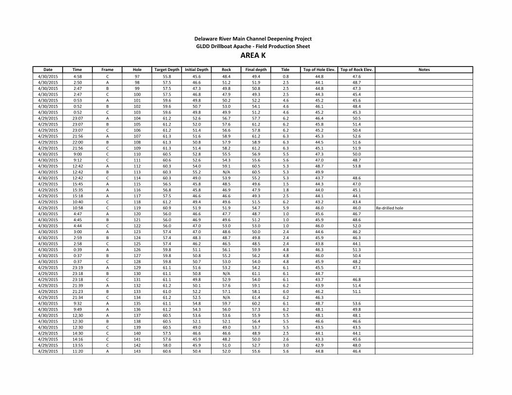
Date Time Frame Hole Target Depth Initial Depth Rock Final depth Tide Top of Hole Elev. Top of Rock Elev. Notes
Delaware River Main Channel Deepening Project
AREA KGLDD Drillboat Apache - Field Production Sheet
4/30/2015 4:58 C 97 55.8 45.6 48.4 49.4 0.8 44.8 47.6
4/30/2015 2:50 A 98 57.5 46.6 51.2 51.9 2.5 44.1 48.7
4/30/2015 2:47 B 99 57.5 47.3 49.8 50.8 2.5 44.8 47.3
4/30/2015 2:47 C 100 57.5 46.8 47.9 49.3 2.5 44.3 45.4
4/30/2015 0:53 A 101 59.6 49.8 50.2 52.2 4.6 45.2 45.6
4/30/2015 0:52 B 102 59.6 50.7 53.0 54.1 4.6 46.1 48.4
4/30/2015 0:52 C 103 59.6 49.8 49.9 51.2 4.6 45.2 45.3
4/29/2015 23:07 A 104 61.2 52.6 56.7 57.7 6.2 46.4 50.5
4/29/2015 23:07 B 105 61.2 52.0 57.6 61.2 6.2 45.8 51.4
4/29/2015 23:07 C 106 61.2 51.4 56.6 57.8 6.2 45.2 50.4
4/29/2015 21:56 A 107 61.3 51.6 58.9 61.2 6.3 45.3 52.6
4/29/2015 22:00 B 108 61.3 50.8 57.9 58.9 6.3 44.5 51.6
4/29/2015 21:56 C 109 61.3 51.4 58.2 61.2 6.3 45.1 51.9
4/30/2015 9:00 C 110 60.5 52.8 55.5 56.9 5.5 47.3 50.0
4/30/2015 9:12 C 111 60.6 52.6 54.3 55.6 5.6 47.0 48.7
4/30/2015 12:42 A 112 60.3 54.0 59.1 60.5 5.3 48.7 53.8
4/30/2015 12:42 B 113 60.3 55.2 N/A 60.5 5.3 49.9
4/30/2015 12:42 C 114 60.3 49.0 53.9 55.2 5.3 43.7 48.6
4/29/2015 15:45 A 115 56.5 45.8 48.5 49.6 1.5 44.3 47.0
4/29/2015 15:35 A 116 56.8 45.8 46.9 47.9 1.8 44.0 45.1
4/29/2015 15:18 A 117 57.5 46.6 46.6 49.3 2.5 44.1 44.1
4/29/2015 10:40 C 118 61.2 49.4 49.6 51.5 6.2 43.2 43.4
4/29/2015 10:58 C 119 60.9 51.9 51.9 54.7 5.9 46.0 46.0 Re-drilled hole
4/30/2015 4:47 A 120 56.0 46.6 47.7 48.7 1.0 45.6 46.7
4/30/2015 4:45 B 121 56.0 46.9 49.6 51.2 1.0 45.9 48.6
4/30/2015 4:44 C 122 56.0 47.0 53.0 53.0 1.0 46.0 52.0
4/30/2015 3:00 A 123 57.4 47.0 48.6 50.0 2.4 44.6 46.2
4/30/2015 2:59 B 124 57.4 48.3 48.7 49.8 2.4 45.9 46.3
4/30/2015 2:58 C 125 57.4 46.2 46.5 48.5 2.4 43.8 44.1
4/30/2015 0:39 A 126 59.8 51.1 56.1 59.9 4.8 46.3 51.3
4/30/2015 0:37 B 127 59.8 50.8 55.2 56.2 4.8 46.0 50.4
4/30/2015 0:37 C 128 59.8 50.7 53.0 54.0 4.8 45.9 48.2
4/29/2015 23:19 A 129 61.1 51.6 53.2 54.2 6.1 45.5 47.1
4/29/2015 23:18 B 130 61.1 50.8 N/A 61.1 6.1 44.7
4/29/2015 23:18 C 131 61.1 49.8 52.9 54.0 6.1 43.7 46.8
4/29/2015 21:39 A 132 61.2 50.1 57.6 59.1 6.2 43.9 51.4
4/29/2015 21:23 B 133 61.0 52.2 57.1 58.1 6.0 46.2 51.1
4/29/2015 21:34 C 134 61.2 52.5 N/A 61.4 6.2 46.3
4/30/2015 9:32 A 135 61.1 54.8 59.7 60.2 6.1 48.7 53.6
4/30/2015 9:49 A 136 61.2 54.3 56.0 57.3 6.2 48.1 49.8
4/30/2015 12;30 A 137 60.5 53.6 53.6 55.9 5.5 48.1 48.1
4/30/2015 12:30 B 138 60.5 52.1 52.1 56.4 5.5 46.6 46.6
4/30/2015 12:30 C 139 60.5 49.0 49.0 53.7 5.5 43.5 43.5
4/29/2015 14:30 C 140 57.5 46.6 46.6 48.9 2.5 44.1 44.1
4/29/2015 14:16 C 141 57.6 45.9 48.2 50.0 2.6 43.3 45.6
4/29/2015 13:55 C 142 58.0 45.9 51.0 52.7 3.0 42.9 48.0
4/29/2015 11:20 A 143 60.6 50.4 52.0 55.6 5.6 44.8 46.4

Date Time Frame Hole Target Depth Initial Depth Rock Final depth Tide Top of Hole Elev. Top of Rock Elev. Notes
Delaware River Main Channel Deepening Project
AREA KGLDD Drillboat Apache - Field Production Sheet
4/29/2015 11:35 A 144 60.5 50.8 51.0 55.3 5.5 45.3 45.5
4/30/2015 4:34 A 145 56.1 45.7 47.5 48.7 1.1 44.6 46.4
4/30/2015 4:34 B 146 56.0 45.7 46.2 47.0 1.0 44.7 45.2
4/30/2015 4:33 C 147 56.1 46.5 49.5 50.7 1.1 45.4 48.4
4/30/2015 3:12 A 148 57.3 47.3 50.6 51.6 2.3 45.0 48.3
4/30/2015 3:11 B 149 57.3 48.4 52.9 54.0 2.3 46.1 50.6
4/30/2015 3:10 C 150 57.3 48.5 54.2 55.1 2.3 46.2 51.9
4/30/2015 0:25 A 151 60.1 51.1 54.2 55.9 5.1 46.0 49.1
4/30/2015 0:25 B 152 60.1 53.0 56.0 57.5 5.1 47.9 50.9
4/30/2015 0:24 C 153 60.1 50.4 53.3 54.7 5.1 45.3 48.2
4/30/2015 9:32 B 155 61.1 54.9 59.4 60.2 6.1 48.8 53.3
4/30/2015 9:49 B 156 61.2 54.3 60.5 61.1 6.2 48.1 54.3
4/30/2015 12;17 A 157 60.8 52.8 57.0 60.9 5.8 47.0 51.2
4/30/2015 12:17 B 158 60.8 52.1 55.5 56.2 5.8 46.3 49.7
4/30/2015 12:17 C 159 60.8 49.8 52.3 53.8 5.8 44.0 46.5
4/29/2015 14:30 B 160 57.5 47.4 56.0 2.5 44.9 -2.5
4/29/2015 14:16 B 161 57.6 47.6 47.6 50.0 2.6 45.0 45.0
4/29/2015 13:55 B 162 58.0 47.7 47.7 50.0 3.0 44.7 44.7
4/29/2015 11:18 B 163 60.6 50.0 51.0 54.8 5.6 44.4 45.4
4/29/2015 11:35 B 164 60.5 50.0 50.0 51.8 5.5 44.5 44.5
4/30/2015 4:23 A 165 56.2 47.8 51.2 51.9 1.2 46.6 50.0
4/30/2015 4:23 B 166 56.2 47.5 51.4 52.4 1.2 46.3 50.2
4/30/2015 4:24 C 167 56.2 47.6 55.4 56.5 1.2 46.4 54.2
4/30/2014 3:21 A 168 57.2 47.4 50.8 51.9 2.2 45.2 48.6
4/30/2014 3:20 B 169 57.2 47.9 54.8 55.8 2.2 45.7 52.6
4/30/2014 3:20 C 170 57.2 48.4 N/A 57.2 2.2 46.2
4/30/2015 0:03 A 171 60.5 50.9 N/A 60.6 5.5 45.4
4/30/2015 0:03 B 172 60.5 51.0 N/A 60.5 5.5 45.5
4/30/2015 0:02 C 173 60.5 51.3 N/A 60.5 5.5 45.8
4/30/2015 9:32 C 175 61.1 54.7 59.4 60.9 6.1 48.6 53.3
4/30/2015 9:49 C 176 61.2 53.4 55.4 58.6 6.2 47.2 49.2
4/30/2015 12:04 A 177 60.9 51.8 55.7 56.7 5.9 45.9 49.8
4/30/2015 12:04 B 178 61.0 51.7 53.7 55.3 6.0 45.7 47.7
4/30/2015 12:04 C 179 60.9 49.8 51.9 53.6 5.9 43.9 46.0
4/29/2015 14:30 A 180 57.5 46.5 57.0 58.9 2.5 44.0 54.5
4/29/2015 14:16 A 181 57.6 46.3 49.0 51.2 2.6 43.7 46.4
4/29/2015 13:55 A 182 57.9 47.2 53.8 56.4 2.9 44.3 50.9
4/29/2015 11:20 C 183 60.6 49.1 56.8 58.9 5.6 43.5 51.2
4/29/2015 11:36 C 184 60.5 47.8 50.6 52.0 5.5 42.3 45.1
4/30/2015 4:11 A 185 56.3 47.9 N/A 56.5 1.3 46.6
4/30/2015 4:10 B 186 56.3 47.2 52.3 53.3 1.3 45.9 51.0
4/30/2015 4:10 C 187 56.3 47.9 N/A 56.5 1.3 46.6
4/30/2015 3:31 A 188 56.9 47.5 N/A 57.5 1.9 45.6
4/30/2015 3:30 B 189 56.9 47.6 N/A 57.1 1.9 45.7
4/30/2015 3:30 C 190 56.9 47.4 N/A 57.4 1.9 45.5
4/29/2015 23:50 A 191 60.6 50.6 N/A 60.9 5.6 45.0
4/29/2015 23:51 B 192 60.6 51.4 N/A 60.8 5.6 45.8

Date Time Frame Hole Target Depth Initial Depth Rock Final depth Tide Top of Hole Elev. Top of Rock Elev. Notes
Delaware River Main Channel Deepening Project
AREA KGLDD Drillboat Apache - Field Production Sheet
4/29/2015 23:50 C 193 60.6 51.8 N/A 60.8 5.6 46.2
4/30/2015 10:09 A 195 61.4 54.5 55.0 56.6 6.4 48.1 48.6
4/30/2015 10:23 A 196 61.5 54.0 56.0 57.3 6.5 47.5 49.5
4/30/2015 10:35 A 197 61.5 53.2 53.5 54.6 6.5 46.7 47.0
4/30/2015 11:50 A 198 61.1 52.1 53.6 54.7 6.1 46.0 47.5
4/30/2015 11:50 B 199 61.1 52.1 52.1 56.6 6.1 46.0 46.0
4/30/2015 11:50 C 200 61.1 52.1 55.0 56.3 6.1 46.0 48.9
4/29/2015 13:24 C 201 58.4 50.3 N/A 58.9 3.4 46.9
4/29/2015 13:12 C 202 58.6 49.4 51.3 52.7 3.6 45.8 47.7
4/29/2015 12:59 C 203 59.0 49.9 50.5 52.7 4.0 45.9 46.5
4/29/2015 12:40 C 204 59.2 49.5 58.0 59.1 4.2 45.3 53.8
4/29/2015 11:53 A 205 60.1 49.8 N/A 60.7 5.1 44.7
4/29/2015 12:08 A 206 59.9 49.5 N/A 60.4 4.9 44.6
4/30/2015 3:57 A 207 56.7 47.9 N/A 56.9 1.7 46.2
4/30/2015 3:54 B 208 56.7 48.4 N/A 56.8 1.7 46.7
4/30/2015 3:54 C 209 56.7 48.3 N/A 56.9 1.7 46.6
4/30/2015 10:09 B 211 61.4 56.4 58.5 59.2 6.4 50.0 52.1
4/30/2015 10:23 B 212 61.5 56.4 60.8 61.4 6.5 49.9 54.3
4/30/2015 10:35 B 213 61.5 60.0 N/A 61.7 6.5 53.5
4/30/2015 11:39 A 214 61.2 53.4 59.5 61.5 6.2 47.2 53.3
4/30/2015 11:39 B 215 61.4 54.7 N/A 61.8 6.4 48.3
4/30/2015 11:39 C 216 61.4 55.6 N/A 61.4 6.4 49.2
4/29/2015 13:24 B 217 58.4 51.4 N/A 58.8 3.4 48.0
4/29/2015 13:12 B 218 58.6 53.1 N/A 59.1 3.6 49.5
4/29/2015 12:59 B 219 59.0 51.5 N/A 59.3 4.0 47.5
4/29/2015 12:40 B 220 59.2 55.8 N/A 59.8 4.2 51.6
4/29/2015 11:53 B 221 60.1 53.6 N/A 60.8 5.1 48.5
4/29/2015 12:08 B 222 59.9 51.3 N/A 60.2 4.9 46.4
4/30/2015 10:09 C 223 61.4 54.8 N/A 61.7 6.4 48.4
4/30/2015 10:23 C 224 61.5 53.8 N/A 61.4 6.5 47.3
4/30/2015 10:35 C 225 61.5 54.7 N/A 61.5 6.5 48.2
4/30/2015 11:05 A 226 61.5 57.2 N/A 61.6 6.5 50.7
4/30/2015 11:05 B 227 61.5 59.7 N/A 61.6 6.5 53.2
4/30/2015 11:05 C 228 61.5 53.2 N/A 61.7 6.5 46.7
4/29/2015 13:24 A 229 58.4 52.2 57.0 57.8 3.4 48.8 53.6
4/29/2015 13:12 A 230 58.6 48.6 N/A 59.1 3.6 45.0
4/29/2015 12:59 A 231 59.0 48.7 N/A 59.4 4.0 44.7
4/29/2015 12:40 A 232 59.2 48.2 N/A 59.7 4.2 44.0
4/29/2015 11:53 C 233 60.1 52.6 58.3 59.8 5.1 47.5 53.2
4/29/2015 12:08 C 234 59.9 52.5 N/A 60.3 4.9 47.6
4/30/2015 15:23 A 1000 57.6 50.2 52.5 54.1 2.6 47.6 49.9
4/30/2015 15:23 B 1001 57.8 51.6 56.0 58.2 2.8 48.8 53.2
4/30/2015 15:23 C 1002 57.6 47.2 49.0 51.2 2.6 44.6 46.4
4/30/2015 15:05 A 1003 57.9 46.4 46.4 48.0 2.9 43.5 43.5
4/30/2015 15:05 B 1004 58.1 47.0 47.0 48.6 3.1 43.9 43.9
4/30/2015 15:05 C 1005 57.9 46.3 46.3 48.5 2.9 43.4 43.4
4/30/2015 14:30 A 1006 58.5 45.0 45.0 48.1 3.5 41.5 41.5
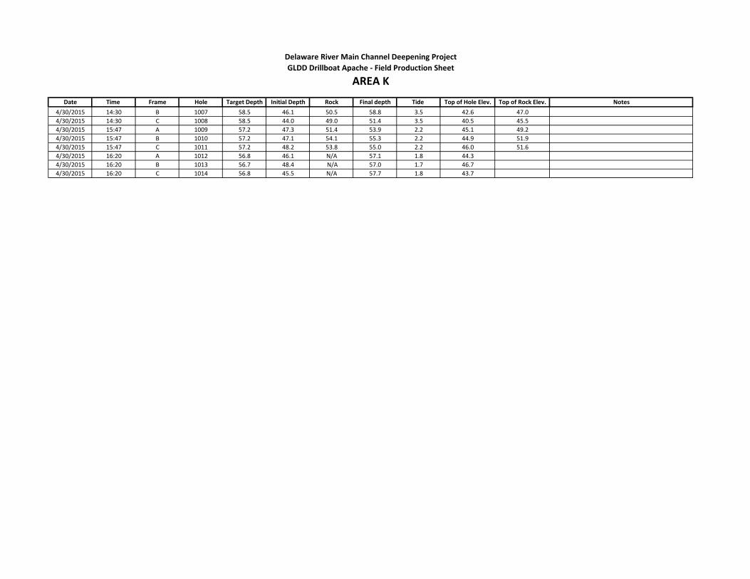
Date Time Frame Hole Target Depth Initial Depth Rock Final depth Tide Top of Hole Elev. Top of Rock Elev. Notes
Delaware River Main Channel Deepening Project
AREA KGLDD Drillboat Apache - Field Production Sheet
4/30/2015 14:30 B 1007 58.5 46.1 50.5 58.8 3.5 42.6 47.0
4/30/2015 14:30 C 1008 58.5 44.0 49.0 51.4 3.5 40.5 45.5
4/30/2015 15:47 A 1009 57.2 47.3 51.4 53.9 2.2 45.1 49.2
4/30/2015 15:47 B 1010 57.2 47.1 54.1 55.3 2.2 44.9 51.9
4/30/2015 15:47 C 1011 57.2 48.2 53.8 55.0 2.2 46.0 51.6
4/30/2015 16:20 A 1012 56.8 46.1 N/A 57.1 1.8 44.3
4/30/2015 16:20 B 1013 56.7 48.4 N/A 57.0 1.7 46.7
4/30/2015 16:20 C 1014 56.8 45.5 N/A 57.7 1.8 43.7
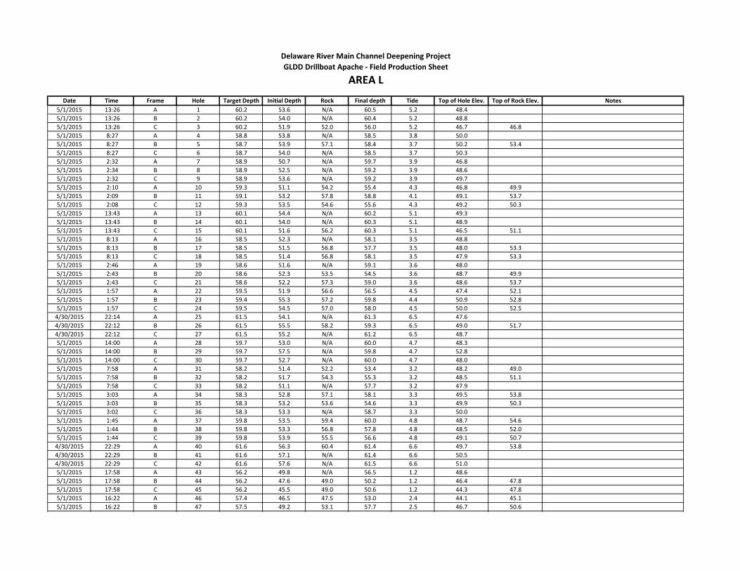
Date Time Frame Hole Target Depth Initial Depth Rock Final depth Tide Top of Hole Elev. Top of Rock Elev. Notes
5/1/2015 13:26 A 1 60.2 53.6 N/A 60.5 5.2 48.4
5/1/2015 13:26 B 2 60.2 54.0 N/A 60.4 5.2 48.8
5/1/2015 13:26 C 3 60.2 51.9 52.0 56.0 5.2 46.7 46.8
5/1/2015 8:27 A 4 58.8 53.8 N/A 58.5 3.8 50.0
5/1/2015 8:27 B 5 58.7 53.9 57.1 58.4 3.7 50.2 53.4
5/1/2015 8:27 C 6 58.7 54.0 N/A 58.5 3.7 50.3
5/1/2015 2:32 A 7 58.9 50.7 N/A 59.7 3.9 46.8
5/1/2015 2:34 B 8 58.9 52.5 N/A 59.2 3.9 48.6
5/1/2015 2:32 C 9 58.9 53.6 N/A 59.2 3.9 49.7
5/1/2015 2:10 A 10 59.3 51.1 54.2 55.4 4.3 46.8 49.9
5/1/2015 2:09 B 11 59.1 53.2 57.8 58.8 4.1 49.1 53.7
5/1/2015 2:08 C 12 59.3 53.5 54.6 55.6 4.3 49.2 50.3
5/1/2015 13:43 A 13 60.1 54.4 N/A 60.2 5.1 49.3
5/1/2015 13:43 B 14 60.1 54.0 N/A 60.3 5.1 48.9
5/1/2015 13:43 C 15 60.1 51.6 56.2 60.3 5.1 46.5 51.1
5/1/2015 8:13 A 16 58.5 52.3 N/A 58.1 3.5 48.8
5/1/2015 8:13 B 17 58.5 51.5 56.8 57.7 3.5 48.0 53.3
5/1/2015 8:13 C 18 58.5 51.4 56.8 58.1 3.5 47.9 53.3
5/1/2015 2:46 A 19 58.6 51.6 N/A 59.1 3.6 48.0
5/1/2015 2:43 B 20 58.6 52.3 53.5 54.5 3.6 48.7 49.9
5/1/2015 2:43 C 21 58.6 52.2 57.3 59.0 3.6 48.6 53.7
5/1/2015 1:57 A 22 59.5 51.9 56.6 56.5 4.5 47.4 52.1
5/1/2015 1:57 B 23 59.4 55.3 57.2 59.8 4.4 50.9 52.8
5/1/2015 1:57 C 24 59.5 54.5 57.0 58.0 4.5 50.0 52.5
4/30/2015 22:14 A 25 61.5 54.1 N/A 61.3 6.5 47.6
4/30/2015 22:12 B 26 61.5 55.5 58.2 59.3 6.5 49.0 51.7
4/30/2015 22:12 C 27 61.5 55.2 N/A 61.2 6.5 48.7
5/1/2015 14:00 A 28 59.7 53.0 N/A 60.0 4.7 48.3
5/1/2015 14:00 B 29 59.7 57.5 N/A 59.8 4.7 52.8
5/1/2015 14:00 C 30 59.7 52.7 N/A 60.0 4.7 48.0
5/1/2015 7:58 A 31 58.2 51.4 52.2 53.4 3.2 48.2 49.0
5/1/2015 7:58 B 32 58.2 51.7 54.3 55.3 3.2 48.5 51.1
5/1/2015 7:58 C 33 58.2 51.1 N/A 57.7 3.2 47.9
5/1/2015 3:03 A 34 58.3 52.8 57.1 58.1 3.3 49.5 53.8
5/1/2015 3:03 B 35 58.3 53.2 53.6 54.6 3.3 49.9 50.3
5/1/2015 3:02 C 36 58.3 53.3 N/A 58.7 3.3 50.0
5/1/2015 1:45 A 37 59.8 53.5 59.4 60.0 4.8 48.7 54.6
5/1/2015 1:44 B 38 59.8 53.3 56.8 57.8 4.8 48.5 52.0
5/1/2015 1:44 C 39 59.8 53.9 55.5 56.6 4.8 49.1 50.7
4/30/2015 22:29 A 40 61.6 56.3 60.4 61.4 6.6 49.7 53.8
4/30/2015 22:29 B 41 61.6 57.1 N/A 61.4 6.6 50.5
4/30/2015 22:29 C 42 61.6 57.6 N/A 61.5 6.6 51.0
5/1/2015 17:58 A 43 56.2 49.8 N/A 56.5 1.2 48.6
5/1/2015 17:58 B 44 56.2 47.6 49.0 50.2 1.2 46.4 47.8
5/1/2015 17:58 C 45 56.2 45.5 49.0 50.6 1.2 44.3 47.8
5/1/2015 16:22 A 46 57.4 46.5 47.5 53.0 2.4 44.1 45.1
5/1/2015 16:22 B 47 57.5 49.2 53.1 57.7 2.5 46.7 50.6
Delaware River Main Channel Deepening Project
AREA LGLDD Drillboat Apache - Field Production Sheet
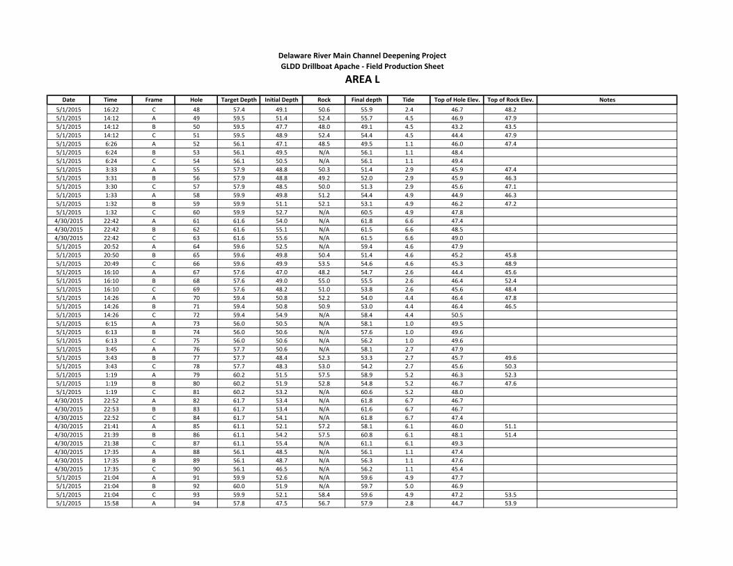
Date Time Frame Hole Target Depth Initial Depth Rock Final depth Tide Top of Hole Elev. Top of Rock Elev. Notes
Delaware River Main Channel Deepening Project
AREA LGLDD Drillboat Apache - Field Production Sheet
5/1/2015 16:22 C 48 57.4 49.1 50.6 55.9 2.4 46.7 48.2
5/1/2015 14:12 A 49 59.5 51.4 52.4 55.7 4.5 46.9 47.9
5/1/2015 14:12 B 50 59.5 47.7 48.0 49.1 4.5 43.2 43.5
5/1/2015 14:12 C 51 59.5 48.9 52.4 54.4 4.5 44.4 47.9
5/1/2015 6:26 A 52 56.1 47.1 48.5 49.5 1.1 46.0 47.4
5/1/2015 6:24 B 53 56.1 49.5 N/A 56.1 1.1 48.4
5/1/2015 6:24 C 54 56.1 50.5 N/A 56.1 1.1 49.4
5/1/2015 3:33 A 55 57.9 48.8 50.3 51.4 2.9 45.9 47.4
5/1/2015 3:31 B 56 57.9 48.8 49.2 52.0 2.9 45.9 46.3
5/1/2015 3:30 C 57 57.9 48.5 50.0 51.3 2.9 45.6 47.1
5/1/2015 1:33 A 58 59.9 49.8 51.2 54.4 4.9 44.9 46.3
5/1/2015 1:32 B 59 59.9 51.1 52.1 53.1 4.9 46.2 47.2
5/1/2015 1:32 C 60 59.9 52.7 N/A 60.5 4.9 47.8
4/30/2015 22:42 A 61 61.6 54.0 N/A 61.8 6.6 47.4
4/30/2015 22:42 B 62 61.6 55.1 N/A 61.5 6.6 48.5
4/30/2015 22:42 C 63 61.6 55.6 N/A 61.5 6.6 49.0
5/1/2015 20:52 A 64 59.6 52.5 N/A 59.4 4.6 47.9
5/1/2015 20:50 B 65 59.6 49.8 50.4 51.4 4.6 45.2 45.8
5/1/2015 20:49 C 66 59.6 49.9 53.5 54.6 4.6 45.3 48.9
5/1/2015 16:10 A 67 57.6 47.0 48.2 54.7 2.6 44.4 45.6
5/1/2015 16:10 B 68 57.6 49.0 55.0 55.5 2.6 46.4 52.4
5/1/2015 16:10 C 69 57.6 48.2 51.0 53.8 2.6 45.6 48.4
5/1/2015 14:26 A 70 59.4 50.8 52.2 54.0 4.4 46.4 47.8
5/1/2015 14:26 B 71 59.4 50.8 50.9 53.0 4.4 46.4 46.5
5/1/2015 14:26 C 72 59.4 54.9 N/A 58.4 4.4 50.5
5/1/2015 6:15 A 73 56.0 50.5 N/A 58.1 1.0 49.5
5/1/2015 6:13 B 74 56.0 50.6 N/A 57.6 1.0 49.6
5/1/2015 6:13 C 75 56.0 50.6 N/A 56.2 1.0 49.6
5/1/2015 3:45 A 76 57.7 50.6 N/A 58.1 2.7 47.9
5/1/2015 3:43 B 77 57.7 48.4 52.3 53.3 2.7 45.7 49.6
5/1/2015 3:43 C 78 57.7 48.3 53.0 54.2 2.7 45.6 50.3
5/1/2015 1:19 A 79 60.2 51.5 57.5 58.9 5.2 46.3 52.3
5/1/2015 1:19 B 80 60.2 51.9 52.8 54.8 5.2 46.7 47.6
5/1/2015 1:19 C 81 60.2 53.2 N/A 60.6 5.2 48.0
4/30/2015 22:52 A 82 61.7 53.4 N/A 61.8 6.7 46.7
4/30/2015 22:53 B 83 61.7 53.4 N/A 61.6 6.7 46.7
4/30/2015 22:52 C 84 61.7 54.1 N/A 61.8 6.7 47.4
4/30/2015 21:41 A 85 61.1 52.1 57.2 58.1 6.1 46.0 51.1
4/30/2015 21:39 B 86 61.1 54.2 57.5 60.8 6.1 48.1 51.4
4/30/2015 21:38 C 87 61.1 55.4 N/A 61.1 6.1 49.3
4/30/2015 17:35 A 88 56.1 48.5 N/A 56.1 1.1 47.4
4/30/2015 17:35 B 89 56.1 48.7 N/A 56.3 1.1 47.6
4/30/2015 17:35 C 90 56.1 46.5 N/A 56.2 1.1 45.4
5/1/2015 21:04 A 91 59.9 52.6 N/A 59.6 4.9 47.7
5/1/2015 21:04 B 92 60.0 51.9 N/A 59.7 5.0 46.9
5/1/2015 21:04 C 93 59.9 52.1 58.4 59.6 4.9 47.2 53.5
5/1/2015 15:58 A 94 57.8 47.5 56.7 57.9 2.8 44.7 53.9
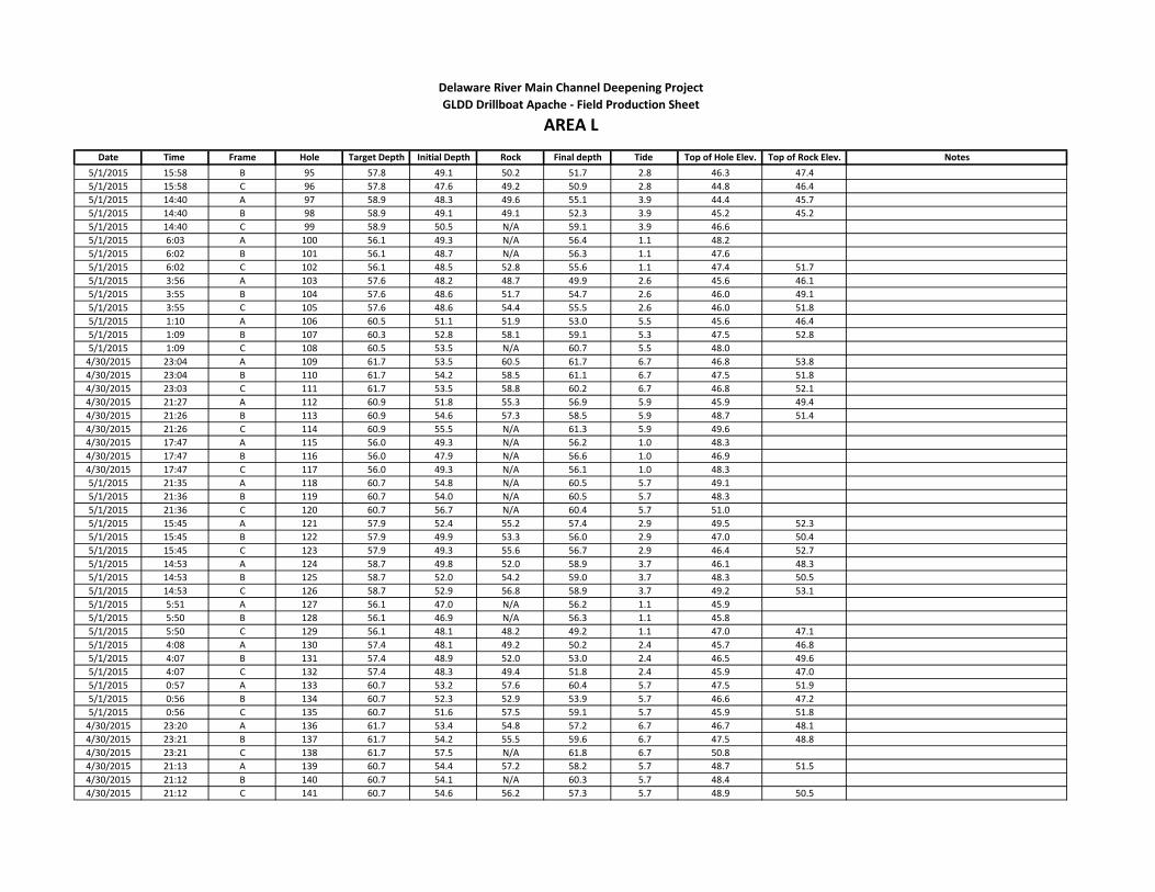
Date Time Frame Hole Target Depth Initial Depth Rock Final depth Tide Top of Hole Elev. Top of Rock Elev. Notes
Delaware River Main Channel Deepening Project
AREA LGLDD Drillboat Apache - Field Production Sheet
5/1/2015 15:58 B 95 57.8 49.1 50.2 51.7 2.8 46.3 47.4
5/1/2015 15:58 C 96 57.8 47.6 49.2 50.9 2.8 44.8 46.4
5/1/2015 14:40 A 97 58.9 48.3 49.6 55.1 3.9 44.4 45.7
5/1/2015 14:40 B 98 58.9 49.1 49.1 52.3 3.9 45.2 45.2
5/1/2015 14:40 C 99 58.9 50.5 N/A 59.1 3.9 46.6
5/1/2015 6:03 A 100 56.1 49.3 N/A 56.4 1.1 48.2
5/1/2015 6:02 B 101 56.1 48.7 N/A 56.3 1.1 47.6
5/1/2015 6:02 C 102 56.1 48.5 52.8 55.6 1.1 47.4 51.7
5/1/2015 3:56 A 103 57.6 48.2 48.7 49.9 2.6 45.6 46.1
5/1/2015 3:55 B 104 57.6 48.6 51.7 54.7 2.6 46.0 49.1
5/1/2015 3:55 C 105 57.6 48.6 54.4 55.5 2.6 46.0 51.8
5/1/2015 1:10 A 106 60.5 51.1 51.9 53.0 5.5 45.6 46.4
5/1/2015 1:09 B 107 60.3 52.8 58.1 59.1 5.3 47.5 52.8
5/1/2015 1:09 C 108 60.5 53.5 N/A 60.7 5.5 48.0
4/30/2015 23:04 A 109 61.7 53.5 60.5 61.7 6.7 46.8 53.8
4/30/2015 23:04 B 110 61.7 54.2 58.5 61.1 6.7 47.5 51.8
4/30/2015 23:03 C 111 61.7 53.5 58.8 60.2 6.7 46.8 52.1
4/30/2015 21:27 A 112 60.9 51.8 55.3 56.9 5.9 45.9 49.4
4/30/2015 21:26 B 113 60.9 54.6 57.3 58.5 5.9 48.7 51.4
4/30/2015 21:26 C 114 60.9 55.5 N/A 61.3 5.9 49.6
4/30/2015 17:47 A 115 56.0 49.3 N/A 56.2 1.0 48.3
4/30/2015 17:47 B 116 56.0 47.9 N/A 56.6 1.0 46.9
4/30/2015 17:47 C 117 56.0 49.3 N/A 56.1 1.0 48.3
5/1/2015 21:35 A 118 60.7 54.8 N/A 60.5 5.7 49.1
5/1/2015 21:36 B 119 60.7 54.0 N/A 60.5 5.7 48.3
5/1/2015 21:36 C 120 60.7 56.7 N/A 60.4 5.7 51.0
5/1/2015 15:45 A 121 57.9 52.4 55.2 57.4 2.9 49.5 52.3
5/1/2015 15:45 B 122 57.9 49.9 53.3 56.0 2.9 47.0 50.4
5/1/2015 15:45 C 123 57.9 49.3 55.6 56.7 2.9 46.4 52.7
5/1/2015 14:53 A 124 58.7 49.8 52.0 58.9 3.7 46.1 48.3
5/1/2015 14:53 B 125 58.7 52.0 54.2 59.0 3.7 48.3 50.5
5/1/2015 14:53 C 126 58.7 52.9 56.8 58.9 3.7 49.2 53.1
5/1/2015 5:51 A 127 56.1 47.0 N/A 56.2 1.1 45.9
5/1/2015 5:50 B 128 56.1 46.9 N/A 56.3 1.1 45.8
5/1/2015 5:50 C 129 56.1 48.1 48.2 49.2 1.1 47.0 47.1
5/1/2015 4:08 A 130 57.4 48.1 49.2 50.2 2.4 45.7 46.8
5/1/2015 4:07 B 131 57.4 48.9 52.0 53.0 2.4 46.5 49.6
5/1/2015 4:07 C 132 57.4 48.3 49.4 51.8 2.4 45.9 47.0
5/1/2015 0:57 A 133 60.7 53.2 57.6 60.4 5.7 47.5 51.9
5/1/2015 0:56 B 134 60.7 52.3 52.9 53.9 5.7 46.6 47.2
5/1/2015 0:56 C 135 60.7 51.6 57.5 59.1 5.7 45.9 51.8
4/30/2015 23:20 A 136 61.7 53.4 54.8 57.2 6.7 46.7 48.1
4/30/2015 23:21 B 137 61.7 54.2 55.5 59.6 6.7 47.5 48.8
4/30/2015 23:21 C 138 61.7 57.5 N/A 61.8 6.7 50.8
4/30/2015 21:13 A 139 60.7 54.4 57.2 58.2 5.7 48.7 51.5
4/30/2015 21:12 B 140 60.7 54.1 N/A 60.3 5.7 48.4
4/30/2015 21:12 C 141 60.7 54.6 56.2 57.3 5.7 48.9 50.5
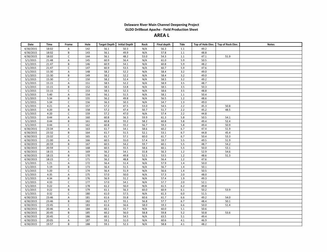
Date Time Frame Hole Target Depth Initial Depth Rock Final depth Tide Top of Hole Elev. Top of Rock Elev. Notes
Delaware River Main Channel Deepening Project
AREA LGLDD Drillboat Apache - Field Production Sheet
4/30/2015 18:02 A 142 56.1 50.3 N/A 56.3 1.1 49.2
4/30/2015 18:02 B 143 56.1 49.9 N/A 57.8 1.1 48.8
4/30/2015 18:02 C 144 56.1 48.2 53.0 54.3 1.1 47.1 51.9
5/1/2015 21:48 A 145 60.9 56.4 N/A 61.0 5.9 50.5
5/1/2015 21:47 B 146 60.9 54.1 N/A 60.8 5.9 48.2
5/1/2015 21:47 C 147 60.9 53.5 N/A 60.7 5.9 47.6
5/1/2015 15:30 A 148 58.2 52.2 N/A 58.4 3.2 49.0
5/1/2015 15:30 B 149 58.2 52.2 N/A 58.4 3.2 49.0
5/1/2015 15:30 C 150 58.2 52.4 N/A 58.5 3.2 49.2
5/1/2015 15:15 A 151 58.5 52.2 N/A 58.9 3.5 48.7
5/1/2015 15:15 B 152 58.5 53.8 N/A 58.5 3.5 50.3
5/1/2015 15:15 C 153 58.5 52.3 N/A 58.6 3.5 48.8
5/1/2015 5:40 A 154 56.1 51.5 N/A 58.1 1.1 50.4
5/1/2015 5:34 B 155 56.2 49.8 N/A 56.5 1.2 48.6
5/1/2015 5:34 C 156 56.3 50.3 N/A 54.7 1.3 49.0
5/1/2015 4:21 A 157 57.2 47.5 53.0 54.5 2.2 45.3 50.8
5/1/2015 4:20 B 158 57.2 47.4 50.7 51.7 2.2 45.2 48.5
5/1/2015 4:20 C 159 57.2 47.0 N/A 57.4 2.2 44.8
5/1/2015 0:44 A 160 60.8 56.3 59.9 61.3 5.8 50.5 54.1
5/1/2015 0:44 B 161 60.8 55.2 58.2 60.8 5.8 49.4 52.4
5/1/2015 0:44 C 162 60.8 55.2 56.7 59.3 5.8 49.4 50.9
4/30/2015 23:34 A 163 61.7 54.1 58.6 60.2 6.7 47.4 51.9
4/30/2015 23:32 B 164 61.7 51.5 52.1 53.1 6.7 44.8 45.4
4/30/2015 23:32 C 165 61.7 57.1 60.0 61.7 6.7 50.4 53.3
4/30/2015 21:00 A 166 60.5 55.0 57.4 59.7 5.5 49.5 51.9
4/30/2015 20:59 B 167 60.5 54.2 59.7 60.1 5.5 48.7 54.2
4/30/2015 20:59 C 168 60.5 55.5 58.6 60.1 5.5 50.0 53.1
4/30/2015 18:15 A 169 56.2 54.1 55.8 56.3 1.2 52.9 54.6
4/30/2015 18:15 B 170 56.2 49.8 52.5 53.5 1.2 48.6 51.3
4/30/2015 18:15 C 171 56.2 48.8 N/A 56.4 1.2 47.6
5/1/2015 5:21 A 172 56.4 51.4 N/A 57.9 1.4 50.0
5/1/2015 5:19 B 173 56.4 51.5 N/A 56.7 1.4 50.1
5/1/2015 5:20 C 174 56.4 51.9 N/A 56.6 1.4 50.5
5/1/2015 4:35 A 175 57.0 50.0 N/A 57.3 2.0 48.0
5/1/2015 4:34 B 176 56.9 51.2 N/A 57.4 1.9 49.3
5/1/2015 4:33 C 177 57.0 54.1 N/A 57.7 2.0 52.1
5/1/2015 0:22 A 178 61.2 56.0 N/A 61.5 6.2 49.8
5/1/2015 0:22 B 179 61.1 56.3 60.0 60.9 6.1 50.2 53.9
5/1/2015 0:32 C 180 61.0 57.5 N/A 61.3 6.0 51.5
4/30/2015 23:46 A 181 61.6 55.8 60.6 61.7 6.6 49.2 54.0
4/30/2015 23:46 B 182 61.7 55.1 56.8 57.7 6.7 48.4 50.1
4/30/2015 23:45 C 183 61.6 56.6 58.0 59.3 6.6 50.0 51.4
4/30/2015 20:46 A 184 60.1 55.7 N/A 60.0 5.1 50.6
4/30/2015 20:45 B 185 60.2 56.0 58.8 59.8 5.2 50.8 53.6
4/30/2015 20:45 C 186 60.1 54.5 N/A 63.5 5.1 49.4
4/30/2015 20:05 A 187 59.1 51.0 N/A 60.6 4.1 46.9
4/30/2015 19:57 B 188 59.1 52.3 N/A 58.8 4.1 48.2

Date Time Frame Hole Target Depth Initial Depth Rock Final depth Tide Top of Hole Elev. Top of Rock Elev. Notes
Delaware River Main Channel Deepening Project
AREA LGLDD Drillboat Apache - Field Production Sheet
4/30/2015 19:59 C 189 59.1 50.9 56.0 57.8 4.1 46.8 51.9
5/1/2015 4:46 A 190 56.9 51.0 N/A 57.4 1.9 49.1
5/1/2015 4:44 B 191 56.9 54.3 N/A 57.2 1.9 52.4
5/1/2015 4:44 C 192 56.9 51.8 N/A 57.3 1.9 49.9
5/1/2015 0:13 A 193 61.3 54.4 N/A 61.7 6.3 48.1
5/1/2015 0:11 B 194 61.5 55.0 58.0 59.3 6.5 48.5 51.5
5/1/2015 0:10 C 195 61.3 52.2 52.6 53.8 6.3 45.9 46.3
5/1/2015 13:00 A 1000 60.7 53.2 57.8 59.1 5.7 47.5 52.1
5/1/2015 13:00 B 1001 60.9 55.9 N/A 60.6 5.9 50.0
5/1/2015 13:00 C 1002 60.7 54.2 57.1 59.2 5.7 48.5 51.4 Driller didn't put L1002
5/1/2015 17:38 A 1003 56.5 48.6 N/A 56.1 1.5 47.1
5/1/2015 17:38 B 1004 56.5 44.7 N/A 56.5 1.5 43.2
5/1/2015 17:38 C 1005 56.5 46.3 51.9 53.2 1.5 44.8 50.4
5/1/2015 17:00 A 1006 57.0 50.7 53.6 54.9 2.0 48.7 51.6
5/1/2015 17:00 B 1007 56.9 51.5 55.2 56.9 1.9 49.6 53.3
5/1/2015 17:00 C 1008 56.9 49.9 N/A 57.0 1.9 48.0
5/1/2015 18:15 A 1009 56.1 49.4 N/A 56.2 1.1 48.3
5/1/2015 18:15 B 1010 56.1 51.2 54.0 56.2 1.1 50.1 52.9
5/1/2015 18:15 C 1011 56.1 48.4 49.2 51.3 1.1 47.3 48.1
5/1/2015 20:14 A 1012 58.7 55.7 N/A 58.4 3.7 52.0
5/1/2015 20:12 B 1013 58.7 53.0 N/A 58.4 3.7 49.3
5/1/2015 20:25 C 1014 58.9 52.0 57.2 58.8 3.9 53.3 54.9

Date Time Frame Hole Target Depth Initial Depth Rock Final depth Tide Top of Hole Elev. Top of Rock Elev. Notes
5/2/2015 3:52 A 1 58.6 48.6 56.9 58.2 3.6 45.0 53.3
5/2/2015 3:51 B 2 58.6 48.4 52.3 53.3 3.6 44.8 48.7
5/2/2015 3:52 C 3 58.6 48.7 55.2 56.0 3.6 45.1 51.6
5/2/2015 3:25 A 4 59.3 50.4 54.0 56.0 4.3 46.1 49.7
5/2/2015 3:25 B 5 59.0 52.1 54.7 55.7 4.0 48.1 50.7
5/2/2015 3:25 C 6 59.0 47.3 47.7 48.7 4.0 43.3 43.7
5/2/2015 0:01 A 7 62.1 50.0 52.3 53.6 7.1 42.9 45.2
5/2/2015 0:01 B 8 62.1 52.6 53.3 56.4 7.1 45.5 46.2
5/2/2015 0:01 C 9 62.1 50.7 53.6 54.8 7.1 43.6 46.5
5/1/2015 23:31 A 10 62.0 51.4 55.1 56.3 7.0 44.4 48.1
5/1/2015 23:31 B 11 62.0 51.5 60.6 61.6 7.0 44.5 53.6
5/1/2015 23:31 C 12 62.0 49.6 49.7 50.7 7.0 42.6 42.7
5/2/2015 4:09 A 13 58.5 53.7 57.3 58.3 3.5 50.2 53.8
5/2/2015 4:07 B 14 58.5 55.7 57.1 58.5 3.5 52.2 53.6
5/2/2015 4:07 C 15 58.5 56.3 N/A 58.5 3.5 52.8
5/2/2015 3:13 A 16 59.4 54.1 55.2 56.3 4.4 49.7 50.8
5/2/2015 3:13 B 17 59.4 54.2 N/A 59.6 4.4 49.8
5/2/2015 3:13 C 18 59.4 53.2 57.3 58.5 4.4 48.8 52.9
5/2/2015 0:18 A 19 62.1 55.8 N/A 62.1 7.1 48.7
5/2/2015 0:17 B 20 62.0 57.2 57.6 58.6 7.0 50.2 50.6
5/2/2015 0:17 C 21 62.0 57.2 N/A 62.1 7.0 50.2
5/1/2015 22:19 A 22 62.0 57.0 N/A 61.9 7.0 50.0
5/1/2015 22:19 B 23 62.0 59.9 N/A 61.9 7.0 52.9
5/1/2015 22:18 C 24 62.0 57.6 N/A 61.9 7.0 50.6
5/2/2015 4:28 A 25 58.1 53.9 N/A 58.4 3.1 50.8
5/2/2015 4:25 B 26 58.1 56.5 57.5 58.3 3.1 53.4 54.4
5/2/2015 4:26 C 27 58.1 53.3 53.9 56.8 3.1 50.2 50.8
5/2/2015 3:01 A 28 59.6 53.1 53.2 54.5 4.6 48.5 48.6
5/2/2015 3:00 B 29 59.5 53.4 N/A 59.9 4.5 48.9
5/2/2015 3:00 C 30 59.5 53.5 54.0 55.0 4.5 49.0 49.5
5/2/2015 0:30 A 31 62.0 57.1 59.6 61.5 7.0 50.1 52.6
5/2/2015 0:30 B 32 61.9 60.2 N/A 62.0 6.9 53.3
5/2/2015 0:30 C 33 61.9 56.9 60.9 62.0 6.9 50.0 54.0
5/1/2015 23:07 A 34 61.8 56.8 61.4 61.7 6.8 50.0 54.6
5/1/2015 23:07 B 35 61.9 57.7 59.1 61.8 6.9 50.8 52.2
5/1/2015 23:07 C 36 61.9 55.1 59.0 60.8 6.9 48.2 52.1
5/2/2015 4:44 A 37 58.0 54.7 56.3 58.0 3.0 51.7 53.3
5/2/2015 4:43 B 38 57.9 53.1 54.3 55.5 2.9 50.2 51.4
5/2/2015 4:43 C 39 57.9 52.6 53.0 54.0 2.9 49.7 50.1
5/2/2015 2:50 A 40 59.8 53.0 54.3 55.3 4.8 48.2 49.5
5/2/2015 2:50 B 41 59.7 54.8 N/A 60.0 4.7 50.1
5/2/2015 2:49 C 42 59.7 55.3 57.2 58.2 4.7 50.6 52.5
5/2/2015 0:41 A 43 61.9 54.9 56.1 57.1 6.9 48.0 49.2
5/2/2015 0:41 B 44 61.8 56.3 61.6 62.0 6.8 49.5 54.8
5/2/2015 0:41 C 45 61.8 56.0 57.1 59.3 6.8 49.2 50.3
5/1/2015 22:56 A 46 61.8 56.5 61.2 61.7 6.8 49.7 54.4
5/1/2015 22:56 B 47 61.8 59.9 N/A 61.7 6.8 53.1
Delaware River Main Channel Deepening Project
AREA MGLDD Drillboat Apache - Field Production Sheet

Date Time Frame Hole Target Depth Initial Depth Rock Final depth Tide Top of Hole Elev. Top of Rock Elev. Notes
Delaware River Main Channel Deepening Project
AREA MGLDD Drillboat Apache - Field Production Sheet
5/1/2015 22:56 C 48 61.8 57.4 59.4 60.5 6.8 50.6 52.6
5/2/2015 4:56 A 49 57.8 53.5 56.8 57.9 2.8 50.7 54.0
5/2/2015 4:55 B 50 57.6 53.9 N/A 57.9 2.6 51.3
5/2/2015 4:55 C 51 57.6 52.2 52.8 53.9 2.6 49.6 50.2
5/2/2015 2:40 A 52 60.2 53.8 N/A 60.5 5.2 48.6
5/2/2015 2:38 B 53 60.1 54.9 58.0 59.0 5.1 49.8 52.9
5/2/2015 2:37 C 54 60.1 58.1 N/A 60.4 5.1 53.0
5/2/2015 0:52 A 55 61.8 55.0 56.2 57.3 6.8 48.2 49.4
5/2/2015 0:52 B 56 61.7 56.8 60.3 61.4 6.7 50.1 53.6
5/2/2015 0:51 C 57 61.7 56.1 57.0 60.0 6.7 49.4 50.3
5/1/2015 22:45 A 58 61.6 58.7 N/A 61.6 6.6 52.1
5/1/2015 22:45 B 59 61.6 58.9 N/A 61.7 6.6 52.3
5/1/2015 22:44 C 60 61.6 56.9 58.5 61.7 6.6 50.3 51.9
5/2/2015 5:10 A 61 57.5 53.1 56.3 57.5 2.5 50.6 53.8
5/2/2015 5:10 B 62 57.4 53.9 N/A 57.5 2.4 51.5
5/2/2015 5:09 C 63 57.4 51.3 52.4 57.6 2.4 48.9 50.0
5/2/2015 2:27 A 64 60.3 54.2 N/A 61.1 5.3 48.9
5/2/2015 2:25 B 65 60.3 54.4 N/A 60.6 5.3 49.1
5/2/2015 2:25 C 66 60.3 54.2 57.1 58.8 5.3 48.9 51.8
5/2/2015 1:03 A 67 61.7 55.6 60.9 61.7 6.7 48.9 54.2
5/2/2015 1:02 B 68 61.7 56.6 58.4 59.3 6.7 49.9 51.7
5/2/2015 1:02 C 69 61.7 56.7 N/A 61.8 6.7 50.0
5/1/2015 22:30 A 70 61.5 57.3 N/A 61.7 6.5 50.8
5/1/2015 22:30 B 71 61.5 60.1 N/A 61.4 6.5 53.6
5/1/2015 22:30 C 72 61.5 57.0 57.7 61.4 6.5 50.5 51.2
5/2/2015 5:23 A 73 57.4 52.8 N/A 57.4 2.4 50.4
5/2/2015 5:23 B 74 57.3 52.6 N/A 57.4 2.3 50.3
5/2/2015 5:22 C 75 57.3 50.8 52.1 53.4 2.3 48.5 49.8
5/2/2015 2:15 A 76 60.4 54.1 60.3 60.8 5.4 48.7 54.9
5/2/2015 2:14 B 77 60.4 54.9 58.8 60.1 5.4 49.5 53.4
5/2/2015 2:14 C 78 60.4 55.5 58.3 59.3 5.4 50.1 52.9
5/2/2015 1:13 A 79 61.6 57.7 61.1 61.6 6.6 51.1 54.5
5/2/2015 1:12 B 80 61.4 58.6 N/A 61.6 6.4 52.2
5/2/2015 1:12 C 81 61.4 55.3 N/A 61.9 6.4 48.9
5/1/2015 22:17 A 82 61.4 54.8 56.9 58.4 6.4 48.4 50.5
5/1/2015 22:15 B 83 61.4 56.8 N/A 61.2 6.4 50.4
5/1/2015 22:15 C 84 61.3 56.3 N/A 61.3 6.3 50.0
5/2/2015 5:41 A 85 57.3 54.5 N/A 57.4 2.3 52.2
5/2/2015 5:41 B 86 56.9 54.8 N/A 57.5 1.9 52.9
5/2/2015 5:44 C 87 56.9 53.9 N/A 57.1 1.9 52.0
5/2/2015 2:04 A 88 60.8 53.3 53.6 54.4 5.8 47.5 47.8
5/2/2015 2:03 B 89 60.6 55.0 58.8 60.0 5.6 49.4 53.2
5/2/2015 2:03 C 90 60.7 53.3 53.6 54.6 5.7 47.6 47.9
5/2/2015 1:25 A 91 61.4 54.8 60.0 61.4 6.4 48.4 53.6
5/2/2015 1:23 B 92 61.3 54.9 59.3 60.3 6.3 48.6 53.0
5/2/2015 1:23 C 93 61.3 54.4 56.5 57.7 6.3 48.1 50.2

Date Time Frame Hole Target Depth Initial Depth Rock Final depth Tide Top of Hole Elev. Top of Rock Elev. Notes
Delaware River Main Channel Deepening Project
AREA MGLDD Drillboat Apache - Field Production Sheet
5/2/2015 6:21 A 94 56.9 N/A 56.9 1.9 -1.9 material very soft? Sensors did not stop drill rods
5/2/2015 6:21 B 95 56.5 N/A 56.9 1.5 -1.5 material very soft? Sensors did not stop drill rods
5/2/2015 6:21 C 96 56.5 N/A 57.2 1.5 -1.5 material very soft? Sensors did not stop drill rods
5/2/2015 1:52 A 97 61.0 55.9 N/A 61.2 6.0 49.9
5/2/2015 1:52 B 98 60.8 56.8 57.1 58.3 5.8 51.0 51.3
5/2/2015 1:51 C 99 61.0 56.7 56.8 57.8 6.0 50.7 50.8
5/2/2015 1:35 A 100 61.2 56.5 57.0 57.9 6.2 50.3 50.8
5/2/2015 1:35 B 101 61.1 58.1 60.2 61.2 6.1 52.0 54.1
5/2/2015 1:35 C 102 61.1 60.0 60.3 61.3 6.1 53.9 54.2

Date Time Frame Hole Target Depth Initial Depth Rock Final depth Tide Top of Hole Elev. Top of Rock Elev. Notes
5/1/2015 9:45 A 3 60.7 50.6 56.9 58.4 5.7 44.9 51.2
5/1/2015 10:05 A 4 60.9 51.0 56.1 58.8 5.9 45.1 50.2
5/1/2015 10:20 A 5 61.1 51.1 59.8 60.6 6.1 45.0 53.7
5/1/2015 10:39 A 6 61.2 49.8 55.5 56.6 6.2 43.6 49.3
5/1/2015 10:55 A 7 61.3 50.2 54.2 55.1 6.3 43.9 47.9
5/1/2015 11:10 A 8 61.4 52.4 N/A 61.4 6.4 46.0
5/1/2015 9:45 B 11 60.7 51.5 55.5 56.5 5.7 45.8 49.8
5/1/2015 10:05 B 12 60.9 51.1 55.0 56.1 5.9 45.2 49.1
5/1/2015 10:20 B 13 61.1 51.6 57.5 60.6 6.1 45.5 51.4
5/1/2015 10:39 B 14 61.2 54.5 N/A 61.2 6.2 48.3
5/1/2015 10:55 B 15 61.3 56.5 N/A 61.3 6.3 50.2
5/1/2015 11:10 B 16 61.4 61.0 N/A 61.5 6.4 54.6
5/1/2015 9:45 C 19 60.7 50.0 53.8 54.7 5.7 44.3 48.1
5/1/2015 10:05 C 20 60.9 52.8 53.1 54.8 5.9 46.9 47.2
5/1/2015 10:20 C 21 61.1 56.3 59.0 60.6 6.1 50.2 52.9
5/1/2015 10:39 C 22 61.2 61.7 N/A 61.7 6.2 55.5
5/1/2015 10:55 C 23 61.3 55.2 N/A 61.4 6.3 48.9
5/1/2015 11:10 C 24 61.4 62.8 N/A 62.8 6.4 56.4
5/1/2015 11:58 A 1000 61.2 55.2 56.7 57.8 6.2 49.0 50.5
5/1/2015 11:58 B 1001 61.2 58.0 N/A 61.3 6.2 51.8
5/1/2015 11:58 C 1002 61.2 61.3 N/A 61.3 6.2 55.1
Delaware River Main Channel Deepening Project
AREA NGLDD Drillboat Apache - Field Production Sheet

Date Time Frame Hole Target Depth Initial Depth Rock Final depth Tide Top of Hole Elev. Top of Rock Elev. Notes
5/2/2015 8:58 C 1 58.7 50.7 N/A 59.1 3.7 47.0
5/2/2015 9:24 C 2 59.2 50.3 N/A 59.3 4.2 46.1
5/2/2015 9:38 C 3 59.6 50.0 N/A 60.0 4.6 45.4
5/2/2015 10:03 C 4 60.0 54.3 N/A 59.9 5.0 49.3
5/2/2015 10:17 A 6 60.4 46.0 52.2 53.2 5.4 49.1 51.1
5/2/2015 10:30 A 7 60.6 52.2 N/A 60.4 5.6 46.6
5/2/2015 10:57 A 8 61.0 49.5 N/A 60.8 6.0 43.5
5/2/2015 11:12 A 9 61.1 52.3 N/A 60.9 6.1 46.2
5/2/2015 8:58 B 10 58.8 58.6 N/A 58.7 3.8 54.8
5/2/2015 9:24 B 11 59.2 N/A N/A 59.3 4.2
5/2/2015 9:37 B 12 59.5 49.9 N/A 59.7 4.5 45.4
5/2/2015 10:03 B 13 60.0 53.3 N/A 59.9 5.0 48.3
5/2/2015 10:17 B 14 60.4 52.3 51.8 54.1 5.4 46.9 46.4
5/2/2015 10:30 B 15 60.6 53.6 58.1 60.0 5.6 48.0 52.5
5/2/2015 10:57 B 16 61.0 55.1 57.1 58.3 6.0 49.1 51.1
5/2/2015 11:11 B 17 61.1 54.5 N/A 61.2 6.1 48.4
5/2/2015 9:04 A 18 58.8 51.4 N/A 58.7 3.8 47.6
5/2/2015 9:24 A 19 59.2 52.5 N/A 59.4 4.2 48.3
5/2/2015 9:38 A 21 59.5 51.6 N/A 59.4 4.5 47.1
5/2/2015 10:04 A 22 60.0 47.2 N/A 59.9 5.0 42.2
5/2/2015 10:17 C 23 60.4 54.5 56.5 58.3 5.4 40.6 46.8
5/2/2015 10:30 C 24 60.6 N/A N/A 60.0 5.6
5/2/2015 11:00 C 25 61.0 55.8 N/A 61.5 6.0 49.8
5/2/2015 11:12 C 26 61.1 53.4 N/A 61.1 6.1 47.3
5/2/2015 11:43 A 1000 61.3 55.3 N/A 60.9 6.3 49.0
5/2/2015 11:43 B 1001 61.3 59.4 N/A 61.3 6.3 53.1
5/2/2015 11:43 C 1002 61.3 54.9 N/A 61.6 6.3 48.6 Hole Reads 1003 should be 1002
Delaware River Main Channel Deepening Project
AREA OGLDD Drillboat Apache - Field Production Sheet

Date Time Frame Hole Target Depth Initial Depth Rock Final depth Tide Top of Hole Elev. Top of Rock Elev. Notes
5/3/2015 5:29 A 4 57.3 40.6 N/A 57.3 2.3 38.3
5/3/2015 5:29 B 5 57.3 40.9 N/A 57.3 2.3 38.6
5/3/2015 5:29 C 6 57.3 43.4 N/A 57.6 2.3 41.1
5/3/2015 4:35 A 7 58.3 41.5 56.4 58.3 3.3 38.2 53.1
5/3/2015 4:35 B 8 58.1 40.6 N/A 58.3 3.1 37.5
5/3/2015 4:35 C 9 58.1 40.2 51.5 52.0 3.1 37.1 48.4
5/2/2015 14:55 A 10 58.9 36.1 44.0 45.4 3.9 32.2 40.1
5/2/2015 14:55 B 11 58.9 36.9 38.0 39.0 3.9 33.0 34.1
5/2/2015 14:55 C 12 58.9 40.6 49.5 51.4 3.9 36.7 45.6
5/2/2015 14:40 A 13 59.1 41.9 46.0 47.5 4.1 37.8 41.9
5/2/2015 14:40 B 14 59.1 42.7 49.8 50.9 4.1 38.6 45.7
5/2/2015 14:40 C 15 59.1 47.6 48.4 49.8 4.1 43.5 44.3
5/3/2015 15:13 A 16 59.0 47.2 50.5 52.0 4.0 43.2 46.5
5/3/2015 15:13 B 17 59.0 47.6 55.0 4.0 43.6 51.0
5/3/2015 15:13 C 18 59.0 46.8 50.0 4.0 42.8 46.0
5/3/2015 5:50 A 19 57.1 45.1 N/A 57.4 2.1 43.0
5/3/2015 5:50 B 20 57.0 46.0 N/A 58.0 2.0 44.0
5/3/2015 5:50 C 21 57.0 44.6 46.1 47.1 2.0 42.6 44.1
5/3/2015 4:17 A 22 59.1 46.3 53.6 54.6 4.1 42.2 49.5
5/3/2015 4:17 B 23 58.4 46.0 53.8 54.8 3.4 42.6 50.4
5/3/2015 4:17 C 24 58.4 46.4 53.2 53.3 3.4 43.0 49.8
5/2/2015 15:16 A 25 58.6 49.2 51.3 53.0 3.6 45.6 47.7
5/2/2015 15:16 B 26 58.6 47.5 51.0 52.5 3.6 43.9 47.4
5/2/2015 15:16 C 27 58.6 48.4 49.4 51.2 3.6 44.8 45.8
5/2/2015 14:24 A 28 59.5 48.1 48.8 50.7 4.5 43.6 44.3
5/2/2015 14:24 B 29 59.5 48.1 48.8 50.0 4.5 43.6 44.3
5/2/2015 14:24 C 30 59.5 45.5 55.3 57.0 4.5 41.0 50.8
5/3/2015 23:53 A 31 61.3 49.9 52.9 60.9 6.3 43.6 46.6
5/3/2015 23:53 B 32 61.3 50.5 57.6 58.6 6.3 44.2 51.3
5/3/2015 23:53 C 33 61.3 50.3 58.0 60.9 6.3 44.0 51.7
5/3/2015 22:02 A 34 58.8 47.2 53.8 55.2 3.8 43.4 50.0
5/3/2015 22:02 B 35 58.9 47.5 52.4 58.6 3.9 43.6 48.5
5/3/2015 22:02 C 36 58.9 47.5 56.5 57.8 3.9 43.6 52.6
5/3/2015 15:35 A 37 58.5 46.0 N/A 58.9 3.5 42.5
5/3/2015 15:35 B 38 58.5 46.5 50.0 52.6 3.5 43.0 46.5
5/3/2015 15:35 C 39 58.5 47.2 49.4 51.5 3.5 43.7 45.9
5/3/2015 14:57 A 40 59.1 49.6 55.0 59.5 4.1 45.5 50.9
5/3/2015 14:57 B 41 59.1 48.8 56.0 59.0 4.1 44.7 51.9
5/3/2015 14:57 C 42 59.1 47.4 50.0 52.3 4.1 43.3 45.9
5/3/2015 6:10 A 43 56.9 45.7 N/A 57.2 1.9 43.8
5/3/2015 6:10 B 44 56.8 46.1 55.2 56.2 1.8 44.3 53.4
5/3/2015 6:10 C 45 56.8 44.7 49.5 50.5 1.8 42.9 47.7
5/3/2015 3:33 A 46 59.2 46.7 46.9 47.9 4.2 42.5 42.7
5/3/2015 3:33 B 47 59.1 48.1 55.4 59.3 4.1 44.0 51.3
5/3/2015 3:33 C 48 59.2 48.5 53.3 54.3 4.2 44.3 49.1
5/2/2015 21:36 A 49 60.0 50.6 57.8 60.1 5.0 45.6 52.8
5/2/2015 21:35 B 50 60.2 51.8 57.8 58.8 5.2 46.6
Delaware River Main Channel Deepening Project
AREA PGLDD Drillboat Apache - Field Production Sheet
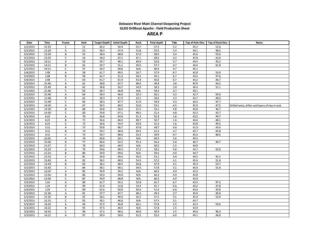
Date Time Frame Hole Target Depth Initial Depth Rock Final depth Tide Top of Hole Elev. Top of Rock Elev. Notes
Delaware River Main Channel Deepening Project
AREA PGLDD Drillboat Apache - Field Production Sheet
5/2/2015 21:35 C 51 60.2 50.4 55.7 57.3 5.2 45.2 52.6
5/2/2015 15:29 A 52 58.3 47.4 51.8 53.5 3.3 44.1 48.5
5/2/2015 15:29 B 53 58.4 48.8 57.0 58.5 3.4 45.4 53.6
5/2/2015 15:29 C 54 58.3 47.1 47.1 48.5 3.3 43.8 43.8
5/2/2015 14:11 A 55 59.7 48.1 49.9 52.6 4.7 43.4 45.2
5/2/2015 14:11 B 56 59.7 51.1 56.5 57.7 4.7 46.4 51.8
5/2/2015 14:11 C 57 59.7 49.8 N/A 60.4 4.7 45.1
5/4/2015 1:08 A 58 61.7 49.5 56.7 57.9 6.7 42.8 50.0
5/4/2015 1:08 B 59 61.7 51.2 54.3 59.1 6.7 44.5 47.6
5/4/2015 1:08 C 60 61.7 51.9 53.4 56.6 6.7 45.2 46.7
5/3/2015 21:46 A 61 58.8 47.7 48.0 49.0 3.8 43.9 44.2
5/3/2015 21:49 B 62 58.8 50.2 54.9 58.3 3.8 46.4 51.1
5/3/2015 21:40 C 63 58.7 46.8 N/A 58.3 3.7 43.1
5/3/2015 15:48 A 64 58.3 46.0 53.3 56.1 3.3 42.7 50.0
5/3/2015 15:48 B 65 58.3 47.0 52.2 58.5 3.3 43.7 48.9
5/3/2015 15:48 C 66 58.3 47.7 51.0 54.9 3.3 44.4 47.7
5/3/2015 14:30 A 67 59.5 49.5 52.0 53.1 4.5 45.0 47.5 Drilled twice, driller said layers of clay in rock
5/3/2015 14:30 B 68 59.8 50.4 51.5 53.1 4.8 45.6 46.7
5/3/2015 14:30 C 69 59.8 47.1 48.5 51.4 4.8 42.3 43.7
5/3/2015 6:23 A 70 56.6 44.9 51.3 52.3 1.6 43.3 49.7
5/3/2015 6:23 B 71 56.6 46.0 49.7 50.7 1.6 44.4 48.1
5/3/2015 6:23 C 72 56.6 44.4 50.9 52.4 1.6 42.8 49.3
5/3/2015 3:12 A 73 59.8 46.7 47.8 48.7 4.8 41.9 43.0
5/3/2015 3:12 B 74 59.7 48.4 50.5 51.5 4.7 43.7 45.8
5/3/2015 3:12 C 75 59.7 48.0 53.3 59.9 4.7 43.3 48.6
5/2/2015 22:01 A 76 60.6 50.1 N/A 60.5 5.6 44.5
5/2/2015 22:00 B 77 60.6 52.3 55.3 56.4 5.6 46.7 49.7
5/2/2015 21:57 C 78 60.5 49.5 N/A 60.5 5.5 44.0
5/2/2015 21:23 A 79 59.6 49.3 57.2 58.2 4.6 44.7 52.6
5/2/2015 21:23 B 80 59.9 49.6 N/A 59.4 4.9 44.7
5/2/2015 21:23 C 81 59.9 49.4 50.0 52.1 4.9 44.5 45.1
5/2/2015 15:43 A 82 58.1 48.5 54.5 57.2 3.1 45.4 51.4
5/2/2015 15:43 B 83 58.1 48.4 56.8 57.9 3.1 45.3 53.7
5/2/2015 15:43 C 84 58.1 48.1 54.5 57.8 3.1 45.0 51.4
5/2/2015 13:56 A 85 59.9 50.2 N/A 60.3 4.9 45.3
5/2/2015 13:56 B 86 59.9 49.8 N/A 60.3 4.9 44.9
5/2/2015 13:56 C 87 59.9 48.8 N/A 60.2 4.9 43.9
5/4/2015 1:24 A 88 61.7 50.2 53.9 61.7 6.7 43.5 47.2
5/4/2015 1:24 B 89 61.6 52.8 54.4 61.7 6.6 46.2 47.8
5/4/2015 1:24 C 90 61.6 50.0 50.4 51.4 6.6 43.4 43.8
5/3/2015 21:26 A 91 57.7 47.7 48.3 49.3 2.7 45.0 45.6
5/3/2015 21:26 B 92 58.1 49.0 56.5 57.5 3.1 45.9 53.4
5/3/2015 21:25 C 93 58.1 46.8 N/A 57.5 3.1 43.7
5/3/2015 16:32 A 94 57.5 45.8 56.1 57.8 2.5 43.3 53.6
5/3/2015 16:32 B 95 57.5 46.4 N/A 57.8 2.5 43.9
5/3/2015 16:32 C 96 57.5 46.5 48.8 49.9 2.5 44.0 46.3
5/3/2015 14:17 A 97 59.9 50.0 51.5 53.5 4.9 45.1 46.6
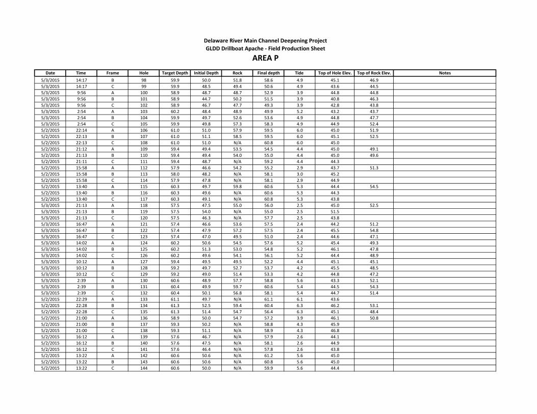
Date Time Frame Hole Target Depth Initial Depth Rock Final depth Tide Top of Hole Elev. Top of Rock Elev. Notes
Delaware River Main Channel Deepening Project
AREA PGLDD Drillboat Apache - Field Production Sheet
5/3/2015 14:17 B 98 59.9 50.0 51.8 58.6 4.9 45.1 46.9
5/3/2015 14:17 C 99 59.9 48.5 49.4 50.6 4.9 43.6 44.5
5/3/2015 9:56 A 100 58.9 48.7 48.7 52.9 3.9 44.8 44.8
5/3/2015 9:56 B 101 58.9 44.7 50.2 51.5 3.9 40.8 46.3
5/3/2015 9:56 C 102 58.9 46.7 47.7 49.3 3.9 42.8 43.8
5/3/2015 2:54 A 103 60.2 48.4 48.9 49.9 5.2 43.2 43.7
5/3/2015 2:54 B 104 59.9 49.7 52.6 53.6 4.9 44.8 47.7
5/3/2015 2:54 C 105 59.9 49.8 57.3 58.3 4.9 44.9 52.4
5/2/2015 22:14 A 106 61.0 51.0 57.9 59.5 6.0 45.0 51.9
5/2/2015 22:13 B 107 61.0 51.1 58.5 59.5 6.0 45.1 52.5
5/2/2015 22:13 C 108 61.0 51.0 N/A 60.8 6.0 45.0
5/2/2015 21:12 A 109 59.4 49.4 53.5 54.5 4.4 45.0 49.1
5/2/2015 21:13 B 110 59.4 49.4 54.0 55.0 4.4 45.0 49.6
5/2/2015 21:11 C 111 59.4 48.7 N/A 59.2 4.4 44.3
5/2/2015 15:58 A 112 57.9 46.6 54.2 55.2 2.9 43.7 51.3
5/2/2015 15:58 B 113 58.0 48.2 N/A 58.1 3.0 45.2
5/2/2015 15:58 C 114 57.9 47.8 N/A 58.1 2.9 44.9
5/2/2015 13:40 A 115 60.3 49.7 59.8 60.6 5.3 44.4 54.5
5/2/2015 13:40 B 116 60.3 49.6 N/A 60.6 5.3 44.3
5/2/2015 13:40 C 117 60.3 49.1 N/A 60.8 5.3 43.8
5/3/2015 21:13 A 118 57.5 47.5 55.0 56.0 2.5 45.0 52.5
5/3/2015 21:13 B 119 57.5 54.0 N/A 55.0 2.5 51.5
5/3/2015 21:13 C 120 57.5 46.3 N/A 57.7 2.5 43.8
5/3/2015 16:47 A 121 57.4 46.6 53.6 57.5 2.4 44.2 51.2
5/3/2015 16:47 B 122 57.4 47.9 57.2 57.5 2.4 45.5 54.8
5/3/2015 16:47 C 123 57.4 47.0 49.5 51.0 2.4 44.6 47.1
5/3/2015 14:02 A 124 60.2 50.6 54.5 57.6 5.2 45.4 49.3
5/3/2015 14:02 B 125 60.2 51.3 53.0 54.8 5.2 46.1 47.8
5/3/2015 14:02 C 126 60.2 49.6 54.1 56.1 5.2 44.4 48.9
5/3/2015 10:12 A 127 59.4 49.5 49.5 52.2 4.4 45.1 45.1
5/3/2015 10:12 B 128 59.2 49.7 52.7 53.7 4.2 45.5 48.5
5/3/2015 10:12 C 129 59.2 49.0 51.4 53.3 4.2 44.8 47.2
5/3/2015 2:39 A 130 60.6 48.9 57.7 58.8 5.6 43.3 52.1
5/3/2015 2:39 B 131 60.4 49.9 59.7 60.6 5.4 44.5 54.3
5/3/2015 2:39 C 132 60.4 50.1 56.8 58.1 5.4 44.7 51.4
5/2/2015 22:29 A 133 61.1 49.7 N/A 61.1 6.1 43.6
5/2/2015 22:28 B 134 61.3 52.5 59.4 60.4 6.3 46.2 53.1
5/2/2015 22:28 C 135 61.3 51.4 54.7 56.4 6.3 45.1 48.4
5/2/2015 21:00 A 136 58.9 50.0 54.7 57.2 3.9 46.1 50.8
5/2/2015 21:00 B 137 59.3 50.2 N/A 58.8 4.3 45.9
5/2/2015 21:00 C 138 59.3 51.1 N/A 58.9 4.3 46.8
5/2/2015 16:12 A 139 57.6 46.7 N/A 57.9 2.6 44.1
5/2/2015 16:12 B 140 57.6 47.5 N/A 58.1 2.6 44.9
5/2/2015 16:12 C 141 57.6 46.4 N/A 57.8 2.6 43.8
5/2/2015 13:22 A 142 60.6 50.6 N/A 61.2 5.6 45.0
5/2/2015 13:22 B 143 60.6 50.6 N/A 60.8 5.6 45.0
5/2/2015 13:22 C 144 60.6 50.0 N/A 59.9 5.6 44.4
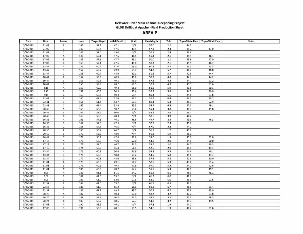
Date Time Frame Hole Target Depth Initial Depth Rock Final depth Tide Top of Hole Elev. Top of Rock Elev. Notes
Delaware River Main Channel Deepening Project
AREA PGLDD Drillboat Apache - Field Production Sheet
5/3/2015 21:02 A 145 57.2 47.1 N/A 57.0 2.2 44.9
5/3/2015 21:02 B 146 57.4 47.6 49.4 57.1 2.4 45.2 47.0
5/3/2015 21:02 C 147 57.4 49.0 N/A 56.9 2.4 46.6
5/3/2015 17:02 A 148 57.1 47.5 48.5 51.4 2.1 45.4 46.4
5/3/2015 17:02 B 149 57.1 47.7 49.1 50.0 2.1 45.6 47.0
5/3/2015 17:02 C 150 57.1 47.6 48.8 50.3 2.1 45.5 46.7
5/3/2015 13:47 A 151 60.7 51.0 59.0 60.8 5.7 45.3 53.3
5/3/2015 13:47 B 152 60.7 49.9 53.7 54.9 5.7 44.2 48.0
5/3/2015 13:47 C 153 60.7 48.6 50.1 51.6 5.7 42.9 44.4
5/3/2015 10:44 A 154 59.8 48.9 49.0 50.3 4.8 44.1 44.2
5/3/2015 10:44 B 155 59.8 49.5 56.0 57.2 4.8 44.7 51.2
5/3/2015 10:44 C 156 59.9 48.2 56.5 57.3 4.9 43.3 51.6
5/3/2015 2:15 A 157 60.9 49.4 56.0 56.9 5.9 43.5 50.1
5/3/2015 2:15 B 158 60.6 50.3 55.6 57.7 5.6 44.7 50.0
5/3/2015 2:15 C 159 60.6 50.4 59.4 60.4 5.6 44.8 53.8
5/2/2015 22:42 A 160 61.4 52.4 56.1 57.2 6.4 46.0 49.7
5/2/2015 22:41 B 161 61.4 54.7 59.3 60.4 6.4 48.3 52.9
5/2/2015 22:41 C 162 61.4 53.4 55.5 56.7 6.4 47.0 49.1
5/2/2015 20:45 A 163 58.8 50.2 53.6 55.4 3.8 46.4 49.8
5/2/2015 20:46 B 164 58.9 50.0 N/A 58.6 3.9 46.1
5/2/2015 20:46 C 165 58.9 48.3 N/A 58.6 3.9 44.4
5/2/2015 16:35 A 166 57.3 46.1 48.6 49.7 2.3 43.8 46.3
5/2/2015 16:35 B 167 57.3 47.5 N/A 57.7 2.3 45.2
5/2/2015 16:35 C 168 57.3 46.5 N/A 57.9 2.3 44.2
5/3/2015 20:50 A 169 56.7 46.7 N/A 56.9 1.7 45.0
5/3/2015 20:50 B 170 56.9 48.0 N/A 56.8 1.9 46.1
5/3/2015 20:49 C 171 56.9 47.6 53.9 55.0 1.9 45.7 52.0
5/3/2015 17:18 A 172 57.0 46.0 52.0 53.6 2.0 44.0 50.0
5/3/2015 17:18 B 173 57.0 46.7 51.3 53.6 2.0 44.7 49.3
5/3/2015 17:18 C 174 57.0 46.4 51.4 52.6 2.0 44.4 49.4
5/3/2015 13:34 A 175 60.8 50.4 51.9 53.2 5.8 44.6 46.1
5/3/2015 13:34 B 176 60.8 50.8 53.2 54.5 5.8 45.0 47.4
5/3/2015 13:34 C 177 60.8 48.6 55.8 57.4 5.8 42.8 50.0
5/3/2015 11:01 A 178 60.3 49.1 56.7 58.5 5.3 43.8 51.4
5/3/2015 11:01 B 179 60.3 49.5 57.9 59.0 5.3 44.2 52.6
5/3/2015 11:01 C 180 60.3 48.2 54.4 55.5 5.3 42.9 49.1
5/3/2015 2:00 A 181 61.1 51.1 54.2 55.5 6.1 45.0 48.1
5/3/2015 2:00 B 182 61.0 53.2 N/A 61.2 6.0 47.2
5/3/2015 2:00 C 183 61.0 52.0 57.5 58.5 6.0 46.0 51.5
5/2/2015 22:57 A 184 61.5 53.2 N/A 61.5 6.5 46.7
5/2/2015 22:58 B 185 61.7 55.2 58.1 59.1 6.7 48.5 51.4
5/2/2015 22:57 C 186 61.7 49.5 49.7 50.9 6.7 42.8 43.0
5/2/2015 20:25 A 187 58.2 50.4 57.0 58.2 3.2 47.2 53.8
5/2/2015 20:24 B 188 58.2 50.2 51.5 53.1 3.2 47.0 48.3
5/2/2015 20:24 C 189 58.2 48.5 52.7 54.0 3.2 45.3 49.5
5/2/2015 17:03 A 190 56.9 46.1 N/A 57.2 1.9 44.2
5/2/2015 17:03 B 191 56.9 48.1 53.5 54.6 1.9 46.2 51.6

Date Time Frame Hole Target Depth Initial Depth Rock Final depth Tide Top of Hole Elev. Top of Rock Elev. Notes
Delaware River Main Channel Deepening Project
AREA PGLDD Drillboat Apache - Field Production Sheet
5/2/2015 17:03 C 192 56.9 47.1 N/A 57.2 1.9 45.2
5/3/2015 20:41 A 193 56.2 46.6 N/A 56.7 1.2 45.4
5/3/2015 20:40 B 194 56.7 47.1 N/A 56.3 1.7 45.4
5/3/2015 20:40 C 195 56.7 46.9 N/A 56.4 1.7 45.2
5/3/2015 17:32 A 196 56.8 45.6 55.3 56.0 1.8 43.8 53.5
5/3/2015 17:32 B 197 56.8 46.1 46.8 47.8 1.8 44.3 45.0
5/3/2015 17:32 C 198 56.8 45.6 55.0 56.1 1.8 43.8 53.2
5/3/2015 13:19 A 199 61.0 51.2 53.4 55.0 6.0 45.2 47.4
5/3/2015 13:19 B 200 61.0 51.5 56.2 57.2 6.0 45.5 50.2
5/3/2015 13:19 C 201 61.0 50.1 55.6 56.7 6.0 44.1 49.6
5/3/2015 11:12 A 202 60.5 50.0 56.7 58.1 5.5 44.5 51.2
5/3/2015 11:12 B 203 60.5 50.1 55.8 56.9 5.5 44.6 50.3
5/3/2015 11:12 C 204 60.5 50.2 53.6 55.1 5.5 44.7 48.1
5/3/2015 1:51 A 205 61.3 54.3 54.2 55.2 6.3 48.0 47.9
5/3/2015 1:47 B 206 61.3 53.5 58.1 59.8 6.3 47.2 51.8
5/3/2015 1:47 C 207 61.3 53.0 59.6 60.6 6.3 46.7 53.3
5/2/2015 23:12 A 208 61.8 54.4 58.5 59.4 6.8 47.6 51.7
5/2/2015 23:11 B 209 61.9 54.1 54.2 55.2 6.9 47.2 47.3
5/2/2015 23:11 C 210 61.9 54.6 54.4 56.9 6.9 47.7 47.5
5/2/2015 20:14 A 211 58.0 47.9 48.0 49.0 3.0 44.9 45.0
5/2/2015 20:14 B 212 58.0 50.1 50.2 51.2 3.0 47.1 47.2
5/2/2015 20:13 C 213 58.0 50.9 N/A 57.7 3.0 47.9
5/2/2015 17:19 A 214 56.7 48.4 N/A 56.9 1.7 46.7
5/2/2015 17:19 B 215 56.7 49.9 N/A 57.0 1.7 48.2
5/2/2015 17:19 C 216 56.7 48.8 N/A 56.9 1.7 47.1
5/3/2015 20:31 A 217 55.8 47.1 N/A 56.6 0.8 46.3
5/3/2015 20:31 B 218 56.0 48.5 N/A 56.7 1.0 47.5
5/3/2015 20:30 C 219 56.0 48.6 N/A 55.9 1.0 47.6
5/3/2015 17:48 A 220 56.6 48.5 52.8 54.9 1.6 46.9 51.2
5/3/2015 17:48 B 221 56.6 48.7 N/A 57.0 1.6 47.1
5/3/2015 17:48 C 222 56.6 48.0 55.8 56.7 1.6 46.4 54.2
5/3/2015 13:06 A 223 61.1 52.8 57.1 58.4 6.1 46.7 51.0
5/3/2015 13:06 B 224 61.1 53.5 59.8 61.2 6.1 47.4 53.7
5/3/2015 13:06 C 225 61.1 52.0 58.5 59.6 6.1 45.9 52.4
5/3/2015 11:28 A 226 60.6 51.7 58.2 59.4 5.6 46.1 52.6
5/3/2015 11:28 B 227 60.6 52.2 N/A 60.6 5.6 46.6
5/3/2015 11:28 C 228 60.6 51.7 58.0 59.1 5.6 46.1 52.4
5/3/2015 3:45 A 229 62.0 54.6 55.9 57.1 7.0 47.6 48.9
5/3/2015 1:15 B 230 61.9 54.9 57.2 58.2 6.9 48.0 50.3
5/3/2015 1:14 C 231 61.9 54.7 55.1 56.1 6.9 47.8 48.2
5/2/2015 23:26 A 232 61.9 56.0 61.1 61.9 6.9 49.1 54.2
5/2/2015 23:26 B 233 61.9 57.5 N/A 61.9 6.9 50.6
5/2/2015 23:25 C 234 61.9 59.1 N/A 62.1 6.9 52.2
5/2/2015 18:21 A 235 56.0 52.0 N/A 56.2 1.0 51.0
5/2/2015 18:21 B 236 56.0 51.7 N/A 56.0 1.0 50.7
5/2/2015 18:21 C 237 56.0 49.0 N/A 56.3 1.0 48.0
5/2/2015 17:34 A 238 56.6 52.8 N/A 57.2 1.6 51.2

Date Time Frame Hole Target Depth Initial Depth Rock Final depth Tide Top of Hole Elev. Top of Rock Elev. Notes
Delaware River Main Channel Deepening Project
AREA PGLDD Drillboat Apache - Field Production Sheet
5/2/2015 17:34 B 239 56.6 55.2 N/A 59.3 1.6 53.6
5/2/2015 17:34 C 240 56.6 51.0 N/A 57.8 1.6 49.4
5/3/2015 20:20 A 241 55.6 52.2 N/A 59.9 0.6 51.6
5/3/2015 20:20 B 242 55.8 52.3 N/A 56.0 0.8 51.5
5/3/2015 20:20 C 243 55.8 51.9 N/A 56.1 0.8 51.1
5/3/2015 18:05 A 244 56.3 53.5 N/A 56.5 1.3 52.2
5/3/2015 18:05 B 245 56.3 50.2 54.3 55.3 1.3 48.9 53.0
5/3/2015 18:05 C 246 56.3 50.7 N/A 56.8 1.3 49.4
5/3/2015 12:50 A 247 61.2 54.5 N/A 61.2 6.2 48.3
5/3/2015 12:50 B 248 61.2 53.6 58.2 59.4 6.2 47.4 52.0
5/3/2015 12:50 C 249 61.2 53.5 56.0 57.3 6.2 47.3 49.8
5/3/2015 11:43 A 250 60.9 52.9 N/A 60.7 5.9 47.0
5/3/2015 11:43 B 251 60.9 54.1 59.1 60.7 5.9 48.2 53.2
5/3/2015 11:43 C 252 60.9 52.0 52.0 53.2 5.9 46.1 46.1
5/3/2015 1:02 A 253 62.1 53.3 54.5 54.5 7.1 46.2 47.4
5/3/2015 1:01 B 254 62.1 56.9 59.0 60.0 7.1 49.8 51.9
5/3/2015 1:01 C 255 62.1 58.1 N/A 62.6 7.1 51.0
5/2/2015 23:38 A 256 62.0 60.7 N/A 63.4 7.0 53.7
5/2/2015 23:38 B 257 62.0 N/A N/A 62.7 7.0
5/2/2015 23:37 C 258 62.0 N/A N/A 62.4 7.0
5/2/2015 18:08 A 259 56.2 N/A N/A 56.6 1.2
5/2/2015 18:08 B 260 56.2 N/A N/A 56.7 1.2
5/2/2015 18:08 C 261 56.2 N/A N/A 56.3 1.2
5/2/2015 17:47 A 262 56.4 N/A N/A 56.8 1.4
5/2/2015 17:47 B 263 56.4 N/A N/A 56.9 1.4
5/2/2015 17:47 C 264 56.4 N/A N/A 57.2 1.4
5/3/2015 12:36 A 265 61.2 54.4 N/A 61.4 6.2 48.2
5/3/2015 12:36 B 266 61.2 55.5 60.2 61.1 6.2 49.3 54.0
5/3/2015 12:36 C 267 61.2 54.0 58.3 59.4 6.2 47.8 52.1
5/3/2015 11:56 A 268 61.0 54.1 58.9 60.2 6.0 48.1 52.9
5/3/2015 11:56 B 269 61.0 55.6 55.9 57.2 6.0 49.6 49.9
5/3/2015 11:56 C 270 61.0 55.1 59.5 60.9 6.0 49.1 53.5
5/3/2015 0:50 A 271 62.2 56.8 N/A 62.3 7.2 49.6
5/3/2015 0:49 B 272 62.1 57.5 N/A 62.2 7.1 50.4
5/3/2015 0:49 C 273 62.1 57.4 N/A 62.2 7.1 50.3
5/2/2015 23:51 A 274 62.1 N/A N/A 62.1 7.1
5/2/2015 23:48 B 275 62.2 N/A N/A 62.4 7.2
5/2/2015 23:53 C 276 62.2 N/A N/A 62.1 7.2
5/3/2015 12:11 A 277 61.0 58.7 N/A 61.1 6.0 52.7
5/3/2015 12:11 B 278 61.0 N/A N/A 61.4 6.0
5/3/2015 12:11 C 279 61.0 58.5 N/A 61.0 6.0 52.5
5/3/2015 0:38 A 280 62.2 59.7 N/A 62.7 7.2 52.5
5/3/2015 0:32 B 281 62.2 61.6 N/A 62.2 7.2 54.4
5/3/2015 0:32 C 282 62.2 57.9 N/A 62.2 7.2 50.7
5/3/2015 9:11 A 1000 57.8 46.6 51.9 57.5 2.8 43.8 49.1
5/3/2015 9:11 B 1001 57.6 46.9 N/A 57.4 2.6 44.3
5/3/2015 9:11 C 1002 57.6 46.7 55.0 55.9 2.6 44.1 52.4
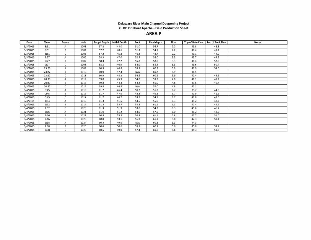
Date Time Frame Hole Target Depth Initial Depth Rock Final depth Tide Top of Hole Elev. Top of Rock Elev. Notes
Delaware River Main Channel Deepening Project
AREA PGLDD Drillboat Apache - Field Production Sheet
5/3/2015 8:51 A 1003 57.2 48.0 51.0 56.7 2.2 45.8 48.8
5/3/2015 8:51 B 1004 57.2 48.6 51.3 54.1 2.2 46.4 49.1
5/3/2015 8:51 C 1005 57.2 45.3 46.2 48.7 2.2 43.1 44.0
5/3/2015 9:27 A 1006 58.3 47.0 52.5 58.0 3.3 43.7 49.2
5/3/2015 9:27 B 1007 58.3 47.7 55.8 58.0 3.3 44.4 52.5
5/3/2015 9:27 C 1008 58.3 46.9 54.0 55.4 3.3 43.6 50.7
5/3/2015 23:23 A 1009 60.9 46.8 59.9 60.7 5.9 40.9 54.0
5/3/2015 23:22 B 1010 60.9 47.4 N/A 60.7 5.9 41.5
5/3/2015 23:22 C 1011 60.9 48.3 54.5 60.6 5.9 42.4 48.6
5/3/2015 20:33 A 1012 59.8 45.9 54.0 59.7 4.8 41.1 49.2
5/3/2015 20:33 B 1013 59.8 44.4 54.2 56.0 4.8 39.6 49.4
5/3/2015 20:32 C 1014 59.8 44.9 N/A 57.0 4.8 40.1
5/4/2015 0:45 A 1015 61.7 46.4 50.7 51.7 6.7 39.7 44.0
5/4/2015 0:45 B 1016 61.7 47.6 48.3 49.3 6.7 40.9 41.6
5/4/2015 0:45 C 1017 61.7 46.7 53.7 54.7 6.7 40.0 47.0
5/4/2105 1:54 A 1018 61.3 51.5 54.5 55.0 6.3 45.2 48.2
5/4/2015 1:52 B 1019 61.3 53.7 55.8 61.5 6.3 47.4 49.5
5/4/2015 1:52 C 1020 61.3 51.9 53.0 54.3 6.3 45.6 46.7
5/4/2015 2:16 A 1021 61.0 51.2 54.0 57.5 6.0 45.2 48.0
5/4/2015 2:16 B 1022 60.8 53.5 56.8 61.1 5.8 47.7 51.0
5/4/2015 2:16 C 1023 60.8 53.1 56.9 61.1 5.8 47.3 51.1
5/4/2015 2:38 A 1024 60.3 49.6 N/A 60.8 5.3 44.3
5/4/2015 2:38 B 1025 60.6 50.6 59.5 60.8 5.6 45.0 53.9
5/4/2015 2:38 C 1026 60.6 49.9 57.4 60.8 5.6 44.3 51.8
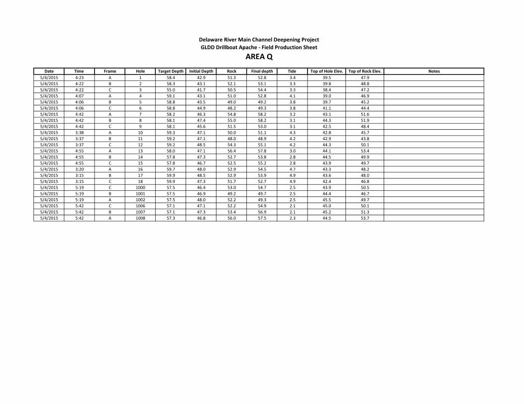
Date Time Frame Hole Target Depth Initial Depth Rock Final depth Tide Top of Hole Elev. Top of Rock Elev. Notes
5/4/2015 4:23 A 1 58.4 42.9 51.3 52.8 3.4 39.5 47.9
5/4/2015 4:22 B 2 58.3 43.1 52.1 53.1 3.3 39.8 48.8
5/4/2015 4:22 C 3 55.0 41.7 50.5 54.4 3.3 38.4 47.2
5/4/2015 4:07 A 4 59.1 43.1 51.0 52.8 4.1 39.0 46.9
5/4/2015 4:06 B 5 58.8 43.5 49.0 49.2 3.8 39.7 45.2
5/4/2015 4:06 C 6 58.8 44.9 48.2 49.3 3.8 41.1 44.4
5/4/2015 4:42 A 7 58.2 46.3 54.8 58.2 3.2 43.1 51.6
5/4/2015 4:42 B 8 58.1 47.4 55.0 58.2 3.1 44.3 51.9
5/4/2015 4:42 C 9 58.1 45.6 51.5 53.0 3.1 42.5 48.4
5/4/2015 3:38 A 10 59.3 47.1 50.0 51.1 4.3 42.8 45.7
5/4/2015 3:37 B 11 59.2 47.1 48.0 48.9 4.2 42.9 43.8
5/4/2015 3:37 C 12 59.2 48.5 54.3 55.1 4.2 44.3 50.1
5/4/2015 4:55 A 13 58.0 47.1 56.4 57.8 3.0 44.1 53.4
5/4/2015 4:55 B 14 57.8 47.3 52.7 53.8 2.8 44.5 49.9
5/4/2015 4:55 C 15 57.8 46.7 52.5 55.2 2.8 43.9 49.7
5/4/2015 3:20 A 16 59.7 48.0 52.9 54.5 4.7 43.3 48.2
5/4/2015 3:15 B 17 59.9 48.5 52.9 53.9 4.9 43.6 48.0
5/4/2015 3:15 C 18 59.9 47.3 51.7 52.7 4.9 42.4 46.8
5/4/2015 5:19 C 1000 57.5 46.4 53.0 54.7 2.5 43.9 50.5
5/4/2015 5:19 B 1001 57.5 46.9 49.2 49.7 2.5 44.4 46.7
5/4/2015 5:19 A 1002 57.5 48.0 52.2 49.3 2.5 45.5 49.7
5/4/2015 5:42 C 1006 57.1 47.1 52.2 54.9 2.1 45.0 50.1
5/4/2015 5:42 B 1007 57.1 47.3 53.4 56.9 2.1 45.2 51.3
5/4/2015 5:42 A 1008 57.3 46.8 56.0 57.5 2.3 44.5 53.7
Delaware River Main Channel Deepening Project
AREA QGLDD Drillboat Apache - Field Production Sheet
Delaware River Main Channel Deepening Project Reach B Rock Probes Investigation
GBA Gahagan and Bryant Associates, Inc. – July 2015
APPENDIX D
Top of Rock XYZ Files

AREA A
Hole Easting Northing
Depth
MLLW (Feet) Hole Easting Northing
Depth MLLW
(Feet)
1 259513.13 371630.43 39.4 51 259945.73 371317.13 46.2
2 259588.10 371632.55 38.1 52 260020.54 371314.11 54.1
3 259663.07 371634.68 35.8 54 259053.55 371271.97 53.8
4 259740.02 371625.81 34.1 55 259128.52 371269.99 54.9
6 259890.38 371616.01 37.9 56 259203.50 371268.01 45.1
7 259960.12 371610.72 41.0 57 259272.68 371259.09 47.5
8 260035.11 371609.57 37.9 58 259347.68 371259.57 45.9
9 259514.03 371560.14 42.8 59 259422.67 371260.06 51.3
10 259588.24 371559.18 41.2 60 259497.83 371255.68 51.0
11 259663.98 371556.17 39.1 61 259572.79 371253.29 55.0
12 259734.83 371547.77 35.9 62 259647.75 371250.89 50.4
13 259809.72 371543.74 42.8 63 259727.33 371253.34 48.1
14 259884.62 371539.71 40.8 64 259802.20 371248.90 48.8
15 259960.58 371534.69 43.9 65 259877.07 371244.47 46.8
16 260036.19 371532.86 39.6 66 259948.23 371237.50 45.0
17 259511.27 371484.36 48.1 67 260022.44 371236.76 55.0
18 259586.26 371483.20 48.8 68 260097.44 371236.02 55.0
19 259661.25 371482.05 46.1 69 259048.89 371191.07 55.0
20 259726.49 371465.19 46.6 70 259123.87 371189.09 55.0
21 259801.49 371464.45 45.6 71 259198.85 371188.11 55.0
22 259876.49 371463.70 45.2 72 259272.00 371195.83 52.6
23 259954.70 371461.99 46.0 73 259346.84 371190.97 48.4
24 260029.68 371460.42 47.2 74 259421.68 371186.11 47
25 259060.16 371419.82 55.0 75 259490.50 371180.19 51.2
26 259135.16 371419.48 55.0 76 259565.50 371181.10 53.6
27 259210.16 371419.15 41.9 77 259640.49 371182.00 51.0
28 259286.47 371420.29 55.0 78 259718.67 371179.45 47.8
29 259361.29 371415.01 55.0 79 259793.48 371174.20 46.9
30 259436.88 371408.72 55.0 80 259868.30 371168.95 46.7
31 259507.69 371407.30 50.3 81 259947.80 371164.47 51.5
32 259582.64 371404.50 50.2 82 260023.54 371162.08 55.0
33 259655.74 371402.04 48.3 83 260098.64 371159.54 55.0
34 259733.04 371400.17 50.4 84 260095.56 371309.92 55.0
35 259807.85 371397.94 48.7 85 260101.80 371390.22 55.0
36 259882.78 371394.74 47.1 86 260104.66 371458.86 46.4
37 259951.81 371388.44 44.3 87 260111.01 371530.92 50.3
38 260026.80 371389.33 46.4 88 260110.10 371608.42 52.3
39 259060.10 371344.89 55.0 1000 259065.42 371566.51 44.1
40 259135.73 371344.70 55.0 1001 259140.27 371566.70 42.3
41 259210.09 371343.39 55.0 1002 259215.42 371565.83 44.4
42 259284.94 371343.63 53.6 1003 259287.80 371560.44 46.5
43 259359.90 371341.25 51.1 1004 259361.23 371560.51 45.5
44 259434.86 371338.86 53.4 1005 259436.23 371560.59 50.1
45 259500.65 371333.49 50.0 1006 259058.54 371491.93 48.0
46 259575.58 371330.27 55.0 1007 259133.52 371493.64 45.6
47 259650.51 371327.06 48.8 1008 259208.50 371495.36 47.7
48 259732.33 371321.50 48.2 1009 259286.23 371489.84 49.9
49 259807.33 371321.17 47.6 1010 259359.58 371487.09 46.0
50 259882.33 371320.83 44.4 1011 259434.53 371484.34 47.3
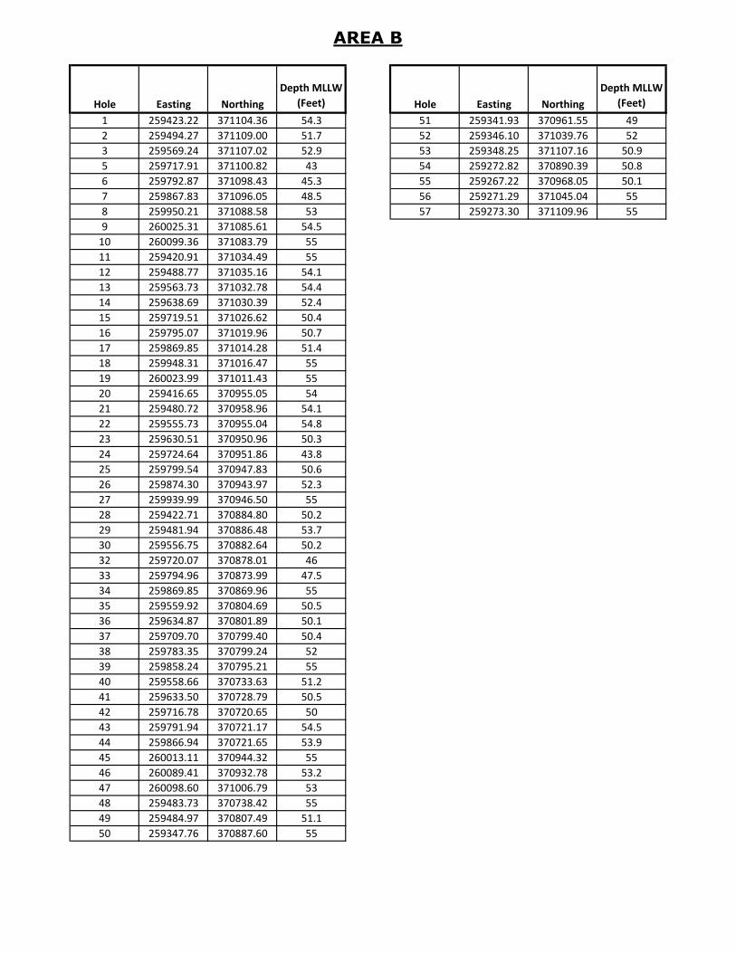
AREA B
Hole Easting Northing
Depth MLLW
(Feet) Hole Easting Northing
Depth MLLW
(Feet)
1 259423.22 371104.36 54.3 51 259341.93 370961.55 49
2 259494.27 371109.00 51.7 52 259346.10 371039.76 52
3 259569.24 371107.02 52.9 53 259348.25 371107.16 50.9
5 259717.91 371100.82 43 54 259272.82 370890.39 50.8
6 259792.87 371098.43 45.3 55 259267.22 370968.05 50.1
7 259867.83 371096.05 48.5 56 259271.29 371045.04 55
8 259950.21 371088.58 53 57 259273.30 371109.96 55
9 260025.31 371085.61 54.5
10 260099.36 371083.79 55
11 259420.91 371034.49 55
12 259488.77 371035.16 54.1
13 259563.73 371032.78 54.4
14 259638.69 371030.39 52.4
15 259719.51 371026.62 50.4
16 259795.07 371019.96 50.7
17 259869.85 371014.28 51.4
18 259948.31 371016.47 55
19 260023.99 371011.43 55
20 259416.65 370955.05 54
21 259480.72 370958.96 54.1
22 259555.73 370955.04 54.8
23 259630.51 370950.96 50.3
24 259724.64 370951.86 43.8
25 259799.54 370947.83 50.6
26 259874.30 370943.97 52.3
27 259939.99 370946.50 55
28 259422.71 370884.80 50.2
29 259481.94 370886.48 53.7
30 259556.75 370882.64 50.2
32 259720.07 370878.01 46
33 259794.96 370873.99 47.5
34 259869.85 370869.96 55
35 259559.92 370804.69 50.5
36 259634.87 370801.89 50.1
37 259709.70 370799.40 50.4
38 259783.35 370799.24 52
39 259858.24 370795.21 55
40 259558.66 370733.63 51.2
41 259633.50 370728.79 50.5
42 259716.78 370720.65 50
43 259791.94 370721.17 54.5
44 259866.94 370721.65 53.9
45 260013.11 370944.32 55
46 260089.41 370932.78 53.2
47 260098.60 371006.79 53
48 259483.73 370738.42 55
49 259484.97 370807.49 51.1
50 259347.76 370887.60 55
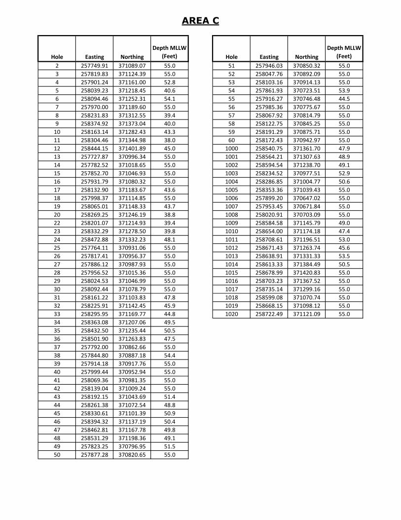
AREA C
Hole Easting Northing
Depth MLLW
(Feet) Hole Easting Northing
Depth MLLW
(Feet)
2 257749.91 371089.07 55.0 51 257946.03 370850.32 55.0
3 257819.83 371124.39 55.0 52 258047.76 370892.09 55.0
4 257901.24 371161.00 52.8 53 258103.16 370914.13 55.0
5 258039.23 371218.45 40.6 54 257861.93 370723.51 53.9
6 258094.46 371252.31 54.1 55 257916.27 370746.48 44.5
7 257970.00 371189.60 55.0 56 257985.36 370775.67 55.0
8 258231.83 371312.55 39.4 57 258067.92 370814.79 55.0
9 258374.92 371373.04 40.0 58 258122.75 370845.25 55.0
10 258163.14 371282.43 43.3 59 258191.29 370875.71 55.0
11 258304.46 371344.98 38.0 60 258172.43 370942.97 55.0
12 258444.15 371401.89 45.0 1000 258540.75 371361.70 47.9
13 257727.87 370996.34 55.0 1001 258564.21 371307.63 48.9
14 257782.52 371018.65 55.0 1002 258594.54 371238.70 49.1
15 257852.70 371046.93 55.0 1003 258234.52 370977.51 52.9
16 257931.79 371080.32 55.0 1004 258286.85 371004.77 50.6
17 258132.90 371183.67 43.6 1005 258353.36 371039.43 55.0
18 257998.37 371114.85 55.0 1006 257899.20 370647.02 55.0
19 258065.01 371148.33 43.7 1007 257953.45 370671.84 55.0
20 258269.25 371246.19 38.8 1008 258020.91 370703.09 55.0
22 258201.07 371214.93 39.4 1009 258584.58 371145.79 49.0
23 258332.29 371278.50 39.8 1010 258654.00 371174.18 47.4
24 258472.88 371332.23 48.1 1011 258708.61 371196.51 53.0
25 257764.11 370931.06 55.0 1012 258671.43 371263.74 45.6
26 257817.41 370956.37 55.0 1013 258638.91 371331.33 53.5
27 257886.12 370987.93 55.0 1014 258613.33 371384.49 50.5
28 257956.52 371015.36 55.0 1015 258678.99 371420.83 55.0
29 258024.53 371046.99 55.0 1016 258703.23 371367.52 55.0
30 258092.44 371078.79 55.0 1017 258735.14 371299.16 55.0
31 258161.22 371103.83 47.8 1018 258599.08 371070.74 55.0
32 258225.91 371142.45 45.9 1019 258668.15 371098.12 55.0
33 258295.95 371169.77 44.8 1020 258722.49 371121.09 55.0
34 258363.08 371207.06 49.5
35 258432.50 371235.44 50.5
36 258501.90 371263.83 47.5
37 257792.00 370862.66 55.0
38 257844.80 370887.18 54.4
39 257914.18 370917.76 55.0
40 257999.44 370952.94 55.0
41 258069.36 370981.35 55.0
42 258139.04 371009.24 55.0
43 258192.15 371043.69 51.4
44 258261.38 371072.54 48.8
45 258330.61 371101.39 50.9
46 258394.32 371137.19 50.4
47 258462.81 371167.78 49.8
48 258531.29 371198.36 49.1
49 257823.25 370796.95 51.5
50 257877.28 370820.65 55.0

AREA D
Hole Easting Northing
Depth MLLW
(Feet) Hole Easting Northing
Depth MLLW
(Feet)
1 255006.51 369886.16 51.6 51 255257.50 369670.74 52.7
2 255074.64 369917.53 55.0 52 255339.41 369719.27 46.6
3 255142.76 369948.91 53.7 53 255392.10 369745.81 50.8
4 255203.63 369986.81 42.0 54 255459.16 369779.54 46.0
5 255271.38 370018.90 37.0 55 255553.18 369812.86 47.6
6 255339.13 370051.15 34.6 56 255607.60 369837.31 47.0
7 255428.06 370090.95 37.5 57 255675.99 369868.10 44.7
8 255482.78 370112.99 37.2 58 255749.66 369905.36 51.0
9 255552.35 370141.02 35.0 59 255803.25 369929.85 55.0
10 255619.98 370180.11 35.3 60 255871.85 369960.38 55.0
11 255673.27 370205.41 35.6 61 255151.45 369541.79 55.0
12 255740.89 370236.63 34.7 62 255219.57 369573.16 55.0
13 255026.43 369819.69 55.0 63 255287.70 369604.53 55.0
14 255049.19 369852.05 55.0 64 255367.41 369649.79 55.0
15 255161.67 369883.83 54.8 65 255421.78 369675.47 55.0
16 255235.39 369922.47 39.8 66 255490.70 369705.81 47.0
17 255303.51 369953.85 39.0 67 255570.97 369747.13 50.0
18 255371.64 369985.22 39.4 68 255625.05 369772.30 44.5
19 255459.28 370020.53 39.9 69 255693.01 369804.02 51.3
20 255513.62 370043.49 41.4 70 255785.26 369840.93 55.0
21 255582.77 370072.68 42.3 71 255839.18 369864.88 55.0
22 255651.27 370108.98 40.6 72 255402.00 369575.07 55.0
23 255711.92 370137.69 41.0 73 255453.62 369603.64 55.0
24 255772.32 370166.46 39.3 74 255519.24 369639.96 49.0
25 255052.68 369748.12 55.0 75 255603.66 369675.23 50.8
26 255120.59 369779.95 55.0 76 255657.13 369700.18 53.0
27 255188.50 369811.79 49.5 77 255725.27 369731.81 55.0
28 255278.43 369857.84 39.6 78 255816.58 369770.80 55.0
29 255333.13 369881.79 40.1 79 255870.49 369794.76 55.0
30 255400.89 369912.15 40.1 80 255443.37 369511.15 55.0
31 255482.20 369954.91 39.3 81 255496.96 369537.31 55.0
32 255537.69 369974.93 38.5 82 255564.34 369570.27 51.0
33 255608.24 370000.39 41.5 83 255653.21 369615.16 55.0
34 255678.62 370042.64 39.0 84 255707.24 369638.84 55.0
35 255732.78 370066.05 40.3 85 255775.93 369668.95 55.0
36 255801.62 370094.82 45.2 86 255851.81 369702.36 55.0
37 255086.95 369680.28 55.0 87 255905.10 369727.66 55.0
38 255154.92 369711.99 53.5 88 255972.85 369759.83 55.0
39 255222.89 369743.70 46.5 89 255939.03 369825.21 55.0
40 255305.38 369786.41 45.4 90 255907.72 369895.34 55.0
41 255360.20 369810.09 45.5 1000 255851.88 370195.84 46.0
42 255428.89 369869.36 47.6 1001 255912.99 370065.70 55.0
43 255524.54 369882.75 47.9 1003 255881.37 370133.72 55.0
44 255578.73 369906.19 47.8 1006 255910.33 370070.55 55.0
45 255647.37 369936.30 46.6 1007 255979.10 370102.64 55.0
46 255715.39 369975.26 47.1 1008 256032.40 370128.10 55.0
47 255769.14 369999.58 48.8
48 255837.47 370030.50 55.0
49 255120.53 369609.59 55.0
50 255189.00 369640.16 55.0
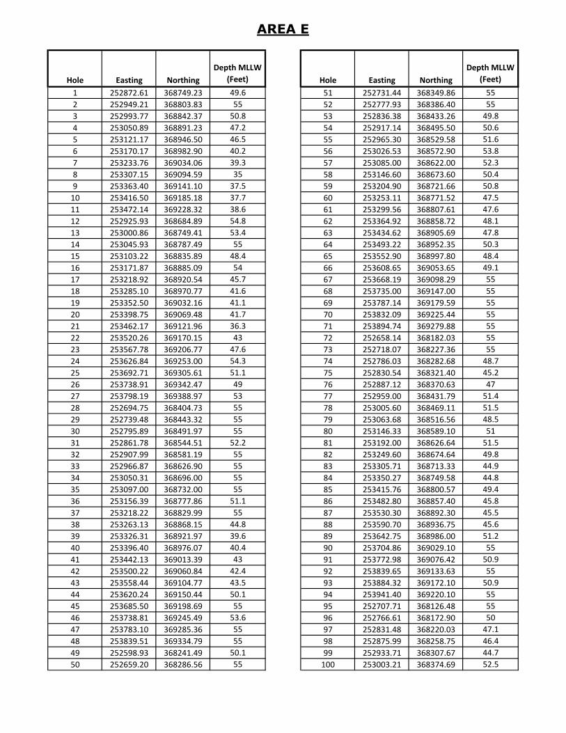
AREA E
Hole Easting Northing
Depth MLLW
(Feet) Hole Easting Northing
Depth MLLW
(Feet)
1 252872.61 368749.23 49.6 51 252731.44 368349.86 55
2 252949.21 368803.83 55 52 252777.93 368386.40 55
3 252993.77 368842.37 50.8 53 252836.38 368433.26 49.8
4 253050.89 368891.23 47.2 54 252917.14 368495.50 50.6
5 253121.17 368946.50 46.5 55 252965.30 368529.58 51.6
6 253170.17 368982.90 40.2 56 253026.53 368572.90 53.8
7 253233.76 369034.06 39.3 57 253085.00 368622.00 52.3
8 253307.15 369094.59 35 58 253146.60 368673.60 50.4
9 253363.40 369141.10 37.5 59 253204.90 368721.66 50.8
10 253416.50 369185.18 37.7 60 253253.11 368771.52 47.5
11 253472.14 369228.32 38.6 61 253299.56 368807.61 47.6
12 252925.93 368684.89 54.8 62 253364.92 368858.72 48.1
13 253000.86 368749.41 53.4 63 253434.62 368905.69 47.8
14 253045.93 368787.49 55 64 253493.22 368952.35 50.3
15 253103.22 368835.89 48.4 65 253552.90 368997.80 48.4
16 253171.87 368885.09 54 66 253608.65 369053.65 49.1
17 253218.92 368920.54 45.7 67 253668.19 369098.29 55
18 253285.10 368970.77 41.6 68 253735.00 369147.00 55
19 253352.50 369032.16 41.1 69 253787.14 369179.59 55
20 253398.75 369069.48 41.7 70 253832.09 369225.44 55
21 253462.17 369121.96 36.3 71 253894.74 369279.88 55
22 253520.26 369170.15 43 72 252658.14 368182.03 55
23 253567.78 369206.77 47.6 73 252718.07 368227.36 55
24 253626.84 369253.00 54.3 74 252786.03 368282.68 48.7
25 253692.71 369305.61 51.1 75 252830.54 368321.40 45.2
26 253738.91 369342.47 49 76 252887.12 368370.63 47
27 253798.19 369388.97 53 77 252959.00 368431.79 51.4
28 252694.75 368404.73 55 78 253005.60 368469.11 51.5
29 252739.48 368443.32 55 79 253063.68 368516.56 48.5
30 252795.89 368491.97 55 80 253146.33 368589.10 51
31 252861.78 368544.51 52.2 81 253192.00 368626.64 51.5
32 252907.99 368581.19 55 82 253249.60 368674.64 49.8
33 252966.87 368626.90 55 83 253305.71 368713.33 44.9
34 253050.31 368696.00 55 84 253350.27 368749.58 44.8
35 253097.00 368732.00 55 85 253415.76 368800.57 49.4
36 253156.39 368777.86 51.1 86 253482.80 368857.40 45.8
37 253218.22 368829.99 55 87 253530.30 368892.30 45.5
38 253263.13 368868.15 44.8 88 253590.70 368936.75 45.6
39 253326.31 368921.97 39.6 89 253642.75 368986.00 51.2
40 253396.40 368976.07 40.4 90 253704.86 369029.10 55
41 253442.13 369013.39 43 91 253772.98 369076.42 50.9
42 253500.22 369060.84 42.4 92 253839.65 369133.63 55
43 253558.44 369104.77 43.5 93 253884.32 369172.10 50.9
44 253620.24 369150.44 50.1 94 253941.40 369220.10 55
45 253685.50 369198.69 55 95 252707.71 368126.48 55
46 253738.81 369245.49 53.6 96 252766.61 368172.90 50
47 253783.10 369285.36 55 97 252831.48 368220.03 47.1
48 253839.51 369334.79 55 98 252875.99 368258.75 46.4
49 252598.93 368241.49 50.1 99 252933.71 368307.67 44.7
50 252659.20 368286.56 55 100 253003.21 368374.69 52.5

AREA E
Hole Easting Northing
Depth MLLW
(Feet) Hole Easting Northing
Depth MLLW
(Feet)
101 253049.90 368410.55 52.4 151 253381.84 368487.08 46.2
102 253109.90 368455.56 51.6 152 253444.62 368534.18 47.4
103 253193.50 368519.56 49.9 153 253499.20 368574.90 47.2
104 253239.50 368555.79 47.8 154 253552.03 368614.28 51.3
105 253297.99 368602.00 45.5 155 253622.65 368675.37 55
106 253350.58 368653.07 44.3 156 253669.36 368711.42 55
107 253395.71 368689.46 50.7 157 253800.18 368816.88 55
108 253461.03 368742.51 47.3 158 253847.38 368853.56 55
109 253513.44 368782.25 45.5 159 253906.12 368900.20 55
110 253571.20 368830.10 47.5 160 253981.80 368954.61 55
111 253629.50 368877.50 55 161 254029.24 369005.82 54.5
112 253691.48 368924.21 55 162 252848.39 367948.77 55
113 253749.85 368971.11 49.7 163 252907.10 367995.45 53.1
114 253815.10 369022.45 54.2 164 252960.97 368049.31 55
115 253887.55 369077.80 53.9 165 253006.53 368086.79 55
116 253931.00 369117.70 55 166 253064.46 368134.43 53.1
117 253986.24 369168.44 54.2 167 253145.90 368200.55 55
118 252756.45 368067.55 55 168 253192.71 368236.38 55
119 252813.38 368116.38 46 169 253252.20 368282.14 50.6
120 252870.70 368162.87 46.4 170 253325.48 368330.89 47.1
121 252916.57 368199.90 52.4 171 253371.81 368368.64 43.5
122 252975.15 368246.73 55 172 253429.85 368414.94 45.2
123 253049.81 368315.53 52 173 253501.48 368483.25 51.2
124 253096.51 368351.57 52.7 174 253548.19 368519.29 49
125 253156.05 368397.40 51 175 253607.56 368565.11 55
126 253227.79 368458.88 50.3 176 253673.56 368618.85 55
127 253278.46 368496.33 46.7 177 252841.83 367855.39 55
128 253330.98 368544.36 47.8 178 252894.90 367895.70 55
129 253399.18 368594.32 46.5 179 252948.43 367936.60 55
130 253446.68 368629.41 47.7 180 253017.11 367990.92 50
131 253506.68 368674.41 44.4 181 253068.31 368036.33 55
132 253574.72 368732.53 55 182 253117.34 368079.97 53.6
133 253620.00 368770.45 55 183 253188.60 368144.50 52.1
134 253678.35 368819.33 55 184 253238.43 368177.19 55
135 253742.10 368865.80 55 185 253301.12 368218.33 55
136 253799.02 368913.45 54.1 186 253362.62 368273.80 51.5
137 253862.94 368966.40 52 187 253414.30 368315.50 52.4
138 253936.64 369023.56 51.8 188 253471.60 368363.89 54.6
139 253982.34 369060.89 51.3 189 253534.06 368414.36 49.8
140 254040.42 369108.34 52.5 190 253580.99 368450.17 54.6
141 252800.81 368004.64 55 191 253640.45 368495.99 55
142 252859.52 368051.32 55 192 253732.57 368567.51 55
143 252917.07 368100.58 55 193 252886.41 367799.12 55
144 252958.99 368139.88 55 194 252939.98 367839.00 55
145 253017.56 368189.26 55 195 252993.56 367879.59 55
146 253099.87 368257.14 55 196 253060.92 367934.34 55
147 253145.31 368294.15 55 197 253107.38 367972.64 50.9
148 253203.72 368341.15 52.9 198 253165.44 368020.17 44.7
149 253277.67 368401.14 46 199 253233.59 368081.85 48.4
150 253324.91 368438.02 45.2 200 253282.66 368115.94 52.6

AREA E
Hole Easting Northing
Depth MLLW
(Feet) Hole Easting Northing
Depth MLLW
(Feet)
201 253343.36 368160.92 54.1 252 252552.20 368206.10 55
202 253461.38 368252.60 55 253 253717.61 368656.91 55
203 253521.19 368296.82 52.8 254 253781.16 368710.17 55
204 253593.17 368362.33 55 255 253776.39 368607.14 55
205 253640.10 368398.14 55 256 253837.53 368663.29 55
206 252928.49 367731.02 55 257 254089.44 369050.40 55
207 252982.46 367772.95 55 258 253698.05 368445.75 55
208 253034.30 367813.23 55
209 253114.99 367873.85 50.6
210 253158.02 367914.21 45.9
211 253216.17 367961.87 42.9
212 253287.20 368020.60 44
213 253334.16 368056.29 45.7
214 253394.12 368102.71 55
215 252983.76 367679.30 55
216 253029.18 367716.97 55
217 253086.90 367764.85 50
218 253148.10 367819.19 46.6
219 253206.05 367866.63 47.1
220 253263.80 367915.10 44.8
221 253336.61 367966.47 45.8
222 253384.13 367999.89 52.4
223 253444.22 368047.63 55
224 253048.00 367632.00 55
225 253083.04 367660.89 54
226 253140.10 367709.56 49.7
227 253215.29 367762.82 51
228 253260.79 367800.01 48.5
229 253319.24 367846.29 51.1
230 253392.02 367909.71 51.4
231 253438.50 367946.33 53.5
232 253497.85 367992.41 55
233 253365.53 367788.76 55
234 253435.88 367848.93 55
235 253479.66 367887.81 55
236 253536.00 367937.22 55
237 253575.78 369313.17 41.9
238 253517.84 369265.64 42.2
239 253728.74 368757.24 55
240 252866.77 368638.99 53.4
241 252820.98 368601.57 55
242 252765.42 368668.62 55
243 252812.44 368704.26 50.4
244 253414.84 368215.97 53.1
245 253307.57 367740.71 55
246 253261.87 367703.38 55
247 252802.21 367912.05 55
248 252755.15 367966.32 55
249 252711.67 368029.13 55
250 252661.93 368089.46 55
251 252610.36 368147.64 55

AREA F
Hole Easting Northing
Depth MLLW
(Feet) Hole Easting Northing
Depth MLLW
(Feet)
1 251609.23 367624.95 55 51 252199.77 367830.64 53
2 251668.02 367682.16 55 52 252256.51 367875.80 43
3 251713.71 367719.48 55 53 252344.23 367931.15 55
4 251771.80 367766.93 54.2 54 252390.43 367967.84 51.5
5 251843.24 367820.85 55 55 252449.17 368014.89 55
6 251889.19 367857.86 53.5 56 251862.60 367444.98 55
7 251947.60 367904.91 49.7 57 251908.45 367482.12 53.4
8 252021.22 367963.61 55 58 251966.73 367529.32 53
9 252067.77 367999.86 55 59 252027.27 367583.80 53.5
10 252126.45 368045.94 53.2 60 252073.73 367620.17 52.4
11 252193.98 368106.08 47.9 61 252132.78 367666.41 55
12 252240.84 368141.18 45.1 62 252214.62 367739.68 55
13 252301.03 368185.80 54.6 63 252260.31 367777.01 55
14 251544.15 367488.34 55 64 252318.39 367824.46 45.3
15 251589.58 367525.80 55 65 252375.52 367870.64 52.7
16 251648.00 367572.83 50 66 252422.23 367906.97 55
17 251719.75 367624.42 52.4 67 252481.60 367952.52 55
18 251766.61 367660.25 55 68 251907.68 367388.90 55
19 251826.18 367705.82 53.9 69 251954.44 367425.75 55
20 251882.86 367767.24 50.9 70 252012.62 367472.24 55
21 251931.49 367800.65 51.6 71 252071.27 367526.24 55
22 251993.30 367843.12 53.5 72 252118.87 367561.11 55
23 252064.55 367908.54 50 73 252179.37 367605.43 55
24 252112.30 367944.65 45.6 74 252263.69 367683.30 53.1
25 252171.75 367988.94 45.3 75 252312.51 367722.14 55
26 252238.32 368049.10 52.5 76 252368.08 367766.36 44.2
27 252285.19 368084.50 49.5 77 252438.88 367818.11 55
28 252344.96 368129.91 55 78 252484.51 367855.38 45.5
29 251592.74 367426.56 55 79 252542.50 367903.23 55
30 251640.27 367461.85 55 80 251501.80 367543.81 55
31 251699.64 367507.68 55 81 251549.54 367579.53 55
32 251762.95 367569.62 54.1
33 251809.57 367605.79 51.9
34 251868.82 367651.77 45.4
35 251933.88 367702.35 46
36 251981.08 367737.75 49
37 252041.08 367782.75 45.5
38 252113.37 367852.40 45.3
39 252159.57 367889.09 45.3
40 252218.31 367935.74 45.5
41 252279.08 367983.74 48.3
42 252325.77 368025.50 53.5
43 252387.29 368079.14 55
44 251814.49 367506.45 50.3
45 251860.44 367543.47 48.3
46 251918.85 367590.50 47.1
47 251978.03 367641.03 46.4
48 252023.65 367679.11 45.5
49 252080.94 367727.51 45.6
50 252154.93 367793.34 50.8
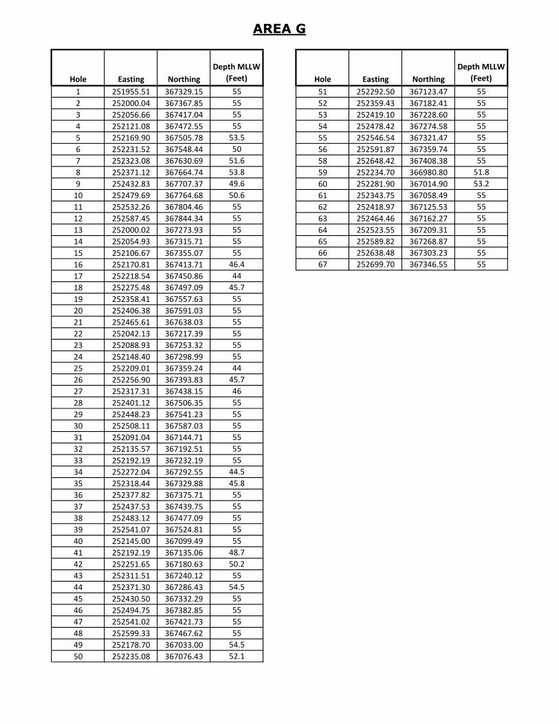
AREA G
Hole Easting Northing
Depth MLLW
(Feet) Hole Easting Northing
Depth MLLW
(Feet)
1 251955.51 367329.15 55 51 252292.50 367123.47 55
2 252000.04 367367.85 55 52 252359.43 367182.41 55
3 252056.66 367417.04 55 53 252419.10 367228.60 55
4 252121.08 367472.55 55 54 252478.42 367274.58 55
5 252169.90 367505.78 53.5 55 252546.54 367321.47 55
6 252231.52 367548.44 50 56 252591.87 367359.74 55
7 252323.08 367630.69 51.6 58 252648.42 367408.38 55
8 252371.12 367664.74 53.8 59 252234.70 366980.80 51.8
9 252432.83 367707.37 49.6 60 252281.90 367014.90 53.2
10 252479.69 367764.68 50.6 61 252343.75 367058.49 55
11 252532.26 367804.46 55 62 252418.97 367125.53 55
12 252587.45 367844.34 55 63 252464.46 367162.27 55
13 252000.02 367273.93 55 64 252523.55 367209.31 55
14 252054.93 367315.71 55 65 252589.82 367268.87 55
15 252106.67 367355.07 55 66 252638.48 367303.23 55
16 252170.81 367413.71 46.4 67 252699.70 367346.55 55
17 252218.54 367450.86 44
18 252275.48 367497.09 45.7
19 252358.41 367557.63 55
20 252406.38 367591.03 55
21 252465.61 367638.03 55
22 252042.13 367217.39 55
23 252088.93 367253.32 55
24 252148.40 367298.99 55
25 252209.01 367359.24 44
26 252256.90 367393.83 45.7
27 252317.31 367438.15 46
28 252401.12 367506.35 55
29 252448.23 367541.23 55
30 252508.11 367587.03 55
31 252091.04 367144.71 55
32 252135.57 367192.51 55
33 252192.19 367232.19 55
34 252272.04 367292.55 44.5
35 252318.44 367329.88 45.8
36 252377.82 367375.71 55
37 252437.53 367439.75 55
38 252483.12 367477.09 55
39 252541.07 367524.81 55
40 252145.00 367099.49 55
41 252192.19 367135.06 48.7
42 252251.65 367180.63 50.2
43 252311.51 367240.12 55
44 252371.30 367286.43 54.5
45 252430.50 367332.29 55
46 252494.75 367382.85 55
47 252541.02 367421.73 55
48 252599.33 367467.62 55
49 252178.70 367033.00 54.5
50 252235.08 367076.43 52.1
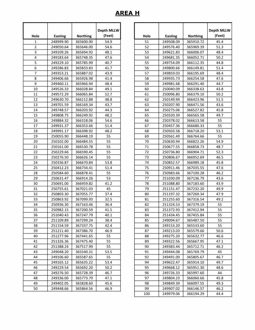
AREA H
Hole Easting Northing
Depth MLLW
(Feet) Hole Easting Northing
Depth MLLW
(Feet)
1 248999.90 365600.90 54.9 51 249508.09 365910.72 45.4
2 249050.64 365646.00 54.6 52 249576.40 365969.39 51.3
3 249109.26 365694.92 48.1 53 249621.83 366006.07 48.4
4 249183.64 365748.35 47.6 54 249681.35 366052.71 50.2
5 249229.10 365785.99 40.7 55 249754.09 366112.35 44.8
6 249286.83 365833.83 41.7 56 249800.66 366149.81 51.4
7 249353.21 365887.02 43.9 57 249859.03 366195.69 48.4
8 249406.66 365926.98 41.4 58 249935.73 366254.58 47.6
9 249460.11 365966.94 48.4 59 249981.68 366291.40 44.7
10 249526.33 366028.84 49.1 60 250040.09 366338.63 43.8
11 249572.29 366065.84 52.7 61 250096.80 366379.10 50.2
12 249630.70 366112.88 48.8 62 250149.94 366423.96 51.5
13 249701.59 366169.34 43.7 63 250207.90 366471.56 43.6
14 249748.57 366203.92 44.3 64 250275.06 366527.82 45.8
15 249808.75 366249.92 48.2 65 250320.39 366565.58 49.7
16 249884.32 366318.06 54.6 66 250378.02 366613.58 55
17 249931.37 366353.66 51.4 67 250457.36 366680.33 55
18 249991.17 366398.92 48.2 68 250503.58 366718.20 53.1
19 250055.90 366448.19 55 69 250561.49 366764.66 55
20 250102.00 366484.55 55 70 250630.94 366822.26 54.9
21 250161.00 366530.78 55 71 250677.55 366858.73 48.7
22 250229.66 366590.45 55 72 250736.80 366904.71 52.3
23 250276.50 366626.14 55 73 250806.67 366952.69 46.5
24 250336.87 366670.84 53.8 74 250852.57 366989.18 45.8
25 250412.23 366734.41 51.4 75 250911.46 367035.55 47.6
28 250584.60 366878.41 55 76 250983.66 367100.28 46.2
29 250631.47 366914.26 53 77 251030.09 367136.79 43.6
30 250691.00 366959.82 41.2 78 251088.80 367183.60 43.9
31 250755.61 367021.03 45 79 251151.47 367232.20 49.9
32 250803.30 367055.77 37.4 80 251197.32 367269.34 47.9
33 250863.92 367099.93 32.5 81 251255.60 367316.54 49.2
34 250936.30 367163.46 36.4 82 251324.53 367379.19 55
35 250982.15 367200.59 41.5 83 251372.93 367412.94 55
36 251040.43 367247.79 40.1 84 251434.45 367455.84 55
37 251109.89 367299.24 38.4 85 249094.67 365487.50 55
38 251154.59 367337.75 42.4 86 249153.20 365533.60 55
39 251211.40 367386.70 46.9 87 249213.03 365579.66 50.6
40 251277.96 367441.65 55 88 249275.20 365632.77 46.6
41 251326.36 367475.40 55 89 249322.56 365667.95 47.1
42 251388.24 367517.99 55 90 249383.44 365712.71 46.2
43 249048.20 365540.31 53.5 91 249444.08 365769.79 45
44 249106.60 365587.65 55 92 249491.00 365805.67 46.7
45 249165.12 365635.22 53.4 94 249622.47 365914.10 49.7
46 249229.54 365692.20 50.2 95 249668.12 365951.30 48.6
47 249276.50 365728.39 46.7 96 249726.33 365997.60 44
48 249336.00 365773.79 47.1 97 249804.23 366060.66 45.8
49 249402.05 365828.60 45.6 98 249849.39 366097.55 49.3
50 249448.66 365864.56 46.9 99 249907.02 366146.57 46.2
100 249979.06 366194.29 44.4

AREA H
Hole Easting Northing
Depth MLLW
(Feet) Hole Easting Northing
Depth MLLW
(Feet)
101 250024.23 366232.24 44.6 151 250550.06 366567.14 49.9
102 250081.66 366280.48 45.7 152 250597.26 366602.54 53
103 250147.00 366336.20 50.9 153 250657.26 366647.53 55
104 250193.50 366373.70 43.3 154 250728.29 366703.95 55
105 250251.26 366421.55 43.7 155 250775.20 366740.24 45.6
106 250320.57 366474.82 43.6 156 250834.12 366786.39 43.5
107 250365.31 366512.93 48.6 157 250898.57 366835.94 48
108 250423.53 366560.52 44.1 158 250945.44 366871.79 52.7
109 250503.25 366626.25 45.5 159 251005.01 366917.35 50.4
110 250549.46 366662.94 49.3 160 251073.75 366984.81 47.1
111 250608.19 366709.58 52.8 161 251119.86 367021.45 49.1
112 250674.62 366755.42 54.4 162 251179.26 367067.41 53.3
113 250720.57 366792.43 50.2 163 249185.12 365367.93 53
114 250778.99 366839.47 47.9 164 249243.96 365414.31 50.3
115 250847.67 366897.90 47.3 165 249303.94 365460.38 46.5
116 250891.94 366936.90 44.9 166 249365.00 365516.13 46.7
117 250948.22 366986.48 44.7 167 249411.35 365553.00 50.8
118 251025.70 367043.52 46.8 168 249469.21 365601.37 47
119 251073.63 367077.93 45.2 169 249542.87 365646.92 47.2
120 251134.55 367121.68 52.9 170 249589.10 365683.60 46.6
121 251206.05 367175.74 55 171 249647.82 365730.24 48.8
122 251250.16 367215.36 55 172 249712.80 365789.24 46.8
123 251307.72 367267.30 55 173 249758.76 365826.25 45.8
124 251369.53 367316.40 55 174 249816.49 365873.26 46.9
125 251417.13 367351.27 55 175 249898.29 365943.75 46.1
126 251477.64 367395.58 55 176 249944.75 365980.12 46.4
127 249141.37 365427.22 55 177 250003.81 366026.35 43.5
128 249200.11 365473.85 50.7 178 250051.20 366070.66 45.3
129 249258.85 365520.49 47 179 250123.95 366116.76 51.4
130 249317.63 365574.76 47.7 180 250184.27 366161.34 53.2
131 249363.33 365612.10 46.8 181 250248.18 366212.07 47.2
132 249421.42 365659.53 47.8 182 250293.41 366249.96 49
133 249497.10 365711.36 45.8 183 250350.90 366298.12 53.9
134 249542.50 365748.96 48.6 184 250418.85 366361.45 52.1
135 249600.00 365796.40 48.5 185 250466.21 366396.64 53.8
136 249666.47 365851.88 48.3 186 250526.41 366442.34 50.3
137 249712.93 365888.24 49.5 187 250599.57 366509.72 50.9
138 249770.64 365936.39 47 188 250646.03 366546.08 52.8
139 249851.26 366002.88 47.3 189 250705.09 366592.31 55
140 249897.71 366039.24 45.1 190 250773.11 366644.44 54.7
141 249956.77 366085.47 44.8 191 250817.60 366682.20 49.2
142 250023.87 366141.52 44.9 192 250876.16 366730.21 45
143 250068.42 366179.78 44.5 193 250946.25 366775.22 54.1
144 250125.88 366227.42 47.1 194 250990.79 366813.92 54.3
145 250199.41 366268.10 52.7 195 251047.40 366863.10 55
146 250244.21 366306.44 47.6 196 251122.45 366925.17 51.9
147 250301.20 366355.24 50 197 251168.63 366961.30 55
148 250371.63 366417.56 47.9 198 251226.10 367008.60 53.9
149 250418.34 366453.61 46.8 199 251290.09 367065.15 55
150 250477.72 366499.43 46.1 200 251336.70 367101.32 52.2
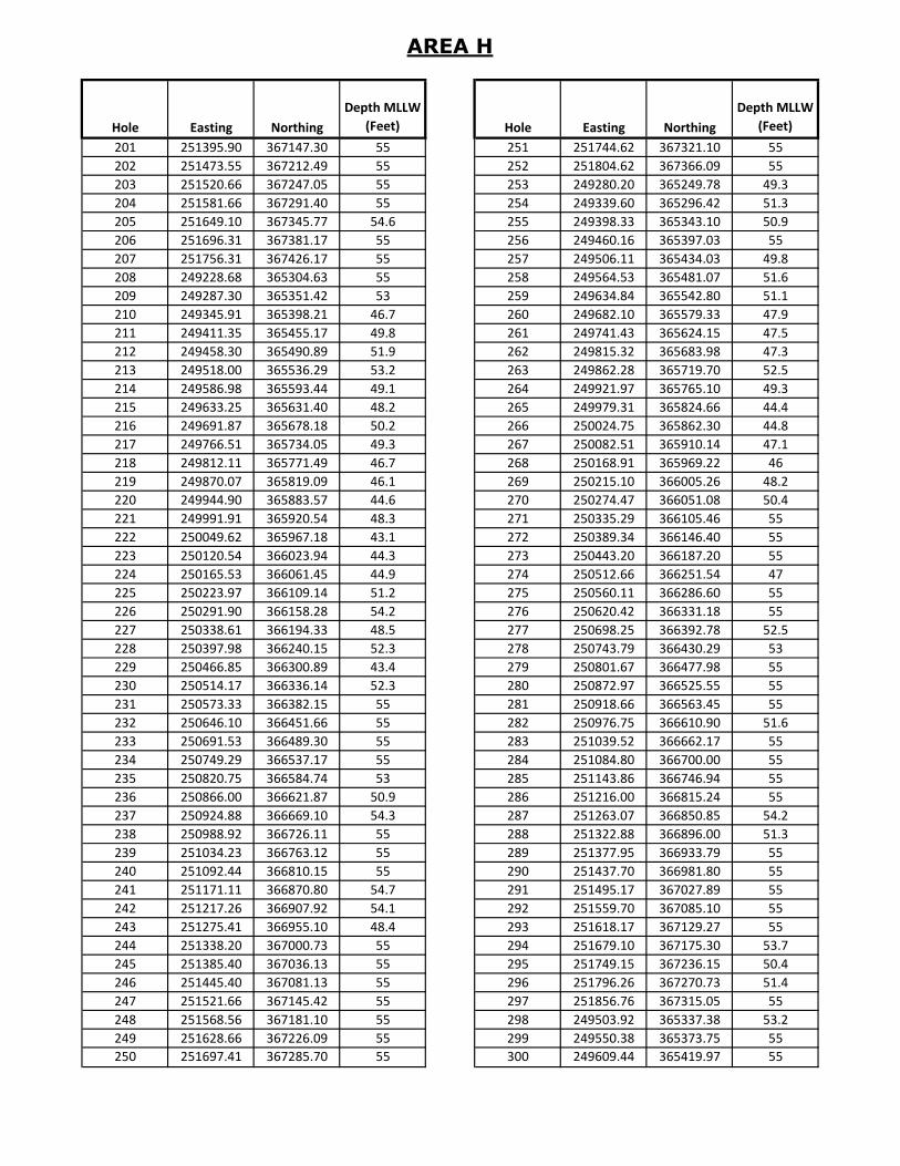
AREA H
Hole Easting Northing
Depth MLLW
(Feet) Hole Easting Northing
Depth MLLW
(Feet)
201 251395.90 367147.30 55 251 251744.62 367321.10 55
202 251473.55 367212.49 55 252 251804.62 367366.09 55
203 251520.66 367247.05 55 253 249280.20 365249.78 49.3
204 251581.66 367291.40 55 254 249339.60 365296.42 51.3
205 251649.10 367345.77 54.6 255 249398.33 365343.10 50.9
206 251696.31 367381.17 55 256 249460.16 365397.03 55
207 251756.31 367426.17 55 257 249506.11 365434.03 49.8
208 249228.68 365304.63 55 258 249564.53 365481.07 51.6
209 249287.30 365351.42 53 259 249634.84 365542.80 51.1
210 249345.91 365398.21 46.7 260 249682.10 365579.33 47.9
211 249411.35 365455.17 49.8 261 249741.43 365624.15 47.5
212 249458.30 365490.89 51.9 262 249815.32 365683.98 47.3
213 249518.00 365536.29 53.2 263 249862.28 365719.70 52.5
214 249586.98 365593.44 49.1 264 249921.97 365765.10 49.3
215 249633.25 365631.40 48.2 265 249979.31 365824.66 44.4
216 249691.87 365678.18 50.2 266 250024.75 365862.30 44.8
217 249766.51 365734.05 49.3 267 250082.51 365910.14 47.1
218 249812.11 365771.49 46.7 268 250168.91 365969.22 46
219 249870.07 365819.09 46.1 269 250215.10 366005.26 48.2
220 249944.90 365883.57 44.6 270 250274.47 366051.08 50.4
221 249991.91 365920.54 48.3 271 250335.29 366105.46 55
222 250049.62 365967.18 43.1 272 250389.34 366146.40 55
223 250120.54 366023.94 44.3 273 250443.20 366187.20 55
224 250165.53 366061.45 44.9 274 250512.66 366251.54 47
225 250223.97 366109.14 51.2 275 250560.11 366286.60 55
226 250291.90 366158.28 54.2 276 250620.42 366331.18 55
227 250338.61 366194.33 48.5 277 250698.25 366392.78 52.5
228 250397.98 366240.15 52.3 278 250743.79 366430.29 53
229 250466.85 366300.89 43.4 279 250801.67 366477.98 55
230 250514.17 366336.14 52.3 280 250872.97 366525.55 55
231 250573.33 366382.15 55 281 250918.66 366563.45 55
232 250646.10 366451.66 55 282 250976.75 366610.90 51.6
233 250691.53 366489.30 55 283 251039.52 366662.17 55
234 250749.29 366537.17 55 284 251084.80 366700.00 55
235 250820.75 366584.74 53 285 251143.86 366746.94 55
236 250866.00 366621.87 50.9 286 251216.00 366815.24 55
237 250924.88 366669.10 54.3 287 251263.07 366850.85 54.2
238 250988.92 366726.11 55 288 251322.88 366896.00 51.3
239 251034.23 366763.12 55 289 251377.95 366933.79 55
240 251092.44 366810.15 55 290 251437.70 366981.80 55
241 251171.11 366870.80 54.7 291 251495.17 367027.89 55
242 251217.26 366907.92 54.1 292 251559.70 367085.10 55
243 251275.41 366955.10 48.4 293 251618.17 367129.27 55
244 251338.20 367000.73 55 294 251679.10 367175.30 53.7
245 251385.40 367036.13 55 295 251749.15 367236.15 50.4
246 251445.40 367081.13 55 296 251796.26 367270.73 51.4
247 251521.66 367145.42 55 297 251856.76 367315.05 55
248 251568.56 367181.10 55 298 249503.92 365337.38 53.2
249 251628.66 367226.09 55 299 249550.38 365373.75 55
250 251697.41 367285.70 55 300 249609.44 365419.97 55
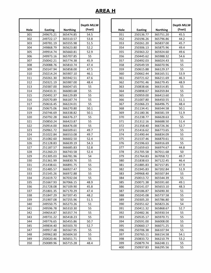
AREA H
Hole Easting Northing
Depth MLLW
(Feet) Hole Easting Northing
Depth MLLW
(Feet)
301 249675.21 365474.85 54.5 351 250136.77 365751.20 45.5
302 249722.17 365510.57 53.8 352 250196.26 365796.86 44.2
303 249781.19 365555.98 51.5 353 250261.20 365837.00 45.7
304 249868.79 365623.80 52.2 354 250306.13 365875.96 49.4
305 249914.74 365660.81 52.9 355 250363.22 365924.60 49.6
306 249973.16 365707.85 55 356 250445.62 365988.32 54.6
307 250042.21 365774.38 45.9 357 250492.03 366024.43 55
308 250088.76 365810.74 47.4 358 250549.59 366070.96 55
309 250147.94 365858.00 47.5 359 250615.88 366129.37 55
310 250214.24 365907.10 46.1 360 250662.44 366165.51 53.9
311 250261.30 365942.51 47.6 361 250721.62 366211.69 46.3
312 250321.19 365987.00 48.4 362 250791.46 366279.45 48.9
313 250387.00 366047.65 55 363 250838.66 366314.85 55
314 250433.31 366083.68 55 364 250898.67 366359.84 55
315 250492.37 366129.89 55 365 250959.00 366413.60 55
316 250570.89 366187.74 55 366 251007.80 366450.55 51.1
317 250616.45 366224.01 55 367 251066.23 366496.75 48.4
318 250675.06 366270.80 50.1 368 251134.41 366544.58 50.1
319 250746.69 366338.82 50.1 369 251180.36 366581.59 51.9
320 250792.28 366376.27 55 370 251238.77 366628.63 55
321 250850.24 366423.87 55 371 251312.16 366688.50 51.4
322 250914.00 366476.00 55 372 251358.40 366726.36 52.7
323 250961.72 366509.61 49.7 373 251416.62 366773.65 55
324 251022.84 366553.08 49.7 374 251490.44 366834.09 55
325 251082.60 366602.50 52.4 375 251537.46 366870.61 55
326 251128.83 366639.19 54.3 376 251596.63 366916.69 55
327 251187.57 366685.83 52.8 377 251659.63 366974.67 44.8
328 251260.23 366743.58 52.4 378 251705.58 367011.68 50
329 251305.03 366781.96 54 379 251764.83 367058.72 49.7
330 251361.99 366830.76 55 380 251838.63 367122.45 46.4
331 251438.61 366891.75 55 381 251885.83 367157.85 47.9
332 251485.57 366927.47 55 382 251945.83 367202.84 51.9
333 251545.26 366972.88 55 383 249968.40 365507.84 55
334 251619.72 367032.04 55 384 250013.72 365544.39 55
335 251667.93 367066.15 48.9 385 250071.38 365591.60 49.1
336 251728.08 367109.90 45.8 386 250141.07 365653.10 48.3
337 251801.35 367170.29 47.4 387 250186.87 365690.30 51
338 251847.29 367207.45 48.2 388 250245.08 365737.58 55
339 251907.08 367255.96 51.5 389 250305.20 365786.80 50
340 249550.75 365273.26 51 390 250351.62 365823.26 54
341 249596.78 365310.30 55 391 250411.32 365868.67 52.7
342 249654.87 365357.74 55 392 250482.36 365930.54 55
343 249731.22 365418.23 55 393 250535.17 365970.71 55
344 249776.65 365455.86 50.7 394 250591.00 366008.00 55
345 249834.40 365503.70 52.7 395 250660.17 366071.25 55
347 249917.48 365567.95 55 396 250706.38 366107.94 55
348 249962.80 365604.50 55 397 250765.11 366154.58 54.1
349 250020.46 365651.71 55 398 250833.72 366210.79 53.2
350 250089.96 365715.28 48.4 399 250879.74 366248.11 55
400 250937.83 366295.56 55

AREA H
Hole Easting Northing
Depth MLLW
(Feet) Hole Easting Northing
Depth MLLW
(Feet)
401 251010.41 366345.84 55 451 251867.31 366943.51 47.6
402 251055.10 366384.41 55 452 251936.98 367005.46 45.5
403 251111.81 366433.44 55 453 251986.15 367036.36 48.4
404 251176.94 366492.12 52.3 454 252045.49 367083.59 54.4
405 251222.38 366529.76 48 455 251814.49 366811.30 53.2
406 251280.74 366576.82 50.3 456 251862.41 366844.72 49
407 251363.56 366634.20 55 457 251923.33 366889.46 47.6
408 251410.76 366669.60 54.6 458 251987.20 366947.98 47.5
409 251470.76 366714.59 55 459 252033.92 366983.38 55
410 251541.43 366778.11 55 460 252093.92 367028.38 55
411 251588.45 366814.63 55 461 251858.30 366748.91 50.9
412 251648.00 366859.59 54.4 462 251897.40 366777.20 49.6
413 251715.43 366924.67 49.3 463 251970.37 366822.49 52.7
414 251764.58 366957.41 47.4 464 252020.50 366871.70 55
415 251827.06 366998.89 45.4 465 252079.90 366920.70 55
416 251892.96 367065.35 44.1 466 252132.30 366967.60 55
417 251938.91 367102.52 46.8 1000 251738.54 366747.27 48.7
418 251997.32 367149.57 50.7 1001 251680.33 366699.98 45.8
419 250011.93 365447.66 55 1002 251634.53 366655.27 50.3
420 250057.25 365484.21 55 1003 251785.52 366685.19 49.6
421 250114.91 365532.44 52 1004 251726.35 366639.11 54
422 250179.73 365589.43 52.2 1005 251672.54 366596.91 51.7
423 250225.68 365626.43 55 1006 249323.99 365193.72 47.4
424 250284.09 365673.47 55 1007 249382.73 365240.35 53.9
425 250344.70 365715.07 55 1008 249441.47 365289.99 46.4
426 250391.27 365751.76 55 1009 249370.35 365132.74 55
427 250449.80 365798.38 55 1010 249428.77 365179.78 48.2
428 250532.72 365862.98 55 1011 249487.18 365226.82 55
429 250579.38 365898.98 55 1015 249194.86 364990.70 55
430 250639.00 365944.38 55 1016 249253.96 365036.80 55
431 250704.89 366009.36 55 1017 249312.35 365083.83 54.4
432 250751.21 366047.14 55 1018 249149.03 365047.24 55
433 250809.43 366093.41 55 1019 249206.79 365095.08 55
434 250884.51 366162.96 55 1020 249264.55 365142.92 55
435 250931.53 366198.73 55 1021 249104.23 365106.68 55
436 250990.91 366244.55 55 1022 249161.04 365155.86 55
437 251052.35 366292.13 55 1023 249217.67 365207.06 55
438 251098.55 366328.82 55
439 251157.29 366375.45 55
440 251227.68 366435.20 55
441 251273.88 366471.85 52.5
442 251332.62 366518.20 51.4
443 251410.54 366572.01 55
444 251457.75 366607.41 55
445 251517.75 366652.41 55
446 251579.11 366715.00 55
447 251626.84 366750.50 48.1
448 251686.66 366795.20 51.2
449 251761.02 366861.89 49.8
450 251807.82 366897.82 49.3

AREA I
Hole Easting Northing
Depth MLLW
(Feet) Hole Easting Northing
Depth MLLW
(Feet)
1 247542.37 364362.91 51.6 51 248011.8 364353.6 51.6
2 247600.66 364410.1 45.4 52 248082.89 364414.28 54.8
3 247658.95 364457.29 46.3 53 248141.96 364460.5 55
4 247716.26 364498.81 46.6 54 248201.02 364506.72 51.8
5 247775.53 364545.03 47.6 55 248260.72 364555.42 53.5
6 247830.46 364588.17 55 56 248319.46 364602.05 51.2
7 247892.98 364644.49 51.9 57 248378.2 364648.68 52.7
8 247952.68 364689.89 50.8 58 248439.1 364693.38 55
9 248008.39 364732.31 45.8 59 248496.2 364743.06 55
10 248076.99 364786.75 49.1 60 248553.29 364790.54 55
11 248133.97 364836.72 52.5 61 247954.76 364207 55
12 248190.4 364885.11 50.1 62 248013.18 364254.47 47
13 247587.62 364303.25 47 63 248067.71 364298.37 50.2
14 247647.63 364348.24 46.1 64 248129.68 364356.83 52.6
15 247707.64 364393.22 50 65 248189.38 364402.24 55
16 247767.22 364441.8 46.5 66 248249.08 364447.64 54.9
17 247825.16 364489.47 45.2 67 248308.82 364500.68 47.7
18 247879.26 364533.89 47 68 248366.91 364548.12 47.3
19 247934 364586.75 49.6 69 248425.01 364595.56 45.4
20 247993.06 364632.97 52.7 70 248483.38 364638.4 51.9
21 248048.19 364676.11 51.4 71 248542.57 364684.47 55
22 248180.76 364778.89 49 72 248601.75 364730.53 55
23 248240.77 364824.16 55 73 248002.44 364155 55
24 248120.75 364733.76 54.3 74 248059 364203 52.2
25 247633.66 364245.12 55 75 248116 364252 53
26 247692.92 364291.09 47.9 76 248174.58 364297.22 45.8
27 247752.18 364337.05 46.7 77 248234.47 364342.55 52.4
28 247810.11 364386.31 50.2 78 248294.36 364387.5 51.7
29 247867.88 364434.1 45.9 79 248353.78 364443.86 49.6
30 247921.79 364478.8 45.9 80 248413.16 364489.68 46.1
31 247983.8 364529.1 46 81 248472.38 364535.49 42.2
32 248042.8 364575.24 49.9 82 248529.5689 364578.174 44.9
33 248102.8 364621.1 47.6 83 248588.05 364624.73 48.5
34 248162.16 364669.89 47.3 84 248646.8 364671.36 55
35 248222.47 364714.46 49.6 85 248044.82 364095.1 55
36 248282.79 364759.05 55 86 248103.57 364141.7 48.3
37 247677.05 364187.36 52.6 87 248162.31 364188.33 51.8
38 247735.11 364234.17 47.2 88 248217.08 364241.14 52.7
39 247793.5 364280.96 51.1 89 248275.82 364285.73 51.8
40 247857.02 364325.22 51.2 90 248334.56 364332.36 46.1
41 247913.62 364374.25 50.5 91 248400.32 364382.52 48.1
42 247967.08 364419.54 48.9 92 248460.35 364428.11 52.3
43 248033.29 364473.2 50.2 93 248519.99 364473.36 47.1
44 248092.99 364518.36 55 94 248575.55 364519.98 45.8
45 248152.87 364563.92 50.3 95 248634.95 364566.61 49.7
46 248213.1 364613.21 51.6 96 248693.8 364612.25 53.3
47 248272.6 364659.18 49.3 97 248094.29 364031.29 48.7
48 248332.1 364704.83 54.2 98 248151.58 364079.69 47.7
49 247897.66 364263.11 49.8 99 248208.88 364128.08 47.6
50 247956.97 364310.08 45.2 100 248272.4 364173.57 48.4

AREA I
Hole Easting Northing
Depth MLLW
(Feet)
101 248329.83 364221.81 54.6
102 248387.26 364270.04 49
103 248445.66 364322.55 51.6
104 248505.79 364367.39 50.3
105 248564.61 364413.9 46.1
106 248623.53 364457.21 48.2
107 248682.53 364504.16 52.5
108 248742.13 364550.04 55
109 248141.02 363973.78 52.5
110 248198.99 364021.37 50.7
111 248256.95 364068.97 47.3
112 248311.09 364119.79 48.2
113 248369.83 364166.42 55
114 248428.58 364213.08 55
115 248499.93 364263.67 50.4
116 248558.86 364309.15 55
117 248618.93 364354.99 51.4
118 248664.08 364400.9 52.9
119 248726.5 364452.6 55
120 248787.5 364501.8 55
121 248188.7 363909.26 55
122 248246.13 363957.5 55
123 248303.56 364005.73 50.2
124 248359.45 364046.34 55
125 248416.27 364095.67 55
126 248473.16 364143.7 55
127 248551.37 364212.1 51.3
128 248611.8 364256.36 50.5
129 248672.23 364300.94 53.1
130 248706.61 364343.84 55
131 248765.03 364390.88 55
132 248823.45 364437.91 55

AREA J
Hole Easting Northing
Depth MLLW
(Feet)
1 246142.81 362476.16 48
2 246203.4 362521.87 55
3 246263.53 362566.71 52
4 246327.9 362615.73 51.1
5 246386.34 362661.87 50.8
6 246444.89 362709.2 55
7 246491.18 362744.66 55
8 246550.89 362790.05 54.6
9 246610.59 362835.45 55
10 246194.15 362410.67 48.2
11 246252.34 362458.35 48.6
12 246310.11 362506.33 48.6
13 246374.65 362557.58 54
14 246433.09 362603.72 49.7
15 246491.64 362651.05 55
16 246534.92 362691.31 55
17 246595.25 362735.87 54.2
18 246655.57 362780.44 54.6
19 246237.42 362354.2 47.1
20 246295.85 362401.23 50.1
21 246354.27 362448.26 48.1
22 246417.79 362499.5 53.2
23 246477.49 362545.56 55
24 246537.2 362590 55
25 246590.97 362624.76 55
26 246648.1 362673.38 55
27 246705.18 362722.01 55
28 246289.13 362293.28 48.3
29 246346.43 362341.66 54.3
30 246403.74 362390.05 48.9
31 246463.49 362439.67 55
32 246522.56 362485.88 55
33 246581.62 362532.1 55
34 246635.3 362571.54 55
35 246690.29 362622.48 55
36 246745.9 362672 55

AREA K
Hole Easting Northing
Depth MLLW
(Feet) Hole Easting Northing
Depth MLLW
(Feet)
1 244116.90 361673.80 39.4 52 245391.28 362503.40 43.7
2 244180.20 361718.30 36.6 53 245448.40 362552.50 51.5
3 244202.63 361742.96 35.5 54 245515.58 362610.26 48
4 244262.19 361787.94 36.3 55 245577.33 362652.87 46.4
5 244322.21 361832.91 33.2 56 245639.16 362695.47 46.1
6 244375.33 361870.46 37.3 57 245697.81 362753.27 45.1
7 244423.36 361923.16 42.9 58 245756.68 362799.74 46.8
8 244731.87 362177.80 39.9 59 245815.55 362846.21 49
9 244784.13 362234.25 35.5 60 244242.16 361474.88 48.9
10 244836.20 362283.30 36.5 61 244306.81 361526.68 48.5
11 244900.10 362305.00 39.3 62 244343.05 361565.83 48.5
12 244956.90 362355.50 37.3 63 244401.25 361613.10 53.7
13 245013.40 362404.40 36.3 64 244460.08 361660.37 47.8
14 245064.00 362440.65 35.6 65 244491.72 361660.92 45.5
15 245125.80 362482.00 43.5 66 244544.75 361718.67 44.8
16 245187.80 362524.80 46.5 67 244588.21 361774.91 43.5
18 244158.00 361610.40 53.9 68 244903.50 362019.90 45.4
19 244243.50 361657.00 52.6 69 244957.60 362086.80 52
20 244246.53 361681.47 53.3 70 245044.80 362130.50 46.9
21 244305.28 361728.09 49 71 245102.50 362178.40 46.5
22 244364.04 361774.71 51.6 72 245160.40 362226.20 47.2
23 244430.03 361819.14 47.8 73 245213.60 362264.77 46.4
24 244480.12 361874.14 45.3 74 245272.00 362311.80 48.4
25 244789.31 362129.25 46.6 75 245330.60 362359.13 47.1
26 244839.03 362183.16 46.4 76 245389.82 362406.00 45.3
27 244891.45 362232.59 46.3 77 245448.00 362453.00 44.1
28 244952.70 362250.70 48.3 78 245506.50 362500.10 53.2
29 245011.30 362296.60 48.6 79 245565.39 362553.26 48.8
30 245071.00 362342.52 46 80 245623.49 362600.69 55
31 245121.00 362378.00 45.7 81 245681.59 362648.12 45.5
32 245179.00 362424.00 44.6 82 245742.58 362691.29 45.1
33 245238.50 362471.00 48.5 83 245802.15 362737.63 46.4
35 244199.10 361547.00 55 84 245861.85 362783.08 49.7
36 244266.45 361595.61 47.1 85 244283.24 361412.30 53.2
37 244298.14 361620.21 51.7 86 244347.34 361463.45 50.8
38 244355.13 361668.83 48.9 87 244393.08 361501.30 50.8
39 244412.36 361717.45 46.9 88 244450.48 361550.70 53.4
40 244484.72 361767.82 44.5 89 244506.92 361600.10 45.7
41 244536.62 361824.71 44.5 90 244549.16 361612.69 46.1
42 244846.75 362081.02 44.4 91 244597.95 361665.41 46.7
43 244893.93 362132.06 47.1 92 244642.41 361724.06 45.8
44 244946.71 362181.87 46.7 93 244961.00 361971.70 45.3
45 244996.00 362192.50 48.2 94 245013.60 362035.50 46.5
46 245055.10 362239.94 46.2 95 245089.70 362072.10 45.1
47 245113.20 362287.40 46.5 96 245147.60 362120.40 47.1
48 245167.90 362322.60 46.2 97 245204.43 362168.20 47.7
49 245227.00 362369.00 50.5 98 245263.70 362206.00 46.7
50 245286.00 362415.00 45.3 99 245322.20 362253.40 45.1
51 245334.00 362454.60 45.6 100 245381.00 362299.99 45.4
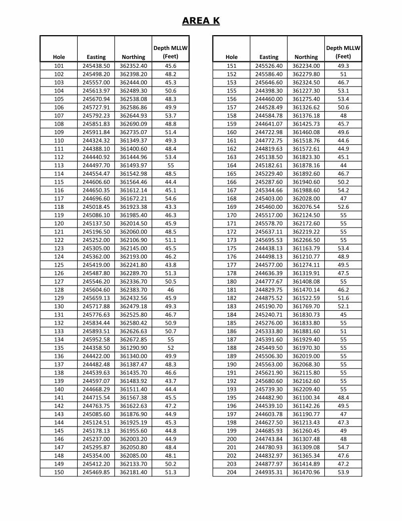
AREA K
Hole Easting Northing
Depth MLLW
(Feet) Hole Easting Northing
Depth MLLW
(Feet)
101 245438.50 362352.40 45.6 151 245526.40 362234.00 49.3
102 245498.20 362398.20 48.2 152 245586.40 362279.80 51
103 245557.00 362444.00 45.3 153 245646.60 362324.50 46.7
104 245613.97 362489.30 50.6 155 244398.30 361227.30 53.1
105 245670.94 362538.08 48.3 156 244460.00 361275.40 53.4
106 245727.91 362586.86 49.9 157 244528.49 361326.62 50.6
107 245792.23 362644.93 53.7 158 244584.78 361376.18 48
108 245851.83 362690.09 48.8 159 244641.07 361425.73 45.7
109 245911.84 362735.07 51.4 160 244722.98 361460.08 49.6
110 244324.32 361349.37 49.3 161 244772.75 361518.76 44.6
111 244388.10 361400.60 48.4 162 244819.63 361572.61 44.9
112 244440.92 361444.96 53.4 163 245138.50 361823.30 45.1
113 244497.70 361493.97 55 164 245182.61 361878.16 44
114 244554.47 361542.98 48.5 165 245229.40 361892.60 46.7
115 244606.60 361564.46 44.4 166 245287.60 361940.60 50.2
116 244650.35 361612.14 45.1 167 245344.66 361988.60 54.2
117 244696.60 361672.21 54.6 168 245403.00 362028.00 47
118 245018.45 361923.38 43.3 169 245460.00 362076.54 52.6
119 245086.10 361985.40 46.3 170 245517.00 362124.50 55
120 245137.50 362014.50 45.9 171 245578.70 362172.60 55
121 245196.50 362060.00 48.5 172 245637.11 362219.22 55
122 245252.00 362106.90 51.1 173 245695.53 362266.50 55
123 245305.00 362145.00 45.5 175 244438.13 361163.79 53.4
124 245362.00 362193.00 46.2 176 244498.13 361210.77 48.9
125 245419.00 362241.80 43.8 177 244577.00 361274.11 49.5
126 245487.80 362289.70 51.3 178 244636.39 361319.91 47.5
127 245546.20 362336.70 50.5 180 244777.67 361408.08 55
128 245604.60 362383.70 46 181 244829.75 361470.14 46.2
129 245659.13 362432.56 45.9 182 244875.52 361522.59 51.6
130 245717.88 362479.18 49.3 183 245190.70 361769.70 52.1
131 245776.63 362525.80 46.7 184 245240.71 361830.73 45
132 245834.44 362580.42 50.9 185 245276.00 361833.80 55
133 245893.51 362626.63 50.7 186 245333.80 361881.60 51
134 245952.58 362672.85 55 187 245391.60 361929.40 55
135 244358.50 361290.90 52 188 245449.50 361970.30 55
136 244422.00 361340.00 49.9 189 245506.30 362019.00 55
137 244482.48 361387.47 48.3 190 245563.00 362068.30 55
138 244539.63 361435.70 46.6 191 245621.90 362115.80 55
139 244597.07 361483.92 43.7 192 245680.60 362162.60 55
140 244668.29 361511.40 44.4 193 245739.30 362209.40 55
141 244715.54 361567.38 45.5 195 244482.90 361100.34 48.4
142 244763.75 361622.63 47.2 196 244539.10 361142.26 49.5
143 245085.60 361876.90 44.9 197 244603.78 361190.77 47
144 245124.51 361925.19 45.3 198 244627.50 361213.43 47.3
145 245178.13 361955.60 44.8 199 244685.93 361260.45 49
146 245237.00 362003.20 44.9 200 244743.84 361307.48 48
147 245295.87 362050.80 48.4 201 244780.93 361309.08 54.7
148 245354.00 362085.00 48.1 202 244832.97 361365.34 47.6
149 245412.20 362133.70 50.2 203 244877.97 361414.89 47.2
150 245469.85 362181.40 51.3 204 244935.31 361470.96 53.9
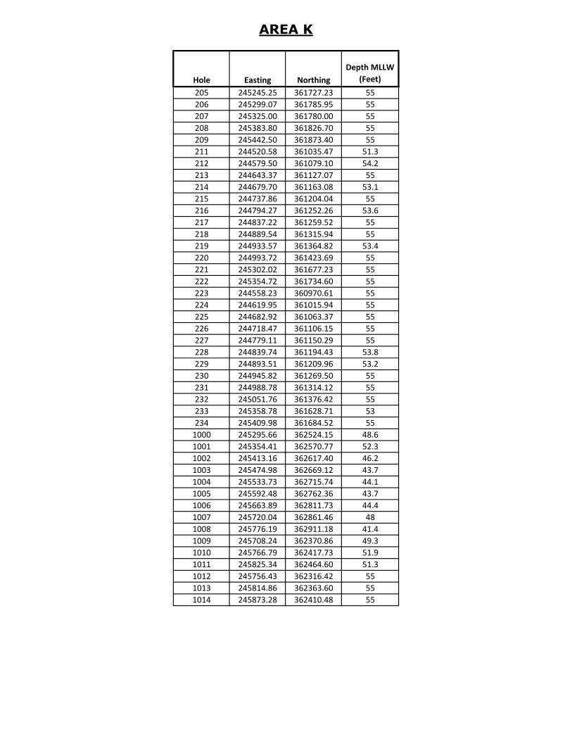
AREA K
Hole Easting Northing
Depth MLLW
(Feet)
205 245245.25 361727.23 55
206 245299.07 361785.95 55
207 245325.00 361780.00 55
208 245383.80 361826.70 55
209 245442.50 361873.40 55
211 244520.58 361035.47 51.3
212 244579.50 361079.10 54.2
213 244643.37 361127.07 55
214 244679.70 361163.08 53.1
215 244737.86 361204.04 55
216 244794.27 361252.26 53.6
217 244837.22 361259.52 55
218 244889.54 361315.94 55
219 244933.57 361364.82 53.4
220 244993.72 361423.69 55
221 245302.02 361677.23 55
222 245354.72 361734.60 55
223 244558.23 360970.61 55
224 244619.95 361015.94 55
225 244682.92 361063.37 55
226 244718.47 361106.15 55
227 244779.11 361150.29 55
228 244839.74 361194.43 53.8
229 244893.51 361209.96 53.2
230 244945.82 361269.50 55
231 244988.78 361314.12 55
232 245051.76 361376.42 55
233 245358.78 361628.71 53
234 245409.98 361684.52 55
1000 245295.66 362524.15 48.6
1001 245354.41 362570.77 52.3
1002 245413.16 362617.40 46.2
1003 245474.98 362669.12 43.7
1004 245533.73 362715.74 44.1
1005 245592.48 362762.36 43.7
1006 245663.89 362811.73 44.4
1007 245720.04 362861.46 48
1008 245776.19 362911.18 41.4
1009 245708.24 362370.86 49.3
1010 245766.79 362417.73 51.9
1011 245825.34 362464.60 51.3
1012 245756.43 362316.42 55
1013 245814.86 362363.60 55
1014 245873.28 362410.48 55

Area L
Hole Easting Northing
Depth MLLW
(Feet) Hole Easting Northing
Depth MLLW
(Feet)
1 241869.99 360001.45 55 51 242111.02 359889.25 47
2 241933.98 360040.57 55 52 242176.96 359930.13 46.1
3 241997.97 360079.68 47 53 242241.40 359968.51 55
4 242061.80 360120.10 51.7 54 242305.83 360006.88 55
5 242126.10 360159.70 52.4 55 242367.42 360043.12 46
6 242190.60 360198.30 55 56 242431.10 360085.56 46
7 242243.25 360230.32 55 57 242491.21 360128.00 45.7
8 242306.60 360270.46 55 58 242557.40 360167.00 45.2
9 242369.95 360310.60 55 59 242621.60 360206.40 45.9
10 242436.37 360355.74 49.8 60 242685.90 360244.94 52.8
11 242500.27 360395.00 53.3 61 242752.90 360284.85 55
12 242564.00 360434.30 49.2 62 242815.60 360326.00 55
13 241906.27 359935.57 55 63 242878.30 360367.16 55
14 241969.27 359976.00 53.9 64 241650.14 359512.15 55
15 242032.44 360016.44 50.9 65 241711.91 359553.88 45.3
16 242102.60 360056.60 52.9 66 241774.22 359595.61 46.6
17 242166.20 360096.30 53.2 67 241840.67 359623.84 44.9
18 242229.80 360136.00 53.1 68 241903.05 359665.04 51.5
19 242292.70 360178.30 55 69 241965.88 359706.34 49.4
20 242355.60 360219.10 48.9 70 242026.66 359747.92 48
21 242418.77 360259.50 49.5 71 242090.67 359787.03 46.1
22 242478.13 360296.13 51.9 72 242154.64 359826.16 55
23 242542.75 360334.20 54.8 73 242217.17 359866.80 55
24 242607.36 360372.30 52.5 74 242281.26 359905.73 55
25 242667.73 360411.69 47.9 75 242345.34 359944.69 55
26 242730.90 360452.13 50 76 242409.20 359978.43 55
27 242794.07 360492.92 51.8 77 242471.52 360020.16 49.4
28 241942.90 359869.52 48.7 78 242533.84 360061.89 50.1
29 242006.07 359909.85 54 79 242599.00 360103.50 46.6
30 242069.24 359950.28 52.4 80 242663.20 360142.60 47
31 242140.43 359995.00 48.8 81 242727.10 360181.70 55
32 242205.37 360035.67 50.9 82 242790.82 360224.46 55
33 242269.80 360073.10 55 83 242853.42 360265.76 55
34 242331.45 360105.60 54 84 242916.02 360307.06 55
35 242394.90 360145.30 50.2 85 242979.15 360345.77 50.9
36 242458.40 360185.30 55 86 243042.59 360385.77 53.9
37 242520.17 360229.43 53.4 87 243106.03 360425.76 55
38 242584.10 360268.70 51.5 88 243175.30 360459.00 55
39 242647.97 360307.96 49.4 89 243239.28 360498.12 55
40 242709.43 360350.99 53 90 243303.27 360537.25 55
41 242773.34 360390.26 54.4 91 241694.44 359440.94 55
42 242837.24 360429.52 55 92 241757.33 359481.80 55
43 241613.88 359576.18 55 93 241820.22 359522.67 53.4
44 241675.42 359619.04 46.9 94 241876.45 359557.23 54
45 241736.97 359661.91 48 95 241938.87 359598.60 46.4
46 241795.16 359687.56 43.5 96 242001.28 359639.22 46.1
47 241857.36 359725.73 49.6 97 242065.13 359685.44 49.8
48 241918.84 359772.44 47.8 98 242130.84 359721.41 45.3
49 241983.61 359810.14 48 99 242196.55 359757.38 55
50 242047.33 359849.70 43.4 100 242256.10 359804.00 55
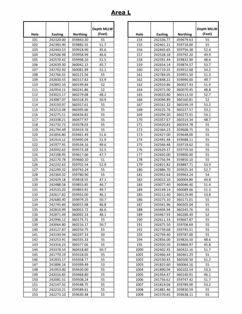
Area L
Hole Easting Northing
Depth MLLW
(Feet) Hole Easting Northing
Depth MLLW
(Feet)
101 242320.00 359843.30 55 154 242336.77 359679.63 55
102 242383.90 359882.55 51.7 155 242401.21 359718.00 55
103 242443.53 359918.90 45.6 156 242465.65 359756.38 52.4
104 242506.98 359958.99 46.6 157 242528.18 359792.20 49.9
105 242570.42 359998.20 51.5 158 242591.44 359832.90 48.6
106 242639.30 360042.15 45.7 159 242654.14 359874.57 53.7
107 242702.92 360081.89 52.1 160 242719.35 359912.68 54.2
108 242766.55 360121.56 55 161 242784.05 359951.50 51.3
109 242830.55 360157.83 53.9 162 242848.22 359990.00 49.7
110 242892.10 360199.84 52 163 242910.86 360027.43 51.9
111 242954.11 360241.86 52 164 242972.00 360070.45 48.8
112 243023.17 360279.08 48.2 165 243033.80 360113.50 52.7
113 243087.07 360318.35 50.9 166 243096.89 360160.81 52
114 243150.97 360357.61 55 167 243161.32 360199.19 53.2
115 243213.08 360395.66 55 168 243225.76 360237.57 53.2
116 243275.51 360436.82 55 169 243294.50 360273.91 54.1
117 243338.21 360477.97 55 170 243357.67 360314.34 48.7
118 241732.72 359378.03 55 171 243420.83 360354.78 55
119 241794.49 359419.76 55 172 242364.23 359608.75 55
120 241856.80 359461.49 51.6 173 242427.00 359648.00 55
121 241914.12 359495.04 51.9 174 242491.48 359688.11 55
122 241977.91 359534.16 49.6 175 242566.48 359718.62 55
123 242042.63 359573.28 52.5 176 242629.37 359759.50 55
124 242108.95 359617.66 47.7 177 242692.00 359800.40 55
125 242170.78 359660.10 51 178 242756.94 359850.10 55
126 242232.62 359702.54 52.9 179 242821.82 359887.71 53.9
127 242299.32 359743.24 55 180 242886.70 359925.34 52.7
128 242364.32 359780.90 55 181 242952.64 359963.24 54
129 242429.18 359818.55 47.1 182 243015.10 360004.80 44.8
130 242488.58 359855.85 46.7 183 243077.40 360046.40 51.4
131 242533.20 359893.92 49.7 184 243149.14 360089.66 51.3
132 242617.82 359932.00 46.1 185 243212.40 360129.89 53.8
133 242680.40 359979.25 50.7 186 243275.10 360171.01 55
134 242745.60 360015.98 46.8 187 243341.96 360205.04 55
135 242810.99 360052.72 46.6 188 243404.94 360245.76 55
136 242871.49 360092.24 48.1 189 243467.93 360286.49 52
138 242996.12 360175.71 55 190 242611.33 359667.87 55
139 243064.80 360216.17 50.7 191 242675.50 359706.69 55
140 243127.87 360256.75 55 192 242739.68 359745.51 55
141 243190.94 360297.33 50 193 242794.40 359787.00 55
142 243253.91 360335.33 55 194 242856.00 359826.50 48.6
143 243316.23 360377.06 55 195 242920.50 359866.97 45.8
144 243378.54 360418.80 50.7 1000 242402.45 360422.16 51.7
145 241770.19 359318.05 55 1001 242466.44 360461.29 55
146 241833.17 359358.77 55 1002 242530.43 360500.50 51.2
147 241896.16 359399.49 53 1003 241825.60 360064.16 55
148 241953.00 359430.00 55 1004 241890.04 360102.54 53.3
149 242016.83 359468.80 55 1005 241954.47 360140.91 46.1
150 242081.51 359508.24 55 1006 241756.62 359747.42 51.7
151 242147.32 359548.75 55 1007 241819.04 359789.00 53.2
152 242210.21 359589.61 55 1008 241881.46 359830.59 55
153 242273.10 359630.48 55 1009 241570.65 359638.11 55

Area L
Hole Easting Northing
Depth MLLW
(Feet)
1010 241634.64 359677.42 52.7
1011 241698.63 359716.34 48.4
1012 241533.07 359705.26 55
1013 241597.06 359744.38 53.6
1014 241661.05 359783.50 53.3
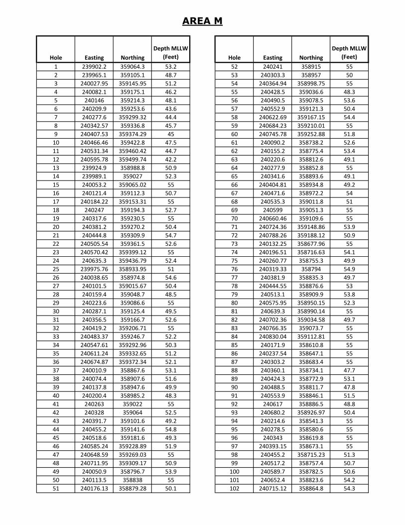
AREA M
Hole Easting Northing
Depth MLLW
(Feet) Hole Easting Northing
Depth MLLW
(Feet)
1 239902.2 359064.3 53.2 52 240241 358915 55
2 239965.1 359105.1 48.7 53 240303.3 358957 50
3 240027.95 359145.95 51.2 54 240364.94 358998.75 55
4 240082.1 359175.1 46.2 55 240428.5 359036.6 48.3
5 240146 359214.3 48.1 56 240490.5 359078.5 53.6
6 240209.9 359253.6 43.6 57 240552.9 359121.3 50.4
7 240277.6 359299.32 44.4 58 240622.69 359167.15 54.4
8 240342.57 359336.8 45.7 59 240684.23 359210.01 55
9 240407.53 359374.29 45 60 240745.78 359252.88 51.8
10 240466.46 359422.8 47.5 61 240090.2 358738.2 52.6
11 240531.34 359460.42 44.7 62 240155.2 358775.4 53.4
12 240595.78 359499.74 42.2 63 240220.6 358812.6 49.1
13 239924.9 358988.8 50.9 64 240277.9 358852.8 55
14 239989.1 359027 52.3 65 240341.6 358893.6 49.1
15 240053.2 359065.02 55 66 240404.81 358934.8 49.2
16 240121.4 359112.3 50.7 67 240471.6 358972.2 54
17 240184.22 359153.31 55 68 240535.3 359011.8 51
18 240247 359194.3 52.7 69 240599 359051.3 55
19 240317.6 359230.5 55 70 240660.46 359109.6 55
20 240381.2 359270.2 50.4 71 240724.36 359148.86 53.9
21 240444.8 359309.9 54.7 72 240788.26 359188.12 50.9
22 240505.54 359361.5 52.6 73 240132.25 358677.96 55
23 240570.42 359399.12 55 74 240196.51 358716.63 54.1
24 240635.3 359436.79 52.4 75 240260.77 358755.3 49.9
25 239975.76 358933.95 51 76 240319.33 358794 54.9
26 240038.65 358974.8 54.6 77 240381.9 358835.3 49.7
27 240101.5 359015.67 50.4 78 240444.55 358876.6 53
28 240159.4 359048.7 48.5 79 240513.1 358909.9 53.8
29 240223.6 359086.6 55 80 240575.95 358950.15 52.3
30 240287.1 359125.4 49.5 81 240639.3 358990.14 55
31 240356.5 359166.7 52.6 82 240702.36 359034.58 49.7
32 240419.2 359206.71 55 83 240766.35 359073.7 55
33 240483.37 359246.7 52.2 84 240830.04 359112.81 55
34 240547.61 359292.96 50.3 85 240171.9 358610.8 55
35 240611.24 359332.65 51.2 86 240237.54 358647.1 55
36 240674.87 359372.34 52.1 87 240303.2 358683.4 55
37 240010.9 358867.6 53.1 88 240360.1 358734.1 47.7
38 240074.4 358907.6 51.6 89 240424.3 358772.9 53.1
39 240137.8 358947.6 49.9 90 240488.5 358811.7 47.8
40 240200.4 358985.2 48.3 91 240553.9 358846.1 51.5
41 240263 359022 55 92 240617 358886.5 48.8
42 240328 359064 52.5 93 240680.2 358926.97 50.4
43 240391.7 359101.6 49.2 94 240214.6 358541.3 55
44 240455.2 359141.6 54.8 95 240278.5 358580.6 55
45 240518.6 359181.6 49.3 96 240343 358619.8 55
46 240585.24 359228.89 51.9 97 240393.15 358673.1 55
47 240648.59 359269.03 55 98 240455.2 358715.23 51.3
48 240711.95 359309.17 50.9 99 240517.2 358757.4 50.7
49 240050.9 358796.7 53.9 100 240589.7 358782.5 50.6
50 240113.5 358838 55 101 240652.4 358823.6 54.2
51 240176.13 358879.28 50.1 102 240715.12 358864.8 54.3
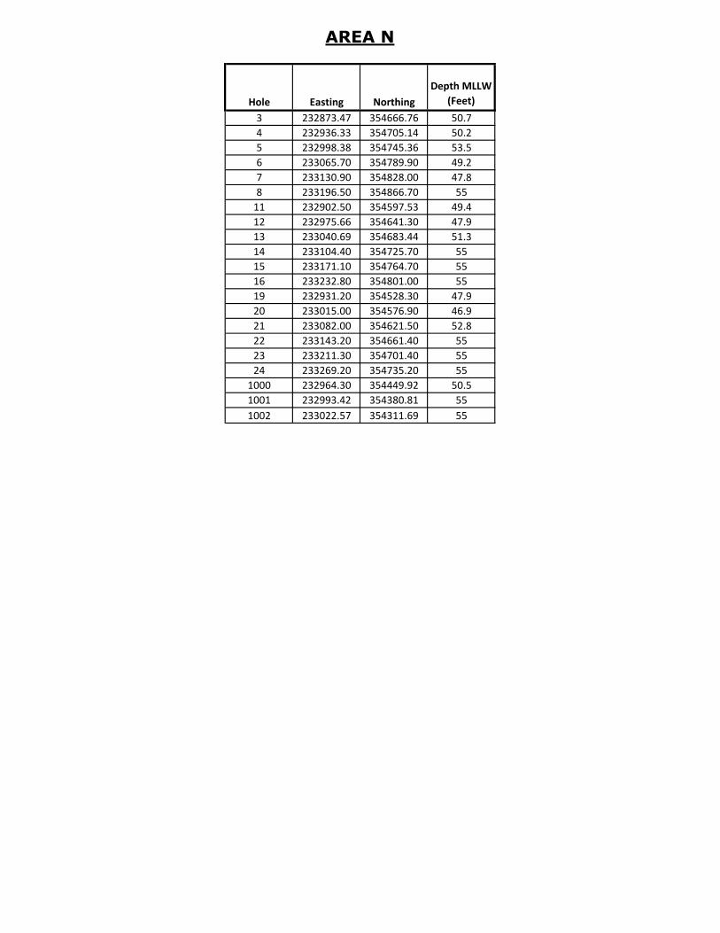
AREA N
Hole Easting Northing
Depth MLLW
(Feet)
3 232873.47 354666.76 50.7
4 232936.33 354705.14 50.2
5 232998.38 354745.36 53.5
6 233065.70 354789.90 49.2
7 233130.90 354828.00 47.8
8 233196.50 354866.70 55
11 232902.50 354597.53 49.4
12 232975.66 354641.30 47.9
13 233040.69 354683.44 51.3
14 233104.40 354725.70 55
15 233171.10 354764.70 55
16 233232.80 354801.00 55
19 232931.20 354528.30 47.9
20 233015.00 354576.90 46.9
21 233082.00 354621.50 52.8
22 233143.20 354661.40 55
23 233211.30 354701.40 55
24 233269.20 354735.20 55
1000 232964.30 354449.92 50.5
1001 232993.42 354380.81 55
1002 233022.57 354311.69 55
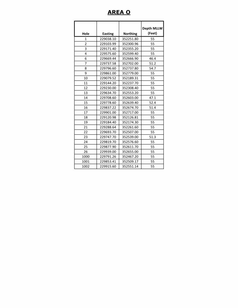
AREA O
Hole Easting Northing
Depth MLLW
(Feet)
1 229038.10 352251.80 55
2 229103.99 352300.96 55
3 229171.40 352355.20 55
4 229575.60 352599.40 55
6 229669.44 352666.90 46.4
7 229737.58 352702.00 51.2
8 229796.60 352737.80 54.7
9 229861.00 352779.00 55
10 229079.52 352189.31 55
11 229144.20 352237.70 55
12 229230.00 352308.40 55
13 229634.70 352553.20 55
14 229708.60 352603.00 47.1
15 229778.60 352639.40 52.4
16 229837.22 352674.70 51.4
17 229901.00 352717.00 55
18 229120.98 352126.81 55
19 229184.40 352174.30 55
21 229288.64 352261.60 55
22 229693.70 352507.00 55
23 229747.70 352539.00 51.3
24 229819.70 352576.60 55
25 229877.90 352611.70 55
26 229939.00 352655.00 55
1000 229791.26 352467.20 55
1001 229853.41 352509.17 55
1002 229915.60 352551.14 55
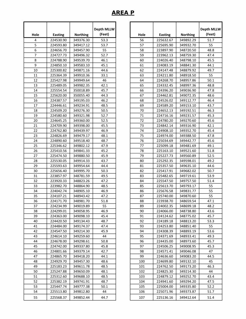
AREA P
Hole Easting Northing
Depth MLLW
(Feet) Hole Easting Northing
Depth MLLW
(Feet)
4 224530.90 349376.30 53.3 56 225632.67 349892.29 51.7
5 224593.80 349417.12 53.7 57 225695.90 349932.70 55
6 224656.70 349457.90 55 58 223897.90 348720.50 48.8
7 224727.73 349496.32 52.7 59 223962.13 348759.30 47.4
8 224788.90 349539.70 46.1 60 224026.40 348798.10 45.5
9 224850.10 349583.10 45.1 61 224083.19 348841.30 44.1
10 225300.82 349871.16 44.6 62 224147.48 348879.92 49.7
11 225364.39 349910.36 33.1 63 224211.80 348918.50 55
12 225427.98 349949.64 46 64 224268.70 348957.86 50.1
13 225489.05 349982.35 42.1 65 224332.45 348997.36 48.8
14 225554.54 350018.89 45.7 66 224396.20 349036.90 47.8
15 225620.00 350055.40 44.3 67 224462.81 349072.35 48.6
16 224387.57 349195.03 46.2 68 224526.02 349112.77 46.4
17 224446.61 349234.91 48.5 69 224589.20 349153.10 43.7
18 224509.20 349276.30 50.5 70 224652.13 349192.51 46.3
19 224580.60 349321.98 52.7 71 224716.16 349231.57 45.3
20 224645.25 349360.00 52.5 72 224780.20 349270.60 45.6
21 224709.90 349398.00 45.5 73 224842.14 349316.90 42.1
22 224762.80 349439.97 46.9 74 224908.10 349352.70 45.4
23 224826.69 349479.17 48.1 75 224974.00 349388.50 47.8
24 224890.60 349518.40 48.7 76 225034.69 349442.77 45.6
25 225346.62 349802.12 47.9 77 225099.18 349481.69 49.1
26 225410.56 349841.33 45.2 78 225163.10 349521.60 51.8
27 225474.50 349880.50 45.9 79 225227.73 349560.89 52.5
28 225530.05 349914.33 43.7 80 225292.35 349598.01 49.2
29 225593.63 349954.64 44.4 81 225357.50 349635.10 44.6
30 225656.40 349995.70 50.3 82 225417.91 349682.02 50.7
31 223857.97 348781.59 49.5 83 225482.65 349719.61 53.9
32 223920.33 348823.26 47.2 84 225547.50 349757.50 51.4
33 223982.70 348864.90 48.5 85 225613.70 349793.17 55
34 224042.74 348905.10 46.9 86 225676.58 349831.77 55
35 224107.21 348943.42 47.2 87 225740.00 349870.60 55
36 224171.70 348981.70 51.8 88 223938.70 348659.54 47.1
37 224234.99 349019.89 55 89 224002.35 348699.18 48.2
38 224299.01 349058.95 46.9 90 224066.00 348738.80 43.6
39 224363.00 349098.10 45.4 91 224124.62 348775.02 45.7
40 224420.50 349134.43 48.7 92 224189.18 348813.20 53.3
41 224484.00 349174.37 47.4 93 224253.80 348851.40 55
42 224547.50 349214.30 45.9 94 224308.39 348893.19 53.6
43 224614.10 349259.60 44 95 224371.69 348933.41 49.3
44 224678.00 349298.61 50.8 96 224435.00 348973.60 45.7
45 224742.00 349337.80 45.8 97 224506.25 349008.95 45.3
46 224801.66 349379.14 42.7 98 224571.41 349046.08 47
47 224865.70 349418.20 44.1 99 224636.60 349083.20 44.5
48 224929.70 349457.30 48.6 100 224699.80 349132.10 45
49 225183.23 349611.78 48.5 101 224762.50 349173.20 46.3
50 225247.88 349650.09 48.1 102 224825.30 349214.30 44
51 225312.60 349688.10 48.5 103 224879.12 349252.70 43.4
52 225382.19 349741.91 48.7 104 224941.60 349294.20 47.5
53 225447.74 349777.38 50.1 105 225004.00 349335.80 52.2
54 225513.80 349812.80 44 106 225071.96 349373.87 51.7
55 225568.37 349852.44 44.7 107 225136.16 349412.64 51.4

AREA P
Hole Easting Northing
Depth MLLW
(Feet) Hole Easting Northing
Depth MLLW
(Feet)
108 225200.40 349451.40 52.6 160 225147.82 349237.56 49.3
109 225268.91 349489.34 49 161 225211.76 349276.77 52.9
110 225331.61 349528.99 49.7 162 225275.70 349316.00 48.4
111 225395.70 349568.60 55 163 225347.26 349363.51 49.8
112 225458.87 349610.36 50.5 164 225410.46 349403.88 53.2
113 225520.85 349652.60 55 165 225473.70 349444.30 55
114 225582.80 349694.80 55 166 225536.73 349485.35 45.9
115 225656.33 349726.37 54.3 167 225599.47 349526.02 55
116 225718.21 349768.75 55 168 225662.21 349566.69 55
117 225780.10 349811.10 55 169 224233.98 348586.96 55
118 224162.41 348707.51 51.6 170 224299.15 348623.99 55
119 224226.88 348745.83 55 171 224364.30 348661.10 52.2
120 224291.40 348784.20 55 172 224437.03 348705.72 50
121 224354.75 348827.43 49.4 173 224498.56 348747.82 49.4
122 224418.50 348866.93 45.8 174 224560.60 348789.90 48.8
123 224482.30 348906.40 46 175 224635.00 348823.53 46.3
124 224551.91 348948.58 46.3 176 224698.48 348863.47 46.6
125 224614.37 348990.10 47.3 177 224762.00 348903.40 49.6
126 224676.80 349031.60 48.8 178 224823.70 348939.95 51.5
127 224742.60 349071.62 45.1 179 224885.28 348982.76 52.7
128 224804.90 349113.00 48.5 180 224946.90 349025.60 49.1
129 224866.90 349154.10 46.3 181 225001.40 349060.40 48.2
130 224919.10 349192.10 49.9 182 225064.20 349102.00 52.7
131 224984.40 349229.40 50 183 225126.80 349143.30 51.4
132 225050.10 349266.10 51 184 225192.54 349187.93 55
133 225110.27 349307.55 52.3 185 225257.53 349225.65 51.3
134 225175.00 349345.42 52.7 186 225322.50 349263.10 42.8
135 225239.70 349383.30 48.3 187 225384.29 349307.99 50.6
136 225309.07 349428.89 50.5 188 225449.63 349345.73 48.3
137 225373.80 349466.77 55 189 225514.30 349383.50 49.3
138 225438.50 349504.70 55 190 225578.23 349418.22 55
139 225496.73 349544.07 55 191 225641.46 349458.62 51.5
140 225559.93 349584.45 55 192 225704.20 349500.40 55
141 225623.10 349624.80 55 193 224274.67 348521.68 55
142 225691.83 349673.84 55 194 224339.83 348559.47 55
143 225756.31 349712.17 55 195 224405.20 348596.90 55
144 225820.60 349750.50 55 196 224475.35 348645.86 52.6
145 224200.02 348646.21 55 197 224539.02 348684.44 45
146 224265.27 348683.19 55 198 224603.90 348723.10 53
147 224330.50 348720.20 55 199 224672.58 348756.45 47.7
148 224394.46 348766.82 46.4 200 224735.79 348796.82 46.7
149 224457.78 348807.01 46.8 201 224799.00 348837.20 49.7
150 224521.10 348847.20 46.8 202 224858.30 348882.64 51.2
151 224589.85 348890.95 49.8 203 224923.13 348921.26 50.4
152 224655.35 348927.49 48 204 224987.40 348959.90 48.2
153 224720.90 348964.00 44.4 205 225047.70 348996.90 47.5
154 224781.37 349012.04 44.4 206 225111.40 349036.50 51.8
155 224845.40 349051.10 51 207 225175.00 349076.10 53.3
156 224909.40 349090.20 51.2 208 225235.29 349119.54 50.3
157 224964.40 349120.30 50 209 225299.31 349158.60 47.2
158 225028.70 349158.40 50.1 210 225363.30 349197.70 47.9
159 225093.00 349197.60 53.4 211 225422.92 349243.00 44.6
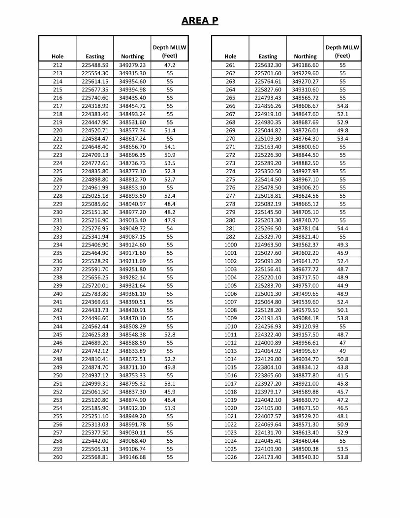
AREA P
Hole Easting Northing
Depth MLLW
(Feet) Hole Easting Northing
Depth MLLW
(Feet)
212 225488.59 349279.23 47.2 261 225632.30 349186.60 55
213 225554.30 349315.30 55 262 225701.60 349229.60 55
214 225614.15 349354.60 55 263 225764.61 349270.27 55
215 225677.35 349394.98 55 264 225827.60 349310.60 55
216 225740.60 349435.40 55 265 224793.43 348565.72 55
217 224318.99 348454.72 55 266 224856.26 348606.67 54.8
218 224383.46 348493.24 55 267 224919.10 348647.60 52.1
219 224447.90 348531.60 55 268 224980.35 348687.69 52.9
220 224520.71 348577.74 51.4 269 225044.82 348726.01 49.8
221 224584.47 348617.24 55 270 225109.30 348764.30 53.4
222 224648.40 348656.70 54.1 271 225163.40 348800.60 55
223 224709.13 348696.35 50.9 272 225226.30 348844.50 55
224 224772.61 348736.73 53.5 273 225289.20 348882.50 55
225 224835.80 348777.10 52.3 274 225350.50 348927.93 55
226 224898.80 348812.70 52.7 275 225414.50 348967.10 55
227 224961.99 348853.10 55 276 225478.50 349006.20 55
228 225025.18 348893.50 52.4 277 225018.81 348624.56 55
229 225085.60 348940.97 48.4 278 225082.19 348665.12 55
230 225151.30 348977.20 48.2 279 225145.50 348705.10 55
231 225216.90 349013.40 47.9 280 225203.30 348740.70 55
232 225276.95 349049.72 54 281 225266.50 348781.04 54.4
233 225341.94 349087.15 55 282 225329.70 348821.40 55
234 225406.90 349124.60 55 1000 224963.50 349562.37 49.3
235 225464.90 349171.60 55 1001 225027.60 349602.20 45.9
236 225528.29 349211.69 55 1002 225091.20 349641.70 52.4
237 225591.70 349251.80 55 1003 225156.41 349677.72 48.7
238 225656.25 349282.14 55 1004 225220.10 349717.50 48.9
239 225720.01 349321.64 55 1005 225283.70 349757.00 44.9
240 225783.80 349361.10 55 1006 225001.30 349499.65 48.9
241 224369.65 348390.51 55 1007 225064.80 349539.60 52.4
242 224433.73 348430.91 55 1008 225128.20 349579.50 50.1
243 224496.60 348470.10 55 1009 224191.43 349084.18 53.8
244 224562.44 348508.29 55 1010 224256.93 349120.93 55
245 224625.83 348548.38 52.8 1011 224322.40 349157.50 48.7
246 224689.20 348588.50 55 1012 224000.89 348956.61 47
247 224742.12 348633.89 55 1013 224064.92 348995.67 49
248 224810.41 348672.51 52.2 1014 224129.00 349034.70 50.8
249 224874.70 348711.10 49.8 1015 223804.10 348834.12 43.8
250 224937.12 348753.33 55 1016 223865.60 348877.80 41.5
251 224999.31 348795.32 53.1 1017 223927.20 348921.00 45.8
252 225061.50 348837.30 45.9 1018 223979.17 348589.88 45.7
253 225120.80 348874.90 46.4 1019 224042.10 348630.70 47.2
254 225185.90 348912.10 51.9 1020 224105.00 348671.50 46.5
255 225251.10 348949.20 55 1021 224007.57 348529.20 48.1
256 225313.03 348991.78 55 1022 224069.64 348571.30 50.9
257 225377.50 349030.11 55 1023 224131.70 348613.40 52.9
258 225442.00 349068.40 55 1024 224045.41 348460.44 55
259 225505.33 349106.74 55 1025 224109.90 348500.38 53.5
260 225568.81 349146.68 55 1026 224173.40 348540.30 53.8
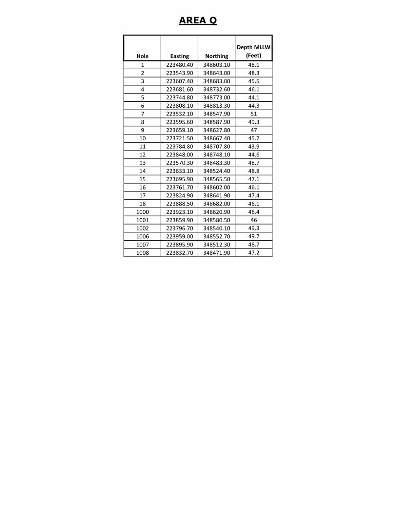
AREA Q
Hole Easting Northing
Depth MLLW
(Feet)
1 223480.40 348603.10 48.1
2 223543.90 348643.00 48.3
3 223607.40 348683.00 45.5
4 223681.60 348732.60 46.1
5 223744.80 348773.00 44.1
6 223808.10 348813.30 44.3
7 223532.10 348547.90 51
8 223595.60 348587.90 49.3
9 223659.10 348627.80 47
10 223721.50 348667.40 45.7
11 223784.80 348707.80 43.9
12 223848.00 348748.10 44.6
13 223570.30 348483.30 48.7
14 223633.10 348524.40 48.8
15 223695.90 348565.50 47.1
16 223761.70 348602.00 46.1
17 223824.90 348641.90 47.4
18 223888.50 348682.00 46.1
1000 223923.10 348620.90 46.4
1001 223859.90 348580.50 46
1002 223796.70 348540.10 49.3
1006 223959.00 348552.70 49.7
1007 223895.90 348512.30 48.7
1008 223832.70 348471.90 47.2


![rene kolman.ppt [מצב תאימות]events.eventact.com/Ortra/IAPH2012/rene kolman_ppt.pdf · Melbourne channel deepening project Quarry tests Specialised ripper draghead Lab tests](https://img.pdfslide.us/doc/110x75/5fc6d3ec599fae6c2503d100/rene-eventseventactcomortraiaph2012rene-kolmanpptpdf.jpg)