Embed Size (px)
Citation preview
Deepika Amonkar
Curriculum VitaePortfolio of academics and professional practice

DEEPIKA AMONKAR
Address: #02-3015, Blk 415, Commonwealth Avenue West, Singapore 120415Tel. no.: (+65) 83070312Email: [email protected]: Indian
I am an architect who has completed the Masters in Landscape Architecture at the National University of Singapore and awaiting my degree in July 2016. In 2011, I completed my Bachelor’s degree in Architecture from the University of Mumbai, India. Due to my interests, I attended and participated in workshops related to the different vernacular construction styles and techniques of India that encompassed the culture of indigenous people. After my undergraduate studies in architecture and three years of varied professional work and learnings, I yearned for a more holistic architectural exposure and hence pursued my Masters in Landscape Architecture. The projects and other academic experiences of my masters program have sensitized me to the importance of landscape solutions in today’s global world. I hope to have work opportunities that will enable me to integrate my architecture knowledge with sound landscaping concepts.
EDUCATION
2014-16
2006-11
National University of Singapore, School of Design and EnvironmentMasters of Landscape Architecture (MLA)Dissertation: The interrelationship between social inequality and theinequities of green space distribution in Mumbai.University of Mumbai, IES College of ArchitectureBachelors of Architecture (B. Arch)Dissertation: Design of a residential institute for orphaned children.
Singapore
India
WORK EXPERIENCE
Intern, Burega Farnell Landscape Architects• Conceptual landscape design for hotels and residential projects in
Zhuhai, Shanghai, Goa, Mumbai Architect, Arvind D’Souza Architects• Design development, construction drawings and site supervision
of houses in Goa based on vernacular architectureArchitect, Siddharth Menon Architect• Design development and working drawings based on traditional
and local building technologies for Yakshi Inter Generational Learning Centre, Telangana, India Architect, M/s Vilas Avachat & Associates• Design development, working drawings and construction drawings
of commercial and residential projects in Mumbai and other cities in India
Intern, Envirodesigners• Landscape design development, working drawings and construction drawings of government projects: Urban parks and gardens in Mumbai
Singapore
India
India
India
India
2015
2012-2014
2013-2014
2011-2012
2011
PERSONAL INTERESTS
• Competitive Running, Handball, Indian Classical Singing & Dance, Community Service
AWARDS & ACHIEVEMENTS
2016
2013 2009-2010 2008
2007-20082002-2003
Made an official presentation to the Municipal Commissioner of Udaipur as part of the Smart Cities program in IndiaSilver Medal, Panjim City Team, Goa State Athletics Meet, GoaMember of Student Council, I.E.S’s College of Architecture, MumbaiGSEN Trophy -Member, Annual National Association of Students of Architecture (NASA) Convention, N.I.T. Bhopal, Madhya PradeshTata scholarship for Academic Excellence, MumbaiGold Medal, Member, Girl’s Handball Team, Jamnabai Narsee School, Maharashtra School Sports Association (MSSA), Mumbai
COMPETENCIES
Computer Skills: Autodesk Sketch up Pro, AutocadAdobe Photoshop, Illustrator, IndesignMicrosoft Office (Word, Outlook, Powerpoint, Excel)
Languages: English, Hindi, Marathi
PROFESSIONAL AFFILIATIONS
From 2012
Council of Architecture, New Delhi
GRADUATE PROJECTS
2014201520152016
Blue PCN: Solution to green patch fragmentationLiving on the Slope:Holistic Approach for Social HousingInfrastructure for Paradise, Bunaken National Marine park Landscape design and Planning of Udaipur
Singapore Philippines IndonesiaIndia
WORKSHOPS AND TRAINING PROGRAMS
2016 2013
2011
2011
Chiba University hospital, Chiba• Workshop on Landscape Design.Sambhaavnaa Institute of Public Policies and Politics, Himachal Pradesh• One-week hands-on building program, production and use of adobe.Bamboo-n-man Associates, Shillong, Meghalaya• 10 day hands-on building program, Treatment and joinery of bamboo, Bamboo-n-man.Auroville, Tamil Nadu• Two-week intensive training course, production and use of compressed stabilized Earth Block.
Japan India
India
India


Academics
NATIONAL UNIVERSITY OF SINGAPORE
Blue PCN, SingaporeLiving On The Slopes, Philippines Infrastructure for Paradise, IndonesiaLandscape design and Planning of Udaipur, India
DissertationThe interrelationship between social inequality and the inequities of green space distribution in Mumbai.
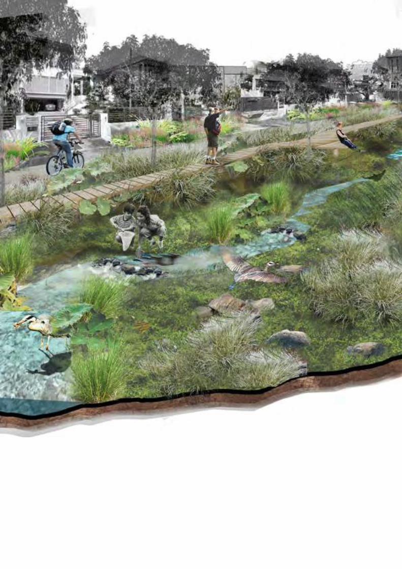
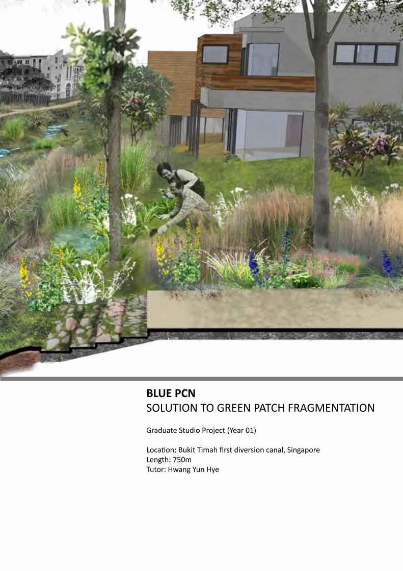
BLUE PCNSOLUTION TO GREEN PATCH FRAGMENTATION
Graduate Studio Project (Year 01)
Location: Bukit Timah first diversion canal, SingaporeLength: 750mTutor: Hwang Yun Hye
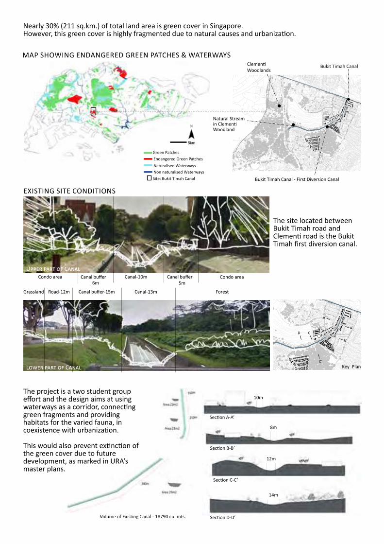
Nearly 30% (211 sq.km.) of total land area is green cover in Singapore. However, this green cover is highly fragmented due to natural causes and urbanization.
The project is a two student group effort and the design aims at using waterways as a corridor, connecting green fragments and providinghabitats for the varied fauna, in coexistence with urbanization.
This would also prevent extinction of the green cover due to future development, as marked in URA’s master plans.
Volume of Existing Canal - 18790 cu. mts.
Section A-A’
Section B-B’
Section C-C’
Section D-D’
10m
8m
12m
14m
The site located between Bukit Timah road and Clementi road is the Bukit Timah first diversion canal.
EXISTING SITE CONDITIONS
Canal-10m
Canal-13m ForestCanal buffer-15mRoad-12mGrassland
Condo area Canal buffer5m
Canal buffer6m
Condo areaUpper part of Canal
Lower part of Canal
A
BCD
D’ C’
B’
A’
Key Plan
Bukit Timah CanalClementiWoodlands
Natural Stream in Clementi Woodland
Bukit Timah Canal - First Diversion Canal
MAP SHOWING ENDANGERED GREEN PATCHES & WATERWAYS
Endangered Green PatchesGreen Patches
Naturalised WaterwaysNon naturalised WaterwaysSite: Bukit Timah Canal
5km
Wetlands along the stream
C
C
Stream
Floodplains
Hardscape
Riparian Extension
Pedestrian/ Cycling Path
Backyards
Future Residential Blocks
Wetlands
Swales
Courtyards/ Parks
Eroded banks
Grasslands for fast flowing waters
Existing HardscapeWatershed BoundaryRiparian Buffer
Existing urban green spaces
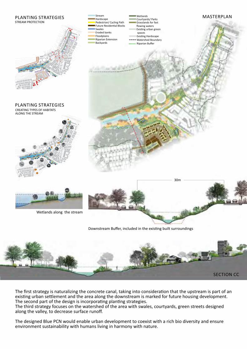
The first strategy is naturalizing the concrete canal, taking into consideration that the upstream is part of an existing urban settlement and the area along the downstream is marked for future housing development. The second part of the design is incorporating planting strategies. The third strategy focuses on the watershed of the area with swales, courtyards, green streets designed along the valley, to decrease surface runoff.
The designed Blue PCN would enable urban development to coexist with a rich bio diversity and ensure environment sustainability with humans living in harmony with nature.
MASTERPLAN
PLANTING STRATEGIES
PLANTING STRATEGIES
Section cc’
Section AA’
Section BB’
Urban Road
Stream StreamSwamp
Landed House Area Urban Road
RiparianExtention
Stream Steep SlopeBird Habitat
Urban Road
Landed House Area
SwampRiparianExtention
RiparianExtention
Reserved Woodland Urban Road
Landed House Area CreatedWoodland
Flood Plain Stream Swamp ReservedForest
Future Developement
rainwater collect swalealong the road
collect rainwater from the hill
pathway in woodland keep existing trees,
enrich the vegetation structure,add more animal attract
underground pipeto connect the waterway
Add birds attracting treesreplace the hedge by birds
attracting shrubskeep existing trees,
enrich vegetation structure
hedge integrated with rainwater collect swale
birds attracting trees
originalcanal arearainwater collect swale
along the road
hedge integrated with riparian habitat timber walkway
along streamplanting with long grassto provide birds habitat
collect rainwater from the hill
Trees for stabilizing the bank
swamp to collect rain waterand reserved for flood
rain water collect corridor
CREATING TYPES OF HABITATS ALONG THE STREAM
STREAM PROTECTION
SECTION CC
Downstream Buffer, included in the existing built surroundings
30m
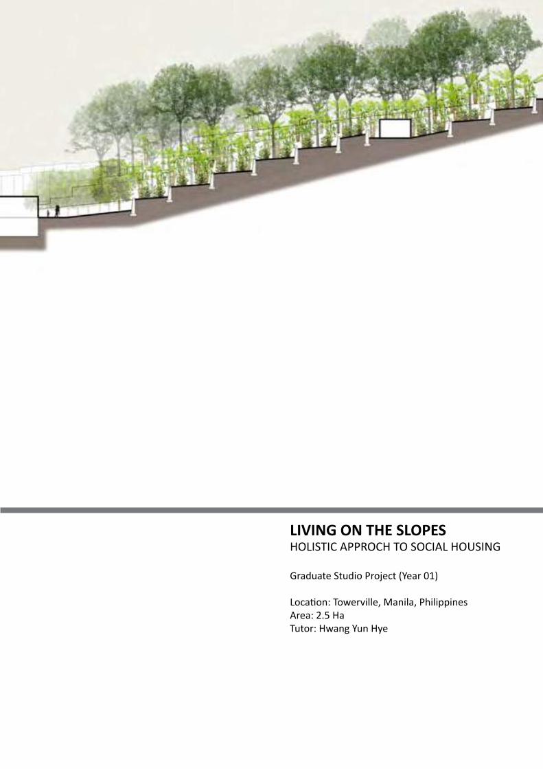
LIVING ON THE SLOPESHOLISTIC APPROCH TO SOCIAL HOUSING
Graduate Studio Project (Year 01)
Location: Towerville, Manila, PhilippinesArea: 2.5 HaTutor: Hwang Yun Hye
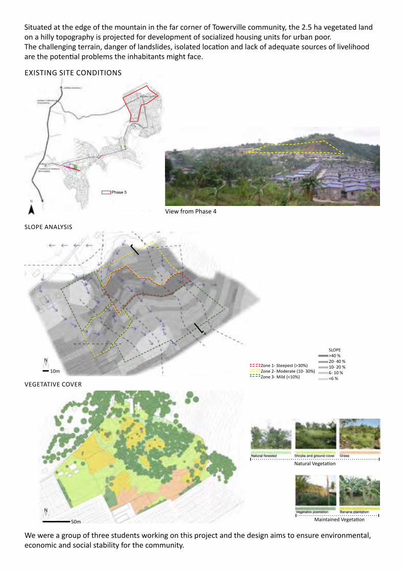
We were a group of three students working on this project and the design aims to ensure environmental, economic and social stability for the community.
Situated at the edge of the mountain in the far corner of Towerville community, the 2.5 ha vegetated land on a hilly topography is projected for development of socialized housing units for urban poor. The challenging terrain, danger of landslides, isolated location and lack of adequate sources of livelihood are the potential problems the inhabitants might face.
View from Phase 4
EXISTING SITE CONDITIONS
SLOPE ANALYSIS
VEGETATIVE COVER
Phase 5
A
A’
SLOPE>40 %20- 40 %10- 20 %6- 10 %<6 %
Zone 1- Steepest (>30%)Zone 2- Moderate (10- 30%)Zone 3- Mild (<10%)
N
10m
Natural Vegetation
50m Maintained Vegetation
N

15-18% slopeLimited Vehicular Axis
6-10% slopeComfortable Vehicular Axis
DEVELOPMENT OF LAYOUT - MODEL EXPERIMENTS
The steep areas of the site to be covered with vegetation to prevent erosionRoad as extension of existing roadsProductive open spaces punctuate the rows
Layout does not help with slope or water managementHousing at corner of plantation is isolated,fragments green cover
Built along contoursRoad and housing from corner ofplantation removedGreen patch consolidatedConnected open spaces between rows
Road too steep in some partsLayout does not help with slope or water management
Road as central spine to provide access, stabilize the land, manage stormwaterBuilt along contoursSteepness of road <10%
Central Spine
16.5% of houses in Phase 5 cannot be accessed by vehicles
Gentle Slope (<5%) Medium Slope (5-15%)
Com
fort
able
Veh
icul
ar A
xis
Steep Slope (>15%) Stepped street
Lim
ited
Vehi
cula
r Axi
s
N
10m
ANALYSIS OF ROADS OF PHASE 5
ANALYSIS OF PRODUCTIVE SPACES ANALYSIS OF SOURCES OF LIVELIHOOD
N
10m
House Within Towerville Household Outside
TowerviileExternal source
11
17
14
12
18
15
13
19
20
16
House
01
02
03
04
05
06
07
08
09
10
Within Towerville Household Outside
TowerviileExternal source
19% 26% 48% 7%
OUTDOOR ACTIVITIES Productive Use of Extension = 19.2% Non Productive Use of Extension = 80.8%
Street VendorsPlantations
CENTRAL SPINE OF PHASE 5
Retain green cover to reduce soil erosion
Allow infiltration of rainwater and reduce surface runoff
Check dams and terrac-es decrease velocity of runoff, preventing soil erosion
Long steep slope broken to form short terraces
SLOPE STABILIZATION STRATEGIESZo
ne 1
Retaing walls and houses help to hold the soilZo
ne 2
,3
Zone 3 Zone 1Schematic section A- A’
Zone 2
Existing terrain
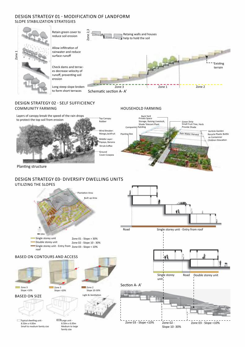
DESIGN STRATEGY 01 - MODIFICATION OF LANDFORM
DESIGN STRATEGY 02 - SELF SUFFICIENCYCOMMUNITY FARMING
Planting structure
Layers of canopy break the speed of the rain drops to protect the top soil from erosion Top Canopy:
Rubber
Wind Breaker: Mango,Jackfruit
Middle Layer: Papaya, BananaShrub:Coffee Ground Cover:Cowpea
8.0mx8.0m
1.2m0.6m
Small Fruit Tree, HerbProvide Shade
Green Strip Private SpaceStorage, Raising Livestock,Shade Tolerant Plant
Back Yard
Verticle GardenRecycle Plastic Bottle as ContainnerChildren Education
Water Drump
Rain Water Harvest
Irrigate the Garden
Planting Box
Companion Palnting
DESIGN STRATEGY 03- DIVERSIFY DWELLING UNITSUTILIZING THE SLOPES
Single storey unitDouble storey unitSingle storey unit - Entry from roof
Zone 01 - Slope > 30%Zone 02 - Slope 10 - 30%Zone 03 - Slope < 10%
Zone 1
Plantation Area
Built up Area
Zone 2
Zone 2
Zone 3
Zone 3
N
10m
A
A’
Zone 03 - Slope <10%Zone 02 - Slope 10 -30%
Zone 03 - Slope <10%
Section A- A’
Single storey unit
Double storey unitRoad
Single storey unit - Entry from roofRoad
BASED ON CONTOURS AND ACCESS
Zone 3 Slope >10%
Zone 3 Slope >10%
Zone 2 Slope 10-30%
3.00m
Light & Ventilation
Typical dwelling unit - 8.50m x 4.00mSmall to medium family size
Large unit - 8.50m x 6.00mMedium to large family size
BASED ON SIZE
HOUSEHOLD FARMING
Existing Dwellings
Road
Road
The first design strategy aims to modify the landform strategically to prevent soil erosion and landslides, ensuring safety for residents and to make everyday navigation through the settlement comfortable. The second strategy helps to diversify sources of livelihood by creating multiple business models for the community to ensure self-sufficiency. The objective of the third strategy is to provide liveable housing units that are sensitive towards the con-tours while achieving the density of built. This new model proposes a holistic approach for future development on sloping terrains.
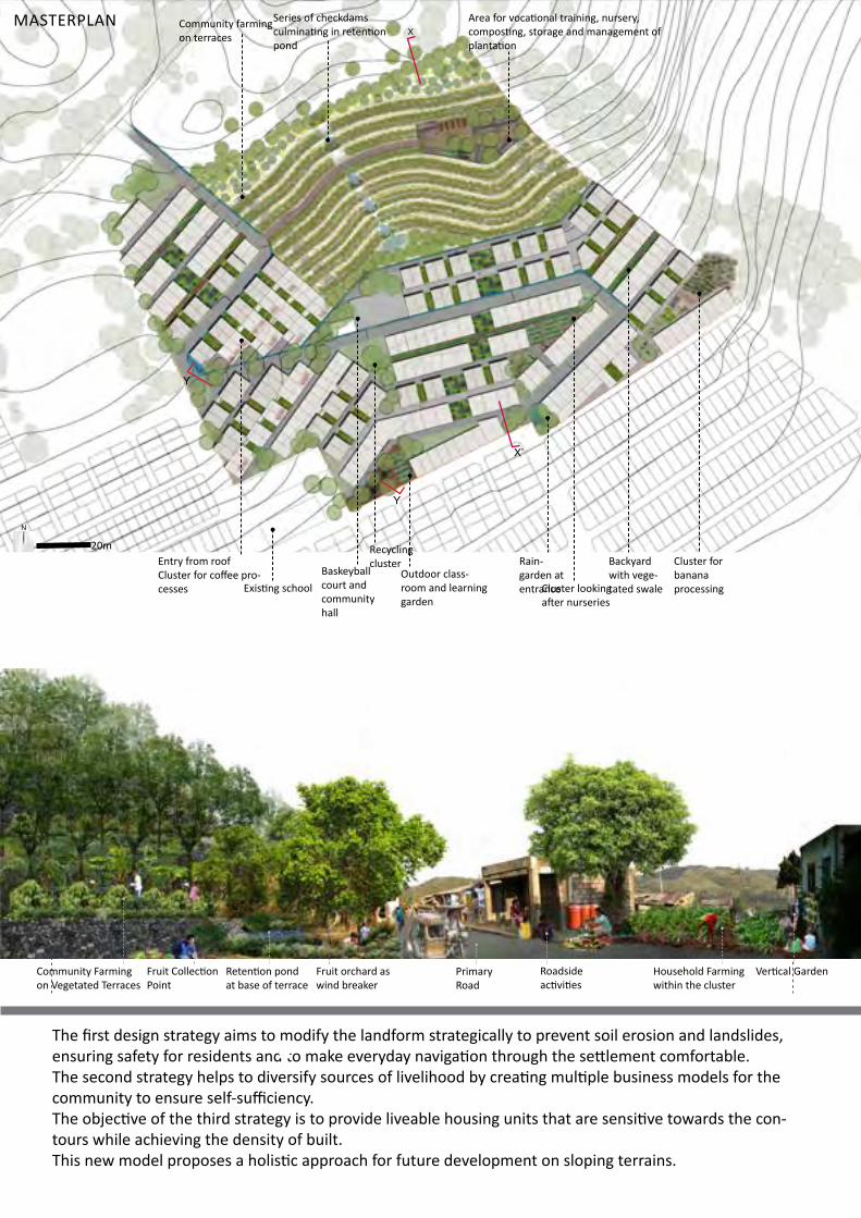
MASTERPLAN
N
20mRain-garden at entranceCluster looking
after nurseries
Cluster for banana processing
Series of checkdams culminating in retention pond
Recycling clusterEntry from roof
Cluster for coffee pro-cesses Existing school
Community farming on terraces
Backyard with vege-tated swale
Area for vocational training, nursery, composting, storage and management of plantation
Outdoor class-room and learning garden
Baskeyball court and community hall
X’
X
Y
Y
SECTION YY
Community Farming on Vegetated Terraces
Retention pond at base of terrace
Fruit Collection Point
Fruit orchard as wind breaker
Primary Road
Roadside activities
Household Farming within the cluster
Vertical Garden
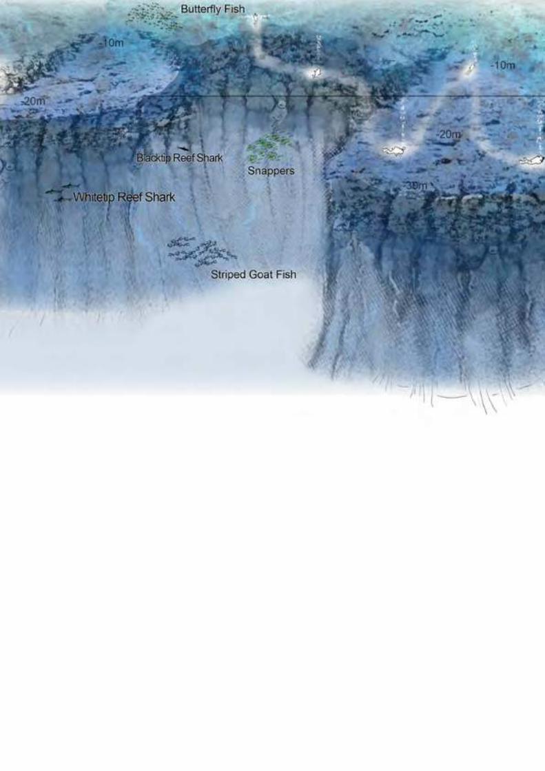
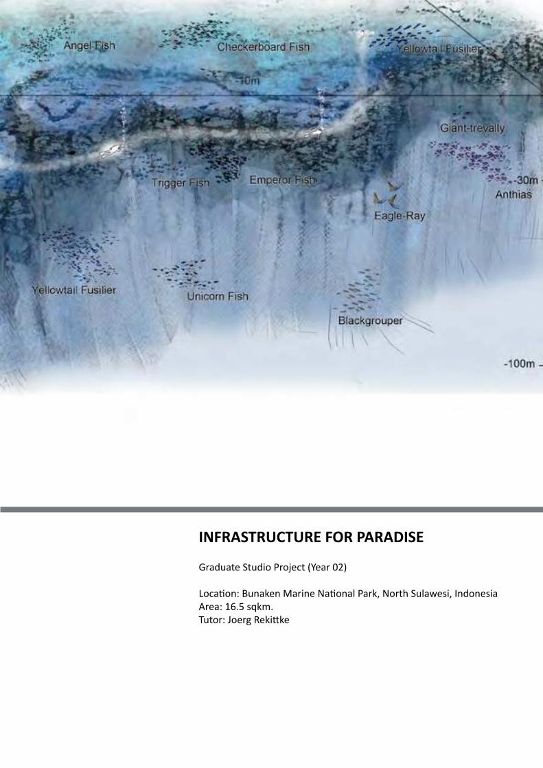
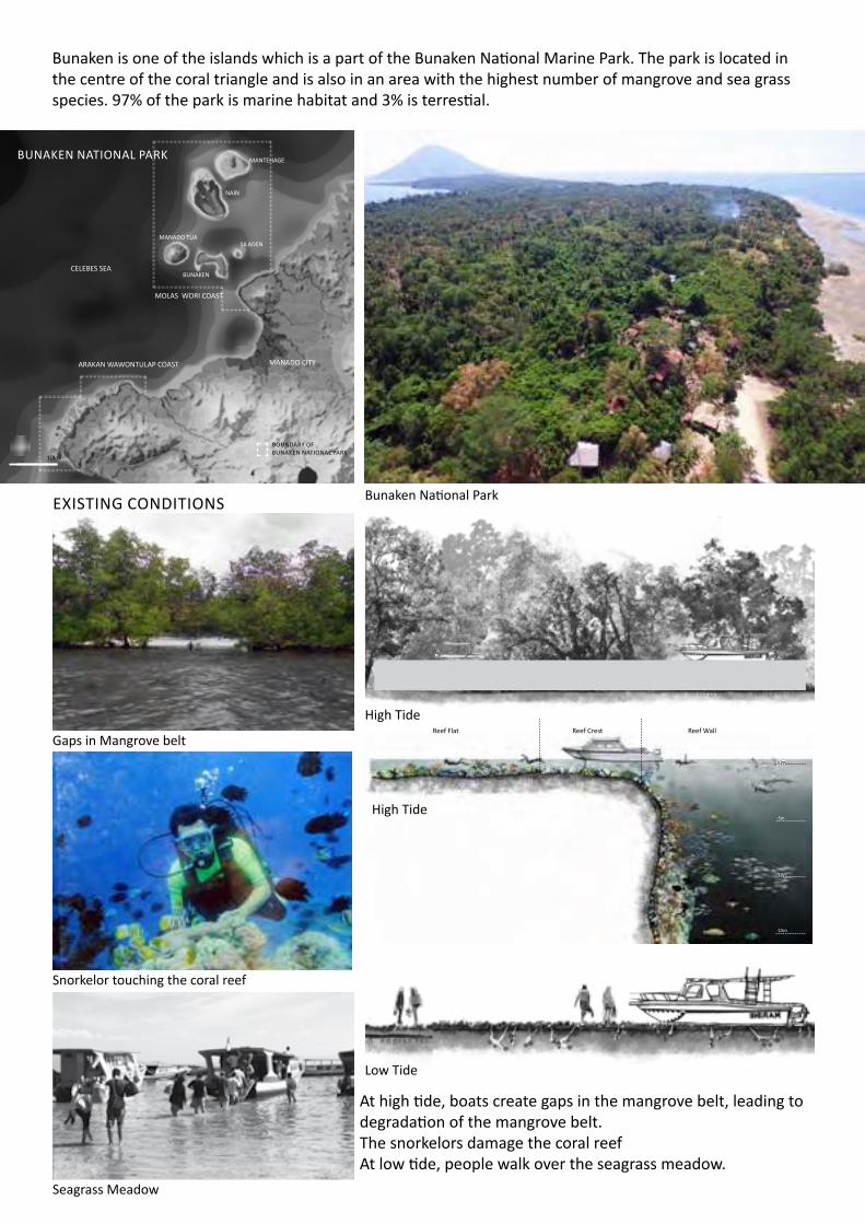
INFRASTRUCTURE FOR PARADISE
Graduate Studio Project (Year 02)
Location: Bunaken Marine National Park, North Sulawesi, IndonesiaArea: 16.5 sqkm.Tutor: Joerg Rekittke
MOVEMENT PATTERN IN A DAY
BUNAKEN NATIONAL PARK
ARAKAN WAWONTULAP COAST
CELEBES SEA
BOUNDARY OF BUNAKEN NATIONAL PARK
MOLAS WORI COAST
MANADO TUA
MANTEHAGE
NAIN
SILADEN
BUNAKEN
MANADO CITY
10km
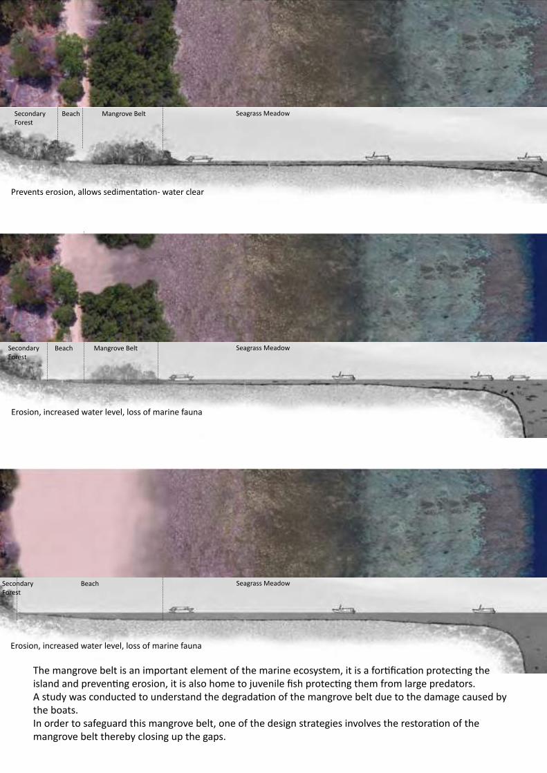
Bunaken is one of the islands which is a part of the Bunaken National Marine Park. The park is located in the centre of the coral triangle and is also in an area with the highest number of mangrove and sea grass species. 97% of the park is marine habitat and 3% is terrestial.
Bunaken National ParkEXISTING CONDITIONS
Gaps in Mangrove belt
Snorkelor touching the coral reef
Seagrass Meadow
At high tide, boats create gaps in the mangrove belt, leading to degradation of the mangrove belt.The snorkelors damage the coral reefAt low tide, people walk over the seagrass meadow.
Reef Flat Reef Crest Reef Wall
-5m
-10m
-15m
±0m
High Tide
High Tide
Low Tide
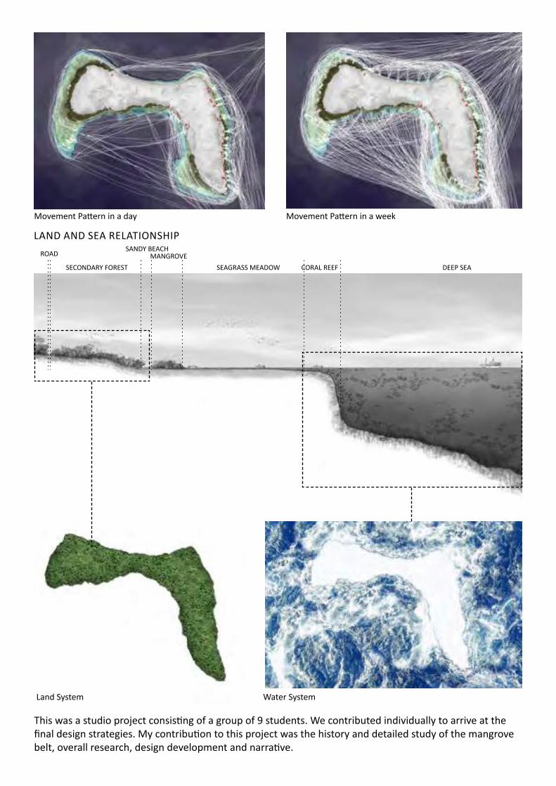
This was a studio project consisting of a group of 9 students. We contributed individually to arrive at the final design strategies. My contribution to this project was the history and detailed study of the mangrove belt, overall research, design development and narrative.
MANGROVESANDY BEACH
ROAD
SECONDARY FOREST SEAGRASS MEADOW CORAL REEF DEEP SEA
Land System
Movement Pattern in a day Movement Pattern in a week
LAND AND SEA RELATIONSHIP
Water System
Secondary Forest
Beach Mangrove Belt Seagrass Meadow
Prevents erosion, allows sedimentation- water clear
Beach Mangrove Belt Seagrass MeadowSecondary Forest
Erosion, increased water level, loss of marine fauna
Beach Seagrass MeadowSecondary Forest
Erosion, increased water level, loss of marine fauna
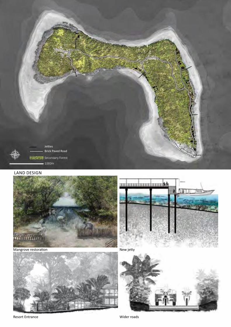
The mangrove belt is an important element of the marine ecosystem, it is a fortification protecting the island and preventing erosion, it is also home to juvenile fish protecting them from large predators. A study was conducted to understand the degradation of the mangrove belt due to the damage caused by the boats. In order to safeguard this mangrove belt, one of the design strategies involves the restoration of the mangrove belt thereby closing up the gaps.

Mangrove restoration
Nursery
128 saplings2m
2.5m
1.5m
2m
Bamboo fence
Sonneratia
Rhizophora
50m
500 Sq.mt.
10m
Existing mangrove beltPotential mangrove restoration sitesSelected site
The restoration of mangroves requires a series of steps which include:1. Site selection2. Identification of mangrove species3. Site analysis4. Design a restoration plan5. Monitoring the site
Site Selection Gap in mangrove to be restored
Identification of mangrove species Site analysis
3000mm
2000mm
Brick Paved Road Jetties
Mangrove restoration
Resort Entrance
New jetty
Wider roads
LAND DESIGN
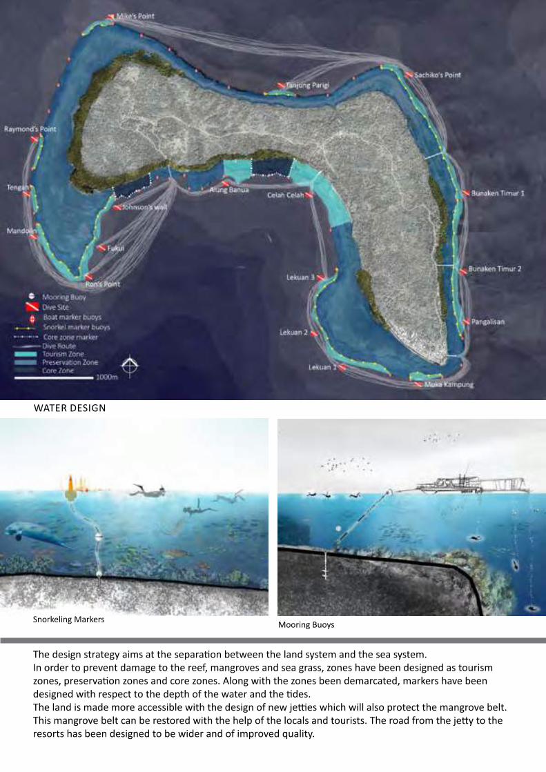
The design strategy aims at the separation between the land system and the sea system.In order to prevent damage to the reef, mangroves and sea grass, zones have been designed as tourism zones, preservation zones and core zones. Along with the zones been demarcated, markers have been designed with respect to the depth of the water and the tides.The land is made more accessible with the design of new jetties which will also protect the mangrove belt. This mangrove belt can be restored with the help of the locals and tourists. The road from the jetty to the resorts has been designed to be wider and of improved quality.
Mooring BuoysSnorkeling Markers
WATER DESIGN

LANDSCAPE DESIGN AND PLANNING OF UDAIPUR
Graduate Studio Project (Year 02)
Location: Udaipur, IndiaArea: 37 sqkm.Tutor: Herbert Dreiseitl
Freiburg Bachle, Germany
An example from Freiburg, Germany where the open drains still exist as part of the old historic city.
The black, grey & rain water from the houses and streets within the walled city are carried through open drains
Open DrainsOpen Drains
3m
Downtake pipe for rain water from terrace
Black & grey waterfrom bathrooms/kitchens
Bathroom/Kitchen
Bathroom/Kitchen
TerraceTerrace
Bathroom/Kitchen
Bathroom/KitchenStreet
Bathroom/Kitchen
Bathroom/Kitchen
DISCHARGE OF RAIN WATER & GREY WATER WITHIN WALLED CITY
Udaipur is a city located in Rajasthan, a state that lies in north west India which is known as the city of lakes surrounded by the Aravalli hills.
The broad topics studied in the studio were the water system, traffic and mobility and quality of open spac-es within the walled city.
India
Udaipur
LakeFateh sagar
Lake Pichola LakeUdai SagarAyad River
Walled city
Udaipur has been chosen as one of the first 20 cities in India to be developed as part of the Smart Cities Program launched to improve the quality of life of the citizens. The walled city in Udaipur is the selected area to implement the smart cities program.
Flow of water along houses
Black & grey water from bathrooms/kitchensRain water from terraces
Flow of water through tertiary drains
The water system of Udaipur consists of the lakes and the river.
The project focusses on the existing flow of black, grey and rain water from the walled city into the water system (lakes and river) and proposes relevant treatments.
Freiburg Bachle, Germany Walled city, Udaipur

SwaroopSagar
Lake Pichola
Ayad RiverFlow of water through primary drains from city into Ayad river
SwaroopSagar
Lake Pichola
Ayad River
580m
577m
588m
579m
578m
579m
590m
591m
588m
611m
605m 581m
574m
580m583m
586m
569m
576m
579m
568m
570m
Flow of water outside walled city
Flow of water within walled city
Flow of water around walled city
500m
N
500m
N
Open drains within walled city
Closed drains outside walled city
Closed drain
Mechanical treatment of water
Cleansing Biotopes
EXISTING FLOW OF WATER FROM WALLED CITY
PROPOSED TREATMENT OF WATER FROM WALLED CITY TO RIVER
At the house scale, the black water must be separated from the grey and rain water.
Within the walled city in order to enhance the catchment system of rain and grey water, the existing open drainage system which is integrated with the city and its people must be upgraded.
Proposed mechanical treatment of grey and rain water within and around the walled city before the water flows from the open drains into the closed drains and natural treatment like cleansing biotopes to treat the water before being discharged into the river.
Existing black, grey and rain water flow into the Ayad river without treatment, thus polluting the river.
- Isolated Gate- Limited amount of pedestriansed areas- Problem of crossing from gate to old city+ Road width 24m (sufficient vehicular movement)
+ Gate a part of old city+ Sufficient pedstrianised areas+ No problem in crossing - Road width 10m (Limited vehicular movement)
- Isolated gate+ Sufficient pedstrianised areas- Problem in crossing from gate to old city+ Road width 15m (sufficient vehicular movement)
Option 02Option 01 Option 03
SidewalksParkingMarketsTemple
Drop offLandscaped areasArea in front of gateArea behind gateArea without shadeVehicular movementPedestrian movement
Delhi Gate
Heritage sitesInstitutionsMarkets
Walled city
500m
N
50m
N
Delhi Gate
Traffic flow within walled cityTraffic flow outside walled cityAreas of conflicts
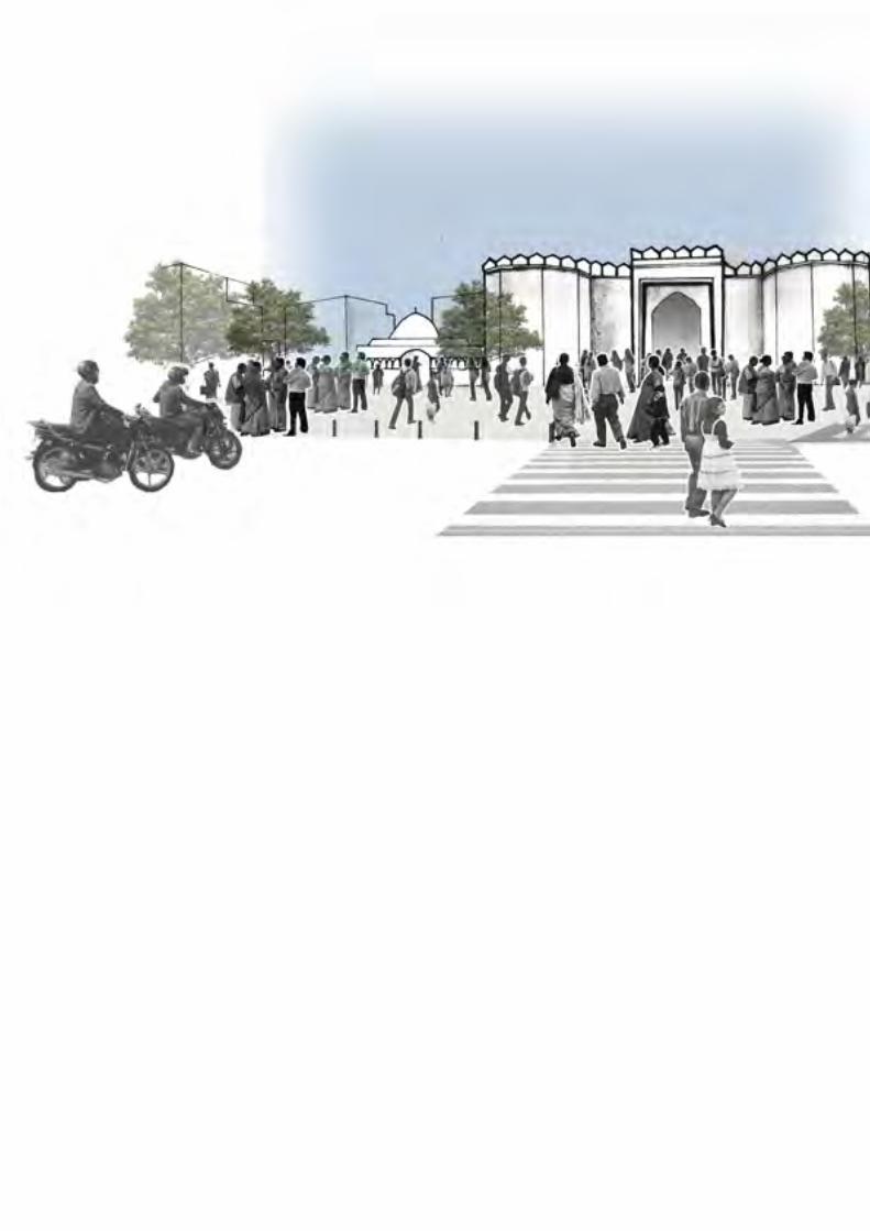
The Delhi Gate demarcates the north east boundaries of the walled city. It is so named as it faces Delhi, the capital of India, towards the north.
Option 2 was proposed for organization of traffic.
After the study of the existing site and traffic conditions, shade and sun analysis, designated spaces for markets, parking, drop offs, green open spaces for recreation have been proposed.
The existing conflict of pedestrianised and vehicular movement has been resolved by proposing zebra crossing and sidewalks along the existing buildings
EXISTING SITE CONDITIONS
EXISTING TRAFFIC CONDITIONS
ORGANIZATION OF TRAFFIC
SPACE DESIGN
Delhi gate stands isolated by wide roads
Conflict between pedestrian and vehicular movement
4 wheeler parkingDriveway
Green open spaces for school
Seating below Ficus religiosa
Cultural activities Vehicular
roadsMixed use streets
Drop off
Zebra crossing
SidewalksGreen TrafficIsland
Flower vendor near temple
Vendors
Vendors under the shade of Azadirachta indica
2 wheeler parking
50m
N
Pedestrian crossing from drop off provided to minimize conflict between vehicular & pedestrian movement
Mixed use streets
Seating provided below trees
Temple Vendors under the shade ofAzadirachta indica
Eateries along the plaza
Pedestrianised areas to act as multi functional spaces for cultural activities, recreation & relaxation
MASTERPLAN
The Delhi Gate was historically the entry into the walled city and is a heritage structure but now stands isolated and forgotten.In this project, the Delhi Gate has been restored as the festive entrance into the old city and the open spaces around Delhi Gate are designed to be multifunctional community spaces which are pedestrian friendly with spaces for recreation, cultural activities and social gatherings.Through the design approaches the project aims at improving the liveability of open spaces in the city of Udaipur.I was selected and made an official presentation of our work to the Municipal Commissioner of Udaipur as part of the Smart Cities program in India on the 14th of April, 2016.


DISSERTATIONThe interrelationship between social inequality and the inequities of green space distribution in Mumbai.
Tutor: Hwang Yun Hye
The aim of this project is to study the relationship of the amount and type of green spaces in Mumbai and social demographics in the city in order to understand the inequities of urban green space distribution with respect to the different strata of society.
This study has three objectives. • To study the urban green space distribution in Mumbai both at a macro -city scale and micro - ward and neighborhood scale. • To study the social demographics in the city through the property value of the residential area in each ward • To study the relationship between urban green spaces and social demographics in the city.
In this study, the following questions are addressed:1. What are the types of green spaces and their significance in the city of Mumbai?2. Is there a relationship between the property value and the amount of urban green spaces in each ward?
In this study, the relationship of the urban green spaces and socio demographics in Mumbai was studied at two scales – macro (city) scale and micro (ward, neighborhood) scale.• The property value of the residential areas that represents the different socio economic groups in vari-
ous wards was compared with the two different types of urban green spaces.• Data was collected using land use maps of Mumbai prepared by the Municipal Corporation of Greater
Mumbai, open street map, high resolution satellite images, cloud free Landsat Images of 2011 for the study area and were downloaded from www.landsatlook.usgs.gov.
• ArcGIS was used for the processing of images and preparation of the Normalized Difference Vegetation Index (NDVI) map.
Ward wise social demographics is a predictor of the urban green space distribution in Mumbai
Worldwide, urbanization has resulted in the use of land space to accommodate the increasing population in cities at the expense of urban green spaces.
Mumbai, a city along the western coast of India is the financial and commercial city of the nation.
It is highly populated with a population of 19 million in an area of 468 sq.km. and this number is only increasing like other cities in the world.
The development of Mumbai has neglected it’s green spaces, in fact the urban green spaces have been sacrificed in the development process.
The city has a distinctive social fabric which given the circumstances of the city strongly reflects the gap between the rich and the poor.
AIM
HYPOTHESIS
OBJECTIVES
RESEARCH QUESTIONS
METHODOLOGY
This study could help policy makers in the planning and development of urban green spaces in Mumbai, thus enabling both environmental sustainability and high quality of life for all the residents irrespective of socio economic status.
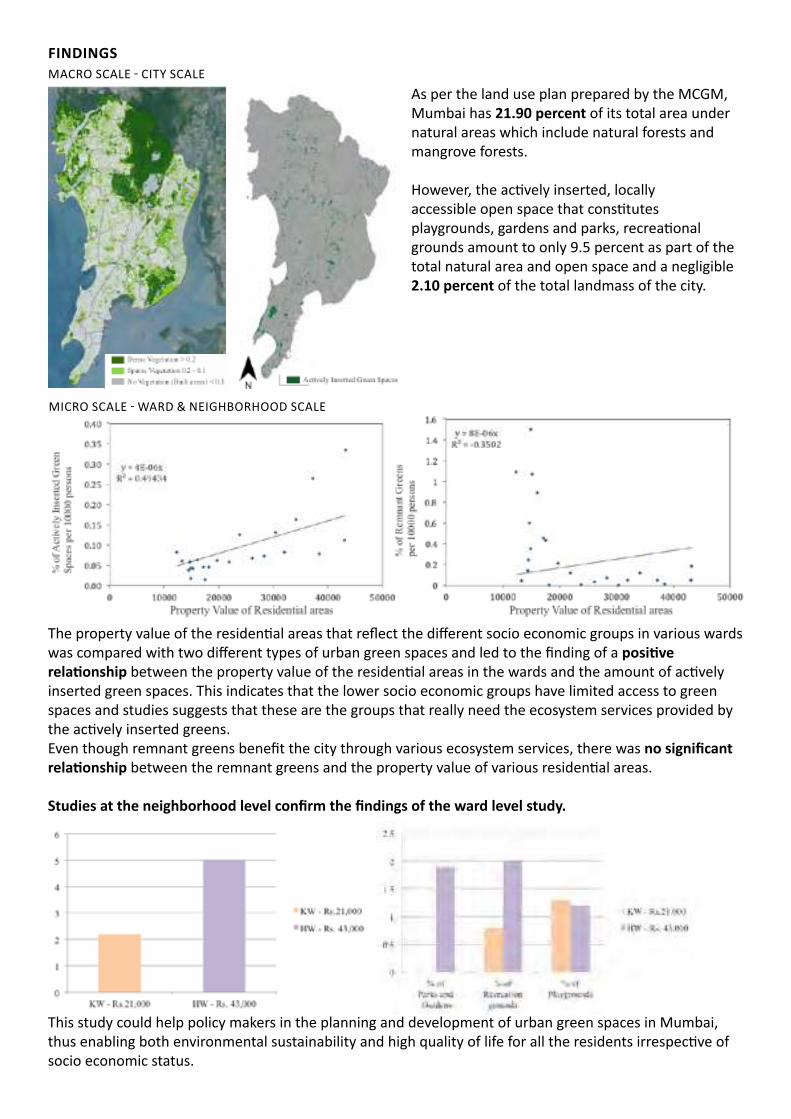
FINDINGSMACRO SCALE - CITY SCALE
MICRO SCALE - WARD & NEIGHBORHOOD SCALE
The property value of the residential areas that reflect the different socio economic groups in various wards was compared with two different types of urban green spaces and led to the finding of a positive relationship between the property value of the residential areas in the wards and the amount of actively inserted green spaces. This indicates that the lower socio economic groups have limited access to green spaces and studies suggests that these are the groups that really need the ecosystem services provided by the actively inserted greens. Even though remnant greens benefit the city through various ecosystem services, there was no significant relationship between the remnant greens and the property value of various residential areas.
Studies at the neighborhood level confirm the findings of the ward level study.
As per the land use plan prepared by the MCGM, Mumbai has 21.90 percent of its total area under natural areas which include natural forests and mangrove forests.
However, the actively inserted, locally accessible open space that constitutes playgrounds, gardens and parks, recreational grounds amount to only 9.5 percent as part of the total natural area and open space and a negligible 2.10 percent of the total landmass of the city.


Professional
WATERFRONT PARKS AND GARDENSMUMBAI, INDIA
SHYAMJI KHATU DHARMASHALAJAIPUR,INDIA
VILLA AT MOIRAGOA, INDIA
YAKSHI INTER GENERATIVE CENTRETELANGANA,INDIA
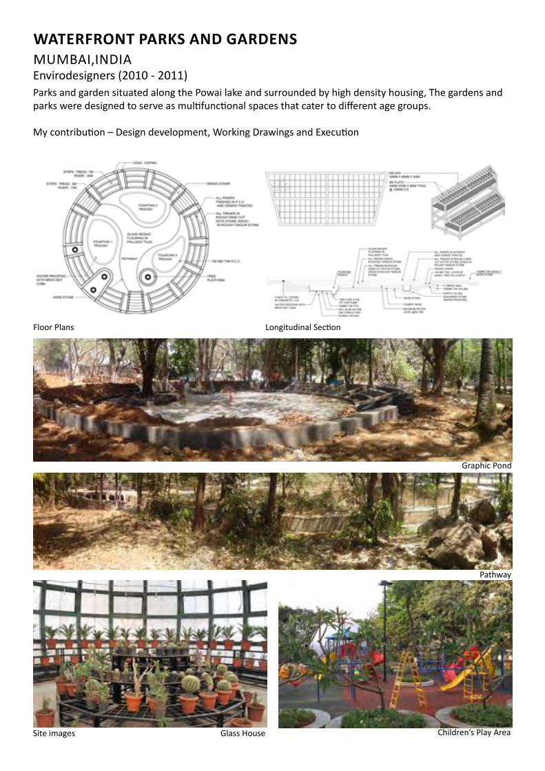
WATERFRONT PARKS AND GARDENSMUMBAI,INDIAEnvirodesigners (2010 - 2011)Parks and garden situated along the Powai lake and surrounded by high density housing, The gardens and parks were designed to serve as multifunctional spaces that cater to different age groups.
My contribution – Design development, Working Drawings and Execution
Site images Glass House Children’s Play Area
Graphic Pond
Pathway
Floor Plans Longitudinal Section

Dharmashala ia the the famous pilgrimage location of “ Shyamji Khatu” in Rajasthan.The dharmashala is equipped with dormitories, halls, conference rooms for pilgrims as well as local tourists
My contribution – Design development, Working Drawings and Execution
SHYAMJI KHATU DHARMASHALAJAIPUR, INDIAM/s Vilas Avachat & Associates (2011 - 2012)
Site images
Longitudianl Section
Floor Plans
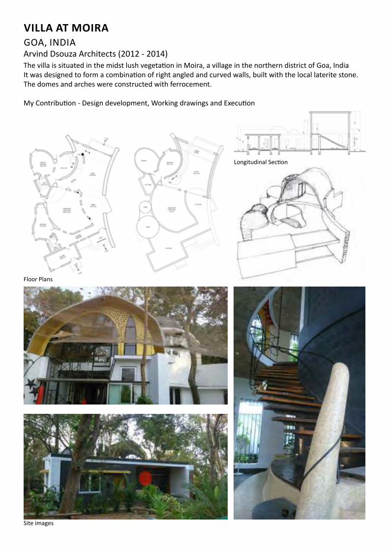
The villa is situated in the midst lush vegetation in Moira, a village in the northern district of Goa, IndiaIt was designed to form a combination of right angled and curved walls, built with the local laterite stone. The domes and arches were constructed with ferrocement.
My Contribution - Design development, Working drawings and Execution
Floor Plans
Site images
Longitudinal Section
VILLA AT MOIRAGOA, INDIAArvind Dsouza Architects (2012 - 2014)
Floor Plans
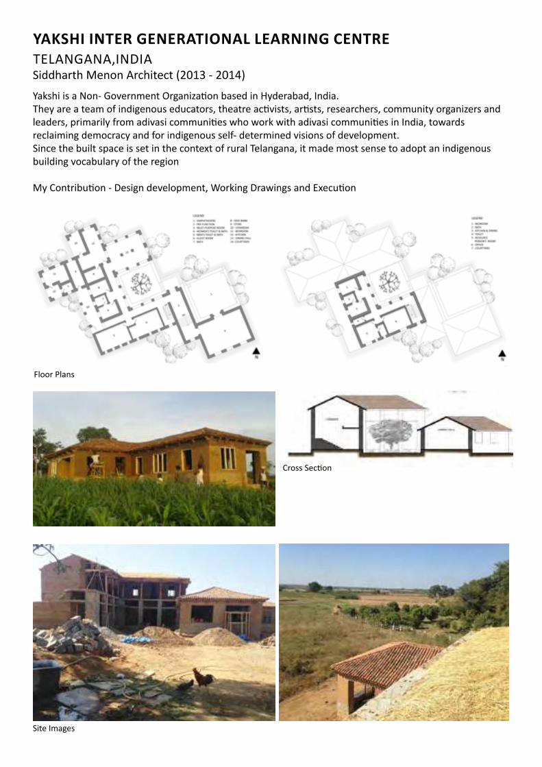
Yakshi is a Non- Government Organization based in Hyderabad, India. They are a team of indigenous educators, theatre activists, artists, researchers, community organizers and leaders, primarily from adivasi communities who work with adivasi communities in India, towards reclaiming democracy and for indigenous self- determined visions of development. Since the built space is set in the context of rural Telangana, it made most sense to adopt an indigenous building vocabulary of the region
My Contribution - Design development, Working Drawings and Execution
YAKSHI INTER GENERATIONAL LEARNING CENTRETELANGANA,INDIASiddharth Menon Architect (2013 - 2014)
Site Images
Cross Section