Embed Size (px)
Citation preview

Decoding the Mediterranean salinity crisis
WILLIAM B. F. RYANLamont-Doherty Earth Observatory of Columbia University, Palisades, NY 10964, USA(E-mail: [email protected])
ABSTRACT
This historical narrative traces the steps to unravel, over a span of 40 years, an
extraordinary event in which 5% of the dissolved salt of the oceans of the
world was extracted in a fraction of a million years to form a deposit more than
1 million km3 in volume. A buried abyssal salt layer was identified with
reflection profiling and sampled during the Deep Sea Drilling Project, Leg 13.
The dolomite, gypsum, anhydrite and halite in the drill cores paint a
surprising picture of a Mediterranean desert lying more than 3 km below the
Atlantic Ocean with brine pools that shrank and expanded by the evaporative
power of the sun. The desert drowned suddenly when the Gibraltar barrier
gave way. The explanation of ‘deep-basin, shallow-water’ desiccation and
the notion of a catastrophic Zanclean flood had a mixed reception. However,
the hypothesis became broadly accepted following subsequent drilling
expeditions. Nevertheless, as experts examined the evaporate facies and
sequences of equivalent age in the terrestrial outcrops, weaknesses appeared in
the concept of repeated flooding and drying to account for the magnitude of the
deposits. The ‘Rosetta Stone’, used to decipher conflicting interpretations,
turns out not to be the deposits but the erosion surfaces that enclose them.
These surfaces and their detritus – formed in response to the drop in base level
during evaporative drawdown – extend to the basin floor. Evaporative
drawdown began halfway through the salinity crisis when influx from the
Atlantic no longer kept up with evaporation. Prior to that time, a million years
passed as a sea of brine concentrated towards halite precipitation. During the
later part of this interval, more than 14 cyclic beds of gypsum accumulated
along shallow margins, modulated by orbital forcing. The thick salt on the
deep seabed precipitated in just the next few cycles when drawdown
commenced and the brine volume shrank. Upon closure of the Atlantic
spillway, the remnants of the briny sea transformed into salt pans and
endorheic lakes fed from watersheds of Eurasia and Africa. The revised model
of evaporative concentration now has shallow-margin, shallow-water and
deep-basin, deep-water precursors to desiccation.
Keywords Desiccation, evaporates, Lago-Mare, Mediterranean, Messinian,salt.
INTRODUCTION
A vast salt deposit beneath the floor of theMediterranean (Fig. 1) was not in itself a surpriseat the time of the first deep-sea drilling in 1970.Seismic reflection profiles already had revealeddiapiric structures (Fig. 2) similar to salt domes(Hersey, 1965; Ryan et al., 1971). Six of the Deep
Sea Drilling Project (DSDP) Leg 13 sites weretargeted specifically to understand the distribu-tion of the salt (Mauffret, 1970; Montadert et al.,1970; Auzende et al., 1971), its cover of ‘M’reflectors (Biscaye et al., 1972) and its lateralunconformity on margins. Yet, less was knownabout either the age or the process by which thesalt had formed.
Sedimentology (2009) 56, 95–136 doi: 10.1111/j.1365-3091.2008.01031.x
� 2009 The Author. Journal compilation � 2009 International Association of Sedimentologists 95

The Gessoso Solfifera Formation in Sicily hasabundant gypsum and salt. Ogniben (1957) attrib-uted its origin to isolation of the Mediterraneanfrom the Atlantic during the Late Miocene. Itsbrackish to freshwater Paratethyan fauna intro-duced the concept of a pan-Mediterranean Salin-ity Crisis (MSC) (Selli, 1960; Decima, 1964;Ruggieri, 1967).
As to the mechanisms of ocean floor saltformation, there were two popular models:(i) deposition in shallow, subsiding and isolatedrift valleys as continents split apart (Pautot et al.,1970); or (ii) precipitation in deep depressionsseparated from an external ocean by an entrancebar (Schmalz, 1969). The first is called the‘shallow-water, shallow-basin’ model and thesecond the ‘deep-water, deep-basin’ model (Hsu,1972a,b, 1973; Hsu et al., 1973a,b).
However, those embarking on the GlomarChallenger drill ship were unaware of a 1 kmdeep incision of a fluvial network extending fromthe Mediterranean to more than 300 km into theinterior of France. This downcutting, described ina publication about the Rhone Valley by Denizot(1952), would contribute to the birth of a thirdmodel – the ‘shallow-water, deep-basin’ model.To account for the river incision, Denizot wrote:‘‘There was a regression of the sea at the end ofthe Miocene … with the connecting passageways
across Spain and Morocco closed and the Gibral-tar Strait not yet opened … the Mediterranean atthat moment completely isolated … reduced to alagoon and evolving independently according toclimatic influence … there was a drop in sea level… following the Strait of Gibraltar opened … thesea invaded the fluvial network’’ (translation byM.B. Cita in Clauzon, 1973).
A similar deep fluvial incision had also beenfound in Egypt (Chumakov, 1967, 1973) wheremarine deposits of Pliocene age indicated that thesea had invaded a 1200 km artery notched intothe interior of Africa during the MSC. Whilesearching for oil in Libya in the late 1960s,geophysicists chanced upon yet other fossildrainage systems of Late Miocene age reachingfar inland before disappearing under the SaharaDesert (Barr & Walker, 1973).
DISCOVERIES FROM THE FIRST DEEP-SEA DRILLING
Ubiquitous erosion
Introduction to the Mediterranean sub-sea ar-chive of the MSC begins 100 km east of theGibraltar Strait (Ryan et al., 1973). Here, in theAlboran Basin, the Glomar Challenger sampled
Fig. 1. Distribution today of the Messinian-age salt and evaporites, locations of drill sites from which materials orintersected unconformities related to the MSC, and locations of margin settings discussed in the text were recovered.
96 W. B. F. Ryan
� 2009 The Author. Journal compilation � 2009 International Association of Sedimentologists, Sedimentology, 56, 95–136

through a subsurface unconformity that is wide-spread throughout the Mediterranean. Pliocenemarl was found on a surface, truncating signifi-cantly older Miocene marl. Momentary bouncingof the drill string hinted at a hard ground or lagdeposit along the contact. The marl above andbelow was deposited in a setting similar to thepresent bathymetry. The gap corresponded tohundreds of metres of the pre-MSC Miocene sea
floor washed from a pathway descending east-ward from the Gibraltar Strait to the edge of theabyssal salt layer in the North Algerian Basin(Olivet et al., 1973).
In the Valencia Trough, the same erosionsurface was encountered as in the Alboran Sea.However, at the transition from slope to troughfloor, the surface here splits into two horizons:one channelling the top of the evaporites and salt
“M” reflectors
“N” reflectors
Sea floor
Salt dome
5 km
0
1
2
3
2·55
3·60
4·15
5·00
6·00
I
II
III
7·00
3·00
Flowing salt layer
Dep
th b
elow
sea
sur
face
(km
)
Sec
onds
two-
way
trav
eltim
e su
b-bo
ttom
5 km
4
5
Products of margin erosion
3·6
5·0
I
II
III
“M”
“N”
Flowing salt layer
Tw
o-w
ay tr
avel
tim
e (s
ec)
Dep
th b
elow
sea
sur
face
(km
)
A
B
Fig. 2. (A) Reflection profile in the Balearic Basin of the Western Mediterranean showing the flowing salt layer(yellow) covered by the ‘M’ Reflectors (red) and underlain by the ‘N’ Reflectors (green), adapted from Ryan (1973).The salt (‘couche fluante’ of Montadert et al., 1970) deforms under the weight of its cover to produce anticlines andsalt domes. Unit I is Pliocene to Pleistocene in age and spans the past 5Æ33 Myr. Unit II represents the MSC with aduration of only 0Æ63 Myr. Unit III encompasses the early pre-evaporite Messinian and reaches back to the Burdi-galian stage of the Miocene epoch at ca 22 Ma. Other letters correspond to the notations used by other researchgroups. (B) Nearby profile closer to the margin showing a wedge of chaotic strata (blue) sandwiched between the ‘N’Reflectors and the flowing salt layer. This deposit is interpreted as detritus eroded from the margins. The GlomarChallenger sampled only the ‘M’ reflectors.
Decoding the Mediterranean salinity crisis 97
� 2009 The Author. Journal compilation � 2009 International Association of Sedimentologists, Sedimentology, 56, 95–136

(Pautot et al., 1973) and the other truncating thestrata directly underneath the salt. The twosurfaces merge over bedrock volcanoes protrud-ing through the salt (Mauffret, 1970; Mauffretet al., 1973).
The first sample of MSC deposits was a sur-prise. It consisted of thick gravel from a channelon the upper erosion surface. The lack of a firmmud matrix prevented further drilling. The gravelhad just four components: (i) basalt; (ii) MiddleMiocene biogenic limestone; (iii) dwarfed shal-low-water molluscs and benthonic foraminifera(Ammonia beccarii, Elphidium macellum) alongwith a lone shark tooth; and (iv) fragments ofselenite. Without having to drill further, materialfrom the volcanoes was recovered, as were theirpelagic cover, an evaporating lagoon, the remainsof creatures that lived there in waters of unusualsalinity and the streambed that had brought themtogether. The evaporating lagoon and its strangefauna belonged to the strata sandwiched betweenthe two erosion surfaces.
Fresh to brackish water
Fortunately, deeper coring into this sandwicheddeposit was possible at the foot of the south-eastmargin of the Balearic Islands. Recovery beganwith 25 m of barren dolomitic marls possessingthin beds of laminated, siliceous and bituminousmud (Fig. 3A) that hosted diatoms, silicofla-gellates, ebridians, archaeomonads, phytolithariaand sponge spicules (Dumitrica, 1973a,b,c; Hajos,1973). Identical fauna had once thrived in a vastlake sea (‘lac mer’ or ‘Lago-Mare’) spread acrossEastern Europe and Western Asia during theMiocene. According to Hajos (1973): these ‘‘taxacharacteristic of stagnant brackish and land-locked salinas and lagoons are present in suchgreat numbers as to suggest reduced salinity,shallow water depth, and a landlocked environ-ment’’. It became obvious that these unexpectedsediments in deep Mediterranean basins be-longed to a salinity crisis of gigantic proportions.
The diatoms were predominantly littoral plank-tonic forms accompanied by freshwater, eury-haline, benthonic and epiphytic species inconsiderable numbers to indicate episodes ofsunlight illuminating a lakebed. The dolomiticmarls also contained sand layers with detritalgypsum (Fig. 3B), reworked foraminifera of mixedages in allochthonous interbeds and occasionaldwarfed specimens of Globigerina, Globigerinitaand Globorotalia of Late Miocene age. Some bedswere pure detrital gypsum. The dolomitic marls
passed downward to laminated anhydrite con-sisting of the typical laminated ‘balatino’ facies(Fig. 3C) of the Gessoso Solfifera Series in Sicilywith tiny nodules of anhydrite (Fig. 3D) in layersseparated by dark laminae (Fig. 3E), interpretedby some researchers as the remains of algal mats(Ogniben, 1957; Hardie & Eugster, 1971; Decima &Wezel, 1973; Friedman, 1973). The anhydriteoccurred in cyclic beds, a metre to several metresin thickness. Each anhydrite bed was separatedby more dolomitic marl with freshwater fauna/flora in thin bituminous layers. As coring contin-ued, the anhydrite beds became nodular (Fig. 3F)and then massive with a chicken-wire texture. Atleast five cycles of dolomitic marl and anhydritewere encountered in the 70 m drilled. Nodularanhydrite, especially with the chicken-wire lat-tice structure, is considered by numerous expertsto be indicative of subaerial diagenesis of softmaterial in which the nodules are formed bydisplacement growth within the host sediment(Murray, 1964; Friedman, 1973; Schreiber, 1973),although some researchers believe that it can formin varied subaqueous environments (Hardie &Lowenstein, 2004).
Sabkhas
Following the discovery of modern nodular andchicken-wire anhydrite in supratidal flats of thePersian Gulf, it had been accepted generally thatthe environment of formation is the subaerialcapillary zone above the groundwater table of thecoastal sabkha (Shearman, 1966; Shearman &Fuller, 1969). The wavy and crinkly texturesmay have formed on an exposed algal mat-coatedtidal flat as suggested by Hardie & Eugster (1971)for similar beds in the Gessoso Solfifera Series inSicily. However, an important observation is theremarkable lateral continuity over many tens ofkilometres of individual reflectors that corre-spond to the dolomitic marl–anhydrite cycles.
The significance of a cyclic deposit that coveredlarge areas of the nearly flat Balearic Basin floorbut was absent on the steeper slopes was consid-ered. Could the landscape have resembled aDeath Valley with ephemeral salt lakes on itsfloor? Did the cyclic mud indicate periodicflooding followed by desiccation of the lakes tocause the alteration of original laminated an-hydrite to nodular and chicken-wire textures inthe shallow subsurface of its shores? Were theallochthonous components derived from slopesthat had become exposed? Maiklem (1971) coinedthe phrase ‘evaporative drawdown’ for this
98 W. B. F. Ryan
� 2009 The Author. Journal compilation � 2009 International Association of Sedimentologists, Sedimentology, 56, 95–136

process that left evaporites of shallow-waterorigin on the floor of an originally deep andsubsequently nearly completely dried depression.Maiklem’s proving ground was the Elk PointBasin of mid-Devonian age in Western Canada.
Divides
If salt precipitation in the Mediterranean tookplace only beneath a thin layer of brine, how didthe Atlantic supply of salt water travel beyondthe closest depression in the Mediterranean andcontinue over interior divides to other depres-sions more distal from the Atlantic that yetcontain salt layers as thick as those in the vicinityof the Atlantic portal? The crest of the Mediter-ranean Ridge in the Ionian Sea was one suchbarrier where reflection profiles revealed only athin MSC deposit that turned out to be mostlydolomitic marl of the same type found betweenthe anhydrite beds in the Balearic Basin andcontaining diatoms of both fresh and brackishwater. A rip-up conglomerate suggested an epi-sode of possible exposure. A nearby cleft incisedthrough the thin MSC deposits provided theopportunity to reach pre-Messinian strata. Thismaterial contained foraminifera representative of
a fully marine bathyal setting except that thespecies in the cleft drill cores were slightly olderthan those recovered from the pre-MSC strata inthe Alboran Sea. Did the absence of substantialamounts of anhydrite or gypsum on the barriercrest confirm that anhydrite, gypsum and haliteonly formed on basin floors; or had originallythick deposits covered the whole seabed but wereeroded from the high region during subsequentevaporative drawdown?
In the Hellenic Trench on the Aegean Sea sideof the Ridge barrier, unusually elevated salinities(> 150&) were discovered in the interstitialwaters squeezed from the cores. It meant thatsubsurface salt was indeed present there and thatthe brine sea had to have been sufficiently deep totransport solutes across the Ridge divide. Hence,in order to feed interior basins with brine, theconcept of repeated filling and drying of theMediterranean took shape (Hsu, 1973; Hsu et al.,1973a,b).
Lakes
On the flank of the Strabo Mountains, anassemblage of ostracods (Cyprideis pannonica)and benthonic foraminifera (Ammonia beccarii
B C
D E F
A
Fig. 3. Photographs of MSC deposits recovered by deep-sea drilling from the Upper Evaporites at the base of theMenorca margin in the Western Mediterranean. (A) Finely laminated dark, euxinic mud hosting freshwater diatoms.(B) Detrital gypsum with ripple-induced cross-bedding. (C) Laminated ‘balatino’ primary anhydrite interpreted asseasonal cycles of precipitation. (D) Thin-section image showing the radial growth of anhydrite laths that create thetiny anhydrite spheres. (E) Thin-section image of dark organic material between wavy anhydrite laminae. (F) Dis-placement growth of large anhydrite nodules that initiate the ‘chicken-wire’ texture. Black scale bars are 1 cm. Whitescale bars are 1 mm.
Decoding the Mediterranean salinity crisis 99
� 2009 The Author. Journal compilation � 2009 International Association of Sedimentologists, Sedimentology, 56, 95–136

tepida) adaptive to the hypohaline milieu (Ben-son, 1973a,b) was discovered. An identicalassemblage appears in the topmost GessosoSolfifera Series in Sicily where it has beencorrelated to the ‘lac mer’ fauna of the Paratethys(Decima, 1964; Ruggieri, 1967; Ruggieri & Sprov-ieri, 1974, 1976). Conclusive evidence of theabrupt drowning of lakes and exposed land atthe conclusion of the MSC was obtained duringdrilling in the Tyrrhenian Sea where silty clayrich in pollen and spores and mud with fresh-water fauna were covered abruptly by deep-seamarine oozes.
Salt at last
The massive salt deposit that had proven elusiveuntil the very last drill site of the expedition wasright where the reflection profiles placed it – inthe deep confines of the Balearic Basin. Thebanded halite consists of couplets comprisingthick light layers and thin dark layers, with theindividual bands ranging from a few millimetresto 40 mm in thickness. The halite crystals areeuhedral in shape (Fig. 4A). These so-called‘cubic hopper crystals’ (Delwig, 1955) have abun-dant fluid inclusions that make them appearcloudy when viewed in thin sections comparedwith their inclusion-free translucent rims. Thehalite bands are subaqueous cumulates resultingfrom precipitation at the brine–air interface. Thedark layers are predominantly without rims andthe lighter layers have sizable clear rims sugges-tive of overgrowth as brine chemistry changed,perhaps on a seasonal basis. The crystals withclear rims are interlocked in the deposit, indicat-ing a process of growth occurring on or within theseabed. Although cumulates themselves are not
water-depth diagnostic, intercalations of detritalsilt and sand display eroded top surfaces. Shrink-age had cracked one such layer of silt and sandinterbedded within the halite (Fig. 4B). Theabsence of any mud matrix and the compositionof the salt matrix suggest transport of the sand bywind and settling in brine dissolved from primarybischofite (i.e. magnesium chloride). The topsurface is split by a crack filled with clear halitecement (Fig. 4C) and interpreted as evidence ofnearly complete basin desiccation (Hsu, 1972a,b;Hsu et al., 1973c).
Terminal flood
The flooding that ended the MSC was permanent.The overlying biogenic ooze of Early Pliocene agepossesses an assemblage of benthonic foramini-fera (including Oridosalis unbonatus) living innormal sea water and in a bathyal setting (Ben-son, 1973a; Cita, 1973, 1975). The abrupt passagefrom Lago_Mare deposits below to Pliocene oozeabove was recovered at three drill sites (Western,Central and Eastern Mediterranean). The pres-ence of the marine ostracod species Agrenocy-there pliocenica suggests water depths greaterthan 1 km and bottom water temperatures near8 �C (Benson, 1972, 1973b).
Key findings from the first drilling
• Elements belonging to the MSC have fauna andfeatures indicative of intermittent shallow andoccasionally subaerial environments, as well asperiodic deeper subaqueous environments andsalinities ranging from hypersaline to slightlybrackish.
A B C
Fig. 4. Photographs of halite from the Balaeric Basin at the foot of the Sardinia margin. (A) Large and semi-opaquehopper crystals with brine inclusions sampled from the light bands. (B) Banded translucent halite above a sand layertruncated by erosion and expanded by a desiccation crack (arrow). (C) Thin-section image showing halite in thedesiccation crack ‘d’ in the form of clear crystals without inclusions. Black scale bar is 1 cm. White scale bars are1 mm.
100 W. B. F. Ryan
� 2009 The Author. Journal compilation � 2009 International Association of Sedimentologists, Sedimentology, 56, 95–136

• The great variability in the isotope measure-ments and brine chemistry informs about settingsthat fluctuated from salty brine seas to driedplayas. Freshwater from rain and streams leftsignatures in the negative carbon and oxygenisotope values of the carbonates (Lloyd & Hsu,1973). However, the crystallization water in thesulphate must have been supplied originally froman Atlantic source (Fontes et al., 1973).
• The recovered MCS sediments are sand-wiched between deep-water marine sediments.
• The recovered anhydrite, gypsum and dolo-mitic marl are all younger than the abyssal saltlayer.
• The salt layer is present today in depressionsthat were in existence at the time of the MSC.
• The dolomitic marl with its diatom-richbituminous mud belongs to a brackish andfreshwater terminal stage of the salinity crisis asdescribed previously by Ruggieri (1967). SomeMediterranean lakes were more than a kilometredeep, submerging the Mediterranean Ridge andleaving shorelines on the Strabo Mountains.
• The MSC ended by an abrupt and permanentdrowning of lakes, their shores and their terres-trial margins, by marine water pouring in from theAtlantic.
INITIAL RECEPTION TO THEDESICCATION HYPOTHESIS
As stated by Hsu et al. (1973b), ‘‘the idea that anocean the size of the Mediterranean could actu-ally dry up and leave a big hole thousands ofmeters below worldwide sea level seems prepos-terous indeed’’. So it was anticipated that, when adesiccation hypothesis was presented in 1973 to170 other researchers attending a colloquiumheld in Utrecht, titled Messinian Events in theMediterranean, the announcement would createquite a controversy. A ‘dry Mediterranean’ pre-sented insurmountable conflicts with other inter-pretations for the origin of its evaporites (Drooger,1973). The first objection voiced at the collo-quium was to the ‘big hole’. For example, itseemed less outrageous to dry up Messiniandepressions ‘only 200 to 500 m deep’ (Nesteroff,1973). Consequently, it was proposed that thepost-MSC bathymetry came about by collapse ofthe sea floor (‘effondrement’) following the MSC(Leenhardt, 1973).
The issue of a ‘big hole’ did not have to beuntenable. The ocean crust imaged beneath thefloor of the Mediterranean by seismic refraction
and reflection (Le Pichon et al., 1971; Ryan et al.,1971; Finetti & Morelli, 1972) and displayingmagnetic anomaly stripes (Bayer et al., 1973) hadbeen formed by volcanic eruptions and dykeinjections during sea floor spreading at a diver-gent plate boundary. Ocean crust forms along theaxis of the mid-ocean ridges typically at depthsbelow 2Æ5 km. Sea floor spreading centres areeven deeper in back-arc basins. Furthermore,ocean crust subsides as its lithosphere cools andcontracts. The Balearic and Tyrrhenian Seas werealready being discussed as back-arc basins (Boc-caletti & Guazzone, 1974). The Eastern Mediter-ranean was a remnant of the Mesozoic Tethys(Dewey et al., 1973), with slivers of its oceaniccrust and upper mantle cropping out in Cyprus.
Nonetheless, the issue of depth needed to bequantified in order to be convincing. In a presen-tation in Utrecht, Ryan (1973) discussed recentcommercial exploration in the Gulf of Lions wherean extensive erosion surface had again beenrecognized. Similar to the gap in the AlboranSea, erosion separated marine Miocene fromoverlying Early Pliocene strata. The horizon inthe Gulf of Lions was littered with gravel belong-ing to fluvial and alluvial deposits. The non-marine interval did not receive wide attentionuntil it was pointed out by Delteil and co-workersin 1972 (at a meeting of the Mediterranean ScienceCommission (CIESM) in Athens) that this surfacewas the equivalent of Reflector ‘M’ and thaterosion continued all the way downslope andbeyond the edge of the salt layer (Fig. 5A).
Presumably, the drastic change in base level inthe Mediterranean that led to incisions of theRhone and Nile river valleys and occasionaldeserts on the floor of the Balearic Basin had alsoled to washing of the sediment from the marginof Europe. The boreholes in the Gulf of Lions(Cravatte et al., 1974) were the evidence necessaryto calculate the magnitude of the base-level drop.Ryan (1976) and Watts & Ryan (1976) tackled thissubject by developing a method called ‘backstrip-ping’. The key assumption was that the mantlebelow the rifted southern edge of France cooledby the same conductive heat loss as observed inthe mantle beneath the mid-ocean ridge. Thus, seafloor subsided in proportion to its age as the con-sequence of thermal contraction. Placing the onsetof subsidence at 25 Ma based on the borehole dataand using the sediment thickness for each bore-hole as a starting point, the sediment cover wasremoved (stripped away) back through time.
Lithosphere rebounds from unloading. Thedepth of basement at any time in the past
Decoding the Mediterranean salinity crisis 101
� 2009 The Author. Journal compilation � 2009 International Association of Sedimentologists, Sedimentology, 56, 95–136

corresponds to the water layer thickness plus theamount of sediment that had accumulated (takinginto consideration the effects of subsequent com-paction). In this manner, a succession of ancientsea floor profiles across the Gulf of Lions werecomputed and compared with estimates frommicrofossils.
The calculations of Ryan (1976) of sea floordepths in the Gulf of Lions just prior to the MSCturned out to be of the same magnitude asestimated by Cravatte et al. (1974) based onmicrofossils. As much as 1Æ5 km of pre-Messiniansediment had been removed from the outer edge ofthe margin during the MSC. When stripping awaythe entire Plio-Quaternary sediment cover fromthe interior shelf to the edge of the bathyal plain,calculations indicated that erosion had reached to3Æ1 km below the surface of the external Atlanticprior to the deposition of the flowing salt layer(Fig. 5B). After the terminal flood, the landwardedge of the salt and evaporites lay at 2Æ7 km below
the earliest Pliocene sea surface. Later computa-tions that accounted for the stretching of conti-nental lithosphere during rifting (Steckler &Watts, 1980) confirmed these results. Indepen-dently, Clauzon (1982) used the magnitude of theincision of the Messinian Rhone canyon to dem-onstrate a base level at least as deep as 1Æ6 km in adry Mediterranean (i.e. without water and theensuing subsidence caused by the water load).The depth, indicated by Clauzon, of 2Æ5 km priorto the salinity crisis for a location at the landwardedge of evaporites compares favourably with the2Æ7 km calculation of Ryan (1976).
Yet the confirmation of a ‘big hole’ only made itmore incredible that the Mediterranean couldactually ‘dry up’. Water mass budgets and mate-rial-balance considerations show that, with themodern rate of excess evaporation relative towater input from rivers and rain, the Mediterra-nean could theoretically be empty in 10 000 yearsif severed completely from the Atlantic. However,
“M”2·3
3·5
4·8
7·5
0
1
2
3
4
5
6
7
Evaporites and flowing salt layer
A
B
Bedrock
Erosion surface
0
1
2
3
4
3·1 km
3·6
2·9
2·3
Exploration boreholes
2·7 km
Plio-Quaternary
Miocene
50 km
50 km
1·5 kmAmount of sediment removed by erosion
Dep
th b
elow
sea
sur
face
(km
)
Dep
th b
elow
sea
sur
face
(km
)T
wo-
way
trav
el ti
me
(sec
)
Fig. 5. (A) Tracing of a reflection profile from the shelf-edge in the Gulf of Lions to the floor of the Balearic abyssalplain. Oblique arrows mark successive truncations of pre-MSC sediments by the intra-Messinian erosion surface (theline marked ‘M’). Erosion extends under the salt layer to a level around 4Æ5 km. Salt flowage has disrupted thePliocene–Quaternary cover. (B) Reconstructed sea floor profiles across the Gulf of Lions margin from the mid shelf tothe abyssal plain using the method of ‘backstripping’. The shaded area illustrates the thickness of pre-MSC sedimentremoved from the margin by erosion. The curves represent the present sea floor and the calculated pre-MSC and post-MSC sea floor profiles. The calculations reveal that erosion reached to 3Æ1 km below the level of the external Atlantic.After water returned with the Pliocene flood, the ‘pinch-out’ of the salt and evaporite layer lay 2Æ7 km below the seasurface. Redrawn from Ryan (1976). Note that the profile at the top corresponds only to the right half of the profile atthe bottom.
102 W. B. F. Ryan
� 2009 The Author. Journal compilation � 2009 International Association of Sedimentologists, Sedimentology, 56, 95–136

one Mediterranean volume of water at Atlanticsalinity would produce only a few tens of metresof salt. So the second consistent objection to thedesiccation hypothesis voiced at Utrecht was therepeated filling necessary to account for the largevolume of the salt layer. How many times in factdid the Mediterranean dry up and refill?
Although the DSDP drilling encountered fivecycles of dolomitic marl and anhydrite, there wasno indication that the Mediterranean had everrefilled to its brim until after the MSC. Cita (1973)cautioned that the sparse, dwarfed foraminiferalassemblage in the dolomitic marl of the DSDPcores represented abnormal conditions, not openmarine. Cita’s view that the ‘‘Mediterraneanevaporates are essentially sterile of marine fos-sils’’ was supported strongly by Decima & Sprov-ieri (1973) in their study of the time-equivalentlast seven marl levels in the Gessi di PasquasiaFormation in Sicily. These authors found that allthe so-called marine foraminifera were reworked.The only autochthonous species were the freshand brackish water Cyprideis and A. beccariitepida. All other microfossils were preservedbadly. Shells were broken, partly dissolved andstained by red iron oxides. Furthermore, theassemblages were inconsistent in stratigraphicdistribution from sample to sample. Many specieswere already extinct. In the words of Decima andSprovieri: ‘‘the presence of brackish water envi-ronments in basins situated in a distal part of theMediterranean makes it impossible to realize adirect connection with the Atlantic Ocean duringthe Late Messinian’’.
Without such connections, from where did thewater come? According to Drooger (1973), whowas probing the weakness of the deep basindesiccation model: ‘‘The refilling, how did itwork? … Filling up to the brim asks for anenormous and rapid water displacement against acontinuous evaporation loss, and the more sowith every meter … why did [the Atlantic water]scour a permanent entrance only the last time? …the more completely we suppose it desiccatedmany times during the Messinian, the moreremarkable the fact that the obstructing barrierwas not demolished well before the Pliocene’’.
ALTERNATE EXPLANATIONS NOTREQUIRING DESICCATION
The hypothesis of repeated filling and desiccationcreated many difficulties for those familiar withMessinian deposits on land. The aforementioned
Gessoso Solfifera Series is widespread throughoutthe Central Sicilian Basin (also referred to as the‘Caltanissetta Basin’). The Central Sicilian Basinis a foredeep caught in a convergent tectonicsetting between the Hyblean Plateau to the southand the Madonie and Nebrodi Mountains to thenorth. Salt is encountered rarely in outcrop andis, therefore, investigated more systematically inmines and boreholes.
Across all of the Central Sicilian Basin, anunconformity separates the Gessoso SolfiferaSeries into lower and upper evaporite deposits(Decima & Wezel, 1971, 1973). The lower groupstarts with pre-MSC diatomaceous sediment(Tripoli Member) passing upwards to carbonates(Calcare di Base Member), the primary evaporitescomprising of the Cattolica Gypsum Beds fol-lowed by gypsum turbidites, an anhydrite brecciaand then halite belonging to the main salt body.The halite is truncated by the unconformity.Above is the upper group, sometimes called the‘Terminal Series’ that consists of the PasquasiaGypsum Beds capped by a sand and conglomerateextant over the whole of Central Sicily (Arenazz-olo Formation). The Gessoso Solfifera Series,including its members truncated by erosion, istransgressed by the open marine Trubi Formationof Early Pliocene age. The onset of the Trubi istime-equivalent to the calcareous marls with theacme of Sphaeroidinellopsis recovered in a drillcore from the Tyrrhenian Sea (Cita, 1973, 1975).The absence of benthonic microfossils in the veryfirst ‘Trubi’ pelagic sediments and the successionof their appearances support the assumption of acomplete sterilization of the Mediterranean dur-ing the MSC (Cita & Gartner, 1973).
At Utrecht, Richter-Bernburg (1973) pointedout that the Calcare di Base is a ‘semi-salinecarbonatic sediment’. Richter-Bernburg observedcavernous features caused by dissolution of saltwith cube-shaped ghosts of halite crystals whichwere thought to be formed in a water mass thatwas already highly concentrated with brine. TheCalcare di Base was not present everywhere. Forexample, it formed only on the north-east andsouth-west elevated rims of the central troughwhere it reached a thickness of 50 m. Much of theSicilian Calcare di Base is now breccia linked tosolution collapse (karst formation) after emer-gence. Subsequent investigators measured theoxygen and carbon isotopic compositions of thecarbonate and have related the negative values tothe influx of meteoric water (Decima et al., 1988).These same investigators have described beddingplanes with desiccation cracks and rip-up clasts
Decoding the Mediterranean salinity crisis 103
� 2009 The Author. Journal compilation � 2009 International Association of Sedimentologists, Sedimentology, 56, 95–136

and conclude: ‘‘The Calcare di Base is primarily alimestone formed in hypersaline waters in theperipheral portions of the Cattolica Basin’’.
Richter-Bernburg (1973) noted that this BasalLimestone passed down the slope to ‘‘gypsummasses of several hundreds of metres in thick-ness’’. The gypsum overlapped the limestoneonly on the edge of the platforms and resteddirectly on the Tripoli Member in the deepertrough. To one experienced in the EuropeanZechstein, the gypsum in the form of selenitewas ‘somewhat mysterious’; their giant swallow-tail crystals initially suggested secondarydiagenesis. Richter-Bernburg writes: ‘‘However,studying the sequences and mapping profileafter profile, we more and more realize theprimary character of this remarkable rock’’.
Selenite crystals nucleate on the bottom mudand grow upward with radial spreading to formvertical cones (Fig. 6). The tops of the selenitebeds are not flat. When exposed on beddingplanes, the cones look like a field of cabbages(hence the name ‘cavoli’ in Italian). The beds ofselenite alternate with much thinner carbonatemarls. The total thickness of all the beds reaches250 m. The schema of Decima & Wezel (1973)illustrates the Cattolica Gypsum Beds passingunder the salt layer in the axis of the trough,whereas Richter-Bernburg (1973) interprets themas building ‘a reef-like platform’ that thinsabruptly to euxinic mud in the trough wheredrilling led to the recovery of finely laminated‘balatino’ anhydrite layers that, when comparedwith the German Zechstein, appear to be ‘‘typicalfor relatively deep and calm waters … by the factthat they are found in company of the halite marlsin outcrops as well as in boreholes’’.
Mines provide excellent exposures of salt.Halite occurs in several distinct types of rhythmicbedding. Miners have given nicknames to varioushalite members in the salt layer. Cyclic repeti-tions occur at scales of a few centimetres to 2 m.Miners have correlated the general sequence ofrepetition between wells for distances up to30 km. Based on drilling close to the edge of thesouthern Riffadali-Amerina Platform, Richter-Bernburg (1973) writes ‘‘the halite has beendeposited in fjord-like channels between seleniteslopes’’ and considers the halite ‘‘a deep watersalt facies, rising from a heavy, concentrated brinethat fills palaeomorphological depressions’’.
Listening to Richter-Bernburg at the Utrechtcolloquium, it could be imagined that he was alsoreferring to the configuration of the salt in thedeep Mediterranean basins (i.e. confined todepressions and missing on ridge crests andslopes). Except, for Richter-Bernburg: the ‘‘Mes-sinian halite, as far as Sicily is concerned, tookplace in a kind of local salt-trap not far from land… an open Mediterranean Sea with normalsalinity was far away to the south’’.
The most compelling evidence of pre-existingdeep areas became the central theme of RicciLucchi (1973) who reported on turbidites crop-ping out in the Northern Apennine forelandthrust-and-fold belt. Extending for > 1000 kmalong the east Peri-Adriatic margin of theApennines, this foreland trough had already beeninherited from the Early Miocene as a depocentrefor turbiditic flysch of the Macigno and Marnoso-arenacea Formations. Turbidites that accumulatedin the trench were scraped up into allochthonousthrust sheets. Ricci Lucchi presented a schematiccross-section from the palaeo-forearc to the
Fig. 6. Typical vertical, nestedcones of long, twin crystals of sele-nite gypsum (from Richter-Bern-burg, 1973). Radial growth createsmounds on the top convex surfacecalled ‘cavoli’ after the Italian wordfor cabbages. Repetitive beds of thistype of selenite separated by thinmarls are common in the LowerEvaporites (e.g. Cattolica GypsumBeds in the Central Sicilian Basinand the Vena del Gesso in theNorthern Apennines).
104 W. B. F. Ryan
� 2009 The Author. Journal compilation � 2009 International Association of Sedimentologists, Sedimentology, 56, 95–136

palaeo-trench and eastern foreland, illustrating aprogressive incorporation of trench deposits intothe growing accretionary wedge. More than 2 kmof clastics with detrital gypsum (Laga Formation)accumulated during the MSC, which was brief.The reconstruction of Ricci Lucchi indicated thatthe detrital gypsum was derived from erosion ofcyclic beds of primary selenite that accumulatedalong a shelf on the western (interior) side of theaccretionary wedge. To get to the trench, thegypsum was carried down the slope by turbiditycurrents, debris flows and massive slides. Somematerials were trapped in thrust-top depressionsand the rest continued to the trench floor. Theselenite beds on the margin rim, with giantswallowtail crystals, are practically identical tothose on the rims of the Central Sicilian Basin(e.g. 14 successive beds in the Vena del Gesso ofthe Apennines, > 16 to 17 beds in the CattolicaGypsum Beds of Sicily, all separated by thincarbonate marls).
As in Sicily, the Vena del Gesso beds in theApennines belong to the lower part of the GessosoSolfifera Series. These beds were also attributedto a shallow sub-aqueous environment (RicciLucchi, 1973; Selli, 1973; Vai & Ricci Lucchi,1976, 1977). Ricci Lucchi remarked that: ‘‘regard-less of degree and style of deformation withinchaotic gypsum bodies … the resedimented gyp-sum fragments and slabs show evidence of pre-slumping nodular and enterolithic structuressuggestive of original anhydrite growing insupratidal flats’’.
The Laga Formation is a huge sequence ofproximal to distal turbidites and displaced slopemud that accumulated in a deep-sea fan. RicciLucchi estimated a palaeo-relief of 1 to 2 kmbetween the top and base of this fan. The LagaBasin of Ricci Lucchi would be comparable indepth, and perhaps area, to the present HellenicTrough south and west of Crete. The Laga Basinsediments were deposited in a lifeless, euxinicand possibly hypersaline realm with no evidenceof scavengers, bioturbation or tracks on beddingsurfaces. No signs of desiccation of this waterbody were observed. According to this inter-pretation, the exposure of the primary gypsum onthe rim and mass sliding into the basin was theresult of tectonic uplift. However, Ricci Lucchileft room in discussions for base-level drop andsuggested two sources for allochthonous materi-als in the Laga Formation: (i) selenite banks onnarrow shelves shattered by earthquakes andpulverized into sand by storm waves; and(ii) detaching selenite drape on slopes for the
slumping of large blocks. Ricci Lucchi noted thateven during the primary gypsum precipitation‘‘slope instability accompanied gypsum deposi-tion [by] the intercalation of chaotic gypsumbetween normal gypsum … and huge lensoidbodies of chaotic gypsum directly overlying thenormal sequence’’.
Selli (1973) presented an outline of the knownItalian Messinian from the Piedmont region toSicily and gave important new details to theemerging picture. One was the basal bituminousmarl of the pre-evaporitic euxinic and stagnantMessinian Sea. The marl was rich in hydrocarbonand pyrite, indicating a long prelude of progres-sive restriction. Selli focused on the ColombacciFormation of the Peri-Adriatic Trough belongingto the upper (post-halite) evaporite time period ofthe MSC. The Colombacci has as many as eightthin evaporitic limestones inter-bedded with theturbidites and other clastics. Selli remarked:‘‘Each limestone horizon displays an enormoushorizontal continuity independent of the litho-logic character of the accompanying terrains’’.Talking about the cycles in the lower evaporates,Selli noted that before and after each selenite bed‘‘the Messinian waters became well diluted’’ sothat ‘‘during these phases not only could themarine oligotypical microfaunas develop, butalso a high production of organic matter’’.
In this evaluation of the shallow-water versusthe deep-water models for the precipitation ofgypsum, anhydrite and halite, Selli (1973) brokeout of the mould of the previous ideas. FromSelli’s experience, the mud-cracks, chicken-wiretextures and stromatolite laminations of the typereported by Hardie & Eugster (1971) in Sicilyindicated shallow-water deposition and subaerialdiagenesis. On the other hand, ‘‘the thick banks ofselenite are of a more doubtful origin’’. Sellielaborated further: ‘‘The finely laminated balatinoand turbiditic gypsarenites originated more likelyin deep waters. To accept the shallow-watermodel for all evaporates, we are forced to infereither enormous rapid and frequent repeatedvertical displacement of the sea floor or equallytremendous eustatic movements of the sea-level’’.
Boundary conditions that could be agreedupon in 1973
Looking back at the Utrecht colloquium fromtoday’s perspective, it appears that practically allof the necessary first-hand observations were inplace as boundary conditions for a unifyingsynthesis. As tabulated by Drooger (1973), the
Decoding the Mediterranean salinity crisis 105
� 2009 The Author. Journal compilation � 2009 International Association of Sedimentologists, Sedimentology, 56, 95–136

participants reached an agreement on the follow-ing issues:
• There is but one set of MSC events to beconsidered.
• Evaporation of sea water is responsible for theprimary sulphates and salt.
• The lateral distribution of the evaporites is ofa bull’s eye pattern in one or more topographicdepressions.
• There is evidence that some evaporation tookplace under shallow water, at least for the Calcaredi Base Member and the sulphates in the UpperEvaporite Pasquasia Gypsum Beds.
• The MSC successions are sandwiched be-tween fully open marine sediments that witnessdistinctly greater depositional depths.
• A general feeling that the Messinian Medi-terranean showed a drop of sea-level relative tothe prior Tortonian.
• There were no clear fundamental climaticchanges around the Mediterranean coincidingwith the MSC.
Obstacles to a consensus model
With this level of agreement, what obstaclesprevented an early arrival of a consensus model?As summarized by Drooger (1973), the conflictsarose from the different perspectives and methodsused by: (i) the sea-going scientist who ap-proached the MSC with geophysical tools andDSDP cores; and (ii) the land geologist whomeasured and described sections in outcropsand mines. The former seeks a solution for theentire Mediterranean realm, including the partsunder sea today as well as those exposed on land.The latter usually explains the deposits of a singlebasin. A unified model requires the whole regioneast of the Atlantic gateway to be influenced by thesame sequence of salinity and water-level varia-tions. What works to explain the deposits underthe Balearic bathyal plain must work to explainthe coeval deposits in Spain, Sicily, the Apen-nines, Crete and Cyprus. To account for salt andevaporites in these margin settings, the oceano-graphers called upon uplift by folding and thrust-ing (Catalano et al., 1975). After all, the marginevaporite settings in Spain, Algeria, Italy, Greece,Turkey and Cyprus are all located in Mioceneto Recent convergent plate boundary settingssusceptible to crustal shortening and thickening.
For the terrestrial geologists, their depositswere formed in regions peripheral to the mainMediterranean and with its water surface coin-
ciding with the Atlantic. From their perspective,the Mediterranean could have been open marinethroughout the entire MSC. In fact Montenat(1973), who investigated the Alicante to Murciaregion of South-east Spain, claimed that theterminal Miocene conserved the characteristicsof a wide open and normal-salinity ocean (sousun facies entierement marin). Montenat reporteda continuity of marine sedimentation from theMiocene into the Pliocene (continuite de sedi-mentation mio-pliocene). For Montenat, as wellas Richter-Bernburg (1973) and Selli (1973), theMediterranean supplied water to evaporatinglagoons and salt traps over shallow sills. Theconcentric bull’s eye pattern of the oceanogra-phers was, to the land geologists, a string of silledbasins. Neither school could put itself in theshoes of the other.
THE NEXT DRILLING EXPEDITION IN1975
Two years after the Utrecht colloquium, theGlomar Challenger was back in the Mediterra-nean for DSDP Leg 42A. Drilling at the footof the Balearic Island on East Menorca encoun-tered once more the pre-evaporitic and post-evaporitic deposits with benthonic foraminiferaand ostracods, indicative of substrates belongingto mid-mesobathyal depths (> 1000 m). Thisfinding finally put to rest the hypothesis of rapidPlio-Quaternary subsidence to create the post-MSC bathymetric configuration. Microfossils inthe intervening dolomitic marls again includedsparse dwarfed planktonic specimens, muchreworking of pre-MSC taxa and rich populationsof A. beccarii and Cyprideis indicating ‘‘stressed… and shallow euryhaline conditions’’ (Benson,1978; Cita et al., 1978a).
Drilling on the crest of the Mediterranean Ridge(Florence Rise) west of Cyprus in the EasternMediterranean led to the discovery of the samesandwiching of evaporitic dolomitic marls be-tween normal deep-sea sediments. The dolomiticmarls differed only by their stronger induration(marlstone) and their greater abundance ofC. pannonica (Benson, 1978; Cita et al., 1978a).Stable isotopes confirmed the importance of rain,river and groundwater in diluting residual brines(McKenzie & Ricchiuto, 1978; Pierre & Fontes,1978; Ricchiuto & McKenzie, 1978).
The evaporites from the Ionian Basin addedmore support to the hypothesis of repeated‘‘cycles of submergence-desiccation as a result
106 W. B. F. Ryan
� 2009 The Author. Journal compilation � 2009 International Association of Sedimentologists, Sedimentology, 56, 95–136
of flooding and subsequent evaporation’’(Garrison et al., 1978). Extremely saline phasesappeared below the gypsum–mudstone cycles,including laminated to nodular anhydrite andbedded halite containing magnesium and potashminerals (Kuehn & Hsu, 1978). The variablebromine content required evaporation of seawater mixed with waters of continental origin.According to Kuehn and Hsu, abrupt changes inthe bromine content signalled precipitation in‘‘nearly-evaporated shallow brine lakes’’.
Selenite with large swallowtail crystals ap-peared in the North Cretean Basin of the AegeanSea; they were capped by a caliche breccia,indicative of probable subaerial exposure priorto the Pliocene flooding. No Lago-Mare dolomiticmarl was evident. The primary, sub-aqueous andbottom-growth selenite is without water-depthindicators but overlies selenite dissolution brec-cias that could indicate periods of exposure orfreshening by ground waters (Garrison et al.,1978).
STEPS TOWARDS AGREEMENT
Looking in the outcrop for signals ofdrawdown
Three months after disembarking from Leg 42Aand at the first seminar of IGCP Project 96(Messinian Correlation), M.B. Cita held a meetingin Erice, Sicily in 1978 to bring the sea-going andland geologists together on the same outcrop. Thepre-conference field trip led by A. Decima visitedmany of the classic sites in the Central SicilianBasin. During the excursion and the subsequentlectures it became more and more evident that thedeposits recovered by drilling only correspondedto the Upper Evaporite Series in Sicily, except forhalite recovered from the Florence Rise west ofCyprus and from the abyssal plain in the IonianSea east of Sicily.
The Realmonte Salt Mine in Sicily displaysincreased (10 to 40 cm) thickness of the indi-vidual dark and light couplets in the Sicilianhalite. The entire sequence of annual cycles inDecima’s Units A and B could have beendeposited in less than 20 kyr. According toDecima (1975), the top of his Unit B was anexposure surface. The bromine content indi-cated that the vast amount of halite hadbeen precipitated under relatively deep watersupplied by pre-concentrated marine sources.Except for the brief exposures, was there any
further evidence of significant early evaporativedrawdown?
In Utrecht, Sturani (1973) had been sceptical ofthe desiccation model. However, in the interim,Sturani had revisited outcrops in the northern-most reaches of the Peri-Adriatic Trough nearAlba and reported in Erice (Sturani, 1975) adramatic shift from upper bathyal euxinic shalesto carbonates possessing stromatolitic, tepee anddesiccation structures that indicated either asubstantial sea-level fall at the onset of evaporitedeposition, an unrecognized effect of substratedewatering in a subaqueous setting (e.g. fromwater/methane venting), or slumping of evapo-ritic limestone from a shallow margin into deepersettings. In discussions at the conference, thisabrupt facies change, from apparent bathyal toprobable subaerial, was presented as confirmationof the initial evaporative drawdown predictedby the deep-basin, shallow-water desiccationhypothesis.
M.B. Cita organized a second conference as partof the same IGCP project in 1976 on the shore ofLake Garda in the Italian Alps. The theme was‘Messinian erosion surfaces’. G.B. Vai andF. Ricci Lucchi led the pre-conference field tripin the Northern Apennines to the 14 successiveselenite beds of the Vena del Gesso. Their recentdiscovery of algae-bearing and clastic gypsumwas announced (Vai & Ricci Lucchi, 1976, 1977).According to these new observations, each of theprimary selenite beds displayed a shoaling-up-ward sequence. The generalized cycle began withfinely laminated bituminous shale representing adeep, quiet lagoon. It then passed upwards toalgal limestone of the near-shore, followed bymassive swallowtail selenite, banded selenite,nodular gypsum of the exposed flat and, at thetop, by chaotic and pebbly gypsum interpreted as‘‘subaerial debris flows building out depositionallobes at the mouths of channels cut into emergedselenite beds and older, clayey formations’’.
Vai & Ricci Lucchi (1976, 1977) gave the term‘evaporitic cannibalism’ to the suspected erosionof the top of each cycle, a process by whichemergence caused gypsum detritus from marginsto be transported towards basin centres. For eachcycle, they envisioned that ‘‘an exchange withfresher water was necessary to produce the largemasses of gypsum and to prevent the precipitationof more soluble salts’’. The cause of the cyclesmight be regional climate variability. Vai & RicciLucchi called attention to the ability of the sill atthe inlet between the Atlantic and the Mediterra-nean to simultaneously control both sea-level and
Decoding the Mediterranean salinity crisis 107
� 2009 The Author. Journal compilation � 2009 International Association of Sedimentologists, Sedimentology, 56, 95–136

salinity in the consistent synchronization thathad been observed in the selenite cycles.
The Northern Apennines apparently containedthe same cyclic elements of the MSC found bydrilling into the floor of the Balearic and IonianBasins: repeated submergence and then exposureaccompanied by freshening and brine concentra-tion, respectively. Did this mean that these basinsshared the same water cover? The answer wasno, because the Vena del Gesso belonged to theearlier (pre-salt) MSC and the abyssal gypsumand anhydrite from DSDP drilling to the later(post-salt) MSC. The two periods were cleaved bya widespread unconformity.
As the cycles in the Apennines could not becorrelated with those in the drill cores whenlooking for signals of evaporative drawdown,could one instead correlate the unconformitycaused by base-level change in the marginalsettings to its coeval unconformity and its even-tual lateral conformity in the abyss? This ap-proach using the surfaces that bound sedimentsuccessions was being applied in petroleumexploration and would soon be called ‘sequencestratigraphy’ (Vail et al., 1977).
Using the erosion surfaces
As erosion was the topic of the meeting, severallectures set out a basis for such correlations. Anearlier hypothesis, that the Southern Alpine lakesowed their origin to entrenchment during low-stands of the MSC, was revived (Bini et al., 1978;Finckh, 1978). Some lakes are so deep today thateven their floors lie well below the bottom of theAdriatic Sea. The canyon cutting dates to theMSC when streams carved more than 1 km intotheir bedrock. The materials removed spreadacross a downslope regional unconformity asfluvial and alluvial conglomerates. This basalunconformity and its Sergnano Gravel cover havebeen mapped beneath the Po Plain by commercialreflection profiles, calibrated by hundreds ofexploratory wells (Rizzini & Dondi, 1978). Theunderlying erosion surface reaches to more than3 km below the sea-level of today. In a few places,the lower part of the gravel contains bioclasticand sandy calcarenites with marine molluscs,corals and re-worked foraminifera. Other South-ern Alpine canyons that incised deeply intofolded Mesozoic bedrock have retained theirMessinian gravel within their narrow floors (e.g.Pontegana Conglomerate).
Although the Sergnano Gravel Formation rep-resents a widespread alluvial fan and braid plain
some hundreds of metres thick, supplied from thenorth side of the Peri-Adriatic Trough, the fanand braid plain was itself incised by a secondepisode of erosion producing a superimposed‘V’-shaped valley system. These younger valleys‘‘show all the elements of a fluvial morphology inits juvenile stage’’ (Rizzini & Dondi, 1978). Thesandy deposits in these valleys and their deltaaprons contain brackish faunas similar to those ofthe Late Messinian Colombacci Formation. Insome places, the fluvial valleys sliced through allof the Sergnano Gravel so that Pliocene marineclays equivalent to the Trubi Formation restdirectly on Early and Middle Miocene formations.The Pliocene clays also invade the upstreamAlpine canyons where they cover the Messiniangravel.
In a second lecture, Rizzini et al. (1978) pre-sented a synopsis of the subsurface of the NileDelta, also explored by commercial reflectionprofiles and boreholes. Again this team foundtwo remarkable Messinian horizons: an older oneabruptly separating ‘‘sedimentation of a fairlydeep sea’’ from overlying ‘‘fluvial-deltaic clastics(Qawasim Fm.)’’ and a younger one cutting acrossthe top of these clastics and creating a network ofstream valleys draining the margin of Africa andfilled by the Abu Madi Formation of fluvial anddeltaic sands.
The upper surface represents ‘‘a fairly pro-nounced emersion … accompanied by … subaerialerosion’’, flooded everywhere by sediments ofEarly Pliocene age. Anhydrite of the Rosetta For-mation is present except where it has been cutaway by canyons and channels formed during thelast episode of erosion. The distribution of theRosetta anhydrite suggested a lowstand depositcorrelative with the Upper Evaporite in the CentralSicilian Basin and deposited after the first intra-Messinian episode of erosion. According to Rizziniet al. (1978): ‘‘the deposition of nearly one thou-sand meters of the Qawasim Fm. in a basin, whichup until a very short time before had been fairlydeep, seems to indicate a sudden lowering of theaverage level of the Mediterranean Sea’’.
Using seismic reflection profiles that extend farout to sea in the distal Eastern Mediterranean, thecase was made for at least two erosion surfaces:one early in the MSC that continues from the innershelf to dive under the main salt layer and theother at the end of the MSC that cuts across the topof this layer (Ryan, 1978). Additional examples ofdual surfaces in the Valencia Trough, BalearicBasin and Sirte Basin were also presented (Ryan &Cita, 1978). Using three-dimensional seismic
108 W. B. F. Ryan
� 2009 The Author. Journal compilation � 2009 International Association of Sedimentologists, Sedimentology, 56, 95–136

reflection profiling while exploring for hydrocar-bons beneath the Nile delta, industry consortiahave imaged the channels associated with theyoungest of the MSC erosion surfaces. Theseincisions are relatively straight chutes confinedby resistant canyon walls of the Rosetta anhydrite(Wescott & Boucher, 2000). The topmost erosionsurface (TES) has also been mapped throughoutthe Valencia Basin (Maillard & Mauffret, 2006;Maillard et al., 2006), where numerous incisedchannels of the type drilled by the Glomar Chal-lenger in 1973 are noted. The streams and deltas ofthe terminal MSC are draped everywhere by thefirst Pliocene marine oozes.
The third Messinian Seminar as part of theIGCP Project 96 took place in Spain in 1977. Onthe first day of the excursion, a careful prepara-tion of the outcrop in the Vera Basin, whereMontenat (1973) had proposed a continuouspassage from a marine Miocene to a marinePliocene, exposed a soil horizon with preservedimpressions of roots. Emergence was identified inthe terminal MSC just before the Pliocene flood-ing. Numerous outcrops of the Yesares Formationin the Sorbas Basin (Fig. 7) expose beds ofgypsum that are also cyclic (Dronkert, 1976,1977); they display more than a dozen marl andselenite cycles (Dronkert, 1985). The tall swal-lowtail crystals of selenite compare favourably
with the Vena del Gesso in Italy. In the nearbyNijar Basin, the Yesares Formation consists offewer cycles of massive primary selenite, cut byan intra-Messinian erosion event that formedcanyons filled by gypsiferous debris of the Yes-ares Formation. Thick, post-evaporitic conglom-erates of the Feos Formation, with exotic blocksfrom reefs and the metamorphic bedrock, coverthis fill (Fortuin et al., 2000; Fortuin & Krijgsman,2003). In the Nijar Basin, the uppermost beds ofthe MSC are fluvial deposits confined to channelscut into the conglomerates of the Feos Formation.The fluvial deposits pass downdip to lacustrinemarls with ostracods belonging to the Lago-Mareassemblage. Some of the lakebed carbonates arewhite and reminiscent of those in the ColombacciFormation of the Peri-Adriatic Trough. Interbed-ded soils are indicators of drying and floodingcycles prior to an abrupt marine inundation at thebeginning of the Pliocene (Bassetti et al., 2003,2004).
Contemporary studies in Crete and Cyprusuncovered a similar sequence: (i) intra-Messinianerosion that shed into depressions a thick apronof breccia containing huge blocks of gypsum(Orszag-Sperber et al., 1980; Rouchy et al., 1980;Delrieu et al., 1993); and (ii) palaeosoils andconglomerates recording the drying of the termi-nal Lago-Mare lakes to expose their floors and
Atlantic Alboran
Morocco
Spain
VeraBasin
Sorbas Basin
Nijar Basin
Porites reefs
Mediterranean Sea
Canyon
Yesares Fm.
Abad Mb.
Fig. 7. Neogene sedimentary basins(light areas) in South-east Spainhosting Late Miocene evaporitedeposits. Here, the salinity crisiscommenced with the suddenappearance of reefs rich in Poritescorals on the basin edges followedby the Yesares Gypsum Beds on thebasin rims, slopes and floors that arecoeval with the 1st cycle evaporitesin Sicily. A subsequent intra-Messinian erosion event incisesdeep canyons into gypsum banks.Debris from the reefs and banks isfound in the canyons and on apronsalong the foot of the margins.Adapted from Fortuin & Krijgsman(2003).
Decoding the Mediterranean salinity crisis 109
� 2009 The Author. Journal compilation � 2009 International Association of Sedimentologists, Sedimentology, 56, 95–136

margins at the end of the MSC. When Robertsonet al. (1995) investigated all the sub-basins inCyprus containing MSC sediments, the sameintra-Messinian breccia were found as in Crete(which was termed a ‘mega-rudite’) ‘‘separatingthe Lower and Upper Gypsum Units’’. Robertsonand colleagues stated that the mega-rudite wasderived from ‘‘a regional-scale collapse of thebasin margin gypsum and en masse gravitytransport towards the depocentres’’. The similar-ities of the intra-Messinian stratigraphic positionof the Sorbas Member canyon cutting and fill inSpain, the breccia in Crete, the mega-rudite inCyprus, the Sergnano Gravel beneath the Po Plainin Italy, the Laga Formation turbidites in theNorthern Apennines and the Qawasim Formationimmature sands in canyon settings beneath theNile Delta are striking (Table 1).
Cutting of the Nile Canyon
The hypothesis that materials eroded from mar-gins were associated with the evaporative draw-down of the Mediterranean was advancedsignificantly by detailed seismic surveys onshoreand offshore of the Nile Delta. Barber (1981)obtained permission from oil company consortiato interpret ca 10 000 km of proprietary reflectionprofiles calibrated by more than 50 commercialwells. From Barber’s reconstruction, the develop-ment of an incised drainage network that re-moved more than a third of the sediment coverfrom a former undersea continental slope with apalaeo-relief of 2 km, including most of itsoriginal landward shelf and terrestrial delta,may be observed. The remaining scene is com-posed of terrestrial river valleys, their dendriticstreams and their distal deltas. Between thevalleys are mesas and buttes, where strata weresaved by the protective armouring of basalt andlimestone. In the wells, drill cuttings retrievedfrom the ancient landscape are stained withhematite, a proxy for exposure to the sun, windand rain.
Far inland from the apex of the pre-MSC deltaand beneath the modern city of Cairo, the Mes-sinian Nile had cut a ‘V’-shaped gorge downthrough sandstone, basalt and limestone to a level1Æ5 km below its rim. The Nile Canyon descendsnorthward to the seaward limit of the surveywhere its floor reaches 3Æ5 km below the sea-levelof today. At locations where the eroded stratawere less resistant, the buried Nile Canyon dis-plays entrenched meanders. In profiles that crossthe canyon, Barber recognized paired rejuvena-
tion terraces that imply ‘‘a gradual lowering ofbase level punctuated with dramatic falls’’. More-over, a series of terraces parallel to the strike ofthe former slope that recorded still-stands of thereceding shoreline were noted. As the erodedlandscape passed seaward into the subsurface ofthe Nile Cone, it became the substrate for theQawasim Formation fluvial and deltaic detritus.
Comparison of sea and land erosion surfaces
Even though Barber (1981) made a compellingcase for margin erosion, when did it occur? Diderosion start at the beginning of the MSC duringthe exposure of the Calcare di Base with itsreported desiccation cracks and tepee structuresor was the erosion a later intra-Messinian pheno-menon? Was the erosion associated with onedrawdown or dozens of dryings and fillings?
Ever since the publication of the stratigraphicsection of the Gessoso Solfifera Series projectedalong the axis of the Central Sicilian Basin (Dec-ima & Wezel, 1973), attention has focused on theunconformity that truncates the Lower Evaporites(equivalent to the truncation of the 1st cycleevaporites of Grasso et al., 1997). Althoughcautioned by Decima & Wezel (1973) that: ‘‘thesharp angular unconformity … was evidence for atectonic phase’’, subsequent researchers extendedthis truncation to a regional sequence boundary(Butler & Grasso, 1993; Butler et al., 1995; Grasso,1997). On the Sicilian field trips, many outcropswere observed where Messinian valleys werefilled with breccias and conglomerates similar tothe situations in Spain, Cyprus and the subsurfaceof the Po Plain and Nile Delta. The valley floordeposits include olistoliths of the Calcare di Baseand slabs of selenite from the Cattolica GypsumBeds. At one location in the Central Sicilian Basin,more than 150 m of graded gypsum sands withpieces of selenite approaching 1 cm in size weredrilled below the Cattolica salt without reachingthe base of the turbidites. According to Grassoet al. (1997): ‘‘the incision of the 1st cycle ofMessinian evaporates presumably correlates withthe ravinement and canyon formation in othercircum-Mediterranean areas’’.
This interpretation essentially is correct butmisses the placement of the thick halite layer.When examining the present margins of theMediterranean, the ubiquitous erosion surfacebeneath the shelf and slope splits into two andsometimes even more surfaces when reaching thebasin depocentre. It is common to observethe deepest and oldest surface extending beneath
110 W. B. F. Ryan
� 2009 The Author. Journal compilation � 2009 International Association of Sedimentologists, Sedimentology, 56, 95–136

Table
1.
Corr
ela
tion
of
the
two
pri
ncip
al
MS
Cero
sion
al
inte
rvals
(sh
ad
ed
)in
cir
cu
m-M
ed
iterr
an
ean
ou
tcro
ps
wit
hd
eep
-sea
refl
ecto
rsan
dd
eep
-sea
evap
ora
te/
salt
layers
imaged
inre
flecti
on
pro
file
s.
Med
iterr
an
ean
layers
&re
flec
tors
Sp
ain
(Nij
ar,
Sorb
as)
Sic
ily
Nort
her
nA
pen
nin
es
Po
Pla
inC
rete
&G
avd
os
Cyp
rus
Levan
tM
arg
inN
ile
Delt
a(1
)(2
)(3
)(4
)(5
)(6
)(7
)(8
)(9
)
AC
uevas
Fm
.calc
aren
ites
Tru
bi
Fm
.P
lioce
ne
blu
ecla
yP
ort
oC
ors
ini
Fm
.P
lioce
ne
marl
sZ
ancle
anm
arl
sY
afo
Fm
.K
afr
el
Sh
eik
hF
m.
B(t
op
)E
rosi
on
2(T
ES
)F
eos
Fm
.fl
uvia
lsa
nd
sA
ren
azzolo
Fm
.sa
nd
sE
rosi
on
on
lyon
the
marg
inC
avig
aS
an
dF
m.
Con
glom
era
te,
soil
sC
on
glom
erate
,so
ils
Afi
qF
m.
san
ds
Abu
Mad
iF
m.
san
ds
B‘M
’R
efl
ect
ors
Zorr
era
sM
em
ber.
Pasq
uasi
agyp
sum
bed
sC
olo
mbacci
Fm
.L
ago-M
are
Colo
mbacci
Fm
.L
ago-M
are
Up
per
evap
ori
tes
gyp
sum
Up
per
evap
ori
tes
gyp
sum
Be’
eri
Fm
.gyp
sum
Rose
tta
Fm
.an
hyd
rite
C(G
ian
tsa
ltla
yer
),‘N
’re
flec
tors
at
base
of
layer
Coll
ap
sed
Man
coM
em
ber
lim
est
on
es
Hal
ite
layers
A-D
Eu
xin
iccla
yE
uxin
iccla
yD
isso
lved
Hal
ite
rare
bu
tin
dep
ocen
tres
Hal
ite
on
marg
inan
dbasi
n
Not
pre
sen
ton
lyin
dis
tal
basi
n
D(t
op
)E
rosi
on
1(B
ES
)T
op
of
Sorb
asM
em
ber
Gyp
sum
turb
idit
es
Laga
Fm
.gyp
sum
turb
idit
es
Serg
nan
ogra
vel
Inte
rmed
iate
Bre
ccia
Mega-
rud
ite
an
dbre
ccia
Gra
vels
,sa
nd
sQ
aw
asi
mF
m.
con
glo
mera
te
DY
esa
res
Fm
.G
yp
sum
sele
nit
ebed
s
Cat
toli
ca
gyp
sum
bed
sV
en
ad
el
Gess
oon
marg
ins,
eu
xin
icsh
ale
Ven
ad
el
Gess
oon
marg
ins,
eu
xin
icsh
ale
Low
er
gyp
sum
sele
nit
ebed
sL
ow
er
gyp
sum
sele
nit
ebed
sM
avqi’
imF
m.
gyp
sum
Ero
ded
aw
ay
DP
ori
tes
reefs
Cal
care
di
Base
Calc
are
di
Base
Calc
are
di
Base
on
marg
ins
Str
om
ato
lite
lim
est
on
eA
lgal
lim
est
on
eM
avqi’
imF
m.
lim
est
on
eE
rod
ed
aw
ay
DA
bad
Mem
ber
marl
s,sa
pro
pel
sT
rip
oli
dia
tom
ites
Eu
xin
icsh
ale
sV
erg
here
toM
arl
Calc
are
ou
sm
arl
sP
akh
na
Fm
.ch
alk
Ziq
imF
m.
Sid
i-sa
lem
Fm
.cla
y
(1)
Mon
tad
ert
et
al.
,1970,
1978;
Au
zen
de
et
al.
,1971;
Ryan
,1973;
lard
&M
au
ffre
t,2006;
lard
et
al.
,2006.
(2)
Dro
nkert
,1976,
1985;
Fort
uin
et
al.
,2000;
Fort
uin
&K
rijg
sman
,2003.
(3)
Ogn
iben
,1957;
Decim
a&
Wezel,
1971,
1973;
Ric
hte
r-B
ern
bu
rg,
1973;
Decim
aet
al.
,1988;
Lu
gli,
1999.
(4)
Vai
&R
icci
Lu
cch
i,1976,
1977;
Kri
jgsm
an
et
al.
,1999b;
Rover
iet
al.
,2003.
(5)
Stu
ran
i,1973;
Stu
ran
i,1975;
Riz
zin
i&
Don
di,
1978;
(6)
Delr
ieu
et
al.
,1993.
(7)
Rou
chy
et
al.
,1980;
Ors
zag-S
perb
er
et
al.
,1980;
Rober
tson
et
al.
,1995.
(8)
Coh
en,
1988;
Dru
ckm
an
et
al.
,1995;
Bert
ini
&C
art
wri
gh
t,2006.
(9)
Riz
zin
iet
al.
,1978;
Wesc
ott
&B
ou
cher,
2000.
Decoding the Mediterranean salinity crisis 111
� 2009 The Author. Journal compilation � 2009 International Association of Sedimentologists, Sedimentology, 56, 95–136

the salt layer for a lateral distance of 10 km ormore. The shallowest and youngest surface inter-sects the top of the ‘M’-Reflectors. The downdipseparation of a single (although composite) mar-gin unconformity into two basin surfaces thatsandwich the salt and evaporite deposits isexactly what was observed in DSDP Leg 13 whendrilling in the Valencia Trough and BalearicBasin. The separation testifies to the polyphaseMessinian erosion recognized by Mauffret (1976).To illustrate the separate surfaces, the classicdiagram from Decima & Wezel (1973) is repro-duced in Fig. 8A. In this figure, an interpretedreflection profile across the Levant Margin in theEastern Mediterranean (Fig. 8B) and another pro-file crossing the Valencia Trough and BalearicBasin in the Western Mediterranean (Fig. 8C) areincluded. Although the top of the abyssal salt(shaded yellow in Fig. 8A to C) is clearly trun-cated in the Byblos Basin (Ryan, 1978), the firstepisode of margin erosion (marked ‘1’ and shadedred in Fig. 8) extends beneath the landward edgeof the salt layer. In the Western Mediterranean, ahuge amount of sediment was removed from theGulf of Lions (Fig. 9A). Although small detritalaprons are common at the salt edge (Lofi, 2001;Lofi et al., 2003, 2005; Maillard et al., 2006), thebulk of the detritus actually may lie underthe salt (Fig 9B). All around the Mediterranean,the abyssal salt layer as a transgressive episodeacross the surface labelled ‘1’ in Fig. 8 is typicallyobserved (Montadert et al., 1978; Ryan & Cita,1978).
There is little doubt that the gypsum turbiditesin the Central Sicilian Basin (also shaded red inFig. 8A), as well as those in the Laga Basin of theNorthern Apennines, are the detrital products ofthe 1st cycle marginal evaporites. This detrituswas created as soon as the margins began to beexposed significantly. The position of the detritusabove the basal 1st cycle beds in the basinsindicates that major evaporative drawdown beganin earnest only after these marginal gypsum bedswere already in place. The extension of erosionbelow the edge of the abyssal salt layer and theoccurrence of turbidites below the halite layer inthe Central Sicilian Basin indicate that draw-down coincided with the onset of the massiveprecipitation of salt from initially deep brines(Debenedetti, 1976, 1982; Ruggieri & Sprovieri,1976; Van Couvering et al., 1976; Busson, 1990;Benson & Rakic-el Bied, 1991). In a simplifiedredrawing of the original Decima & Wezel (1971)cross-section, Grasso et al. (1997, fig. 16) missedthe significance of the gypsum turbidites and left
them out of the sketch. Instead, the incision of the1st cycle gypsum was traced to the unconformityon top of the salt. Grasso and colleagues, likemany other researchers, have placed the halitelayer within the 1st cycle or Lower EvaporiteSeries, rather than observe it as an independentsequence with its own top and bottom uncon-formities and related to a large-scale sea-leveldrop.
Environment of salt deposition
Should the abyssal salt layer be seen as accu-mulating in a permanently filled Mediterraneanwith a two-way water exchange with the Atlan-tic (Debenedetti, 1976, 1982; Sonnenfeld, 1985;Sonnenfeld & Finetti, 1985; Hardie & Lowen-stein, 2004), or in a brine sea shrinking fromnearly full to nearly empty (Hsu et al., 1978a;Rouchy, 1982a,b,c)? In order to address thisquestion, the Tripoli Formation precursor to theMSC is examined first. Although some research-ers view the Tripoli diatomite and the Calcare diBase as coeval deposits with carbonates onanticlines and siliceous mud in synclines andnormal marine waters exterior to the silledbasins (Richter-Bernburg, 1973; Butler et al.,1995; Grasso et al., 1997), others have proposedthat the passage from euxinic shales to stromat-olitic limestone was brief and occurred over thewhole of the circum-Mediterranean at the sametime.
This latter proposal was presented first by W.Krijgsman and F. Hilgen at a Messinian seminarin Erice, Sicily in 1997, titled Neogene Mediter-ranean Palaeoceanography and organized byM.B. Cita and J.A. McKenzie. At the Falconaraand Gibliscemi sections on the south-east marginof the Central Sicilian Basin, Sprovieri pointeddirectly to the horizon at which the MSC began(Sprovieri et al., 1997, 1999; Hilgen & Krijgsman,1999). The combined successions at Falconaraand Gibliscemi include a total of 49 precession-controlled diatomite cycles similar in periodicityto the sapropel cycles in the Trubi Formation ofthe Early Pliocene (Hilgen et al., 1995, 1999;Krijgsman et al., 1995; Sprovieri et al., 1996).Diatomite deposition started at 7 Ma in Sicily.When visiting the Gibliscemi outcrop, Hilgen &Krijgsman (1999) stated: ‘‘the astronomical linkhas far-reaching implications, since global gla-cial-eustatic sea-level variations are not involvedprimarily because glacial cyclicity was domi-nantly obliquity-controlled during the Messini-an’’. The dominance of the precession frequency
112 W. B. F. Ryan
� 2009 The Author. Journal compilation � 2009 International Association of Sedimentologists, Sedimentology, 56, 95–136

20 km
M
M
N
200 km
salt
M
M
N
100 km
Calcare di Base
Trubi
6Pasquasia Gypsum Beds
Cattolica Gypsum Beds
11
10
9
8
7
5
2
1
12
13
4
Halite
Gypsum turbidites
2nd cycle
1st cycleA
B
C
D
Levant Margin - Eastern Mediterranean
Central Sicilian Basin
Valencia Trough - Western Mediterranean
A
B
C
Fig. 8. (A) The NE–SW stratigraphic section of the Solfifera Series in Sicily from Decima & Wezel (1973). The LowerGroup (1st cycle evaporites) is labelled ‘1’ to ‘8’, with ‘8A’ and ‘8B’ being the primary bedded salt with intercalationsof potash and magnesium salts in ‘8B’ followed by an exposure surface. The upper group (2nd cycle) corresponds tolabels ‘9’ to ‘11’. Note the gypsum turbidites (red) under the halite. (B) Interpreted east–west reflection profile acrossthe Levant Margin and Byblos Basin in the Eastern Mediterranean revealing an extensive erosion surface passingunder the salt deposits (from Ryan, 1978). Note the truncation of the top of the salt as also seen in Sicily.(C) Interpreted west–east reflection profile from the Ebro shelf, down the Valencia Trough, and onto the floor ofBalearic Basin showing a similar erosion surface passing under the landward edge of the salt (from Ryan & Cita,1978). The vertical lines with dots are drill sites where the erosion surfaces have been cored. Generally, there are twooffshore erosion surfaces: (1) under the salt and (2) at the top of the MSC deposits and prior to the Zanclean flood.The earlier surface (1) is correlated to the deposition of gypsum turbidites in the Central Sicilian Basin. The youngersurface (2) is from emersion at the end of the ‘Lago-Mare’ stage and is time-equivalent with the ‘ArenazzoloFormation’ in Sicily (no. 11 in panel A).
Decoding the Mediterranean salinity crisis 113
� 2009 The Author. Journal compilation � 2009 International Association of Sedimentologists, Sedimentology, 56, 95–136

meant that the external forcing was primarilyfrom local climate within the Mediterraneandrainage. Krijgsman reported that new magneto-stratigraphic data pinned the onset of the Calcaredi Base in Sicily, Gavdos, Spain and the NorthernApennines within the same precession cycle at5Æ96 Ma (Krijgsman et al., 1999a,b).
McKenzie et al. (1979) had previously attrib-uted heavy values of the oxygen isotopes in thecarbonates of the Tripoli Formation to a sign ofdolomitization by highly evaporated sea water.Extremely negative carbon isotopic compositionsdenoted an organic source of carbon dioxideattributed to the metabolic activity of sulphate-reducing bacteria in anoxic sediments. Did thismean that gypsum was already being precipitatedwell before the formal onset of the MSC? If so, theprecipitates had been preserved in only verysmall quantities. In a subsequent detailed exam-ination of the Tripoli Formation, Bellanca et al.(2001) uncovered pseudomorphs of gypsum andhalite crystals that would be expected during atrend towards hypersalinity. These authors alsonoted a corresponding decrease in the diversity ofcalcareous microfossils on the same trend untiltheir complete disappearance at the top of theformation. The salinity ultimately reached suffi-cient concentration to precipitate evaporites asdiscrete beds, commencing with the overlyingCalcare di Base.
W. Krijgsman and G.B. Vai used the 16 to 17cycles of gypsum in the Lower Evaporites and theseven to eight cycles in the Upper Evaporites ofSicily to propose that, if they were all precession-controlled, they would represent more than 80%of the duration of the MSC (Vai, 1997; Krijgsman,1999; Krijgsman et al., 1999a). For the NorthernApennines, the six cycles in the Calcare di Base,the 14 cycles in the Vena del Gesso and the eightcycles in the Colombacci could add up to the full0Æ630 Myr duration of the MSC. Just one or twoprecession cycles were left for the salt layer in thedeep Mediterranean basins (Krijgsman et al.,1999b). Yet the abyssal salt had a volume > 1million km3 that dwarfed the volume of sulphatein all the marginal settings combined (Ryan, 1973;Cita, 1988).
When looking for an explanation as to how somuch salt could have been deposited so quickly,it is important to decipher the message from theTripoli and Calcare di Base Formations: the firstprecipitates were preceded by a long stepwiseadvance towards hypersalinity (Pedley & Grasso,1993; Blanc-Valleron et al., 2002). The surfacewaters of a density-stratified Mediterranean werebeing pre-conditioned to the level of saturationfor carbonate and sulphate. Even more salinewater would evolve in the abyss during thesucceeding hypersaline cycles of the Yesaresand Cattolica Gypsum Beds.
100 km
Plio-Quaternary
Margin detritus?
SaltM
M
M
N
A
B
Fig. 9. (A) The former Mioceneshelf in the Gulf of Lions denudedby erosion during the MSC. Reflec-tor ‘M’ marks a surface carved by anetwork of streams and rivers. Thesubsequent Pliocene and Quater-nary cover has built upwards andoutwards to create a modern shelfand a submarine-canyon-dissectedcontinental slope (adapted from Lofiet al., 2005). (B) Reflection profilecontinuing downslope onto the floorof the floor of the Balearic Basin.The wedge of sediment (shaded)beneath the salt is likely to corre-spond to the material shed from theMiocene shelf as a consequence ofthe rising density of brine and itsfalling surface and their sequentialimpact on pore-water sapping andslope instability.
114 W. B. F. Ryan
� 2009 The Author. Journal compilation � 2009 International Association of Sedimentologists, Sedimentology, 56, 95–136

SETTINGS FOR THE LOWEREVAPORITES
Suggestions of early evaporative drawdown
On the ancient Messinian margins of the Medi-terranean, a rather sudden appearance of fringingreefs constructed with salinity-tolerant Poritescorals is observed (Esteban, 1979; Esteban &Giner, 1980). The reef formation begins at thetransition from Tripoli euxinic shale to evaporiticlimestone (Rouchy & Saint Martin, 1992; theirunit C2). The extraordinary feature of these reefsis the down-stepping progression of the coralbodies and their Halimeda sand fringes thatdocument a sustained sea-level drop in excessof 100 m (Pomar, 1991; Pomar & Ward, 1994).
The reefs were never draped by gypsum orother evaporates; they were only covered muchlater by terrestrial and lacustrine deposits (Este-ban et al., 1996). In the meantime, the reefs andtheir talus were eroded severely and karstified toa subsurface depth exceeding 60 m, as if they hadbeen emerged for a long time well above theadjacent sea. Reefs with Porites corals of the sameage and the same down-stepping feature as thosein South-east Spain (Fig. 7) are common on theAlboran coast of Morocco, the coasts of Calabria,the margins of the Central Sicilian Basin and theLevant and in similar coastal settings in Cyprus.
The reefs indicate a significant evolution in thesalinity of the Mediterranean water to a thresholdcapable of excluding grazers, because coeval reefsof this type are not found outside the Mediterra-nean. It appears that the MSC was alreadyunderway during reef growth; but was the emer-gence of the reefs a phenomenon of globaleustacy? Alternatively, was the drop in the sur-face of the evolving brine a signal of early MSCevaporative drawdown as suggested by Rouchy(1982c), Rouchy & Saint Martin (1992) and Mail-lard & Mauffret (2006)? Or had the rise in thesalinity of the Mediterranean’s brine caused thewhole water body to gain such significant densitythat its growing weight induced a flow of theunderlying mantle away from the basin centersand towards the periphery to elevate the reefs?
When recently reassessing the most salientfeatures of the MSC and considering the hydro-logical requirements for evaporite deposition,Rouchy & Caruso (2006) presented a scenario withthe first evaporitic stage accompanied by substan-tial early drawdown. Accordingly, a base level fallof more than 1000 m not only exposed the reefs butalso set the stage for the 1st cycle gypsum and the
subsequent halite layer. Therefore, gypsum depo-sition under shallow-water conditions in the mar-gins preceded gypsum deposition under similarconditions in the deep basins. Rouchy & Caruso(2006) discount the evidence of Krijgsman et al.(1999a) for ‘‘the synchronous onset of the Messin-ian salinity crisis over the entire Mediterranean’’in order to explain successive deposits at deeperand deeper elevations. Thus, the time period forthe accumulation of selenite beds in marginsettings had to be brief, because early drawdownwas well on its way towards completion by5Æ96 Ma. However, where is the evidence of corre-sponding margin erosion and the delivery of thedetritus to the floor during the shrinking brine sea?As pointed out by Butler (2006), reworked shelfand slope components are not observed within theLower Evaporites in any region, deep or shallow.Butler continues: ‘‘These [early] evaporites are freeof detritus and bear witness to the lack of sedimententering the basins’’. In its place, just thin carbon-ate marls are found, whether in Spain, Sicily, theApennines, Crete or Cyprus.
No drawdown at all
In order to avoid the messy and controversial issueof evaporative drawdown altogether, Debenedetti(1976, 1982) simply left the brine surface at thelevel of the Atlantic throughout the MSC whilepresenting quantitative arguments to show ‘‘thatthe salt deposits on the bottom of the Mediterra-nean cannot have originated from repeated stagesof total desiccation’’. Sonnenfeld & Finetti (1985)joined in with a similar ‘‘model of brine circula-tion and evaporite precipitation … that presumes asteady inflow/outflow regime across a severelyrestricted entrance strait’’. Dietz & Woodhouse(1988) concurred that the ‘‘Mediterranean [desic-cation] theory may be all wet’’. In their permanentdeep-water alternatives to the Hsu et al. (1973a,b)desiccation hypothesis, the independent evidenceof erosion surfaces, canyon incision, soil horizons,sabkha facies, detrital gypsum, desiccation cracks,etc., was either dismissed or ignored.
Drawdown, but not early
Clauzon et al. (1996) addressed the likelihood ofa delayed drawdown with a ‘two-step model’, inwhich an early and complete evaporite sequence(Calcare di Base, Lower and Upper Evaporites)took place in just the peripheral basins. Theexterior Mediterranean remained connected toand at the level of the Atlantic and may not have
Decoding the Mediterranean salinity crisis 115
� 2009 The Author. Journal compilation � 2009 International Association of Sedimentologists, Sedimentology, 56, 95–136

been especially briny. Deposition of basin evap-orites began in a second period when ‘‘theMediterranean was isolated from the AtlanticOcean … its base level dropped about 1500 m,and the Messinian erosional surface truncated themargins’’. Frequent overflows from the Atlanticthen delivered the volume of marine watersnecessary for the abyssal evaporites and salt.
The Clauzon et al. (1996) scenario placed, forthe first time, the deposition of deep-basin halitecoeval with the cutting of canyons. It explainedthe presence of in situ marine faunas in the marlsinterbedded with early marginal gypsum andtheir absence in the younger, post-salt marlsrecovered by the Glomar Challenger. However,the two-step model had its limitations. In theprocess of correlating the erosion surface with thetop of the Upper Evaporites on the margins (e.g.Arenazzolo conglomerates and soils), Clausonet al. (1996) neglected the significance of theintra-Messinian erosional event in the margins,separating the Lower and Upper Evaporites andresponsible for the widespread conglomerates,breccias, turbidites and mega-rudites in the cir-cum-Mediterranean. The ‘two-step model’ doesnot adequately explain why the Upper Evaporitesin the margins occurred in fresh to brackish waterwhile the Mediterranean remained marine.
Krijgsman et al. (1999a) soon recognized theimprobability of duplication of two successiveevaporitic sequences that both progress frommarine to continental. These authors arguedinstead for a common ‘‘deep-water … LowerEvaporite’’ period for both the Mediterraneanmargins and its interior basins. ‘‘Desiccation wasonly established after deposition of the LowerEvaporites … as shown by incised canyons.’’Krijgsman et al. (1999a) do not state explicitlythat the halite layer is separate from the LowerEvaporites but imply that the halite was depos-ited most probably during the hiatus observed inthe Sorbas and Nijar Basins in Spain. Precipita-tion of halite in the Nijar Basin may have left itspresence in the ‘‘chaotic, totally altered dissolu-tion facies’’ capping the selenite beds of theYesares Formation (Van de Poel, 1991; Krijgsmanet al., 2001; Fortuin & Krijgsman, 2003).
Early drawdown, but of limited magnitude
The possibility that brief episodes of drawdownbegan as early as the abrupt facies changeobserved across the contact between the Tripolieuxinic shales and the Calcare di Base limestonecannot be ruled out. However, the stratigraphic
gap is only seen in the shallowest regions of themargins in the vicinity of the reefs (Rouchy &Saint Martin, 1992; Fortuin et al., 2000).
Judging from the location of the deep-waterYesares selenite in the Sorbas and Nijar Basins atlocations in relatively close proximity to thefringing reefs, Krijgsman et al. (1999a) cite Dronk-ert (1985) in proposing that any sea-level fallduring the early MSC was probably limited to amagnitude of < 200 m. For example, Van de Poel(1991) makes the case for a conformable, althoughabrupt, contact between the Abad marls (pre-MSCand equivalent to the Tripoli diatomites) andmassive Yesares gypsiferous strata in the NijarBasin depocentre. Any perched and barred mar-ginal basin abandoned by drawdown of the largerexternal Mediterranean is likely to retain somebrine on its basin floor and thus not display thesigns of complete desiccation within the actualdepocentre. On the other hand, it is interestingthat seven exploratory wells on the ValenciaTrough margin of Spain show no apparentdiscontinuity between the first evaporites andthe underlying Castellon sands. Erosion is onlyrecognized along the top of the 1st cycle gypsumsequence (Lanaja, 1987).
Isotopic evidence
The strontium isotope composition of all 1st cyclegypsum (Fig. 10) retains an oceanic fingerprint(Muller & Mueller, 1991; Flecker & Ellam, 2006)that would not be expected in a desiccated seawhere the marine input must have been so smallthat its flux combined with rivers did not exceedevaporative loss (Keogh & Butler, 1999). This sameoceanic composition in the Messinian Red Sea saltrequires that the Atlantic water traversed all inter-vening sills to reach the distal end of the evaporat-ing system. Any significant drawdown upstream ofthe Suez Sill would have denied the Red Sea of asalt magnitude equal to that of the Balearic Basinclose to the Atlantic portal.
What does the salt in Sicily indicate about itsorigin and timing?
The Realmonte salt deposit reaches a maximumthickness of 670 m near Agrigento, Sicily (Lugli,1999). An exposure surface separates the salt intotwo units: (i) a lower unit (layers ‘8A’ and ‘8B’ inFig. 8A) composed of cumulates of halite platecrystals with minor amounts of kainite showingevidence of initial precipitation from a stratifiedwater body of substantial thickness, followed by
116 W. B. F. Ryan
� 2009 The Author. Journal compilation � 2009 International Association of Sedimentologists, Sedimentology, 56, 95–136
shoaling to subaerial exposure; and (ii) an upperunit (layers ‘8C’ and ‘8D’ in Fig. 8A) characteri-zed by cumulates of halite hopper crystals indi-cating precipitation in shallow, saline lakes. Atthe Erice meeting in 1997, S. Lugli led theparticipants down shafts in the salt mine to alocation between layers B and C where he pointedto 6 m deep fissures outlining giant polygonsformed during an episode of subaerial exposure(Lugli & Schreiber, 1997; Lugli et al., 1999). Thesalt in layer C above the exposure surface dis-played repetitious halite–mud cycles akin tothose drilled beneath the floors of the Ionian Sea(Garrison et al., 1978) and the Red Sea (Stoffers &Kuhn, 1974). Maximum homogenization temper-atures of primary fluid inclusions in halite abovethe exposure surface indicated palaeo-tempera-tures decreasing by as much as 10 �C during eachof the repetitive intervals of precipitation and
dissolution (Lugli & Lowenstein, 1997). The largefluctuations in bottom temperatures are a conse-quence of new water flowing into a shallow non-stratified water body. Deep brine bodies maintainstable bottom temperatures.
According to Lugli et al. (1999), ‘‘the salt[exposed on the walls of the Realmonte Mine]represents the basinal facies of the evaporitesequence’’. The Cattolica Gypsum Beds that werevisited the following day were the margin facies.
Then again, if the salt was simply the down-slope equivalent of the margin gypsum, it shouldhave occupied the same time window for itsaccumulation. Light and dark couplets in theRealmonte salt average 15 cm in thickness. Thealternation of pure halite with clayey salt repre-sents a seasonal rhythmicity in which the purelayers form during summer dry seasons and thethinner clay laminae form during winter wetseasons (Busson, 1990). If 700 to 800 m of salt inthe Central Sicilian Basin had precipitated on aseasonal basis without major interruption, theduration of this entire halite interval should havetaken less time than a single precession cycle (ca22 kyr). In contrast, the Cattolica Gypsum Bedsencompass more than a dozen such cycles with atime duration estimated at 370 kyr (Krijgsmanet al., 1999a).
Therefore, as first deduced by Rouchy (1982c),the basin equivalent of the margin gypsum mustbe the bituminous clay reported in the logs of themany boreholes archived at the Ente MinerariaSiciliana. The interval of deposition of halite issimply too short to be coeval with the CattolicaGypsum Beds. Salt precipitation occupies its ownbrief stage in the middle of the MSC.
What about salt on the Mediterranean Ridgeand Levant Margin?
Shortly before the 1997 Erice meeting, a workinggroup of the International Mediterranean RidgeSeismic Experiment published reflection profilesshowing thick Messinian salt in the interior ofthe Mediterranean Ridge (von Huene, 1997). TheMediterranean Ridge Fluid Flow (MEDRIFF)consortium subsequently announced the discov-ery of brines trapped because of their high densityin pools on the Ridge with the highest salinityever found in the marine environment (Tay et al.,2002). The brine composition gave clear evidenceof bischofite in the Messinian salt and showedthat ‘‘the Eastern Mediterranean must have beenevaporated to near dryness’’ (Wallmann et al.,1997). Reflection profiles across the pool have
Onset of MSC
Zanclean flood
Tripoli
1st cycle
2nd cycle
“Oceanic” trend
87Sr/86Sr
Trubi
0·7085 0·7087 0·7089 0·7091
5·0
6·0
7·0
8·0
Fig. 10. Strontium isotopic compositions of Mediter-ranean carbonates and gypsum as a function of age. Theshaded belt represents the global ocean trend. The1st cycle gypsum lies close to the ‘oceanic’ valuesindicating that the primary supply of water to theMediterranean brine was from the Atlantic. However,the brines that precipitated the 2nd cycle gypsum sig-nificantly were supplied by river input from the sur-rounding continents. Adapted from Flecker & Ellam(2006).
Decoding the Mediterranean salinity crisis 117
� 2009 The Author. Journal compilation � 2009 International Association of Sedimentologists, Sedimentology, 56, 95–136

revealed 1 to 2 km thick salt bodies preserved inlocalized depressions within the accretionaryprism. When some of the salt dissolved later toform karst-like depressions (Kastens & Spiess,1984), the released solutes seeped into these seafloor pools where they remain for long periodsbecause of their high density. Salt dissolutionalso delivered chloride of extremely high concen-tration into the pore-waters of the sediments inthe nearby Hellenic Trench.
The discovery of salt on the MediterraneanRidge – as thick as the salt beneath the basinfloors – led Tay et al. (2002) to conclude that theevaporite deposits near the crest ‘‘are unlikely tobe coeval with evaporites of the abyssal plain infront of the Ridge’’. However, Messinian halitebelonging to the Mavqi’im Formation has beenencountered at much higher elevations in themargin of Israel. Halite is identified in the logs ofnumerous exploration boreholes by its exception-ally low electrical conductivity. These logs dis-play recognizable marker horizons (Cohen, 1988).Whereas Gvirtzman & Buchbinder (1978) hadproposed, from the experience of DSDP Leg 42Adrilling, that the Mavqi’im evaporites penetratedin different wells at different elevations might bediachronous and formed by repetitive desiccationand filling, Cohen (1988) found that markerhorizons in the Mavqi’im Formation correlatefrom borehole to borehole across distances> 50 km. Cohen was able to trace beds as thin as1 or 2 m between holes regardless of whether thesalt was encountered at 900 or 1850 m belowthe sea-level of today. Cohen concluded: ‘‘most ofthe individual beds and members of the Mavqi’imFormation retain their identity in minute details’’and finally, ‘‘it appears that the Mavqi’im Forma-tion was deposited synchronously within a single[deep-water] basin’’.
Finding a Messinian salinity crisis dipstick tomeasure the magnitude of drawdown
At the second Erice conference, highlights fromthe Ocean Drilling Program Leg 160 that exploredthe Eratosthenes Seamount offshore of Israel werepresented (Major & Ryan, 1999). Eratosthenes is aMesozoic carbonate platform, the summit ofwhich became a substrate for reefs during thepre-MSC Messinian. Drilling on the summitrecovered a limestone, brecciated during subaer-ial weathering and dissolution diagenesis. Thebreccia (initially described as a conglomerateaboard the drill ship) contained fragments oflimestone, with the polygonal cracking seen
elsewhere in the Calcare di Base Formation(Decima et al., 1988). Where the surface of theplateau has been imaged by sonar it revealspockmarks resembling karst pits. On the mid-flank at 0Æ6 km below the summit of the plateau,the MSC is only represented by soil. Cores from1Æ5 km below the summit led to the recovery ofdolomitic marl above a single bed of 2nd cyclegypsum and containing the Paratethys C. panno-nica ostracod assemblage. The thin (< 10 m) MSCdeposit is in erosional contact with Oligocenechalk. At this meeting, Spezzaferri et al. (1998)announced that the Eratosthenes Seamount wasdraped by nannofossil ooze of the Sphaeroidi-nellopsis acme zone at the conclusion of the MSC.The Early Pliocene sea abruptly submerged theentire plateau. If any evaporites had ever beenpresent, they had washed away during the emer-gence by the subsequent erosion that etchedgullies and canyons from the summit rim to theplateau base.
Druckman et al. (1995) report a terminal MSCbase-level fall exceeding 1000 m that resulted ‘‘ina subaerial environment in the Afiq canyon [onthe margin of Israel], the erosion of the UpperEvaporites on the canyon’s shoulder and thesubsequent deposition of fluvial sediments (AfiqFormation) corresponding to the Lago-Mare’’. Therapidly rising Pliocene sea drowned the canyonand set the stage for its eventual burial within afew million years.
Additional boundary conditions from 1973 to2000
• Compelling, but not universally accepted,evidence for a synchronous onset of the MSCacross the entire Mediterranean region at 5Æ96 Ma.
• The deposition of the first evaporite carbon-ates and sulphates after a long (> 0Æ7 Myr) inter-val of increasing restriction at the Atlantic portaland rising salinity.
• As the salinity increased, it formed stratifiedbrine in the Mediterranean, Red Sea and satellitebasins.
• The Lower Evaporite selenite beds precipi-tated from this marine brine in subaqueoussettings with minor interruptions. Strontium iso-topes indicate an external ocean water source.
• Polyphase erosion surfaces: one exposing thePorites reefs; a second surface cutting across thetop of the 1st cycle gypsum on the margins andextending to the basin floor to be later onlappedby the salt layer; a third that interrupts the salt
118 W. B. F. Ryan
� 2009 The Author. Journal compilation � 2009 International Association of Sedimentologists, Sedimentology, 56, 95–136

precipitation in Sicily; a fourth cutting across thetop of the salt in the Eastern Mediterranean oncebrine is no longer able to get beyond interveningsills; and a fifth in the terminal ‘Lago-Mare’ stage-associated exposure of the lower flanks of theEratosthenes Plateau as well as the thalweg of theAfiq Canyon.
• The intra-Messinian conglomerates, breccias,gypsum turbidites and mega-rudites in the mar-ginal settings including the Po Plain and NileDelta are products of the second (intra-Messinian)erosion episode.
• This erosion corresponds to the ultra-deepentrenchment of rivers all around the Mediterra-nean as the consequence of a regional drop inbase level.
• The thick abyssal salt layer is present not justin the basin depocentres, but also on accretionaryridges, on canyon floors and on the slope of theLevant.
• The composition, crystal properties andpalaeo-temperature indicate precipitation of thehalite beds ‘8A’ and ‘8B’ (Fig. 8) in Sicilyfrom stratified brine under deep subaqueousconditions.
• Key marker horizons in logs indicate the lat-eral continuity of individual halite and anhydritebeds for tens of kilometres.
• The abyssal salt layer formed in a very shortperiod of time (perhaps only a few precessioncycles).
• Upper evaporites and halite beds ‘8C’ and‘8D’ (Fig. 8) were deposited in an intermittentlydesiccated Mediterranean and its satellite basinscut off from Atlantic supply.
• The remarkably consistent strontium isotopiccompositions within each bed of Upper Evaporitegypsum from location to location (e.g. in Sicily)suggests precipitation from a regionally widewater body fed by rivers.
• The common strontium isotopic composi-tions of Lago-Mare fauna in the DSDP samplesshow that the lacustrine systems within thedeeper Mediterranean basins (east and west)remained interconnected until the very end of theMSC. Exceptions are lakes in Cyprus and Spainlocated above the level of the large MediterraneanLago-Mare lakes and supplied from their ownwatersheds.
TOWARDS A QUANTITATIVE MODEL
An invited talk in Paris by Ryan (2000) discussedModelling the Mediterranean’s Messinian Salinity
Crisis: Chronology, Sedimentary Cycles, ErosionSurfaces and the Role of Sills. Independent effortsto quantitatively assess the MSC had also beenmade by Blanc (2000) who also needed to accountfor the large volume of salt in the distal easternMediterranean. Blanc wrote: ‘‘It appears impossi-ble that sea water or brines could have beentransferred to the Eastern Mediterranean after themajor withdrawal of the western basin below thelevel of the internal, Sicily Sill’’. Blanc’s compu-tations produced a three-stage drawdown, com-mencing when the Atlantic inflow across Morocco(Fig. 11A) decreased below the rate of evaporationminus water from rain and rivers. This firststage drained the shelves and upper slopes untilthe surface of the brine sea dropped to the level ofthe sill (Fig. 11B) dividing the east from the west(currently the Sicily Sill, but possibly anothergap through the Apennine Arc). In the secondstage, greater evaporative loss over the larger andmore arid Eastern Mediterranean caused the waterthere to continue to drawdown. The western sea,upstream of the sill, remained pinned at the sill.The third stage began when the Atlantic supplydecreased by another two-thirds. Then evapora-tive loss upstream of the dividing sill consumedall of the input. Salt deposition in the westcontinued until the gate from the Atlantic shut.
The salinity in the Mediterranean increased tosaturation before the first stage drawdown, leav-ing time for the growth of subaqueous gypsumbanks on the shelf and slope (Blanc, 2000). Theprecipitation of salt occurred during the secondand third stages. A dividing sill across Sicily andthrough the Apeninne Arc allocated more salt tothe eastern basins. However, salt accumulationlasted considerably longer than allowed by theprecession cycle chronology (Vai, 1997; Krijgs-man, 1999; Krijgsman et al., 1999a) and theamount precipitated in Blanc’s calculation greatlyexceeds the volume measured.
The intervals of salt deposition in the east andwest can be shortened and the amplitude ofdrawdown increased by using a modern depth-versus-area bathymetric distribution instead ofthe simplified truncated cone adopted by Blanc(2000), as well as by allowing for density strati-fication of the brine. Because the rate of evapora-tion is dependent upon surface area, the smallersurface area of Mediterranean slopes, as com-pared with shelves, would accelerate drawdownonce the shelves emerged. By closing the Atlanticspillway at a faster rate than that proposed byBlanc (2000), consistency can be achieved with aduration corresponding to a few precession cycles
Decoding the Mediterranean salinity crisis 119
� 2009 The Author. Journal compilation � 2009 International Association of Sedimentologists, Sedimentology, 56, 95–136

and a salt volume in the order of 1 million km3
(Ryan, 1973).
Limits to the magnitude of early drawdown
Blanc (2000) pointed out the critical role of sillsin the Mediterranean in controlling the delivery
of brine to distal regions. The eastern region of theMediterranean not only has a larger excess evap-oration than the west but it also has a broadersurface area over which evaporation took place.Thus, once the Mediterranean surface fell to aninterior sill, hypsometry and climate would com-bine to produce an initial high-amplitude draw-down in the east before the west. However, incalculations, Blanc did not include brine deliveryto the Red Sea that also shared the Messiniansalinity crisis. Evaporation there led to aMessinian-age salt layer that has been probed bycommercial drilling and sampled in 1972 onDSDP leg 23 (Ross et al., 1973; Stoffers & Kuhn,1974). The connection of the Red Sea to theMediterranean was through the Suez Gulf(Fig. 11C), the relatively shallow floor of whichin the north acted as a spillway for brine comingfrom the Mediterranean. The large rate of evapo-ration over the surface of the Red Sea ensured thatonce Mediterranean brine levels fell to the SuezSill, any brine that had accumulated in theMediterranean would be delivered to the distalRed Sea and end up in its salt deposit (Fig 12).During this time it is unlikely that early MSCMediterranean brine levels would have droppedbelow the Suez Sill, except during brief periods ofextreme aridity.
Then, as the Atlantic spillway further con-stricted, evaporation within the Mediterraneaneventually would become sufficient to lower itsbrine surface to the Sicily Sill, abandoning theRed Sea in a ‘continental stage’ (Stoffers & Kuhn,1974). Although heights of either the Suez orSicily Sills are not known, the lack of obviousbasal unconformities associated with the contactbetween the Tripoli Formation and the Calcare diBase implies that early MSC drawdowns wereunlikely to have been of extremely high ampli-tude. It is conceivable that the down-steppingof the Porites reefs around the margin of the
today’s coast
A
B
C
Fig. 11. (A) The Atlantic spillway at the onset of theMSC. Prior connections across Spain have been sev-ered. The basins in South-east Spain are satellites of theMediterranean and supplied with evolving Mediterra-nean brine. (B) Sills and spillways connecting theBalearic basin in the west to the Ionian Basin in theeast. In Messinian time, the Tyrrhenian Sea had onlybegun to open part way. The Laga and Central SicilianBasins were large central regions with convergentmargin trenches. (C) The Suez spillway into the RedSea. At this time the Red Sea rift is considerably morenarrow than today, yet it provides a deep trough forthick Messinian salt.
120 W. B. F. Ryan
� 2009 The Author. Journal compilation � 2009 International Association of Sedimentologists, Sedimentology, 56, 95–136

Mediterranean is in response to the fall in theMediterranean brine surface to the Suez Sill.Only one precession cycle would be needed todeliver all the necessary solutes to the Red Seafor its giant salt layer.
Timing of halite precipitation in theMediterranean
The period of main halite precipitation upstreamof the Mediterranean needs to be placed inan overall stratigraphic framework of the MSC.This calibration might be accomplished byassigning the major intra-Messinian erosion eventto the zenith of Lower Evaporite deposition andsubsequent exposure on the margins. Exposurecorrelates with the delivery of conglomerates,breccia and mega-rudites into basin settingsin South-east Spain, Sicily, the Peri-AdriaticTrough, Crete and Cyprus. The exposure and theaccompanying massive erosion on all the circum-Mediterranean margins would be the expectedconsequence of a dramatic drop in base level. Byreasoning that the base-level drop tracks thefalling surface of the brine, such a drop wouldultimately expose the Realmonte salt Unit B inSicily and result in the giant desiccation cracksfilled with wind-blown red dust that can beobserved in the mine shafts. The consequence ofthis logic is that the halite precipitation thatproduced Units A and B was driven, mostprobably, by the large-scale and rapid evaporativedrawdown midway through the MSC. For exam-ple, if the 0Æ37 Myr duration of the Lower Evap-orites and the 5Æ96 Ma age for the onset of theMSC are accepted, the massive halite depositionwould have started around 5Æ59 Ma (Krijgsmanet al., 1999a).
Evaporative concentration
The concept of ‘density-bedding’ (i.e. a pro-nounced vertical density-stratification of thewater column) was a critical component of theRichter-Bernburg (1973) deep-water model. Asevaporation proceeded, the brine stratified. Deepbasins collected the densest brine. The surfacelayer held the least dense brine. Consequently,the less saline surface layer, therefore, ideally wassuited for precipitating carbonate and sulphateminerals along coasts and on the shallow mar-gins, respectively. Furthermore, the evaporativeactivity of less-saline surface brine would begreater than that of more-saline brine. Conse-quently, the negative feedback that normally
would reduce the rate of evaporation as salinityincreased because of the decrease in the activityof water would not be as important as firstquantified by Blanc (2000). Hence, density strati-fication allowed the Mediterranean to becomeconcentrated towards halite saturation prior todrawdown.
Once the Atlantic inflow became too small tobalance evaporative loss, shrinkage of the brinevolume concentrates it further. This ‘evaporativeconcentration’ would be the driving agent torapidly precipitate the halite. As drawdownneared completion, dissolved magnesium andpotassium would be the last to leave solution.All of the Sicilian halite exposed on the walls ofthe Realmonte Mine below the polygon crackscan be explained quantitatively by ‘evaporativeconcentration’. Any continued input of Atlanticwater during drawdown, as well as after itscompletion, would contribute to the total saltrepository.
It is suggested that the term ‘evaporative con-centration’ be adopted from Hardie & Lowenstein(1985) to describe the process in which theshrinkage of a near-saturated brine body in aninitially full basin delivers large quantities of saltin a short interval of time. In the case of theCentral Sicilian Basin, more than one concentra-tion cycle is needed to re-submerge its saltpanand precipitate the upper salt layers C and D.These younger salt layers display many featuresof dissolution and reprecipitation (Lugli, 1999).The very low bromine content in the upper saltlayers suggests that chlorides were derived fromearlier layers A and B through dissolution bymeteoric waters after exposure on slopes andbasin aprons (Decima, 1978).
Drawdown and shrinkage of pre-concentratedbrine bodies result in distribution of salt acrossmuch of the sea floor beyond the shelf edge but inthicknesses inversely proportional to elevationabove the basin floor. Halite deposits wouldtherefore be thin on slopes, thicker on deep-seafan aprons and thickest on the abyssal plains.‘Evaporative concentration’ can account for thebodies of halite ponded in depressions on theflank of the Mediterranean Ridge. It can explainthe presence of relatively thin salt layers in theAdana Basin in South-east Turkey at moderatelyhigh elevations (Bridge et al., 2005), thicker saltlayers in the slightly deeper Cilicia Basin betweenCyprus and Turkey, layers of even greater thick-ness in the deeper Byblos Basin between theLevant Margin and Eratosthenes Seamount(Bertini & Cartwright, 2006) and the thickest layer
Decoding the Mediterranean salinity crisis 121
� 2009 The Author. Journal compilation � 2009 International Association of Sedimentologists, Sedimentology, 56, 95–136
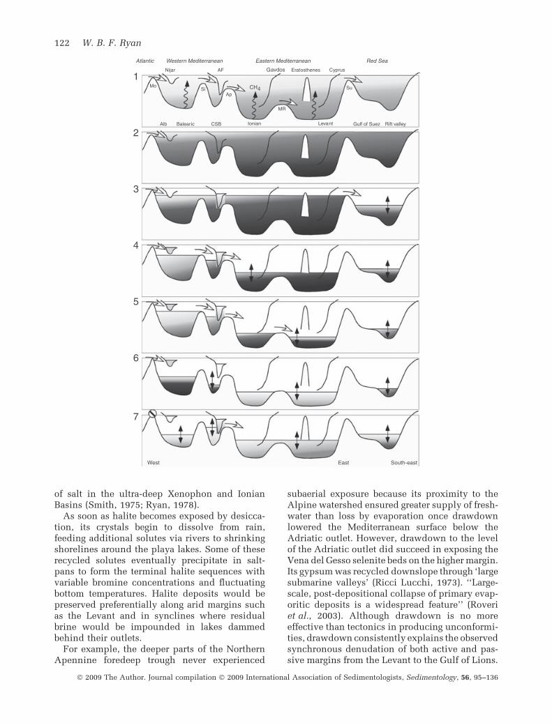
of salt in the ultra-deep Xenophon and IonianBasins (Smith, 1975; Ryan, 1978).
As soon as halite becomes exposed by desicca-tion, its crystals begin to dissolve from rain,feeding additional solutes via rivers to shrinkingshorelines around the playa lakes. Some of theserecycled solutes eventually precipitate in salt-pans to form the terminal halite sequences withvariable bromine concentrations and fluctuatingbottom temperatures. Halite deposits would bepreserved preferentially along arid margins suchas the Levant and in synclines where residualbrine would be impounded in lakes dammedbehind their outlets.
For example, the deeper parts of the NorthernApennine foredeep trough never experienced
subaerial exposure because its proximity to theAlpine watershed ensured greater supply of fresh-water than loss by evaporation once drawdownlowered the Mediterranean surface below theAdriatic outlet. However, drawdown to the levelof the Adriatic outlet did succeed in exposing theVena del Gesso selenite beds on the higher margin.Its gypsum was recycled downslope through ‘largesubmarine valleys’ (Ricci Lucchi, 1973). ‘‘Large-scale, post-depositional collapse of primary evap-oritic deposits is a widespread feature’’ (Roveriet al., 2003). Although drawdown is no moreeffective than tectonics in producing unconformi-ties, drawdown consistently explains the observedsynchronous denudation of both active and pas-sive margins from the Levant to the Gulf of Lions.
Red S ea Eastern Mediterranean Western Mediterranean A t lant ic
Gulf of Suez Rift valley Alb Balear ic CSB Ionian Leva nt
Erat os t he nes C y pr us AF Nijar G avdos
MR
Mo Si
Ap Su
W est S outh -east E ast
1
2
3
4
5
6
7
CH 4
122 W. B. F. Ryan
� 2009 The Author. Journal compilation � 2009 International Association of Sedimentologists, Sedimentology, 56, 95–136

Shallow-water versus deep-water selenite
A continuity of sedimentation from the TripoliFormation diatomites through the Calcare di Baseand Cattolica Gypsum Beds is demonstrated bythe book-keeping of precession cycles calibratedto magnetic reversals (Krijgsman et al., 1999a,2001). Occasionally, a cycle is missing in oneoutcrop but it appears in others. It is assumed,therefore, that until the end of the 1st cycle(Lower Evaporite) gypsum, there was no majorevaporative drawdown. Normal eustatic cycles of10 to 40 m amplitude can account for regressionsthat produced desiccation cracks in the Calcare diBase and the shoaling in the Vena del Gessoprimary selenite beds (Vai & Ricci Lucchi, 1977).The abrupt vertical facies change from euxinicshales to selenite results from bottom-growthcrystal precipitation on the outer shelf and upperslope seaward of the near-shore carbonate plat-forms as proposed by Richter-Bernburg (1973).The filaments of blue-green algae and the residuesof cyanobacteria observed in laminae within the‘swallow-tail’ crystals only require sunlight aspresent today in the upper few hundred metres ofthe water column. The epiphytic diatoms in thedrill cores attest to substrates below wave action.Substantial depth is also a prerequisite for theaccommodation of the 250 m of 1st cycle selenite(Richter-Bernburg, 1973; Roveri et al., 2003).Either sea-level rose steadily at an extraordinarilyhigh rate or deposition began with adequate roomfor these deposits.
Subaqueous versus subaerial erosion
In reviewing the reflection profiles from all overthe Mediterranean, and especially the Gulf ofLions, Montadert et al. (1978) arrived at the con-clusion: ‘‘The erosional surface and the formationof some canyons was a result of subaerial erosionlinked to a major regression along the margins atthe same time the salt layer was being deposited inthe deep basin[s]’’. This interpretation that thematerial delivered to the deeper basin had beensupplied primarily by subaerial processes hasstood essentially unchallenged for two decades.However, in studying a larger set of reflectionprofiles covering thousands of kilometres, Lofi(2001) and Lofi et al. (2005) have noted that thedetrital aprons at the base of the slope in proximityto the landward edge of the salt layer account forless than 30% of the volume of material removedfrom the adjacent margins. Furthermore theremainder of the material removed from themargin can not be accounted for either withthe salt layer or in the strata of the overlying ‘M’reflectors. The missing sediment must residebeneath the salt. These strata (Fig. 2B) have asubstantially lower compressional-wave velocitythan the salt, attested by the phase-reversal at thebase of the salt (Montadert et al., 1978). Similarvelocity inversions have been observed in theEastern Mediterranean (Ryan, 1978).
Although researchers traditionally have assignedthe ‘N’ reflectors directly beneath the salt layer asthe basin equivalent of the marginal Lower Evap-
Fig. 12. Evolution of brine surfaces during the MSC. (1) Onset with salinity sufficiently high for the widespreadcolonization of Porites reefs and the beginning of large-scale of pore water sapping. Methane oxidizes to carbonatewhich contributes to the basal limestone. (2) Salinity increases further to the level for bottom growth of selenite onmargins and slopes. This period involves 1st cycle gypsum accumulation in all circum-Mediterranean satellite basinspulsed by precession-forced climatic change. If drawdown occurs, it is brief and the magnitude minor. The deepbasins accumulate euxinic mud and laminated anhydrite. (3) Evaporation over the whole surface of the Mediterra-nean and Red Sea exceeds the input from the Atlantic combined with rivers plus rain. The surface of the most aridRed Sea at the distal end of the seaway is the first to experience evaporative drawdown. Evaporative concentrationdelivers the Red Sea salt. Intra-Messinian erosion commences. The Laga, Nijar and Sorbas basins evolve intoshrunken lakes fed from their own watersheds and acquire individual strontium isotopic signatures. (4) As Atlanticsupply diminishes further, evaporation of the Eastern Mediterranean is adequate to drop its surface below theApennine spillway. The Eratosthenes Plateau emerges and remains exposed except for its deepest flanks until theZanclean flood. (5) The interior of the Eastern Mediterranean drops below its spillway across the MediterraneanRidge to produce thick salt deposits in the Hellenic Trough followed shortly by salt in the Ionian, Sirte, andHerodotus basins. (6) Soon the surface of the Central Mediterranean falls to expose the selenite banks of the NorthernApennine and Sicilian margins and force the precipitation of the Realmonte Mine halite deposit. The Atlantic inputis now so small that the brine surface in the Western Mediterranean descends below the Sicilian sill and startsmassive halite accumulation in the Balearic Basin. The Gulf of Lions shelf undergoes extensive erosion by streamsand rivers to form the huge incision of the Rhone River valley. (7) With the Atlantic input stopped or reduced to aslow trickle, each basin becomes occupied by its own Lago Mare lakes whose surfaces rise and fall with the pre-cession cycles. Stages 3 to 6 are very brief and over in well under 100 kyr. Sills – Mo, Morocco corridor; Si, Sicilian;Ap, Apennine; MR, Mediterranean Ridge; Su, Suez. Basins – Alb, Alboran; AF, Apennine foredeep; CSB, CentralSicilian.
Decoding the Mediterranean salinity crisis 123
� 2009 The Author. Journal compilation � 2009 International Association of Sedimentologists, Sedimentology, 56, 95–136

orites, there is no direct evidence of repetitivegypsum/marl beds in the deepest basins. In theCentral Sicilian Basin, salt precipitation apparentlyis initiated on sterile euxinic mud (Rouchy, 1982c),although tectonic disturbances often obscure thispassage. In the Levant, the salt layer smothers adeep-sea fan etched by sinuous channel/leveedistributary systems sourced from adjacent sub-marine canyons (Bertini & Cartwright, 2006).
In the quantitative scenario of Blanc (2000), thefirst stage of drawdown affecting the Gulf of Lionsstopped briefly at the level of the sill to theEastern Mediterranean. Blanc placed this sillaround 0Æ5 km below modern sea-level based onthe gentle (< 0Æ03%) upstream gradient of theRhone Valley incision (Clauzon, 1982). A base-level drop of such magnitude would destabilizesub-sea slopes leading to retrogressive masswasting into the shelf via headward erosion ofincipient valleys and gullies. Slope failure pro-ceeds quickly as the margin buttress of water isreplaced by air. Expressions such as ‘‘chaoticslumping … enormous tectonic gravitationalsheets of chaotic materials’’ (Selli, 1973), ‘‘gravitysliding … debris flows … massive chaotic bodiesof gypsum’’ (Ricci Lucchi, 1973) and ‘‘large-scale, gravity-driven gypsum-slab sliding andrelated gravity flow deposits’’ (Roveri et al.,2003) describe downslope transport of materialby subaqueous processes. It is therefore possiblethat the truncation of pre-Messinian strata by thelower erosion surface in the Valencia Trough andbeneath the salt in the Levant was initiated by thescouring action of high-velocity subaqueous flowsand not necessarily by rivers, rain or wind.
Changes to the 1973 shallow-water, deep-basinmodel
A review of the current knowledge of the MSCrequires the insertion of an early ‘deep-water,deep-basin’ and ‘shallow-water, shallow-margin’stage not considered in the formulations of theoriginal desiccation hypothesis in 1973. Hsuet al. (1978a,b) corrected this deficiency but stillleft the possibility of significant lowstands duringthe 1st cycle. The deposition of the diatomitesof the Tripoli Formation takes place under theinfluence of two-way inflow and outflow throughthe Atlantic portal (Debenedetti, 1982; Sonnen-feld, 1985; Sonnenfeld & Finetti, 1985). However,as modelled by Blanc (2000), the circulation mustevolve to intermittent one-way inflow to accountfor the rise of salinity to a threshold for theCalcare di Base. No convincing evidence of
sustained evaporative drawdown is seen untilthe intra-Messinian ‘‘great erosional unconfor-mity that cuts the lower gypsum unit’’ (Roveriet al., 2003). Vai & Ricci Lucchi (1977) andKrijgsman et al. (1999a) have made a compellingcase that the Cattolica Gypsum beds and the Venadel Gesso Beds were synchronous. The early MSCwater level remained at the level of the Atlanticexcept for possible minor excursions when globaleustacy might have briefly restricted the Atlanticportal and dropped the Mediterranean surfaceto the Suez Sill. The departure from previousschemes with early MSC lowstands (Rouchy,1982a,b; Rouchy & Saint Martin, 1992; Rouchy& Caruso, 2006) is in precipitating the salt duringa relatively brief interval accompanying draw-down rather than precipitating the ‘‘massivehalite (and lower gypsum) in a long period oflow-level, high concentrated brines’’ (Rouchy &Caruso, 2006). As Blanc (2000) pointed out,persistent low-level lakes make it impossible totransport Atlantic-sourced solutes to the distalEastern Mediterranean basins and deposit thickhalite across a wide spectrum of elevations from< 1 km to > 4 km below modern sea-level. Earlylowstand is unable to supply marine water fromthe Atlantic into the Red Sea rift.
Finally, as the major drawdown nears comple-tion, the playa lakes appear. The upper evaporitesessentially are strata-derived by clastic rework-ing, dissolution, re-precipitation and diagenesisof materials belonging to the lower selenite andmassive salt with little or no supply of newsolutes from the Atlantic except, perhaps, in thewesternmost regions. Calcite washed down inmarls from exposed slopes becomes converted todolomite in brackish lakes fed by rivers crossingexposed sabkhas and playas.
Lago-Mare as an environment
The name ‘Lago-Mare’ calls attention to the freshand brackish water conditions spread across thebroad Mediterranean realm during the terminalMSC. Ruggieri (1967) was among the first to applythis environmental attribute to the Congeria orMelanopsis beds underneath the Arenazzolo flu-vial sands and alluvial conglomerates in Sicily.The close association of those salinity-intolerantmolluscs with terrestrial materials, such asalluvium, soil, leaves, insects, turtles, root casts,etc., is common elsewhere (Selli, 1973; Sturani,1973; Orszag-Sperber & Rouchy, 1979). Thisassemblage occupied the shores of lakes, marshes,river mouths and deltas.
124 W. B. F. Ryan
� 2009 The Author. Journal compilation � 2009 International Association of Sedimentologists, Sedimentology, 56, 95–136

The deep-sea drilling expeditions discoveredfresh to brackish water diatoms, benthonic fora-minifera, ostracods, etc., in non-bioturbated mudindicative of subaqueous substrates in the moreoffshore fresh to brackish settings. When exam-ining the depth distribution of the microfossilassemblages in the drill cores, the picture emergesof sterile deep lakebeds in the Eastern Mediterra-nean, ostracod-rich mud where the lakebed wasshallow on the crest of the Mediterranean Ridgeand Florence Rise and molluscs along the lake-shores and river mouths. The finding of soilinstead of Lago-Mare mud on the flank of Eratos-thenes seamount and alluvial pebbles above Lago-Mare sands in the Alboran Sea (Iaccarino &Bossio, 1999) implies that the terminal Messinianlake surface remained well below the level of theexterior Atlantic. Any perched basins, higher upon the margins and fed by their own rivers, alsowould have been suitable for colonization by theLago-Mare fauna without being connected toeither the broader Mediterranean lakes in thedeep basins or other satellite basins.
Did the introduction of the Lago-Mare faunarequire a direct water route from the Pontian-ageBlack Sea (Cita, 1973; Hsu & Giovanoli, 1979; Cita& McKenzie, 1986), or were the fauna simply theresult of colonization in a suitable alkaline waterbody after the connection of the Mediterraneanwith the Atlantic was severed (Benson & Rakic-el Bied, 1991; Orszag-Sperber, 2006)? Althoughthe magneto-stratigraphic records on continuoussections in the Dacian Basin of Romania do notshow a break in sedimentation corresponding tothe MSC and maintain the precession-forcedperiodicity of 23 kyr for the Pontian sedimentcycles (Vasiliev et al., 2004), there is recentevidence of a base-level drop in the adjacentBlack Sea. At a meeting in 2003 in Kiev, Ukraine,V.N. Semenenko and G.N. Orlovsky reported: ‘‘Ahydrographic network of the Northern Black Seacoastal region formed after regression of the LateMiocene (Early Pontian) basin. It took place inconsequence of the Messinian salinity crisis inthe Mediterranean Sea … as a result of lateralerosion, the Pontian basin was dropped into theMediterranean’’. Gillet et al. (2003) projectedreflection profiles (Fig. 13) across the shelf andslope of the Black Sea displaying a distinctMessinian-age sub-bottom ‘ravinement surface’.This intra-Pontian unconformity (IPU) correlateswith the gypsum and conglomerate recovered byDSDP Leg 42B (Hsu & Giovanoli, 1979). As thesub-bottom depth of this unconformity extends tothe foot of the slope (Fig. 13), the only sink for the
missing water was the even lower Eastern Med-iterranean or evaporation of the Black Sea Basinitself. It seems logical that some Lago-Mareinhabitants such as the Loxochonca djaffaroviassemblage may have travelled through an outlet,others such as Candona sp. and Cypridies sp. mayhave been carried to more faraway locations inthe Western Mediterranean on the feet of birds(Benson & Rakic-el Bied, 1991). Benthonic for-aminifera, including Ammonia tepida, may havebeen already endemic to Mediterranean rivers.
It is within the 2nd cycle evaporites and Lago-Mare deposits that strontium composition chan-ged from its oceanic precursor to one heavilyinfluenced by continental source rocks dissolvedin river water (De Deckker et al., 1988; McKenzieet al., 1988; McCulluch & De Deckker, 1989).As a consequence, there is little surprise thatthe 2nd cycle gypsum layers typically areinterbedded with marls washed from the higher-standing exposed seabed. The non-oceaniccomposition is common to all autochthonous2nd cycle strata throughout the Mediterranean.While looking at the compositions in theCentral Sicilian Basin, Butler (2006) realized ‘‘thatthe gypsum of the 2nd cycle was precipitatedfrom the same, Mediterranean-wide, water body’’.Such continuity is in agreement with the largelateral extent of the ‘M’ Reflectors; their passageup and down and across a sea floor of consider-able elevation change would only be possiblewith amplitudes of drawdown and reflooding
Fig. 13. The Messinian-age (Pontian) erosion surfacein the deep Black Sea (Reflector ‘M’) sampled by DSDPdrilling (from Gillet et al., 2003).
Decoding the Mediterranean salinity crisis 125
� 2009 The Author. Journal compilation � 2009 International Association of Sedimentologists, Sedimentology, 56, 95–136

exceeding that of the relief between basin edgesand margins. Nevertheless, in more elevatedregions such as the basins in South-east Spainand Cyprus, the strontium isotopic composition isnot the same as in Sicily and the Glomar Chal-lenger cores from the deeper areas (Fig. 14).Therefore, the water in these basins must nothave exchanged with the larger Mediterraneanlakes. This lack of exchange is the primaryevidence to show that the Mediterranean neverrefilled to its brim during the 2nd cycle of theMSC.
Zanclean flood
The opening of the Gibraltar gateway at the end ofthe MSC (5Æ33 Ma) returned the Mediterranean
desert to an open-marine sea in less than a fewdecades (Hsu et al., 1973a; McKenzie et al., 1990;McKenzie, 1999; Blanc, 2002). The imprint of theZanclean flood is evident at the Capo Rossellooutcrop (Cita & Gartner, 1973; Cita, 1975). Thissection, with its overlying Trubi Formation, hasbecome the template for the astronomical timescale of the Late Neogene (Hilgen & Langereis,1988, 1993; Hilgen et al., 1999). The same passagebetween the Miocene and Pliocene is intact incores from eight deep-sea drill sites from theAlboran Sea to the Eratosthenes Seamount (Spe-zzaferri et al., 1998; Iaccarino & Bossio, 1999;Iaccarino et al., 1999). Across the boundary, overa scale of a few centimetres, dramatic shifts incolour, grain-size, bioturbation and inorganic tobiogenic calcite are measured. The stable isotopesof carbon, oxygen and strontium announce thearrival of fully marine water (Pierre et al., 2006).Over the slower span of the first few tens ofmetres of ooze, the Pliocene seabed repopulatedfrom west to east with deep Atlantic emigrantsincluding Bythoceratina scaberrina, Parrelloidesbradyi and P. robertsonianus (Benson, 1973a,b;McKenzie et al., 1990). Sedimentation rates in thedeep-sea Trubi marls are slow above the floodsurface and rise by a factor of 6 over a few millionyears (Cita et al., 1978b, 1999), as sediment fromthe continents was able to find its way across themargins drowned by the enormous sea-level riseand restore the eroded ramps to shelves withprograding slopes (Ryan & Cita, 1978; Lofi et al.,2003).
Hydrocarbon implications
Slope mud typically has the highest organiccarbon content of all marine sediments, exceptsapropels. The rapid displacement to basin floorsof slope mud and shelf sands during drawdownand burial by impermeable salt would set theconditions for hydrocarbon source rocks, reser-voirs and seals. When the basin fully desiccated,temperatures > 30 to 45 �C on its floor would turnthe Mediterranean into a Death Valley (Hsu,1972b, 1984). The thick salt layer and its Plioceneto Quaternary cover provide the necessary burialto begin maturation, especially in the youngWestern Mediterranean. Gasoline-range hydro-carbons have already seeped into thermally un-altered Lago-Mare dolomitic marl on theSardinian edge of the Balearic Basin (McIver,1973). In describing the Messinian deep-wateraccumulations in the Peri-Adriatic region, Selli(1973) informed those attending the Utrecht
DSDP
–100
–80
–60
–40
–20
0
20–6 –5 –4 –3 –2 –1 0 1 2 3
Sr
SpainCyprus
Capo rossello
Error range
Fig. 14. Strontium isotopic composition (dSr) ofostracods in 2nd cycle deposits relative to the ‘oceanic’norm (after McCulluch & De Deckker, 1989). The sub-stantial differences and lack of overlap between themeasurements on the drill cores from the deep basinsand samples from Cyprus and South-east Spain areevidence that the waters of the Mediterranean did notmix with the satellite basins.
126 W. B. F. Ryan
� 2009 The Author. Journal compilation � 2009 International Association of Sedimentologists, Sedimentology, 56, 95–136

meeting, ‘‘These are the source rocks from whichoriginated, after fluid migration, the major part ofthe Italian gas field in the Po Plain’’.
WHAT TOOK SO LONG?
With so much descriptive information aboutMessinian sediments on land and beneath thesea already assembled in the 1970s and 1980s,why did it take such a long time to reshape theearly model of multiple fillings and dryings ofthe oceanographers and make it conform to theboundary conditions derived from the study ofthe marginal basins and quantitative modelling?Four reasons are suggested.
The first reason is a possible confusion gener-ated from the widely accepted stratigraphicreconstruction of the Central Sicilian Basin byDecima & Wezel (1973). This schema (Fig. 8A)shows the lateral transition from early ‘‘carbonatefacies in the marginal zone’’ with a ‘‘lateralpassage to the Cattolica gypsum beds’’ on theslope as also envisioned by Richter-Bernburg(1973). Complications arise from extending theprimary gypsum under the salt in this diagram –an interpretation not supported by boreholes(Rouchy, 1982c; Lugli, 1999). Consequently,many publications have included the salt asbelonging to the margin setting (Clauzon et al.,1996) despite cautions in the original paper that‘‘the Cattolica deposits were deposited in arelatively deep basin’’. In addressing ‘‘how theevaporites were deposited in this basin’’, Decima& Wezel (1973) suggest: ‘‘it could have been byin situ precipitation, by clastic resedimentationfrom the marginal zone, or as seems likely to us,by a combination of both’’.
In this classic publication, the emphasis givento olistostrome-type deposits and gypsum turbi-dites intercalated in euxinic sediments, thatresearchers such as Vai & Ricci Lucchi (1976,1977) used to promote deep-water depositionalenvironments during the MSC, is often over-looked. Such allochthonous facies require a pre-existing depocentre not unlike the trench andaccretionary wedge settings in modern conver-gent margins with substantial pre-existing reliefto provide the necessary accommodation spacefor huge sediment thicknesses to be deposited inshort intervals of time.
The second reason is the confusion generatedby correlating the ubiquitous sub-bottom erosionsurface on the Mediterranean margins to theunconformity drawn by Decima & Wezel (1973)
across the top of the halite deposits in Sicily(Fig 8A). The illusive downdip unconformityequivalents to the initial Mediterranean-wideerosion event are the gypsum turbidities anddebris flows beneath the salt, not the truncation ofthe salt. The truncation is a natural phenomenonoccurring once the brine level in the EasternMediterranean falls below the surface of the saltin the Central Sicilian Trough; this happened allalong the foot of the margin of the Levant.
The third reason was the lack of a high-resolution, reliable chronology. In its absence,researchers have proposed that the lower evapo-rite gypsum was deposited diachronously in asequence of silled depressions as sea-level fell insteps (Grasso & Pedley, 1988; Rouchy & SaintMartin, 1992; Butler & Grasso, 1993; Pedley &Grasso, 1993; Butler et al., 1995; Rouchy &Caruso, 2006). In some of these schemes, thedeep Mediterranean remained normal marine(Grasso, 1997; Riding et al., 1998). The astronom-ical time scale provided by the revolutionaryefforts of Hilgen & Krijgsman (1999) and their co-workers now give strong evidence for the onset ofevaporitic limestone and gypsum at the same timefrom Spain to Cyprus and additional support forthe Lower Gypsum (selenite) beds in Sicily andthe Northern Apennines having been paced bythe same climate forcing.
The fourth and final reason was the need forquantitative modelling of water input and sub-sequent precipitation in basins separated by sills.Models had to reproduce the observed distribu-tions and volumes of evaporites and salt in thebrief time span of the MSC instead of the originaldesiccation model with multiple fillings anddryings.
Issues still unresolved
During the progressive increase in the salinity anddensity of the Mediterranean Sea brine prior to thethreshold for halite precipitation, its evolvingweight would induce a progressive loading onthe underlying lithosphere. This loading wouldincrease the water depth (as well as the brinevolume) of the precursor Ionian and Leventineabyssal plains by nearly a kilometre as halitesaturation is reached. The consequence of suchbasin loading is uplift of the rims and a tilting ofthe slopes towards the basin centres. Might thisover-steepening be the instigator of the observedearly erosion of the margins observed in theseismic reflection profiles? Moreover, might muchof the material shed from the margins and not
Decoding the Mediterranean salinity crisis 127
� 2009 The Author. Journal compilation � 2009 International Association of Sedimentologists, Sedimentology, 56, 95–136
volumetrically accounted for within the halitelayer and the upper evaporate ‘M’ Reflectors(Fig. 2) actually reside on the basin floors beneaththe salt?
Loss of sediment from the margins and itsaccumulation in the basins produce a positivefeedback for uplift and tilting. Most thinking sofar on this problem has been to consider thedesiccation an unloading phenomenon (Ryan,1976; Gvirtzman & Buchbinder, 1978). However,with continued delivery of Atlantic water duringevaporative drawdown, the weight of its new salt(with a density of 2Æ2 g cm)3) might have morethan counter-balanced the weight of the freshcomponent of the brine, with a density of1 g cm)3 lost to evaporation. Formal calculationsof rim uplift need should take into considerationthe weight added by the salt first as it is concen-trated in brine and second as it is precipitated as asolid (Major & Ryan, 1999).
In proposing a significant delay in the onset ofmajor high-amplitude drawdown until midwaythrough the MSC there are still problems with thesupposed shallow-water-depth signal of the Cal-care di Base in Sicily and the other widespreadcarbonates of equivalent age that herald the onsetof the MSC. That this limestone in the Apennines,Piedmont, Crete, Gavdos and Cyprus displaysmany features common to microbial stromatolitescannot be denied, including structures inter-preted as expansion cracks (Schreiber et al.,1976; Rouchy, 1982c; Decima et al., 1988). Con-sequently, evidence from the Calcare di Base hasbeen used to infer early drawdown. However, thislimestone often appears rather abruptly abovedeposits considered to be relatively deep-water.What seems special about the Calcare di Base isthat it changes in thickness and facies from oneoutcrop to the next, even over short distances.The sediment succession shows no obvious pre-cursor signs of an approaching near-shore, highwave-energy depositional environment. Thus it isenticing to consider the process of evaporativedrawdown as the agent to transform the seabedfrom deep to ultra-shallow (Rouchy & Caruso,2006). In Gavdos, the Messinian water depth priorto the sudden appearance of the limestone wasclose to 1 km (Kouwenhoven et al., 1999). Here,the stromatolitic-like limestone is locally anintraformational breccia.
Yet, if drawdown is the primary agent ofdramatic facies change, where are the contempo-rary clastics and avalanche deposits set in placeby exposure of all the higher slopes? Why is amarked coeval unconformity not found at the
numerous sites investigated with palaeomagneticstratigraphic methods? The gap, if it exists,stays hidden. The 1st cycle primary gypsum isremarkable for its lack of allochthonous upslopematerials in many outcrops.
So what other agent could produce a widespreaddevelopment of microbial carbonates? One possi-bility is pore-water sapping as salinity in theoverlying water body rises to the level for gypsumprecipitation. Under increasing water density indeep areas, the subsurface pore water would beginto experience buoyancy, escape to the sea floor andexchange its pore space with the overlying brine.Such venting would initiate cracks in the sea flooras well as fissures and pipes where the fluid passesthrough the substrate. Release of methane wouldaccompany the exchange of the fluids. The escapeof buoyant pore-water out of the seabed, especiallywhere the inverse density gradient between pore-water and brine would be the greatest and thusfluid exchange the most vigorous, might be anagent for the widely-observed brecciation. Bacte-rial communities would thrive on released meth-ane and oxidize it to carbonate as they do today inlocalized cold-water seeps on passive and activemargins. As salinities continued to rise, bottomwaters would be replaced by denser and denserbrine sinking from the surface in regions of thestrongest evaporation where the brine surface isthe warmest. Haline-driven circulation replacestheromohaline circulation. Warming bottomwaters would propagate a thermal pulse into thesubsurface across the span of several thousandyears and accelerate the disassociation of subsur-face gas hydrates. Then even more methane wouldbe released. The one million year interval ofanoxia during the formation of the thick LateTortonian and Early Messinian euxinic sedimentensures abundant organic carbon burial and itssubsequent microbial fermentation to methane. Itseems reasonable that the diatomaceous and bitu-minous sediments could have held a sizablehydrate reservoir. Although originally attributedto the calcitization of calcium sulphate (McKenzieet al., 1979), the negative carbon isotopic compo-sition of the Calcare di Base might also be theconsequence of carbon derived from methane.
Pierre et al. (2002) and Pierre & Rouchy (2004)have described dolomitic nodules in Tortonianmarls from South-east Spain and Morocco thatthey relate to the past occurrence of gas hydrates.Clari et al. (1994) and Taviani (1994) reportmethane-derived carbonates and chemosymbioticcold vent communities in Miocene sediments ofPiedmont and the Apennines. Destabilization on
128 W. B. F. Ryan
� 2009 The Author. Journal compilation � 2009 International Association of Sedimentologists, Sedimentology, 56, 95–136

a sufficiently large scale to deliver isotopicallylight carbon to the basal limestone of the MSC isspeculative. Potential triggers for methane releaseare the heat from warm saline bottom waters asbrine stratifies and, alternatively, a drop in con-fining pressure accompanying drawdown. Evenminor sea-surface fall, limited to the elevation ofthe Suez Sill, could have had a significant impactfor triggering methane release.
CONCLUSIONS
It took three decades to advance from the discus-sions, disagreements and limited concessions atthe Utrecht colloquium to a scheme for theMessinian Salinity Crisis (MSC) that integratesthe margins of the Mediterranean with its abyss.In comparing shallow-water versus deep-watermodels, Selli (1973) showed foresight when stat-ing: ‘‘both models, even in the same area or basin,can be readily justified’’.
The floor of Mediterranean basins lay severalkilometres below the surface of the Atlantic,before, during and after the MSC. The sills thatseparated the basins in the west from those in thecentre and east were of sufficient height that only athick layer of concentrated brine could transportthe necessary volume of solutes from the Atlanticto the distal interior and on to the Red Sea. Duringthe time required to further concentrate the strat-ified brine to saturation for halite, the lesser salinesurface layer set the stage for the growth of selenitebanks of rhythmic succession all around themargins, while the deep remained stagnant andlifeless. Once the input from the Atlantic no longercould overcome the amount of water evaporated,the surface of this vast and pre-concentrated brinesea began to fall, its shorelines shrank and sub-strates that had been underwater became emerged.The drawdown immediately destabilized theslope. Retrogressive erosion denuded the Gulf ofLions and the Nile Delta. Gypsum banks disinte-grated under the attack of waves and springsapping. As the brine volume shrank, haliteaccumulated rapidly upon the eroded detritus bya process of ‘evaporative concentration’.
The process of evaporative concentration wasnot necessarily continuous. It may have beeninterrupted by one or more precession cyclesduring which the regional climate swung fromdry to wet and back again to dry. Major draw-down and eventual isolation from Atlanticsources began first in the eastern interior beyondthe sill through the Palaeo-Apennine Arc. Draw-
down occurred later in the west as the Atlanticspillway continued its closure. The Lago-Marefauna appeared when the marine input dimin-ished to a trickle or ceased altogether. The term‘Lago-Mare’ more aptly is applied to fresh andbrackish water environments than to a LateMessinian chronozone. An extensive erosionsurface of Pontian age in the Black Sea correlateswith base-level fall there as Paratethys watereither found an exit along with its fauna into thepartially empty Eastern Mediterranean, or evap-orated under its own arid climate. In the terminalphase of the MSC, the Lago-Mare lakes expandedto submerge the crest of the Mediterranean Ridge,yet still left the flanks and summit of the Eratos-thenes Plateau exposed. An episode of severeevaporation shrunk the lakes to produce theyoungest erosion surface. This lowstand is cap-tured in the stream-valley incisions and deltas ofthe Abu Madi and Afiq Formations and in thereflection profiles across the Valencia Trough.The Zanclean flood was geologically instanta-neous. However, it took a few million years forsedimentation in the Mediterranean to build backits slopes and shelves to the modern and pre-MSCconfigurations, as a consequence of the extensiveremoval of former margin sediment as well as bythe void created from the downward flexure of theregional lithosphere because of the weight of thesalt on the basin floors and the weight of the newwater added by the flood.
ACKNOWLEDGEMENTS
I thank Maria Bianca Cita for inviting me topresent this synthesis at the International Geo-logical Congress in Florence in 2004. She andKenneth Hsu have been my mentors ever sinceour adventure together on the Glomar Challenger.I also acknowledge Georges Clauzon, ArvedoDecima, Franco Ricci Lucchi, Charlotte Schreiberand Gian Battista Vai for guiding me during fieldtrips that greatly shaped my appreciation for thecomplexity of the MSC and the need for aunifying explanation. Discussions with RichardBenson, Paul-Louis Blanc, Silvia Iaccarino, KimKastens, Alberto Malinverno, Yossi Mart, AlainMauffret, Judy McKenzie, Walter Pitman, MarcoRoveri and Michael Steckler have been veryinformative. I acknowledge especially CandaceMajor and Johanna Lofi who undertook disser-tation research with me and brought manyoriginal ideas to this synthesis. Daniel Bernoulli,Maria Cita, Robert Garrison, Wout Krijgsman and
Decoding the Mediterranean salinity crisis 129
� 2009 The Author. Journal compilation � 2009 International Association of Sedimentologists, Sedimentology, 56, 95–136

Jean-Marie Rouchy provided very helpful reviewsand constructive refinements to the manuscript.The U.S. National Science Foundation fundedthis synthesis under grant NSF OCE 02-41964.
REFERENCES
Auzende, J.M., Bonnin, J., Olivet, J.-L. and Pautot, G. (1971)
Upper Miocene salt layer in the western Mediterranean.
Nature, 230, 82–84.
Barber, P.M. (1981) Messinian subaerial erosion of the proto-
Nile delta. Mar. Geol., 44, 253–272.
Barr, F.T. and Walker, B.R. (1973) Late Tertiary channel
system in northern Libya and its implications on Mediter-
ranean sea level changes. In: Initial Reports of the Deep Sea
Drilling Project (Eds W.B.F. Ryan and K.J. Hsu), Vol. 13, Part
2, pp. 1244–1250. U.S. Government Printing Office, Wash-
ington, DC.
Bassetti, M.A., Miculan, P. and Ricci-Lucchi, F. (2003)
Ostracod faunas and brackish water environments of the
Late Messinian Sapigno section (North Apennines, Italy).
Palaeogeogr. Palaeoclimatol. Palaeoecol., 198, 335–352.
Bassetti, M.A., Manzi, V., Lugli, S., Roveri, M., Longinelli, A.,Ricci Lucchi, F. and Barbieri, M. (2004) Paleoenvironmen-
tal significance of Messinian post-evaporitic lacustrine car-
bonates in the northern Apennines, Italy. Sed. Geol., 172, 1–
18.
Bayer, R., Le Mouel, J.L. and Le Pichon, X. (1973) Magnetic
anomaly pattern in the western Mediterranean. Earth Pla-
net. Sci. Lett., 19, 168–176.
Bellanca, A., Caruso, A., Ferruzza, G., Neri, R., Rouchy, J.-M.,Sprovieri, M. and Blanc-Valleron, M.M. (2001) Transition
from marine to hypersaline conditions in the Messinian
Tripoli Formation from the marginal areas of the central
Sicilian Basin. Sed. Geol., 140, 87–105.
Benson, R.H. (1972) The Bradleya Problem with descriptions
of two new psychrospheric ostracode genera, Agrenocythere
and Poseidonamicus (Ostracoda: Crustacea). Smithson.
Contrib. Paleobiol., 12, 1–138.
Benson, R.H. (1973a) Psychrospheric and continental
ostracoda from ancient sediments in the floor of the Medi-
terranean. In: Initial Reports of the Deep Sea Drilling Pro-gram (Eds W.B.F. Ryan and K.J. Hsu), Vol. 13, Part 2, pp.
1002–1008. U.S. Government Printing Office, Washington,
DC.
Benson, R.H. (1973b) An ostracodal view of the Messinian
salinity crisis. In: Messinian Events in the Mediterranean
(Ed. C.W. Drooger), pp. 235–242. North-Holland Publ. Co.,
Amsterdam.
Benson, R.H. (1978) The paleoecology of the ostracodes of
DSDP Leg 42A. In: Initial Reports of the Deep Sea Drilling
Project (Eds K.J. Hsu and L. Montadert), Vol. 42A, pp. 777–
787. U.S. Government Printing Office, Washington, DC.
Benson, R.H. and Rakic-el Bied, K. (1991) Biodynamics, saline
giants and late Miocene catastrophism. Carbonates Evap-
orites, 6, 127–168.
Bertini, C. and Cartwright, J.A. (2006) Controls on the basin-
wide architecture of late Miocene (Messinian) evaporites on
the Levant margin (Eastern Mediterranean). Sed. Geol., 188–189, 92–114.
Bini, A., Cita, M.B. and Gaetani, M. (1978) Southern Alpine
lakes – hypothesis of an erosional origin related to the
Messinian entrenchment. Mar. Geol., 27, 271–288.
Biscaye, P.E., Ryan, W.B.F. and Wezel, F.C. (1972) Age and
nature of the pan-Mediterranean subbottom Reflector M. In:
The Mediterranean Sea (Ed. D.J. Stanley), pp. 83–90. Dow-
den, Hutchinson & Ross, Inc, Stroudsburg, PA.
Blanc, P.L. (2000) Of sills and straits, a quantitative assess-
ment of the Messinian Salinity Crisis. Deep-Sea Res., 47,1429–1460.
Blanc, P.L. (2002) The opening of the Plio-Quarternary
Gibraltar Strait, assessing the size of a cataclysm. Geodin.
Acta, 15, 117–122.
Blanc-Valleron, M.-M., Pierre, C., Caulet, J.-P., Caruso, A.,Rouchy, J.M., Gespuglio, G., Sprovieri, R., Pestrea, S. and
Di Stefano, E. (2002) Sedimentary, stable isotope and
micropaleontological records of paleoceanographic change
in the Messinian Tripoli Formation (Sicily, Italy). Palaeo-geogr. Palaeoclimat. Palaeoecol., 185, 255–286.
Boccaletti, M. and Guazzone, G. (1974) Remnant arcs and
marginal basins in the Cainozoic development of the Med-
iterranean. Nature, 252, 18–21.
Bridge, C., Calon, T.J., Hall, J. and Aksu, A.E. (2005) Salt
tectonics in two convergent-margin basins of the Cyprus arc,
Northeastern Mediterranean. Mar. Geol., 221, 223–259.
Busson, G. (1990) Le Messinien de la Mediterranee … vingt
ans apres. Geol. Fr., 3–4, 3–58.
Butler, R. (2006) When the Mediterranean dried up: Forensics
of a geocatastrophe. Geotimes, October, 20–23.
Butler, R.W.H. and Grasso, M. (1993) Tectonic controls on
base-level variations and depositional sequences within
thrust-top and foredeep basins, examples from the Neogene
thrust belt of central Sicily. Basin Res., 5, 137–151.
Butler, R.W., Lickorish, H., Grasso, M., Pedley, H.M. and
Ramberti, L. (1995) Tectonics and sequence stratigraphy in
Messinian basins, Sicily, constraints on the initiation and
termination of the Mediterraean salinity crisis. Geol. Soc.
Am. Bull., 107, 425–439.
Catalano, R., Ruggieri, G. and Sprovieri, R. (1975) Messinian
evaporites in the Mediterranean. Mem. Soc. Geol. It., 16,385–400.
Chumakov, I.S. (1967) Pliocene and Pleistocene deposits of
the Nile Vallet: Nubia and Upper Egypt (in Russian). Acad.
Sci. U.S.S.R., Geo. Inst. Trans., 170, 5.
Chumakov, I.S. (1973) Pliocene and Pleistocene deposits of
the Nile Valley in Nubia and Upper Egypt. In: Initial Reports
of the Deep Sea Drilling Project (Eds W.B.F. Ryan and K.J.
Hsu), Vol. 13, Part 2, pp. 1242–1243. U.S. Government
Printing Office, Washington, DC.
Cita, M.B. (1973) Mediterranean evaporite, paleontological
arguments for a deep-basin desiccation model. In: MessinianEvents in the Mediterranean (Ed. D.W. Drooger), pp. 206–
228. North-Holland Publ. Co., Amsterdam, Netherlands.
Cita, M.B. (1975) Planktonic foraminiferal biozonation of the
Mediterranean Pliocene deep-sea record, A revision. Riv. It.Paleont. Stratigr., 81, 527–544.
Cita, M.B. (1988) Il disseccamento del Mediterraneo alla fine
del Miocene. Rend. Fis. Accad. Lincei, ser. 8, 81, 455–466.
Cita, M.B. and Gartner, S. (1973) The stratotype Zanclean,
foraminiferal and nannofossil biostratigrapy. Riv. It. Pa-
leont. Stratigr., 79, 503–558.
Cita, M.B. and McKenzie, J.A. (1986) The terminal Miocene
event. In: Mesozoic and Cainozoic Oceans (Ed. K.J. Hsu),
pp. 123–140. Geodynamics Series, American Geophysical
Union, Washington, DC.
Cita, M.B., Wright, R.C., Ryan, W.B.F. and Longinelli, A.(1978a) Messinian paleoenvironments. In: Initial Reports of
the Deep Sea Drilling Project (Eds K.J. Hsu and L. Montad-
130 W. B. F. Ryan
� 2009 The Author. Journal compilation � 2009 International Association of Sedimentologists, Sedimentology, 56, 95–136

ert), Vol. 42A, pp. 1003–1035. U.S. Government Printing
Office, Washington, DC.
Cita, M.B., Ryan, W.B.F. and Kidd, R.B. (1978b) Sedimenta-
tion rates in Neogene deep-sea sediments from the Medi-
terranean and geodynamic implications of their changes. In:
Initial Reports of the Deep Sea Drilling Project (Eds K.J. Hsu
and L. Montadert), Vol. 42A, pp. 991–1002. U.S. Govern-
ment Printing Office, Washington DC.
Cita, M.B., Racchetti, S., Brambilla, R., Negri, M., Colom-baroli, D., Morelli, L., Ritter, M., Rovira, E., Sala, P., Ber-tarini, L. and Sanvito, S. (1999) Changes in sedimentation
rates in all Mediterranean drillsites document basin evolu-
tion and support starved basin conditions after early Zan-
clean flood. Mem. Soc. Geol. It., 54, 145–159.
Clari, P., Fornara, L., Ricci, B. and Zuppi, G.M. (1994)
Methane-derived carbonates and chemosymbiotic commu-
nities of Piedmont (Miocene, northern Italy): an update.
Geo-Mar. Lett., 14, 201–209.
Clauzon, G. (1973) The eustatic hypothesis and the pre-Plio-
cene cutting of the Rhone Valley. In: Initial Reports of the
Deep Sea Drilling Project (Eds W.B.F. Ryan and K.J. Hsu),
Vol. 13, Part 2, pp. 1251–1256. U.S. Government Printing
office, Washington, DC.
Clauzon, G. (1982) Le canyon messinien du Rhone, une pre-
uve decisive du ‘‘desiccated deep-basin model’’ [Hsu, Cita
et Ryan, 1973]. Bull. Soc. Geol. Fr., ser. 7, 24, 597–610.
Clauzon, G., Suc, J.P., Gautier, F., Berger, A. and Loutre, M.F.(1996) Alternate interpretation of the Messinian salinity
crisis, controversy resolved? Geology, 24, 363–366.
Cohen, A. (1988) Stratification of the Messinian evaporites in
Israel. Israel J. Earth-Sci., 37, 193–203.
Cravatte, J., Dufaure, P., Prim, M. and Rouaix, S. (1974) Les
sondages du Golfe du Lion, stratigraphie et sedimentologie.
Notes Mem. Compagnie Fr. Petrol., Paris, 11, 209–274.
De Deckker, P., Chivas, A.R. and Shelley, M.G. (1988) Paleo-
environment of the Messinian Mediterranean ‘‘Lago Mare’’
from strontium and magnesium in ostracode shells. Palaios,
3, 352–358.
Debenedetti, A. (1976) Messinian salt deposits in the Medi-
terranean: evaporites or precipitates? Boll. Soc. Geol. It., 95,941–950.
Debenedetti, A. (1982) The problem of the origin of the salt
deposits in the Mediterranean and of their relations to other
salt occurrences in the Neogene formations of the contigu-
ous regions. Mar. Geol., 49, 91–114.
Decima, A. (1964) Ostracodi del genere Cyprideis Jones del
Neogene e del Quaternario Italiani. Paleont. It., 57, 81–133.
Decima, A. (1975) Considerazioni preliminari sulla distri-
buzione del bromo nella formazione Salina della Sicilia
meridionale. Abstract in: Messinian Seminar, Erice, Sicily.
Decima, A. (1978) Initial data on bromine distribution in the
Miocene salt formation of southern Sicily. Mem. Soc. Geol.It., 16, 39–43.
Decima, A. and Sprovieri, R. (1973) Comments on the Late
Messinian microfaunas in several sections from Sicily. In:
Messinian Events in the Mediterranean (Ed. C.W. Drooger),
pp. 229–234. North-Holland Publ. Co., Amsterdam.
Decima, A. and Wezel, F.C. (1971) Osservazioni sulle evaporiti
messiniane della Sicilia centro-meridionale. Riv. Miner.Siciliana, 22, 172–187.
Decima, A. and Wezel, F.C. (1973) Late Miocene evaporites of
the Central Sicilian Basin. In: Initial Reports of the Deep Sea
Drilling Project (Eds W.B.F. Ryan and K.J. Hsu), Vol. 13, Part
2, pp. 1234–1240. U.S. Government Printing Office, Wash-
ington, DC.
Decima, A., McKenzie, J.A. and Schreiber, B.C. (1988) The
origin of ‘‘evaporative’’ limestones, an example from the
Messinian of Sicily (Italy). J. Sed. Petrol., 58, 256–272.
Delrieu, B., Rouchy, J.-M. and Foucault, A. (1993) La surface
d’erosion finimessinienne en Crete centrale (Grece) et sur le
pourtour mediterraneen, rapports avec la crise de salinite
mediterraneenne. CR Acad. Sci. Paris, 316, 527–533.
Delwig, L.F. (1955) Origin of the Salina Salt of Michigan.
J. Sed. Petrol., 25, 83–110.
Denizot, G. (1952) Le Pliocene dans la vallee du Rhone. Rev.
Geogr, Lyon, 27, 327.
Dewey, J.F., Pitman W.C., III, Ryan, W.B.F. and Bonnin, J.(1973) Plate tectonics and the evolution of the Alpine sys-
tem. Geol. Soc. Am. Bull., 84, 3137–3180.
Dietz, R.S. and Woodhouse, M. (1988) Mediterranean theory
may be all wet. Geotimes, May, 4.
Dronkert, H. (1976) Late Miocene evaporites in the Sorbas
Basin and adjoining areas. Mem. Soc. Geol. It., 16, 341–361.
Dronkert, H. (1977) The evaporites of the Sorbas Basin. Rev.Inst. Inv. Geol. Dip. Provincial Barcelona, 32, 55–76.
Dronkert, H. (1985) Evaporite models and sedimentology of
Messinian and recent evaporites. GUA Pap. Geol., 24, 283.
Drooger, C.W. (1973) The Messinian events in the Mediterra-
nean, a review. In: Messinian Events in the Mediterranean
(Ed. C.W. Drooger), pp. 263–272. North-Holland Publ. Co.,
Amsterdam.
Druckman, Y., Buchbinder, B., Martinotti, G.M., Siman-Tov, R.and Aharon, P. (1995) The buried Afiq Canyon (eastern
Mediterranean, Israel), a case study of a Tertiary submarine
canyon exposed in Late Messinian times. Mar. Geol., 123,167–185.
Dumitrica, P. (1973a) Miocene and Quaternary ebridians in
sediments from the Mediterranean Sea, DSDP Leg 13.
In: Initial Reports of the Deep Sea Drilling Project (Eds
W.B.F. Ryan and K.J. Hsu), Vol. 13, Part 2, pp. 934–939.
U.S. Government Printing Office, Washington, DC.
Dumitrica, P. (1973b) Miocene and Quaternary silicoflagel-
lates in sediments from the Mediterranean Sea. In: Initial
Reports of the Deep Sea Drilling Project (Eds W.B.F. Ryan
and K.J. Hsu), Vol. 13, Part 2, pp. 902–933. U.S. Government
Printing Office, Washington, DC.
Dumitrica, P. (1973c) Phytolitharia. In: Initial Reports of the
Deep Sea Drilling Project (Eds W.B.F. Ryan and K.J. Hsu),
Vol. 13, Part 2, pp. 940–943. U.S. Government Printing
Office, Washington, DC.
Esteban, M. (1979) Significance of Upper Miocene coral reefs
of the western Mediterranean. Palaeogeogr. Palaeoclimatol.
Palaeoecol. 29, 169–188.
Esteban, M. and Giner, J. (1980) Messinian coral reefs and
erosion surfaces in Cabo de Gata (Almeria, SE Spain). Acta
Geol. Hisp., 15, 97–104.
Esteban, M., Braga, J.C., Martin, J.C. and Santisteban, C.(1996) An overview of Miocene reefs from the Mediterra-
nean areas: general trends and facies models. In: Models for
Carbonate Stratigraphy from Miocene Reef Complexes of
Mediterranean (Eds E.K. Franseen, M. Esteban, W. Ward
and J.M. Rouchy) SEPM Concepts Sedimentol. Paleontol., 5,3–53.
Finckh, P.G. (1978) Are southern Alpine lakes former Mes-
sinian Canyons? — Geophysical evidence for preglacial
erosion in the southern Alpine lakes Mar. Geol., 27, 289–
302.
Finetti, I. and Morelli, C. (1972) Wide scale digital seismic
exploration of the Mediterranean Sea. Boll. Geofis. Teor.
Appl., 14, 291–342.
Decoding the Mediterranean salinity crisis 131
� 2009 The Author. Journal compilation � 2009 International Association of Sedimentologists, Sedimentology, 56, 95–136

Flecker, R. and Ellam, R.M. (2006) Identifying Late Miocene
episodes of connection and isolation in the Mediterranean-
Parathyan realm us Sr isotopes. Sed. Geol., 188–189, 189–
203.
Fontes, J.C., Letolle, R., Nesteroff, W.D. and Ryan, W.B.F.(1973) Oxygen, carbon, sulfur, and hydrogen stable isotopes
in carbonate and sulphate mineral phases of Neogene
evaporites, sediments and interstitial waters. In: Initial Re-ports of the Deep Sea Drilling Project (Eds W.B.F. Ryan and
K.J. Hsu), Vol. 13, Part 2, pp. 788–796. U.S. Government
Printing Office, Washington, DC.
Fortuin, A.R. and Krijgsman, W. (2003) The Messinian of the
Nijar Basin (SE Spain), sedimentation, depositional envi-
ronment and paleogeographic evolution. Sed. Geol., 160,213–242.
Fortuin, A.R., Krijgsman, W., Hilgen, F.J. and Sierro, F.J.(2000) Late Miocene Mediterranean desiccation; topography
and significance of the ‘‘salinity crisis’’ erosion surface on-
land in Southeast Spain; discussion and reply. Sed. Geol.,133, 167–184.
Friedman, G.M. (1973) Petrographic data and comments on
the depositional environment of the Miocene sulphates and
dolomites at Sites 124, 132, and 134, western Mediterranean
Sea. In: Initial Reports of the Deep Sea Drilling Project (Eds
W.B.F. Ryan and K.J. Hsu), Vol. 13, Part 2, pp. 695–707. U.S.
Government Printing Office, Washington, DC.
Garrison, R., Schreiber, B.C., Bernoulli, D., Fabricius, F.,Kidd, R. and Melieres, F. (1978) Sedimentary petrology and
structures of Mediterranean evaporitic sediments in the
Mediterranean Sea. In: Initial Reports of the Deep Sea Dril-ling Project (Eds K.J. Hsu and L. Montadert), Vol. 42A, pp.
571–612. U.S. Government Printing Office, Washington, DC.
Gillet, H., Lericolais, G., Rehault, J.-P. and Dinu, C. (2003) La
stratigraphie oligo-miocene et la surface d’erosion messini-
enne en Mer Noire, stratigraphie sismique haute resolution.
C. R. Acad. Sci. (Paris), Geosci., 335, 907–916.
Grasso, M. (1997) Architectures and facies distribution within
late Tortonian-Messinian thrust-top basins of central-north
Sicily. In: Neogene Mediterranean Paleogeography: Excur-
sion Guide Book (Eds M.B. Cita and J.A. McKenzie), pp. 5–
19. Societa Geologica Italiana, Erice.
Grasso, M. and Pedley, H.M. (1988) The sedimentology and
development of Terravecchia Formation carbonates (Upper
Miocene) of north Central Sicily, possible eustatic influence
on facies development. Sed. Geol., 57, 131–149.
Grasso, M., Butler, R., Pedley, M., Schreiber, B.C., Lickorish,H., Maniscalco, R., Diliberto, E., McClelland, E., Keogh, S.and Jones, E. (1997) Neogene tectonics and sedimentation
in thrust-top basins of central Sicily. In: Neogene Basins of
the Mediterranean Region, Controls and Correlations in
Space and Time (Eds E. Diliberto, A. Di Stefano and
R. Maniscalco), pp. 25–73. Universita di Catania, Catania.
Gvirtzman, G. and Buchbinder, B. (1978) The late Tertiary of
the coastal plain and continental shelf of Israel and its
bearing on the history of the Eastern Mediterranean. In:
Initial Reports of the Deep Sea Drilling Project (Eds D.A.
Ross and Y.P. Neprochnov), Vol. 42B, pp. 1195–1222. U.S.
Government Printing Office, Washington, DC.
Hajos, M. (1973) The Mediterranean diatoms. In: Initial Re-ports of the Deep Sea Drilling Project (Eds W.B.F. Ryan and
K.J. Hsu), Vol. 13, Part 2, pp. 944–970. U.S. Government
Printing Office, Washington, DC.
Hardie, L.A. and Eugster, H.P. (1971) The depositional envi-
ronment of marine evaporites, a case study for shallow,
clastic accumulation. Sedimentology, 16, 187–220.
Hardie, L.A. and Lowenstein, T.K. (1985) Criteria for recog-
nition of ephemeral salt-pan facies in halite evaporites.
Sedimentology, 32, 627–644.
Hardie, L.A. and Lowenstein, T.K. (2004) Did the Mediterra-
nean Sea dry out during the Miocene? A reassessment of the
evaporite evidence from DSDP Legs 13 and 42A cores.
J. Sed. Res., 74, 453–461.
Hersey, J.B. (1965) Sedimentary basins of the Mediterranean
Sea, in Submarine Geology and Geophysics: Proc. 17th
Symposium Colston Res, Soc. April 5-9, 1965 (Eds
W.F. Whittard and R. Bradshaw), pp. 75–91. Butterworths.
London.
Hilgen, F.J. and Krijgsman, W. (1999) Cyclostratigraphy
and astrochronology of the Tripoli diatomite formation
(pre-evaporite Messinian Sicily, Italy). Terra Nova, 11, 16–
22.
Hilgen, F.J. and Langereis, C.G. (1988) The age of the Mio-
cene/Pliocene boundary in the Capo Rossello area (Sicily).
Earth Planet. Sci. Lett., 91, 214–222.
Hilgen, F.J. and Langereis, C.G. (1993) A critical re-evaluation
of the Miocene-Pliocene boundary as defined in the Medi-
terranean. Earth Planet. Sci. Lett., 118, 167–179.
Hilgen, F.J., Krijgsman, W., Langereis, C.G., Lourens, L.J.,Santarelli, A. and Zachariasse, W.J. (1995) Extending the
astronomically calibrated (polarity) time scale into the
Miocene. Earth Planet. Sci. Lett., 136, 495–510.
Hilgen, F.J., Abdul-Aziz, H., Krijgsman, W., Langereis, C.G.,Lourens, L.J., Meulenkamp, J.E., Raffi, I., Steenbrink, J.,Turco, E., van Vugt, N., Wijbrans, J.R. and Zachariasse,W.J. (1999) Present status of the astronomical (polarity)
time-scale for the Mediterranean late Neogene. In: Astro-
nomical (Milankovitch) Calibration of the Geological Time-
scale (Eds N. Shackleton, N.I. McCave and G.P. Weedon),
Phil. Trans. R. Soc.. Math. Phys. Engin. Sci., 357, 1757,
1931–1947.
Hsu, K.J. (1972a) Origin of Saline Giants: a critical review after
the discovery of the Mediterranean evaporite. Earth-Sci.Rev., 8, 371–396.
Hsu, K.J. (1972b) When the Mediterranean dried up. Sci. Am.,
227, 44–51.
Hsu, K.J. (1973) The desiccated deep-basin model for the
Messinian events. In: Messinian Events in the Mediterra-
nean (Ed. C.W. Drooger), pp. 60–67. North-Holland Publ.
Co., Amsterdam.
Hsu, K.J. (1984) The Mediterranean was a Desert. Princeton
University Press, Princeton, NJ, 197 pp.
Hsu, K.J. and Giovanoli, F. (1979) Messinian event in the
Black Sea. Palaeogeogr. Palaeoclimatol. Palaeoecol., 29, 75–
93.
Hsu, K.J., Cita, M.B. and Ryan, W.B.F. (1973a) Origin of the
Mediterranean evaporite. In: Initial Reports of the Deep Sea
Drilling Project (Eds W.B.F. Ryan and K.J. Hsu), Vol. 13, Part
2, pp. 1203–1231. U.S. Government Printing Office, Wash-
ington DC.
Hsu, K.J., Ryan, W.B.F. and Cita, M.B. (1973b) Late Miocene
desiccation of the Mediterranean. Nature, 242, 240–244.
Hsu, K.J., Ryan, W.B.F. and Schreiber, B.C. (1973c) Petrogra-
phy of a halite sample from Hole 134 – Balearic abyssal
plain. In: Initial Reports of the Deep Sea Drilling Project(Eds W.B.F. Ryan and K.J. Hsu), Vol. 13, Part 2, pp. 708–711.
U.S. Government Printing Office, Washington DC.
Hsu, K.J., Montadert, L., Bernoulli, D., Cita, M.B., Erikson, A.,Garrison, R.E., Kidd, R.B., Melieres, F., Muller, C. and
Wright, R. (1978a) History of the Mediterranean salinity
crisis. Nature, 267, 399–403.
132 W. B. F. Ryan
� 2009 The Author. Journal compilation � 2009 International Association of Sedimentologists, Sedimentology, 56, 95–136

Hsu, K.J., Montadert, L., Bernouilli, D., Cita, M.B., Erikson,A., Garrison, R., Kidd, R.B., Melieres, F., Muller, C. and
Wright, R. (1978b) History of the Mediterranean salinity
crisis. In: Initial Reports of the Deep Sea Drilling Project(Eds K.J. Hsu and L. Montadert), Vol. 42A, pp. 1053–1078.
U.S. Government Printing Office, Washington, DC.
von Huene, R. (1997) Mediterranean ridge structure; results
from IMERSE. EOS. Trans. Am. Geophys. Union, 78, 155.
Iaccarino, S. and Bossio, A. (1999) Paleoenvironment of
uppermost Messinian sequences in the western Mediterra-
nean (Sites 974, 975, and 978). In: Proceedings of the OceanDrilling Program, Scientific Results (Eds R. Zahn, M.C. Co-
mas and A. Klaus), Vol. 161, pp. 529–542. Ocean Drilling
Program, College Station, TX.
Iaccarino, S., Castradori, D., Cita, M.B., Di Stefano, E., Ga-boardi, S., McKenzie, J.A., Spezzaferri, S. and Sprovieri, R.(1999) The Miocene-Pliocene boundary and the significance
of the earliest Pliocene flooding in the Mediterranean.
Mem.Soc. Geol. It., 54, 109–131.
Kastens, K.A. and Spiess, F.N. (1984) Dissolution and collapse
features on the Eastern Mediterranean Ridge. Mar. Geol., 56,181–193.
Keogh, S. and Butler, R.W.-H. (1999) The Mediterranean water
body in the late Messinian; interpreting the record from
marginal basins on Sicily. J. Geol. Soc (London), 156, 837–
846.
Kouwenhoven, T.J., Seidenkrantz, M.-S. and van der Zwaan,G.J. (1999) Deep-water changes: the near-synchronous dis-
appearance of a group of benthic foraminifera from the Late
Miocene Mediterranean. Palaeogeogr. Palaeoclimatol.Palaeoecol., 152, 259–281.
Krijgsman, W. (1999) Closing the Messinian gap in the astro-
nomical polarity timescale. Mem. Soc. Geol. It., 54, 39–40.
Krijgsman, W., Hilgen, F.J., Langereis, C.G., Lourens, L.J.,Santarelli, A. and Zachariasse, W.J. (1995) An astronomical
(polarity) time scale for the late Miocene. Earth Planet. Sci.
Lett., 136, 475–494.
Krijgsman, W., Hilgen, F.J., Raffi, I., Sierro, F.J. and Wilson,D.S. (1999a) Chronology, causes and progression of the
Mediterranean salinity crisis. Nature, 400, 652–655.
Krijgsman, W., Hilgen, F.J., Marabini, S. and Vai, G.B. (1999b)
New paleomagnetic and cyclostratigraphic age constraints
on the Messinian of the northern Apennines (Vena del
Gesso Basin, Italy). Mem. Soc. Geol. It., 54, 25–33.
Krijgsman, W., Fortuin, A.R., Hilgen, F.J. and Sierro, F.J.(2001) Astrochronology for the Messinian Sorbas basin (SE
Spain) and orbital (precession) forcing of evaporite cyclic-
ity. Sed. Geol., 140, 43–60.
Kuehn, R. and Hsu, K.J. (1978) Chemistry of halite and potash
salt cores, DSDP Sites 374 and 376, Leg 42A, Mediterranean
Sea. In: Initial Reports of the Deep Sea Drilling Project (Eds
K.J. Hsu and L. Montadert), Vol. 42A, pp. 613–6192. U.S.
Government Printing Office, Washington, DC.
Lanaja, J.M. (1987) Contribucion de la Exploracion Petrolifera
al Conocimento de la Geologia de Espana. IGME, Servicio
Publico Minnesota Industria, Energia, Madrid, 465 pp.
Le Pichon, X., Pautot, G., Auzende, J.M. and Olivet, J.l. (1971)
La Mediterranee Occidentale depuis l’Oligocene. Earth
Planet. Sci. Lett., 13, 145–152.
Leenhardt, O. (1973) Distribution and thickness of the Mes-
sinian evaporites in the Western Mediterranean. In: Mes-
sinian Events in the Mediterranean (Ed. C.W. Drooger),
pp. 39–43. North-Holland Publ. Co., Amsterdam.
Lloyd, R.M. and Hsu, K.J. (1973) Stable isotope investigations
of the Miocene evaporites and Pliocene and Pleistocene
sedimentary rocks and oozes. In: Initial Reports of the Deep
Sea Drilling Project (Eds W.B.F. Ryan and K.J. Hsu), Vol. 13,
Part 2, pp. 783–787. U.S. Government Printing Office,
Washington, DC.
Lofi, J. (2001) La Crise de Salinite Messinienne: Consequences
directes et differees sur l’evolution sedimentaire de la marge
du Golfe du Lion. These de Doctorat, Univ. Lille 1, Lille, 260
pp.
Lofi, J., Rabineau, M., Gorini, C., Berne, S., Clauzon, G.,Clarens, P.D., Reis, T.D., Mountain, G.S., Ryan, W.B.F.,Steckler, M.S. and Fouchet, C. (2003) Plio-Quaternary pro-
grading clinoform wedges of the western Gulf of Lion con-
tinental margin (NW Mediterranean) after the Messinian
Salinity Crisis. Mar. Geol., 198, 289–317.
Lofi, J., Gorini, C., Berne, S., Clauzon, G., Dos Reis, A.T.,Ryan, W.B.F. and Steckler, M.S. (2005) Erosional processes
and paleo-environmental changes in the western Gulf of
Lions (SW France) during the Messinian Salinity Crisis.
Mar. Geol., 217, 1–30.
Lugli, S. (1999) Geology of the Realmonte salt deposit, a des-
iccated Messinian basin (Agrigento, Sicily). Mem. Soc. Geol.
It., 54, 75–81.
Lugli, S. and Lowenstein, T.K. (1997) Paleotemperatures pre-
served in fluid inclusions in Messinian halite, Realmonte
Mine (Agrigento, Italy). Abstract in: Neogene Mediterranean
Paleoceanography (Eds M.B. Cita and J.A. McKenzie),
pp. 28–30, Consiglio Nazionale delle Recerche, Erice.
Lugli, S. and Schreiber, B.C. (1997) Giant polygons in the
Messinian salt of the Realmonte Mine (Agrigento, Sicily),
Implications for modeling the ‘‘salinity crisis’’ in the Med-
iterranean. Abstract in: Neogene Mediterranean Paleocea-
nography (Eds M.B. Cita and J.A. McKenzie), pp. 28–30,
Erice.
Lugli, S., Schreiber, B.C. and Triberti, B. (1999) Giant poly-
gons in the Realmonte mine (Agrigento, Sicily), evidence for
the desiccation of a Messinian halite basin. J. Sed. Res., 69,764–771.
Maiklem, W.R. (1971) Evaporative drawdown—a mechanism
for water-level lowering and diagenesis in the Elk Point
basin. Bull. Can. Petr. Geol., 19, 487–503.
Maillard, A. and Mauffret, A. (2006) Relationships between
erosion surfaces and Late Miocene Salinity Crisis deposits
in the Valencia Basin (northwestern Mediterranean):
evidences for an early sea-level fall. Terra Nova, 18, 321–
329.
Maillard, A., Gorini, C., Mauffret, A., Sage, F., Lofi, J. and
Gaullier, V. (2006) Offshore evidence of polyphase erosion
in the Valencia Basin (Northwestern Mediterranean): Sce-
nario for the Messinian Salinity Crisis. Sed. Geol., 188–189,69–91.
Major, C.O. and Ryan, W.B.F. (1999) Eratosthenes Seamount:
Record of late Messinian sea-level changes and facies re-
lated to the Messinian salinity crisis. Mem. Soc. Geol. It., 54,47–59.
Mauffret, A. (1970) Structure des fonds marins autour des
Baleares. Cah. Oceanogr. Fr., 22, 33.
Mauffret, A. (1976) Etude geodynamique de la marge des ıles
Baleares. These de l’Universite Paris 6, Paris, 137 pp.
Mauffret, A., Fail, J.P., Montadert, L., Sancho, J. and Win-nock, E. (1973) Northwestern Mediterranean sedimentary
basin from seismic reflection profile. AAPG Bull., 57, 2245–
2262.
McCulluch, M.T. and De Deckker, P. (1989) Sr isotope con-
straints on the Mediterranean environment at the end of the
Messinian salinity crisis. Nature, 342, 62–65.
Decoding the Mediterranean salinity crisis 133
� 2009 The Author. Journal compilation � 2009 International Association of Sedimentologists, Sedimentology, 56, 95–136

McIver, R.D. (1973) Geochemical significance of gas and gas-
oline-range hydrocarbons and other organic matter in a
Miocene sample from Site 134 - Balearic Abyssal Plain. In:
Initial Reports of the Deep Sea Drilling Project (Eds W.B.F.
Ryan and K.J. Hsu), Vol. 13, Part 2, pp. 813–816. U.S.
Government Printing Office, Washington, DC.
McKenzie, J.A. (1999) From desert to deluge in the Mediter-
ranean. Nature, 400, 613–614.
McKenzie, J.A. and Ricchiuto, T.E. (1978) Stable isotope
investigation of carbonate samples related to the Messinian
salinity crisis from DSDP Leg 42A, Mediterranean Sea. In:
Initial Reports of the Deep Sea Drilling Project
(Eds L. Montadert and K.J. Hsu), Vol. 42A, pp. 650–655.
U.S. Government Printing Office, Washington, DC.
McKenzie, J.A., Jenkyns, H.C. and Bennet, G.G. (1979) Stable
isotope study of the cyclic diatomite-claystones from the
Tripoli Formation, Sicity, a prelude to the Messinian
salinity crisis. Palaeogeogr. Palaeoclimatol. Palaeoecol., 29,125–141.
McKenzie, J.A., Hodell, D.A., Mueller, P.A. and Muller, D.W.(1988) Application of strontium isotopes to late Miocene-
early Pliocene stratigraphy. Geology, 16, 1022–1025.
McKenzie, J.A., Sprovieri, R. and Channell, J.E.T. (1990)
The Terminal Miocene Flood and earliest Pliocene
paleoceanography in the Mediterranean, Results from ODP
Leg 107, Site 652, Tyrrhenian Sea. Mem. Soc. Geol. It., 44,81–91.
Montadert, L., Sancho, J., Fail, J.P., Debyser, J. and Winnock,E. (1970) De l’age tertiaire de la serie salifere responsable
des structures diapiriques en Mediterranee Occidentale
(Nord-Est des Baleares). CR Acad. Sci. Paris, Serie D, 271,812–815.
Montadert, L., Letouzey, J. and Mauffret, A. (1978) Messinian
event, seismic evidences. In: Initial Reports of the Deep Sea
Drilling Project (Eds K.J. Hsu and L. Montadert), Vol. 42A, pp.
1037–1050. U.S. Government Printing Office, Washington,
DC.
Montenat, C. (1973) Le Miocene terminal des chaınes betiques
(Espagne meridionale), esquisse paleogeographique. In:
Messinian Events in the Mediterranean (Ed. C.W. Drooger),
pp. 180–187. North-Holland Publ. Co., Amsterdam.
Muller, D.W. and Mueller, P.A. (1991) Origin and age of the
Mediterranean Messinian evaporites: implications from Sr
isotopes. Earth Planet. Sci. Lett., 107, 1–12.
Murray, R.C. (1964) Origin and diagenesis of gypsum and
anhydrite. J. Sed. Petrol., 34, 512.
Nesteroff, W.D. (1973) Un modele pour les evaporites mes-
siniennes en Mediterranee, bassins peu profonds avec depot
d’evaporites lagunaires. In: Messinian Events in the Medi-
terranean (Ed. C.W. Drooger), pp. 68–81. North-Holland
Publ. Co., Amsterdam.
Ogniben, L. (1957) Petrografia della Serie Solfifera Siciliana e
considerazioni geologiche relative. Mem. Descrit. Carta
Geol. It., 33, 275.
Olivet, J.-L., Pautot, G. and Auzende, J.-M. (1973) Alboran
Sea. In: Initial Reports of the Deep Sea Drilling Project (Eds
W.B.F. Ryan and K.J. Hsu), Vol. 13, Part 2, pp. 1417–1429.
U.S. Government Printing Office, Washington, DC.
Orszag-Sperber, F. (2006) Changing perspectives in the con-
cept of ‘‘Lago-Mare’’ in Mediterranean Late Miocene evo-
lution. Sed. Geol., 188–189, 259–277.
Orszag-Sperber, F. and Rouchy, J.M. (1979) Le Miocene Ter-
minal et le Pliocene Inferieur au Sud de Chypre, Livret Guide
accompanying the 5e Seminaire sur le Messin, accompanying
the Cyprus.
Orszag-Sperber, F., Rouchy, J.M., Bizon, G., Bizon, J.J.,Cravatte, J. and Muller, J. (1980) La sedimentation mes-
sinienne dans le bassin de Polemi (Chypre). Geol. Mediterr.,
7, 91–102.
Pautot, G., Auzende, J.M. and Le Pichon, X. (1970) Continu-
ous deep sea salt layer along North Atlantic margins related
to early phase of rifting. Nature, 227, 351.
Pautot, G., Auzende, J.-M. and Olivet, J.-L. (1973) Valencia
Basin. In: Initial Reports of the Deep Sea Drilling Project
(Eds W.B.F. Ryan and K.J. Hsu), Vol. 13, Part 2, pp. 1430–
1440. U.S. Government Printing Office, Washington, DC.
Pedley, H.M. and Grasso, M. (1993) Controls on faunal and
sediment cyclicity within the Tripoli and Calcare di Base
basins (Late Miocene) of central Sicily. Palaeogeogr.,
Palaeoclimat., Palaeoecol., 105, 337–360.
Pierre, C. and Fontes, J.C. (1978) Isotope composition of
Messinian sediments from the Mediterranean Sea as indi-
cators of paleoenvironments and diagenesis. In: Initial
Reports of the Deep Sea Drilling Project (Eds K.J. Hsu and
L. Montadert), Vol. 42A, pp. 635–650. U.S. Government
Printing Office, Washington, DC.
Pierre, C. and Rouchy, J.-M. (2004) Isotopic compositions of
diagenetic dolomite in the Tortonian marls of the western
Mediterranean margins: evidence of past gas hydrate
formation and dissociation. Chem. Geol., 205, 469–484.
Pierre, C., Rouchy, J.M. and Blanc-Valleron, M.-M. (2002) Gas
hydrate dissociation in the Lorca Basin (SE Spain) during
the Mediterranean Messinian salinity crisis. Sed. Geol., 147,247–252.
Pierre, C., Caruso, A., Blanc-Valleron, M.-M., Rouchy, J.M.and Orzag-Sperber, F. (2006) Reconstruction of the paleo-
environmental changes around the Miocene–Pliocene
boundary along a West–East transect across the Mediterra-
nean. Sed. Geol., 188–189, 319–340.
Pomar, L. (1991) Reef geometries, erosion surfaces and high
frequency sea-level changes, Upper Miocene reef complex,
Mallorca, Spain. Sedimentology, 38, 243–270.
Pomar, L. and Ward, W.C. (1994) Response of a Miocene
carbonate platform to high-frequency eustacy. Geology, 22,131–134.
Ricchiuto, T.E. and McKenzie, J.A. (1978) Stable isotope
investigation of Messinian sulphate samples from DSDP Leg
42A, Mediterranean Sea. In: Initial Reports of the Deep Sea
Drilling Project (Eds L. Montadert and K.J. Hsu), Vol. 42A,
pp. 657–660. U.S. Government Printing Office, Washington,
DC.
Ricci Lucchi, F. (1973) Resedimented evaporites, indicators of
slope instability and deep-basin conditions in Periadriatic
Messinian (Apennines Foredeep, Italy). In: Messinian
Events in the Mediterranean (Ed. C.W. Drooger), pp. 142–
149. North-Holland Publ. Co., Amsterdam.
Richter-Bernburg, G. (1973) Facies and paleogeography of the
Messinian evaporites in Sicily. In: Messinian Events in the
Mediterranean (Ed. C.W. Drooger), pp. 124–141. North-
Holland Publ. Co., Amsterdam, Netherlands.
Riding, R., Braga, J.C., Martin, J.M. and Sancho-Almazo, I.M.(1998) Mediterranean Messinian Salinity Crisis, constraints
from a coeval marginal basin: Sorbas, southeastern Spain.
Mar. Geol., 146, 1–20.
Rizzini, A. and Dondi, L. (1978) Erosional surface of Messin-
ian age in the subsurface of the Lombardian Plain (Italy).
Mar. Geol., 27, 303–325.
Rizzini, A., Vezzani, F., Cococcetta, V. and Milad, G. (1978)
Stratigraphy and sedimentation of a Neogene-Quaternary
section in the Nile Delta area. Mar. Geol., 27, 327–348.
134 W. B. F. Ryan
� 2009 The Author. Journal compilation � 2009 International Association of Sedimentologists, Sedimentology, 56, 95–136
Robertson, A.H.F., Eaton, S., Follows, E.J. and Payne, A.S.(1995) Depositional processes and basin analysis of the
Messinian evaporites in Cyprus. Terra Nova, 7, 233–253.
Ross, D.A., Whitmarsh, R.B., Ali, S.A., Boudreaux, J.E.,Coleman, R., Fleisher, R.L., Girdler, R., Manheim, F.,Matter, A., Nigrini, C., Stoffers, P. and Supko, P.R. (1973)
Red Sea Drillings. Science, 179, 377–380.
Rouchy, J.M. (1982a) Commentaires sur une interpretation
paleogeographique du domaine Mediterraneen au cours du
depot des evaporites messiniennes propose a partir de
l’etude des surfaces d’erosion perimediterraneennes. Bull.Soc. Geol. Fr., ser. 7, 14, 653–658.
Rouchy, J.M. (1982b) La crise evaporitique messinienne de
Mediterranee; nouvelles propositions pour une interpreta-
tion genetique. Bull. Mus. Nat. Hist., 4, 107–136.
Rouchy, J.M. (1982c) La genese des evaporites messiniennes
de Mediterrannee. Mem. Mus. Nat. Hist. Paris, 50, 277.
Rouchy, J.M. and Caruso, A. (2006) The Messinian salinity
crisis in the Mediterranean basin: A reassessment of
the data and an integrated scenario. Sed. Geol., 188–189,35–67.
Rouchy, J.M. and Saint Martin, J.P. (1992) Late Miocene
events in the Mediterranean as recorded by carbonate-
evaporitic relations. Geology, 20, 629–632.
Rouchy, J.M., Orszag-Sperber, F., Bizon, G. and Bizon, J.-J.(1980) Mise en evidence d’une phase d’emersion fini-mes-
sinienne dans le bassin de Pissouri, Chypre, une modalite
de passage Miocene-Pliocene en Mediterranee orientale. CR
Acad. Sci. Paris, 291, 729–732.
Roveri, M., Manzi, V., Ricci Lucchi, F. and Rogledi, S. (2003)
Sedimentary and tectonic evolution of the Vena del Gesso
basin (Northern Apennines, Italy), Implication for the onset
of the Messinian salinity crisis. Geol. Soc. Am. Bull., 115,387–405.
Ruggieri, G. (1967) The Miocene and later evolution of the
Mediterranean Sea. In: Aspects of Tethyan Biogeography
(Eds C.G. Adams and A.V. Ager), Vol. 7, pp. 283–290. Sys-
tematics Association Publ., London.
Ruggieri, G. and Sprovieri, R. (1974) The lacustrine faunas in
Sicily and the desiccation theory of Messinian salinity cri-
sis. Lavori Ist. Geol. Univ. Palermo, 13, 3–6.
Ruggieri, G. and Sprovieri, R. (1976) Messinian salinity crisis
and its paleogeographical implications. Palaeogeogr., Pal-
aeoclimat., Palaeoecol., 20, 13–21.
Ryan, W.B.F. (1973) Geodynamic implications of the Messin-
ian crisis of salinity. In: Messinian Events in the Mediter-
ranean (Ed. C.W. Drooger), pp. 26–38. North-Holland Publ.
Co., Amsterdam, Netherlands.
Ryan, W.B.F. (1976) Quantitative evaluation of the depth of
the western Mediterranean before, during and after the Late
Miocene salinity crisis. Sedimentology, 23, 791–813.
Ryan, W.B.F. (1978) Messinian badlands on the southeastern
margin of the Mediterranean Sea. Mar. Geol., 27, 349–363.
Ryan, W.B.F. (2000) The Messinian Mediterranean. GDR
‘‘Marges’’ ‘‘Atelier’’ sur le Golfe du Lion, 10–11 mai, Paris.
Ryan, W.B.F. and Cita, M.B. (1978) The nature and distribu-
tion of Messinian erosion surfaces, indicators of a several-
kilometer-deep Mediterranean in the Miocene. Mar. Geol.,
27, 193–230.
Ryan, W.B.F., Stanley, D.J., Hersey, J.B., Fahlquist, D.A. and
Allan, T.D. (1971) The tectonics and geology of the Medi-
terraneran Sea. In: The Sea (Ed. A.E. Maxwell), Vol. 4,
pp. 387–492, Wiley-Interscience, New York.
Ryan, W.B.F., Hsu, K.J., Cita, M.B., Dumitrica, P., Lort, P.,Maync, W., Nesteroff, W.D., Pautot, P., Stradner, H. and
Wezel, F.C. (1973) Initial Reports of the Deep Sea Drilling
Project (Eds W.B.F. Ryan and K.J. Hsu), Vol. 13, pp. 1447.
U.S. Government Printing Office, Washington, DC.
Schmalz, R.F. (1969) Deep-water evaporite deposition, a
genetic model. AAPG Bull., 53, 798–823.
Schreiber, B.C. (1973) Survey of the physical features of
Messinian chemical sediments. In: Messinian events in the
Mediterranean (Ed. C.W. Drooger), pp. 101–110. North-
Holland Publ. Co., Amsterdam.
Schreiber, B.C., Friedman, G.M., Decima, A. and Schreiber, E.(1976) Depositional environments of upper Miocene (Mes-
sinian) evaporite deposits of the Sicilian basin. Sedimen-
tology, 23, 729–760.
Selli, R. (1960) Il Messiniano Mayer-Eymar 1867. Proposta di
un neostratotipo. Giorn. Geol., ser. 2., 28, 1.
Selli, R. (1973) An outline of the Italian Messinian. In: Mes-
sinian Events in the Mediterranean (Ed. C.W. Drooger),
pp. 150–171. North-Holland Publ. Co., Amsterdam, Neth-
erlands.
Shearman, D.J. (1966) Origin of marine evaporites by diagen-
esis. Trans. Inst. Min. Metall., 75, 208–215.
Shearman, D.J. and Fuller, J.G. (1969) Anhydrite diagenesis,
calcitization, and organic laminates, Winnepegosis Forma-
tion, Middle Devonian, Saskatchewan. Bull. Can. Petr.
Geol., 17, 496–525.
Smith, S.G. (1975) The Synthesis of Seismic ReflectionProfiles. Thesis, Cambridge University, Cambridge, 135 pp.
Sonnenfeld, P. (1985) Models of Upper Miocene evaporite
genesis in the Mediterranean region. In: Geological Evolu-
tion of the Mediterranean Basin (Eds D.J. Stanley and
F.C. Wezel), pp. 323–346. Springer-Verlag, New York.
Sonnenfeld, P. and Finetti, I. (1985) Messinian evaporites in
the Mediterranean, a model of continuous inflow and out-
flow. In: Geological Evolution of the Mediterranean Basin
(Eds D.J. Stanley and F.C. Wezel), pp. 347–553. Springer-
Verlag, New York.
Spezzaferri, S., Cita, M.B. and McKenzie, J.A. (1998) The Mio-
cene-Pliocene boundary in the eastern Mediterranean, results
from the ODP Leg 160, Sites 967 and 969. In: Proceedings
of the Ocean Drilling Program, Scientific Results (Eds
A.H.F. Robertson, K.-C. Emeis, C. Richter and A. Camer-
lenghi), Vol. 160, pp. 9–28. Ocean Drilling Program, College
Station, TX.
Sprovieri, R., Di Stefano, E. and Sprovieri, M. (1996) High
resolution chronology for late Miocene Mediterranean
stratigraphic events. Riv. It. Paleont. Stratigr, 102, 77–104.
Sprovieri, R., Bellanca, A., Neri, R., Mazzola, S., Bonanno, A.and Sorgente, R. (1997) Astrochronology of the Tortonian/
Messinian stratigraphic interval in the Mediterranean ba-
sins. In: Neogene Mediterranean Paleoceanography
(Eds M.B. Cita and J.A. McKenzie), pp. 81. Societa Geolog-
ica Italiana, Erice.
Sprovieri, R., Bellanca, A., Neri, R., Mazzola, S., Bonanno, A.,Patti, B. and Sorgente, R. (1999) Astronomical calibration of
Late Miocene stratigraphic events and analysis of preces-
sionally driven paleoceanographic changes in the Mediter-
ranean basin. Mem. Soc. Geol. It., 54, 7–24.
Steckler, M.S. and Watts, A.B. (1980) The Gulf of Lion, sub-
sidence of a young continental margin. Nature, 287, 425–
429.
Stoffers, P. and Kuhn, R. (1974) Red Sea evaporites: a petro-
logic and geochemical study. In: Initial Reports of the Deep
Sea Drilling Project (Eds R.B. Whitmarsh, O.E. Weser and
D.A. Ross), Vol. 23, pp. 849–865. U.S. Government Printing
Office, Washington, D. C.
Decoding the Mediterranean salinity crisis 135
� 2009 The Author. Journal compilation � 2009 International Association of Sedimentologists, Sedimentology, 56, 95–136

Sturani, C. (1973) A fossil eel (Anguilla sp.) from the Mes-
sinian of Alba (Tertiary Piedmontese Basin). Palaeoenvi-
ronmental and palaeogeographic implications.
In: Messinian Events in the Mediterranean (Ed. C.W. Droo-
ger), pp. 243–255. North-Holland Publ. Co., Amsterdam.
Sturani, C. (1975) Relazione relativa al contatto di ricerca
73.01036.05. In: Il significato della crisi di salinita del
Miocene terminale del Mediterraneo, pp. 50–83, C.N.R,
Torino .
Taviani, M. (1994) The ‘‘calcari a Lucina’’ macrofauna recon-
sidered: deep-sea faunal oases from Miocene-age cold vents
in the Romagna Apennines, Italy. Geo-Mar. Lett., 14, 185–
191.
Tay, P.L., Lonergan, L., Warner, M. and Jones, K.A. (2002)
Seismic investigation of thick evaporite deposits on the
central and inner unit of the Mediterranean Ridge accre-
tionary complex. Mar. Geol., 185, 167–194.
Vai, G.B. (1997) Cyclostratigraphic estimate of the Messinian
stage duration. In: Miocene Stratigraphy, An IntegratedApproach (Ed. A. Montanari et al.), pp. 462–476. Elsevier,
Amsterdam.
Vai, G.B. and Ricci Lucchi, F. (1976) The Vena del GessoBasin in the Northern Apennines (Field Trip No. 1 Guide-
book, Accompanying Messinian Seminar No. 2, Gargnano,
Italy). Consiglio Nazionale delle Ricerche, Rome, 1–37 pp.
Vai, G.B. and Ricci Lucchi, F. (1977) Algal crusts, autoch-
thonous and clastic gypsum in a cannibalistic evaporite
basIn: a case history from the Messinian of the Northern
Apennines. Sedimentology, 24, 211–244.
Vail, P.R., Mitchum, R.M. and Thompson, S. (1977) Seismic
stratigraphy and global changes in sea level. Part 3, Relative
changes from coastal onlap. In: Seismic Stratigraphy,
Applications to Hydrocarbon Exploration (Ed. C.W. Pay-
ton), AAPG Mem., 26, 83–97.
Van Couvering, J.A., Berggren, W.A., Drake, R.E., Aguirre, E.and Curtis, G.H. (1976) The terminal Miocene event. Mar.
Micropaleontol., 1, 263–286.
Van de Poel, H.M. (1991) The Messinian stratigraphy of the
Nijar Basin (S.E. Spain) and the origin of its gypsum ghost
limestones. Geol. Mijnbouw, 70, 215–234.
Vasiliev, I., Krijgsman, W., Langereis, C.G., Panaiotu, C.E.,Matenco, L. and Bertotti, G. (2004) Towards an astrochro-
nological framework for the eastern Paratethys Mio-Pliocene
sedimentary sequences of the Focsani basin (Romania).
Earth Planet. Sci. Lett., 227, 231–247.
Wallmann, K., Suess, E., Westbrook, G.H., Winckler, G., Cita,M.B. and MEDRIFF Consortium. (1997) Salty brines in the
Mediterranean seafloor. Nature, 287, 31–32.
Watts, A.B. and Ryan, W.B.F. (1976) Flexure of the lithosphere
and continental margin basins. Tectonophysics, 36, 25–44.
Wescott, W.A. and Boucher, P.J. (2000) Imaging submarine
channels in the western Nile Delta and interpreting their
paleohydraulic characteristics from 3-D seismic. Lead.
Edge, 19, 580–590.
Manuscript received 1 February 2008; revisionaccepted 7 October 2008
136 W. B. F. Ryan
� 2009 The Author. Journal compilation � 2009 International Association of Sedimentologists, Sedimentology, 56, 95–136