Embed Size (px)
Citation preview
THE MINISTRY OF CONSTRUCTION ---------
SOCIALIST REPUBLIC OF VIET NAM Independence - Freedom - Happiness
----------
No. 04/2008/QD-BXD Hanoi, April 3, 2008
DECISION
PROMULGATING THE VIETNAM BUILDING CODE ON REGIONAL AND URBAN PLANNING AND RURAL RESIDENTIAL PLANNING
THE MINISTER OF CONSTRUCTION
Pursuant to the Government’s Decree No. 17/2008/ND-CP of February 4, 2008, defining the functions, tasks, powers and organizational structure of the Ministry of Construction; At the proposal of the director of the Science and Technology Department and the director of the Institute for Urban and Rural Planning in Official Utter No. 53/VQH-QHXD2 of January 30, 2008,
DECIDES:
Article 1. To promulgate together with this Decision the Vietnam Building Code on Regional and Urban Planning and Rural Residential Planning “QCVN : 01/2008/BXD Vietnam Building Code on Regional and Urban Planning and Rural Residential Planning” to replace Part II (construction planning) - Vietnam Building Code, volume 1 - 1997.
Article 2. This Decision takes effect 15 days after its publication in “CONG BAO.”
Article 3. Ministries, ministerial-level agencies, government-attached agencies and provincial/municipal People’s Committees shall implement this Decision.
MINISTER OF CONSTRUCTION
Nguyen Hong Quan
VIETNAM BUILDING CODE REGIONAL AND URBAN PLANNING AND RURAL RESIDENTIAL PLANNING
Chapter I
GENERAL PROVISIONS
1.1. Scope of application
Vietnam Building Code on Regional and Urban Planning and Rural Residential Planning consists of regulations which must be complied with in the process of elaboration, evaluation and approval of construction plans; serves as a legal ground for management of the promulgation and application of construction planning standards and regulations on construction management under local planning.
1.2. Interpretation of terms
1) Construction planning means organization or orientation for organization of spaces of regions, urban centers and residential areas and systems of technical and social infrastructure works, creation of living environments suitable to inhabitants in these regions and areas, ensuring a harmonious combination between national interests and community interests and achievement of socio-economic development, defense, security and environmental protection objectives.
2) Urban area means a densely populated area which plays the role of promoting socio-economic development of a region, has appropriate urban infrastructure works and an urban population of at least 4,000 (or 2,800 for mountainous areas), of whom non-agricultural laborers account for at least 65%. Urban areas include cities, provincial towns and district townships. An urban area consists of different functional zones.
3) Urban center means an area where one or several functional zones of an urban area are built and which is delimited by natural or artificial boundaries or urban trunk roads. An urban center consists of residential units, service works for the urban center itself and possibly common service works for the whole urban area or region.
4) Residential unit means a functional zone consisting of groups of residential houses; service works of the residential-unit level, such as preschools. primary schools and lower secondary schools; healthcare stations, markets, sport and physical training centers, places for cultural activities and other service centers of the residential-unit level in service of daily-life needs of the resident community in the residential unit; flower gardens and playgrounds within the residential unit; land areas for internal roads (including sub-zone roads and roads to groups of residential houses) and parking lots for the residential unit. A service work of the residential-unit level (level I), flower garden or playground in a residential unit has a service radius of ≤ 500 m. The maximum population and minimum population of a residential unit are 20,000 and 4,000 respectively (or 2,800 for mountainous areas). Urban trunk roads must not intersect residential units. Ward-level administrative centers shall be located depending on the size and management requirements. Land areas of ward-level administrative centers are included in those of residential units. Depending on planning solutions, some works outside above functional zones of residential units may be interposed, but land areas for building these works do not belong to those of residential units.
5) Group of residential houses is delimited by roads of sub-zone or higher grade (see Table 4.4).
- A group of apartment buildings consists of land areas occupied by apartment buildings themselves, internal roads, yards and playgrounds for the group of residential houses, internal parking lots and yards and gardens within the group of residential houses.
- A group of adjoining or separate residential houses consists of areas of land lots for building residential houses of households (residential land areas), roads for the group of residential houses (common roads to land plots of households), flower gardens and internal playgrounds of the group of residential houses.
- In internal playgrounds it is allowed to install works for community cultural activities and of a size suitable to the community’s needs.
6) Residential land means a land area occupied by apartment buildings (within a land lot reserved for apartment buildings) or a land area within premises of adjoining land lots and separate residential houses (including land areas occupied by adjoining residential houses and separate residential houses, and yards, gardens and private accesses to these adjoining or separate residential houses, excluding common roads).
7) Urban construction land means land for construction of urban functional zones (including also urban technical infrastructure). Land reserved for future development, agricultural and forest land in urban areas and other land categories not in service of activities of urban functional zones are not regarded as urban construction land.
8) Urban land:
- Urban land means land in inner cities, inner provincial towns and district townships.
- Suburban land already planned and approved by competent state agencies for urban development shall be managed like urban land.
9) Residential quarter means an area for urban construction with the main function of serving residential and daily-life needs of urban inhabitants, regardless of its sizes.
10) Strategic structure of urban development means the organizational structure of urban spaces to realize the urban development strategy. Spatial structure means a materialized form of relationships between components of urban areas.
11) Urban technical infrastructure includes:
- Traffic system;
- Energy supply system;
- Public lighting system;
- Water supply and water drainage systems;
- Waste management and environmental sanitation system;
- Cemetery and graveyard system;
- Other technical infrastructure works.
12) Urban social infrastructure include:
- Residential houses;
- Public and service works for healthcare, culture, education, sports, physical training, commerce and other urban service works;
- Public squares, parks, greeneries, water surface areas;
- Urban administrative offices;
- Other social infrastructure works.
13) Combined-use work (or land area) means a work (or a land area) used for different purposes (for example: residential purpose combined with business and service purpose, and/or combined with production purpose, etc.).
14) Building density:
a/ Net building density means the ratio of land areas occupied by architectures and construction projects on a land lot to the total area of this land lot (excluding land areas occupied by such works as landscape decorations, swimming pools, outdoor sport fields and courts (except for tennis courts and sport fields which are firmly built and occupy spaces on the ground surface), decoration tanks, etc.
b/ Gross building density (brutalism) of an urban area means the ratio of land areas occupied by architectures on a land lot to the total area of this land lot (the total area of the land lot covers also yards, roads, greeneries, open spaces and areas where no works are built in this land lot).
15) Red line means a boundary segregating the part of a land lot for work construction from that reserved for roads or technical infrastructure works.
16) Building line means a line delimiting an area in a land plot on which houses and works are allowed to be built.
17) Underground building line means a line delimiting an area in which underground houses and works (excluding underground technical infrastructure) are allowed to be built.
18) Set-back means the distance from the red line to the building line.
19) Controlled construction level means a mandatory minimum construction level selected to conform to the regulation on technical preparation planning.
20) Environmentally safe distance means a safe distance from a water discharge source (a pumping station, wastewater treating facility, bio-reservoir, complex for treatment of solid wastes, solid waste landfill, cemetery, crematory, industrial production or cottage industry and handicraft establishment) to social infrastructure works, for protection of water sources.
21) Power grid safety protection corridor means a clear three-dimensional space stretching along a power transmission line or around a transformer station.
1.3. Work protection zones and sanitation and safety clearances
Construction or construction management planning must comply with specialized regulations on protection zones and sanitation and safety clearances, including:
1) Protection zones of technical infrastructure works:
- Dikes, irrigation works;
- Road, railway, waterway and airway traffic or navigation works;
- Information and communication systems;
- High-voltage power grids;
- Fuel gas and oil pipelines;
- Water supply and drainage works;
- Water sources.
2) Protection zones of historical and cultural relics, scenic places and beauty spots, and conservation zones.
3) Protection zones of security and defense works.
4) Segregation zones between civil areas and:
- Industrial or cottage industry establishments;
- Warehouses;
- Pumping stations and wastewater treatment facilities:
- Solid waste disposal areas and cemeteries;
- Positions of blasting for coal mining, earth or stone exploitation.
5) Safety distances for fire prevention between different works:
- Between houses and civil-use works;
- Between industrial works and other works;
- Between fuel storages, petrol and oil depots, fuel gas distribution stations and other works.
6) Flight safety distances.
7) Safety distances for areas vulnerable to natural disasters or geological catastrophes (slumps, fractures, landslides, flash floods), radioactivity.
1.4. Requirements on construction planning work
1.4.1. General requirements
Construction planning must satisfy the following requirements:
1) Complying with current legal documents on construction planning.
2) Complying with relevant legal provisions on protection of technical works, defense works, historical or cultural relics, and environmental protection.
3) Being suitable to local characteristics in terms of:
- Natural conditions: terrain, geology, hydrogeology, soil, water sources, environment, climate, natural resources and landscape;
- Economic situation and development potential;
- Social conditions: population, customs, traditions, beliefs, etc.
4) Ensuring that the new construction or renovation of urban areas, residential areas, industrial parks achieves desired efficiency in the following aspects:
- Assurance of safety, sanitation and conveniences for people working and residing in areas or works under construction or renovation.
- Protection of interests of the entire society, including:
+ Protection of living environment, landscapes and historical and cultural relics: preservation and development of national cultural identity;
+ Compatibility with the economic, political and social development trends;
+ Protection of construction works and assets therein;
+ Satisfaction of defense and security requirements;
+ Assurance of sustainable development.
- Rational use of investment capital, land and natural resources;
- Sustainable use of environmental resources.
14.2. Requirements on regional construction planning
1) Construction planning for regions with general or specialized functions must incorporate objectives and tasks approved by competent authorities.
2) Depending on characteristics and size of each region, a regional construction planning must satisfy the following requirements:
- Determining development vision and perspective of the whole region;
- Setting strategic development objectives for the whole region;
- Orienting roles and functions of driving-force sub-regions and nucleus urban areas of major sub-regions and rural sub-regions in the region;
- Identifying models of interlinks and relationships between urban areas and rural population sub-regions (or rural residential areas in case of district construction planning);
- Orientating sub-regions in which development of major functions, such as industrial and agricultural production, forestry, fisheries and tourism, are boosted;
- Zoning off areas for protection of natural heritages and landscapes, historical and cultural relics; and construction-free areas;
- Forecasting needs to use infrastructure in the region; orientation of a strategy for provision of technical infrastructure works in the region, identification of key works, networks, locations and sizes of technical infrastructure works bearing regional or inter-regional characteristics;
- Proposing strategic projects and resources for implementation;
- Giving strategic environmental assessment and proposing environmental control measures.
1.4.3. Requirements on general urban construction planning
Depending on characteristics and size of each urban area, a general urban construction planning must satisfy the following requirements:
- Determining an urban development perspective (vision);
- Elaborating major urban development strategies;
- Proposing a general structure of urban space development (including both urban and suburban areas) and typical structures suitable to urban development strategies;
- Forecasting population, labor demand and urban construction land demand;
- Proposing land use and infrastructure provision norms suitable to development objectives for different stages of urban development;
- Proposing land use planning solutions which optimize the possibility to use land for mixed purposes, ensuring flexibility and dynamism in implementing urban development strategies;
- Orienting a framework system of technical infrastructure works in service of urban development:
+ Generally assessing and selecting urban construction land, ensuring optimal achievement of urban development objectives;
+ Determining controlled construction level in necessary areas and urban trunk roads, ensuring the effective control of and links between functional zones in the urban area;
+ Determining a framework traffic network, consisting of outbound roads, major urban trunk roads, key traffic works (airports, seaports, river ports, traffic hubs, irrigation works, etc.); organizing mass transit for urban areas of grade III or higher grades; indicating red lines of urban trunk roads;
+ Selecting sources, determining sizes, locations and capacity of key works; major transmission and distribution networks of water and power supply systems; networks of water drainage sewers; wastewater or solid waste treatment facilities; cemeteries and other major technical infrastructure works of the urban area;
+ Arranging a system of technical tunnels suitable to the framework technical infrastructure system.
- Determining strategic projects and resources for implementation;
- Urban designing: proposing a general framework urban design, consisting of pivotal and key spaces and typical spaces in the urban area.
- Giving strategic environmental assessment and proposing environmental control measures.
1.4.4. Requirements on detailed urban construction plans of 1/2,000 scale
In a detailed urban construction plan of 1/2,000 scale, it is necessary to study and propose orienting and structural planning solutions for the whole area subject to the study, ensuring its compatibility with the general development strategy and structure of the whole urban area, and consistency in terms of spatial organization, technical and social infrastructure and organization between units at the center of areas subject to study and neighboring areas, ensuring the harmony, effectiveness and sustainability, and at the same time flexibly meeting social development investment needs.
A detailed urban construction plan of 1/2,000 scale must achieve approved specific objectives and tasks and concurrently satisfy the following requirements:
- Proposing organizational structures of urban spaces;
- Proposing land use planning solutions which satisfy requirements on use of land for mixed purposes, ensuring flexibility and dynamism for urban development needs, including: works with one or several functions allowed to be constructed in each land lot, proposing controlled limits (when

necessary) of construction density and work height to suit the planning space structure and general development strategies of the whole urban area;
- Determining specifications and arrangement of major social infrastructure works of the designed area or each typical zone in the designed area to meet development management needs;
- Determining principal econo-technical norms of technical infrastructure works of the designed area or each typical zone in the designed area to meet development management needs;
- Orientating solutions to planning a system of urban technical infrastructure works, including:
+ Road network: Solutions to planning outbound roads related to the designed area, urban traffic (to section boundaries); cross-sections, red lines; requirements on planning on car terminals and parking lots and systems of underground works and technical tunnels, etc;
+ Water supply system: Forecast of water demand and supply sources; locations and sizes of water plants and pumping stations; reservoirs; other major water supply works and network of water pipelines to section boundaries;
+ Power supply: Forecast of power demand and supply sources; locations and sizes of power distribution stations; network of medium-voltage transmission lines and urban lighting, etc;
+ Water drainage system: Water drainage network; locations and sizes of wastewater or solid waste treatment facilities, etc;
- Proposing strategic projects and resources for implementation;
- Urban design: Proposing urban design solutions which meet requirements on implementation control under the design’s planning solutions;
- Giving strategic environmental assessment and proposing environmental protection measures.
1.4.5. Requirements on detailed urban construction plans of 1/500 scale
In a detailed urban construction plan of 1/500 scale, it is necessary to study and propose planning solutions in service of specific investment needs or policies, ensuring its compatibility with the general development strategy and structure of the whole urban area, consistency in terms of spatial organization and technical infrastructure between the planned area and neighboring areas, and the harmony, effectiveness and sustainability.
A detailed urban construction plan of 1/500 scale must achieve approved specific objectives and tasks, and concurrently satisfy the following requirements:
- Proposing solutions to organizing spaces of architecture and landscape planning on the ground and underground construction spaces;
- Identifying characteristics, functions and major econo-technical norms of land use, social and technical infrastructure of the designed area;
- Proposing contents of land use planning, including: determining land area, building density and work height for each land lot; determining sizes of underground works;
- Proposing solutions to planning a system of urban technical infrastructure works, including:
+ Road network: Solutions to planning outbound roads related to the designed area, urban traffic (to each work); cross-sections, red lines and building lines of road sections (to internal roads); locations and sizes of car terminals and parking lots and systems of underground works and technical tunnels, etc;
+ Water supply system: Water demand and supply sources; locations and sizes of water plants and pumping stations; reservoirs; a network of water pipelines to each work and detailed technical parameters, etc;
+ Power supply system: Power demand and supply sources; locations and sizes of power distribution stations; network of medium- and low-voltage transmission lines and urban lighting, etc;
+ Water drainage system: Water drainage network; locations and sizes of wastewater or solid waste treatment facilities, etc;
- Urban design: Proposing urban design solutions which meet requirements on implementation control under the design’s planning solutions;
- Giving environmental impact assessment and proposing environmental protection measures.
1.4.6. Requirements on rural residential area construction planning
Subject to rural residential area construction planning are commune centers or rural residential areas (collectively referred to as villages). A rural residential area construction planning must be based on specific objectives and tasks and elaborated in the following order:
- Orientating the planning of construction of a network of rural residential areas within administrative boundaries of the whole commune, or planning of construction of a network of rural residential areas within the scope of close relationships with the planned area, which shall serve as a basis for forecasting rational development scale and mode of each residential area at each planning stage.
- Planning construction of a rural population area, meeting the following requirements:
+ Identifying relationships between residential areas within the planning network and neighboring areas in all aspects (socio-economic conditions, technical and social infrastructure, etc);
+ Identifying potential, advantages and development prerequisites;
+ Forecasting population and needs for construction of works;
+ Planning the general land use plan, layout of such construction works as residential houses, service works, areas for conservation and embellishment of relics and landscapes, and construction-free areas;
+ Planning the development of technical infrastructure works, determining red lines and building lines;
+ Proposing of projects prioritized for first-stage construction.
1.4.7. Requirements on population forecasts in construction planning
Population forecasts should be studied with scientific methods and suitable to the condition of input database of plans, ensuring that forecast results are suitable to urban development needs and capacity and serve as a basis for forecasting demands for technical and social infrastructure in the region, urban area or each functional zone, and ensuring urban development efficiency.
Population forecasts must touch upon population sections identified in compliance with the Residence Law, forecast numbers of permanent inhabitants, temporary inhabitants and people working but not residing in urban areas, etc.
Urban construction planning must forecast the average household size.
Chapter II
SPATIAL PLANNING
2.1. Regional spatial planning
In a regional construction planning, it is necessary to set forth strategic orientations for development of regional space. Functional sub-regions that need to be studied include:
1) Urban areas and sub-regions or rural residential areas;
2) Areas for concentrated industrial production, warehousing, mining, etc;
3) Areas for concentrated agricultural production, forestry or fisheries;
4) Areas for service centers (at regional, national or international level):
- Culture and tourism (including scenic places and beauty spots, relics, nature conservation, ecological environment, etc.);
- Convalescence, entertainment and recreation;
- Healthcare and medical services;
- Training, science and technology;
- Sport training and competition centers.
5) Other special functional sub-regions.
2.2. Spatial organization in a general urban construction planning
1) Selection of land for urban construction
To be selected for urban construction, a land area must satisfy the following conditions:
- Being imbued with economic, social, technical infrastructure and environmental advantages;
- Having favorable natural conditions (topographic, geological, hydrological and meteorological conditions) for work construction; not lying in a region vulnerable to collapse, karst, landslide, corrosion, tremor, etc;
- Being large enough for urban development in a 20-year period and reservation for the subsequent period;
- Having sufficient conditions for development of an urban technical infrastructure system;
- Being free from environmental pollution (caused by toxic chemicals, radioactive substances, noise, infectious epidemics, fire, explosion, etc.);
- Not lying within a region already zoned off for mining or natural reserve;
- Not lying within a region in which construction is banned under the construction law;
- A land area selected for construction of underground works must have technical conditions compatible with regulations on construction of underground works and conditions for rational connection with surface works.
2) Spatial organization in a general urban construction planning
A general urban construction planning must determine urban spatial development structures in order to realize urban development strategies (structures of urban development strategies).
Urban spatial development structures must be determined on the basis of natural frames of urban areas, practical conditions and urban development potentials; ensure the sustainable, dynamic and effective urban development, and gear toward strategic urban development objectives with a vision (perspective) to a desired future urban area.
- Urban spatial development structures must ensure:
+ Urban conformation: Explanation of urban spatial structures, delimitation of boundaries for development of urban areas and centers, trunk roads, construction density, etc;
+ Urban economy: Forecast of population size and density, ensuring effective urban development; structure of branches and occupations; identification of interrelations between and principles for linking functional regions in the same plane;

+ Urban design: Setting forth of strategies for development control and guidance related to urban design, such as major directions, sections and eye-catching landscapes, a system of open spaces in urban areas, architectural style, urban landscapes, etc;
+ Urban ecosystem: Setting forth of development strategies appropriate to the urban ecosystem (terrain, sunlight, wind, natural energy, flora and fauna, etc.);
+ Urban sociology: Setting forth of urban development strategies toward optimal social equality in planning on spatial use, ensuring living conditions for people of different strata in society (including tourists, unofficial population sections, etc.); solutions to rich-poor gap problems; and solutions to other social problems;
+ Urban culture: Setting forth of strategies for promotion of historical and cultural values in future urban areas, creation of spaces necessary for traditional cultural and belief activities:
+ The general spatial development structure of entire urban areas is the outcome of integration of component structures with the urban technical infrastructure framework. The urban technical infrastructure framework consists of multi-level and multi-grade traffic structures and major technical infrastructure frameworks in urban areas.
+ Regarding the land use planning, proposals must be suitable to the urban spatial development structure for each specific region and identify;
+ Areas reserved for independent functional zones;
+ Areas for mixed use purposes in which different functional works may be built, specifying type of functional works allowed to be built in each zone.
Depending on the location and characteristics of each planned zone, boundaries between different land use planning zones in an urban area might be inaccurately delimited but must ensure principles for connection in a common spatial structure. Depending on development strategies and potentials, it might be necessary to determine size limits of a number of functional works in urban areas.
2.3. Detailed urban construction plannings
Detailed plannings of 1/2,000 scale:
A detailed planning of 1/2,000 scale means a structural planning that identifies in a more specific manner an urban development structure under development strategies related to designed areas in the general strategy of the entire urban area integrated with the traffic structure and technical infrastructure framework. The traffic structure must clarify grade and level structures of the system, while the framework of other technical infrastructure works must ensure the capability to supply infrastructures for component projects (proposals must be detailed to sectional roads).
Norms on provision of urban social infrastructure services and arrangement of these works shall be determined to serve as a basis for controlling and linking component investment projects. In a detailed plan of 1/2,000 scale, landmarks and boundaries of each land lot as well as roads are not yet determined.
Detailed plannings of 1/500 scale:
A detailed planning of 1/500 scale needs to determine the size, location and appearance of each urban functional zone, meeting specific investment needs or policies for the planned area. In a detailed plan of 1/500 scale, it is necessary to determine building lines and landmarks of roads.
2.3.1. Urban functional zones include:
- Zones for construction of works for mixed use purposes (residential houses, administrative works, service works, non-hazardous production establishments, etc.);
- Zones for construction of residential houses;
- Zones for construction of urban service works:
+ Administrative works of all levels of the urban area;
+ Urban service works of all levels for general education, job training, health care, culture, sports and physical training, commerce, tourism, finance, banking, insurance, post, telecommunications, informatics, office activities, etc;
- Zones for construction of urban greeneries, parks and flower gardens;
- Zones for construction of administrative works beyond urban administrative management levels;
- Zones for diplomatic functions;
- Research institutes, professional schools, specialized hospitals of a level beyond urban levels;
- Zones for non-agricultural production: industrial production, warehouses, storing yards (for cargoes), animal slaughterhouses, etc;
- Zones for construction of religious and belief works;
- Zones for construction of traffic works, including inner city roads and outbound roads (the network of roads, railway stations, car terminals, waterway ports, airports, etc.);
- Zones for construction of major urban technical infrastructure works and environmental safety distances between them (cemeteries, power supply works, water supply and drainage works, wastewater and garbage treatment facilities, fire prevention and fighting works, etc.);
- Special zones (military zones, security zones, etc.);
- Special-use greeneries: nurseries, trees for research, separation tree lines, etc;
- Other urban functional zones.

2.3.2. Requirements for planning on urban functional zones
- A planning on urban functional zones must ensure the systematic arrangement and concurrently satisfy the requirement on mixed arrangement of different functional works in each specific zone in a rational manner in order to ensure efficiency, flexibility and sustainability of each urban zone and compliance with the general development strategy structure of the entire area.
- Urban functional zones must have appropriate locations ensuring requirements on environmental and landscape protection, fire prevention and fighting, be conveniently interlinked by a rational and safety traffic system, and ensure service radiuses of public and service works and parks and greeneries;
- Urban functional sub-zones must fully exploit natural terrain, practical socio-economic conditions and existing construction works to arrange urban spaces and technical systems with a high aesthetical effect as well as high investment and use efficiency;
- Surface and underground urban spaces must be rationally linked;
- Planning on the use of land in functional zones must be made on the basis of specific conditions of each region; planning objectives; natural conditions and practical conditions; land area reserved for development, with a view to ensuring favorable living and working environments for inhabitants, raising the land use efficiency and gearing toward sustainable development;
- Apart from needs of the planned area itself, sizes of urban functional zones must take into account their capability to meet needs of passing guests and inhabitants of neighboring areas as well as the entire urban area and be suitable to characteristics of the planned area already determined in the general strategic structure of the entire urban area.
2.4. Planning on residential units
2.4.1. Requirements on residential unit planning:
A planning on residential units must ensure the provision of residential houses and essential daily-life services (preschool education, lower secondary education, culture and information, marketplaces, commercial services, sports and physical training, spaces for strolls and leisure, etc.) for inhabitants within a radius of 500 m or less in order to promote the use of mass transit vehicles and form the walking habit.
A planning on construction of new residential units must ensure that these residential units are not divided by urban trunk roads or highways.
The land norm of average residential units of an entire urban area shall be selected on the basis of forecast demands for various types of urban residence of different entities residing in the urban area and spatial organization solutions according to strategic structures of urban development.
2.4.2. Regulations on residential unit-based land use planning
Detailed plans of 1/500 scale must identify locations and sizes of functional zones. Urban-service public works must comply with regulations in Table 2.1 and population in the designed area, taking into account demands of adjacent areas.
Population must be forecast to suit selected house models as well as house and residential land criteria. Or, vice versa, with certain land funds and population settlement objectives, suitable planning solutions as well as house models and criteria should be selected.
In groups of residential houses, there must be flower gardens and playgrounds within a service radius (calculated according to the nearest actual approach line) not exceeding 300m.
For groups of apartment buildings, residential land area is the land-occupying area of the building blocks with the maximum building density specified in Table 2.7a (permitted maximum net building density of a group of apartment buildings according to land lot area and works’ height).
For groups of adjoining residential houses or separate houses, residential land area is the area of the land lot for construction of households’ houses.
In residential units having houses of different types, residential land occupancy must be calculated for each type of separate houses; occupancy for land of other types is the average occupancy rate.
Regulations on the use of residential unit-based land:
- The minimum area of residential unit-based land is 8m2/person. The average occupancy of residential unit-based land for the whole urban center must not exceed 50m2/person. In special cases (tourist urban centers, mountainous urban centers, urban centers with special climatic or natural conditions, etc.), bases for selection of suitable occupancy rates are required;
- Public-use greenery land area within a residential unit must be at least 2m2/person, of which greenery land within a group of residential houses must be at least 1m2/person;
- Land area for preschools, primary schools and lower secondary schools must be at least 2.7m2/person.
Land for combined use (including residential land and production/business land) will be converted into land of corresponding categories according to the ratio of floor area used for each function.
For residential quarters for low-income earners or social houses, land occupancy under planning for a residential unit must represent at least 70% of the above occupancy rate and, at the same time, the minimum cross section of roads (within a group of residential houses) must be ≥ 4 m.
For quarters for special households (single-person households, dormitories, etc.), land occupancy should be adjusted appropriately.
2.5. Planning on the system of urban service works
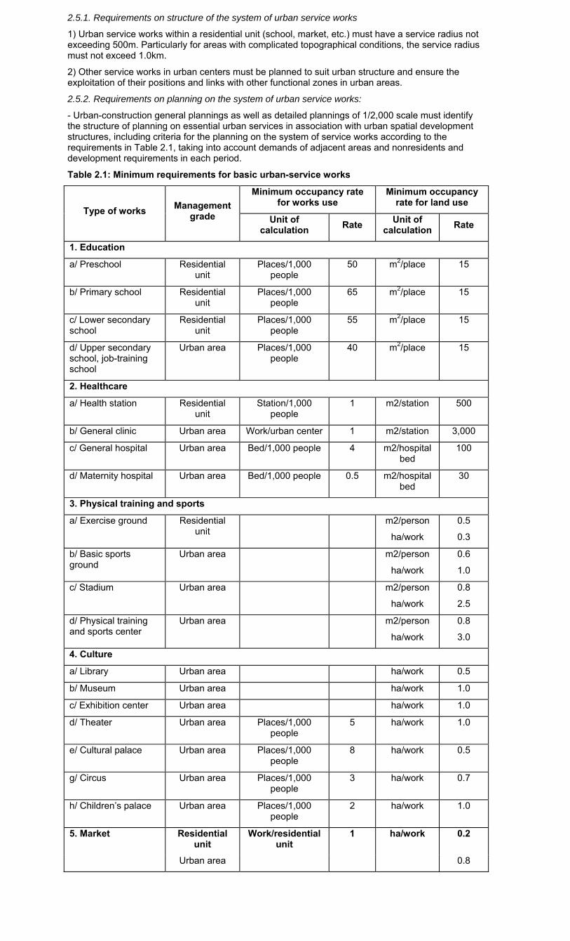
2.5.1. Requirements on structure of the system of urban service works
1) Urban service works within a residential unit (school, market, etc.) must have a service radius not exceeding 500m. Particularly for areas with complicated topographical conditions, the service radius must not exceed 1.0km.
2) Other service works in urban centers must be planned to suit urban structure and ensure the exploitation of their positions and links with other functional zones in urban areas.
2.5.2. Requirements on planning on the system of urban service works:
- Urban-construction general plannings as well as detailed plannings of 1/2,000 scale must identify the structure of planning on essential urban services in association with urban spatial development structures, including criteria for the planning on the system of service works according to the requirements in Table 2.1, taking into account demands of adjacent areas and nonresidents and development requirements in each period.
Table 2.1: Minimum requirements for basic urban-service works
Type of works Management
grade
Minimum occupancy rate for works use
Minimum occupancy rate for land use
Unit of calculation
Rate Unit of
calculation Rate
1. Education
a/ Preschool Residential unit
Places/1,000 people
50 m2/place 15
b/ Primary school Residential unit
Places/1,000 people
65 m2/place 15
c/ Lower secondary school
Residential unit
Places/1,000 people
55 m2/place 15
d/ Upper secondary school, job-training school
Urban area Places/1,000 people
40 m2/place 15
2. Healthcare
a/ Health station Residential unit
Station/1,000 people
1 m2/station 500
b/ General clinic Urban area Work/urban center 1 m2/station 3,000
c/ General hospital Urban area Bed/1,000 people 4 m2/hospital bed
100
d/ Maternity hospital Urban area Bed/1,000 people 0.5 m2/hospital bed
30
3. Physical training and sports
a/ Exercise ground Residential unit
m2/person
ha/work
0.5
0.3
b/ Basic sports ground
Urban area m2/person
ha/work
0.6
1.0
c/ Stadium Urban area m2/person
ha/work
0.8
2.5
d/ Physical training and sports center
Urban area m2/person
ha/work
0.8
3.0
4. Culture
a/ Library Urban area ha/work 0.5
b/ Museum Urban area ha/work 1.0
c/ Exhibition center Urban area ha/work 1.0
d/ Theater Urban area Places/1,000 people
5 ha/work 1.0
e/ Cultural palace Urban area Places/1,000 people
8 ha/work 0.5
g/ Circus Urban area Places/1,000 people
3 ha/work 0.7
h/ Children’s palace Urban area Places/1,000 people
2 ha/work 1.0
5. Market Residential unit
Work/residential unit
1 ha/work 0.2
Urban area 0.8
- In detailed plannings of 1/500 scale, urban service works must ensure harmonious arrangement based on service users and specialties; convenient service and economical use of land and construction investment funds; and urban beauty. Service works must be located suitably to their functions:
+ Kindergartens, schools, hospitals must not be located adjacently to roads of urban or higher grade, ensuring adequate area of grounds, gardens, greeneries and parking lots;
+ Cultural, trade and service works must be located on trunk roads according to service grades;
+ Accesses to service works reserved for the elderly, children and the disabled must not cross urban trunk roads if there are no underpasses or overpasses;
+ Underground urban-service works must be planned to ensure rational and convenient connection between ground-surface and underground works;
+ Each area with population of 20,000 people or more must have at least one upper secondary school
2.6. Urban greenery planning
2.6.1. Urban greenery system:
Urban greenery is divided into three major groups:
1) Public-use greenery (squares, parks, flower gardens, stroll gardens, etc., including water surface area in their premises and area of riverside landscape greenery planned for urban inhabitants’ access and use for physical training, rest, recreation, relax, etc.). For area of water surface without regular water, there must be planning solutions to ensure good appearance of the environment when there is no water.
2) Street greenery (green trees, lawns planted within the red line): All roads of sub-regional or higher grade must have street greeneries.
3) Special-purpose greenery (for isolation, protection, nursery, botanical research, etc.).
2.6.2. Requirements on urban greenery system planning
- Urban green spaces must be connected together by streets planted with trees and tree-strips to form a continuous green system. Lakeside land, land along canals and all spaces must be used as much as possible for greenery.
- Tree planting must not affect traffic safety, damage house foundations or underground works, or cause danger (not to plant trees easy to break or fall) or affect environmental sanitation (not to plant trees discharging toxic and harmful substances or insect attractants, etc.).
2.6.3. Regulations on the area of public-use greenery land in urban areas
- Public-use greenery land outside residential units in urban areas embraces parks, flower gardens serving one or more residential unit, the whole urban area or region (including theme parks); water surface area within premises of parks and flower gardens, of which water surface area converted into greenery land area per person must not exceed 50% of total area of public-use greenery land outside residential unit, excluding special-purpose greeneries.
- For mountainous and island urban areas, public greenery land area may be smaller but must not be less than 70% of that specified in Table 2.2.
Table 2.2: Public-use greenery land occupancy outside residential units in urban areas
Urban-area grade Occupancy (m2/person)
Special ≥7
I and II ≥6
III and IV ≥5
V ≥4
- Public-use greenery land within a residential unit embraces playgrounds, flower gardens and sports grounds for daily-life activities, including works serving the whole residential unit and works serving groups of residential houses. A newly built unit must have at least one flower garden (which may be combined with an outdoor sports ground and place for community activities) of at least 5,000 m2 serving the whole residential unit.
2.7. Planning on industrial parks and warehouses
2.7.1. Industrial parks
1) Planning on the construction, renovation and expansion of industrial parks and clusters must meet the following requirements:
- Environmental protection:
+ To ensure the observance of the law on environmental protection.
+ Locations of industrial enterprises must ensure the minimum adverse impacts on the urban environment, and comply with Points 2 and 3 of Section 2.7.1.
- Convenient and rational production organization.
- Works location suitably to topographical, geological and landscape conditions, in harmony with other urban architectural complexes, satisfying requirements on fire and explosion prevention and fighting.
- Rational arrangement of technical infrastructure and greenery networks.
- Rational use of land.
2) Locations of industrial enterprises:
Locations of enterprises must not adversely affect the living environment of residential areas:
- Enterprises which discharge toxic and harmful substances or are prone to environmental pollution must be located at the end of the major wind direction, or at the end of rivers or streams against residential areas.
- Depending on the extent of adverse impacts on the environment and the volume of to-and-fro transport:
+ To locate outside urban areas enterprises which use strong radioactive substances or radioactive substances prone to fire or explosion; and large-sized industrial-scrap landfills or those containing dangerous scraps.
+ To locate far from civil areas grade-I and grade-II hazardous enterprises (according to classification of hazard grades in Appendix 6).
+ To locate right in residential areas enterprises whose wastes, noises and vibrators satisfy permitted standards for residential areas and which have strictly controlled environmental criteria.
3) Sanitation isolation strips:
- Depending on the extent of harms to the environment, there must be sanitation isolation strips between industrial works and residential areas.
- The width of an isolation strip must ensure the minimum distance according to Vietnam environmental standard.
- In a sanitation isolation strip, at least 50% of land area must be planted with green trees and not more than 40% of land area may be used for parking lots, pumping stations, wastewater treatment facilities and solid-waste transit facilities.
4) Waste and scrap landfills:
- Industrial waste and scrap landfills must be fenced and must neither adversely affect sanitation conditions of surrounding enterprises nor contaminate the environment.
- For sites of dangerous scraps (which are prone to fire, explosion or epidemics, etc.), measures to handle toxic and hazardous substances and ensure isolation space are required.
2.7.2. Warehouse zones
1) A planning on urban warehouse zones must meet the following requirements:
- Rational organization of the network of warehouses of three types:
+ Retail warehouses for daily-life needs may be located within urban centers;
+ Distribution and wholesale warehouses must be located in vicinities and outside urban centers;
+ National reserve warehouses, transit warehouses and warehouses for storing toxic, hazardous and fire- or explosion-prone substances must be located in separate zones in suburbs.
- Locations of warehouse zones must:
+ Be on high places, not be prone to flood and be near distribution and consumption places;
+ Be convenient for communication and transportation;
+ Ensure sanitation isolation distances from civil areas.
2) Within warehouse zones, warehouses must be grouped based on classification of goods in warehouses; there must be convenient roads, parking lots and warehouse equipment.
2.7.3. Regulations on the use of land for industrial and small-cottage industry activities and warehouses
- Land for construction of industrial or small-cottage industry zones must be planned to suit industrial development potential, socio-economic development master plan and relevant development strategies of each urban area.
- Land for warehouses serving urban areas: Non-hazardous warehouse zones for urban areas may be located within civil zones. Warehouse zones which are likely to discharge hazardous wastes must be located in industrial zones or clusters or independently, ensuring isolation and waste treatment conditions to meet environmental management requirements.
- The planning on the use of land in industrial or small-cottage industry zones must satisfy the requirements on functions of industrial zones. The ratios of land of various categories in an industrial zone depend on the location of the industrial zone, the area module of land lots for construction of factories or warehouses, which must comply with stipulations in Table 2.3.
Table 2.3: Ratios of land of various categories in industrial or small-cottage industry zones
Land category Ratio (% of area of the whole zone)
Factories and warehouses ≥ 55
Technical zones ≥ 1
Administrative and service works ≥ 1
Transport ≥ 8
Greenery ≥ 10
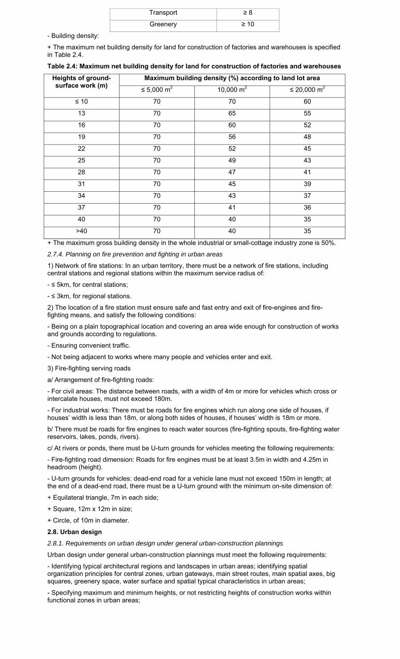
- Building density:
+ The maximum net building density for land for construction of factories and warehouses is specified in Table 2.4.
Table 2.4: Maximum net building density for land for construction of factories and warehouses
Heights of ground-surface work (m)
Maximum building density (%) according to land lot area
≤ 5,000 m2 10,000 m2 ≤ 20,000 m2
≤ 10 70 70 60
13 70 65 55
16 70 60 52
19 70 56 48
22 70 52 45
25 70 49 43
28 70 47 41
31 70 45 39
34 70 43 37
37 70 41 36
40 70 40 35
>40 70 40 35
+ The maximum gross building density in the whole industrial or small-cottage industry zone is 50%.
2.7.4. Planning on fire prevention and fighting in urban areas
1) Network of fire stations: In an urban territory, there must be a network of fire stations, including central stations and regional stations within the maximum service radius of:
- ≤ 5km, for central stations;
- ≤ 3km, for regional stations.
2) The location of a fire station must ensure safe and fast entry and exit of fire-engines and fire-fighting means, and satisfy the following conditions:
- Being on a plain topographical location and covering an area wide enough for construction of works and grounds according to regulations.
- Ensuring convenient traffic.
- Not being adjacent to works where many people and vehicles enter and exit.
3) Fire-fighting serving roads
a/ Arrangement of fire-fighting roads:
- For civil areas: The distance between roads, with a width of 4m or more for vehicles which cross or intercalate houses, must not exceed 180m.
- For industrial works: There must be roads for fire engines which run along one side of houses, if houses’ width is less than 18m, or along both sides of houses, if houses’ width is 18m or more.
b/ There must be roads for fire engines to reach water sources (fire-fighting spouts, fire-fighting water reservoirs, lakes, ponds, rivers).
c/ At rivers or ponds, there must be U-turn grounds for vehicles meeting the following requirements:
- Fire-fighting road dimension: Roads for fire engines must be at least 3.5m in width and 4.25m in headroom (height).
- U-turn grounds for vehicles: dead-end road for a vehicle lane must not exceed 150m in length; at the end of a dead-end road, there must be a U-turn ground with the minimum on-site dimension of:
+ Equilateral triangle, 7m in each side;
+ Square, 12m x 12m in size;
+ Circle, of 10m in diameter.
2.8. Urban design
2.8.1. Requirements on urban design under general urban-construction plannings
Urban design under general urban-construction plannings must meet the following requirements:
- Identifying typical architectural regions and landscapes in urban areas; identifying spatial organization principles for central zones, urban gateways, main street routes, main spatial axes, big squares, greenery space, water surface and spatial typical characteristics in urban areas;
- Specifying maximum and minimum heights, or not restricting heights of construction works within functional zones in urban areas;
- Setting requirements on urban architectural management under the general construction planning for the management of the general landscape architecture of the whole urban area according to the above requirements.
2.8.2. Requirements on urban design under detailed urban-construction plannings
1) Urban design under detailed urban-construction plannings of 1/2,000 scale must meet the following requirements:
- Identifying typical works in the space of the planned area according to major directions and visions;
- Setting (or not setting) maximum and minimum control limits and principles on the height interrelation of adjacent works for each functional zone and the whole area;
- Specifying the building set-back on major streets and crossroads;
- Setting principles on principal configuration, color, light and architectural appearances of architectures, greeneries, water surface and squares;
- Identifying principles of connecting space of the designed area with adjacent space outside the designed area;
- Formulating regulations on urban architecture management under the detailed construction plan of 1/2,000 scale for management of landscape architecture of the designed area according to the above requirements;
- Specifying land use limits such as building density, building stories (depending on spatial control requirements and planning organization intentions, specifying accurate building stories and average stories, or only maximum and minimum stories, and the interrelation between the heights of works in the planned area, or not restricting construction heights).
2) Urban design under detailed urban-construction plannings of 1/500 scale must meet the following requirements:
- Identifying typical works in the planned area’s space according to main directions and visions;
- Specifying works’ construction heights and first-floor heights for each land lot;
- Identifying the building set-back on each street and at crossroads;
- Specifying configuration and architectural appearances of works; color and other requirements on works’ building materials;
- Specifying the arrangement of urban public-utility works, monuments, grandiose paintings, advertisement boards, instruction boards, signboards, greeneries, garden grounds, water surface, squares, fences, passageways for the disabled, pavements, and architecture covering urban technical infrastructure works;
- Specifying pavement level and work construction foundation level;
- Setting requirements on urban architecture management under detailed construction plans of 1/500 scale for management of landscape architecture of each work, street block, street line and region.
2.8.3. Regulations on work disposition suitable to climatic conditions of planned areas
Works’ planning disposition should be studied on the basis of analyzing micro-climatic conditions of the designed land zone to select optimal solutions to limit sunlight and wind directions’ adverse impacts on works’ micro-climatic conditions, minimizing energy use for the purpose of cooling or warming works.
2.8.4. Minimum distances between terraces
Minimum distances between separate construction works or adjoining houses (collectively referred to as terraces) in new construction planning areas are prescribed as follows:
- The distance between the long sides of two terraces < 46m high must be ≥ 1/2 of the work’s height (≥ 1/2h) and must not be < 7m. For works of ≥ 46m high, this distance must be ≥ 25m;
- The distance between the two gables of two terraces < 46m high must be ≥ 1/3 of the work’s height (≥ 1/3h) and must not be < 4m. For works ≥ 46m high, this distance must be ≥ 15m;
- For terraces including works’ bases and top towers, regulations on the minimum distance to the opposite terrace apply separately to works’ bases and top towers depending on corresponding building stories, counting from the ground surface (pavement level);
- If in a terrace, the length of the long side and that of the gable is equal, the front adjacent to the road which is the largest one among those adjacent to that land lot is regarded the long side of the house.
2.8.5. Building set-back
Building set-back against the planned road’s building-line depends on the organization of architectural spatial planning, work height and building-line width, but the minimum set-back must satisfy the requirements in Table 2.5.
Table 2.5. Minimum building set-back (m) according to building line's width and work construction height
Work construction height (m)
Building line adjacent to the land lot for work construction (m)
≤ 16 19 22 25 ≥28
< 19 0 0 3 4 6
19 ÷ < 22 0 0 0 3 6
22 ÷ < 25 0 0 0 0 6
≥ 25 0 0 0 0 6
- For work complexes including works’ bases and top towers, regulations on building set-back apply separately to works’ bases and top towers according to corresponding building stories counting from the ground surface (pavement level).
2.8.6. Permitted maximum net building density
1) Residential houses:
The maximum net building density of a land lot for the construction of groups of adjoining houses, separate houses and apartment buildings are specified in Tables 2.6 and 2.7a.
Table 2.6: Maximum net building density of a land lot for the construction of groups of adjoining houses or separate houses (garden houses, villas, etc.)
Land lot area (m2/house) ≤ 50 75 100 200 300 500 ≥ 1,000
Maximum building density (%) 100 90 80 70 60 50 40
Table 2.7a: Maximum net building density of groups of apartment buildings according to land lot area and work height
Ground-surface work construction height (m)
Maximum building density (%) according to land lot area
≤ 3,000 m2 10,000 m2 18,000 m2 ≥ 35,000 m2
≤ 16 75 65 63 60
19 75 60 58 55
22 75 57 55 52
25 75 53 51 48
28 75 50 48 45
31 75 48 46 43
34 75 46 44 41
37 75 44 42 39
40 75 43 41 38
43 75 42 40 37
46 75 41 39 36
>46 75 40 38 35
2) Educational, healthcare and cultural works and markets:
The maximum net building density of such public works as educational, healthcare, cultural and physical training and sport works and markets in newly built areas is 40%.
3) Other urban service works and works with combined functions:
The maximum net building density of other urban service works and works with combined functions which are built on a land lot of e”3,000 m2 should be considered depending on their locations in urban areas and specific planning solutions for such land lot and be approved by competent authorities. However, this density must satisfy the requirements on the minimum distance between terraces (Section 2.8.4) and the building set-back (Section 2.8.5) and ensure the area of parking lots as prescribed, and comply with the requirements specified in Table 2.7b.
For other urban service works and works with combined functions which are built on a land lot of <3,000 m2, after excluding the land area for the building set-back specified at Section 2.8.5, the building density of 100% may apply to the remaining land area, ensuring the requirements on the minimum distance between terraces (Section 2.8.4) and the area of parking lots as prescribed.
Table 2.7b: Maximum net building density of urban service houses and houses with combined functions according to land lot area and work height
Height of ground-surface works (m)
Maximum building density (%) according to land lot area
3,000 m2 10,000 m2 18,000 m2 ≥ 35,000 m2
≤ 16 80 70 68 65
19 80 65 63 60
22 80 62 60 57
25 80 58 56 53
28 80 55 53 50
31 80 53 51 48
34 80 51 49 46
37 80 49 47 44
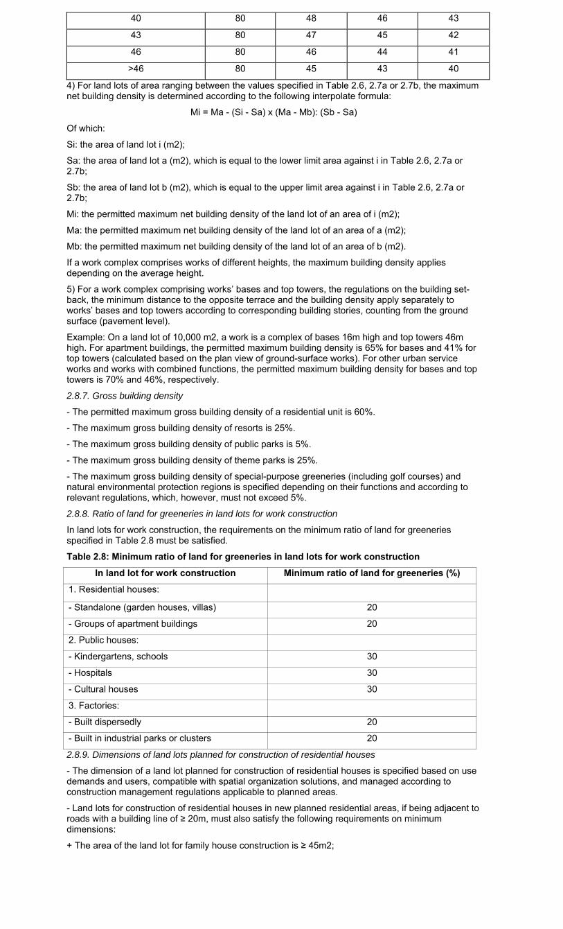
40 80 48 46 43
43 80 47 45 42
46 80 46 44 41
>46 80 45 43 40
4) For land lots of area ranging between the values specified in Table 2.6, 2.7a or 2.7b, the maximum net building density is determined according to the following interpolate formula:
Mi = Ma - (Si - Sa) x (Ma - Mb): (Sb - Sa)
Of which:
Si: the area of land lot i (m2);
Sa: the area of land lot a (m2), which is equal to the lower limit area against i in Table 2.6, 2.7a or 2.7b;
Sb: the area of land lot b (m2), which is equal to the upper limit area against i in Table 2.6, 2.7a or 2.7b;
Mi: the permitted maximum net building density of the land lot of an area of i (m2);
Ma: the permitted maximum net building density of the land lot of an area of a (m2);
Mb: the permitted maximum net building density of the land lot of an area of b (m2).
If a work complex comprises works of different heights, the maximum building density applies depending on the average height.
5) For a work complex comprising works’ bases and top towers, the regulations on the building set-back, the minimum distance to the opposite terrace and the building density apply separately to works’ bases and top towers according to corresponding building stories, counting from the ground surface (pavement level).
Example: On a land lot of 10,000 m2, a work is a complex of bases 16m high and top towers 46m high. For apartment buildings, the permitted maximum building density is 65% for bases and 41% for top towers (calculated based on the plan view of ground-surface works). For other urban service works and works with combined functions, the permitted maximum building density for bases and top towers is 70% and 46%, respectively.
2.8.7. Gross building density
- The permitted maximum gross building density of a residential unit is 60%.
- The maximum gross building density of resorts is 25%.
- The maximum gross building density of public parks is 5%.
- The maximum gross building density of theme parks is 25%.
- The maximum gross building density of special-purpose greeneries (including golf courses) and natural environmental protection regions is specified depending on their functions and according to relevant regulations, which, however, must not exceed 5%.
2.8.8. Ratio of land for greeneries in land lots for work construction
In land lots for work construction, the requirements on the minimum ratio of land for greeneries specified in Table 2.8 must be satisfied.
Table 2.8: Minimum ratio of land for greeneries in land lots for work construction
In land lot for work construction Minimum ratio of land for greeneries (%)
1. Residential houses:
- Standalone (garden houses, villas) 20
- Groups of apartment buildings 20
2. Public houses:
- Kindergartens, schools 30
- Hospitals 30
- Cultural houses 30
3. Factories:
- Built dispersedly 20
- Built in industrial parks or clusters 20
2.8.9. Dimensions of land lots planned for construction of residential houses
- The dimension of a land lot planned for construction of residential houses is specified based on use demands and users, compatible with spatial organization solutions, and managed according to construction management regulations applicable to planned areas.
- Land lots for construction of residential houses in new planned residential areas, if being adjacent to roads with a building line of ≥ 20m, must also satisfy the following requirements on minimum dimensions:
+ The area of the land lot for family house construction is ≥ 45m2;
+ The width of the land lot for house construction is ≥ 5m;
+ The depth of the land lot for house construction is ≥ 5m.
- Land lots for construction of residential houses in new planned residential areas, if being adjacent to roads with a building line of < 20m, must also satisfy the following requirements on minimum dimensions:
+ The area of the land lot for family house construction is ≥ 36m2;
+ The width of the land lot for house construction is ≥ 4m;
+ The depth of the land lot for house construction is ≥ 4m.
- The maximum length of a terrace of adjoining or separate houses with both sides adjacent to roads of regional or lower grade is 60m. There must be roads between terraces according to regulations on the road network planning (Table 4.4), or walkways at least 4m wide for pedestrians.
2.8.10. House parts which may protrude the red line in case the building line coincides with the red line
These regulations should be applied suitably to specific spatial organization solutions for each region and manifested in construction management regulations according to the planning of each region, and comply with the following regulations:
1) Fixtures of a house:
- In the space of a height of 3.5m above the pavement, all parts of a house must not protrude the red line, except the cases below:
+ Vertical rainwater drains on the outer side of the house may protrude the red line not more than 0.2m and have a good appearance;
+ From the height of 1m or more (from the pavement surface), sommer, cornice and decorative parts may protrude the red line not more than 0.2m.
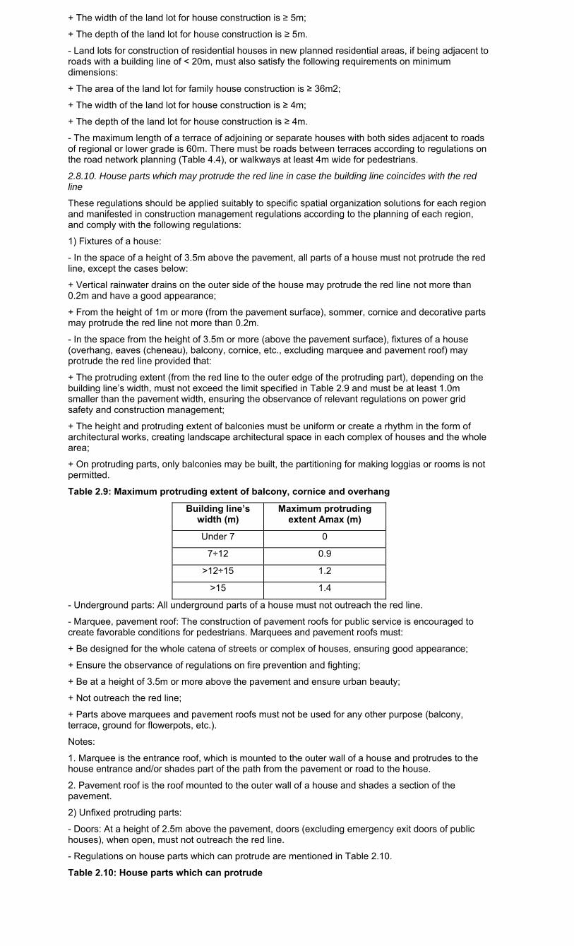
- In the space from the height of 3.5m or more (above the pavement surface), fixtures of a house (overhang, eaves (cheneau), balcony, cornice, etc., excluding marquee and pavement roof) may protrude the red line provided that:
+ The protruding extent (from the red line to the outer edge of the protruding part), depending on the building line’s width, must not exceed the limit specified in Table 2.9 and must be at least 1.0m smaller than the pavement width, ensuring the observance of relevant regulations on power grid safety and construction management;
+ The height and protruding extent of balconies must be uniform or create a rhythm in the form of architectural works, creating landscape architectural space in each complex of houses and the whole area;
+ On protruding parts, only balconies may be built, the partitioning for making loggias or rooms is not permitted.
Table 2.9: Maximum protruding extent of balcony, cornice and overhang
Building line’s width (m)
Maximum protruding extent Amax (m)
Under 7 0
7÷12 0.9
>12÷15 1.2
>15 1.4
- Underground parts: All underground parts of a house must not outreach the red line.
- Marquee, pavement roof: The construction of pavement roofs for public service is encouraged to create favorable conditions for pedestrians. Marquees and pavement roofs must:
+ Be designed for the whole catena of streets or complex of houses, ensuring good appearance;
+ Ensure the observance of regulations on fire prevention and fighting;
+ Be at a height of 3.5m or more above the pavement and ensure urban beauty;
+ Not outreach the red line;
+ Parts above marquees and pavement roofs must not be used for any other purpose (balcony, terrace, ground for flowerpots, etc.).
Notes:
1. Marquee is the entrance roof, which is mounted to the outer wall of a house and protrudes to the house entrance and/or shades part of the path from the pavement or road to the house.
2. Pavement roof is the roof mounted to the outer wall of a house and shades a section of the pavement.
2) Unfixed protruding parts:
- Doors: At a height of 2.5m above the pavement, doors (excluding emergency exit doors of public houses), when open, must not outreach the red line.
- Regulations on house parts which can protrude are mentioned in Table 2.10.
Table 2.10: House parts which can protrude
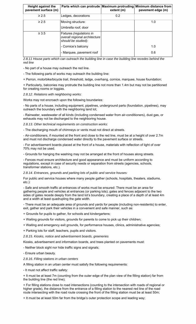
Height against the pavement surface (m)
Parts which can protrude Maximum protruding extent (m)
Minimum distance from pavement edge (m)
≥ 2.5 Ledges, decorations 0.2
≥ 2.5 Moving structure:
Umbrella roof, door
1.0
≥ 3.5 Fixtures (regulations in overall regional architecture should be studied):
- Cornice’s balcony 1.0
- Marquee, pavement roof 0.6
2.8.11 House parts which can outreach the building line in case the building line recedes behind the red line
- No part of a house may outreach the red line.
- The following parts of works may outreach the building line:
+ Perron, motorbike/bicycle trail, threshold, ledge, overhang, cornice, marquee, house foundation;
+ Particularly, balconies may protrude the building line not more than 1.4m but may not be partitioned for creating rooms or loggias.
2.8.12. Relations with neighboring works:
Works may not encroach upon the following boundaries:
- No parts of a house, including equipment, pipelines, underground parts (foundation, pipelines), may outreach the boundary with the neighboring land lot;
- Rainwater, wastewater of all kinds (including condensed water from air-conditioners), dust gas, or exhausts may not be discharged to the neighboring house.
2.8.13. Other technical requirements on construction works:
- The discharging mouth of chimneys or vents must not direct at streets.
- Air-conditioners, if mounted at the front and close to the red line, must be at a height of over 2.7m and must not discharge condensed water directly to the pavement surface or streets.
- For advertisement boards placed at the front of a house, materials with reflection of light of over 70% may not be used.
- Grounds for hanging the washing may not be arranged at the front of houses along streets.
- Fences must ensure architecture and good appearance and must be uniform according to regulations, except in case of security needs or separation from streets (agencies, schools, transformer stations, etc.).
2.8.14. Entrances, grounds and parking lots of public and service houses:
For public and service houses where many people gather (schools, hospitals, theaters, stadiums, etc.):
- Safe and smooth traffic at entrances of works must be ensured: There must be an area for gathering people and vehicles at entrances (or parking lots); gates and fences adjacent to the two sides of gates recede deeply from the land lot’s boundary, creating a place of a depth of at least 4m and a width at least quadrupling the gate width.
- There must be an adequate area of grounds and yards for people (including non-residents) to enter, exit, gather and park their vehicles in a convenient and safe manner, such as:
+ Grounds for pupils to gather, for schools and kindergartens;
+ Waiting grounds for visitors, grounds for parents to come to pick up their children;
+ Waiting and emergency exit grounds, for performance houses, clinics, administrative agencies;
+ Parking lots for staff, teachers, pupils and visitors.
2.8.15. Kiosks, notice and advertisement boards, greeneries
Kiosks, advertisement and information boards, and trees planted on pavements must:
- Neither block sight nor hide traffic signs and signals;
- Ensure urban beauty.
2.8.16. Filling stations in urban centers
A filling station in an urban center must satisfy the following requirements:
- It must not affect traffic safety:
+ It must be at least 7m (counting from the outer edge of the plan view of the filling station) far from the building line (the red line);
+ For filling stations close to road intersections (counting to the intersection with roads of regional or higher grade), the distance from the entrance of a filling station to the nearest red line of the road route intersecting with the road route crossing the front of the filling station must be at least 50m;
+ It must be at least 50m far from the bridge’s outer protection scope and leading way;
+ It must be at least 50m far from the place with obstructed vision (for example: it must be at least 50m far from the tangent point of the curve of a road of a curved diameter <50m along the road).
- It must ensure safety in fire prevention and fighting, and landscape protection:
+ It must be at least 100m from a place where many people gather (school, market);
+ It must be at least 300m from another filling station;
+ It must be at least 100m from a beauty spot.
2.9. Underground space planning
2.9.1. General requirements on underground-space construction planning
The planning on construction of urban underground works must ensure rational, economical and efficient use of land; ensure appropriate, synchronous and safe connection between underground works themselves and between underground works and ground-surface works; satisfy requirements on protection of the environment and ground water sources in close association with security and defense requirements.
2.9.2. Requirements on planning on the construction of underground technical infrastructure works
- To select forms of arranging underground technical infrastructure works suitable to each type and long-term development trends of urban areas.
- These works must be at a depth and have a horizontal distance which do not affect one another and safety in their management, exploitation and use and relevant ground-surface works.
- The connection of technical infrastructure works with one another and with other underground works in urban areas must be convenient and safe and satisfy technical requirements.
2.9.3. Requirements on planning on construction of urban underground transport networks
The planning on urban underground transport networks must ensure systematism, synchronism, interconnection, convenient spatial connection, safety for transport on the ground and underground public works as well as adjacent public works on the ground.
2.9.4. Requirements on planning on the construction of underground public works
- Those works must be compatible with the urban spatial organization planning and public service systems.
- Those works must ensure convenient and safe spatial connection with underground transport works, ground-surface public works as well as underground public works adjacent to and connecting with general underground technical infrastructure systems in urban centers.
2.9.5. Minimum distances between underground works
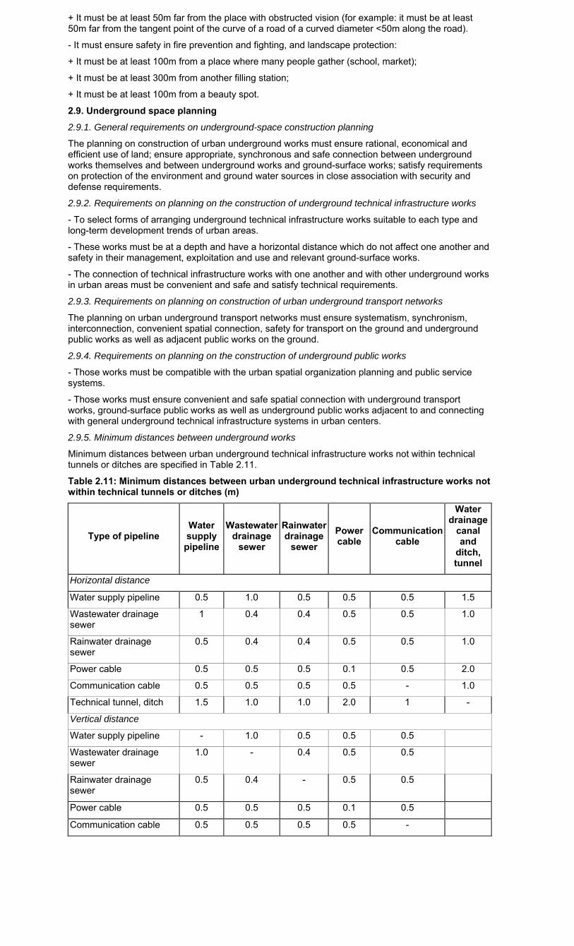
Minimum distances between urban underground technical infrastructure works not within technical tunnels or ditches are specified in Table 2.11.
Table 2.11: Minimum distances between urban underground technical infrastructure works not within technical tunnels or ditches (m)
Type of pipeline Water supply
pipeline
Wastewater drainage
sewer
Rainwater drainage
sewer
Power cable
Communication cable
Water drainage
canal and
ditch, tunnel
Horizontal distance
Water supply pipeline 0.5 1.0 0.5 0.5 0.5 1.5
Wastewater drainage sewer
1 0.4 0.4 0.5 0.5 1.0
Rainwater drainage sewer
0.5 0.4 0.4 0.5 0.5 1.0
Power cable 0.5 0.5 0.5 0.1 0.5 2.0
Communication cable 0.5 0.5 0.5 0.5 - 1.0
Technical tunnel, ditch 1.5 1.0 1.0 2.0 1 -
Vertical distance
Water supply pipeline - 1.0 0.5 0.5 0.5
Wastewater drainage sewer
1.0 - 0.4 0.5 0.5
Rainwater drainage sewer
0.5 0.4 - 0.5 0.5
Power cable 0.5 0.5 0.5 0.1 0.5
Communication cable 0.5 0.5 0.5 0.5 -
When daily-life water supply pipelines are placed in parallel with dirty-water drainage pipelines, the distance between pipelines must not be shorter than 1.5m; this distance must not be shorter than 3m in case water-supply pipeline diameter is equal to 200mm; in case water-supply pipeline diameter is larger than 200mm, pipelines running in parallel with water supply pipelines must be made of metal.
The distance between water supply pipelines of over 300mm in diameter and between them and communication cables must not be shorter than 1 m.
- If several water supply pipelines are located in parallel with one another, the distance between them must not be shorter than 0.7m in case the pipeline diameter is 300mm; 1m in case the pipeline diameter is 400÷1,000mm; or 1.5m in case the pipeline diameter is over 1,000mm. The distance between pipelines with other pressures is subject to similar standards.
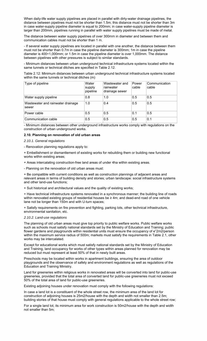
- Minimum distances between urban underground technical infrastructure systems located within the same tunnels or technical ditches are specified in Table 2.12.
Table 2.12: Minimum distances between urban underground technical infrastructure systems located within the same tunnels or technical ditches (m)
Type of pipeline Water supply pipeline
Wastewater and rainwater drainage sewer
Power cable
Communication cable
Water supply pipeline 0.8 1.0 0.5 0.5
Wastewater and rainwater drainage sewer
1.0 0.4 0.5 0.5
Power cable 0.5 0.5 0.1 0.5
Communication cable 0.5 0.5 0.5 0.1
- Minimum distances between other underground infrastructure works comply with regulations on the construction of urban underground works.
2.10. Planning on renovation of old urban areas
2.10.1. General regulations
- Renovation planning regulations apply to:
+ Embellishment or dismantlement of existing works for rebuilding them or building new functional works within existing areas;
+ Areas intercalating construction-free land areas of under 4ha within existing areas.
- Planning on the renovation of old urban areas must:
+ Be compatible with current conditions as well as construction plannings of adjacent areas and relevant areas in terms of building density and stories; urban landscape: social infrastructure systems and other land-use functions;
+ Suit historical and architectural values and the quality of existing works;
+ Have technical infrastructure systems renovated in a synchronous manner; the building line of roads within renovated existing groups of residential houses be ≥ 4m; and dead-end road of one vehicle lane not be longer than 150m and with U-turn spaces;
+ Satisfy requirements on fire prevention and fighting, parking lots, other technical infrastructure, environmental sanitation, etc.
2.10.2. Land-use regulations
The planning of old urban areas must give top priority to public welfare works. Public welfare works such as schools must satisfy national standards set by the Ministry of Education and Training; public flower gardens and playgrounds within residential units must ensure the occupancy of e”2m2/person within the maximum service radius of 500m; markets must satisfy the requirements in Table 2.1, other works may be intercalated.
Except for educational works which must satisfy national standards set by the Ministry of Education and Training, land occupancy for works of other types within areas planned for renovation may be reduced but must represent at least 50% of that in newly built areas.
Preschools may be located within works in apartment buildings, ensuring the area of outdoor playgrounds and the observance of safety and environment regulations as well as regulations of the Education and Training Ministry.
Land for greeneries within religious works in renovated areas will be converted into land for public-use greeneries, provided that the total area of converted land for public-use greeneries must not exceed 50% of the total area of land for public-use greeneries.
Existing adjoining houses under renovation must comply with the following regulations:
In case a land lot is a constituent of the whole street row, the minimum area of the land lot for construction of adjoining houses is 25m2/house with the depth and width not smaller than 2.5m; building stories of that house must comply with general regulations applicable to the whole street row;
For a single land lot, its minimum area for work construction is 50m2/house with the depth and width not smaller than 5m;
Regarding works’ volume: For single works built on single land lots of 10m or less in width or depth, the ratio between the work height and width or the ratio between the work height and depth (against the front) must not exceed a triple of the dimension of the smaller side of the work, except for works with special typical characteristics determined under regulations on urban construction management according to approved detailed planning;
- Special cases in the course of ground clearance for urban construction comply with current relevant regulations.
2.10.3. Regulations on service radius
For old areas in urban centers, the service radius of public works may be increased but not exceeding 100% against that applicable to new planned areas and must ensure specialized regulations. The reduction of the scale or quantity of urban service works must comply with regulations on service radius and land use scale as for new construction plannings, so that adjacent units, within a service radius doubling the radius under new construction plannings, can satisfy their demands in terms of public works of that type.
2.10.4. Regulations on building set-back comply with Section 2.8.5 of this Code.
2.10.5. Regulations on distances between terraces of adjoining houses or single works (collectively referred to as terraces):
- For terraces of 16m or more in height: The distance between them must be equal to 70% of that prescribed for construction works in new planned areas.
- For terraces of under 16m in height: The distance between the long sides of two terraces must be at least 4m and the distance between two gables of two terraces with a common path must be at least 3m (the distance from the land lot’s boundary to the heart of the common path must be at least 1.5m).
- In case two terraces of different heights belong to two adjacent land lots of two different owners of land use rights, the minimum distance from each of those terraces to the boundary between the two land lots must be at least equal to 50% of the minimum distance between the two terraces of a height equal to the height of that terrace.
2.10.6. Regulations on permitted maximum net building density
The maximum net building density for areas planned for renovation must comply with Section 2.8.6 of this Code. In case of embellishment not resulting in the increase in building density and stories, the current building density may be kept unchanged.
The increase in the building density or stories, or the dismantlement for re-construction must comply with regulations on the maximum net building density in areas planned for renovation stated at Section 2.8.6 of this Code.
The maximum net building density of public works such as educational, healthcare and cultural works and markets in areas planned for renovation is 60%. In addition, the planning on construction of these works must comply with specialized regulations.
2.10.7. Other regulations on height, house parts which can protrude the red line and the building line, relations with neighboring works, kiosks, advertisement boards, and greeneries are the same as those applicable to new planned areas.
2.10.8. Entrances, grounds and parking lots of public and service houses
Public and service houses (schools, hospitals, theaters, stadiums, etc.) must:
- Ensure safe and smooth traffic at their entrances; have an area for gathering people and vehicles in front of the entrances (also referred to as parking lots or vehicle dispersion areas): Gates and fences adjacent to the two sides of gates must recede from the land lot’s boundary, creating a gathering place of a depth of at least 4m and a width at least doubling the gate width;
- Have an adequate area of grounds and yards for people (including nonresidents) to come in and out, gather or park their vehicles in a convenient and safe manner:
+ Grounds for gathering pupils, for schools and kindergartens;
+ Waiting grounds for visitors and grounds for parents to come to pick up their children;
+ Waiting and emergency exit grounds, for performance houses, clinics, administrative agencies;
+ Parking lots for staff, teachers, pupils and visitors.
2.10.9. Filling stations in urban areas must comply with regulations applicable to newly planned areas in Section 2.8.16.
2.11. Planning on construction of rural residential areas
2.11.1. Requirements on land for the construction and expansion of rural residential areas:
1) Land for the construction and expansion of rural residential areas must not be within the following areas:
- Areas which are polluted with industrial wastes, or which are unhygienic, prone to epidemics;
- Areas having bad climate conditions with whirl-wind;
- Areas with to-be-exploited natural resources or within archaeological sites;
- Areas where construction is banned (protection scope of technical infrastructure works, protection zones of historical and cultural relics, scenic places or defense works, etc.);
- Areas frequently flooded (over 3m deep), or affected by landslides or flash-floods.
2) The use of cultivation soil must be restricted; hill, mountain or knoll soil or soil with low cultivation productivity should be used to build and expand rural residential areas.
2.11.2. Construction land occupancy for rural residential areas must comply with local conditions
Table 2.13: Land occupancy for rural residential areas in communes
Categories of land Land occupancy (m2/person)
Residential land (household residential land lots)
≥ 25
Land for construction of service works
≥ 5
Land for transport and technical infrastructure
≥ 5
Public greeneries ≥ 2
2.11.3. Functional sub-zones in rural residential areas
1) Major functional zones
A commune’s rural residential area embraces the following principal functional zones:
- Residential zone, including house villages and hamlets and service works;
- Communal center zone;
- Production and production-serving works;
- Communal social infrastructure works;
- Communal technical infrastructure works.
2) Requirements on functional sub-zones in the planning on rural residential areas:
- Saving cultivation land (restricting the expansion of available residential areas on agricultural land);
- Ensuring convenient traffic, production, accommodation, rest, recreation and public activities;
- Protecting the living environment;
- Taking advantage of topographical conditions and natural landscapes to create a beautiful architectural spatial composition imbued with identity of each region;
- Being compatible with regional characteristics in terms of geographical position and nature (being in vicinities, deep-lying or remote areas, long-existing residential areas or new economic zones, etc.); local economic branches as well as customs, habits and religions;
- Animal breeding, agricultural production and small-cottage industry should be planned to satisfy the requirements on sanitation isolation distance, prevention and control of the spread and outbreak of epidemics.
2.11.4. Planning on rural residential areas
The selection of land zones for construction of residential houses must satisfy the following requirements:
- Inheriting population distribution status and being compatible with the population distribution network planning of a relevant larger area;
- Ensuring the development of population which is appropriate and convenient for the organization of necessary public works such as kindergartens, lower secondary schools, service establishments, etc.;
- Being compatible with land and topographical conditions; determining boundaries based on natural topographical conditions such as roads, ponds, lakes, canals, ditches, hills, mountains and land strips.
For house construction areas planned on the basis of household residential land lots, the area of residential land for each household must comply with local regulations on limits of residential land allocated to each household.
Each household land lot embraces land for:
- Main house and easement (kitchen, warehouse, ancillary production zone);
- Ancillary works;
- Passageway, yard, place for storing straw, firewood, garbage, fence;
- Garden land, pond land, etc.
The composition of components in a land lot must ensure convenience for households’ daily-life and production activities, creating an architectural appearance for villages and hamlets.
2.11.5. Planning on communal central zones

1) General regulations:
In each commune, at least one central zone must be planned. For communes with large population and area, there may be a principal center and a subsidiary center. In the central zone, to arrange important works in service of administrative transaction, shopping, rest and recreation needs such as:
- Head offices of communal agencies: People’s Council, People’s Committee, Party Committee, Public Security Section, Detachment, cooperatives, mass organizations (Peasants’ Association, Women’s Union, Elderly Association, Youth Union, Veterans’ Association, Fatherland Front, etc.);
- Communal public works: cultural house, club, heritage hall, library, primary school, lower secondary school, sports ground, market, central service shop, post office, cultural services;
- For communes with population of 20,000 people or more, an upper secondary school must be planned.
2) Head offices of communal agencies:
- Head offices of the communal People’s Council and People’s Committee and their attached bodies; head offices of the communal Party Committee and mass organizations must be located in one place for convenient transactions and economical use of land.
- The land area for head offices of communal agencies must be at least 1,000m2.
3) Schools:
Each commune must be planned to have a primary school and a lower secondary school located near residential areas and in quiet places with good hygienic conditions, ensuring pupils’ safe and convenient travel. Those schools must be designed according to specialized standards.
4) Kindergartens and preschools:
Kindergartens and preschools must be located right in or near residential areas and designed according to specialized standards.
5) Health stations:
- Each commune must have a health station with the family planning ward, community health ward, obstetrics ward, medical examination and treatment wards, professional ward (which do simple tests, prepare traditional medicines and sell medicines), traditional medicinal-herb garden or flower garden.
- The communal health station must be located in a quiet, high and open-air place with abundant water sources which is convenient for communication with residential areas. The minimum area of land for construction of a health station without or with traditional-herb garden is 500m2 or 1,000m2, respectively.
6) Cultural and sport works:
- Communal cultural and sport works include culture house; club; heritage hall, exhibition or information room; library; meeting hall; broadcasting station; sport ground, etc.
- A cultural house comprises indoor and outdoor recreation sections and places for artistic activities (singing, dancing, music, dramatics, traditional opera, reformed opera). The minimum land area of a cultural house is 2,000m2.
- A heritage hall or exhibition room for displaying historical objects and combat and production achievements of the locality must be built on an area of at least 200m2.
- A library must have a reading room of at least 15 seats to be built on an area of at least 200m2.
- A meeting hall or place for artistic performances must have at least 100 seats.
- Sport grounds: The communal sport ground should be combined with the lower secondary school’s sport ground and outdoor ground for film screening in order to save land; the area of a sport ground must be at least 4,000m2; available rivers, ponds and lakes should be revamped into swimming pools and recreation places.
7) Markets, service shops:
- Each commune must have at least one market.
- Markets should be located in places convenient for travel, and on high and easy-to-drain land zones.
- Each market must have a place for keeping bicycles and motorcycles, a place for collecting and storing daily solid waste, and public water closets.
- Apart from private service shops, service shops organized by the commune must be located in the communal center.
2.11.6. Planning on small-cottage industry production zones
- The planning on construction of production and production-serving works must suit the commune’s production development potential in terms of:
+ Land (production of specialty paddy, crops, fruits), animal breeding, aquaculture;
+ Development of branches and trades, especially traditional ones such as production of goods for export and consumer goods;
+ Development of construction materials industry; stone, sand and gravel exploitation; food and foodstuff processing, small mechanical engineering, etc;

+ Conditions necessary for production: consumption market; capital raising capacity; applicable technologies; technical infrastructure (transport, electricity supply, water supply and drainage).
- Concentrated small-cottage industry zones must comply with land use and environment regulations as those applicable to industrial parks in urban areas.
- When planning production works, the following solutions may be applied:
+ Small-cottage industry production establishments causing no harms may be located in residential areas, in household easements, but must not let wastewater and noise pollute the environment;
+ Production and production-serving works which have adverse impacts on the environment must be located into production clusters outside residential areas and near transport hubs;
+ Between a production zone and a residential zone, there must be an isolation space suitable to characteristics and scale of production works.
Notes: The planning on large industrial enterprises in rural areas and the planning on agricultural production, forestry and fishery are not governed by this Chapter.
2.11.7. Planning on greeneries in rural residential areas
1) Greeneries in rural residential areas:
Greeneries in communal residential areas include:
- Public greeneries and flower gardens;
- Gardens of economic trees, fruits and herbs, and nurseries;
- Isolation greeneries planted surrounding concentrated production zones or production works.
2) General regulations:
A planning on planting trees in rural residential areas must satisfy the following requirements:
- To closely combine economic benefits (planting vegetables, fruit trees, timber trees, and trees for protection, etc.) with requirements on eco-environmental improvement, defense and security.
- To combine with the planning on planting protection trees in fields, coastal sand-shielding trees and anti-erosion trees in order to create a greenery in the commune.
3) Technical requirements:
- To create flower gardens in the central zone and in the land zone for construction of cultural, historical and religious works.
- Not to plant trees containing toxic resin or fly- or mosquito-attracting fruits, or thorny trees in health stations, schools, kindergartens or preschools; to plant high trees with thick and large foliages which can clean the air.
- To plant herbs in the health station’s land zone and trees in schools in service of teaching and learning.
- There must be greenery isolation strips surrounding concentrated production zones and production works emitting dust, stench or noise, meeting the requirements on isolation space for each type of production or the extent of discharge.
2.11.8. Regulation on architecture management
The architectural space of rural residential areas must be studied to suit natural structures and exploit particularities of localities, creating a typical image for each rural residential area and suitable to utilities of each work item.
2.11.9. Planning on renovation of old rural residential areas
The renovation of old residential areas covers:
- Reorganization or adjustment of functional zones in hamlets; adjustment of public-work networks; improvement of the service quality and comfort of works; additional construction or expansion of some works;
- Reorganization or additional adjustment of essential technical infrastructure networks;
- Improvement of environmental sanitation conditions;
- Expansion of the greenery area in residential zones and along technical infrastructure axes.
Chapter III
TECHNICAL PREPARATION PLANNING
3.1. General regulations on technical preparation planning
3.1.1. Compulsory technical preparations for land areas planned for construction
- Urban foundation leveling and filling (height planning).
- Planning on rainwater drainage systems.
- Other technical preparations such as lowering of groundwater level; prevention of landslides; plans to minimize damage caused by natural disasters (flood, flash-flood, storm, earthquake, flood-tide, etc.).
3.1.2. Requirements on foundation leveling and filling planning
- Being compatible with the rainwater drainage system, irrigation drainage system and system of works for protection of the land area from flood.
- Ensuring road slope according to standards.
- Making the fullest use of natural topographical conditions, maintaining existing rich soil and greenery, limiting the digging volume and embanked-soil height.
- Not making worse the works’ geological conditions or hydro-geological conditions.
- For existing urban centers, areas with rather high building density and relatively stable foundation level, the height planning must suit the present construction status.
3.1.3. Requirements on rainwater drainage system planning
- The rainwater drainage system must ensure the drainage of rainwater in the whole basin under planning into lakes, rivers, streams or irrigation drainage systems. Depending on urban-center grades, the nature of functional zones and the area of water drainage basin, to study the network of sewers and works in the system based on appropriate rain cycles.
- Regulations on rainwater collection:
+ 100% of inner-city roads must have rainwater drainage systems;
+ At least 60% of roads in vicinities must have rainwater drainage systems;
+ For roads of 40m or more in width, to arrange rainwater drainage systems along two roadsides.
- Common, separate or semi-separate systems must be suitable to urban sizes, sanitation requirements and natural conditions (topographical, climatic and hydrographical) and urban status.
- In low delta regions, to make use of existing lakes and ponds or build new rainwater-regulating reservoirs. If rainwater-drainage pumping stations must be used for urban areas, to study the use of these pumping stations for agricultural irrigation in vicinities in dry seasons.
- Ditches and streams running across urban areas must be embanked and, depending on requirements of urban areas, to apply solutions suitable to urban landscape and environment requirements.
3.1.4. Requirements on other technical preparations
- Riverside and coastal urban areas must be protected from inundation.
- The minimum limited foundation level must be 0.3m higher than the calculated minimum water level, for civil land, or 0.5m, for industrial land.
- Dike-top level must comply with the specialized irrigation planning.
- The calculated water level is the highest water level in a certain frequency cycle (years) as prescribed in Table 3.1
Table 3.1. Calculated water level - maximum water level in a certain frequency cycle (years)
Urban-center grade
Functional zone
Special grade
Grade I Grade II Grade III Grade IV Grade V
Central zone 100 100 50 40 20 10
Industrial zone, warehouse 100 100 50 40 20 10
Residential zone 100 100 50 40 20 10
Greenery, physical training and sport zone
20 10 10 10 10 2
Rural residential zone - Civil: > average annual Hmax
- Public: >Hmax + 0.3m
- River and lake banks in urban centers must be protected and reinforced from wave, rainwater or landslide.
- If mud or sand threatens to be washed by rainwater into a zone planned for construction, measures to block and divert mud and sand from that zone must be taken.
- If that zone is eroded by rainwater flows into trenches, measures to adjust rainwater flows and reinforce slope sides must be taken.
- If that zone is located within an area in danger of mountain-side slide, it is necessary to study geological and hydro-geological characteristics in the zone in order to seek appropriate technical solutions.
3.2. Regional planning on technical preparations
In a regional construction planning, the technical preparation planning must satisfy the following requirements:
- Identifying construction level for urban areas in the region and main dike systems;
- Devising regional rainwater-drainage solutions for main rivers, streams and water drainage basins as well as major water-drainage works;
- Identifying zones prone to natural disasters and seeking prevention measures.
3.3. Planning on urban technical preparations
3.3.1. Technical preparation planning under general urban-construction planning
In a general construction planning, technical preparation planning must meet the following requirements:
- Evaluating and identifying land categories based on favorable, less favorable or unfavorable natural conditions, or which are banned or restricted from construction;
- Identifying restricted construction level of each zone, the whole urban center and urban trunk roads; clearly determining areas subject to foundation elevation or lowering and forecasting foundation-leveling volumes; anticipating earth volumes for embankment and places for storing redundant earth volumes;
- Identifying main rainwater-drainage basins, main rainwater-drainage sewer systems; to-be-built reservoirs, and major works;
- Proposing solutions to prevent and mitigate natural disasters (flood, storm, tsunami, floodtide, etc).
3.3.2. Detailed technical-preparation planning
In a detailed construction planning, technical preparation planning must meet the following requirements:
1) For detailed plannings of 1/2,000 scale:
- Height planning: must match with relevant areas and meet requirements on technical infrastructure and urban construction; identify level at road intersections and special places; determin digging and embankment locations based on volume-related parameters;
- Rainwater drainage system: To design a sewer network with adequate technical parameters (dimension, slope, drainage direction, terminal levels of sewer sections and discharge mouths); identify technical parameters and locations of expected regulating reservoirs as well as major and local pumping stations (to be maintained or newly built);
- Other technical preparations: To identify places subject to embankment or foundation stabilization and anti-flood dikes.
2) For detailed plannings of 1/500 scale:
- Height planning: The requirements are the same as for detailed plannings of 1/2,000 scale and depending on topographical characteristics, to reflect the foundation leveling solution through “design isohypse.”
- Rainwater drainage system: In addition to the requirements for detailed plannings of a 1/2,000 scale, to identify water collection stations and technical wells, talus locations, shielding walls, etc.
3.4. Technical preparation planning for rural residential areas
3.4.1. Height planning (planning on foundation leveling and embankment)
The height planning for rural residential areas must satisfy the following requirements:
- Not to level or embank foundation when the work construction location is not yet identified and when there is no rainwater drainage planning;
- To plan foundation leveling and embankment for the land area for construction of works (houses, public houses and works, production houses, roads). Natural topographical conditions of the remaining land area shall be kept unchanged. Works’ foundation must be higher than the maximum regular flood level, especially for warehouses (which store chemical fertilizers, insecticides, rice seeds), schools, kindergartens, health stations, etc. The foundation level must be at least 0.3m higher than the annual maximum calculated water level;
- To ensure that rainwater is fast drained without causing erosion to roads’ or works’ foundation;
- To ensure convenient and safe traffic and travel;
- To take advantage of natural topographical conditions, limit volumes of land to be leveled or embanked; to protect perennial trees and rich soil;
- Not to settle population in areas prone to landslide or flood.
3.4.2. Rainwater drainage planning
- Rainwater drainage planning must suit the irrigation drainage system.
- For rivers or streams running across residential areas, their banks must be renovated and reinforced to prevent landslides.
- To select an appropriate water drainage system.
- For residential areas located near hill or mountain sides, to design canals for water flows from the top of hills or mountains in order to prevent overflow into residential areas.
- To seek solutions to prevent and mitigate damage caused by flood.
Chapter IV
TRANSPORT PLANNING
4.1. General regulations on transport planning
Requirements on a transport planning:
- To meet passenger and cargo transportation demands in service of socio-economic development, urbanization and international integration;
- To clearly grade the transport network;
- The external transport system crossing urban areas must be compatible with the urban planning.
4.2. Regional transport planning
Requirements on regional transport planning:
- To ensure convenient contact between the region and other regions and between functional zones in the region;
- To meet passenger and cargo transportation demands in service of the region’s socio-economic development, urbanization and international integration;
- To ensure convenient contact between regional and national as well as international transport systems;
- To clearly grade and connect to one another road networks: expressways, national highways, provincial roads, district roads, urban roads and important special-purpose roads;
- National, urban and special-purpose railways must be connected to one another through station systems, including passenger stations, cargo stations, technical stations and mixed stations;
- To identify locations and sizes of international and local airports and airfields;
- To identify types of seaport (grade I, grade II and grade III), locations and sizes of regional seaports;
- To identify inland waterway fairways and ports.
4.3. Urban transport planning
4.3.1. External transport system
1) Road:
- Motor expressways of grade 80, grade 100 and grade 120 must run outside the scope of urban construction planning and comply with specialized regulations (see Appendix 15).
- Not to arrange motorways of grades I, II and III (Appendix 15) running through urban areas but to arrange by-passes instead. Particularly, grade-III roads may run through some urban areas but planning solutions to ensure external transport and urban transport safety are required.
- To arrange urban car-terminals in places, which are convenient for contact with urban centers, stations, ports, markets and residential areas.
- To arrange garages and stopovers for cars running through urban areas, which are near transport hubs to urban areas.
2) Railway:
a/ Railway routes:
- For urban centers of special grade and grades I and II with national railways crossing, to build by-passes outward urban centers or apply appropriate transport organization solutions so that railways will not adversely impact urban centers.
- In urban centers of special grade and grade I where railway routes transport large numbers of passengers, to arrange railway routes or stations for passengers to travel to and from inner cities and vicinities.
- Urban houses must be at least 20m far from the heart of the nearest rail. In localities where railways run on trenches, the isolation space may be shorter but must not be under 10m. At least 50% of the width of the isolation strip must be planted with green trees.
- For renovated urban areas, to build protection isolation fence walls and ensure the prescribed distance for maintaining railway traffic order and safety (see Appendix 4).
b/ Intersections between railways themselves and between railways and roads:
- Intersections between railways themselves, and between urban railways, roads and traffic axes must be arranged at different heights.
- At all intersections between railways and roads, to take measures to ensure traffic safety (signals or barriers).
c/ Railway stations:
- Main passenger stations must be located near civil areas and have convenient connections with the central zone, residential areas and industrial parks. For urban centers of special grade and grades I and II, passenger stations may be located in the center of urban areas, but measures to minimize noise and intersections with urban roads of different types must be taken.
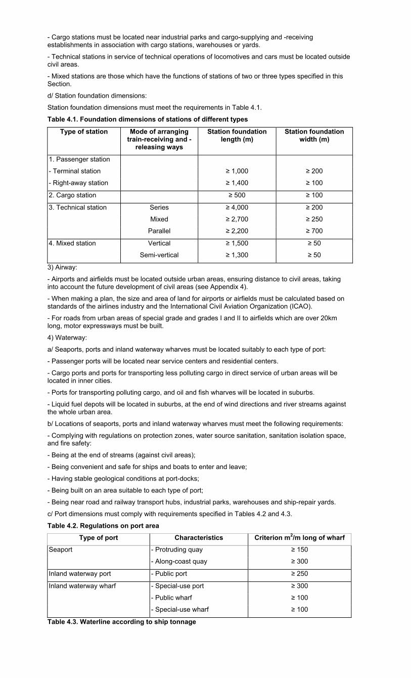
- Cargo stations must be located near industrial parks and cargo-supplying and -receiving establishments in association with cargo stations, warehouses or yards.
- Technical stations in service of technical operations of locomotives and cars must be located outside civil areas.
- Mixed stations are those which have the functions of stations of two or three types specified in this Section.
d/ Station foundation dimensions:
Station foundation dimensions must meet the requirements in Table 4.1.
Table 4.1. Foundation dimensions of stations of different types
Type of station Mode of arranging train-receiving and -
releasing ways
Station foundation length (m)
Station foundation width (m)
1. Passenger station
- Terminal station ≥ 1,000 ≥ 200
- Right-away station ≥ 1,400 ≥ 100
2. Cargo station ≥ 500 ≥ 100
3. Technical station Series ≥ 4,000 ≥ 200
Mixed ≥ 2,700 ≥ 250
Parallel ≥ 2,200 ≥ 700
4. Mixed station Vertical ≥ 1,500 ≥ 50
Semi-vertical ≥ 1,300 ≥ 50
3) Airway:
- Airports and airfields must be located outside urban areas, ensuring distance to civil areas, taking into account the future development of civil areas (see Appendix 4).
- When making a plan, the size and area of land for airports or airfields must be calculated based on standards of the airlines industry and the International Civil Aviation Organization (ICAO).
- For roads from urban areas of special grade and grades I and II to airfields which are over 20km long, motor expressways must be built.
4) Waterway:
a/ Seaports, ports and inland waterway wharves must be located suitably to each type of port:
- Passenger ports will be located near service centers and residential centers.
- Cargo ports and ports for transporting less polluting cargo in direct service of urban areas will be located in inner cities.
- Ports for transporting polluting cargo, and oil and fish wharves will be located in suburbs.
- Liquid fuel depots will be located in suburbs, at the end of wind directions and river streams against the whole urban area.
b/ Locations of seaports, ports and inland waterway wharves must meet the following requirements:
- Complying with regulations on protection zones, water source sanitation, sanitation isolation space, and fire safety:
- Being at the end of streams (against civil areas);
- Being convenient and safe for ships and boats to enter and leave;
- Having stable geological conditions at port-docks;
- Being built on an area suitable to each type of port;
- Being near road and railway transport hubs, industrial parks, warehouses and ship-repair yards.
c/ Port dimensions must comply with requirements specified in Tables 4.2 and 4.3.
Table 4.2. Regulations on port area
Type of port Characteristics Criterion m2/m long of wharf
Seaport - Protruding quay ≥ 150
- Along-coast quay ≥ 300
Inland waterway port - Public port ≥ 250
Inland waterway wharf - Special-use port ≥ 300
- Public wharf ≥ 100
- Special-use wharf ≥ 100
Table 4.3. Waterline according to ship tonnage
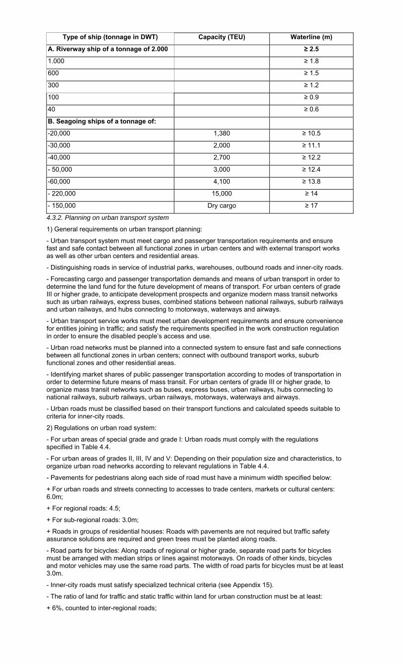
Type of ship (tonnage in DWT) Capacity (TEU) Waterline (m)
A. Riverway ship of a tonnage of 2.000 ≥ 2.5
1.000 ≥ 1.8
600 ≥ 1.5
300 ≥ 1.2
100 ≥ 0.9
40 ≥ 0.6
B. Seagoing ships of a tonnage of:
-20,000 1,380 ≥ 10.5
-30,000 2,000 ≥ 11.1
-40,000 2,700 ≥ 12.2
- 50,000 3,000 ≥ 12.4
-60,000 4,100 ≥ 13.8
- 220,000 15,000 ≥ 14
- 150,000 Dry cargo ≥ 17
4.3.2. Planning on urban transport system
1) General requirements on urban transport planning:
- Urban transport system must meet cargo and passenger transportation requirements and ensure fast and safe contact between all functional zones in urban centers and with external transport works as well as other urban centers and residential areas.
- Distinguishing roads in service of industrial parks, warehouses, outbound roads and inner-city roads.
- Forecasting cargo and passenger transportation demands and means of urban transport in order to determine the land fund for the future development of means of transport. For urban centers of grade III or higher grade, to anticipate development prospects and organize modern mass transit networks such as urban railways, express buses, combined stations between national railways, suburb railways and urban railways, and hubs connecting to motorways, waterways and airways.
- Urban transport service works must meet urban development requirements and ensure convenience for entities joining in traffic; and satisfy the requirements specified in the work construction regulation in order to ensure the disabled people’s access and use.
- Urban road networks must be planned into a connected system to ensure fast and safe connections between all functional zones in urban centers; connect with outbound transport works, suburb functional zones and other residential areas.
- Identifying market shares of public passenger transportation according to modes of transportation in order to determine future means of mass transit. For urban centers of grade III or higher grade, to organize mass transit networks such as buses, express buses, urban railways, hubs connecting to national railways, suburb railways, urban railways, motorways, waterways and airways.
- Urban roads must be classified based on their transport functions and calculated speeds suitable to criteria for inner-city roads.
2) Regulations on urban road system:
- For urban areas of special grade and grade I: Urban roads must comply with the regulations specified in Table 4.4.
- For urban areas of grades II, III, IV and V: Depending on their population size and characteristics, to organize urban road networks according to relevant regulations in Table 4.4.
- Pavements for pedestrians along each side of road must have a minimum width specified below:
+ For urban roads and streets connecting to accesses to trade centers, markets or cultural centers: 6.0m;
+ For regional roads: 4.5;
+ For sub-regional roads: 3.0m;
+ Roads in groups of residential houses: Roads with pavements are not required but traffic safety assurance solutions are required and green trees must be planted along roads.
- Road parts for bicycles: Along roads of regional or higher grade, separate road parts for bicycles must be arranged with median strips or lines against motorways. On roads of other kinds, bicycles and motor vehicles may use the same road parts. The width of road parts for bicycles must be at least 3.0m.
- Inner-city roads must satisfy specialized technical criteria (see Appendix 15).
- The ratio of land for traffic and static traffic within land for urban construction must be at least:
+ 6%, counted to inter-regional roads;
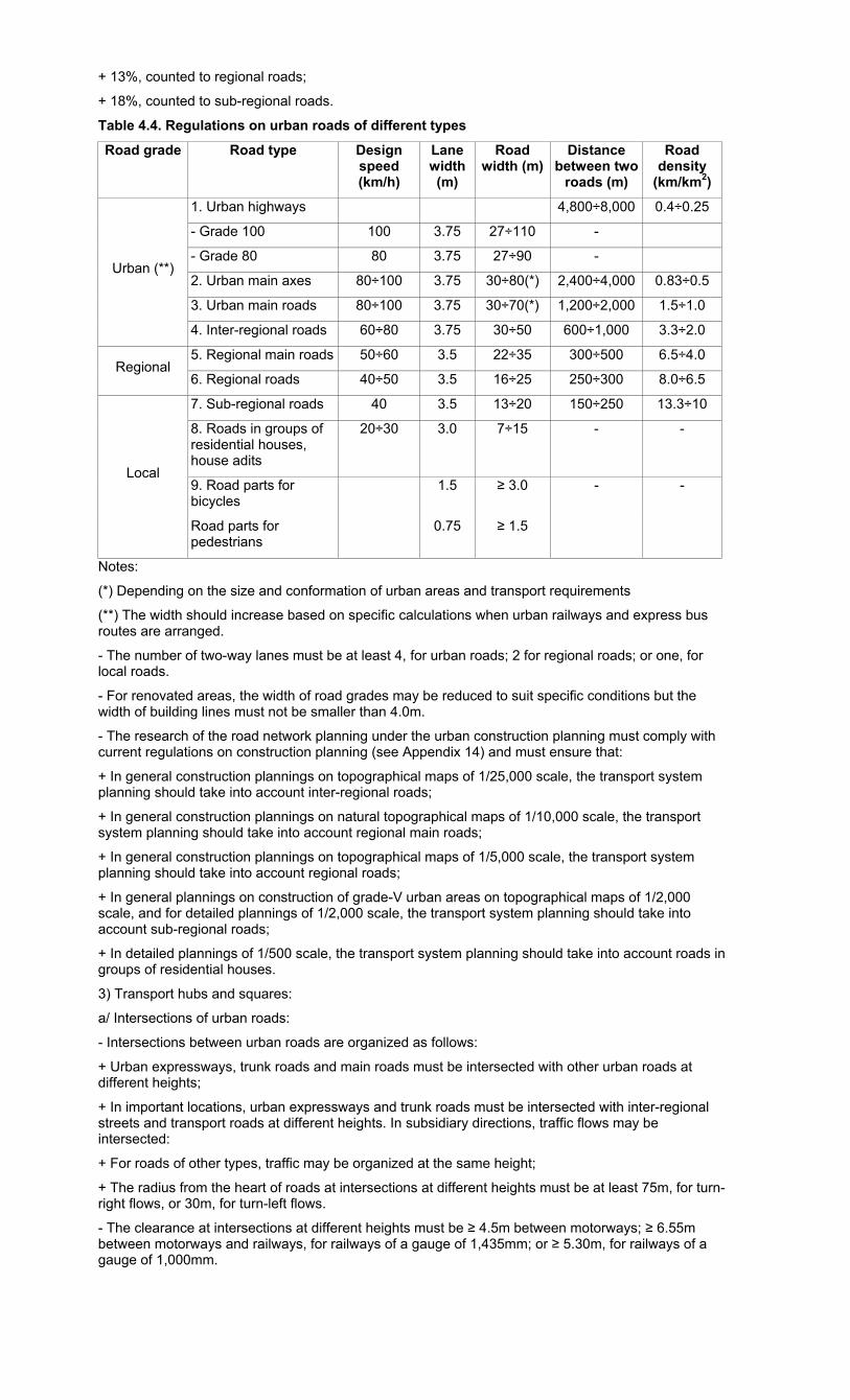
+ 13%, counted to regional roads;
+ 18%, counted to sub-regional roads.
Table 4.4. Regulations on urban roads of different types
Road grade Road type Design speed (km/h)
Lane width (m)
Road width (m)
Distance between two
roads (m)
Road density
(km/km2)
Urban (**)
1. Urban highways 4,800÷8,000 0.4÷0.25
- Grade 100 100 3.75 27÷110 -
- Grade 80 80 3.75 27÷90 -
2. Urban main axes 80÷100 3.75 30÷80(*) 2,400÷4,000 0.83÷0.5
3. Urban main roads 80÷100 3.75 30÷70(*) 1,200÷2,000 1.5÷1.0
4. Inter-regional roads 60÷80 3.75 30÷50 600÷1,000 3.3÷2.0
Regional 5. Regional main roads 50÷60 3.5 22÷35 300÷500 6.5÷4.0
6. Regional roads 40÷50 3.5 16÷25 250÷300 8.0÷6.5
Local
7. Sub-regional roads 40 3.5 13÷20 150÷250 13.3÷10
8. Roads in groups of residential houses, house adits
20÷30 3.0 7÷15 - -
9. Road parts for bicycles
1.5 ≥ 3.0 - -
Road parts for pedestrians
0.75 ≥ 1.5
Notes:
(*) Depending on the size and conformation of urban areas and transport requirements
(**) The width should increase based on specific calculations when urban railways and express bus routes are arranged.
- The number of two-way lanes must be at least 4, for urban roads; 2 for regional roads; or one, for local roads.
- For renovated areas, the width of road grades may be reduced to suit specific conditions but the width of building lines must not be smaller than 4.0m.
- The research of the road network planning under the urban construction planning must comply with current regulations on construction planning (see Appendix 14) and must ensure that:
+ In general construction plannings on topographical maps of 1/25,000 scale, the transport system planning should take into account inter-regional roads;
+ In general construction plannings on natural topographical maps of 1/10,000 scale, the transport system planning should take into account regional main roads;
+ In general construction plannings on topographical maps of 1/5,000 scale, the transport system planning should take into account regional roads;
+ In general plannings on construction of grade-V urban areas on topographical maps of 1/2,000 scale, and for detailed plannings of 1/2,000 scale, the transport system planning should take into account sub-regional roads;
+ In detailed plannings of 1/500 scale, the transport system planning should take into account roads in groups of residential houses.
3) Transport hubs and squares:
a/ Intersections of urban roads:
- Intersections between urban roads are organized as follows:
+ Urban expressways, trunk roads and main roads must be intersected with other urban roads at different heights;
+ In important locations, urban expressways and trunk roads must be intersected with inter-regional streets and transport roads at different heights. In subsidiary directions, traffic flows may be intersected:
+ For roads of other types, traffic may be organized at the same height;
+ The radius from the heart of roads at intersections at different heights must be at least 75m, for turn-right flows, or 30m, for turn-left flows.
- The clearance at intersections at different heights must be ≥ 4.5m between motorways; ≥ 6.55m between motorways and railways, for railways of a gauge of 1,435mm; or ≥ 5.30m, for railways of a gauge of 1,000mm.

- Self-operated traffic squares (circle, ellipse, or rectangle and square with round angles) may be designed only when the total number of motor vehicles in different directions is less than 4,000/h.
The dimension of a circle traffic square (roundabouts) depends on the number of intersecting roads and calculated traffic flows at directions, but the curve radius of a circle island must be at least ≥ 20.0m.
- The curve radius of pavement at street intersections must be at least:
+ 15.0m, at traffic squares and urban streets;
+ 12.0m, for regional streets;
+ 8.0m, for local streets.
b/ Median strips:
- A median strip is a road part used for dividing traffic flows into two separate lanes or dividing road parts for motor vehicles and rudimentary ones.
- The width of a median strip must be at least:
+ 5m, on expressways;
+ 4m, on urban trunk roads and transport roads;
+ 5m, between the surface of urban trunk roads for vehicles and internal roads;
+ In case of narrow roads in mountainous areas, the width of a median strip between the surface of trunk roads for vehicles and internal roads may be reduced but must not be smaller than 3m;
+ 2m, between the surface of inter-regional streets and internal roads;
+ 2m, between the surface of roads for motor vehicles and the tramcars’ road foundation.
- The width of fenced median strips must be at least 4m on expressways, or 2m on urban trunk roads and transport roads.
- For renovated areas, solid or soft median strips of at least 0.5m wide may be used.
In the central median strip of a width of less than 5m, not to place lamp-posts, advertisement boards or other works irrelevant to traffic safety assurance.
c/ Squares:
- For main squares located in urban centers, vehicles are not allowed to pass, only means of transport in service of works on squares are allowed.
- On squares in front of public works where many people travel, to separate roads for pedestrians and local transport roads from right-away roads. There must be parking lots and public-car parks on road parts for local transport.
- Traffic squares and squares in front of bridges must comply with traffic organization charts.
- On station squares, to divide flows for to-and fro-passengers, ensuring safety and the nearest distance for passengers going to public traffic stations and parking lots.
- Squares at hubs of transport works must be planned into sub-zones for passengers’ convenient, fast and safe transshipment.
d/ Mass transit network
- To serve the transport of people in urban centers of grade III or higher grade, to focus on mass transit development.
+ The distance between mass transit routes must be between 600m and 1,200m; in urban centers, this distance must be at least 400m.
+ The distance for pedestrians to go from their residential or working places to public car parks must not exceed 500m.
- Types of means of mass transit depend on types of urban centers and amounts of passengers. For urban centers with a calculated population of more than one million, to study the construction of urban railway systems (systems of subways, tramcars or sky trains).
- Mass transit network density depends on urban planning structure, which must be at least 2.0km/km2 of land for urban construction. The distance between transit stations in urban centers must be:
+ Not more than 600m, for bus stops and tramcar stations;
+ At least 800m, for bus stops, express-tramcar stations, express subways or sky trains.
- At intersections between highways and roads passed by means of mass transit, to locate transshipment stations with a road length for pedestrians of less than 200m.
- Bus stops and tramcar stations on trunk roads with signal lamp or posts must be located at least 20m far from intersections. The length of a one-route or one-direction station must be at least 20m; on multiple-direction routes, specific calculation is needed, but this length must not be less than 30m. The station width must be at least 6m.
- The final terminal of a route must have a service house for workers and a waiting lounge for passengers.
- On expressways and express bus stops, special parking stations with speed change strips outside the traffic lane should be located.
e/ Urban railway system
- Outside-street urban railway system is the system of express railways, including subways and tramcars. Based on mass transit demands, to determine locations of outside-street railway stations and routes. Subway stations must be connected, synchronous and safe for underground works and between underground works and ground-surface works.
- The width of the red line planned for tramcar routes along urban routes must take into account railway system. The tramcar corridor’s width must be-at least 10m.
4.3.3 Planning on works in service of urban traffic
- Urban centers, residential units and groups of residential houses must reserve land for garages and parking lots. Industrial parks and warehouses must have parking lots and garages with repair services.
- Parking lots and cargo loading grounds must be located near markets, cargo stations, commercial centers and other works having great transport needs.
- In renovated urban areas, streets prohibited for circulating vehicles and roads with traffic lane larger than their designed capacity may have parking lots for cars. The width of a parking space must be at least 3m if vehicles park along the road or at least 6m if vehicles park at an angle of 45°- 60o.
- Public ground or underground parking lots must be located near trade, service, sports and recreational centers and be interconnected with street networks. The maximum walking distance is 500m. Underground parking lots and garages shall be connected in a way that ensures compatibility, uniformity and safety among underground works and between underground and ground works.
- Bus terminals and garages must be located at first and final stops of bus routes and their sizes shall be determined based on specific demands.
- Locomotive tram depots shall be arranged at first and final stops and linking points of tram routes for repair services.
- The minimum single parking space for some vehicles in a parking lot is specified as follows:
+ 25m2, for cars,
+ 3m2, for motorcycles,
+ 0.9m2, for bicycles,
+ 40m2, for buses,
+ 30m2, for trucks.
- Works must meet requirements on minimum parking space specified in Table 4.5 below:
Table 4.5: Minimum parking space for cars
Types of buildings Minimum car parking space requirements
- Hotels of three-star or higher grade 4 rooms/single parking space
- Luxury offices, offices of foreign relation agencies 100m2 of use floor/single parking space
- Supermarkets, big stores, and conference, exhibition and showroom centers
100m2 of use floor/single parking space
- Luxury apartment buildings 1 apartment/1.5 single parking space
- Under-three-star hotels, offices and service works must have parking space ≥ 50% of the levels specified in the above table.
4.3.4 Planning on urban traffic safety assurance
1) Visibility: Construction works and trees must not limit visibility and hide traffic signs and signals.
The distance of one-way visibility on contour maps and vertical section depends on calculated speeds, but must satisfy the following minimum requirements:
Expressways: ≥ 175m;
Urban roads: ≥ 100m:
Sectional roads: ≥ 75m;
Internal roads: ≥ 40m.
2) Public works accommodating large numbers of to-and-fro people, and works on sidewalks such as kiosks, public transport stations, advertisement boards and trees must not affect the traffic flow and safety.
3) Chamfer angles at intersections
To ensure a safe visibility for traffic, works at intersections must be chamfer cut in conformity with sectional planning. Based on prescribed speeds and road construction norms, the minimum visibility must be ≥ 20m. When the building line coincides with the red line or when a work is built within the
building line with a set-back against the red line but still fails to satisfy the minimum visibility requirement, the facade of the work must also be chamfer cut to ensure the minimum visibility.
4) Sidewalks and crosswalks
- A level crosswalk of a road must be larger than 6m for trunk roads and 4m for sectional roads.
- The distance between two level crosswalks of a road must be larger than 300m for trunk roads and 200m for sectional roads;
5) Overpasses and tunnels for pedestrians must be built at traffic hubs with large numbers of circulating traffic and pedestrians; grade intersections, intersections where urban roads cut railways; and locations near subway stations, carparks and stadiums.
- The distance between tunnels and overpasses for pedestrians is ≥ 500m.
- The width of a tunnel or overpass for pedestrians shall be designed based on the circulation of pedestrians at rush hours, but must be larger than 3m.
4.4. Traffic planning for rural residential areas
Planning on traffic road networks of rural residential areas must satisfy the following requirements:
- Conforming with local (district, provincial) master plans, taking over and developing existing road networks in response to current and future transport demands; interconnecting with national, provincial and district road networks.
- Associating with master plans on irrigation systems, population and works for agricultural and rural modernization.
- Matching existing and future means of transport.
- Ensuring convenient connection with district and provincial road systems to create a complete road network.
- Ensuring direct convenient connection between centers and population quarters, between population quarters and production zones and between residential areas.
- Making full use of existing conditions, being suitable to local terrains, reducing ground clearance compensation, volume of digging and embankment work as well as the number of works to be built on a route.
- Road structure and surface width must be suitable with specific conditions of each commune and satisfy technical requirements for rural roads, meeting current and future development demands.
- Making utmost use of river and canal systems to organize waterway networks for cargo and passenger transport.
- The cross section of an internal road in rural residential areas must be ≥ 4m.
Chapter V
WATER SUPPLY PLANNING
5.1. Water-supply works protection zones
1) Water-sources protection zones
Water sources to be supplied to urban centers must have protection zones surrounding them as prescribed in Table 5.1
Table 5.1. Protection zones of urban water sources (principal regulations)
Types of water sources and protection zones
Radius of protection zones counting from water
sources (m)
Prohibited activities
Surface water sources from water-taking points:
Construction; discharge of waste and irrigation water;
animal breeding; bathing and washing - Upstream
- Downstream
≥ 200
≥ 100
Underground water sources: around drilling wells with a radius of
≥ 25 Construction, digging of cesspools, and garbage and lime pits; animal breeding,
garbage discharge
Reservoirs, dams:
- With flat banks
- With sloping banks
≥ 300
The entire area
Construction; animal breeding; fruit tree plantation
2) Protection zones of water supply plants and stations
- Fence walls around water treatment works shall be built within 30m from the foot of the works.

- To ban construction of dwelling houses, works in service of daily life and recreation, and toilets, tree fertilizing and animal breeding inside these fence walls.
3) Water pipe-protection zones must be at least 0.5m from pipes.
5.2. Regional water supply planning
Regional water supply planning must:
1) Assess current water supply status of urban centers, rural residential areas and industrial parks in studied areas regarding the number of qualified and unqualified water supply works and the number of inhabitants supplied with clean water.
2) Forecast water demands of each urban center; industrial parks and rural residential areas (for urban centers of district and town levels or higher, for interregional planning; and for urban centers of township level or higher, for provincial planning).
3) Identify water sources:
a/ Water sources shall be selected in accordance with regulations of water source planning and management agencies. Water sources shall be used regardless of administrative management boundaries.
b/ To determine water reserves (including surface and ground water sources). The flow of a water source (except for islands and high mountains) must be at least 10 times the use demand. The monthly or daily flow of surface water sources must reach 95% for water supply reliability level I; 90% for water supply reliability level II; and 85% for water supply reliability level III.
c/ Crude water source requirements - a number of principal norms applied to ordinary water treatment works:
- Hardness °dH ≤ 12;
- Dried sediments not exceeding 1,000 mg/l;
- No strange smell or taste;
- Salinity not exceeding 250mg/I.
If water sources failing to meet the above requirements must be used, such use must be approved by epidemic management agencies and appropriate and economical treatment methods shall be adopted.
Water for production shall be selected based on specific quality requirements of each water user.
d/ To prioritize the use of surface water sources meeting the above requirements.
e/ Not to use ground water sources for supply for non-daily life needs. Areas that do not have other water sources, but have sufficient ground water sources may use ground water for other purposes as permitted by water source management agencies.
f/ To permit the treatment of mineral or sea water for supply for daily life needs, but econo-technical comparison with other water sources is required.
g/ To permit the supply of geothermal water for daily life needs and production if water sources satisfy requirements specified at Point c. The highest temperature of water for supply for daily life needs must not exceed 35°C.
h/ A water supply system may use different water sources with different hydrological and hydrogeological properties.
i/ Plans on water source selection must be comprehensively evaluated based on criteria on reserves, quality, feasibility and investment capital.
4) Propose water supply solutions:
- To select specific water sources for urban areas and rural residential areas;
- To determine sizes of key works and preliminary treatment technologies for water sources;
- To determine water source-based supply solutions for rural residential areas.
5.3. Urban water supply planning
5.3.1. General planning on urban water supply
1) General planning on urban water supply must satisfy the following requirements:
- Determining standards and demands for urban water supply according to water supply reliability levels in each period;
- Rationally selecting water sources;
- Selecting construction sizes and sites of key works;
- Determining water treatment technologies.
2) Forecast of urban water use must ensure that:
a/ Water users: Urban water supply systems must satisfy requirements on quality, pressure and flow of water for supply to meet urban use demands, including:
- Water for daily life of urban inhabitants (including inner-city and suburban inhabitants);
- Water for daily life of non-residents;
- Water for public works and services: ≥ 10% of the volume for daily life;
- Water for tree watering and road cleaning: ≥ 8% of the volume for daily life;
- Water for small production and industries: ≥ 8% of the volume for daily life;
- Water for industrial parks shall be determined based on the types of industry, but must ensure a minimum of 20m3/ha/day for at least 60% of the area;
- Reserve and leaking water must not exceed 30% of the total volume for the above demands, for upgraded water supply systems, and 25%, for new water supply systems;
- Water for water treatment works must be at least 4% of the total volume mentioned above.
b/ Water supply for daily life must satisfy requirements specified in Table 5.2.
Table 5.2: Water supply for daily life
Types of urban centers
Water use demands
First stage (10 years) Long-term (20 years)
Water supply rates (% of population)
Standards (liter/person/day)
Water supply rates (% of population)
Standards (liter/person/day)
Special ≥ 90 ≥ 180 100 ≥ 200
Grade I ≥ 80 ≥ 150 ≥ 90 ≥ 180
Grade II ≥ 80 ≥ 120 ≥ 90 ≥ 150
Grade III, IV, V ≥ 80 ≥ 80 ≥ 90 ≥ 100
- Water supply for daily life of suburban inhabitants and non-residents must reach at least 80% of the norms on water supply for daily life of respective urban centers.
- Water supply for daily life must be ≥ 40 liters/person/day for residential areas that only use water from public taps.
c/ Reliability levels of water supply systems, see Table 5.3.
Table 5.3: Reliability levels of water supply systems
No. Characteristics of water users Reliability level
1. For metallurgy, oil processing and chemicals enterprises, power plants, and daily life water supply systems for residential areas of over 50,000 inhabitants, to permit reduction of the water supply flow by no more than 30% of the designed flow for 3 days and stoppage of supplying water for no more than 10 minutes.
I
2. For mining, mechanical-engineering and other industrial enterprises, and daily life water supply systems for residential areas of up to 50,000 inhabitants, to permit reduction of the water supply flow by no more than 30% of the designed flow for 10 days or stoppage of supplying water for 6 hours.
II
3. For small industrial enterprises, agricultural irrigation systems and water supply systems for industrial parks, to permit reduction of the water supply flow by no more than 30% for 15 days and stoppage of supplying water for 1 day.
III
d/ Identification and selection of water sources must satisfy hygienic requirements for water sources supplied for daily life and meet urban water use demands.
e/ Water supply system planning:
- Key works must determine:
+ For well pumping stations (if being ground water sources): the number of wells, technical specifications and measures to raise the capacity of existing works.
+ For pumping stations I (if being surface water sources): technical specifications and measures to raise the capacity of existing works. Works to collect surface water must be in the upper stream against urban areas, industrial parks and residential areas.
- Treatment works must:
+ Be on the head of the water flow against residential areas and production areas;
+ Collect a water volume of good quality meeting current and future demands; be convenient for water source protection and sanitation;
+ Be located at sites with stable river banks and basins and few erosion and water flow change; sites with good geological conditions that can avoid impacts of other hydrological phenomena such as wave and tide.
- Requirements on minimum areas for construction of water treatment stations are specified in Table 5.4.
- Electricity supply for key works: To determine sources and build separate transformer stations to supply electricity for well-pumping stations, grade-I pumping stations and water treatment stations.
Pipe networks: Networks of main pipes shall be designed into round circuits and hydraulic power shall be calculated to accommodate the volume of transmitted water and pipe pressure during peak hours of use and when fire occurs. When there is a tower for water regulating, the network must accommodate the highest water flow to the tower.
- Required minimum pressure at main points (grade-I networks) must be 8m for old and upgraded networks and 15m for new networks. If the pressure is lower, pumps of grade-II pumping stations shall be changed (within permitted limits) to reach required pressure, or high pressure pumping stations shall be built at those points.
- Water supply for fire fighting: The flow and number of simultaneous fires shall be calculated in conformity with urban sizes. The water flow supplied to a fire must be ≥ 15 liters/second; the number of simultaneous fires to be calculated must be ≥ 2; free pressure in networks of water supply for fire fighting must be ≥ 10m.
Table 5.4: Minimum areas for construction sites of water treatment stations
Capacity of water treatment stations (1,000 m3/day)
Minimum areas for construction sites (ha)
1 0.5
1÷5 0.5
> 5÷10 1.0
> 10÷30 2.0
> 30÷60 3.0
> 60÷120 4.0
> 120÷250 5.0
> 250÷400 7.0
> 400÷800 9.0
> 800÷1,200 13.0
1.200 or more 16.0
5.3.2 Detailed planning on water supply for urban functional zones
Detailed planning on water supply for urban functional zones must satisfy the following requirements:
1) To forecast water use demands:
- Water for daily life shall be estimated according to standards of urban centers and the general planning.
- Water for public works and services shall be planned based on specific characteristics of works, but must be at least 2 liters/m2 of floor area/day.
- Water for schools must be at least 20 liters/pupil/day.
- Water for preschools must be at least 100 liters/child/day.
- Water for public flower gardens and parks must be at least 3 liters/m2/day.
- Water for road cleaning must be at least 0.5 liter/m2/day.
2) To identify water sources:
- When an area designed in details is within an approved master plan, the water flow of main water pipes through the designed area shall be checked. When the water flow is insufficient, the diameter of main pipes must be changed.
- When a master plan is not available, steps of formulating a master plan shall be taken.
3) To adopt planning on water pipe networks to ensure water supply safety.
4) To test pressure: To test pressure based on the network pressure of the general planning and take measures to ensure water supply pressure.
5) Water supply for fire fighting:
- To make use of rivers, lakes and ponds for reserve of water for fire fighting; to ensure sufficient water reserves at any time and access to water for fire engines. The depth of water surface against the ground must be no more than 4m and the thickness of water layer must be no less than 0.5m.
- In urban water supply pipe networks, to arrange (ground or underground) fire-hydrants along streets which must satisfy the following distance requirements:
+ Maximum distance between fire-hydrants must be 150 m for special, grade I and grade II urban centers and areas with high population density; and 150m for other areas.
+ Minimum distance between fire-hydrants and walls of houses must be 5m.
+ Maximum distance between fire-hydrants and road edges (when fire-hydrants are located along roads, not on roadways) must be 2.5m.
- Fire-hydrants shall be located at places convenient for collecting water such as T-junctions and crossroads.
- Diameters of water pipes for fire extinguishment outside houses must be no less than 100mm.
5.4. Planning on water supply for rural residential areas
5.4.1. Water supply demands of rural residential areas
Water for supply to communal residential areas includes:
- Water for daily life of inhabitants in the residential areas include water for public service works such as kindergartens, schools, health centers, cultural houses and office buildings.
- Water for poultry and cattle rearing farms.
- Water for farm production and processing establishments and other industries.
5.4.2. Norms on minimum water supply for daily life
When formulating a plan on concentrated water supply for rural residential areas, the following water supply requirements must be met:
- Houses having bathroom fixtures and water supply and drainage pipes: ≥ 80 liters/person/day;
- Houses only having water supply pipes and household water taps: ≥ 60 liters/person/day;
Water taken from public taps: ≥ 40 liters/person/day;
5.4.3. Water sources
1) To make use of different water sources: shallow and deep ground water, rainwater and surface water (of rivers, streams and penetrated wells).
2) To take water treatment measures suitable to each water source when the quality of source water fails to meet prescribed hygiene requirements for water for daily life (see Appendix 7).
3) To ensure water source hygiene
a/ For ground water:
- Not to build works polluting water sources in areas within a radius of 20m from a well.
- Wells for households must be far from toilets and animal breeding facilities;
- To select areas with good water sources for building public wells which must be built with high tiled walls.
b/ For surface water: not to build works polluting water sources within 200m upstream and 100m downstream from the water supply point.
Chapter VI
PLANNING ON WASTEWATER DRAINAGE, AND MANAGEMENT OF SOLID WASTES AND CEMETERIES
6.1. General provisions
6.1.1. Planning on wastewater drainage systems
1) Provisions on water drainage planning
Urban water drainage systems must:
- Fully collect urban wastewater (from daily life, production, business and services).
- Apply appropriate wastewater treatment methods; treated water must satisfy environmental standards.
2) Selection of types of water drainage systems
- (Common, private or semi-private) water drainage systems must conform with urban sizes, hygiene requirements, natural conditions (terrain, climate and hydrology) and current status of urban areas and water drainage systems.
- Provisions on selection of water drainage systems:
+ New urban centers shall build their own water drainage systems.
+ Existing urban centers with common water drainage systems shall use semi-private water drainage systems or upgrade common water drainage systems into private ones.
- Drainage of wastewater for underground works: To adopt planning on private sewer systems for wastewater drainage, to collect all wastewater for treatment. Wastewater pumping stations must have standby pumps and two independent power sources for electricity supply to pumps.
- Wastewater drainage for islands: To adopt planning on private water drainage systems, to collect and treat wastewater completely. Treated wastewater meeting environmental requirements may be re-used for other purposes (watering, fresh water aquaculture, reserve for supply for daily life in areas in shortage of water sources).
3) Provisions on wastewater discharge
- Industrial wastewater to be discharged into surface water sources or urban sluices must meet prescribed environmental requirements (Appendix 8).
- Wastewater from private and public toilets shall be treated through properly built septic tanks before being discharged into urban wastewater sewers, and be treated separately to meet environmental requirements if being discharged into rainwater sewers.
Hospital wastewater must be classified into two kinds:
+ Wastewater from daily-life activities of patients and medical workers, which must be treated through properly built septic tanks before being discharged into urban wastewater sewers, and be treated separately to meet environmental requirements if being discharged into rainwater sewers.
+ Hazardous medical wastewater, which must be treated separately to meet environmental requirements before being discharged into urban wastewater sewers.
- Positions of wastewater discharge points:
+ Treated wastewater shall be discharged into surface water sources at the final point of the flow against urban centers and residential areas.
+ Positions for discharge shall be determined based on the calculation of environmental impacts and in conformity with the quality of wastewater being treated; characteristics and planning on use of water sources receiving wastewater; and planning on urban areas, industrial parks and residential areas involved in the protection of water sources.
4) Provisions on wastewater collection:
- Wastewater from daily life shall be collected at ≥ 80% of the norms on water supply for daily life.
- Industrial wastewater shall be collected at ≥ 80% of the norms on water supply for industries (depending on types of industries).
- Prior to collection, industrial wastewater shall be classified (contaminated, uncontaminated, or for hazardous water) and be treated separately.
5) Provisions on wastewater treatment:
- Wastewater from daily life activities of urban centers, industrial parks and craft villages shall be collected and treated separately in compliance with current regulations on the environment.
- Mud discharged from wastewater treatment systems shall be collected and transported by special-use vehicles to solid waste treatment facilities for treatment.
- Mud containing hazardous substances discharged from wastewater treatment systems shall be collected and transported separately by special-use vehicles to consolidated hazardous waste facilities.
6) Provisions on environmentally safe distance of pumping and wastewater treatment stations:
- Requirements on environmentally safe distance between wastewater pumping and treatment stations, and residential areas, food enterprises, hospitals, schools and other construction works in urban centers are specified in Table 6.1.
- Trees shall be planted on areas of ≥ 10m wide within the environmentally safe distance.
- Environmentally safe distance is not required for wastewater pumping stations that use pumps installed in closed gas wells, but air ducts must be installed (air must be emitted at a height of ≥ 3m).
7) Provisions on arrangement of wastewater drainage systems
- Sewers may be installed on roadways of old streets where sidewalks are too small for sewer installation.
- Newly built roads must have water drainage sewers installed in technical tunnels under sidewalks.
- Sewers for wastewater collection shall be installed along two sides of roads of ≥ 7m wide.
8) Arrangement of wastewater treatment stations
- Wastewater treatment stations shall be installed at the end of the wastewater, or main wind directions, and areas having sufficient land reserved for expansion.
- In special cases when wastewater treatment stations or mud drying grounds have to be located in places where urban centers’ main wind starts, the environmentally safe distance specified in Table 6.1 must be at least 1.5 times higher.
Table 6.1: Minimum environmentally safe distance
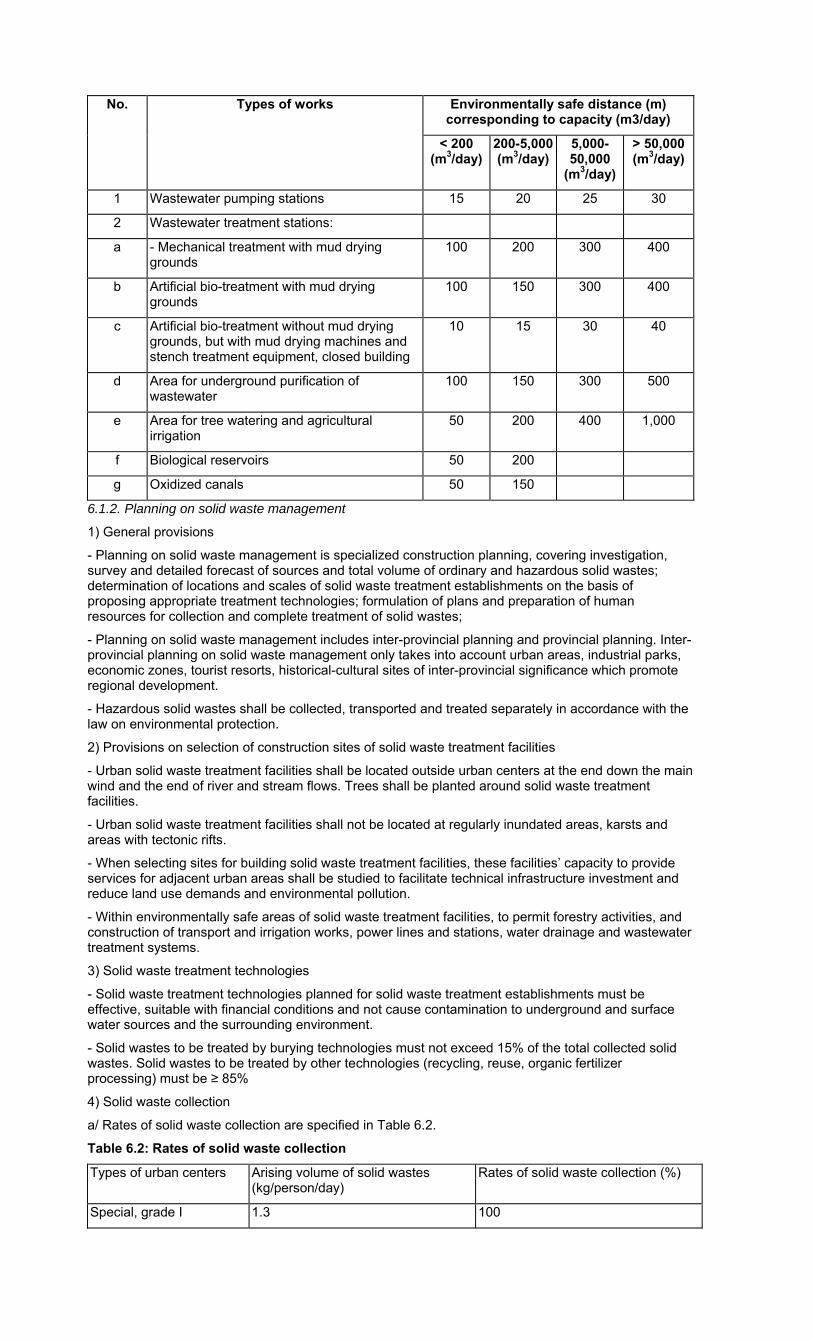
No. Types of works Environmentally safe distance (m) corresponding to capacity (m3/day)
< 200 (m3/day)
200-5,000 (m3/day)
5,000-50,000
(m3/day)
> 50,000 (m3/day)
1 Wastewater pumping stations 15 20 25 30
2 Wastewater treatment stations:
a - Mechanical treatment with mud drying grounds
100 200 300 400
b Artificial bio-treatment with mud drying grounds
100 150 300 400
c Artificial bio-treatment without mud drying grounds, but with mud drying machines and stench treatment equipment, closed building
10 15 30 40
d Area for underground purification of wastewater
100 150 300 500
e Area for tree watering and agricultural irrigation
50 200 400 1,000
f Biological reservoirs 50 200
g Oxidized canals 50 150
6.1.2. Planning on solid waste management
1) General provisions
- Planning on solid waste management is specialized construction planning, covering investigation, survey and detailed forecast of sources and total volume of ordinary and hazardous solid wastes; determination of locations and scales of solid waste treatment establishments on the basis of proposing appropriate treatment technologies; formulation of plans and preparation of human resources for collection and complete treatment of solid wastes;
- Planning on solid waste management includes inter-provincial planning and provincial planning. Inter-provincial planning on solid waste management only takes into account urban areas, industrial parks, economic zones, tourist resorts, historical-cultural sites of inter-provincial significance which promote regional development.
- Hazardous solid wastes shall be collected, transported and treated separately in accordance with the law on environmental protection.
2) Provisions on selection of construction sites of solid waste treatment facilities
- Urban solid waste treatment facilities shall be located outside urban centers at the end down the main wind and the end of river and stream flows. Trees shall be planted around solid waste treatment facilities.
- Urban solid waste treatment facilities shall not be located at regularly inundated areas, karsts and areas with tectonic rifts.
- When selecting sites for building solid waste treatment facilities, these facilities’ capacity to provide services for adjacent urban areas shall be studied to facilitate technical infrastructure investment and reduce land use demands and environmental pollution.
- Within environmentally safe areas of solid waste treatment facilities, to permit forestry activities, and construction of transport and irrigation works, power lines and stations, water drainage and wastewater treatment systems.
3) Solid waste treatment technologies
- Solid waste treatment technologies planned for solid waste treatment establishments must be effective, suitable with financial conditions and not cause contamination to underground and surface water sources and the surrounding environment.
- Solid wastes to be treated by burying technologies must not exceed 15% of the total collected solid wastes. Solid wastes to be treated by other technologies (recycling, reuse, organic fertilizer processing) must be ≥ 85%
4) Solid waste collection
a/ Rates of solid waste collection are specified in Table 6.2.
Table 6.2: Rates of solid waste collection
Types of urban centers Arising volume of solid wastes (kg/person/day)
Rates of solid waste collection (%)
Special, grade I 1.3 100
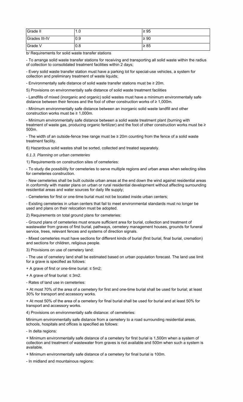
Grade II 1.0 ≥ 95
Grades III-IV 0.9 ≥ 90
Grade V 0.8 ≥ 85
b/ Requirements for solid waste transfer stations
- To arrange solid waste transfer stations for receiving and transporting all solid waste within the radius of collection to consolidated treatment facilities within 2 days;
- Every solid waste transfer station must have a parking lot for special-use vehicles, a system for collection and preliminary treatment of waste liquids;
- Environmentally safe distance of solid waste transfer stations must be ≥ 20m.
5) Provisions on environmentally safe distance of solid waste treatment facilities
- Landfills of mixed (inorganic and organic) solid wastes must have a minimum environmentally safe distance between their fences and the fool of other construction works of ≥ 1,000m.
- Minimum environmentally safe distance between an inorganic solid waste landfill and other construction works must be ≥ 1,000m.
- Minimum environmentally safe distance between a solid waste treatment plant (burning with treatment of waste gas, producing organic fertilizer) and the foot of other construction works must be ≥ 500m.
- The width of an outside-fence tree range must be ≥ 20m counting from the fence of a solid waste treatment facility.
6) Hazardous solid wastes shall be sorted, collected and treated separately.
6.1.3. Planning on urban cemeteries
1) Requirements on construction sites of cemeteries:
- To study die possibility for cemeteries to serve multiple regions and urban areas when selecting sites for cemeteries construction.
- New cemeteries shall be built outside urban areas at the end down the wind against residential areas in conformity with master plans on urban or rural residential development without affecting surrounding residential areas and water sources for daily life supply;
- Cemeteries for first or one-time burial must not be located inside urban centers;
- Existing cemeteries in urban centers that fail to meet environmental standards must no longer be used and plans on their relocation must be adopted.
2) Requirements on total ground plans for cemeteries:
- Ground plans of cemeteries must ensure sufficient area for burial, collection and treatment of wastewater from graves of first burial, pathways, cemetery management houses, grounds for funeral service, trees, relevant fences and systems of direction signals.
- Mixed cemeteries must have sections for different kinds of burial (first burial, final burial, cremation) and sections for children, religious people.
3) Provisions on use of cemetery land:
- The use of cemetery land shall be estimated based on urban population forecast. The land use limit for a grave is specified as follows:
+ A grave of first or one-time burial: ≤ 5m2;
+ A grave of final burial: ≤ 3m2.
- Rates of land use in cemeteries:
+ At most 70% of the area of a cemetery for first and one-time burial shall be used for burial; at least 30% for transport and accessory works.
+ At most 50% of the area of a cemetery for final burial shall be used for burial and at least 50% for transport and accessory works.
4) Provisions on environmentally safe distance: of cemeteries:
Minimum environmentally safe distance from a cemetery to a road surrounding residential areas, schools, hospitals and offices is specified as follows:
- In delta regions:
+ Minimum environmentally safe distance of a cemetery for first burial is 1,500m when a system of collection and treatment of wastewater from graves is not available and 500m when such a system is available.
+ Minimum environmentally safe distance of a cemetery for final burial is 100m.
- In midland and mountainous regions:
+ Minimum environmentally safe distance of a cemetery for first burial is 2,000m when a system of collection and treatment of wastewater from graves is not available and 500m when such a system is available.
+ Minimum environmentally safe distance of a cemetery for final burial is 100m.
- Minimum environmentally safe distance of a cemetery for one-time burial is 500m.
- Minimum environmentally safe distance from a cemetery for first burial to a work of concentrated exploitation of water for daily life is 2,500m.
- Minimum environmentally safe distance from a cemetery to the nearest edge of water surface (of rivers, lakes and sea) which are not used for supply for daily life:
+ For a cemetery for first burial: 300m;
+ For a cemetery for final burial: 100 m.
- Minimum environmentally safe distance from a cemetery for first burial to urban beltway and railway is 200m and there must be trees surrounding cemeteries.
- Minimum environmentally safe distance from a newly built crematory to the nearest residential areas, public or civil works is 500m.
- Within the environmentally safe area of a cemetery, to permit agro-forestry cultivation, construction of technical infrastructure such as transport irrigation, power lines and stations, water drainage system and petroleum transmission.
5) Provisions on collection and treatment of wastes from cemeteries:
- Solid wastes shall be collected and treated in accordance with environmental sanitation requirements.
- There must be a system to collect water from graves of first burial for concentrated treatment before being discharged into the environment.
- Areas for treatment of wastewater from graves of first burial must be located down the wastewater flow in the lowest area of a cemetery.
6) Funeral parlors:
- Each urban center must have at least a funeral parlor.
- A funeral parlor provides services for a maximum of 250,000 people.
- Construction sites of new funeral parlors must not cause adverse impacts on the operation of other functional zones and urban transport activities.
- Minimum environmentally safe distance from a new funeral parlor to:
+ A dwelling house is 100m;
+ A market, school or hospital is 200m.
Each funeral parlor must have a minimum premise of 10,000m2.
6.1.4. Planning on public toilets
- To install public toilets along trunk roads and in commercial areas, parks, markets, stations and public places.
- The distance between two public toilets on trunk roads is ≤ 1.5km.
- Main bus stops must have toilets.
- To build underground public toilets in areas with limited land funds or those having special value of urban view.
- To use a room at the ground floor of high buildings as a public toilet with direction signs.
- At suburban filling stations, to install public toilets ≥ 10m away from petrol tanks.
- Underground works (subway station, underground supermarket, garage, and restaurant) must have public toilets with direction signs. Wastewater from septic tanks must be pumped into wastewater sewers of urban areas.
6.2. Planning on wastewater drainage, solid waste management and regional cemeteries
Regional construction planning concerning wastewater drainage, solid waste management and cemeteries must meet the following requirements:
- To determine norms on wastewater, solid waste and cemetery land;
- To forecast the total volume of wastewater and (ordinary and hazardous) solid wastes;
- To project land demands for wastewater treatment and solid waste works and cemeteries;
- To select wastewater drainage systems;
- To determine locations and sizes of ordinary and hazardous solid waste treatment facilities and regional wastewater treatment areas;
- To propose technologies for solid waste and wastewater treatment;
- To propose appropriate burial technologies.
6.3. Planning on wastewater drainage, solid waste management and urban cemeteries
6.3.1. Planning on wastewater drainage, solid waste management and cemeteries in construction master plans
General planning on wastewater drainage, solid waste management and cemeteries of an entire urban area must meet the following requirements:
- To determine norms of wastewater, solid wastes and land for cemeteries of the urban center,
- To forecast the total volume of wastewater, solid wastes and demand for cemetery land;
- To select and plan wastewater drainage networks (wastewater pumping and treatment stations);
- To propose wastewater treatment technologies;
- To determine locations and project land demand for construction of key works (wastewater and solid waste treatment);
- To determine collection scope and treatment technologies for solid wastes;
- To determine positions and sizes of transfer stations and solid waste treatment facilities;
- To determine positions and sizes of funeral parlors, cemeteries and burial technologies;
6.3.2. Planning on wastewater drainage, solid waste management, cemeteries and public toilets in detailed construction plans
Detailed plans on construction of wastewater drainage systems, solid waste management, cemeteries and public toilets must meet the following requirements:
- To determine norms and volumes of wastewater and solid wastes;
- To plan on water drainage systems and wastewater treatment works;
- To determine sizes of wastewater treatment works and technologies;
- To determine collection scopes and sizes of transfer stations and solid waste treatment technologies;
- To determine locations and sizes of funeral parlors;
- To determine positions of public toilets.
6.4. Planning on water drainage, solid waste management and cemeteries of rural residential areas
6.4.1. Water drainage
- Concentrated rural residential areas must have drainage systems for rainwater and wastewater.
- To make use of ponds, lakes and canals for drainage and natural cleaning of wastewater. To permit the use of rainwater drainage systems for drainage of wastewater having been treated through septic tanks.
- Contaminated and hazardous wastewater from craft villages must be classified and treated in accordance with environmental requirements before being discharged into receiving sources.
- At least 80% of supplied water shall be collected for treatment.
6.4.2. Solid waste management
- To build hygienic toilets, not to discharge fecal matters directly into lakes, ponds or fishponds.
- Animal breeding facilities must be at least 5m away from dwelling houses and common roads and must be separated with trees. Manure and urines from animal breeding facilities and farms shall be collected and treated properly (burying or composting);
- Solid wastes from households shall be classified, collected and treated;
+ Organic wastes may be used for animal breeding; treated by burying together with manure of cattle on fields or gardens for use as fertilizer;
+ Inorganic wastes shall be treated (recycling, burying).
6.4.3. Cemeteries
- New cemeteries must be located in peaceful and high areas without erosion at least 500m away from residential areas.
- To make use of hilly land and land inappropriate for cultivation for cemetery construction.
- Cemeteries shall be designed to have appropriate pathways, trees and fences.
Chapter VII
PLANNING ON ELECTRICITY SUPPLY
7.1. Requirements for electricity supply planning
Planning on electricity supply systems must fully meet demands and ensure electricity supply reliability for each group of electricity users.
1) Types of electricity users and requirements
Grade-1 users include important office buildings (the National Assembly office, working offices of the State President and the Prime Minister), places where large numbers of people gather, emergency rooms, operating rooms, television and radio broadcast centers, communication centers, chemicals plants, metallurgical furnaces and clinker furnaces.
Requirements: To ensure constant electricity supply, time of blackout must not exceed the time for automatic switching on of standby power sources.
Grade-2 users include urban public works, residential buildings of over 5 floors, water plants, waste treatment works and concentrated electricity consumers with an output of 4,000KW or larger.
Requirements: To ensure constant electricity supply, time of blackout must not exceed the time to operate equipment for manual switching on of standby power sources.
Grade-3 users include remaining electricity users.
Requirements: Time of blackout must not exceed 12 hours, standby power sources are not required.
2) Requirement on electricity sources
- Thermopower plants and 500KV source power supply stations shall be located near big power load centers, national high-voltage grids and big transport hubs such as ports, national highways, railways, and places convenient for connecting transmission lines with power plants and stations; these plants and stations must not be located in inner cities and flooded areas and environmental sanitation requirements must be satisfied.
- 220KV source power supply stations shall be located in suburban areas. When these stations have to be located in inner cities, they must not be located in urban centers and adequate areas for installing stations and air corridor for connection with medium and high voltage transmission lines must be ensured. When these stations are installed near urban centers of grade-1 or special grade cities, they must be closed ones.
- Closed 110KV power supply stations in inner cities of urban areas from grade II to special grade shall be used.
3) Provisions on power grids:
- 500KV transmission lines must not go through inner cities of urban areas.
- 110KV and 220KV high-voltage grids going through inner cities of urban areas of grade II to special grade must be laid underground.
- Planning on high-voltage power grids must comply with the Electricity Law concerning planning on electricity development approved by competent state agencies and current regulations on safety protection for high-voltage grid works (see Appendix 17).
7.2. Regional electricity supply planning
1) Load
In regional construction plans, load includes load for urban areas, rural residential areas, economic zones, specialized zones and large-sized (industrial, agricultural) production zones in the planned region.
2) Power source
- For big urban and inter-provincial construction plans, power sources are power plants or transformer stations of 220KV or higher; transmission grids of 220KV or higher may supply electricity for regions.
- For provincial construction plans, power sources are power plants and transformer stations of 110KV or higher; transmission grids of 110KV or higher may supply electricity for the area.
- For plans on construction of district or inter-district areas, power sources are transformer stations of 35KV or higher, power grids of 35KV or higher may supply electricity for the planned area.
3) Power grids
- To plan power grids of 220KV or higher for inter-provincial construction.
- To plan power grids of 110KV or higher for provincial construction.
- To plan power grids of 22KV or higher for district and inter-district construction.
7.3. Planning on urban electricity supply
7.3.1. General planning on electricity supply
1) Load
- In urban construction plans, load includes load for daily life, public works and services, and (industrial, agricultural) production in urban areas. Each kind of load shall be projected based on electricity supply norms.
- General plans on urban construction must comply with the minimum electricity supply norms specified in Tables below.
Table 7.1: Norms of electricity supply for daily life (per person)
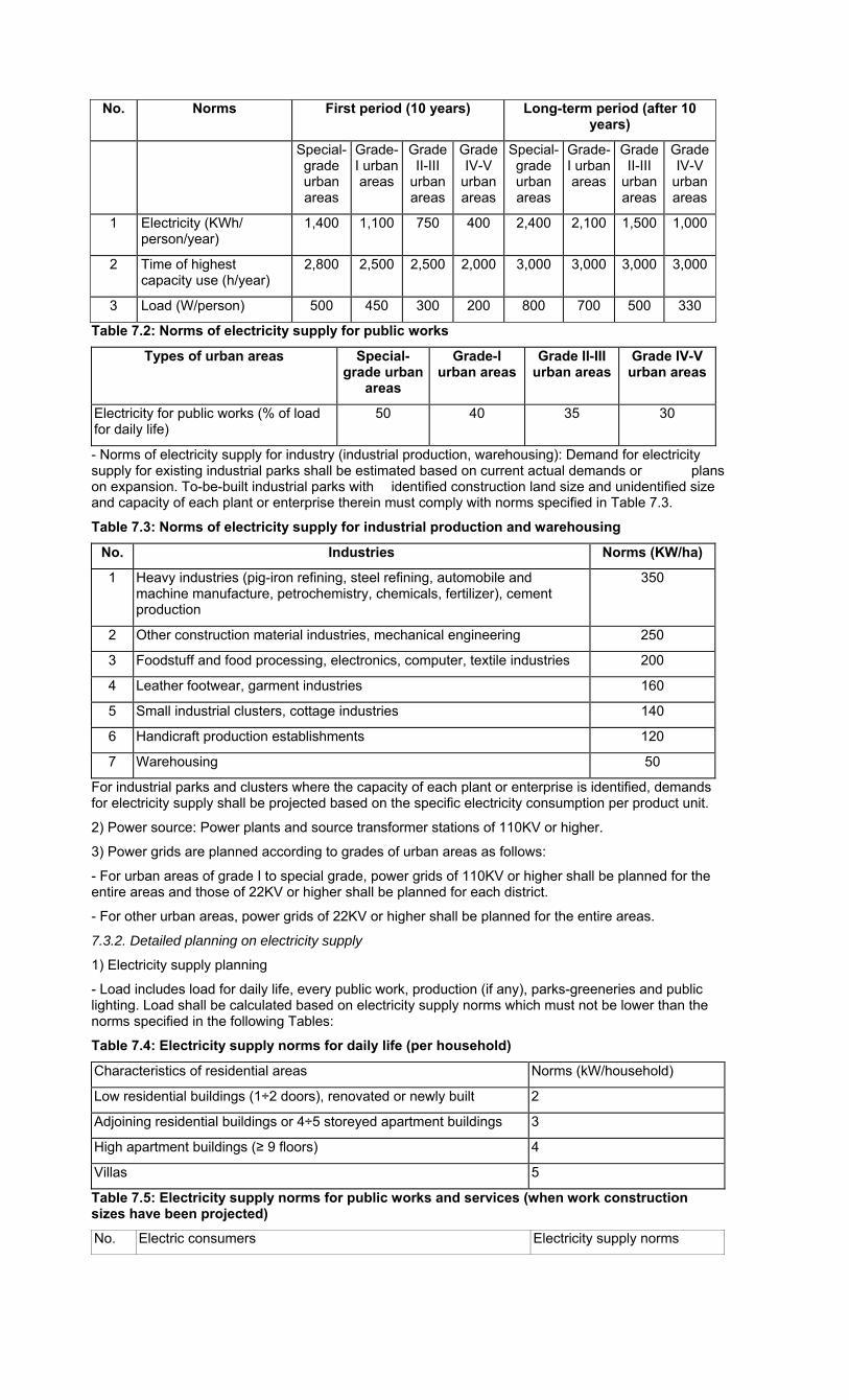
No. Norms First period (10 years) Long-term period (after 10 years)
Special-grade urban areas
Grade-I urban areas
Grade II-III
urban areas
Grade IV-V
urban areas
Special-grade urban areas
Grade-I urban areas
Grade II-III
urban areas
Grade IV-V
urban areas
1 Electricity (KWh/ person/year)
1,400 1,100 750 400 2,400 2,100 1,500 1,000
2 Time of highest capacity use (h/year)
2,800 2,500 2,500 2,000 3,000 3,000 3,000 3,000
3 Load (W/person) 500 450 300 200 800 700 500 330
Table 7.2: Norms of electricity supply for public works
Types of urban areas Special-grade urban
areas
Grade-I urban areas
Grade II-III urban areas
Grade IV-V urban areas
Electricity for public works (% of load for daily life)
50 40 35 30
- Norms of electricity supply for industry (industrial production, warehousing): Demand for electricity supply for existing industrial parks shall be estimated based on current actual demands or plans on expansion. To-be-built industrial parks with identified construction land size and unidentified size and capacity of each plant or enterprise therein must comply with norms specified in Table 7.3.
Table 7.3: Norms of electricity supply for industrial production and warehousing
No. Industries Norms (KW/ha)
1 Heavy industries (pig-iron refining, steel refining, automobile and machine manufacture, petrochemistry, chemicals, fertilizer), cement production
350
2 Other construction material industries, mechanical engineering 250
3 Foodstuff and food processing, electronics, computer, textile industries 200
4 Leather footwear, garment industries 160
5 Small industrial clusters, cottage industries 140
6 Handicraft production establishments 120
7 Warehousing 50
For industrial parks and clusters where the capacity of each plant or enterprise is identified, demands for electricity supply shall be projected based on the specific electricity consumption per product unit.
2) Power source: Power plants and source transformer stations of 110KV or higher.
3) Power grids are planned according to grades of urban areas as follows:
- For urban areas of grade I to special grade, power grids of 110KV or higher shall be planned for the entire areas and those of 22KV or higher shall be planned for each district.
- For other urban areas, power grids of 22KV or higher shall be planned for the entire areas.
7.3.2. Detailed planning on electricity supply
1) Electricity supply planning
- Load includes load for daily life, every public work, production (if any), parks-greeneries and public lighting. Load shall be calculated based on electricity supply norms which must not be lower than the norms specified in the following Tables:
Table 7.4: Electricity supply norms for daily life (per household)
Characteristics of residential areas Norms (kW/household)
Low residential buildings (1÷2 doors), renovated or newly built 2
Adjoining residential buildings or 4÷5 storeyed apartment buildings 3
High apartment buildings (≥ 9 floors) 4
Villas 5
Table 7.5: Electricity supply norms for public works and services (when work construction sizes have been projected)
No. Electric consumers Electricity supply norms
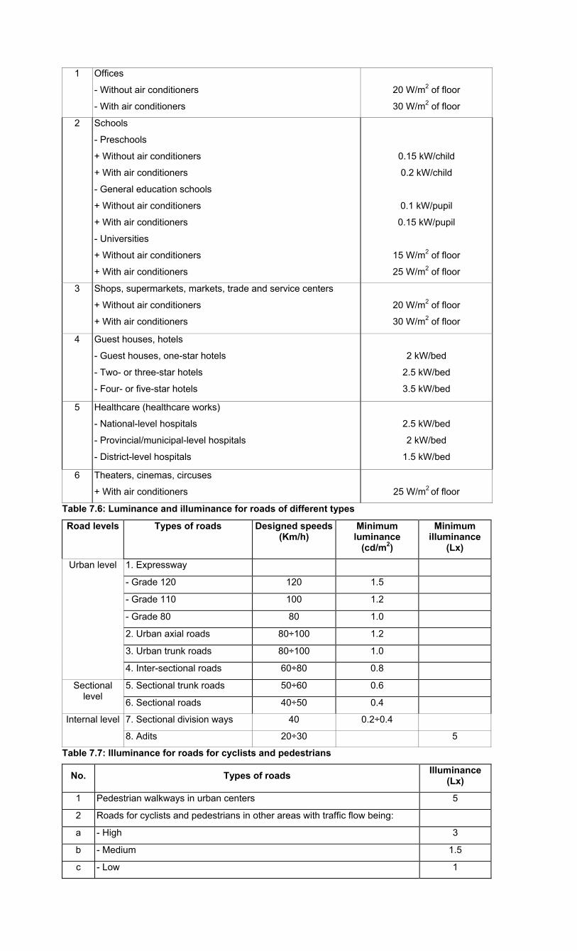
1 Offices
- Without air conditioners
- With air conditioners
20 W/m2 of floor
30 W/m2 of floor
2 Schools
- Preschools
+ Without air conditioners
+ With air conditioners
- General education schools
+ Without air conditioners
+ With air conditioners
- Universities
+ Without air conditioners
+ With air conditioners
0.15 kW/child
0.2 kW/child
0.1 kW/pupil
0.15 kW/pupil
15 W/m2 of floor
25 W/m2 of floor
3 Shops, supermarkets, markets, trade and service centers
+ Without air conditioners
+ With air conditioners
20 W/m2 of floor
30 W/m2 of floor
4 Guest houses, hotels
- Guest houses, one-star hotels
- Two- or three-star hotels
- Four- or five-star hotels
2 kW/bed
2.5 kW/bed
3.5 kW/bed
5 Healthcare (healthcare works)
- National-level hospitals
- Provincial/municipal-level hospitals
- District-level hospitals
2.5 kW/bed
2 kW/bed
1.5 kW/bed
6 Theaters, cinemas, circuses
+ With air conditioners
25 W/m2 of floor
Table 7.6: Luminance and illuminance for roads of different types
Road levels Types of roads Designed speeds (Km/h)
Minimum luminance
(cd/m2)
Minimum illuminance
(Lx)
Urban level 1. Expressway
- Grade 120 120 1.5
- Grade 110 100 1.2
- Grade 80 80 1.0
2. Urban axial roads 80÷100 1.2
3. Urban trunk roads 80÷100 1.0
4. Inter-sectional roads 60÷80 0.8
Sectional level
5. Sectional trunk roads 50÷60 0.6
6. Sectional roads 40÷50 0.4
Internal level 7. Sectional division ways 40 0.2÷0.4
8. Adits 20÷30 5
Table 7.7: Illuminance for roads for cyclists and pedestrians
No. Types of roads Illuminance
(Lx)
1 Pedestrian walkways in urban centers 5
2 Roads for cyclists and pedestrians in other areas with traffic flow being:
a - High 3
b - Medium 1.5
c - Low 1
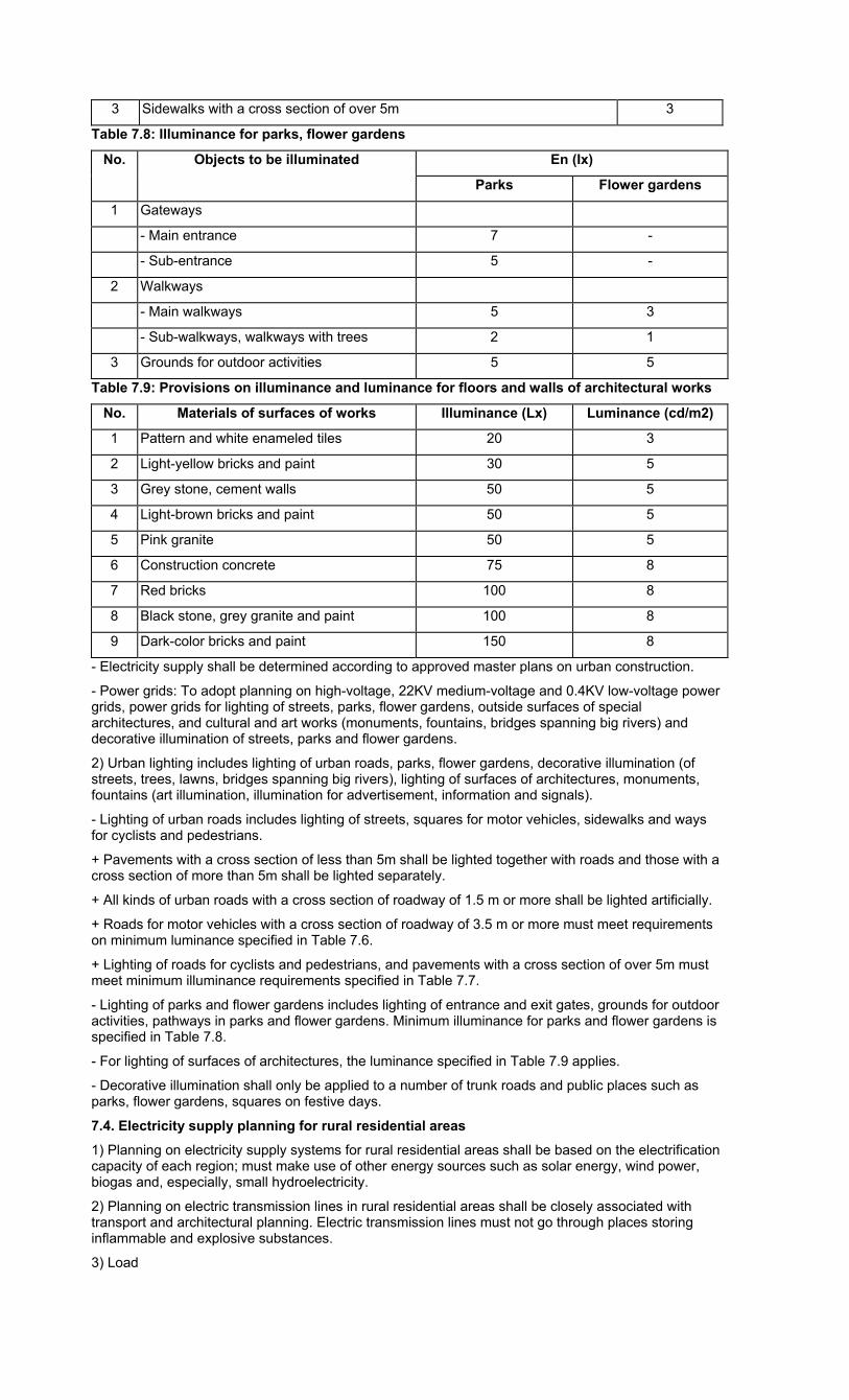
3 Sidewalks with a cross section of over 5m 3
Table 7.8: Illuminance for parks, flower gardens
No. Objects to be illuminated En (Ix)
Parks Flower gardens
1 Gateways
- Main entrance 7 -
- Sub-entrance 5 -
2 Walkways
- Main walkways 5 3
- Sub-walkways, walkways with trees 2 1
3 Grounds for outdoor activities 5 5
Table 7.9: Provisions on illuminance and luminance for floors and walls of architectural works
No. Materials of surfaces of works Illuminance (Lx) Luminance (cd/m2)
1 Pattern and white enameled tiles 20 3
2 Light-yellow bricks and paint 30 5
3 Grey stone, cement walls 50 5
4 Light-brown bricks and paint 50 5
5 Pink granite 50 5
6 Construction concrete 75 8
7 Red bricks 100 8
8 Black stone, grey granite and paint 100 8
9 Dark-color bricks and paint 150 8
- Electricity supply shall be determined according to approved master plans on urban construction.
- Power grids: To adopt planning on high-voltage, 22KV medium-voltage and 0.4KV low-voltage power grids, power grids for lighting of streets, parks, flower gardens, outside surfaces of special architectures, and cultural and art works (monuments, fountains, bridges spanning big rivers) and decorative illumination of streets, parks and flower gardens.
2) Urban lighting includes lighting of urban roads, parks, flower gardens, decorative illumination (of streets, trees, lawns, bridges spanning big rivers), lighting of surfaces of architectures, monuments, fountains (art illumination, illumination for advertisement, information and signals).
- Lighting of urban roads includes lighting of streets, squares for motor vehicles, sidewalks and ways for cyclists and pedestrians.
+ Pavements with a cross section of less than 5m shall be lighted together with roads and those with a cross section of more than 5m shall be lighted separately.
+ All kinds of urban roads with a cross section of roadway of 1.5 m or more shall be lighted artificially.
+ Roads for motor vehicles with a cross section of roadway of 3.5 m or more must meet requirements on minimum luminance specified in Table 7.6.
+ Lighting of roads for cyclists and pedestrians, and pavements with a cross section of over 5m must meet minimum illuminance requirements specified in Table 7.7.
- Lighting of parks and flower gardens includes lighting of entrance and exit gates, grounds for outdoor activities, pathways in parks and flower gardens. Minimum illuminance for parks and flower gardens is specified in Table 7.8.
- For lighting of surfaces of architectures, the luminance specified in Table 7.9 applies.
- Decorative illumination shall only be applied to a number of trunk roads and public places such as parks, flower gardens, squares on festive days.
7.4. Electricity supply planning for rural residential areas
1) Planning on electricity supply systems for rural residential areas shall be based on the electrification capacity of each region; must make use of other energy sources such as solar energy, wind power, biogas and, especially, small hydroelectricity.
2) Planning on electric transmission lines in rural residential areas shall be closely associated with transport and architectural planning. Electric transmission lines must not go through places storing inflammable and explosive substances.
3) Load
- Demand for electricity supply for rural residential areas’ daily life shall be met at least 50% of the norms of electricity supply for daily life of grade-V urban areas (Table 7.1).
- Demand for electricity supply for public works in rural residential areas (communal and inter-communal centers) shall be met at least ≥ 15% of the electricity demand for daily life of a commune or a number of neighboring communes.
- Electricity demand for production shall be determined based on specific demand of each production establishment.
4) Road lighting systems for rural residential areas must be designed to reach ≥ 3Lx for communal or inter-communal centers and ≥ 1.5Lx for other roads.
5) Low-voltage stations shall be installed at load centers or near the largest load, and at places where line installation is convenient, requires few road crossing and does not obstruct or cause danger to production and daily life activities.
6) Medium- and low-voltage transmission lines must not be installed across ponds, lakes, swamps, high mountains, roads with large cross sections, and industrial production areas.
7) Low-voltage stations and medium- and high-voltage power grids in rural residential areas must meet current requirements on protection corridor and distance.
APPENDICES
The appendices below cover current regulations at the time of promulgating the Code. When new legal documents supplementing or replacing these regulations are available, provisions of new documents apply.
APPENDIX 1
REGULATIONS ON URBAN DESIGN
Government’s Decree No. 08/2005/ND-CP of January 24, 2005, on construction planning:
- Article 30: Urban design under general urban construction planning;
- Article 31: Urban design under detailed urban construction planning.
APPENDIX 2
REGULATIONS ON DIKE PROTECTION AREAS
- The 2006 Law on Dikes.
APPENDIX 3
REGULATIONS ON IRRIGATION WORK PROTECTION AREAS
- Ordinance No. 32/2001/PL-UBTVQH10 of April 4, 2001, on Exploitation and Protection of Irrigation Works.
- Decree No. 143/2003/ND-CP of November 28, 2003, detailing the implementation of a number of articles the Ordinance on Exploitation and Protection of Irrigation Works.
APPENDIX 4
DOCUMENTS CONCERNING PROTECTION AREAS OF TRAFFIC WORKS
- Road Law No. 26/2001/QH10.
- Inland Waterway Law No. 23/2004/QH11 of June 15, 2004.
- Maritime Law No. 40/2004/QH11 of June 14, 2004.
- Railway Law No. 35/2005/QH11 of June 14, 2005.
- Civil Aviation Law No. 66/2006/QH11 of May 16, 2006.
- Decree No. 186/2004/ND-CP of November 5, 2004, on management and protection of road traffic infrastructure.
- Decree No. 109/2006/ND-CP of September 22, 2006, detailing and guiding the implementation of a number of articles of the Railway Law.
- Decree No. 71/2006/ND-CP of July 25, 2006, on management of seaports and marine navigable channels.
- Decree No. 94/2007/ND-CP of June 4, 2007, on management of air navigation.
- Clearance between airports and civil areas (Tables PL4.1 and PL4.2)
Table PL4.1: Minimum clearance between airports and civil areas (km)
No Take-off direction and flight route direction
against civil areas
Airport grades
I II III IV
a Take-over crossing civil areas
- Flight routes across civil areas
- Flight routes not across civil areas
5
5
10
10
20
15
30
15
b Take-over and flight routes without crossing civil areas
2 5 6 6
Notes: Grades of airports are determined based on the basic length of runways specified in Table PL4.2 below:
Table PL4.2: Airport grades according to runway length
Airport grades I II III IV
Length of runways (m) Under 800 800÷1,200 1,200÷1,800 Over 1,800
Classification of airports according to ICAO (*) standards
1 2 3 4
Notes: (*) ICAO is the abbreviation of the International Civil Aviation Organization.
APPENDIX 5
REGULATIONS ON SOLID WASTE MANAGEMENT
- TCVN 6706-2000: Hazardous wastes. Classification.
- TCVN 6696-2000: Hygienic solid waste landfills. General requirements on environmental protection.
- TCXDVN 261-2001: Solid waste landfills. Design standards.
- TCXDVN 320-2004: Hazardous waste landfills. Design standards.
- The Government’s Decree No. 59/2007/ND-CP of April 9, 2007, on management of solid wastes.
- The Construction Ministry’s Circular No. 13/2007/TT-BXD of December 31, 2007, guiding a number of articles of the Government’s Decree No. 59/2007/ND-CP of April 9, 2007, on management of solid wastes.
APPENDIX 6
LEVELS OF HAZARD OF ENTERPRISES AND WAREHOUSES
- TCVN 4449-1987: Classification of enterprises and warehouses according to levels of hazard and hygienically safe distance.
APPENDIX 7
REGULATIONS ON QUALITY OF SUPPLIED WATER
- The Health Minister’s Decision No. 09/2005/QD-BYT of March 11, 2005, prescribing the quality of water supplied for daily life of urban areas and rural residential areas.
- The Health Minister’s Decision No. 1329/2002/QD-BYT of April 18, 2002, prescribing the quality of supplied water for instant drinking.
APPENDIX 8
REGULATIONS ON WASTEWATER QUALITY
- Discharge of daily life wastewater into coastal water complies with TCVN 5943-1995.
- Daily life wastewater - Permitted limits of pollution comply with TCVN 6772-2000.
- Discharge of daily life wastewater into water sources for irrigation complies with TCVN 6773-2000.
- Discharge of daily life wastewater into freshwater sources for protection of aquatic life complies with TCVN 6774-2000.
- Post-treatment daily life wastewater satisfies TCVN 7222-2002 requirements.
- Discharge of daily life wastewater into surface water sources complies with TCVN 5942-1995.
- TCVN 7382-2004: Water quality. Hospital wastewater. Standards of discharge.
- TCVN 5945-2005 “Industrial wastewater. Standards of discharge.”
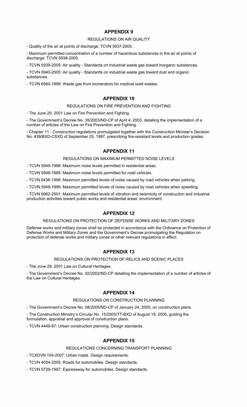
APPENDIX 9
REGULATIONS ON AIR QUALITY
- Quality of the air at points of discharge: TCVN 5937-2005.
- Maximum permitted concentration of a number of hazardous substances in the air at points of discharge: TCVN 5938-2005.
- TCVN 5939-2005: Air quality - Standards on industrial waste gas toward inorganic substances.
- TCVN 5940-2005: Air quality - Standards on industrial waste gas toward dust and organic substances.
- TCVN 6560-1999: Waste gas from incinerators for medical solid wastes.
APPENDIX 10
REGULATIONS ON FIRE PREVENTION AND FIGHTING
- The June 29, 2001 Law on Fire Prevention and Fighting.
- The Government’s Decree No. 35/2003/ND-CP of April 4, 2003, detailing the implementation of a number of articles of the Law on Fire Prevention and Fighting.
- Chapter 11 - Construction regulations promulgated together with the Construction Minister’s Decision No. 439/BXD-CSXD of September 25, 1997, prescribing fire-resistant levels and production grades.
APPENDIX 11
REGULATIONS ON MAXIMUM PERMITTED NOISE LEVELS
- TCVN 5949-1998: Maximum noise levels permitted in residential areas.
- TCVN 5948-1995: Maximum noise levels permitted for road vehicles.
- TCVN 6436-1998: Maximum permitted levels of noise caused by road vehicles when parking.
- TCVN 5948-1999: Maximum permitted levels of noise caused by road vehicles when speeding.
- TCVN 6962-2001: Maximum permitted levels of vibration and seismicity of construction and industrial production activities toward public works and residential areas’ environment.
APPENDIX 12
REGULATIONS ON PROTECTION OF DEFENSE WORKS AND MILITARY ZONES
Defense works and military zones shall be protected in accordance with the Ordinance on Protection of Defense Works and Military Zones and the Government’s Decree promulgating the Regulation on protection of defense works and military zones or other relevant regulations in effect.
APPENDIX 13
REGULATIONS ON PROTECTION OF RELICS AND SCENIC PLACES
- The June 29, 2001 Law on Cultural Heritages.
- The Government’s Decree No. 92/2002/ND-CP detailing the implementation of a number of articles of the Law on Cultural Heritages.
APPENDIX 14
REGULATIONS ON CONSTRUCTION PLANNING
- The Government’s Decree No. 08/2005/ND-CP of January 24, 2005, on construction plans.
- The Construction Ministry’s Circular No. 15/2005/TT-BXD of August 19, 2005, guiding the formulation, appraisal and approval of construction plans.
- TCVN 4449-87: Urban construction planning. Design standards.
APPENDIX 15
REGULATIONS CONCERNING TRANSPORT PLANNING
- TCXDVN 104-2007: Urban roads. Design requirements.
- TCVN 4054-2005: Roads for automobiles. Design standards.
- TCVN 5729-1997: Expressway for automobiles. Design standards.

- TCVN 4117-1985: Regulation on design of railroads of 1,435 mm.
APPENDIX 16
REGULATIONS CONCERNING WATER SUPPLY PLANNING
- TCXDVN 33-2006: Water supply. Outside networks and works. Design standards.
- TCXD 233-1999: Norms on selection of surface and ground water sources for daily-life supply.
APPENDIX 17
PROTECTION OF SAFETY OF HIGH-VOLTAGE POWER GRID WORKS
- The Electricity Law.
- The Government’s Decree No. 106/2005/ND-CP of August 17, 2005, detailing and guiding -the implementation of a number of articles of the Electricity Law concerning protection of safety of power grid works.