Embed Size (px)
Citation preview
DECISION ON THE CITY OF BOSTON’S
REQUEST FOR APPROVAL
OF THE
SOUTH BOSTON WATERFRONT MUNICIPAL HARBOR PLAN
RENEWAL AND AMENDMENT
PURSUANT TO 301 CMR 23.00
December 21, 2016
Commonwealth of Massachusetts
Executive Office of Energy and Environmental Affairs
Matthew A. Beaton, Secretary

I. INTRODUCTION
Today, as Secretary of the Massachusetts Executive Office of Energy and Environmental
Affairs (EEA), I am approving, subject to the conditions noted below, the City of Boston’s (“City”)
South Boston Waterfront Municipal Harbor Plan Renewal and Amendment (“Plan”) dated June
2016. This Decision presents a synopsis of the content of the Plan including supplemental
information submitted on November 14, 2016 and findings on how it complies with the standards
for approval set forth in the Municipal Harbor Planning regulations at 301 CMR 23.00. For
purposes of this Decision, the geographic scope of the Plan is the planning area as originally
proposed in the 2000 South Boston Municipal Harbor Plan. The proposed revisions to the Plan
through the amendment are focused on an area within the South Boston Municipal Harbor Plan
planning area located at 146 to 150 Seaport Boulevard.
Pursuant to the review procedures at 301 CMR 23.00, the Plan was submitted by the City on
June 15, 2016. Following a review for completeness, the Office of Coastal Zone Management
(CZM) published a notice of public hearing and 30-day opportunity to comment in the Environmental
Monitor dated June 22, 2016. Oral testimony was accepted during a public hearing held at Boston
City Hall on July 19, 2016. Twenty-one individual comment letters and 2,194 form letters were
received within the public comment period. The consultation period which included three
extensions, ended on December 9, 2016. The review and consultation process led by EEA and
CZM, included consultation between staff of CZM, the Waterways Regulation Program of the
Department of Environmental Protection (DEP), and the Boston Planning and Development
Agency (BPDA). During the consultation period, a determination regarding the delineation and
location of the project shoreline was affirmed by DEP. Supplemental information was submitted by
the City on November 14, 2016 that described the project shoreline determination, revised
calculations, and modifications to the substitutions and offsets. During a subsequent public
comment period, I received five comment letters relating to the revised Plan.
During the public comment periods, I received comments primarily related to the proposed
amendments in the Plan for a redevelopment project located at 146 to 150 Seaport Boulevard
known as “150 Seaport Boulevard”. Comments in support outlined the benefits of the project such
as improved public access along the waterfront and the development of an underutilized site.
Comments also strongly supported the efforts of the developer to support low income housing in
South Boston. Although I agree with this sentiment and support these important efforts, the
provision of affordable housing offsite is outside both the jurisdiction of Chapter 91 Waterways
1
regulations and the Municipal Harbor Plan (MHP) review and approval process. Comments
questioning the proposed project were fewer in numbers, but far ranging in topics—from regulatory
concerns to building design concerns. Some comments expressed concern with the adequacy of the
Plan and its consistency with the state’s tidelands policy for development within Chapter 91
jurisdiction. Comments also expressed concern with the extent to which the project incorporated
climate resilient design practices and techniques. While MHPs can include certain types of site-
specific design guidelines for proposed developments, state review of MHPs is limited to the formal
evaluation and approval of substitutions and amplifications to specific standards of the Chapter 91
Waterways Regulations. As such, review and approval of MHPs is not intended to consider all
building and design elements that would be more applicable to review under municipal code and
other jurisdictions. Comments regarding the proposed Chapter 91 substitutions and offsets
proposed for the 150 Seaport Boulevard Project in the Plan and supplemental information filing
were carefully considered in the review and analysis of the Plan and discussion of these comments is
contained in the analysis section of this Decision.
2
II. PLAN CONTENT
Plan Renewal
The planning area encompassed by the Plan renewal is the same as the original South Boston
Waterfront District Municipal Harbor Plan (MHP) in 2000. It includes approximately 108 acres of
South Boston extending along the eastern side of the Fort Point Channel from the property owned
by the Gillette Company to the Moakley Court House and then along the Boston Inner Harbor
shoreline including Fan Pier and Pier 4 to the midpoint of the waterway between Pier 4 and
Commonwealth Pier (Figure 1). The area is almost entirely within Chapter 91 jurisdiction and
primarily consists of Commonwealth tidelands. Generally, the planning area follows the area of
Chapter 91 jurisdiction bounded by the Fort Point Channel to the west, Boston Inner Harbor to the
north, Commonwealth Pier and A Street to the east and West 4th Street to the south. The planning
area does not include any Designated Port Areas (DPA); however, the South Boston DPA lies just
to the east of the planning area and includes the adjacent Commonwealth Pier. The South Boston
planning area is a mix of commercial uses, residential, office space and vacant land or buildings
slated for development. The area has changed significantly since the initial filing of the South Boston
MHP in 2000 with new residential, office, retail and other business development.
The renewal of the Plan builds upon the vision and general goals of the South Boston
Waterfront Municipal Harbor Plan (2000) and its first amendment in 2009 by incorporating updated
and new planning layers and describing how the additional information promotes and supports
water related public interests and neighborhood planning goals. Information incorporated within the
2016 Plan adds depth and details to the City’s vision for the planning area relating to transportation,
open space goals, climate change projections and adaptation opportunities, civic/cultural space
demands, and other planning objectives for the area. Specifically, the City has incorporated
information from the following planning initiatives: the South Boston Waterfront Transportation
Plan (2015), the Inner Harbor Passenger Water Transportation Plan (2000), City of Boston Open
Space Plan (2015), Northern Avenue Bridge Project (2016), Imagine Boston 2030, Boston Creates,
Go Boston, Climate Ready Boston, Housing a Changing City, as well as others. The incorporation
of new data, public involvement, and prioritization into the Plan through its renewal allows it to
serve as an updated and highly relevant planning tool that will be critical to the City as the South
Boston Waterfront District continues to be developed.
3
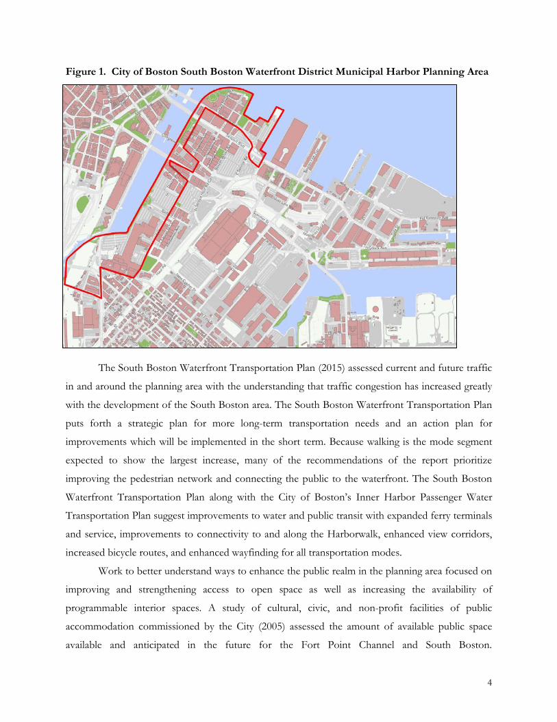
Figure 1. City of Boston South Boston Waterfront District Municipal Harbor Planning Area
The South Boston Waterfront Transportation Plan (2015) assessed current and future traffic
in and around the planning area with the understanding that traffic congestion has increased greatly
with the development of the South Boston area. The South Boston Waterfront Transportation Plan
puts forth a strategic plan for more long-term transportation needs and an action plan for
improvements which will be implemented in the short term. Because walking is the mode segment
expected to show the largest increase, many of the recommendations of the report prioritize
improving the pedestrian network and connecting the public to the waterfront. The South Boston
Waterfront Transportation Plan along with the City of Boston’s Inner Harbor Passenger Water
Transportation Plan suggest improvements to water and public transit with expanded ferry terminals
and service, improvements to connectivity to and along the Harborwalk, enhanced view corridors,
increased bicycle routes, and enhanced wayfinding for all transportation modes.
Work to better understand ways to enhance the public realm in the planning area focused on
improving and strengthening access to open space as well as increasing the availability of
programmable interior spaces. A study of cultural, civic, and non-profit facilities of public
accommodation commissioned by the City (2005) assessed the amount of available public space
available and anticipated in the future for the Fort Point Channel and South Boston.
4
Recommendations for South Boston include supporting the availability of facilities of public
accommodation (FPAs) such as restaurants, museums, retail, visitor centers, and temporary exhibits,
markets, and public events like performances. The City of Boston’s Open Space Plan (2015)
assessed and reviewed the quantity and quality of open space resources to guide future public and
private investments. Recommendations for South Boston included the completion of the
Harborwalk network with connections to inland neighborhoods, support for ground floor uses that
are compatible with the public’s use of the Harborwalk, expand signage and landscaping to draw the
public to the waterfront, encourage recreational use of the watersheet by providing amenities such as
restrooms and wash stations, and support connections to the Boston Harbor Islands through the
Harbor Islands Gateway and other means. Also, in 2016 the City commissioned an Ideas
Competition to solicit suggestions for the multi-modal connection once provided by the Northern
Avenue Bridge. With the structure closed to both vehicles and pedestrians, and planned for
replacement, a new structure would replace a necessary transportation connection between
Downtown Boston and South Boston while acting as a gateway between the two regions of the City.
These studies provide a vision for an all-inclusive and well-connected public realm that will be
cultivated through the renewal of the Plan.
In the last few years, the City has made important strides to better understand how climate
change will affect the City by identifying the potential impacts of climate change, outlining
mitigation goals, and incorporating adaptation opportunities into city planning. The City’s 2014
Climate Action Plan Update focuses on setting goals and establishing a tracking framework for
reducing greenhouse gas. The Metro Boston Climate Preparedness Commitment connects the area
communities in an agreement to take coordinated action to address impacts to critical regional
infrastructure. The Climate Preparedness and Resiliency checklist requires proponents to identify
how proposed projects will be resilient. And this fall, the Climate Ready Boston (CRB) project
released climate change projections for the Boston region relating to sea level rise, precipitation,
coastal flooding, and temperature. The CRB implementation roadmap will guide the City as it
incorporates these projections into all aspects of current and future City operations. City-wide
visioning such as Boston Creates, Go Boston and Imagine Boston 2030 will employ the climate
change lens while informing future development and growth while striving for a healthy, thriving,
and innovative city. These climate change initiatives inform the Plan Renewal by guiding resilient
development in the planning area.
5
The incorporation of these new data into the Plan through the renewal process provides
strong support for alternative modes of transportation, green space connections (within the planning
area and beyond), public realm connections along and to the waterfront, and resilient design
techniques with the goal of improving the South Boston area for residents and business now and
into the future.
With this submittal, the City requests a renewal of the Plan for a period of ten years. This
time period will allow for the City to realize many of its development goals for the South Boston
Waterfront district under the guidelines, planning elements and specific regulatory provisions within
the framework established by the Plan.
Plan Amendment
The scope of the Plan amendment is for a small section of the South Boston MHP planning
area located at 146 to 150 Seaport Boulevard and known as the “150 Seaport Boulevard” project,
located at the northeastern edge of the planning area along the Boston Inner Harbor (Figure 2). The
area for the Plan amendment consists of approximately 25,000 square feet (sf) of filled and flowed
Commonwealth tidelands and is located near Commonwealth Pier which is located within the South
Boston DPA.
The 150 Seaport Boulevard site is located within a section of the South Boston planning area
that is currently being redeveloped but also includes large undeveloped and unimproved areas. The
South Boston MHP (2000) briefly discussed the area of focus for the Plan amendment located at
146 – 150 Northern Avenue, known as “the restaurant parcels”, describing the restaurants on the
Plan Amendment area as some of the few active businesses in the planning area doing well. At that
time, the owners of the land were not interested in redevelopment and because new activity from
the development proposed at Pier 4 and Fan Pier would continue to support the restaurant uses, no
substitute provisions were requested for the 150 Seaport Boulevard site in 2000. At that time, it was
understood that any requested changes to Chapter 91 baseline requirements for the restaurant
parcels would be addressed in a future MHP amendment.
6

Figure 2. Area of focus for the South Boston Waterfront Municipal Harbor Plan amendment
The 150 Seaport Boulevard site is uniquely constrained by its physical location, size,
ownership, and licensing history. The site as proposed has complicated ownership status, comprised
of fee interest ownership, easements, and agreements. The developer holds fee interest in the parcels
on which the Whiskey Priest and Atlantic Beer Garden restaurants are currently located, and other
easements and licenses allowing for the current use of the existing restaurant infrastructure. The
developer has indicated its intent to acquire development rights to two parcels owned by the City,
one relating to the discontinuance of Old Northern Avenue and the other including a portion of the
sidewalk along the new Northern Avenue (Figure 3). The Old Northern Avenue parcel has an
existing high voltage transmission line running beneath it which limits development. The developer
is also acquiring fee interest, easements, and/or leases with abutters for other portions of the project
site: Tishman Speyer to the north and Massachusetts Port Authority (Massport) to the east. Lot
coverage for the existing site is nearly 100 percent and public access is limited to a single table with
7

seating, located on the second floor of The Whiskey Priest and accessed via a narrow alley and
stairway through the restaurant service area. Although required by the DEP to provide some public
access under existing conditions, the current situation does not meet the standards nor the spirit of
the public access requirements of the Waterways regulations. Water access to the site is limited as
the site shares watersheet with the neighboring Commonwealth Pier within the South Boston DPA.
The west side of Commonwealth Pier is regularly used by large vessels including the Spirit of Boston
and Bay State Cruise Company. Additionally, the Water Commons, a public docking facility, is
located just to the north of the site along Pier 4. Vehicular access to the site is limited by the narrow
shape, proximity to Pier 4, access via busy Seaport Boulevard and proximity to the B Street/Seaport
Boulevard intersection.
Figure 3. 150 Seaport Boulevard project site land ownership
The 150 Seaport Boulevard site has a complex Chapter 91 Waterways licensing history. The
proposed project site is comprised of four different parcels, three of which were licensed separately
at different times, as well as a license agreement with Massport. A Written Determination by DEP
for the 146 Northern Avenue (1997) required the construction of a Harborwalk; however, it was
under appeal until a recent settlement in 2015. DEP’s Waterways license for 148 Northern Avenue
(1997, #6970) authorizes the existing restaurant and proposed Harborwalk; however, the
Harborwalk was not constructed due to implications associated with the 146 Northern Avenue
8
appeal. Following enforcement proceedings, 150 Northern Avenue sought approval for a license
authorizing the restaurant use and a proposed Harborwalk, but due to land owner and easement
complications, the licensing has not been concluded.
As a general approach, the MHP process is meant to take a broad view that incorporates
local goals and objectives for a harbor and translates them into a plan and implementable strategy
for a specific region of the harbor in question. Depending on municipal priorities, timing of
proposed developments, geographic constraints, and other factors, the process manifests itself in
different ways, focusing different areas and extents for the plans—from an entire harbor to a district
or neighborhood and, in some cases, a smaller subset of parcels. The plans also vary in their scopes,
sometimes laying out detailed development standards and other times looking to establish general
building maximums to allow for flexibility in future developments. Additionally, amendments to
approved MHPs very often focus on smaller and site-specific scales to allow for revisions of the
plan in order to account for changes in the planning area and surrounding development, variables of
economic climates, details of a proposed project, and other constraints and factors.
In the Plan and supplemental filings, the City has proposed amendments for substitute
provisions and offsetting measures specific to the redevelopment project site at 150 Seaport
Boulevard. Through its local process, the City has developed the Plan and the proposed
discretionary modifications to the Chapter 91 Waterways regulations and offsetting mitigation
measures in a framework that the City has determined to be the best appropriate for this area of the
waterfront. The Plan seeks substitute provisions for Chapter 91 standards specific to: additional
building height, additional lot coverage, and a reconfigured Water-Dependent Use Zone (WDUZ).
9
III. STANDARDS FOR APPROVAL
As noted previously, my approval today is bounded by the authority and standards as
contained in 301 CMR 23.00 et seq. (Review and Approval of Municipal Harbor Plans) and is
applicable only to those elements of the Chapter 91 Waterways regulations that are specifically noted
in this Decision. This Decision does not supersede or stand for separate regulatory review
requirements for any activity.
A. Consistency with CZM Program Policies and Management Principles
The federally-approved CZM Program Plan establishes 20 enforceable program policies and
nine management principles which embody coastal policy for the Commonwealth of Massachusetts.
The following is a brief summary of the Policies and Management Principles applicable to the Plan
area:
• Water Quality Policy #1 – Ensure that point-source discharges in or affecting the coastal zone are consistent with federally approved state effluent limitations and water quality standards.
• Water Quality Policy #2 – Ensure that non-point pollution controls promote the
attainment of state surface water quality standards in the coastal zone.
• Habitat Policy #2 – Restore degraded or former wetland resources in coastal areas and ensure that activities in coastal areas do not further wetland degradation but instead take advantage of opportunities to engage in wetland restoration.
• Protected Areas Policy #3 – Ensure that proposed developments in or near designated
or registered historic districts or sites respect the preservation intent of the designation and that potential adverse effects are minimized.
• Coastal Hazards Policy #1 – Preserve, protect, restore, and enhance the beneficial
functions of storm damage prevention and flood control provided by natural coastal landforms, such as dunes, beaches, barrier beaches, coastal banks, land subject to coastal storm flowage, salt marshes, and land under the ocean.
• Coastal Hazards Policy #2 – Ensure construction in water bodies and contiguous land
area will minimize interference with water circulation and sediment transport. Approve permits for flood or erosion control projects only when it has been determined that there will be no significant adverse effects on the project site or adjacent or downcoast areas.
• Ports Management Principle #1 – Encourage, through technical and financial assistance,
expansion of water dependent uses in designated ports and developed harbors, re-development of urban waterfronts, and expansion of visual access.
10

• Public Access Policy #1 – Ensure that developments proposed near existing public recreation sites minimize their adverse effects.
• Public Access Management Principal #1 – Improve public access to coastal recreation
facilities and alleviate auto traffic and parking problems through improvements in public transportation. Link existing coastal recreation sites to each other or to nearby coastal inland facilities via trails for bicyclists, hikers, and equestrians, and via rivers for boaters.
• Public Access Management Principal #2 – Increase capacity of existing recreation areas
by facilitating multiple use and by improving management, maintenance, and public support facilities. Resolve conflicting uses whenever possible through improved management rather than through exclusion of uses.
• Public Access Management Principal #3 – Provide technical assistance to developers of
private recreational facilities and sites that increase public access to the shoreline.
• Public Access Management Principal #4 – Expand existing recreation facilities and acquire and develop new public areas for coastal recreational activities. Give highest priority to expansions or new acquisitions in regions of high need or limited site availability. Assure that both transportation access and the recreational facilities are compatible with social and environmental characteristics of surrounding communities.
• Energy Management Principle #1 – Encourage energy conservation and the use of alternative sources such as solar and wind power in order to assist in meeting the energy needs of the Commonwealth.
The Plan includes an assessment of how it is consistent with CZM Program Policies and
Management Principles, and based on review of the documentation provided by the City and the
assessment of CZM, I conclude that it meets the intent of each relevant policy and, as required by
301 CMR 23.05(1), I find the Plan consistent with CZM policies.
B. Consistency with Tidelands Policy Objectives
As required by 301 CMR 23.05(2), I must also find that the Plan is consistent with state
tidelands policy objectives and associated regulatory principles set forth in the Chapter 91
Waterways (“Waterways”) regulations of DEP (310 CMR 9.00). As promulgated, the Waterways
regulations provide a uniform statewide framework for regulating tidelands projects. Municipal
Harbor Plans and associated amendments provide cities and towns with an opportunity to propose
modifications to these uniform standards through either the amplification of the discretionary
requirements of the Waterways regulations and/or the adoption of provisions that, if approved, are
intended to substitute for the minimum use limitations or numerical standards of 310 CMR 9.00 by
DEP. The substitute provisions of Municipal Harbor Plans can reflect local planning goals in
11

decisions involving the complex balancing of public rights in and private uses of tidelands, and in
effect, serve as the basis for a DEP waiver of specific use limitations and numerical standards
affecting nonwater-dependent use projects, provided that other requirements are in place to
mitigate, compensate, or otherwise offset adverse effects on water-related public interests.
The Plan contains clear guidance that will have a direct bearing on DEP licensing decisions
within the harbor planning area. Included in this guidance are provisions that are intended to
substitute for certain minimum use limitation and numerical standards in the regulations. These
provisions are each subject to the approval criteria under 301 CMR 23.05(2)(b)-(e), and as explained
below, I find that all such criteria have been met.
Evaluation of Requested Substitute Provisions
The general framework for evaluating all proposed substitute provisions to the Waterways
requirements is established in the Municipal Harbor Plan regulations at 301 CMR 23.05(2)(c) and
301 CMR 23.05(2)(d). The regulations, in effect, set forth a two part standard that must be applied
individually to each proposed substitution in order to ensure that the intent of the Waterways
requirements with respect to public rights in tidelands is preserved.
For the first part, in accordance with 301 CMR 23.05(2)(c), there can be no waiver of a
Waterways requirement unless the Secretary determines that the requested alternative requirements
or limitations ensure that certain conditions—specifically applicable to each minimum use limitation
or numerical standard—have been met. The second standard, as specified in 301 CMR 23.05(2)(d),
requires that the municipality demonstrate that a proposed substitute provision will promote, with
comparable or greater effectiveness, the appropriate state tidelands policy objective. A municipality
may propose alternative use limitations or numerical standards that are less restrictive than the
Waterways requirements as applied in individual cases, provided that the plan includes other
requirements that, considering the balance of effects on an area-wide basis, will mitigate, compensate
for, or otherwise offset adverse effects on water-related public interests.
For substitute provisions relative to the minimum use and numerical standards of 310 CMR
9.51(3)(a)–(e), any proposal must ensure that nonwater-dependent uses do not unreasonably
diminish the capacity of tidelands to accommodate water-dependent uses. Similarly, substitute
provisions for nonwater-dependent projects on Commonwealth Tidelands must promote public use
and enjoyment of such lands to a degree that is fully commensurate with the proprietary rights of
12
the Commonwealth therein, and which ensures that private advantages of use are not primary but
merely incidental to the achievement of public purposes, as provided in 310 CMR 9.53.
Table 1 at the end of this section contains a summary of the proposed offsets and substitute
provisions contained in the Plan and subject to this Decision.
Analysis of Requested Substitute Provisions
Building Height
To approve any substitute provision to the height standard at 310 CMR 9.51(3)(e), I must
first determine that the Plan specifies alternative height limits and other requirements that ensure
that, in general, new or expanded buildings for nonwater-dependent use will be relatively modest in
size, in order that wind, shadow, and other conditions of the ground-level environment will be
conducive to water-dependent activity and public access associated therewith, as appropriate for the
harbor planning area. The approval regulations focus on how a building’s mass will be experienced
at the public open spaces on the project site, especially along the waterfront and key pathways
leading thereto. Within this context, I must apply the “comparable or greater effectiveness” test to
determine whether the proposed substitution and offsetting measures will assure that the above
objective is met. My determination relative to whether or not these provisions promote this tideland
policy with comparable or greater effectiveness was conducted in accordance with the Municipal
Harbor Plan regulatory guidance discussed in detail below.
Under the Waterways regulations heights shall not exceed 55 feet (ft) within 100 ft of the
shoreline, stepping up one foot for every two feet landward of the project shoreline. The resulting
height allowed within jurisdiction on the development site would be 55 ft. The Plan requests a
substitution of the Waterways requirements at 310 CMR 9.51(3)(e) that would allow non-water
dependent buildings up to a height of 250 ft.
Several comments included concerns regarding the height of the building at 150 Seaport
Boulevard proposed in the Plan. A few comments questioned whether the proposed height met the
‘modest in size standard’ of the Waterways requirements.
In reviewing the Plan and the supplemental information submitted during the consultation
period, I find that while the proposed building height is greater than what would be allowed under
the baseline Waterways requirements, the proposed height is in keeping with the height of other
buildings in the area, will not adversely interfere with water-dependent activity and public access and
is appropriate for the South Boston waterfront. The building located immediately to the west, 100
13
Pier 4, is 250 ft in height as will be the proposed building located across Seaport Boulevard on the
M1 parcel. Additionally, the buildings located within the Fan Pier development located to the west
of Pier 4 at parcels B, C, D, and G are, or will be, 250 ft. Indeed, the majority of the buildings
located to the North of Seaport Boulevard between the Old Northern Avenue Bridge and the
project site are 250 ft tall. I believe that in the context of the neighboring developments, the
proposed height is relative and modest in size, as appropriate for the South Boston harbor planning
area, and as detailed below I find that the proposed offsets adequately compensate for the proposed
increase in height.
Impacts from additional height are assessed at the pedestrian level with special attention to
whether the ground level environment will be conducive to water-dependent activity and associated
public access. Shadow studies are conducted to measure any changes to the ground level conditions.
Shadow impacts caused by increased building height, effecting the ground level environment, are
mitigated with appropriate offsetting measures.
Shadow studies, included as a part of the Plan, provided an analysis of how the proposed
building height would compare to baseline Chapter 91 compliant shadows. For the purposes of this
project, shadow impacts are measured within the Shadow Protection Zone as delineated in the 2000
South Boston MHP and based on the solar orientation on October 23rd when open space is still
actively used and shadows are larger due to the position of the sun. The shadow studies completed
for the 150 Seaport Boulevard project indicate a net new shadow of 16,640 sf of which 4,443 sf falls
on land associated with the adjacent Pier 4 development and 12,197 sf falls on water associated with
the watersheet area between Pier 4 and Commonwealth Pier, known as the Water Commons
(Appendix 1 in the Plan). While the shadow studies showed an increase in net new shadow, the
duration of the new shadow is largely limited to two or less hours. A small area comprised primarily
of watersheet will be affected by a net new shadow for the duration of three or more hours.
Wind studies for 150 Seaport Boulevard found that for 97 percent of the tests run, wind
conditions either improved or remained the same for the pedestrian level experience. To ensure this
is the case, the City has committed to reviewing building design elements such as canopies, wind
screens and landscaping during Article 80 review, to ensure there are no negative wind impacts on
ground-level conditions, and that any impacts will be adequately mitigated.
Based on my review of the Plan, it appears that there will be net new shadow cast by the 150
Seaport Boulevard project that will affect a portion of the ground-level conditions as described
above. As part of my review, I must ensure that the plan includes requirements that, considering the
14
balance of effects on an area-wide basis, will mitigate, compensate for, or otherwise offset adverse
effects on water-related public interests.
The City has proposed a combination of measures in an offset framework for both
proposed height substitution and the lot coverage substitution. These offsetting measures and my
analysis of their capacity to mitigate and compensate for any potential diminishment of water-
dependent activity and public access to the waterfront from the proposed substitutions are described
below.
Lot Coverage
To approve any substitute provision to the lot coverage standard at 310 CMR 9.51(3)(d), I
must first determine that the Plan specifies alternative site coverage ratios and other requirements
that ensure that, in general, buildings for nonwater-dependent use will be relatively condensed in
footprint, in order that an amount of open space commensurate with that occupied by such
buildings will be available to accommodate water-dependent activity and public access associated
therewith, as appropriate for the area. My determination relative to whether or not this substitute
provision promotes this tidelands policy with comparable or greater effectiveness is conducted in
accordance with the regulatory guidance discussed below.
The Waterways regulations require at least one square foot of the project site be preserved as
open space for every square foot of building containing nonwater-dependent uses on the project
site. The Plan proposes a substitute provision to allow for lot coverage of up to 75 percent of the
site, resulting in at least 25 percent of the site being preserved as publicly accessible open space.
As detailed in the Plan and the supplemental filing, the site for the 150 Seaport Boulevard
project is comprised of several parcels, easements, and a license agreement with different owners
and separate Chapter 91 licenses that will be aggregated to make up the project site. As such, the
determination of the project shoreline is necessary prerequisite to the analysis and determination of
certain Waterways requirements, such as lot coverage, pedestrian access (i.e., Harborwalk) and
WDUZ. The City’s initial Plan filing was based on an interpretation of project shoreline that
included the pile-supported Harborwalk required by DEP’s 1997 Waterways license (#6970).
During the consultation period, DEP made the formal determination that the project shoreline is
the line marking the perimeter of the current piers, wharfs, or other structures supported by existing
piles of the parcels and easements making up the proposed project site.
15
Several comments expressed concerns with the proposed lot coverage substitution. One
concern raised was that the requested amount of 75 percent lot coverage was too high for the area.
The second concern focused on the acquisition/easements of City-owned property by the 150
Seaport Boulevard developers for the project site.
In evaluating this considerable modification from the Chapter 91 baseline requirement of 50
percent lot coverage, several important factors were considered. Firstly, the project site is
significantly constrained and under current conditions, lot coverage is close to 100 percent, and
there is a significant lack of public access. Another factor is the building architecture which
according to the City’s Plan includes a unique design intended to highlight its location as an
important gateway into both the Seaport District and the city and its connection with the water. The
proposed building design has a smaller building footprint plate on the lowest floors, and beginning
approximately 40 ft above the ground floor, the building gradually extends out over the ground level
plane. The design of the proposed 150 Seaport Boulevard allows for greater outdoor public access
well beyond the 25 percent open space value: due to the architectural design of the building, there
are areas of the project site that will be open and accessible to the public, but because they are not
open to the sky, they do not qualify as open space under the Waterways standards and operative
policies. The open space provided on 150 Seaport Boulevard site in connection with the covered
public realm areas (approximately 3,600 sf or 18 percent of the lot) will provide a substantial amount
of continuous area that may be utilized by the public to access the waterfront. Another element of
my consideration is the reduction in building footprint (and thus lot coverage) from the original
submission, from 15,600 sq ft to 15,000 sq ft, allowing for a 10 foot wide Harborwalk around the
project shoreline as detailed in the City’s supplemental filing. Additionally, as described below, to
further activate the project site, the City has proposed an amplification for additional public space
through a new Seaport Wharf.
With respect to the inclusion of City-owned space in the calculation of lot coverage, it is the
developer’s responsibility to properly and legally secure through fee interest, easement, lease or other
lawful agreement to construct or improve the various parcels and area comprising the project site.
The substitutions proposed in the Plan are based on the aggregation of the parcels and areas to form
this project site, and consequently the approval of these substitutions in this Decision is necessarily
contingent on obtaining such rights.
The City has proposed a combination of measures in an offset framework for both the
proposed lot coverage substitution and the height substitution. These offsetting measures and my
16
analysis of their capacity to mitigate and compensate for any potential diminishment of water-
dependent activity and public access to the waterfront from the proposed substitutions are described
below.
Offsetting Measures for Building Height and Lot Coverage
In its Plan, the City has proposed a combination of measures to collectively offset the
shadow impacts associated with the proposed height substitution and the effects of increased lot
coverage on public access and water-dependent activity. The first measure is an obligation for the
funding of open space at Children’s Wharf along the Fort Point Channel. More specifically, the Plan
requires that $1.5M for Martin’s Park at Children’s Wharf, a universally accessible park and
playground to honor Martin W. Richard, the youngest victim of the 2013 Boston Marathon
bombings. Martin’s Park will provide a landmark venue for children, families, and visitors of all
abilities and is a priority of the Commonwealth, the City and the South Boston neighborhood.
Comments raised concerns as to the valuation of this funding requirement and its timing. I have
reviewed the City’s rationale and analysis for this valuation, and I found this information to be useful
in the overall assessment of offsetting measures. While there is no formal process for establishing
monetary value for mitigation and compensation within the Municipal Harbor Plan review and
approval process, the quantitative estimates and valuation together with a qualitative assessment of
needs, planning goals, public input, and other factors inform my determination that the City has
proposed requirements that, considering the balance of effects on an area-wide basis, will mitigate,
compensate for, or otherwise offset adverse effects on water-related public interests. With respect
to timing, I note there has been significant progress in the planning, design, and financing of
Martin’s Park at Children’s Wharf, and I am confident that implementation of the park will be
generally coincident with any potential redevelopment of 150 Seaport Boulevard. As a result of my
review, I find that the proposed offset will provide amenities and benefits that have been ranked as
top priorities by the South Boston MHP Advisory Committee and in public comment letters
received on the Plan Amendment. The offset will serve to provide high quality open space within
the planning area.
The second offsetting measure is a proposed requirement to further enhance the public’s
experience along the waterfront by providing for an interior public area at 150 Seaport Boulevard.
Comments raised questions about this interior space as an offsetting measure. This first-floor
interior space, located on the Seaport Boulevard side of the building, will welcome the transient
17
public, including people waiting for water transportation departures and arrivals landing at the Water
Commons or at Commonwealth Pier, as well as others seeking publically accessible indoor space on
the waterfront. The City is proposing that the interior space be integrated within a section of the
lobby area of 150 Seaport Boulevard and will include seating and tables, amenities such as free Wi-Fi
and information on water transit options. The space will also offer programming, including the
display of artwork from local artists (e.g., Artists for Humanity and Fort Point Arts Council) as well
as other opportunities for educational or artistic exhibits. The City’s proposal to provide interior
public space that is co-located within a section of the ground floor lobby area with associated
features, services, and programming is an alternative that provides the general public with a more
welcoming atmosphere and greater benefits than an option that would provide the transient public
with a separate, smaller, and discrete space. The specific details on the final dimensions, hours of
operation, management requirements and programming will occur during the Waterways licensing
for the 150 Seaport Boulevard project.
Approval of the substitute provisions for building height and lot coverage proposed in the
Plan requires that I find that the details and specifics of the alternative provisions together with the
proposed offsetting measures will promote, with comparable or greater effectiveness, the applicable
state tidelands policy objectives. As a result of my review, I agree that the proposed offset measures
will provide significant amenities and benefits that will serve to enhance the public realm, the
public’s waterfront experience, and accommodate a range of water-dependent activities. I find that
the requested substitute provisions, coupled with the proposed offsetting measures, will not impair
water-dependent activity and public access to the waterfront, and will appropriately serve to meet
the objectives of 310 CMR 9.51(3)(d) and 310 CMR 9.51(3)(e). Therefore, I approve these
substitutions and the corresponding offset measures.
Water-Dependent Use Zone
To approve any substitute provision to the standard for WDUZ at 310 CMR 9.51(3)(c), I
must first determine that the Plan specifies alternate distances and other requirements that ensure
new or expanded buildings for nonwater-dependent use are not constructed immediately adjacent to
a project shoreline, in order that sufficient space along the water’s edge will be devoted exclusively
to water-dependent use and public access associated therewith as appropriate for the area. Second,
within the context of the Plan, the City must demonstrate that the substitute provision will meet this
standard with comparable or greater effectiveness. My determination relative to whether or not these
18
provisions promote this tideland policy with comparable or greater effectiveness is conducted in
accordance with the Municipal Harbor Plan regulatory guidance discussed in detail below.
The initial Plan submittal did not include a request for a substitution to the Water-
Dependent Use Zone requirement at 310 CMR 9.51(3)(c), but in its supplemental filing, the City has
proposed a substitution allowing for the reconfiguration of the WDUZ (Figure 4). The requested
reconfiguration would require that a minimum width of 10 feet be maintained along the project
shoreline for a Harborwalk, meeting the minimum width requirements, and that no net loss of
WDUZ area (5,770 sf total WDUZ area) be allowed. The WDUZ within the project shoreline
includes a 10 ft Harborwalk connecting from Pier 4 along the north side of the project site and then
running down the east side of the project site to Seaport Boulevard (totaling approximately 4,000 sf).
The proposed WDUZ substitution will reconfigure the balance of the required WDUZ
(approximately 2,000 sf) onto one of two locations: (1) a pile-supported wharf area—referred to as
Massport Wharf—extending from the eastern edge of the proposed project along Seaport Boulevard
to Commonwealth Pier, or (2) an alternative pile-supported wharf area that would extend
southeasterly from the project site. This reconfigured WDUZ will widen pedestrian connections
from the project site to Seaport Boulevard and down to Commonwealth Pier, enhancing the
pedestrian experience along the waterfront and increasing safety by providing a queueing area for
the public accessing the water transportation facilities at Commonwealth Pier. Both options for
reconfiguration meet community goals for improved public realm while still protecting the shoreline
for water-dependent uses by maintaining at least the quantity of WDUZ area (approximately 5,770 sf
total) as required by the regulations. The reconfiguration of the WDUZ will also provide
opportunities to balance the protection of the waterfront for water-dependent uses with the
specifics of the development project.
There were no comments indicating concerns with the proposed reconfiguration of the
WDUZ. Regarding the location options for the reconfigured WDUZ area, comments indicated a
strong preference for the Massport Wharf alternative which runs parallel to Seaport Boulevard
providing a connection to Commonwealth Pier. This alternative was preferred as it will provide a
significant public benefit by improving pedestrian circulation around the ferry terminal at
Commonwealth Pier.
19
Figure 4. 150 Seaport Boulevard proposed Water Dependent Use Zone reconfiguration: Massport Wharf preferred and alternate locations
As a result of my review, I find that the City has demonstrated that the proposed substitute
provision ensures that considering the constraints specific to this site, the WDUZ provided along
the edge of the project shoreline which will be devoted exclusively to water-dependent use and
public access is sufficient, and I therefore approve this substitute provision and associated offsetting
measure. My approval of this substitution is conditioned with a preference that the approximately
2,000 sf of reconfigured WDUZ be met through the Massport Wharf alternative described above,
and further that under no circumstances will there be a net loss of WDUZ area as a result of
reconfiguration.
Amplification for Exterior Open Space (310 CMR 9.53(2)(b))
As part of the Plan Amendment, the City requests an amplification to the standard for the
Activation of Commonwealth Tidelands at 310 CMR 9.53(2)(b). Due to the unique nature of the
site and the significant constraints relative to its size, location, ownership and licensing history, the
opportunities for providing quality public realm space and benefits along the waterfront is extremely
limited. Many comments received during the public comment period emphasized the need to
provide for greater public access and pedestrian connections along the water between the
Harborwalk along Pier 4 and Seaport Boulevard. The City’s supplemental filing includes a request to
amplify the discretionary provisions of the Waterways standards relating to exterior open space by
20
creating a deck area of approximately 5,000 sf beyond the existing project shoreline, referred to as
Seaport Wharf (Figure 5). Seaport Wharf would be in addition to the 10 ft Harborwalk located
within the existing project shoreline and will not count towards lot coverage, open space, or WDUZ
calculations.
Figure 5. 150 Seaport Boulevard with Seaport Wharf Amplification
The City’s Plan proposes the amplification of publically accessible space along the water’s
edge through the construction of Seaport Wharf to significantly enhance public realm opportunities
at the project site. The proposed Seaport Wharf will extend beyond the existing project shoreline
over open watersheet located between the existing restaurant parcels and the public docking facilities
at the Water Commons. This watersheet, located at a pinch point, does not currently provide much
opportunity for water-dependent use.
Comments on the proposed Seaport Wharf amplification were generally supportive of the
addition of Seaport Wharf. However, one comment letter, while supportive, raised concerns
regarding the precedent of allowing projects to expand over open water to provide public space that
could not be provided onsite. To be clear, the Seaport Wharf amplification is a significant amenity to
the project for the public access and activation of the site, but it is not being considered for the
calculation of lot coverage, open space, or WDUZ, and it is not proposed as an offset for requested
substitutions. Seaport Wharf is an additional but important feature of the 150 Seaport Boulevard
21
project providing increased opportunities for the public to access the waterfront which was a stated
priority of the Advisory Committee, the City and the public. Although the requested amplification
will result in the loss of open water, I find that given the particular factors, conditions, and
constraints unique to the 150 Seaport Boulevard site, including the lack of water-dependent use
opportunities this space can accommodate, the strong public desire to unify the public realm areas
along Pier 4 with the proposed development, and the greater public activation that would be realized
through a new wharf, the benefits of Seaport Wharf out-weigh the detriments of the net loss of
watersheet in the area. Further, because Seaport Wharf will be licensed solely as a water-dependent
use, public access to and along the shore will be protected. Therefore, as a result of my review, I
grant the amplification request for greater publically accessible exterior space on the project site. My
approval of this amplification is conditioned such that the required easements and other agreements
with abutting property owners must be in place prior to licensing of the development project.
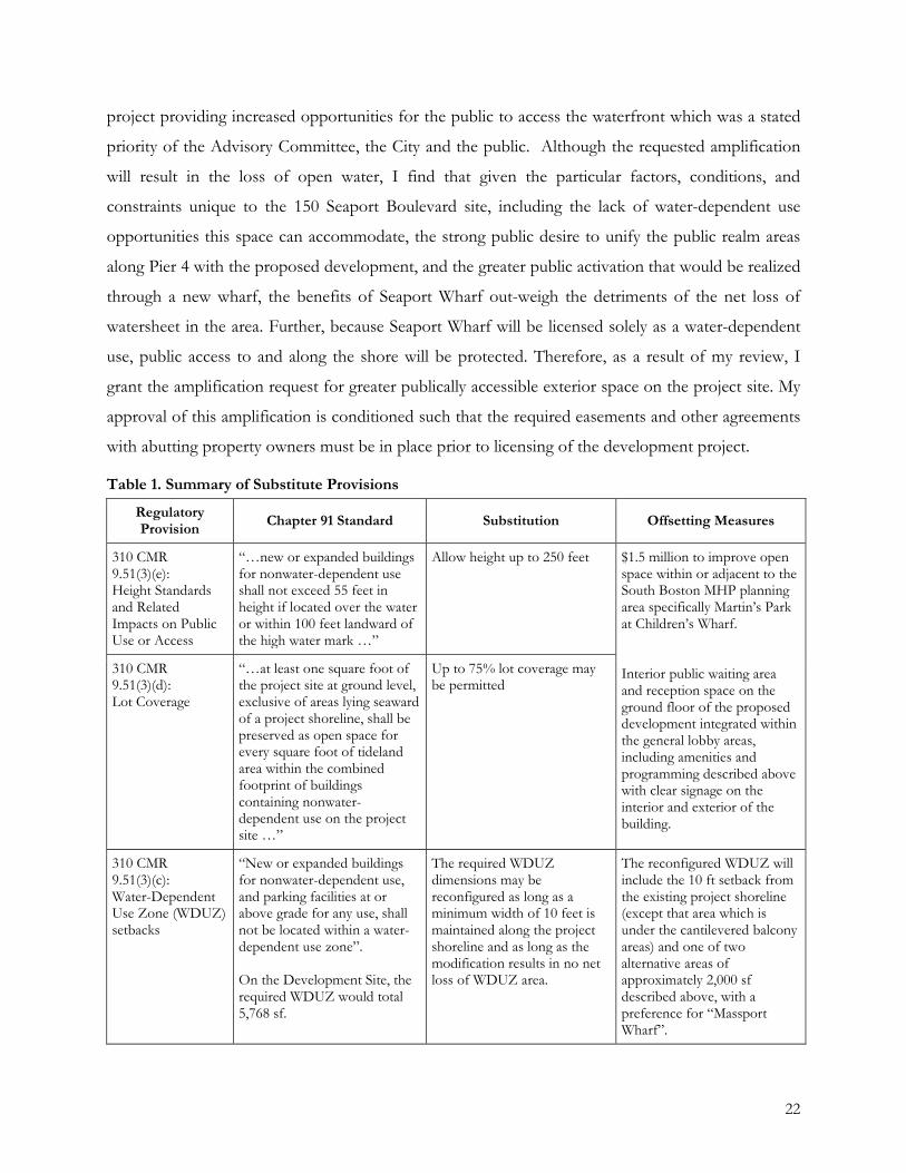
Table 1. Summary of Substitute Provisions
Regulatory Provision Chapter 91 Standard Substitution Offsetting Measures
310 CMR 9.51(3)(e): Height Standards and Related Impacts on Public Use or Access
“…new or expanded buildings for nonwater-dependent use shall not exceed 55 feet in height if located over the water or within 100 feet landward of the high water mark …”
Allow height up to 250 feet
$1.5 million to improve open space within or adjacent to the South Boston MHP planning area specifically Martin’s Park at Children’s Wharf. Interior public waiting area and reception space on the ground floor of the proposed development integrated within the general lobby areas, including amenities and programming described above with clear signage on the interior and exterior of the building.
310 CMR 9.51(3)(d): Lot Coverage
“…at least one square foot of the project site at ground level, exclusive of areas lying seaward of a project shoreline, shall be preserved as open space for every square foot of tideland area within the combined footprint of buildings containing nonwater-dependent use on the project site …”
Up to 75% lot coverage may be permitted
310 CMR 9.51(3)(c): Water-Dependent Use Zone (WDUZ) setbacks
“New or expanded buildings for nonwater-dependent use, and parking facilities at or above grade for any use, shall not be located within a water-dependent use zone”. On the Development Site, the required WDUZ would total 5,768 sf.
The required WDUZ dimensions may be reconfigured as long as a minimum width of 10 feet is maintained along the project shoreline and as long as the modification results in no net loss of WDUZ area.
The reconfigured WDUZ will include the 10 ft setback from the existing project shoreline (except that area which is under the cantilevered balcony areas) and one of two alternative areas of approximately 2,000 sf described above, with a preference for “Massport Wharf”.
22

Extended License Terms
The Plan includes recommendations for additional public benefits that would be required if
the 150 Seaport Boulevard project requests an extended license term from DEP for Commonwealth
tideland occupation. The Plan recommends that DEP consider funds to build out space allocated to
the Fort Point Arts Community located at the Envoy Hotel. I concur with this recommendation,
and advise DEP to look to this and other public benefits such as water transportation subsidies and
waterfront activation during the licensing process. During the licensing process, DEP should closely
coordinate with the City of Boston on the appropriateness of public benefits associated with a
request for any extended term license.
Climate Resilience
While not formally a part of the MHP review and approval standards, I note that the Plan
includes strategies to address the potential impacts of climate change in the South Boston
Waterfront District planning area. As recognized in Governor Baker’s recent Executive Order 569
“Establishing an Integrated Climate Change Strategy for the Commonwealth” and a suite of other
state and municipal initiatives, the impacts of climate change must be an important consideration for
development across the state, within the City of Boston, and in South Boston. Specific to the 150
Seaport Boulevard project, building design elements have been incorporated which will limit the
site’s vulnerability to coastal flooding and storm events. The proposed project will locate all critical
mechanical and electrical infrastructure above the first floor, the underground infrastructure and
below grade parking will be enclosed in a water proofed envelope that can be extended to include
the first floor, emergency generators will be located on the roof, the first floor will be constructed at
a height which would allow for future modification of the ground floor elevation as sea levels rise,
and the pile-supported outdoor public areas will be constructed so that they may be raised to match
changes to the interior ground floor elevation. These and other resilient design techniques
incorporated into the proposed project are critically important and address public comments
received regarding the importance of planning for the impacts of climate change.
C. Relationship To State Agency Interests
The proposed 150 Seaport Boulevard project is located immediately to the east of
Commonwealth Pier which is owned by the Massport. Additionally, the ownership interests
comprising the 150 Seaport Boulevard Project include an existing license from Massport for the
23
restaurant structures extending beyond the eastern edge of the property owned in fee. In order for
the project to proceed, an additional easement or lease from Massport will be required. A letter from
Massport is attached to this Decision regarding the relationship between the 150 Seaport Boulevard
Project and Massport interests.
D. Implementation Strategies
Pursuant to 301 CMR 23.05(4), the Plan must include enforceable implementation
commitments to ensure that, among other things, all measures will be taken in a timely and
coordinated manner to offset the effect of any plan requirement less restrictive than that contained
in 310 CMR 9.00. The provisions of this Plan will be implemented through the City of Boston
Zoning Code’s Planned Development Area (PDA) planning mechanism. The 150 Seaport Boulevard
project is located within the South Boston Inner Harbor subdistrict of the South Boston Waterfront
Interim Planning Overlay District (IPOD). The proponent will seek approval of a PDA
development plan for the 150 Seaport Boulevard project which will be subject to approval by the
BPDA Board, the Boston Zoning Commission, and the Mayor. The PDA will establish specific
dimensional requirements as set forth within this Plan Amendment regarding height, lot coverage,
and building setbacks that are consistent with the approved substitute provisions and offsetting
measures described in the Plan Amendment. Based on the information provided in the Plan and as
discussed above, implementation commitments including the finalization of easements and land
transfers required for the PDA must be complete prior to final approval of the PDA by the City.
With the identification of the implementation commitment discussed above, I believe no further
commitments are warranted, and I find that this approval standard has been met.
24
IV. EFFECTIVE DATE AND TERM OF APPROVAL
This Decision shall take effect immediately upon issuance on December 21, 2016. As
requested by the City of Boston, the South Boston Waterfront Municipal Harbor Plan Renewal and
Amendment Decision shall expire 10 years from this effective date unless a renewal request is filed
prior to that date in accordance with the procedural provisions of 301 CMR 23.06. No later than six
months prior to such expiration date, in addition to the notice from the Secretary to the City
required under 301 CMR 23.06(2)(b), the City shall notify the Secretary in writing of its intent to
request a renewal and shall submit therewith a review of implementation experience relative to the
promotion of state tidelands policy objectives.
25
V. STATEMENT OF APPROVAL
Based on the planning information and public comment submitted to me pursuant to 301
CMR 23.04 and evaluated herein pursuant to the standards set forth in 301 CMR 23.05, I hereby
approve the City of Boston South Boston Waterfront Municipal Harbor Plan Renewal and
Amendment subject to the following conditions:
1. The application of the substitutions and amplifications in the Plan are contingent on properly and legally securing the rights to construct or improve the various parcels and area comprising the 150 Seaport Boulevard project site through fee interest, easement, lease, or other lawful agreement.
2. DEP shall require reasonable conditions and arrangements to ensure that off-site open space improvements and/or amenities are generally implemented concurrent with the associated development on tidelands.
3. In the application of substitutions DEP shall refer to Section III(B), Table 1, and the following conditions:
• In meeting the reconfigured WDUZ substitution, the City, developer and Massport shall make every reasonable effort to implement the approximately 2,000 sf WDUZ area in the location described in the Plan and this Decision as Massport Wharf. Before the alternative option can be advanced, the City shall submit a justification and explanation with details of why the preferred Massport Wharf option is unfeasible.
• Although the construction of the reconfigured WDUZ relies on easement agreements with Massport, it shall proceed within the same timeframe as the rest of the proposed 150 Seaport Boulevard project and must be complete prior to occupancy.
• Although the construction of Seaport Wharf relies on easement agreements with Tishman Speyer, it shall proceed within the same timeframe as the rest of the proposed 150 Seaport Boulevard project and must be complete prior to occupancy.
4. The City shall prepare a final, approved City of Boston South Boston Waterfront Municipal Harbor Plan Renewal and Amendment (“Approved Plan Renewal and Amendment”) to include:
• The Plan Renewal and Amendment dated June, 2016; • Supplemental materials dated November 15, 2016 submitted during the
consultation session; and • This Decision.
Copies of the final Approved Plan Renewal and Amendment shall be provided to CZM and
DEP’s Waterways Program, kept on file at the City of Boston, and made available to the public
through the City’s website and/or copies at the public library. For Chapter 91 Waterways licensing
purposes pursuant to 310 CMR 9.34(2), the Approved Plan Renewal and Amendment shall not be
construed to include any of the following:
26
1. Any subsequent addition, deletion, or other revision to the final Approved Plan Renewal and Amendment, except as may be authorized in writing by the Secretary as a modification unrelated to the approval standards of 301 CMR 23.05 or as a plan amendment in accordance with 301 CMR 23.06(1);
2. Any provision which, as applied to the project-specific circumstances of an individual license application, is determined by DEP to be inconsistent with the Waterways regulations at 310 CMR 9.00 or with any qualification, limitation, or condition stated in this Approval Decision.
This Decision and the Approved Plan Renewal and Amendment do not supersede separate
regulatory review requirements for any activity.
In a letter dated December 20, 2016, the D EP Waterways Program Chief has expressed
support for approval of the Plan and stated that in accordance with the provisions of 310 CMR
9 .34(2) the Department will require conformance with any applicable provisions of the approved
Plan in the case of all waterways license applications submitted subsequent to the Plan's effective
date. It will apply as well to all pending applications for which no public hearing has occurred or
where the required public comment period has not expired by the effective date of the approved
Plan.
Date a7hew A. Beaton Sec~'lry of Energy and Environmental Affairs
27
Commonwealth of Massachusetts Exacutiva Office of Energy & Environmental Affairs
Department of Environmental Protection One Winter Street Boston, MA 02108 • 617-292-5500
Charles o. Baker Governor
Matthew A. Beaton Secretary
Karyn E. Polito Lieutenant Governor
Matthew A. Beaton, Secretary Executive Office of Energy and Environmental Affairs 100 Cambridge Street Boston, MA 02114
December 20, 2016
RE: DEP Recommendation for the Approval of the City of Boston's South Boston Waterfront District Municipal Harbor Plan Renewal and Amendment, dated June 15, 2016
Dear Secretary Beaton:
Martin Suuberg Commissioner
The Department of Environmental Protection, Waterways Regulation Program ("the Department") has review the City of Boston's South Boston Waterfront District Municipal Harbor Plan Renewal and Amendment ("the Plan") dated June 15,2016 and supplemental information dated November 23, 2016. The Department's staff have worked closely with the Massachusetts Office of Coastal Zone Management (CZM) and representatives of the City of Boston throughout the planning process and our comments have been addressed and incorporated into the Plan and supplemental information. The Department, therefore, recommends that you approve the Plan and make a finding that it is consistent with state tidelands policy objectives, as required by 301 CMR 23.05(3).
The Department will adopt as binding guidance in all License application review any Substitute Provisions contained in the final Decision. The Plan and supplemental information lay out Substitutions and Offsets that will adequately meet the protected interests pursuant to 310 CMR 9.00. The Substitutions contained in the Plan and supplemental information will modify the standards pursuant to: 310 CMR 9.51(3)(c), which governs allowable uses and setbacks in the Water-Dependent Use Zone (WDUZ); 310 CMR 9.51(3)(d), which governs the amount of pedestrian level open space on the Project Site; and 310 CMR 9.51(3)(e), which governs the allowable heights of nonwater-dependent buildings based on their distance from the high-water mark on the Project Site. The Department has determined that the Plan establishes appropriate Offsets for each of the Substitutions. The Plan and supplemental information also lay out an Amplification pursuant to 310 CMR 9.51(3)(d) and 310 CMR 9.52(1)(b) for an expanded pedestrian access network seaward of the project shoreline ..
In accordance with the provisions of 310 CMR 9.34(2), the Department will require conformance with any applicable provision of the approved Plan in the case of all waterways license applications
This Information ls avallable In alternate format. Contact Michelle Waters-Ekanem, Director of Diversity/CIVIi Rights at 617-292-5761. TTY# MassRelay Service 1·800-439-2370
MassDEP Website: www.mass.gov/dep
Printed on Recyctad Paper
submitted subsequent to the Plan's effective date. Approved Plans apply to all pending applications for which no public hearing has occurred and where the required public comment period has not expired by the effective date of the Decision.
The Department looks forward to continuing its work with CZM, representatives of the City of Boston, and the advocacy community in the implementation of this important planning effort. Should you have any questions in regard to the foregoing, please contact me at (617)292-5615. Thank you for your consideration.
~ Ben Lynch Program Chief Waterways Regulation Program
Cc: Brian Golden, City of Boston Rich McGuinness, Boston Planning and Development Authority Bruce Carlisle, CZM
Massachusetts Port Authority One Harborside Drive East Boston, MA 02128-2909 Telephone (617) 568-5000 www.massport.com
December 21, 2016
Mathew A. Beaton, Secretary Executive Office of Energy & Environmental Affairs 100 Cambridge Street, Suite 900 Boston, MA 02114
RE: 2016 South Boston Municipal Harbor Plan Renewal and Amendment
Dear Secretary Beaton:
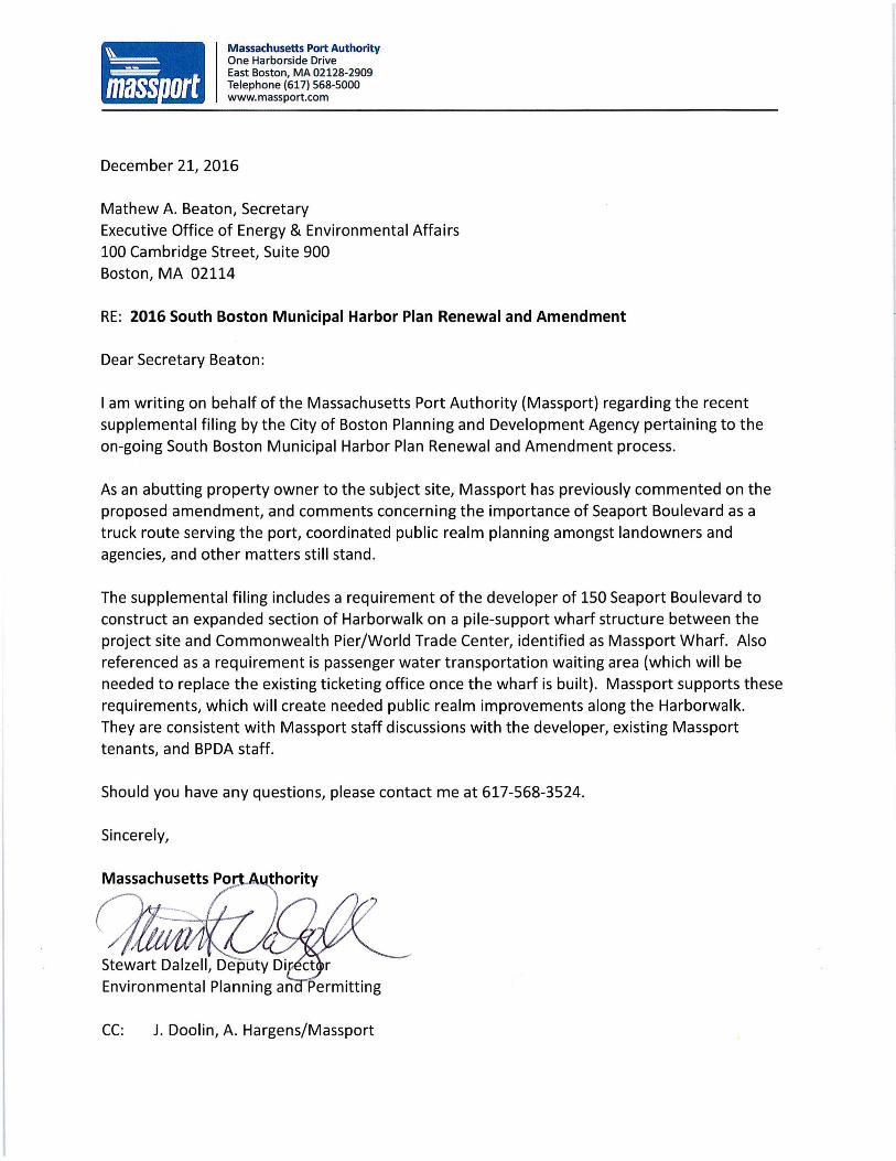
I am writing on behalf of the Massachusetts Port Authority (Massport) regarding the recent supplemental filing by the City of Boston Planning and Development Agency pertaining to the on-going South Boston Municipal Harbor Plan Renewal and Amendment process.
As an abutting property owner to the subject site, Massport has previously commented on the proposed amendment, and comments concerning the importance of Seaport Boulevard as a truck route serving the port, coordinated public realm planning amongst landowners and agencies, and other matters still stand.
The supplemental filing includes a requirement of the developer of 150 Seaport Boulevard to construct an expanded section of Harborwalk on a pile-support wharf structure between the project site and Commonwealth Pier/World Trade Center, identified as Massport Wharf. Also referenced as a requirement is passenger water transportation waiting area (which will be needed to replace the existing ticketing office once the wharf is built). Massport supports these requirements, which will create needed public realm improvements along the Harborwalk. They are consistent with Massport staff discussions with the developer, existing Massport tenants, and BPDA staff.
Should you have any questions, please contact me at 617-568-3524.
Sincerely,
Stewart Dalzell, Deputy Di Environmental Planning an
CC: J. Doolin, A. Hargens/Massport


![Mhp Gold The Automated Mhp Mgr[1].Revised](https://img.pdfslide.us/doc/110x75/55c343e3bb61ebe9438b45a3/mhp-gold-the-automated-mhp-mgr1revised-55c4568e3551f.jpg)