Embed Size (px)
Citation preview

CHAPTER 4
DECENTRALISED PLANNING IN KOTTAYAM DISTRICT: AN OVERVIEW
OF FUND UTILISATION

133
The name Kottayam is said to have come from 'Kotta Akam' in Malayalam,
meaning 'inside the fort'. The Rajas of Thekkumkur, an independent little
kingdom, to which Kottayam area belonged, ruled their domain from a
location in the present day Kottayam called Thazhathangadi. When, in the
mid-Eighteenth century, Marthanda Varma of Travancore annexed
Thekkumcore, Kottayam area, along with the areas of the rest of what is
today's Kottayam District, became part of the Kingdom of Travancore
(later to be the Princely State of Travancore under the British). After Indian
independence, Kottayam eventually became the headquarters of the present
Kottayam District.
Kottayam is located in the south-central half of Kerala state.
Kottayam is an important trading center of commercial crops and a
publishing centre in Kerala. Extensive cultivation of rubber trees in Kerala,
especially in vast areas of Kottayam District, in small and large plantations
as well as in small lots and even in many housesyards, has made Kottayam
a major trading place of natural rubber in India. The town has been in the
forefront of modern education in Kerala from the nineteenth century.
Kottayam is considered to be part of the midlands of Kerala, and the
climate is also pretty moderate. Quite fittingly, The Rubber Board, a body
set up by the Indian government for the development of rubber industry is
located at Kottayam. A number of small and medium-sized enterprises in

134
and around the town are engaged in the processing of rubber and
manufacturing of rubber products. Besides rubber, Kottayam is also a trading
place of other commercial crops grown in the district and neighbouring areas.
Kottayam was known as an educational hub in the state, and still has a niche for
itself in the field of education. In 1989, Kottayam became the first fully literate
municipal town in India. The grama panchayats of Kottayam and the
development programmes initiated are discussed below.
Fund Utilisation
Before the IX plan, grama panchayats could not undertake many
projects due to lack of funds and resources. In the IX plan, 40 per cent of
the state plan funds were handed over to the three – tier panchayats. This
gave a boost to local developmental efforts through people’s participation.
There was much enthusiasm among the people at the bottom of the social
pyramid to participate in the planning process and get benefits.
Vaikom Block
Before getting into the utlisation of funds allotted to the Panchayats,
a brief overview of each panchayat can be done.
Maravanthuruth Grama Panchayat
Maravanthuruth grama panchayat is situated on the shores of
Vembanad Lake and is surrounded on two sides by rivers. Some area of the

135
panchayat is lake and the land area covers 1942.2 hectares. Of this, 696.8
hectares are paddy fields, 984.8 hectares are homestead lands and 283.6
hectares are purampoke lands.The alluvial soil and humus deposited by the
Muvattupuzha river have made the area very fertile. The climate is
favorable for the cultivation of several crops like rice, coconut trees,
bananas, tapioca, vegetables, etc. The most important crops are rice and
coconuts.
The panchayat area can be divided into four water shed zones –viz
Koodavattom, Kadookkara, Kulasekharamangalam and Thurithumma. 60 per
cent of the population of the panchyath at the time of the IX plan
commencement were below poverty line category. It is clear that a major part
of the fund (81.24 percent) was allotted for general plan activities. Fund
allocated for SCP (Special Component Plan) and TSP (Tribal Sub Plan) are
only 18.76 per cent of the total allocated fund.The panchayat has no allocation
for TSP from the Plan fund.
Chembu Grama Panchayat
Located in the lowlands of Kottayam district, Chempu Grama
Panchayat had been facing several problems earlier. As the area in general
is water – logged and is surrounded by backwaters and canals, fishing, coir
– making and agriculture have been the chief sectors where people of the
panchayat depended on for livelihood. Majority of the people belong to

136
BPL sections, having little land. The 9th plan was implemented at a time
when several problems were facing the economy. The financial and other
assistance provided by the government through decentralised planning
helped the panchayat in solving several problems and tackling many
others. Though full success cannot be claimed, satisfactory achievements
were made during the plan period.
Thalayaazham Grama Panchayat
The economy of Thalayaazham grama panchayat is largely
dependent on the agricultural sector. Rice and coconut are the important
crops. Rice cultivation had been adversely affected by floods, water
infusion, lack of clean water, logging, soil – filling of paddy fields, low
price of paddy, weeds, etc. Coconut trees were affected by plant diseases.
Sales price of coconuts was low at the time of the IX plan.Scarcity of
drinking water was very severe, when the IX plan started.
In the case of women, there were a number of problems facing
them. Though physical torture of women had not been reported, women in
general were psychologically tortured by men and society in general. They
were economically exploited, were ignored, their unseen work was not
recognised and were held inferior to men. Their status in society and in the
family was rather low. Alcoholic husbands made matters worse. Water
pollution had been causing environmental problems. Transportation

137
facilities were inadequate. It was under such circumstances that the IX
plan arrived with grass-root level planning.
T.V Puram Grama Panchayat
Being situated in the west coastal area of north Travancore and near
Cochin region, the rural agriculture economy of T.V.Puram grama
panchayat, has been historically dependent on agriculture, fisheries, animal
husbandry and traditional cottage industries. Though three sides of
T.V.Puram panchayat region are bounded by water of Vembanad Lake and
Moovattupuzha river, usable water is scarce here. This is due to several
reasons. Canals and other water ways are filled with water-weeds like '
African paayal', pola, etc. This causes pollution of water. Latrines with no
septic tanks, empty excreta into the backwaters of the area, thereby causing
the growth of germs and infections and diseases. This had been affecting
health in the densely populated coastal areas.
Udayanapuram Grama Panchayat
Surrounded by Muvattupuzha river and Maravanthuruthu in North,
Thalayolaparambu Panchayat in East, Kariyaar and Vaikom Municipality
in South and Vembanad Lake in West, Udayanapuram is mainly dependent
on agriculture. 60 per cent of the population is engaged in agriculture and
allied occupations. 250 households were doing dairy farming under 4 milk-
producers’ co-operative societies. 30 households used to manufacture
138
pottery products. About 2,000 people were working in the coir industry
under 6 coir co-operative societies. 80 per cent of the population were
living below poverty level during the IX plan.
Vechoor Grama Panchayat
Situated in the lowlands of the district, this panchayat is largely an
agrarian area, with fishing an important occupation of the people. Rice,
coconut and fish are the main sources of income for the people.
Agriculture, livestock rearing and fishing are the three main economic
activities having more or less equal importance. When the IX plan started,
all these three sectors were experiencing problems and hurdles and the
economy was in a poor shape.
In the background of the discussion about the profile of Panchayats
in Vaikom Block, the efficiency in fund utilisation can be looked into.

139
Extent of utilisation
Table 4.1 shows the extent of fund utilisation among the panchayats
in Vaikom Block.
Table 4.1
Extent of utilisation across various Grama Panchayats in Vaikom Block During the IX plan
Sl.No. Block Panchayat Receipts Expenditure Percentage
of utilisation
1 Vaikom
1 Chempu 16880370 16035630 94.99
2 Maravanthuruth 27366142 14406780 52.64
3 Thalayaazham 18542078 16059779 86.61
4 T.V.Puram 15789750 13162778 83.36
5 Udayanapuram 24204000 22350919 92.3
6 Vechoor 15356127 12837859 83.6
Source: Survey Data
As far as Vaikom Block is concerned Maravanthuruth had the
lowest utilisation of fund with 52.64 per cent; the highest utilisation was
noticed in Chembu Panchayat. Five out of six panchayats had utilised more
than 80 per cent of the fund received by them and two of them had utilised
more than 90 per cent.
140
Erattupetta Block
Erattupetta Grama Panchayat
Situated in the eastern region of Kottayam district in the foot hills
of the Western Ghats, this panchayat, where two rivers meet to form
the Meenachil River, has been a trading centre from early days. Traders
settled down at the confluence of the rivers, as transportation of goods was
via canoes and rafts. The market town grew with high density of
population, which was 3,380/sq km in 1991. Population in 1991 was
more than 30,000 within the limited area of 7.5 sq km. Floating
population coming for trade also is substantial, requiring more attention
from the local self-government. In addition to the local population, people
from other states in search of livelihood, appear in the town, sleeping on
shop verandhas and elsewhere. They create sanitary and other problems.
Thus, Erattupetta panchayat has certain peculiar characteristics, and so the
nature of developmental problems are somewhat different from those of the
other panchayats. About 90 per cent of the population of this town
panchayat, within a limited area of 7.5 sq.km, had been earning their
livelihood from trade and related occupations. In most other panchayats,
farmers are the majority.
Among the trading population , most are “mobile traders” who go
around the countryside and purchase agricultural produce from farmers ,

141
and “instalment sales” people, who sell various consumer products by going
door- to – door, in towns and villages. People of Erattupetta town panchayat,
travel all around Kerala, from north Malabar to southern regions.
Melukaav Grama Panchayat
Situated in the foothills of the Western Ghats, this panchayat is
entirely an agrarian one without industries, except for two or three small
scale units, struggling to survive. As watering during the dry season is
important for the crops, irrigation projects were given importance in the
agricultural sector.One defect in the panchayat’s plans was the failure to
take measures to prevent soil erosion and water conservation.
Moonnilavu Grama Panchayat
Moonnilavu Grama Panchayat is situated close to Idukki District in
the north-eastern region of Kottayam District. This is a hilly area with
mountains. Majority of the population in the panchayat are dependent on
agriculture and allied occupations for the livelihood of their families. Most
of the farmers cultivate rubber, as the climate and geography of the place is
suitable for it. Other lesser crops are coconuts, arecanut, banana/ plantain,
coffee, cloves etc. for which only some land is devoted.
142
Poonjar Grama Panchayat
Poonjar Grama Panchayat was formed in 1969, by bifurcating the
erstwhile Poonjar Panchayat established in 1953 and separating Thekkekara
areas.Situated in southern Kerala, mainly in the highlands near the eastern
boundary of Kottayam district, this panchayat is blessed by favourable climate
and fertile soil. The terrain is hilly or mountainous in various areas, with deep
narrow valleys in the eastern parts. The industrious people of this panchayat
have made the land rich with various plantation crops.
Poonjar Thekkekkara Grama Panchayat
This panchayat is situated in the foothills of the highland mountains
of the Western Ghats, in central Travancore midlands. This panchayat is
composed of 11 villages of mainly farmers and agricultural labourers. 86
per cent of the population depends on agriculture for livelihood. The main
source of income for the families is agriculture and allied activities. As
there are practically no industries, except saw-mills and woodworks, there
are only very few people dependent on industries.12 per cent of the people
are working in the services sector.
Theekkoy Grama Panchayat
Situated in the eastern region of Kottayam district and close to the
Idukki district, this panchayat is totally agrarian without any industries. 95

143
per cent of the people are either farmers or agricultural workers. 80 per
cent of the cultivable area is under rubber. There are also farms where
mixed farming is practised. Coconut trees, nutmeg, clover, coffee, cocoa,
mango trees etc.. are grown in such farms. Rice is not cultivated due to lack
of land suitable for paddy.There is one tea factory in the panchayat area in
the co-operative sector, for which raw material (tea leaves) are brought
from the neighbouring Idukki district.
Thalanad Grama Panchayat
Situated at the eastern region of Kottayam district, bordering on
Idukki District, this grama panchayat is largely mountainous. Almost 70
per cent of the area are steep slopes. Heavy rains cause soil erosion and
landslides. Cloud bursts during rainy season also destroy crops. This
panchayat is almost completely agricultural, with no industries. Rubber is
the main crop. During the 9th plan sales price of raw rubber was very low
resulting in low income to farmers. Unemployment of the educated and
uneducated was a serious problem at that time.
Thalappalam Grama Panchayat
Vast majority of people in this panchayat depend on agriculture for
their livelihood. 90 per cent of the area of the panchayat are farmlands. 80
per cent of the land is under rubber cultivation. Only less than 10 hectares
are paddy fields.

144
Thidanaadu Grama Panchayat
With an area of 37.49 sq km, this is an agrarian panchayat, without
industries. Location is in the midlands, close to the foothills of the
mountains. Agriculture and allied activities are the important sectors in the
production sector. Livestock /animal husbandry sector is another important
sector. Industrially it is a backward panchayat.
Extent of utilisation
Table 4.2 shows the extent of fund utilisation among the Panchayats in
Erattupetta Block.
Table 4.2
Extent of utilisation across various Grama Panchayats in Erattupetta Block During the IX plan
Sl. No. Block Panchayat Receipts Expenditure Percentage
of utilisation
2 Erattupetta 7 Erattupetta 14974500 13971841 93.3 8 Melukkav 11434423 10031162 87.72 9 Moonilavu 11091443 9518024 85.8 10 Poonjar 11248500 10400998 92.4
11 Poonjar Thekkekara
16761500 15799388 94.2
12 Theekoy 10798403 9939861 92.04 13 Thalanad 10815253 9941088 91.92 14 Thalappalam 10920257 9607984 87.98 15 Thidanadu 15442000 14743865 95.4
Source : Survey Data

145
It is evident from table 4.2 that all panchayats were successful in
utilising the fund transferred to them during the IX plan. The highest
utilisation was reported in Thidanadu panchayat with 95.4 per cent.It may
be noted that the lowest rate was 85.8 per cent, which itself is a satisfactory
level. While nine panchayats in the Block had utilised more than 80 per
cent, six out of nine had utilised more than 90 per cent.
Ettumanoor Block
Ettumanoor Grama Panchayat
Ettumanoor Grama Panchayat can be described as an area blessed
by nature and geography, because neither floods nor droughts cause havocs
in the region and river Meenachil constantly irrigates its farmlands.
Farming is the principal occupation of the people and the fertile soil is very
suitable for cultivation of many crops. Most of the people in this panchayat
are either farmers or agricultural labourers, depending for their livelihood
on agriculture and allied activities. There are also industries and an
industrial estate. Traditional industries are declining due to lack of markets
and other reasons. Services sector has been expanding at a faster rate in
recent times.
Aymanam Grama Panchayat
Aymanam panchayat is an agrarian village in the lowlands, with
Vembanad Lake as the western boundary. Though near Kottayam town,

146
this panchayat is quite rural in features. Majority of the people are either
farmers or agricultural labourers. Since there are water bodies all around
and inside this panchayat, there are a good number of fishermen also. Main
crops cultivated are rice and coconuts. 3,500 acres are under paddy
cultivation. Of this 3,000 acres can be cultivated twice a year. Cultivation
of rice has been facing problems for a long time. Scarcity of labour and
high wage rates, plant diseases, floods, weeds, low price of paddy etc. were
problems, when the IXth plan started. About 40 per cent of the families
were living below poverty line.
Arpookara Grama Panchayat
This panchayat is an agrarian region. In the western region of the
panchayat, coming under upper Kuttanad, paddy is cultivated. In the
eastern region, crops like coconut, rubber, pepper, banana, tapioca and
vegetables are cultivated. Kottayam Medical College is situated in this
panchayat.
Athirampuzha Grama Panchayat
This panchayat’s economy is largely agricultural, with around 75
per cent of the people depending on agriculture and allied activities for
livelihood. There are also small scale industries and micro-enterprises
giving employment and income to others. The main problems in these

147
production sectors were low prices of the products, high cost of production,
etc.
Kumaranalloor Grama Panchayat
Kumaranalloor grama panchayat coming under Kottayam district
panchayat and Ettumanoor block panchayat is surrounded by various
estuaries of river Meenachil and is criss- crossed by canals and river
branches, dividing the 14.06 sq km area into rice fields and coconut groves
and homesteads. Total population of the panchayat during the 1991 census
was 5,40,529. Residents include farmers, agricultural labourers, government
and semi-governmental employees, middle class people working in private
sector companies and business, merchants, unemployed youth, etc. 3,390
persons belonged to SC/ST sections. This panchayat area has witnessed many
historical events and there are legends and myths associated with this place.
This panchayat has produced many illustrious personalities in the fields of
arts, culture and renaissance. There were 4 high schools in this panchayat
during the IX plan. Two newspapers are published from the panchayat
area. Due to proximity to the Kottayam town, urbanisation of
Kumaranalloor panchayat was taking place at the time of implimentation of
the people's planning. The economy of the panchayat has agriculture and
allied activities, business and small- scale industries, as the prominent
sectors. People were 100 per cent literate.

148
Neendoor Grama Panchayat
With an area of 26 sq.km., it has 12 wards. This panchayat gave
priority to the production and infrastructure sectors. In the production
sector, agriculture was given priority as this area is largely agricultural.
Extent of utilisation
Tabel 4.3 shows the extent of utilisation among the panchayats
Table 4.3
Extent of utilisation across various Grama Panchayats in Ettumanoor Block during the IX plan
Sl.No. Block Panchayat Receipts Expenditure Percentage
of utilisation
3 Ettumanoor
16 Aymanam 30912207 21930683 70.94
17 Ettumanoor 32016055 26919207 84.08
18 Arpookara 21930683 15047030 68.61
19 Athirampuzha 22894854 20806045 90.87
10 Kumaranallur 27700791 26281438 94.8
21 Neendoor 17880500 15985811 89.4
Source : Survey Data
Table 4.3 makes it clear that two out of six panchayats had utilised
more than 90 per cent of the funds allotted to it. Two had utilised around
70 per cent. However, when it is more than 80 per cent the number of
panchayats is increased to four. On the basis of this discussion, it can be

149
concluded that the performance of panchayats in Ettumanoor Block is
average only.
Kaduthuruthy Block
Kaduthuruthy Grama Panchayat
Kaduthuruthy grama panchayat is situated in north -western region
of Kottayam district and comes under Vaikom taluk.It is part of the
western lowlands and is predominantly agricultural.It has an area of 32.73
sq. km. There are 16 wards. Population in 1991 was 30,720 (M -15,209 &
F- 15,511). Agrculture is the main source of income of the people of this
panchayat. 752.406 hectares of land are under coconut tree cultivation.
859.360 hectares are devoted to rubber plantation. There were 7,087 houses
during the IX plan, of which many lacked basic facilities and comforts.
Drinking water shortage was experienced in several wards.
Kallara Grama Panchayat
Located in the lowlands of Kottayam district in Vaikom taluk,
Kallara panchayat used to be a major rice producing area with 1943
hectares of paddy fields. Gradually farmers in this panchayat, just like in
many other places in Kerala, stopped cultivating rice due to high cost of
production and little or no profit. During the IX plan about one-third of the
paddy fields were not cultivated. As adverse factors like scarcity of farm
laborers, high wages, high cost of fertilisers, inadequate marketing
150
facilities etc. intensified, farmers became more and more reluctant to
cultivate land. This had been affecting the welfare of many families. It was
at such a time that the IX plan came with a lot of funds for development of
the panchayat.
Manjoor Grama Panchayat
In the entire history of Manjoor panchayat , the period between
1997-98 and 2001-02, had been exceptional wit a large number of
beneficial projects undertaken as part of the People’s Planning mode.
Infrastructure of the panchayat was improved considerably by the
construction of panchayat community hall, vegetable market, modern fish
market, Krishi Bhavan building, water supply scheme at Kanjirathanam
etc. Such achievements in the creation of social assets have made this
panchayat to record a higher level of success in the IX plan. Dairy farming
in the panchayat was provided a boost by financial assistance to buy cows,
construct cow sheds, care of calves, and establish a pasteurisation plant by
Manjoor Milk Producers Co-operative Society.
Mulakkulam Grama Panchayat
Mulakkulam is an agrarian economy. Being situated in the lowlands,
there are many paddy fields. Coconut also is an important crop here. About
1.5 km length of Muvattupuzha river flows through the northern boundary.

151
Njeezhoor Grama Panchayat
Njeezhoor panchayat is located in the northern region of Kottayam
district in the midlands zone and the topography consists of hills, plains,
wetlands and paddy fields. It is an agricultural area and the people mainly
depend on agriculture and allied activities for their livelihood. As the
majority of farmers had stopped cultivating food crops and vegetables and
started cultivating mainly rubber and other cash crops, volatility in the
prices of rubber, coconut, cocoa, vanilla etc. affect the economy deeply.
Thalayolaparambu Grama Panchayat
Located in the western lowlands of northern parts of Kottayam
district, Thalayolaparambu grama panchayat had been neither a group of
villages, nor an urban area. With high density of population and closely-
packed houses and shops, the area was semi-urban. However, vast majority
of the population had been dependent on agriculture for livelihood.
People’s way of life had been moulded in the agrarian set up of villages in
the lowlands.This panchayat had been a land of paddy/rice, coconuts and
several cash crops. On the whole, the panchayat was an agricultural area.
Velloor Grama Panchayat
Velloor grama panchayat is situated in the northern part of Kottayam
district. Its area is 19.29 sq. km. Population was 21,884 in 1991. Density of
population was 119/sq. km. There were 12 wards at the time of the IX plan.

152
This panchayat is surrounded by Thalayolaparambu, Mulanthuruthy,
Ampalloor, Cherpu, Edackattuvayal and Mulakkulam grama panchayats.
The region is irrigated and sometimes flooded by the Muvattupuzha
river flowing across it. Panchayat is predominantly agricultural. It can
boast of a very big PSU industrial unit Hindusthan Newsprint Ltd at
Velloor, which is also accused of polluting the surrounding soil and water
bodies as well as the atmosphere, by emissions of carbon dioxide etc. and
effluents, plus, coal ash.
Extent of utilisation
Table 4.4 shows the extent of utilisation across various grama panchayats
during the IX plan.
Table 4.4
Extent of utilisation across various Grama Panchayats in Kaduthuruthy Block during the IX plan
Sl.No. Block Panchayat Receipts Expenditure Percentage
of utilisation
4 Kaduthuruthy 22 Kaduthuruthy 26301333 24597938 93.52 23 Kallara 14266640 12536147 87.87 24 Manjoor 22651027 21880731 96.59 25 Mulakkulam 20720742 18407081 88.83 26 Njeezhoor 15468483 13894595 89.82
27 Thalayola parambu 18701046` 15651399 83.69
28 Velloor 18604084 15126680 81.3
Source : Survey Data

153
It is made clear by table 4.4 that the performance of all panchayats
in Kaduthuruthy block was satisfactory in terms of utilisation of funds
during IX plan period. While the highest utilisation was reported in
Manjoor, the lowest was reported in Velloor but above 80 per cent.
Kanjirappally Block
Kanjirappally Grama Panchayat
Kanjirappally grama panchayat is situated in the south–eastern part
of Kottayam district and is in the midlands. Area is 5,316.6 hectares. There
are 18 wards. Majority of the population are dependent on agriculture.
Small farmers and agricultural labourers form the largest sections.In
Kanjirappally panchayat, about 75 per cent of the cultivable land is under
rubber. The low price of rubber at that time discouraged rubber cultivation
and encouraged alternatives like banana and vegetable cultivation, teak
plantation, manchium etc. But, lack of sufficient irrigation facilities and
subsidies were discouraging factors for expansion of such crops. When
rubber cultivation became popular a few decades ago, the erstwhile
principal crop, coconut trees, were cut down for the monoculture of rubber,
where no other crops are allowed by the Rubber Board for registration and
subsidy purposes. When price of rubber remained low consecutively for
several years, farmers had started to plant coconut saplings on land cleared
off rubber trees.

154
Erumely Grama Panchayat
Erumely grama panchayat is located in the south-east region of
Kottayam district, mainly in the midlands and the foothills of the Western
Ghats highlands.
Blessed by 3 rivers viz. Pampa, its tributary Azhutha and Manimala
River, flowing around substantial lengths of boundaries in the south, north
and west, the panchayat area is well-irrigated and so the soil is very
fertile.The economy of the panchayat has been heavily dependent on
agriculture, especially rubber. Trade and commerce also is active at
various centres in the panchayat. Pilgrimage to Sabarimala, being an
annual feature, has been having a positive effect on the economy of the
panchayat. The allotted amount was 91 per cent utilised for a large number
of projects in the various sectors.
Koottickal Grama Panchayat
Koottickal grama panchayat is located in the eastern region of
Kottayam district and boards on Idukki district. The area belongs to the
highlands with mountains and hills. The climate is favorable for the
cultivation of such crops like rubber, coffee and pepper. Most of the
residents are farmers or agricultural labourers, who had been facing
problems due to low sales prices of crops during the time when the IXth
plan started.The income of the panchayat was negligible earlier and

155
grants from the governments were the only source of funds for
developmental activities. The decentralisation of planning and allocation
of plan funds to panchayats during the 9th plan was a blessing for
Koottickal grama panchayat also.
Manimala Grama Panchayat
Manimala panchayat is predominantly an agricultural area. Main
crop is rubber. Also cultivated are coconut trees, arecanut trees, coffee,
cocoa, pepper and vegetables. There is no paddy cultivation, the panchayat
being a hilly area. Manimala panchayat could achieve remarkable economic
and social progress during the period of people’s planning. It brought about
appreciable changes in society. Making good use of the powers and resources
made available to the panchayat people enthusiastically participated in the
development effort without sectarian prejudices and political differences.
Government officials and the general public participated in the whole
process sincerely and whole-heartedly with a sense of sincere cooperation.
Mundakkayam Grama Panchayat
Mundakkayam panchayat is situated in the foot-hills of the Western
Ghats and has also a number of mountains. The panchayat spreads over
82.67 sq.km area and includes a number of large rubber plantations,
created by the British people. Panchayat population includes a large
number of plantation workers. There is substantial number of tribal people

156
also. About 40 per cent of the families are BPL. A large part of the
panchayat area is covered by the big plantations owned by companies and
individuals. The rest of the cultivated area is farmer families. Farmers and
agricultural labourers form the majority of the population. Industries have
been few here.
Parathodu Grama Panchayat
Parathodu grama panchayat is located in the eastern part of
Kottayam district. Geographically it is in the midlands with hills, valleys
and streams. It is an agricultural area with rubber as the predominant crop.
During and before the IX plan, price of rubber sheet was very low,
affecting the farmers and the economy of the Panchayat in general.
However the funds received under the decentralised IX plan helped the
panchayat to change the situation dramatically and drastically with a lot of
achievements to its credit.
Extent of utilisation
Table 4.5 extent of utilisation across various grama panchayats
during the IX plan.
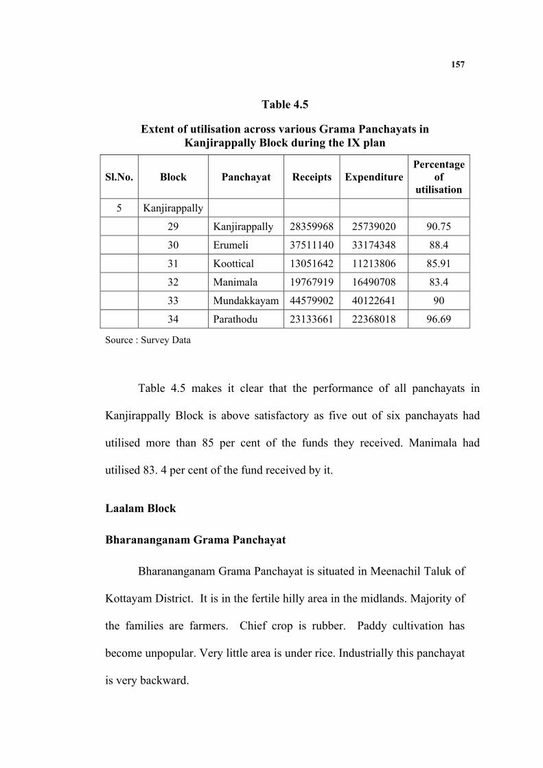
157
Table 4.5
Extent of utilisation across various Grama Panchayats in Kanjirappally Block during the IX plan
Sl.No. Block Panchayat Receipts Expenditure Percentage
of utilisation
5 Kanjirappally
29 Kanjirappally 28359968 25739020 90.75
30 Erumeli 37511140 33174348 88.4
31 Koottical 13051642 11213806 85.91
32 Manimala 19767919 16490708 83.4
33 Mundakkayam 44579902 40122641 90
34 Parathodu 23133661 22368018 96.69
Source : Survey Data
Table 4.5 makes it clear that the performance of all panchayats in
Kanjirappally Block is above satisfactory as five out of six panchayats had
utilised more than 85 per cent of the funds they received. Manimala had
utilised 83. 4 per cent of the fund received by it.
Laalam Block
Bharananganam Grama Panchayat
Bharananganam Grama Panchayat is situated in Meenachil Taluk of
Kottayam District. It is in the fertile hilly area in the midlands. Majority of
the families are farmers. Chief crop is rubber. Paddy cultivation has
become unpopular. Very little area is under rice. Industrially this panchayat
is very backward.

158
Kadanad Grama Panchayat
Kadanad Panchayat situated in the midlands at the foothills of the
highlands in the eastern region of Kottayam district is naturally an agrarian
one, with hills, plains and paddy fields lying scattered. And most of the
people are engaged in agriculture and allied activities. Industrially, this
panchayat is quite backward.Principal crop is rubber. Vanilla cultivation
had started in this area too, during the plan period
Karoor Grama Panchayat
Formed in 1953, Karoor panchayat is one of the earliest in Kerala.
The economy of this panchayat is almost totally dependent on agriculture.
Main crop is rubber. Industrially the panchayat is very backward. There are
only a few cottage industrial units and a few micro– enterprises. The low
price of agricultural produce before and during the start of the IXth plan had
impoverished the farmers. Fall in the income of the farmers led to
unemployment among agricultural labourers. Thus, the standard of living
of the majority of the population was deteriorating at that time.
Kozhuvanal Grama Panchayat
Kozhuvanal panchayat is one of the earliest panchayats formed in
Travancore. When it was formed in 1953 before the formation of Kerala
state, there were only 7 wards. Number of wards then increased to 8 and then
to 10. This panchayat comprises Kozhuvamkulam Kara of Puliyannoor
159
village, Mevida Kara of Meenachil village and some areas of
Poovaranikara. Rubber cultivation is the main occupation and source of
income of farmers of this panchayat. Livestock rearing is also a traditional
occupation of many peasant families. Traditional cottage industries had
been flourishing in and leaf-made articles were widely used earlier. But
with the arrival of modern plastic articles, traditional industries
declined.Scarcity of raw materials is also a cause.Transportation in old
days was through rivers and streams, as well as via small roads for bullock
carts. Modern roads were constructed in the panchayat only during 1940-
50 and later.Agriculture and rearing of livestock was the traditional way of
life of the people. All sorts of crops including large variety of vegetables
used to be cultivated before the arrival of rubber. After rubber plantations
covered the landscape, food crops production was abandoned by farmers.
Meenachil Grama Panchayat
Meenachil Grama Panchayat is situated in the midlands of the
Kottayam district, near Pala municipal town, and includes two villages:
Meenachil and Poovarani. Agriculture is the main occupation of the
people. Most of the population are farmers and agricultural labourers. A
small number of people are engaged in trading and very small-scale
industries.

160
Mutholy Gramapanchayat
Situated in the midland of Kottayam district, Mutholy panchayat area is
blessed by the waters of the river Meenachil and some of its tributary streams,
which keep the ground water level near the surface during the dry season.
Geographical location is favourable for the growth of vegetation and this
panchayat’s fertile soil is covered with crops, especially rubber. Being an
agricultural economy, the development of the panchayat is through agriculture
and allied activities, with little scope for industrialisation.
Extent of Utilisation
Table 4.6 shows the extent of utilisation across various grama
panchayats during the IX plan.
Table 4.6
Extent of utilisation across various Grama Panchayats in Laalam Block During the IX plan
Sl. No. Block Panchayat Receipts Expenditure Percentage
of utilisation
6 Laalam
35 Bharananganam 13251500 12261439 92.52
36 Kadanad 15346750 14926773 97.26
37 Karoor 18382500 16530849 89.92
38 Kozhuvanal 11270267 11270267 100
39 Meenachil 13427750 13183841 98.18
40 Mutholy 12675500 11919068 94.03
Source : Survey Data

161
It is evident from table 4.6 that excellent performance was done by
all panchayats in Laalam Block.Cent per cent utilisation of the funds was
reported in Kozhuvanal panchayat. Three panchayats are very close to this
figure and other panchayats had utilsed 90 per cent of the fund they
received.
Madappally Block
Karukachal Grama Panchayat
The larger share of land in the panchayat is devoted to cultivation of
rubber, the rest for other crops like coconuts, banana, pepper, vegetables,
tapioca etc.
Kurichy Grama Panchayat
The principal sources of income in the economy of Kurichy grama
panchayat are agriculture and related sectors, small scale industries and
labour sector. During the IXth plan the approach adopted in Kurichy
panchayat was to give priority to the agriculture and allied activities sector.
Yet it is a fact that developmental plans could not be implemented even in
the priority sector in the intended manner. The activities carried out included
irrigation of graden lands under cultivation on homestead farms,
horticulture, cultivation of medicinal herbs, use of high-yielding varieties of
rice, providing motor and related accessories for drainage of excess
water/irrigation, construction of retaining walls along waterways,

162
distribution of coconut tree saplings, application of pesitcides against the
coconut plant disease mandari, rat control etc.
Madappally Grama Panchayat
Madappally Grama Panchayat, situated in the western midlands
region of Kottayam district, a few kilometers east of Changanacherry, is an
agrarian area. Traditionally, agriculture had been the principal means of
livelihood for the villagers of the region, with emphasis on a wide variety
of crops, such as coconut, pepper, arecanut, vegetables, ginger, turmeric,
banana, plantains, rice etc. With the arrival of rubber as a profitable crop,
farmers increasingly adopted monoculture of rubber and abandoned the
multi-crops. As there were no large or medium industries, and only micro
enterprises to provide alternate employment opportunities, agriculture and
allied activities were the sources of employment for the BPL households.
Paippad Grama Panchayat
This is an agrarian panchayat in all respects. The area has extensive
paddy fields and other croplands. Being an agricultural economy, the
development of the panchayat is through agriculture and allied activities,
with little scope for industrialisation.

163
Thrikkodithanam Grama Panchayat
Thrikkodithanam Grama Panchayat is situated just east of
Changanacherry Municipality on the southern border of Kottayam district
and borders on Pathanamthitta district.
Vakathanam Grama Panchayat
Vakathanam Grama Panchayat is an agricultural area, producing
cash crops and food crops. Majority of families here are dependent on
agricultural and allied occupations. Historically, this village was famous
during the days of the little local kingdom/principality called Thekkumkoor.
Places mentioned in an old Malayalam poetic work titled ‘Unnineeli
Sandesham’, like Manikandapuram, Kadamuri, and Thrukkothamangalam
are in this panchayat area. The population consists of people belonging to
different religions, castes and other groups, yet all live in harmony and
peace. There is cooperation wherever possible.Vakathanam Grama
Panchayat could make some positive progress in the economy and society
through the formulation and execution of many projects in various sectors,
with the considerable funds allocated by the government as part of
decentralisation of powers and duties as well as resources during the IX
plan started in 1997-98.

164
Vazhappally Grama Panchayat
Situated in the south western region of Kottayam district, near
Changanacherry town, Vazhappally Panchayat is a semi-urbanised area,
with some industries and commerce. But agriculture is the predominant
activity of the people. The area has extensive paddy fields and other
croplands.
Extent of utilisation
Table 4.7 shows the extent of utilisation across various Grama
Panchayats during the IX plan.
Table 4.7
Extent of utilisation across various Grama Panchayats in Madappally Block During the IX plan
Sl. No. Block Panchayat Receipts Expenditure Percentage
of utilisation
7 Madappally
41 Madappally 24986021 21486394 85.9
42 Karukachal 16837457 14776555 87.7
43 Kurichy 26733705 21423368 80.13
44 Paippad 19327512 17403173 90.04
45 Trikkodithanam 22668847 19820683 87.4
46 Vakathanam 25867250 22988520 88.87
47 Vazhappally 27075183 23100459 85.31
Source : Panchayat Records

165
It is made clear by table 4.8 that all panchayats in Madappally Block
had utilsed more than 80 per cent of the funds they received. Except one all
had utilised more than 85 per cent. Hence the performance of these
panchayats was in line with the expectations in terms of fund utilisation.
Pallom Block
Ayarkunnam Grama Panchayat
This panchayat is one of the economically backward panchayats in
Kottayam district. It is predominantly an agrarian area, with no industries
except a few units producing rubber bands. The IXth plan began at a time
when agricultural sector was facing a crisis due to low prices of crops. Till
the VIIIth plan, the panchayat had been functioning with very limited
resources of taxes and fees collected by it and limited grants received from
the government. With such limited resources, substantial developmental
projects could not be undertaken earlier. The sudden allocation of large
amounts from plan funds was a revolutionary change in the functioning of
the panchayat. However, in the absence of precedents, the utilisation of the
allotted funds was inefficient in the initial stages. Later on, improvements
were made as people involved in planning and implementation gained
experience.

166
Kumarakom Grama Panchayat
Kumarakom village had tradionally been an agricultural area, before
tourism emerged as a major industry here. At the beginning of the IXth
plan in 1997, tourism had started developing, but agriculture was still
important for the majority of the families inhabiting the area. 24 per cent of
the area (1,250 hectares) is wetlands with paddy fields. About 30 per cent
is solid land and canals, covering 1,504 hectares. 46 per cent of the area
(2,423)hectares) is part of Vembanad lake.Main crops here have been rice
and coconuts. While the embankments are strengthened by planting
coconut trees, the area inside the bunds is used to cultivate rice. The
extensive Vembanad Lake in the western region of the panchayat, is a
source of fish, lime shell and clay. Many people of this panchayat earn
their livelihood by collection of these and marketing them. The
Thanneermukkom Bund had been causing problems to Vembanad Lake
and surrounding land. This bund meant to prevent entry of salt water into
the southern areas of the lake and the surrounding farmlands, has been
blocking tidal ebb and flow. The earlier ecosystem which naturally kept
the backwaters clean and healthy, was changed. As water flow is blocked,
the still water becomes, polluted with fertilisers and insecticides/pesticides
used in the paddy fields. Other pollutants also join the water. Water weeds
grow luxuriantly, covering water bodies like carpets. Fresh water fish

167
cannot grow in such polluted water and quantity of fish caught had been
declining.
Manarkad Grama Panchayat
The 74th grama panchayat in Kottayam district was formed under
the name Manarkad, by dividing the erstwhile Vijayapuram panchayat. It
came into existence on 2-10-2000 in the fourth year of the IXth plan. So,
this panchayat had only one year of annual planning.
Nattakom Grama Panchayat
Nattakom Grama Panchayat is located just south of Kottayam town.
Most areas in this panchayat are lowlands. Of the 2010 hectares of land
here about 1250 hectares are paddy fields. Of the rest, about 800 hectares
are homestead lands which are cultivated with coconuts, fruit trees, banana
and other crops.
Panachikkaad Grama Panchayat
This panchayat is predominantly agricultural. There are also
industrial and commercial activities. Panachikkaad grama panchayat is
situated south of Kottayam town on the southern side of river Kodoor. The
center of this village is famous as the southern Mookambika because of the
Saraswathi Temple dedicated to the goddess of learning and fine arts.

168
Puthuppally Grama Panchayat
This Panchayat is an agricultural area, producing cash crops and
food crops. Majority of families here are dependent on agricultural and
allied occupations. The five years of decentralised people’s planning with
participation of the people could bring about some notable changes for the
better in various sectors of the economy and society of the panchayat.
Thiruvarpu Grama Panchayat
The foundation of the economy of Thiruvarppu panchayatu is
agriculture and allied activities. The area belongs to upper Kuttanad region
and the climate is hot with high moisture. The biggest threat faced by the
lowland area is flood during rainy season causing damage to crops. During
the IX plan period the economy of the panchayat was in a depression due to
low price of agricultural produce. A large proportion of the population in this
industrially backward panchayat lives below poverty level. To solve such
problems and to accelerate development, several projects and programmes
were undertaken during the IX plan. An evaluation of the achievements and
failures of the people’s planning is given below.
Vijayapurm Gramapanchayat
Vijayapuram Grama Panchayat situated just east of Kottayam town
has lowlands with paddy fields and river as well as hilly areas. The

169
lowlands with fertile soil and irrigation water have lush vegetables and
fruit trees. Hilly elevations have laterite soil suitable for rubber, pepper,
tapioca and vegetables. Panchayat is mainly agricultural, with a few big
industrial units and also a few small-scale industries.
Extent of utilisation
Table 4.8 shows the extent of utilisation across various Grama
Panchayats during the IX plan.
Table 4.8
Extent of utilisation across various Grama Panchayats in Pallam Block during the IX plan
Sl.No. Block Panchayat Receipts Expenditure Percentage
of utilisation
8 Pallom
48 Ayarkunnam 25620441 23532159 91.84
49 Kumarakom 21221500 18659849 87.92
50 Manarkad 2845500 1038095 36.48
51 Nattakom 29574655 27354896 92.49
52 Panachikkad 26349740 22395161 84.99
53 Puthupally 22950709 21168424 92.23
54 Thiruvaarp 23627790 19433985 82.25
55 Vijayapuram 36756518 33736128 91.78
Source : Panchayat Records

170
Table 4.8 makes it clear that 50 per cent of the panchayats had
utilsed more than 90 per cent of the funds they received. Other panchayats
except one had utilised more than 80 per cent. The only one panchayat
which had utilsed less than 80 per cent is Manarkad. The percentage of
utilisation was 36.48 per cent only.
Pambady Block
Akalakkunnam Grama Panchayat
This is predominantly an agricultural area, with little industrial
activity. Most families are dependent on agriculture for their livelihood.
So, fall in the prices of agricultural products and crop failures due to plant
diseases, affect this panchayat, which was the case during the years of the
IX plan. In order to give encouragement to the agrarian sector, several
projects were formulated and implemented by the panchayat, during the IX
plan.
Ellikulam Grama Panchayat
Elikulam Panchayat was formed on Fifteenth Augest 1953. Economy
of this panchayat is dependent on agriculture. Though several projects were
formulated on the basis of the proposals made by grama sabhas, many
projects aimed at total development were not very successful, due to lack
of vision and technical expertise. Still many achievements were made
using the plan allocations.
171
Kooroppada Grama Panchayat
Situated in the midlands zone, with hilly slopes and valleys, streams
and fertile soil, Kooroppada panchayat is an agrarian one, with 50 per cent
of land under rubber. Most people are dependent on agriculture. There are
no industrial units. Commercial sector also was limited. Therefore,
sources of own incomes were limited to building tax, professional tax etc.
This had been inadequate for development projects.
Meenadom Grama Panchayat
Situated in central midlands just east of Kottayam town, Meenadom
panchayat is largely an agricultural economy, with no major industries at the
time of the IX plan. Economically it is a backward panchayat with little sources
of own income and so heavily dependent on the government for funds.
Pallickathodu Grama Panchayat
With an area of 22.46sq.km, it has the boundaries as Elikkulam
grama panchayat in north, Akalakkunnam grama panchayat in east, Vazhoor
grama panchayat in south and Kooroppada grama panchayat in west
Pampady Grama Panchayat
Pampady panchayat is largely an agricultural one.It has an area of
30 sq.km. Own sources of income from the panchayat area were limited
172
and it was difficult for the panchayat to undertake developmental works
earlier.
Extent of utilisation
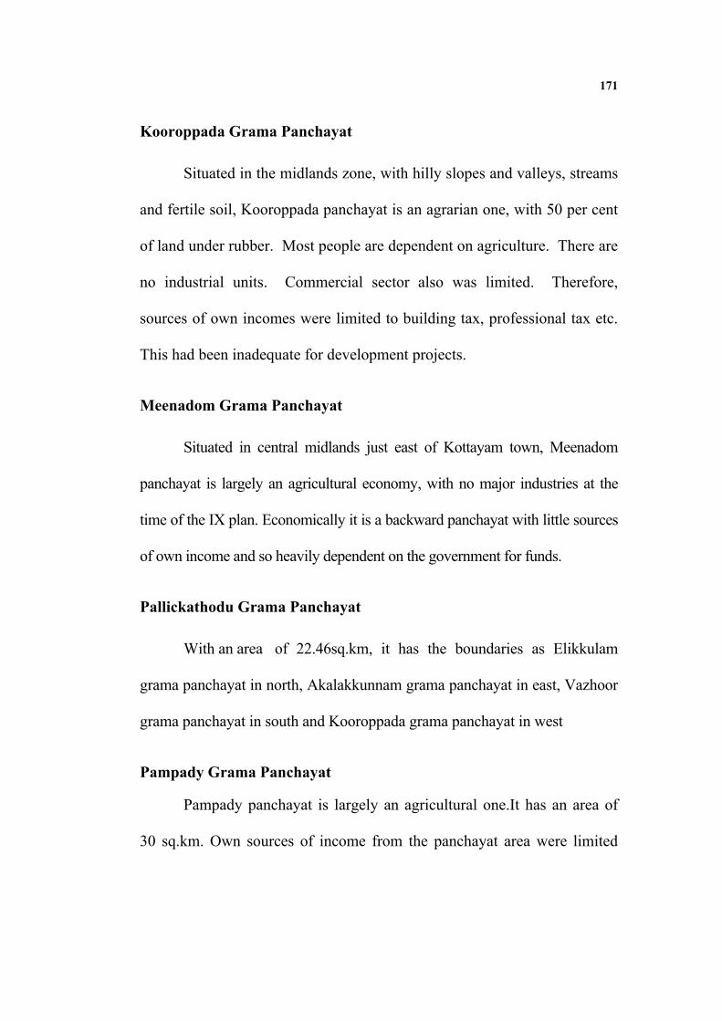
Table 4.9 shows the extent of utilisation across various Grama
Panchayats during the IX plan.
Table 4.9
Extent of utilisation across various Grama Panchayats in Pambady Block during the IX plan
Sl.No. Block Panchayat Receipts Expenditure Percentage
of utilisation
9 Pampady
56 Pampady 22554907 19514154 86.5
57 Akalakunnam 15312370 14998832 97.95
58 Ellikulam 16277150 14845825 91.2
59 Kooropada 17042337 15230203 89.36
60 Meenadom 11010604 10508161 95.43
61 Pallikkathodu 12758695 11946121 93.63
Source : Survey Data
It is clear from table 4.9 that the performance of all panchayats in
terms of fund utilisation is satisfactory as they utilised more than 85 per
cent of the funds.

173
Uzhavoor Block
Kadaplamattom Grama Panchayat
Kadaplamattom grama panchayat is an agricultural area in the
midlands zone of Kottayam district coming under the western region of
Meenachil taluk. Its 22.02 sq.km. or 2,201.67 hectares area spreads over
two villages – Kidangoor and Elakkad.Population in 1991 was 13,093 and
in 2001 were 13,997. 80 per cent of the population depend on agriculture
and related occupations for their livelihood. Of the 2201.67 hectares of
land, 84.45 hectares are used for houses, roads, etc. and not available for
cultivation. The rest of the land, 2117.23 hectares are available for
agriculture. This consists of 146 hectares of wetlands (paddy fields) and
1971.22 hectares of homestead lands. Of the paddy fields, only less than 70
hectares were utilised for rice cultivation at least once in an year.
Kaanakkari Grama Panchayat
The economy of the Kaanakkari grama panchayat is dependent
mainly on agriculture, as almost 80 per cent per cent of the population earn
their livelihood from agriculture and allied activities. There are some
small-scale and tiny industries also in the panchayat area.
174
Kidangoor Grama Panchayat
Situated in the midlands, spread over both sides of river Meenachil,
this fertile land is largely an agrarian one.75 per cent of the people are
dependent on agriculture and allied activities for their livelihood. There are
no large– scale industries, in this panchayat. Clay bricks production was
very active till 1999.
Kuravilangad Grama Panchayat
People of the panchayat earn their livelihood from agriculture and
allied activities. Trading also is an important occupation. There are also a
lot of people employed in the service sector.
Marangattupilly Grama Panchayat
The population of this panchayat depends on agriculture and related
occupations for their livelihood. Trading also is an important occupation.
Ramapuram Grama Panchayat
The economy of the panchayat is largely based on agriculture and
allied activities. Principal crop is rubber. The price level of raw rubber
affected the standard of living of the majority of people in this panchayat.
The IX plan began at a time when farmers were increasingly abandoning
cultivation of coconut trees, rice, vegetables, etc. and shifting to rubber
cultivation.

175
Uzhavoor Grama Panchayat
This panchayat is largely dependent on agriculture and allied
activities. The economy of this panchayat is heavily dependent on rubber.
It has 10 wards and 13 colonies.
Veliyannoor Grama Panchayat
It has an area of 19.49 sq.k.m. The Agriculture and related
occupations are predominant for their livelihood.
Extent of utilisation
Table 4.10 shows the extent of utilisation across various Grama
Panchayats during the IX plan.
Table 4.10
Extent of utilisation across various Grama Panchayats in Uzhavur Block during the IX plan
Sl.No. Block Panchayat Receipts Expenditure Percentage
of Utilisation
10 Uzhavoor
62 Uzhavoor 13005000 10507689 80.7
63 Kadaplamattom 12002836 10382203 86.49
64 Kanaakkari 16613065 14998047 90.27
65 Kidangoor 14794230 13138409 88.8
66 Kuravilangad 13939750 10889920 78.12
67 Marangattupilly 14737555 13903390 94.33
68 Ramapuaram 23042196 21681948 94.09
69 Veliyanoor 11256750 9747037 86.58
Source : Survey data

176
It is clear from table 4.10 that while three panchayats had utilised
more than 90 per cent of the funds they received, four panchayats had
utilised between 80 and 90 per cent. Only one panchayat had spent less
than 80 per cent, but it is 78.12 per cent.
Vazhoor Block
Chirakkadav Grama Panchayat
The economy of this panchayat is heavily dependent on agriculture.
To be accurate, economy depends on the price of raw rubber. The principal
crop in this panchayat being rubber, increases and decreases in the price
level, deeply affected the fortunes of the majority of the families. During
the IX plan, price of rubber was very low and so the economy of this
panchayat was depressed. Soil, climate, and other factors in the locality
are very conducive for the growth of rubber. High productivity of the land,
ensures good yield also. So farmers prefer this cash crop.
Kangazha Grama Panchayat
Kangazha grama panchayat area has an economy based on
agriculture. Most of the families earn their livelihood from rubber. 2500
hectares of arable land in the panchayat are in the possession of nearly
4000 households. So, most of the farmers are marginal, with less than one
hactare land. There are a large number of people belonging to this place,
who earn good income from Gulf countries and elsewhere. Contributions

177
from them to their families have been playing a crucial role in the economy
of the panchayat.
Nedumkunnam Grama Panchayat
Situated in the midlands rural area, this panchayat has an agrarian
economy. Rubber is the main crop cultivated. Industrially the panchayat is
quite backward.Though employment generation was an objective in the
agricultural sector, it cannot be claimed that more employment opportunities
were generated through the plan projects.
Vazhoor Grama Panchayat
The economy of Vazhoor panchayat is based only on the
agricultural sector.As rubber cultivation expanded, other crops were
ignored by most farmers. Even marginal land owners planted rubber trees
in their limited homestead plots.But as price of rubber had fallen very low,
farmers were in a crisis at the time of the IX plan. Many rubber planters
were in a state of despair. Though prodution of rubber had increased in the
area, no rubber-based industrial unit came up. Though some micro and
small-scale industries were started in the panchayat at various times, most
could not survive due to lack of market. Locally - made products could not
compete with the branded products of big companies.Inadequate training of
industrial people and investment limits, marketing problems, etc. were
factors inhibiting industrialisation in the panchayat. Though there was

178
unemployment among educated youngsters, nobody was willing to work in
the agricultural field. There was scarcity of farm labourers and wages had
gone up.
Vellavoor Grama Panchayat
Located in the midlands, covering an area 13 km in length,
Vellavoor grama panchayat consists of hills, rock formations, rice fields,
valleys and streams. Main crop is rubber.
Extent of Utilisation
Table 4.11 shows the extent of utilisation across various Grama
Panchayats during the IX plan in Vazhoor Block.
Table 4.11
Extent of utilisation across various Grama Panchayats in Vazhoor Block during the IX plan
Sl.No. Block Panchayat Receipts Expenditure Percentage
of utilisation
11 Vazhoor
70 Vazhoor 14473523 8687916 60.03
71 Chirakkadavu 25179250 24342109 96.6
72 Kangazha 14059685 12030348 85.5
73 Nedukunnam 15456322 12331955 79.78
74 Vellavoor 13129740 10794319 82.21
Source: Computed from Panchayat Data
179
Table 4.11 shows that only one panchayat in Vazhoor Block had
utilised more than 90 per cent and only one panchayat had utilised a mere
60 per cent. The rest had a utilisation of 80 per cent. It means that the
performance of these panchayats in terms of fund utilisation can be rated as
average.
Tables 4.1 to 4.11 show that most of the Panchayats utilised the
lion’s share of the funds allotted to them. The main observation that is
deduced from the above tables is that there are wide differences in the
utilsation of funds across panchayats. Hence the detailed analysis is done in
the following tables.
Detailed Analysis
Table 4.12 shows the number and name of panchayats which utilised
more than 90 per cent of the funds allotted to them.

180
Table 4.12 The Panchayats which utilised more than 90 per cent of allocation
Sl No. Block Panchayth Percentage of Utilisation 1 Vaikom 1.Chempu 94.99 2 Erattupetta 2.Erattupetta 93.3 3.Poonjar 92.4 4.Poonjar Thekkekara 94.2 5.Theekoy 92 6.Thalanad 91.9 7.Thidanadu 95.4 3 Ettumanoor 8.Athirampuzha 90.8 9.Kumaranalloor 94.8 4 Kaduthuruthy 10.Kaduthuruthy 93.5 11.Maanjoor 96.5 5 Pallom 12.Ayarkunnam 91.8 13.Puthupally 92.2 14.Vijayapuram 91.7 6 Pambady 15.Akalakunnam 97.95 16.Elikkulam 91.2 17.Meenadom 95.4 18.Pallikkathode 93.63 7 Uzhavoor 19.Kannakari 90.27 20.Ramapuram 94.04 21.Marangattupilly 8 Madappally 22.Paippad 90.04 9 Vazhoor 23.Chirakkadavu 96.67
10 Kanjirappally 24.Kanjirappally 90.75 25.Mundakkayam 90.0 26.Parathode 96.69
11 Lallom 27.Bharananganam 92.52 28.Kadanad 97.52 29.Kozhuvanal 100 30.Meenachil 98.1 31.Mutholy 94.03
Source : Computed from Data

181
Table 4.12 shows that 30 Panchayats (out of 74 Panchayats) had
spent more than 90 per cent of the funds allotted to them. While
Mundakkayam utilised 90.0 per cent of the fund, Kozhuvanal spent 100 per
cent of the allocation during the decentralised period. Table 4.13 gives the
number and names of panchayats which utilised more than 80 per cent, but
less than 90 per cent.
Table 4.13 The Panchayats which utilised between 80 and 90 per cent
Sl No. Block Panchayat Percentage of utilisation1 Erattupetta
1 Melukkav 87.72 2 Moonilavu 85.8 3 Thalappalam 87.98
2 Ettumanoor 4 Ettumanoor 84.08 5 Neendoor 89.4
3 Kaduthuruthy 6 Kallara 87.87
7 Mulakkulam 88.83 8 Njeezhoor 89.82
9
Thalayola parambu
83.69
10 Velloor 81.3 4 Pallom 11 Kumarakom 87.92
12 Panachikkad 84.99 13 Thiruvaarp 82.25
5 Pampady 14 Pampady 15 Kooropada 89.36
6 Uzhavoor 16 Uzhavoor 80.7 17 Kadaplamattom 86.49 18 Kidangoor 88.8 19 Veliyanoor 86.58

182
7 Madappally 20 Madappally 85.9 21 Karukachal 87.7
22 Kurichy 80.13 23 Trikkodithanam 87.4 24 Vakathanam 88.87 25 Vazhappilly 85.31 8 Vazhoor
26 Kangazha 85.5 27 Vellavoor 82.21
9 Kanjirappally 28 Erumeli 88.4 29 Koottickal 85.91 30 Manimala 83.4
10 Laalam 31 Karoor 89.92
11 Vaikom 32 Thalayaazham 86.61 33 T.V.Puram 83.36 34 Vechoor 83.6
Source: Computed from Data
There are 34 Panchayats which utilised 80 to 90 per cent of their
receipts for various categories of expenditure. There is more consistency
than the previous table in terms of utilisation as far as this group is
concerned.The lowest extent of utilisation is reported by Kurichy with
80.13 per cent and the highest is 89.92 per cent by Karoor. In short, 34
panchayats had utilsed more than 80 per cent of allocation made to them.
Table 4.14 shows the percentage utilisation between 70 and 80 per cent.

183
Table 4.14
The Panchayats which utilised between 70 and 80 per cent
Block Panchayth Percentage
of utilisation
1 Ettumanoor
1 Aymanam 70.94
2 Vazhoor
2 Nedukunnam 79.78
3 Uzhavoor
3 Kuruvilangadu 78.12
Source: Computed from Data
Only three Panchayats have utilised between 70 and 80 per cent of
the receipts for various purposes. The extent of utilisation varies from
70.94 to 79.78 per cent.Table 4.15 shows the utilisation range between 60
and 70 per cent.
Table 4.15
The Panchayats which utilised between 60 and 70 per cent
Sl.No. Block Panchayat Percentage of utilisation
1 Ettumanoor
1 Arpookkara 68.61
2 Vazhoor
2 Vazhoor 60.03
Source : Computed from Data
184
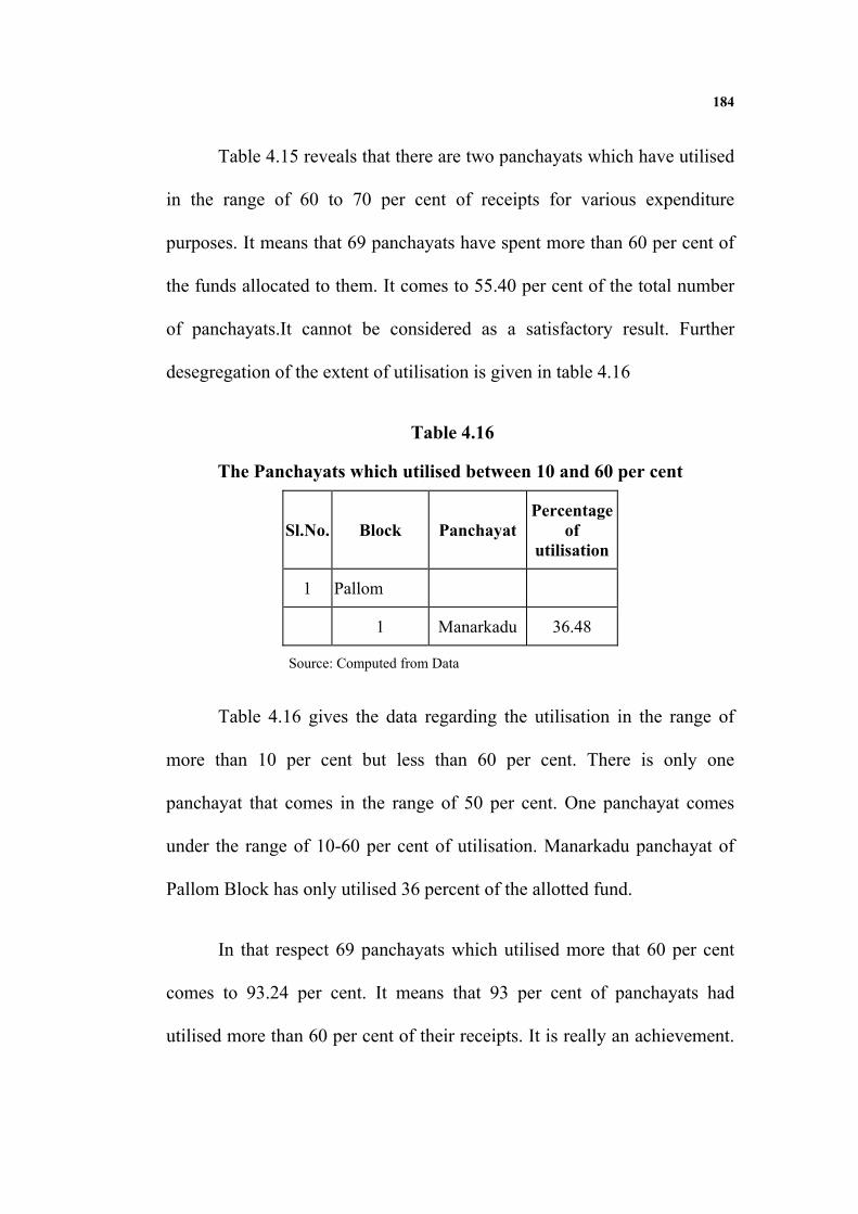
Table 4.15 reveals that there are two panchayats which have utilised
in the range of 60 to 70 per cent of receipts for various expenditure
purposes. It means that 69 panchayats have spent more than 60 per cent of
the funds allocated to them. It comes to 55.40 per cent of the total number
of panchayats.It cannot be considered as a satisfactory result. Further
desegregation of the extent of utilisation is given in table 4.16
Table 4.16
The Panchayats which utilised between 10 and 60 per cent
Sl.No. Block Panchayat Percentage
of utilisation
1 Pallom
1 Manarkadu 36.48
Source: Computed from Data
Table 4.16 gives the data regarding the utilisation in the range of
more than 10 per cent but less than 60 per cent. There is only one
panchayat that comes in the range of 50 per cent. One panchayat comes
under the range of 10-60 per cent of utilisation. Manarkadu panchayat of
Pallom Block has only utilised 36 percent of the allotted fund.
In that respect 69 panchayats which utilised more that 60 per cent
comes to 93.24 per cent. It means that 93 per cent of panchayats had
utilised more than 60 per cent of their receipts. It is really an achievement.

185
In the next section we analyse the performene of different blocks in
utilising funds.
Block - wise analysis of utilisation of funds
As there are eleven blocks in Kottayam district, the performances in
terms of fund utilisation of each block in the district, are given in table 4.17.
Table 4.17
Block - wise analysis of utilisation of funds
Sl.No. Block Percentage of utilisation
1 Ettumanoor 82.81 2 Erattupetta 91.6 3 Kaduthuruthy 89.31 4 Pallom 87.82 5 Pampady 97.67 6 Vazhoor 82.85 7 Kanjirappally 89.6 8 Laalam 94.94 9 Madappally 86.24 10 Uzhavoor 88.15 11 Vaikom 80.29
The table above shows the utilisation of funds by the different
blocks in Kottayam District. All blocks have utilised more than 80 per cent
of the funds allotted to them. Laalam block is the highest in terms of
utilisation as it utilised about 94.94 percent of its fund. Lowest is reported
in Vaikom block, where it is 80.29 percent.

186
To conclude, on an average, 88 percent of the funds was utilised by
the Blocks in the district. It means that the performance in terms of fund
utilisation is satisfactory. On the basis of this, one jump to the conclusion
that the decentralised palnning was successful in Kottayam District. The
nature and composition of fund utilisation are the other two aspects to be
considered, so as to evaluate the sucess of the people’s plan programme. In
other words, a concrete conclusion can be made only on the basis of
category-wise and sector-wise performances which are discussed in the
ensuing chapters.