Embed Size (px)
Citation preview
104 Avalon Court, Suite F, Brandon MS 39047 P. O. Box 15369, Hattiesburg, MS 39404 Phone (601) 992-8233 Fax (601) 919-2674 www.env-mgt.com Phone (601) 544-3674 Fax (601) 544-0504
December 21, 2018 Mr. Jeff Pittman, PE Cooperative Energy P.O. Box 15849 Hattiesburg, MS 39402 Re: Annual CCR Landfill Inspection Report for 2018 Revision 1 R.D. Morrow, Sr. Power Generating Station Purvis, Lamar County, Mississippi Dear Mr. Pittman: Cooperative Energy (formerly South Mississippi Electric Power Association) retained Environmental Management Services, Inc. (EMS) to conduct the annual inspection for the coal combustion residuals (CCR) landfill at the R.D. Morrow, Sr. Generating Station in Purvis, Mississippi. The purpose of this report is to comply with the air criteria in the federal Coal Combustion Residual Rule (CCR Rule) 40 CFR 257.84(b)(1) and (b)(2) requiring an annual inspection of the CCR landfill at the subject property. 1.0 Introduction EMS performed the CCR landfill inspection on December 7, 2018 and a land elevation survey was performed on September 11, 2018. The review of available existing information, inspection summary, and conclusions regarding changes in landfill geometry, CCR volume, and the structure, operation, stability, and safety of the landfill are summarized herein. The CCR Rule requirements for the annual landfill inspection include:
• A review of available information regarding the status and condition of the CCR unit [257.84 (b)(1)(i)]
• A visual inspection of the CCR unit to identify signs of distress or malfunction [257.84(B)(1)(ii)] • An inspection report that includes the following:
o Changes in geometry since the last inspection [257.84 (b)(2)(i)] o Approximate volume of CCR in unit at time of inspection [257.84 (b)(2)(ii)] o Appearance of actual or potential structural weakness of the CCR unit, in addition to any
existing conditions that are disrupting or have the potential to disrupt the operation and safety of the CCR unit [257.84 (b)(2)(iii)]
o Any other changes which may have affected the stability or operation of the CCR unit since the last inspection [257.84 (b)(2)(iv)]
Cooperative Energy must notify the Mississippi Department of Environmental Quality (MDEQ) Director within 30 days of placing the CCR Landfill Annual Inspection Report in the operating record and posting to the CCR web site (40 CFR 257.106 and 257.107).
Mr. Jeff Pittman, PE December 21, 2018 Cooperative Energy Page 2
104 Avalon Court, Suite F, Brandon MS 39047 P. O. Box 15369, Hattiesburg, MS 39404 Phone (601) 992-8233 Fax (601) 919-2674 www.env-mgt.com Phone (601) 544-3674 Fax (601) 544-0504
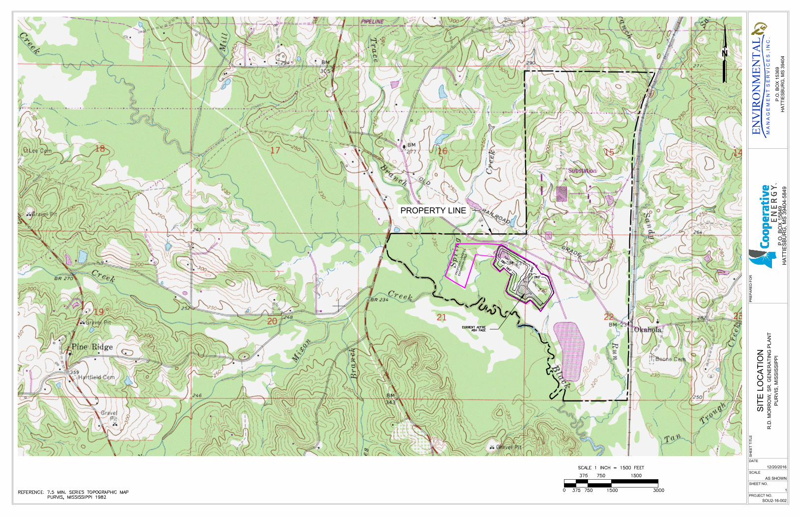
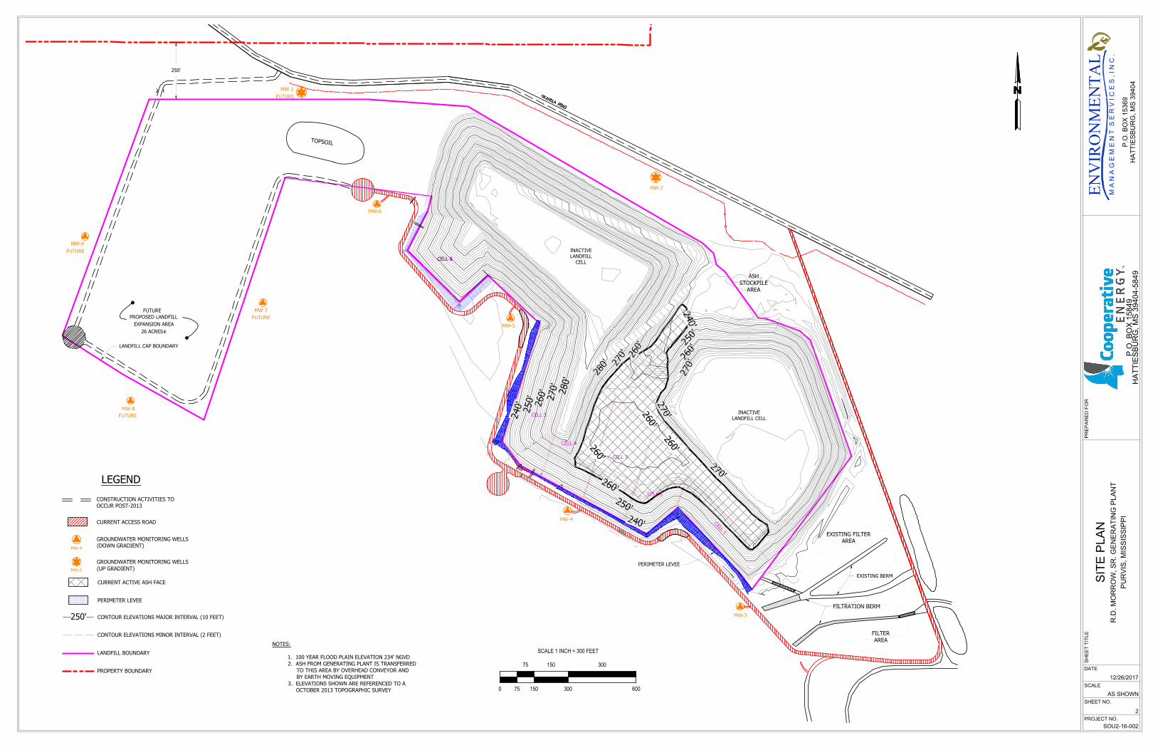
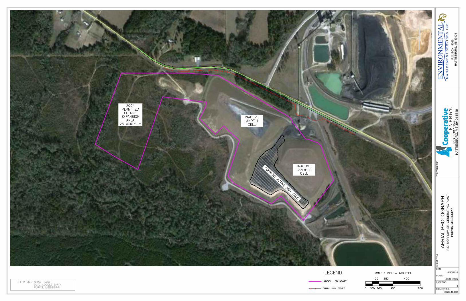
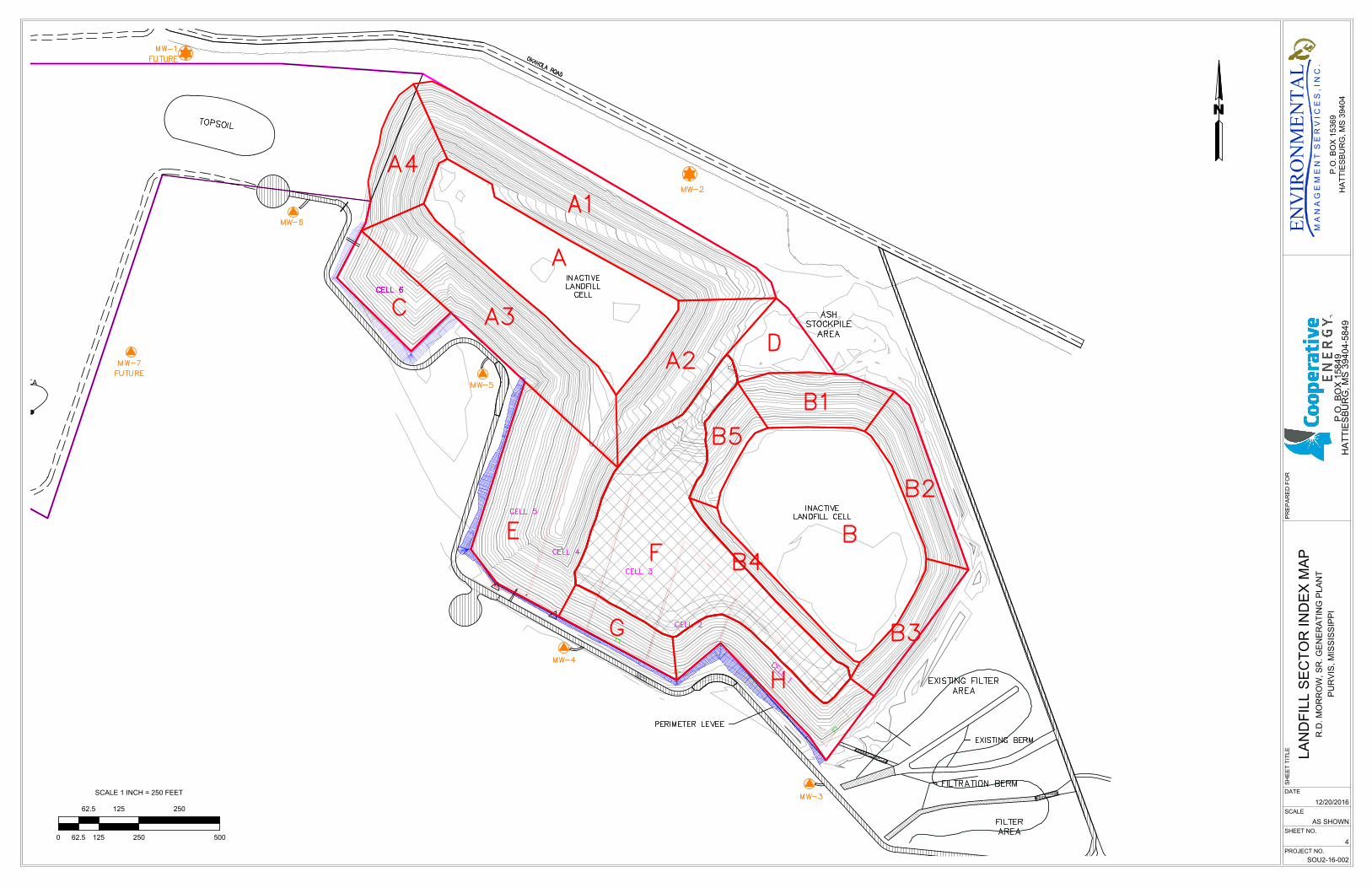
The landfill site is located in the N1/2 of the NE1/4 of Sec.21, T3N, R14W, in Lamar County, Mississippi, as shown on the Site Location Map presented as Figure 1. The site is located at latitude 31̊ 12’ 40” and longitude -89˚ 23’ 53”. The approximately 72 acre permitted landfill site is located within the 1,200 acre R.D. Morrow, Sr. Generating Station property. The permitted landfill area is shown on the Existing Site Plan presented as Figure 2. The 72 acre permitted landfill area includes approximately 46 acres of existing landfill permit and a proposed 26 acre expansion area located to the west of the existing landfill. None of the expansion area has been constructed at this time. The CCR landfill consists of various cells and partially capped areas as shown in the Figure 2 site plan. An aerial photograph showing the landfill area is shown in Figure 3. The entire existing operating footprint of the landfill is regulated as an “existing CCR landfill” in accordance with the definitions in the CCR Rule. The proposed expansion will be classified as a new or lateral expansion of the CCR landfill. However, the landfill also operates under a solid waste permit issued by the Mississippi Department of Environmental Quality. 2.0 Review of Available Information EMS has worked for Cooperative Energy providing services for over 10 years related to the design, construction, operation, and monitoring of the CCR landfill, and therefore, have a great degree of familiarity with the landfill and relevant records. EMS has also performed professional land surveys of the landfill to calculate filled and available volumes on an approximately annual basis for the past several years. In preparing this year’s volume estimate EMS had direct access to prior volume survey records. Other information was available for review as needed for this annual inspection and report. 3.0 Inspection Summary The EMS personnel, Jeremy Van Slyke, performed the annual landfill inspection on December 7, 2018. The inspection findings are summarized in the following sections. A landfill sector index map showing the various portions of the active landfill with alphanumeric sector labels is attached as Figure 4. At the time of the inspection, CCR materials had recently been placed in Sector F as shown on the index map. In preparation to repower the plant, remaining unburned coal from the coal pile is being placed into Sector F, as approved by the MDEQ. 3.1 Vegetation Healthy grassy vegetation is present on all sectors of the landfill except the active working face area, Sector F, the top surface of the western cell designated as Sector A, and scattered locations where invasive grasses (including Cogon grass) have been eradicated. The grassy areas are mowed with a bush hog several times per year. No trees or woody vegetation are present on the landfill surfaces or capped areas. The earthen drainage ditches along the south side of the landfill are generally clear of vegetation and those ditches drained uniformly eastward to the serpentine ditch treatment system. The eastern edge of Sector A2 which had seepage during the 2017 inspection contained very little seepage during the 2018 inspection, and conditions are better than 2017. A small seep was identified at the
Mr. Jeff Pittman, PE December 21, 2018 Cooperative Energy Page 3
104 Avalon Court, Suite F, Brandon MS 39047 P. O. Box 15369, Hattiesburg, MS 39404 Phone (601) 992-8233 Fax (601) 919-2674 www.env-mgt.com Phone (601) 544-3674 Fax (601) 544-0504
western toe of Sector A4. Active seeps with associated erosion were identified on the northern boundary of Sector A1. This condition and planned corrective measures are described further in Section 8.0 below. 3.2 Erosion Erosion was noted in December 2018 within seepage areas along the northern boundary of Sector A1. Early stage rill erosion that was beginning to form during the 2016 annual inspection could not be located during the2017 and 2018 inspections. Increased grass growth and routine maintenance and mowing appears to have mitigated the prior erosion rills. Therefore, no corrective measures are required for this area. The seeps and erosion on the northern boundary of Sector A1 are addressed in Section 8.0 below. 3.3 Storm Water Management Storm water management around the landfill consists primarily of a system of earthen perimeter ditches that route non-contact storm water into the serpentine treatment system. Seepage of leachate from the northern boundary of Sector A1 and a limited amount of non-contact storm water runoff from closed areas including the northern half of Sector A1 and all of Sector A4 drain westward, then south into Black Creek. The storm water ditch on the north side of Sector A1 contains cattails and has somewhat reduced drainage efficiency toward its west end due to rip-rap velocity breaks in that area. Storm water runoff south of the landfill cells flowing toward the east is robust due to ditch maintenance. 3.4 Leachate Collection System In the fourth quarter of 2017 Cooperative Energy applied to the MDEQ for permission to install permanent automated sump pumps and associated connecting piping along the southern border of the landfill leading to the serpentine ditch treatment system. MDEQ granted permission by letter reply. Cooperative Energy completed the pump installation project during 2018. The system is now operating. 3.5 Record Keeping Cooperative Energy performs weekly inspections of the landfill as required by the CCR regulations. In addition to visual inspection of the landfill flow measurements from the automated sump pumps are collected and entered into an electronic database to track the leachate collection systems effectiveness. 4.0 Changes in Geometry Given that most of the landfill is covered by lush grassy vegetation, it is readily apparent from visual inspection where CCR has been placed recently. The inspection indicated that CCR had recently been filled only in Sector F. The EMS licensed professional land surveyor performs elevation surveys of the landfill on an approximately annual basis. EMS performed the 2018 survey on September 11, 2018. EMS then used the survey data to create a digital elevation terrain model. Inspection of the model surface confirmed that CCR placement had been limited to Sector F.
Mr. Jeff Pittman, PE December 21, 2018 Cooperative Energy Page 4
104 Avalon Court, Suite F, Brandon MS 39047 P. O. Box 15369, Hattiesburg, MS 39404 Phone (601) 992-8233 Fax (601) 919-2674 www.env-mgt.com Phone (601) 544-3674 Fax (601) 544-0504
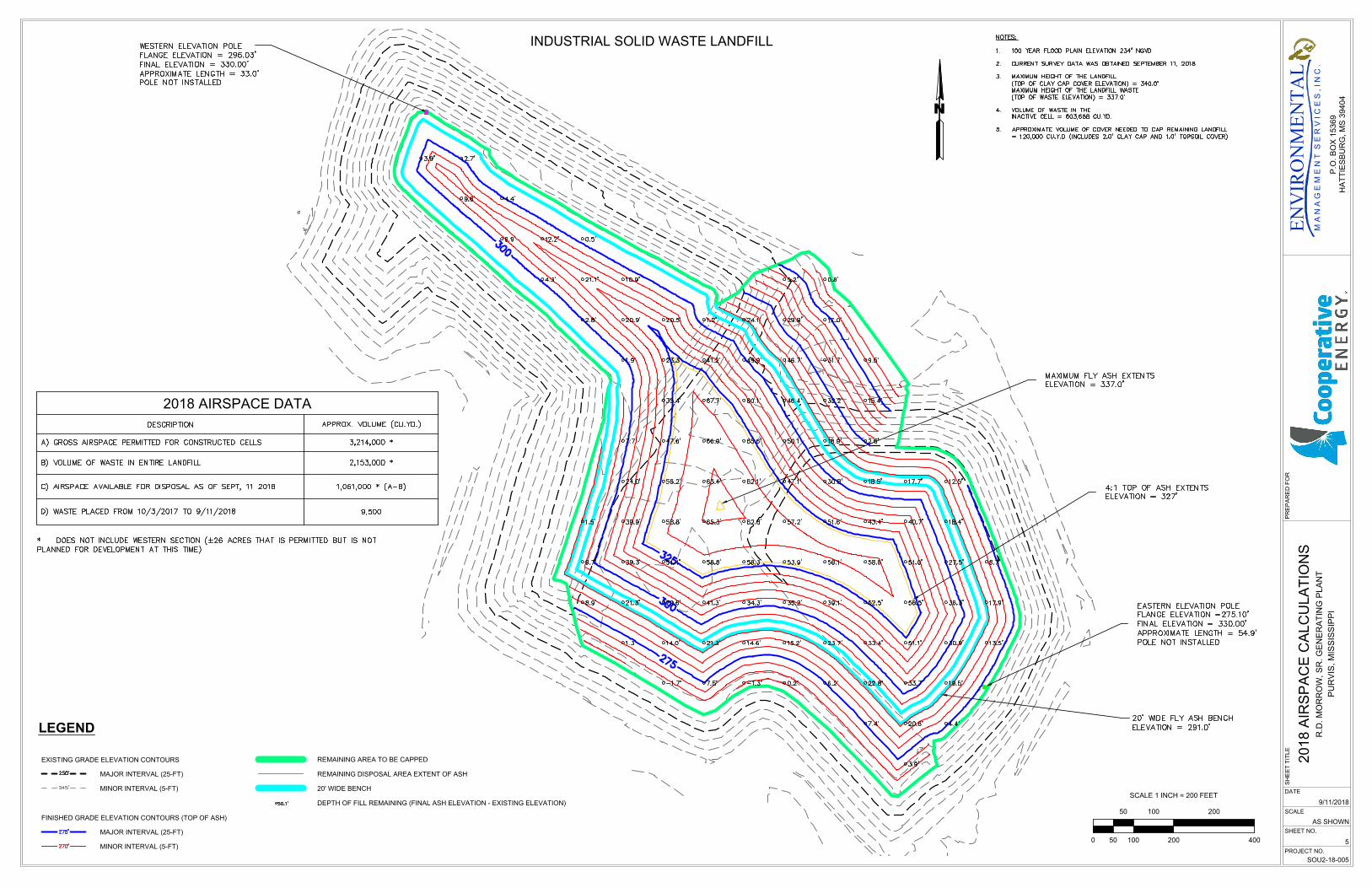
5.0 CCR Volume As described in the previous section, an AutoCAD® surface model was prepared based on an elevation survey of the landfill. The model surface was compared to the prior year model surface using the AutoCAD® Civil 3D package to calculate the change in volume from 2017 to 2018. The map representing the results of this effort is included as Figure 5 – 2018 Airspace Calculations showing airspace volume calculations. The CCR volume in the Landfill as of September 11, 2018, is estimated to be approximately 2,153,000 cubic yards (CY). Approximately 9,500 CY of material was added to the landfill since the last survey conducted October 3, 2017. Based on the design volume and the latest topographic survey, approximately 1,061,000 CY of permitted airspace remains available in the developed portion of the landfill. 6.0 Structural Weakness and Disrupting Conditions Based on a review of available information and the December 7, 2018 observations, EMS found no significant indications of structural weakness of the landfill. Seepage and erosion along Sector A1 northern boundary was identified, but this area has gravel-filled toe drains that were installed over 10 years ago to relieve hydrostatic pressure in that area. In addition saturated conditions, seepage, and bare soil were observed along a portion of the boundary between Sectors A2 and F. A small saturated area was identified on the western edge of Sector A4. 7.0 Changes Affecting Stability or Operations Based on the inspections, survey, and review of records performed in association with this annual inspection, to our knowledge, there have been no changes in condition or operation that have affected stability or operation of the CCR landfill. The plant is preparing for a repower project that will eliminate the use of coal as a fuel and will therefore stop the production of CCR materials for disposal in the CCR Landfill. 8.0 Recommendations The CCR Rule requires deficiencies or releases to be remedied as soon as feasible in accordance with 257.84(b)(5) which states:
“If a deficiency or release is identified during an inspection, the owner or operator must remedy the deficiency or release as soon as feasible and prepare documentation detailing the corrective measures taken.”
While seepage conditions have been identified in and around Sector A, these conditions are not expected to disrupt the operation and safety of the CCR landfill given that they have been in steady state conditions for many years. We recommend that Cooperative Energy continue to perform weekly inspections of the landfill to monitor for any conditions that would indicate a change or worsening of the seepage conditions.
104 Avalon Court, Suite F, Brandon MS 39047 P. O. Box 15369, Hattiesburg, MS 39404 Phone (601) 992-8233 Fax (601) 919-2674 www.env-mgt.com Phone (601) 544-3674 Fax (601) 544-0504
FIGURES
P.O
. B
OX
15849
HA
TT
IE
SB
UR
G, M
S 39404-5849
DATE
SCALE
SHEET NO.
PROJECT NO.
SH
EE
T T
IT
LE
12/20/2016
SOU2-16-002
1
AS SHOWN
SIT
E L
OC
AT
IO
N
R.D
. M
OR
RO
W, S
R. G
EN
ER
AT
IN
G P
LA
NT
PU
RV
IS
, M
IS
SIS
SIP
PI
PR
EP
AR
ED
F
OR
M A
N
A
G
E
M
E
N
T
S
E
R
V
I C
E
S
, I N
C
.
ENV
IRO
NM
ENTA
L
P.O
. B
OX
1
53
69
HA
TT
IE
SB
UR
G, M
S 3
94
04
PROPOSED LANDFILL
EXPANSION AREA
26 ACRES±
INACTIVE
LANDFILL CELL
INACTIVE
LANDFILL
CELL
MW-2
MW-3
MW-4
MW-5
MW-6
MW-7
MW-8
MW-9
ASH
STOCKPILE
AREA
FILTER
AREA
FILTRATION BERM
0
0
0
0
EXISTING FILTER
AREA
FUTURE
PERIMETER LEVEE
EXISTING BERM
MW-1
FUTURE
FUTURE
FUTURE
LANDFILL CAP BOUNDARY
2
6
0
'
2
7
0
'
2
4
0
'
2
5
0
'
2
6
0
'
2
6
0
'
2
7
0
'
2
7
0
'
2
8
0
'
2
8
0
'
T
O
P
S
O
IL
CELL 6
CELL 5
CELL 6
CELL 4
CELL 3
CELL 2
C
E
L
L
1
2
4
0
'
2
4
0
'
2
5
0
'
2
5
0
'
2
6
0
'
2
6
0
'
2
6
0
'
2
6
0
'
2
7
0
'
2
7
0
'
250'
FUTURE
N
(UP GRADIENT)
MW-4
(DOWN GRADIENT)
MW-2
GROUNDWATER MONITORING WELLS
GROUNDWATER MONITORING WELLS
CURRENT ACCESS ROAD
OCCUR POST-2013
CONSTRUCTION ACTIVITIES TO
LEGEND
NOTES:
1. 100 YEAR FLOOD PLAIN ELEVATION 234' NGVD
2. ASH FROM GENERATING PLANT IS TRANSFERRED
TO THIS AREA BY OVERHEAD CONVEYOR AND
BY EARTH MOVING EQUIPMENT
3. ELEVATIONS SHOWN ARE REFERENCED TO A
OCTOBER 2013 TOPOGRAPHIC SURVEY
PERIMETER LEVEE
CONTOUR ELEVATIONS MAJOR INTERVAL (10 FEET)
250'
CONTOUR ELEVATIONS MINOR INTERVAL (2 FEET)
CURRENT ACTIVE ASH FACE
LANDFILL BOUNDARY
PROPERTY BOUNDARY
P.O
. B
OX
15849
HA
TT
IE
SB
UR
G, M
S 39404-5849
DATE
SCALE
SHEET NO.
PROJECT NO.
SH
EE
T T
IT
LE
12/26/2017
SOU2-16-002
2
AS SHOWN
SIT
E P
LA
N
R.D
. M
OR
RO
W, S
R. G
EN
ER
AT
IN
G P
LA
NT
PU
RV
IS
, M
IS
SIS
SIP
PI
PR
EP
AR
ED
F
OR
M A
N
A
G
E
M
E
N
T
S
E
R
V
I C
E
S
, I N
C
.
ENV
IRO
NM
ENTA
L
P.O
. B
OX
1
53
69
HA
TT
IE
SB
UR
G, M
S 3
94
04
SCALE 1 INCH = 300 FEET
0 15075
75
300
150 300
600
P.O
. B
OX
15849
HA
TT
IE
SB
UR
G, M
S 39404-5849
DATE
SCALE
SHEET NO.
PROJECT NO.
SH
EE
T T
IT
LE
12/20/2016
SOU2-16-002
3
AS SHOWN
AE
RIA
L P
HO
TO
GR
AP
H
R.D
. M
OR
RO
W, S
R. G
EN
ER
AT
IN
G P
LA
NT
PU
RV
IS
, M
IS
SIS
SIP
PI
PR
EP
AR
ED
F
OR
M A
N
A
G
E
M
E
N
T
S
E
R
V
I C
E
S
, I N
C
.
ENV
IRO
NM
ENTA
L
P.O
. B
OX
1
53
69
HA
TT
IE
SB
UR
G, M
S 3
94
04
P.O
. B
OX
15849
HA
TT
IE
SB
UR
G, M
S 39404-5849
DATE
SCALE
SHEET NO.
PROJECT NO.
SH
EE
T T
IT
LE
12/20/2016
SOU2-16-002
4
AS SHOWN
LA
ND
FILL S
EC
TO
R IN
DE
X M
AP
R.D
. M
OR
RO
W, S
R. G
EN
ER
AT
IN
G P
LA
NT
PU
RV
IS
, M
IS
SIS
SIP
PI
PR
EP
AR
ED
F
OR
M A
N
A
G
E
M
E
N
T
S
E
R
V
I C
E
S
, I N
C
.
ENV
IRO
NM
ENTA
L
P.O
. B
OX
1
53
69
HA
TT
IE
SB
UR
G, M
S 3
94
04
N
SCALE 1 INCH = 250 FEET
125
62.5
62.50
125
250
250
500
LEGEND
MAJOR INTERVAL (25-FT)
MINOR INTERVAL (5-FT)
MAJOR INTERVAL (25-FT)
MINOR INTERVAL (5-FT)
EXISTING GRADE ELEVATION CONTOURS
FINISHED GRADE ELEVATION CONTOURS (TOP OF ASH)
REMAINING AREA TO BE CAPPED
REMAINING DISPOSAL AREA EXTENT OF ASH
DEPTH OF FILL REMAINING (FINAL ASH ELEVATION - EXISTING ELEVATION)
20' WIDE BENCH
INDUSTRIAL SOLID WASTE LANDFILL
DATE
SCALE
SHEET NO.
PROJECT NO.
SH
EE
T T
IT
LE
9/11/2018
SOU2-18-005
5
AS SHOWN
2018 A
IR
SP
AC
E C
ALC
ULA
TIO
NS
R.D
. M
OR
RO
W, S
R. G
EN
ER
AT
IN
G P
LA
NT
PU
RV
IS
, M
IS
SIS
SIP
PI
PR
EP
AR
ED
F
OR
M A
N
A
G
E
M
E
N
T
S
E
R
V
I C
E
S
, I N
C
.
ENV
IRO
NM
ENTA
L
P.O
. B
OX
15369
HA
TT
IE
SB
UR
G, M
S 39404
400
200
200
100
0 50
50
100
SCALE 1 INCH = 200 FEET
N
2018 AIRSPACE DATA