Embed Size (px)
Citation preview
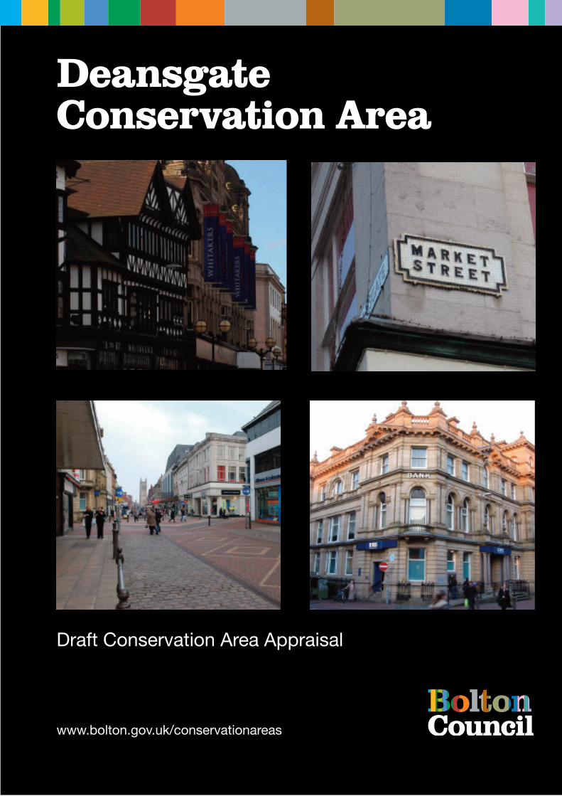
DeansgateConservation Area
Draft Conservation Area Appraisal
www.bolton.gov.uk/conservationareas
July 2008 1
CONTENTS Page 1 Introduction 3 2 Policy Background 3 3 Summary of Special Interest 4 4 Assessing special interest 5 4.1 Location and setting 5 4.2 Historic Development and Archaeology 5
Early Bolton
Bolton and Deansgate in the 19th century
Deansgate in the 20th century
4.3 Open spaces 9 4.4 Views and vistas 10 4.5 Character and appearance 11 4.6 Character areas 13
Deansgate
The Old Market Area
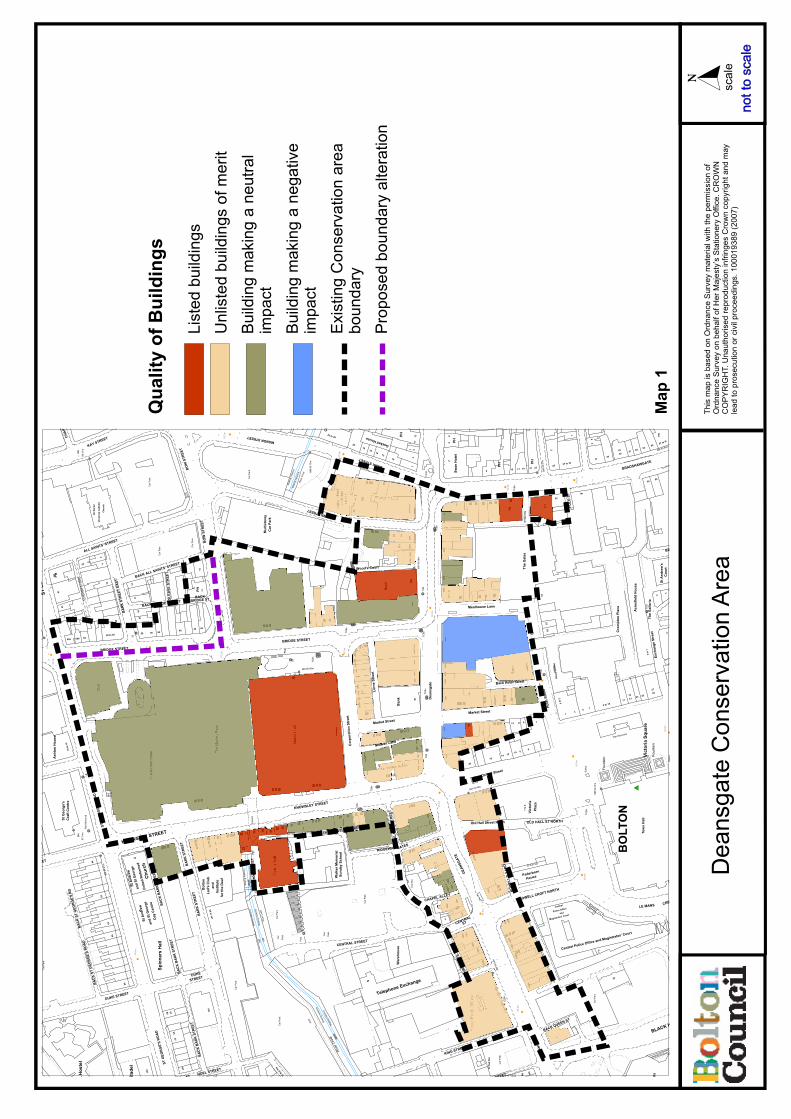
4.7 The Qualities of Buildings 14
Listed Building
Unlisted buildings 17 4.8 Building materials and features 19
4.9 Public realm: roads and pavements 20 5 Extent of intrusion and damage 22
5.1 Negative aspects 5.2 Neutral areas 5.3 General condition 5.4 Pressure for change
6 Community involvement 26 7 Suggested Conservation Area Boundary Changes 27 8 Guidelines for development 28
8.1 New development 8.2 Demolition 8.3 Advertisement control 8.4 Street surfacing and furniture 8.5 Building Materials 8.6 Windows and doors
July 2008 2
8.7 Chimneys and roofs 8.8 Rainwater goods 8.9 Boundary walls, gates and railings 8.10 Shop fronts and advertising 8.11 Minor fixtures and services 8.12 Wheeled bins 8.13 Interpretation 8.14 Archaeology
9.0 References 33
Appendices 1. UDP Policies 34 2. Historic maps 37 3. Conservation area appraisal maps 42

July 2008 3
DEANSGATE CONSERVATION AREA APPRAISAL
1.0 Introduction
The purpose of this conservation area appraisal is to reassess the designated Deansgate Conservation Area, and to evaluate and record its special interest. This review of the Deansgate Conservation Area was undertaken in 2007 by The Architectural History Practice, on behalf of Bolton Metropolitan Borough Council. The appraisal complements the guidance in Building Bolton, Supplementary Planning Document published in 2006; the Deansgate conservation area is covered under the Civic Core, St Peter‟s and St Helena sections in this SPD document. The appraisal will inform planning officers and developers about the conservation area, to assist with developing initiatives in the area. AHP is grateful for assistance in preparing this report from Jackie Whelan, Diane Vaughton (Bolton Council), Norman Redhead (GMAU) and the Librarians at Bolton Archives.
2.0 Policy Background A conservation area is an “area of special architectural or historic interest, the character or appearance of which it is desirable to preserve or enhance”, as set out in Section 69 of the 1990 Planning (Listed Buildings and Conservation Areas) Act 1990. Local authorities have a duty to designate such areas and to review them, and to use their planning powers to safeguard and enhance the special qualities of these areas within a framework of managing change with a positive approach. Designation automatically entails control over the demolition of unlisted buildings, strengthens controls over minor development and gives special protection to trees within the area. Policies in the adopted Unitary Development Plan (UDP) guide the Council‟s planning decisions within Conservation Areas. In addition, the Bolton Town Centre Framework was launched in 2005, covering five different strategy or policy documents, including Building Bolton (2006) and the Public Realm Implementation Framework (2007). The Deansgate Conservation Area was originally included in the Town Centre Conservation Area, which was first designated in 1987. This large area was broken down into three smaller areas – Deansgate, Town Hall and St George‟s – in 1996. The conservation area was last reviewed by Bolton Council in the late 1990s.
July 2008 4
3.0 Summary of special interest The Deansgate Conservation Area is situated in the heart of Bolton town centre and include most of the retail core of the historic town. It includes the most properties fronting Deansgate, the town‟s principal shopping street, together with the west side of northern Bradshawgate and the streets surrounding the mid-Victorian market hall.The conservation area covers a thriving network of partly pedestrianised streets, intersected by principal roads carrying vehicles and buses. The gently curving line of Deansgate has not altered since the Middle Ages, although the street has been widened. The street pattern on the north side of the street was considerably altered in the mid-nineteenth century for the building of the market hall. All the principal streets in the conservation area are of a good width and the conservation area has a surprisingly open character, with a higher density north of Deansgate. There are some surviving traces of dense residential and industrial streets which once occupied the land between Deansgate and the river Croal to the north, but these have mostly been cleared and await redevelopment. The area contains no open spaces apart from pedestrianised streets. There are good views along Deansgate to the east and west; the former terminated by St Peter‟s Church, the latter by the spire of St Paul‟s. There are also long views from Deansgate northwards down the slope to the Croal and across it to Little Bolton and St George‟s Church. To the south, towards the Town Hall conservation area, there are tightly framed views along narrow streets. The area contains a wide variety of buildings dating from the eighteenth century to the present day. Although a few properties were originally built as dwellings, almost all are now in commercial use, and a wide variety of shop fronts and fascia signs dominate most ground floors. With one or two exceptions, the buildings of the conservation area are no more than three storeys high, which results in an unusual homogeneity to the centre of the town. At the same time, there is a wide diversity of materials including stone, brick and terracotta as well as half-timbering and painted render and brick. Historic buildings in the area retain a wealth of architectural detail such as windows, parapets, doorways and roof turrets, which enliven the street scene. Buildings built before the early 20th century generally have a vertical proportion due to narrow plot widths and elevations with sash windows, but 20th century retail premises tend to have wider frontages with horizontal lines. There are some good examples of the latter, faced in Portland limestone in a classical style. There are a few notable modern intrusions into the character of the area, of which the most conspicuous is the 1980s Market Hall shopping centre at the northern end of the conservation area. This was built over the river Croal, which is now partly hidden from the town centre. There are also other smaller new buildings or additions to existing buildings, such as mansard roof on the Marks & Spencer store on Deansgate, with its prominent mansard roof. A small area of Deansgate conservation area is to be transferred to St George‟s conservation area, north east of Bridge Street (see map in Appendix 3).
July 2008 5
4.0 Assessing Special Interest: 4.1 Location and setting The Deansgate Conservation Area includes the western part of Bolton town centre, which lies along a ridge of land originally sloping northwards down to the Croal stream. The underlying geology is carboniferous sandstone with coal measures, the Deansgate area is situated on a terrace of sand and gravel south of the River Croal. The conservation area is roughly 300 metres above sea level at its highest point. The northern slope was partly made-up in the mid-nineteenth century to provide the foundation for the new market building and also to provide direct access between the old town and the settlement beyond the river known as Little Bolton. Deansgate extends westwards almost as far as Marsden Moor, the A676, which is effectively the boundary of the central area of town; to the east Deansgate continues into Churchgate, the town‟s principal mediaeval street and a separate conservation area. To the south is the Town Hall conservation area. The northern boundary of the conservation area extends across the river Croal up to St George‟s Road, one of the principal streets of Little Bolton and itself a conservation area. 4.2 Historic Development and Archaeology Early Bolton Archaeological research in Bolton has shown that there were probably prehistoric settlements in the area, although no evidence of early structures has been found; a Bronze Age burial was found just a quarter of a mile to the south east of the Church of St Peter. The only evidence for Roman activity in Bolton comes from a fragment of Roman pottery found during recent archaeological excavations at the site of the former Boar‟s Head Inn on the north side of Churchgate. Although Bolton is not mentioned in Domesday, a settlement almost certainly existed by then, suggested by the Anglo-Saxon cross found during the construction of the present St Peter‟s Church. The place-name is Old English and means a dwelling or hamlet in an enclosure, first recorded in the 12th century. The town was known as Bolton-le-Moors in the early Medieval period, referring to its location on the edge of open moorland. Following the granting of borough status to Bolton in 1253, the town‟s burgesses had the right to build on burgage plots fronting the main streets, Deansgate and Churchgate. In 1288, there were 69 of these burgage plots, each long plot had a narrow street frontage. Excavations and maps show that these plots had a standard width of just over 8 metres, or multiples thereof. During most of the medieval period Bolton was principally a market town, with its residents dependent on the surrounding farmland. Textiles became increasingly important to the prosperity of the town, initially woollens and later cotton and linen; by the 1530s Leland noted that the market “standeth most by cottons and coarse yarn”, with fuel coming from coal pits as well from turf. In the 17th century the town was known for fustian manufacture, a mix of cotton and linen, and this supported a growing merchant class. Counter-panes and bed-quilts were specialities; Bolton was renowned for the fine quality of its cotton production.
July 2008 6
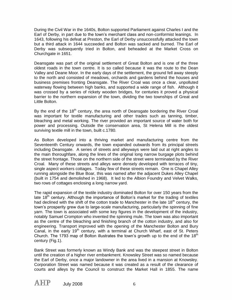
During the Civil War in the 1640s, Bolton supported Parliament against Charles I and the Earl of Derby, in part due to the town‟s merchant class and non-conformist leanings. In 1643, following his defeat at Preston, the Earl of Derby unsuccessfully attacked the town but a third attack in 1644 succeeded and Bolton was sacked and burned. The Earl of Derby was subsequently tried in Bolton, and beheaded at the Market Cross on Churchgate in 1651. Deansgate was part of the original settlement of Great Bolton and is one of the three oldest roads in the town centre. It is so called because it was the route to the Dean Valley and Deane Moor. In the early days of the settlement, the ground fell away steeply to the north and consisted of meadows, orchards and gardens behind the houses and business premises fronting Deansgate. The River Croal was once a clear, unpolluted waterway flowing between high banks, and supported a wide range of fish. Although it was crossed by a series of rickety wooden bridges, for centuries it proved a physical barrier to the northern expansion of the town, dividing the two townships of Great and Little Bolton. By the end of the 18th century, the area north of Deansgate bordering the River Croal was important for textile manufacturing and other trades such as tanning, timber, bleaching and metal working. The river provided an important source of water both for power and processing. Outside the conservation area, St Helena Mill is the oldest surviving textile mill in the town, built c.1780. As Bolton developed into a thriving market and manufacturing centre from the Seventeenth Century onwards, the town expanded outwards from its principal streets including Deansgate. A series of streets and alleyways were laid out at right angles to the main thoroughfare, along the lines of the original long narrow burgage plots behind the street frontage. Those on the northern side of the street were terminated by the River Croal. Many of these streets and alleys were densely developed with terraces of tiny, single aspect workers cottages. Today few of these streets remain. One is Chapel Alley running alongside the Blue Boar, this was named after the adjacent Dukes Alley Chapel (built in 1754 and demolished in 1968). It led to the Albion Foundry and Velvet Walks, two rows of cottages enclosing a long narrow yard. The rapid expansion of the textile industry dominated Bolton for over 150 years from the late 18th century. Although the importance of Bolton‟s market for the trading of textiles had declined with the shift of the cotton trade to Manchester in the late 18th century, the town‟s prosperity grew due to large-scale manufacturing, particularly the spinning of fine yarn. The town is associated with some key figures in the development of the industry, notably Samuel Crompton who invented the spinning mule. The town was also important as the centre of the bleaching and finishing branch of the cotton industry, and also for engineering. Transport improved with the opening of the Manchester Bolton and Bury Canal, in the early 19th century, with a terminal at Church Wharf, east of St. Peters Church. The 1793 map of Bolton illustrates the town‟s growth up to the end of the 18th century (Fig.1). Bank Street was formerly known as Windy Bank and was the steepest street in Bolton until the creation of a higher river embankment. Knowsley Street was so named because the Earl of Derby, once a major landowner in the area lived in a mansion at Knowsley. Corporation Street was named because it was created as a result of the clearance of courts and alleys by the Council to construct the Market Hall in 1855. The name
July 2008 7
Mealhouse Lane recalls a large grain warehouse that once fronted Deansgate at its northern end. Ridgway Gates, between Numbers 80 and 82 Deansgate was named after James Ridgway, a dyer and bleacher. There were gates here at one time to protect his open bleaching grounds in the vicinity of the present Market Hall.
Fig.1: Deansgate from the 1793 map of Bolton (Bolton Archives). Bolton and Deansgate in the 19th century In the early 19th Century many of the long narrow burgage plots and alleyways at the rear of properties facing Deansgate were developed to provide courtyard housing for working people. These are clearly shown on the 1849 OS maps (Appendix 1), and formed short rows of one-up, one-down cottages, with a single-aspect and often back-to back, facing narrow lanes or courts. The lack of sanitation and cramped dwellings in close proximity to industry created poor living conditions. During the nineteenth century Deansgate began to develop into a major shopping, commercial and social centre. For most of the Century it contained a wide variety of small local retailers dealing in products such as medicines, paints, dress fabrics, millinery, clothing, automobiles and tools. The 2-3 storey buildings occupied narrow plots with cramped rear yards. At one time there were twenty-six public houses and in 1908 The Empire Theatre (later the Hippodrome Theatre) was opened at the western end of the street. In the mid Nineteenth Century the south bank of the river Croal was lined by timber yards, a saw mill, cotton and flax mills a foundry and a gas works.
July 2008 8
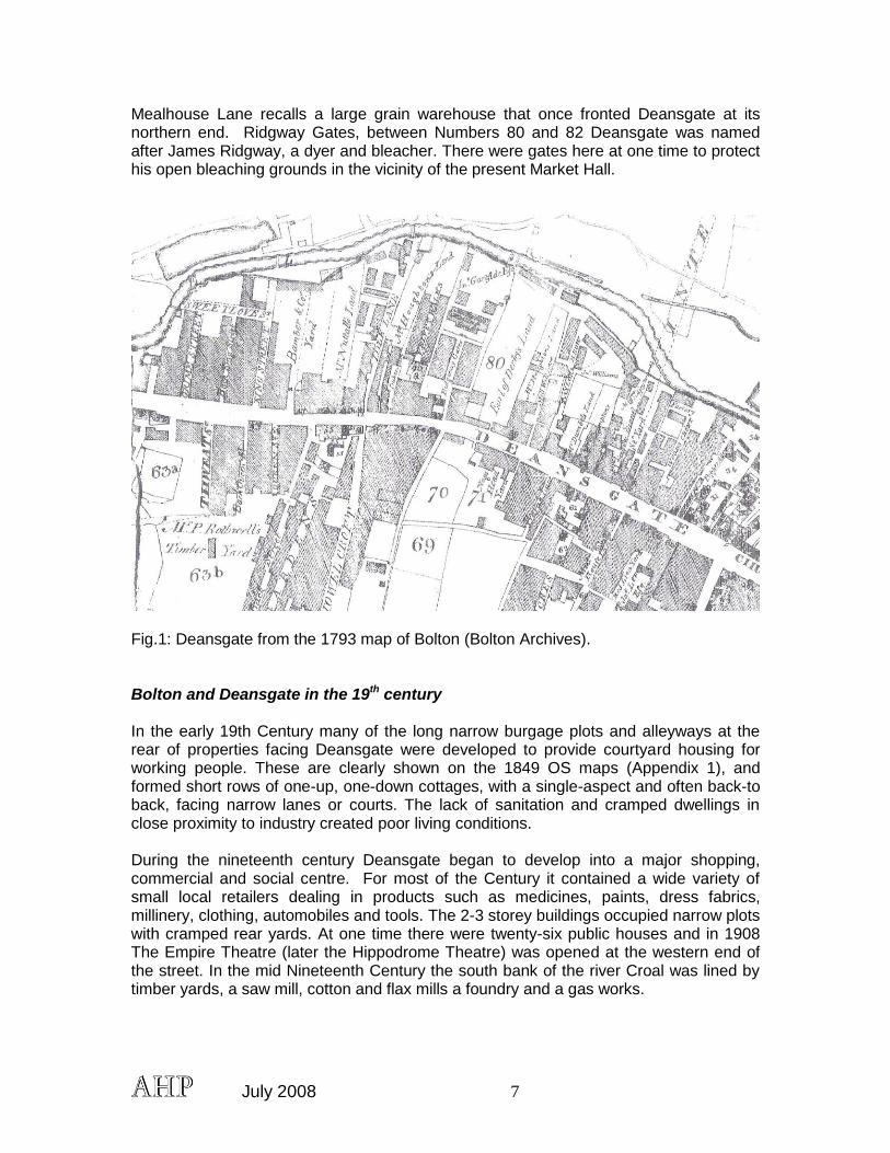
Fig.2: Prestons corner in the late 19th century before the present store was built (Bolton Archives)
The first major redevelopment scheme in the area was carried out by the Town Council under the Bolton Improvement Act of 1850 when a maze of courts, alleys and slum properties to the north of Deansgate were cleared away to build a new Market Hall. This was opened in 1855 and an adjacent Fish Market at the Bridge Street end of Corporation Street was opened ten years later. As a result of this scheme, Corporation Street was created and Bridge Street and Knowsley Street were widened and extended to provide wide thoroughfares connecting Great and Little Bolton. Bradshawgate and Deansgate were widened and the original frontages were redeveloped in the late nineteenth and twentieth centuries. In the second half of the nineteenth century a number of imposing bank buildings were erected in Deansgate, marking a further increase in its status.
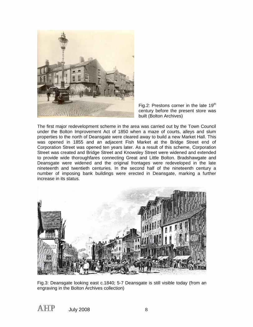
Fig.3: Deansgate looking east c.1840; 5-7 Deansgate is still visible today (from an engraving in the Bolton Archives collection)
July 2008 9
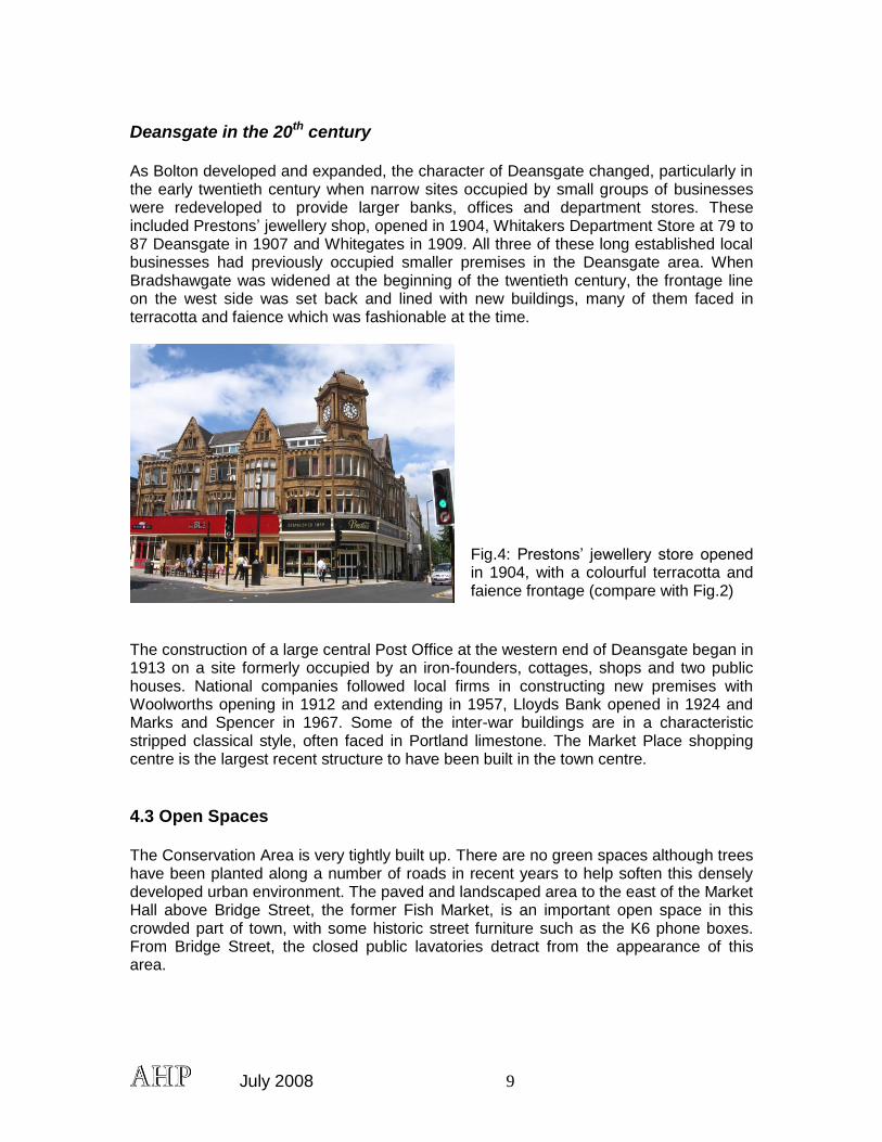
Deansgate in the 20th century As Bolton developed and expanded, the character of Deansgate changed, particularly in the early twentieth century when narrow sites occupied by small groups of businesses were redeveloped to provide larger banks, offices and department stores. These included Prestons‟ jewellery shop, opened in 1904, Whitakers Department Store at 79 to 87 Deansgate in 1907 and Whitegates in 1909. All three of these long established local businesses had previously occupied smaller premises in the Deansgate area. When Bradshawgate was widened at the beginning of the twentieth century, the frontage line on the west side was set back and lined with new buildings, many of them faced in terracotta and faience which was fashionable at the time.
Fig.4: Prestons‟ jewellery store opened in 1904, with a colourful terracotta and faience frontage (compare with Fig.2)
The construction of a large central Post Office at the western end of Deansgate began in 1913 on a site formerly occupied by an iron-founders, cottages, shops and two public houses. National companies followed local firms in constructing new premises with Woolworths opening in 1912 and extending in 1957, Lloyds Bank opened in 1924 and Marks and Spencer in 1967. Some of the inter-war buildings are in a characteristic stripped classical style, often faced in Portland limestone. The Market Place shopping centre is the largest recent structure to have been built in the town centre.
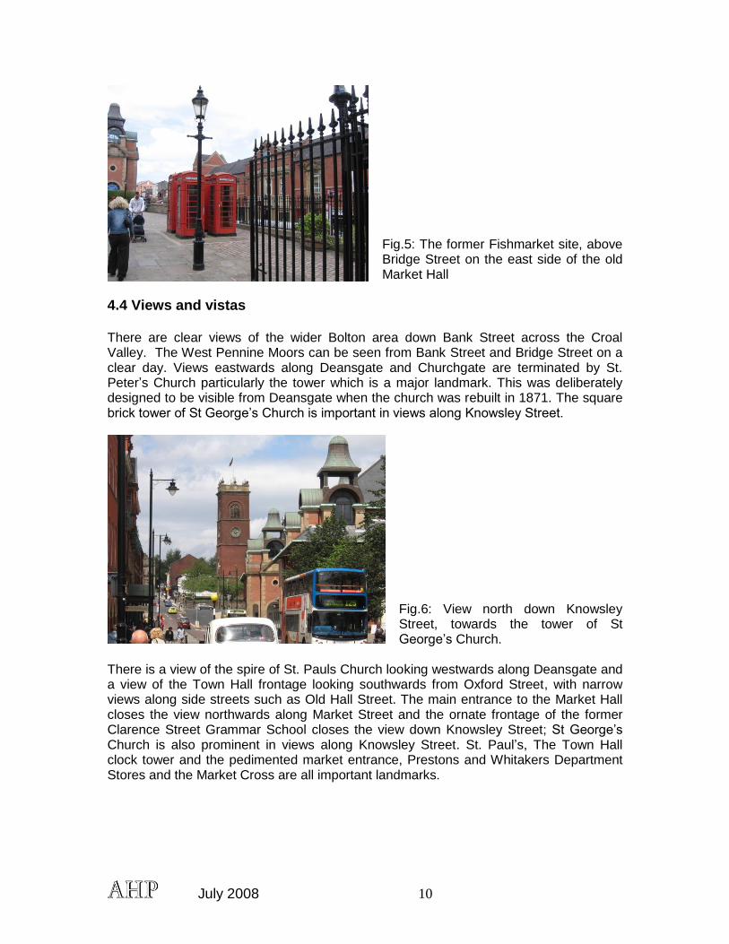
4.3 Open Spaces The Conservation Area is very tightly built up. There are no green spaces although trees have been planted along a number of roads in recent years to help soften this densely developed urban environment. The paved and landscaped area to the east of the Market Hall above Bridge Street, the former Fish Market, is an important open space in this crowded part of town, with some historic street furniture such as the K6 phone boxes. From Bridge Street, the closed public lavatories detract from the appearance of this area.
July 2008 10
Fig.5: The former Fishmarket site, above Bridge Street on the east side of the old Market Hall
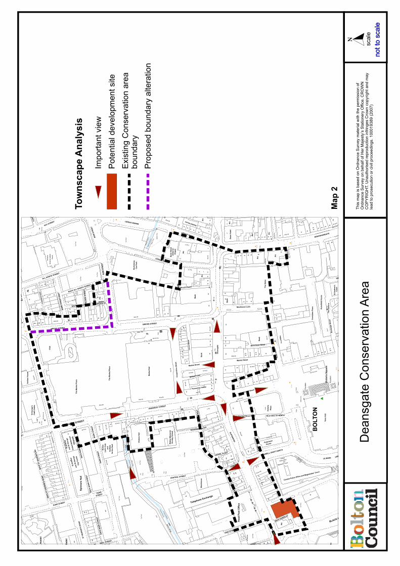
4.4 Views and vistas There are clear views of the wider Bolton area down Bank Street across the Croal Valley. The West Pennine Moors can be seen from Bank Street and Bridge Street on a clear day. Views eastwards along Deansgate and Churchgate are terminated by St. Peter‟s Church particularly the tower which is a major landmark. This was deliberately designed to be visible from Deansgate when the church was rebuilt in 1871. The square brick tower of St George‟s Church is important in views along Knowsley Street.
Fig.6: View north down Knowsley Street, towards the tower of St George‟s Church.
There is a view of the spire of St. Pauls Church looking westwards along Deansgate and a view of the Town Hall frontage looking southwards from Oxford Street, with narrow views along side streets such as Old Hall Street. The main entrance to the Market Hall closes the view northwards along Market Street and the ornate frontage of the former Clarence Street Grammar School closes the view down Knowsley Street; St George‟s Church is also prominent in views along Knowsley Street. St. Paul‟s, The Town Hall clock tower and the pedimented market entrance, Prestons and Whitakers Department Stores and the Market Cross are all important landmarks.

July 2008 11
Fig.7: Deansgate, looking east towards the tower of St Peter‟s Church (compare with Fig.3)
The gentle curve of Deansgate creates a succession of views and the skyline is punctuated by domes and turrets which are characteristic of many buildings in the conservation area. These are particularly important on corner plots where they give emphasis to junctions and provide a sense of orientation.
Fig.8: corner towers, decorated parapets and pediments on the north side of Deansgate
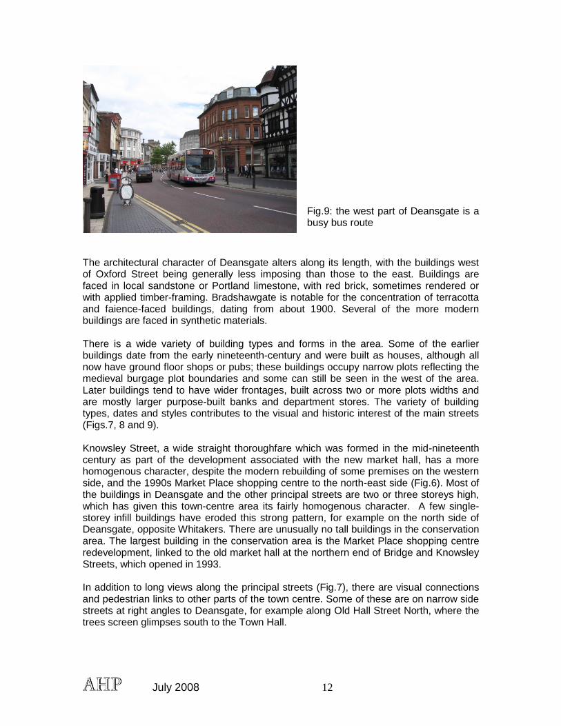
4.5 Character and appearance Deansgate is a long, wide street, reflecting its status as one of Bolton‟s principal thoroughfares. The area has a dense urban grain with buildings built up to plot boundaries. The central part of Deansgate itself is pedestrianised, together with the streets to north and south between Victoria Square and the old Market Hall, and this largely retail area is busy with people during the daytime. The eastern and western ends of Deansgate carry considerable vehicular traffic, particularly west of the junction with Knowlsey Street, which is also a bus route. Back streets and cleared sites to the north of Deansgate, just outside the boundary of the conservation area are currently used as surface parking, but new development has been agreed.
July 2008 12
Fig.9: the west part of Deansgate is a busy bus route
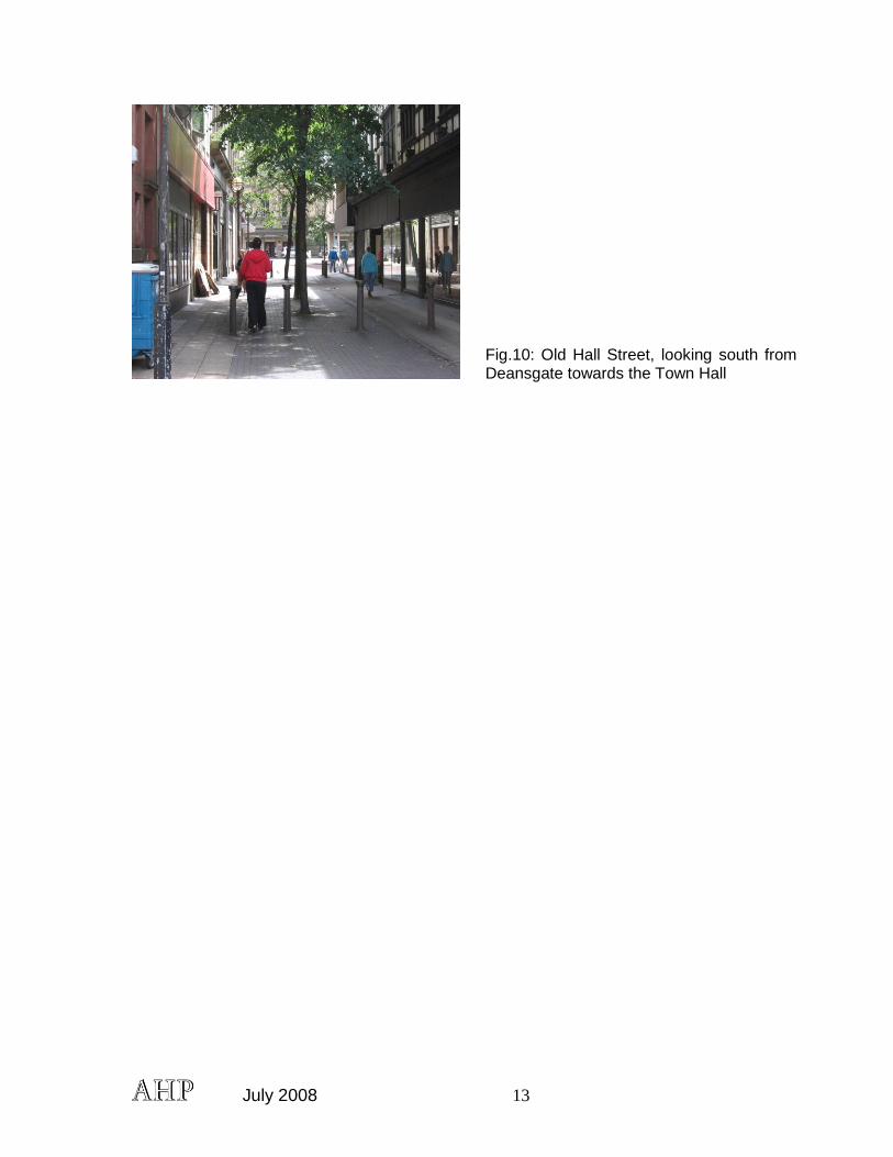
The architectural character of Deansgate alters along its length, with the buildings west of Oxford Street being generally less imposing than those to the east. Buildings are faced in local sandstone or Portland limestone, with red brick, sometimes rendered or with applied timber-framing. Bradshawgate is notable for the concentration of terracotta and faience-faced buildings, dating from about 1900. Several of the more modern buildings are faced in synthetic materials. There is a wide variety of building types and forms in the area. Some of the earlier buildings date from the early nineteenth-century and were built as houses, although all now have ground floor shops or pubs; these buildings occupy narrow plots reflecting the medieval burgage plot boundaries and some can still be seen in the west of the area. Later buildings tend to have wider frontages, built across two or more plots widths and are mostly larger purpose-built banks and department stores. The variety of building types, dates and styles contributes to the visual and historic interest of the main streets (Figs.7, 8 and 9). Knowsley Street, a wide straight thoroughfare which was formed in the mid-nineteenth century as part of the development associated with the new market hall, has a more homogenous character, despite the modern rebuilding of some premises on the western side, and the 1990s Market Place shopping centre to the north-east side (Fig.6). Most of the buildings in Deansgate and the other principal streets are two or three storeys high, which has given this town-centre area its fairly homogenous character. A few single-storey infill buildings have eroded this strong pattern, for example on the north side of Deansgate, opposite Whitakers. There are unusually no tall buildings in the conservation area. The largest building in the conservation area is the Market Place shopping centre redevelopment, linked to the old market hall at the northern end of Bridge and Knowsley Streets, which opened in 1993. In addition to long views along the principal streets (Fig.7), there are visual connections and pedestrian links to other parts of the town centre. Some of these are on narrow side streets at right angles to Deansgate, for example along Old Hall Street North, where the trees screen glimpses south to the Town Hall.
July 2008 13
Fig.10: Old Hall Street, looking south from Deansgate towards the Town Hall
July 2008 14
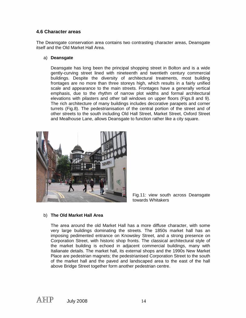
4.6 Character areas The Deansgate conservation area contains two contrasting character areas, Deansgate itself and the Old Market Hall Area.
a) Deansgate
Deansgate has long been the principal shopping street in Bolton and is a wide gently-curving street lined with nineteenth and twentieth century commercial buildings. Despite the diversity of architectural treatments, most building frontages are no more than three storeys high, which results in a fairly unified scale and appearance to the main streets. Frontages have a generally vertical emphasis, due to the rhythm of narrow plot widths and formal architectural elevations with pilasters and other tall windows on upper floors (Figs.8 and 9). The rich architecture of many buildings includes decorative parapets and corner turrets (Fig.8). The pedestrianisation of the central portion of the street and of other streets to the south including Old Hall Street, Market Street, Oxford Street and Mealhouse Lane, allows Deansgate to function rather like a city square.
Fig.11: view south across Deansgate towards Whitakers
b) The Old Market Hall Area
The area around the old Market Hall has a more diffuse character, with some very large buildings dominating the streets. The 1850s market hall has an imposing pedimented entrance on Knowsley Street, and a strong presence on Corporation Street, with historic shop fronts. The classical architectural style of the market building is echoed in adjacent commercial buildings, many with Italianate details. The market hall, its external shops and the 1990s New Market Place are pedestrian magnets; the pedestrianised Corporation Street to the south of the market hall and the paved and landscaped area to the east of the hall above Bridge Street together form another pedestrian centre.
July 2008 15
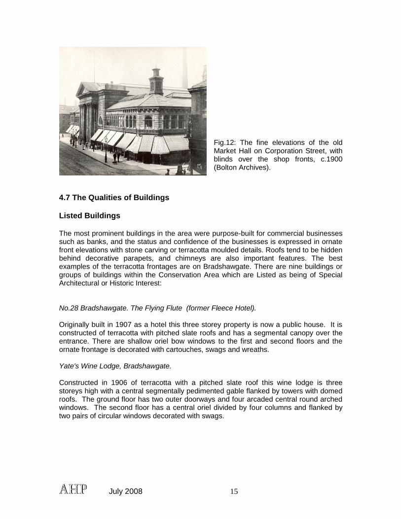
Fig.12: The fine elevations of the old Market Hall on Corporation Street, with blinds over the shop fronts, c.1900 (Bolton Archives).
4.7 The Qualities of Buildings Listed Buildings The most prominent buildings in the area were purpose-built for commercial businesses such as banks, and the status and confidence of the businesses is expressed in ornate front elevations with stone carving or terracotta moulded details. Roofs tend to be hidden behind decorative parapets, and chimneys are also important features. The best examples of the terracotta frontages are on Bradshawgate. There are nine buildings or groups of buildings within the Conservation Area which are Listed as being of Special Architectural or Historic Interest: No.28 Bradshawgate. The Flying Flute (former Fleece Hotel). Originally built in 1907 as a hotel this three storey property is now a public house. It is constructed of terracotta with pitched slate roofs and has a segmental canopy over the entrance. There are shallow oriel bow windows to the first and second floors and the ornate frontage is decorated with cartouches, swags and wreaths. Yate's Wine Lodge, Bradshawgate. Constructed in 1906 of terracotta with a pitched slate roof this wine lodge is three storeys high with a central segmentally pedimented gable flanked by towers with domed roofs. The ground floor has two outer doorways and four arcaded central round arched windows. The second floor has a central oriel divided by four columns and flanked by two pairs of circular windows decorated with swags.
July 2008 16
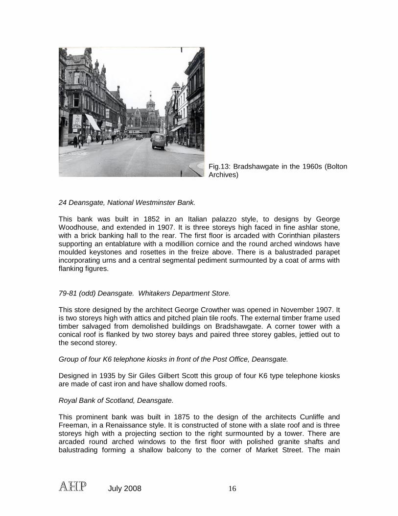
Fig.13: Bradshawgate in the 1960s (Bolton Archives)
24 Deansgate, National Westminster Bank. This bank was built in 1852 in an Italian palazzo style, to designs by George Woodhouse, and extended in 1907. It is three storeys high faced in fine ashlar stone, with a brick banking hall to the rear. The first floor is arcaded with Corinthian pilasters supporting an entablature with a modillion cornice and the round arched windows have moulded keystones and rosettes in the freize above. There is a balustraded parapet incorporating urns and a central segmental pediment surmounted by a coat of arms with flanking figures. 79-81 (odd) Deansgate. Whitakers Department Store. This store designed by the architect George Crowther was opened in November 1907. It is two storeys high with attics and pitched plain tile roofs. The external timber frame used timber salvaged from demolished buildings on Bradshawgate. A corner tower with a conical roof is flanked by two storey bays and paired three storey gables, jettied out to the second storey. Group of four K6 telephone kiosks in front of the Post Office, Deansgate. Designed in 1935 by Sir Giles Gilbert Scott this group of four K6 type telephone kiosks are made of cast iron and have shallow domed roofs. Royal Bank of Scotland, Deansgate. This prominent bank was built in 1875 to the design of the architects Cunliffe and Freeman, in a Renaissance style. It is constructed of stone with a slate roof and is three storeys high with a projecting section to the right surmounted by a tower. There are arcaded round arched windows to the first floor with polished granite shafts and balustrading forming a shallow balcony to the corner of Market Street. The main
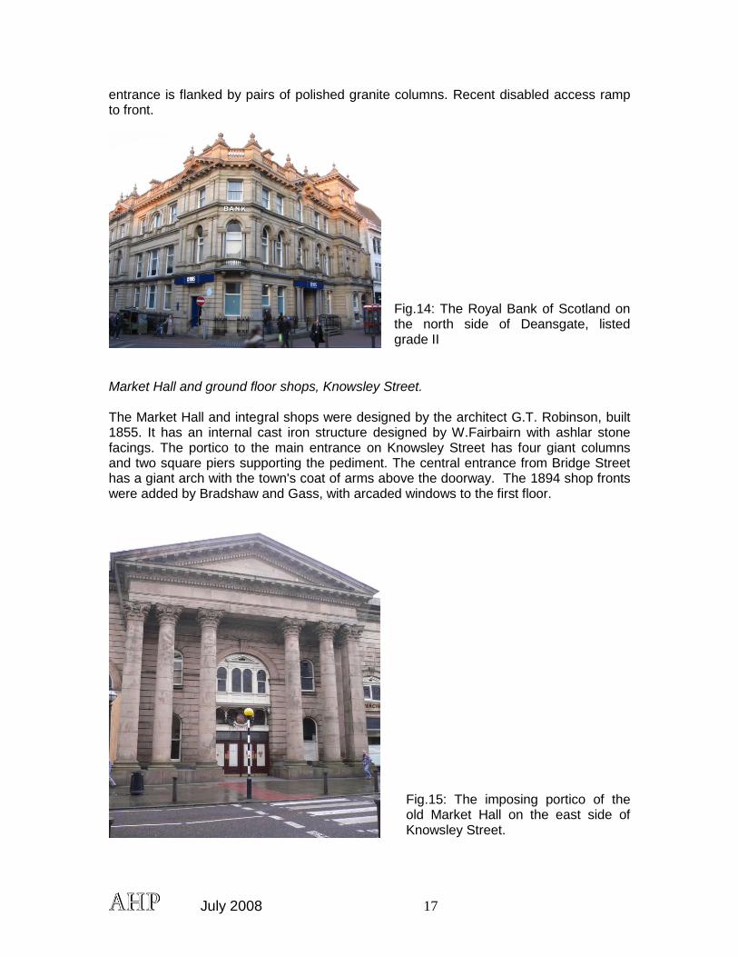
July 2008 17
entrance is flanked by pairs of polished granite columns. Recent disabled access ramp to front.
Fig.14: The Royal Bank of Scotland on the north side of Deansgate, listed grade II
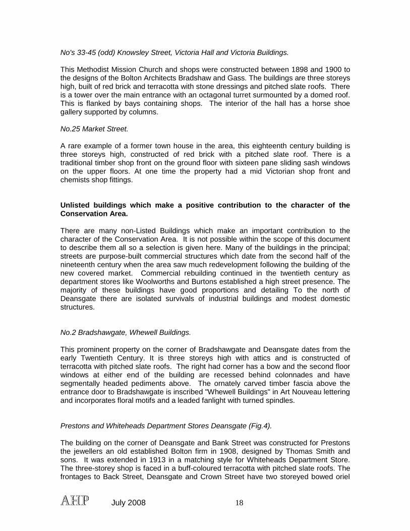
Market Hall and ground floor shops, Knowsley Street. The Market Hall and integral shops were designed by the architect G.T. Robinson, built 1855. It has an internal cast iron structure designed by W.Fairbairn with ashlar stone facings. The portico to the main entrance on Knowsley Street has four giant columns and two square piers supporting the pediment. The central entrance from Bridge Street has a giant arch with the town's coat of arms above the doorway. The 1894 shop fronts were added by Bradshaw and Gass, with arcaded windows to the first floor.
Fig.15: The imposing portico of the old Market Hall on the east side of Knowsley Street.
July 2008 18
No's 33-45 (odd) Knowsley Street, Victoria Hall and Victoria Buildings. This Methodist Mission Church and shops were constructed between 1898 and 1900 to the designs of the Bolton Architects Bradshaw and Gass. The buildings are three storeys high, built of red brick and terracotta with stone dressings and pitched slate roofs. There is a tower over the main entrance with an octagonal turret surmounted by a domed roof. This is flanked by bays containing shops. The interior of the hall has a horse shoe gallery supported by columns. No.25 Market Street. A rare example of a former town house in the area, this eighteenth century building is three storeys high, constructed of red brick with a pitched slate roof. There is a traditional timber shop front on the ground floor with sixteen pane sliding sash windows on the upper floors. At one time the property had a mid Victorian shop front and chemists shop fittings. Unlisted buildings which make a positive contribution to the character of the Conservation Area. There are many non-Listed Buildings which make an important contribution to the character of the Conservation Area. It is not possible within the scope of this document to describe them all so a selection is given here. Many of the buildings in the principal; streets are purpose-built commercial structures which date from the second half of the nineteenth century when the area saw much redevelopment following the building of the new covered market. Commercial rebuilding continued in the twentieth century as department stores like Woolworths and Burtons established a high street presence. The majority of these buildings have good proportions and detailing To the north of Deansgate there are isolated survivals of industrial buildings and modest domestic structures. No.2 Bradshawgate, Whewell Buildings. This prominent property on the corner of Bradshawgate and Deansgate dates from the early Twentieth Century. It is three storeys high with attics and is constructed of terracotta with pitched slate roofs. The right had corner has a bow and the second floor windows at either end of the building are recessed behind colonnades and have segmentally headed pediments above. The ornately carved timber fascia above the entrance door to Bradshawgate is inscribed "Whewell Buildings" in Art Nouveau lettering and incorporates floral motifs and a leaded fanlight with turned spindles. Prestons and Whiteheads Department Stores Deansgate (Fig.4). The building on the corner of Deansgate and Bank Street was constructed for Prestons the jewellers an old established Bolton firm in 1908, designed by Thomas Smith and sons. It was extended in 1913 in a matching style for Whiteheads Department Store. The three-storey shop is faced in a buff-coloured terracotta with pitched slate roofs. The frontages to Back Street, Deansgate and Crown Street have two storeyed bowed oriel
July 2008 19
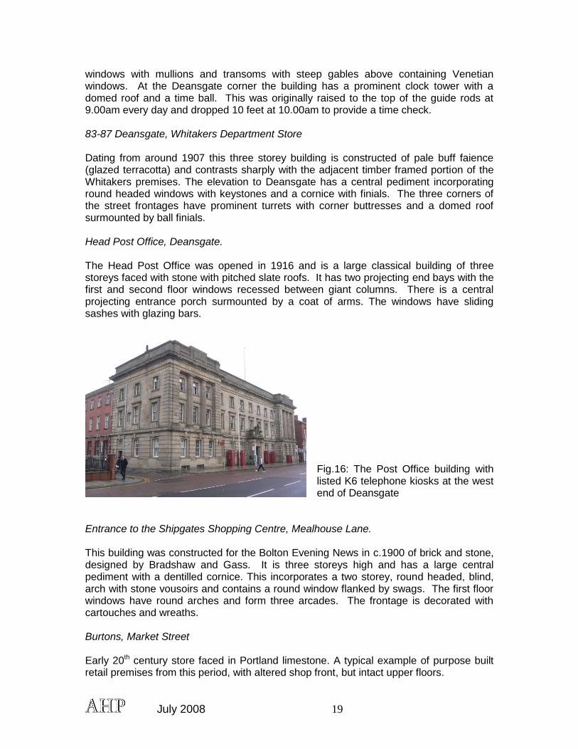
windows with mullions and transoms with steep gables above containing Venetian windows. At the Deansgate corner the building has a prominent clock tower with a domed roof and a time ball. This was originally raised to the top of the guide rods at 9.00am every day and dropped 10 feet at 10.00am to provide a time check. 83-87 Deansgate, Whitakers Department Store Dating from around 1907 this three storey building is constructed of pale buff faience (glazed terracotta) and contrasts sharply with the adjacent timber framed portion of the Whitakers premises. The elevation to Deansgate has a central pediment incorporating round headed windows with keystones and a cornice with finials. The three corners of the street frontages have prominent turrets with corner buttresses and a domed roof surmounted by ball finials. Head Post Office, Deansgate. The Head Post Office was opened in 1916 and is a large classical building of three storeys faced with stone with pitched slate roofs. It has two projecting end bays with the first and second floor windows recessed between giant columns. There is a central projecting entrance porch surmounted by a coat of arms. The windows have sliding sashes with glazing bars.
Fig.16: The Post Office building with listed K6 telephone kiosks at the west end of Deansgate
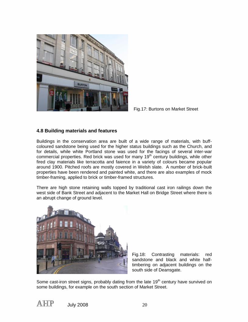
Entrance to the Shipgates Shopping Centre, Mealhouse Lane. This building was constructed for the Bolton Evening News in c.1900 of brick and stone, designed by Bradshaw and Gass. It is three storeys high and has a large central pediment with a dentilled cornice. This incorporates a two storey, round headed, blind, arch with stone vousoirs and contains a round window flanked by swags. The first floor windows have round arches and form three arcades. The frontage is decorated with cartouches and wreaths. Burtons, Market Street Early 20th century store faced in Portland limestone. A typical example of purpose built retail premises from this period, with altered shop front, but intact upper floors.
July 2008 20
Fig.17: Burtons on Market Street
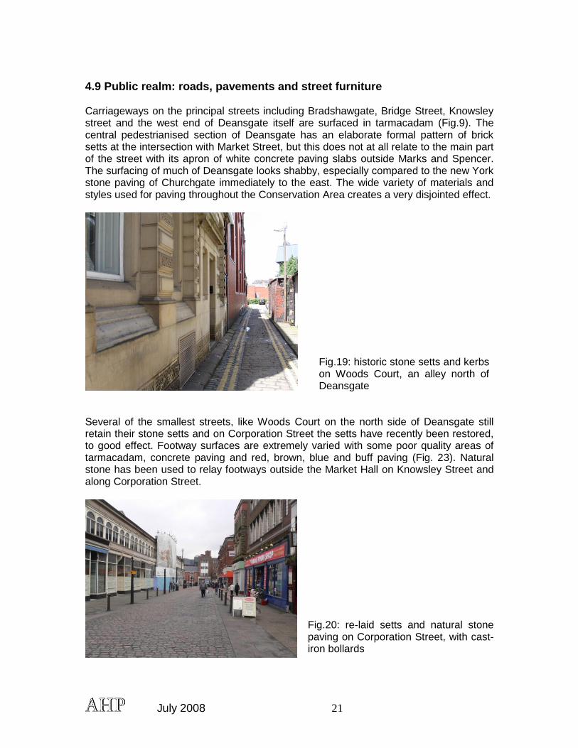
4.8 Building materials and features Buildings in the conservation area are built of a wide range of materials, with buff-coloured sandstone being used for the higher status buildings such as the Church, and for details, while white Portland stone was used for the facings of several inter-war commercial properties. Red brick was used for many 19th century buildings, while other fired clay materials like terracotta and faience in a variety of colours became popular around 1900. Pitched roofs are mostly covered in Welsh slate. A number of brick-built properties have been rendered and painted white, and there are also examples of mock timber-framing, applied to brick or timber-framed structures. There are high stone retaining walls topped by traditional cast iron railings down the west side of Bank Street and adjacent to the Market Hall on Bridge Street where there is an abrupt change of ground level.
Fig.18: Contrasting materials: red sandstone and black and white half-timbering on adjacent buildings on the south side of Deansgate.
Some cast-iron street signs, probably dating from the late 19th century have survived on some buildings, for example on the south section of Market Street.
July 2008 21
4.9 Public realm: roads, pavements and street furniture Carriageways on the principal streets including Bradshawgate, Bridge Street, Knowsley street and the west end of Deansgate itself are surfaced in tarmacadam (Fig.9). The central pedestrianised section of Deansgate has an elaborate formal pattern of brick setts at the intersection with Market Street, but this does not at all relate to the main part of the street with its apron of white concrete paving slabs outside Marks and Spencer. The surfacing of much of Deansgate looks shabby, especially compared to the new York stone paving of Churchgate immediately to the east. The wide variety of materials and styles used for paving throughout the Conservation Area creates a very disjointed effect.
Fig.19: historic stone setts and kerbs on Woods Court, an alley north of Deansgate
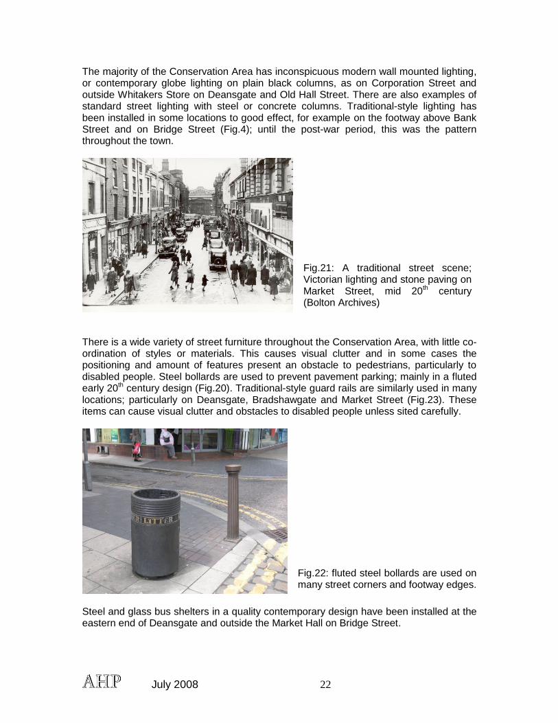
Several of the smallest streets, like Woods Court on the north side of Deansgate still retain their stone setts and on Corporation Street the setts have recently been restored, to good effect. Footway surfaces are extremely varied with some poor quality areas of tarmacadam, concrete paving and red, brown, blue and buff paving (Fig. 23). Natural stone has been used to relay footways outside the Market Hall on Knowsley Street and along Corporation Street.
Fig.20: re-laid setts and natural stone paving on Corporation Street, with cast-iron bollards
July 2008 22
The majority of the Conservation Area has inconspicuous modern wall mounted lighting, or contemporary globe lighting on plain black columns, as on Corporation Street and outside Whitakers Store on Deansgate and Old Hall Street. There are also examples of standard street lighting with steel or concrete columns. Traditional-style lighting has been installed in some locations to good effect, for example on the footway above Bank Street and on Bridge Street (Fig.4); until the post-war period, this was the pattern throughout the town.
Fig.21: A traditional street scene; Victorian lighting and stone paving on Market Street, mid 20th century (Bolton Archives)
There is a wide variety of street furniture throughout the Conservation Area, with little co-ordination of styles or materials. This causes visual clutter and in some cases the positioning and amount of features present an obstacle to pedestrians, particularly to disabled people. Steel bollards are used to prevent pavement parking; mainly in a fluted early 20th century design (Fig.20). Traditional-style guard rails are similarly used in many locations; particularly on Deansgate, Bradshawgate and Market Street (Fig.23). These items can cause visual clutter and obstacles to disabled people unless sited carefully.
Fig.22: fluted steel bollards are used on many street corners and footway edges.
Steel and glass bus shelters in a quality contemporary design have been installed at the eastern end of Deansgate and outside the Market Hall on Bridge Street.
July 2008 23
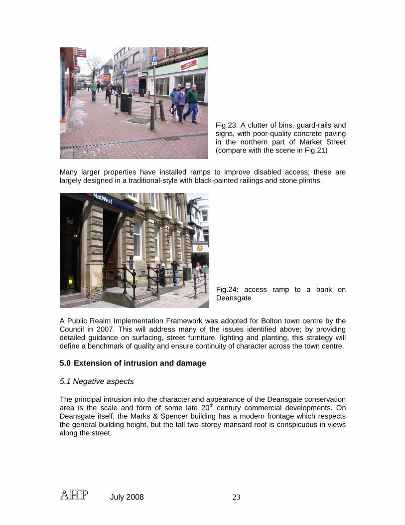
Fig.23: A clutter of bins, guard-rails and signs, with poor-quality concrete paving in the northern part of Market Street (compare with the scene in Fig.21)
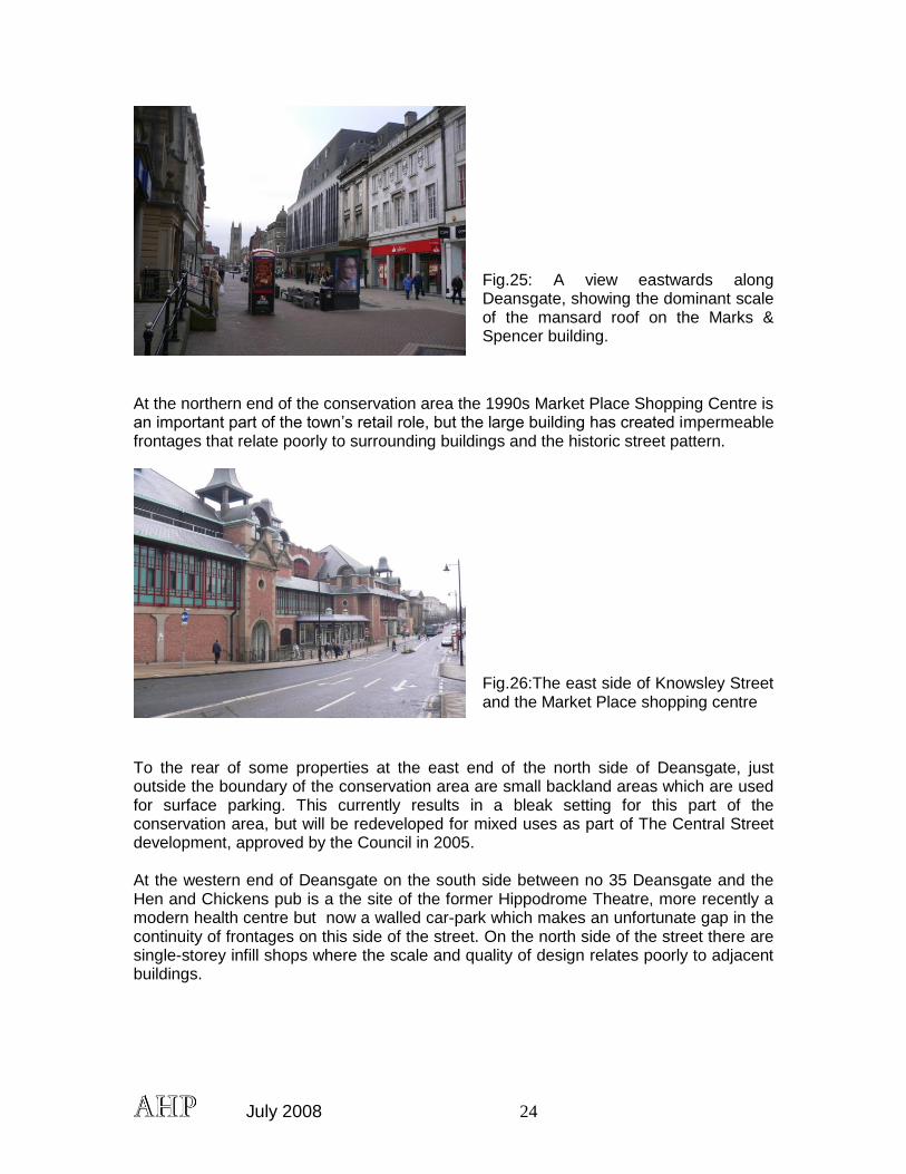
Many larger properties have installed ramps to improve disabled access; these are largely designed in a traditional-style with black-painted railings and stone plinths.
Fig.24: access ramp to a bank on Deansgate
A Public Realm Implementation Framework was adopted for Bolton town centre by the Council in 2007. This will address many of the issues identified above; by providing detailed guidance on surfacing, street furniture, lighting and planting, this strategy will define a benchmark of quality and ensure continuity of character across the town centre.
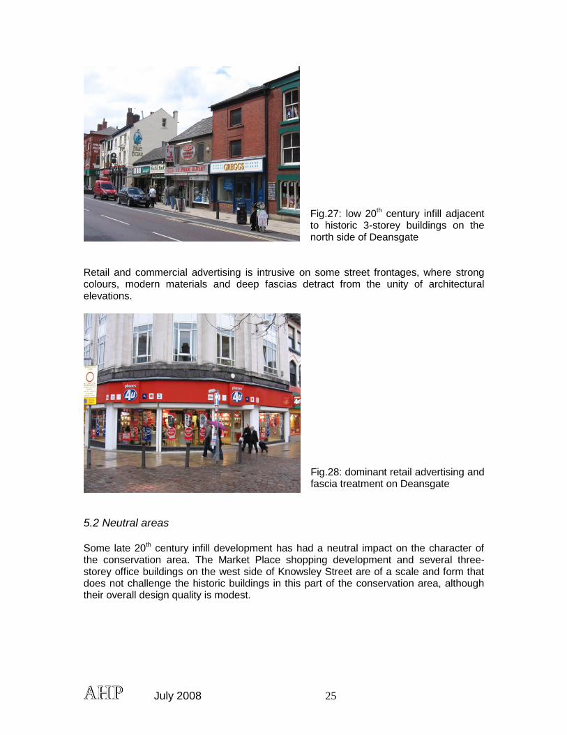
5.0 Extension of intrusion and damage 5.1 Negative aspects The principal intrusion into the character and appearance of the Deansgate conservation area is the scale and form of some late 20th century commercial developments. On Deansgate itself, the Marks & Spencer building has a modern frontage which respects the general building height, but the tall two-storey mansard roof is conspicuous in views along the street.
July 2008 24
Fig.25: A view eastwards along Deansgate, showing the dominant scale of the mansard roof on the Marks & Spencer building.
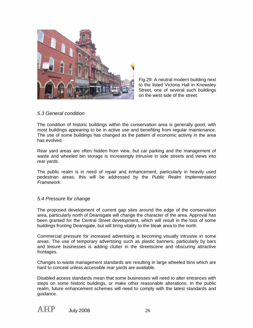
At the northern end of the conservation area the 1990s Market Place Shopping Centre is an important part of the town‟s retail role, but the large building has created impermeable frontages that relate poorly to surrounding buildings and the historic street pattern.
Fig.26:The east side of Knowsley Street and the Market Place shopping centre
To the rear of some properties at the east end of the north side of Deansgate, just outside the boundary of the conservation area are small backland areas which are used for surface parking. This currently results in a bleak setting for this part of the conservation area, but will be redeveloped for mixed uses as part of The Central Street development, approved by the Council in 2005. At the western end of Deansgate on the south side between no 35 Deansgate and the Hen and Chickens pub is a the site of the former Hippodrome Theatre, more recently a modern health centre but now a walled car-park which makes an unfortunate gap in the continuity of frontages on this side of the street. On the north side of the street there are single-storey infill shops where the scale and quality of design relates poorly to adjacent buildings.
July 2008 25
Fig.27: low 20th century infill adjacent to historic 3-storey buildings on the north side of Deansgate
Retail and commercial advertising is intrusive on some street frontages, where strong colours, modern materials and deep fascias detract from the unity of architectural elevations.
Fig.28: dominant retail advertising and fascia treatment on Deansgate
5.2 Neutral areas Some late 20th century infill development has had a neutral impact on the character of the conservation area. The Market Place shopping development and several three-storey office buildings on the west side of Knowsley Street are of a scale and form that does not challenge the historic buildings in this part of the conservation area, although their overall design quality is modest.
July 2008 26
Fig.29: A neutral modern building next to the listed Victoria Hall in Knowsley Street, one of several such buildings on the west side of the street.
5.3 General condition The condition of historic buildings within the conservation area is generally good, with most buildings appearing to be in active use and benefiting from regular maintenance. The use of some buildings has changed as the pattern of economic activity in the area has evolved. Rear yard areas are often hidden from view, but car parking and the management of waste and wheeled bin storage is increasingly intrusive in side streets and views into rear yards. The public realm is in need of repair and enhancement, particularly in heavily used pedestrian areas; this will be addressed by the Public Realm Implementation Framework.
5.4 Pressure for change The proposed development of current gap sites around the edge of the conservation area, particularly north of Deansgate will change the character of the area. Approval has been granted for the Central Street development, which will result in the loss of some buildings fronting Deansgate, but will bring vitality to the bleak area to the north. Commercial pressure for increased advertising is becoming visually intrusive in some areas. The use of temporary advertising such as plastic banners, particularly by bars and leisure businesses is adding clutter in the streetscene and obscuring attractive frontages. Changes to waste management standards are resulting in large wheeled bins which are hard to conceal unless accessible rear yards are available. Disabled access standards mean that some businesses will need to alter entrances with steps on some historic buildings, or make other reasonable alterations. In the public realm, future enhancement schemes will need to comply with the latest standards and guidance.
July 2008 27
The 2007 ban on smoking in enclosed public places and workplaces is likely to generate a demand for smoking shelters and outdoor seating, which will require careful management to avoid intrusive new structures.
6.0 Community involvement. A publicity leaflet which included a tear out questionnaire was distributed to businesses and properties within all the Town Centre Conservation Areas. In addition two half day drop in sessions were held at the library foyer in Le Mans Crescent on 22nd and 23rd January 2008 to provide advice and respond to comments. In total approximately 600 leaflets were distributed. A press release raising awareness of the drop in session was advertised in the Bolton Evening News and the Conservation Area Appraisals were made available to view online. Respondents were asked if they agreed on the boundary extensions, whether they wished to see more areas protected and to score in terms of importance eight key recommendations set out in the Conservation Area Management Plan. The response rate was low but raised no objections to the boundary extensions. The Civic Trust were one of the respondents and were generally supportive of all the Conservation Area boundary extensions. Some concern was raised regarding constraints that Conservation Area status afforded and that the extended areas could not be afforded adequate protection by the Authority given the investment pressure in some of these areas.
July 2008 28
7. Suggested conservation area boundary changes No boundary extensions are proposed. A small area to the north-east of Bridge Street is to be transferred to the St George‟s Conservation Area, following recommendations made in the appraisal of the latter area.
July 2008 29
8. Guidelines for development 8.1 New Development. Building Bolton provides guidelines for new development in the town centre. However, opportunities within the conservation area are limited and are most likely to be presented by small infill and gap sites, or sites where existing buildings have a negative impact on the character of the area. New development must reflect the character of existing buildings with respect to siting, scale, proportions, materials and detailing. Applications for Outline Planning Permission will not be considered unless supported by a masterplan and a high level of detail. Applications for full planning permission must include a Design and Access statement that explains the development‟s affect on the character and appearance of the conservation area, demonstrating that the scheme will be sensitive to its context, supported by visual images such as photomontages or perspective drawings. Good quality contemporary design, related to the historic context and character of the area will be encouraged. Key factors to take into account are:
consistent building heights, except where punctuated by corner features;
the varied skyline,
the texture of frontages and the balance of windows/recessed openings to solid wall;
vertical rhythm and the proportion of elevations;
articulation of building elevations;
tightly-developed plots and buildings providing enclosure to streets. 8.2 Demolition Consent will not usually be given to demolish buildings which make a positive contribution to the character of the Conservation Area, unless it can be demonstrated that the replacement development will bring over-riding community benefits and be of a high design quality. The criteria in PPG15 and UDP policy will be referred to. 8.3 Advertisement Control. The Authority will apply high standards when considering applications for Advertisement Consent in the Conservation Area. Certain categories of advertisements are not permitted in Conservation Areas and discontinuance action will be taken against existing signs where they do not conform to the guidelines given in Planning Control Policy Note No.6 - The Display of Signs and Advertisements. 8.4 Street surfacing and furniture The Public Realm Implementation Framework, adopted by the Council in 2007, provides guidance on design and standards for public realm enhancement, In addition, an audit of original stone flags, setts and kerbs in the conservation area should be undertaken, and significant examples retained and relaid where necessary.
July 2008 30
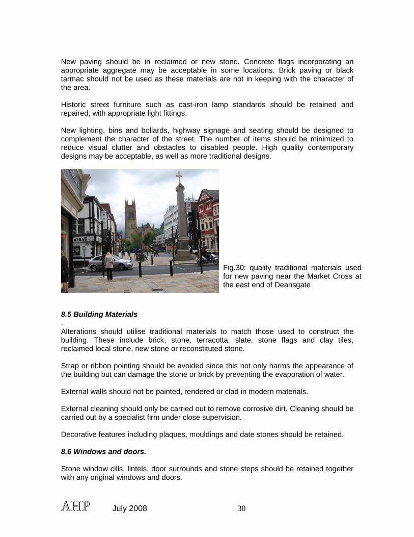
New paving should be in reclaimed or new stone. Concrete flags incorporating an appropriate aggregate may be acceptable in some locations. Brick paving or black tarmac should not be used as these materials are not in keeping with the character of the area. Historic street furniture such as cast-iron lamp standards should be retained and repaired, with appropriate light fittings. New lighting, bins and bollards, highway signage and seating should be designed to complement the character of the street. The number of items should be minimized to reduce visual clutter and obstacles to disabled people. High quality contemporary designs may be acceptable, as well as more traditional designs.
Fig.30: quality traditional materials used for new paving near the Market Cross at the east end of Deansgate
8.5 Building Materials . Alterations should utilise traditional materials to match those used to construct the building. These include brick, stone, terracotta, slate, stone flags and clay tiles, reclaimed local stone, new stone or reconstituted stone. Strap or ribbon pointing should be avoided since this not only harms the appearance of the building but can damage the stone or brick by preventing the evaporation of water. External walls should not be painted, rendered or clad in modern materials. External cleaning should only be carried out to remove corrosive dirt. Cleaning should be carried out by a specialist firm under close supervision. Decorative features including plaques, mouldings and date stones should be retained. 8.6 Windows and doors. Stone window cills, lintels, door surrounds and stone steps should be retained together with any original windows and doors.
July 2008 31
Any doorways or windows no longer in use should be retained and not blocked up. Historic joinery should be maintained in good condition and not replaced with modern imitations. Owners should be encouraged to use the following styles when replacing windows and doors:
For eighteenth and early nineteenth century properties, vertical sliding sash windows with glazing bars and six-panelled doors.
For late nineteenth and early twentieth century properties, vertical sliding sash windows and four-panelled doors.
Windows and doors should be made of timber and should be painted. Staining is not a traditional finish for timber and should not be used. U.P.V.C. windows and doors are not acceptable as they are not in keeping with the character of traditional buildings. New windows and doors should be recessed to the original depth and should not be fitted flush with the face of the wall or project from it. 8.7 Chimneys and Roofs. Chimney stacks should be retained. If rebuilding is necessary this should be in the same materials used to construct the remainder of the building, this may be brick or stone with clay pots. Where central heating flues are installed, these should be contained within the original chimney pot or a traditional replacement. Roof repairs or replacements should be in natural slate, stone flags or red clay tiles to match the existing materials. Where ridge tiles need replacing these should be in stone or clay. New rooflights may be acceptable but these should be flush fitting and should not be on prominent roof slopes. 8.8 Rainwater Goods. Replacement rainwater goods should be in cast iron or moulded aluminium with a black coating. Plastic rainwater goods are not acceptable. 8.9 Boundary Walls, Gates and Railings Brick and stone boundary walls, iron railings and gates should be retained and any repairs carried out using the same materials and methods of workmanship. 8.10 Shop fronts and Advertisements. Shop fronts are visually important in the street scene, but over-dominant fascias detract from the architecture of upper floors. The installation of traditional-style painted timber shop fronts will be encouraged on historic buildings, including the use of stall risers, pilasters and cornices to frame the shop window. High quality contemporary shop fronts
July 2008 32
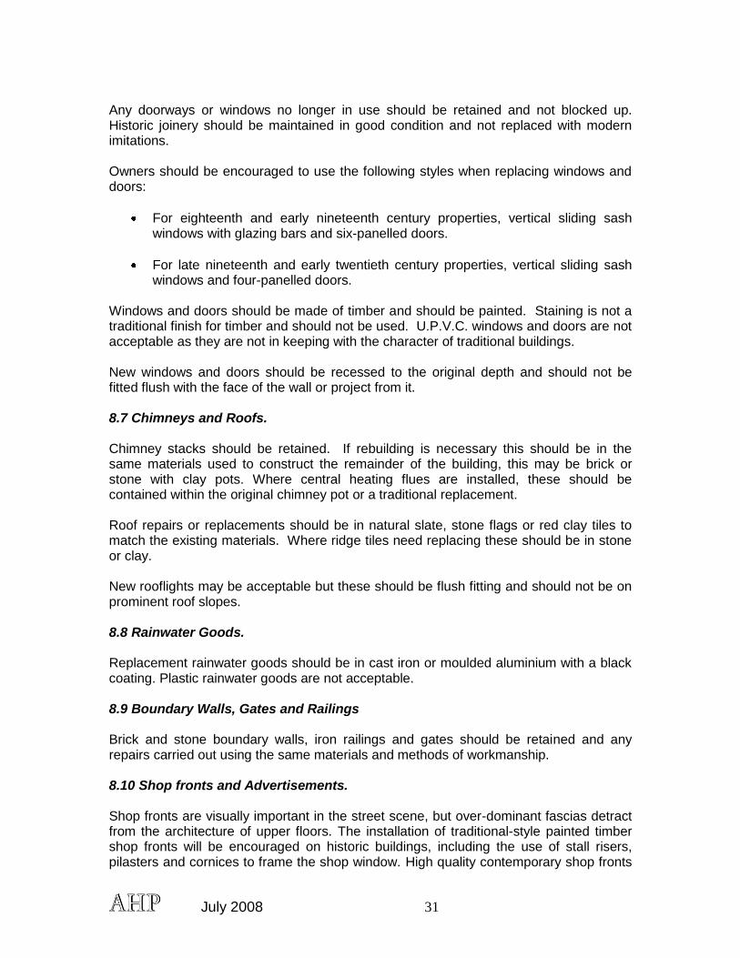
will also be encouraged. More guidance is provided in the Council‟s Shopfront Design Guide.
Fig.31: example of a well-designed contemporary shop-front on the Oxford Street/Deansgate corner
Advertisement consent will not be given for internally illuminated box signs. The use of external lights and concealed lighting will be encouraged, in conjunction with well-designed signage. Temporary plastic signage and banners are not appropriate in the conservation area. Hand painted fascia signs or hanging signs will also be encouraged. Security roller shutters are not acceptable on the exterior of frontages; if essential they should be installed inside shop windows and be of a perforated grille type to allow for a view of the window display. 8.11 Minor Fixtures and Services. Standard external fixtures including satellite dishes, meter boxes, burglar alarms, central heating flues and security cameras should be sited in unobtrusive positions wherever possible. They should be colour-coated to match the background materials i.e. walls or roofs. Air-conditioning units should only be located on hidden, rear elevations. 8.12 Wheeled Bins. The layout of traditional properties can create difficulties for storing bins. Wherever possible they should be stored out of sight and not left out on the street or footway where they can create obstacles for people with disabilities. New development should incorporate well-designed, discreet bin storage. 8.13 Interpretation Historic Bolton is an interesting place for people who work there, as well as visitors. Well-designed and carefully sited interpretation boards or plaques can enhance people‟s enjoyment and understanding and raise awareness of good conservation area management.

July 2008 33
8.14 Archaeology Where there is the potential for archaeology to be discovered on development sites, appropriate recording or investigation should take place in advance of development, with the advice of the Greater Manchester Archaeological Unit.
July 2008 34
References: Bolton Vision, Building Bolton, SPD, 2006 Bolton Council, Public Realm Implementation Framework, 2007 C.Hartwell, M.Hyde and N.Pevsner, The Buildings of England, Lancashire: Manchester and the South-East, 2004 English Heritage, Conservation Area Appraisals, 2006 English Heritage, Streets for All, North West, 2005 Gordon Readyhough, Bolton Town Centre, a Modern History, 1998 Unpublished documents Bolton Council, Deansgate Conservation Area, n.d (c.1999). Greater Manchester Archaeological Unit, Bolton: Areas of Archaeological Interest, 1982 Greater Manchester Archaeological Unit, Greater Manchester Sites and Monuments Record, University of Manchester D.Lloyd, Churchgate, Bolton: an archaeological and historical study of the development of an early urban landscape, BA Dissertation, University of Manchester, 1999 M.Sanderson, CgMS, Historic Environment Report: Central and Bark Streets, Bolton, July 2005 Historic images on the website www.ourtreaures.org.uk
July 2008 35
APPENDIX 1
Unitary Development Plan Conservation Areas Conservation Areas represent a significant element of Bolton's architectural and historical heritage. The council will preserve and enhance these areas through the control of development and through positive schemes of enhancement. Development which is allowed should contribute positively to the quality of the environment. The Council is empowered to designate further Conservation Areas and will consider designating them as appropriate. D7. The Council will permit development proposals that preserve or enhance the character or appearance of conservation areas. They should:
(i) be of appropriate height, size, design, materials, roofscape and plot width; (ii) retain materials, features, trees and open spaces that contribute to the
character or appearance of the conservation area;
(iii) utilize appropriate materials for highway and footpath surfacing; and
(iv) not adversely affect important views into, and across, a conservation area. The desirability of preserving or enhancing the character or appearance of Conservation Areas is prescribed by the Planning (Listed Buildings and Conservation Areas) Act 1990. Conservation Areas represent a significant element of Bolton's architectural and historical heritage and contribute to local distinctiveness. The Council will preserve or enhance these areas through the control of development and through positive schemes of enhancement. The number and extent of Conservation Areas in the Borough has been recently reviewed, with a total of 25 Conservation Areas within the plan area (Appendix 3). However, it is possible that further Conservation Areas might be proposed during the life of the plan or the boundaries of existing Conservation Areas reviewed. This policy outlines some of the elements which the Council will take into account when considering applications in Conservation Areas. D8. The Council will permit development proposals involving the demolition of an unlisted building or feature within a conservation area that contribute to its character or appearance provided that the applicant can demonstrate that:
(i) rehabilitation is impractical and there is no viable new use for the building; and
(ii) redevelopment would produce substantial benefits for the community that
would outweigh the loss resulting from demolition; and
July 2008 36
(iii) detailed proposals for the reuse of the site, including any replacement building or other structure, have been approved by the Council which incorporates agreements made to ensure that the replacement works will be carried out within a specified timescale.
Conservation area consent procedures for the demolition of most buildings within a conservation area are dealt with under Section 74 of the Planning (Listed Buildings and Conservation Areas) Act 1990. Under the consent procedures, English Heritage must be notified of all proposals to demolish listed buildings, and allowed access to buildings that it wishes to record before demolition takes place. For unlisted buildings within a conservation area, in the case of a demolition proposal the Council will in specific instances condition any consent, requiring recording. There is a general presumption in favour of retaining buildings and features which make a positive contribution to the character and appearance of the Conservation Area. Applicants should refer the Conservation Area Character Assessments which identify buildings and features of particular interest and note. Demolition of buildings in Conservation Areas may lead to the creation of „gap sites‟, which can remain vacant for long periods before redevelopment takes place, damaging the appearance of the area. It is therefore important that consent should not be given for demolition unless it is clear that the site will be redeveloped in a way which will preserve or enhance the character of the area within a reasonable timescale. Before demolition, the Council will require an assessment to establish whether the building contains a protected species, such as bats (policy N9). D9. The Council will require proposals for new or replacement shopfronts in Conservation Areas to:
(i) respect the period and style of the building and relate to it as a whole; (ii) be of a high standard of design, and use appropriate materials;
(iii) avoid the use of large expanses of undivided glass;
(iv) include historically accurate detailing; where the proposal is of traditional
character; and
(v) retain any features of architectural or historic interest. Shopfronts can play an important part in establishing the unique character of town centres. The Council will endeavour, through control of development and design advice, to improve the standard of shopfronts in the Conservation Areas in particular. Where the building involved is „listed‟, the introduction of a new shopfront or changes to an existing one will almost always require Listed Building Consent. Because of the historic and architectural interest of these areas it will be essential that shopfronts should not conflict with the style or period of the building, weakening its character and its contribution to the area as a whole. Equally the quality of the design must be high: poorly proportioned shopfronts, for example, will detract from the visual quality of the area. Large expanses of undivided glass are a feature of modern shopfronts, and conflict with the historic character of these areas, as well as reducing the interest of the building in order to let

July 2008 37
the displayed goods predominate. Applicants should refer to Planning Control Policy Note 4 – Shopfronts.
July 2008 38
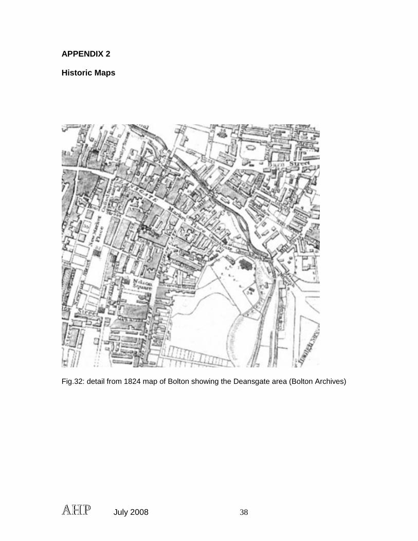
APPENDIX 2 Historic Maps
Fig.32: detail from 1824 map of Bolton showing the Deansgate area (Bolton Archives)
July 2008 39
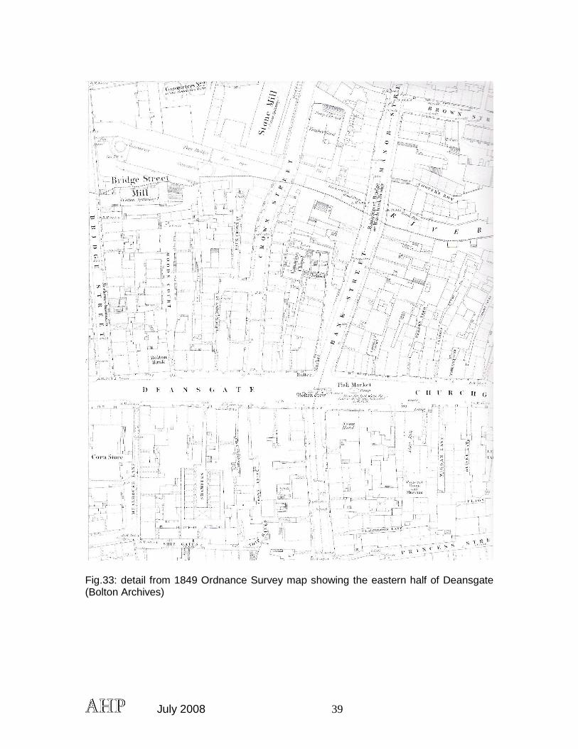
Fig.33: detail from 1849 Ordnance Survey map showing the eastern half of Deansgate (Bolton Archives)
July 2008 40
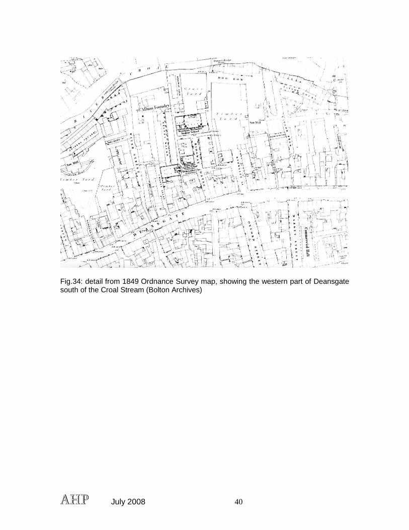
Fig.34: detail from 1849 Ordnance Survey map, showing the western part of Deansgate south of the Croal Stream (Bolton Archives)
July 2008 41
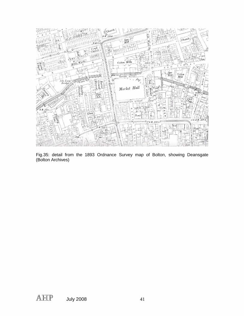
Fig.35: detail from the 1893 Ordnance Survey map of Bolton, showing Deansgate (Bolton Archives)
July 2008 42
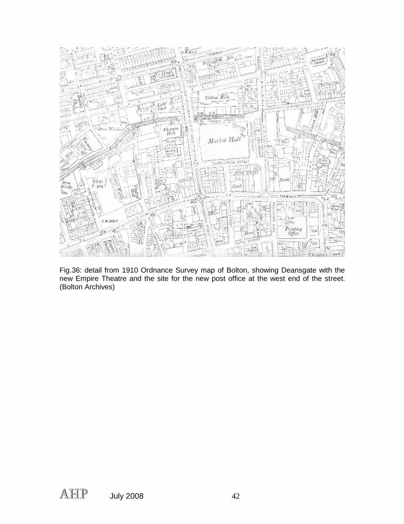
Fig.36: detail from 1910 Ordnance Survey map of Bolton, showing Deansgate with the new Empire Theatre and the site for the new post office at the west end of the street. (Bolton Archives)