Embed Size (px)
Citation preview

UNITED STATES DEPARTMENT OF THE INTERIOR
BUREAU OF LAND MANAGEMENT MEDFORD DISTRICT OFFICE ASHLAND RESOURCE AREA
REVISED ENVIRONMENTAL ASSESSMENT
For the DEADWOOD GRAZING ALLOTMENT
LEASE AUTHORIZATION
(DOI-BLM-OR-M060-2010-0028-EA)
List of Preparers Responsibility
Stephen Slavik Rangeland Management Specialist
Steve Godwin Wildlife Biologist
Jennifer Smith Fish Biologist
Ted Hass Soils Scientist
Tim Montfort Hydrologist
Dulcey Schuster Botanist NEPA Compliance
Anthony Kerwin NEPA Compliance
Location The Deadwood Allotment is located to the north and east of Howard Prairie Lake in T 38 S
R 3 E in Sections 10 11 12 13 14 and 15 WM T 38 S R 4E in Sections 7 17 18 19 20 21 25
26 27 28 29 30 32 33 34 and 35 WM T 39 S R 4 E in Sections 3 4 and 9 WM
Approximately 32 acres of the Deadwood Allotment are within the Cascade Siskiyou National Monument
(CSNM) located in the NE14NE14 of Section 9 Township 38 S Range 4E The entire allotment is
approximately 11890 acres and the BLM-managed portion of the allotment is 7972 acres
TABLE OF CONTENTS
CHAPTER 1 - PURPOSE AND NEED 4
CONFORMANCE WITH LAND USE PLANS amp LEGAL REQUIREMENTS 5 RELEVANT ASSESSMENTS AND PLANS 6
Deadwood Allotment Rangeland Health Assessment 6 Jenny Creek and South Fork Little Butte Creek Watershed Analysis 8 Water Quality Restoration Plan for the North and South Fork Little Butte Key Watershed 8
CHAPTER 2 - ALTERNATIVES 8
Common to All Grazing Alternatives 9 Grazing Management 9 Monitoring 10
ALTERNATIVE 1 (NO ACTION) 12 ALTERNATIVE 2 13 ALTERNATIVE 3 15 ALTERNATIVE 4 16 ALTERNATIVES CONSIDERED BUT ELIMINATED FROM FURTHER ANALYSIS 16
Range Improvement Projects by Maintenance Responsibility by Alternative 18 ALTERNATIVE COMPARISON 20
CHAPTER 3 - AFFECTED ENVIRONMENT amp ENVIRONMENTAL IMPACTS 20
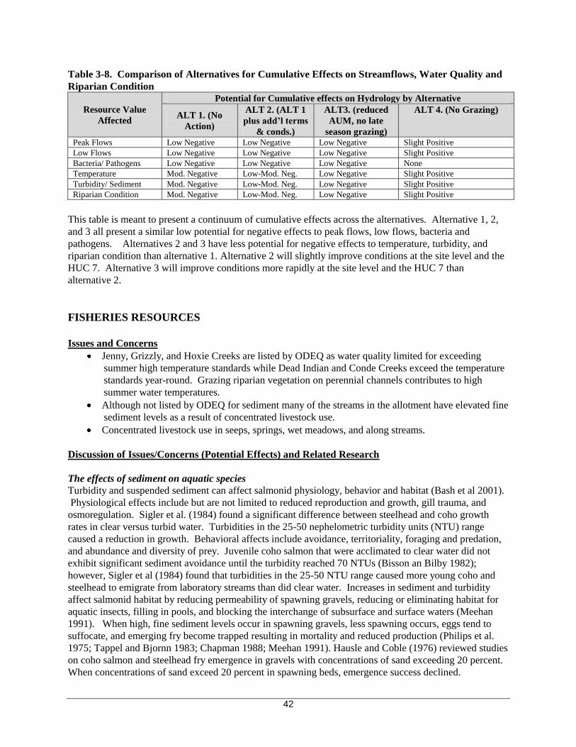
CONSIDERATION OF CUMULATIVE EFFECTS 22 RANGE RESOURCES 22
Affected Environment 262 Environmental Consequences 263
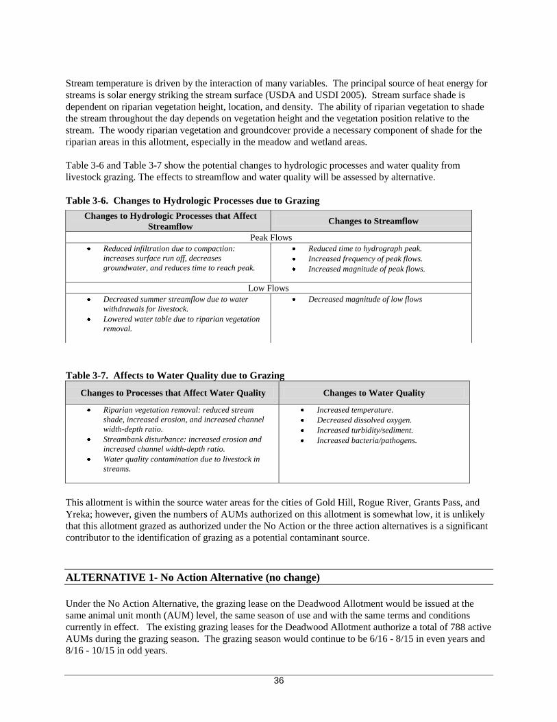
WATER RESOURCES 25 Affected Environment 27 Environmental Consequences 34
Alternative 1 (No Action) 35 Alternative 2 37 Alternative 3 38 Alternative 4 39
FISHERIES RESOURCES 41 Affected Environment 46 Environmental Consequences 48
Alternative 1 (No Action) 48 Alternative 2 49 Alternative 3 50 Alternative 4 50
AQUATIC CONSE RVATION STRATEGY (ACS) 50 TERRESTRIAL WILDLIFE 55
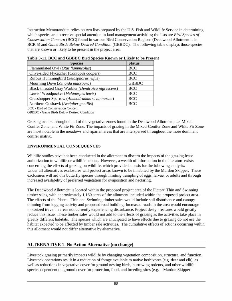
Affected Environment 55 Environmental Consequences 57
Alternative 1 (No Action) 58 Alternative 2 60 Alternative 3 61 Alternative 4 60
SOIL RESOURCES 60 Affected Environment 60 Environmental Consequences 61
Alternative 1 (No Action) 61 Alternative 2 62 Alternative 3 62 Alternative 4 62
i
BOTANY RESOURCES 62 Affected Environment 62 Environmental Effects 69
Alternative 1 (No Action) 70 Alternative 2 71 Alternative 3 72 Alternative 4 72
CULTURAL RESOURCES 73 RECREATIONAL AND VISUAL RESOURCES 73
CHAPTER 4 - PUBLIC PARTICIPATION 75
REFERENCES 76
i
CHAPTER 1 PURPOSE AND NEED
INTRODUCTION
The Bureau of Land Management (BLM) Ashland Resource Area proposes to renew the 10-year grazing
lease on the Deadwood Allotment This Revised Environmental Assessment (EA) documents the
environmental analysis conducted to estimate the site-specific effects on the human environment that may
result from the renewal of this lease The EA has been revised to clarify several factors that further support
the rationale for the proposed decision Changes are summarized here with associated page numbers to
allow the reader to easily find the clarifications
P 9 Objectives and brief history of the Deadwood Coordinated Range Management Plan (CRMP)
P 10 Clarification as to what will happen to the 32 acres of land within the bounds of the Cascade
Siskiyou National Monument (CSNM)
P 15 Adjustment of a term and condition to be in compliance with the CRMP and clarification of
the vehicle washing term and condition
P 53 Acknowledgment that livestock are not the only factor effecting the physical integrity of
aquatic ecosystems
P 59 The discussion of Franklinrsquos Bumblebee has been removed because the a species survey was
conducted in the vicinity of Howard Prairie Reservoir and Hyatt Lake prior to the decline of this
species and didnrsquot produce any individuals of this species The expert consulted explained that
there seems to be an invisible but real division created by the Sierra-Cascade crest and so this
species would not be affected by the grazing within the Deadwood grazing allotment (Robbin
Thorp Pers comm)
P 73 Clarification of ongoing noxious weed treatments within the Deadwood grazing allotment
The Bureau of Land Management is working cooperatively with the US Forest Service to manage a
deferred rotation grazing system in accordance with the 1972 Deadwood Coordinated Range Management
Plan (CRMP) The analysis documented in this EA will provide the BLM authorized officer the Ashland
Resource Area Field Manager with current information to aid in the decision-making process This EA
complies with the Council on Environmental Qualityrsquos (CEQ) Regulations for Implementing the
Procedural Provisions of the National Environmental Policy Act (NEPA 40 CFR Parts 1500-1508) and
the Department of the Interiorrsquos regulations on Implementation of the National Environmental Policy Act
of 1969 (43 CFR part 46)
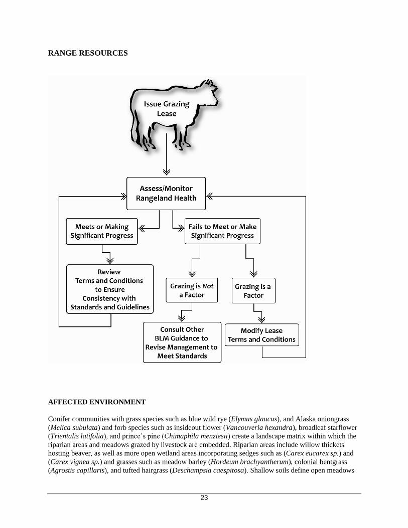
WHAT IS BLM PROPOSING amp WHY
The Medford BLM authorizes livestock grazing as a component of its multiple-use program under the
Federal Lands Policy and Management Act of 1976 (FLPMA) (43 USC sect 1701 et seq) The objectives
of the regulations set forth under 43 CFR 4100 Grazing Administration are to ldquoestablish efficient and
effective administration of public rangelandsrdquo so as to ldquoprovide for the sustainability of the western
livestock industry and communities dependent upon productive healthy public rangelandsrdquo Standards
for Rangeland Health and Guidelines for Livestock Grazing Management for Public Lands in Oregon and
Washington meets the requirements and intent of 43 CFR Subpart 4180 (Fundamentals of Rangeland
Health) and provide a basis for assessing the rangeland condition and trend
A Rangeland Health Assessment was completed for the Deadwood Allotment in April of 2008 assessing
the conditions and trends of the Deadwood Grazing Allotment against the Standards for Rangeland Health
A determination on the results of the assessment was made July 8 2008 and is summarized below under
4
Relevant Assessments amp Plans These documents are available on BLMrsquos Website
lthttpwwwblmgovordistrictsmedfordplansinventasphpgt The BLM determined that one of the five
standards Upland Watershed Function was being met The Standards for RiparianWetland Watershed
Function Ecological Processes Water Quality and Native T amp E and Locally Important Species were not
being met due in part to current livestock grazing management practices There is a need to develop
grazing management for the Deadwood Grazing Allotment that is operationally and administratively
feasible and addresses the requirements of 43 CFR 41801 which is to make progress towards meeting the
Standards for Rangeland Health in the Deadwood Grazing Allotment
The project area is defined as BLM-administered lands within the Deadwood Grazing Allotment The
analysis area is the area used to assess the effects to resources affected by the project proposal The
analysis area varies by resource
SCOPING AND ISSUES
Scoping is the name for the process used to determine the scope of the environmental analysis to be
conducted It is used early in the NEPA process to identify (1) the issues to be addressed (2) the depth of
the analysis and (3) potential environmental impacts of the action
Scoping has occurred for the Deadwood grazing lease authorization A notice for the Deadwood Grazing
Lease Renewal appeared in the Ashland Resource Arearsquos Schedule of Proposed Actions published in
Medfordrsquos Messenger (BLMrsquos quarterly newsletter) beginning in the fall 2008 edition Scoping letters
were sent on June 9 2009 to adjacent landowners and interested organizations and individuals
An interdisciplinary (ID) team of resource specialists reviewed the proposal and all pertinent information
including public input received and identified relevant issues to be addressed during the environmental
analysis The following questions frame the issues determined to be relevant to the Deadwood Grazing
Lease Renewal proposal These issues will be used to identify required terms and conditions and to focus
the analysis of environmental effects that may result from the implementation of BLMrsquos alternatives
What is the potential for effects to riparian and wetland areas and associated aquatic habitat
What is the potential for effects to water resources
What it the potential for effects to fish
What is the potential for effects to botanical resources
What is the potential for effects to wildlife
What is the potential for effects to soils and site productivity
DECISION FRAMEWORK
This Environmental Assessment will provide the information needed for the authorized officer the
Ashland Resource Area Field Manager to select an alternative for managing grazing in the Deadwood
Grazing Allotment The Ashland Resource Area Field Manager must decide which Alternative to
implement including the no-action alternative In choosing an alternative the Field Manager will consider
how well the alternative responds to the identified project needs along with the relative merits and
consequences of each alternative related to the relevant issues
5
The forthcoming grazing decision will document the authorized officerrsquos rationale for selecting a course of
action based on the effects documented in this EA The decision will also include a determination whether
or not the impacts of the proposed action are significant to the human environment If the impacts are
determined not to result in significant effects beyond those disclosed in the 1995 Final EIS or otherwise
determined to not be significant a Finding of No Significant Impact (FONSI) can be issued and a decision
implemented If this EA determines that the impacts are significant or not within the level of effects
identified in the EISs then a project specific Environmental Impact Statement (EIS) must be prepared
CONFORMANCE WITH LAND USE PLANS amp LEGAL REQUIREMENTS
The actions proposed and analyzed in this EA were developed to be consistent with andor tier to the
following documents
1 Final EISROD for the Medford District Resource Management Plan (RMP) (1995)
2 Final Supplemental Environmental Impact Statement and Record of Decision for Amendments to
Forest Service and Bureau of Land Management Planning Documents Within the Range of the
Northern Spotted Owl (Northwest Forest Plan FSEIS 1994 and ROD 1994)
3 Final SEIS for Amendment to the Survey amp Manage Protection Buffer and other Mitigation
Measures Standards and Guidelines (2000) and the ROD and Standards and Guidelines for
Amendment to the Survey amp Manage Protection Buffer and other Mitigation Measures Standards
and Guidelines (2001)
4 Medford District Integrated Weed Management Plan Environmental Assessment (1998) and tiered to
the Northwest Area Noxious Weed Control Program (EIS 1985)
The alternatives are compliant with the direction given for the management of public lands in the Medford
District by the Oregon and California Lands Act of 1937 (OampC Act) Federal Land Policy and
Management Act of 1976 (FLPMA) Endangered Species Act (ESA) of 1973 Clean Water Act (as
amended 1972 1981 1987 and 2002) Safe Drinking Water Act of 1974 (as amended 1986 and 1996)
Clean Air Act (as amended 1990) Archaeological Resources Protection Act of 1979 Taylor Grazing Act
(TGA) of 1934 Public Rangelands Improvement Act of 1978 and National Environmental Policy Act
(NEPA) of 1969
RELEVANT ASSESSMENTS amp PLANS
Deadwood Allotment Rangeland Health Assessment
The Standards for Rangeland Health provide a basis for assessing and monitoring ecological and rangeland
conditions and trends The five standards and associated criteria listed below were used to assess the
conditions and trends in the Deadwood Grazing Allotment Findings documented in the resulting
Deadwood Allotment Rangeland Health Determination provided a basis for formulating the BLMrsquos action
alternatives for renewing the Deadwood Grazing Leases The following is a brief summary of the
Deadwood Rangeland Health Determination
Standard 1 Watershed Function- Uplands
Upland soils exhibit infiltration and permeability rates moisture storage and stability that are appropriate
to soil climate and landform
Summary of finding Recovery from past fire and associated management activities together with
the limited influence of livestock at a landscape scale result in meeting the rangeland health
standard for upland watershed functions in the Deadwood Allotment
6
Standard 2 Watershed Function ndash RiparianWetland Areas
RiparianWetland areas are in properly functioning physical condition appropriate to soil climate and
landform
Summary of finding Several factors influence the functionality of riparian and wetland areas
Management practices including livestock grazing timber harvest road construction and water
withdrawals contribute to elevated fine sediment levels Lack of riparian shade elevated water
temperatures loss of connectivity aquatic habitat degradation and excessively low summer flows
prevent the attainment of the rangeland health standard for riparianwetland areas in the Deadwood
Allotment
Factors directly related to grazing include the degree of consumption of riparian vegetation the
degree of streambank trampling and the degree of disturbance in wet areas which all influence
water quality and temperature
Standard 3 Ecological Processes
Healthy productive and diverse plant and animal populations and communities appropriate to soil climate
and landform are supported by ecological processes of nutrient cycling energy flow and hydrologic cycle
Summary of finding Repeat fires of the early 20th century reservoirs salvage logging the
difficult reestablishment of conifer canopy and influence of livestock on meadow successional
and hydrological processes prevent the attainment of the rangeland health standard for ecological
processes
The lack of improvement in hydrological process indicated by cut-banks and deteriorating rills
across dry and wet meadows prevents meeting this standard
Standard 4 Water Quality
Surface water and groundwater quality influenced by agency actions complies with state water quality
standards
Summary of finding Several factors influence water quality in this allotment Management
practices including livestock grazing timber harvest road construction and water withdrawals
contribute to elevated fine sediment levels lack of riparian shade elevated water temperatures
loss of connectivity aquatic habitat degradation and excessively low summer flows
This allotment is not meeting this standard because livestock are negatively affecting stream
temperature establishment of riparian vegetation stabilization of streambanks sediment regimes
and water quality
Standard 5 Native Threatened and Endangered and Locally Important Species
Habitats support healthy productive and diverse populations and communities of native plants and animals
(including special status species and species of local importance) appropriate to soil climate and landform
Summary of finding The distribution of noxious weeds within the allotment is primarily limited to
roadsides There are no threatened and endangered (TampE) plant species and two species of District
Sensitive plants within the Deadwood allotment Existing data (although limited) indicates that
livestock are not significantly influencing vegetation as it pertains to the ldquoNative TampE and
Locally Important Speciesrdquo rangeland health standard of the Deadwood Allotment
For aquatic species grazing negatively effects aquatic mollusks and their habitat by disturbing the
soil removing vegetation that provides shade and habitat for the mollusks and by trampling the
mollusks themselves
7
Several BLM Special Status terrestrial wildlife species are negatively affected by the grazing in the
Deadwood allotment The moderate to severe average utilization (RHA p3) in the riparian areas
and ldquowet meadowsrdquo produces the greatest negative impacts to native wildlife species The foothill
yellow-legged frog and northwestern pond turtle (BLM sensitive species) are dependent on
riparian and aquatic habitat and are negatively affected when these habitats are degraded by cattle
Habitat degradation occurs through streambank trampling and wading in shallow ponds springs
and streams
A complex of wet meadows in the allotment is occupied by the Mardon skipper a federal candidate
species These meadows are heavily grazed in most years which reduces the height and potentially
(depending on the species) percent cover of plants used by this species for nectaring and ovipositing
The impact of grazing to these habitat components likely reduces reproduction for this species The
primary threat listed for each of these sites is grazing (Xerces 2007 2010 Hosten 2007c)
Watershed Analysis (USDIUSDA 1997)
Watershed Analysis is a procedure used to characterize conditions processes and functions related to
human aquatic riparian and terrestrial features within a watershed Watershed analysis is issue driven
Analysis teams of resource specialists identify and describe ecological processes of greatest concern in a
particular ldquofifth fieldrdquo watershed and recommend restoration activities and conditions under which other
management activities should occur Watershed analysis is not a decision making process Rather
watershed analysis provides information and non-binding recommendations for agencies to establish the
context for subsequent planning project development regulatory compliance and agency decisions (See
Federal Guide for Watershed Analysis 1995 p 1)
The Deadwood Grazing Allotment falls within the Jenny Creek and South Fork Little Butte Creek
Watershed Analysis Areas Watershed analysis focused on the use of existing information available at the
time the analysis was conducted and provides baseline information Additional information determined to
be necessary for completing an analysis of this grazing lease proposal has been collected and is considered
along with existing information provided by the 1995 Jenny Creek and 1997 Little Butte Creek Watershed
Analyses Management Objectives and Recommendations provided by watershed analysis were
considered and addressed as they applied to the Deadwood Grazing Lease Renewal
Water Quality Restoration Plan
The BLM is recognized by Oregon Department of Environmental (DEQ) as a Designated Management
Agency for implementing the Clean Water Act on BLM-administered lands in Oregon The BLM has
signed a Memorandum of Agreement (MOA) with the DEQ that defines the process by which the BLM
will cooperatively meet State and Federal water quality rules and regulations
To comply with the BLM-DEQ Memorandum of Agreement the BLM completed Water Quality
Restoration Plans (WQRPs) for the Jenny Creek Key Watershed and the North and South Forks Little
Butte Key Watershed These documents describe how the Bureau of Land Management (BLM) will meet
Oregon water quality standards for 303(d) listed streams on BLM-administered lands within the above
referenced watersheds The Water Quality Restoration Plans are designed to be consistent with the DEQs
Water Quality Management Plans Proposed recovery goals in the WQRPs focus on protecting areas
where water quality meets standards and avoiding future impairments of these areas and restoring areas
that do not currently meet water quality standards
The water quality restoration plan (WQRP) for BLM-administered lands in the Jenny Creek Watershed
(USDI 2008) was submitted to the DEQ in May 2008 prior to the release by DEQ of the Upper Klamath
and Lost River subbasins total maximum daily load (TMDL) and water quality management plan
8
(WQMP) After the final TMDL was released in December 2010 BLM re-submitted the WQRP with
edits for review by DEQ A TMDL defines the amount of pollution that can be present in the waterbody
without causing water quality standards to be violated BLMrsquos Water Quality Restoration Plan for the
North and South Forks Little Butte Key Watershed was submitted to the DEQ and finalized in May of
2006 The Rogue Basin Water Quality Management Plan and TMDLs are posted on DEQs website
httpwwwdeqstateorusWQTMDLsroguehtm
CHAPTER 2 ALTERNATIVES
INTRODUCTION
This chapter describes the No Action Alternative which would continue the existing lease two Action
Alternatives developed by the Interdisciplinary (ID) Team to achieve objectives identified in the Purpose
and Need statement in Chapter 1 and an alternative that defers grazing for 10 years A No Action
alternative which assumes a continuance of the existing lease is presented to form a base line for analysis
Lease Terms and Conditions included as required features of Alternatives 1 2 and 3 are important for
reducing impacts of grazing and considered in the analysis of anticipated environmental impacts
Common to All Grazing Alternatives
GRAZING MANAGEMENT
It is mandatory under all alternatives that Terms and Conditions would be met by the lessees If it is
determined by the BLM at any time that a lessee is not meeting their required Terms and Conditions
corrective measures would be implemented Corrective measures would include consulting with the
responsible lessee and may include withholding the annual use authorization temporary or permanent
reductions in AUMs or lease cancellation Failure to maintain range improvements to BLM standards
could result in an evaluation for damages and compensation to cover maintenance deficiencies based on
non-compliance with lease Terms and Conditions and other penalties defined in 43 CFR 4170 Penalties
Deadwood Allotment Coordinated Range Management Plan (CRMP)
The Deadwood Allotment CRMP is a management plan and agreement between the USFS BLM private land owners and the lessees of the Deadwood grazing allotment The objectives of the Deadwood CRMP are
A To develop and implement a grazing system for an area which is divided by agency and
private land boundaries but can be more effectively managed as a single unit
B To obtain better utilization of the forage resource thru the application of a grazing system
which will allow earlier and more complete use without damaging the forage plants
C To enable better coordination with other management practices such as reforestation and land
treatment projects which often require close coordination with the pattern of grazing use
Approximately eleven miles of fencing separates Bureau of Land Management Forest Service and private
lands These fences make a deferred-rotation system of grazing possible The divide fence was
reconstructed in the late 90rsquos The design assumed animals would be held in place by proximity to water
Dry upland areas were not fenced as effectively as lower elevations but proved to be places where livestock
were moving from Forest Service lands to BLM lands through breaks in the fence opened gates and in
places where either maintenance was lacking or design was ineffective In addition there was some
confusion amongst lessees on maintenance responsibilities that needed clarification
9
In 2008 the divide fence was thoroughly inspected and through cooperative efforts of the lessees and BLM
maintenance was brought up to fully functional expectations which improved grazing control Monitoring
of grazing conditions (9209 101309 and 102709) after improvements to the division fence and other
improvements and strict adherence to grazing seasons vegetation showed recovery and trampling and
instability of streambanks in riparian areas was reduced that were previously noted as having livestock
caused impacts Meetings were held with lessees and maintenance responsibilities and requirements were
clearly defined Compliance checks in 2010 and 2011 indicate that maintenance is now being conducted
on range improvements adequately and impacts to concern areas have diminished in conformance to the
CRMP expectations
Allotment Lands within the Boundary of the Cascade Siskiyou National Monument (CSNM)
The 32 acres that are within the bounds of the CSNM would be removed from the Deadwood grazing
allotment by adjusting the allotment boundary to the section line along the northern edge of T 38S R4E
Section 9 The boundary adjustment would be done to ensure management of the 32 acres is consistent
with management of other CSNM lands and to keep management considerations associated with the
monument from impinging on the greater area of the Deadwood Allotment At this time review of
livestock movement and utilization data indicates the parcel receives no use by livestock due to low
quantities of palatable forage no available drinking water and most of all steep heavily timbered slopes
that livestock rarely travel through If utilization data indicates that livestock grazing is occurring on this 32
acre parcel then a fence would be constructed to prevent unauthorized livestock use
Protective Exclosure
Under all alternatives exclusion of grazing would occur at two exclosures to protect areas known to be
inhabited by the mardon skipper a species that is a federal candidate for listing under the Endangered
Species Act Under the Bureau Special Status Species Policy (BLM Handbook 6840 2008) candidate
species are to be managed as Sensitive Species Both exclosures are located in T 39S R 4E Section 17
One exclosure is approximately 1 acre in size and the second is approximately 6 acres in size around an
existing water development (project 750355) which would prevent access by livestock Livestock would be
allowed to access the water development portion of the exclosure in years when the allotment is grazed late
season (August 16 to October 15)
Noxious Weed Management
Documented Noxious weed populations would continue to be treated as prescribed in the 1995 RMP and
Medford District Integrated Weed Management Plan Environmental Assessment (1998)
Education and Outreach Measures
The BLM is striving to more fully integrate all BLM programs and activities into actions which will
improve the quality and ecological conditions of lands under the BLM management To aid in meeting the
objective set forth in the BLM Manual 9015 Integrated Weed Management (901506) it is recommended
by the Ashland Resource Area Noxious Weed Specialist that lessees feed livestock certified weed-free
feed for no fewer than 3 days prior to the livestock turnout date provided livestock are being moved from
privately-owned land to lands within the Deadwood allotment area
To provide for cooperative weed management opportunities the Medford BLM Range program would
include noxious weed information with the annual grazing application to ensure lesseersquos receipt of current
information regarding noxious weed species of concern
10
MONITORING
As funding and priorities allow periodic monitoring would be conducted to ensure management objectives
are met or moving toward meeting the Standards for Rangeland Health and Guidelines for Livestock
Grazing Management for Public Lands Administered by the Bureau of Land Management in the States of
Oregon and Washington The following monitoring strategy would apply to Alternatives 1-3 The BLM
currently conducts periodic inventories and observations to measure long-term resource condition changes
Trend
Trend monitoring using BLM protocol (TR 4400-4 1985) consists of data collection at 2 established
Nested Plot Frequency Transect study sites on an approximately 5-year interval BLM has evaluated
current monitoring data and determined trend sites are appropriately located and additional monitoring
location(s) would be valuable if funding allows
Upland Utilization
Areas have been selected for conducting key upland forage species utilization studies Methods currently
used on the Deadwood allotment are the Key Species Method and Mapping Use Zones using BLM
technical reference Utilization Studies and Residual Measurements (Cooperative Extension Service et al
1999)
HydrologicRiparian and Photo Point Surveys
These surveys are conducted using the Ashland Resource Area Stream Survey Protocol Location flow
duration channel classificationmorphology data is gathered for streams wetlands and other hydrologic
features In addition data is collected in regards to instream large wood impact descriptions and
restoration opportunities especially as it relates to livestock transportation and vegetation Properly
functioning condition (PFC) is assessed during the surveys On BLM lands within the allotment data was
collected in the Upper Jenny Creek and South Fork Little Butte-Dead Indian Creeks Subwatersheds in
1996 and 2002 Some of the reaches around Howard Prairie Lake were revisited and updated in 2006
Riparian photo monitoring sites have been installed at ten locations within the allotment to document
changes in riparian areas (BLM Ashland Fisheries and Range Photo Monitoring 1988-2007)
Baseline Stream Temperature Monitoring
Seasonal 30-minute interval stream temperature data is collected within the allotment using USGS and
Oregon DEQ-established methodologies Temperature monitoring data assists in assessment of Aquatic
Conservation Strategy (ACS) Objectives 2 4 and 9 (USDAUSDI 1994b) for assessment of compliance
with state water quality standards and assists in development of State of OregonEPA-required Water
Quality Management Plans for the area
Stream Channel Cross Sections
Stream cross-section measurements occur within the allotment Measurement methodologies include
standard cadastral survey techniques and those outlined in Rosgen (1996) Sites are measured at
approximately five-year intervals and after major flood events Cross-sections provide a reference point
from which to document changes in channel morphology conduct flow measurements and estimate flood
flows Documentation of changes in channel morphology provides an indication of stability and
functioning of the upstream surface hydrologic system
Rain Gages
Rainfall data is collected at 15-minute intervals at one site in lower Jenny Creek using a tipping bucket rain
gage Daily precipitation is collected at Howard Prairie Dam (NOAA) Parker Mountain (RAWS) and
11
Buckhorn Springs (RAWS) Daily snowfall and snow-on-the-ground is collected at Howard Prairie Dam
(NOAA) Assessment of hydrologic response and water quality parameters as well as many other aspects
of ecosystem function can only be analyzed accurately in the context of recent precipitation Although
year-to-year trends in precipitation tend to be uniform over an area the size of the Deadwood Allotment
there is substantial variability in precipitation between locations based on terrain elevation etc
Precipitation data from a number of sites at varying elevations and locations in and around the allotment is
needed for interpretation of related data including hydrologic and vegetation conditions
Special Status Species Wildlife
Mardon Skipper Butterfly
As funding permits continue cooperative surveys with Xerces Society using day-count monitoring
techniques at known Mardon Skipper habitat in Section 17 Township 39 S Range 4 E and throughout
the allotment to establish trend information In Section 17 at two high-population sites two exclosure
fences would protect Mardon skipper habitat by excluding grazing activities at those locations Day-counts
would be conducted by the Xerces Society to determine if the exclosures enhance population numbers in
ungrazed habitat areas BLMs objective is to reduce impacts that may harm the Mardon skipper or its
habitat to prevent the need to be listed as a Threatened or Endangered species
Aquatic Macroinvertebrate Monitoring
Macroinvertebrate monitoring is conducted at one site in this allotment using methods that meet or exceed
state or EPA protocols for the sampling of benthic macroinvertebrates Taxa abundance taxa richness and
other metrics are measured at 5-6 year intervals These surveys were conducted at Jenny Creek Spring in
1991 1995 and 2000 (Aquatic Biology Associates) Pebblesnail surveys were conducted at seven sites in
the allotment (BLM 1999-2005) Two springs were sampled for aquatic mollusk presence species data
and livestock impacts (Frest and Johannes 2005 BLM 1999-2006) Livestock grazing was measured by a
combination of factors (stubble height trampling feces bank destabilization and bare ground) and was
rated on a scale with the same range as follows 1- nil or nearly so 2- light 3- moderate 4-heavy 5shy
severe These are not quantitative measures but attempts to divide a complex range continuum often multishy
faceted in cause into more or less proportionate segments (Frest and Johannes 2005)
Additional Monitoring
The following monitoring strategy would apply to Alternatives 2 and 3 Monitoring would occur at
riparian areas of concern currently evaluated as Functioning at Risk with a Downward Trend or Not
Functioning as well as other riparian areas that are currently evaluated as Functioning at Risk with an
Upward Trend or Properly Functioning Monitoring sites will be chosen in the field in cooperation with
the lessees
Riparian Utilization
Stubble heights would be measured for conformance with Terms and Conditions at key riparian areas
representative of use in accordance with BLM protocol The key species for each of these sites would be
selected at the same time BLM specialists will select areas representative of use as an indication of
potential concernsimprovements not an average for the stream within the allotment (Cowley and Burton
2004)
Riparian Functionality
Streambank alteration would be measured for conformance with Terms and Conditions at key riparian
areas in accordance with BLM protocol
12
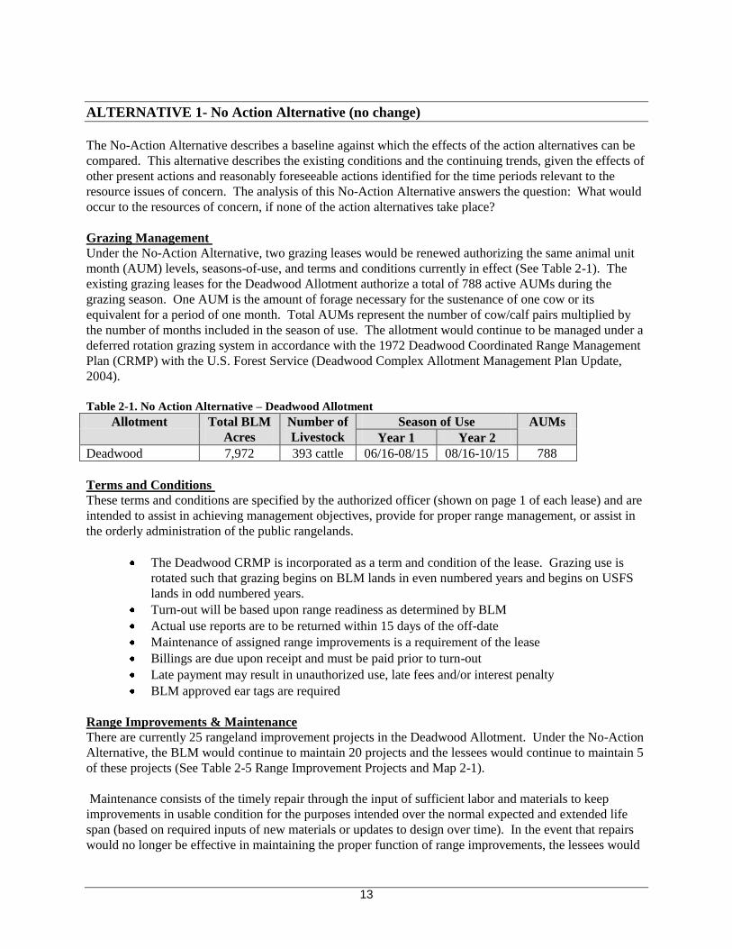
ALTERNATIVE 1- No Action Alternative (no change)
The No-Action Alternative describes a baseline against which the effects of the action alternatives can be
compared This alternative describes the existing conditions and the continuing trends given the effects of
other present actions and reasonably foreseeable actions identified for the time periods relevant to the
resource issues of concern The analysis of this No-Action Alternative answers the question What would
occur to the resources of concern if none of the action alternatives take place
Grazing Management
Under the No-Action Alternative two grazing leases would be renewed authorizing the same animal unit
month (AUM) levels seasons-of-use and terms and conditions currently in effect (See Table 2-1) The
existing grazing leases for the Deadwood Allotment authorize a total of 788 active AUMs during the
grazing season One AUM is the amount of forage necessary for the sustenance of one cow or its
equivalent for a period of one month Total AUMs represent the number of cowcalf pairs multiplied by
the number of months included in the season of use The allotment would continue to be managed under a
deferred rotation grazing system in accordance with the 1972 Deadwood Coordinated Range Management
Plan (CRMP) with the US Forest Service (Deadwood Complex Allotment Management Plan Update
2004)
Table 2-1 No Action Alternative ndash Deadwood Allotment
Allotment Total BLM Number of Season of Use AUMs
Acres Livestock Year 1 Year 2
Deadwood 7972 393 cattle 0616-0815 0816-1015 788
Terms and Conditions
These terms and conditions are specified by the authorized officer (shown on page 1 of each lease) and are
intended to assist in achieving management objectives provide for proper range management or assist in
the orderly administration of the public rangelands
The Deadwood CRMP is incorporated as a term and condition of the lease Grazing use is
rotated such that grazing begins on BLM lands in even numbered years and begins on USFS
lands in odd numbered years
Turn-out will be based upon range readiness as determined by BLM
Actual use reports are to be returned within 15 days of the off-date
Maintenance of assigned range improvements is a requirement of the lease
Billings are due upon receipt and must be paid prior to turn-out
Late payment may result in unauthorized use late fees andor interest penalty
BLM approved ear tags are required
Range Improvements amp Maintenance
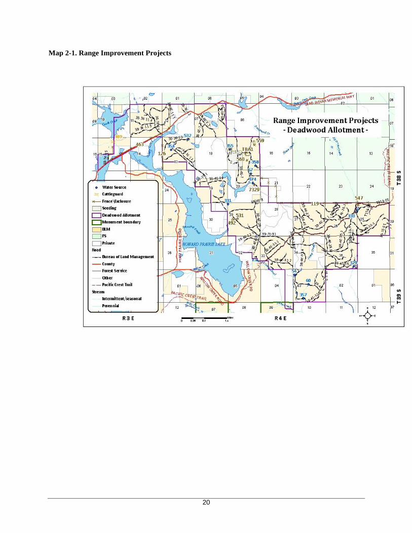
There are currently 25 rangeland improvement projects in the Deadwood Allotment Under the No-Action
Alternative the BLM would continue to maintain 20 projects and the lessees would continue to maintain 5
of these projects (See Table 2-5 Range Improvement Projects and Map 2-1)
Maintenance consists of the timely repair through the input of sufficient labor and materials to keep
improvements in usable condition for the purposes intended over the normal expected and extended life
span (based on required inputs of new materials or updates to design over time) In the event that repairs
would no longer be effective in maintaining the proper function of range improvements the lessees would
13
notify the BLM to determine replacement needs
Fence maintenance includes annual inspection by the lessee to meet BLM standards for functionality
(including design and materials) keeping wire properly attached to posts keeping stays functional
repairing structures gates drainage crossings splicing broken wire replacing segments of wire when worn
out and any other work necessary to keep fences functional
Maintenance for springs pipelines and troughs includes annual inspection repair or replacement of worn
or damaged parts repair of leaks removing trash or silt winterizing the facility and maintaining wildlife
escape ramps
In the event maintenance performance is not done to meet the BLM standard the BLM may opt to seek
damages for repairs from the lessee responsible and take further punitive actions according to 43 CFR
4170 Penalties which may include withholding the annual use authorization temporary or permanent
reductions in AUMs or lease cancellation
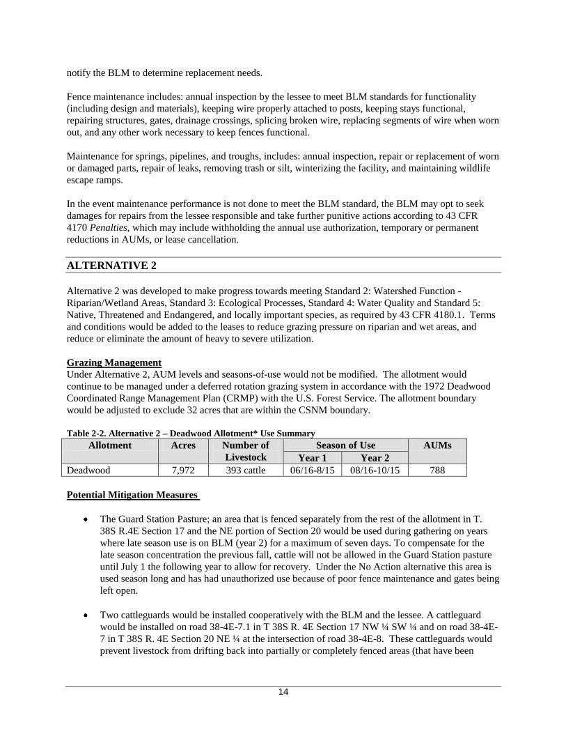
ALTERNATIVE 2
Alternative 2 was developed to make progress towards meeting Standard 2 Watershed Function shy
RiparianWetland Areas Standard 3 Ecological Processes Standard 4 Water Quality and Standard 5
Native Threatened and Endangered and locally important species as required by 43 CFR 41801 Terms
and conditions would be added to the leases to reduce grazing pressure on riparian and wet areas and
reduce or eliminate the amount of heavy to severe utilization
Grazing Management
Under Alternative 2 AUM levels and seasons-of-use would not be modified The allotment would
continue to be managed under a deferred rotation grazing system in accordance with the 1972 Deadwood
Coordinated Range Management Plan (CRMP) with the US Forest Service The allotment boundary
would be adjusted to exclude 32 acres that are within the CSNM boundary
Table 2-2 Alternative 2 ndash Deadwood Allotment Use Summary
Allotment Acres Number of Season of Use AUMs
Livestock Year 1 Year 2
Deadwood 7972 393 cattle 0616-815 0816-1015 788
Potential Mitigation Measures
The Guard Station Pasture an area that is fenced separately from the rest of the allotment in T
38S R4E Section 17 and the NE portion of Section 20 would be used during gathering on years
where late season use is on BLM (year 2) for a maximum of seven days To compensate for the
late season concentration the previous fall cattle will not be allowed in the Guard Station pasture
until July 1 the following year to allow for recovery Under the No Action alternative this area is
used season long and has had unauthorized use because of poor fence maintenance and gates being
left open
Two cattleguards would be installed cooperatively with the BLM and the lessee A cattleguard
would be installed on road 38-4E-71 in T 38S R 4E Section 17 NW frac14 SW frac14 and on road 38-4Eshy
7 in T 38S R 4E Section 20 NE frac14 at the intersection of road 38-4E-8 These cattleguards would
prevent livestock from drifting back into partially or completely fenced areas (that have been
14
grazed) at locations where gates are often left opened during the grazing season Installing
cattleguards would improve the distribution within the allotment and reduce or eliminate
unauthorized use
Terms and Conditions
This alternative would include the following Terms and Conditions Modifications of the current Terms
and Conditions are proposed to ensure progress toward meeting the Standards for Rangeland Health
The Deadwood CRMP is incorporated as a term and condition of the lease Grazing use is
rotated such that grazing begins on BLM lands in even numbered years and begins on USFS
lands in odd numbered years
Turn-out would be based upon range readiness
Actual use reports are to be returned within 15 days of off-date
Billings are due upon receipt and must be paid prior to turn-out
Late payment may result in unauthorized use late fees andor interest penalty
Lessees are expected to commit continuous day-long riding and gathering efforts necessary to
effectively locate and remove all livestock by the annual authorization period In even
numbered years 75 of livestock must be rotated to the USFS Deadwood Allotment by 816
and the remaining 25 would be rotated by 823 Any livestock not rotated or returning to the
early season (BLM) allotment would be removed within 3 days of notification
Lessees are expected to remove 95 of their cows by the late season take-off date Grazing
use (greater than 5 of the cows) after the take-off date will result in unauthorized use fees for
forage consumed a 20 reduction in AUMs and termination of the late season grazing period
until such time as progress toward meeting standards is achieved in accordance with the
provisions of 43 CFR part 4180
An average stubble height of 5 inches with no more than 20 livestock caused bank alteration
will be maintained in riparian areas of concern and would be seeded by BLM using native
seed mixtures when native seed and workforce are available
BLM approved ear tags may be a requirement of the lease
Lessees will conduct active management practices such as herding to promote livestock
distribution to reduce grazing use in riparian areas
Saltmineral blocks will be placed at hardened locations at least frac14 mile from streams springs
seeps or other wetlands with riparian vegetation special status species and recreation areas
and will be rotated to promote livestock distribution and movements into areas where
utilization levels are low
Lessees are expected to annually commit labor materials andor funds necessary to keep
improvements fully functional prior to livestock turn-out for the duration of the lease
including during periods of approved nonuse
To prevent the spread of invasive species all vehicles that have travelled through a weed
infested area shall be washed prior to entry onto BLM-administered lands Washing must
remove all mud dirt excrement and vegetative debris from vehicles
Range Improvements amp Maintenance
Under Alternative 2 maintenance responsibilities for 9 range improvement projects would be transferred
to the lessees with responsibilities divided amongst the lessees (Table 2-5 Alternative 2) A new
maintenance agreement will be developed after lease renewal has taken place formalizing maintenance
responsibilities for each lessee The requirements for maintenance and associated penalties would be the
same as described under Alternative 1
15
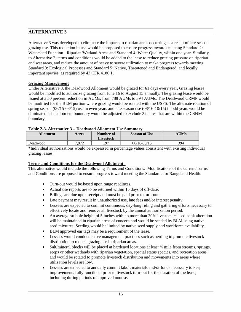
ALTERNATIVE 3
Alternative 3 was developed to eliminate the impacts to riparian areas occurring as a result of late-season
grazing use This reduction in use would be proposed to ensure progress towards meeting Standard 2
Watershed Function - RiparianWetland Areas and Standard 4 Water Quality within one year Similarly
to Alternative 2 terms and conditions would be added to the lease to reduce grazing pressure on riparian
and wet areas and reduce the amount of heavy to severe utilization to make progress towards meeting
Standard 3 Ecological Processes and Standard 5 Native Threatened and Endangered and locally
important species as required by 43 CFR 41801
Grazing Management
Under Alternative 3 the Deadwood Allotment would be grazed for 61 days every year Grazing leases
would be modified to authorize grazing from June 16 to August 15 annually The grazing lease would be
issued at a 50 percent reduction in AUMs from 788 AUMs to 394 AUMs The Deadwood CRMP would
be modified for the BLM portion where grazing would be rotated with the USFS The alternate rotation of
spring season (0615-0815) use in even years and late season use (0816-1015) in odd years would be
eliminated The allotment boundary would be adjusted to exclude 32 acres that are within the CSNM
boundary
Table 2-3 Alternative 3 ndash Deadwood Allotment Use Summary
Allotment Acres Number of
Livestock
Season of Use AUMs
Deadwood 7972 197 0616-0815 394
Individual authorizations would be expressed in percentage values consistent with existing individual
grazing leases
Terms and Conditions for the Deadwood Allotment
This alternative would include the following Terms and Conditions Modifications of the current Terms
and Conditions are proposed to ensure progress toward meeting the Standards for Rangeland Health
Turn-out would be based upon range readiness
Actual use reports are to be returned within 15 days of off-date
Billings are due upon receipt and must be paid prior to turn-out
Late payment may result in unauthorized use late fees andor interest penalty
Lessees are expected to commit continuous day-long riding and gathering efforts necessary to
effectively locate and remove all livestock by the annual authorization period
An average stubble height of 5 inches with no more than 20 livestock caused bank alteration
will be maintained in riparian areas of concern and would be seeded by BLM using native
seed mixtures Seeding would be limited by native seed supply and workforce availability
BLM approved ear tags may be a requirement of the lease
Lessees would conduct active management practices such as herding to promote livestock
distribution to reduce grazing use in riparian areas
Saltmineral blocks will be placed at hardened locations at least frac14 mile from streams springs
seeps or other wetlands with riparian vegetation special status species and recreation areas
and would be rotated to promote livestock distribution and movements into areas where
utilization levels are low
Lessees are expected to annually commit labor materials andor funds necessary to keep
improvements fully functional prior to livestock turn-out for the duration of the lease
including during periods of approved nonuse
16
To prevent the further spread of nonnative species in the allotment vehicles used for livestock
transport and herding (trailers trucks all-terrain vehicles [ATVs]) and all motorized vehicles
intended for use off of established roadways must be power-washed prior to entry onto BLM-
administered lands Washing must remove all mud dirt excrement and vegetative debris
from vehicles
Range Improvements amp Maintenance
Under Alternative 3 maintenance responsibilities for 9 range improvement projects would be transferred
to the lessees with responsibilities divided amongst the lessees (Table 2-5) A new maintenance
agreement will be developed after leases renewal has taken place formalizing maintenance responsibilities
for each lessee and will be addressed as part of the maintenance of range improvements term and condition
in each alternative The requirements for maintenance and associated penalties would be the same as
described under Alternative 1
ALTERNATIVE 4
This alternative would rest the Deadwood allotment for a period of 10 years This alternative serves to
speed up the recovery of ecological conditions on BLM-administered lands impacted by past grazing
where the potential for recovery exists
Grazing Management
In accordance with 43 CFR 41103-3 active use of the allotment would terminate at the close of the 2011
grazing season The Deadwood CRMP would be modified for the BLM portion where grazing would not
be rotated with the US Forest Service Deadwood Allotment At the end of the 10 years the allotment
would be available for grazing and rangeland health conditions would be reevaluated at that time
Table 2-4 Alternative 4 Deadwood Allotment Use Summary
Allotment Acres Number of
Livestock
Season of Use AUMs
Deadwood 7972 0 cattle Rest 0
Terms and Conditions
No Terms or Conditions would be required as no lease authorizations to graze would be issued
ALTERNATIVES CONSIDERED BUT ELIMINATED FROM FURTHER ANALYSIS
This section describes actions andor alternatives that were considered during analysis but were eliminated
from detailed analysis
Riparian Fencing Riparian fencing to protect springs seeps and riparian areas or develop riparian
pastures was considered as part of Alternatives 2 and Alternative 3
Rationale for Elimination BLM installed (approximately 25 miles of) improved fenceline (project
750119) which improved grazing control Monitoring of grazing conditions during recent field visits
(9209 101309 and 102709) showed vegetative recovery in riparian areas after improvements to
existing fenceline (in T 38S R 4E Section 20) and strict adherence to grazing seasons In previous years
stubble heights less than four inches were observed in the Deadwood Allotment primarily in the Grizzly
Creek Moon Prairie and Hoxie Creek areas Riparian grazing recommendations suggest that four to six
17
inches of forage stubble height should remain on streamside areas at the end of the growing season after
fall frost to limit potential impacts to the herbaceous plant community the woody plant community and
streambank stability (Clary 1999) When terms and conditions are followed and use occurs during
authorized periods riparian vegetation consumption and associated bank disturbance is limited even in the
late season when water availability is limited The high cost of constructing and maintaining additional
fences around all riparian areas is not a reasonable alternative when areas of concern for vegetative
recovery streambank recovery sedimentation and rangeland health conditions are limited to a few areas
and were primarily a result of use that was occurring outside of the authorized grazing season
18
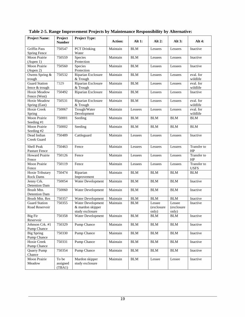
Table 2-5 Range Improvement Projects by Maintenance Responsibility by Alternative
Project Name Project
Number
Project Type Action Alt 1 Alt 2 Alt 3 Alt 4
Griffin Pass
Spring Fence
750547 PCT Drinking
Water
Maintain BLM Lessees Lessees Inactive
Moon Prairie
(Aspen 1)
750559 Species
Protection
Maintain BLM Lessees Lessees Inactive
Moon Prairie
(Aspen 2)
750560 Species
Protection
Maintain BLM Lessees Lessees Inactive
Owens Spring amp
trough
750532 Riparian Exclosure
amp Trough
Maintain BLM Lessees Lessees eval for
wildlife
Guard Station
fence amp trough
7329 Riparian Exclosure
amp Trough
Maintain BLM Lessees Lessees eval for
wildlife
Hoxie Meadow
Fence (West)
750492 Riparian Exclosure Maintain BLM Lessees Lessees Inactive
Hoxie Meadow
Spring (East)
750531 Riparian Exclosure
amp Trough
Maintain BLM Lessees Lessees eval for
wildlife
Hoxie Creek
Spring
750067 TroughWater
Development
Maintain Lessees Lessees Lessees eval for
wildlife
Moon Prairie
Seeding 1
750001 Seeding Maintain BLM BLM BLM BLM
Moon Prairie
Seeding 2
750002 Seeding Maintain BLM BLM BLM BLM
Dead Indian
Creek Guard
750489 Cattleguard Maintain Lessees Lessees Lessees Inactive
Shell Peak
Pasture Fence
750463 Fence Maintain Lessees Lessees Lessees Transfer to
HP
Howard Prairie
Fence
750126 Fence Maintain Lessees Lessees Lessees Transfer to
HP
Moon Prairie
Fence
750119 Fence Maintain Lessees Lessees Lessees Transfer to
USFS
Hoxie Tributary
Rock Dams
750474 Riparian
Improvement
Maintain BLM BLM BLM BLM
Jenny Crk
Detention Dam
750054 Water Development Maintain BLM BLM BLM Inactive
Brush Mtn
Detention Dam
750060 Water Development Maintain BLM BLM BLM Inactive
Brush Mtn Res 750357 Water Development Maintain BLM BLM BLM Inactive
Guard Station
Road Reservoir
750355 Water Development
amp mardon skipper
study exclosure
Maintain BLM Lessee
(exclosure
only)
Lessee
(exclosure
only)
Inactive
Big Fir
Reservoir
750358 Water Development Maintain BLM BLM BLM Inactive
Johnson Crk 1
Pump Chance
750329 Pump Chance Maintain BLM BLM BLM Inactive
Big Spring
Pump Chance
750330 Pump Chance Maintain BLM BLM BLM Inactive
Hoxie Creek
Pump Chance
750331 Pump Chance Maintain BLM BLM BLM Inactive
Quarry Pump
Chance
750354 Pump Chance Maintain BLM BLM BLM Inactive
Moon Prairie
Meadow
To be
assigned
(TBA1)
Mardon skipper
study exclosure
Maintain BLM Lessee Lessee Inactive
19
Map 2-1 Range Improvement Projects
20
ALTERNATIVE COMPARISON
Table 2-6 Comparison of Alternatives Comparison
Factor
Alternative 1
(No Action)
Alternative 2 Alternative 3 Alternative 4
Number of Cattle 393 393 197 0
Season-of-Use 0616-0815 or
0816-1015
0616-0815 or
0816-1015
0616-0815 No grazing for 10shy
years
Total AUMs
788 788 394
50 reduction
0
Days on the
Allotment
61 61 61 0
Grazing Rotation Deferred grazing-
rotated with USFS
Deferred grazing-rotated
with USFS
Early Season only None
Rangeland
Improvement
Responsibility
BLM
Lessee
20
5
11
14
11
14
3 transfer to USFS
3
0
Terms amp
Conditions
Same 7 Terms and
Conditions as previous
lease
7 Additional Terms amp
Conditions including
75 of livestock must be
rotated by the rotation
date 100 within 2
weeks
Reduce AUMs by 20 for
late livestock removal
Retain average 5rdquo stubble
height in key riparian
areas
Wash vehicles to prevent
weed dispersal
5 Additional Terms amp
Conditions including
Retain average 5rdquo stubble
height in key riparian
areas
Wash vehicles to prevent
weed dispersal
None
CHAPTER 3 AFFECTED ENVIRONMENT amp ENVIRONMENTAL IMPACTS
INTRODUCTION
This chapter forms the scientific and analytical comparison of alternatives and answers the question
What are the effects of BLMrsquos Alternative(s)
The Affected Environment section describes the existing conditions of the project planning area and
associated analysis areas and it sets the environmental baseline for comparing the effects of the
alternatives including the No Action Alternative The affected environment is described to the level of
detail needed to determine the significance of impacts to the environment of implementing Alternatives
The impact analysis addresses direct indirect and cumulative effects on all identified affected resources of
the physical biological and human environment The analysis areas for actions proposed under this EA
vary by resource For all resources it includes the project area which encompasses the areas where actions
21
are proposed for the Deadwood Lease Renewal
CONSIDERATION OF CUMULATIVE EFFECTS
The Council on Environmental Quality (CEQ) in guidance issued on June 24 2005 points out the
ldquoenvironmental analysis required under NEPA is forward-lookingrdquo and review of past actions is required
only ldquoto the extent that this review informs agency decision-making regarding the alternativesrdquo The CEQ
stated in this guidance that ldquo[g]enerally agencies can conduct an adequate cumulative effects analysis by
focusing on the current aggregate effects of past actions without delving into the historical details of
individual past actionsrdquo This is because a description of the current state of the environment inherently
includes the effects of past actions The CEQ guidance specifies that the ldquoCEQ regulations do not require
the consideration of the individual effects of all past actions to determine the present effects of past
actionsrdquo The importance of ldquopast actionsrdquo is to set the context for understanding the incremental effects of
the action alternatives This context is determined by combining the current conditions with available
information on the expected effects of other present and reasonably foreseeable future actions
The analysis of the effects of other present and reasonably foreseeable actions relevant to the effects of the
alternatives is necessary How each resource analysis uses the information concerning other present and
reasonably foreseeable actions is dependent on the geographic scale of concern and attributes considered
during each resource analysis Reasonably foreseeable actions are considered and analyzed as appropriate
specific to each affected resource
Past Silviculture Treatments
The reforestation areas located in the Deadwood grazing allotment were harvested by commercial timber
removal from 1960 through early 1980 These harvested areas have been manually conifer seeded and
planted with seedlings along with other vegetation management treatments including paper mulching or
radius scalping and vegetation cutting The planted conifer seedlings also had protective treatments such
as gopher baiting and trapping and vexar tube or netting installation These silviculture treatments were
used to protect the seedlings from rodents big game animals (browse) and grazing cattle in the allotment
There are 123 reforestation units and several slashbuster treated areas (for fuels reduction) located in the
allotment The reforestation units have been monitored for seedling survival and growth over time by
using the Bureau Stocking Survey Guidelines
Future Silviculture Treatments
The majority of the reforestation units have developed into sapling or small pole size stands The age and
stocking level distribution are at minimum tree per acres to overstocked stand condition Some units will
need a release treatment using precommercial thinning methods Most of the reforestation units have been
thinned over the past 15 years
Ashland Resource Area MicroStorms database records as of 52010 which is based on the Bureau
Stocking Survey Guidelines indicates approximately 350 acres are in need of final precommercial thinning
treatment These areas will be treated over the next four years within budget constraints In addition some
of these units may have tree pruning on the lower branches for improved wood quality These
precommercial thinning and tree pruning treatments will occur after these areas have been surveyed for
botanical species
Swinning and Plateau Thin Timber Sale
Swinning and Plateau Thin are timber sales which fall partially within the Deadwood grazing allotment
and are planned to occur in 2011 on approximately 1160 acres
22
RANGE RESOURCES
AFFECTED ENVIRONMENT
Conifer communities with grass species such as blue wild rye (Elymus glaucus) and Alaska oniongrass
(Melica subulata) and forb species such as insideout flower (Vancouveria hexandra) broadleaf starflower
(Trientalis latifolia) and princersquos pine (Chimaphila menziesii) create a landscape matrix within which the
riparian areas and meadows grazed by livestock are embedded Riparian areas include willow thickets
hosting beaver as well as more open wetland areas incorporating sedges such as (Carex eucarex sp) and
(Carex vignea sp) and grasses such as meadow barley (Hordeum brachyantherum) colonial bentgrass
(Agrostis capillaris) and tufted hairgrass (Deschampsia caespitosa) Shallow soils define open meadows
23
that may be dominated by California oatgrass (Danthonia californica) on clayey sites or Idaho fescue
(Festuca idahoensis) Secundrsquos bluegrass (Poa secunda) and Lemmonrsquos needlegrass (Achnatherum
lemmonii) on soils with more sand or silt Seasonally inundated soils may host California false hellebore
(veratrum californicum) cone flower (Rudbeckia sp) and other forbs Other open meadows may be
dominated by shrubs such as common snowberry (Symphoricarpus albus)
ENVIRONMENTAL CONSEQUENCES
Field inspections in 2007 and 2008 indicated fence maintenance on the line between the Forest Service
and BLM portions of the allotment was not being performed The fence was non-functional and
apparently had been that way for a number of years The lack of a functional fence negated the benefits
from alternating seasons of use as well as increased AUMs on BLM lands After repairs to this fence in
2008 field observations indicated the effects on riparian wetlands meadows were reduced and the
amount of heavy to severe utilization was less
Methane Emissions - Greenhouse Gas Production Resulting from Livestock Grazing on the
Deadwood Allotment
Livestock grazing results in methane emissions as a result of ruminant digestion Methane emission rates
from cattle vary widely and depend on many variables (Johnson and Johnson 1995 DeRamus et al 2003)
Estimates for grazing cattle typically range from 80 ndash 101 kilograms of methane per year per animal (EPA
2009) or 67 -92 kilograms of methane per month This analysis will assume a methane emission rate of 8
kilograms of methane per animal unit month (AUM) Assuming that methane has a global warming
potential 21 times carbon dioxide (EPA 2009 p ES-3) each AUM results in 0168 metric tons of carbon
dioxide equivalent Continuing to lease this area (in this example) for grazing use at the authorized level of
1000 AUMs would result in methane emissions of 168 metric tons of carbon dioxide equivalent per year
Current US emissions of methane from livestock total approximately 139 million metric tons of carbon
dioxide equivalent per year (EPA 2009 p 6-2) current US emissions of all greenhouse gases total
approximately 7 billion metric tons of carbon dioxide equivalent (EPA 2009 p 2-4) current global
emissions of all greenhouse gases total 25 billion metric tons of carbon dioxide equivalent (Denman et al
2007 p 513) This emission would represent 00001 of the annual US methane emissions from
livestock and 0000002 of the annual US emissions of all greenhouse gases and 00000007 of the
global emissions of all greenhouse gases Carbon storage as a result of changes in grazing practices is
likely to be small and difficult to predict especially where a rangeland health assessment has determined
that the Standards for Rangeland Health Standards and Guidelines for Livestock Grazing Management are
being met Therefore this analysis will assume that changes in grazing practices on allotments would not
result in any change in total carbon storage Livestock grazing can affect rangeland carbon levels through
changes in plant community and changes in ecosystem processes but the effects have been variable and
inconsistent among the ecosystems studied (Schuman et al 2009) Some studies have found that grazing
can result in increased carbon storage compared to no grazing because of increased plant turnover and
changes in plant species composition (Follett et al 2001) Many changes in rangeland carbon from
different grazing practices do not result in substantial changes in total ecosystem carbon but are
redistributions of carbon for example from above-ground vegetation to root biomass (Derner and
Schuman 2007) Overall changes in rangeland carbon storage as a result of changes in grazing practices
are likely to be small and difficult to predict Therefore this analysis will assume that changes in grazing
practices on this allotment would not result in any change in total carbon storage
Livestock grazing currently authorized in the Deadwood grazing lease represents the highest potential
methane production of all the alternatives being analyzed in this EA As the EPA working in conjunction
with the Oregon DEQ have set project area limits of 25000 metric tons of Methane production for
projects within the Medford District project area the Deadwood Allotment falls well below the production
24
limit to be in compliance with the Council for Environmental Qualityrsquos directions for Methane production
Table 3-1 Methane Production (GHGs) From Grazing on the Deadwood Allotment
Authorization Use Type Number of
Livestock AUMs
Tons CO2
EquivAUM
Methane
Production
(metric tons)
Lessee 1 Active Lease 282 cattle 566 0168 95088
Lessee 2 Active Lease 111 cattle 223 0168 37464
Total 393 Cattle 789 132552
Economic Analysis by Alternative
Costs associated with AUM reductions AUM replacement and Maintenance of Improvements
The cost tables below estimate some of the costs that the lessees would likely experience from
implementation of each alternative This cost analysis assumes that the lessees would lease private pasture
land and does not account for costs associated with feeding hay cost of transporting animals or cost of
additional herding that may be required to be in compliance with additional terms and conditions
The fees for Active AUMs are calculated at the 2010 Annual Grazing Fee of $135 per AUM and
replacement AUMs are calculated at the Average Private Grazing Land Lease Rate per AUM for Oregon
of $1460 per AUM (BLM Instruction Memorandum No 2010-67)
Table 3-2 Cost Comparison of Alternatives
Comparison
Factor
Alternative 1
(No-Action) Alternative 2 Alternative 3 Alternative 4
Number of
Cattle 393 393 197 0
Season-of-Use 0616-0815 or
0816-1015
0616-0815 or
0816-1015
0616-0815 No grazing for
10-years
Total AUMs 788 788 394
50 reduction 0
Active AUM
Costs $106380 $106380 $53190 $000
Replacement
AUM Costs $0 $0 $575240 $1150480
Total Annual
AUM Cost $106380 $106380 $628430 $1150480
The cost analysis associated with maintenance of range improvements accounts for transfer of
improvement maintenance to lessees Maintenance is considered a cost of doing business associated with
grazing authorizations and is reflected in the discounted AUM rate as defined in 43 CFR 41308 Fees
Table 3-3 illustrates an estimate of the average number of hours necessary to complete the annual
maintenance on the Deadwood Allotment by alternative Annual maintenance costs are calculated at $840
per hour
25
Table 3-3 Cost of Maintaining Range Improvements by Alternative
Description Alternative 1 Alternative 2 Alternative 3 Alternative 4
Maintenance
Responsibility BLM Lessee BLM Lessee BLM Lessee BLM Lessee
Number of Improvements 20 5 11 14 11 14 3 0
Annual Maintenance Time
(in hours) - 185 - 32 - 32 - 0
Annual Maintenance Costs - $15540 - $26880 - $26880 - 0
WATER RESOURCES
Characterization
The Jenny Creek Watershed Analysis (USDI 1995) provides general water resources background
information for the Deadwood Allotment The Draft Water Quality Restoration Plan for the Jenny Creek
Watershed (USDI 2008c) provides additional water quality information about the area
Climate
Mild wet winters and hot dry summers characterize the allotment area During the winter the moist
westerly flow of air from the Pacific Ocean results in frequent storms of varied intensities The analysis
area is located entirely within the snow zone transient snow zone is not an issue Winter precipitation
usually occurs as snow which ordinarily melts during the spring runoff season from March through June
Precipitation falls predominately from November through March and summer months are typically dry
The precipitation patterns in the winter months are wide based with relatively low intensity and long
duration in contrast to localized short duration and high intensity summer storms that occasionally occur
Average annual precipitation in the Deadwood Allotment is about 38 inches
During the summer months the allotment area is dominated by the Pacific high pressure system which
results in hot dry summers Summer rainstorms occur occasionally and are usually of short duration and
limited area coverage Air temperatures can display wide variations daily seasonally and by elevation
The nearest NOAA weather stations with air temperature data are located at Howard Prairie Dam (located
south of the allotment area) and the Medford Weather Station (west of the allotment area) The highest
average maximum monthly temperatures occur in July and August where they reach 792degF and 797degF at
the Howard Prairie Dam Station and 905degF and 908degF at the Medford Station (USDI and USDA 1997)
Analysis Area Description
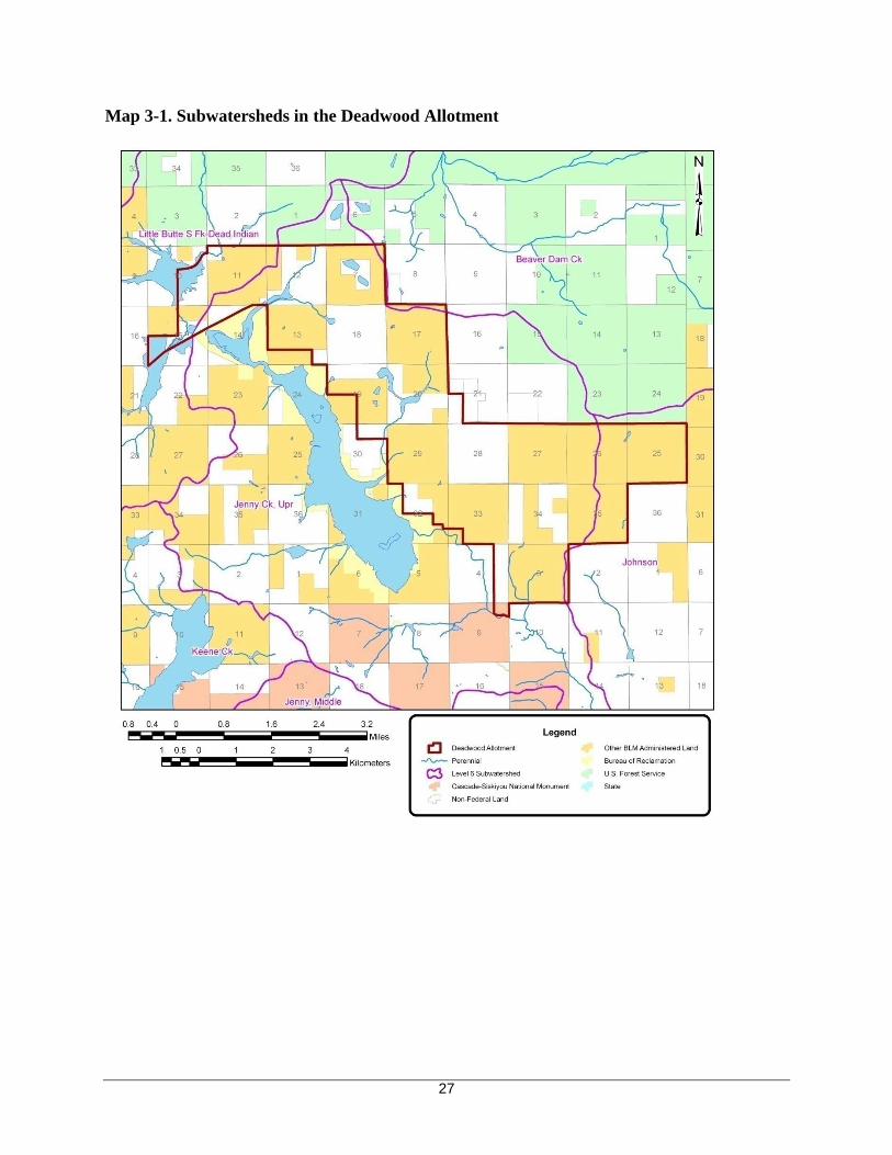
The Deadwood Allotment includes 8004 acres of federal land administered by the Bureau of Land
Management (BLM) and 3886 acres of interspersed privately owned land This allotment lies in two Tier
One watersheds The allotment lies mostly within the Jenny Creek Watershed (91 percent) and includes
portions of the Upper Jenny Creek and Johnson Creek Subwatersheds The remainder of the allotment
(nine percent) falls within the Little Butte Creek Watershed and includes portions of the South Fork Little
Butte-Dead Indian Creeks and Beaver Dam Creek Subwatersheds Map 3-1 illustrates the subwatersheds in
the Deadwood Allotment The major creeks within the allotment include Hoxie Grizzly Jenny Green
Dead Indian and Conde Creeks There are approximately 11 miles of perennial streams 19 miles of
intermittent streams 19 miles of dry draws and one mile of ditch within the allotment
26
Map 3-1 Subwatersheds in the Deadwood Allotment
27
Past Actions
Removal of riparian vegetation and the shade it provides contributes to elevated stream temperatures
Past human-caused activities in riparian areas such as timber harvest road construction residential and
agricultural clearing and livestock grazing have reduced the amount of riparian vegetation in the analysis
area (USDI 2006 and USDI 2008c) Water withdrawals during the summer also contribute to elevated
stream temperatures Augmentation and diversion of flows in Jenny Creek Watershed for purposes of
irrigation and hydroelectric production in the Bear Creek Watershed greatly complicate the instream flow
regime for Jenny Creek
Past ground-disturbing activities such as road building logging land clearing agriculture and livestock
grazing contributed sediment to streams in the analysis areas (USDI 2006) Agricultural and residential
development along the South Fork Little Butte Creek contributed sediment through channel modification
grazing and land clearing Livestock grazing has occurred throughout the analysis areas since the midshy
1800s (USDI and USDA 1997) Large numbers of cattle and sheep were driven from lower valley
pastures to high plateau meadows each summer during the mid-1800s to early 1900s These large numbers
of livestock had an adverse impact on watershed conditions especially along stream courses and near
springs and meadows (USDI and USDA 1997) After 1930 cattle became the primary livestock in the
South Fork Little Butte Creek area By the early 1960s livestock grazing on public lands had been
reduced by 50 percent and there has been an additional 50 percent reduction since then (USDI and USDA
1997) BLM stream surveys conducted in riparian areas of this allotment between 1996 and 2006 identify
numerous locations where streambanks have been trampled and damaged by cattle (USDI 1995-2007)
AFFECTED ENVIRONMENT
Water Quality
The Oregon Environmental Quality Commission has adopted numeric and narrative water quality
standards to protect designated beneficial uses In practice water quality standards have been set at a level
to protect the most sensitive uses Cold-water aquatic life such as salmon and trout in the Rogue Basin and
redband trout in the Jenny Creek watershed are the most sensitive beneficial uses (USDI 2006 and USDI
2008c) The Oregon Department of Environmental Quality (DEQ) is required by the federal Clean Water
Act (CWA) to maintain a list of stream segments that do not meet water quality standards for one or more
beneficial uses This list is called the 303(d) list because of the section of the CWA that makes the
requirement DEQrsquos 20042006 303(d) list is the most recent listing of these streams (ODEQ 2006)
The BLM is recognized by Oregon DEQ as a Designated Management Agency for implementing the Clean
Water Act on BLM-administered lands in Oregon The BLM and DEQ have a Memorandum of
Agreement (MOA) that defines the process by which the BLM will cooperatively meet State and Federal
water quality rules and regulations In accordance with the MOA the BLM in cooperation with the Forest
Service DEQ and the Environmental Protection Agency is implementing the Forest Service and Bureau
of Land Management Protocol for Addressing Clean Water Act Section 303(d) Listed Waters (USDI and
USDA 1999) Under the Protocol the BLM will protect and maintain water quality where standards are
met or surpassed and restore water quality limited waterbodies within their jurisdiction to conditions that
meet or surpass standards for designated beneficial uses The BLM would also adhere to the State
Antidegradation Policy (OAR 2006b 340-041-0004) under any proposed actions
In December 2008 the ODEQ issued the Rogue River Basin Total Maximum Daily Load (TMDL) The
TMDL addresses temperature and bacteria (E coli) impairments for an area that includes the North and
South Forks Little Butte Creek In December 2010 the ODEQ issued the Upper Klamath and Lost River
Subbasins TMDL for review TMDLs are numerical loadings that are set to limit pollutant levels such that
instream water quality standards are met
28
Both TMDLs target system potential effective shade as the surrogate measure to meet the TMDL load
allocation for nonpoint sources Effective shade is defined as the percent reduction of potential daily solar
radiation load delivered to the water surface (ODEQ 2008 and ODEQ 2010) It can be measured in the
field and relates directly to solar loading
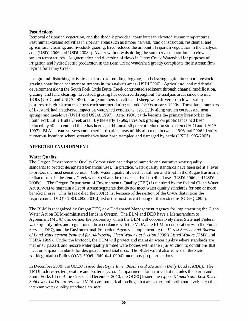
There are five streams in or adjacent to the Deadwood Allotment on the Oregon DEQrsquos 20042006
Environmental Protection Agency approved 303(d) list Three streams are listed for summer temperature
(salmonid fish rearing) and two streams for year around temperature (core cold water habitat) (ODEQ
2006) (Table 3-4)
Table 3-4 Water Quality Limited Streams within or adjacent to the Deadwood Allotment (ODEQ
2006)
Level 5
Watershed
Stream River Miles Parameter Status Miles in
the
Allotment
Jenny Creek 0 to 178 Temperature-Summer 303(d) none
Jenny Creek Grizzly Creek 0 to 30 Temperature-Summer 303(d) none
Hoxie Creek 08 to 44 Temperature-Summer 303(d) 22
Little Butte Dead Indian Creek 0 to 96 Temperature-Year Around 303(d) 26
Creek Conde Creek 0 to 44 Temperature-Year Around 303(d) 04
a Temperature
There are a total of 52 stream miles listed for temperature (22 miles for summer temperature and 30
miles for year around temperature) in the allotment of which 17 miles ( 14 miles on Hoxie Creek 03
miles on Dead Indian Creek 00 miles on Conde Creek) are on BLM-administered lands
Stream temperature is influenced by riparian vegetation channel morphology hydrology climate and
geographic location While climate and geographic location are outside of human control the condition of
the riparian area channel morphology and hydrology can be altered by land use Human activities that
contribute to degraded thermal water quality conditions include agricultural activity rural residential
developments water withdrawals timber harvests local and forest access roads (USDI and USDA 1997)
Timber harvest roads livestock grazing and OHV use are the primary impacts specific to federally
managed lands that have the potential to affect water quality conditions in the allotment Both Rogue
River Basin TMDL and Upper Klamath and Lost River Subbasins TMDL identify four nonpoint source
factors that may result in increased thermal loads stream shade stream channel morphology flow and
natural sources (ODEQ 2008 and ODEQ 2010)
The BLM collected summertime stream temperature data at locations within the South Fork Little Butte
Creek and Jenny Creek watersheds between 1994 and 2005 (Table 3) The 7-day statistics for all sites
listed in Table 3 exceed the established 2004 temperature criteria In the South Fork Little Butte Creek
perennial streams are designated as core cold-water habitat therefore the seven-day-average maximum for
these streams may not exceed 160degC (608degF) outside the salmon and steelhead period of spawning use
In the Jenny Creek Watershed the seven-day-average maximum temperature may not exceed 200degC
(680degF) for streams in Jenny Creek Watershed designated as redband trout use Prior to the 2004 list the
Oregon DEQ 7-day maximum listing criteria was 178degC (640degF) for both watersheds
29
Table 3-5 Temperature summary for selected streams within the allotment
Watershed Stream Name Period of
Record1
7-day
Statistic
(ave for all
years)
Range of 7-day
Statistic
Minimum Maximum
South Fork Little Butte
Creek
Dead Indian Creek (above Conde
Creek)
94-01 03-05 749 725 776
Conde Creek (above TID
diversion)
94-97 99-03
05 721 692 740
Conde Creek lower BLM line
Sec 9 NE14 SW14
98-01 736 731 748
Jenny Creek
Grizzly Creek (abv Soda Creek) 2001 03-05 699 690 713 Hoxie Creek (abv Keno access
rd)
1997-1998 722 702 742
Jenny Creek (abv Johnson Creek) 1996-2001 730 710 742 1 Temperature measured from June to September
System potential shade targets (percent-effective shade) along with current shade were calculated for two
streams on BLM-administered lands in the Deadwood allotment that are within the North and South Forks
Little Butte Creek Key Watershed Conde and Dead Indian The Shadow model (Park 1993) was used for
the shade assessment The Shadow model determines the system potential targets and number of years
needed to obtain shade recovery using forest growth curves for various tree species within southwestern
Oregon The growth curves project growth rates and maximum heights for the dominant riparian tree
species Target shade values represent the maximum potential stream shade based on the system potential
tree height The BLM administered lands along the assessed reaches of lower Conde and Dead Indian
Creek meet the target shade
The RAPID effective shade model (Park and Hawkins 2007) was used to analyze the existing shade
conditions and potential future shade along perennial streams on BLM-administered lands within the Jenny
Creek portion of the Deadwood Allotment The target shade values represent the maximum potential
stream shade based on the system potential tree height The analysis is based on regional shade curves
(Park 1993) which provide effective shade values based on stream width tree height channel orientation
and stream adjacent slope The projection of years to recovery uses forest growth estimates for Douglas-fir
in southwest Oregon A total of 39 miles of field verified perennial streams on BLM land were analyzed
Thirty-six percent of the reaches met the target shade The average additional shade needed across the
allotment for all reaches was 13 The average years to maximum stream shade recovery was 77
Stream temperatures are on an upward trend (decreasing) on federal land as previously harvested riparian
vegetation recovers However roads built in riparian areas and livestock grazing that damages shade-
producing vegetation in riparian areas will continue to contribute to temperature increases On non-federal
lands near-stream vegetation disturbanceremoval and water withdrawals continue to adversely affect
stream temperatures (ODEQ 2004) Water withdrawals have the potential to greatly impact surface water
temperatures within the Little Butte Creek and Jenny Creek Watersheds Talent Irrigation District (TID)
diverts water from Conde and Dead Indian Creeks into Howard Prairie Reservoir Dead Indian is a
tributary to South Fork Little Butte Creek a tributary to Little Butte Creek a tributary to the Rogue River
Streams in the Deadwood Allotment drain into Howard Prairie Reservoir Jenny Creek and Dead Indian
Creek Howard Prairie Reservoir is actually in the Jenny Creek subbasin however water from the Howard
Prairie Reservoir is transported to Keene Creek Reservoir and then into the Bear Creek Watershed (a
tributary of the Rogue River) through tunnels and a pipeline down to Green Springs Power Plant Water
from the power plant flows to Emigrant Creek for storage in Emigrant Reservoir and dispersal through the
Talent Irrigation District canal system The transbasin conveyance of water from Keene Creek Reservoir
30
to Emigrant Creek normally captures 100 percent of the flow of Keene Creek Input to the downstream
Jenny Creek system via Keene Creek occurs rarely during flood events or instances where the transport
system into Emigrant is shut down Jenny Creek flows into the Irongate Reservoir in northern California
in the Klamath basin
There are numerous small water developments within the allotment including pump chances and small
reservoirs BLM has water rights to store water at ten locations in the allotment for livestock wildlife fire
suppression and road operations The functionality of most of the developments in the allotment is reliant
upon seasonal precipitation The management of water withdrawals is within the jurisdiction of the
Oregon Water Resources Department and as such the BLM has no authority in this area
b Sediment
Sediment is a natural part of a healthy stream system with equilibrium between sediment input routing
and in-stream storage Under natural conditions there is generally a balance between the amount of fine
sediment coarse bed load sediment and larger elements of instream structure (ie wood boulders)
Sedimentation results from either stream channel or upland erosion Disturbances that change riparian
vegetation increase the rate or amount of overland flow or destabilize a stream bank may increase the
rates of stream bank erosion and result in sedimentation increases (ODEQ 2004) Disturbances in the
uplands that remove vegetation reduce soil stability on slopes or channel runoff can increase sediment
inputs (ODEQ 2004)
Natural erosion processes occurring in the allotment area such as landslides surface erosion and flood
events contribute to increased sedimentation (USDI and USDA 1997) Sediment sources resulting from
human activities include roads logging (tractor skid trails yarding corridors and landings) off-highway
vehicle (OHV) trails and concentrated livestock grazing in riparian zones
The Oregon statewide narrative criteria found in OAR 340-041-0007(1) (ODEQ 2006b) is the water
quality criteria that applies to BLM management
(1) Notwithstanding the water quality standards contained in this Division the highest and
best practicable treatment andor control of wastes activities and flows must in every case be
provided so as to maintain dissolved oxygen and overall water quality at the highest possible
levels and water temperatures coliform bacteria concentrations dissolved chemical
substances toxic materials radioactivity turbidities color odor and other deleterious factors
at the lowest possible levels
Improper livestock management contributes to sedimentation through bank trampling and the reduction or
elimination of riparian vegetation BLM stream surveys from 1996 to 2006 noted many reaches with these
types of grazing impacts
Current conditions resulting from past and present actions are summarized as follows Surface erosion
from existing roads on all lands contributes to low levels of sediment input primarily at road-stream
crossings and where fill slopes closely parallel streams Streambank trampling from livestock grazing
continues to contribute sediment to streams
c Coliform
Fecal coliform bacteria are produced in the guts of warm-blooded vertebrate animals and indicate the
presence of pathogens that cause illness in humans E coli is a species of fecal coliform bacteria A
31
variety of everyday activities cause bacterial contamination in surface waters (ODEQ 2004) The largest
sources of contamination include runoff from agricultural industrial rural and urban residential activities
(ODEQ 2004) Sources of bacteria from BLM-administered lands include animal feces (wild and
domestic including livestock such as cattle) and inadequate waste disposal by recreational users The
BLM does not monitor fecal coliform and it is often difficult as it is with the other parameters to attribute
livestock impacts to the monitoring results
The Rogue River Basin TMDL (ODEQ 2008) addresses bacteria (E coli) and acknowledges that the
management of federal forest lands does not typically contribute to elevated levels of E coli that are the
basis for the listings in the Rogue Basin (ODEQ 2008) The Water Quality Restoration Plan for BLM-
Administered Lands in the North and South Forks Little Butte Creek Key Watershed (USDI 2006) includes
the following recovery goal for E coli manage livestock to prevent concentrations in streams or riparian
zones There are currently no E coli-listed streams on BLM-administered lands within the Deadwood
Allotment however livestock access and concentration in streams or riparian zones continues to allow
site-level bacterial contamination in surface water from BLM-managed lands in some locations within the
allotment
Livestock grazing is managed in accordance with the Standards and Guidelines for Livestock Grazing
Management for Public Lands Administered by the Bureau of Land Management in the States of Oregon
and Washington (USDI 1997) and the BLM grazing regulations These documents provide guidance for
grazing management activities to ensure water quality will be maintained protected andor restored
Management measures used to limit the presence of livestock in stream channels or riparian zones in order
to reduce sedimentation (USDI 2006) will also minimize the amount of bacterial contamination in surface
water from BLM-managed lands
The Preliminary Determination and Evaluation found that the allotment was ldquoNot Meeting the Standard
current livestock grazing management practices are significant factorsrdquo and ldquoDoes not conform with
Guidelines for Livestock Grazing Managementrdquo for Standard 4 Water Quality (USDI 2008b)
The Guidelines for Livestock Grazing Management (USDI 1997) that are not being achieved for Standard
4 include
Adequate cover and plant community structure to promote streambank stability debris and
sediment capture and floodwater energy dissipation in riparian areas
Promote livestock distribution
Avoid unwanted or damaging concentrations of livestock on streambanks in riparian areas and
other sensitive areas such as highly erodible soils unique wildlife habitats and plant communities
Protect water quality
Animal introductions in riparian and wetland areas must be compatible with the capability of the
site including the systemrsquos hydrologic regime and contribute to the maintenance and restoration
of properly functioning condition
Watershed Analysis Recommendations
The Deadwood Allotment falls within the source water areas for the cities of Gold Hill Rogue River and
Grants Pass in Oregon and Yreka in California The surface water source for the three cities in Oregon is
the Rogue River downstream from Bear Creek The Bear Creek and Little Butte Creek Watersheds are
included in the source water area and 1012 acres of the allotment are in the South Fork Little Butte-Dead
Indian Creeks and Beaver Dam Creek Subwatersheds of Little Butte Creek (Map 3-1) The allotment lands
within the Little Butte Creek Watershed are approximately 25 miles upstream from the closest public water
system intake The water source for Yreka is Fall Creek The Fall Creek Subwatershed lies within the
32
Jenny Creek Watershed Approximately 10877 acres of the allotment are within the Upper Jenny Creek
and Johnson Creek Subwatersheds of the Jenny Creek Watershed (Map 3) Fall Creek is outside the
Deadwood Allotment
Source water assessments have been completed by the DEQ and the Oregon Department of Human
Services for the cities of Gold Hill Rogue River and Grants Pass and by the California Department of
Health Services for the City of Yreka The assessments include an inventory of potential contaminant
sources within the source water areas Grazing animals (greater than five large animals or equivalent per
acre) were identified as a potential contaminant source for the Gold Hill Rogue River and Grants Pass
drinking water protection areas The assessments recognized that concentrated livestock may contribute to
erosion and sedimentation of surface water bodies Grazing in the Little Butte Creek portion of the
allotment consists of open range grazing with an average of approximately 48 cows across the 1012 acres
of the allotment The City of Yreka source water assessment identified open range cattle as a potential
contaminating activity No other potential contaminant sources that could occur on BLM lands were
identified in the state source water assessments
The Water Quality Restoration Plan for the North and South Forks of Little Butte Creek Key Watershed
and the Draft Water Quality Restoration Plan for the Jenny Creek Watershed (USDI 2006 and USDI
2008c) identified several nonpoint source factors that may result in increased thermal loads including
near-stream vegetation disturbanceremoval channel modifications and widening dams diversions and
irrigation districts and hydromodificationndashwater rights
The Water Quality Restoration Plan for the North and South Forks of Little Butte Creek Key Watershed
(USDI 2006) identifies percent-effective shade targets for major perennial and fish-bearing streams on
BLM-administered lands Streams are considered recovered where current shade achieves the target shade
or is 80 percent or greater Lower Conde and Dead Indian Creeks are considered recovered
Current shade is less than the target on BLM-administered lands for Hoxie Creek and the headwaters of
Grizzly Creek The majority of the field verified portions of the Jenny Creek Spring tributary system on
BLM are at or near recovery for shade
Both WQRPs (USDI 2006 and USDI 2008c) identify the effect of channel morphology on stream
temperature Wide channels tend to have lower levels of shade due to simple geometric relationships
between shade producing vegetation and the angle of the sun Channel widening is often related to
degraded riparian conditions that allow increased streambank erosion and sedimentation of the streambed
Sediment sources resulting from human activities include roads logging (tractor skid trails yarding
corridors and landings) concentrated livestock grazing in riparian zones residential clearing of riparian
zones irrigation ditch blowouts and poor irrigation practices (USDI and USDA 1997)
Riparian Condition
Riparian areas (streams wetlands springs and seeps) within the allotment were inventoried using BLMrsquos
Process for Assessing Proper Functioning Condition Technical Reference 1737-9 (USDI 1993) On
BLM lands within the allotment data was collected in the Upper Jenny Creek and South Fork Little Butte-
Dead Indian Creeks Subwatersheds in 1996 and 2002 Some of the reaches around Howard Prairie Lake
were revisited and updated in 2006 The process used an interdisciplinary evaluation to rate riparian areas
as either ldquoProper Functioning Conditionrdquo ldquoFunctioning at Riskrdquo or ldquoNonfunctionalrdquo The ratings are
defined as
Proper Functioning Condition (PFC) ndash Riparian-wetland areas are functioning properly when adequate
vegetation landform or large woody debris is present to dissipate stream energy associated with high
33
waterflows thereby reducing erosion and improving water quality filter sediment capture bedload and
aid floodplain development improve flood-water retention and ground-water recharge develop ponding
and channel characteristics to provide the habitat and the water depth duration and temperature necessary
for fish production waterfowl breeding and other uses and support greater biodiversity The functioning
condition of riparian-wetland areas is a result of interaction among geology soil water and vegetation
Functional-At Risk (FAR) ndash Riparian-wetland areas that are in functional condition but an existing soil
water or vegetation attribute makes them susceptible to degradation
Nonfunctional ndash Riparian-wetland areas that clearly are not providing adequate vegetation landform or
large woody debris to dissipate stream energy associated with high flows and thus are not reducing erosion
improving water quality etc as listed above The absence of certain physical attributes such as a
floodplain where one should exist is an indicator of nonfunctioning conditions
Stream surveys and PFC Assessments were conducted in riparian areas on BLM land in this allotment
between 1996 and 2006 The PFC Assessment refers to a consistent approach for considering hydrology
vegetation and erosiondeposition (soils) attributes and processes to assess the condition of riparian areas
Only perennial and intermittent streams are assessed for PFC Stream survey data in this allotment
identifies numerous locations where streambanks have been trampled and damaged by cattle In the Hoxie
Creek drainage PFC surveys conducted on BLM land found approximately 25 miles of the 30 miles
surveyed (82) in non-functional or functioning-at-risk with a downward trend The Hoxie Creek system
has more stream segments that are non-functional (approximately one mile) or functioning-at-risk with a
downward trend (approximately 4000 feet) than other streams in the allotment As a perennial stream
Hoxie Creek receives heavier grazing pressure late in the season when water and palatable vegetation are
limited to perennial riparian areas (BLM 2003 and 2004) An 800 foot section of an unnamed perennial
tributary to Grizzly Creek in Section 13 was also identified as nonfunctional due in part to trampling of
banks and substrate resulting in an increased width to depth ratio In section 19 and 29 unnamed
intermittent tributaries to Howard Prairie reservoir with a total length of approximately one mile were
identified as nonfunctional or functioning-at-risk with a downward trend On these stream reaches and
Dead Indian Creek in Section 15 surveyors noted that overutilization by cattle is contributing to
destabilization of streambanks and instream sedimentation A survey conducted along Jenny Creek (T39S
R4E Section 3) found altered streambanks along 36 percent of the 200 meters surveyed (Ashland
Exclosure Monitoring 2005) This protocol describes the linear length of streambank alteration that can be
directly attributed to large herbivores Grazing impacts from moderate to severe were observed in three of
the four springs surveyed for aquatic mollusks (Frest and Johannes 2005)
The BLM livestock impact study by Hosten and Whitridge found stream channel riparian areas show
considerable improvement in vegetation composition expressed as the establishment of vegetation on bare
ground replacement of grass by sedge and replacement of herbaceous vegetation by riparian shrubs
depending on the site While change is slow relative to ungrazed areas streamside riparian areas are
generally improving throughout the Deadwood Allotment (Hosten and Whitridge 2007) in areas accessible
to livestock However stubble heights less than four inches were observed in the Deadwood Allotment
primarily in the Grizzly Creek Moon Prairie and Hoxie Creek areas Riparian grazing recommendations
suggest that four to six inches of forage stubble height should remain on streamside areas at the end of the
growing season after fall frost to limit potential impacts to the herbaceous plant community the woody
plant community and streambank stability (Clary 1999)
Physical Habitat Surveys conducted by ODFW (2002) on Grizzly Creek just downstream of the Howard
Prairie Reservoir spillway found actively eroding stream banks (34 percent of the 3370 feet surveyed) and
high levels of fine sediment (39 percent) in the stream substrate This report listed grazing as the primary
34
contributor to degraded conditions Cows have repeatedly been observed on this allotment past the removal
date increasing the pressure on perennial seeps springs and streams
In both the even and odd-numbered years cattle tend to linger and congregate in riparian areas throughout
the entire grazing season because of convenience of forage water and shade In the odd-numbered years
cattle have access to riparian areas in the late fall allowing no time for plant regrowth or bank stabilization
prior to winter rains Grazing beyond approximately August 15th
leads to increased bank disturbance bare
ground fine sediment and heavy use of riparian vegetation because the cattle are attracted to riparian areas
for the lush vegetation cool water and cooler temperatures
Six riparian exclosures 13 developed water sources and 2 pasture fences (table 2-5 EA p19) help reduce
concentrated use in riparian areas and facilitate even distribution particularly if used with herding and salt
placement The composite map of utilization and transect data collected between the years of (1984-2004)
shows an overall decrease in utilization over the past decade within the Deadwood allotment (RHA p3)
The major variables defining utilization include proximity to water roads and elevation Patterns in
utilization with elevation are associated with the transition in grazing from summer to fall when uplands
are drier and grazing becomes concentrated in riparian areas (Hosten et al 2007a)
The Preliminary Determination and Evaluation found that the allotment was ldquoNot Meeting the Standard
current livestock grazing management practices are significant factorsrdquo and ldquoDoes not conform with
Guidelines for Livestock Grazing Managementrdquo for Standard 2 Watershed FunctionmdashRiparianWetland
Areas (USDI 2008b)
The Guidelines for Livestock Grazing Management (USDI 1997) that are not being achieved for Standard
2 include
Adequate cover and plant community structure to promote streambank stability debris and
sediment capture and floodwater energy dissipation in riparian areas
Promote livestock distribution
Avoid unwanted or damaging concentrations of livestock on streambanks in riparian areas and
other sensitive areas such as highly erodible soils unique wildlife habitats and plant communities
Protect water quality
Animal introductions in riparian and wetland areas must be compatible with the capability of the
site including the systemrsquos hydrologic regime and contribute to the maintenance and restoration
of properly functioning condition
ENVIRONMENTAL CONSEQUENCES
As identified in the WQRP (USDI 2006) stream temperature is affected by both shade and channel
modification For achievement of shade targets the WQRP recommends allowing riparian vegetation to
grow up to reach target values
Stream flow also influences stream temperature The temperature change produced by a given amount of
heat is inversely proportional to the volume of water heated (USDA and USDI 2005) A stream with less
flow will heat up faster than a stream with more flow given all other channel and riparian characteristics
are equal Trampling by cattle reduces the porosity in wetlands springs and seeps and thus reduces the
volume of water that can be contained in the macropores The indirect effect of this compaction is less
water storage capabilities and reduced contribution to late-season streamflows
35
Stream temperature is driven by the interaction of many variables The principal source of heat energy for
streams is solar energy striking the stream surface (USDA and USDI 2005) Stream surface shade is
dependent on riparian vegetation height location and density The ability of riparian vegetation to shade
the stream throughout the day depends on vegetation height and the vegetation position relative to the
stream The woody riparian vegetation and groundcover provide a necessary component of shade for the
riparian areas in this allotment especially in the meadow and wetland areas
Table 3-6 and Table 3-7 show the potential changes to hydrologic processes and water quality from
livestock grazing The effects to streamflow and water quality will be assessed by alternative
Table 3-6 Changes to Hydrologic Processes due to Grazing
Changes to Hydrologic Processes that Affect
Streamflow Changes to Streamflow
Peak Flows
Reduced infiltration due to compaction
increases surface run off decreases
groundwater and reduces time to reach peak
Reduced time to hydrograph peak
Increased frequency of peak flows
Increased magnitude of peak flows
Low Flows
Decreased summer streamflow due to water
withdrawals for livestock
Lowered water table due to riparian vegetation
removal
Decreased magnitude of low flows
Table 3-7 Affects to Water Quality due to Grazing
Changes to Processes that Affect Water Quality Changes to Water Quality
Riparian vegetation removal reduced stream
shade increased erosion and increased channel
width-depth ratio
Streambank disturbance increased erosion and
increased channel width-depth ratio
Water quality contamination due to livestock in
streams
Increased temperature
Decreased dissolved oxygen
Increased turbiditysediment
Increased bacteriapathogens
This allotment is within the source water areas for the cities of Gold Hill Rogue River Grants Pass and
Yreka however given the numbers of AUMs authorized on this allotment is somewhat low it is unlikely
that this allotment grazed as authorized under the No Action or the three action alternatives is a significant
contributor to the identification of grazing as a potential contaminant source
ALTERNATIVE 1- No Action Alternative (no change)
Under the No Action Alternative the grazing lease on the Deadwood Allotment would be issued at the
same animal unit month (AUM) level the same season of use and with the same terms and conditions
currently in effect The existing grazing leases for the Deadwood Allotment authorize a total of 788 active
AUMs during the grazing season The grazing season would continue to be 616 - 815 in even years and
816 - 1015 in odd years
36
Direct and Indirect Effects
Grazing under this alternative would continue to impact water quantity by contributing to altered peak and
low flow regimes at the site level continued compaction and reduction of plant coverlitter in the seeps
springs streams and uplands within the allotment Impacts to the riparian areas and wetlands from cattle
grazing reduce the resiliency of the watershed to high flow events
This alternative also affects summer low flows at the site scale through decreased discharge from soil water
storage and cattle use of riparian areas and wetlands late into the season
Grazing under this alternative would continue to impact water quality at the site scale through the
trampling of streambanks and the reduction of riparian vegetation contributing to elevated sedimentation
and water temperatures Livestock access and concentration in streams would continue to allow bacterial
contamination in surface water from BLM-managed lands in some locations within the allotment Under
this alternative grazing would continue to contribute sediment to streams Tributaries in the allotment
flow directly into Dead Indian Creek Howard Prairie Reservoir and Jenny Creek
The physical integrity of the seeps springs and streams is compromised under this alternative by grazing
of riparian vegetation and the shearing and sloughing of streambanks increasing stream width and
decreasing stream depth resulting in higher stream temperatures Removal of riparian vegetation allows
higher levels of solar radiation to reach the water surface in seepsspringsstreams resulting in increased
water temperatures
September and October is the most critical time of the year in terms of protecting the plant cover plant
litter and organic matter that are necessary to protect banks from erosion reduce water velocity along the
stream edges and filter out sediments during high water In alternating years late season grazing (through
October 15) in this alternative exacerbates the effects to the stream system because as the season progress
the cattle tend to congregate in the riparian areas and wetlands where there is still palatable vegetation
water and shade
Long-term consequences of continued grazing at current levels would mean the impacted areas identified
in the BLM stream surveys (1996-2006) and BLM photo documentation (2003-2008) would continue to
have compaction eroding banks and reduced productivity of riparian vegetation Soil disturbance post-
holing churning and compaction from cattle loitering in these areas would continue threatening the water
holding capacity of these areas The intermittent and perennial streams and associated springs would
continue to be grazed at the current level of use Some downcutting would continue in the sections of the
channel that are unarmored by bedrock and cobble The stability of the low gradient areas where sediment
is being retained by pieces of large wood woody riparian species and riparian groundcover would
continue to be compromised Under this alternative impacts to riparian soils would continue to reduce the
soilrsquos ability to retain moisture
This alternative does not address the findings in the Preliminary Determination and Evaluation that grazing
practices in the Deadwood Allotment are not conforming to the Guidelines for Livestock Grazing
Management (USDI 1997) for Standard 2 Watershed Function or Standard 4 Water Quality This
alternative does not alter any of the terms and conditions of the lease to make progress toward 1)
improving plant cover and community structure to promote streambank stability debris and sediment
capture and floodwater energy dissipation in riparian areas improving livestock distribution 2) improving
water quality and 3) avoiding unwanted or damaging concentrations of livestock on streambanks and
wetland areas
37
Alternative 1 fails to meet Standard 2 (RiparianWetlands) and Standard 4 (Water Quality) because
Trampling of streambanks and the reduction of riparian vegetation continues to remain a factor in
sedimentation levels and water temperatures that do not meet the water quality standards for the
303(d) listed streams in the North and South Forks Little Butte and Jenny Creek Key Watersheds
There are 52 miles of 303(d) listed streams on the allotment 17 miles are on BLM-administered
lands
Late-season grazing results in vegetation that does not adequately regrow before dormancy sets
and therefore does not function to filter sediments as water flows in and around streambanks
Stubble heights of less than 4 inches are occurring along perennial waterways
Grazing is a factor because
Current grazing levels mean the impacted areas identified in the BLM stream surveys (1996-2006)
and BLM photo documentation (2003-2008) would continue to have compaction eroding banks
and reduced productivity of riparian vegetation
Late season grazing in Hoxie Creek Dead Indian Creek and unnamed tributaries to Grizzly Creek
and Howard Prairie reservoir have contributed to 31 stream miles of non-functional or
functioning-at-risk with a downward trend Surveyors noted that overutilization by cattle is
contributing to destabilization of streambanks channel widening and instream sedimentation
Until maximum shade recovery occurs in areas with an absence of an established forest canopy
and in meadows and wetlands woody riparian shrubs and grasses provide essential riparian shade
Continued grazing pressure on these woody shrubs and grasses reduces stream shading
A survey along Jenny Creek found altered streambanks along 36 of the 200 meters surveyed
Livestock use was identified as the primary cause for the altered streambanks
Grazing impacts from moderate to severe were observed in three of the four springs surveyed for
aquatic mollusks (Frest and Johannes 2005)
Cattle tend to linger and congregate in riparian areas throughout the entire grazing season Cattle
tend to avoid hot dry environments and congregate in wet areas for water and forage which is
more succulent and abundant than in the forested uplands (Belsky Matzke and Uselman 1999)
Impacts are not widespread throughout the entire allotment rather they are focused along perennial
and intermittent stream sections
Animal introductions in riparian and wetland areas must be compatible with the capability of the site
including the systemrsquos hydrologic regime and contribute to the maintenance and restoration of
properly functioning condition While there is some recovery from past management (logging historic
grazing road construction) impacts from late season grazing and focused use along perennial riparian
areas prevent attainment of the ACS objectives at the site level
ALTERNATIVE 2
Under this alternative the existing cattle grazing lease authorization would continue at the same AUMs and
season of use as Alternative 1 This alternative would include seven additional terms and conditions listed
on EA page 15-16 including stubble height and bank alteration criteria stricter management requirements
with penalties for non-compliance and two potential mitigation measures
Terms and Conditions
The addition of the term and condition requiring removal of livestock when a 5rdquo stubble height andor 20
bank alteration threshold is met will slightly improve streambank stability and improve the ability of
vegetation to trap sediment during higher streamflows Maintaining adequate riparian vegetation reduces
38
the solar radiation and heating of the water surface in seepsspringsstreams The success of this alternative
will rely on close monitoring of riparian stubble heights and altered banks in the latter half of each grazing
season
The addition of the term and condition requiring removal of livestock within the authorization periods will
allow for some recovery of riparian vegetation before fall rain events in years with the early grazing season
In the odd years (late season) enforcement of the take-off date will help reduce impacts to vegetative cover
critical to trapping fine sediment and stabilizing banks Seeding of native vegetation on bare riparian
ground will also benefit water resources
Many of the stream segments in this allotment are intermittent and do not have flowing water late in the
summer Most of the water developments in the allotment rely on annual precipitation In dry years and in
odd-numbered years when late season grazing is authorized many of the small ponds and reservoirs are not
reliable sources of water In drought years Howard Prairie reservoir can be the only reliable source of
water In both even and odd- numbered year grazing seasons as vegetation dries out and water becomes
scarce cattle will continue to congregate and linger in the riparian areas that have any moisture and forage
It will be the lesseersquos responsibility to herd and salt the livestock away from riparian areas as mandated in
the terms and conditions
Potential Mitigation Measures
If the potential mitigation measures are elected in this alternative there will be an additional benefit to
water resources in the allotment In odd years with late season grazing the Guard Station Pasture will be
used to gather livestock Excluding cows from this area until July 1 the following year (two weeks later
than the rest of the allotment) will be a benefit to riparian vegetation in this area The installation of the
two cattleguards in section 17 and Section 20 would improve the distribution within portions of the
allotment and provide some benefit to riparian vegetation in Hoxie Creek
This alternative addresses the findings in the Preliminary Determination and Evaluation that grazing
practices in the Deadwood Allotment were not conforming to the Guidelines for Livestock Grazing
Management (USDI 1997) This alternative alters the terms and conditions of the lease to make slight
progress toward 1) improving plant cover and community structure to promote streambank stability
debris and sediment capture and floodwater energy dissipation in riparian areas 2) improving livestock
distribution 3) improving water quality and 4) avoiding unwanted or damaging concentrations of
livestock on streambanks and wetland areas
The 7 additional terms and conditions under this alternative especially maintaining 5rdquo stubble heights and
less than 20 active livestock caused bank alteration and active herd management would have some local
benefits to water resources Late season use would continue to focus impacts on riparian areas making
attainment of ACS difficult although not impossible The 7 additional terms and conditions and active herd
management will be vital for this alternative to meet ACS objectives at the site level and HUC 7 level
ALTERNATIVE 3
Under this alternative the existing cattle grazing lease authorization would continue but there would be 5
additional terms and conditions a 50 reduction in AUMs and elimination of late season grazing
Terms and Conditions
The addition of terms and conditions requiring removal of livestock when a 5rdquo stubble height andor 20
bank alteration threshold is met will slightly improve streambank stability and improve the ability of
39
vegetation to trap sediment during higher streamflows Maintaining adequate riparian vegetation will also
reduce the solar radiation and heating of the water surface in seepsspringsstreams These terms will help
ensure that in years of low vegetative productivity adequate stubble heights are maintained to protect banks
from erosion reduce water velocity along the stream edges and filter out sediments during high water
flows
This alternative would improve the physical integrity of the seeps springs and streams in the allotment
Eliminating the late season of use will decrease the concentrated grazing of riparian vegetation and the
shearing and sloughing of streambanks thus improving riparian-wetland functions (Hosten et al 2007a)
This alternative addresses the findings in the Preliminary Determination and Evaluation that grazing
practices in the Deadwood Allotment were not conforming to the Guidelines for Livestock Grazing
Management (USDI 1997) This alternative alters the terms and conditions of the lease and reduces the
authorized AUMs by 50 to make progress toward 1) improving plant cover and community structure to
promote streambank stability debris and sediment capture and floodwater energy dissipation in riparian
areas 2) improving livestock distribution 3) improving water quality and 4) avoiding unwanted or
damaging concentrations of livestock on streambanks and wetland areas
This alternative would reduce site level impacts to water resources Hydrologic function and aquatic
habitat would improve at the site level and likely at the HUC Level 7 level thus meeting ACS objectives
ALTERNATIVE 4
Under this alternative lands within the Deadwood Allotment would not be available for livestock grazing
for a period of ten years This alternative serves to provide for the recovery of ecological conditions that
have been impacted by grazing within the allotment boundary In accordance with 43 CFR 41103-3
permitted use of the allotment would terminate at the close of the 2011 grazing season
The singular action of eliminating grazing in this allotment is not likely to change the water quality listings
for Conde Dead Indian and Hoxie Creeks Past timber harvest on federal and non-federal lands and roads
built in riparian areas will continue to contribute to temperature increases On non-federal lands near-
stream vegetation disturbanceremoval and water withdrawals continue to adversely affect stream
temperatures On federal forested lands the long-term recovery of shade in the riparian reserves will
decrease water temperatures Under this alternative with the removal of grazing over time slight progress
would be made toward meeting the water quality standards for temperature
The elimination of grazing on this allotment would allow riparian vegetation to thrive in the perennial and
intermittent streams and the springs and wet meadow areas associated with these systems Over time hoof
impacts along the streams and at the springs would heal Soil disturbance and churning associated with
cattle use in these areas would heal protecting the water holding capacity of these ecosystems Increases
in riparian vegetation where there is sufficient water to support these species would be expected
Improved riparian vegetation will contribute to rooting strength and floodplainstreambank roughness that
dissipates erosive energies associated with flowing water Removing grazing from the allotment would
allow historic streambank failures to revegetate In the absence of grazing the storage capacity of the
trampled wetlands seeps and springs would improve and could improve late-season streamflows and
decrease stream temperature
This alternative would eliminate site level impacts to water resources from grazing Hydrologic function
and aquatic habitat would improve at the site level and likely at the HUC Level 7 level thus meeting ACS
40
objectives
Cumulative Effects
The Plateau Thin EA (EA M060-2010-0034) addressed other federal timber sales planned within the
larger Jenny Creek Watershed These include the Swinning Timber sale which is proposed in areas
upstream of Howard Prairie Reservoir and the Cold Onion Timber Sale proposed in upper portions of the
Johnson Creek catchment on the Klamath Falls Resource area of the Lakeview BLM Environmental
analyses have been conducted for both of these sales the Swinning timber sale was analyzed under the
Plateau Thin EA while Cold Onion Forest Health Treatments EA (EA OR 014-08-11) was prepared for
the Cold Onion Timber sale It was determined that the Plateau Thin Forest Management project would
not contribute to significant cumulative effects due to increased risk in peak flow Both analyses
determined that potential adverse effects to aquatic environments from proposed activities would be
limited to small site level short term inputs of sediment andor turbidity These inputs were determined to
have no potential to adversely impact water quality and therefore no potential for these projects to
contribute to significant adverse cumulative effects to water quality or aquatic habitat in the Jenny Creek
Watershed
As analyzed in the Plateau Thin EA up to 350 acres of silviculture treatments including pruning and pre-
commercial thinning could occur over the next four years No-treatment buffers would protect stream
systems from instream effects and the proposed silvicultural prescriptions would maintain canopy cover
providing shade along stream corridors
The Plateau Thin EA also included analysis of private timber harvest Future timber harvest on private
lands would likely occur within the analysis area The water resources analysis of this EA addresses future
timber harvest on private lands and assumes that it will continue to occur at a similar rate as has occurred
in the past with similar affects to aquatic habitats Private lands are governed under state forestry
regulations and as such receive a different level of protection than federal lands Analysis of effects from
private timber harvest generally considers the worst case scenario (ie all suitable forested lands would be
logged at ~ 60 year tree-growing rotations) At this time it is not known when or where private timber
harvest will occur in the area This analysis will assume that all suitable private lands will continue to be
subject to timber harvest and that the amount of disturbance to aquatic systems as a result of this harvest
will continue similar to present rates helping to maintain degraded aquatic habitats
Outside of the Plateau Thin analysis area the Sampson Cove Timber sale proposed on BLM lands includes
6 acres of units which slop over the drainage divide from the Bear Creek Watershed into the Keene Creek
subwatershed These units are located near the ridge top do not include any stream channels or Riparian
Reserves and would leave a minimum of between 40 to 60 canopy cover following harvest Because
they do not have any hydrological connectivity with aquatic habitat in the Keene Creek subwatershed and
because they would retain sufficient canopy cover to negate the possibility of altering peak or base flows
these units would have no causal mechanism to affect aquatic habitat in Keene Creek As such harvest of
these units would not have any direct or indirect effects and hence would not add a cumulative effect to
aquatic habitat
Comparison of Cumulative Effects between Alternatives
Table 3-8 shows a comparison between alternatives of the potential for cumulative effects on stream flows
water quality and riparian functioning condition
41
Table 3-8 Comparison of Alternatives for Cumulative Effects on Streamflows Water Quality and
Riparian Condition
Resource Value
Affected
Potential for Cumulative effects on Hydrology by Alternative
ALT 1 (No
Action)
ALT 2 (ALT 1
plus addrsquol terms amp conds)
ALT3 (reduced
AUM no late
season grazing)
ALT 4 (No Grazing)
Peak Flows Low Negative Low Negative Low Negative Slight Positive
Low Flows Low Negative Low Negative Low Negative Slight Positive
Bacteria Pathogens Low Negative Low Negative Low Negative None
Temperature Mod Negative Low-Mod Neg Low Negative Slight Positive
Turbidity Sediment Mod Negative Low-Mod Neg Low Negative Slight Positive
Riparian Condition Mod Negative Low-Mod Neg Low Negative Slight Positive
This table is meant to present a continuum of cumulative effects across the alternatives Alternative 1 2
and 3 all present a similar low potential for negative effects to peak flows low flows bacteria and
pathogens Alternatives 2 and 3 have less potential for negative effects to temperature turbidity and
riparian condition than alternative 1 Alternative 2 will slightly improve conditions at the site level and the
HUC 7 Alternative 3 will improve conditions more rapidly at the site level and the HUC 7 than
alternative 2
FISHERIES RESOURCES
Issues and Concerns
Jenny Grizzly and Hoxie Creeks are listed by ODEQ as water quality limited for exceeding
summer high temperature standards while Dead Indian and Conde Creeks exceed the temperature
standards year-round Grazing riparian vegetation on perennial channels contributes to high
summer water temperatures
Although not listed by ODEQ for sediment many of the streams in the allotment have elevated fine
sediment levels as a result of concentrated livestock use
Concentrated livestock use in seeps springs wet meadows and along streams
Discussion of IssuesConcerns (Potential Effects) and Related Research
The effects of sediment on aquatic species
Turbidity and suspended sediment can affect salmonid physiology behavior and habitat (Bash et al 2001)
Physiological effects include but are not limited to reduced reproduction and growth gill trauma and
osmoregulation Sigler et al (1984) found a significant difference between steelhead and coho growth
rates in clear versus turbid water Turbidities in the 25-50 nephelometric turbidity units (NTU) range
caused a reduction in growth Behavioral affects include avoidance territoriality foraging and predation
and abundance and diversity of prey Juvenile coho salmon that were acclimated to clear water did not
exhibit significant sediment avoidance until the turbidity reached 70 NTUs (Bisson an Bilby 1982)
however Sigler et al (1984) found that turbidities in the 25-50 NTU range caused more young coho and
steelhead to emigrate from laboratory streams than did clear water Increases in sediment and turbidity
affect salmonid habitat by reducing permeability of spawning gravels reducing or eliminating habitat for
aquatic insects filling in pools and blocking the interchange of subsurface and surface waters (Meehan
1991) When high fine sediment levels occur in spawning gravels less spawning occurs eggs tend to
suffocate and emerging fry become trapped resulting in mortality and reduced production (Philips et al
1975 Tappel and Bjornn 1983 Chapman 1988 Meehan 1991) Hausle and Coble (1976) reviewed studies
on coho salmon and steelhead fry emergence in gravels with concentrations of sand exceeding 20 percent
When concentrations of sand exceed 20 percent in spawning beds emergence success declined
42
Cedarholm (1981) found increased fine sediment in spawning gravels when more than 25 of a basin
area was roaded Roads and associated culverts can cause erosion and sedimentation if not properly
maintained or installed Improperly installed culverts are also migration barriers for fish and other aquatic
organisms
The effects of stream temperature on fish
Five streams within the planning area are included on DEQrsquos 303(d) list for exceeding temperature
criterion (see Water Resources section) Summer maximum temperature standards were generated for fish
specifically salmonids because of their narrow thermal temperature tolerance Elevated water
temperatures can affect feeding growth and survival of salmonids (Meehan 1991) The preferred
temperature range for coho salmon is between 536 and 572 degrees F (Meehan 1991) Temperatures
outside of the preferred range affect the metabolic performance of fish altering the balance between energy
inputs and outputs (growth) This does not mean that a fish cannot grow at higher or lower temperatures
but that growth is not as efficient outside of the optimum temperature range As temperature increases so
do the metabolic needs of the fish with decreases in growth and increases in stress becoming more
apparent as temperatures continue to rise until a point termed the upper lethal limit 7890
F where death
of the individual is imminent (Meehan 1991)
The effects of late and hot season grazing on perennial riparian areas
Hot season (midsummer) grazing exacerbates physical effects to streams as cattle focus on riparian areas
because the riparian vegetation is still palatable (upland vegetation has cured and is less palatable) water is
available and there is more shade (Chaney et al 1993) Next to season-long grazing which is universally
recognized as detrimental to riparian areas repeated or extended grazing during the hot summer season is
generally considered most injurious to riparian zones (USDI BLM 1998) Reduced soil moisture and
declining temperatures are the norm during late season (fall) grazing these conditions are not conducive to
vegetative regrowth once the cattle are removed (USDI BLM 1998) Altered stream banks and excessively
grazed riparian vegetation leave streams vulnerable to fall and winter high stream flows and spring snow
melt
Stubble height recommendations
Riparian grazing recommendations suggest that four to six inches of forage stubble height should remain
on streamside areas at the end of the growing season after fall frost to limit potential impacts to the
herbaceous plant community the woody plant community and streambank stability (Clary 1999) For
recovery of depleted meadow riparian systems ten to fifteen centimeters (4-6 inches) of forage stubble
height should remain on streamside areas at the end of the growing season or at the end of the grazing
season after fall frost to limit impacts to the herbaceous plant community the woody plant community
and streambank stability (Clary 1999) In other situations fifteen to twenty centimeters (6-8 inches) of
stubble height may be required to reduce browsing of willows or limit trampling impact to vulnerable
streambanks (Clary and Leininger 2000) According to Hall and Bryant (1995) cattle preference will shift
to woody vegetation as stubble height for the most palatable species (Kentucky bluegrass) approaches three
inches but in sedge and rush communities the shift will happen earlier and six to nine inch stubble heights
may be more suitable (Marlow comm 2003)
The effects of disturbance on aquatic mollusks
Studies in seeps and springs found that high diversity and species indicative of clean water were
compatible with low to moderate ungulate use (Dinger et al 2007) Higher use resulted in a loss of
intolerant species Locally there were no statistically significant associations of aquatic mollusk richness
with livestock utilization however aquatic communities of larger and minimally altered springs are more
diverse than are those of small and more disturbed springs (Barr and Frest In prep) Sada amp Vinyard
43
(2002) concluded that spring degradation and biotic population decline and loss were primarily due to
anthropogenic factors including livestock grazing in mollusk-occupied spring habitats A study examining
patterns of aquatic macroinvertebrates in streamside riparian influence found that the combined influence
of road density logging and livestock reduced aquatic macroinvertebrate richness (Barr et al In review)
Disturbance-intolerant taxa decline with increased average livestock utilization across the Cascade
Siskiyou National Monument located within and south of the Deadwood Allotment
The effects of increased nutrient loading on fish
Increased inputs of organic nutrients (such as cattle feces) can lead to decreased dissolved oxygen content
in aquatic habitats Increased nutrients may promote increased algal growth increasing respiration rates
and hence oxygen demands by plant material Additionally as the additional nutrients andor algae
decompose (an aerobic process) oxygen is depleted from the water at an accelerated rate (Meehan 1991)
Elevated water temperatures would exacerbate this situation as warmer water does not allow for as much
oxygen saturation as colder water Dissolved oxygen is a critical habitat element that allows aquatic
organisms to respire As dissolved oxygen levels fall below optimum ranges for particular species of fish
metabolic processes become stressed growth and development may be hampered and death ensues if
levels fall below critical thresholds or remain low for long durations It has been suggested that DO
concentrations below 5 mgL limits growth rates of salmonids (Meehan 1991)
Coho Critical and Essential Fish Habitat
In 1997 the Southern OregonNorthern California (SONC) Evolutionary Significant Unit (ESU) of coho
salmon (Oncorhynchus kisutch) was listed as ldquothreatenedrdquo with the possibility of extinction under the
Endangered Species Act (ESA) by the National Marine Fisheries Service (NMFS) On May 5 1999 the
National Marine Fisheries Service (NMFS) designated Coho Critical Habitat (CCH) for SONC coho
salmon Critical Habitat includes ldquoall waterways substrate and adjacent riparian zones below
longstanding naturally impassable barriersrdquo It further includes ldquothose physical or biological features
essential to the conservation of the species and which may require special management considerations or
protectionrdquo including all historically accessible waters (FR vol 64 no 86 24049) In the Klamath
River system Southern OregonNorthern California (SONC) coho salmon (Oncorhynchus kisutch) a
ldquothreatenedrdquo species under the Endangered Species Act (ESA) are restricted to habitat below Irongate
Reservoir located approximately 18 miles downstream of the Deadwood Allotment South Fork Little
Butte Subwatershed supports populations of coho salmon approximately four miles downstream of the
allotment boundary
Essential Fish Habitat (EFH) has been defined by NOAA fisheries as ldquothose waters and substrate necessary
to fish for spawning breeding feeding or growth to maturityrdquo This definition includes all waters
historically used by anadromous salmonids of commercial value (including coho salmon) In the South
Fork Little Butte project area EFH is identical to CCH More information regarding EFH may be found
at httpwwwnmfsnoaagovhabitathabitatprotectionefhindexhtm
Aquatic Conservation Strategy (ACS) Objectives
The Aquatic Conservation Strategy (USDI BLM 1995) was developed to restore and maintain the
ecological health of watersheds and aquatic ecosystems contained within them on public lands Under the
ACS Riparian Reserves are used to maintain and restore riparian structures and functions of intermittent
streams confer benefits to riparian-dependent and associated species other than fish enhance habitat
conservation for organisms that are dependent on the transition zone between upslope and riparian areas
improve travel and dispersal corridors for many terrestrial animals and plants and provide for greater
connectivity of the watershed Guidance for grazing management requires BLM to ldquoadjust grazing
practices to eliminate impacts that retard or prevent attainment of Aquatic Conservation Strategy
objectives If adjusting practices is not effective eliminate grazing
44
Riparian Reserves
Riparian Reserves are an important component of the Aquatic Conservation Strategy and the Northwest
Forest Plan Under the ACS Riparian Reserves are used to maintain and restore riparian structures and
functions for the benefit of riparian dependent and associated species and to provide connectivity These
reserves provide a buffer of protection from many proposed management actions and most often actions
approved for Riparian Reserves are much less impacting than actions outside reserves Livestock grazing
is just the opposite and in many cases the impacts to riparian reserves are greater than in any other part of
the watershed Riparian Reserves provide livestock with clear water palatable vegetation and shade from
the hot summer sun and as such effects occur along many of the perennial reaches including bank and
channel disturbance that leads to fine sediment increases and channel widening Riparian vegetation is
grazed along these perennial waterways negatively impacting vegetative species composition bank
stability and cover
Tier 1 Key Watersheds
The South Fork Little Butte and Jenny Creek drainages and their tributaries are a Tier 1 Key Watershed as
identified in the 1995 Record of Decision ldquoKey watersheds serve as refugia critical to maintaining and
recovering habitat for at risk stocks of anadromous salmonids and resident fish species This system of
watersheds provides refugia in areas of high quality habitat and areas of degraded habitat Key watersheds
with high quality conditions serve as anchors for the potential recovery of depressed stocks Those of
lower quality habitat have high potential for restoration and will become future sources of high quality
habitat with the implementation of a comprehensive restoration program Tier 1 watersheds specifically
contribute directly to conservation of at-risk anadromous salmonids bull trout and resident fish species
Key watersheds overlay portions of all land use allocations in the BLMs Medford District and place
additional management requirements or emphasis on activities in those areas
Past Actions
Removal of riparian vegetation and the shade it provides contributes to elevated stream temperatures
Past human-caused activities in riparian areas such as timber harvest road construction residential and
agricultural clearing and livestock grazing have reduced the amount of riparian vegetation in the analysis
area (USDI 2006 and USDI 2008c) Water withdrawals during the summer also contribute to elevated
stream temperatures Augmentation and diversion of flows in Jenny Creek Watershed for purposes of
irrigation and hydroelectric production in the Bear Creek Watershed greatly complicate the instream flow
regime for Jenny Creek
Past ground-disturbing activities such as road building logging land clearing agriculture and livestock
grazing contributed sediment to streams in the analysis areas (USDI 2006) Agricultural and residential
development along the South Fork Little Butte Creek contributed sediment through channel modification
grazing and land clearing Livestock grazing has occurred throughout the analysis areas since the midshy
1800s (USDI and USDA 1997) Large numbers of cattle and sheep were driven from lower valley
pastures to high plateau meadows each summer during the mid-1800s to early 1900s These large numbers
of livestock had an adverse impact on watershed conditions especially along stream courses and near
springs and meadows (USDI and USDA 1997) After 1930 cattle became the primary livestock in the
South Fork Little Butte Creek area By the early 1960s livestock grazing on public lands had been
reduced by 50 percent and there has been an additional 50 percent reduction since then (USDI and USDA
1997) BLM stream surveys conducted in riparian areas of this allotment between 1996 and 2006 identify
numerous locations where streambanks have been trampled and damaged by cattle (USDI 1995-2007)
Foreseeable Future Actions
This section will present projects proposed in the foreseeable future that may add cumulative impacts to
45
fisheries resources on top of anticipated impacts resulting from the Deadwood Allotment Lease Renewal
project within the analysis area Anticipated direct and indirect affects to fisheries resources will be
described from each action For any foreseeable future action determined to have any anticipated effects to
aquatic habitat the cumulative effect of the action coupled with effects from the Deadwood Allotment
Lease Renewal will be discussed at the end of this analysis
Federal Timber Harvest The Sampson Cove Timber sale proposed on BLM lands includes 6 acres of
units which slop over the drainage divide from the Bear Creek Watershed into the Keene Creek
subwatershed These units are located near the ridge top do not include any stream channels or Riparian
Reserves and would leave a minimum of between 40 to 60 canopy cover following harvest Because
they do not have any hydrological connectivity with aquatic habitat in the Keene Creek subwatershed and
because they would retain sufficient canopy cover to negate the possibility of altering peak or base flows
these units would have no causal mechanism to affect aquatic habitat in Keene Creek As such harvest of
these units would not have any direct or indirect effects and hence would not add a cumulative effect to
aquatic habitat
Other federal timber sales are planned within the larger Jenny Creek Watershed These include the
Swinning Timber sale which is proposed in areas upstream of Howard Prairie Reservoir and the Cold
Onion Timber Sale proposed in upper potions of the Johnson Creek catchment on the Klamath Falls
Resource area of the Lakeview BLM Environmental analyses have been conducted for both of these
sales the Swinning timber sale was analyzed under the Plateau Thin EA (EA M060-2010-0034) while
Cold Onion Forest Health Treatments EA (EA OR 014-08-11) was prepared for the Cold Onion Timber
sale Both analyses determined that potential adverse effects to aquatic environments from proposed
activities would be limited to small site level short term inputs of sediment andor turbidity These inputs
were determined to have no potential to adversely impact water quality and therefore no potential for these
projects to contribute to significant adverse cumulative effects to water quality or aquatic habitat in the
Jenny Creek Watershed
Private Timber Harvest Future timber harvest on private lands would likely occur within the analysis
area The water resources analysis of this EA addresses future timber harvest on private lands and
assumes that it will continue to occur at a similar rate as has occurred in the past with similar affects to
aquatic habitats Private lands are governed under state forestry regulations and as such receive a different
level of protection than federal lands Analysis of effects from private timber harvest generally considers
the worst case scenario (ie all suitable forested lands would be logged at ~ 60 year tree-growing
rotations) At this time it is not known when or where private timber harvest will occur in the area This
analysis will assume that all suitable private lands will continue to be subject to timber harvest and that the
amount of disturbance to aquatic systems as a result of this harvest will continue similar to present rates
helping to maintain degraded aquatic habitats
Little Hyatt Dam Little Hyatt Dam has weathered to the point that its integrity has been compromised
Recent emergency stabilization measures undertaken by the BLM have alleviated short term concerns of a
dam failure but its long term future remains in doubt The BLM is considering several alternatives for
dealing with the dam including restoration full removal and partial removal At this time no decision
has been made as to the fate of the dam If the dam is restored existing conditions would remain no
additional impacts to aquatic habitat would occur as a result of this decision If it is decided to fully
remove the dam it is anticipated that effects to fish and fish habitat would occur The primary impact
would likely be a large input of sediment and turbidity to Keene Creek immediately following dam
removal The sediment would migrate downstream overtime to Keene Creek reservoir where it would
settle out and be stored Turbidity pulses would periodically occur as high water events flushed deposited
fine sediment downstream potentially resulting in short term impacts to feeding behavior Removal of the
46
dam would restore upstream passage to migratory fish though this would be of limited benefit to aquatic
species as other large dams exist both up and downstream of Little Hyatt dam Should the BLM choose to
partially decommission the dam fish passage facilities could be a requirement of the action again restoring
access to the limited amount of stream between Little Hyatt and Hyatt Lake Dam This alternative would
not release the volume of sediment associated with full dam removal as the majority of deposited sediment
behind Little Hyatt Dam would remain behind the partial structure left It is probable that as Keene Creek
carved through newly exposed mud flats as the reservoir level was dropped that turbidity levels would
spike for short periods impacting downstream habitats for a short durations
The turbidity pulses could potentially disrupt feeding behavior of aquatic organisms in downstream reaches
of Keene Creek for short periods The native fauna of the Jenny Creek Watershed have evolved in a
dynamic system that historically was naturally subject to periods of increased turbidity such as would
occur during a rain on snow event or a particularly rapid snow melt As such short periods of increased
turbidity resulting in either a full or partial dam removal would not be expected to have long term
detrimental impacts to aquatic species A significant release of fine sediment (in the case of the full
removal option) on the other hand could potentially have more severe impacts these include reduction in
spawning habitat reduced substrate availability for macroinvertebrates and hence reduced food source for
other aquatic organisms both of which could lead to decreased growth survival and reproduction rates of
fish and other aquatic fauna Impacts of this nature would persist for some time as the mobilized sediment
made its way ~ 21 downstream to Keene Creek reservoir but would be limited to this reach as the
reservoir would effectively capture and hold the sediment
Silviculture treatments Up to 350 acres of silviculture treatments including pruning and pre-commercial
thinning could occur over the next four years No-treatment buffers would protect stream systems from
instream effects and the proposed silvicultural prescriptions would maintain canopy cover providing shade
along stream corridors
AFFECTED ENVIRONMENT
Aquatic Organisms and Designated Habitat
The allotment supports populations of Jenny Creek redband trout (Oncorhynchus mykiss) rainbow trout
(O mykiss) speckled dace (Rhinichthys osculus) Keene Creek pebblesnails and Emigrant Creek
pebblesnails Downstream of the allotment boundary Jenny Creek suckers (Catostomus rimiculus) and
other endemic pebblesnails (13 known species) are distributed throughout the Jenny Creek drainage
Jenny Creek redband trout are considered ldquosensitiverdquo on the Final Interagency Special StatusSensitive
Species List (January 2008) and the Jenny Creek sucker are considered a ldquostrategicrdquo species Within the
Jenny Creek Watershed downstream of the allotment boundary there is one ldquosensitiverdquo pebblsnail species
(nerite pebblesnail) and three ldquostrategicrdquo species (toothed Fall Creek and Keene Creek pebblesnails) In
the Klamath River system Southern OregonNorthern California (SONC) coho salmon (Okisutch) a
ldquothreatenedrdquo species under the Endangered Species Act (ESA) and Klamath Mountain Province steelhead
(Oncorhynchus mykiss) a ldquosensitiverdquo species on the Final Interagency Special StatusSensitive Species
List (January 2008) and chinook salmon (O tshawytscha) are restricted to habitat below Irongate
Reservoir located approximately 18 miles downstream of the Deadwood Allotment
Dead Indian Creek a tributary to South Fork Little Butte Creek in the Rogue basin supports populations
of Klamath small scale suckers speckled dace Emigrant Creek pebblesnail and Keene Creek pebblesnails
In addition the South Fork Little Butte Creek drainage supports populations of steelhead listed as
ldquosensitiverdquo on the Final Interagency Special StatusSensitive Species List (January 2008) and coho salmon
approximately 40 miles downstream of the allotment boundary Chinook salmon have been confirmed in
the lower mile of South Fork Little Butte Creek approximately 17 miles downstream of the allotment
47
Very little information exists on the abundance or distribution of the Special Status species caddisflies
Riparian and Aquatic Habitat Condition
As described previously in the Water Resources section impaired stream function (high fine sediment
levels and actively eroding stream banks) has been reported in the Grizzly Creek Hoxie Creek and Keno
Springs systems Sand and silt were the dominant substrates on all surveyed fish bearing streams draining
into Howard Prairie Reservoir Spawning gravel is low both in volume and appropriate size and pool
frequency was low (BLM Riparian Surveys USDI 2002 BLM PresenceAbsence Surveys 2007) Hoxie
Creek had the highest percentages of fine sediment with ninety percent of the stream dominated by sand
and silt The high sediment levels observed in the riparian surveys are consistent with the BLM fish
presenceabsence survey habitat observations (2007) Existing levels of sediment likely reduce incubation
and emergence success in most streams According to the PFC Assessments ODFW DOI and BLM
surveys these conditions are attributable in large part to grazing and past timber harvest
Within the allotment photo point exclusion cage and associated vegetation plot monitoring (USDI BLM
1995-2007) occurred on Hoxie Creek a Hoxie Creek tributary and Jenny Creek Photo point monitoring
designed to track seasonal changes and year to year trends were established at two sites on upper Hoxie
Creek (Moon Prairie) and one site on Jenny Creek These photo points generally demonstrate the
transition from little to no livestock use early in the season to increased use late in the season Overall
trends in riparian condition can also be discerned from this type of monitoring Exclusion cages were set
up on upper Hoxie Creek and a Hoxie Creek tributary to show vegetation site potential and to compare
ungrazed vegetation inside the exclosure cage to grazed conditions outside the cage These two types of
monitoring show increased late season use along perennial stream channels with associated bank
disturbance bare ground and grazed streamside vegetation
As a perennial stream Hoxie Creek receives heavier grazing pressure late in the season when water and
palatable vegetation are limited to perennial riparian areas (BLM 2003 and 2004) Stream survey data in
this allotment identifies numerous locations where streambanks have been trampled and damaged by cattle
A survey conducted along Jenny Creek (T39S R4E Section 3) found altered streambanks along 36 percent
of the 200 meters surveyed (Ashland Exclosure Monitoring 2005) This protocol describes the linear
length of streambank alteration that can be directly attributed to large herbivores
Grazing impacts from moderate to severe were observed in three of the four springs surveyed for aquatic
mollusks and reported by Frest and Johannes (2005) Livestock grazing was measured by a combination
of factors (stubble height trampling feces bank destabilization and bare ground) and was rated on a scale
with the same range as follows 1- nil or nearly so 2- light 3- moderate 4-heavy 5- severe These are not
claimed to be quantitative measures but merely attempts to divide a complex range continuum often multishy
faceted in cause into more or less proportionate segments (Frest and Johannes 2005) Stubble heights less
than four inches were observed in the Deadwood Allotment primarily in the Grizzly Creek Moon Prairie
and Hoxie Creek areas
Macroinvertebrate monitoring was conducted at one site in this allotment using methods that meet or
exceed state or EPA protocols for the sampling of benthic macroinvertebrates Taxa abundance taxa
richness and other metrics are measured at 5-6 year intervals These surveys were conducted at Jenny
Creek Spring in 1991 1995 and 2000 (Aquatic Biology Associates) Dinger et al (2007) found that
disturbance intolerant taxa decline with increased average livestock utilization across the CSNM
Maintenance of intolerant species and species indicative of clean water (Ephemoptera Plecoptera and
Trichoptera) suggest low to moderate grazing would retain macroinvertebrate species diversity (Dinger et
al 2007) Barr et al (In review) found that road density livestock use and logging likely acted
48
interdependently to increase fine sediments in first and second order streams High levels of sand and silt
(90 percent) in the Jenny Creek Spring were attributed to intensive grazing and extensive road network
(Aquatic Biology Associates 1991 1995 and 2000)
Pebblesnail surveys were conducted at seven sites in the allotment (BLM 1999-2005) four of which
support local southwest Oregon endemic pebblesnail (Flumincola sp) populations Four springs were
sampled for aquatic mollusk presence species data and livestock impacts (Frest and Johannes 2005 BLM
1999-2006) Of the four sites evaluated for livestock impacts moderate impacts were recorded at two
sites severe impacts at one site and very little impacts at the fourth site
ENVIRONMENTAL CONSEQUENCES
ALTERNATIVE 1- No Action Alternative (no change)
Grazing under this alternative compromises the physical integrity of perennial seeps springs and streams
at the site level by increasing compaction bank disturbance and sedimentation at several locations
throughout the allotment Compaction of fragile moist soils reduces the water storage capacity of these
critically important habitats Increases in bank disturbance occur where cows have direct access to streams
and where heavy to severe use occurs Bank disturbance causes increases in fine sediment Under this
alternative grazing would continue to contribute sediment to streams Many of these tributaries flow
directly into Howard Prairie Reservoir while others flow into the Jenny Creek and Dead Indian Creek
The physical integrity of seeps springs and streams is further compromised by grazing of riparian
vegetation Where minimum stubble heights are not maintained throughout the grazing season and where
repeated grazing inhibits plant vigor riparian vegetation has a reduced capacity to trap sediment during
elevated flows and stream bank stability decreases Additionally removal of riparian vegetation allows
higher levels of solar radiation to reach the water surface in seepsspringsstreams resulting in increased
water temperatures
Late season grazing exacerbates physical effects to streams as cattle focus on riparian areas because the
vegetation is still palatable water is available and there is more shade (Chaney et al 1993) Late season
grazing leads to increased bank disturbance bare ground and sediment because the cattle spend an
inordinate amount of time ldquoloafingrdquo in these areas Continuous season-long grazing riparian vegetation
below the 4-6rdquo minimum further inhibits riparian function and with late season grazing there is not enough
time for vegetative regrowth root production and energy storage to occur before fall rains Lack of
overhanging and bank stabilizing vegetation negatively influence water quality by decreasing shade cover
and bank stability
Alternative 1 does not meet Standard 2 (RiparianWetlands) Standard 4 (Water Quality) or Standard 5
(Native and TampE Species) because
Focused use is occurring along perennial riparian areas causing bank erosion fine
sediment and bare ground with no time for recovery before fall rains
Late season grazing is not allowing enough time for vegetative regrowth to occur leaving
banks to withstand the winter rains in a degraded condition increasing erosion and
disturbance
Stubble heights of less than 4 inches are occurring along perennial waterways
Streams in the allotment are exceeding temperature standards set by ODEQ
49
Seeps and springs surveyed were in degraded condition This is an area of high
pebblesnail endemism and pebblesnails need clean cold water to survive
Grazing is a factor because
Cattle congregate in perennial riparian areas especially late in the season At the current
grazing levels fragile riparian areas would continue to see heavy to severe use and
associated bank disturbance fine sediment and bare ground These impacts are not
widespread throughout the entire allotment rather they are focused along critical
perennial stream sections
Stubble heights of lt 4rdquo are less effective at trapping sediment during high flows and this is
critical to proper hydrologic function Once vegetation is grazed to 4 inches cattle
preference tends to shift toward woody species like willow and these woody species are
critical for shade and bank protection Stubble heights of less than 4rdquo do not provide
adequate cover to aquatic species
Grazing impacts stream temperature by removing aquatic vegetation and by trampling
banks and increasing the width to depth ratio
Surveys conducted by ODFW and BLM described grazing and timber production as
dominant uses along the stream channels surveyed In the Hoxie Creek drainage PFC
surveys conducted on BLM land found approximately 25 miles of the 30 miles surveyed
(82) as non-functional or functioning-at-risk with a downward trend In Jenny Creek
altered streambanks were observed along 35 of the 200 meters surveyed Both reported
grazing as the primary contributor to degraded conditions
Grazing impacts from moderate to severe were observed in three of the four springs
surveyed for aquatic mollusks as reported by Frest and Johannes (2005)
Grazing contributes to aquatic degradation along perennial waterways in the allotment and
most of this use occurs in the late-season Spatially the area of impact is relatively small
compared to the size of the allotment but many of these areas are fragile and support
equally fragile ecosystems
ALTERNATIVE 2
This alternative proposes to permit the same number of cows over the same season of use resulting in the
same AUMs as Alternative 1 (No Action) and the effects to aquatic systems are similar
Seven new terms and conditions proposed under this alternative specifically maintenance of 5rdquo stubble
heights in riparian areas lt20 active livestock caused bank alteration and active herd management will
provide a measure of protection for riparian areas allowing for slightly improved condition of riparian
hotspots at the end of each grazing season There would be a slight decrease in bank trampling and
disturbances near water sources due to the term and condition requiring herding of animals away from
riparian areas The proposed mitigation measures (if chosen) would help reduce hotspot impacts but due to
the season of grazing would have a very slight positive effect on stream banks and riparian stubble heights
Given the late season use every other year and the logistics of frequent and widespread monitoring long-
term site level improvement is dependent upon successful livestock management Successful livestock
management is the lesseersquos responsibility and is based upon the terms and conditions outlined in this
document and other livestock management practices such as herding and salting livestock away from
riparian areas Monitoring by BLM employees will determine the efficacy of the terms and conditions and
will determine future management changes if needed
50
ALTERNATIVE 3
Reducing the number of cows and eliminating late season rotation with the USFS would accelerate
recovery of perennial riparian areas in this allotment Cattle tend to start congregating in riparian areas
around August 15 when much of the upland vegetation has dried out so removing cows from the allotment
at this time would provide myriad benefits to the aquatic systems Under this alternative vegetative
regrowth would occur before fall rains increasing plants capacity to trap sediment and protect stream
banks Bank disturbance and associated sediment would decrease because cows would not have the
opportunity to linger in these areas throughout the dry late summer and early fall months when they are
particularly appealing for their cooler temperatures water and palatable vegetation Spring habitats
would see marked improvement in this alternative improving habitat for pebblesnails and other aquatic
organisms
ALTERNATIVE 4
The condition of seeps springs and streams on the Deadwood Allotment would immediately improve
under this alternative Over several years riparian vegetation would reestablish increasing the capacity to
trap sediment and protect stream banks and decrease bank disturbance Associated fine sediment would
decrease filling in areas of bare ground stabilizing banks and increasing shade Riparian and aquatic
habitat conditions in the allotment would improve as trampling and associated fine sediment would
decrease while riparian vegetation density would increase Upland seeps and springs would see marked
improvement in this alternative improving habitat for pebblesnails and other aquatic organisms
Aquatic habitat conditions would improve in the short and long term Shrub recovery can be dramatic
following the elimination of livestock grazing (Platts and Rinne 1985 Elmore and Beschta 1987)
Removing all cattle from the allotment will lead to improvement in the condition of seeps springs and
streams on and downstream of the allotment area Macroinvertebrate habitat would improve including
habitat for the Little Butte pebblesnail In the short term sedimentation would continue in areas of bare
ground as it will take time for vegetation to reestablish on the stream banks Over the long term (over 5
years) riparian vegetation would reestablish filling in areas of bare ground stabilizing banks and
increasing shade Stream temperatures would eventually lower in the allotment and would eventually
contribute to lower stream temperatures downstream in fish-bearing streams Riparian and aquatic habitat
conditions in the allotment would improve as trampling and associated fine sediment would decrease while
riparian vegetation density would increase
Over time compaction in the uplands and riparian areas from livestock grazing would be reduced
improving ground water storage and recharge Plant cover and litter would increase filling in areas of bare
ground improving the dissipation of flood energy and maintaining infiltration and permeability These
changes over time would enhance the timing and duration of peak flows and improve the availability of
summer low flows at the site scale
AQUATIC CONSERVATION STRATEGY (ACS)
The Northwest Forest Planrsquos (NWFP) Aquatic Conservation Strategy (ACS) has four components
Riparian Reserves Key Watersheds Watershed Analysis and Watershed Restoration It is guided by nine
objectives which are meant to focus agency actions to protect ecological processes at the 5th-field
th thhydrologic scale or watershed at the 6 and or 7 fields (subwatershed and or drainage) and at the site
level The Deadwood Allotment includes 8004 acres of federal land administered by the Bureau of Land
51
Management (BLM) and 3886 acres of interspersed privately owned land This allotment lies in two Tier
One watersheds 91 of the allotment is within the Jenny Creek Watershed including portions of the
Upper Jenny Creek and Johnson Creek Subwatersheds while the remainder of the allotment (9) falls
within the Little Butte Creek Watershed and includes portions of the South Fork Little Butte-Dead Indian
Creeks and Beaver Dam Creek Subwatersheds How the four components of ACS relate to the Deadwood
Allotment is explained below
Component 1 Riparian Reserves Riparian Reserve widths for streams springs wetlands and unstable
soils have been determined according to the protocol outlined in the NWFPs Aquatic Conservation
Strategy
Component 2 Key Watersheds Tier 1 Key Watersheds contribute directly to conservation of at-risk
anadromous salmonids bull trout and resident fish species They also have a high potential of being
restored as part of a watershed restoration program The South Fork Little Butte and Jenny Creek
Watersheds are designated Tier 1 Key Watersheds for anadromous salmonids
Component 3 Watershed Analysis The Deadwood Grazing Allotment falls within the Jenny Creek
(1995) and South Fork Little Butte Creek (1997) Watershed Analysis Areas
Component 4 Watershed Restoration Most of the restoration activities in the watershed have focused
on road and culvert maintenance Range improvements put in place for the protection and restoration of
riparian areas are listed in table 2-5 (EA p 18)
Potential Mitigation Measures
Restricted use at Guard Station Pasture
Installation of two new cattle guards to improve distribution
Evaluation of this actionrsquos consistency with Northwest Forest Plan Aquatic Conservation Strategy
Objectives
Objective 1 Maintain and restore the distribution diversity and complexity of watershed and landscape-
scale features to ensure protection of the aquatic systems to which species populations and communities
are uniquely adapted
Topography slope forest fire regime climate and the distribution of soil types and plant communities are
some of the landscape-scale features affecting aquatic systems in the Jenny and South Fork Little Butte
Creek Watershed Biological features included in this objective include vegetation Riparian Reserves and
fish and wildlife habitat
Under Alternative 1 stream channel complexity is diminished where livestock use within Riparian
Reserves results in bank collapse channel widening and reduced riparian vegetation Localized impacts
are observed at numerous perennial waterways in the allotment and as such Alternative 1 is not
maintaining ACS Objective 1 Native plant communities continue to be at risk for further degradation
and conversion Late season grazing will continue to threaten the health of root systems nutrient storage
capacity and seed bank capacity of native riparian and meadow species increasing the potential for
colonization by nonnative species in those areas Soil destabilization in areas where vegetation has been
trampled or overgrazed or where nonnative annuals are dominant species will continue to be a threat to
riparian systemsrsquo health
Alternative 2 would see minor improvements over Alternative 1 because of the 5rdquo stubble height and
lt20 bank disturbance outlined in the terms and conditions If 5rdquo stubble heights and lt20 bank
disturbance are maintained throughout the allotment and active herding is conducted effectively then
improvements at the site level would occur Late season use would continue to focus impacts on riparian
areas making attainment of ACS difficult although not impossible
52
Alternative 3 would restore complexity because of the shortened season of use at a time of year when
much of the rangeland is palatable allowing for better distribution throughout the allotment and less focus
on perennial waterways Alternative 3 would increase the likelihood that native plant communities
(particularly those in the riparian areas) would maintain or improve current levels of native colonization
due to the elimination of late-season grazing and seeding in areas where disturbance levels reach or exceed
20
Alternative 4 would restore stream channel complexity by eliminating grazing as a source of disturbance
Passive restoration of plant communities would occur by eliminating grazing as a disturbance factor
However plant community restoration would also be dependent on reducing the likelihood of nonnative
species colonization in disturbed areas via seeding and active restoration practices which are not addressed
in Alternative 4
Objective 2 Maintain and restore spatial and temporal connectivity within and between watersheds
Lateral longitudinal and drainage network connections include floodplains wetlands upslope areas
headwater tributaries and intact refugia These network connections must provide chemically and
physically unobstructed routes to areas critical for fulfilling life history requirements of aquatic and
riparian-dependent species
Spatial connectivity is compromised under Alternative 1 as access to refugia is limited by areas of poor
habitat quality and because sediment and temperature impacts occurring in the headwater areas are
transmitted to downstream habitats
Alternative 2 see ACS Objective 1
Spatial connectivity would improve under Alternative 3 by reducing the amount of time that cattle spend
on the allotment so that in-channel disturbance is diminished Removing cattle on August 15 would
improve distribution throughout the allotment so that perennial waterways would recover from years of late
season disturbance
Alternative 4 would improve connectivity by eliminating grazing as a source of disturbance
Objective 3 Maintain and restore the physical integrity of the aquatic system including shorelines
banks and bottom configurations
The physical integrity of shorelines banks and bottom configurations would be compromised under
Alternative 1 as cattle continue to trample stream banks and bottoms Water lush vegetation and cooler
temperatures draw cattle to these areas in effect ldquoloving them to deathrdquo Where perennial water is
accessible to cattle meaning the topography is not too steep or channels not densely vegetated cattle linger
for most of the grazing season with little incentive to move on Native plant communities continue to be at
risk for further degradation and conversion affecting the long-term integrity of riparian systems Late
season grazing will continue to negatively impact root systems nutrient storage capacity and seed bank
capacity of native riparian and meadow species increasing the potential for colonization by nonnative
species Soil destabilization in areas where vegetation has been trampled or overgrazed or where
nonnative annuals are dominant species will continue to be a threat to riparian systemsrsquo health
Alternative 2 see ACS Objectives 1 and 2
Under Alternative 3 hot spots would occur however not to the degree that would impact ACS because
53
cows would be moved off the allotment by August 15th at a time when riparian areas would not have
experienced concentrated use and in time for bank stabilization to occur before fall rains Alternative 3
would increase the likelihood that native riparian plant communities would maintain or improve current
levels of native colonization due to the elimination of late-season grazing and seeding in areas where
disturbance levels reach or exceed 20
Alternative 4 would restore the physical integrity of the aquatic system to the extent that livestock grazing
is the effect by eliminating grazing as a source of disturbance Alternative 4 would allow for passive
restoration of riparian plant communities by eliminating grazing as a disturbance factor However riparian
plant community restoration would also be dependent on reducing the likelihood of nonnative species
colonization in disturbed areas via seeding and active restoration practices which are not addressed in
Alternative 4
Objective 4 Maintain and restore water quality necessary to support healthy riparian aquatic and
wetland ecosystems Water quality must remain within the range that maintains the biological physical
and chemical integrity of the system and benefits survival growth reproduction and migration of
individuals composing aquatic and riparian communities
Water quality continues to be compromised under Alternative 1 The Rogue Basin and Draft Upper
Klamath and Lost River Subbasins temperature TMDL identifies four nonpoint source factors result in
increased thermal loads stream shade stream channel morphology flow and natural sources Under
Alternative 1 riparian plant community degradation would continue to negatively impact water quality and
cattle continue to trample and overgraze riparian vegetation effectively reducing the shading function of
streamside vegetation In the meadow systems of the allotment in the absence of a forested overstory
streambank vegetation such as willows and grass species provide the primary shade for the riparian areas
Consumption of this vegetation increases the exposure of water surfaces to solar heating
Addressing the Rogue Basin and Draft Upper Klamath and Lost River Subbasins temperature TMDL the
Water Quality Restoration Plan for the North and South Forks of Little Butte Creek Key Watershed and
the Draft Water Quality Restoration Plan for the Jenny Creek Watershed (USDI 2006 and USDI 2008c)
identifies the effect of channel morphology on stream temperature Wide channels tend to have lower
levels of shade due to simple geometric relationships between shade producing vegetation and the angle of
the sun Concentrated livestock grazing in riparian zones and channel widening is often related to
degraded riparian conditions that allow increased streambank erosion and sedimentation of the streambed
A stream with less flow will heat up faster than a stream with more flow given all other channel and
riparian characteristics are equal Under alternative 1 trampling by cattle reduces the porosity in wetlands
springs and seeps and thus reduces the volume of water that can be contained in the macropores The
indirect effect of this compaction is less water storage capabilities and reduced contribution to late-season
streamflows
Under alternative 2 the seven additional terms and conditions will slightly improve the physical integrity
of these sites and reduce some of the effects of grazing on riparian vegetation Maintaining 5rdquo stubble
height and less than 20 bank disturbance throughout the allotment will improve water quality Active
herd management will be necessary to promote livestock dispersal so as to prevent the development of
other hotspots and overutilization of the woody shrub species and grasses that provide stream shade in the
riparian areas Late season use would continue to focus impacts on riparian areas making attainment of
ACS difficult although not impossible
Water quality would improve under alternative 3 Reducing the season of use would decrease the
54
concentrated grazing of riparian vegetation and the shearing and sloughing of streambanks in the late
season Vegetative regrowth would occur before fall rains increasing their capacity to trap sediment and
protect stream banks Bank disturbance and associated sediment would decrease improving channel
stability and reestablishment of undercut banks Improving the riparian plant health under Alternative 3
would improve water quality by ensuring soil stabilization root function and proper nutrient cycling
Elimination of grazing under Alternative 4 would allow for passive restoration to the plant community and
therefore allow for water quality improvement However the necessary riparian plant community
restoration that would allow for water quality improvements would also be dependent on active restoration
activities which are not addressed
Objective 5 Maintain and restore the sediment regime under which aquatic ecosystems evolved
Elements of the sediment regime include the timing volume rate and character of sediment input
storage and transport
Alternative 1 contributes sediment through bank trampling and the reduction or elimination of riparian
vegetation (see ACS Objective 3)
Alternatives 2 3 and 4 see ACS Objective 3
Objective 6 Maintain and restore instream flows sufficient to create and sustain riparian aquatic and
wetland habitats and to retain patterns of sediment nutrient and wood routing The timing magnitude
duration and spatial distribution of peak high and low flows must be protected
Peak and low streamflows are not expected to be influenced beyond the site scale with the implementation
of any of the alternatives
Grazing under alternative 1 would continue to impact water quantity through contributing to altered peak
and low flow regimes at the site level by increasing compaction and reducing plant coverlitter in the seeps
spring streams and uplands within the allotment Active downcutting in riparian areas exacerbated by
season-long grazing of the streambanks will continue to lower the water table and decrease groundwater
storage and yield for summer low flows During high water plant cover plant litter and organic matter
are necessary to protect banks from erosion reduce water velocity along the stream edges and filter out
sediments Under alternative 1 summer low flows are affected at the site scale through decreased
discharge from soil water storage and cattle use of riparian areas and wetlands late into the season
Alternative 2 see ACS Objective 1-4
Under alternative 3 removing cattle on August 15 would allow for the regrowth and maintenance of plant
cover plant litter and organic residue in the riparian areas going into the rainy season This in turn
would help to prevent hydrologic degradation by protecting the banks from erosion reducing water
velocity along the stream edge and causing sediments to settle out In addition to the localized positive
impacts to the peak flow regime in the allotment alternative 3 would benefit low summer flows by
eliminating cattle use of wetlands and riparian areas at the time of the year when instream flows are
limited Reduction in riparian disturbance will likely improve ground water and bank storage making
more water available for recharge later into the season Additionally if two years of rest is selected as a
mitigating measure compaction in the uplands and riparian areas from livestock grazing would begin to
recover improving ground water storage and recharge Regrowth of riparian vegetation could help
stabilize the streambanks reduce water velocity and dissipate energy in high water events
55
Alternative 4 would result in improving localized impacts on peak and low flows Conditions in seeps
springs and streams in and downstream of the allotment would improve by eliminating cattle grazing on
the allotment Over time compaction in the uplands and riparian areas from livestock grazing would be
reduced improving ground water storage and recharge Plant cover and litter would reestablish filling in
areas of bare ground improving the dissipation of flood energy and maintain infiltration and permeability
These changes over time would enhance the timing and duration of peak flows and improve the
availability of summer low flows at the site scale
Objective 7 Maintain and restore the timing variability and duration of floodplain inundation and water
table elevation in meadows and wetlands
Wetlands would be negatively impacted under Alternative 1 because cattle congregate in these areas
during hot and late season use causing chronic site-level disturbance Chronic compaction of these areas
alters the water table elevation and floodplain inundation
Alternative 2 see ACS Objectives 1-4
Alternative 3 would maintain wetlands in current condition as cattle will use these areas but not to the
degree they would be used in Alternatives 1 and 2 allowing adequate time for recovery at the end of the
grazing season and reducing overall pressure by decreasing AUMs
Wetland conditions would improve under Alternative 4 by removing cattle from these fragile areas for the
next 10 years Over time compaction in the uplands and riparian areas from livestock grazing would be
reduced improving ground water storage and recharge
Objective 8 Maintain and restore the species composition and structural diversity of plant communities
in riparian areas and wetlands to provide adequate summer and winter thermal regulation nutrient
filtering appropriate rates of surface erosion bank erosion and channel migration and to supply
amounts and distributions of coarse woody debris sufficient to sustain physical complexity and stability
Livestock are attracted to Riparian Reserves for their lush vegetation clear water and cooler temperatures
Under Alternative 1 chronic site level disturbance in riparian areas alter species composition and
structural diversity of plant communities in riparian areas and wetlands
For Alternatives 2 3 and 4 see ACS Objectives 1-5
Objective 9 Maintain and restore habitat to support well-distributed populations of native plant
invertebrate and vertebrate riparian-dependent species
Pebblesnail populations are negatively impacted by trampling and fine sediment that occurs under
Alternative 1
For Alternatives 2 3 and 4 see ACS Objectives 1-8
TERRESTRIAL WILDLIFE
AFFECTED ENVIRONMENT
56
Terrestrial Wildlife Habitat
An array of habitat typesplant communities occur in the Deadwood allotment This is reflected in the
diversity of terrestrial wildlife species that are present
The many plant communities that support wildlife in this allotment are grouped into various zones based
primarily on elevation The zones found in the Deadwood allotment are the Mixed-Conifer Zone (midshy
elevation) and the White Fir Zone (high elevation) Representative plant communities for each zone are
presented in Table 3-8 (USDI 1995)
Table 3-9 Elevational zones within the Deadwood Allotment
Zones Representative Plant Communities
Mixed Conifer Zone Douglas Fir Mixed Fir and Pine Oak Woodland
White Fir Zone White Fir Shasta Red Fir
Specialunique habitats that support various wildlife species occur at multiple locations throughout the
allotment These special habitats include cliffs seeps and springs caves and meadows (USDI 1995a)
Special Status Species
The terrestrial wildlife species of special concern in the allotment are grouped into two categories Special
Status Species and Birds of Conservation Concern (including Game Birds Below Desired Condition)
Species are recognized as special status if they are federally listed as threatened or endangered proposed
or a candidate for federal listing as threatened or endangered or if they are a BLM sensitive species BLM
policy is to manage for the conservation of these species and their habitat so as not to contribute to the
need to list additional species and to recover listed species Special Status Species known or likely to be
present in the project area are displayed in the following table
Table 3-10 Known or Suspected Special Status Species
Common Name Scientific Name Status
Northern Spotted Owl Strix occidentalis caurina FT - Suspected
Fisher Martes pennant FC - Suspected
Mardon Skipper Butterfly Polites mardon FC - Known
Bald Eagle Haliaeetus leucocephalus BS - Known
Foothill Yellow-legged Frog Rana boylii BS - Suspected
Northwestern Pond Turtle Actinemys marmorata marmorata BS - Suspected
Pallid Bat Antrozous pallidus BS - Suspected
Fringed Myotis Myotis thysanodes BS - Suspected
Chase Sideband Monadenia chaceana BS - Suspected
Travelling Sideband Monadenia fidelis celeuthia BS - Suspected
Siskiyou Hesperian Vespericola sierranus BS - Suspected
Siskiyou Short-horned Grasshopper Chloealtis aspasma BS ndash Known
Oregon shoulderband Snail Helmithoglypta hertleini BS - Suspected
FT = Federal threatened FC = Federal Candidate BS = Bureau Sensitive
Birds of Conservation Concern and Game Birds below Desired Condition
BLM has interim guidance for meeting federal responsibilities under the Migratory Bird Treaty Act and
Executive Order 13186 (EO) Both the Act and the EO promote the conservation of migratory bird
populations The interim guidance was transmitted through Instruction Memorandum No 2008-050 The
57
Instruction Memorandum relies on two lists prepared by the US Fish and Wildlife Service in determining
which species are to receive special attention in land management activities the lists are Bird Species of
Conservation Concern (BCC) found in various Bird Conservation Regions (Deadwood Allotment is in
BCR 5) and Game Birds Below Desired Condition (GBBDC) The following table displays those species
that are known or likely to be present in the project area
Table 3-11 BCC and GBBDC Bird Species Known or Likely to be Present
Species Status
Flammulated Owl (Otus flammeolus) BCC
Olive-sided Flycatcher (Contopus cooperi) BCC
Rufous Hummingbird (Selasphorus rufus) BCC
Mourning Dove (Zenaida macroura) GBBDC
Black-throated Gray Warbler (Dendroica nigrescens) BCC
Lewisrsquo Woodpecker (Melanerpes lewis) BCC
Grasshopper Sparrow (Ammodramus savannarum) BCC
Northern Goshawk (Accipiter gentilis) BCC BCC - Bird of Conservation Concern
GBBDC - Game Birds Below Desired Condition
Grazing occurs throughout all of the vegetative zones found in the Deadwood Allotment ie Mixed-
Conifer Zone and White Fir Zone The impacts of grazing in the Mixed-Conifer Zone and White Fir Zone
are most notable in the meadows and riparian areas that are interspersed throughout the more dominant
conifer matrix
ENVIRONMENTAL CONSEQUENCES
Wildlife studies have not been conducted in the allotment to discern the impacts of the grazing lease
authorization to wildlife or wildlife habitat However a wealth of information in the literature exists
concerning the effects of grazing on wildlife which provided a basis for the following analysis
Under all alternatives exclosures will protect areas known to be inhabited by the Mardon Skipper These
exclosures will aid this butterfly species through limiting trampling of eggs larvae or adults and through
increased availability of preferred vegetation for ovaposition and nectaring
The Deadwood Allotment is located within the proposed project area of the Plateau Thin and Swinning
timber sales with approximately 1160 acres of the allotment included within the proposed project area
The effects of the Plateau Thin and Swinning timber sales would include soil disturbance and canopy
thinning from logging activity and proposed road building Increased roads in the area would encourage
motorized travel in areas not currently experiencing disturbance Project design features would greatly
reduce this issue These timber sales would not add to the effects of grazing as the activities take place in
greatly different habitats The species which are anticipated to have effects due to grazing do not use the
habitat expected to be affected by timber sale activities The cumulative effects of actions occurring within
this allotment would not differ alternative by alternative
ALTERNATIVE 1- No Action Alternative (no change)
Livestock grazing primarily impacts wildlife by changing vegetation composition structure and function
Livestock operations result in a reduction of forage available to native herbivores (eg deer and elk) as
well as reductions in vegetative cover for ground nesting birds burrowing rodents and other wildlife
species dependent on ground cover for protection food and breeding sites (egmdashMardon Skipper
58
Butterfly) Grazing also reduces water quality in seeps springs and streams used by native wildlife The
presence of livestock can change local distribution and habitat use by native species due to interspecific
behavioral traits Currently grazing occurs in all vegetation communities and condition classes in the
allotment but is most prevalent in the grasslandmeadow and open forest vegetation communities
Riparian areas are favored grazing sites in all vegetation communities in the allotment
Species of Special Concern that are Minimally Affected by Grazing
Some of the species of special concern found in the allotment are not greatly affected by grazing
The suite of species that is not affected or affected to only a minor degree includes the following Northern
Spotted Owl Bald Eagle Fisher Olive-sided Flycatcher Black-throated Gray Warbler Flammulated Owl
Northern Goshawk Pallid Bat and Fringed Myotis These species are primarily associated with the Mixed-
Conifer and White Fir Zones Grazing does not physically reduce the numbers of these species nor does it
appreciably reduce feeding breeding and sheltering opportunities
Northern Spotted Owl ndash There is one known Northern Spotted Owl nest site in this allotment Northern
Spotted Owls prefer dense forest habitat and grazing is light to non-existent in these areas due to a lack of
forage Grazing does not affect this species in this allotment
Bald Eagle nests are known to be located near Howard Prairie Lake and have been documented within this
allotment Bald Eagles are unlikely to be impacted by grazing as neither their treetop nest sites nor the fish and
waterfowl upon which they feed are subject to significant impacts from grazing
Fisher are confirmed to occupy forested habitat within the Deadwood Allotment Fisher are unlikely to be
impacted by grazing as they primarily utilize forested areas and depend upon large wood for denning sites
and small to medium sized mammals for prey Denning sites and prey species are unlikely to be impacted
by grazing
Olive-sided Flycatcher and Black-throated Gray Warbler ndash Flycatchers and warblers feed primarily on
insects and nests are generally located relatively high in conifers (Marshall et al 2003 2006) where they
are not disturbed by cattle There could be a minor impact to this species if an occasional nest is placed
near the ground where nesting could be disrupted by cattle
Flammulated Owl and Northern Goshawk - Both of these species have been documented within the
Deadwood allotment These species are associated with mature forest stands Grazing impact to these
stands is minimal Thus these species are not affected by grazing in this allotment
Pacific Pallid Bat and Fringed Myotis ndash These bats are associated with a variety of habitats including
conifer forests and oak-woodlands They forage primarily on flying insects and roost in mines caves
abandoned buildings and crevices and cavities in large trees Due to their foraging and roosting habits
impacts from grazing are undetectable
Travelling Sideband Chase Sideband and Siskiyou Hesperianndash These mollusks are commonly associated
with rocky moist forest dominated areas Due to the concentrated grazing in riparian areas habitat quality
may be degraded There also is potential for individuals of these species to be trampled Impacts to these
species would be limited by the tendency of cattle to avoid rocky ground
Species of Special Concern that are Physically Affected by Grazing
Some species of special concern are susceptible to the physical aspects of grazing eg trampling rubbing
and water quality degradation These include Foothill Yellow-legged Frog Northwestern Pond Turtle
Travelling Sideband Chase Sideband Siskiyou Hesperian Rufous Hummingbird and Mourning Dove
Large amounts of habitat for these species exist in areas adjacent to this grazing allotment Much of this
59
habitat is not subject to grazing and will continue to provide for the persistence of this species in this area
Foothill Yellow-legged Frog and Northwestern Pond Turtle ndash These species are dependent on riparian and
aquatic habitat therefore they can be adversely affected when these habitats are degraded by grazing
Habitat degradation occurs through streambank trampling wading in shallow ponds springs and streams
and defecationurination in springs and seeps Pond turtles also use upland habitat for nesting and nests
can be trampled by cattle
Species of Special Concern that are Adversely Affected by Vegetation Removal
Rufous Hummingbird Mourning Dove Siskiyou Short-horned Grasshopper Franklinrsquos Bumblebee
Grasshopper Sparrow and Mardon Skipper Butterfly can be adversely affected by the reduction in grasses
forbs and shrubs due to grazing
Rufous Hummingbird and Mourning Dove ndash These species are common shrub nesters Browsing and
rubbing can disturb nesting activities and in some cases nests can be destroyed Doves also occasionally
nest on the ground and these nests are susceptible to trampling Doves are seedeaters and grazing reduces
the seed available to this species Some graminoids because of drought immaturity or other stressors such
as repeated heavy grazing do not set seed and others may be grazed after seed set Hummingbirds depend
on flowering plants for nectar and grazing reduces the number of nectar-producing plants that reach the
flowering stage through both utilization and trampling
Siskiyou Short-horned Grasshopper - This species is documented within two miles of the boundary of this
allotment It is often associated with blue elderberry for the egg-laying phase of its life cycle Siskiyou
short-horned grasshoppers are actively feeding and reproducing from July through September and are
likely to be impacted by reduction of grass and forb resources upon which they depend for food and
protective cover Suitable habitat occurs at many locations within the Deadwood Allotment Cattle have
been documented to impact elderberry through use as rubbing objects
Grasshopper Sparrow ndashA ground nesting bird the grasshopper sparrow depends on forbs grasses and
shrubs for protection Its diet consists of insects and seeds both of which are negatively impacted by
consumption of the vegetation in the open grassland habitat that this bird requires
Mardon Skipper Butterfly -- The Mardon Skipper Butterfly is a Bureau Sensitive Species and is listed as a
Federal Candidate species under the US Endangered Species Act Two reproductive sites are known
within this allotment Twelve known sites occur in the Ashland Resource Area The ldquoprimary threatrdquo listed
for each of these sites is ldquograzingrdquo Mechanisms through which livestock may impact this species include
trampling eating food sources and facilitating invasion of non-native plants (Xerces 2007 2010) With
the construction of two protective exclosures at the reproductive sites impacts to the Mardon Skipper are
greatly reduced
There is little diet overlap between livestock and deer with greater overlap of preferred forage between
livestock and elk There is a tendency of both deer and elk to avoid areas being grazed by cattle (Hosten P
E et al 2007b)
ALTERNATIVE 2
Impacts to wildlife under Alternative 2 would be similar as under Alternative 1 AUMs would be the same
in both Alternatives Grazing use would be eliminated on the 32 acres of this allotment which are located
within the bounds of the Cascade Siskiyou National Monument Since little use was occurring on this
steep ground and very little forage exists due to the heavy tree canopy little change to wildlife impacts are
60
expected Potential mitigation measures include installation of two cattleguards and pasture rotation
Additional terms and conditions include herding salt block location and rotation and removal of livestock
when stubble height andor bank alteration benchmarks are reached Measures noted above which facilitate
distribution of livestock will result in improved forage conditions for wildlife Disturbance and potential
nest trampling of nesting birds would not differ measurably from those under Alternative 1
ALTERNATIVE 3
Impacts to wildlife under Alternative 3 will be lessened by a reduced season of use and reduced AUMs
which results in reduced areas of moderate to heavy grazing utilization which in turn lessens the impacts
associated with removal of plants and trampling of ground nest sites Additional terms and conditions
include herding salt block rotation and removal of livestock when stubble height andor bank alteration
benchmarks are reached These reductions in livestock use on the allotment and terms and conditions noted
above which facilitate distribution of livestock would result in more forage and cover available for wildlife
species
ALTERNATIVE 4
This alternative would benefit wildlife by eliminating the direct adverse impacts (eg nest trampling and
trampling of individual mollusks) described in Alternative 1 In the long term the removal of cattle from
the allotment for a 10 year rest period would improve both riparian and upland habitat condition which
would benefit native wildlife species
SOIL RESOURCES
AFFECTED ENVIRONMENT
The main effects that livestock grazing has on the soil resource is disturbance leading to increased erosion
and increase in bulk density when cattle grazing occurs during wet soil conditions Cattle can exert both
beneficial and detrimental effects on a grazed field The greatest detrimental concerns perhaps are the
physical effects of treading The interaction of several factors will determine the amount of potential
damage that may result Soil moisture content soil physical properties type of forage stocking rate and
number of days grazed all interact greatly in managing to minimize treading damage The most basic
concept is that the application of weight (cattle) to soil which is wet will compress more soil into smaller
volumes thereby increasing bulk density of soil (weight per unit volume) The effect of compaction is a
diminished volume of soil pore space in the plant rooting zone that can store oxygen and water Because
the effect of treading is greatest at the soil surface this can lead to decreased soil permeability of both air
and water Lowered rates of water infiltration may lead to higher rates of surface runoff during heavy rains
and to greater soil erosion a problem often related to overgrazing (Wells 1997)
The nature of the forage can also affect the rate at which treading damage occurs Established forages that
have a prolific rooting system in the top 6 to 10 inches of soil (form a good sod) can absorb more treading
energy than those forages that do not form a dense rooting mass thereby slowing the rate at which soil
damage can occur Annual grasses have shallower root systems and shorter life cycles than native perennial
grasses and thus have reduced capacity to hold the soil and retain water and nutrients Annual grassland
furthermore often accumulates a layer of thatch where decomposition and nutrient cycling are different
than in native plant communities (Ehrenfeld 2003 DrsquoAntonio and Vitousek 1992)
61
Large quantities of dung and urine are deposited across the allotment as a result of cattle grazing In
addition to nutrient recycling organic matter in the dung will increase the rate of organic matter buildup in
the soil which also leads to improved soil physical properties One of the obvious consequences of using
cattle to harvest forages is that nutrient content of ingested forages may be transported from some parts of a
field to other parts and re-deposited in urine and feces Most estimates indicate that about 25 20 and
15 respectively of nitrogen (N) phosphorus (P) and potassium (K) contained in forages consumed by
grazing cattle is retained in their bodies for support of their various metabolic processes This means that
about 75 80 and 85 respectively of N P and K passes through the animal and are excreted in
urine and feces Most of the nutrients ingested are thereby recycled by the animals perhaps many times
On grazed fields these recycled animal nutrients are or can become available as plant nutrients One point
of concern though is that urination and defecation patterns of grazing cattle do not result in recycling of
nutrients uniformly over the field Grazing practices affect the distribution of recycled nutrients (Wells
1997)
The Deadwood Allotment is located within the proposed project area of the Plateau Thin and Swinning
timber sales with approximately 1160 acres of the allotment included within the proposed project area
The effects of the Plateau Thin and Swinning timber sales would include soil disturbance from logging
activity and proposed road building Increased roads in the area would encourage motorized travel in areas
not currently experiencing disturbance and thus increase the likelihood that these areas would be
susceptible to soil damages from unauthorized off-highway vehicle (OHV) activity However project
design features would greatly reduce this issue The cumulative effects of actions occurring within this
allotment would not differ alternative by alternative
ENVIRONMENTAL CONSEQUENCES
ALTERNATIVE 1- No Action Alternative (no change)
Under this alternative the existing cattle grazing lease authorization would be renewed at the current
AUMs and season of use The topography of this allotment is fairly gentle so erosion rates on most of the
landscape in this area are moderate There is a potential for higher than normal erosion rates along stream
banks and near water sources Field observations revealed that impacts to the soil resource such as
trampling and an increase in soil erosion are occurring near the watering areas where the cattle congregate
In these areas forage is reduced at a higher level than across the general landscape and soil disturbance
and compaction near the water sources would continue
There is one rangeland health standard related to the soils resources that was assessed for environmental
consequences
Alternative 1 fails to meet Standard 3 (Ecological Processes) because
There is a potential for higher than normal erosion rates along stream banks and near water
sources
Grazing is a factor because Field observations revealed that impacts to the soil resource such as trampling and an increase in
soil erosion are occurring near the watering areas where cattle congregate The amount of area
affected in this allotment would be small (about 2 acres total) but itrsquos the location of these
disturbed areas in relationship to water that remains the concern However in the Deadwood
62
allotment the disturbance near the watering areas is a minor issue because the main watering area
is Howard Prairie Lake
ALTERNATIVE 2
This alternative is similar to the existing conditions (No Action Alternative) and affects to the soil resource
are anticipated to be the similar as Alternative 1 There would be a slight decrease in bank trampling and
disturbances near water source due to the additional monitoring and possible herding of animals away from
streambanks Overall the erosion rates in this allotment would remain moderately above natural levels in
the areas where cattle water The proposed mitigation will help to insure cattle will remain in the allotted
grazing area but due to the season of grazing would have only a very slight positive effect on soil erosion
andor productivity rates The 7 additional terms and conditions will slightly reduce trampling and soil
compaction in riparian areas
ALTERNATIVE 3
Under this alternative the proposed release date would be consistent yearly for 61 days with a fifty percent
reduction in the number of cattle grazing the allotment Reducing the number of cattle grazing by one-half
would most likely reduce the negative effects of cattle grazing by fifty percent particularly in the area
where the cattle congregate (water sources) Removing the cattle every year on August 15 would allow for
vegetative ldquogreen-uprdquo in the fall which would increase vegetative cover before the winter rains and reduce
erosion potential
ALTERNATIVE 4
Eliminating cattle grazing from the BLM-administered land in this allotment for 10 years would have
moderate positive benefits to the soil resource Trampling and erosion currently associated with the
grazing lease authorization particularly in the riparian areas and water sources would gradually recover to
near natural conditions
BOTANY RESOURCES
AFFECTED ENVIRONMENT
The forested portion (94) of this allotment supports a diverse mix of forest plant communities Plant
series found within the Deadwood Allotment uplands and forested areas include Douglas fir Ponderosa
Pine and White Fir Dominant shrubs and forbs vary within these areas depending on canopy cover soil
type slope aspect and elevation Dominant shrubs include thimbleberry (Rubus parviflorus) snowberry
(Symphoricarpus albus) wild currants (Ribes sp) and rose species (Rosa sp) Common forbs and
graminoid species include white inside-out flower (Vancouveria hexandra) anemone (Anemone sp)
Pacific woodrush (Luzula comosa) wakerobin species (Trillium sp) and sweetcicely (Osmorhiza
chilensis) wild strawberry (Fragaria vesca) broadleaf starflower (Trientalis latifolia) princersquos pine
(Chimaphila menziesii) blue wild rye (Elymus glaucus) and Alaska oniongrass (Melica subulata)
63
Meadows comprise 6 of the allotment area Riparian areas include willow (Salix sp) thickets hosting
beaver as well as open wetland areas incorporating sedges such as water sedge (Carex aquatalis var
dives) panicled bulrush (Scirpus microcarpus) swordleaved rush (Juncus ensifolius) and common rush
(Juncus effusus) and grasses such as meadow barley (Hordeum brachyantherum) colonial bentgrass
(Agrostis capillaris) meadow foxtail (Alopecurus pratensis) and tufted hairgrass (Deschampsia
caespitosa) Seasonally inundated soils may host California false hellebore (veratrum californicum) cone
flower (Rudbeckia sp) yampah (Perideridia species) small camas (Camassia quamash) straightbeak
buttercup (Ranunculus orthorhyncus) checker lily (Fritillaria affinis) and bigleaf lupine (Lupinus
polyphyllus) Shallow soils define open meadows that may be dominated by California oatgrass
(Danthonia californica) on clayey sites or Idaho fescue (Festuca idahoensis) Secundrsquos bluegrass (Poa
secunda) silver hairgrass (Aira caryophyllea) and Lemmonrsquos needlegrass (Achnatherum lemmonii) on
soils with more sand or silt Forbs associated with drier sites include larkspur (Delphinium sp) slender
cinquefoil (Potentilla gracilis) narrow-leaf blue-eyed Mary (Collinsia linearis) Oregon sunshine
(Eriophyllum lanatum) rose spiraea (Spiraea douglassii) and horsemint (Agastache urtricifolia) There
are also populations of quaking aspens (Populus tremuloides) in portions of the allotmentrsquos meadows
although populations are small and the species is not considered to be abundant within the Deadwood
allotment area
The Rangeland Health Assessment completed in 2008 showed that there are varied departures in Biotic
Integrity within this allotment depending on the ecological site being evaluated Three ecological sites
were evaluated Mixed Fir-Yew Forest (None to Slight departure) Wet Meadow (Slight departure) and
Dry Meadow (Moderate departure)
Known populations of noxious weeds are present throughout the allotment but are primarily confined to
roadsides or rock quarries Introduced plants not necessarily recognized by Oregon Department of
Agriculture (ODA) as ldquonoxious weedsrdquo are present throughout the allotment with high concentrations in
open meadow areas
Dry meadows are generally less productive and more vulnerable to invasive plant influences from nonshy
native species including bulbous bluegrass (Poa bulbosa) cheatgrass (Bromus tectorum) and a variety of
other non-native species Annual grassland furthermore often accumulates a layer of thatch where
decomposition and nutrient cycling are different than in native plant communities (Ehrenfeld 2003
DrsquoAntonio and Vitousek 1992) Current livestock grazing is not considered a significant contributing
factor in the rangeland health decline on these dry meadows It is apparent from the Bureaursquos upland
assessment that the dry meadows have suffered declines in plant productivity distribution and vigor
There are two Nested Frequency plots within the Deadwood Allotment representing both the dry meadow
ecotype and the perennially wetsemi-wet meadow ecotype (Figure 3-1 and 3-2)
64
Figure 3-1 The collection of trend data using the Nested Frequency Method occurred at a perennially
wetsemi-wet meadow ecotype in 1988 1994 1999 and 2004
Deadwood 1
0
20
40
60
80
100
DACA3 FEID HYPE
F
req
uen
cy
Oldest Sample
Newest Sample
Species showing significant change include an increase in native perennial bunchgrasses California
oatgrass (DACA3) and Idaho fescue (FEID) and a decrease in St Johnswort (HYPE) a perennial nonshy
native forb listed on the ODAs noxious weed list The condition of this site is showing an upward trend
because of the increase of native perennial grasses and the decrease of a noxious weed species
Figure 3-2 The collection of trend data using the Nested Frequency Method occurred at the dry meadow
ecotype in 1996 2001 and 2006
Species showing significant change include a decrease in California brome (BRCA5) and an increase in
Lemmonrsquos needlegrass (ACLE8) California oatgrass (DACA3) and Idaho fescue (FEID) these are native
perennial bunchgrasses Other species showing change include a decrease in cheatgrass (BRTE) a nonshy
native annual grass The condition of this site is showing an upward trend because of the increase of native
perennial grasses and a decrease in an invasive annual grass species
Threatened Endangered and Bureau Special Status Species
No occurrences of any federally listed plant species are known or expected on federal lands within the
Deadwood allotment The allotment is outside the range of federally listed plants known to occur on the
Medford District of the BLM (Fritillaria gentneri Limnanthes floccosa ssp grandiflora Arabis
macdonaldiana and Lomatium cookii) as defined by the US Fish and Wildlife Service (USDI Fish and
Wildlife Service 2003)
Survey and Manage
There are four Survey and Manage fungi species and no lichen or bryophyte species known to occur within
65
the Deadwood allotment These species have status which has been determined that pre-disturbance
surveys were impractical and not required or have unknown practicality (Table 3-12) Oregon State Office
Information Bulletin No OR-2004-145 reaffirmed that these surveys were impractical and further stated
that Bureau policy (Manual Section 6840) would be met by known site protection and large-scale
inventory work (strategic surveys) through fiscal year 2004
The two species occurring within the Deadwood allotment that require management of known sites and
manage high priority sites (Table 3-12) respectively are Cortinarius olympianus and Pithya vulgaris
Cortinarius olympianus is a pale lilac mushroom with pink-lilac gills and a viscid cap The one site within
the Deadwood Allotment is located in a forested area that is mapped as slight (6-20) utilization The
fruiting period for this species is September to December Pithya vulgaris is located at five locations
within the allotment with utilization ranging from slight to moderate (6-40) utilization The fruiting
period for this species is early March and November which is outside the lease authorization period
Management of these species is primarily related to maintaining an overstory of trees
Sensitive Vascular Plants
Approximately 53 of the allotment has had vascular plant surveys within 10 years of the project initiation
date of July 6 2007 Surveys have been conducted in timber stands proposed for timber harvest or
silvilcultural treatment as well as in meadows and other areas of light-severe livestock utilization (21shy
100) One vascular special status species is known to occur within the Deadwood Allotment (Table 3shy
12)
Cimicifuga elata is a perennial broadleaved forb that has reproductive limitations that make colonization
into new sites difficult including its lack of effective seed dispersal and attraction for pollinators when in
competition with other flowering plants due to lack of nectar (Penny and Douglas 2001) Monitoring at
three sites on the Medford District for four years has shown that Cimicifuga elata is able to persist even
with annual herbivory by deer and insects (Kaye 2002) Populations typically occur in coniferous forests
on north facing slopes where departure from the ecological site description is rated none to slight Both of
the known populations are located in an area that has an average utilization of ldquolightrdquo (21-40)
Sensitive Fungi lichens and bryophytes
Approximately 53 of the allotment area has been surveyed for Bureau Special Status fungi lichens and
bryophytes Currently there are no known occurrences of Bureau Sensitive lichens or bryophytes and one
population of fungus within the allotment
Boletus pulcherrimus is a species of fungi known as the red-pored bolete mushroom Plant community data
for this area shows this species occurring in White firDouglas-fir early mature forests Douglas-firWhite
firPonderosa pine young forest White firchinquapin communities and Shasta red firchinquapin
communities with elevation ranges from 4620rsquo to 5640rsquo The species is a mycorrhizal fungus dependent
on the health of its symbiotic partnership with mixed conifers (Castellano et al 1999)
66
Table 3-12 Bureau Special Status Species Located Within the Deadwood Allotment
Scientific Name Common Name 2010 Status Total of Populations
Cimicifuga elata tall bugbane SEN 2
Boletus pulcherrimus red-pored bolete mushroom SEN 1
Gyrometra montana snow mushroom SampM (F) 1
Sarcosoma mexicana Mexican Gel-cup SampM (F) 1
Cortinarius olympianus - SampM (B) 1
Pithya vulgaris - SampM (D) 5
SEN-Bureau Sensitive (USDI Oregon State Directorrsquos List)
SampM- Survey and Manage
Category B Manage all known sites No pre-disturbance surveys required
Category D Manage ldquohigh-priority ldquosites Pre-disturbance surveys not practical OR not required to provide a reasonable
assurance of species persistence
Category F No site management Practicality of pre-disturbance surveys undetermined
Noxious Weeds and Introduced Plant Species
ldquoNoxious Weedrdquo describes any plant classified by the Oregon State Weed Board that is injurious to public
health agriculture recreation wildlife or any public or private property The definition of a B-Designated
weed is one ldquoof economic importance which is regionally abundant but which may have limited
distribution in some countiesrdquo and treatment methods are determined on a case-by-case basis (ODA
Noxious Weed Program)
Field surveys have located populations of 9 species of B-Designated noxious weeds within or adjacent to
the allotment Canada thistle (Circium arvense) meadow knapweed (Centaurea nigrescens) diffuse
knapweed (Centaurea diffusa) spotted knapweed (Centaurea maculosa) Dyerrsquos woad (Isatis tinctoria)
bull thistle (Circium vulgare) St Johnrsquos Wort (Hypericum perforatum) houndstongue (Cynoglossum
officinale) and Dalmatian toadflax (Linaria dalmatica) (Table 3-13)
Table 3-13 Noxious Weed Species Located Within or Adjacent to the Deadwood Allotment
Boundary
Scientific Name Common Name Number of Occurrences
Centaurea nigrescens Meadow knapweed 1
Centaurea diffusa Diffuse knapweed 1
Centaurea stoebe Spotted knapweed 1
Circium arvense Canada thistle 8
Cynoglossum officinale Houndstongue 1
Isatis tinctoria Dyerrsquos woad 1
Linaria dalmatica Dalmatian toadflax 9
Circium vulgare Bull thistle Unknown
Hypericum perforatum St Johnswort Unknown
67
Meadow knapweed (Centaurea nigrescens) is a perennial forb native to Europe that favors moist
roadsides sand or gravel bars river banks irrigated pastures moist meadows and forest openings Its
foliage is coarse and tough and not generally palatable to livestock Meadow knapweed out-competes
grasses and other pasture species threatens wildlife habitat and is difficult to control Meadow knapweed
seeds are carried in rivers streams or irrigation water in hay or by vehicles along roadsides It is
susceptible to herbicide treatments but control efforts must persist for the long-term There is some
evidence that knapweeds release chemical substances that can inhibit the growth and reproductive cycles
of surrounding vegetation There are 459 sites reported for the Medford District and 1 site in the project
area One roadside population of this species is found within the allotment in an area that averages 41shy
60 (Moderate) grazing use
Diffuse knapweed (Centaurea diffusa) is a biennial or short-lived perennial that is a native of Eurasia that
infests roadsides waste areas and dry rangelands It is considered to be a highly competitive plant that
threatens to exclude native species once it is established This species has limited forage value increases
ranching and haying costs displaces native plants and decreases plant diversity Diffuse knapweed
contains an allelopathic chemical that can suppress the growth of other species which allows the formation
of dense single-species stands Lasting control will require a combination of various methods of land
management biological control physical control chemical control and suppression by desirable
vegetation There are 22 sites reported for the Medford District and one population located within the
allotment in an area that averages 41-60 (Moderate) grazing use
Spotted knapweed (Centaurea stoebe) is a biennial or short-lived perennial that is a native of Eurasia that
easily invades areas with disturbance and causes a reduction in desirable plant communities It can easily
outcompete native plants for soil moisture and nutrients and as the other knapweeds may release chemical
substances that can inhibit the growth and reproductive cycles of surrounding vegetation There are 74
known sites of spotted knapweed on the Medford District and 1 roadside population is found within the
allotment in an area that averages 41-60 (Moderate) grazing use
Canada thistle (Circium arvense) is a colony-forming (primarily by asexual reproduction) perennial that is
a native of Eurasia This prickly rose-purple flowered plant can produce up to 1500 wind transported seed
per flowering shoot with seed that can remain viable in the soil for 20 years Detrimental effects attributed
to the establishment of Canada thistle include displacement of native species decrease of plant diversity
reduced forage and it serves as an alternate host for insects and pathogenic microorganisms that attack
various crops Successful control methods include biological chemical cultural and some limited success
with mechanical methods There are 1141 sites reported for the Medford District with 8 populations
within the allotment boundary in areas ranging from Slight (6-20) to Moderate (41-60) grazing use
Houndstongue (Cynoglossum officinale) is a biennial that was introduced to the United States from Eurasia
in the late 1800s as a contaminant of cereal seed Plants form rosettes the first year and produce flowers
and seed the second year Individual plants can produce up to 2000 seeds in a season It is considered to be
unpalatable and toxic to livestock and is generally avoided The species can establish rapidly and will
easily form dense monocultures in areas of disturbance displacing native species Because it produces
barbed seeds it is easily transported on animal hair clothing shoes and vehicles Successful control of this
species is usually obtained using a multi management approach including chemical treatments and seeding
with competitive vegetation There are 4 sites on the Medford District and 1 reported site that occurs
roadside within the Deadwood allotment in an area averaging Slight (6-20) grazing use
Dyers woad (Isatis tinctoria) is a native of Europe and can grow as a winter annual a biennial or short-
lived perennial and is a member of the mustard family Dyers woad produces thousands of seeds in a
flowering season Seeds can remain viable in the soil for years Considered to be an aggressive invader
68
Dyers woad forms dense stands in rangelands and crowds out native vegetation It reduces forage
availability by suppressing annual grasses and is not palatable (though not toxic) to livestock The
decomposing seed pods are considered to have allelopathic properties that inhibit the growth of other
plants around it (ODA 2009b) Successful control methods include manual (before seed maturation) and
chemical (before bolting occurs) There are 64 reported and current sites of dyers woad on the Medford
District and 1 known occurrence within the allotment boundary in an area with an average utilization of
Slight (6-20)
Dalmatian toadflax (Linaria dalmatica) is a native of Europe and typically colonizes roadsides and
rangelands A short-lived perennial it reproduces both by seed and roots and is considered to be an
aggressive invader and will easily crowd out native vegetation Because it has an extensive and deep root
system it is an extremely difficult plant to control Successful control methods include chemical biological
and using native species to out-compete There are 18 known sites on the Medford District with 7
occurrences within the allotment boundary occurring in areas with average utilization of Slight to light (6shy
40)
Bull thistle (Cirsium vulgare) is a taprooted biennial with spiny stems leaves and inflorescences native to
Eurasia Each flower head can produce up to 250 seeds Most seed falls within six feet of the parent plant
but is capable of long distance transport by wind and animals Seed survival is very low as is seedling and
rosette survival It is estimated to take 200 seeds to produce one flowering plant Bull thistle seedlings are
poor competitors and require bare mineral soil to survive There are 1548 sites reported on the Medford
District however this weed is under-reported on the Medford District as active control methods are not
usually employed Personal knowledge of the Botanist and recent records verify sites within the allotment
area Detrimental effects include displacement of native species decrease of plant diversity limits wildlife
movement and reduced forage Bull thistle is eventually outcompeted by other vegetation for light
moisture and nutrients
Common St Johnswort (Hypericum perforatum) is a perennial forb with extensive creeping rhizomes
introduced from Eurasia as an ornamental plant It is both a toxic and invasive weed It can form dense
stands in meadows pastures rangelands disturbed sites and along roads This weed is under-reported on
the Medford District and active control methods other than the release and monitoring of biological
control agents are not usually employed Personal knowledge of the Botanist and recent records verify
numerous sites within the Deadwood allotment area including dense monocultures along roadways
Detrimental effects include displacement of native species decrease of plant diversity and reduced forage
Successful control methods include biological and chemical
Most of the noxious weed populations occur along roads or in areas with historical disturbance regimes
Due to their invasive nature noxious weeds present on the allotment can continue to spread when left
untreated Areas of moderate-to-heavy livestock utilization and congregation areas (salt blocks water
sources shade) that experience soil and vegetation disturbance within the allotment are at risk for weed
colonization To control known populations and prevent future spread of noxious and invasive species the
BLM weed control program uses herbicides biological control agents and hand pulling to treat
infestations across the landscape Chemical treatments in the Deadwood Allotment have occurred at three
separate locations totaling 21 acres treating several species (knapweed houndstongue and Canada thistle)
Treatments will be ongoing assuming time budget and personnel permit
Introduced plants are species that are nonnative to the ecosystem under consideration Introduced plants
may adversely affect the proper functioning condition of the ecosystem Although not listed on the ODA
Noxious Weed list many introduced species pose a threat to natural plant communities in the Deadwood
Allotment some areas once dominated by native species have been converted to those species considered
69
to be non-native andor invasive Recorded surveys and range monitoring plots indicate that there are many
non-native species located within the Deadwood allotment
ENVIRONMENTAL CONSEQUENCES
Effects to Botanical Resources Common to all Grazing Alternatives (Alternatives 1-3)
This section of the EA will discuss the effects of implementing all of the alternatives and the impacts it
would have on botanical resources This section will also discuss any cumulative effects considering our
range of alternatives plus the effects of other actions that are currently happening or will be happening in
the foreseeable future
The Deadwood Allotment is located within the proposed project area of the Plateau Thin and Swinning
timber sales with approximately 1160 acres of the allotment included within the proposed project area
The effects of the Plateau Thin and Swinning timber sales would include soil disturbance canopy thinning
and proposed road building Native plant seeding in the area post-disturbance would not only decrease the
likelihood of increases in non-native species but would also increase the amount of native forage available
for ungulates This would increase the area considered to be preferred for use in the grazing season which
would improve livestock distribution Thinning of the canopy would allow more light to hit the forest floor
providing for the introduction and spread of more herbaceous species Increased roads in the area would
encourage motorized travel in areas not currently experiencing disturbance and thus increase the
likelihood that these areas would be susceptible to weed invasions and unauthorized off-highway vehicle
(OHV) activity However project design features would greatly reduce this issue The cumulative effects
of actions occurring within this allotment would not differ alternative by alternative
Survey and Manage
The persistence of SampM species would not be affected because livestock use in forested areas where much
of the habitat that can support SampM species occurs has none to slight utilization (0-20) Where use does
occur in forested areas it is generally restricted to the edge of meadows where cattle go to ruminate and rest
in the shade In some forested areas a wildlifelivestock trail will be used as a movement corridor from one
high forage area (meadow) to another which creates a small area of soil compaction and bare ground
where most species would not be able to survive In some instances livestock will go into forested areas
seeking water however because the Deadwood allotment has numerous developed sites (troughs and
ponds) this is not occurring Review of our Special Status plant database (Geobob) and species lists
included in survey reports from 2001 to 2009 included no incidental sightings of other SampM species in the
allotment Many of the Survey and Manage lichens and bryophytes are arboreal species (occur in trees)
and would not be effected by grazing
There are no known vascular or non-vascular lichens and bryophyte SampM species and no damage to
known sites of fungi is expected from the levels of grazing analyzed in this EA because livestock do not
graze any of these species and because the fruiting period for Cortinarius olympianus and Pithya vulgaris
is outside or close to outside of the authorized grazing period These species are not expected to have
negative impacts from the grazing on the Deadwood Allotment therefore no protectionmitigation measures
will be recommended for these populations
Sensitive Vascular Plants
The populations of Cimicifuga elata occur in coniferous forests on north facing slopes where departure
from the ecological site description is rated none to slight Known sites of the plant occur in an area with
an average utilization of light (21-40) It is not expected that grazing poses a threat to the persistence of
the Bureau Sensitive plant Cimicifuga elata and loss of some individuals would not contribute to the need
to list this species
70
Sensitive Fungi lichens and bryophytes
Boletus pulcherrimus is not palatable to livestock and because it occurs in coniferous forests where
livestock seldom forage it is unlikely that livestock have any impact from trampling or herbivory on its
population
Weeds
Localized site disturbance would continue to produce conditions favoring noxious weeds and invasive
introduced species These introduced species are superior competitors for available resources thereby
displacing and excluding native plants Livestock would continue to contribute to the spread of introduced
seed via ingestion and involuntary transport The level at which livestock grazing on this allotment occurs
would not significantly change the structure or rate of noxious weed spread These species would continue
to spread or maintain their current levels particularly in roadsides and open areas
Recreational use and other land management activities (both private and federal) will continue to
contribute to the conversion of native landscapes to non-native dominated landscapes Introduced species
will continue to present management challenges
Areas within this allotment that are overly dense due to fire suppression would be susceptible to intense
stand replacement fires This in turn would create more susceptibility to non-native species introduction
in these areas Native plant communities would continue to be threatened by conversion to a landscape
dominated by non-native plant species Rare plant populations and grassland meadow communities could
be lost
ALTERNATIVE 1- No Action Alternative (no change)
Grazing would occur from June 16-August 15 in Year 1 (even years) and from August 16-October 15 in
Year 2 (odd years) The Deadwood CRMP is incorporated as a term and condition of the lease and grazing
is rotated with the US Forest Service portion of the Deadwood Allotment every year Stocking rates would
allow up to 393 cattle (788 AUMs) within the allotment
Some of the perennial plants have not produced seed by June 16 in this area Due to high elevation
(ranging from approximately 4400 to 6040 feet) within the allotment the growing season often begins
much later than low elevation sites However because livestock disperse and are not grazing the entire
allotment before seed set 40-80 of the plants within the allotment are able to produce seed annually
The early season of use that occurs on this allotment allows livestock the opportunity to graze invasive
species such as non-native grasses and palatable noxious weeds before they bloom and become
unpalatable One of the Nested Frequency Transects (EA p 55) did have a decrease in a noxious weed
however it is unknown whether or not the current grazing regime is having a definitive negative or
positive impact on the invasive species population There is little doubt that livestock strongly influenced th th
vegetation at the end of the 19 and early 20 centuries when stocking rates were ten times higher than the
current (Hosten et al 2007a) Studies indicate that many plant communities are still recovering from past
livestock-induced annual grass domination (Hosten et al 2007d) Past conversion of seeps and springs to
stockponds and the restricted area of wetland systems result in livestock concentrations and consequent soil
and vegetation impacts preventing recovery of seeps and springs However repeat riparian photos show an
increase in vegetative cover throughout the CSNM (Hosten and Whitridge 2007) Therefore with no
change in grazing or disturbance regimes within the allotment area plant community health would persist
71
i
i
because
The pl
Only l
invasi
specie
The R
in its current state or show slight improvement
There are two standards related to the botany resources that were assessed for environmental
consequences
Alternative 1 meets Standard 1 (Watershed Function-Uplands) and Standard 5 (Native TampE Species)
ant community health persists in its current state or shows a slight improvement
ocalized site disturbance would continue to produce conditions favoring noxious weeds and
ve introduced species Noxious weed populationssites in the allotment are sparse with most
s occupying a single small location
angeland Health Assessment completed in 2008 showed that there are varied departures in
Biotic Integrity within this allotment depending on the ecological site being evaluated Three
ecological sites were evaluated Mixed Fir-Yew Forest (None to Slight departure) Wet Meadow
(Slight departure) and Dry Meadow (Moderate departure) Current livestock grazing is not
considered a significant contributing factor in the rangeland health decline on these dry meadows
Both Deadwood Nested Frequency sites show an upward trend in vegetation health because of the
ncrease of native perennial grasses and a decrease in an invasive species
No federally listed plant species are known to occur on the allotment
The four species of Survey and Manage fungi species and one Bureau sensitive fungi are mostly
mpacted by the maintenance of overstory trees and not by grazing
Monitoring on the Medford District of Cimicifuga elata indicates it is able to persist despite
herbivory Both of the known populations are located in an area that has an average utilization of
ldquolightrdquo (21-40)
The level at which livestock grazing on this allotment occurs would not significantly change the
structure or rate of noxious weed spread
ALTERNATIVE 2
Under Alternative 2 grazing would occur from June 16-August 15 in Year 1 (even years) and from
August 16-October 15 in Year 2 (odd years) The Deadwood CRMP would continue to be incorporated as
a term and condition of the lease and grazing would be rotated with the US Forest Service portion of the
Deadwood Allotment every year There would be seven additional terms and conditions and two potential
mitigation measures to make progress toward meeting the Rangeland Health Standards that are currently
not being met Stocking rates would allow up to 393 cattle totaling 788 AUMs within the allotment and
turnout would continue to be based on range readiness
Ensuring that use dates are complied with and if they are not implementing a 20 reduction in AUMs the
following grazing season would allow plants to restore carbohydrate reserves for winter dormancy and
spring growth in years with the early season of use ( June 16-August 15) In years with the late season of
use (August 16-October 15) a higher percentage of plants will be able to complete their growth cycles
from early season sprouting and blooming to setting seed successfully (if this is their primary means of
reproduction)
Soil and vegetation trampling of wet or semi-wet areas would continue to a lesser extent than in
Alternative 1 The repair to a fence separating the BLM from the US Forest Service and additional terms
and conditions of the lease (particularly stubble height requirements in key riparian areas) would reduce
the amount of time that livestock spend in riparian areas This in turn would benefit native riparian
72
species as well as those that grow in the semi-wet to dry areas adjacent to perennial sources of water Seed
set would remain in adequate condition for successful germination the following season Native species
could begin to outcompete the short-lived and highly successful exotic species which thrive in disturbed
soils and contributed to a conversion from native to non-native dominance in some open areas within the
Deadwood allotment The ability of a site to increase in native species will depend on the species
characteristics (native and non-native) that are present and the ecological site
A term and condition has been added to reduce the further spread of nonnative species by requiring
washing of vehicles used for livestock transport and herding off of established roadways The level at
which livestock grazing on this allotment occurs would not significantly change the structure or rate of
noxious weed spread Populations of noxious weeds selected by the BLM for treatment and control efforts
would continue to decrease in size Because many of these populations are small and sparse priority would
be given towards eradication efforts
ALTERNATIVE 3
Under Alternative 3 the allotment would be leased with permitted grazing reduced by 50 percent achieved
by reducing the allowable grazing season and the permitted AUMs Grazing would occur from June 16shy
August 15 (elimination of late-season grazing) and allowable AUMs would be limited to 394 (197 cattle)
The initial turnout date is not altered and is based on range readiness
Elimination of late-season grazing would better allow perennial plants to restore carbohydrate reserves for
winter dormancy and spring growth which could increase plant vigor slightly
Soil trampling erosion and compaction of wet or semi-wet areas would continue to a lesser extent than in
Alternative 1 and 2 as the need for water later in the season (when temperatures increase and make riparian
areas more appealing for cattle) would be reduced This in turn would benefit native riparian species as
well as those that grow in the semi- wet to dry areas adjacent to perennial sources of water Seed set earlier
in the growing season would remain in adequate conditions for successful germination the following
season Native species could begin to outcompete the short-lived and highly successful exotic species
which thrive in disturbed soils and contributed to a conversion from native to non-native dominance in
some open areas within the Deadwood allotment The ability of a site to increase in native species will
depend on the species characteristics (native and non-native) that are present and the ecological site
It is unknown whether or not reduced grazing poses a threat to the persistence of the Bureau Sensitive
plant Cimicifuga elata
A term and condition has been added to reduce the further spread of nonnative species by requiring
washing of vehicles used for livestock transport and herding off of established roadways The reduced
level of livestock grazing on this allotment is not expected to change the structure or rate of noxious weed
spread
ALTERNATIVE 4
This alternative would not have any direct effects on botanical resources within the allotment
However eliminating grazing on the allotment would allow plant community restoration to occur at a
slightly faster rate than would occur with the current grazing allocation Riparian vegetation would expand
73
in some cases without the annual herbivory while in other cases the water may stay sub-surface and
decrease the amount of riparian vegetation In areas where there is a slight to moderate departure from the
ecological reference condition it is expected that positive effects to the plant community composition and
structure would be visible within 3-10 years depending on climate conditions Slow displacement of
annual grasses (and other introduced invasive species) by native perennial grasses would improve the
condition of the natural plant communities especially the open meadows In areas with an extreme
departure from the ecological reference condition there would be no visible benefits from removing
livestock grazing because livestock do not use these areas as there is no suitable forage Furthermore in
expansive areas of non-native grasses there would be little to no seed source for the establishment of native
perennial grasses
Resting the Deadwood allotment for ten years would slightly increase the effectiveness of noxious weed
treatments due to reduced soil disturbance in areas actively utilized for grazing management desirable and
palatable species would be able to produce more seed and some species would grow more vigorously
without annual defoliation and the transport of weed seed by livestock in their hair hooves or feces
would be eliminated There is no indication that cattle have utilized (as a primary forage source) the
existing noxious weed populations although one nested frequency did show a decrease in a noxious weed
species Without active management of noxious weed species in the Deadwood allotment weed
populations would continue to increase in size and the potential for introduction of new species due to
continued human activity remains
CULTURAL RESOURCES
This project would not result in restricting access to and ceremonial use of Indian sacred sites by Indian
religious practitioners or adversely affect the physical integrity of such sacred sites No sites have been
identified in the project area Executive Order 13007 (Indian Sacred Sites)
This project would have no effect on Indian Trust Resources as none exist in the project area
This project was determined to have no adverse effects on properties listed or eligible for listing on the
National Register of Historic Places This includes Native American religious or cultural sites
archaeological sites or historic properties The proposed project would have no adverse effects on known
cultural resources
RECREATIONAL AND VISUAL RESOURCES
The grazing allotment is near several established and developed recreation areas within the Hyatt-Howard
Prairie Special Recreation Management Area The allotment is adjacent to Lily Glenn horse camp and
surrounds Dick R Lake Lily Glenn horse camp is fully fenced while Dick R Lake is in a forested area
that receives little to no livestock grazing use causing little negative effect to the recreation experience at
these sites Additional recreation which may occur in the project area would be of a limited and dispersed
nature such as equestrian and foot traffic on the Lilly Glen Trail hunters on foot and ATV and by those
exploring the area for wild flowers mushroom collection sunbathing and activities of this nature The
allotment is within a Visual Resource Management Area with a Class 2 management objective The
objective for this class is to retain the existing character of the landscape The level of change to the
characteristic landscape should be low Management activities may be seen but should not attract the
attention of the casual observer Any changes must repeat the basic elements of form line color and
texture found in the predominant natural features of the characteristic landscape Cattle grazing activities
74
in the Deadwood Allotment would have little to no effect on the basic elements of form line color and
texture for the area and the basic character of the landscape would be unchanged by this activity
SPECIAL DESIGNATION AREAS Areas of Critical Environmental Concern (ACECs) and
Research Natural Areas (RNAs)
The Hoxie Creek ACEC is located in the SE corner of 38S 4E Section 29 and is a 255 acre area designated
in the Medford District RMP for the areas natural systems wildlife and botanical values The ACEC is
within the SE corner of the Deadwood allotment boundary Utilization within the Hoxie Creek ACEC has
generally been light
The Moon Prairie ACEC is located in 38 4E in the NE corner of section 17 and SE corner of section 20
and was formed for the natural systems that exist in the area There are 91 acres of the ACEC within the
Deadwood Allotment boundary Utilization within the Moon Prairie ACEC is heavy along Hoxie Creek
near livestock watering ponds and in meadows A heavy level of use on a consistent basis (year after year)
will cause harm to the natural systems that the ACEC was set aside to protect Fires and subsequent
salvage operations of the early 1900s increased forage available to livestock (Minore 1978) in the Moon
Prairie area of the Deadwood Allotment Competition with herbs and grasses frost and gopher problems
slowed down the regeneration of conifer for many decades The slow establishment of plantations has
likely resulted in concomitant declines in forage Repeat photos in the Moon Prairie area show a general
improvement in range condition over the past two decades
The Old Baldy RNA is located in the NE corner of 38S 4E section 25 and occupies 166 acres that lie
partially within the Deadwood Allotment boundary The RNA has white fir at high elevation with Shasta
fir Red firMountain hemlock Pacific Silver fir White pine and chaparral plant communities It was
formed for scientific research and as a baseline study area According to Utilization mapping livestock do
not use this area therefore livestock have no effect on the Old Baldy RNA
CHAPTER 4 - PUBLIC PARTICIPATION
Letters were mailed to interested organizations community groups individuals and other agencies and
tribes announcing the proposed action to renew grazing leases in June 2009 A description of the proposed
action expected activities and maps were included in the mailing along with a request for public input
regarding BLMrsquos proposed management activities Meetings and a field trip were held with the allotment
lessee to gather and share information as required by part 41302 (b) of the BLM grazing regulations
ldquohellipbefore issuing or renewing grazing permits or leasesrdquo
Announcement of EA availability was mailed to interested individuals and to the following agencies
organizations and tribes
Association of OampC Counties Klamath Siskiyou Wildlands Center
Audubon Society Little Butte Watershed Council
Dead Indian Stockmanrsquos Association Medford Water Commission
Hannon Library Southern Oregon University National Center for Conservation Science and
Jackson County Commissioners and Courthouse Policy
Jackson Co Soil and Water Conservation Northwest Environmental Defense Center
District Oregon Department of Environmental Quality ndash
Jackson Co Stockmanrsquos Association Medford
75
Oregon Department of Environmental Quality ndash
Portland
Oregon Department of Fish and Wildlife
Oregon Wild
Pacific Legal Foundation
Rogue River ndash Siskiyou National Forest
Siskiyou Project ndash Grants Pass
Southern Oregon Timber Industries Association
Federally Recognized Tribes
Cow Creek Band of Umpqua Indians
Confederated Tribes of Grand Ronde
Confederated Tribes of Siletz
Klamath Tribe
Quartz Valley Indian Reservation (Shasta Tribe)
Shasta Nation
Other Tribes
Confederated Bands [Shasta] Shasta Upper
Klamath Indians
Confederated Tribes of the Rogue-table Rock
and Associated Tribes
References Aquatic Biology Associates 1991 1995 2000 Benthic invertebrate monitoring in the Bureau of Land
Management Medford District Oregon Unpublished annual reports
Barr BR Frest T and EJ Johannes In prep Effects of livestock grazing on springsnail
presence and water quality in the Cascade-Siskiyou National Monument spring habitats
Barr BR Williams JE RC Horton and MS Parker In review Ecological conditions of
headwater streams in the Cascade-Siskiyou National Monument Oregon Draft submitted to Western
North American Naturalist
Bash J C Berman and S Bolton 2001 Effects of Turbidity and Suspended Solids on Salmonids
Center for Streamside Studies University of Washington
Belsky AJ Matzke A S Uselman 1999 Survey of livestock Influences on Stream and riparian
Ecosystems in the Western United States Journal of Soil and Water Conservation 5 419-431
Bisson P A and RE Bilby 1982 Avoidance of suspended sediment by juvenile coho salmon North
American Journal of Fisheries Management 2 (4)371-374
Castellano MA JE Smith T OrsquoDell E Caacutezares and S Nugent 1999 Handbook to Strategy 1 Fungal
Species in the Northwest Forest Plan General Technical Report PNW-GTR-476 Portland OR US
Department of Agriculture Forest Service Pacific Northwest Research Station 195 p
Cedarholm CJ L M Reid and E O Salo 1981 Cumulative Effects of Logging Road Sediment on
Salmonid Populations in the Clearwater River Jefferson County Washington Pages 38-74 in
Proceedings Conference on Salmon Spawning Gravel A Renewable Resource in the Pacific Northwest
Washington State University Water Research Center Report 39 Pullman
Chaney Ed Wayne Elmore and William S Platts 1993 Livestock Grazing on Western Riparian Areas
Produced for the US Environmental Protection Agency by the Northwest Resource Information Center
Inc
Chapman D W 1988 Critical Review of Variables Used to Define Effects of Fines in Redds or Large
76
Salmonids Transactions of the American Fisheries Society 1171ndash21
Clary Warren P et al 1999 Riparian Stubble Height and Recovery of Degraded Streambanks
Rangelands 18(4)
Clary Warren P and W C Leininger 2000 Invited Paper Stubble Height as a Tool for Management of
Riparian Areas Journal of Range Management 53562-573
DrsquoAntonio C M and Vitousek P M 1992 Biological Invasions by Exotic Grasses the GrassFire
Cycle and Global Change Annual Review of Ecology and Systematics 2363-87
DeRamus H Alana Terry C Clement
b Dean D Giampola
a and Peter C Dickinson
b 2003 Methane
Emissions of Beef Cattle on Forages (Efficiency of Grazing Management Systems Journal of
Environmental Quality 32 269-277
Derner J D and G E Shuman 2007 Carbon Sequestration and Rangelands A Synthesis of Land
Management and Precipitation Effects Journal of Soil and Water Conservation 62 (2) 77-85
Dinger E P E Hosten M Vinson and A Walker 2007 Cascade-Siskiyou National Monument
spring aquatic invertebrates and their relation to environmental and management factors USDI Bureau of
Land Management Medford District httpsodasouedubioregionhtml
DiTomaso JM 2000 Invasive weeds in rangelands Species impacts and management Weed Science
48255-265
Ehrenfeld J G 2003 Effects of Exotic Plant Invasions on Soil Nutrient Cycling Processes Ecosystems
6503-523
Elmore Wayne and RL Bescheta 1987 Riparian Areas Perceptions in Management Rangelands Vol
9 No 6 (Dec 1987) pp 260-265
Follet R F J M Kimble R Lal 2001 The Potential of US Grazing Lands to Sequester Carbon and
Mitigate the Greenhouse Effect Lewis Publishers CRC Press LLC 443 pages
Frest TJ and EJ Johannes 2005 Springsnails of the Cascade-Siskiyou National Monument and
Vicinity Oregon 2004 report World Wildlife Fund Klamath-Siskiyou Ecoregion Office Ashland OR
Hall FC and L Bryant 1995 Herbaceous Stubble Height as a Warning of Impending Cattle Grazing
Damage to Riparian Areas General Technical Reference PNW-GTR-362 USDA Forest Service Pacific
Northwest Research Station
Hausle DA Coble DW 1976 Influence of sand in redds on survival and emergence of brook trout
(Salvelinus fontinalis) Transactions of the American Fisheries Society 105(1) 57-63
Hosten P E 2007b Select riparian photo-pairs from the Dead Indian Plateau USDI Bureau of
Land Management Medford District httpsodasouedubioregionhtml
Hosten P E and H Whitridge 2007 Vegetation changes associated with livestock exclusion
from riparian areas on the Dead Indian Plateau of southwest Oregon USDI Bureau of Land Management
77
Medford District httpsodasouedubioregionhtml
Hosten P E H Whitridge D Schuster and J Alexander 2007a Livestock on the Cascade-
Siskiyou National Monument a summary of stocking rates utilization and management USDI Bureau of
Land Management Medford District httpsodasouedubioregionhtml
Hosten P E H Whitridge and M Broyles 2007b Diet overlap and social interactions among
cattle horses deer and elk in the Cascade-Siskiyou National Monument southwest Oregon USDI Bureau
of Land Management Medford District httpsodasouedubioregionhtml
Hosten P E G Hickman and F Lang 2007c Patterns of vegetation change in grasslands shrublands and woodlands of southwest Oregon USDI Bureau of Land Management Medford District httpsodasouedubioregionhtml
Hosten P E G Hickman and D Schuster 2007d Recent and historic changes (5 to 30 years) in
plant community composition in the Cascade-Siskiyou National Monument southwest Oregon USDI
Bureau of Land Management Medford District httpsodasouedubioregionhtml
Johnson K A and D E Johnson 1995 Methane Emissions from Cattle Journal of Animal Science 73
8 2483-2492
Kaye Thomas N and Cramer Jen 2002 Cimicifuga elata population Monitoring Medford District OR
Institute of Applied Ecology Progress report
Marlow Clayton 2003 Personal communication
Marshall DB MG Hunter and AL Contreras Eds 2003 2006 Birds of Oregon A General
Reference Oregon State University Press Corvallis OR 768 Pp
Meehan W R Editor 1991 Influences of Forest and Rangeland Management on Salmonid Fishes and
their Habitats American Fisheries Society Special Publication 19
Oregon Department of Agriculture Noxious Weed Control Program 2009 Noxious Weed Policy and
Classification System httpwwworegongovODAPLANTWEEDSdocsweed_policypdf
Oregon Department of Environmental Quality (ODEQ) 2004 Draft Rogue Basin Riparian Condition
Assessment Report DEQ Medford Oregon
Oregon Department of Environmental Quality (ODEQ) 2006a Oregonrsquos 20042006 Integrated Report Internet address [httpwwwdeqstateoruswq303dlistwq2004intgrrpthtm] DEQ Portland
Oregon
Oregon Department of Environmental Quality (ODEQ) 2006b Oregon administrative rules chapter 340
division 41 internet address [httpwwdeqstateoruswqwqruleswqruleshtm] DEQ Portland Oregon
Oregon Department of Environmental Quality (ODEQ) 2008 Rogue River Basin Total Maximum Daily
Load DEQ Medford Oregon
Oregon Department of Environmental Quality (ODEQ) 2010 Upper Klamath and Lost River subbasins
78
total maximum daily load (TMDL) and water quality management plan (WQMP) DEQ Bend Oregon
Oregon Department of Fish and Wildlife 2002 Physical Habitat Surveys Aquatic Inventory Project
Oregon Water Resources Department 1989 Rogue River Basin Programs State of Oregon Water
Resources Department Salem Oregon
Park C 1993 SHADOW Stream Temperature Management Program Users Manual v 23 USDA
Forest Service Pacific Northwest Region Portland OR
Park C and J Hawkins 2007 Updated Rapid Stream Assessment Model (RAPID) Rogue River ndash Siskiyou
National Forests Medford OR
Penny Jenifer L and GW Douglas 2001 COSEWIC Status Report on the Tall Bugbane
Cimicifuga elata in Canada BC Ministry of Environment Lands and Parks Victoria BC
Phillips RW RL Lantz EW Claire and JR Moring 1975 Some Effects of Gravel Mixtures on
Emergence of Coho Salmon and Steelhead Trout Fry Transactions of the American Fisheries Society 104
461-466
Platts WS and JN Rinne 1985 Riparian and Stream Enhancement Management and Research in the
Rocky Mountains North American Journal of Fisheries Management 5115-125
Sada DW Vinyard GL and Hershler R 1992 Environmental Characteristics of Small Springs in
Northern Nevada (abstract) In Hendrickson DA ed Proceedings of the Desert Fishes Council Volumes
XXII amp XXIII Page 76
1 3 2 1 1 1Schuman G E J D Reeder J T Manley R H Hart and W A Manley 1999 Impact Of
Grazing Management On The Carbon and Nitrogen Balance Of A Mixed-Grass Rangeland Ecological
Applications 9(1)
Sigler JW TC Bjornn and FH Everest 1984 Effects of Chronic Turbidity on Density and Growth
of Steelhead and Coho Salmon Transactions of the American Fisheries Society 113 142-150
Tappel P D and T C Bjornn 1983 A new method of relating size of spawning gravel to salmonid
embryo survival North American Journal of Fisheries Management 3 123-135
Thorp Robbin--personal communication 2006 Professor Emeritus University of California Davis
California
USDA Forest Service and USDI Bureau of Land Management and the Oregon Agricultural Experimental
Station 1993 Soil survey of Jackson County area Oregon
USDA Forest Service and USDI Bureau of Land Management 1994 Record of decision for Amendments
to Forest Service and Bureau of Land Management Planning Documents within the Range of the Northern
Spotted Owl Standards and Guidelines for Management of Habitat for Late-Successional and Old-Growth
Forest Related Species within the Range of the Northern Spotted Owl Portland Oregon
USDA Forest Service and USDI Bureau of Land Management 2005 Northwest forest plan temperature
79
TMDL implementation strategies Portland Oregon
USDI Bureau of Land Management 1984 Medford Grazing Management Program Environmental Impact
Statement Medford District Office Medford Oregon
USDI Bureau of Land Management 1984 Rangeland Program Summary Record of Decision Medford
District Office Medford Oregon
USDI Bureau of Land Management 1993 Riparian area management TR-1737-9 Process for assessing
proper functioning condition Denver CO
USDI Bureau of Land Management 1994 Medford District Proposed Resource Management Plan
Environmental Impact Statement Medford Oregon
USDI Bureau of Land Management 1995 - 2007 Stream and Riparian Survey Data Medford District
Office Medford Oregon
USDI Bureau of Land Management 1995 Record of Decision and Resource Management Plan Medford
District Office Medford Oregon
USDI Bureau of Land Management Medford District Office 1995a Jenny Creek Watershed Assessment
and Analysis Medford District Office Medford Oregon
USDI Bureau of Land Management 1996 Utilization studies and residual measurements
(Technical Reference 4400-3) BLM Service Center Denver Colorado
USDI Bureau of Land Management and USDA Forest Service 1997 Little Butte Creek Watershed
Analysis Medford District Office Medford Oregon
USDI Bureau of Land Management 1997b Standards for Rangeland Health and Guidelines for Livestock
Grazing Management for Public Lands Administered by the Bureau of Land Management in the States of
Oregon and Washington Bureau of Land Management Washington DC
USDI Bureau of Land Management Medford District Office and USDA Forest Service 1999 Forest
Service and Bureau of Land Management Protocol for Addressing Clean Water Act Section 303(d) Listed
Waters Portland Oregon
USDI Bureau of Land Management 2006 Water Quality Restoration Plan for the North and South Forks
Little Butte Creek Key Watershed Medford Oregon
USDI Bureau of Land Management 2008 Oregon and Washington Bureau of Land Management Special
Status Species List Portland OR
USDI Bureau of Land Management 2008a Deadwood AllotmentmdashStandards of Rangeland Health
Analysis Medford District Office Medford Oregon
USDI Bureau of Land Management 2008b Evaluation and Preliminary Determination Achieving the
ORWA Standards for Rangeland Health and Conformance with the Guidelines for Livestock Grazing
Management for the Heppsie Mountain Allotment Medford District Office Medford Oregon
80
USDI Bureau of Land Management Medford District Office 2008c Draft Water Quality Restoration Plan
for the Jenny Creek Watershed Medford Oregon
USDI Fish and Wildlife Service Roseburg Field Office 2003 Rogue River South Coast Biological
Assessment FY 2004-2008 for Activities that may affect listed species in the Rogue RiverSouth Coast
Province for Medford District Bureau of Land Management Rogue River and Siskiyou National Forests
11 July 2003 Biological Opinion (FWS) 1-14-03-F-511 20 October 2003
Wells KL and CT Dougherty 1997 Soil Management for Intensive Grazing published in the Soil
Science News and Views University of Kentucky Vol18 No 2 1997
httpwwwukyeduAgAgronomyExtensionssnvssvl182htm
Xerces Society ldquoPolites mardon surveys in southern Oregonrdquo (Summer 2007)
81

TABLE OF CONTENTS
CHAPTER 1 - PURPOSE AND NEED 4
CONFORMANCE WITH LAND USE PLANS amp LEGAL REQUIREMENTS 5 RELEVANT ASSESSMENTS AND PLANS 6
Deadwood Allotment Rangeland Health Assessment 6 Jenny Creek and South Fork Little Butte Creek Watershed Analysis 8 Water Quality Restoration Plan for the North and South Fork Little Butte Key Watershed 8
CHAPTER 2 - ALTERNATIVES 8
Common to All Grazing Alternatives 9 Grazing Management 9 Monitoring 10
ALTERNATIVE 1 (NO ACTION) 12 ALTERNATIVE 2 13 ALTERNATIVE 3 15 ALTERNATIVE 4 16 ALTERNATIVES CONSIDERED BUT ELIMINATED FROM FURTHER ANALYSIS 16
Range Improvement Projects by Maintenance Responsibility by Alternative 18 ALTERNATIVE COMPARISON 20
CHAPTER 3 - AFFECTED ENVIRONMENT amp ENVIRONMENTAL IMPACTS 20
CONSIDERATION OF CUMULATIVE EFFECTS 22 RANGE RESOURCES 22
Affected Environment 262 Environmental Consequences 263
WATER RESOURCES 25 Affected Environment 27 Environmental Consequences 34
Alternative 1 (No Action) 35 Alternative 2 37 Alternative 3 38 Alternative 4 39
FISHERIES RESOURCES 41 Affected Environment 46 Environmental Consequences 48
Alternative 1 (No Action) 48 Alternative 2 49 Alternative 3 50 Alternative 4 50
AQUATIC CONSE RVATION STRATEGY (ACS) 50 TERRESTRIAL WILDLIFE 55
Affected Environment 55 Environmental Consequences 57
Alternative 1 (No Action) 58 Alternative 2 60 Alternative 3 61 Alternative 4 60
SOIL RESOURCES 60 Affected Environment 60 Environmental Consequences 61
Alternative 1 (No Action) 61 Alternative 2 62 Alternative 3 62 Alternative 4 62
i
BOTANY RESOURCES 62 Affected Environment 62 Environmental Effects 69
Alternative 1 (No Action) 70 Alternative 2 71 Alternative 3 72 Alternative 4 72
CULTURAL RESOURCES 73 RECREATIONAL AND VISUAL RESOURCES 73
CHAPTER 4 - PUBLIC PARTICIPATION 75
REFERENCES 76
i
CHAPTER 1 PURPOSE AND NEED
INTRODUCTION
The Bureau of Land Management (BLM) Ashland Resource Area proposes to renew the 10-year grazing
lease on the Deadwood Allotment This Revised Environmental Assessment (EA) documents the
environmental analysis conducted to estimate the site-specific effects on the human environment that may
result from the renewal of this lease The EA has been revised to clarify several factors that further support
the rationale for the proposed decision Changes are summarized here with associated page numbers to
allow the reader to easily find the clarifications
P 9 Objectives and brief history of the Deadwood Coordinated Range Management Plan (CRMP)
P 10 Clarification as to what will happen to the 32 acres of land within the bounds of the Cascade
Siskiyou National Monument (CSNM)
P 15 Adjustment of a term and condition to be in compliance with the CRMP and clarification of
the vehicle washing term and condition
P 53 Acknowledgment that livestock are not the only factor effecting the physical integrity of
aquatic ecosystems
P 59 The discussion of Franklinrsquos Bumblebee has been removed because the a species survey was
conducted in the vicinity of Howard Prairie Reservoir and Hyatt Lake prior to the decline of this
species and didnrsquot produce any individuals of this species The expert consulted explained that
there seems to be an invisible but real division created by the Sierra-Cascade crest and so this
species would not be affected by the grazing within the Deadwood grazing allotment (Robbin
Thorp Pers comm)
P 73 Clarification of ongoing noxious weed treatments within the Deadwood grazing allotment
The Bureau of Land Management is working cooperatively with the US Forest Service to manage a
deferred rotation grazing system in accordance with the 1972 Deadwood Coordinated Range Management
Plan (CRMP) The analysis documented in this EA will provide the BLM authorized officer the Ashland
Resource Area Field Manager with current information to aid in the decision-making process This EA
complies with the Council on Environmental Qualityrsquos (CEQ) Regulations for Implementing the
Procedural Provisions of the National Environmental Policy Act (NEPA 40 CFR Parts 1500-1508) and
the Department of the Interiorrsquos regulations on Implementation of the National Environmental Policy Act
of 1969 (43 CFR part 46)
WHAT IS BLM PROPOSING amp WHY
The Medford BLM authorizes livestock grazing as a component of its multiple-use program under the
Federal Lands Policy and Management Act of 1976 (FLPMA) (43 USC sect 1701 et seq) The objectives
of the regulations set forth under 43 CFR 4100 Grazing Administration are to ldquoestablish efficient and
effective administration of public rangelandsrdquo so as to ldquoprovide for the sustainability of the western
livestock industry and communities dependent upon productive healthy public rangelandsrdquo Standards
for Rangeland Health and Guidelines for Livestock Grazing Management for Public Lands in Oregon and
Washington meets the requirements and intent of 43 CFR Subpart 4180 (Fundamentals of Rangeland
Health) and provide a basis for assessing the rangeland condition and trend
A Rangeland Health Assessment was completed for the Deadwood Allotment in April of 2008 assessing
the conditions and trends of the Deadwood Grazing Allotment against the Standards for Rangeland Health
A determination on the results of the assessment was made July 8 2008 and is summarized below under
4
Relevant Assessments amp Plans These documents are available on BLMrsquos Website
lthttpwwwblmgovordistrictsmedfordplansinventasphpgt The BLM determined that one of the five
standards Upland Watershed Function was being met The Standards for RiparianWetland Watershed
Function Ecological Processes Water Quality and Native T amp E and Locally Important Species were not
being met due in part to current livestock grazing management practices There is a need to develop
grazing management for the Deadwood Grazing Allotment that is operationally and administratively
feasible and addresses the requirements of 43 CFR 41801 which is to make progress towards meeting the
Standards for Rangeland Health in the Deadwood Grazing Allotment
The project area is defined as BLM-administered lands within the Deadwood Grazing Allotment The
analysis area is the area used to assess the effects to resources affected by the project proposal The
analysis area varies by resource
SCOPING AND ISSUES
Scoping is the name for the process used to determine the scope of the environmental analysis to be
conducted It is used early in the NEPA process to identify (1) the issues to be addressed (2) the depth of
the analysis and (3) potential environmental impacts of the action
Scoping has occurred for the Deadwood grazing lease authorization A notice for the Deadwood Grazing
Lease Renewal appeared in the Ashland Resource Arearsquos Schedule of Proposed Actions published in
Medfordrsquos Messenger (BLMrsquos quarterly newsletter) beginning in the fall 2008 edition Scoping letters
were sent on June 9 2009 to adjacent landowners and interested organizations and individuals
An interdisciplinary (ID) team of resource specialists reviewed the proposal and all pertinent information
including public input received and identified relevant issues to be addressed during the environmental
analysis The following questions frame the issues determined to be relevant to the Deadwood Grazing
Lease Renewal proposal These issues will be used to identify required terms and conditions and to focus
the analysis of environmental effects that may result from the implementation of BLMrsquos alternatives
What is the potential for effects to riparian and wetland areas and associated aquatic habitat
What is the potential for effects to water resources
What it the potential for effects to fish
What is the potential for effects to botanical resources
What is the potential for effects to wildlife
What is the potential for effects to soils and site productivity
DECISION FRAMEWORK
This Environmental Assessment will provide the information needed for the authorized officer the
Ashland Resource Area Field Manager to select an alternative for managing grazing in the Deadwood
Grazing Allotment The Ashland Resource Area Field Manager must decide which Alternative to
implement including the no-action alternative In choosing an alternative the Field Manager will consider
how well the alternative responds to the identified project needs along with the relative merits and
consequences of each alternative related to the relevant issues
5
The forthcoming grazing decision will document the authorized officerrsquos rationale for selecting a course of
action based on the effects documented in this EA The decision will also include a determination whether
or not the impacts of the proposed action are significant to the human environment If the impacts are
determined not to result in significant effects beyond those disclosed in the 1995 Final EIS or otherwise
determined to not be significant a Finding of No Significant Impact (FONSI) can be issued and a decision
implemented If this EA determines that the impacts are significant or not within the level of effects
identified in the EISs then a project specific Environmental Impact Statement (EIS) must be prepared
CONFORMANCE WITH LAND USE PLANS amp LEGAL REQUIREMENTS
The actions proposed and analyzed in this EA were developed to be consistent with andor tier to the
following documents
1 Final EISROD for the Medford District Resource Management Plan (RMP) (1995)
2 Final Supplemental Environmental Impact Statement and Record of Decision for Amendments to
Forest Service and Bureau of Land Management Planning Documents Within the Range of the
Northern Spotted Owl (Northwest Forest Plan FSEIS 1994 and ROD 1994)
3 Final SEIS for Amendment to the Survey amp Manage Protection Buffer and other Mitigation
Measures Standards and Guidelines (2000) and the ROD and Standards and Guidelines for
Amendment to the Survey amp Manage Protection Buffer and other Mitigation Measures Standards
and Guidelines (2001)
4 Medford District Integrated Weed Management Plan Environmental Assessment (1998) and tiered to
the Northwest Area Noxious Weed Control Program (EIS 1985)
The alternatives are compliant with the direction given for the management of public lands in the Medford
District by the Oregon and California Lands Act of 1937 (OampC Act) Federal Land Policy and
Management Act of 1976 (FLPMA) Endangered Species Act (ESA) of 1973 Clean Water Act (as
amended 1972 1981 1987 and 2002) Safe Drinking Water Act of 1974 (as amended 1986 and 1996)
Clean Air Act (as amended 1990) Archaeological Resources Protection Act of 1979 Taylor Grazing Act
(TGA) of 1934 Public Rangelands Improvement Act of 1978 and National Environmental Policy Act
(NEPA) of 1969
RELEVANT ASSESSMENTS amp PLANS
Deadwood Allotment Rangeland Health Assessment
The Standards for Rangeland Health provide a basis for assessing and monitoring ecological and rangeland
conditions and trends The five standards and associated criteria listed below were used to assess the
conditions and trends in the Deadwood Grazing Allotment Findings documented in the resulting
Deadwood Allotment Rangeland Health Determination provided a basis for formulating the BLMrsquos action
alternatives for renewing the Deadwood Grazing Leases The following is a brief summary of the
Deadwood Rangeland Health Determination
Standard 1 Watershed Function- Uplands
Upland soils exhibit infiltration and permeability rates moisture storage and stability that are appropriate
to soil climate and landform
Summary of finding Recovery from past fire and associated management activities together with
the limited influence of livestock at a landscape scale result in meeting the rangeland health
standard for upland watershed functions in the Deadwood Allotment
6
Standard 2 Watershed Function ndash RiparianWetland Areas
RiparianWetland areas are in properly functioning physical condition appropriate to soil climate and
landform
Summary of finding Several factors influence the functionality of riparian and wetland areas
Management practices including livestock grazing timber harvest road construction and water
withdrawals contribute to elevated fine sediment levels Lack of riparian shade elevated water
temperatures loss of connectivity aquatic habitat degradation and excessively low summer flows
prevent the attainment of the rangeland health standard for riparianwetland areas in the Deadwood
Allotment
Factors directly related to grazing include the degree of consumption of riparian vegetation the
degree of streambank trampling and the degree of disturbance in wet areas which all influence
water quality and temperature
Standard 3 Ecological Processes
Healthy productive and diverse plant and animal populations and communities appropriate to soil climate
and landform are supported by ecological processes of nutrient cycling energy flow and hydrologic cycle
Summary of finding Repeat fires of the early 20th century reservoirs salvage logging the
difficult reestablishment of conifer canopy and influence of livestock on meadow successional
and hydrological processes prevent the attainment of the rangeland health standard for ecological
processes
The lack of improvement in hydrological process indicated by cut-banks and deteriorating rills
across dry and wet meadows prevents meeting this standard
Standard 4 Water Quality
Surface water and groundwater quality influenced by agency actions complies with state water quality
standards
Summary of finding Several factors influence water quality in this allotment Management
practices including livestock grazing timber harvest road construction and water withdrawals
contribute to elevated fine sediment levels lack of riparian shade elevated water temperatures
loss of connectivity aquatic habitat degradation and excessively low summer flows
This allotment is not meeting this standard because livestock are negatively affecting stream
temperature establishment of riparian vegetation stabilization of streambanks sediment regimes
and water quality
Standard 5 Native Threatened and Endangered and Locally Important Species
Habitats support healthy productive and diverse populations and communities of native plants and animals
(including special status species and species of local importance) appropriate to soil climate and landform
Summary of finding The distribution of noxious weeds within the allotment is primarily limited to
roadsides There are no threatened and endangered (TampE) plant species and two species of District
Sensitive plants within the Deadwood allotment Existing data (although limited) indicates that
livestock are not significantly influencing vegetation as it pertains to the ldquoNative TampE and
Locally Important Speciesrdquo rangeland health standard of the Deadwood Allotment
For aquatic species grazing negatively effects aquatic mollusks and their habitat by disturbing the
soil removing vegetation that provides shade and habitat for the mollusks and by trampling the
mollusks themselves
7
Several BLM Special Status terrestrial wildlife species are negatively affected by the grazing in the
Deadwood allotment The moderate to severe average utilization (RHA p3) in the riparian areas
and ldquowet meadowsrdquo produces the greatest negative impacts to native wildlife species The foothill
yellow-legged frog and northwestern pond turtle (BLM sensitive species) are dependent on
riparian and aquatic habitat and are negatively affected when these habitats are degraded by cattle
Habitat degradation occurs through streambank trampling and wading in shallow ponds springs
and streams
A complex of wet meadows in the allotment is occupied by the Mardon skipper a federal candidate
species These meadows are heavily grazed in most years which reduces the height and potentially
(depending on the species) percent cover of plants used by this species for nectaring and ovipositing
The impact of grazing to these habitat components likely reduces reproduction for this species The
primary threat listed for each of these sites is grazing (Xerces 2007 2010 Hosten 2007c)
Watershed Analysis (USDIUSDA 1997)
Watershed Analysis is a procedure used to characterize conditions processes and functions related to
human aquatic riparian and terrestrial features within a watershed Watershed analysis is issue driven
Analysis teams of resource specialists identify and describe ecological processes of greatest concern in a
particular ldquofifth fieldrdquo watershed and recommend restoration activities and conditions under which other
management activities should occur Watershed analysis is not a decision making process Rather
watershed analysis provides information and non-binding recommendations for agencies to establish the
context for subsequent planning project development regulatory compliance and agency decisions (See
Federal Guide for Watershed Analysis 1995 p 1)
The Deadwood Grazing Allotment falls within the Jenny Creek and South Fork Little Butte Creek
Watershed Analysis Areas Watershed analysis focused on the use of existing information available at the
time the analysis was conducted and provides baseline information Additional information determined to
be necessary for completing an analysis of this grazing lease proposal has been collected and is considered
along with existing information provided by the 1995 Jenny Creek and 1997 Little Butte Creek Watershed
Analyses Management Objectives and Recommendations provided by watershed analysis were
considered and addressed as they applied to the Deadwood Grazing Lease Renewal
Water Quality Restoration Plan
The BLM is recognized by Oregon Department of Environmental (DEQ) as a Designated Management
Agency for implementing the Clean Water Act on BLM-administered lands in Oregon The BLM has
signed a Memorandum of Agreement (MOA) with the DEQ that defines the process by which the BLM
will cooperatively meet State and Federal water quality rules and regulations
To comply with the BLM-DEQ Memorandum of Agreement the BLM completed Water Quality
Restoration Plans (WQRPs) for the Jenny Creek Key Watershed and the North and South Forks Little
Butte Key Watershed These documents describe how the Bureau of Land Management (BLM) will meet
Oregon water quality standards for 303(d) listed streams on BLM-administered lands within the above
referenced watersheds The Water Quality Restoration Plans are designed to be consistent with the DEQs
Water Quality Management Plans Proposed recovery goals in the WQRPs focus on protecting areas
where water quality meets standards and avoiding future impairments of these areas and restoring areas
that do not currently meet water quality standards
The water quality restoration plan (WQRP) for BLM-administered lands in the Jenny Creek Watershed
(USDI 2008) was submitted to the DEQ in May 2008 prior to the release by DEQ of the Upper Klamath
and Lost River subbasins total maximum daily load (TMDL) and water quality management plan
8
(WQMP) After the final TMDL was released in December 2010 BLM re-submitted the WQRP with
edits for review by DEQ A TMDL defines the amount of pollution that can be present in the waterbody
without causing water quality standards to be violated BLMrsquos Water Quality Restoration Plan for the
North and South Forks Little Butte Key Watershed was submitted to the DEQ and finalized in May of
2006 The Rogue Basin Water Quality Management Plan and TMDLs are posted on DEQs website
httpwwwdeqstateorusWQTMDLsroguehtm
CHAPTER 2 ALTERNATIVES
INTRODUCTION
This chapter describes the No Action Alternative which would continue the existing lease two Action
Alternatives developed by the Interdisciplinary (ID) Team to achieve objectives identified in the Purpose
and Need statement in Chapter 1 and an alternative that defers grazing for 10 years A No Action
alternative which assumes a continuance of the existing lease is presented to form a base line for analysis
Lease Terms and Conditions included as required features of Alternatives 1 2 and 3 are important for
reducing impacts of grazing and considered in the analysis of anticipated environmental impacts
Common to All Grazing Alternatives
GRAZING MANAGEMENT
It is mandatory under all alternatives that Terms and Conditions would be met by the lessees If it is
determined by the BLM at any time that a lessee is not meeting their required Terms and Conditions
corrective measures would be implemented Corrective measures would include consulting with the
responsible lessee and may include withholding the annual use authorization temporary or permanent
reductions in AUMs or lease cancellation Failure to maintain range improvements to BLM standards
could result in an evaluation for damages and compensation to cover maintenance deficiencies based on
non-compliance with lease Terms and Conditions and other penalties defined in 43 CFR 4170 Penalties
Deadwood Allotment Coordinated Range Management Plan (CRMP)
The Deadwood Allotment CRMP is a management plan and agreement between the USFS BLM private land owners and the lessees of the Deadwood grazing allotment The objectives of the Deadwood CRMP are
A To develop and implement a grazing system for an area which is divided by agency and
private land boundaries but can be more effectively managed as a single unit
B To obtain better utilization of the forage resource thru the application of a grazing system
which will allow earlier and more complete use without damaging the forage plants
C To enable better coordination with other management practices such as reforestation and land
treatment projects which often require close coordination with the pattern of grazing use
Approximately eleven miles of fencing separates Bureau of Land Management Forest Service and private
lands These fences make a deferred-rotation system of grazing possible The divide fence was
reconstructed in the late 90rsquos The design assumed animals would be held in place by proximity to water
Dry upland areas were not fenced as effectively as lower elevations but proved to be places where livestock
were moving from Forest Service lands to BLM lands through breaks in the fence opened gates and in
places where either maintenance was lacking or design was ineffective In addition there was some
confusion amongst lessees on maintenance responsibilities that needed clarification
9
In 2008 the divide fence was thoroughly inspected and through cooperative efforts of the lessees and BLM
maintenance was brought up to fully functional expectations which improved grazing control Monitoring
of grazing conditions (9209 101309 and 102709) after improvements to the division fence and other
improvements and strict adherence to grazing seasons vegetation showed recovery and trampling and
instability of streambanks in riparian areas was reduced that were previously noted as having livestock
caused impacts Meetings were held with lessees and maintenance responsibilities and requirements were
clearly defined Compliance checks in 2010 and 2011 indicate that maintenance is now being conducted
on range improvements adequately and impacts to concern areas have diminished in conformance to the
CRMP expectations
Allotment Lands within the Boundary of the Cascade Siskiyou National Monument (CSNM)
The 32 acres that are within the bounds of the CSNM would be removed from the Deadwood grazing
allotment by adjusting the allotment boundary to the section line along the northern edge of T 38S R4E
Section 9 The boundary adjustment would be done to ensure management of the 32 acres is consistent
with management of other CSNM lands and to keep management considerations associated with the
monument from impinging on the greater area of the Deadwood Allotment At this time review of
livestock movement and utilization data indicates the parcel receives no use by livestock due to low
quantities of palatable forage no available drinking water and most of all steep heavily timbered slopes
that livestock rarely travel through If utilization data indicates that livestock grazing is occurring on this 32
acre parcel then a fence would be constructed to prevent unauthorized livestock use
Protective Exclosure
Under all alternatives exclusion of grazing would occur at two exclosures to protect areas known to be
inhabited by the mardon skipper a species that is a federal candidate for listing under the Endangered
Species Act Under the Bureau Special Status Species Policy (BLM Handbook 6840 2008) candidate
species are to be managed as Sensitive Species Both exclosures are located in T 39S R 4E Section 17
One exclosure is approximately 1 acre in size and the second is approximately 6 acres in size around an
existing water development (project 750355) which would prevent access by livestock Livestock would be
allowed to access the water development portion of the exclosure in years when the allotment is grazed late
season (August 16 to October 15)
Noxious Weed Management
Documented Noxious weed populations would continue to be treated as prescribed in the 1995 RMP and
Medford District Integrated Weed Management Plan Environmental Assessment (1998)
Education and Outreach Measures
The BLM is striving to more fully integrate all BLM programs and activities into actions which will
improve the quality and ecological conditions of lands under the BLM management To aid in meeting the
objective set forth in the BLM Manual 9015 Integrated Weed Management (901506) it is recommended
by the Ashland Resource Area Noxious Weed Specialist that lessees feed livestock certified weed-free
feed for no fewer than 3 days prior to the livestock turnout date provided livestock are being moved from
privately-owned land to lands within the Deadwood allotment area
To provide for cooperative weed management opportunities the Medford BLM Range program would
include noxious weed information with the annual grazing application to ensure lesseersquos receipt of current
information regarding noxious weed species of concern
10
MONITORING
As funding and priorities allow periodic monitoring would be conducted to ensure management objectives
are met or moving toward meeting the Standards for Rangeland Health and Guidelines for Livestock
Grazing Management for Public Lands Administered by the Bureau of Land Management in the States of
Oregon and Washington The following monitoring strategy would apply to Alternatives 1-3 The BLM
currently conducts periodic inventories and observations to measure long-term resource condition changes
Trend
Trend monitoring using BLM protocol (TR 4400-4 1985) consists of data collection at 2 established
Nested Plot Frequency Transect study sites on an approximately 5-year interval BLM has evaluated
current monitoring data and determined trend sites are appropriately located and additional monitoring
location(s) would be valuable if funding allows
Upland Utilization
Areas have been selected for conducting key upland forage species utilization studies Methods currently
used on the Deadwood allotment are the Key Species Method and Mapping Use Zones using BLM
technical reference Utilization Studies and Residual Measurements (Cooperative Extension Service et al
1999)
HydrologicRiparian and Photo Point Surveys
These surveys are conducted using the Ashland Resource Area Stream Survey Protocol Location flow
duration channel classificationmorphology data is gathered for streams wetlands and other hydrologic
features In addition data is collected in regards to instream large wood impact descriptions and
restoration opportunities especially as it relates to livestock transportation and vegetation Properly
functioning condition (PFC) is assessed during the surveys On BLM lands within the allotment data was
collected in the Upper Jenny Creek and South Fork Little Butte-Dead Indian Creeks Subwatersheds in
1996 and 2002 Some of the reaches around Howard Prairie Lake were revisited and updated in 2006
Riparian photo monitoring sites have been installed at ten locations within the allotment to document
changes in riparian areas (BLM Ashland Fisheries and Range Photo Monitoring 1988-2007)
Baseline Stream Temperature Monitoring
Seasonal 30-minute interval stream temperature data is collected within the allotment using USGS and
Oregon DEQ-established methodologies Temperature monitoring data assists in assessment of Aquatic
Conservation Strategy (ACS) Objectives 2 4 and 9 (USDAUSDI 1994b) for assessment of compliance
with state water quality standards and assists in development of State of OregonEPA-required Water
Quality Management Plans for the area
Stream Channel Cross Sections
Stream cross-section measurements occur within the allotment Measurement methodologies include
standard cadastral survey techniques and those outlined in Rosgen (1996) Sites are measured at
approximately five-year intervals and after major flood events Cross-sections provide a reference point
from which to document changes in channel morphology conduct flow measurements and estimate flood
flows Documentation of changes in channel morphology provides an indication of stability and
functioning of the upstream surface hydrologic system
Rain Gages
Rainfall data is collected at 15-minute intervals at one site in lower Jenny Creek using a tipping bucket rain
gage Daily precipitation is collected at Howard Prairie Dam (NOAA) Parker Mountain (RAWS) and
11
Buckhorn Springs (RAWS) Daily snowfall and snow-on-the-ground is collected at Howard Prairie Dam
(NOAA) Assessment of hydrologic response and water quality parameters as well as many other aspects
of ecosystem function can only be analyzed accurately in the context of recent precipitation Although
year-to-year trends in precipitation tend to be uniform over an area the size of the Deadwood Allotment
there is substantial variability in precipitation between locations based on terrain elevation etc
Precipitation data from a number of sites at varying elevations and locations in and around the allotment is
needed for interpretation of related data including hydrologic and vegetation conditions
Special Status Species Wildlife
Mardon Skipper Butterfly
As funding permits continue cooperative surveys with Xerces Society using day-count monitoring
techniques at known Mardon Skipper habitat in Section 17 Township 39 S Range 4 E and throughout
the allotment to establish trend information In Section 17 at two high-population sites two exclosure
fences would protect Mardon skipper habitat by excluding grazing activities at those locations Day-counts
would be conducted by the Xerces Society to determine if the exclosures enhance population numbers in
ungrazed habitat areas BLMs objective is to reduce impacts that may harm the Mardon skipper or its
habitat to prevent the need to be listed as a Threatened or Endangered species
Aquatic Macroinvertebrate Monitoring
Macroinvertebrate monitoring is conducted at one site in this allotment using methods that meet or exceed
state or EPA protocols for the sampling of benthic macroinvertebrates Taxa abundance taxa richness and
other metrics are measured at 5-6 year intervals These surveys were conducted at Jenny Creek Spring in
1991 1995 and 2000 (Aquatic Biology Associates) Pebblesnail surveys were conducted at seven sites in
the allotment (BLM 1999-2005) Two springs were sampled for aquatic mollusk presence species data
and livestock impacts (Frest and Johannes 2005 BLM 1999-2006) Livestock grazing was measured by a
combination of factors (stubble height trampling feces bank destabilization and bare ground) and was
rated on a scale with the same range as follows 1- nil or nearly so 2- light 3- moderate 4-heavy 5shy
severe These are not quantitative measures but attempts to divide a complex range continuum often multishy
faceted in cause into more or less proportionate segments (Frest and Johannes 2005)
Additional Monitoring
The following monitoring strategy would apply to Alternatives 2 and 3 Monitoring would occur at
riparian areas of concern currently evaluated as Functioning at Risk with a Downward Trend or Not
Functioning as well as other riparian areas that are currently evaluated as Functioning at Risk with an
Upward Trend or Properly Functioning Monitoring sites will be chosen in the field in cooperation with
the lessees
Riparian Utilization
Stubble heights would be measured for conformance with Terms and Conditions at key riparian areas
representative of use in accordance with BLM protocol The key species for each of these sites would be
selected at the same time BLM specialists will select areas representative of use as an indication of
potential concernsimprovements not an average for the stream within the allotment (Cowley and Burton
2004)
Riparian Functionality
Streambank alteration would be measured for conformance with Terms and Conditions at key riparian
areas in accordance with BLM protocol
12
ALTERNATIVE 1- No Action Alternative (no change)
The No-Action Alternative describes a baseline against which the effects of the action alternatives can be
compared This alternative describes the existing conditions and the continuing trends given the effects of
other present actions and reasonably foreseeable actions identified for the time periods relevant to the
resource issues of concern The analysis of this No-Action Alternative answers the question What would
occur to the resources of concern if none of the action alternatives take place
Grazing Management
Under the No-Action Alternative two grazing leases would be renewed authorizing the same animal unit
month (AUM) levels seasons-of-use and terms and conditions currently in effect (See Table 2-1) The
existing grazing leases for the Deadwood Allotment authorize a total of 788 active AUMs during the
grazing season One AUM is the amount of forage necessary for the sustenance of one cow or its
equivalent for a period of one month Total AUMs represent the number of cowcalf pairs multiplied by
the number of months included in the season of use The allotment would continue to be managed under a
deferred rotation grazing system in accordance with the 1972 Deadwood Coordinated Range Management
Plan (CRMP) with the US Forest Service (Deadwood Complex Allotment Management Plan Update
2004)
Table 2-1 No Action Alternative ndash Deadwood Allotment
Allotment Total BLM Number of Season of Use AUMs
Acres Livestock Year 1 Year 2
Deadwood 7972 393 cattle 0616-0815 0816-1015 788
Terms and Conditions
These terms and conditions are specified by the authorized officer (shown on page 1 of each lease) and are
intended to assist in achieving management objectives provide for proper range management or assist in
the orderly administration of the public rangelands
The Deadwood CRMP is incorporated as a term and condition of the lease Grazing use is
rotated such that grazing begins on BLM lands in even numbered years and begins on USFS
lands in odd numbered years
Turn-out will be based upon range readiness as determined by BLM
Actual use reports are to be returned within 15 days of the off-date
Maintenance of assigned range improvements is a requirement of the lease
Billings are due upon receipt and must be paid prior to turn-out
Late payment may result in unauthorized use late fees andor interest penalty
BLM approved ear tags are required
Range Improvements amp Maintenance
There are currently 25 rangeland improvement projects in the Deadwood Allotment Under the No-Action
Alternative the BLM would continue to maintain 20 projects and the lessees would continue to maintain 5
of these projects (See Table 2-5 Range Improvement Projects and Map 2-1)
Maintenance consists of the timely repair through the input of sufficient labor and materials to keep
improvements in usable condition for the purposes intended over the normal expected and extended life
span (based on required inputs of new materials or updates to design over time) In the event that repairs
would no longer be effective in maintaining the proper function of range improvements the lessees would
13
notify the BLM to determine replacement needs
Fence maintenance includes annual inspection by the lessee to meet BLM standards for functionality
(including design and materials) keeping wire properly attached to posts keeping stays functional
repairing structures gates drainage crossings splicing broken wire replacing segments of wire when worn
out and any other work necessary to keep fences functional
Maintenance for springs pipelines and troughs includes annual inspection repair or replacement of worn
or damaged parts repair of leaks removing trash or silt winterizing the facility and maintaining wildlife
escape ramps
In the event maintenance performance is not done to meet the BLM standard the BLM may opt to seek
damages for repairs from the lessee responsible and take further punitive actions according to 43 CFR
4170 Penalties which may include withholding the annual use authorization temporary or permanent
reductions in AUMs or lease cancellation
ALTERNATIVE 2
Alternative 2 was developed to make progress towards meeting Standard 2 Watershed Function shy
RiparianWetland Areas Standard 3 Ecological Processes Standard 4 Water Quality and Standard 5
Native Threatened and Endangered and locally important species as required by 43 CFR 41801 Terms
and conditions would be added to the leases to reduce grazing pressure on riparian and wet areas and
reduce or eliminate the amount of heavy to severe utilization
Grazing Management
Under Alternative 2 AUM levels and seasons-of-use would not be modified The allotment would
continue to be managed under a deferred rotation grazing system in accordance with the 1972 Deadwood
Coordinated Range Management Plan (CRMP) with the US Forest Service The allotment boundary
would be adjusted to exclude 32 acres that are within the CSNM boundary
Table 2-2 Alternative 2 ndash Deadwood Allotment Use Summary
Allotment Acres Number of Season of Use AUMs
Livestock Year 1 Year 2
Deadwood 7972 393 cattle 0616-815 0816-1015 788
Potential Mitigation Measures
The Guard Station Pasture an area that is fenced separately from the rest of the allotment in T
38S R4E Section 17 and the NE portion of Section 20 would be used during gathering on years
where late season use is on BLM (year 2) for a maximum of seven days To compensate for the
late season concentration the previous fall cattle will not be allowed in the Guard Station pasture
until July 1 the following year to allow for recovery Under the No Action alternative this area is
used season long and has had unauthorized use because of poor fence maintenance and gates being
left open
Two cattleguards would be installed cooperatively with the BLM and the lessee A cattleguard
would be installed on road 38-4E-71 in T 38S R 4E Section 17 NW frac14 SW frac14 and on road 38-4Eshy
7 in T 38S R 4E Section 20 NE frac14 at the intersection of road 38-4E-8 These cattleguards would
prevent livestock from drifting back into partially or completely fenced areas (that have been
14
grazed) at locations where gates are often left opened during the grazing season Installing
cattleguards would improve the distribution within the allotment and reduce or eliminate
unauthorized use
Terms and Conditions
This alternative would include the following Terms and Conditions Modifications of the current Terms
and Conditions are proposed to ensure progress toward meeting the Standards for Rangeland Health
The Deadwood CRMP is incorporated as a term and condition of the lease Grazing use is
rotated such that grazing begins on BLM lands in even numbered years and begins on USFS
lands in odd numbered years
Turn-out would be based upon range readiness
Actual use reports are to be returned within 15 days of off-date
Billings are due upon receipt and must be paid prior to turn-out
Late payment may result in unauthorized use late fees andor interest penalty
Lessees are expected to commit continuous day-long riding and gathering efforts necessary to
effectively locate and remove all livestock by the annual authorization period In even
numbered years 75 of livestock must be rotated to the USFS Deadwood Allotment by 816
and the remaining 25 would be rotated by 823 Any livestock not rotated or returning to the
early season (BLM) allotment would be removed within 3 days of notification
Lessees are expected to remove 95 of their cows by the late season take-off date Grazing
use (greater than 5 of the cows) after the take-off date will result in unauthorized use fees for
forage consumed a 20 reduction in AUMs and termination of the late season grazing period
until such time as progress toward meeting standards is achieved in accordance with the
provisions of 43 CFR part 4180
An average stubble height of 5 inches with no more than 20 livestock caused bank alteration
will be maintained in riparian areas of concern and would be seeded by BLM using native
seed mixtures when native seed and workforce are available
BLM approved ear tags may be a requirement of the lease
Lessees will conduct active management practices such as herding to promote livestock
distribution to reduce grazing use in riparian areas
Saltmineral blocks will be placed at hardened locations at least frac14 mile from streams springs
seeps or other wetlands with riparian vegetation special status species and recreation areas
and will be rotated to promote livestock distribution and movements into areas where
utilization levels are low
Lessees are expected to annually commit labor materials andor funds necessary to keep
improvements fully functional prior to livestock turn-out for the duration of the lease
including during periods of approved nonuse
To prevent the spread of invasive species all vehicles that have travelled through a weed
infested area shall be washed prior to entry onto BLM-administered lands Washing must
remove all mud dirt excrement and vegetative debris from vehicles
Range Improvements amp Maintenance
Under Alternative 2 maintenance responsibilities for 9 range improvement projects would be transferred
to the lessees with responsibilities divided amongst the lessees (Table 2-5 Alternative 2) A new
maintenance agreement will be developed after lease renewal has taken place formalizing maintenance
responsibilities for each lessee The requirements for maintenance and associated penalties would be the
same as described under Alternative 1
15
ALTERNATIVE 3
Alternative 3 was developed to eliminate the impacts to riparian areas occurring as a result of late-season
grazing use This reduction in use would be proposed to ensure progress towards meeting Standard 2
Watershed Function - RiparianWetland Areas and Standard 4 Water Quality within one year Similarly
to Alternative 2 terms and conditions would be added to the lease to reduce grazing pressure on riparian
and wet areas and reduce the amount of heavy to severe utilization to make progress towards meeting
Standard 3 Ecological Processes and Standard 5 Native Threatened and Endangered and locally
important species as required by 43 CFR 41801
Grazing Management
Under Alternative 3 the Deadwood Allotment would be grazed for 61 days every year Grazing leases
would be modified to authorize grazing from June 16 to August 15 annually The grazing lease would be
issued at a 50 percent reduction in AUMs from 788 AUMs to 394 AUMs The Deadwood CRMP would
be modified for the BLM portion where grazing would be rotated with the USFS The alternate rotation of
spring season (0615-0815) use in even years and late season use (0816-1015) in odd years would be
eliminated The allotment boundary would be adjusted to exclude 32 acres that are within the CSNM
boundary
Table 2-3 Alternative 3 ndash Deadwood Allotment Use Summary
Allotment Acres Number of
Livestock
Season of Use AUMs
Deadwood 7972 197 0616-0815 394
Individual authorizations would be expressed in percentage values consistent with existing individual
grazing leases
Terms and Conditions for the Deadwood Allotment
This alternative would include the following Terms and Conditions Modifications of the current Terms
and Conditions are proposed to ensure progress toward meeting the Standards for Rangeland Health
Turn-out would be based upon range readiness
Actual use reports are to be returned within 15 days of off-date
Billings are due upon receipt and must be paid prior to turn-out
Late payment may result in unauthorized use late fees andor interest penalty
Lessees are expected to commit continuous day-long riding and gathering efforts necessary to
effectively locate and remove all livestock by the annual authorization period
An average stubble height of 5 inches with no more than 20 livestock caused bank alteration
will be maintained in riparian areas of concern and would be seeded by BLM using native
seed mixtures Seeding would be limited by native seed supply and workforce availability
BLM approved ear tags may be a requirement of the lease
Lessees would conduct active management practices such as herding to promote livestock
distribution to reduce grazing use in riparian areas
Saltmineral blocks will be placed at hardened locations at least frac14 mile from streams springs
seeps or other wetlands with riparian vegetation special status species and recreation areas
and would be rotated to promote livestock distribution and movements into areas where
utilization levels are low
Lessees are expected to annually commit labor materials andor funds necessary to keep
improvements fully functional prior to livestock turn-out for the duration of the lease
including during periods of approved nonuse
16
To prevent the further spread of nonnative species in the allotment vehicles used for livestock
transport and herding (trailers trucks all-terrain vehicles [ATVs]) and all motorized vehicles
intended for use off of established roadways must be power-washed prior to entry onto BLM-
administered lands Washing must remove all mud dirt excrement and vegetative debris
from vehicles
Range Improvements amp Maintenance
Under Alternative 3 maintenance responsibilities for 9 range improvement projects would be transferred
to the lessees with responsibilities divided amongst the lessees (Table 2-5) A new maintenance
agreement will be developed after leases renewal has taken place formalizing maintenance responsibilities
for each lessee and will be addressed as part of the maintenance of range improvements term and condition
in each alternative The requirements for maintenance and associated penalties would be the same as
described under Alternative 1
ALTERNATIVE 4
This alternative would rest the Deadwood allotment for a period of 10 years This alternative serves to
speed up the recovery of ecological conditions on BLM-administered lands impacted by past grazing
where the potential for recovery exists
Grazing Management
In accordance with 43 CFR 41103-3 active use of the allotment would terminate at the close of the 2011
grazing season The Deadwood CRMP would be modified for the BLM portion where grazing would not
be rotated with the US Forest Service Deadwood Allotment At the end of the 10 years the allotment
would be available for grazing and rangeland health conditions would be reevaluated at that time
Table 2-4 Alternative 4 Deadwood Allotment Use Summary
Allotment Acres Number of
Livestock
Season of Use AUMs
Deadwood 7972 0 cattle Rest 0
Terms and Conditions
No Terms or Conditions would be required as no lease authorizations to graze would be issued
ALTERNATIVES CONSIDERED BUT ELIMINATED FROM FURTHER ANALYSIS
This section describes actions andor alternatives that were considered during analysis but were eliminated
from detailed analysis
Riparian Fencing Riparian fencing to protect springs seeps and riparian areas or develop riparian
pastures was considered as part of Alternatives 2 and Alternative 3
Rationale for Elimination BLM installed (approximately 25 miles of) improved fenceline (project
750119) which improved grazing control Monitoring of grazing conditions during recent field visits
(9209 101309 and 102709) showed vegetative recovery in riparian areas after improvements to
existing fenceline (in T 38S R 4E Section 20) and strict adherence to grazing seasons In previous years
stubble heights less than four inches were observed in the Deadwood Allotment primarily in the Grizzly
Creek Moon Prairie and Hoxie Creek areas Riparian grazing recommendations suggest that four to six
17
inches of forage stubble height should remain on streamside areas at the end of the growing season after
fall frost to limit potential impacts to the herbaceous plant community the woody plant community and
streambank stability (Clary 1999) When terms and conditions are followed and use occurs during
authorized periods riparian vegetation consumption and associated bank disturbance is limited even in the
late season when water availability is limited The high cost of constructing and maintaining additional
fences around all riparian areas is not a reasonable alternative when areas of concern for vegetative
recovery streambank recovery sedimentation and rangeland health conditions are limited to a few areas
and were primarily a result of use that was occurring outside of the authorized grazing season
18
Table 2-5 Range Improvement Projects by Maintenance Responsibility by Alternative
Project Name Project
Number
Project Type Action Alt 1 Alt 2 Alt 3 Alt 4
Griffin Pass
Spring Fence
750547 PCT Drinking
Water
Maintain BLM Lessees Lessees Inactive
Moon Prairie
(Aspen 1)
750559 Species
Protection
Maintain BLM Lessees Lessees Inactive
Moon Prairie
(Aspen 2)
750560 Species
Protection
Maintain BLM Lessees Lessees Inactive
Owens Spring amp
trough
750532 Riparian Exclosure
amp Trough
Maintain BLM Lessees Lessees eval for
wildlife
Guard Station
fence amp trough
7329 Riparian Exclosure
amp Trough
Maintain BLM Lessees Lessees eval for
wildlife
Hoxie Meadow
Fence (West)
750492 Riparian Exclosure Maintain BLM Lessees Lessees Inactive
Hoxie Meadow
Spring (East)
750531 Riparian Exclosure
amp Trough
Maintain BLM Lessees Lessees eval for
wildlife
Hoxie Creek
Spring
750067 TroughWater
Development
Maintain Lessees Lessees Lessees eval for
wildlife
Moon Prairie
Seeding 1
750001 Seeding Maintain BLM BLM BLM BLM
Moon Prairie
Seeding 2
750002 Seeding Maintain BLM BLM BLM BLM
Dead Indian
Creek Guard
750489 Cattleguard Maintain Lessees Lessees Lessees Inactive
Shell Peak
Pasture Fence
750463 Fence Maintain Lessees Lessees Lessees Transfer to
HP
Howard Prairie
Fence
750126 Fence Maintain Lessees Lessees Lessees Transfer to
HP
Moon Prairie
Fence
750119 Fence Maintain Lessees Lessees Lessees Transfer to
USFS
Hoxie Tributary
Rock Dams
750474 Riparian
Improvement
Maintain BLM BLM BLM BLM
Jenny Crk
Detention Dam
750054 Water Development Maintain BLM BLM BLM Inactive
Brush Mtn
Detention Dam
750060 Water Development Maintain BLM BLM BLM Inactive
Brush Mtn Res 750357 Water Development Maintain BLM BLM BLM Inactive
Guard Station
Road Reservoir
750355 Water Development
amp mardon skipper
study exclosure
Maintain BLM Lessee
(exclosure
only)
Lessee
(exclosure
only)
Inactive
Big Fir
Reservoir
750358 Water Development Maintain BLM BLM BLM Inactive
Johnson Crk 1
Pump Chance
750329 Pump Chance Maintain BLM BLM BLM Inactive
Big Spring
Pump Chance
750330 Pump Chance Maintain BLM BLM BLM Inactive
Hoxie Creek
Pump Chance
750331 Pump Chance Maintain BLM BLM BLM Inactive
Quarry Pump
Chance
750354 Pump Chance Maintain BLM BLM BLM Inactive
Moon Prairie
Meadow
To be
assigned
(TBA1)
Mardon skipper
study exclosure
Maintain BLM Lessee Lessee Inactive
19
Map 2-1 Range Improvement Projects
20
ALTERNATIVE COMPARISON
Table 2-6 Comparison of Alternatives Comparison
Factor
Alternative 1
(No Action)
Alternative 2 Alternative 3 Alternative 4
Number of Cattle 393 393 197 0
Season-of-Use 0616-0815 or
0816-1015
0616-0815 or
0816-1015
0616-0815 No grazing for 10shy
years
Total AUMs
788 788 394
50 reduction
0
Days on the
Allotment
61 61 61 0
Grazing Rotation Deferred grazing-
rotated with USFS
Deferred grazing-rotated
with USFS
Early Season only None
Rangeland
Improvement
Responsibility
BLM
Lessee
20
5
11
14
11
14
3 transfer to USFS
3
0
Terms amp
Conditions
Same 7 Terms and
Conditions as previous
lease
7 Additional Terms amp
Conditions including
75 of livestock must be
rotated by the rotation
date 100 within 2
weeks
Reduce AUMs by 20 for
late livestock removal
Retain average 5rdquo stubble
height in key riparian
areas
Wash vehicles to prevent
weed dispersal
5 Additional Terms amp
Conditions including
Retain average 5rdquo stubble
height in key riparian
areas
Wash vehicles to prevent
weed dispersal
None
CHAPTER 3 AFFECTED ENVIRONMENT amp ENVIRONMENTAL IMPACTS
INTRODUCTION
This chapter forms the scientific and analytical comparison of alternatives and answers the question
What are the effects of BLMrsquos Alternative(s)
The Affected Environment section describes the existing conditions of the project planning area and
associated analysis areas and it sets the environmental baseline for comparing the effects of the
alternatives including the No Action Alternative The affected environment is described to the level of
detail needed to determine the significance of impacts to the environment of implementing Alternatives
The impact analysis addresses direct indirect and cumulative effects on all identified affected resources of
the physical biological and human environment The analysis areas for actions proposed under this EA
vary by resource For all resources it includes the project area which encompasses the areas where actions
21
are proposed for the Deadwood Lease Renewal
CONSIDERATION OF CUMULATIVE EFFECTS
The Council on Environmental Quality (CEQ) in guidance issued on June 24 2005 points out the
ldquoenvironmental analysis required under NEPA is forward-lookingrdquo and review of past actions is required
only ldquoto the extent that this review informs agency decision-making regarding the alternativesrdquo The CEQ
stated in this guidance that ldquo[g]enerally agencies can conduct an adequate cumulative effects analysis by
focusing on the current aggregate effects of past actions without delving into the historical details of
individual past actionsrdquo This is because a description of the current state of the environment inherently
includes the effects of past actions The CEQ guidance specifies that the ldquoCEQ regulations do not require
the consideration of the individual effects of all past actions to determine the present effects of past
actionsrdquo The importance of ldquopast actionsrdquo is to set the context for understanding the incremental effects of
the action alternatives This context is determined by combining the current conditions with available
information on the expected effects of other present and reasonably foreseeable future actions
The analysis of the effects of other present and reasonably foreseeable actions relevant to the effects of the
alternatives is necessary How each resource analysis uses the information concerning other present and
reasonably foreseeable actions is dependent on the geographic scale of concern and attributes considered
during each resource analysis Reasonably foreseeable actions are considered and analyzed as appropriate
specific to each affected resource
Past Silviculture Treatments
The reforestation areas located in the Deadwood grazing allotment were harvested by commercial timber
removal from 1960 through early 1980 These harvested areas have been manually conifer seeded and
planted with seedlings along with other vegetation management treatments including paper mulching or
radius scalping and vegetation cutting The planted conifer seedlings also had protective treatments such
as gopher baiting and trapping and vexar tube or netting installation These silviculture treatments were
used to protect the seedlings from rodents big game animals (browse) and grazing cattle in the allotment
There are 123 reforestation units and several slashbuster treated areas (for fuels reduction) located in the
allotment The reforestation units have been monitored for seedling survival and growth over time by
using the Bureau Stocking Survey Guidelines
Future Silviculture Treatments
The majority of the reforestation units have developed into sapling or small pole size stands The age and
stocking level distribution are at minimum tree per acres to overstocked stand condition Some units will
need a release treatment using precommercial thinning methods Most of the reforestation units have been
thinned over the past 15 years
Ashland Resource Area MicroStorms database records as of 52010 which is based on the Bureau
Stocking Survey Guidelines indicates approximately 350 acres are in need of final precommercial thinning
treatment These areas will be treated over the next four years within budget constraints In addition some
of these units may have tree pruning on the lower branches for improved wood quality These
precommercial thinning and tree pruning treatments will occur after these areas have been surveyed for
botanical species
Swinning and Plateau Thin Timber Sale
Swinning and Plateau Thin are timber sales which fall partially within the Deadwood grazing allotment
and are planned to occur in 2011 on approximately 1160 acres
22
RANGE RESOURCES
AFFECTED ENVIRONMENT
Conifer communities with grass species such as blue wild rye (Elymus glaucus) and Alaska oniongrass
(Melica subulata) and forb species such as insideout flower (Vancouveria hexandra) broadleaf starflower
(Trientalis latifolia) and princersquos pine (Chimaphila menziesii) create a landscape matrix within which the
riparian areas and meadows grazed by livestock are embedded Riparian areas include willow thickets
hosting beaver as well as more open wetland areas incorporating sedges such as (Carex eucarex sp) and
(Carex vignea sp) and grasses such as meadow barley (Hordeum brachyantherum) colonial bentgrass
(Agrostis capillaris) and tufted hairgrass (Deschampsia caespitosa) Shallow soils define open meadows
23
that may be dominated by California oatgrass (Danthonia californica) on clayey sites or Idaho fescue
(Festuca idahoensis) Secundrsquos bluegrass (Poa secunda) and Lemmonrsquos needlegrass (Achnatherum
lemmonii) on soils with more sand or silt Seasonally inundated soils may host California false hellebore
(veratrum californicum) cone flower (Rudbeckia sp) and other forbs Other open meadows may be
dominated by shrubs such as common snowberry (Symphoricarpus albus)
ENVIRONMENTAL CONSEQUENCES
Field inspections in 2007 and 2008 indicated fence maintenance on the line between the Forest Service
and BLM portions of the allotment was not being performed The fence was non-functional and
apparently had been that way for a number of years The lack of a functional fence negated the benefits
from alternating seasons of use as well as increased AUMs on BLM lands After repairs to this fence in
2008 field observations indicated the effects on riparian wetlands meadows were reduced and the
amount of heavy to severe utilization was less
Methane Emissions - Greenhouse Gas Production Resulting from Livestock Grazing on the
Deadwood Allotment
Livestock grazing results in methane emissions as a result of ruminant digestion Methane emission rates
from cattle vary widely and depend on many variables (Johnson and Johnson 1995 DeRamus et al 2003)
Estimates for grazing cattle typically range from 80 ndash 101 kilograms of methane per year per animal (EPA
2009) or 67 -92 kilograms of methane per month This analysis will assume a methane emission rate of 8
kilograms of methane per animal unit month (AUM) Assuming that methane has a global warming
potential 21 times carbon dioxide (EPA 2009 p ES-3) each AUM results in 0168 metric tons of carbon
dioxide equivalent Continuing to lease this area (in this example) for grazing use at the authorized level of
1000 AUMs would result in methane emissions of 168 metric tons of carbon dioxide equivalent per year
Current US emissions of methane from livestock total approximately 139 million metric tons of carbon
dioxide equivalent per year (EPA 2009 p 6-2) current US emissions of all greenhouse gases total
approximately 7 billion metric tons of carbon dioxide equivalent (EPA 2009 p 2-4) current global
emissions of all greenhouse gases total 25 billion metric tons of carbon dioxide equivalent (Denman et al
2007 p 513) This emission would represent 00001 of the annual US methane emissions from
livestock and 0000002 of the annual US emissions of all greenhouse gases and 00000007 of the
global emissions of all greenhouse gases Carbon storage as a result of changes in grazing practices is
likely to be small and difficult to predict especially where a rangeland health assessment has determined
that the Standards for Rangeland Health Standards and Guidelines for Livestock Grazing Management are
being met Therefore this analysis will assume that changes in grazing practices on allotments would not
result in any change in total carbon storage Livestock grazing can affect rangeland carbon levels through
changes in plant community and changes in ecosystem processes but the effects have been variable and
inconsistent among the ecosystems studied (Schuman et al 2009) Some studies have found that grazing
can result in increased carbon storage compared to no grazing because of increased plant turnover and
changes in plant species composition (Follett et al 2001) Many changes in rangeland carbon from
different grazing practices do not result in substantial changes in total ecosystem carbon but are
redistributions of carbon for example from above-ground vegetation to root biomass (Derner and
Schuman 2007) Overall changes in rangeland carbon storage as a result of changes in grazing practices
are likely to be small and difficult to predict Therefore this analysis will assume that changes in grazing
practices on this allotment would not result in any change in total carbon storage
Livestock grazing currently authorized in the Deadwood grazing lease represents the highest potential
methane production of all the alternatives being analyzed in this EA As the EPA working in conjunction
with the Oregon DEQ have set project area limits of 25000 metric tons of Methane production for
projects within the Medford District project area the Deadwood Allotment falls well below the production
24
limit to be in compliance with the Council for Environmental Qualityrsquos directions for Methane production
Table 3-1 Methane Production (GHGs) From Grazing on the Deadwood Allotment
Authorization Use Type Number of
Livestock AUMs
Tons CO2
EquivAUM
Methane
Production
(metric tons)
Lessee 1 Active Lease 282 cattle 566 0168 95088
Lessee 2 Active Lease 111 cattle 223 0168 37464
Total 393 Cattle 789 132552
Economic Analysis by Alternative
Costs associated with AUM reductions AUM replacement and Maintenance of Improvements
The cost tables below estimate some of the costs that the lessees would likely experience from
implementation of each alternative This cost analysis assumes that the lessees would lease private pasture
land and does not account for costs associated with feeding hay cost of transporting animals or cost of
additional herding that may be required to be in compliance with additional terms and conditions
The fees for Active AUMs are calculated at the 2010 Annual Grazing Fee of $135 per AUM and
replacement AUMs are calculated at the Average Private Grazing Land Lease Rate per AUM for Oregon
of $1460 per AUM (BLM Instruction Memorandum No 2010-67)
Table 3-2 Cost Comparison of Alternatives
Comparison
Factor
Alternative 1
(No-Action) Alternative 2 Alternative 3 Alternative 4
Number of
Cattle 393 393 197 0
Season-of-Use 0616-0815 or
0816-1015
0616-0815 or
0816-1015
0616-0815 No grazing for
10-years
Total AUMs 788 788 394
50 reduction 0
Active AUM
Costs $106380 $106380 $53190 $000
Replacement
AUM Costs $0 $0 $575240 $1150480
Total Annual
AUM Cost $106380 $106380 $628430 $1150480
The cost analysis associated with maintenance of range improvements accounts for transfer of
improvement maintenance to lessees Maintenance is considered a cost of doing business associated with
grazing authorizations and is reflected in the discounted AUM rate as defined in 43 CFR 41308 Fees
Table 3-3 illustrates an estimate of the average number of hours necessary to complete the annual
maintenance on the Deadwood Allotment by alternative Annual maintenance costs are calculated at $840
per hour
25
Table 3-3 Cost of Maintaining Range Improvements by Alternative
Description Alternative 1 Alternative 2 Alternative 3 Alternative 4
Maintenance
Responsibility BLM Lessee BLM Lessee BLM Lessee BLM Lessee
Number of Improvements 20 5 11 14 11 14 3 0
Annual Maintenance Time
(in hours) - 185 - 32 - 32 - 0
Annual Maintenance Costs - $15540 - $26880 - $26880 - 0
WATER RESOURCES
Characterization
The Jenny Creek Watershed Analysis (USDI 1995) provides general water resources background
information for the Deadwood Allotment The Draft Water Quality Restoration Plan for the Jenny Creek
Watershed (USDI 2008c) provides additional water quality information about the area
Climate
Mild wet winters and hot dry summers characterize the allotment area During the winter the moist
westerly flow of air from the Pacific Ocean results in frequent storms of varied intensities The analysis
area is located entirely within the snow zone transient snow zone is not an issue Winter precipitation
usually occurs as snow which ordinarily melts during the spring runoff season from March through June
Precipitation falls predominately from November through March and summer months are typically dry
The precipitation patterns in the winter months are wide based with relatively low intensity and long
duration in contrast to localized short duration and high intensity summer storms that occasionally occur
Average annual precipitation in the Deadwood Allotment is about 38 inches
During the summer months the allotment area is dominated by the Pacific high pressure system which
results in hot dry summers Summer rainstorms occur occasionally and are usually of short duration and
limited area coverage Air temperatures can display wide variations daily seasonally and by elevation
The nearest NOAA weather stations with air temperature data are located at Howard Prairie Dam (located
south of the allotment area) and the Medford Weather Station (west of the allotment area) The highest
average maximum monthly temperatures occur in July and August where they reach 792degF and 797degF at
the Howard Prairie Dam Station and 905degF and 908degF at the Medford Station (USDI and USDA 1997)
Analysis Area Description
The Deadwood Allotment includes 8004 acres of federal land administered by the Bureau of Land
Management (BLM) and 3886 acres of interspersed privately owned land This allotment lies in two Tier
One watersheds The allotment lies mostly within the Jenny Creek Watershed (91 percent) and includes
portions of the Upper Jenny Creek and Johnson Creek Subwatersheds The remainder of the allotment
(nine percent) falls within the Little Butte Creek Watershed and includes portions of the South Fork Little
Butte-Dead Indian Creeks and Beaver Dam Creek Subwatersheds Map 3-1 illustrates the subwatersheds in
the Deadwood Allotment The major creeks within the allotment include Hoxie Grizzly Jenny Green
Dead Indian and Conde Creeks There are approximately 11 miles of perennial streams 19 miles of
intermittent streams 19 miles of dry draws and one mile of ditch within the allotment
26
Map 3-1 Subwatersheds in the Deadwood Allotment
27
Past Actions
Removal of riparian vegetation and the shade it provides contributes to elevated stream temperatures
Past human-caused activities in riparian areas such as timber harvest road construction residential and
agricultural clearing and livestock grazing have reduced the amount of riparian vegetation in the analysis
area (USDI 2006 and USDI 2008c) Water withdrawals during the summer also contribute to elevated
stream temperatures Augmentation and diversion of flows in Jenny Creek Watershed for purposes of
irrigation and hydroelectric production in the Bear Creek Watershed greatly complicate the instream flow
regime for Jenny Creek
Past ground-disturbing activities such as road building logging land clearing agriculture and livestock
grazing contributed sediment to streams in the analysis areas (USDI 2006) Agricultural and residential
development along the South Fork Little Butte Creek contributed sediment through channel modification
grazing and land clearing Livestock grazing has occurred throughout the analysis areas since the midshy
1800s (USDI and USDA 1997) Large numbers of cattle and sheep were driven from lower valley
pastures to high plateau meadows each summer during the mid-1800s to early 1900s These large numbers
of livestock had an adverse impact on watershed conditions especially along stream courses and near
springs and meadows (USDI and USDA 1997) After 1930 cattle became the primary livestock in the
South Fork Little Butte Creek area By the early 1960s livestock grazing on public lands had been
reduced by 50 percent and there has been an additional 50 percent reduction since then (USDI and USDA
1997) BLM stream surveys conducted in riparian areas of this allotment between 1996 and 2006 identify
numerous locations where streambanks have been trampled and damaged by cattle (USDI 1995-2007)
AFFECTED ENVIRONMENT
Water Quality
The Oregon Environmental Quality Commission has adopted numeric and narrative water quality
standards to protect designated beneficial uses In practice water quality standards have been set at a level
to protect the most sensitive uses Cold-water aquatic life such as salmon and trout in the Rogue Basin and
redband trout in the Jenny Creek watershed are the most sensitive beneficial uses (USDI 2006 and USDI
2008c) The Oregon Department of Environmental Quality (DEQ) is required by the federal Clean Water
Act (CWA) to maintain a list of stream segments that do not meet water quality standards for one or more
beneficial uses This list is called the 303(d) list because of the section of the CWA that makes the
requirement DEQrsquos 20042006 303(d) list is the most recent listing of these streams (ODEQ 2006)
The BLM is recognized by Oregon DEQ as a Designated Management Agency for implementing the Clean
Water Act on BLM-administered lands in Oregon The BLM and DEQ have a Memorandum of
Agreement (MOA) that defines the process by which the BLM will cooperatively meet State and Federal
water quality rules and regulations In accordance with the MOA the BLM in cooperation with the Forest
Service DEQ and the Environmental Protection Agency is implementing the Forest Service and Bureau
of Land Management Protocol for Addressing Clean Water Act Section 303(d) Listed Waters (USDI and
USDA 1999) Under the Protocol the BLM will protect and maintain water quality where standards are
met or surpassed and restore water quality limited waterbodies within their jurisdiction to conditions that
meet or surpass standards for designated beneficial uses The BLM would also adhere to the State
Antidegradation Policy (OAR 2006b 340-041-0004) under any proposed actions
In December 2008 the ODEQ issued the Rogue River Basin Total Maximum Daily Load (TMDL) The
TMDL addresses temperature and bacteria (E coli) impairments for an area that includes the North and
South Forks Little Butte Creek In December 2010 the ODEQ issued the Upper Klamath and Lost River
Subbasins TMDL for review TMDLs are numerical loadings that are set to limit pollutant levels such that
instream water quality standards are met
28
Both TMDLs target system potential effective shade as the surrogate measure to meet the TMDL load
allocation for nonpoint sources Effective shade is defined as the percent reduction of potential daily solar
radiation load delivered to the water surface (ODEQ 2008 and ODEQ 2010) It can be measured in the
field and relates directly to solar loading
There are five streams in or adjacent to the Deadwood Allotment on the Oregon DEQrsquos 20042006
Environmental Protection Agency approved 303(d) list Three streams are listed for summer temperature
(salmonid fish rearing) and two streams for year around temperature (core cold water habitat) (ODEQ
2006) (Table 3-4)
Table 3-4 Water Quality Limited Streams within or adjacent to the Deadwood Allotment (ODEQ
2006)
Level 5
Watershed
Stream River Miles Parameter Status Miles in
the
Allotment
Jenny Creek 0 to 178 Temperature-Summer 303(d) none
Jenny Creek Grizzly Creek 0 to 30 Temperature-Summer 303(d) none
Hoxie Creek 08 to 44 Temperature-Summer 303(d) 22
Little Butte Dead Indian Creek 0 to 96 Temperature-Year Around 303(d) 26
Creek Conde Creek 0 to 44 Temperature-Year Around 303(d) 04
a Temperature
There are a total of 52 stream miles listed for temperature (22 miles for summer temperature and 30
miles for year around temperature) in the allotment of which 17 miles ( 14 miles on Hoxie Creek 03
miles on Dead Indian Creek 00 miles on Conde Creek) are on BLM-administered lands
Stream temperature is influenced by riparian vegetation channel morphology hydrology climate and
geographic location While climate and geographic location are outside of human control the condition of
the riparian area channel morphology and hydrology can be altered by land use Human activities that
contribute to degraded thermal water quality conditions include agricultural activity rural residential
developments water withdrawals timber harvests local and forest access roads (USDI and USDA 1997)
Timber harvest roads livestock grazing and OHV use are the primary impacts specific to federally
managed lands that have the potential to affect water quality conditions in the allotment Both Rogue
River Basin TMDL and Upper Klamath and Lost River Subbasins TMDL identify four nonpoint source
factors that may result in increased thermal loads stream shade stream channel morphology flow and
natural sources (ODEQ 2008 and ODEQ 2010)
The BLM collected summertime stream temperature data at locations within the South Fork Little Butte
Creek and Jenny Creek watersheds between 1994 and 2005 (Table 3) The 7-day statistics for all sites
listed in Table 3 exceed the established 2004 temperature criteria In the South Fork Little Butte Creek
perennial streams are designated as core cold-water habitat therefore the seven-day-average maximum for
these streams may not exceed 160degC (608degF) outside the salmon and steelhead period of spawning use
In the Jenny Creek Watershed the seven-day-average maximum temperature may not exceed 200degC
(680degF) for streams in Jenny Creek Watershed designated as redband trout use Prior to the 2004 list the
Oregon DEQ 7-day maximum listing criteria was 178degC (640degF) for both watersheds
29
Table 3-5 Temperature summary for selected streams within the allotment
Watershed Stream Name Period of
Record1
7-day
Statistic
(ave for all
years)
Range of 7-day
Statistic
Minimum Maximum
South Fork Little Butte
Creek
Dead Indian Creek (above Conde
Creek)
94-01 03-05 749 725 776
Conde Creek (above TID
diversion)
94-97 99-03
05 721 692 740
Conde Creek lower BLM line
Sec 9 NE14 SW14
98-01 736 731 748
Jenny Creek
Grizzly Creek (abv Soda Creek) 2001 03-05 699 690 713 Hoxie Creek (abv Keno access
rd)
1997-1998 722 702 742
Jenny Creek (abv Johnson Creek) 1996-2001 730 710 742 1 Temperature measured from June to September
System potential shade targets (percent-effective shade) along with current shade were calculated for two
streams on BLM-administered lands in the Deadwood allotment that are within the North and South Forks
Little Butte Creek Key Watershed Conde and Dead Indian The Shadow model (Park 1993) was used for
the shade assessment The Shadow model determines the system potential targets and number of years
needed to obtain shade recovery using forest growth curves for various tree species within southwestern
Oregon The growth curves project growth rates and maximum heights for the dominant riparian tree
species Target shade values represent the maximum potential stream shade based on the system potential
tree height The BLM administered lands along the assessed reaches of lower Conde and Dead Indian
Creek meet the target shade
The RAPID effective shade model (Park and Hawkins 2007) was used to analyze the existing shade
conditions and potential future shade along perennial streams on BLM-administered lands within the Jenny
Creek portion of the Deadwood Allotment The target shade values represent the maximum potential
stream shade based on the system potential tree height The analysis is based on regional shade curves
(Park 1993) which provide effective shade values based on stream width tree height channel orientation
and stream adjacent slope The projection of years to recovery uses forest growth estimates for Douglas-fir
in southwest Oregon A total of 39 miles of field verified perennial streams on BLM land were analyzed
Thirty-six percent of the reaches met the target shade The average additional shade needed across the
allotment for all reaches was 13 The average years to maximum stream shade recovery was 77
Stream temperatures are on an upward trend (decreasing) on federal land as previously harvested riparian
vegetation recovers However roads built in riparian areas and livestock grazing that damages shade-
producing vegetation in riparian areas will continue to contribute to temperature increases On non-federal
lands near-stream vegetation disturbanceremoval and water withdrawals continue to adversely affect
stream temperatures (ODEQ 2004) Water withdrawals have the potential to greatly impact surface water
temperatures within the Little Butte Creek and Jenny Creek Watersheds Talent Irrigation District (TID)
diverts water from Conde and Dead Indian Creeks into Howard Prairie Reservoir Dead Indian is a
tributary to South Fork Little Butte Creek a tributary to Little Butte Creek a tributary to the Rogue River
Streams in the Deadwood Allotment drain into Howard Prairie Reservoir Jenny Creek and Dead Indian
Creek Howard Prairie Reservoir is actually in the Jenny Creek subbasin however water from the Howard
Prairie Reservoir is transported to Keene Creek Reservoir and then into the Bear Creek Watershed (a
tributary of the Rogue River) through tunnels and a pipeline down to Green Springs Power Plant Water
from the power plant flows to Emigrant Creek for storage in Emigrant Reservoir and dispersal through the
Talent Irrigation District canal system The transbasin conveyance of water from Keene Creek Reservoir
30
to Emigrant Creek normally captures 100 percent of the flow of Keene Creek Input to the downstream
Jenny Creek system via Keene Creek occurs rarely during flood events or instances where the transport
system into Emigrant is shut down Jenny Creek flows into the Irongate Reservoir in northern California
in the Klamath basin
There are numerous small water developments within the allotment including pump chances and small
reservoirs BLM has water rights to store water at ten locations in the allotment for livestock wildlife fire
suppression and road operations The functionality of most of the developments in the allotment is reliant
upon seasonal precipitation The management of water withdrawals is within the jurisdiction of the
Oregon Water Resources Department and as such the BLM has no authority in this area
b Sediment
Sediment is a natural part of a healthy stream system with equilibrium between sediment input routing
and in-stream storage Under natural conditions there is generally a balance between the amount of fine
sediment coarse bed load sediment and larger elements of instream structure (ie wood boulders)
Sedimentation results from either stream channel or upland erosion Disturbances that change riparian
vegetation increase the rate or amount of overland flow or destabilize a stream bank may increase the
rates of stream bank erosion and result in sedimentation increases (ODEQ 2004) Disturbances in the
uplands that remove vegetation reduce soil stability on slopes or channel runoff can increase sediment
inputs (ODEQ 2004)
Natural erosion processes occurring in the allotment area such as landslides surface erosion and flood
events contribute to increased sedimentation (USDI and USDA 1997) Sediment sources resulting from
human activities include roads logging (tractor skid trails yarding corridors and landings) off-highway
vehicle (OHV) trails and concentrated livestock grazing in riparian zones
The Oregon statewide narrative criteria found in OAR 340-041-0007(1) (ODEQ 2006b) is the water
quality criteria that applies to BLM management
(1) Notwithstanding the water quality standards contained in this Division the highest and
best practicable treatment andor control of wastes activities and flows must in every case be
provided so as to maintain dissolved oxygen and overall water quality at the highest possible
levels and water temperatures coliform bacteria concentrations dissolved chemical
substances toxic materials radioactivity turbidities color odor and other deleterious factors
at the lowest possible levels
Improper livestock management contributes to sedimentation through bank trampling and the reduction or
elimination of riparian vegetation BLM stream surveys from 1996 to 2006 noted many reaches with these
types of grazing impacts
Current conditions resulting from past and present actions are summarized as follows Surface erosion
from existing roads on all lands contributes to low levels of sediment input primarily at road-stream
crossings and where fill slopes closely parallel streams Streambank trampling from livestock grazing
continues to contribute sediment to streams
c Coliform
Fecal coliform bacteria are produced in the guts of warm-blooded vertebrate animals and indicate the
presence of pathogens that cause illness in humans E coli is a species of fecal coliform bacteria A
31
variety of everyday activities cause bacterial contamination in surface waters (ODEQ 2004) The largest
sources of contamination include runoff from agricultural industrial rural and urban residential activities
(ODEQ 2004) Sources of bacteria from BLM-administered lands include animal feces (wild and
domestic including livestock such as cattle) and inadequate waste disposal by recreational users The
BLM does not monitor fecal coliform and it is often difficult as it is with the other parameters to attribute
livestock impacts to the monitoring results
The Rogue River Basin TMDL (ODEQ 2008) addresses bacteria (E coli) and acknowledges that the
management of federal forest lands does not typically contribute to elevated levels of E coli that are the
basis for the listings in the Rogue Basin (ODEQ 2008) The Water Quality Restoration Plan for BLM-
Administered Lands in the North and South Forks Little Butte Creek Key Watershed (USDI 2006) includes
the following recovery goal for E coli manage livestock to prevent concentrations in streams or riparian
zones There are currently no E coli-listed streams on BLM-administered lands within the Deadwood
Allotment however livestock access and concentration in streams or riparian zones continues to allow
site-level bacterial contamination in surface water from BLM-managed lands in some locations within the
allotment
Livestock grazing is managed in accordance with the Standards and Guidelines for Livestock Grazing
Management for Public Lands Administered by the Bureau of Land Management in the States of Oregon
and Washington (USDI 1997) and the BLM grazing regulations These documents provide guidance for
grazing management activities to ensure water quality will be maintained protected andor restored
Management measures used to limit the presence of livestock in stream channels or riparian zones in order
to reduce sedimentation (USDI 2006) will also minimize the amount of bacterial contamination in surface
water from BLM-managed lands
The Preliminary Determination and Evaluation found that the allotment was ldquoNot Meeting the Standard
current livestock grazing management practices are significant factorsrdquo and ldquoDoes not conform with
Guidelines for Livestock Grazing Managementrdquo for Standard 4 Water Quality (USDI 2008b)
The Guidelines for Livestock Grazing Management (USDI 1997) that are not being achieved for Standard
4 include
Adequate cover and plant community structure to promote streambank stability debris and
sediment capture and floodwater energy dissipation in riparian areas
Promote livestock distribution
Avoid unwanted or damaging concentrations of livestock on streambanks in riparian areas and
other sensitive areas such as highly erodible soils unique wildlife habitats and plant communities
Protect water quality
Animal introductions in riparian and wetland areas must be compatible with the capability of the
site including the systemrsquos hydrologic regime and contribute to the maintenance and restoration
of properly functioning condition
Watershed Analysis Recommendations
The Deadwood Allotment falls within the source water areas for the cities of Gold Hill Rogue River and
Grants Pass in Oregon and Yreka in California The surface water source for the three cities in Oregon is
the Rogue River downstream from Bear Creek The Bear Creek and Little Butte Creek Watersheds are
included in the source water area and 1012 acres of the allotment are in the South Fork Little Butte-Dead
Indian Creeks and Beaver Dam Creek Subwatersheds of Little Butte Creek (Map 3-1) The allotment lands
within the Little Butte Creek Watershed are approximately 25 miles upstream from the closest public water
system intake The water source for Yreka is Fall Creek The Fall Creek Subwatershed lies within the
32
Jenny Creek Watershed Approximately 10877 acres of the allotment are within the Upper Jenny Creek
and Johnson Creek Subwatersheds of the Jenny Creek Watershed (Map 3) Fall Creek is outside the
Deadwood Allotment
Source water assessments have been completed by the DEQ and the Oregon Department of Human
Services for the cities of Gold Hill Rogue River and Grants Pass and by the California Department of
Health Services for the City of Yreka The assessments include an inventory of potential contaminant
sources within the source water areas Grazing animals (greater than five large animals or equivalent per
acre) were identified as a potential contaminant source for the Gold Hill Rogue River and Grants Pass
drinking water protection areas The assessments recognized that concentrated livestock may contribute to
erosion and sedimentation of surface water bodies Grazing in the Little Butte Creek portion of the
allotment consists of open range grazing with an average of approximately 48 cows across the 1012 acres
of the allotment The City of Yreka source water assessment identified open range cattle as a potential
contaminating activity No other potential contaminant sources that could occur on BLM lands were
identified in the state source water assessments
The Water Quality Restoration Plan for the North and South Forks of Little Butte Creek Key Watershed
and the Draft Water Quality Restoration Plan for the Jenny Creek Watershed (USDI 2006 and USDI
2008c) identified several nonpoint source factors that may result in increased thermal loads including
near-stream vegetation disturbanceremoval channel modifications and widening dams diversions and
irrigation districts and hydromodificationndashwater rights
The Water Quality Restoration Plan for the North and South Forks of Little Butte Creek Key Watershed
(USDI 2006) identifies percent-effective shade targets for major perennial and fish-bearing streams on
BLM-administered lands Streams are considered recovered where current shade achieves the target shade
or is 80 percent or greater Lower Conde and Dead Indian Creeks are considered recovered
Current shade is less than the target on BLM-administered lands for Hoxie Creek and the headwaters of
Grizzly Creek The majority of the field verified portions of the Jenny Creek Spring tributary system on
BLM are at or near recovery for shade
Both WQRPs (USDI 2006 and USDI 2008c) identify the effect of channel morphology on stream
temperature Wide channels tend to have lower levels of shade due to simple geometric relationships
between shade producing vegetation and the angle of the sun Channel widening is often related to
degraded riparian conditions that allow increased streambank erosion and sedimentation of the streambed
Sediment sources resulting from human activities include roads logging (tractor skid trails yarding
corridors and landings) concentrated livestock grazing in riparian zones residential clearing of riparian
zones irrigation ditch blowouts and poor irrigation practices (USDI and USDA 1997)
Riparian Condition
Riparian areas (streams wetlands springs and seeps) within the allotment were inventoried using BLMrsquos
Process for Assessing Proper Functioning Condition Technical Reference 1737-9 (USDI 1993) On
BLM lands within the allotment data was collected in the Upper Jenny Creek and South Fork Little Butte-
Dead Indian Creeks Subwatersheds in 1996 and 2002 Some of the reaches around Howard Prairie Lake
were revisited and updated in 2006 The process used an interdisciplinary evaluation to rate riparian areas
as either ldquoProper Functioning Conditionrdquo ldquoFunctioning at Riskrdquo or ldquoNonfunctionalrdquo The ratings are
defined as
Proper Functioning Condition (PFC) ndash Riparian-wetland areas are functioning properly when adequate
vegetation landform or large woody debris is present to dissipate stream energy associated with high
33
waterflows thereby reducing erosion and improving water quality filter sediment capture bedload and
aid floodplain development improve flood-water retention and ground-water recharge develop ponding
and channel characteristics to provide the habitat and the water depth duration and temperature necessary
for fish production waterfowl breeding and other uses and support greater biodiversity The functioning
condition of riparian-wetland areas is a result of interaction among geology soil water and vegetation
Functional-At Risk (FAR) ndash Riparian-wetland areas that are in functional condition but an existing soil
water or vegetation attribute makes them susceptible to degradation
Nonfunctional ndash Riparian-wetland areas that clearly are not providing adequate vegetation landform or
large woody debris to dissipate stream energy associated with high flows and thus are not reducing erosion
improving water quality etc as listed above The absence of certain physical attributes such as a
floodplain where one should exist is an indicator of nonfunctioning conditions
Stream surveys and PFC Assessments were conducted in riparian areas on BLM land in this allotment
between 1996 and 2006 The PFC Assessment refers to a consistent approach for considering hydrology
vegetation and erosiondeposition (soils) attributes and processes to assess the condition of riparian areas
Only perennial and intermittent streams are assessed for PFC Stream survey data in this allotment
identifies numerous locations where streambanks have been trampled and damaged by cattle In the Hoxie
Creek drainage PFC surveys conducted on BLM land found approximately 25 miles of the 30 miles
surveyed (82) in non-functional or functioning-at-risk with a downward trend The Hoxie Creek system
has more stream segments that are non-functional (approximately one mile) or functioning-at-risk with a
downward trend (approximately 4000 feet) than other streams in the allotment As a perennial stream
Hoxie Creek receives heavier grazing pressure late in the season when water and palatable vegetation are
limited to perennial riparian areas (BLM 2003 and 2004) An 800 foot section of an unnamed perennial
tributary to Grizzly Creek in Section 13 was also identified as nonfunctional due in part to trampling of
banks and substrate resulting in an increased width to depth ratio In section 19 and 29 unnamed
intermittent tributaries to Howard Prairie reservoir with a total length of approximately one mile were
identified as nonfunctional or functioning-at-risk with a downward trend On these stream reaches and
Dead Indian Creek in Section 15 surveyors noted that overutilization by cattle is contributing to
destabilization of streambanks and instream sedimentation A survey conducted along Jenny Creek (T39S
R4E Section 3) found altered streambanks along 36 percent of the 200 meters surveyed (Ashland
Exclosure Monitoring 2005) This protocol describes the linear length of streambank alteration that can be
directly attributed to large herbivores Grazing impacts from moderate to severe were observed in three of
the four springs surveyed for aquatic mollusks (Frest and Johannes 2005)
The BLM livestock impact study by Hosten and Whitridge found stream channel riparian areas show
considerable improvement in vegetation composition expressed as the establishment of vegetation on bare
ground replacement of grass by sedge and replacement of herbaceous vegetation by riparian shrubs
depending on the site While change is slow relative to ungrazed areas streamside riparian areas are
generally improving throughout the Deadwood Allotment (Hosten and Whitridge 2007) in areas accessible
to livestock However stubble heights less than four inches were observed in the Deadwood Allotment
primarily in the Grizzly Creek Moon Prairie and Hoxie Creek areas Riparian grazing recommendations
suggest that four to six inches of forage stubble height should remain on streamside areas at the end of the
growing season after fall frost to limit potential impacts to the herbaceous plant community the woody
plant community and streambank stability (Clary 1999)
Physical Habitat Surveys conducted by ODFW (2002) on Grizzly Creek just downstream of the Howard
Prairie Reservoir spillway found actively eroding stream banks (34 percent of the 3370 feet surveyed) and
high levels of fine sediment (39 percent) in the stream substrate This report listed grazing as the primary
34
contributor to degraded conditions Cows have repeatedly been observed on this allotment past the removal
date increasing the pressure on perennial seeps springs and streams
In both the even and odd-numbered years cattle tend to linger and congregate in riparian areas throughout
the entire grazing season because of convenience of forage water and shade In the odd-numbered years
cattle have access to riparian areas in the late fall allowing no time for plant regrowth or bank stabilization
prior to winter rains Grazing beyond approximately August 15th
leads to increased bank disturbance bare
ground fine sediment and heavy use of riparian vegetation because the cattle are attracted to riparian areas
for the lush vegetation cool water and cooler temperatures
Six riparian exclosures 13 developed water sources and 2 pasture fences (table 2-5 EA p19) help reduce
concentrated use in riparian areas and facilitate even distribution particularly if used with herding and salt
placement The composite map of utilization and transect data collected between the years of (1984-2004)
shows an overall decrease in utilization over the past decade within the Deadwood allotment (RHA p3)
The major variables defining utilization include proximity to water roads and elevation Patterns in
utilization with elevation are associated with the transition in grazing from summer to fall when uplands
are drier and grazing becomes concentrated in riparian areas (Hosten et al 2007a)
The Preliminary Determination and Evaluation found that the allotment was ldquoNot Meeting the Standard
current livestock grazing management practices are significant factorsrdquo and ldquoDoes not conform with
Guidelines for Livestock Grazing Managementrdquo for Standard 2 Watershed FunctionmdashRiparianWetland
Areas (USDI 2008b)
The Guidelines for Livestock Grazing Management (USDI 1997) that are not being achieved for Standard
2 include
Adequate cover and plant community structure to promote streambank stability debris and
sediment capture and floodwater energy dissipation in riparian areas
Promote livestock distribution
Avoid unwanted or damaging concentrations of livestock on streambanks in riparian areas and
other sensitive areas such as highly erodible soils unique wildlife habitats and plant communities
Protect water quality
Animal introductions in riparian and wetland areas must be compatible with the capability of the
site including the systemrsquos hydrologic regime and contribute to the maintenance and restoration
of properly functioning condition
ENVIRONMENTAL CONSEQUENCES
As identified in the WQRP (USDI 2006) stream temperature is affected by both shade and channel
modification For achievement of shade targets the WQRP recommends allowing riparian vegetation to
grow up to reach target values
Stream flow also influences stream temperature The temperature change produced by a given amount of
heat is inversely proportional to the volume of water heated (USDA and USDI 2005) A stream with less
flow will heat up faster than a stream with more flow given all other channel and riparian characteristics
are equal Trampling by cattle reduces the porosity in wetlands springs and seeps and thus reduces the
volume of water that can be contained in the macropores The indirect effect of this compaction is less
water storage capabilities and reduced contribution to late-season streamflows
35
Stream temperature is driven by the interaction of many variables The principal source of heat energy for
streams is solar energy striking the stream surface (USDA and USDI 2005) Stream surface shade is
dependent on riparian vegetation height location and density The ability of riparian vegetation to shade
the stream throughout the day depends on vegetation height and the vegetation position relative to the
stream The woody riparian vegetation and groundcover provide a necessary component of shade for the
riparian areas in this allotment especially in the meadow and wetland areas
Table 3-6 and Table 3-7 show the potential changes to hydrologic processes and water quality from
livestock grazing The effects to streamflow and water quality will be assessed by alternative
Table 3-6 Changes to Hydrologic Processes due to Grazing
Changes to Hydrologic Processes that Affect
Streamflow Changes to Streamflow
Peak Flows
Reduced infiltration due to compaction
increases surface run off decreases
groundwater and reduces time to reach peak
Reduced time to hydrograph peak
Increased frequency of peak flows
Increased magnitude of peak flows
Low Flows
Decreased summer streamflow due to water
withdrawals for livestock
Lowered water table due to riparian vegetation
removal
Decreased magnitude of low flows
Table 3-7 Affects to Water Quality due to Grazing
Changes to Processes that Affect Water Quality Changes to Water Quality
Riparian vegetation removal reduced stream
shade increased erosion and increased channel
width-depth ratio
Streambank disturbance increased erosion and
increased channel width-depth ratio
Water quality contamination due to livestock in
streams
Increased temperature
Decreased dissolved oxygen
Increased turbiditysediment
Increased bacteriapathogens
This allotment is within the source water areas for the cities of Gold Hill Rogue River Grants Pass and
Yreka however given the numbers of AUMs authorized on this allotment is somewhat low it is unlikely
that this allotment grazed as authorized under the No Action or the three action alternatives is a significant
contributor to the identification of grazing as a potential contaminant source
ALTERNATIVE 1- No Action Alternative (no change)
Under the No Action Alternative the grazing lease on the Deadwood Allotment would be issued at the
same animal unit month (AUM) level the same season of use and with the same terms and conditions
currently in effect The existing grazing leases for the Deadwood Allotment authorize a total of 788 active
AUMs during the grazing season The grazing season would continue to be 616 - 815 in even years and
816 - 1015 in odd years
36
Direct and Indirect Effects
Grazing under this alternative would continue to impact water quantity by contributing to altered peak and
low flow regimes at the site level continued compaction and reduction of plant coverlitter in the seeps
springs streams and uplands within the allotment Impacts to the riparian areas and wetlands from cattle
grazing reduce the resiliency of the watershed to high flow events
This alternative also affects summer low flows at the site scale through decreased discharge from soil water
storage and cattle use of riparian areas and wetlands late into the season
Grazing under this alternative would continue to impact water quality at the site scale through the
trampling of streambanks and the reduction of riparian vegetation contributing to elevated sedimentation
and water temperatures Livestock access and concentration in streams would continue to allow bacterial
contamination in surface water from BLM-managed lands in some locations within the allotment Under
this alternative grazing would continue to contribute sediment to streams Tributaries in the allotment
flow directly into Dead Indian Creek Howard Prairie Reservoir and Jenny Creek
The physical integrity of the seeps springs and streams is compromised under this alternative by grazing
of riparian vegetation and the shearing and sloughing of streambanks increasing stream width and
decreasing stream depth resulting in higher stream temperatures Removal of riparian vegetation allows
higher levels of solar radiation to reach the water surface in seepsspringsstreams resulting in increased
water temperatures
September and October is the most critical time of the year in terms of protecting the plant cover plant
litter and organic matter that are necessary to protect banks from erosion reduce water velocity along the
stream edges and filter out sediments during high water In alternating years late season grazing (through
October 15) in this alternative exacerbates the effects to the stream system because as the season progress
the cattle tend to congregate in the riparian areas and wetlands where there is still palatable vegetation
water and shade
Long-term consequences of continued grazing at current levels would mean the impacted areas identified
in the BLM stream surveys (1996-2006) and BLM photo documentation (2003-2008) would continue to
have compaction eroding banks and reduced productivity of riparian vegetation Soil disturbance post-
holing churning and compaction from cattle loitering in these areas would continue threatening the water
holding capacity of these areas The intermittent and perennial streams and associated springs would
continue to be grazed at the current level of use Some downcutting would continue in the sections of the
channel that are unarmored by bedrock and cobble The stability of the low gradient areas where sediment
is being retained by pieces of large wood woody riparian species and riparian groundcover would
continue to be compromised Under this alternative impacts to riparian soils would continue to reduce the
soilrsquos ability to retain moisture
This alternative does not address the findings in the Preliminary Determination and Evaluation that grazing
practices in the Deadwood Allotment are not conforming to the Guidelines for Livestock Grazing
Management (USDI 1997) for Standard 2 Watershed Function or Standard 4 Water Quality This
alternative does not alter any of the terms and conditions of the lease to make progress toward 1)
improving plant cover and community structure to promote streambank stability debris and sediment
capture and floodwater energy dissipation in riparian areas improving livestock distribution 2) improving
water quality and 3) avoiding unwanted or damaging concentrations of livestock on streambanks and
wetland areas
37
Alternative 1 fails to meet Standard 2 (RiparianWetlands) and Standard 4 (Water Quality) because
Trampling of streambanks and the reduction of riparian vegetation continues to remain a factor in
sedimentation levels and water temperatures that do not meet the water quality standards for the
303(d) listed streams in the North and South Forks Little Butte and Jenny Creek Key Watersheds
There are 52 miles of 303(d) listed streams on the allotment 17 miles are on BLM-administered
lands
Late-season grazing results in vegetation that does not adequately regrow before dormancy sets
and therefore does not function to filter sediments as water flows in and around streambanks
Stubble heights of less than 4 inches are occurring along perennial waterways
Grazing is a factor because
Current grazing levels mean the impacted areas identified in the BLM stream surveys (1996-2006)
and BLM photo documentation (2003-2008) would continue to have compaction eroding banks
and reduced productivity of riparian vegetation
Late season grazing in Hoxie Creek Dead Indian Creek and unnamed tributaries to Grizzly Creek
and Howard Prairie reservoir have contributed to 31 stream miles of non-functional or
functioning-at-risk with a downward trend Surveyors noted that overutilization by cattle is
contributing to destabilization of streambanks channel widening and instream sedimentation
Until maximum shade recovery occurs in areas with an absence of an established forest canopy
and in meadows and wetlands woody riparian shrubs and grasses provide essential riparian shade
Continued grazing pressure on these woody shrubs and grasses reduces stream shading
A survey along Jenny Creek found altered streambanks along 36 of the 200 meters surveyed
Livestock use was identified as the primary cause for the altered streambanks
Grazing impacts from moderate to severe were observed in three of the four springs surveyed for
aquatic mollusks (Frest and Johannes 2005)
Cattle tend to linger and congregate in riparian areas throughout the entire grazing season Cattle
tend to avoid hot dry environments and congregate in wet areas for water and forage which is
more succulent and abundant than in the forested uplands (Belsky Matzke and Uselman 1999)
Impacts are not widespread throughout the entire allotment rather they are focused along perennial
and intermittent stream sections
Animal introductions in riparian and wetland areas must be compatible with the capability of the site
including the systemrsquos hydrologic regime and contribute to the maintenance and restoration of
properly functioning condition While there is some recovery from past management (logging historic
grazing road construction) impacts from late season grazing and focused use along perennial riparian
areas prevent attainment of the ACS objectives at the site level
ALTERNATIVE 2
Under this alternative the existing cattle grazing lease authorization would continue at the same AUMs and
season of use as Alternative 1 This alternative would include seven additional terms and conditions listed
on EA page 15-16 including stubble height and bank alteration criteria stricter management requirements
with penalties for non-compliance and two potential mitigation measures
Terms and Conditions
The addition of the term and condition requiring removal of livestock when a 5rdquo stubble height andor 20
bank alteration threshold is met will slightly improve streambank stability and improve the ability of
vegetation to trap sediment during higher streamflows Maintaining adequate riparian vegetation reduces
38
the solar radiation and heating of the water surface in seepsspringsstreams The success of this alternative
will rely on close monitoring of riparian stubble heights and altered banks in the latter half of each grazing
season
The addition of the term and condition requiring removal of livestock within the authorization periods will
allow for some recovery of riparian vegetation before fall rain events in years with the early grazing season
In the odd years (late season) enforcement of the take-off date will help reduce impacts to vegetative cover
critical to trapping fine sediment and stabilizing banks Seeding of native vegetation on bare riparian
ground will also benefit water resources
Many of the stream segments in this allotment are intermittent and do not have flowing water late in the
summer Most of the water developments in the allotment rely on annual precipitation In dry years and in
odd-numbered years when late season grazing is authorized many of the small ponds and reservoirs are not
reliable sources of water In drought years Howard Prairie reservoir can be the only reliable source of
water In both even and odd- numbered year grazing seasons as vegetation dries out and water becomes
scarce cattle will continue to congregate and linger in the riparian areas that have any moisture and forage
It will be the lesseersquos responsibility to herd and salt the livestock away from riparian areas as mandated in
the terms and conditions
Potential Mitigation Measures
If the potential mitigation measures are elected in this alternative there will be an additional benefit to
water resources in the allotment In odd years with late season grazing the Guard Station Pasture will be
used to gather livestock Excluding cows from this area until July 1 the following year (two weeks later
than the rest of the allotment) will be a benefit to riparian vegetation in this area The installation of the
two cattleguards in section 17 and Section 20 would improve the distribution within portions of the
allotment and provide some benefit to riparian vegetation in Hoxie Creek
This alternative addresses the findings in the Preliminary Determination and Evaluation that grazing
practices in the Deadwood Allotment were not conforming to the Guidelines for Livestock Grazing
Management (USDI 1997) This alternative alters the terms and conditions of the lease to make slight
progress toward 1) improving plant cover and community structure to promote streambank stability
debris and sediment capture and floodwater energy dissipation in riparian areas 2) improving livestock
distribution 3) improving water quality and 4) avoiding unwanted or damaging concentrations of
livestock on streambanks and wetland areas
The 7 additional terms and conditions under this alternative especially maintaining 5rdquo stubble heights and
less than 20 active livestock caused bank alteration and active herd management would have some local
benefits to water resources Late season use would continue to focus impacts on riparian areas making
attainment of ACS difficult although not impossible The 7 additional terms and conditions and active herd
management will be vital for this alternative to meet ACS objectives at the site level and HUC 7 level
ALTERNATIVE 3
Under this alternative the existing cattle grazing lease authorization would continue but there would be 5
additional terms and conditions a 50 reduction in AUMs and elimination of late season grazing
Terms and Conditions
The addition of terms and conditions requiring removal of livestock when a 5rdquo stubble height andor 20
bank alteration threshold is met will slightly improve streambank stability and improve the ability of
39
vegetation to trap sediment during higher streamflows Maintaining adequate riparian vegetation will also
reduce the solar radiation and heating of the water surface in seepsspringsstreams These terms will help
ensure that in years of low vegetative productivity adequate stubble heights are maintained to protect banks
from erosion reduce water velocity along the stream edges and filter out sediments during high water
flows
This alternative would improve the physical integrity of the seeps springs and streams in the allotment
Eliminating the late season of use will decrease the concentrated grazing of riparian vegetation and the
shearing and sloughing of streambanks thus improving riparian-wetland functions (Hosten et al 2007a)
This alternative addresses the findings in the Preliminary Determination and Evaluation that grazing
practices in the Deadwood Allotment were not conforming to the Guidelines for Livestock Grazing
Management (USDI 1997) This alternative alters the terms and conditions of the lease and reduces the
authorized AUMs by 50 to make progress toward 1) improving plant cover and community structure to
promote streambank stability debris and sediment capture and floodwater energy dissipation in riparian
areas 2) improving livestock distribution 3) improving water quality and 4) avoiding unwanted or
damaging concentrations of livestock on streambanks and wetland areas
This alternative would reduce site level impacts to water resources Hydrologic function and aquatic
habitat would improve at the site level and likely at the HUC Level 7 level thus meeting ACS objectives
ALTERNATIVE 4
Under this alternative lands within the Deadwood Allotment would not be available for livestock grazing
for a period of ten years This alternative serves to provide for the recovery of ecological conditions that
have been impacted by grazing within the allotment boundary In accordance with 43 CFR 41103-3
permitted use of the allotment would terminate at the close of the 2011 grazing season
The singular action of eliminating grazing in this allotment is not likely to change the water quality listings
for Conde Dead Indian and Hoxie Creeks Past timber harvest on federal and non-federal lands and roads
built in riparian areas will continue to contribute to temperature increases On non-federal lands near-
stream vegetation disturbanceremoval and water withdrawals continue to adversely affect stream
temperatures On federal forested lands the long-term recovery of shade in the riparian reserves will
decrease water temperatures Under this alternative with the removal of grazing over time slight progress
would be made toward meeting the water quality standards for temperature
The elimination of grazing on this allotment would allow riparian vegetation to thrive in the perennial and
intermittent streams and the springs and wet meadow areas associated with these systems Over time hoof
impacts along the streams and at the springs would heal Soil disturbance and churning associated with
cattle use in these areas would heal protecting the water holding capacity of these ecosystems Increases
in riparian vegetation where there is sufficient water to support these species would be expected
Improved riparian vegetation will contribute to rooting strength and floodplainstreambank roughness that
dissipates erosive energies associated with flowing water Removing grazing from the allotment would
allow historic streambank failures to revegetate In the absence of grazing the storage capacity of the
trampled wetlands seeps and springs would improve and could improve late-season streamflows and
decrease stream temperature
This alternative would eliminate site level impacts to water resources from grazing Hydrologic function
and aquatic habitat would improve at the site level and likely at the HUC Level 7 level thus meeting ACS
40
objectives
Cumulative Effects
The Plateau Thin EA (EA M060-2010-0034) addressed other federal timber sales planned within the
larger Jenny Creek Watershed These include the Swinning Timber sale which is proposed in areas
upstream of Howard Prairie Reservoir and the Cold Onion Timber Sale proposed in upper portions of the
Johnson Creek catchment on the Klamath Falls Resource area of the Lakeview BLM Environmental
analyses have been conducted for both of these sales the Swinning timber sale was analyzed under the
Plateau Thin EA while Cold Onion Forest Health Treatments EA (EA OR 014-08-11) was prepared for
the Cold Onion Timber sale It was determined that the Plateau Thin Forest Management project would
not contribute to significant cumulative effects due to increased risk in peak flow Both analyses
determined that potential adverse effects to aquatic environments from proposed activities would be
limited to small site level short term inputs of sediment andor turbidity These inputs were determined to
have no potential to adversely impact water quality and therefore no potential for these projects to
contribute to significant adverse cumulative effects to water quality or aquatic habitat in the Jenny Creek
Watershed
As analyzed in the Plateau Thin EA up to 350 acres of silviculture treatments including pruning and pre-
commercial thinning could occur over the next four years No-treatment buffers would protect stream
systems from instream effects and the proposed silvicultural prescriptions would maintain canopy cover
providing shade along stream corridors
The Plateau Thin EA also included analysis of private timber harvest Future timber harvest on private
lands would likely occur within the analysis area The water resources analysis of this EA addresses future
timber harvest on private lands and assumes that it will continue to occur at a similar rate as has occurred
in the past with similar affects to aquatic habitats Private lands are governed under state forestry
regulations and as such receive a different level of protection than federal lands Analysis of effects from
private timber harvest generally considers the worst case scenario (ie all suitable forested lands would be
logged at ~ 60 year tree-growing rotations) At this time it is not known when or where private timber
harvest will occur in the area This analysis will assume that all suitable private lands will continue to be
subject to timber harvest and that the amount of disturbance to aquatic systems as a result of this harvest
will continue similar to present rates helping to maintain degraded aquatic habitats
Outside of the Plateau Thin analysis area the Sampson Cove Timber sale proposed on BLM lands includes
6 acres of units which slop over the drainage divide from the Bear Creek Watershed into the Keene Creek
subwatershed These units are located near the ridge top do not include any stream channels or Riparian
Reserves and would leave a minimum of between 40 to 60 canopy cover following harvest Because
they do not have any hydrological connectivity with aquatic habitat in the Keene Creek subwatershed and
because they would retain sufficient canopy cover to negate the possibility of altering peak or base flows
these units would have no causal mechanism to affect aquatic habitat in Keene Creek As such harvest of
these units would not have any direct or indirect effects and hence would not add a cumulative effect to
aquatic habitat
Comparison of Cumulative Effects between Alternatives
Table 3-8 shows a comparison between alternatives of the potential for cumulative effects on stream flows
water quality and riparian functioning condition
41
Table 3-8 Comparison of Alternatives for Cumulative Effects on Streamflows Water Quality and
Riparian Condition
Resource Value
Affected
Potential for Cumulative effects on Hydrology by Alternative
ALT 1 (No
Action)
ALT 2 (ALT 1
plus addrsquol terms amp conds)
ALT3 (reduced
AUM no late
season grazing)
ALT 4 (No Grazing)
Peak Flows Low Negative Low Negative Low Negative Slight Positive
Low Flows Low Negative Low Negative Low Negative Slight Positive
Bacteria Pathogens Low Negative Low Negative Low Negative None
Temperature Mod Negative Low-Mod Neg Low Negative Slight Positive
Turbidity Sediment Mod Negative Low-Mod Neg Low Negative Slight Positive
Riparian Condition Mod Negative Low-Mod Neg Low Negative Slight Positive
This table is meant to present a continuum of cumulative effects across the alternatives Alternative 1 2
and 3 all present a similar low potential for negative effects to peak flows low flows bacteria and
pathogens Alternatives 2 and 3 have less potential for negative effects to temperature turbidity and
riparian condition than alternative 1 Alternative 2 will slightly improve conditions at the site level and the
HUC 7 Alternative 3 will improve conditions more rapidly at the site level and the HUC 7 than
alternative 2
FISHERIES RESOURCES
Issues and Concerns
Jenny Grizzly and Hoxie Creeks are listed by ODEQ as water quality limited for exceeding
summer high temperature standards while Dead Indian and Conde Creeks exceed the temperature
standards year-round Grazing riparian vegetation on perennial channels contributes to high
summer water temperatures
Although not listed by ODEQ for sediment many of the streams in the allotment have elevated fine
sediment levels as a result of concentrated livestock use
Concentrated livestock use in seeps springs wet meadows and along streams
Discussion of IssuesConcerns (Potential Effects) and Related Research
The effects of sediment on aquatic species
Turbidity and suspended sediment can affect salmonid physiology behavior and habitat (Bash et al 2001)
Physiological effects include but are not limited to reduced reproduction and growth gill trauma and
osmoregulation Sigler et al (1984) found a significant difference between steelhead and coho growth
rates in clear versus turbid water Turbidities in the 25-50 nephelometric turbidity units (NTU) range
caused a reduction in growth Behavioral affects include avoidance territoriality foraging and predation
and abundance and diversity of prey Juvenile coho salmon that were acclimated to clear water did not
exhibit significant sediment avoidance until the turbidity reached 70 NTUs (Bisson an Bilby 1982)
however Sigler et al (1984) found that turbidities in the 25-50 NTU range caused more young coho and
steelhead to emigrate from laboratory streams than did clear water Increases in sediment and turbidity
affect salmonid habitat by reducing permeability of spawning gravels reducing or eliminating habitat for
aquatic insects filling in pools and blocking the interchange of subsurface and surface waters (Meehan
1991) When high fine sediment levels occur in spawning gravels less spawning occurs eggs tend to
suffocate and emerging fry become trapped resulting in mortality and reduced production (Philips et al
1975 Tappel and Bjornn 1983 Chapman 1988 Meehan 1991) Hausle and Coble (1976) reviewed studies
on coho salmon and steelhead fry emergence in gravels with concentrations of sand exceeding 20 percent
When concentrations of sand exceed 20 percent in spawning beds emergence success declined
42
Cedarholm (1981) found increased fine sediment in spawning gravels when more than 25 of a basin
area was roaded Roads and associated culverts can cause erosion and sedimentation if not properly
maintained or installed Improperly installed culverts are also migration barriers for fish and other aquatic
organisms
The effects of stream temperature on fish
Five streams within the planning area are included on DEQrsquos 303(d) list for exceeding temperature
criterion (see Water Resources section) Summer maximum temperature standards were generated for fish
specifically salmonids because of their narrow thermal temperature tolerance Elevated water
temperatures can affect feeding growth and survival of salmonids (Meehan 1991) The preferred
temperature range for coho salmon is between 536 and 572 degrees F (Meehan 1991) Temperatures
outside of the preferred range affect the metabolic performance of fish altering the balance between energy
inputs and outputs (growth) This does not mean that a fish cannot grow at higher or lower temperatures
but that growth is not as efficient outside of the optimum temperature range As temperature increases so
do the metabolic needs of the fish with decreases in growth and increases in stress becoming more
apparent as temperatures continue to rise until a point termed the upper lethal limit 7890
F where death
of the individual is imminent (Meehan 1991)
The effects of late and hot season grazing on perennial riparian areas
Hot season (midsummer) grazing exacerbates physical effects to streams as cattle focus on riparian areas
because the riparian vegetation is still palatable (upland vegetation has cured and is less palatable) water is
available and there is more shade (Chaney et al 1993) Next to season-long grazing which is universally
recognized as detrimental to riparian areas repeated or extended grazing during the hot summer season is
generally considered most injurious to riparian zones (USDI BLM 1998) Reduced soil moisture and
declining temperatures are the norm during late season (fall) grazing these conditions are not conducive to
vegetative regrowth once the cattle are removed (USDI BLM 1998) Altered stream banks and excessively
grazed riparian vegetation leave streams vulnerable to fall and winter high stream flows and spring snow
melt
Stubble height recommendations
Riparian grazing recommendations suggest that four to six inches of forage stubble height should remain
on streamside areas at the end of the growing season after fall frost to limit potential impacts to the
herbaceous plant community the woody plant community and streambank stability (Clary 1999) For
recovery of depleted meadow riparian systems ten to fifteen centimeters (4-6 inches) of forage stubble
height should remain on streamside areas at the end of the growing season or at the end of the grazing
season after fall frost to limit impacts to the herbaceous plant community the woody plant community
and streambank stability (Clary 1999) In other situations fifteen to twenty centimeters (6-8 inches) of
stubble height may be required to reduce browsing of willows or limit trampling impact to vulnerable
streambanks (Clary and Leininger 2000) According to Hall and Bryant (1995) cattle preference will shift
to woody vegetation as stubble height for the most palatable species (Kentucky bluegrass) approaches three
inches but in sedge and rush communities the shift will happen earlier and six to nine inch stubble heights
may be more suitable (Marlow comm 2003)
The effects of disturbance on aquatic mollusks
Studies in seeps and springs found that high diversity and species indicative of clean water were
compatible with low to moderate ungulate use (Dinger et al 2007) Higher use resulted in a loss of
intolerant species Locally there were no statistically significant associations of aquatic mollusk richness
with livestock utilization however aquatic communities of larger and minimally altered springs are more
diverse than are those of small and more disturbed springs (Barr and Frest In prep) Sada amp Vinyard
43
(2002) concluded that spring degradation and biotic population decline and loss were primarily due to
anthropogenic factors including livestock grazing in mollusk-occupied spring habitats A study examining
patterns of aquatic macroinvertebrates in streamside riparian influence found that the combined influence
of road density logging and livestock reduced aquatic macroinvertebrate richness (Barr et al In review)
Disturbance-intolerant taxa decline with increased average livestock utilization across the Cascade
Siskiyou National Monument located within and south of the Deadwood Allotment
The effects of increased nutrient loading on fish
Increased inputs of organic nutrients (such as cattle feces) can lead to decreased dissolved oxygen content
in aquatic habitats Increased nutrients may promote increased algal growth increasing respiration rates
and hence oxygen demands by plant material Additionally as the additional nutrients andor algae
decompose (an aerobic process) oxygen is depleted from the water at an accelerated rate (Meehan 1991)
Elevated water temperatures would exacerbate this situation as warmer water does not allow for as much
oxygen saturation as colder water Dissolved oxygen is a critical habitat element that allows aquatic
organisms to respire As dissolved oxygen levels fall below optimum ranges for particular species of fish
metabolic processes become stressed growth and development may be hampered and death ensues if
levels fall below critical thresholds or remain low for long durations It has been suggested that DO
concentrations below 5 mgL limits growth rates of salmonids (Meehan 1991)
Coho Critical and Essential Fish Habitat
In 1997 the Southern OregonNorthern California (SONC) Evolutionary Significant Unit (ESU) of coho
salmon (Oncorhynchus kisutch) was listed as ldquothreatenedrdquo with the possibility of extinction under the
Endangered Species Act (ESA) by the National Marine Fisheries Service (NMFS) On May 5 1999 the
National Marine Fisheries Service (NMFS) designated Coho Critical Habitat (CCH) for SONC coho
salmon Critical Habitat includes ldquoall waterways substrate and adjacent riparian zones below
longstanding naturally impassable barriersrdquo It further includes ldquothose physical or biological features
essential to the conservation of the species and which may require special management considerations or
protectionrdquo including all historically accessible waters (FR vol 64 no 86 24049) In the Klamath
River system Southern OregonNorthern California (SONC) coho salmon (Oncorhynchus kisutch) a
ldquothreatenedrdquo species under the Endangered Species Act (ESA) are restricted to habitat below Irongate
Reservoir located approximately 18 miles downstream of the Deadwood Allotment South Fork Little
Butte Subwatershed supports populations of coho salmon approximately four miles downstream of the
allotment boundary
Essential Fish Habitat (EFH) has been defined by NOAA fisheries as ldquothose waters and substrate necessary
to fish for spawning breeding feeding or growth to maturityrdquo This definition includes all waters
historically used by anadromous salmonids of commercial value (including coho salmon) In the South
Fork Little Butte project area EFH is identical to CCH More information regarding EFH may be found
at httpwwwnmfsnoaagovhabitathabitatprotectionefhindexhtm
Aquatic Conservation Strategy (ACS) Objectives
The Aquatic Conservation Strategy (USDI BLM 1995) was developed to restore and maintain the
ecological health of watersheds and aquatic ecosystems contained within them on public lands Under the
ACS Riparian Reserves are used to maintain and restore riparian structures and functions of intermittent
streams confer benefits to riparian-dependent and associated species other than fish enhance habitat
conservation for organisms that are dependent on the transition zone between upslope and riparian areas
improve travel and dispersal corridors for many terrestrial animals and plants and provide for greater
connectivity of the watershed Guidance for grazing management requires BLM to ldquoadjust grazing
practices to eliminate impacts that retard or prevent attainment of Aquatic Conservation Strategy
objectives If adjusting practices is not effective eliminate grazing
44
Riparian Reserves
Riparian Reserves are an important component of the Aquatic Conservation Strategy and the Northwest
Forest Plan Under the ACS Riparian Reserves are used to maintain and restore riparian structures and
functions for the benefit of riparian dependent and associated species and to provide connectivity These
reserves provide a buffer of protection from many proposed management actions and most often actions
approved for Riparian Reserves are much less impacting than actions outside reserves Livestock grazing
is just the opposite and in many cases the impacts to riparian reserves are greater than in any other part of
the watershed Riparian Reserves provide livestock with clear water palatable vegetation and shade from
the hot summer sun and as such effects occur along many of the perennial reaches including bank and
channel disturbance that leads to fine sediment increases and channel widening Riparian vegetation is
grazed along these perennial waterways negatively impacting vegetative species composition bank
stability and cover
Tier 1 Key Watersheds
The South Fork Little Butte and Jenny Creek drainages and their tributaries are a Tier 1 Key Watershed as
identified in the 1995 Record of Decision ldquoKey watersheds serve as refugia critical to maintaining and
recovering habitat for at risk stocks of anadromous salmonids and resident fish species This system of
watersheds provides refugia in areas of high quality habitat and areas of degraded habitat Key watersheds
with high quality conditions serve as anchors for the potential recovery of depressed stocks Those of
lower quality habitat have high potential for restoration and will become future sources of high quality
habitat with the implementation of a comprehensive restoration program Tier 1 watersheds specifically
contribute directly to conservation of at-risk anadromous salmonids bull trout and resident fish species
Key watersheds overlay portions of all land use allocations in the BLMs Medford District and place
additional management requirements or emphasis on activities in those areas
Past Actions
Removal of riparian vegetation and the shade it provides contributes to elevated stream temperatures
Past human-caused activities in riparian areas such as timber harvest road construction residential and
agricultural clearing and livestock grazing have reduced the amount of riparian vegetation in the analysis
area (USDI 2006 and USDI 2008c) Water withdrawals during the summer also contribute to elevated
stream temperatures Augmentation and diversion of flows in Jenny Creek Watershed for purposes of
irrigation and hydroelectric production in the Bear Creek Watershed greatly complicate the instream flow
regime for Jenny Creek
Past ground-disturbing activities such as road building logging land clearing agriculture and livestock
grazing contributed sediment to streams in the analysis areas (USDI 2006) Agricultural and residential
development along the South Fork Little Butte Creek contributed sediment through channel modification
grazing and land clearing Livestock grazing has occurred throughout the analysis areas since the midshy
1800s (USDI and USDA 1997) Large numbers of cattle and sheep were driven from lower valley
pastures to high plateau meadows each summer during the mid-1800s to early 1900s These large numbers
of livestock had an adverse impact on watershed conditions especially along stream courses and near
springs and meadows (USDI and USDA 1997) After 1930 cattle became the primary livestock in the
South Fork Little Butte Creek area By the early 1960s livestock grazing on public lands had been
reduced by 50 percent and there has been an additional 50 percent reduction since then (USDI and USDA
1997) BLM stream surveys conducted in riparian areas of this allotment between 1996 and 2006 identify
numerous locations where streambanks have been trampled and damaged by cattle (USDI 1995-2007)
Foreseeable Future Actions
This section will present projects proposed in the foreseeable future that may add cumulative impacts to
45
fisheries resources on top of anticipated impacts resulting from the Deadwood Allotment Lease Renewal
project within the analysis area Anticipated direct and indirect affects to fisheries resources will be
described from each action For any foreseeable future action determined to have any anticipated effects to
aquatic habitat the cumulative effect of the action coupled with effects from the Deadwood Allotment
Lease Renewal will be discussed at the end of this analysis
Federal Timber Harvest The Sampson Cove Timber sale proposed on BLM lands includes 6 acres of
units which slop over the drainage divide from the Bear Creek Watershed into the Keene Creek
subwatershed These units are located near the ridge top do not include any stream channels or Riparian
Reserves and would leave a minimum of between 40 to 60 canopy cover following harvest Because
they do not have any hydrological connectivity with aquatic habitat in the Keene Creek subwatershed and
because they would retain sufficient canopy cover to negate the possibility of altering peak or base flows
these units would have no causal mechanism to affect aquatic habitat in Keene Creek As such harvest of
these units would not have any direct or indirect effects and hence would not add a cumulative effect to
aquatic habitat
Other federal timber sales are planned within the larger Jenny Creek Watershed These include the
Swinning Timber sale which is proposed in areas upstream of Howard Prairie Reservoir and the Cold
Onion Timber Sale proposed in upper potions of the Johnson Creek catchment on the Klamath Falls
Resource area of the Lakeview BLM Environmental analyses have been conducted for both of these
sales the Swinning timber sale was analyzed under the Plateau Thin EA (EA M060-2010-0034) while
Cold Onion Forest Health Treatments EA (EA OR 014-08-11) was prepared for the Cold Onion Timber
sale Both analyses determined that potential adverse effects to aquatic environments from proposed
activities would be limited to small site level short term inputs of sediment andor turbidity These inputs
were determined to have no potential to adversely impact water quality and therefore no potential for these
projects to contribute to significant adverse cumulative effects to water quality or aquatic habitat in the
Jenny Creek Watershed
Private Timber Harvest Future timber harvest on private lands would likely occur within the analysis
area The water resources analysis of this EA addresses future timber harvest on private lands and
assumes that it will continue to occur at a similar rate as has occurred in the past with similar affects to
aquatic habitats Private lands are governed under state forestry regulations and as such receive a different
level of protection than federal lands Analysis of effects from private timber harvest generally considers
the worst case scenario (ie all suitable forested lands would be logged at ~ 60 year tree-growing
rotations) At this time it is not known when or where private timber harvest will occur in the area This
analysis will assume that all suitable private lands will continue to be subject to timber harvest and that the
amount of disturbance to aquatic systems as a result of this harvest will continue similar to present rates
helping to maintain degraded aquatic habitats
Little Hyatt Dam Little Hyatt Dam has weathered to the point that its integrity has been compromised
Recent emergency stabilization measures undertaken by the BLM have alleviated short term concerns of a
dam failure but its long term future remains in doubt The BLM is considering several alternatives for
dealing with the dam including restoration full removal and partial removal At this time no decision
has been made as to the fate of the dam If the dam is restored existing conditions would remain no
additional impacts to aquatic habitat would occur as a result of this decision If it is decided to fully
remove the dam it is anticipated that effects to fish and fish habitat would occur The primary impact
would likely be a large input of sediment and turbidity to Keene Creek immediately following dam
removal The sediment would migrate downstream overtime to Keene Creek reservoir where it would
settle out and be stored Turbidity pulses would periodically occur as high water events flushed deposited
fine sediment downstream potentially resulting in short term impacts to feeding behavior Removal of the
46
dam would restore upstream passage to migratory fish though this would be of limited benefit to aquatic
species as other large dams exist both up and downstream of Little Hyatt dam Should the BLM choose to
partially decommission the dam fish passage facilities could be a requirement of the action again restoring
access to the limited amount of stream between Little Hyatt and Hyatt Lake Dam This alternative would
not release the volume of sediment associated with full dam removal as the majority of deposited sediment
behind Little Hyatt Dam would remain behind the partial structure left It is probable that as Keene Creek
carved through newly exposed mud flats as the reservoir level was dropped that turbidity levels would
spike for short periods impacting downstream habitats for a short durations
The turbidity pulses could potentially disrupt feeding behavior of aquatic organisms in downstream reaches
of Keene Creek for short periods The native fauna of the Jenny Creek Watershed have evolved in a
dynamic system that historically was naturally subject to periods of increased turbidity such as would
occur during a rain on snow event or a particularly rapid snow melt As such short periods of increased
turbidity resulting in either a full or partial dam removal would not be expected to have long term
detrimental impacts to aquatic species A significant release of fine sediment (in the case of the full
removal option) on the other hand could potentially have more severe impacts these include reduction in
spawning habitat reduced substrate availability for macroinvertebrates and hence reduced food source for
other aquatic organisms both of which could lead to decreased growth survival and reproduction rates of
fish and other aquatic fauna Impacts of this nature would persist for some time as the mobilized sediment
made its way ~ 21 downstream to Keene Creek reservoir but would be limited to this reach as the
reservoir would effectively capture and hold the sediment
Silviculture treatments Up to 350 acres of silviculture treatments including pruning and pre-commercial
thinning could occur over the next four years No-treatment buffers would protect stream systems from
instream effects and the proposed silvicultural prescriptions would maintain canopy cover providing shade
along stream corridors
AFFECTED ENVIRONMENT
Aquatic Organisms and Designated Habitat
The allotment supports populations of Jenny Creek redband trout (Oncorhynchus mykiss) rainbow trout
(O mykiss) speckled dace (Rhinichthys osculus) Keene Creek pebblesnails and Emigrant Creek
pebblesnails Downstream of the allotment boundary Jenny Creek suckers (Catostomus rimiculus) and
other endemic pebblesnails (13 known species) are distributed throughout the Jenny Creek drainage
Jenny Creek redband trout are considered ldquosensitiverdquo on the Final Interagency Special StatusSensitive
Species List (January 2008) and the Jenny Creek sucker are considered a ldquostrategicrdquo species Within the
Jenny Creek Watershed downstream of the allotment boundary there is one ldquosensitiverdquo pebblsnail species
(nerite pebblesnail) and three ldquostrategicrdquo species (toothed Fall Creek and Keene Creek pebblesnails) In
the Klamath River system Southern OregonNorthern California (SONC) coho salmon (Okisutch) a
ldquothreatenedrdquo species under the Endangered Species Act (ESA) and Klamath Mountain Province steelhead
(Oncorhynchus mykiss) a ldquosensitiverdquo species on the Final Interagency Special StatusSensitive Species
List (January 2008) and chinook salmon (O tshawytscha) are restricted to habitat below Irongate
Reservoir located approximately 18 miles downstream of the Deadwood Allotment
Dead Indian Creek a tributary to South Fork Little Butte Creek in the Rogue basin supports populations
of Klamath small scale suckers speckled dace Emigrant Creek pebblesnail and Keene Creek pebblesnails
In addition the South Fork Little Butte Creek drainage supports populations of steelhead listed as
ldquosensitiverdquo on the Final Interagency Special StatusSensitive Species List (January 2008) and coho salmon
approximately 40 miles downstream of the allotment boundary Chinook salmon have been confirmed in
the lower mile of South Fork Little Butte Creek approximately 17 miles downstream of the allotment
47
Very little information exists on the abundance or distribution of the Special Status species caddisflies
Riparian and Aquatic Habitat Condition
As described previously in the Water Resources section impaired stream function (high fine sediment
levels and actively eroding stream banks) has been reported in the Grizzly Creek Hoxie Creek and Keno
Springs systems Sand and silt were the dominant substrates on all surveyed fish bearing streams draining
into Howard Prairie Reservoir Spawning gravel is low both in volume and appropriate size and pool
frequency was low (BLM Riparian Surveys USDI 2002 BLM PresenceAbsence Surveys 2007) Hoxie
Creek had the highest percentages of fine sediment with ninety percent of the stream dominated by sand
and silt The high sediment levels observed in the riparian surveys are consistent with the BLM fish
presenceabsence survey habitat observations (2007) Existing levels of sediment likely reduce incubation
and emergence success in most streams According to the PFC Assessments ODFW DOI and BLM
surveys these conditions are attributable in large part to grazing and past timber harvest
Within the allotment photo point exclusion cage and associated vegetation plot monitoring (USDI BLM
1995-2007) occurred on Hoxie Creek a Hoxie Creek tributary and Jenny Creek Photo point monitoring
designed to track seasonal changes and year to year trends were established at two sites on upper Hoxie
Creek (Moon Prairie) and one site on Jenny Creek These photo points generally demonstrate the
transition from little to no livestock use early in the season to increased use late in the season Overall
trends in riparian condition can also be discerned from this type of monitoring Exclusion cages were set
up on upper Hoxie Creek and a Hoxie Creek tributary to show vegetation site potential and to compare
ungrazed vegetation inside the exclosure cage to grazed conditions outside the cage These two types of
monitoring show increased late season use along perennial stream channels with associated bank
disturbance bare ground and grazed streamside vegetation
As a perennial stream Hoxie Creek receives heavier grazing pressure late in the season when water and
palatable vegetation are limited to perennial riparian areas (BLM 2003 and 2004) Stream survey data in
this allotment identifies numerous locations where streambanks have been trampled and damaged by cattle
A survey conducted along Jenny Creek (T39S R4E Section 3) found altered streambanks along 36 percent
of the 200 meters surveyed (Ashland Exclosure Monitoring 2005) This protocol describes the linear
length of streambank alteration that can be directly attributed to large herbivores
Grazing impacts from moderate to severe were observed in three of the four springs surveyed for aquatic
mollusks and reported by Frest and Johannes (2005) Livestock grazing was measured by a combination
of factors (stubble height trampling feces bank destabilization and bare ground) and was rated on a scale
with the same range as follows 1- nil or nearly so 2- light 3- moderate 4-heavy 5- severe These are not
claimed to be quantitative measures but merely attempts to divide a complex range continuum often multishy
faceted in cause into more or less proportionate segments (Frest and Johannes 2005) Stubble heights less
than four inches were observed in the Deadwood Allotment primarily in the Grizzly Creek Moon Prairie
and Hoxie Creek areas
Macroinvertebrate monitoring was conducted at one site in this allotment using methods that meet or
exceed state or EPA protocols for the sampling of benthic macroinvertebrates Taxa abundance taxa
richness and other metrics are measured at 5-6 year intervals These surveys were conducted at Jenny
Creek Spring in 1991 1995 and 2000 (Aquatic Biology Associates) Dinger et al (2007) found that
disturbance intolerant taxa decline with increased average livestock utilization across the CSNM
Maintenance of intolerant species and species indicative of clean water (Ephemoptera Plecoptera and
Trichoptera) suggest low to moderate grazing would retain macroinvertebrate species diversity (Dinger et
al 2007) Barr et al (In review) found that road density livestock use and logging likely acted
48
interdependently to increase fine sediments in first and second order streams High levels of sand and silt
(90 percent) in the Jenny Creek Spring were attributed to intensive grazing and extensive road network
(Aquatic Biology Associates 1991 1995 and 2000)
Pebblesnail surveys were conducted at seven sites in the allotment (BLM 1999-2005) four of which
support local southwest Oregon endemic pebblesnail (Flumincola sp) populations Four springs were
sampled for aquatic mollusk presence species data and livestock impacts (Frest and Johannes 2005 BLM
1999-2006) Of the four sites evaluated for livestock impacts moderate impacts were recorded at two
sites severe impacts at one site and very little impacts at the fourth site
ENVIRONMENTAL CONSEQUENCES
ALTERNATIVE 1- No Action Alternative (no change)
Grazing under this alternative compromises the physical integrity of perennial seeps springs and streams
at the site level by increasing compaction bank disturbance and sedimentation at several locations
throughout the allotment Compaction of fragile moist soils reduces the water storage capacity of these
critically important habitats Increases in bank disturbance occur where cows have direct access to streams
and where heavy to severe use occurs Bank disturbance causes increases in fine sediment Under this
alternative grazing would continue to contribute sediment to streams Many of these tributaries flow
directly into Howard Prairie Reservoir while others flow into the Jenny Creek and Dead Indian Creek
The physical integrity of seeps springs and streams is further compromised by grazing of riparian
vegetation Where minimum stubble heights are not maintained throughout the grazing season and where
repeated grazing inhibits plant vigor riparian vegetation has a reduced capacity to trap sediment during
elevated flows and stream bank stability decreases Additionally removal of riparian vegetation allows
higher levels of solar radiation to reach the water surface in seepsspringsstreams resulting in increased
water temperatures
Late season grazing exacerbates physical effects to streams as cattle focus on riparian areas because the
vegetation is still palatable water is available and there is more shade (Chaney et al 1993) Late season
grazing leads to increased bank disturbance bare ground and sediment because the cattle spend an
inordinate amount of time ldquoloafingrdquo in these areas Continuous season-long grazing riparian vegetation
below the 4-6rdquo minimum further inhibits riparian function and with late season grazing there is not enough
time for vegetative regrowth root production and energy storage to occur before fall rains Lack of
overhanging and bank stabilizing vegetation negatively influence water quality by decreasing shade cover
and bank stability
Alternative 1 does not meet Standard 2 (RiparianWetlands) Standard 4 (Water Quality) or Standard 5
(Native and TampE Species) because
Focused use is occurring along perennial riparian areas causing bank erosion fine
sediment and bare ground with no time for recovery before fall rains
Late season grazing is not allowing enough time for vegetative regrowth to occur leaving
banks to withstand the winter rains in a degraded condition increasing erosion and
disturbance
Stubble heights of less than 4 inches are occurring along perennial waterways
Streams in the allotment are exceeding temperature standards set by ODEQ
49
Seeps and springs surveyed were in degraded condition This is an area of high
pebblesnail endemism and pebblesnails need clean cold water to survive
Grazing is a factor because
Cattle congregate in perennial riparian areas especially late in the season At the current
grazing levels fragile riparian areas would continue to see heavy to severe use and
associated bank disturbance fine sediment and bare ground These impacts are not
widespread throughout the entire allotment rather they are focused along critical
perennial stream sections
Stubble heights of lt 4rdquo are less effective at trapping sediment during high flows and this is
critical to proper hydrologic function Once vegetation is grazed to 4 inches cattle
preference tends to shift toward woody species like willow and these woody species are
critical for shade and bank protection Stubble heights of less than 4rdquo do not provide
adequate cover to aquatic species
Grazing impacts stream temperature by removing aquatic vegetation and by trampling
banks and increasing the width to depth ratio
Surveys conducted by ODFW and BLM described grazing and timber production as
dominant uses along the stream channels surveyed In the Hoxie Creek drainage PFC
surveys conducted on BLM land found approximately 25 miles of the 30 miles surveyed
(82) as non-functional or functioning-at-risk with a downward trend In Jenny Creek
altered streambanks were observed along 35 of the 200 meters surveyed Both reported
grazing as the primary contributor to degraded conditions
Grazing impacts from moderate to severe were observed in three of the four springs
surveyed for aquatic mollusks as reported by Frest and Johannes (2005)
Grazing contributes to aquatic degradation along perennial waterways in the allotment and
most of this use occurs in the late-season Spatially the area of impact is relatively small
compared to the size of the allotment but many of these areas are fragile and support
equally fragile ecosystems
ALTERNATIVE 2
This alternative proposes to permit the same number of cows over the same season of use resulting in the
same AUMs as Alternative 1 (No Action) and the effects to aquatic systems are similar
Seven new terms and conditions proposed under this alternative specifically maintenance of 5rdquo stubble
heights in riparian areas lt20 active livestock caused bank alteration and active herd management will
provide a measure of protection for riparian areas allowing for slightly improved condition of riparian
hotspots at the end of each grazing season There would be a slight decrease in bank trampling and
disturbances near water sources due to the term and condition requiring herding of animals away from
riparian areas The proposed mitigation measures (if chosen) would help reduce hotspot impacts but due to
the season of grazing would have a very slight positive effect on stream banks and riparian stubble heights
Given the late season use every other year and the logistics of frequent and widespread monitoring long-
term site level improvement is dependent upon successful livestock management Successful livestock
management is the lesseersquos responsibility and is based upon the terms and conditions outlined in this
document and other livestock management practices such as herding and salting livestock away from
riparian areas Monitoring by BLM employees will determine the efficacy of the terms and conditions and
will determine future management changes if needed
50
ALTERNATIVE 3
Reducing the number of cows and eliminating late season rotation with the USFS would accelerate
recovery of perennial riparian areas in this allotment Cattle tend to start congregating in riparian areas
around August 15 when much of the upland vegetation has dried out so removing cows from the allotment
at this time would provide myriad benefits to the aquatic systems Under this alternative vegetative
regrowth would occur before fall rains increasing plants capacity to trap sediment and protect stream
banks Bank disturbance and associated sediment would decrease because cows would not have the
opportunity to linger in these areas throughout the dry late summer and early fall months when they are
particularly appealing for their cooler temperatures water and palatable vegetation Spring habitats
would see marked improvement in this alternative improving habitat for pebblesnails and other aquatic
organisms
ALTERNATIVE 4
The condition of seeps springs and streams on the Deadwood Allotment would immediately improve
under this alternative Over several years riparian vegetation would reestablish increasing the capacity to
trap sediment and protect stream banks and decrease bank disturbance Associated fine sediment would
decrease filling in areas of bare ground stabilizing banks and increasing shade Riparian and aquatic
habitat conditions in the allotment would improve as trampling and associated fine sediment would
decrease while riparian vegetation density would increase Upland seeps and springs would see marked
improvement in this alternative improving habitat for pebblesnails and other aquatic organisms
Aquatic habitat conditions would improve in the short and long term Shrub recovery can be dramatic
following the elimination of livestock grazing (Platts and Rinne 1985 Elmore and Beschta 1987)
Removing all cattle from the allotment will lead to improvement in the condition of seeps springs and
streams on and downstream of the allotment area Macroinvertebrate habitat would improve including
habitat for the Little Butte pebblesnail In the short term sedimentation would continue in areas of bare
ground as it will take time for vegetation to reestablish on the stream banks Over the long term (over 5
years) riparian vegetation would reestablish filling in areas of bare ground stabilizing banks and
increasing shade Stream temperatures would eventually lower in the allotment and would eventually
contribute to lower stream temperatures downstream in fish-bearing streams Riparian and aquatic habitat
conditions in the allotment would improve as trampling and associated fine sediment would decrease while
riparian vegetation density would increase
Over time compaction in the uplands and riparian areas from livestock grazing would be reduced
improving ground water storage and recharge Plant cover and litter would increase filling in areas of bare
ground improving the dissipation of flood energy and maintaining infiltration and permeability These
changes over time would enhance the timing and duration of peak flows and improve the availability of
summer low flows at the site scale
AQUATIC CONSERVATION STRATEGY (ACS)
The Northwest Forest Planrsquos (NWFP) Aquatic Conservation Strategy (ACS) has four components
Riparian Reserves Key Watersheds Watershed Analysis and Watershed Restoration It is guided by nine
objectives which are meant to focus agency actions to protect ecological processes at the 5th-field
th thhydrologic scale or watershed at the 6 and or 7 fields (subwatershed and or drainage) and at the site
level The Deadwood Allotment includes 8004 acres of federal land administered by the Bureau of Land
51
Management (BLM) and 3886 acres of interspersed privately owned land This allotment lies in two Tier
One watersheds 91 of the allotment is within the Jenny Creek Watershed including portions of the
Upper Jenny Creek and Johnson Creek Subwatersheds while the remainder of the allotment (9) falls
within the Little Butte Creek Watershed and includes portions of the South Fork Little Butte-Dead Indian
Creeks and Beaver Dam Creek Subwatersheds How the four components of ACS relate to the Deadwood
Allotment is explained below
Component 1 Riparian Reserves Riparian Reserve widths for streams springs wetlands and unstable
soils have been determined according to the protocol outlined in the NWFPs Aquatic Conservation
Strategy
Component 2 Key Watersheds Tier 1 Key Watersheds contribute directly to conservation of at-risk
anadromous salmonids bull trout and resident fish species They also have a high potential of being
restored as part of a watershed restoration program The South Fork Little Butte and Jenny Creek
Watersheds are designated Tier 1 Key Watersheds for anadromous salmonids
Component 3 Watershed Analysis The Deadwood Grazing Allotment falls within the Jenny Creek
(1995) and South Fork Little Butte Creek (1997) Watershed Analysis Areas
Component 4 Watershed Restoration Most of the restoration activities in the watershed have focused
on road and culvert maintenance Range improvements put in place for the protection and restoration of
riparian areas are listed in table 2-5 (EA p 18)
Potential Mitigation Measures
Restricted use at Guard Station Pasture
Installation of two new cattle guards to improve distribution
Evaluation of this actionrsquos consistency with Northwest Forest Plan Aquatic Conservation Strategy
Objectives
Objective 1 Maintain and restore the distribution diversity and complexity of watershed and landscape-
scale features to ensure protection of the aquatic systems to which species populations and communities
are uniquely adapted
Topography slope forest fire regime climate and the distribution of soil types and plant communities are
some of the landscape-scale features affecting aquatic systems in the Jenny and South Fork Little Butte
Creek Watershed Biological features included in this objective include vegetation Riparian Reserves and
fish and wildlife habitat
Under Alternative 1 stream channel complexity is diminished where livestock use within Riparian
Reserves results in bank collapse channel widening and reduced riparian vegetation Localized impacts
are observed at numerous perennial waterways in the allotment and as such Alternative 1 is not
maintaining ACS Objective 1 Native plant communities continue to be at risk for further degradation
and conversion Late season grazing will continue to threaten the health of root systems nutrient storage
capacity and seed bank capacity of native riparian and meadow species increasing the potential for
colonization by nonnative species in those areas Soil destabilization in areas where vegetation has been
trampled or overgrazed or where nonnative annuals are dominant species will continue to be a threat to
riparian systemsrsquo health
Alternative 2 would see minor improvements over Alternative 1 because of the 5rdquo stubble height and
lt20 bank disturbance outlined in the terms and conditions If 5rdquo stubble heights and lt20 bank
disturbance are maintained throughout the allotment and active herding is conducted effectively then
improvements at the site level would occur Late season use would continue to focus impacts on riparian
areas making attainment of ACS difficult although not impossible
52
Alternative 3 would restore complexity because of the shortened season of use at a time of year when
much of the rangeland is palatable allowing for better distribution throughout the allotment and less focus
on perennial waterways Alternative 3 would increase the likelihood that native plant communities
(particularly those in the riparian areas) would maintain or improve current levels of native colonization
due to the elimination of late-season grazing and seeding in areas where disturbance levels reach or exceed
20
Alternative 4 would restore stream channel complexity by eliminating grazing as a source of disturbance
Passive restoration of plant communities would occur by eliminating grazing as a disturbance factor
However plant community restoration would also be dependent on reducing the likelihood of nonnative
species colonization in disturbed areas via seeding and active restoration practices which are not addressed
in Alternative 4
Objective 2 Maintain and restore spatial and temporal connectivity within and between watersheds
Lateral longitudinal and drainage network connections include floodplains wetlands upslope areas
headwater tributaries and intact refugia These network connections must provide chemically and
physically unobstructed routes to areas critical for fulfilling life history requirements of aquatic and
riparian-dependent species
Spatial connectivity is compromised under Alternative 1 as access to refugia is limited by areas of poor
habitat quality and because sediment and temperature impacts occurring in the headwater areas are
transmitted to downstream habitats
Alternative 2 see ACS Objective 1
Spatial connectivity would improve under Alternative 3 by reducing the amount of time that cattle spend
on the allotment so that in-channel disturbance is diminished Removing cattle on August 15 would
improve distribution throughout the allotment so that perennial waterways would recover from years of late
season disturbance
Alternative 4 would improve connectivity by eliminating grazing as a source of disturbance
Objective 3 Maintain and restore the physical integrity of the aquatic system including shorelines
banks and bottom configurations
The physical integrity of shorelines banks and bottom configurations would be compromised under
Alternative 1 as cattle continue to trample stream banks and bottoms Water lush vegetation and cooler
temperatures draw cattle to these areas in effect ldquoloving them to deathrdquo Where perennial water is
accessible to cattle meaning the topography is not too steep or channels not densely vegetated cattle linger
for most of the grazing season with little incentive to move on Native plant communities continue to be at
risk for further degradation and conversion affecting the long-term integrity of riparian systems Late
season grazing will continue to negatively impact root systems nutrient storage capacity and seed bank
capacity of native riparian and meadow species increasing the potential for colonization by nonnative
species Soil destabilization in areas where vegetation has been trampled or overgrazed or where
nonnative annuals are dominant species will continue to be a threat to riparian systemsrsquo health
Alternative 2 see ACS Objectives 1 and 2
Under Alternative 3 hot spots would occur however not to the degree that would impact ACS because
53
cows would be moved off the allotment by August 15th at a time when riparian areas would not have
experienced concentrated use and in time for bank stabilization to occur before fall rains Alternative 3
would increase the likelihood that native riparian plant communities would maintain or improve current
levels of native colonization due to the elimination of late-season grazing and seeding in areas where
disturbance levels reach or exceed 20
Alternative 4 would restore the physical integrity of the aquatic system to the extent that livestock grazing
is the effect by eliminating grazing as a source of disturbance Alternative 4 would allow for passive
restoration of riparian plant communities by eliminating grazing as a disturbance factor However riparian
plant community restoration would also be dependent on reducing the likelihood of nonnative species
colonization in disturbed areas via seeding and active restoration practices which are not addressed in
Alternative 4
Objective 4 Maintain and restore water quality necessary to support healthy riparian aquatic and
wetland ecosystems Water quality must remain within the range that maintains the biological physical
and chemical integrity of the system and benefits survival growth reproduction and migration of
individuals composing aquatic and riparian communities
Water quality continues to be compromised under Alternative 1 The Rogue Basin and Draft Upper
Klamath and Lost River Subbasins temperature TMDL identifies four nonpoint source factors result in
increased thermal loads stream shade stream channel morphology flow and natural sources Under
Alternative 1 riparian plant community degradation would continue to negatively impact water quality and
cattle continue to trample and overgraze riparian vegetation effectively reducing the shading function of
streamside vegetation In the meadow systems of the allotment in the absence of a forested overstory
streambank vegetation such as willows and grass species provide the primary shade for the riparian areas
Consumption of this vegetation increases the exposure of water surfaces to solar heating
Addressing the Rogue Basin and Draft Upper Klamath and Lost River Subbasins temperature TMDL the
Water Quality Restoration Plan for the North and South Forks of Little Butte Creek Key Watershed and
the Draft Water Quality Restoration Plan for the Jenny Creek Watershed (USDI 2006 and USDI 2008c)
identifies the effect of channel morphology on stream temperature Wide channels tend to have lower
levels of shade due to simple geometric relationships between shade producing vegetation and the angle of
the sun Concentrated livestock grazing in riparian zones and channel widening is often related to
degraded riparian conditions that allow increased streambank erosion and sedimentation of the streambed
A stream with less flow will heat up faster than a stream with more flow given all other channel and
riparian characteristics are equal Under alternative 1 trampling by cattle reduces the porosity in wetlands
springs and seeps and thus reduces the volume of water that can be contained in the macropores The
indirect effect of this compaction is less water storage capabilities and reduced contribution to late-season
streamflows
Under alternative 2 the seven additional terms and conditions will slightly improve the physical integrity
of these sites and reduce some of the effects of grazing on riparian vegetation Maintaining 5rdquo stubble
height and less than 20 bank disturbance throughout the allotment will improve water quality Active
herd management will be necessary to promote livestock dispersal so as to prevent the development of
other hotspots and overutilization of the woody shrub species and grasses that provide stream shade in the
riparian areas Late season use would continue to focus impacts on riparian areas making attainment of
ACS difficult although not impossible
Water quality would improve under alternative 3 Reducing the season of use would decrease the
54
concentrated grazing of riparian vegetation and the shearing and sloughing of streambanks in the late
season Vegetative regrowth would occur before fall rains increasing their capacity to trap sediment and
protect stream banks Bank disturbance and associated sediment would decrease improving channel
stability and reestablishment of undercut banks Improving the riparian plant health under Alternative 3
would improve water quality by ensuring soil stabilization root function and proper nutrient cycling
Elimination of grazing under Alternative 4 would allow for passive restoration to the plant community and
therefore allow for water quality improvement However the necessary riparian plant community
restoration that would allow for water quality improvements would also be dependent on active restoration
activities which are not addressed
Objective 5 Maintain and restore the sediment regime under which aquatic ecosystems evolved
Elements of the sediment regime include the timing volume rate and character of sediment input
storage and transport
Alternative 1 contributes sediment through bank trampling and the reduction or elimination of riparian
vegetation (see ACS Objective 3)
Alternatives 2 3 and 4 see ACS Objective 3
Objective 6 Maintain and restore instream flows sufficient to create and sustain riparian aquatic and
wetland habitats and to retain patterns of sediment nutrient and wood routing The timing magnitude
duration and spatial distribution of peak high and low flows must be protected
Peak and low streamflows are not expected to be influenced beyond the site scale with the implementation
of any of the alternatives
Grazing under alternative 1 would continue to impact water quantity through contributing to altered peak
and low flow regimes at the site level by increasing compaction and reducing plant coverlitter in the seeps
spring streams and uplands within the allotment Active downcutting in riparian areas exacerbated by
season-long grazing of the streambanks will continue to lower the water table and decrease groundwater
storage and yield for summer low flows During high water plant cover plant litter and organic matter
are necessary to protect banks from erosion reduce water velocity along the stream edges and filter out
sediments Under alternative 1 summer low flows are affected at the site scale through decreased
discharge from soil water storage and cattle use of riparian areas and wetlands late into the season
Alternative 2 see ACS Objective 1-4
Under alternative 3 removing cattle on August 15 would allow for the regrowth and maintenance of plant
cover plant litter and organic residue in the riparian areas going into the rainy season This in turn
would help to prevent hydrologic degradation by protecting the banks from erosion reducing water
velocity along the stream edge and causing sediments to settle out In addition to the localized positive
impacts to the peak flow regime in the allotment alternative 3 would benefit low summer flows by
eliminating cattle use of wetlands and riparian areas at the time of the year when instream flows are
limited Reduction in riparian disturbance will likely improve ground water and bank storage making
more water available for recharge later into the season Additionally if two years of rest is selected as a
mitigating measure compaction in the uplands and riparian areas from livestock grazing would begin to
recover improving ground water storage and recharge Regrowth of riparian vegetation could help
stabilize the streambanks reduce water velocity and dissipate energy in high water events
55
Alternative 4 would result in improving localized impacts on peak and low flows Conditions in seeps
springs and streams in and downstream of the allotment would improve by eliminating cattle grazing on
the allotment Over time compaction in the uplands and riparian areas from livestock grazing would be
reduced improving ground water storage and recharge Plant cover and litter would reestablish filling in
areas of bare ground improving the dissipation of flood energy and maintain infiltration and permeability
These changes over time would enhance the timing and duration of peak flows and improve the
availability of summer low flows at the site scale
Objective 7 Maintain and restore the timing variability and duration of floodplain inundation and water
table elevation in meadows and wetlands
Wetlands would be negatively impacted under Alternative 1 because cattle congregate in these areas
during hot and late season use causing chronic site-level disturbance Chronic compaction of these areas
alters the water table elevation and floodplain inundation
Alternative 2 see ACS Objectives 1-4
Alternative 3 would maintain wetlands in current condition as cattle will use these areas but not to the
degree they would be used in Alternatives 1 and 2 allowing adequate time for recovery at the end of the
grazing season and reducing overall pressure by decreasing AUMs
Wetland conditions would improve under Alternative 4 by removing cattle from these fragile areas for the
next 10 years Over time compaction in the uplands and riparian areas from livestock grazing would be
reduced improving ground water storage and recharge
Objective 8 Maintain and restore the species composition and structural diversity of plant communities
in riparian areas and wetlands to provide adequate summer and winter thermal regulation nutrient
filtering appropriate rates of surface erosion bank erosion and channel migration and to supply
amounts and distributions of coarse woody debris sufficient to sustain physical complexity and stability
Livestock are attracted to Riparian Reserves for their lush vegetation clear water and cooler temperatures
Under Alternative 1 chronic site level disturbance in riparian areas alter species composition and
structural diversity of plant communities in riparian areas and wetlands
For Alternatives 2 3 and 4 see ACS Objectives 1-5
Objective 9 Maintain and restore habitat to support well-distributed populations of native plant
invertebrate and vertebrate riparian-dependent species
Pebblesnail populations are negatively impacted by trampling and fine sediment that occurs under
Alternative 1
For Alternatives 2 3 and 4 see ACS Objectives 1-8
TERRESTRIAL WILDLIFE
AFFECTED ENVIRONMENT
56
Terrestrial Wildlife Habitat
An array of habitat typesplant communities occur in the Deadwood allotment This is reflected in the
diversity of terrestrial wildlife species that are present
The many plant communities that support wildlife in this allotment are grouped into various zones based
primarily on elevation The zones found in the Deadwood allotment are the Mixed-Conifer Zone (midshy
elevation) and the White Fir Zone (high elevation) Representative plant communities for each zone are
presented in Table 3-8 (USDI 1995)
Table 3-9 Elevational zones within the Deadwood Allotment
Zones Representative Plant Communities
Mixed Conifer Zone Douglas Fir Mixed Fir and Pine Oak Woodland
White Fir Zone White Fir Shasta Red Fir
Specialunique habitats that support various wildlife species occur at multiple locations throughout the
allotment These special habitats include cliffs seeps and springs caves and meadows (USDI 1995a)
Special Status Species
The terrestrial wildlife species of special concern in the allotment are grouped into two categories Special
Status Species and Birds of Conservation Concern (including Game Birds Below Desired Condition)
Species are recognized as special status if they are federally listed as threatened or endangered proposed
or a candidate for federal listing as threatened or endangered or if they are a BLM sensitive species BLM
policy is to manage for the conservation of these species and their habitat so as not to contribute to the
need to list additional species and to recover listed species Special Status Species known or likely to be
present in the project area are displayed in the following table
Table 3-10 Known or Suspected Special Status Species
Common Name Scientific Name Status
Northern Spotted Owl Strix occidentalis caurina FT - Suspected
Fisher Martes pennant FC - Suspected
Mardon Skipper Butterfly Polites mardon FC - Known
Bald Eagle Haliaeetus leucocephalus BS - Known
Foothill Yellow-legged Frog Rana boylii BS - Suspected
Northwestern Pond Turtle Actinemys marmorata marmorata BS - Suspected
Pallid Bat Antrozous pallidus BS - Suspected
Fringed Myotis Myotis thysanodes BS - Suspected
Chase Sideband Monadenia chaceana BS - Suspected
Travelling Sideband Monadenia fidelis celeuthia BS - Suspected
Siskiyou Hesperian Vespericola sierranus BS - Suspected
Siskiyou Short-horned Grasshopper Chloealtis aspasma BS ndash Known
Oregon shoulderband Snail Helmithoglypta hertleini BS - Suspected
FT = Federal threatened FC = Federal Candidate BS = Bureau Sensitive
Birds of Conservation Concern and Game Birds below Desired Condition
BLM has interim guidance for meeting federal responsibilities under the Migratory Bird Treaty Act and
Executive Order 13186 (EO) Both the Act and the EO promote the conservation of migratory bird
populations The interim guidance was transmitted through Instruction Memorandum No 2008-050 The
57
Instruction Memorandum relies on two lists prepared by the US Fish and Wildlife Service in determining
which species are to receive special attention in land management activities the lists are Bird Species of
Conservation Concern (BCC) found in various Bird Conservation Regions (Deadwood Allotment is in
BCR 5) and Game Birds Below Desired Condition (GBBDC) The following table displays those species
that are known or likely to be present in the project area
Table 3-11 BCC and GBBDC Bird Species Known or Likely to be Present
Species Status
Flammulated Owl (Otus flammeolus) BCC
Olive-sided Flycatcher (Contopus cooperi) BCC
Rufous Hummingbird (Selasphorus rufus) BCC
Mourning Dove (Zenaida macroura) GBBDC
Black-throated Gray Warbler (Dendroica nigrescens) BCC
Lewisrsquo Woodpecker (Melanerpes lewis) BCC
Grasshopper Sparrow (Ammodramus savannarum) BCC
Northern Goshawk (Accipiter gentilis) BCC BCC - Bird of Conservation Concern
GBBDC - Game Birds Below Desired Condition
Grazing occurs throughout all of the vegetative zones found in the Deadwood Allotment ie Mixed-
Conifer Zone and White Fir Zone The impacts of grazing in the Mixed-Conifer Zone and White Fir Zone
are most notable in the meadows and riparian areas that are interspersed throughout the more dominant
conifer matrix
ENVIRONMENTAL CONSEQUENCES
Wildlife studies have not been conducted in the allotment to discern the impacts of the grazing lease
authorization to wildlife or wildlife habitat However a wealth of information in the literature exists
concerning the effects of grazing on wildlife which provided a basis for the following analysis
Under all alternatives exclosures will protect areas known to be inhabited by the Mardon Skipper These
exclosures will aid this butterfly species through limiting trampling of eggs larvae or adults and through
increased availability of preferred vegetation for ovaposition and nectaring
The Deadwood Allotment is located within the proposed project area of the Plateau Thin and Swinning
timber sales with approximately 1160 acres of the allotment included within the proposed project area
The effects of the Plateau Thin and Swinning timber sales would include soil disturbance and canopy
thinning from logging activity and proposed road building Increased roads in the area would encourage
motorized travel in areas not currently experiencing disturbance Project design features would greatly
reduce this issue These timber sales would not add to the effects of grazing as the activities take place in
greatly different habitats The species which are anticipated to have effects due to grazing do not use the
habitat expected to be affected by timber sale activities The cumulative effects of actions occurring within
this allotment would not differ alternative by alternative
ALTERNATIVE 1- No Action Alternative (no change)
Livestock grazing primarily impacts wildlife by changing vegetation composition structure and function
Livestock operations result in a reduction of forage available to native herbivores (eg deer and elk) as
well as reductions in vegetative cover for ground nesting birds burrowing rodents and other wildlife
species dependent on ground cover for protection food and breeding sites (egmdashMardon Skipper
58
Butterfly) Grazing also reduces water quality in seeps springs and streams used by native wildlife The
presence of livestock can change local distribution and habitat use by native species due to interspecific
behavioral traits Currently grazing occurs in all vegetation communities and condition classes in the
allotment but is most prevalent in the grasslandmeadow and open forest vegetation communities
Riparian areas are favored grazing sites in all vegetation communities in the allotment
Species of Special Concern that are Minimally Affected by Grazing
Some of the species of special concern found in the allotment are not greatly affected by grazing
The suite of species that is not affected or affected to only a minor degree includes the following Northern
Spotted Owl Bald Eagle Fisher Olive-sided Flycatcher Black-throated Gray Warbler Flammulated Owl
Northern Goshawk Pallid Bat and Fringed Myotis These species are primarily associated with the Mixed-
Conifer and White Fir Zones Grazing does not physically reduce the numbers of these species nor does it
appreciably reduce feeding breeding and sheltering opportunities
Northern Spotted Owl ndash There is one known Northern Spotted Owl nest site in this allotment Northern
Spotted Owls prefer dense forest habitat and grazing is light to non-existent in these areas due to a lack of
forage Grazing does not affect this species in this allotment
Bald Eagle nests are known to be located near Howard Prairie Lake and have been documented within this
allotment Bald Eagles are unlikely to be impacted by grazing as neither their treetop nest sites nor the fish and
waterfowl upon which they feed are subject to significant impacts from grazing
Fisher are confirmed to occupy forested habitat within the Deadwood Allotment Fisher are unlikely to be
impacted by grazing as they primarily utilize forested areas and depend upon large wood for denning sites
and small to medium sized mammals for prey Denning sites and prey species are unlikely to be impacted
by grazing
Olive-sided Flycatcher and Black-throated Gray Warbler ndash Flycatchers and warblers feed primarily on
insects and nests are generally located relatively high in conifers (Marshall et al 2003 2006) where they
are not disturbed by cattle There could be a minor impact to this species if an occasional nest is placed
near the ground where nesting could be disrupted by cattle
Flammulated Owl and Northern Goshawk - Both of these species have been documented within the
Deadwood allotment These species are associated with mature forest stands Grazing impact to these
stands is minimal Thus these species are not affected by grazing in this allotment
Pacific Pallid Bat and Fringed Myotis ndash These bats are associated with a variety of habitats including
conifer forests and oak-woodlands They forage primarily on flying insects and roost in mines caves
abandoned buildings and crevices and cavities in large trees Due to their foraging and roosting habits
impacts from grazing are undetectable
Travelling Sideband Chase Sideband and Siskiyou Hesperianndash These mollusks are commonly associated
with rocky moist forest dominated areas Due to the concentrated grazing in riparian areas habitat quality
may be degraded There also is potential for individuals of these species to be trampled Impacts to these
species would be limited by the tendency of cattle to avoid rocky ground
Species of Special Concern that are Physically Affected by Grazing
Some species of special concern are susceptible to the physical aspects of grazing eg trampling rubbing
and water quality degradation These include Foothill Yellow-legged Frog Northwestern Pond Turtle
Travelling Sideband Chase Sideband Siskiyou Hesperian Rufous Hummingbird and Mourning Dove
Large amounts of habitat for these species exist in areas adjacent to this grazing allotment Much of this
59
habitat is not subject to grazing and will continue to provide for the persistence of this species in this area
Foothill Yellow-legged Frog and Northwestern Pond Turtle ndash These species are dependent on riparian and
aquatic habitat therefore they can be adversely affected when these habitats are degraded by grazing
Habitat degradation occurs through streambank trampling wading in shallow ponds springs and streams
and defecationurination in springs and seeps Pond turtles also use upland habitat for nesting and nests
can be trampled by cattle
Species of Special Concern that are Adversely Affected by Vegetation Removal
Rufous Hummingbird Mourning Dove Siskiyou Short-horned Grasshopper Franklinrsquos Bumblebee
Grasshopper Sparrow and Mardon Skipper Butterfly can be adversely affected by the reduction in grasses
forbs and shrubs due to grazing
Rufous Hummingbird and Mourning Dove ndash These species are common shrub nesters Browsing and
rubbing can disturb nesting activities and in some cases nests can be destroyed Doves also occasionally
nest on the ground and these nests are susceptible to trampling Doves are seedeaters and grazing reduces
the seed available to this species Some graminoids because of drought immaturity or other stressors such
as repeated heavy grazing do not set seed and others may be grazed after seed set Hummingbirds depend
on flowering plants for nectar and grazing reduces the number of nectar-producing plants that reach the
flowering stage through both utilization and trampling
Siskiyou Short-horned Grasshopper - This species is documented within two miles of the boundary of this
allotment It is often associated with blue elderberry for the egg-laying phase of its life cycle Siskiyou
short-horned grasshoppers are actively feeding and reproducing from July through September and are
likely to be impacted by reduction of grass and forb resources upon which they depend for food and
protective cover Suitable habitat occurs at many locations within the Deadwood Allotment Cattle have
been documented to impact elderberry through use as rubbing objects
Grasshopper Sparrow ndashA ground nesting bird the grasshopper sparrow depends on forbs grasses and
shrubs for protection Its diet consists of insects and seeds both of which are negatively impacted by
consumption of the vegetation in the open grassland habitat that this bird requires
Mardon Skipper Butterfly -- The Mardon Skipper Butterfly is a Bureau Sensitive Species and is listed as a
Federal Candidate species under the US Endangered Species Act Two reproductive sites are known
within this allotment Twelve known sites occur in the Ashland Resource Area The ldquoprimary threatrdquo listed
for each of these sites is ldquograzingrdquo Mechanisms through which livestock may impact this species include
trampling eating food sources and facilitating invasion of non-native plants (Xerces 2007 2010) With
the construction of two protective exclosures at the reproductive sites impacts to the Mardon Skipper are
greatly reduced
There is little diet overlap between livestock and deer with greater overlap of preferred forage between
livestock and elk There is a tendency of both deer and elk to avoid areas being grazed by cattle (Hosten P
E et al 2007b)
ALTERNATIVE 2
Impacts to wildlife under Alternative 2 would be similar as under Alternative 1 AUMs would be the same
in both Alternatives Grazing use would be eliminated on the 32 acres of this allotment which are located
within the bounds of the Cascade Siskiyou National Monument Since little use was occurring on this
steep ground and very little forage exists due to the heavy tree canopy little change to wildlife impacts are
60
expected Potential mitigation measures include installation of two cattleguards and pasture rotation
Additional terms and conditions include herding salt block location and rotation and removal of livestock
when stubble height andor bank alteration benchmarks are reached Measures noted above which facilitate
distribution of livestock will result in improved forage conditions for wildlife Disturbance and potential
nest trampling of nesting birds would not differ measurably from those under Alternative 1
ALTERNATIVE 3
Impacts to wildlife under Alternative 3 will be lessened by a reduced season of use and reduced AUMs
which results in reduced areas of moderate to heavy grazing utilization which in turn lessens the impacts
associated with removal of plants and trampling of ground nest sites Additional terms and conditions
include herding salt block rotation and removal of livestock when stubble height andor bank alteration
benchmarks are reached These reductions in livestock use on the allotment and terms and conditions noted
above which facilitate distribution of livestock would result in more forage and cover available for wildlife
species
ALTERNATIVE 4
This alternative would benefit wildlife by eliminating the direct adverse impacts (eg nest trampling and
trampling of individual mollusks) described in Alternative 1 In the long term the removal of cattle from
the allotment for a 10 year rest period would improve both riparian and upland habitat condition which
would benefit native wildlife species
SOIL RESOURCES
AFFECTED ENVIRONMENT
The main effects that livestock grazing has on the soil resource is disturbance leading to increased erosion
and increase in bulk density when cattle grazing occurs during wet soil conditions Cattle can exert both
beneficial and detrimental effects on a grazed field The greatest detrimental concerns perhaps are the
physical effects of treading The interaction of several factors will determine the amount of potential
damage that may result Soil moisture content soil physical properties type of forage stocking rate and
number of days grazed all interact greatly in managing to minimize treading damage The most basic
concept is that the application of weight (cattle) to soil which is wet will compress more soil into smaller
volumes thereby increasing bulk density of soil (weight per unit volume) The effect of compaction is a
diminished volume of soil pore space in the plant rooting zone that can store oxygen and water Because
the effect of treading is greatest at the soil surface this can lead to decreased soil permeability of both air
and water Lowered rates of water infiltration may lead to higher rates of surface runoff during heavy rains
and to greater soil erosion a problem often related to overgrazing (Wells 1997)
The nature of the forage can also affect the rate at which treading damage occurs Established forages that
have a prolific rooting system in the top 6 to 10 inches of soil (form a good sod) can absorb more treading
energy than those forages that do not form a dense rooting mass thereby slowing the rate at which soil
damage can occur Annual grasses have shallower root systems and shorter life cycles than native perennial
grasses and thus have reduced capacity to hold the soil and retain water and nutrients Annual grassland
furthermore often accumulates a layer of thatch where decomposition and nutrient cycling are different
than in native plant communities (Ehrenfeld 2003 DrsquoAntonio and Vitousek 1992)
61
Large quantities of dung and urine are deposited across the allotment as a result of cattle grazing In
addition to nutrient recycling organic matter in the dung will increase the rate of organic matter buildup in
the soil which also leads to improved soil physical properties One of the obvious consequences of using
cattle to harvest forages is that nutrient content of ingested forages may be transported from some parts of a
field to other parts and re-deposited in urine and feces Most estimates indicate that about 25 20 and
15 respectively of nitrogen (N) phosphorus (P) and potassium (K) contained in forages consumed by
grazing cattle is retained in their bodies for support of their various metabolic processes This means that
about 75 80 and 85 respectively of N P and K passes through the animal and are excreted in
urine and feces Most of the nutrients ingested are thereby recycled by the animals perhaps many times
On grazed fields these recycled animal nutrients are or can become available as plant nutrients One point
of concern though is that urination and defecation patterns of grazing cattle do not result in recycling of
nutrients uniformly over the field Grazing practices affect the distribution of recycled nutrients (Wells
1997)
The Deadwood Allotment is located within the proposed project area of the Plateau Thin and Swinning
timber sales with approximately 1160 acres of the allotment included within the proposed project area
The effects of the Plateau Thin and Swinning timber sales would include soil disturbance from logging
activity and proposed road building Increased roads in the area would encourage motorized travel in areas
not currently experiencing disturbance and thus increase the likelihood that these areas would be
susceptible to soil damages from unauthorized off-highway vehicle (OHV) activity However project
design features would greatly reduce this issue The cumulative effects of actions occurring within this
allotment would not differ alternative by alternative
ENVIRONMENTAL CONSEQUENCES
ALTERNATIVE 1- No Action Alternative (no change)
Under this alternative the existing cattle grazing lease authorization would be renewed at the current
AUMs and season of use The topography of this allotment is fairly gentle so erosion rates on most of the
landscape in this area are moderate There is a potential for higher than normal erosion rates along stream
banks and near water sources Field observations revealed that impacts to the soil resource such as
trampling and an increase in soil erosion are occurring near the watering areas where the cattle congregate
In these areas forage is reduced at a higher level than across the general landscape and soil disturbance
and compaction near the water sources would continue
There is one rangeland health standard related to the soils resources that was assessed for environmental
consequences
Alternative 1 fails to meet Standard 3 (Ecological Processes) because
There is a potential for higher than normal erosion rates along stream banks and near water
sources
Grazing is a factor because Field observations revealed that impacts to the soil resource such as trampling and an increase in
soil erosion are occurring near the watering areas where cattle congregate The amount of area
affected in this allotment would be small (about 2 acres total) but itrsquos the location of these
disturbed areas in relationship to water that remains the concern However in the Deadwood
62
allotment the disturbance near the watering areas is a minor issue because the main watering area
is Howard Prairie Lake
ALTERNATIVE 2
This alternative is similar to the existing conditions (No Action Alternative) and affects to the soil resource
are anticipated to be the similar as Alternative 1 There would be a slight decrease in bank trampling and
disturbances near water source due to the additional monitoring and possible herding of animals away from
streambanks Overall the erosion rates in this allotment would remain moderately above natural levels in
the areas where cattle water The proposed mitigation will help to insure cattle will remain in the allotted
grazing area but due to the season of grazing would have only a very slight positive effect on soil erosion
andor productivity rates The 7 additional terms and conditions will slightly reduce trampling and soil
compaction in riparian areas
ALTERNATIVE 3
Under this alternative the proposed release date would be consistent yearly for 61 days with a fifty percent
reduction in the number of cattle grazing the allotment Reducing the number of cattle grazing by one-half
would most likely reduce the negative effects of cattle grazing by fifty percent particularly in the area
where the cattle congregate (water sources) Removing the cattle every year on August 15 would allow for
vegetative ldquogreen-uprdquo in the fall which would increase vegetative cover before the winter rains and reduce
erosion potential
ALTERNATIVE 4
Eliminating cattle grazing from the BLM-administered land in this allotment for 10 years would have
moderate positive benefits to the soil resource Trampling and erosion currently associated with the
grazing lease authorization particularly in the riparian areas and water sources would gradually recover to
near natural conditions
BOTANY RESOURCES
AFFECTED ENVIRONMENT
The forested portion (94) of this allotment supports a diverse mix of forest plant communities Plant
series found within the Deadwood Allotment uplands and forested areas include Douglas fir Ponderosa
Pine and White Fir Dominant shrubs and forbs vary within these areas depending on canopy cover soil
type slope aspect and elevation Dominant shrubs include thimbleberry (Rubus parviflorus) snowberry
(Symphoricarpus albus) wild currants (Ribes sp) and rose species (Rosa sp) Common forbs and
graminoid species include white inside-out flower (Vancouveria hexandra) anemone (Anemone sp)
Pacific woodrush (Luzula comosa) wakerobin species (Trillium sp) and sweetcicely (Osmorhiza
chilensis) wild strawberry (Fragaria vesca) broadleaf starflower (Trientalis latifolia) princersquos pine
(Chimaphila menziesii) blue wild rye (Elymus glaucus) and Alaska oniongrass (Melica subulata)
63
Meadows comprise 6 of the allotment area Riparian areas include willow (Salix sp) thickets hosting
beaver as well as open wetland areas incorporating sedges such as water sedge (Carex aquatalis var
dives) panicled bulrush (Scirpus microcarpus) swordleaved rush (Juncus ensifolius) and common rush
(Juncus effusus) and grasses such as meadow barley (Hordeum brachyantherum) colonial bentgrass
(Agrostis capillaris) meadow foxtail (Alopecurus pratensis) and tufted hairgrass (Deschampsia
caespitosa) Seasonally inundated soils may host California false hellebore (veratrum californicum) cone
flower (Rudbeckia sp) yampah (Perideridia species) small camas (Camassia quamash) straightbeak
buttercup (Ranunculus orthorhyncus) checker lily (Fritillaria affinis) and bigleaf lupine (Lupinus
polyphyllus) Shallow soils define open meadows that may be dominated by California oatgrass
(Danthonia californica) on clayey sites or Idaho fescue (Festuca idahoensis) Secundrsquos bluegrass (Poa
secunda) silver hairgrass (Aira caryophyllea) and Lemmonrsquos needlegrass (Achnatherum lemmonii) on
soils with more sand or silt Forbs associated with drier sites include larkspur (Delphinium sp) slender
cinquefoil (Potentilla gracilis) narrow-leaf blue-eyed Mary (Collinsia linearis) Oregon sunshine
(Eriophyllum lanatum) rose spiraea (Spiraea douglassii) and horsemint (Agastache urtricifolia) There
are also populations of quaking aspens (Populus tremuloides) in portions of the allotmentrsquos meadows
although populations are small and the species is not considered to be abundant within the Deadwood
allotment area
The Rangeland Health Assessment completed in 2008 showed that there are varied departures in Biotic
Integrity within this allotment depending on the ecological site being evaluated Three ecological sites
were evaluated Mixed Fir-Yew Forest (None to Slight departure) Wet Meadow (Slight departure) and
Dry Meadow (Moderate departure)
Known populations of noxious weeds are present throughout the allotment but are primarily confined to
roadsides or rock quarries Introduced plants not necessarily recognized by Oregon Department of
Agriculture (ODA) as ldquonoxious weedsrdquo are present throughout the allotment with high concentrations in
open meadow areas
Dry meadows are generally less productive and more vulnerable to invasive plant influences from nonshy
native species including bulbous bluegrass (Poa bulbosa) cheatgrass (Bromus tectorum) and a variety of
other non-native species Annual grassland furthermore often accumulates a layer of thatch where
decomposition and nutrient cycling are different than in native plant communities (Ehrenfeld 2003
DrsquoAntonio and Vitousek 1992) Current livestock grazing is not considered a significant contributing
factor in the rangeland health decline on these dry meadows It is apparent from the Bureaursquos upland
assessment that the dry meadows have suffered declines in plant productivity distribution and vigor
There are two Nested Frequency plots within the Deadwood Allotment representing both the dry meadow
ecotype and the perennially wetsemi-wet meadow ecotype (Figure 3-1 and 3-2)
64
Figure 3-1 The collection of trend data using the Nested Frequency Method occurred at a perennially
wetsemi-wet meadow ecotype in 1988 1994 1999 and 2004
Deadwood 1
0
20
40
60
80
100
DACA3 FEID HYPE
F
req
uen
cy
Oldest Sample
Newest Sample
Species showing significant change include an increase in native perennial bunchgrasses California
oatgrass (DACA3) and Idaho fescue (FEID) and a decrease in St Johnswort (HYPE) a perennial nonshy
native forb listed on the ODAs noxious weed list The condition of this site is showing an upward trend
because of the increase of native perennial grasses and the decrease of a noxious weed species
Figure 3-2 The collection of trend data using the Nested Frequency Method occurred at the dry meadow
ecotype in 1996 2001 and 2006
Species showing significant change include a decrease in California brome (BRCA5) and an increase in
Lemmonrsquos needlegrass (ACLE8) California oatgrass (DACA3) and Idaho fescue (FEID) these are native
perennial bunchgrasses Other species showing change include a decrease in cheatgrass (BRTE) a nonshy
native annual grass The condition of this site is showing an upward trend because of the increase of native
perennial grasses and a decrease in an invasive annual grass species
Threatened Endangered and Bureau Special Status Species
No occurrences of any federally listed plant species are known or expected on federal lands within the
Deadwood allotment The allotment is outside the range of federally listed plants known to occur on the
Medford District of the BLM (Fritillaria gentneri Limnanthes floccosa ssp grandiflora Arabis
macdonaldiana and Lomatium cookii) as defined by the US Fish and Wildlife Service (USDI Fish and
Wildlife Service 2003)
Survey and Manage
There are four Survey and Manage fungi species and no lichen or bryophyte species known to occur within
65
the Deadwood allotment These species have status which has been determined that pre-disturbance
surveys were impractical and not required or have unknown practicality (Table 3-12) Oregon State Office
Information Bulletin No OR-2004-145 reaffirmed that these surveys were impractical and further stated
that Bureau policy (Manual Section 6840) would be met by known site protection and large-scale
inventory work (strategic surveys) through fiscal year 2004
The two species occurring within the Deadwood allotment that require management of known sites and
manage high priority sites (Table 3-12) respectively are Cortinarius olympianus and Pithya vulgaris
Cortinarius olympianus is a pale lilac mushroom with pink-lilac gills and a viscid cap The one site within
the Deadwood Allotment is located in a forested area that is mapped as slight (6-20) utilization The
fruiting period for this species is September to December Pithya vulgaris is located at five locations
within the allotment with utilization ranging from slight to moderate (6-40) utilization The fruiting
period for this species is early March and November which is outside the lease authorization period
Management of these species is primarily related to maintaining an overstory of trees
Sensitive Vascular Plants
Approximately 53 of the allotment has had vascular plant surveys within 10 years of the project initiation
date of July 6 2007 Surveys have been conducted in timber stands proposed for timber harvest or
silvilcultural treatment as well as in meadows and other areas of light-severe livestock utilization (21shy
100) One vascular special status species is known to occur within the Deadwood Allotment (Table 3shy
12)
Cimicifuga elata is a perennial broadleaved forb that has reproductive limitations that make colonization
into new sites difficult including its lack of effective seed dispersal and attraction for pollinators when in
competition with other flowering plants due to lack of nectar (Penny and Douglas 2001) Monitoring at
three sites on the Medford District for four years has shown that Cimicifuga elata is able to persist even
with annual herbivory by deer and insects (Kaye 2002) Populations typically occur in coniferous forests
on north facing slopes where departure from the ecological site description is rated none to slight Both of
the known populations are located in an area that has an average utilization of ldquolightrdquo (21-40)
Sensitive Fungi lichens and bryophytes
Approximately 53 of the allotment area has been surveyed for Bureau Special Status fungi lichens and
bryophytes Currently there are no known occurrences of Bureau Sensitive lichens or bryophytes and one
population of fungus within the allotment
Boletus pulcherrimus is a species of fungi known as the red-pored bolete mushroom Plant community data
for this area shows this species occurring in White firDouglas-fir early mature forests Douglas-firWhite
firPonderosa pine young forest White firchinquapin communities and Shasta red firchinquapin
communities with elevation ranges from 4620rsquo to 5640rsquo The species is a mycorrhizal fungus dependent
on the health of its symbiotic partnership with mixed conifers (Castellano et al 1999)
66
Table 3-12 Bureau Special Status Species Located Within the Deadwood Allotment
Scientific Name Common Name 2010 Status Total of Populations
Cimicifuga elata tall bugbane SEN 2
Boletus pulcherrimus red-pored bolete mushroom SEN 1
Gyrometra montana snow mushroom SampM (F) 1
Sarcosoma mexicana Mexican Gel-cup SampM (F) 1
Cortinarius olympianus - SampM (B) 1
Pithya vulgaris - SampM (D) 5
SEN-Bureau Sensitive (USDI Oregon State Directorrsquos List)
SampM- Survey and Manage
Category B Manage all known sites No pre-disturbance surveys required
Category D Manage ldquohigh-priority ldquosites Pre-disturbance surveys not practical OR not required to provide a reasonable
assurance of species persistence
Category F No site management Practicality of pre-disturbance surveys undetermined
Noxious Weeds and Introduced Plant Species
ldquoNoxious Weedrdquo describes any plant classified by the Oregon State Weed Board that is injurious to public
health agriculture recreation wildlife or any public or private property The definition of a B-Designated
weed is one ldquoof economic importance which is regionally abundant but which may have limited
distribution in some countiesrdquo and treatment methods are determined on a case-by-case basis (ODA
Noxious Weed Program)
Field surveys have located populations of 9 species of B-Designated noxious weeds within or adjacent to
the allotment Canada thistle (Circium arvense) meadow knapweed (Centaurea nigrescens) diffuse
knapweed (Centaurea diffusa) spotted knapweed (Centaurea maculosa) Dyerrsquos woad (Isatis tinctoria)
bull thistle (Circium vulgare) St Johnrsquos Wort (Hypericum perforatum) houndstongue (Cynoglossum
officinale) and Dalmatian toadflax (Linaria dalmatica) (Table 3-13)
Table 3-13 Noxious Weed Species Located Within or Adjacent to the Deadwood Allotment
Boundary
Scientific Name Common Name Number of Occurrences
Centaurea nigrescens Meadow knapweed 1
Centaurea diffusa Diffuse knapweed 1
Centaurea stoebe Spotted knapweed 1
Circium arvense Canada thistle 8
Cynoglossum officinale Houndstongue 1
Isatis tinctoria Dyerrsquos woad 1
Linaria dalmatica Dalmatian toadflax 9
Circium vulgare Bull thistle Unknown
Hypericum perforatum St Johnswort Unknown
67
Meadow knapweed (Centaurea nigrescens) is a perennial forb native to Europe that favors moist
roadsides sand or gravel bars river banks irrigated pastures moist meadows and forest openings Its
foliage is coarse and tough and not generally palatable to livestock Meadow knapweed out-competes
grasses and other pasture species threatens wildlife habitat and is difficult to control Meadow knapweed
seeds are carried in rivers streams or irrigation water in hay or by vehicles along roadsides It is
susceptible to herbicide treatments but control efforts must persist for the long-term There is some
evidence that knapweeds release chemical substances that can inhibit the growth and reproductive cycles
of surrounding vegetation There are 459 sites reported for the Medford District and 1 site in the project
area One roadside population of this species is found within the allotment in an area that averages 41shy
60 (Moderate) grazing use
Diffuse knapweed (Centaurea diffusa) is a biennial or short-lived perennial that is a native of Eurasia that
infests roadsides waste areas and dry rangelands It is considered to be a highly competitive plant that
threatens to exclude native species once it is established This species has limited forage value increases
ranching and haying costs displaces native plants and decreases plant diversity Diffuse knapweed
contains an allelopathic chemical that can suppress the growth of other species which allows the formation
of dense single-species stands Lasting control will require a combination of various methods of land
management biological control physical control chemical control and suppression by desirable
vegetation There are 22 sites reported for the Medford District and one population located within the
allotment in an area that averages 41-60 (Moderate) grazing use
Spotted knapweed (Centaurea stoebe) is a biennial or short-lived perennial that is a native of Eurasia that
easily invades areas with disturbance and causes a reduction in desirable plant communities It can easily
outcompete native plants for soil moisture and nutrients and as the other knapweeds may release chemical
substances that can inhibit the growth and reproductive cycles of surrounding vegetation There are 74
known sites of spotted knapweed on the Medford District and 1 roadside population is found within the
allotment in an area that averages 41-60 (Moderate) grazing use
Canada thistle (Circium arvense) is a colony-forming (primarily by asexual reproduction) perennial that is
a native of Eurasia This prickly rose-purple flowered plant can produce up to 1500 wind transported seed
per flowering shoot with seed that can remain viable in the soil for 20 years Detrimental effects attributed
to the establishment of Canada thistle include displacement of native species decrease of plant diversity
reduced forage and it serves as an alternate host for insects and pathogenic microorganisms that attack
various crops Successful control methods include biological chemical cultural and some limited success
with mechanical methods There are 1141 sites reported for the Medford District with 8 populations
within the allotment boundary in areas ranging from Slight (6-20) to Moderate (41-60) grazing use
Houndstongue (Cynoglossum officinale) is a biennial that was introduced to the United States from Eurasia
in the late 1800s as a contaminant of cereal seed Plants form rosettes the first year and produce flowers
and seed the second year Individual plants can produce up to 2000 seeds in a season It is considered to be
unpalatable and toxic to livestock and is generally avoided The species can establish rapidly and will
easily form dense monocultures in areas of disturbance displacing native species Because it produces
barbed seeds it is easily transported on animal hair clothing shoes and vehicles Successful control of this
species is usually obtained using a multi management approach including chemical treatments and seeding
with competitive vegetation There are 4 sites on the Medford District and 1 reported site that occurs
roadside within the Deadwood allotment in an area averaging Slight (6-20) grazing use
Dyers woad (Isatis tinctoria) is a native of Europe and can grow as a winter annual a biennial or short-
lived perennial and is a member of the mustard family Dyers woad produces thousands of seeds in a
flowering season Seeds can remain viable in the soil for years Considered to be an aggressive invader
68
Dyers woad forms dense stands in rangelands and crowds out native vegetation It reduces forage
availability by suppressing annual grasses and is not palatable (though not toxic) to livestock The
decomposing seed pods are considered to have allelopathic properties that inhibit the growth of other
plants around it (ODA 2009b) Successful control methods include manual (before seed maturation) and
chemical (before bolting occurs) There are 64 reported and current sites of dyers woad on the Medford
District and 1 known occurrence within the allotment boundary in an area with an average utilization of
Slight (6-20)
Dalmatian toadflax (Linaria dalmatica) is a native of Europe and typically colonizes roadsides and
rangelands A short-lived perennial it reproduces both by seed and roots and is considered to be an
aggressive invader and will easily crowd out native vegetation Because it has an extensive and deep root
system it is an extremely difficult plant to control Successful control methods include chemical biological
and using native species to out-compete There are 18 known sites on the Medford District with 7
occurrences within the allotment boundary occurring in areas with average utilization of Slight to light (6shy
40)
Bull thistle (Cirsium vulgare) is a taprooted biennial with spiny stems leaves and inflorescences native to
Eurasia Each flower head can produce up to 250 seeds Most seed falls within six feet of the parent plant
but is capable of long distance transport by wind and animals Seed survival is very low as is seedling and
rosette survival It is estimated to take 200 seeds to produce one flowering plant Bull thistle seedlings are
poor competitors and require bare mineral soil to survive There are 1548 sites reported on the Medford
District however this weed is under-reported on the Medford District as active control methods are not
usually employed Personal knowledge of the Botanist and recent records verify sites within the allotment
area Detrimental effects include displacement of native species decrease of plant diversity limits wildlife
movement and reduced forage Bull thistle is eventually outcompeted by other vegetation for light
moisture and nutrients
Common St Johnswort (Hypericum perforatum) is a perennial forb with extensive creeping rhizomes
introduced from Eurasia as an ornamental plant It is both a toxic and invasive weed It can form dense
stands in meadows pastures rangelands disturbed sites and along roads This weed is under-reported on
the Medford District and active control methods other than the release and monitoring of biological
control agents are not usually employed Personal knowledge of the Botanist and recent records verify
numerous sites within the Deadwood allotment area including dense monocultures along roadways
Detrimental effects include displacement of native species decrease of plant diversity and reduced forage
Successful control methods include biological and chemical
Most of the noxious weed populations occur along roads or in areas with historical disturbance regimes
Due to their invasive nature noxious weeds present on the allotment can continue to spread when left
untreated Areas of moderate-to-heavy livestock utilization and congregation areas (salt blocks water
sources shade) that experience soil and vegetation disturbance within the allotment are at risk for weed
colonization To control known populations and prevent future spread of noxious and invasive species the
BLM weed control program uses herbicides biological control agents and hand pulling to treat
infestations across the landscape Chemical treatments in the Deadwood Allotment have occurred at three
separate locations totaling 21 acres treating several species (knapweed houndstongue and Canada thistle)
Treatments will be ongoing assuming time budget and personnel permit
Introduced plants are species that are nonnative to the ecosystem under consideration Introduced plants
may adversely affect the proper functioning condition of the ecosystem Although not listed on the ODA
Noxious Weed list many introduced species pose a threat to natural plant communities in the Deadwood
Allotment some areas once dominated by native species have been converted to those species considered
69
to be non-native andor invasive Recorded surveys and range monitoring plots indicate that there are many
non-native species located within the Deadwood allotment
ENVIRONMENTAL CONSEQUENCES
Effects to Botanical Resources Common to all Grazing Alternatives (Alternatives 1-3)
This section of the EA will discuss the effects of implementing all of the alternatives and the impacts it
would have on botanical resources This section will also discuss any cumulative effects considering our
range of alternatives plus the effects of other actions that are currently happening or will be happening in
the foreseeable future
The Deadwood Allotment is located within the proposed project area of the Plateau Thin and Swinning
timber sales with approximately 1160 acres of the allotment included within the proposed project area
The effects of the Plateau Thin and Swinning timber sales would include soil disturbance canopy thinning
and proposed road building Native plant seeding in the area post-disturbance would not only decrease the
likelihood of increases in non-native species but would also increase the amount of native forage available
for ungulates This would increase the area considered to be preferred for use in the grazing season which
would improve livestock distribution Thinning of the canopy would allow more light to hit the forest floor
providing for the introduction and spread of more herbaceous species Increased roads in the area would
encourage motorized travel in areas not currently experiencing disturbance and thus increase the
likelihood that these areas would be susceptible to weed invasions and unauthorized off-highway vehicle
(OHV) activity However project design features would greatly reduce this issue The cumulative effects
of actions occurring within this allotment would not differ alternative by alternative
Survey and Manage
The persistence of SampM species would not be affected because livestock use in forested areas where much
of the habitat that can support SampM species occurs has none to slight utilization (0-20) Where use does
occur in forested areas it is generally restricted to the edge of meadows where cattle go to ruminate and rest
in the shade In some forested areas a wildlifelivestock trail will be used as a movement corridor from one
high forage area (meadow) to another which creates a small area of soil compaction and bare ground
where most species would not be able to survive In some instances livestock will go into forested areas
seeking water however because the Deadwood allotment has numerous developed sites (troughs and
ponds) this is not occurring Review of our Special Status plant database (Geobob) and species lists
included in survey reports from 2001 to 2009 included no incidental sightings of other SampM species in the
allotment Many of the Survey and Manage lichens and bryophytes are arboreal species (occur in trees)
and would not be effected by grazing
There are no known vascular or non-vascular lichens and bryophyte SampM species and no damage to
known sites of fungi is expected from the levels of grazing analyzed in this EA because livestock do not
graze any of these species and because the fruiting period for Cortinarius olympianus and Pithya vulgaris
is outside or close to outside of the authorized grazing period These species are not expected to have
negative impacts from the grazing on the Deadwood Allotment therefore no protectionmitigation measures
will be recommended for these populations
Sensitive Vascular Plants
The populations of Cimicifuga elata occur in coniferous forests on north facing slopes where departure
from the ecological site description is rated none to slight Known sites of the plant occur in an area with
an average utilization of light (21-40) It is not expected that grazing poses a threat to the persistence of
the Bureau Sensitive plant Cimicifuga elata and loss of some individuals would not contribute to the need
to list this species
70
Sensitive Fungi lichens and bryophytes
Boletus pulcherrimus is not palatable to livestock and because it occurs in coniferous forests where
livestock seldom forage it is unlikely that livestock have any impact from trampling or herbivory on its
population
Weeds
Localized site disturbance would continue to produce conditions favoring noxious weeds and invasive
introduced species These introduced species are superior competitors for available resources thereby
displacing and excluding native plants Livestock would continue to contribute to the spread of introduced
seed via ingestion and involuntary transport The level at which livestock grazing on this allotment occurs
would not significantly change the structure or rate of noxious weed spread These species would continue
to spread or maintain their current levels particularly in roadsides and open areas
Recreational use and other land management activities (both private and federal) will continue to
contribute to the conversion of native landscapes to non-native dominated landscapes Introduced species
will continue to present management challenges
Areas within this allotment that are overly dense due to fire suppression would be susceptible to intense
stand replacement fires This in turn would create more susceptibility to non-native species introduction
in these areas Native plant communities would continue to be threatened by conversion to a landscape
dominated by non-native plant species Rare plant populations and grassland meadow communities could
be lost
ALTERNATIVE 1- No Action Alternative (no change)
Grazing would occur from June 16-August 15 in Year 1 (even years) and from August 16-October 15 in
Year 2 (odd years) The Deadwood CRMP is incorporated as a term and condition of the lease and grazing
is rotated with the US Forest Service portion of the Deadwood Allotment every year Stocking rates would
allow up to 393 cattle (788 AUMs) within the allotment
Some of the perennial plants have not produced seed by June 16 in this area Due to high elevation
(ranging from approximately 4400 to 6040 feet) within the allotment the growing season often begins
much later than low elevation sites However because livestock disperse and are not grazing the entire
allotment before seed set 40-80 of the plants within the allotment are able to produce seed annually
The early season of use that occurs on this allotment allows livestock the opportunity to graze invasive
species such as non-native grasses and palatable noxious weeds before they bloom and become
unpalatable One of the Nested Frequency Transects (EA p 55) did have a decrease in a noxious weed
however it is unknown whether or not the current grazing regime is having a definitive negative or
positive impact on the invasive species population There is little doubt that livestock strongly influenced th th
vegetation at the end of the 19 and early 20 centuries when stocking rates were ten times higher than the
current (Hosten et al 2007a) Studies indicate that many plant communities are still recovering from past
livestock-induced annual grass domination (Hosten et al 2007d) Past conversion of seeps and springs to
stockponds and the restricted area of wetland systems result in livestock concentrations and consequent soil
and vegetation impacts preventing recovery of seeps and springs However repeat riparian photos show an
increase in vegetative cover throughout the CSNM (Hosten and Whitridge 2007) Therefore with no
change in grazing or disturbance regimes within the allotment area plant community health would persist
71
i
i
because
The pl
Only l
invasi
specie
The R
in its current state or show slight improvement
There are two standards related to the botany resources that were assessed for environmental
consequences
Alternative 1 meets Standard 1 (Watershed Function-Uplands) and Standard 5 (Native TampE Species)
ant community health persists in its current state or shows a slight improvement
ocalized site disturbance would continue to produce conditions favoring noxious weeds and
ve introduced species Noxious weed populationssites in the allotment are sparse with most
s occupying a single small location
angeland Health Assessment completed in 2008 showed that there are varied departures in
Biotic Integrity within this allotment depending on the ecological site being evaluated Three
ecological sites were evaluated Mixed Fir-Yew Forest (None to Slight departure) Wet Meadow
(Slight departure) and Dry Meadow (Moderate departure) Current livestock grazing is not
considered a significant contributing factor in the rangeland health decline on these dry meadows
Both Deadwood Nested Frequency sites show an upward trend in vegetation health because of the
ncrease of native perennial grasses and a decrease in an invasive species
No federally listed plant species are known to occur on the allotment
The four species of Survey and Manage fungi species and one Bureau sensitive fungi are mostly
mpacted by the maintenance of overstory trees and not by grazing
Monitoring on the Medford District of Cimicifuga elata indicates it is able to persist despite
herbivory Both of the known populations are located in an area that has an average utilization of
ldquolightrdquo (21-40)
The level at which livestock grazing on this allotment occurs would not significantly change the
structure or rate of noxious weed spread
ALTERNATIVE 2
Under Alternative 2 grazing would occur from June 16-August 15 in Year 1 (even years) and from
August 16-October 15 in Year 2 (odd years) The Deadwood CRMP would continue to be incorporated as
a term and condition of the lease and grazing would be rotated with the US Forest Service portion of the
Deadwood Allotment every year There would be seven additional terms and conditions and two potential
mitigation measures to make progress toward meeting the Rangeland Health Standards that are currently
not being met Stocking rates would allow up to 393 cattle totaling 788 AUMs within the allotment and
turnout would continue to be based on range readiness
Ensuring that use dates are complied with and if they are not implementing a 20 reduction in AUMs the
following grazing season would allow plants to restore carbohydrate reserves for winter dormancy and
spring growth in years with the early season of use ( June 16-August 15) In years with the late season of
use (August 16-October 15) a higher percentage of plants will be able to complete their growth cycles
from early season sprouting and blooming to setting seed successfully (if this is their primary means of
reproduction)
Soil and vegetation trampling of wet or semi-wet areas would continue to a lesser extent than in
Alternative 1 The repair to a fence separating the BLM from the US Forest Service and additional terms
and conditions of the lease (particularly stubble height requirements in key riparian areas) would reduce
the amount of time that livestock spend in riparian areas This in turn would benefit native riparian
72
species as well as those that grow in the semi-wet to dry areas adjacent to perennial sources of water Seed
set would remain in adequate condition for successful germination the following season Native species
could begin to outcompete the short-lived and highly successful exotic species which thrive in disturbed
soils and contributed to a conversion from native to non-native dominance in some open areas within the
Deadwood allotment The ability of a site to increase in native species will depend on the species
characteristics (native and non-native) that are present and the ecological site
A term and condition has been added to reduce the further spread of nonnative species by requiring
washing of vehicles used for livestock transport and herding off of established roadways The level at
which livestock grazing on this allotment occurs would not significantly change the structure or rate of
noxious weed spread Populations of noxious weeds selected by the BLM for treatment and control efforts
would continue to decrease in size Because many of these populations are small and sparse priority would
be given towards eradication efforts
ALTERNATIVE 3
Under Alternative 3 the allotment would be leased with permitted grazing reduced by 50 percent achieved
by reducing the allowable grazing season and the permitted AUMs Grazing would occur from June 16shy
August 15 (elimination of late-season grazing) and allowable AUMs would be limited to 394 (197 cattle)
The initial turnout date is not altered and is based on range readiness
Elimination of late-season grazing would better allow perennial plants to restore carbohydrate reserves for
winter dormancy and spring growth which could increase plant vigor slightly
Soil trampling erosion and compaction of wet or semi-wet areas would continue to a lesser extent than in
Alternative 1 and 2 as the need for water later in the season (when temperatures increase and make riparian
areas more appealing for cattle) would be reduced This in turn would benefit native riparian species as
well as those that grow in the semi- wet to dry areas adjacent to perennial sources of water Seed set earlier
in the growing season would remain in adequate conditions for successful germination the following
season Native species could begin to outcompete the short-lived and highly successful exotic species
which thrive in disturbed soils and contributed to a conversion from native to non-native dominance in
some open areas within the Deadwood allotment The ability of a site to increase in native species will
depend on the species characteristics (native and non-native) that are present and the ecological site
It is unknown whether or not reduced grazing poses a threat to the persistence of the Bureau Sensitive
plant Cimicifuga elata
A term and condition has been added to reduce the further spread of nonnative species by requiring
washing of vehicles used for livestock transport and herding off of established roadways The reduced
level of livestock grazing on this allotment is not expected to change the structure or rate of noxious weed
spread
ALTERNATIVE 4
This alternative would not have any direct effects on botanical resources within the allotment
However eliminating grazing on the allotment would allow plant community restoration to occur at a
slightly faster rate than would occur with the current grazing allocation Riparian vegetation would expand
73
in some cases without the annual herbivory while in other cases the water may stay sub-surface and
decrease the amount of riparian vegetation In areas where there is a slight to moderate departure from the
ecological reference condition it is expected that positive effects to the plant community composition and
structure would be visible within 3-10 years depending on climate conditions Slow displacement of
annual grasses (and other introduced invasive species) by native perennial grasses would improve the
condition of the natural plant communities especially the open meadows In areas with an extreme
departure from the ecological reference condition there would be no visible benefits from removing
livestock grazing because livestock do not use these areas as there is no suitable forage Furthermore in
expansive areas of non-native grasses there would be little to no seed source for the establishment of native
perennial grasses
Resting the Deadwood allotment for ten years would slightly increase the effectiveness of noxious weed
treatments due to reduced soil disturbance in areas actively utilized for grazing management desirable and
palatable species would be able to produce more seed and some species would grow more vigorously
without annual defoliation and the transport of weed seed by livestock in their hair hooves or feces
would be eliminated There is no indication that cattle have utilized (as a primary forage source) the
existing noxious weed populations although one nested frequency did show a decrease in a noxious weed
species Without active management of noxious weed species in the Deadwood allotment weed
populations would continue to increase in size and the potential for introduction of new species due to
continued human activity remains
CULTURAL RESOURCES
This project would not result in restricting access to and ceremonial use of Indian sacred sites by Indian
religious practitioners or adversely affect the physical integrity of such sacred sites No sites have been
identified in the project area Executive Order 13007 (Indian Sacred Sites)
This project would have no effect on Indian Trust Resources as none exist in the project area
This project was determined to have no adverse effects on properties listed or eligible for listing on the
National Register of Historic Places This includes Native American religious or cultural sites
archaeological sites or historic properties The proposed project would have no adverse effects on known
cultural resources
RECREATIONAL AND VISUAL RESOURCES
The grazing allotment is near several established and developed recreation areas within the Hyatt-Howard
Prairie Special Recreation Management Area The allotment is adjacent to Lily Glenn horse camp and
surrounds Dick R Lake Lily Glenn horse camp is fully fenced while Dick R Lake is in a forested area
that receives little to no livestock grazing use causing little negative effect to the recreation experience at
these sites Additional recreation which may occur in the project area would be of a limited and dispersed
nature such as equestrian and foot traffic on the Lilly Glen Trail hunters on foot and ATV and by those
exploring the area for wild flowers mushroom collection sunbathing and activities of this nature The
allotment is within a Visual Resource Management Area with a Class 2 management objective The
objective for this class is to retain the existing character of the landscape The level of change to the
characteristic landscape should be low Management activities may be seen but should not attract the
attention of the casual observer Any changes must repeat the basic elements of form line color and
texture found in the predominant natural features of the characteristic landscape Cattle grazing activities
74
in the Deadwood Allotment would have little to no effect on the basic elements of form line color and
texture for the area and the basic character of the landscape would be unchanged by this activity
SPECIAL DESIGNATION AREAS Areas of Critical Environmental Concern (ACECs) and
Research Natural Areas (RNAs)
The Hoxie Creek ACEC is located in the SE corner of 38S 4E Section 29 and is a 255 acre area designated
in the Medford District RMP for the areas natural systems wildlife and botanical values The ACEC is
within the SE corner of the Deadwood allotment boundary Utilization within the Hoxie Creek ACEC has
generally been light
The Moon Prairie ACEC is located in 38 4E in the NE corner of section 17 and SE corner of section 20
and was formed for the natural systems that exist in the area There are 91 acres of the ACEC within the
Deadwood Allotment boundary Utilization within the Moon Prairie ACEC is heavy along Hoxie Creek
near livestock watering ponds and in meadows A heavy level of use on a consistent basis (year after year)
will cause harm to the natural systems that the ACEC was set aside to protect Fires and subsequent
salvage operations of the early 1900s increased forage available to livestock (Minore 1978) in the Moon
Prairie area of the Deadwood Allotment Competition with herbs and grasses frost and gopher problems
slowed down the regeneration of conifer for many decades The slow establishment of plantations has
likely resulted in concomitant declines in forage Repeat photos in the Moon Prairie area show a general
improvement in range condition over the past two decades
The Old Baldy RNA is located in the NE corner of 38S 4E section 25 and occupies 166 acres that lie
partially within the Deadwood Allotment boundary The RNA has white fir at high elevation with Shasta
fir Red firMountain hemlock Pacific Silver fir White pine and chaparral plant communities It was
formed for scientific research and as a baseline study area According to Utilization mapping livestock do
not use this area therefore livestock have no effect on the Old Baldy RNA
CHAPTER 4 - PUBLIC PARTICIPATION
Letters were mailed to interested organizations community groups individuals and other agencies and
tribes announcing the proposed action to renew grazing leases in June 2009 A description of the proposed
action expected activities and maps were included in the mailing along with a request for public input
regarding BLMrsquos proposed management activities Meetings and a field trip were held with the allotment
lessee to gather and share information as required by part 41302 (b) of the BLM grazing regulations
ldquohellipbefore issuing or renewing grazing permits or leasesrdquo
Announcement of EA availability was mailed to interested individuals and to the following agencies
organizations and tribes
Association of OampC Counties Klamath Siskiyou Wildlands Center
Audubon Society Little Butte Watershed Council
Dead Indian Stockmanrsquos Association Medford Water Commission
Hannon Library Southern Oregon University National Center for Conservation Science and
Jackson County Commissioners and Courthouse Policy
Jackson Co Soil and Water Conservation Northwest Environmental Defense Center
District Oregon Department of Environmental Quality ndash
Jackson Co Stockmanrsquos Association Medford
75
Oregon Department of Environmental Quality ndash
Portland
Oregon Department of Fish and Wildlife
Oregon Wild
Pacific Legal Foundation
Rogue River ndash Siskiyou National Forest
Siskiyou Project ndash Grants Pass
Southern Oregon Timber Industries Association
Federally Recognized Tribes
Cow Creek Band of Umpqua Indians
Confederated Tribes of Grand Ronde
Confederated Tribes of Siletz
Klamath Tribe
Quartz Valley Indian Reservation (Shasta Tribe)
Shasta Nation
Other Tribes
Confederated Bands [Shasta] Shasta Upper
Klamath Indians
Confederated Tribes of the Rogue-table Rock
and Associated Tribes
References Aquatic Biology Associates 1991 1995 2000 Benthic invertebrate monitoring in the Bureau of Land
Management Medford District Oregon Unpublished annual reports
Barr BR Frest T and EJ Johannes In prep Effects of livestock grazing on springsnail
presence and water quality in the Cascade-Siskiyou National Monument spring habitats
Barr BR Williams JE RC Horton and MS Parker In review Ecological conditions of
headwater streams in the Cascade-Siskiyou National Monument Oregon Draft submitted to Western
North American Naturalist
Bash J C Berman and S Bolton 2001 Effects of Turbidity and Suspended Solids on Salmonids
Center for Streamside Studies University of Washington
Belsky AJ Matzke A S Uselman 1999 Survey of livestock Influences on Stream and riparian
Ecosystems in the Western United States Journal of Soil and Water Conservation 5 419-431
Bisson P A and RE Bilby 1982 Avoidance of suspended sediment by juvenile coho salmon North
American Journal of Fisheries Management 2 (4)371-374
Castellano MA JE Smith T OrsquoDell E Caacutezares and S Nugent 1999 Handbook to Strategy 1 Fungal
Species in the Northwest Forest Plan General Technical Report PNW-GTR-476 Portland OR US
Department of Agriculture Forest Service Pacific Northwest Research Station 195 p
Cedarholm CJ L M Reid and E O Salo 1981 Cumulative Effects of Logging Road Sediment on
Salmonid Populations in the Clearwater River Jefferson County Washington Pages 38-74 in
Proceedings Conference on Salmon Spawning Gravel A Renewable Resource in the Pacific Northwest
Washington State University Water Research Center Report 39 Pullman
Chaney Ed Wayne Elmore and William S Platts 1993 Livestock Grazing on Western Riparian Areas
Produced for the US Environmental Protection Agency by the Northwest Resource Information Center
Inc
Chapman D W 1988 Critical Review of Variables Used to Define Effects of Fines in Redds or Large
76
Salmonids Transactions of the American Fisheries Society 1171ndash21
Clary Warren P et al 1999 Riparian Stubble Height and Recovery of Degraded Streambanks
Rangelands 18(4)
Clary Warren P and W C Leininger 2000 Invited Paper Stubble Height as a Tool for Management of
Riparian Areas Journal of Range Management 53562-573
DrsquoAntonio C M and Vitousek P M 1992 Biological Invasions by Exotic Grasses the GrassFire
Cycle and Global Change Annual Review of Ecology and Systematics 2363-87
DeRamus H Alana Terry C Clement
b Dean D Giampola
a and Peter C Dickinson
b 2003 Methane
Emissions of Beef Cattle on Forages (Efficiency of Grazing Management Systems Journal of
Environmental Quality 32 269-277
Derner J D and G E Shuman 2007 Carbon Sequestration and Rangelands A Synthesis of Land
Management and Precipitation Effects Journal of Soil and Water Conservation 62 (2) 77-85
Dinger E P E Hosten M Vinson and A Walker 2007 Cascade-Siskiyou National Monument
spring aquatic invertebrates and their relation to environmental and management factors USDI Bureau of
Land Management Medford District httpsodasouedubioregionhtml
DiTomaso JM 2000 Invasive weeds in rangelands Species impacts and management Weed Science
48255-265
Ehrenfeld J G 2003 Effects of Exotic Plant Invasions on Soil Nutrient Cycling Processes Ecosystems
6503-523
Elmore Wayne and RL Bescheta 1987 Riparian Areas Perceptions in Management Rangelands Vol
9 No 6 (Dec 1987) pp 260-265
Follet R F J M Kimble R Lal 2001 The Potential of US Grazing Lands to Sequester Carbon and
Mitigate the Greenhouse Effect Lewis Publishers CRC Press LLC 443 pages
Frest TJ and EJ Johannes 2005 Springsnails of the Cascade-Siskiyou National Monument and
Vicinity Oregon 2004 report World Wildlife Fund Klamath-Siskiyou Ecoregion Office Ashland OR
Hall FC and L Bryant 1995 Herbaceous Stubble Height as a Warning of Impending Cattle Grazing
Damage to Riparian Areas General Technical Reference PNW-GTR-362 USDA Forest Service Pacific
Northwest Research Station
Hausle DA Coble DW 1976 Influence of sand in redds on survival and emergence of brook trout
(Salvelinus fontinalis) Transactions of the American Fisheries Society 105(1) 57-63
Hosten P E 2007b Select riparian photo-pairs from the Dead Indian Plateau USDI Bureau of
Land Management Medford District httpsodasouedubioregionhtml
Hosten P E and H Whitridge 2007 Vegetation changes associated with livestock exclusion
from riparian areas on the Dead Indian Plateau of southwest Oregon USDI Bureau of Land Management
77
Medford District httpsodasouedubioregionhtml
Hosten P E H Whitridge D Schuster and J Alexander 2007a Livestock on the Cascade-
Siskiyou National Monument a summary of stocking rates utilization and management USDI Bureau of
Land Management Medford District httpsodasouedubioregionhtml
Hosten P E H Whitridge and M Broyles 2007b Diet overlap and social interactions among
cattle horses deer and elk in the Cascade-Siskiyou National Monument southwest Oregon USDI Bureau
of Land Management Medford District httpsodasouedubioregionhtml
Hosten P E G Hickman and F Lang 2007c Patterns of vegetation change in grasslands shrublands and woodlands of southwest Oregon USDI Bureau of Land Management Medford District httpsodasouedubioregionhtml
Hosten P E G Hickman and D Schuster 2007d Recent and historic changes (5 to 30 years) in
plant community composition in the Cascade-Siskiyou National Monument southwest Oregon USDI
Bureau of Land Management Medford District httpsodasouedubioregionhtml
Johnson K A and D E Johnson 1995 Methane Emissions from Cattle Journal of Animal Science 73
8 2483-2492
Kaye Thomas N and Cramer Jen 2002 Cimicifuga elata population Monitoring Medford District OR
Institute of Applied Ecology Progress report
Marlow Clayton 2003 Personal communication
Marshall DB MG Hunter and AL Contreras Eds 2003 2006 Birds of Oregon A General
Reference Oregon State University Press Corvallis OR 768 Pp
Meehan W R Editor 1991 Influences of Forest and Rangeland Management on Salmonid Fishes and
their Habitats American Fisheries Society Special Publication 19
Oregon Department of Agriculture Noxious Weed Control Program 2009 Noxious Weed Policy and
Classification System httpwwworegongovODAPLANTWEEDSdocsweed_policypdf
Oregon Department of Environmental Quality (ODEQ) 2004 Draft Rogue Basin Riparian Condition
Assessment Report DEQ Medford Oregon
Oregon Department of Environmental Quality (ODEQ) 2006a Oregonrsquos 20042006 Integrated Report Internet address [httpwwwdeqstateoruswq303dlistwq2004intgrrpthtm] DEQ Portland
Oregon
Oregon Department of Environmental Quality (ODEQ) 2006b Oregon administrative rules chapter 340
division 41 internet address [httpwwdeqstateoruswqwqruleswqruleshtm] DEQ Portland Oregon
Oregon Department of Environmental Quality (ODEQ) 2008 Rogue River Basin Total Maximum Daily
Load DEQ Medford Oregon
Oregon Department of Environmental Quality (ODEQ) 2010 Upper Klamath and Lost River subbasins
78
total maximum daily load (TMDL) and water quality management plan (WQMP) DEQ Bend Oregon
Oregon Department of Fish and Wildlife 2002 Physical Habitat Surveys Aquatic Inventory Project
Oregon Water Resources Department 1989 Rogue River Basin Programs State of Oregon Water
Resources Department Salem Oregon
Park C 1993 SHADOW Stream Temperature Management Program Users Manual v 23 USDA
Forest Service Pacific Northwest Region Portland OR
Park C and J Hawkins 2007 Updated Rapid Stream Assessment Model (RAPID) Rogue River ndash Siskiyou
National Forests Medford OR
Penny Jenifer L and GW Douglas 2001 COSEWIC Status Report on the Tall Bugbane
Cimicifuga elata in Canada BC Ministry of Environment Lands and Parks Victoria BC
Phillips RW RL Lantz EW Claire and JR Moring 1975 Some Effects of Gravel Mixtures on
Emergence of Coho Salmon and Steelhead Trout Fry Transactions of the American Fisheries Society 104
461-466
Platts WS and JN Rinne 1985 Riparian and Stream Enhancement Management and Research in the
Rocky Mountains North American Journal of Fisheries Management 5115-125
Sada DW Vinyard GL and Hershler R 1992 Environmental Characteristics of Small Springs in
Northern Nevada (abstract) In Hendrickson DA ed Proceedings of the Desert Fishes Council Volumes
XXII amp XXIII Page 76
1 3 2 1 1 1Schuman G E J D Reeder J T Manley R H Hart and W A Manley 1999 Impact Of
Grazing Management On The Carbon and Nitrogen Balance Of A Mixed-Grass Rangeland Ecological
Applications 9(1)
Sigler JW TC Bjornn and FH Everest 1984 Effects of Chronic Turbidity on Density and Growth
of Steelhead and Coho Salmon Transactions of the American Fisheries Society 113 142-150
Tappel P D and T C Bjornn 1983 A new method of relating size of spawning gravel to salmonid
embryo survival North American Journal of Fisheries Management 3 123-135
Thorp Robbin--personal communication 2006 Professor Emeritus University of California Davis
California
USDA Forest Service and USDI Bureau of Land Management and the Oregon Agricultural Experimental
Station 1993 Soil survey of Jackson County area Oregon
USDA Forest Service and USDI Bureau of Land Management 1994 Record of decision for Amendments
to Forest Service and Bureau of Land Management Planning Documents within the Range of the Northern
Spotted Owl Standards and Guidelines for Management of Habitat for Late-Successional and Old-Growth
Forest Related Species within the Range of the Northern Spotted Owl Portland Oregon
USDA Forest Service and USDI Bureau of Land Management 2005 Northwest forest plan temperature
79
TMDL implementation strategies Portland Oregon
USDI Bureau of Land Management 1984 Medford Grazing Management Program Environmental Impact
Statement Medford District Office Medford Oregon
USDI Bureau of Land Management 1984 Rangeland Program Summary Record of Decision Medford
District Office Medford Oregon
USDI Bureau of Land Management 1993 Riparian area management TR-1737-9 Process for assessing
proper functioning condition Denver CO
USDI Bureau of Land Management 1994 Medford District Proposed Resource Management Plan
Environmental Impact Statement Medford Oregon
USDI Bureau of Land Management 1995 - 2007 Stream and Riparian Survey Data Medford District
Office Medford Oregon
USDI Bureau of Land Management 1995 Record of Decision and Resource Management Plan Medford
District Office Medford Oregon
USDI Bureau of Land Management Medford District Office 1995a Jenny Creek Watershed Assessment
and Analysis Medford District Office Medford Oregon
USDI Bureau of Land Management 1996 Utilization studies and residual measurements
(Technical Reference 4400-3) BLM Service Center Denver Colorado
USDI Bureau of Land Management and USDA Forest Service 1997 Little Butte Creek Watershed
Analysis Medford District Office Medford Oregon
USDI Bureau of Land Management 1997b Standards for Rangeland Health and Guidelines for Livestock
Grazing Management for Public Lands Administered by the Bureau of Land Management in the States of
Oregon and Washington Bureau of Land Management Washington DC
USDI Bureau of Land Management Medford District Office and USDA Forest Service 1999 Forest
Service and Bureau of Land Management Protocol for Addressing Clean Water Act Section 303(d) Listed
Waters Portland Oregon
USDI Bureau of Land Management 2006 Water Quality Restoration Plan for the North and South Forks
Little Butte Creek Key Watershed Medford Oregon
USDI Bureau of Land Management 2008 Oregon and Washington Bureau of Land Management Special
Status Species List Portland OR
USDI Bureau of Land Management 2008a Deadwood AllotmentmdashStandards of Rangeland Health
Analysis Medford District Office Medford Oregon
USDI Bureau of Land Management 2008b Evaluation and Preliminary Determination Achieving the
ORWA Standards for Rangeland Health and Conformance with the Guidelines for Livestock Grazing
Management for the Heppsie Mountain Allotment Medford District Office Medford Oregon
80
USDI Bureau of Land Management Medford District Office 2008c Draft Water Quality Restoration Plan
for the Jenny Creek Watershed Medford Oregon
USDI Fish and Wildlife Service Roseburg Field Office 2003 Rogue River South Coast Biological
Assessment FY 2004-2008 for Activities that may affect listed species in the Rogue RiverSouth Coast
Province for Medford District Bureau of Land Management Rogue River and Siskiyou National Forests
11 July 2003 Biological Opinion (FWS) 1-14-03-F-511 20 October 2003
Wells KL and CT Dougherty 1997 Soil Management for Intensive Grazing published in the Soil
Science News and Views University of Kentucky Vol18 No 2 1997
httpwwwukyeduAgAgronomyExtensionssnvssvl182htm
Xerces Society ldquoPolites mardon surveys in southern Oregonrdquo (Summer 2007)
81