Embed Size (px)
Citation preview

perating, LLC NMO"-CONSBRVAT
Eddy County, NM (NAD 27) ARTESIA DISTRI*
T,°N
Sec 28, T26S, R28E S^p 2 4 20J4 Graham Nash State Com #8H
Wellbore #1
Survey: MWD
DDC Survey Report
02 June, 2014
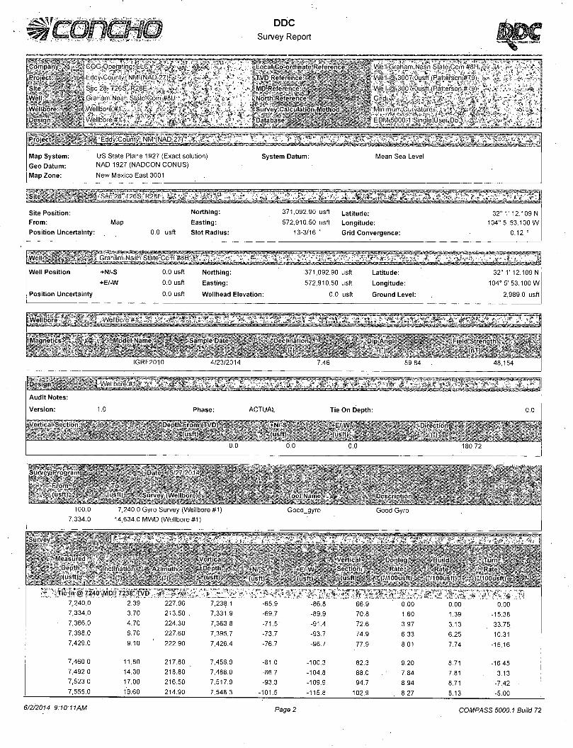
DDC
Survey Report
f Company
feProjoct
(Site
* . « COG Operating* LLCj* t r t v ^ j g g ^ ^
J * ,»» Eddy County NM'(NAD 27) | A „ . A „
/ l ' Sec28-T26S R28E , ' / - I !
; , f i i Graham Nash State Com #8H
Wellbore " V " i j Wellbore #1 * " L t ,
' Wellbore # n " « "W
(Well
Design
BLocal CO orrinidtp Rofcroncu
• ifcTiVD RcffrcncL
KMDiRoferoncc
. liNorth Rolercnre
WelljjGraham Nash StateJCom #8H\
Well t@ 3007 Ousft (Patterson #7,9), *
Well,® 3007 Ousff (Patterson #79) A
Grid,,, *T4.*i , i , . ... .,
Survny Calculation Method 1 Database
• 1 , 1 ' * . " • EDM 5000>1 Single User^Dbi ^ * w '
Project saE SB Eddy County NM (NAD 27) , v
Map System: US State Plane 1927 (Exact solution) Geo Datum: NAD 1927 (NADCON CONUS)
Map Zone: New Mexico East 3001
System Datum: Mean Sea Level
- - •••/".•i't-v V'IIH" ^,^'Kini,iffi,if7?'7i':ry^ 1 *
Site Position: From:
Position Uncertainty:
Map
0.0 usft
Northing:
Easting:
Slot Radius:
371,092.90 usft Latitude:
572,910.50 usft Longitude:
13-3/16" Grid Convergence:
32° 1' 12.109 N
104° 5' 53.100 W
0.12 °
. ..<•<? . 1 G r a h a r r V N a s h " ^ ^ * * ! v " , v >
Wel l Pos i t ion +N/-S 0.0 usft Nor th ing : 371.092.90 usft Lat i tude: 32° V 12.109 N
+E/-W 0.0 usft Eas t ing : 572,910.50 usft Long i tude : 104° 5' 53.100 W
Pos i t ion Uncer ta inty 0.0 usft Wel lhead E levat ion: 0.0 usft Ground Level : 2,989.0 usft
weMboiu _ ^ej£o[itf.ij£i:rs*. ify^^Tx.i^^i^iL7c^'hiJL Mudi I Name SainpieiDat"
IGRF2010 4/23/2014
Magnetic Declination Dip Anqle Field Strength
7.46 59.84 48,154
Audit Notes:
Version: 1.0
EeriicaifSe^tion
Phase:
Depth From "(TVD) (usft)
ACTUAL
+N' S (usfl)
Tie On Depth:
+E/ W (uslt)
Direction
o.o
Survpy Program D j t o ' ~ I I
1 From 1 (usft) (usft ] Survey (Wel lbore) Too l Ni i im Descr ip t ion
100.0 7,240.0 Gyro Survey (Wellbore #1) Good_gyro Good Gyro
7,334.0 14,634.0 MWD (Wellbore #1)
• - • Survey
Measured Ver t i : a l Vert ical Dogleg Bu i ld Dnpth Incl in i t ion Az imu th Dc pth +N/ S - E W Sei t ion Rat. Rati- ^ H R a ^ ^ ^ ^ ^ ^ S
j^^^fc : (usf t ) i^ (usl t ) (usft) (ust t) (usft) ?" iC/100i ibft) (°/1 OOusft) ( 10Ousft)
" : Tie In @ 7240' MD / 7238' TVD -«'"' * , : * ! r »i V _ K 7,240.0 2.39 227.96 7,238.1 -65.9 -86.8 66.9 0.00 0.00 0.00 7,334.0 3.70 213.50 . 7,331.9 -69.7 -89.9 70.8 1.60 1.39 -15.38
7,366.0 4.70 224.30 7,363.8 -71.5 -91.4 72.6 3.97 3.13 33.75
7,398.0 6.70 227.60 7,395.7 -73.7 -93.7 74.9 6.33 6.25 10.31
7,429.0 9.10 222.90 7,426.4 -76.7 -96.7 77.9 8.01 7.74 -15.16
7,460.0 11.80 217.80 7,456.9 -81.0 -100.3 82.3 9.20 8.71 -16.45
7,492.0 14.30 218.80 7,488.0 -86.7 -104.8 88.0 7.84 7.81 3.13 7,523.0 17.00 216.50 7,517.9 -93.3 -109.9 94.7 8.94 8.71 -7,42 •
7,555.0 19.60 214.90 7,548.3 -101.5 -115.8 102.9 8.27 8.13 -5.00
6/2/2014 9:10:11AM Page 2 COMPASS 5000.1 Build 72
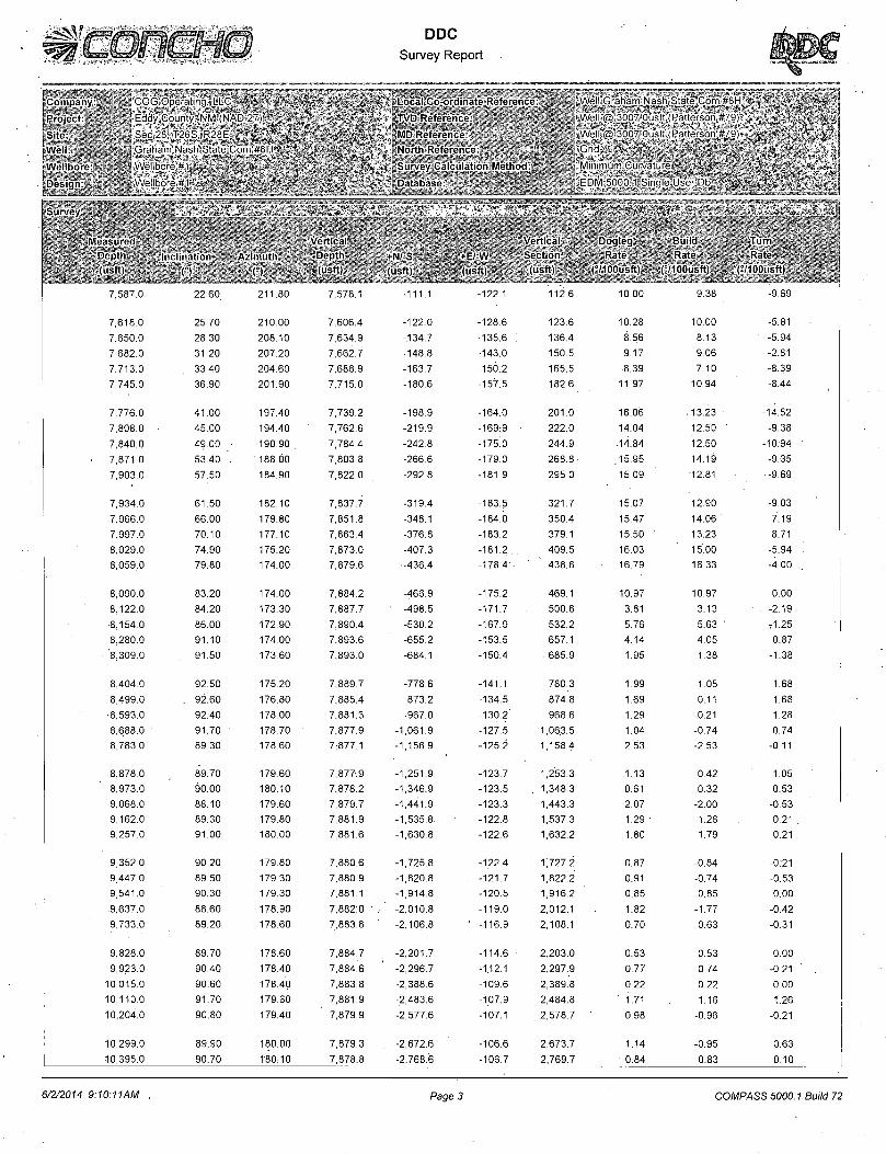
Company li$tliilfiji!i«i! Project
Site Well
Wellbore
Design
Survey
' COCOperan i L I '
^Eddy^Count M N
r|Sec28'>-T2e'" " F~
i Graham' Na ' 1
iWellbore^#J
1 Wellbore #1
DDC Survey Report
Loral Co ordinate Rofpri nee
TVD Reference
MD Refpreiice
North Reference
Survey Calculation Method
Database
„Well Graham Nash State Corr
Well @ 3007 Ousft (Patterson
.Well @ 3007 Ousft (Patterson
J G W | f I ^ ^ ^ ^ | i ^ ^ ^ ^ W -Minimum Curvatui
EDM 5000 1-Sinqle User Db
Measured Vertical Vertical Dogleg Build Turn
Dppth Im hiution Azimuth Depth +N' S +E'W Section Rate Rate Rate
(usft) (usft) (usft) (usftl (usft) I '100uslt) ( lOOustt) ( 10Ousft)
7,587.0 -12_ , -9.69
7,618.0 25.70 210.00 7,606.4 -122.0 -128.6 123.6 10.28 10.00 -5.81
7,650.0 28.30 208.10 7,634.9 -134.7 -135.6 136.4 8.56 8.13 -5.94
7,682.0 31.20 207.20 7,662.7 -148.8 -143.0 150.5 9.17 9.06 -2.81
7,713.0 33.40 204.60 7,688.9 -163.7 -150.2 165.5 8.39 7.10 -8.39
7,745.0 36.90 201.90 7,715.0 -180.6 -157.5 182.6 '11.97 10.94 -8.44
7,776.0 41.00 197.40 7,739.2 -198.9 -164.0 201.0 16.06 .13.23 -14.52
7,808.0 45.00 194.40 7,762.6 -219.9 -169:9 222.0 14.04 12.50 -9.38
7,840.0 49.00 190.90 . 7,784.4 -242.8 -175.0 244.9 .14.84 12.50 -10:94
• 7,871.0 53.40 . 188.00 7,803.8 -266.6 -179.0 268.8 ,15.95 14.19 -9.35
7,903.0 57.50 184.90 7,822.0 -292.8 -181.9 295.0 15.09 12.81 •-9.69
7,934.0 61.50 182.10 7,837.7 -319.4 -183.5 321.7 15.07 12.90 -9.03
7,966.0 66.00 179.80 7,851.8 -348.1 -184.0 350.4 15.47 14.06 -7.19
7,997.0 70.10 177.10 7,863.4 -376.8 -183.2 379.1 15.50 13.23 -8.71
8,029.0 74.90 175.20 7,873.0 -407.3 -181.2 . 409.5 16.03 15.00 -5.94
8,059,0 79.80 174.00 7,879.6 -436.4 -178.4 • 438.6 16.79 16.33 -4.00
8,090.0 83.20 174.00 7,884.2 -466.9 -175.2 469.1 10.97 10.97 0.00
8,122.0 84.20 173.30 7,887.7 -498.5 -171.7 500.6 3.81 3.13 . -2.19
8,154.0 86.00 172.90 7,890.4 -530.2 -167.9 532.2 5.76 5.63 • T1 .25
8,280.0 91.10 174.00 7,893.6 -655.2 -153.5 657.1 4.14 4.05 0.87
'8,309.0 91.50 173.60 7,893.0 -684.1 -150.4 685.9 1.95 1.38 -1.38
8,404.0 92.50 175.20 7,889.7 -778.6
8,499.0 . 92^60 176.80 7,885.4 -873.2
8,593.0 92.40 178.00 7,881.3 -967.0
8,688.0 • 91.70 178.70 ' 7,877.9 . -1,061.9 8,783.0 89.30 178.60 7-877.1 -1,156.9
8,878.0 89.70 179.60 7,877.9 -1,251.9
8,973.0 90.00 180.10 7,878.2 -1,346.9
9,068.0 88.10 179.60 7,879.7 -1,441.9
9,162.0 89.30 179.80 7,881.9 -1,535.8
9,257.0 91.00 180.00 7,881.6 -1,630.8
9,352.0 90.20 179.80 7,880.6 -1,725.8
9,447.0 89.50 179.30 7,880.9 -1,820.8
9,541.0 90.30 179.30 7,881.1 -1,914.8
9,637.0 88.60 178.90 7,882:0 " -2,010.8
9,733.0 89.20 178.60 7,883.8 -2,106.8
9,828.0 89.70 178.60 7,884.7 -2,201.7
9,923.0 90.40 178.40 7,884.6 -2,296.7
10,015.0 90.60 178.40 7,883.8 -2,388.6
10,110.0 91.70 179.60 7,881.9 -2,483.6 10,204.0 90.80 179.40 7,879.9 -2,577.6
10,299.0 89.90 180.00 7,879.3 -2,672.6
10,395.0 90.70 180.10 7,878.8 -2,768.6
-141.1 780.3 1.99 1.05 1.68
-134.5 874.8 1.69 0.11 1.68
-130.2' 968.6 1.29 -0.21 1.28
-127.5 1,06.3.5 1.04 -0.74 0.74
-125.2 1,158.4 2.53 -2.53 -0.11
-123.7 1,253.3 1.13 0.42 1.05
-123.5 . 1,348.3 0.61 0.32 0.53
-123.3 1,443.3 2.07 -2.00 -0.53
-122.8 1,537.3 1.29 • 1.28 0.21
-122.6 1,632.2 1.80 1.79 0.21
-122.4 1,727.2 0.87 -0.84 -0:21
-121.7 1,822.2 0.91 -0.74 -0.53
-120.5 1,916.2 0.85 0.85 0.00
-119.0 2,012.1 1.82 -1.77 -0.42
-116.9 2,108.1 0.70 0.63 -0.31
-114.6 2,203.0 0.53 0.53 0.00
-1.12.1 2,297.9 0.77 0.74 -0.21
-109.6 2,389.8 0.22 0.22 0.00
-107.9 2,484.8 ' 1.71 1.16 1.26
-107.1 2,578.7 0.98 -0.96 -0.21
-106.6 2,673.7 1.14 -0.95 0.63
-106.7 2,769.7 0.84 0.83 0.10
6/2/2014 9:10:11AM Page 3 COMPASS 5000.1 Build 72

DDC Survey Report
Company
Project
Site
Well
Wellbore:
Design \
COGOperating'[LLC«i -
Eddy County NM (NAD 27) r
Sec 28'T26S R28E "\ f~ *
Graham:Nash;State'Com".#8HS|li^
Wellbore#1-* ' . < , ^
Wellbore #l"sit ^ ^ "
.l2ocaltCojordmate:Referencetj
TVD Referei
MD Reference
North Reference
Survey Calculation;Method:«
Database i y
Well.GraharmNash State Com.#8H,
Well @ 3007 Ousft (Patterson #79)
Wei' @ 30C7.0usft (Patterson #79}
Grid , * ^ , J j£ " MinimumiCurvature.. "
EDM 5000 1 Single User D f -
Surveys
'Measured Depth (usft)
Inclination-•t »
Azimuth
Vertical \ i D e p t l v
10,490.0
10,585.0
10,681.0
90.10
89.60
90.70
178.60
179.80
179.40
7,878.1
7,878.4
7,878.1
+N/-S , t
(usft)
-2,863.6
-2,958.6
-3,054.5
+E/-W (usft)
-105.6
-104.3
-103.6
Vertical Section (usft)
2,864.7
2,959.6
3,055.6
Dogleg ' Rate
(°/100usft)
1.70
1.37
1.22
Build Rate
(°/1 OOusft)
-0.63
-0.53
1.15
Turn Rate
/1 OOusft)
-1.58
1.26
-0.42
10,777.0 90.80 180.50 7,876.9 -3,150.5 -103.5 3,151.6 1.15 0.10 1.15 10,872.0 90.10 180.30 7,876.1 -3,245.5 -104.2 3,246.6 0.77 -0.74 -0.21 10,967.0 92.30 180.30 7,874.1 -3,340.5 -104.7 3,341.6 2.32 2.32 0.00 11,062.0 92.70 181.20 7,870.0 -3,435.4 -105.9 3,436.5 • 1.04 0.42 0.95 11,158.0 90.30 181.20 7,867.5 -3,531.3 -107.9 3,532.4 2.50 -2.50 0.00
11,253.0 89.70 • 181.70 7,867.5 -3,626.3 -110.3 3,627.4 0.82 -0.63 0.53 11,348.0 , 88.70 181.90 7,868.8 • -3,721.3 -113.3 3,722.4 1.07 -1.05 0.21 11,443.0 89.70 181.90 7,870.1 -3,816.2 -116.5 3,817.4 1.05 1.05 0.00 11,539.0 89.10 182.20 • 7,871.1 -3,912.1 -119.9 . 3,913.3 0.70 -0.63 0.31 11,634.0 89.10 181.90 7,872.6 .-4,007.1 -123.3 4,008.3 0.32 0.00 -0.32
11,729.0 89.40 180.80 7,873.9 -4,102.0 -125.5 .4,103.3 1.20 0.32 -1.16 11,825.0 90.00 180.50 7,874.4 -4,198.0 -126.6 4,199.3 0.70 0.63 -0.31 11,920.0 89.80 179.60 7,874.5 -4,293.0 -126.7 4,294.3 0.97 -0.21 -0.95 12,015.0 91.60 179.80 7,873.4 -4,388.0 -126.2 4,389.2 1.91 1.89 0.21 12,111.0 91.20 179.40 7,871.0 -4,484.0 -125.5 4,485.2 0.59 -0.42 -0.42
12,206.0 91.70 178.40 7,868.6 -4,578.9 -123.7 4,580.1 1.18 0.53 -1.05 12,301.0 91.40 178.40 7,866.1 -4,673.8 -121.1 4,675.0 0.32 -0.32 0.00 12,400.0 90.50 178.70 7,864.4 -4,772.8 -118.6 4,773.9 0.96 -0.91 0.30 12,495.0 91.50 178.70 7,862.8 -4,867.8 -116.4 4,868.8 1.05 1.05 0.00 12,590.0 90.30 177.90 7,861.3 -4,962.7 -113.6 4,963.7 1.52 -1.26 -0.84
12,685.0 91.70 177.10 7,859.6 -5,057.6 -109.4 5,058.6 1.70 . 1.47 -0.84 12,779.0 90.90 179.30 7,857.5 -5,151.5. -106.5 5,152.4 2.49 -0.85 2.34 12,875.0 89.20 180.00 7,857.4 -5,247.5 -105.9 5,248.4 1.92 -1.77 0.73 12,970.0 89.80 180.00 7,858.2 -5,342.5 -105.9 5,343.4 0.63 0.63 0.00 13,065.0 90.00 181.40 7,858.4 -5,437.5 -107.1 5,438.4 1.49 0.21 1.47
13,162.0 90.90 180.50 7,857^6 -5,534.5 -108.7 5,535.4 1.31 0.93 -0.93 13,256.0 91.30 179.60 7,855.8 ,-5,628.5 -108.7 5,629.4 1.05 0.43 -0.96 13,351.0 90.00 181.00 7,854.8 '-5,723.4 -109.2 ' 5,724.4 2.01 -1.37 1.47 13,446.0 88.60 181.20 7,855.9 -5,818.4 -111.1 5,819.4 1.49 -1.47 0.21 13,541.0 89.10 181.90 7,857.8 -5,913.4 -113.6 5,914.3 0.91 0.53 0.74
13,636.0 89.80 181.90 7,858.7 -6,008.3 -116.8 6,009.3 0.74 0.74 0.00 13,732.0 90.50 181.40 7,858.5 ' -6,104.3 -119.6 6,105.3 0.90 0.73 -0.52 13,827.0 91.40 182.20 7,856.9 -6,199.2 -122.5 6,200.3 1.27 0.95 0.84 13,923.0 90.00 181.70 7,855.7 -6,295.1 -125.8 6,296.2 1.55 -1.46 -0.52 14,018.0 89.10 182.60 7,856.5 -6,390.1 -129.4 6,391.2 1.34 -0.95 0.95
14,114.0 89.30 182.80 7,857.8 -6,486.0 -133.9 6,487.1 0.29 0.21 0.21 14,208.0 90.20 182.80 7,858.2 -6,579.8 -138.5 6,581.1 0.96 0.96 0.00 14,304.0 90.40 182.80 7,857.7 -6,675.7 -143.2 6,677.0 0.21 0.21 0.00 14,399.0 90.60 182.90 7,856.9 -6,770.6 -147.9 6,771.9 0.24 0.21 0.11 14,495.0 90.70 . 182.60 7,855.8 -6,866.5 -152.5 6,867.9 0.33 0.10 -0.31
6/2/2014 9:10:11AM Page 4 COMPASS 5000.1 Build 72

DDC Survey Report
Company:'-?
Project
Si1
WHI
Wellbore
Design:
—̂ •••
COG Operating LLC>
Eddy County. NM (NAD 27);
Sec 28 T26S R28E>* ^ %T ~ \ ^ % \ « *
Graham Nash State*Com #8H i »
Wellbore #1 *"-' - *
.Wellbore*!
Local Co-ordmateiReference:'
TVD Reference
MDtReferenci
North Reference K
! Well.GrahamNash State Com #811-
i Well,@J3007-.Ousft (Patterson #79)^
J Well,© 3007 Ousft (Patterson #79)*
Grid
Survey.Calculation Method:' .irtftvi Minimum;Curvature..:°».'
Database . • ' * - I FnM i;nnn 1 Qinnio i ic EDM 5000 1 Single User Db *6
Survey ' „ J
<3§1
1 " J C Z T ^ E 1
• Vertical Depth Inclination Azimuth Depth
: Measured Vertical Dogleg Build Turn
(uslt) +N/-S +E/-W . " Sec Hon Rate Rate Rati-(usft) (usft). - / (us f t ) (°/100usft) ("M OOusft) ( 'lOOusft)
d. „ u h u u^c . f ..— y.i^.. . , .
14.584.0 91.30
.•TD;@' 14634'MD7.7853' TVD'Uff: 14.634.0 91.30 183.50
183.50 7.854.3
7.853.1
-6.955.3
-7.005.2
-157.2
-160.3
6.956.8
7.006.7
1.22
0.00
0.67
0.00
1.01
. 0.00
Survey'Annotations
•^Measured Depth ^ (usf t ) " '
Vertical Depth (usft)
Local Coordinates +N/-S' i +E/-W (usft) , (usft) Comment.;
8HM
7.240.0 • 14,634.0
7.238.1 7,853.1
-65.9 -7,005.2
-86.8 -160.3
Tie In @ 7240' MD / 7238' TVD TD @ 14634' MD / 7853' TVD
Checked By: Approved By: Date:
6/2&014 9:10:11AM Page 5 COMPASS 5000.1 Build 72
SURVEY INTERNATIONAL
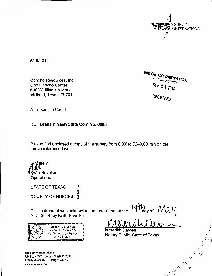
5/19/2014
Concho Resources, Inc One Concho Center 600 W. Illinois Avenue Midland, Texas 79701
Attn: Kanicia Castillo
RE: Graham Nash State Com No. 008H
NMoiL
S E P 2 4 2 0 H
Please find enclosed a copy of the survey from 0.00' to 7240.00' ran on the above referenced well.
erely,
Havelka perations
STATE OF TEXAS § §
COUNTY OF NUECES §
This instrument was acknowledged before me on the A.D., 2014, by Keith Havelka.
day of
MEREDITH DARDEN fV .^LVr ' i Notary Public, State of Texas l i / ^N . - i? / My Commission Expires
July 25, 2017
VES Survey International P.O. Box 261021 Corpus Christi, TX 78426 T (361) 767-0602 F (361) 767-0612 www.vessurvey.com
Meredith Darden Notary Public, State of Texas
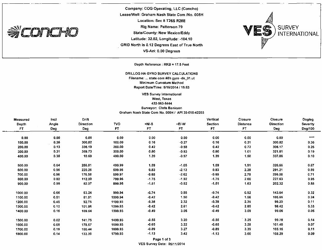
Company: COG Operat ing, LLC (Concho)
Lease/Well: Graham Nash State Com /No. 008H
Locat ion : Sec 8 T26S R28E
Rig Name: Patterson 79
State/County: New Mexico/Eddy
Lat i tude: 32.02, Longi tude: -104.10
GRID North is 0.12 Degrees East of True North
VS-Azi: 0.00 Degrees
SURVEY INTERNATIONAL
Depth Reference : RKB = 17.5 Feet
Measured Depth
FT
Incl Angle Deg
Drift Direction
Deg
DRILLOG HA GYRO SURVEY CALCULATIONS Filename: ... state com #8h gyro -de_01.ut
Minimum Curvature Method Report Date/Time: 5/16/2014 /15:53
VES Survey International West, Texas 432-563-5444
Surveyor: Chris Bankson Graham Nash State Com No. 008H / API 30-015-42203
TVD FT
+N/-S FT
+E/-W FT
Vertical Section
FT
Closure Distance
FT
Closure Direction
Deg
Dogleg Severity Deg/100
0.00 100.00 200.00 300.00 400.00
0.00
0.36
0.13
0.31
0.38
0.00
300.82
336.19
359.73
10.69
0.00
100.00
200.00
300.00
400.00
0.00 0.16 0.42 0.80 1.39
0.00 -0.27 -0.58 -0.63 -0.57
0.00 0.16 0.42 0.80 1.39
0.00 0.31 0.72 1.01 1.50
0.00 300.82 306.17 321.81 337.86
0.36
0.26
0.19
0.10
500.00
600.00
700.00
800.00
900.00
0.64
0.96
0.96
0.80
0.95
256.81
220.26
176.58
112.09
52.07
499.99
599.98
699.97
799.96
899.95
1.59
0.83
-0.65
-1.75
-1.51
-1.05
-2.13
-2.62
-1.92
-0.62
1.59
0.83
-0.65
-1.75
-1.51
1.91
2.28
2.70
2.60
1.63
326.66
291.21
256.08
227.63
202.32
0.87
0.59
0.71
0.95
0.88
1000.00
1100.00
1200.00
1300.00
1400.00
0.66
0.51
0.45
0.12
0.16
63.24
81.91
92.75
101.96
109.64
999.94
1099.94
1199.93
1299.93
1399.93
-0.74
-0.42
-0.38
-0.42
-0.49
0.55
1.50
2.32
2.81
3.05
-0.74
-0.42
-0.38
-0.42
-0.49
0.92
1.56
2.35
2.85
3.09
143.64
105.66
99.20
98.42
99.06
0.32
0.24
0.11
0.33
0.05
1500.00
1600.00
1700.00
1800.00
0.02
0.09
0.19
0.14
141.75
178.57
160.44
133.39
1499.93
1599.93
1699.93
1799.93
-0.55 -0.65 -0.89 -1.13
3.20 3.22 3.27 3.42
Page 1 of 3 VES Survey Date: 05/11/2014
-0.55 -0.65 -0.89 -1.13
3.25 3.28 3.39 3.60
99.78 101.40 105.15 108.29
0.14 0.07 0.11 0.09

Measured Depth
FT
Incl Angle Deg
Drift Direction
Deg TVD FT
1900.00 0.12 137.61 1899.93
2000.00 0.15 77.81 1999.93 2100.00 0.05 22.31 2099.93 2200.00 0.27 337.18 2199.93 2300.00 0.18 335.58 2299.93 2400.00 0.14 321.64 2399.93
2500.00 0.09 324.33 2499.93 2600.00 0.08 325.28 2599.93 2700.00 0.24 334.22 2699.93 2800.00 0.27 316.22 2799.93 2900.00 0.30 297.08 2899.93
3000.00 0.34 279.59 2999.92 3100.00 0.29 290.22 3099.92 3200.00 0.40 286.42 3199.92 3300.00 0.66 285.38 3299.92 3400.00 0.47 280.33 3399.91
3500.00 0.62 277.19 3499.91 3600.00 0.68 274.20 3599.90 3700.00 0.78 277.21 3699.89 3800.00 0.74 285.12 3799.88 3900.00 0.99 282.83 3899.87
4000.00 0.97 261.86 3999.86 4100.00 0.91 238.39 4099.85 4200.00 1.07 239.89 4199.83 4300.00 0.90 239.85 4299.82 4400.00 0.97 241.23 4399.80
4500.00 1.51 239.58 4499.78 4600.00 1.43 232.88 4599.75 4700.00 1.40 226.08 4699.72 4800.00 1.70 237.84 4799.68 4900.00 1.85 224.68 4899.63
5000.00 2.05 225.98 4999.57 5100.00 2.02 230.43 5099.51 5200.00 2.07 235.62 5199.45 5300.00 1.91 227.41 5299.39 5400.00 1.96 229.80 5399.33
5500.00 1.94 228.16 5499.27 5600.00 2.17 223.75 5599.21 5700.00 2.16 217.29 5699.14
Vertical +N/-S +E/-W Section
FT FT FT
-1.30 3.58 -1.30
-1.35 3.78 -1.35 -1.28 3.92 -1.28 -1.02 3.85 -1.02 -0.66 3.69 -0.66 -0.42 3.55 -0.42
-0.27 3.43 -0.27 -0.14 3.34 -0.14 0.11 3.21 0.11 0.47 2.95 0.47 0.76 2.55 0.76
0.93 2.03 0.93 1.06 1.50 1.06 1.25 0.93 1.25 1.50 0.03 1.50 1.73 -0.92 1.73
1.87 -1.86 1.87 1.98 -2.98 1.98 2.11 -4.25 2.11 2.36 -5.55 2.36 2.72 -7.02 2.72
2.79 -8.69 2.79 2.26 -10.20 2.26 1.37 -11.69 1.37 0.51 -13.17 0.51
-0.29 -14.59 -0.29
-1.36 -16.47 -1.36 -2.78 -18.60 -2.78 -4.39 -20.48 -4.39 -6.03 -22.62 -6.03 -7.97 -25.01 -7.97
-10.36 -27.43 -10.36 -12.73 -30.08 -12.73 -14.87 -32.93 -14.87 -17.02 -35.65 -17.02 -19.25 -38.18 -19.25
-21.48 -40.75 -21.48 -23.98 -43.32 -23.98 -26.85 -45.77 -26.85
Page 2 of 3 VES Survey Date: 05/11/2014
Closure Closure Dogleg Distance Direction Severity
FT Deg Deg/100
3.81 109.88 0.02
4.01 109.63 0.14 4.12 108.10 0.12 3.98 104.91 0.24 3.75 100.17 0.09 3.57 96.81 0.06
3.44 94.43 0.05 3.34 92.43 0.01 3.21 88.11 0.16 2.99 81.03 0.09 2.66 73.48 0.10
2.23 65.48 0.10 1.84 54.67 0.07 1.56 36.51 0.11 1.50 1.31 0.26 1.96 331.92 0.20
2.63 315.18 0.15 3.58 303.56 0.07 4.75 296.37 0.11 6.03 293.05 0.11 7.52 291.20 0.25
9.13 287.82 0.36 10.45 282.48 0.39 11.77 276.70 0.16 13.18 272.22 0.17 14.59 268.86 0.08
16.52 265.26 0.54 18.80 261.48 0.19 20.94 257.90 0.17 23.41 255.07 0.44 26.25 252.33 0.43
29.32 249.31 0.20 32.66 247.07 0.16 36.13 245.70. 0.19 39.50 244.48 0.33 42.76 243.24 0.10
46.06 242.20 0.06 49.51 241.03 0.28 53.06 239.61 0.24
Measured Incl Drift Vertical Closure Closure Dogleg Depth Angle Direction TVD +N/-S +E/-W Section Distance Direction Severity
FT Deg Deg FT FT FT FT FT Deg Deg/100
5800.00
5900.00
1.97 1.96
220.24 228.40
5799.07 5899.01
-29.66 -32.11
-48.02 -50.41
-29.66 -32.11
56.44 59.77
238.30 237.51
0.22 0.28
6000.00 6100.00 6200.00 6300.00 6400.00
2.00 1.84 1.81 1.81 1.94
223.10 223.73 216.47 221.27 213.60
5998.95 6098.90 6198.85 6298.80 6398.74
-34.52 -36.95 -39.38 -41.84 -44.44
-52.88 -55.18 -57.23 -59.22 -61.20
-34.52 -36.95 -39.38 -41.84 -44.44
63.15 66.41 69.47 72.51 75.64
236.87 236.20 235.47 234.76 234.01
0.19 0.16 0.23 0.15 0.28
6500.00 6600.00 6700.00 6800.00 6900.00
2.15 2.10 2.55 3.16 2.27
225.30 221.65 234.66 239.36 242.05
6498.68 6598.61 6698.53 6798.40 6898.29
-47.17 -49.86 -52.51 -55.20 -57.54
-63.47 -66.02 -69.05 -73.23 -77.36
-47.17 -49.86 -52.51 -55.20 -57.54
79.08 82.73 86.74 91.71 96.41
233.38 232.94 232.75 232.99 233.36
0.46 0.14 0.69 0.66 0.90
7000.00 7100.00 7200.00 7240.00
1.86 2.08 2.47 2.39
230.24 225.20 221.70 227.96
6998.23 7098.17 7198.09 7238.05
-59.51 -61.83 -64.71 -65.91
-80.36 -82.90 -85.62 -86.81
-59.51 -61.83 -64.71 -65.91
99.99 103.41 107.32 109.00
233.48 233.28 232.92 232.79
0.59 0.28 0.41 0.69
Page 3 of 3 VES Survey Date: 05/11/2014
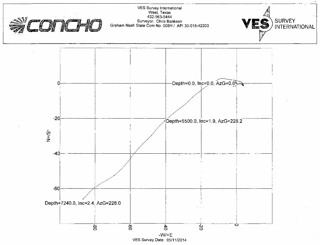
VES Survey International West, Texas
432-563-5444 Surveyor: Chris Bankson
Graham Nash State Com No. 008H / API 30-015-42203 SURVEY INTERNATIONAL
V\e±r \ tV \ — n n I n c=0.0, AzG=0.0 i
ic=1.9, AzG=22i
uepin—u.u, in
/ ' /'
/ /
/' /'
Depth=5500.0, 1
c=0.0, AzG=0.0 i
ic=1.9, AzG=22i
/ /
/ /
/ /
uepin—u.u, in
/ ' /'
/ /
/' /'
Depth=5500.0, 1
c=0.0, AzG=0.0 i
ic=1.9, AzG=22i 3.2
/ /
/ / '
/
/ /
=7240.0, lnc=2.4, AzG=228.0
i i CO O) ro °
CO
-W/+E VES Survey Date: 05/11/2014
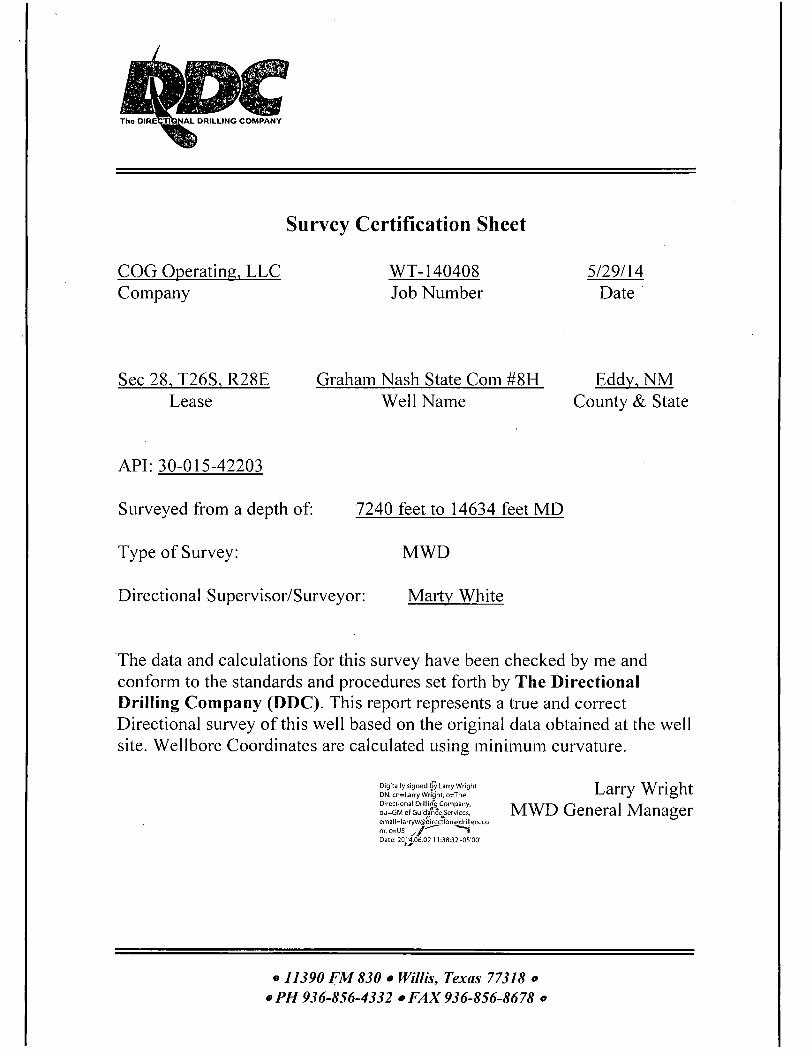
A L D R I L L I N G C O M P A N Y
Survey Certification Sheet
COG Operating, LLC WT-140408 5/29/14 Company Job Number Date
Sec 28, T26S, R28E Graham Nash State Com #8H Eddy, NM Lease Well Name County & State
API: 30-015-42203
Surveyed from a depth of: 7240 feet to 14634 feet MD
Type of Survey: MWD
Directional Supervisor/Surveyor: Marty White
The data and calculations for this survey have been checked by me and conform to the standards and procedures set forth by The Directional Drilling Company (DDC). This report represents a true and correct Directional survey of this well based on the original data obtained at the well site. Wellbore Coordinates are calculated using minimum curvature.
Larry Wright Directional Drilling Company, » j r \ t r~r~\ i > r OU=GMofcuid/feslices. MWD General Manager [email protected]
Digitally signed by Larry Wright DN: cn=Larry Wright, o=The Directional Drilling Company,
m,c=US j / * * "~» Date: 2014.06.02 11:38:32 -05"00'
o 11390 FM830 • Willis, Texas 77318 o *PH 936-856-4332 • FAX 936-856-8678 o