Embed Size (px)
Citation preview

7/29/2019 DCP AND BC
http://slidepdf.com/reader/full/dcp-and-bc 1/87
GEOTECHNICAL ASSESSMENT
Proposed Walkers Hut – Tunnel Bay
Geo-Environmental Solutions P/L 86 Queen Street Sandy Bay 7005. Ph 6223 1839 Fax 6223 4539
CLIENT
Parks & Wildlife Service
July 2011

7/29/2019 DCP AND BC
http://slidepdf.com/reader/full/dcp-and-bc 2/87
Geotechnical Assessment – Proposed Walkers Hut - Tunnel Bay
© Geo-Environmental Solutions 2011 1
Introduction ........................................................................................................................ 2 Site information.................................................................................................................. 4 Geotechnical Assessment ................................................................................................ 7
Wind Loading Assessment ............................................................................................. 10 Site Suitability for Onsite Wastewater Disposal ........................................................... 11 Conclusions...................................................................................................................... 13 Appendix 1 –Trench summary report ............................................................................ 14

7/29/2019 DCP AND BC
http://slidepdf.com/reader/full/dcp-and-bc 3/87
Geotechnical Assessment – Proposed Walkers Hut - Tunnel Bay
© Geo-Environmental Solutions 2011 2
1 Introduction
Geo-Environmental Solutions Pty Ltd (GES) were contracted by the TasmanianParks and Wildlife Service (PWS) to undertake a geotechnical assessment of theproposed Hut site at Tunnel Bay on the Three Capes Track. The proposed hut siteis located at Tunnel Bay, which is in the Tasman National Park, close to ShipsternBluff, Tasman Peninsular, Tasmania (see figure 1 below). The developmentproposal is for the construction of a walkers hut, to accommodate up to 52 personsper night (up to 48 walkers and 4 staff), with associated infrastructure and on-sitewaste management.
Figure 1 Site Location – Extract from PWS Brochure
The site is located in an area of low elevation, on an alluvial terrace of the smallcreek which flows in to Tunnel Bay (see figure 2). The land surveyed is gentlysloping land to the North (2-5% slopes) with the small creek (Tunnel Bay Creek)which dissects the area some 30-50m from the site. The vegetation is predominantlythick native low level scrub, with ground surface cover of native grasses andbracken fern (see figure 3).
It is the scope of this report to consider the capability of the land to supportsustainable development without environmental harm or undue risk to capital. It isalso the aim of this report to use a scientific framework to classify the biophysicalfeatures of the land in the context of proposed development.

7/29/2019 DCP AND BC
http://slidepdf.com/reader/full/dcp-and-bc 4/87
Geotechnical Assessment – Proposed Walkers Hut - Tunnel Bay
© Geo-Environmental Solutions 2011 3
Figure 2 View of Tunnel Bay Creek to the south of the hut site
Figure 3 View of the vegetation in the area of the proposed hut

7/29/2019 DCP AND BC
http://slidepdf.com/reader/full/dcp-and-bc 5/87
Geotechnical Assessment – Proposed Walkers Hut - Tunnel Bay
© Geo-Environmental Solutions 2011 4
2 Site information
Site information pertaining to the capability of the land to sustain developmentwithout causing environmental harm or undue risk to capital was collected fromdesktop and field survey. Field survey was undertaken utilising a 70mm auger and a9kg DCP with soil samples assessed according to AS2870-2011 and AS/NZS1547-2000 for suitability for construction and on-site waste management.
GeologyThe study area falls within the Mineral Resources Tasmania, South East Tasmania1:250000 sheet which indicates the local area is underlain by Permian sediments tothe south, Triassic sandstone to the East, and Jurassic Dolerite on the upper slopes.However the coarse scale of the mapping does not identify smaller areas of Quaternary deposits associated with alluvial systems or slope colluvial materials.Site inspection identified alluvial deposits, most likely quaternary in age as theparent materials for soils forming on the proposed construction area. The alluvial
sediments are dominated by sand and gravel deposits, grading to a base of larger water worn cobbles associated with the present stream level.
Figure 5 MRT 1:250 000 South East Tasmania Sheet Geological Survey – approximate hut site shown with red star
Jurassic Dolerite
Triassic sandstone
Permian sediments

7/29/2019 DCP AND BC
http://slidepdf.com/reader/full/dcp-and-bc 6/87
Geotechnical Assessment – Proposed Walkers Hut - Tunnel Bay
© Geo-Environmental Solutions 2011 5
Soil distributionThe soils found on the site shows a close correlation with underlying geologicalmaterial, and are therefore classified according to geological association (i.e.Tenosol on Quaternary alluvium). Soil distribution within the proposed developmentarea was relatively uniform, with some variation in soil depth according totopographic position and surface organic matter accumulation (see typical bore log
below).
The soils on site are deep sands developing from alluvial deposits associated withthe nearby creek with a shallow water table encountered at approximately 1m depth.The soils are dominated by fine to medium grained sands with a trace of clay atdepth. The soils are weakly structured with only slight horizon development and arelikely to have moderately high permeability. Analysis results indicate the soils willexhibit only slight movement with soil moisture variations, with an indicative AS2870-2011 site classification of class S. The measured soil permeability at adepth of 0.4m was approximately 70mm/hour or 1.7m/day indicating the soils aremoderately to highly permeable with a good capacity to accept wastewater flows.The soils are classified as category 2 (sandy loam) according to AS/NZS1547-2000for on-site wastewater disposal.
Soils of this type developing on Quaternary sediments are generally stable but areweakly structured. The soils on site may be prone to surface erosion when denudedof cover, and or subject to abnormal drainage conditions. Therefore care should betaken during site clearing and construction to ensure soil erosion does not occur,and that local surface water values are maintained. A soil and water managementplan (SWMP) should therefore be developed, implemented, and monitored for allconstruction activities.
Table 1 – Typical Soil Profile Description
Depth (m) Horizon Description
0 – 0.25 A1 Black (10 YR 2/1) SAND (SW), leaf litter at surface, loam
fabric, weak polyhedral structure parting to single grain, moist to
wet soft consistency, fine to medium sand grains, few fine to
medium roots, clear smooth boundary to
0.25 – 0.60 A2 Light Brownish Grey (10 YR 6/2) SAND (SW), weak
polyhedral structure parting to single grain, medium sand grains,
slightly moist soft to medium dense consistency, trace of yellowmottles at depth, gradual boundary to
0.60 - 1.0 B1 Mixed Brownish Grey (10 YR 5/2) and Brownish Yellow (10
YR 6/8) SAND (SC), approximately 5-10% clay, weak sub-angular blocky structure, medium sand grains, moist medium
dense consistency, gradual boundary to
1.0 – 2.60 BC Brownish Grey (10 YR 5/2) SAND (SW), massive structure
parting to single grain, medium sand grains, wet medium denseconsistency – free groundwater encountered at or below 1m,
gradual boundary to
2.60+ C Mixed alluvial boulder, rock and gravel deposits of
predominantly dolerite clasts in sand and gravel matrix

7/29/2019 DCP AND BC
http://slidepdf.com/reader/full/dcp-and-bc 7/87
Geotechnical Assessment – Proposed Walkers Hut - Tunnel Bay
© Geo-Environmental Solutions 2011 6
Figure 6 Auger hole in the vicinity of the proposed hut site at Tunnel Bay – auger length is 1.4m showing topsoil starting at the handle extending to subsoils at the tipof the auger. Organic rich sandy topsoils overlie deep sandy subsoils grading oquaternary alluvium below 2.5m depth.

7/29/2019 DCP AND BC
http://slidepdf.com/reader/full/dcp-and-bc 8/87
Geotechnical Assessment – Proposed Walkers Hut - Tunnel Bay
© Geo-Environmental Solutions 2011 7
3 Geotechnical Assessment
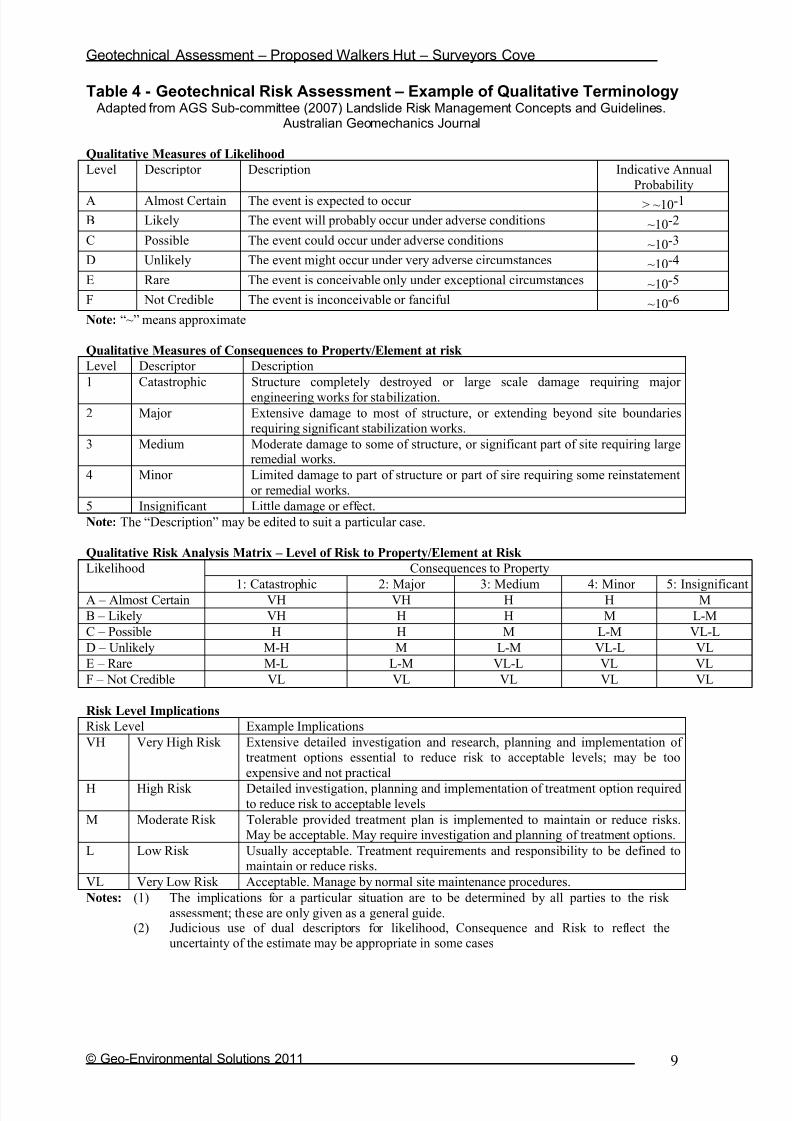
A number of geotechnical risk scenarios have been considered for the developmentincluding risk of land instability, risk of inundation/flooding, risk of foundation failure,and erosion risk. The level of risk associated with any possible event is described interms of likelihood and consequence (see table 3 for classification and see table 4for an explanation of terminology). That is, how likely is the event to occur (eg rare,unlikely, likely possible etc), and what is the consequence of the event (eg loss of life, serious capital damage, limited capital damage, localised erosion etc). Basedupon an assessment of the site and the likely risks, the overall geotechnical riskassociated with the development is rated as low.
The AS2870-2011 site classification for the site is Class S based upon soil textureand typical soil depth across the site. Based upon 9Kg DCP measurements anallowable bearing capacity of 125kPa has been assigned for a minimum foundingdepth of 600mm. The bearing capacity in the surface layers was weak (see table 2
below), and is a likely result of the organic content in the surface horizons. It istherefore recommended that the surface horizons be removed from the foundingarea, and all foundations be placed into subsoils with adequate bearing capacity.
Table 2 – Typical DCP test Results
Dynamic Cone Penetration (DCP) Conversion to Californian Bearing Ratio
(ref: Australian Standard AS 1289.6.3.2 - 1997)
Date 27-May-11
Location Tunnel Bay
Bedrock Depth (mm) 2.5m+Water Table Location 1m
DCP Commencement Depth at surface
Slope and Aspect 3% E
Depth (mm) DCP DCP DCP Resistance Bearing Capacity CBR
(Blows/150mm) (mm/Blow) (mPa) (kPa)
0-150 1 150.0 0.2 28 1
150-300 1 150.0 0.2 28 1
300-450 3 50.0 0.7 84 4
450-600 5 30.0 1.2 140 6
600-750 6 25.0 1.4 168 8
750-900 8 18.8 1.9 224 11
900-1050 6 25.0 1.4 168 8

7/29/2019 DCP AND BC
http://slidepdf.com/reader/full/dcp-and-bc 9/87
Geotechnical Assessment – Proposed Walkers Hut - Tunnel Bay
© Geo-Environmental Solutions 2011 8
Table 3 – Preliminary Geotechnical Risk Analysis of the Site
Hazard Likelihoodof
occurrence
Consequencesto property
Level of risk to
property
Treatmentoptions
Surface erosion Possible Minor Very Lowto Low
Soil and Water ManagementPlan (SWMP)
Subsoil or tunnelerosion
Unlikely Minor Very Lowto Low
Dispersiontesting asrequired
Soil creep Rare Minor Very Low None required
Shallow seatedlandslide (eg.Debris slide/flows)
Unlikely Minor Very Low Adequate AS2870-2011assessment &
SWMP
Deep seatedlandslide (eg.Boulder bed/talusinstability)
Not credible Major Very Low None required
Excessivefoundationmovement (eg.Due to extremelyreactive soils)
Possible Medium Moderate Appropriateengineeringfoundation
design/drainagedesign
Foundationfailure (eg.Excessivesettlement, fillfailure)
Possible Medium Moderate Appropriateengineeringfoundation
design/drainagedesign
Flooding or inundation
Possible Medium Moderate Adequatesetbacks from
high water markand FFL’s min
0.3m above1:100 yr level
Sitecontamination
Rare Minor Very Low Visual inspectionof site/soils andreview of prior
activities
Concepts and terminology from AGS Sub-committee (March 2007) Landslide Risk Management Concepts and Guidelines. Australian Geomechanics Journal 35 (1) p49-92.

7/29/2019 DCP AND BC
http://slidepdf.com/reader/full/dcp-and-bc 10/87
Geotechnical Assessment – Proposed Walkers Hut - Tunnel Bay
© Geo-Environmental Solutions 2011 9
Table 4 - Geotechnical Risk Assessment – Example of Qualitative Terminology Adapted from AGS Sub-committee (2007) Landslide Risk Management Concepts and Guidelines.
Australian Geomechanics Journal
Qualitative Measures of Likelihood
Level Descriptor Description Indicative Annual
Probability
A Almost Certain The event is expected to occur > ~10-1
B Likely The event will probably occur under adverse conditions ~10-2
C Possible The event could occur under adverse conditions ~10-3
D Unlikely The event might occur under very adverse circumstances ~10-4
E Rare The event is conceivable only under exceptional circumstances ~10-5
F Not Credible The event is inconceivable or fanciful ~10-6
Note: “~” means approximate
Qualitative Measures of Consequences to Property/Element at risk
Level Descriptor Description
1 Catastrophic Structure completely destroyed or large scale damage requiring major
engineering works for stabilization.2 Major Extensive damage to most of structure, or extending beyond site boundaries
requiring significant stabilization works.
3 Medium Moderate damage to some of structure, or significant part of site requiring largeremedial works.
4 Minor Limited damage to part of structure or part of sire requiring some reinstatement
or remedial works.
5 Insignificant Little damage or effect.
Note: The “Description” may be edited to suit a particular case.
Qualitative Risk Analysis Matrix – Level of Risk to Property/Element at Risk
Likelihood Consequences to Property
1: Catastrophic 2: Major 3: Medium 4: Minor 5: InsignificantA – Almost Certain VH VH H H M
B – Likely VH H H M L-M
C – Possible H H M L-M VL-L
D – Unlikely M-H M L-M VL-L VL
E – Rare M-L L-M VL-L VL VL
F – Not Credible VL VL VL VL VL
Risk Level Implications
Risk Level Example Implications
VH Very High Risk Extensive detailed investigation and research, planning and implementation of treatment options essential to reduce risk to acceptable levels; may be too
expensive and not practical
H High Risk Detailed investigation, planning and implementation of treatment option requiredto reduce risk to acceptable levels
M Moderate Risk Tolerable provided treatment plan is implemented to maintain or reduce risks.May be acceptable. May require investigation and planning of treatment options.
L Low Risk Usually acceptable. Treatment requirements and responsibility to be defined tomaintain or reduce risks.
VL Very Low Risk Acceptable. Manage by normal site maintenance procedures.
Notes: (1) The implications for a particular situation are to be determined by all parties to the risk
assessment; these are only given as a general guide.(2) Judicious use of dual descriptors for likelihood, Consequence and Risk to reflect the
uncertainty of the estimate may be appropriate in some cases

7/29/2019 DCP AND BC
http://slidepdf.com/reader/full/dcp-and-bc 11/87
Geotechnical Assessment – Proposed Walkers Hut - Tunnel Bay
© Geo-Environmental Solutions 2011 10
4 Wind Loading Assessment
A wind loading assessment for the site has been undertaken in accordance with AS4055-2006.
Region: A
Terrain category: TC2
Shielding Classification: NS
Topographic Classification: T1
Wind Classification: N2
Design Wind Gust Speed ( V h,u ) 40 m/sec
7/29/2019 DCP AND BC
http://slidepdf.com/reader/full/dcp-and-bc 12/87
Geotechnical Assessment – Proposed Walkers Hut - Tunnel Bay
© Geo-Environmental Solutions 2011 11
5 Site Suitability for Onsite Wastewater Disposal
One indicative soil profile was chosen for classification according to AS/NZS1547-2000 (on-site wastewater management). A typical soil profiledescription is presented in section 3 whilst site and soil factors pertinent to
wastewater disposal under AS/NZS1547-2000 are discussed in this section.
The soils across the site area classified according to AS/NZS1547-2000 ascategory 2- sandy loam, with moderate to high Long Term Acceptance Rates(LTAR’s) of up to 35L/m2/day. Based upon the modelling undertaken moreconservative Design Loading Rates (DLR’s) in the range 15-25L/m2/day arerecommended due to the sensitive environmental values in the area.
Indicative wastewater budget and wastewater disposalIndicative wastewater modelling has been undertaken based upon a walkers hutwith a maximum occupancy of 52 persons (48 walkers and 4 staff), roof water supply, fully contained composting toilet systems (eg Gough or similar), and onesingle potable water tap on site. It is envisaged that the toilets on site will nothave any liquid discharge, and that alcohol hand wash or similar products wouldbe available for hand washing in the toilet facilities. It is also assumed that onecentral tap will be supplied for drinking water, cooking supply, and washing. Thecentral tap system will be located above a gross pollutant trap/basket filter, whichwill act as primary treatment for any excess water and washing water produced. Itis further proposed that secondary treatment of the water be undertaken in either a bag filtration system prior to in ground absorption, or via in ground absorption ina bio-filter trench.
Modelling of potential wastewater produced from the single tap and waste trap isbased upon typical flow rates for a gravity fed rainwater tank system, and up totwo events per person per day. The modelling indicates a potential peak load of up to 104L/day (i.e. two 0.5 minute events per person per day @ 1L per event for a gravity fed flow restricting tap with a flow rate of 4L/min and a spillage/washpercentage of 50% with a maximum occupancy of 52 persons).
Based upon a conservative DLR of 15m2, the required primary absorption area is8 square meters, which is further amended to 16 square meters to fulfil therequirements for a 100% reserve area. With a required primary area of up to
8m2
, an absorption trench of 6m x 1.2m x 0.5m should prove suitable. Basedupon the modelling undertaken in the trench program, the calculated basalabsorption area is more than adequate to sustain long term wash water application from the single tap (see appendix 1 for Trench summary reports).
Nutrient balance and sustainable wastewater applicationThe soils across the site are developed from alluvial sediments with low cationexchange complex in the sandy subsoils. The soils examined are also weaklystructured, with a significant organic content in surface horizons, and a low tomoderate estimated Cation Exchange Capacity (CEC). Therefore the soils have alow ability to retain applied nutrients in wastewater and the risk of nutrient
attenuation associated with wastewater application is moderate. In particular theshallow (approximately 1m) depth to groundwater imparts a significant risk for

7/29/2019 DCP AND BC
http://slidepdf.com/reader/full/dcp-and-bc 13/87
Geotechnical Assessment – Proposed Walkers Hut - Tunnel Bay
© Geo-Environmental Solutions 2011 12
disposal of wastewater on the site. This risk is however lessened by theanticipated wastewater quality which is primarily spillage of potable water andsmall volumes of dishwashing water. It is therefore recommended that further treatment of the water be undertaken prior to discharge from the basket filter/trapand designs such as the Baldwin RM10 system or a bio-filter trench previously
specified in national park environments by GES may prove suitable. The finaldesign of secondary treatment should ensure satisfactory treatment of effluentprior to absorption in the natural soils, and it is recommended that GES isconsulted prior to construction to finalise system specifications and designs. Itmust be noted that if the proposed toilet system are to produce any liquidoverflow that an appropriately designed absorption system will be required.

7/29/2019 DCP AND BC
http://slidepdf.com/reader/full/dcp-and-bc 14/87
Geotechnical Assessment – Proposed Walkers Hut - Tunnel Bay
© Geo-Environmental Solutions 2011 13
6 Conclusions
In conclusion, I feel that the land area examined is capable of supporting theproposed development provided that the identified landscape constraints areaddressed with appropriate site specific management strategies.
The land surveyed is suitable for construction of the proposed walkers hut
The land surveyed is suitable for on site grey water disposal utilisingprimary separation, secondary filtration and in ground absorption
Final wastewater loadings and system designs should be confirmed prior to construction
A minimum down slope setbacks from the wastewater application area toany surface water of 25m is recommended and should be utilised in thesite specific building and wastewater design phase
The risk of land instability in the indicative building is low, and the risk
acceptable provided the recommendations contained in this report arefollowed
The development is not expected to have any significant effect upon landstability on the subject site or immediate surrounding area
The risk of foundation instability is low and standard footing designs inaccordance with AS2870-2011 Class S is applicable
I do however recommend careful attention is paid to foundation design anddrainage design to further eliminate the potential for foundation movement
All earthworks on site must comply with AS3798-2007 and considerationshould be given to drainage and sediment control on site during and after construction, particularly given the sandy soils across the site.
The final approval for construction and wastewater disposal rests with thepermit authority at the building approvals stage, and the recommendationsin this report should not be viewed as blanket approval for any scale or type of development
It is my professional opinion that the land surveyed is suitable to support theproposed development without sustaining environmental harm or causing unduerisk to capital.
Dr John Paul Cumming B.Agr.Sc (hons) PhD CPSS GAICDEnvironmental and Engineering Soil Scientist

7/29/2019 DCP AND BC
http://slidepdf.com/reader/full/dcp-and-bc 15/87
Geotechnical Assessment – Proposed Walkers Hut - Tunnel Bay
© Geo-Environmental Solutions 2011 14
Appendix 1 –Trench summary reports
GES P/L
Land suit abil i ty and syst em sizing for on-sit e wast ewat er m anagem entTrench 3.0 (Austr alian Instit ut e of Enviro nm ent al Health )
Assessment Report
Site assessment for on-site waste water disposal
Assessment for PWS Assess. Dat e
Ref . No.
Assessed site(s) Tun nel Bay Hut Sit e Sit e(s) inspect ed
Local authority Tasm an Council Assessed by
B.Agr.Sc(hons) PhD
Wastewater Characteristics
Wastewater volume (L/day) used for this assessment = (using a method independent of the no. of bedrooms)
Septic tank wastewater volume (L/day) =
Sullage volume (L/day) =
Total nitrogen (kg/year) generated by wastewater =
Total phosphorus (kg/year) generated by wastewater =
Climatic assumptions for site (Evapotranspiration calculated using the crop factor method)
Jan Feb Mar Apr May Jun Jul Aug Sep Oct Nov Dec
Mean rainfall (mm) 81 63 81 87 74 99 100 113 95 92 70 86
Adopted rainfall (R, mm) 81 63 81 87 74 99 100 113 95 92 70 86
Retained rain (Rr, mm) 73 57 73 78 67 89 90 102 86 83 63 77
Max. daily temp. (deg. C)
Evapotrans (ET, mm) 130 110 91 63 42 29 32 42 63 84 105 126
Evapotr. less rain (mm) 57 53 18 -15 -25 -60 -59 -60 -23 1 42 49
Annual evapotranspiration less retained rain (mm) = -20
Soil characterisitics
Texture = Category = 2 Thick. (m) = 2
Adopted permeability (m/day) = Adopted LTAR (L/sq m/day) = 15 Min depth (m) to water = 1
Proposed disposal and treatment methods
Proportion of wastewater to be retained on site: Only sullage wastes will be disposed of on the siteThe preferred method of on-site primary treatment: No primary treatment is required/proposed
The preferred method of on-site secondary treatment: In-ground
The preferred type of in-ground secondary treatment: Trench(es)
The preferred type of above-ground secondary treatment: None
Site modifications or specific designs: Not needed
Suggested dimensions for on-site secondary treatment system
Total length (m) =
Width (m) = 1.2
Depth (m) = 0.55
Total disposal area (sq m) required =
comprising a Primary Area (sq m) of:
and a Secondary (backup) Area (sq m) of:
Sufficient area is available on site
8
104
0.2
7
104
8
1.7
sandy loam
0
28-Jul-11
0.2
27-May-11
John Paul Cum m ing
This report summarises wastewater volumes, climatic inputs for the site, soil characteristics and sustem sizing and design issues. Site Capability and Environmental
sensitivity issues are reported separately, where 'Alert' columns flag factors with high ( A) or veryhigh ( AA) limitations which probably require special consideration for
system design(s). Blank spaces on this page indicate data have not been entered into TRENCH.
CommentsDue to the permeable soils on site the DLR is 15L/sq m/day and an absorption area of 8 sq m is recommended. Therefore the system should
have the capacity to cope with predicted climatic and loading events.

7/29/2019 DCP AND BC
http://slidepdf.com/reader/full/dcp-and-bc 16/87
Geotechnical Assessment – Proposed Walkers Hut - Tunnel Bay
© Geo-Environmental Solutions 2011 15
GES P/L
Land suit abil i ty and syst em sizing for on-sit e wast ewat er m anagem entTrench 3.0 (Austr alian Instit ut e of Enviro nm ent al Health )
Site Capability Report
Site assessment for on-site waste water disposal
Assessment for PWS Assess. Dat e
Ref . No.
Assessed site(s) Tun nel Bay Hut Sit e Sit e(s) inspect ed
Local authority Tasm an Council Assessed by
B.Agr.Sc(hons) PhD
Confid
Alert Factor Units level
A Expected design area sq m V. high High
Density of disposal systems /sq km Mod. Very low
Slope angle degrees High Very low
Slope form Straight simple High Low
Surface drainage Good High Very low
Flood potential Site floods <1:100 yrs High Very low
Heavy rain events Infrequent High Moderate
Aspect (Southern hemi.) Faces NE or NW V. high Low
Frequency of strong winds Common High Low
Wastewater volume L/day High Very low
SAR of septic tank effluent High Low
SAR of sullage High Moderate
Soil thickness m V. high Very low
Depth to bedrock m V. high Low
Surface rock outcrop % V. high Very low
Cobbles in soil % V. high Very low
Soil pH High Low
Soil bulk density gm/cub. cm High Very low
Soil dispersion Emerson No. V. high Very low
Adopted permeability m/day Mod. High Moderate
Long Term Accept. Rate L/day/sq m High Very low Moderate
Remarks
Limitation
500
Trench AmendedValue
15
1.7
1
2
104
2.6
0
5.5
0
1.4
1.7
2.0
8
2.0
John Paul Cum m ing
Other factors lessen impact
28-Jul-11
27-May-11
This report summarises data relating to the physical capability of the assessed site(s) to accept wastewater. Environmental sensitivity and system design issues are
reported separately. The 'Alert' column flags factors with high ( A) or veryhigh( AA) site limitations which probably require special consideration in site acceptability or for
system design(s). Blank spaces indicate data have not been entered into TRENCH.
Comments
Dueto the snesitive environment a conservativeDLR of 15L/sq m has been adopted increase the confidence of effluent being adequately treated
and absorbed.

7/29/2019 DCP AND BC
http://slidepdf.com/reader/full/dcp-and-bc 17/87
Geotechnical Assessment – Proposed Walkers Hut - Tunnel Bay
© Geo-Environmental Solutions 2011 16
GES P/L
Land suit abil i ty and syst em sizing for on-sit e wast ewat er m anagem entTrench 3.0 (Austr alian Instit ut e of Enviro nm ent al Health )
Environmental Sensitivity Report
Site assessment for on-site waste water disposal
Assessment for PWS Assess. Dat e
Ref . No.
Assessed site(s) Tun nel Bay Hut Sit e Sit e(s) inspect ed
Local authority Tasm an Council Assessed by
B.Agr.Sc(hons) PhD
Confid
Alert Factor Units level
AA Cation exchange capacity mmol/100g High Very high
A Phos. adsorp. capacity kg/cub m High High
Annual rainfall excess mm High Low
A Min. depth to water table m High High
Annual nutrient load kg High Very low
G'water environ. value Agr ic sensit /d om ir r ig V. high Moderate
Min. separation dist. required m High Moderate
Risk to adjacent bores Very low V. high Very low
A Surf. water env. value Recreational V. high High
AA Dist. to nearest surface water m V. high Very high
Dist. to nearest other feature m V. high Moderate
Risk of slope instability Low V. high Low
Distance to landslip m V. high Very low
1
25
Limitation
27-May-11
John Paul Cum m ing
0.4
Value
20
25
0.5
50
50
1000
Trench Amended Remarks
28-Jul-11
This report summarises data relating to the environmental sensitivity of the assessed site(s) in relation to applied wastewater. Physical capability and system design
issues are reported separately. The'Alert' column flags factors with high ( A) or veryhigh( AA) limitations which probably requirespecial consideration in site acceptability
or for system design(s). Blank spaces indicate data have not been entered into TRENCH.
Comments
The soil on site has a sandy texture and a low CEC, therefore the system has a low capacity to cope with the applied nutrient load from thesystem. The DLR has been scaled back and the use of secondary filtration, and/or a biofilter base is recommended.

7/29/2019 DCP AND BC
http://slidepdf.com/reader/full/dcp-and-bc 18/87
Geotechnical Assessment – Proposed Walkers Hut - Tunnel Bay
© Geo-Environmental Solutions 2011 17
7/29/2019 DCP AND BC
http://slidepdf.com/reader/full/dcp-and-bc 19/87
GEOTECHNICAL ASSESSMENT
Proposed Walkers Hut – Maingon Creek
Geo-Environmental Solutions P/L 86 Queen Street Sandy Bay 7005. Ph 6223 1839 Fax 6223 4539
CLIENT
Parks & Wildlife Service
July 2011

7/29/2019 DCP AND BC
http://slidepdf.com/reader/full/dcp-and-bc 20/87
Geotechnical Assessment – Proposed Walkers Hut – Maingon Creek
© Geo-Environmental Solutions 2011 1
Introduction ........................................................................................................................ 2 Site information.................................................................................................................. 4 Geotechnical Assessment ................................................................................................ 7
Wind Loading Assessment ............................................................................................. 10 Site Suitability for Onsite Wastewater Disposal ........................................................... 11 Conclusions...................................................................................................................... 13 Appendix 1 –Trench summary report ............................................................................ 14

7/29/2019 DCP AND BC
http://slidepdf.com/reader/full/dcp-and-bc 21/87
Geotechnical Assessment – Proposed Walkers Hut – Maingon Creek
© Geo-Environmental Solutions 2011 2
1 Introduction
Geo-Environmental Solutions Pty Ltd (GES) were contracted by the TasmanianParks and Wildlife Service (PWS) to undertake a geotechnical assessment of theproposed Hut site at Maingon Creek on the Three Capes Track. The proposed hutsite is located at Maingon Creek, which is in the Tasman National Park, close toMaingon Bay, Tasman Peninsular, Tasmania (see figure 1 below). The developmentproposal is for the construction of a walkers hut, to accommodate up to 52 personsper night (up to 48 walkers and 4 staff), with associated infrastructure and on-sitewaste management.
Figure 1 Site Location – Extract from PWS Brochure
The site is located in an area of significant elevation, on a sandstone ridge which isexposed to the south east (see figure 2). The land surveyed is moderately sloping
land to the south east (5-15% slopes) and the vegetation is predominantly openeucalypt forest, with ground surface cover of native grasses and bracken fern (seefigure 3).
It is the scope of this report to consider the capability of the land to supportsustainable development without environmental harm or undue risk to capital. It isalso the aim of this report to use a scientific framework to classify the biophysicalfeatures of the land in the context of proposed development.

7/29/2019 DCP AND BC
http://slidepdf.com/reader/full/dcp-and-bc 22/87
Geotechnical Assessment – Proposed Walkers Hut – Maingon Creek
© Geo-Environmental Solutions 2011 3
Figure 2 View to the east from the hut site
Figure 3 View of the vegetation in the area of the proposed hut

7/29/2019 DCP AND BC
http://slidepdf.com/reader/full/dcp-and-bc 23/87
Geotechnical Assessment – Proposed Walkers Hut – Maingon Creek
© Geo-Environmental Solutions 2011 4
2 Site information
Site information pertaining to the capability of the land to sustain developmentwithout causing environmental harm or undue risk to capital was collected fromdesktop and field survey. Field survey was undertaken utilising a 70mm auger and a9kg DCP with soil samples assessed according to AS2870-2011 and AS/NZS1547-2000 for suitability for construction and on-site waste management.
GeologyThe study area falls within the Mineral Resources Tasmania, South East Tasmania1:250000 sheet which indicates the local area is underlain by Triassic sandstone.Site inspection confirmed Triassic sandstone as the parent materials for soilsforming in the proposed construction area. The sandstone deposits are dominatedby quartz sands, with resultant weathering products of sands grading to sandyclays.
Figure 5 MRT 1:250 000 South East Tasmania Sheet Geological Survey – approximate hut site shown with red star
Jurassic Dolerite
Triassic sandstone

7/29/2019 DCP AND BC
http://slidepdf.com/reader/full/dcp-and-bc 24/87
Geotechnical Assessment – Proposed Walkers Hut – Maingon Creek
© Geo-Environmental Solutions 2011 5
Soil distributionThe soils found on the site shows a close correlation with underlying geologicalmaterial, and are therefore classified according to geological association (i.e.Chromosol on Triassic sandstone). Soil distribution within the proposeddevelopment area was relatively uniform, with some variation in soil depth accordingto topographic position and surface organic matter accumulation (see typical bore
log below).
The soils on site are duplex profiles developing from Triassic sandstone depositswith fine sandy loam surface horizons overlying weakly to moderately structuredsandy clays. The soils are weakly to moderately structure with distinct horizondevelopment and are likely to have moderately low permeability in the subsurfacesandy clays. Analysis results indicate the soils will exhibit only slight to moderatemovement with soil moisture variations, with an indicative AS2870-2011 siteclassification of class M. The measured soil permeability at a depth of 0.4m wasapproximately 20mm/hour or 0.48m/day indicating the soils are slowly permeablewith a moderately low capacity to accept wastewater flows. The soils are classifiedas category 4 (clay loam) according to AS/NZS1547-2000 for on-site wastewater disposal.
Soils of this type developing on Triassic Sandstone are generally stable but areweakly to moderately structured. The soils on site may be prone to surface erosionwhen denuded of cover, and or subject to abnormal drainage conditions. Thereforecare should be taken during site clearing and construction to ensure soil erosiondoes not occur, and that local surface water values are maintained. A soil and water management plan (SWMP) should therefore be developed, implemented, andmonitored for all construction activities.
Table 1 – Typical Soil Profile Description
Depth (m) Horizon Description
0 – 0.15 A1 Dark Grey (10 YR 4/1) SAND (SW), leaf litter at surface, loam
fabric, weak polyhedral structure parting to single grain, moist
loose consistency, fine to medium sand grains, few fine to
medium roots, clear smooth boundary to
0.15 – 0.40 A2 Brownish Grey (10 YR 5/2) SAND (SW), weak polyhedral
structure parting to single grain, medium sand grains, slightly
moist medium dense consistency, gradual boundary to0.40 – 0.60 B1 Mixed Brown (10 YR 4/4) and Brownish Yellow (10 YR 6/8)
SAND (SC), approximately 5-10% clay, weak sub-angular
blocky structure, medium sand grains, moist medium denseconsistency, gradual boundary to
0.60 – 0.90 B2 Mixed Brown (10 YR 4/4) and Brownish Yellow (10 YR 6/8)
SANDY CLAY (CL), medium plasticity, moderately developed
sub-angular blocky structure, approx 60% fine to medium sandgrains, moist very firm consistency, trace of weathered
sandstone fragments increasing to
0.90 + C Auger refusal on assumed Triassic sandstone

7/29/2019 DCP AND BC
http://slidepdf.com/reader/full/dcp-and-bc 25/87
Geotechnical Assessment – Proposed Walkers Hut – Maingon Creek
© Geo-Environmental Solutions 2011 6
Figure 6 Auger hole in the vicinity of the proposed hut site at Maingon Creek – auger length is 1.4m showing topsoil starting at the handle extending to subsoils atthe tip of the auger. Organic rich sandy topsoils overlie deep sandy clay subsoilsgrading to Triassic sandstone at variable depths below 0.90 depth.

7/29/2019 DCP AND BC
http://slidepdf.com/reader/full/dcp-and-bc 26/87
Geotechnical Assessment – Proposed Walkers Hut – Maingon Creek
© Geo-Environmental Solutions 2011 7
3 Geotechnical Assessment
A number of geotechnical risk scenarios have been considered for the developmentincluding risk of land instability, risk of inundation/flooding, risk of foundation failure,and erosion risk. The level of risk associated with any possible event is described interms of likelihood and consequence (see table 3 for classification and see table 4for an explanation of terminology). That is, how likely is the event to occur (eg rare,unlikely, likely possible etc), and what is the consequence of the event (eg loss of life, serious capital damage, limited capital damage, localised erosion etc). Basedupon an assessment of the site and the likely risks, the overall geotechnical riskassociated with the development is rated as low.
The AS2870-2011 site classification for the site is Class M based upon soil textureand typical soil depth across the site. Based upon 9Kg DCP measurements anallowable bearing capacity of 150kPa has been assigned for a minimum founding
depth of 600mm. The bearing capacity in the surface layers was weak (see table 2below), and is a likely result of the organic content in the surface horizons. It istherefore recommended that the surface horizons be removed from the foundingarea, and all foundations be placed into subsoils with adequate bearing capacity.
Table 2 – Typical DCP test Results
Dynamic Cone Penetration (DCP) Conversion to Californian Bearing Ratio
(ref: Australian Standard AS 1289.6.3.2 - 1997)
Date 31-May-11
Location Maingon CreekBedrock Depth (mm) 0.9m+
Water Table Location not encountered
DCP Commencement Depth at surface
Slope and Aspect 5%SE
Depth (mm) DCP DCP DCP Resistance Bearing Capacity CBR
(Blows/150mm) (mm/Blow) (mPa) (kPa)
0-150 2 75.0 0.5 56 2
150-300 2 75.0 0.5 56 2
300-450 4 37.5 1.0 112 5
450-600 4 37.5 1.0 112 5
600-750 6 25.0 1.4 168 8
750-900 6 25.0 1.4 168 8
900-1050 7 21.4 1.7 196 9

7/29/2019 DCP AND BC
http://slidepdf.com/reader/full/dcp-and-bc 27/87
Geotechnical Assessment – Proposed Walkers Hut – Maingon Creek
© Geo-Environmental Solutions 2011 8
Table 3 – Preliminary Geotechnical Risk Analysis of the Site
Hazard Likelihoodof
occurrence
Consequencesto property
Level of risk to
property
Treatmentoptions
Surface erosion Possible Minor Very Lowto Low
Soil and Water ManagementPlan (SWMP)
Subsoil or tunnelerosion
Unlikely Minor Very Lowto Low
Dispersiontesting asrequired
Soil creep Rare Minor Very Low None required
Shallow seatedlandslide (eg.Debris slide/flows)
Unlikely Medium Low Adequate AS2870-2011assessment &
SWMP
Deep seatedlandslide (eg.Boulder bed/talusinstability)
Unlikely Medium Low Assessment of slope morphologyafter site clearing
Excessivefoundationmovement (eg.Due to extremelyreactive soils)
Possible Medium Moderate Appropriateengineeringfoundation
design/drainagedesign
Foundationfailure (eg.Excessivesettlement, fillfailure)
Possible Medium Moderate Appropriateengineeringfoundation
design/drainagedesign
Flooding or inundation
Unlikely Medium Low Adequatesetbacks from
high water markand FFL’s min
0.3m above1:100 yr level
Sitecontamination
Rare Minor Very Low Visual inspectionof site/soils andreview of prior
activities
Concepts and terminology from AGS Sub-committee (March 2007) Landslide Risk Management Concepts and Guidelines. Australian Geomechanics Journal 35 (1) p49-92.

7/29/2019 DCP AND BC
http://slidepdf.com/reader/full/dcp-and-bc 28/87
Geotechnical Assessment – Proposed Walkers Hut – Maingon Creek
© Geo-Environmental Solutions 2011 9
Table 4 - Geotechnical Risk Assessment – Example of Qualitative Terminology Adapted from AGS Sub-committee (2007) Landslide Risk Management Concepts and Guidelines.
Australian Geomechanics Journal
Qualitative Measures of Likelihood
Level Descriptor Description Indicative Annual
Probability
A Almost Certain The event is expected to occur > ~10-1
B Likely The event will probably occur under adverse conditions ~10-2
C Possible The event could occur under adverse conditions ~10-3
D Unlikely The event might occur under very adverse circumstances ~10-4
E Rare The event is conceivable only under exceptional circumstances ~10-5
F Not Credible The event is inconceivable or fanciful ~10-6
Note: “~” means approximate
Qualitative Measures of Consequences to Property/Element at risk
Level Descriptor Description
1 Catastrophic Structure completely destroyed or large scale damage requiring major
engineering works for stabilization.2 Major Extensive damage to most of structure, or extending beyond site boundaries
requiring significant stabilization works.
3 Medium Moderate damage to some of structure, or significant part of site requiring largeremedial works.
4 Minor Limited damage to part of structure or part of sire requiring some reinstatement
or remedial works.
5 Insignificant Little damage or effect.
Note: The “Description” may be edited to suit a particular case.
Qualitative Risk Analysis Matrix – Level of Risk to Property/Element at Risk
Likelihood Consequences to Property
1: Catastrophic 2: Major 3: Medium 4: Minor 5: InsignificantA – Almost Certain VH VH H H M
B – Likely VH H H M L-M
C – Possible H H M L-M VL-L
D – Unlikely M-H M L-M VL-L VL
E – Rare M-L L-M VL-L VL VL
F – Not Credible VL VL VL VL VL
Risk Level Implications
Risk Level Example Implications
VH Very High Risk Extensive detailed investigation and research, planning and implementation of treatment options essential to reduce risk to acceptable levels; may be too
expensive and not practical
H High Risk Detailed investigation, planning and implementation of treatment option requiredto reduce risk to acceptable levels
M Moderate Risk Tolerable provided treatment plan is implemented to maintain or reduce risks.May be acceptable. May require investigation and planning of treatment options.
L Low Risk Usually acceptable. Treatment requirements and responsibility to be defined tomaintain or reduce risks.
VL Very Low Risk Acceptable. Manage by normal site maintenance procedures.
Notes: (1) The implications for a particular situation are to be determined by all parties to the risk
assessment; these are only given as a general guide.(2) Judicious use of dual descriptors for likelihood, Consequence and Risk to reflect the
uncertainty of the estimate may be appropriate in some cases

7/29/2019 DCP AND BC
http://slidepdf.com/reader/full/dcp-and-bc 29/87
Geotechnical Assessment – Proposed Walkers Hut – Maingon Creek
© Geo-Environmental Solutions 2011 10
4 Wind Loading Assessment
A wind loading assessment for the site has been undertaken in accordance with AS4055-2006.
Region: A
Terrain category: TC2
Shielding Classification: NS
Topographic Classification: T4
Wind Classification: N4
Design Wind Gust Speed ( V h,u ) 61 m/sec

7/29/2019 DCP AND BC
http://slidepdf.com/reader/full/dcp-and-bc 30/87
Geotechnical Assessment – Proposed Walkers Hut – Maingon Creek
© Geo-Environmental Solutions 2011 11
5 Site Suitability for Onsite Wastewater Disposal
One indicative soil profile was chosen for classification according to AS/NZS1547-2000 (on-site wastewater management). A typical soil profiledescription is presented in section 3 whilst site and soil factors pertinent to
wastewater disposal under AS/NZS1547-2000 are discussed in this section.
The soils across the site area classified according to AS/NZS1547-2000 ascategory 4- clay loam, with low to moderate Long Term Acceptance Rates(LTAR’s) of up to 20L/m2/day. Based upon the modelling undertaken moreconservative Design Loading Rates (DLR’s) in the range 8-12L/m2/day arerecommended due to the sensitive environmental values in the area.
Indicative wastewater budget and wastewater disposalIndicative wastewater modelling has been undertaken based upon a walkers hutwith a maximum occupancy of 52 persons (48 walkers and 4 staff), roof water supply, fully contained composting toilet systems (eg Gough or similar), and onesingle potable water tap on site. It is envisaged that the toilets on site will nothave any liquid discharge, and that alcohol hand wash or similar products wouldbe available for hand washing in the toilet facilities. It is also assumed that onecentral tap will be supplied for drinking water, cooking supply, and washing. Thecentral tap system will be located above a gross pollutant trap/basket filter, whichwill act as primary treatment for any excess water and washing water produced. Itis further proposed that secondary treatment of the water be undertaken in either a bag filtration system prior to in ground absorption, or via in ground absorption ina bio-filter trench.
Modelling of potential wastewater produced from the single tap and waste trap isbased upon typical flow rates for a gravity fed rainwater tank system, and up totwo events per person per day. The modelling indicates a potential peak load of up to 104L/day (i.e. two 0.5 minute events per person per day @ 1L per event for a gravity fed flow restricting tap with a flow rate of 4L/min and a spillage/washpercentage of 50% with a maximum occupancy of 52 persons).
Based upon a conservative DLR of 10m2, the required primary absorption area is10 square meters, which is further amended to 20 square meters to fulfil therequirements for a 100% reserve area. With a required primary area of up to
10m2
, an absorption trench of 8m x 1.2m x 0.5m should prove suitable. Basedupon the modelling undertaken in the trench program, the calculated basalabsorption area is more than adequate to sustain long term wash water application from the single tap (see appendix 1 for Trench summary reports).
Nutrient balance and sustainable wastewater applicationThe soils across the site are developed from Triassic sandstone with moderatecation exchange complex in the sandy clay subsoils. The soils examined are alsoweakly to moderately structured, with a significant organic content in surfacehorizons, and a moderate estimated Cation Exchange Capacity (CEC). Thereforethe soils have a moderate ability to retain applied nutrients in wastewater and the
risk of nutrient attenuation associated with wastewater application is moderate. Inparticular the shallow soil depth to underlying rock and the slope angles imparts a

7/29/2019 DCP AND BC
http://slidepdf.com/reader/full/dcp-and-bc 31/87
Geotechnical Assessment – Proposed Walkers Hut – Maingon Creek
© Geo-Environmental Solutions 2011 12
significant risk for disposal of wastewater on the site. This risk is however lessened by the anticipated wastewater quality which is primarily spillage of potable water and small volumes of dishwashing water. It is thereforerecommended that further treatment of the water be undertaken prior to dischargefrom the basket filter/trap and designs such as the Baldwin RM10 system or a
bio-filter trench previously specified in national park environments by GES mayprove suitable. The final design of secondary treatment should ensuresatisfactory treatment of effluent prior to absorption in the natural soils, and it isrecommended that GES is consulted prior to construction to finalise systemspecifications and designs. It must be noted that if the proposed toilet system areto produce any liquid overflow that an appropriately designed absorption systemwill be required.

7/29/2019 DCP AND BC
http://slidepdf.com/reader/full/dcp-and-bc 32/87
Geotechnical Assessment – Proposed Walkers Hut – Maingon Creek
© Geo-Environmental Solutions 2011 13
6 Conclusions
In conclusion, I feel that the land area examined is capable of supporting theproposed development provided that the identified landscape constraints areaddressed with appropriate site specific management strategies.
The land surveyed is suitable for construction of the proposed walkers hut
The land surveyed is suitable for on site grey water disposal utilisingprimary separation, secondary filtration and in ground absorption
Final wastewater loadings and system designs should be confirmed prior to construction
A minimum down slope setbacks from the wastewater application area toany surface water of 25m is recommended and should be utilised in thesite specific building and wastewater design phase
The risk of land instability in the indicative building is low, and the risk
acceptable provided the recommendations contained in this report arefollowed
The development is not expected to have any significant effect upon landstability on the subject site or immediate surrounding area
The risk of foundation instability is low and standard footing designs inaccordance with AS2870-2011 Class M is applicable
I do however recommend careful attention is paid to foundation design anddrainage design to further eliminate the potential for foundation movement
All earthworks on site must comply with AS3798-2007 and considerationshould be given to drainage and sediment control on site during and after construction, particularly given the sandy soils across the site.
The final approval for construction and wastewater disposal rests with thepermit authority at the building approvals stage, and the recommendationsin this report should not be viewed as blanket approval for any scale or type of development
It is my professional opinion that the land surveyed is suitable to support theproposed development without sustaining environmental harm or causing unduerisk to capital.
Dr John Paul Cumming B.Agr.Sc (hons) PhD CPSS GAICDEnvironmental and Engineering Soil Scientist

7/29/2019 DCP AND BC
http://slidepdf.com/reader/full/dcp-and-bc 33/87
Geotechnical Assessment – Proposed Walkers Hut – Maingon Creek
© Geo-Environmental Solutions 2011 14
Appendix 1 –Trench summary reports
GES P/L
Land suit abil i ty and syst em sizing for on-sit e wast ewat er m anagem entTrench 3.0 (Austr alian Instit ut e of Enviro nm ent al Health )
Assessment Report
Site assessment for on-site waste water disposal
Assessment for PWS Assess. Dat e
Ref . No.
Assessed site(s) Maingo n Creek Hut Sit e Sit e(s) inspect ed
Local authority Tasm an Council Assessed by
B.Agr.Sc(hons) PhD
Wastewater Characteristics
Wastewater volume (L/day) used for this assessment = (using a method independent of the no. of bedrooms)
Septic tank wastewater volume (L/day) =
Sullage volume (L/day) =
Total nitrogen (kg/year) generated by wastewater =
Total phosphorus (kg/year) generated by wastewater =
Climatic assumptions for site (Evapotranspiration calculated using the crop factor method)
Jan Feb Mar Apr May Jun Jul Aug Sep Oct Nov Dec
Mean rainfall (mm) 81 63 81 87 74 99 100 113 95 92 70 86
Adopted rainfall (R, mm) 81 63 81 87 74 99 100 113 95 92 70 86
Retained rain (Rr, mm) 73 57 73 78 67 89 90 102 86 83 63 77
Max. daily temp. (deg. C)
Evapotrans (ET, mm) 130 110 91 63 42 29 32 42 63 84 105 126
Evapotr. less rain (mm) 57 53 18 -15 -25 -60 -59 -60 -23 1 42 49
Annual evapotranspiration less retained rain (mm) = -20
Soil characterisitics
Texture = Category = 4 Thick. (m) = 1
Adopted permeability (m/day) = Adopted LTAR (L/sq m/day) = 10 Min depth (m) to water = 20
Proposed disposal and treatment methods
Proportion of wastewater to be retained on site: Only sullage wastes will be disposed of on the siteThe preferred method of on-site primary treatment: No primary treatment is required/proposed
The preferred method of on-site secondary treatment: In-ground
The preferred type of in-ground secondary treatment: Trench(es)
The preferred type of above-ground secondary treatment: None
Site modifications or specific designs: Not needed
Suggested dimensions for on-site secondary treatment system
Total length (m) =
Width (m) = 1.2
Depth (m) = 0.55
Total disposal area (sq m) required =
comprising a Primary Area (sq m) of:
and a Secondary (backup) Area (sq m) of:
Sufficient area is available on site
10
104
0.2
8
104
10
0.48
clay loam
0
28-Jul-11
0.2
31-May-11
John Paul Cum m ing
This report summarises wastewater volumes, climatic inputs for the site, soil characteristics and sustem sizing and design issues. Site Capability and Environmental
sensitivity issues are reported separately, where 'Alert' columns flag factors with high ( A) or veryhigh ( AA) limitations which probably require special consideration for
system design(s). Blank spaces on this page indicate data have not been entered into TRENCH.
CommentsDue to the permeable soils on site the DLR is 10L/sq m/day and an absorption area of 10 sq m is recommended. Therefore the system should
have the capacity to cope with predicted climatic and loading events.

7/29/2019 DCP AND BC
http://slidepdf.com/reader/full/dcp-and-bc 34/87
Geotechnical Assessment – Proposed Walkers Hut – Maingon Creek
© Geo-Environmental Solutions 2011 15
GES P/L
Land suit abil i ty and syst em sizing for on-sit e wast ewat er m anagem entTrench 3.0 (Austr alian Instit ut e of Enviro nm ent al Health )
Site Capability Report
Site assessment for on-site waste water disposal
Assessment for PWS Assess. Dat e
Ref . No.
Assessed site(s) Maingo n Creek Hut Sit e Sit e(s) inspect ed
Local authority Tasm an Council Assessed by
B.Agr.Sc(hons) PhD
Confid
Alert Factor Units level
A Expected design area sq m V. high High
Density of disposal systems /sq km Mod. Very low
Slope angle degrees High Very low
Slope form Convex spreading High Very low
Surface drainage Mod. good High Low
Flood potential Site floods <1:100 yrs High Very low
Heavy rain events Infrequent High Moderate
Aspect (Southern hemi.) Faces NE or NW V. high Low
Frequency of strong winds Common High Low
Wastewater volume L/day High Very low
SAR of septic tank effluent High Low
SAR of sullage High Moderate
Soil thickness m V. high Low
A Depth to bedrock m V. high High
Surface rock outcrop % V. high Very low
Cobbles in soil % V. high Very low
Soil pH High Low
Soil bulk density gm/cub. cm High Very low
Soil dispersion Emerson No. V. high Low
Adopted permeability m/day Mod. High Moderate
Long Term Accept. Rate L/day/sq m High Very low Moderate
Remarks
Limitation
500
Trench AmendedValue
10
0.48
1
5
104
2.6
0
5.5
0
1.4
1.7
1.0
6
1.0
John Paul Cum m ing
Other factors lessen impact
28-Jul-11
31-May-11
This report summarises data relating to the physical capability of the assessed site(s) to accept wastewater. Environmental sensitivity and system design issues are
reported separately. The 'Alert' column flags factors with high ( A) or veryhigh( AA) site limitations which probably require special consideration in site acceptability or for
system design(s). Blank spaces indicate data have not been entered into TRENCH.
Comments
Dueto the sensitive environment a conservativeDLR of 10L/sq m has been adopted increase the confidence of effluent being adequately treated
and absorbed.

7/29/2019 DCP AND BC
http://slidepdf.com/reader/full/dcp-and-bc 35/87
Geotechnical Assessment – Proposed Walkers Hut – Maingon Creek
© Geo-Environmental Solutions 2011 16
GES P/L
Land suit abil i ty and syst em sizing for on-sit e wast ewat er m anagem entTrench 3.0 (Austr alian Instit ut e of Enviro nm ent al Health )
Environmental Sensitivity Report
Site assessment for on-site waste water disposal
Assessment for PWS Assess. Dat e
Ref . No.
Assessed site(s) Maingo n Creek Hut Sit e Sit e(s) inspect ed
Local authority Tasm an Council Assessed by
B.Agr.Sc(hons) PhD
Confid
Alert Factor Units level
A Cation exchange capacity mmol/100g High High
Phos. adsorp. capacity kg/cub m High Moderate
Annual rainfall excess mm High Low
Min. depth to water table m High Very low
Annual nutrient load kg High Very low
G'water environ. value Agr ic sensit /d om ir r ig V. high Moderate
Min. separation dist. required m High Moderate
Risk to adjacent bores Very low V. high Very low
A Surf. water env. value Recreational V. high High
Dist. to nearest surface water m V. high Moderate
Dist. to nearest other feature m V. high Very low
Risk of slope instability Low V. high Low
Distance to landslip m V. high Very low
28-Jul-11
Trench Amended Remarks
1000
200
200
50
0.7
20
Value
31-May-11
John Paul Cum m ing
0.4
20
25
Limitation
This report summarises data relating to the environmental sensitivity of the assessed site(s) in relation to applied wastewater. Physical capability and system design
issues are reported separately. The'Alert' column flags factors with high ( A) or veryhigh( AA) limitations which probably requirespecial consideration in site acceptability
or for system design(s). Blank spaces indicate data have not been entered into TRENCH.
Comments
The soil on site has a sandy clay texture and a moderate CEC, therefore the system has a moderate capacity to cope with the applied nutrientload from the system. The DLR has been scaled back and the use of secondary filtration, and/or a biofilter base is recommended.

7/29/2019 DCP AND BC
http://slidepdf.com/reader/full/dcp-and-bc 36/87
Geotechnical Assessment – Proposed Walkers Hut – Maingon Creek
© Geo-Environmental Solutions 2011 17

7/29/2019 DCP AND BC
http://slidepdf.com/reader/full/dcp-and-bc 37/87
GEOTECHNICAL ASSESSMENT
Proposed Walkers Hut – Surveyors Cove
Geo-Environmental Solutions P/L 86 Queen Street Sandy Bay 7005. Ph 6223 1839 Fax 6223 4539
CLIENT
Parks & Wildlife Service
July 2011

7/29/2019 DCP AND BC
http://slidepdf.com/reader/full/dcp-and-bc 38/87
Geotechnical Assessment – Proposed Walkers Hut – Surveyors Cove
© Geo-Environmental Solutions 2011 1
Introduction ............................................................................................................... 2
Site information ......................................................................................................... 4
Geotechnical Assessment ......................................................................................... 7 Wind Loading Assessment ...................................................................................... 10
Site Suitability for Onsite Wastewater Disposal....................................................... 11
Conclusions............................................................................................................. 13
Appendix 1 –Trench summary report ...................................................................... 14

7/29/2019 DCP AND BC
http://slidepdf.com/reader/full/dcp-and-bc 39/87
Geotechnical Assessment – Proposed Walkers Hut – Surveyors Cove
© Geo-Environmental Solutions 2011 2
1 Introduction
Geo-Environmental Solutions Pty Ltd (GES) were contracted by the TasmanianParks and Wildlife Service (PWS) to undertake a geotechnical assessment of theproposed Hut site at Surveyors Cove on the Three Capes Track. The proposed hutsite is located close to Surveyors Cove, which is in the Tasman National Park, to thenorth of Arthurs Peak, Tasman Peninsular, Tasmania (see figure 1 below). Thedevelopment proposal is for the construction of a walkers hut, to accommodate upto 52 persons per night (up to 48 walkers and 4 staff), with associated infrastructureand on-site waste management.
Figure 1 Site Location – Extract from PWS Brochure
The site is located in an area of significant elevation, on a gentle dolerite slope withcommon rock outcropping and surface stones(see figure 2). The land surveyed ismoderately sloping land to the east (5-10% slopes) and the vegetation ispredominantly open eucalypt forest, with ground surface cover of native grassesand shrub species (see figure 3).
It is the scope of this report to consider the capability of the land to supportsustainable development without environmental harm or undue risk to capital. It isalso the aim of this report to use a scientific framework to classify the biophysicalfeatures of the land in the context of proposed development.

7/29/2019 DCP AND BC
http://slidepdf.com/reader/full/dcp-and-bc 40/87
Geotechnical Assessment – Proposed Walkers Hut – Surveyors Cove
© Geo-Environmental Solutions 2011 3
Figure 2 View to the west looking over the proposed hut site
Figure 3 View of the vegetation in the area of the proposed hut

7/29/2019 DCP AND BC
http://slidepdf.com/reader/full/dcp-and-bc 41/87
Geotechnical Assessment – Proposed Walkers Hut – Surveyors Cove
© Geo-Environmental Solutions 2011 4
2 Site information
Site information pertaining to the capability of the land to sustain developmentwithout causing environmental harm or undue risk to capital was collected fromdesktop and field survey. Field survey was undertaken utilising a 70mm auger and a9kg DCP with soil samples assessed according to AS2870-2011 and AS/NZS1547-2000 for suitability for construction and on-site waste management.
GeologyThe study area falls within the Mineral Resources Tasmania, South East Tasmania1:250000 sheet which indicates the local area is underlain by Jurassic Dolerite. Siteinspection confirmed Jurassic dolerite as the parent materials for soils forming in theproposed construction area. The dolerite deposits have undergone only shallowweathering with exposed bedrock and common surface stones, and residual clayweathering products forming the subsoils on site.
Figure 5 MRT 1:250 000 South East Tasmania Sheet Geological Survey –
approximate hut site shown with red star
Jurassic Dolerite
Quaternary sediments

7/29/2019 DCP AND BC
http://slidepdf.com/reader/full/dcp-and-bc 42/87
Geotechnical Assessment – Proposed Walkers Hut – Surveyors Cove
© Geo-Environmental Solutions 2011 5
Soil distributionThe soils found on the site shows a close correlation with underlying geologicalmaterial, and are therefore classified according to geological association (i.e.Dermosol on Jurassic Dolerite). Soil distribution within the proposed developmentarea was relatively uniform, with some variation in soil depth according totopographic position and rock outcropping (see typical bore log below).
The soils on site are duplex profiles developing from Jurassic dolerite deposits withfine sandy loam surface horizons overlying moderately to strongly structured clays.The soils are moderately to strongly structured with distinct horizon developmentand are likely to have low permeability in the subsurface clays. Analysis resultsindicate the soils will exhibit moderate movement with soil moisture variations, withan indicative AS2870-2011 site classification of class M. The measured soilpermeability at a depth of 0.4m was approximately 5mm/hour or 0.12m/dayindicating the soils are slowly permeable with a low capacity to accept wastewater flows. The soils are classified as category 5 (light clay) according to AS/NZS1547-2000 for on-site wastewater disposal.
Soils of this type developing on Jurassic dolerite are generally stable and arestrongly structured. The topsoils on site may be prone to surface erosion whendenuded of cover, and or subject to abnormal drainage conditions. Therefore careshould be taken during site clearing and construction to ensure soil erosion does notoccur, and that local surface water values are maintained. A soil and water management plan (SWMP) should therefore be developed, implemented, andmonitored for all construction activities.
Table 1 – Typical Soil Profile Description
Depth (m) Horizon Description
0 – 0.05 A1 Grey (10 YR 5/1) SAND (SW), loam fabric, weak polyhedral
structure parting to single grain, moist loose consistency, fine to
medium sand grains, few fine to medium roots, common surface
stones, clear smooth boundary to
0.05 – 0.15 A2 Light Grey (10 YR 6/1) SAND (SW), single grain structure, fine
to medium sand grains, slightly moist medium dense consistency,
gradual boundary to
0.15 – 0.30 B1 Yellowish Brown (10 YR 5/6) SANDY CLAY (CL), medium
plasticity, approximately 60% fine to medium sand, weak sub-
angular blocky structure, moist firm consistency, trace fineironstone gravels, gradual boundary to
0.30 – 0.70 B2 Mixed Brownish Yellow (10 YR 6/8) and Grey (10 YR 5/1)
SANDY CLAY (CH), high plasticity, well developed sub-angular blocky structure, approx 50% fine to medium sand grains,
moist stiff consistency, CaCo3 nodules, gradual boundary to
0.70 – 0.90 BC Gleyed - Brownish Yellow (10 YR 6/8) SANDY CLAY (CH),
high plasticity, massive structure, approx 50% fine to mediumsand grains, wet stiff consistency, abrupt boundary to
0.90+ C Auger refusal on assumed slightly weathered Jurassic dolerite

7/29/2019 DCP AND BC
http://slidepdf.com/reader/full/dcp-and-bc 43/87
Geotechnical Assessment – Proposed Walkers Hut – Surveyors Cove
© Geo-Environmental Solutions 2011 6
Figure 6 Auger hole in the vicinity of the proposed hut site at Surveyors Cove – auger length is 1.4m showing topsoil starting at the handle extending to subsoilstowards the head of the auger. Shallow sandy topsoils overlie sandy clay subsoilsgrading to Jurassic dolerite at variable depths below 0.80m depth.

7/29/2019 DCP AND BC
http://slidepdf.com/reader/full/dcp-and-bc 44/87
Geotechnical Assessment – Proposed Walkers Hut – Surveyors Cove
© Geo-Environmental Solutions 2011 7
3 Geotechnical Assessment
A number of geotechnical risk scenarios have been considered for the developmentincluding risk of land instability, risk of inundation/flooding, risk of foundation failure,and erosion risk. The level of risk associated with any possible event is described interms of likelihood and consequence (see table 3 for classification and see table 4for an explanation of terminology). That is, how likely is the event to occur (eg rare,unlikely, likely possible etc), and what is the consequence of the event (eg loss of life, serious capital damage, limited capital damage, localised erosion etc). Basedupon an assessment of the site and the likely risks, the overall geotechnical riskassociated with the development is rated as low.
The AS2870-2011 site classification for the site is Class M based upon soil textureand typical soil depth across the site. Based upon 9Kg DCP measurements anallowable bearing capacity of 150kPa has been assigned for a minimum foundingdepth of 600mm. The bearing capacity in the surface layers was weak (see table 2
below), and is a likely result of the organic content in the surface horizons. It istherefore recommended that the surface horizons be removed from the foundingarea, and all foundations be placed into subsoils with adequate bearing capacity.
Table 2 – Typical DCP test Results
Dynamic Cone Penetration (DCP) Conversion to Californian Bearing Ratio
(ref: Australian Standard AS 1289.6.3.2 - 1997)
Date 27-May-11
Location Surveyors Cove
Bedrock Depth (mm) 0.80m+Water Table Location not encountered
DCP Commencement Depth at surface
Slope and Aspect 8%E
Depth (mm) DCP DCP DCP Resistance Bearing Capacity CBR
(Blows/150mm) (mm/Blow) (mPa) (kPa)
0-150 1 150.0 0.2 28 1
150-300 1 150.0 0.2 28 1
300-450 4 37.5 1.0 112 5
450-600 6 25.0 1.4 168 8
600-750 6 25.0 1.4 168 8
750-900 12 12.5 2.9 336 17
900-1050 refusal na na na na
7/29/2019 DCP AND BC
http://slidepdf.com/reader/full/dcp-and-bc 45/87
Geotechnical Assessment – Proposed Walkers Hut – Surveyors Cove
© Geo-Environmental Solutions 2011 8
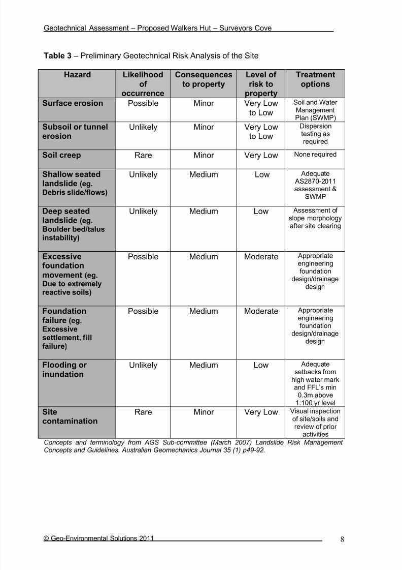
Table 3 – Preliminary Geotechnical Risk Analysis of the Site
Hazard Likelihoodof
occurrence
Consequencesto property
Level of risk to
property
Treatmentoptions
Surface erosion Possible Minor Very Lowto Low
Soil and Water ManagementPlan (SWMP)
Subsoil or tunnelerosion
Unlikely Minor Very Lowto Low
Dispersiontesting asrequired
Soil creep Rare Minor Very Low None required
Shallow seatedlandslide (eg.Debris slide/flows)
Unlikely Medium Low Adequate AS2870-2011assessment &
SWMP
Deep seatedlandslide (eg.Boulder bed/talusinstability)
Unlikely Medium Low Assessment of slope morphologyafter site clearing
Excessivefoundationmovement (eg.Due to extremelyreactive soils)
Possible Medium Moderate Appropriateengineeringfoundation
design/drainagedesign
Foundationfailure (eg.Excessivesettlement, fillfailure)
Possible Medium Moderate Appropriateengineeringfoundation
design/drainagedesign
Flooding or inundation
Unlikely Medium Low Adequatesetbacks from
high water markand FFL’s min
0.3m above1:100 yr level
Sitecontamination
Rare Minor Very Low Visual inspectionof site/soils andreview of prior
activities
Concepts and terminology from AGS Sub-committee (March 2007) Landslide Risk Management Concepts and Guidelines. Australian Geomechanics Journal 35 (1) p49-92.
7/29/2019 DCP AND BC
http://slidepdf.com/reader/full/dcp-and-bc 46/87
Geotechnical Assessment – Proposed Walkers Hut – Surveyors Cove
© Geo-Environmental Solutions 2011 9
Table 4 - Geotechnical Risk Assessment – Example of Qualitative Terminology Adapted from AGS Sub-committee (2007) Landslide Risk Management Concepts and Guidelines.
Australian Geomechanics Journal
Qualitative Measures of Likelihood
Level Descriptor Description Indicative Annual
Probability
A Almost Certain The event is expected to occur > ~10-1
B Likely The event will probably occur under adverse conditions ~10-2
C Possible The event could occur under adverse conditions ~10-3
D Unlikely The event might occur under very adverse circumstances ~10-4
E Rare The event is conceivable only under exceptional circumstances ~10-5
F Not Credible The event is inconceivable or fanciful ~10-6
Note: “~” means approximate
Qualitative Measures of Consequences to Property/Element at risk
Level Descriptor Description
1 Catastrophic Structure completely destroyed or large scale damage requiring major
engineering works for stabilization.2 Major Extensive damage to most of structure, or extending beyond site boundaries
requiring significant stabilization works.
3 Medium Moderate damage to some of structure, or significant part of site requiring largeremedial works.
4 Minor Limited damage to part of structure or part of sire requiring some reinstatement
or remedial works.
5 Insignificant Little damage or effect.
Note: The “Description” may be edited to suit a particular case.
Qualitative Risk Analysis Matrix – Level of Risk to Property/Element at Risk
Likelihood Consequences to Property
1: Catastrophic 2: Major 3: Medium 4: Minor 5: InsignificantA – Almost Certain VH VH H H M
B – Likely VH H H M L-M
C – Possible H H M L-M VL-L
D – Unlikely M-H M L-M VL-L VL
E – Rare M-L L-M VL-L VL VL
F – Not Credible VL VL VL VL VL
Risk Level Implications
Risk Level Example Implications
VH Very High Risk Extensive detailed investigation and research, planning and implementation of treatment options essential to reduce risk to acceptable levels; may be too
expensive and not practical
H High Risk Detailed investigation, planning and implementation of treatment option requiredto reduce risk to acceptable levels
M Moderate Risk Tolerable provided treatment plan is implemented to maintain or reduce risks.May be acceptable. May require investigation and planning of treatment options.
L Low Risk Usually acceptable. Treatment requirements and responsibility to be defined tomaintain or reduce risks.
VL Very Low Risk Acceptable. Manage by normal site maintenance procedures.
Notes: (1) The implications for a particular situation are to be determined by all parties to the risk
assessment; these are only given as a general guide.(2) Judicious use of dual descriptors for likelihood, Consequence and Risk to reflect the
uncertainty of the estimate may be appropriate in some cases
7/29/2019 DCP AND BC
http://slidepdf.com/reader/full/dcp-and-bc 47/87
Geotechnical Assessment – Proposed Walkers Hut – Surveyors Cove
© Geo-Environmental Solutions 2011 10
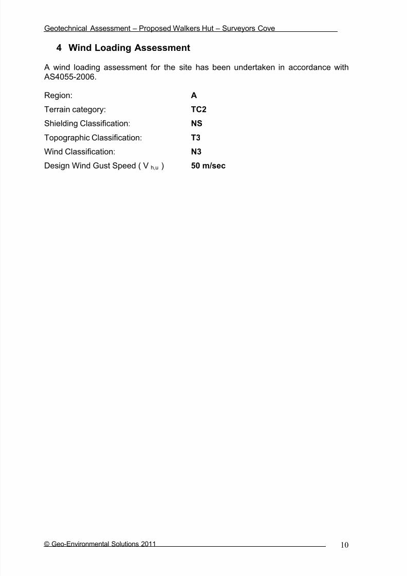
4 Wind Loading Assessment
A wind loading assessment for the site has been undertaken in accordance with AS4055-2006.
Region: A
Terrain category: TC2
Shielding Classification: NS
Topographic Classification: T3
Wind Classification: N3
Design Wind Gust Speed ( V h,u ) 50 m/sec

7/29/2019 DCP AND BC
http://slidepdf.com/reader/full/dcp-and-bc 48/87
Geotechnical Assessment – Proposed Walkers Hut – Surveyors Cove
© Geo-Environmental Solutions 2011 11
5 Site Suitability for Onsite Wastewater Disposal
One indicative soil profile was chosen for classification according to AS/NZS1547-2000 (on-site wastewater management). A typical soil profiledescription is presented in section 3 whilst site and soil factors pertinent to
wastewater disposal under AS/NZS1547-2000 are discussed in this section.
The soils across the site area classified according to AS/NZS1547-2000 ascategory 5 – light clay, with low Long Term Acceptance Rates (LTAR’s) of up to10L/m2/day. Based upon the modelling undertaken more conservative DesignLoading Rates (DLR’s) in the range 6-8L/m2/day are recommended due to thesensitive environmental values in the area.
Indicative wastewater budget and wastewater disposalIndicative wastewater modelling has been undertaken based upon a walkers hutwith a maximum occupancy of 52 persons (48 walkers and 4 staff), roof water supply, fully contained composting toilet systems (eg Gough or similar), and onesingle potable water tap on site. It is envisaged that the toilets on site will nothave any liquid discharge, and that alcohol hand wash or similar products wouldbe available for hand washing in the toilet facilities. It is also assumed that onecentral tap will be supplied for drinking water, cooking supply, and washing. Thecentral tap system will be located above a gross pollutant trap/basket filter, whichwill act as primary treatment for any excess water and washing water produced. Itis further proposed that secondary treatment of the water be undertaken in either a bag filtration system prior to in ground absorption, or via in ground absorption ina bio-filter trench.
Modelling of potential wastewater produced from the single tap and waste trap isbased upon typical flow rates for a gravity fed rainwater tank system, and up totwo events per person per day. The modelling indicates a potential peak load of up to 104L/day (i.e. two 0.5 minute events per person per day @ 1L per event for a gravity fed flow restricting tap with a flow rate of 4L/min and a spillage/washpercentage of 50% with a maximum occupancy of 52 persons).
Based upon a conservative DLR of 8m2, the required primary absorption area is12 square meters, which is further amended to 24 square meters to fulfil therequirements for a 100% reserve area. With a required primary area of up to
12m2
, an absorption trench of 10m x 1.2m x 0.5m should prove suitable. Basedupon the modelling undertaken in the trench program, the calculated basalabsorption area is more than adequate to sustain long term wash water application from the single tap (see appendix 1 for Trench summary reports).
Nutrient balance and sustainable wastewater applicationThe soils across the site are developed from Jurassic dolerite with high cationexchange complex in the clay subsoils. The soils examined are also moderatelyto strongly structured, with a significant organic content in surface horizons, and ahigh estimated Cation Exchange Capacity (CEC). Therefore the soils have agood ability to retain applied nutrients in wastewater and the risk of nutrient
attenuation associated with wastewater application is low. However, the shallowsoil depth to underlying rock and the slope angles imparts a moderate risk for

7/29/2019 DCP AND BC
http://slidepdf.com/reader/full/dcp-and-bc 49/87
Geotechnical Assessment – Proposed Walkers Hut – Surveyors Cove
© Geo-Environmental Solutions 2011 12
disposal of wastewater on the site. This risk is however lessened by theanticipated wastewater quality which is primarily spillage of potable water andsmall volumes of dishwashing water. It is therefore recommended that further treatment of the water be undertaken prior to discharge from the basket filter/trapand designs such as the Baldwin RM10 system or a bio-filter trench previously
specified in national park environments by GES may prove suitable. The finaldesign of secondary treatment should ensure satisfactory treatment of effluentprior to absorption in the natural soils, and it is recommended that GES isconsulted prior to construction to finalise system specifications and designs. Itmust be noted that if the proposed toilet system are to produce any liquidoverflow that an appropriately designed absorption system will be required.
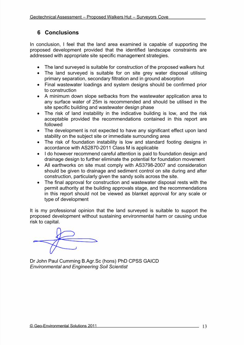
7/29/2019 DCP AND BC
http://slidepdf.com/reader/full/dcp-and-bc 50/87
Geotechnical Assessment – Proposed Walkers Hut – Surveyors Cove
© Geo-Environmental Solutions 2011 13
6 Conclusions
In conclusion, I feel that the land area examined is capable of supporting theproposed development provided that the identified landscape constraints areaddressed with appropriate site specific management strategies.
The land surveyed is suitable for construction of the proposed walkers hut
The land surveyed is suitable for on site grey water disposal utilisingprimary separation, secondary filtration and in ground absorption
Final wastewater loadings and system designs should be confirmed prior to construction
A minimum down slope setbacks from the wastewater application area toany surface water of 25m is recommended and should be utilised in thesite specific building and wastewater design phase
The risk of land instability in the indicative building is low, and the risk
acceptable provided the recommendations contained in this report arefollowed
The development is not expected to have any significant effect upon landstability on the subject site or immediate surrounding area
The risk of foundation instability is low and standard footing designs inaccordance with AS2870-2011 Class M is applicable
I do however recommend careful attention is paid to foundation design anddrainage design to further eliminate the potential for foundation movement
All earthworks on site must comply with AS3798-2007 and considerationshould be given to drainage and sediment control on site during and after construction, particularly given the sandy soils across the site.
The final approval for construction and wastewater disposal rests with thepermit authority at the building approvals stage, and the recommendationsin this report should not be viewed as blanket approval for any scale or type of development
It is my professional opinion that the land surveyed is suitable to support theproposed development without sustaining environmental harm or causing unduerisk to capital.
Dr John Paul Cumming B.Agr.Sc (hons) PhD CPSS GAICDEnvironmental and Engineering Soil Scientist
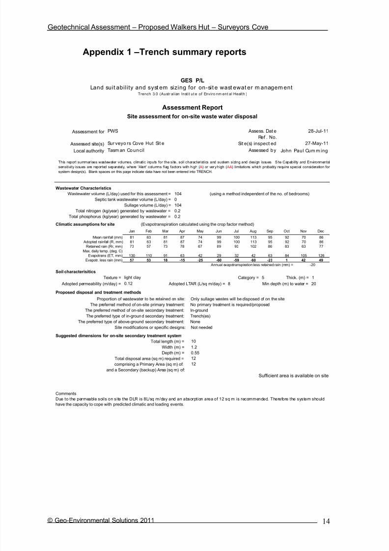
7/29/2019 DCP AND BC
http://slidepdf.com/reader/full/dcp-and-bc 51/87
Geotechnical Assessment – Proposed Walkers Hut – Surveyors Cove
© Geo-Environmental Solutions 2011 14
Appendix 1 –Trench summary reports
GES P/L
Land suit abil i ty and syst em sizing for on-sit e wast ewat er m anagem entTrench 3.0 (Austr alian Instit ut e of Enviro nm ent al Health )
Assessment Report
Site assessment for on-site waste water disposal
Assessment for PWS Assess. Dat e
Ref . No.
Assessed site(s) Sur veyo rs Cove Hut Sit e Sit e(s) inspect ed
Local authority Tasm an Council Assessed by
B.Agr.Sc(hons) PhD
Wastewater Characteristics
Wastewater volume (L/day) used for this assessment = (using a method independent of the no. of bedrooms)Septic tank wastewater volume (L/day) =
Sullage volume (L/day) =
Total nitrogen (kg/year) generated by wastewater =
Total phosphorus (kg/year) generated by wastewater =
Climatic assumptions for site (Evapotranspiration calculated using the crop factor method)
Jan Feb Mar Apr May Jun Jul Aug Sep Oct Nov Dec
Mean rainfall (mm) 81 63 81 87 74 99 100 113 95 92 70 86
Adopted rainfall (R, mm) 81 63 81 87 74 99 100 113 95 92 70 86
Retained rain (Rr, mm) 73 57 73 78 67 89 90 102 86 83 63 77
Max. daily temp. (deg. C)
Evapotrans (ET, mm) 130 110 91 63 42 29 32 42 63 84 105 126
Evapotr. less rain (mm) 57 53 18 -15 -25 -60 -59 -60 -23 1 42 49
Annual evapotranspiration less retained rain (mm) = -20
Soil characterisitics
Texture = Category = 5 Thick. (m) = 1
Adopted permeability (m/day) = Adopted LTAR (L/sq m/day) = 8 Min depth (m) to water = 20
Proposed disposal and treatment methods
Proportion of wastewater to be retained on site: Only sullage wastes will be disposed of on the site
The preferred method of on-site primary treatment: No primary treatment is required/proposed
The preferred method of on-site secondary treatment: In-ground
The preferred type of in-ground secondary treatment: Trench(es)
The preferred type of above-ground secondary treatment: None
Site modifications or specific designs: Not needed
Suggested dimensions for on-site secondary treatment system
Total length (m) =
Width (m) = 1.2
Depth (m) = 0.55
Total disposal area (sq m) required =
comprising a Primary Area (sq m) of:
and a Secondary (backup) Area (sq m) of:
Sufficient area is available on site
12
104
0.2
10
104
12
0.12
light clay
0
28-Jul-11
0.2
27-May-11
John Paul Cum m ing
This report summarises wastewater volumes, climatic inputs for the site, soil characteristics and sustem sizing and design issues. Site Capability and Environmental
sensitivity issues are reported separately, where 'Alert' columns flag factors with high ( A) or veryhigh ( AA) limitations which probably require special consideration for
system design(s). Blank spaces on this page indicate data have not been entered into TRENCH.
Comments
Due to the permeable soils on site the DLR is 8L/sq m/day and an absorption area of 12 sq m is recommended. Therefore the system should
have the capacity to cope with predicted climatic and loading events.

7/29/2019 DCP AND BC
http://slidepdf.com/reader/full/dcp-and-bc 52/87
Geotechnical Assessment – Proposed Walkers Hut – Surveyors Cove
© Geo-Environmental Solutions 2011 15
GES P/L
Land suit abil i ty and syst em sizing for on-sit e wast ewat er m anagem entTrench 3.0 (Austr alian Instit ut e of Enviro nm ent al Health )
Site Capability Report
Site assessment for on-site waste water disposal
Assessment for PWS Assess. Dat e
Ref . No.
Assessed site(s) Sur veyo rs Cove Hut Sit e Sit e(s) inspect ed
Local authority Tasm an Council Assessed by
B.Agr.Sc(hons) PhD
Confid
Alert Factor Units level
A Expected design area sq m V. high High
Density of disposal systems /sq km Mod. Very low
Slope angle degrees High Very low
Slope form Convex spreading High Very low
Surface drainage Mod. good High Low
Flood potential Site floods <1:100 yrs High Very low
Heavy rain events Infrequent High Moderate
Aspect (Southern hemi.) Faces E or W V. high Moderate
Frequency of strong winds Common High Low
Wastewater volume L/day High Very low
SAR of septic tank effluent High Low
SAR of sullage High Moderate
Soil thickness m V. high Low
A Depth to bedrock m V. high High
Surface rock outcrop % V. high Very low
Cobbles in soil % V. high Very low
Soil pH High Low
Soil bulk density gm/cub. cm High Very low
Soil dispersion Emerson No. V. high Very low
Adopted permeability m/day Mod. High Moderate
Long Term Accept. Rate L/day/sq m High Very low Moderate
Remarks
Limitation
500
Trench AmendedValue
8
0.12
1
5
104
2.6
0
5.5
0
1.4
1.7
1.0
7
1.0
John Paul Cum m ing
Other factors lessen impact
28-Jul-11
27-May-11
This report summarises data relating to the physical capability of the assessed site(s) to accept wastewater. Environmental sensitivity and system design issues are
reported separately. The 'Alert' column flags factors with high ( A) or veryhigh( AA) site limitations which probably require special consideration in site acceptability or for
system design(s). Blank spaces indicate data have not been entered into TRENCH.
Comments
Due to the sensitive environment a conservative DLR of 8L/sq m has been adopted increase the confidence of effluent being adequately treated
and absorbed.

7/29/2019 DCP AND BC
http://slidepdf.com/reader/full/dcp-and-bc 53/87
Geotechnical Assessment – Proposed Walkers Hut – Surveyors Cove
© Geo-Environmental Solutions 2011 16
GES P/L
Land suit abil i ty and syst em sizing for on-sit e wast ewat er m anagem entTrench 3.0 (Austr alian Instit ut e of Enviro nm ent al Health )
Environmental Sensitivity Report
Site assessment for on-site waste water disposal
Assessment for PWS Assess. Dat e
Ref . No.
Assessed site(s) Sur veyo rs Cove Hut Sit e Sit e(s) inspect ed
Local authority Tasm an Council Assessed by
B.Agr.Sc(hons) PhD
Confid
Alert Factor Units level
Cation exchange capacity mmol/100g High Moderate
Phos. adsorp. capacity kg/cub m High Moderate
Annual rainfall excess mm High Low
Min. depth to water table m High Very low
Annual nutrient load kg High Very low
G'water environ. value Agr ic sensit /d om ir r ig V. high Moderate
Min. separation dist. required m High Moderate
Risk to adjacent bores Very low V. high Very low
A Surf. water env. value Recreational V. high High
A Dist. to nearest surface water m V. high High
Dist. to nearest other feature m V. high Low
Risk of slope instability Low V. high Low
Distance to landslip m V. high Very low
20
25
Limitation
27-May-11
John Paul Cum m ing
0.4
Value
20
75
0.9
100
100
1000
Trench Amended Remarks
28-Jul-11
This report summarises data relating to the environmental sensitivity of the assessed site(s) in relation to applied wastewater. Physical capability and system design
issues are reported separately. The'Alert' column flags factors with high ( A) or veryhigh( AA) limitations which probably requirespecial consideration in site acceptability
or for system design(s). Blank spaces indicate data have not been entered into TRENCH.
Comments
The soil on site has a sandy clay texture and a high CEC, therefore the system has a good capacity to cope with the applied nutrient load fromthe system. The DLR has been scaled back and the use of secondary filtration, and/or a biofilter base is recommended.

7/29/2019 DCP AND BC
http://slidepdf.com/reader/full/dcp-and-bc 54/87

7/29/2019 DCP AND BC
http://slidepdf.com/reader/full/dcp-and-bc 55/87

7/29/2019 DCP AND BC
http://slidepdf.com/reader/full/dcp-and-bc 56/87

7/29/2019 DCP AND BC
http://slidepdf.com/reader/full/dcp-and-bc 57/87

7/29/2019 DCP AND BC
http://slidepdf.com/reader/full/dcp-and-bc 58/87
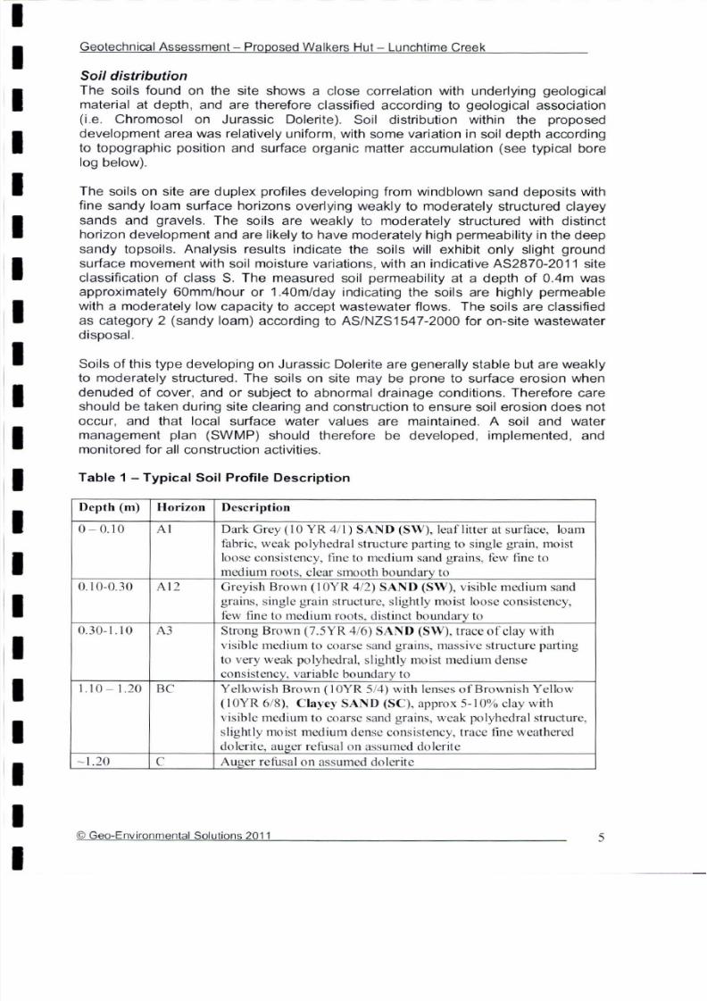
7/29/2019 DCP AND BC
http://slidepdf.com/reader/full/dcp-and-bc 59/87

7/29/2019 DCP AND BC
http://slidepdf.com/reader/full/dcp-and-bc 60/87

7/29/2019 DCP AND BC
http://slidepdf.com/reader/full/dcp-and-bc 61/87

7/29/2019 DCP AND BC
http://slidepdf.com/reader/full/dcp-and-bc 62/87

7/29/2019 DCP AND BC
http://slidepdf.com/reader/full/dcp-and-bc 63/87
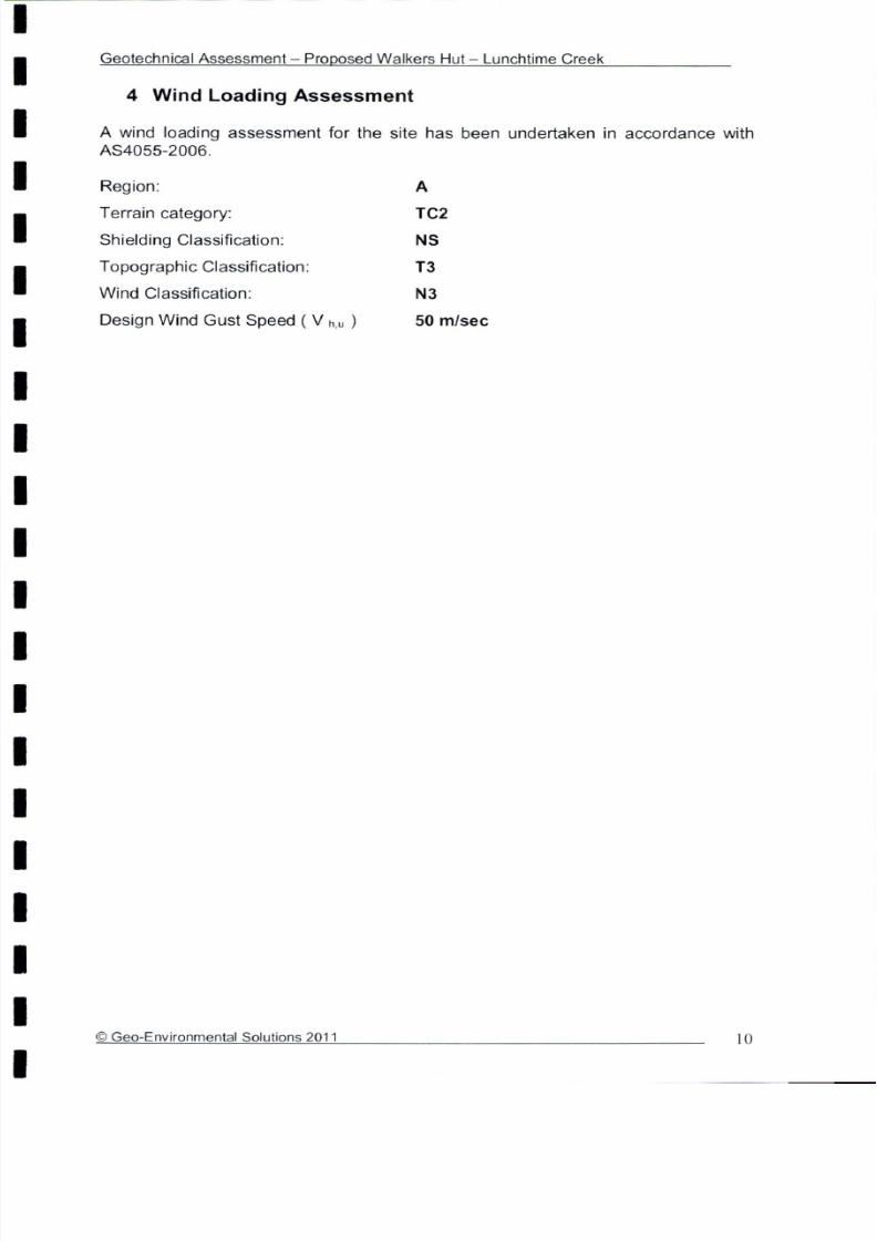
7/29/2019 DCP AND BC
http://slidepdf.com/reader/full/dcp-and-bc 64/87

7/29/2019 DCP AND BC
http://slidepdf.com/reader/full/dcp-and-bc 65/87

7/29/2019 DCP AND BC
http://slidepdf.com/reader/full/dcp-and-bc 66/87

7/29/2019 DCP AND BC
http://slidepdf.com/reader/full/dcp-and-bc 67/87

7/29/2019 DCP AND BC
http://slidepdf.com/reader/full/dcp-and-bc 68/87

7/29/2019 DCP AND BC
http://slidepdf.com/reader/full/dcp-and-bc 69/87

7/29/2019 DCP AND BC
http://slidepdf.com/reader/full/dcp-and-bc 70/87

7/29/2019 DCP AND BC
http://slidepdf.com/reader/full/dcp-and-bc 71/87
GEOTECHNICAL ASSESSMENT
Proposed Walkers Hut – Retakuna Creek
Geo-Environmental Solutions P/L 86 Queen Street Sandy Bay 7005. Ph 6223 1839 Fax 6223 4539
CLIENT
Parks & Wildlife Service
July 2011

7/29/2019 DCP AND BC
http://slidepdf.com/reader/full/dcp-and-bc 72/87
Geotechnical Assessment – Proposed Walkers Hut – Retakuna Creek
© Geo-Environmental Solutions 2011 1
Introduction ............................................................................................................... 2
Site information ......................................................................................................... 4
Geotechnical Assessment ......................................................................................... 7 Wind Loading Assessment ...................................................................................... 10
Site Suitability for Onsite Wastewater Disposal....................................................... 11
Conclusions............................................................................................................. 13
Appendix 1 –Trench summary report ...................................................................... 14

7/29/2019 DCP AND BC
http://slidepdf.com/reader/full/dcp-and-bc 73/87
Geotechnical Assessment – Proposed Walkers Hut – Retakuna Creek
© Geo-Environmental Solutions 2011 2
1 Introduction
Geo-Environmental Solutions Pty Ltd (GES) were contracted by the TasmanianParks and Wildlife Service (PWS) to undertake a geotechnical assessment of theproposed Hut site at Retakuna Creek on the Three Capes Track. The proposed hutsite is located close to Retakuna Creek, which is in the Tasman National Park, tothe south of Mount Fortescue, Tasman Peninsular, Tasmania (see figure 1 below).The development proposal is for the construction of a walkers hut, to accommodateup to 52 persons per night (up to 48 walkers and 4 staff), with associatedinfrastructure and on-site waste management.
Figure 1 Site Location – Extract from PWS Brochure
The site is located in an area of significant elevation, on a gentle slope grading to anopen plain (see figure 2). The land surveyed is gently sloping land to the west (2-5%slopes) and the vegetation is predominantly low coastal scrub, with ground surfacecover of native grasses and shrub species (see figure 3).
It is the scope of this report to consider the capability of the land to supportsustainable development without environmental harm or undue risk to capital. It isalso the aim of this report to use a scientific framework to classify the biophysicalfeatures of the land in the context of proposed development.

7/29/2019 DCP AND BC
http://slidepdf.com/reader/full/dcp-and-bc 74/87
Geotechnical Assessment – Proposed Walkers Hut – Retakuna Creek
© Geo-Environmental Solutions 2011 3
Figure 2 View to the north looking towards the proposed hut site
Figure 3 View of the vegetation in the area of the proposed hut
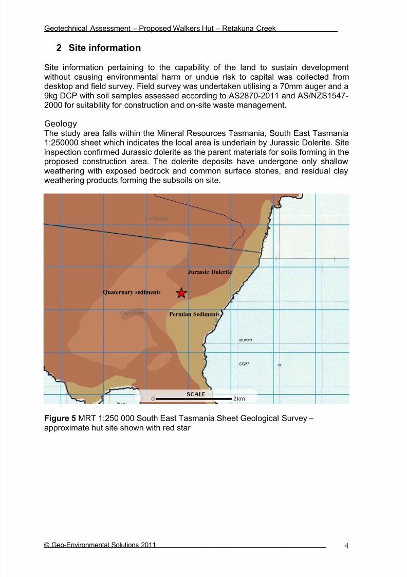
7/29/2019 DCP AND BC
http://slidepdf.com/reader/full/dcp-and-bc 75/87
Geotechnical Assessment – Proposed Walkers Hut – Retakuna Creek
© Geo-Environmental Solutions 2011 4
2 Site information
Site information pertaining to the capability of the land to sustain developmentwithout causing environmental harm or undue risk to capital was collected fromdesktop and field survey. Field survey was undertaken utilising a 70mm auger and a9kg DCP with soil samples assessed according to AS2870-2011 and AS/NZS1547-2000 for suitability for construction and on-site waste management.
GeologyThe study area falls within the Mineral Resources Tasmania, South East Tasmania1:250000 sheet which indicates the local area is underlain by Jurassic Dolerite. Siteinspection confirmed Jurassic dolerite as the parent materials for soils forming in theproposed construction area. The dolerite deposits have undergone only shallowweathering with exposed bedrock and common surface stones, and residual clayweathering products forming the subsoils on site.
Figure 5 MRT 1:250 000 South East Tasmania Sheet Geological Survey – approximate hut site shown with red star
Jurassic Dolerite
Quaternary sediments
Permian Sediments

7/29/2019 DCP AND BC
http://slidepdf.com/reader/full/dcp-and-bc 76/87
Geotechnical Assessment – Proposed Walkers Hut – Retakuna Creek
© Geo-Environmental Solutions 2011 5
Soil distributionThe soils found on the site shows a close correlation with underlying geologicalmaterial, and are therefore classified according to geological association (i.e.Chromosol on Jurassic Dolerite). Soil distribution within the proposed developmentarea was relatively uniform, with some variation in soil depth according totopographic position and the presence or absence of subsurface hard pans (see
typical bore log below).
The soils on site are duplex profiles developing from Jurassic dolerite deposits withfine sandy loam surface horizons overlying moderately structured clays. The soilsare moderately to strongly structured with distinct horizon development and arelikely to have low permeability in the subsurface clays. Analysis results indicate thesoils will exhibit moderate movement with soil moisture variations, with an indicative AS2870-2011 site classification of class M. The measured soil permeability at adepth of 0.4m was approximately 4mm/hour or 0.1m/day indicating the soils areslowly permeable with a low capacity to accept wastewater flows. The soils areclassified as category 5 (light clay) according to AS/NZS1547-2000 for on-sitewastewater disposal.
Soils of this type developing on Jurassic dolerite are generally stable and arestrongly structured. The topsoils on site may be prone to surface erosion whendenuded of cover, and or subject to abnormal drainage conditions. Therefore careshould be taken during site clearing and construction to ensure soil erosion does notoccur, and that local surface water values are maintained. A soil and water management plan (SWMP) should therefore be developed, implemented, andmonitored for all construction activities.
Table 1 –
Typical Soil Profile Description
Depth (m) Horizon Description
0 – 0.30 A1 Grey (10 YR 5/1) SAND (SW), loam fabric, weak polyhedral
structure parting to single grain, moist loose consistency, fine to
medium sand grains, few fine to medium roots, few surface
stones, clear smooth boundary to
0.30 – 0.40 A2 Light Brownish Grey (10 YR 6/2) SAND (SW), single grain
structure, fine to medium sand grains, slightly moist medium
dense consistency, gradual boundary to
0.40 – 0.60 B1 Brownish Yellow (10 YR 6/8) SANDY CLAY (CH), medium to
high plasticity, approximately 60% fine to medium sand, weak sub-angular blocky structure, moist firm consistency, trace fine
ironstone gravels – discontinuous iron pan, gradual boundary to
0.60 – 1.0 BC Gleyed - Brownish Yellow (10 YR 6/8) SANDY CLAY (CH),high plasticity, massive structure, approx 50% fine to medium
sand grains, wet stiff consistency, abrupt boundary to
1.0+ C Auger refusal on assumed slightly weathered Jurassic dolerite

7/29/2019 DCP AND BC
http://slidepdf.com/reader/full/dcp-and-bc 77/87
Geotechnical Assessment – Proposed Walkers Hut – Retakuna Creek
© Geo-Environmental Solutions 2011 6
Figure 6 Auger hole in the vicinity of the proposed hut site at Retakuna Creek – auger length is 1.4m showing topsoil starting at the handle extending to subsoilstowards the head of the auger. Shallow sandy topsoils overlie sandy clay subsoilsgrading to Jurassic dolerite at variable depths below 1.0m depth.

7/29/2019 DCP AND BC
http://slidepdf.com/reader/full/dcp-and-bc 78/87
Geotechnical Assessment – Proposed Walkers Hut – Retakuna Creek
© Geo-Environmental Solutions 2011 7
3 Geotechnical Assessment
A number of geotechnical risk scenarios have been considered for the developmentincluding risk of land instability, risk of inundation/flooding, risk of foundation failure,and erosion risk. The level of risk associated with any possible event is described interms of likelihood and consequence (see table 3 for classification and see table 4for an explanation of terminology). That is, how likely is the event to occur (eg rare,unlikely, likely possible etc), and what is the consequence of the event (eg loss of life, serious capital damage, limited capital damage, localised erosion etc). Basedupon an assessment of the site and the likely risks, the overall geotechnical riskassociated with the development is rated as low.
The AS2870-2011 site classification for the site is Class M based upon soil textureand typical soil depth across the site. Based upon 9Kg DCP measurements anallowable bearing capacity of 150kPa has been assigned for a minimum foundingdepth of 600mm. The bearing capacity in the surface layers was weak (see table 2
below), and is a likely result of the organic content in the surface horizons. It istherefore recommended that the surface horizons be removed from the foundingarea, and all foundations be placed into subsoils with adequate bearing capacity.
Table 2 – Typical DCP test Results
Dynamic Cone Penetration (DCP) Conversion to Californian Bearing Ratio
(ref: Australian Standard AS 1289.6.3.2 - 1997)
Date 28-May-11
Location Retakuna Creek
Bedrock Depth (mm) 1.0m+Water Table Location not encountered
DCP Commencement Depth at surface
Slope and Aspect 5% W
Depth (mm) DCP DCP DCP Resistance Bearing Capacity CBR
(Blows/150mm) (mm/Blow) (mPa) (kPa)
0-150 1 150.0 0.2 28 1
150-300 2 75.0 0.5 56 2
300-450 4 37.5 1.0 112 5
450-600 5 30.0 1.2 140 6
600-750 8 18.8 1.9 224 11
750-900 9 16.7 2.1 252 13
900-1050 refusal na na na na

7/29/2019 DCP AND BC
http://slidepdf.com/reader/full/dcp-and-bc 79/87
Geotechnical Assessment – Proposed Walkers Hut – Retakuna Creek
© Geo-Environmental Solutions 2011 8
Table 3 – Preliminary Geotechnical Risk Analysis of the Site
Hazard Likelihoodof
occurrence
Consequencesto property
Level of risk to
property
Treatmentoptions
Surface erosion Possible Minor Very Lowto Low
Soil and Water ManagementPlan (SWMP)
Subsoil or tunnelerosion
Unlikely Minor Very Lowto Low
Dispersiontesting asrequired
Soil creep Rare Minor Very Low None required
Shallow seatedlandslide (eg.Debris slide/flows)
Unlikely Medium Low Adequate AS2870-2011assessment &
SWMP
Deep seatedlandslide (eg.Boulder bed/talusinstability)
Unlikely Medium Low Assessment of slope morphologyafter site clearing
Excessivefoundationmovement (eg.Due to extremelyreactive soils)
Possible Medium Moderate Appropriateengineeringfoundation
design/drainagedesign
Foundationfailure (eg.Excessivesettlement, fillfailure)
Possible Medium Moderate Appropriateengineeringfoundation
design/drainagedesign
Flooding or inundation
Unlikely Medium Low Adequatesetbacks from
high water markand FFL’s min
0.3m above1:100 yr level
Sitecontamination
Rare Minor Very Low Visual inspectionof site/soils andreview of prior
activities
Concepts and terminology from AGS Sub-committee (March 2007) Landslide Risk Management Concepts and Guidelines. Australian Geomechanics Journal 35 (1) p49-92.

7/29/2019 DCP AND BC
http://slidepdf.com/reader/full/dcp-and-bc 80/87
Geotechnical Assessment – Proposed Walkers Hut – Retakuna Creek
© Geo-Environmental Solutions 2011 9
Table 4 - Geotechnical Risk Assessment – Example of Qualitative Terminology Adapted from AGS Sub-committee (2007) Landslide Risk Management Concepts and Guidelines.
Australian Geomechanics Journal
Qualitative Measures of Likelihood
Level Descriptor Description Indicative Annual
Probability
A Almost Certain The event is expected to occur > ~10-1
B Likely The event will probably occur under adverse conditions ~10-2
C Possible The event could occur under adverse conditions ~10-3
D Unlikely The event might occur under very adverse circumstances ~10-4
E Rare The event is conceivable only under exceptional circumstances ~10-5
F Not Credible The event is inconceivable or fanciful ~10-6
Note: “~” means approximate
Qualitative Measures of Consequences to Property/Element at risk
Level Descriptor Description
1 Catastrophic Structure completely destroyed or large scale damage requiring major
engineering works for stabilization.2 Major Extensive damage to most of structure, or extending beyond site boundaries
requiring significant stabilization works.
3 Medium Moderate damage to some of structure, or significant part of site requiring largeremedial works.
4 Minor Limited damage to part of structure or part of sire requiring some reinstatement
or remedial works.
5 Insignificant Little damage or effect.
Note: The “Description” may be edited to suit a particular case.
Qualitative Risk Analysis Matrix – Level of Risk to Property/Element at Risk
Likelihood Consequences to Property
1: Catastrophic 2: Major 3: Medium 4: Minor 5: InsignificantA – Almost Certain VH VH H H M
B – Likely VH H H M L-M
C – Possible H H M L-M VL-L
D – Unlikely M-H M L-M VL-L VL
E – Rare M-L L-M VL-L VL VL
F – Not Credible VL VL VL VL VL
Risk Level Implications
Risk Level Example Implications
VH Very High Risk Extensive detailed investigation and research, planning and implementation of treatment options essential to reduce risk to acceptable levels; may be too
expensive and not practical
H High Risk Detailed investigation, planning and implementation of treatment option requiredto reduce risk to acceptable levels
M Moderate Risk Tolerable provided treatment plan is implemented to maintain or reduce risks.May be acceptable. May require investigation and planning of treatment options.
L Low Risk Usually acceptable. Treatment requirements and responsibility to be defined tomaintain or reduce risks.
VL Very Low Risk Acceptable. Manage by normal site maintenance procedures.
Notes: (1) The implications for a particular situation are to be determined by all parties to the risk
assessment; these are only given as a general guide.(2) Judicious use of dual descriptors for likelihood, Consequence and Risk to reflect the
uncertainty of the estimate may be appropriate in some cases

7/29/2019 DCP AND BC
http://slidepdf.com/reader/full/dcp-and-bc 81/87
Geotechnical Assessment – Proposed Walkers Hut – Retakuna Creek
© Geo-Environmental Solutions 2011 10
4 Wind Loading Assessment
A wind loading assessment for the site has been undertaken in accordance with AS4055-2006.
Region: A
Terrain category: TC2
Shielding Classification: NS
Topographic Classification: T3
Wind Classification: N3
Design Wind Gust Speed ( V h,u ) 50 m/sec

7/29/2019 DCP AND BC
http://slidepdf.com/reader/full/dcp-and-bc 82/87
Geotechnical Assessment – Proposed Walkers Hut – Retakuna Creek
© Geo-Environmental Solutions 2011 11
5 Site Suitability for Onsite Wastewater Disposal
One indicative soil profile was chosen for classification according to AS/NZS1547-2000 (on-site wastewater management). A typical soil profiledescription is presented in section 3 whilst site and soil factors pertinent to
wastewater disposal under AS/NZS1547-2000 are discussed in this section.
The soils across the site area classified according to AS/NZS1547-2000 ascategory 5 – light clay, with low Long Term Acceptance Rates (LTAR’s) of up to10L/m2/day. Based upon the modelling undertaken more conservative DesignLoading Rates (DLR’s) in the range 6-8L/m2/day are recommended due to thesensitive environmental values in the area.
Indicative wastewater budget and wastewater disposalIndicative wastewater modelling has been undertaken based upon a walkers hutwith a maximum occupancy of 52 persons, roof water supply, fully containedcomposting toilet systems (eg Gough or similar), and one single potable water tapon site. It is envisaged that the toilets on site will not have any liquid discharge,and that alcohol hand wash or similar products would be available for handwashing in the toilet facilities. It is also assumed that one central tap will besupplied for drinking water, cooking supply, and washing. The central tap systemwill be located above a gross pollutant trap/basket filter, which will act as primarytreatment for any excess water and washing water produced. It is further proposed that secondary treatment of the water be undertaken in either a bagfiltration system prior to in ground absorption, or via in ground absorption in a bio-filter trench.
Modelling of potential wastewater produced from the single tap and waste trap isbased upon typical flow rates for a gravity fed rainwater tank system, and up totwo events per person per day. The modelling indicates a potential peak load of up to 104L/day (i.e. two 0.5 minute events per person per day @ 1L per event for a gravity fed flow restricting tap with a flow rate of 4L/min and a spillage/washpercentage of 50% with a maximum occupancy of 52 persons).
Based upon a conservative DLR of 8m2, the required primary absorption area is12 square meters, which is further amended to 24 square meters to fulfil therequirements for a 100% reserve area. With a required primary area of up to
12m2
, an absorption trench of 10m x 1.2m x 0.5m should prove suitable. Basedupon the modelling undertaken in the trench program, the calculated basalabsorption area is more than adequate to sustain long term wash water application from the single tap (see appendix 1 for Trench summary reports).
Nutrient balance and sustainable wastewater applicationThe soils across the site are developed from Jurassic dolerite with high cationexchange complex in the clay subsoils. The soils examined are also moderatelyto strongly structured, with a significant organic content in surface horizons, and ahigh estimated Cation Exchange Capacity (CEC). Therefore the soils have agood ability to retain applied nutrients in wastewater and the risk of nutrient
attenuation associated with wastewater application is low. However, the shallowsoil depth to underlying rock and the slope angles imparts a moderate risk for

7/29/2019 DCP AND BC
http://slidepdf.com/reader/full/dcp-and-bc 83/87
Geotechnical Assessment – Proposed Walkers Hut – Retakuna Creek
© Geo-Environmental Solutions 2011 12
disposal of wastewater on the site. This risk is however lessened by theanticipated wastewater quality which is primarily spillage of potable water andsmall volumes of dishwashing water. It is therefore recommended that further treatment of the water be undertaken prior to discharge from the basket filter/trapand designs such as the Baldwin RM10 system or a bio-filter trench previously
specified in national park environments by GES may prove suitable. The finaldesign of secondary treatment should ensure satisfactory treatment of effluentprior to absorption in the natural soils, and it is recommended that GES isconsulted prior to construction to finalise system specifications and designs. Itmust be noted that if the proposed toilet system are to produce any liquidoverflow that an appropriately designed absorption system will be required.

7/29/2019 DCP AND BC
http://slidepdf.com/reader/full/dcp-and-bc 84/87
Geotechnical Assessment – Proposed Walkers Hut – Retakuna Creek
© Geo-Environmental Solutions 2011 13
6 Conclusions
In conclusion, I feel that the land area examined is capable of supporting theproposed development provided that the identified landscape constraints areaddressed with appropriate site specific management strategies.
The land surveyed is suitable for construction of the proposed walkers hut
The land surveyed is suitable for on site grey water disposal utilisingprimary separation, secondary filtration and in ground absorption
Final wastewater loadings and system designs should be confirmed prior to construction
A minimum down slope setbacks from the wastewater application area toany surface water of 25m is recommended and should be utilised in thesite specific building and wastewater design phase
The risk of land instability in the indicative building is low, and the risk
acceptable provided the recommendations contained in this report arefollowed
The development is not expected to have any significant effect upon landstability on the subject site or immediate surrounding area
The risk of foundation instability is low and standard footing designs inaccordance with AS2870-2011 Class M is applicable
I do however recommend careful attention is paid to foundation design anddrainage design to further eliminate the potential for foundation movement
All earthworks on site must comply with AS3798-2007 and considerationshould be given to drainage and sediment control on site during and after construction, particularly given the sandy soils across the site.
The final approval for construction and wastewater disposal rests with thepermit authority at the building approvals stage, and the recommendationsin this report should not be viewed as blanket approval for any scale or type of development
It is my professional opinion that the land surveyed is suitable to support theproposed development without sustaining environmental harm or causing unduerisk to capital.
Dr John Paul Cumming B.Agr.Sc (hons) PhD CPSS GAICDEnvironmental and Engineering Soil Scientist

7/29/2019 DCP AND BC
http://slidepdf.com/reader/full/dcp-and-bc 85/87
Geotechnical Assessment – Proposed Walkers Hut – Retakuna Creek
© Geo-Environmental Solutions 2011 14
Appendix 1 –Trench summary reports
GES P/L
Land suit abil i ty and syst em sizing for on-sit e wast ewat er m anagem entTrench 3.0 (Austr alian Instit ut e of Enviro nm ent al Health )
Assessment Report
Site assessment for on-site waste water disposal
Assessment for PWS Assess. Dat e
Ref . No.
Assessed site(s) Ret akuna Creek Hut Sit e Sit e(s) inspect ed
Local authority Tasm an Council Assessed by
B.Agr.Sc(hons) PhD
Wastewater Characteristics
Wastewater volume (L/day) used for this assessment = (using a method independent of the no. of bedrooms)Septic tank wastewater volume (L/day) =
Sullage volume (L/day) =
Total nitrogen (kg/year) generated by wastewater =
Total phosphorus (kg/year) generated by wastewater =
Climatic assumptions for site (Evapotranspiration calculated using the crop factor method)
Jan Feb Mar Apr May Jun Jul Aug Sep Oct Nov Dec
Mean rainfall (mm) 81 63 81 87 74 99 100 113 95 92 70 86
Adopted rainfall (R, mm) 81 63 81 87 74 99 100 113 95 92 70 86
Retained rain (Rr, mm) 73 57 73 78 67 89 90 102 86 83 63 77
Max. daily temp. (deg. C)
Evapotrans (ET, mm) 130 110 91 63 42 29 32 42 63 84 105 126
Evapotr. less rain (mm) 57 53 18 -15 -25 -60 -59 -60 -23 1 42 49
Annual evapotranspiration less retained rain (mm) = -20
Soil characterisitics
Texture = Category = 5 Thick. (m) = 1
Adopted permeability (m/day) = Adopted LTAR (L/sq m/day) = 8 Min depth (m) to water = 20
Proposed disposal and treatment methods
Proportion of wastewater to be retained on site: Only sullage wastes will be disposed of on the site
The preferred method of on-site primary treatment: No primary treatment is required/proposed
The preferred method of on-site secondary treatment: In-ground
The preferred type of in-ground secondary treatment: Trench(es)
The preferred type of above-ground secondary treatment: None
Site modifications or specific designs: Not needed
Suggested dimensions for on-site secondary treatment system
Total length (m) =
Width (m) = 1.2
Depth (m) = 0.55
Total disposal area (sq m) required =
comprising a Primary Area (sq m) of:
and a Secondary (backup) Area (sq m) of:
Sufficient area is available on site
27-May-11
John Paul Cum m ing
0.2
28-Jul-11
0.12
light clay
0
12
10
104
12
104
0.2
This report summarises wastewater volumes, climatic inputs for the site, soil characteristics and sustem sizing and design issues. Site Capability and Environmental
sensitivity issues are reported separately, where 'Alert' columns flag factors with high ( A) or veryhigh ( AA) limitations which probably require special consideration for
system design(s). Blank spaces on this page indicate data have not been entered into TRENCH.
Comments
Due to the permeable soils on site the DLR is 8L/sq m/day and an absorption area of 12 sq m is recommended. Therefore the system should
have the capacity to cope with predicted climatic and loading events.

7/29/2019 DCP AND BC
http://slidepdf.com/reader/full/dcp-and-bc 86/87
Geotechnical Assessment – Proposed Walkers Hut – Retakuna Creek
© Geo-Environmental Solutions 2011 15
GES P/L
Land suit abil i ty and syst em sizing for on-sit e wast ewat er m anagem entTrench 3.0 (Austr alian Instit ut e of Enviro nm ent al Health )
Site Capability Report
Site assessment for on-site waste water disposal
Assessment for PWS Assess. Dat e
Ref . No.
Assessed site(s) Ret akuna Creek Hut Sit e Sit e(s) inspect ed
Local authority Tasm an Council Assessed by
B.Agr.Sc(hons) PhD
Confid
Alert Factor Units level
A Expected design area sq m V. high High
Density of disposal systems /sq km Mod. Very low
Slope angle degrees High Very low
Slope form Convex spreading High Very low
Surface drainage Mod. good High Low
Flood potential Site floods <1:100 yrs High Very low
Heavy rain events Infrequent High Moderate
Aspect (Southern hemi.) Faces E or W V. high Moderate
Frequency of strong winds Common High Low
Wastewater volume L/day High Very low
SAR of septic tank effluent High Low
SAR of sullage High Moderate
Soil thickness m V. high Low
A Depth to bedrock m V. high High
Surface rock outcrop % V. high Very low
Cobbles in soil % V. high Very low
Soil pH High Low
Soil bulk density gm/cub. cm High Very low
Soil dispersion Emerson No. V. high Very low
Adopted permeability m/day Mod. High Moderate
Long Term Accept. Rate L/day/sq m High Very low Moderate
28-Jul-11
27-May-11
Other factors lessen impact
John Paul Cum m ing
1.0
0
1.4
1.7
1.0
7
1
5
104
2.6
0
5.5
8
0.12
500
Trench AmendedValue Remarks
Limitation
This report summarises data relating to the physical capability of the assessed site(s) to accept wastewater. Environmental sensitivity and system design issues are
reported separately. The 'Alert' column flags factors with high ( A) or veryhigh( AA) site limitations which probably require special consideration in site acceptability or for
system design(s). Blank spaces indicate data have not been entered into TRENCH.
Comments
Due to the sensitive environment a conservative DLR of 8L/sq m has been adopted increase the confidence of effluent being adequately treated
and absorbed.

7/29/2019 DCP AND BC
http://slidepdf.com/reader/full/dcp-and-bc 87/87
Geotechnical Assessment – Proposed Walkers Hut – Retakuna Creek
GES P/L
Land suit abil i ty and syst em sizing for on-sit e wast ewat er m anagem entTrench 3.0 (Austr alian Instit ut e of Enviro nm ent al Health )
Environmental Sensitivity Report
Site assessment for on-site waste water disposal
Assessment for PWS Assess. Dat e
Ref . No.
Assessed site(s) Ret akuna Creek Hut Sit e Sit e(s) inspect ed
Local authority Tasm an Council Assessed by
B.Agr.Sc(hons) PhD
Confid
Alert Factor Units level
Cation exchange capacity mmol/100g High Moderate
Phos. adsorp. capacity kg/cub m High Moderate
Annual rainfall excess mm High Low
Min. depth to water table m High Very low
Annual nutrient load kg High Very low
G'water environ. value Agr ic sensit /d om ir r ig V. high Moderate
Min. separation dist. required m High Moderate
Risk to adjacent bores Very low V. high Very low
A Surf. water env. value Recreational V. high High
A Dist. to nearest surface water m V. high High
Dist. to nearest other feature m V. high Low
Risk of slope instability Low V. high Low
Distance to landslip m V. high Very low
28-Jul-11
Trench Amended Remarks
1000
100
100
75
0.9
20
Value
27-May-11
John Paul Cum m ing
0.4
20
25
Limitation
This report summarises data relating to the environmental sensitivity of the assessed site(s) in relation to applied wastewater. Physical capability and system design
issues are reported separately. The'Alert' column flags factors with high ( A) or veryhigh( AA) limitations which probably requirespecial consideration in site acceptability
or for system design(s). Blank spaces indicate data have not been entered into TRENCH.
Comments
The soil on site has a sandy clay texture and a high CEC, therefore the system has a good capacity to cope with the applied nutrient load fromthe system. The DLR has been scaled back and the use of secondary filtration, and/or a biofilter base is recommended.