Embed Size (px)
Citation preview

1
Migration corridors for alpine plants among the ‘sky islands’ of eastern Africa: do they, or did they exist?
Desalegn Chala1, Niklaus E. Zimmermann2, Christian Brochmann1* and Vegar Bakkestuen1, 3*
1Natural History Museum, University of Oslo, PO Box 1172 Blindern, NO-0318 Oslo, Norway
2Swiss Federal Research Institute WSL, Zürcherstrasse 111, CH-8903 Birmensdorf, Switzerland
3Norwegian Institute for Nature Research, Gaustadalléen 21, N-0349 Oslo, Norway
*shared senior authorship
* Corresponding author: Desalegn Chala, Natural History Museum, University of Oslo, PO Box 1172 Blindern,
NO-0318 Oslo, Norway, E-mail: [email protected] or [email protected]
2
Abstract
The tropical alpine ecosystem in eastern Africa is highly fragmented among biological ‘sky islands’, where
populations of frost-tolerant organisms are isolated from each other by a ‘sea’ of tropical lowlands. One-third of
the species in the afroalpine flora are exclusively alpine, but the other species can to varying degrees extend into
grasslands and open forests of lower vegetation belts. A long-debated question is whether colonization of the
alpine zone of these mountains and subsequent intermountain gene flow entirely depend on long-distance
dispersal across unsuitable habitats, or whether suitable habitats shifted far enough downslope under past colder
climates to form bridges enabling gradual migration. Here we address this question using a classification tree
model. We mapped the extent of the current alpine habitat and projected it to the last glacial maximum (LGM)
climate to assess whether gradual migration was possible for exclusively alpine taxa during this glacial period,
and thus potentially also during earlier Pleistocene glaciations. Next, we modelled landcover under current and
LGM climates to assess whether grassland and open forests could have served as migration corridors for alpine
taxa that today extend into lower vegetation belts. We estimated that the LGM treeline was about 1,000 m lower
and the alpine habitat was about eight times larger than today. At the LGM, we found that most of the currently
fragmented alpine habitat of the Ethiopian highlands was interconnected except across the Great Rift Valley,
whereas the solitary mountains of East/Central Africa remained isolated for exclusively alpine species. However,
for drought-tolerant alpine species that today extend below the treeline, gradual migration through habitat
corridors may have been possible among mountains during the dry glacial periods, and possibly also under the
current climate before agriculture transformed the low-lying landscapes.
Keywords: Afroalpine, CART, gene flow, habitat connectivity, Last Glacial Maximum, treeline
3
Introduction
Fragmented landscapes and isolated islands have been a central topic in evolutionary and biogeographic research
since Darwin (Darwin, 1859) and Wallace (Wallace, 1876). In eastern Africa, the tropical alpine habitat with its
high degree of endemism and peculiar life forms is today restricted to the highest mountain peaks. It represents a
highly fragmented biological ‘sky island’ system, where populations of frost-tolerant alpine organisms are
isolated from each other by tropical lowlands. A long-standing question in African biogeography is whether
colonization of the mountains and subsequent intermountain gene flow mainly depend on long-distance dispersal
across unsuitable lowland habitat, or whether gradual migration has been possible through habitat bridges under
colder climates in the past, when the afroalpine habitat extended to lower altitudes than today (Coetzee, 1964).
Here we address this question based on a new analysis using alpine habitat and landcover type modeling, and by
hindcasting these models to the climate of the Last Glacial Maximum (LGM) to represent the glacial periods
during the Pleistocene.
Tropical alpine ecosystems are shaped by unique climatic conditions, characterized by warm days alternating
with freezing nights and little seasonal variation in temperature (Hedberg, 1964; Rundel, 1994). At tropical
latitudes, only mountains reaching above the treeline at about 3500 m present such climatic conditions and
support true alpine floras (Hedberg, 1951). In eastern Africa, alpine ecosystems are found scattered in three
major mountain regions, two of them located in Ethiopia and one in East/Central Africa. The contiguous and
elevated Ethiopian Plateau is divided by the Great Rift Valley into one northwestern (NWE) and one
southeastern (SEE) region, both characterized by high peaks and mountain ranges. The East/Central African
(ECA) mountain region comprises several solitary high mountain peaks in Kenya, Tanzania, Uganda,
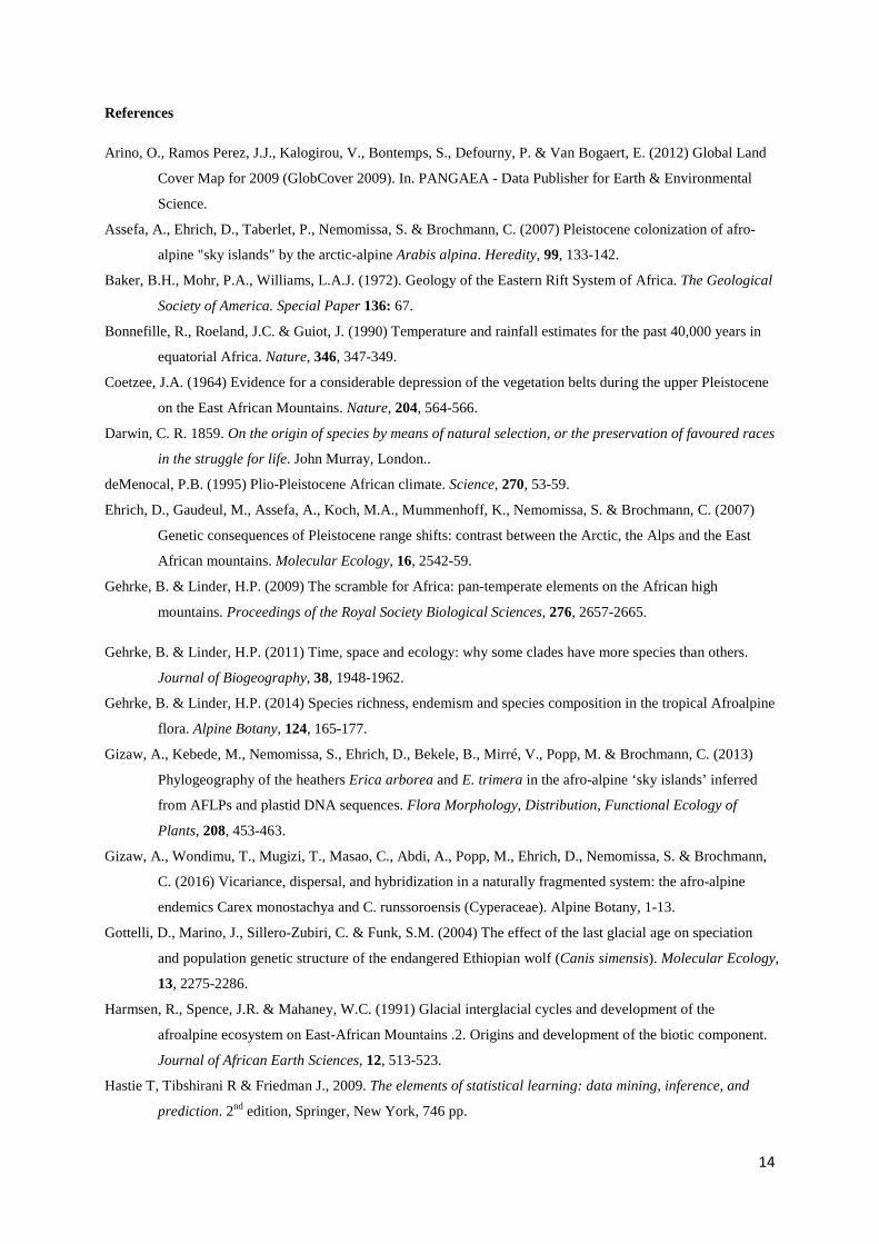
Democratic Congo and Rwanda, separated from the Ethiopian mountains by the Turkana Lowlands (Fig. 1).
The high eastern African mountains harbor unique alpine floras and faunas. Endemism is remarkably high, 80%
at the species level for vascular plants (Hedberg, 1957; Gehrke & Linder, 2014) and 64% for mosses (Spence &
Pocs, 1988). In spite of the high degree of fragmentation, the mountain floras have many species in common and
show close relationships to remote temperate regions in the northern and southern hemispheres (Hedberg, 1951;
Hedberg, 1970; Smith & Cleef, 1988; Gehrke & Linder, 2009). It has been suggested that the isolation among
these mountain floras may be stronger than that among oceanic islands, where ocean currents may play a role as
an interconnecting dispersal agent (Hedberg, 1970). In particular, the Rift Valley is a prominent landscape
feature which has long been considered to represent a strong barrier against gene flow (Hedberg, 1970; Kebede
et al., 2007; Gizaw et al., 2016). The Rift Valley is a continuous valley system, 6000 km in length, and runs
from northern Syria in Asia to Mozambique in southeastern Africa, cutting through mountains and lowlands in
eastern Africa. It was formed by volcanic processes that started many million years ago and continued to be
active well into the Pleistocene (Baker et al., 1972; Gehrke & Linder 2014).
How the sky island biotas evolved and how similarities among mountain systems were established and
maintained over time have been intensely discussed in the literature (Hedberg, 1951, 1957, 1970; Smith & Cleef,
1988; Harmsen et al., 1991; Gottelli et al., 2004; Koch et al., 2006; Ehrich et al., 2007; Umer et al., 2007; Popp
et al., 2008; Gehrke & Linder, 2009; Gehrke & Linder, 2011; Gehrke & Linder, 2014; Sklenář et al., 2014). The
4
proportion of shared species generally correlates with the geographic distance among the mountains (Gehrke &
Linder, 2014; Sklenář et al., 2014). The more geographically isolated the mountains are, the more endemic taxa
they harbor and the poorer they are in species number (Smith & Cleef, 1988; Harmsen et al., 1991; Gehrke &
Linder, 2014). Colonization patterns thus seem to be closely associated with geographic distance. However, the
patterns of genetic structuring and diversity within species seem to be more complex. Recent phylogeographic
studies suggest that afroalpine species may have a dynamic history with periods of allopatric divergence often
interrupted by repeated intermountain dispersal and hybridization, but the inferred histories differ considerably
from species to species and among different mountains (Assefa et al. 2007, Ehrich et al. 2007; Gizaw et al. 2013,
2016; Masao et al. 2013; Wondimu et al. 2014). In some species, populations inhabiting distant mountains are
genetically very similar, suggesting recent colonization or extensive gene flow. Two species that also extend to
lower vegetation belts in the mountains show no geographic structuring of their genetic diversity at all (Gizaw et
al. 2013; Masao et al. 2013), possibly indicating that habitat connectivity through lowland corridors has been
more important than long-distance dispersal.
The Pleistocene ice ages were distinct climatic events during the past 700,000 years also in eastern Africa. The
vegetation belts in the mountains were oscillating in response to the changing climate, but few details are known
(Bonnefille et al., 1990; deMenocal, 1995; Shanahan & Zreda, 2000; Thompson et al., 2002). Pollen analyses
show that the African tropics were colder and drier than today during the last glaciation (Bonnefille et al., 1990;
Mark & Osmaston, 2008) and that the alpine zone in East Africa may have descended as much as 1,000 m
(Coetzee, 1964). The treeline started to rise soon after the start of the Holocene (11 200 cal BP) following the
increase in temperature and moisture and soon reached its current elevation (Umer et al., 2007). Globally, the
natural treeline is associated with an isoline average temperature of 6.4±0.7 °C during a growing season that lasts
at least 90 days (Körner, 2012). In the tropics, there is only little seasonal variation in temperature and the
growing season therefore lasts the whole year with respect to temperature (Rundel, 1994, Körner & Paulsen,
2004). In our study area, the annual temperature is highly correlated with seasonal temperatures (Fig. S1, table
S1) and can therefore be used as a proxy for the temperature of the growing season. In tropical eastern Africa,
the temperature was reconstructed to have been 4.0 ± 2.0 °C lower during the LGM than today (Bonnefille et al.,
1990). The LGM temperature reported by Schneider von Deimling et al. (2006) falls within the same range.
Despite shifting to lower altitudes during cold periods, the afroalpine belt in East/Central Africa has been
thought to have been isolated since its origin (Hedberg, 1970; Harmsen et al., 1991). This may be true for these
solitary mountains, but it remains uncertain to what degree this also holds for the alpine habitat in Ethiopia. In
Ethiopia, vast landmasses are found at high elevations and the current alpine habitat exists on punctuated
volcanic uplifts. It is therefore possible that the alpine zone of most of the high Ethiopian mountains became
interconnected and formed one continuous habitat, at least on each side of the Rift Valley under colder climates.
The possibility for gradual migration through habitat corridors between the eastern African mountains under
colder climates may however have varied considerably among different afroalpine species, which show large
variation in their lower elevation boundaries under the current climate. While some species are confined to areas
above 4500 m, others extend into afromontane grasslands and open montane forests, and some of them have
5
been observed as low as 1000 m (Hedberg, 1970; Gehrke & Linder, 2014). Only 169 (32%) of the species in the
afroalpine flora are ‘exclusively alpine’ when defined by a lower elevation limit of 3200 m (Gehrke & Linder
2014). Thirty-six percent of the species not only occur below the afroalpine zone in eastern Africa but also in
tropical countries that lack mountains characterized by alpine climate (Gehrke & Linder, 2014). Depending on
their individual traits and habitat requirements, it may thus have been possible for some ‘non-exclusively alpine’
species to disperse among mountains through non-alpine habitat corridors under colder climates, and possibly
even under the current climate before the landscape was strongly transformed by agriculture. Strong isolation
and migration solely via long-distance dispersal may thus be restricted to the one-third of the afroalpine species
that are exclusively alpine and only occur in areas experiencing nightly frosts. Since most alpine species are
adapted to grow in full sunlight, grasslands at lower altitudes are candidate for serving as migratory corridor for
the non-exclusively alpine species that are sufficiently drought-tolerant. For afroalpine species that today stretch
to the lowermost altitudes even open forests may serve as migration corridor.
Here we explore the potential for past habitat connectivity under the colder climate of the LGM, to represent also
earlier glacial maxima during the Pleistocene, and assess whether gradual migration corridors can help explain
patterns in floristic and genetic similarity among the three mountain regions as well as among individual
mountains. We used a classification tree model to project the treeline position as well as the land cover
distribution based on paleoclimate data. We modelled the extent of the current alpine habitat and projected it to
the LGM climate to assess whether the alpine habitat was widespread enough to allow gradual intermountain
migration of exclusively alpine species. Next, we modelled a suite of eastern African landcover types both under
current and LGM climates to assess whether grassland and open forest types may have served as migration
corridors for non-exclusively alpine species, i.e. those that today extend downslope into to the montane forest
and other lower elevation vegetation types.
6
Methods
Defining the alpine habitat in the study region
The alpine habitat in tropical Africa covers the area situated above approximately 3500 m (Hedberg, 1951). We
used this elevation as a cut-off value and classified the study area into alpine and non-alpine landcover units
based on the 1 km resolution DEM (Hijmans et al., 2005). We sampled both ‘alpine’ and ‘non-alpine’ habitat
units randomly proportional to the log of their area (x 1,000) for generating a training and test dataset. We
randomly split this dataset into 75% for training and 25% for testing.
Defining the landcover types in the study region
We used the 300 m resolution GlobCover dataset (Arino et al., 2012) to represent landcover types in our study
area after simplifying and reclassifying it into seven general landcover units: (i) closed forest, (ii) open forest I,
(iii) open forest II, (iv) shrub/grassland I, (v) shrub/grassland II, (vi) flooded areas and (vii) croplands and other.
Almost all landcover types of the GlobCover dataset cover wide altitudinal ranges. Especially the landcover
units that are categorized as open forest and shrub/grassland are very heterogeneous in terms of their distribution
across elevation gradients (Figs. S1& S2). Some of them are mainly confined to lower elevations, while others
cover a large altitudinal span. To minimize heterogeneity, those covering a large altitudinal span and thus
potentially most suited as migration corridors for alpine species were reclassified as type I (shrub/grassland I and
open forest I), and those mainly confined to lower elevations and thus drier conditions were reclassified as type
II (shrub/grassland II and open forest II; Table 1). We computed the area per landcover unit and sampled each
unit randomly proportional to the log of its area (x 1,000) for generating a training and test dataset. The
‘croplands and other’ landcover unit was excluded from land cover reconstruction. Over the last 10,000 years, 50%
of the ice-free terrestrial surface has been modified by humans, whereas there was little human influence prior to
this period (Lambin et al., 2003). Cropland is a landcover type that has been converted from other landcover
units. We decided to model ‘potential land cover units’ by letting other landcover units colonize the areas now
covered by cropland. All sample points were randomly split into 75% training and 25% test data.
Predictor variables
In order to model both alpine/non-alpine vegetation and the sampled landcover types, we used 19 bioclimatic
variables of the current climate (~1 km resolution) obtained from the WorldClim database (Hijmans et al., 2005).
We also used a DEM of ~1 km resolution from the same data source and generated two topographic variables,
slope angle and slope aspect. The slope aspect was converted into eight categorical classes (N, NE, E, SE, S, SW,
W, NW). We stacked the bioclimatic layers and the two topographic variables and overlaid the stacked raster
datasets with the randomly sampled points. These sample points now contained information about alpine vs.
non-alpine classes for alpine habitat modelling and the six land cover units for landcover types as dependent
variables and the 19+2 variables as independent predictors. Pairwise Pearson correlations were computed
between all independent variables. For further analyses, we only retained predictor variables with a Pearson
correlation threshold below |0.7| by selecting only one variable based on assumed biological importance among
those correlated higher than this threshold. This resulted in ten variables selected for building both models
(alpine habitat and landcover types; Fig. S3): slope angle, slope aspect, Annual Mean Temperature (BIO1),
7
Mean Diurnal Range (BIO2), Isothermality (BIO3), Precipitation Seasonality (Coefficient of Variation; BIO15),
Precipitation of Wettest Quarter (Bio16), Precipitation of Driest Quarter (Bio17), precipitation of warmest
quarter (BIO18) and precipitation of coldest quarter (BIO19).
In order to allow both alpine habitat and landcover type reconstruction of the LGM climate, we used the same
eight bioclimatic variables that we selected from three different climate models of the LGM (~5 km resolution)
from the WorldClim database (www.worldclim.org): CCSM4 (CC, hereafter); MICRO-ESM (MR) and MPI-
ESM-P (ME). All the bioclimatic layers of the three LGM climate models were resampled to the same (1 km)
resolution as the current climate variables using nearest neighbor assignment technique in a GIS.
Statistical model calibration of alpine habitat extent and landcover types
The randomly selected training data points and the selected predictor variables were used as input to fit a
classification tree model to reconstruct both the alpine habitat extent and the landcover types in the rpart package
(Therneau & Atkinson, 2015). We first fitted a full rpart model with low values for minimal complexity gain per
additional split (cp = 0.001), which can be considered a relaxed parameter set that allows for overfitting the
resulting tree. Next, we optimized the complexity parameter (cp) of a statistically optimized tree model through
crossvalidation by identifying the cp value after which the improvement was no longer significant. The full tree
was pruned at this identified cp value of the optimized model. Finally we computed misclassification error rates
and Cohen’s kappa values on both the training and test data sets to evaluate model performance. Finally, we
projected these models (alpine habitat extent and land cover types) to the three LGM climate models.
In addition to using the reconstructed LGM climates, we also generated an additional environmental layer in
order to build an even simpler model of treeline shift under LGM climate. We derived an LGM mean annual
temperature map by deducting 4.0 °C from each pixel of the current mean annual temperature values relying on
information from Bonnefille et al. (1990), i.e., in tropics the temperature was expected to be 4.0 ± 2.0 °C lower
during LGM than today. We then built an additional, simpler model of alpine habitat based only on two variables:
1) annual mean temperature and 2) slope angle. This conforms to the general theory of treeline position by
Körner (2012), but modified by adding one more variable, slope, which had high variable importance in the
more complex model (Table 2). We used the same training and test dataset and the same procedure as in the
more complex models and evaluated it accordingly. Then we hindcasted the model to the computed average
annual temperature of the LGM, which had temperatures reduced by 4.0 °C. Finally we investigated how much
the treeline descended and the extent of the alpine habitat was enlarged during the LGM under the more simple
treeline model applied to the current temperature map that was reduced by 4 °C. This means that we had a total
of 4 treeline reconstructions for LGM, three originating from the more complex treeline model that was applied
to the three LGM climate models, and one originating from the simpler treeline model.
8
Results
Habitat connectivity among exclusively alpine taxa
Hindcasting the alpine habitat based on all selected predictor variables to the three LGM climate models showed
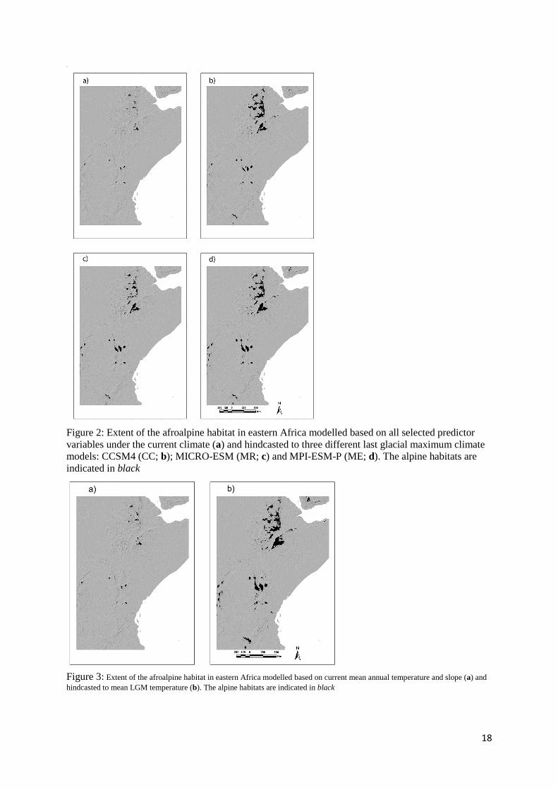
that there was a vast extent of alpine habitat both in Ethiopia and in East/Central Africa (Fig. 2). The simpler
model based only on slope and mean annual temperature of the LGM gave similar results (Fig. 3). The models
were highly and equally robust, with very low misclassification error rates (< 0.001) and gave very high kappa
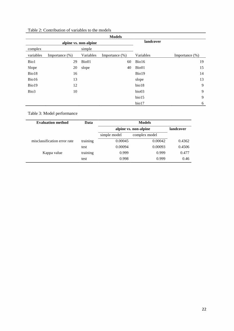
values (> 0.99) when evaluated on both the training and test datasets. In the more complex treeline model, annual
mean temperature had the highest variable importance followed by slope and precipitation of the warmest
quarter (bio18; Table 2). In the simpler treeline model, mean annual temperature contributed 60% and slope
contributed 40% to the predictive power.
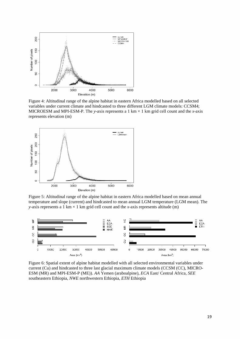
The simpler model predicted a larger extent of alpine habitat area both under current and LGM climate than did
the more complex model. Although the hindcasted LGM extent of the alpine habitat area varied among climate
models, the predicted lower altitudinal limit of the alpine zone was quite similar, approximately 1000 m lower
than today (Figs. 4, 5). The simpler model predicted larger alpine extent under LGM climate (Fig. 5, 7).
Averaged over all four treeline reconstructions, the afroalpine habitat was 8.3 times larger during the LGM as
compared to today.
In Ethiopia, most of the currently fragmented afroalpine habitat areas were united during the LGM, except across
the Rift Valley. Especially in the Shewa-Wallo massif in the NWE mountain region, almost all currently alpine
fragments became interconnected following the downward shift of the treeline. In contrast, the alpine habitat
areas in East/Central Africa remained disconnected during LGM, despite expansion on each of the solitary
mountains.
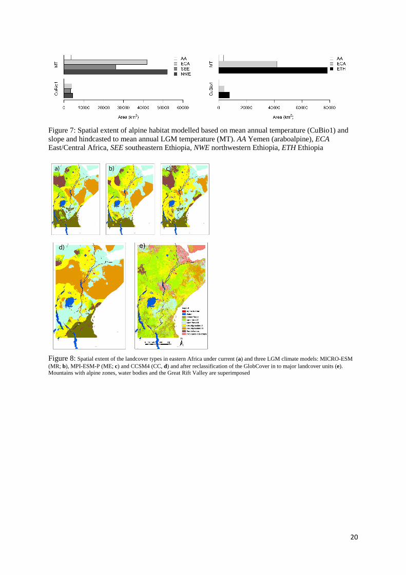
Under both current and LGM climates, the alpine habitat area in Ethiopia was more than two times larger than
that in the East/Central Africa (Figs. 6 & 7). The Ethiopian alpine habitat represented 64% and 69% of the total
alpine habitat under current and LGM climates, respectively. The Ethiopian mountains in the SEE region alone
harbored a current alpine habitat almost as large as that in East/Central Africa. The modelling based on current
climate did not predict presence of a proper alpine habitat in Yemen, but, notably, all models suggested the
presence of an araboalpine habitat during the LGM.
9
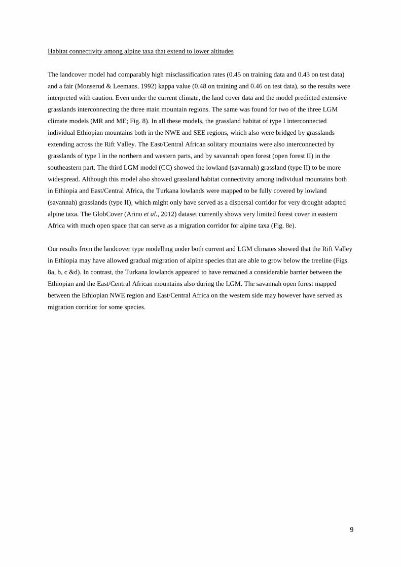
Habitat connectivity among alpine taxa that extend to lower altitudes
The landcover model had comparably high misclassification rates (0.45 on training data and 0.43 on test data)
and a fair (Monserud & Leemans, 1992) kappa value (0.48 on training and 0.46 on test data), so the results were
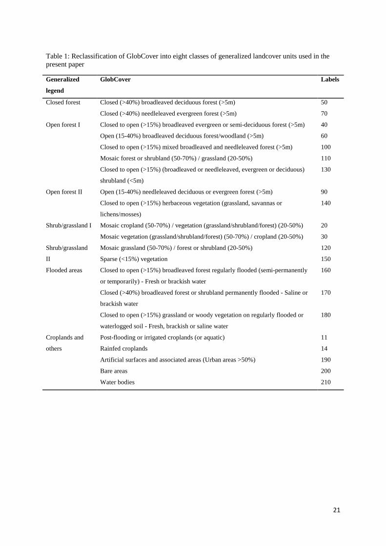
interpreted with caution. Even under the current climate, the land cover data and the model predicted extensive
grasslands interconnecting the three main mountain regions. The same was found for two of the three LGM
climate models (MR and ME; Fig. 8). In all these models, the grassland habitat of type I interconnected
individual Ethiopian mountains both in the NWE and SEE regions, which also were bridged by grasslands
extending across the Rift Valley. The East/Central African solitary mountains were also interconnected by
grasslands of type I in the northern and western parts, and by savannah open forest (open forest II) in the
southeastern part. The third LGM model (CC) showed the lowland (savannah) grassland (type II) to be more
widespread. Although this model also showed grassland habitat connectivity among individual mountains both
in Ethiopia and East/Central Africa, the Turkana lowlands were mapped to be fully covered by lowland
(savannah) grasslands (type II), which might only have served as a dispersal corridor for very drought-adapted
alpine taxa. The GlobCover (Arino et al., 2012) dataset currently shows very limited forest cover in eastern
Africa with much open space that can serve as a migration corridor for alpine taxa (Fig. 8e).
Our results from the landcover type modelling under both current and LGM climates showed that the Rift Valley
in Ethiopia may have allowed gradual migration of alpine species that are able to grow below the treeline (Figs.
8a, b, c &d). In contrast, the Turkana lowlands appeared to have remained a considerable barrier between the
Ethiopian and the East/Central African mountains also during the LGM. The savannah open forest mapped
between the Ethiopian NWE region and East/Central Africa on the western side may however have served as
migration corridor for some species.
10
Discussion
Using alpine habitat and landcover type modeling and hindcasting these models to the LGM climate, we have
here provided insights into a long-debated issue in African biogeography: to what degree did colonization of the
currently strongly isolated sky islands and subsequent intermountain gene flow depend on long-distance
dispersal across unsuitable habitat, and to what extent did suitable habitat corridors occur under LGM and earlier
colder climates to enable gradual migration? We have shown that the answer to these questions may strongly
depend on the species and the mountain region considered. Exclusively alpine species, which currently only
occur above the treeline in these mountains, remained isolated in each of the solitary East/Central African
mountains even during the LGM, when we estimated the treeline to be 1,000 m lower and the alpine habitat
about eight times larger than today. In this region, exclusively alpine species seem to have been entirely
dependent on long-distance dispersal for colonization and intermountain gene flow (except for a few mountains
in Kenya and along the Uganda/Rwanda/Congo borders; Figs. 2 & 3). In contrast, the alpine fragments in
Ethiopia probably fused during the LGM except across the Rift Valley, allowing for migration of such species.
We also show that drought-tolerant alpine species that today extend below the treeline may have had
opportunities for gradual migration through grassland and open forest corridors among mountains in all regions
during the dry glacial periods, possibly also under the current climate before agriculture transformed the low-
lying landscapes.
Exclusively alpine species: isolated in East/Central Africa, partly connected in Ethiopia
The results from both treeline models and all LGM climate data sources showed that the afroalpine habitat was
considerably expanded during this (and probably earlier) glaciation(s), on average about 8.3 times larger than
today. Although the spatial extent of the alpine habitat predicted by different LGM climate models differed
somewhat, they consistently predicted that the LGM treeline was about 1,000 m lower than today, in agreement
with the results of a pollen analysis from Mount Kenya (Coetzee, 1964).
Our finding of a lack alpine habitat in the low-lying landscapes separating the East/Central African mountains
during the LGM is consistent with Hedberg (1970) and Harmsen et al. (1991), who considered their alpine zones
to have been isolated since their origin. This would explain why these mountains harbor more single-mountain
endemics than the Ethiopian mountains (Hedberg, 1964; Hedberg, 1970; Knox & Palmer, 1998), which our
analyses showed to have been more interconnected during colder climates. Considerable intermountain gene
flow among the East/Central mountains has nevertheless been inferred in several phylogeographic studies, even
across the vast Ugandan gap separating the mountains along the western and eastern branches of the Rift Valley,
demonstrating the importance of long-distance dispersal and hybridization (Gizaw et al. 2013, 2016; Masao et al.
2013; Wondimu et al. 2014, and unpublished data).
In Ethiopia, the Rift Valley appears to have presented a strong barrier against migration of exclusively alpine
species even during the LGM (Figs. 2&3). Although the northwestern and southeastern mountain regions share a
considerable number of alpine species (Gehrke & Linder 2014), the Rift Valley represent a distinct genetic break
11
in several of those examined to date (Gizaw et al. 2013, 2016; Masao et al. 2013; Wondimu et al. 2014, and
unpublished data). However, the phylogeographic studies have mainly focused on the geographically most
separated mountain ranges in Ethiopia, the Simen Mts in the northwest and the Bale Mts in the southeast (Fig. 1),
which often harbor distinct genetic groups (e.g. Gizaw et al. 2016). The study of Wondimu et al. (2014) also
included Mt Choke, which is situated in the northwestern region but much closer to the Rift Valley than the
Simen Mts and showed that the populations in this mountain represented admixtures of both the Simen and Bale
Mts. These results call for more extensively sampled phylogeographic studies to assess the relevance of our
finding of the fusion of LGM alpine habitat on each side of the Rift but not across it for gene flow in exclusively
alpine species in Ethiopia.
Interestingly, our models predicted the existence of an araboalpine LGM habitat in Yemen, an area that lacks
proper alpine zones today. This is a significant finding since Yemen and the Arabian Peninsula have been
suggested as a main migratory pathway for Eurasian lineages colonizing the mountains of eastern Africa (Koch
et al. 2006; Assefa et al. 2007, Ehrich et al. 2007, Popp et al. 2008, Gehrke & Linder 2009).
In eastern Africa, we found that the alpine habitat seems mainly to be shaped by temperature-related bioclimatic
variables, which is in agreement with Körner & Paulsen (2004). Mean annual temperature strongly correlates
with seasonal temperature variables and was found to be the most important variable in our model. The seasonal
variation in temperature is minimal (Rundel, 1994). Because of the high correlation with seasonal temperature
variables, mean annual temperature can be used as a proxy to the temperature of the growing season. We found
that relying only on annual temperature and slope to model the treeline and the extent of the alpine habitat in
eastern Africa provided a model almost as robust as the model in which we used more variables to discriminate
the alpine habitat from non-alpine lowlands.
Alpine species that extend below the treeline: potential grassland corridors
Because our landcover model had comparably high misclassification error rates and a fair kappa value, we
interpret the results with caution. Many of the landcover types in eastern Africa are today influenced by
anthropogenic activities, and they cover large altitudinal spans (Figs. S2, S3). This indicates that they are quite
heterogeneous and that the thematic resolution of GlobCover is not very precise, and may partly explain the
comparably high misclassification in our habitat model.
From the GlobCover data, it can clearly be seen that the forest cover in eastern Africa is small and highly
fragmented (Fig. 8e). In accordance, even under the current climate (when agricultural landscapes were replaced
by potential natural landcover types in our models), we predicted extensive grasslands interconnecting individual
mountains as well as the three main mountain regions. The same was found for two of the three LGM climate
models. Grasslands and open forests probably interconnected all the Ethiopian mountains, also across the Rift
Valley. In East/Central Africa, the mountains were also interconnected by grassland extending from the Virunga
12
and Rwenzori mountains in the west to Mt Elgon and Mt Kenya in the northeast, with further extensions towards
northwestern Ethiopia on the western side of the Turkana Lowlands (Figs. 1 & 8). The Turkana Lowlands
separating the East/Central African mountains from Ethiopia seem to present the strongest barrier for alpine
species in our study region; this area was mapped to be fully covered by the driest type of grasslands (type II),
which might have served as a dispersal corridor only for very drought-adapted taxa.
Regardless of the uncertainty associated with our model, it is difficult to assess to what degree grasslands may
have served as migration corridors for ‘non-exclusively’ alpine species. Firstly, such grasslands may be partly
too dry to be suitable for most alpine species, especially during glacial periods. Secondly, it is possible that most
of the alpine species that today also occur below the treeline have their primary populations in the alpine zone,
functioning as sources for occasional sink populations extending downslope along open patches and along
watercourses. However, we tentatively explored occurrence data for some alpine taxa from the Global
Biodiversity Information Facility (GBIF), providing some support for the Rift Valley in Ethiopia, but not the
Turkana Lowlands, as a potential migration corridor for non-exclusively alpine plants (Chala et al., unpubl. data).
We found some occurrence points located in the current grasslands in the Ethiopian Rift Valley, bridging those
from the northwestern and southeastern mountain regions. Our findings are also in line with phylogeographic
studies of some alpine species, such as Erica arborea (Gizaw et al., 2013) and Koeleria capensis (Masao et al.,
2013). These species are drought-tolerant, extend to lower vegetation belts in the eastern African mountains, and
show no geographic structuring of their genetic diversity, possibly indicating that habitat connectivity through
grassland and open forest corridors has been more important than long-distance dispersal.
Although the Turkana Lowlands appear as a virtually impenetrable barrier against gradual migration of alpine
species, the genetic structuring in several species points to higher levels of gene flow across this extensive
lowland gap than across the Rift Valley in Ethiopia. In these species, the populations in southeastern Ethiopia
belong to the same genetic group as those in East Africa, whereas another, distinct genetic group is found in
northwestern Ethiopia (Gizaw et al., 2013; Wondimu et al., 2014; Gizaw et al., 2016). The most likely
explanation is that this unexpected pattern is driven by long-distance dispersal directed by prevailing winds and
bird migration routes.
Our results call for more detailed comparative studies of species with different traits, habitat requirements, and
altitudinal ranges using a combined phylogeographic and modeling approach, to further explore the relative
importance of migrational corridors and long-distance dispersal in the fascinating sky island system of eastern
Africa.

13
Acknowledgements
We acknowledge financial support by the Norwegian State Loan Fund (Lånekassen); Natural History Museum,
University of Oslo and the PET and GEco research groups at the Museum. We thank Achilleas Psomas, Swiss
Federal Research Institute (WSL), and all members of PET and GEco for discussions on the manuscript.
14
References
Arino, O., Ramos Perez, J.J., Kalogirou, V., Bontemps, S., Defourny, P. & Van Bogaert, E. (2012) Global Land
Cover Map for 2009 (GlobCover 2009). In. PANGAEA - Data Publisher for Earth & Environmental
Science.
Assefa, A., Ehrich, D., Taberlet, P., Nemomissa, S. & Brochmann, C. (2007) Pleistocene colonization of afro-
alpine "sky islands" by the arctic-alpine Arabis alpina. Heredity, 99, 133-142.
Baker, B.H., Mohr, P.A., Williams, L.A.J. (1972). Geology of the Eastern Rift System of Africa. The Geological
Society of America. Special Paper 136: 67.
Bonnefille, R., Roeland, J.C. & Guiot, J. (1990) Temperature and rainfall estimates for the past 40,000 years in
equatorial Africa. Nature, 346, 347-349.
Coetzee, J.A. (1964) Evidence for a considerable depression of the vegetation belts during the upper Pleistocene
on the East African Mountains. Nature, 204, 564-566.
Darwin, C. R. 1859. On the origin of species by means of natural selection, or the preservation of favoured races
in the struggle for life. John Murray, London..
deMenocal, P.B. (1995) Plio-Pleistocene African climate. Science, 270, 53-59.
Ehrich, D., Gaudeul, M., Assefa, A., Koch, M.A., Mummenhoff, K., Nemomissa, S. & Brochmann, C. (2007)
Genetic consequences of Pleistocene range shifts: contrast between the Arctic, the Alps and the East
African mountains. Molecular Ecology, 16, 2542-59.
Gehrke, B. & Linder, H.P. (2009) The scramble for Africa: pan-temperate elements on the African high
mountains. Proceedings of the Royal Society Biological Sciences, 276, 2657-2665.
Gehrke, B. & Linder, H.P. (2011) Time, space and ecology: why some clades have more species than others.
Journal of Biogeography, 38, 1948-1962.
Gehrke, B. & Linder, H.P. (2014) Species richness, endemism and species composition in the tropical Afroalpine
flora. Alpine Botany, 124, 165-177.
Gizaw, A., Kebede, M., Nemomissa, S., Ehrich, D., Bekele, B., Mirré, V., Popp, M. & Brochmann, C. (2013)
Phylogeography of the heathers Erica arborea and E. trimera in the afro-alpine ‘sky islands’ inferred
from AFLPs and plastid DNA sequences. Flora Morphology, Distribution, Functional Ecology of
Plants, 208, 453-463.
Gizaw, A., Wondimu, T., Mugizi, T., Masao, C., Abdi, A., Popp, M., Ehrich, D., Nemomissa, S. & Brochmann,
C. (2016) Vicariance, dispersal, and hybridization in a naturally fragmented system: the afro-alpine
endemics Carex monostachya and C. runssoroensis (Cyperaceae). Alpine Botany, 1-13.
Gottelli, D., Marino, J., Sillero-Zubiri, C. & Funk, S.M. (2004) The effect of the last glacial age on speciation
and population genetic structure of the endangered Ethiopian wolf (Canis simensis). Molecular Ecology,
13, 2275-2286.
Harmsen, R., Spence, J.R. & Mahaney, W.C. (1991) Glacial interglacial cycles and development of the
afroalpine ecosystem on East-African Mountains .2. Origins and development of the biotic component.
Journal of African Earth Sciences, 12, 513-523.
Hastie T, Tibshirani R & Friedman J., 2009. The elements of statistical learning: data mining, inference, and
prediction. 2nd edition, Springer, New York, 746 pp.
15
Hedberg, O. (1951) Vegetation belts of the East African mountains. Svensk Botanisk Tidskrift, 45, 140-202.
Hedberg, O. (1957) Afroalpine vascular plants. A taxonomic revision. Symbolae Botanicae Upsalienses, 15, 1-
411.
Hedberg, O. (1964) Features of afroalpine plant ecology. Acta Phytogeographica Suecica, 49, 1-144.
Hedberg, O. (1970) Evolution of the Afroalpine flora. Biotropica, 2, 16-23.
Kebede, M., Ehrich, D., Taberlet, P., Nemomissa, S. & Brochmann, C. (2007) Phylogeography and conservation
genetics of a giant lobelia (Lobelia giberroa) in Ethiopian and Tropical East African mountains.
Molecular Ecology, 16, 1233-43.
Knox, E.B. & Palmer, J.D. (1998) Chloroplast DNA evidence on the origin and radiation of the giant lobelias in
eastern Africa. Systematic Botany, 23, 109-149.
Koch, M.A., Kiefer, C., Ehrich, D., Vogel, J., Brochmann, C. & Mummenhoff, K. (2006) Three times out of
Asia Minor: the phylogeography of Arabis alpina L. (Brassicaceae). Molecular Ecology, 15, 825-839.
Körner, C. & Paulsen, J. (2004) A world-wide study of high altitude treeline temperatures. Journal of
Biogeography, 31, 713-732.
Körner, C. (2007) Climatic Treelines: Conventions, Global Patterns, Causes (Klimatische Baumgrenzen:
Konventionen, globale Muster, Ursachen). Erdkunde, 61, 316-324.
Körner, C. (2012) Alpine Treelines. Springer, Basel.
Lambin, E.F., Geist, H.J. & Lepers, E. (2003) Dynamics of land-use and land-cover change in tropical regions.
Annual Review of Environment and Resources, 28, 205-241.
Mark, B.G. & Osmaston, H.A. (2008) Quaternary glaciation in Africa: key chronologies and climatic
implications. Journal of Quaternary Science, 23, 589-608.
Masao, C., Gizaw, A., Piñeiro, R., Tusiime, F., Wondimu, T., Abdi, A., Popp, M., Gussarova, G., Lye, K.,
Munishi, P., Nemomissa, S. & Brochmann, C. (2013) Phylogeographic history and taxonomy of some
afro-alpine grasses assessed based on AFLPs and morphometry: Deschampsia cespitosa, D. angusta
and Koeleria capensis. Alpine Botany, 123, 107-122.
Monserud, R.A. & Leemans, R. (1992) Comparing global vegetation maps with the Kappa statistic. Ecological
Modelling, 62, 275-293.
Popp, M., Gizaw, A., Nemomissa, S., Suda, J. & Brochmann, C. (2008) Colonization and diversification in the
African ‘sky islands’ by Eurasian Lychnis L. (Caryophyllaceae). Journal of Biogeography, 35, 1016-
1029.
Rundel, P.W. (1994) Tropical alpine climates. Tropical Alpine Environments: Plant Form and Function (ed. by
P.W. Rundel, A.P. Smith and F.C. Meinzer), pp. 21-44. Cambridge University Press, Cambridge.
Shanahan, T.M. & Zreda, M. (2000) Chronology of Quaternary glaciations in East Africa. Earth and Planetary
Science Letters, 177, 23-42.
Sklenář, P., Hedberg, I. & Cleef, A.M. (2014) Island biogeography of tropical alpine floras. Journal of
Biogeography, 41, 287-297.
Smith, J.M.B. & Cleef, A.M. (1988) Composition and origins of the worlds tropical alpine floras. Journal of
Biogeography, 15, 631-645.
16
Spence, J.R. & Pocs, T. (1988) Distribution patterns in the Afroalpine moss flora of East Africa. Quaternary and
Environmental Research on East African Mountains (ed. by W.C. Mahaney), pp. 291-307. Balkema,
Rotterdam.
Therneau, T.M. & Atkinson, E.J. (2015) An introduction to recursive partitioning using the raprt routines.
Available at: https://cran.r- project.org/web/packages/rpart/vignettes/longintro.pdf.
Thompson, L.G., Mosley-Thompson, E., Davis, M.E., Henderson, K.A., Brecher, H.H., Zagorodnov, V.S.,
Mashiotta, T.A., Lin, P.N., Mikhalenko, V.N., Hardy, D.R. & Beer, J. (2002) Kilimanjaro ice core
records: evidence of holocene climate change in tropical Africa. Science, 298, 589-93.
Umer, M., Lamb, H.F., Bonnefille, R., Lezine, A.M., Tiercelin, J.J., Gibert, E., Cazet, J.P. & Watrin, J. (2007)
Late Pleistocene and Holocene vegetation history of the Bale Mountains, Ethiopia. Quaternary Science
Reviews, 26, 2229-2246.
Wallace, A.R. (1876) The Geographical Distribution of Animals: With a Study of the Relations of Living and
Extinct Faunas as Elucidating the Past Changes of the Earth's Surface. Harper and brothers, New York.
Wondimu, T., Gizaw, A., Tusiime, F., Masao, C., Abdi, A., Gussarova, G., Popp, M., Nemomissa, S. &
Brochmann, C. (2014) Crossing barriers in an extremely fragmented system: two case studies in the
afro-alpine sky island flora. Plant Systematics and Evolution, 300, 415-430.
17
Figure 1: a Mountains and low-lying landscapes of eastern Africa. The eastern and western branches of the Great Rift Valley are indicated with stippled lines. b Potential habitat corridors for drought-tolerant alpine species that today extend below the treeline, assessed based on landcover modelling (line thickness indicates potential corridor suitability
18
Figure 2: Extent of the afroalpine habitat in eastern Africa modelled based on all selected predictor variables under the current climate (a) and hindcasted to three different last glacial maximum climate models: CCSM4 (CC; b); MICRO-ESM (MR; c) and MPI-ESM-P (ME; d). The alpine habitats are indicated in black
Figure 3: Extent of the afroalpine habitat in eastern Africa modelled based on current mean annual temperature and slope (a) and hindcasted to mean LGM temperature (b). The alpine habitats are indicated in black
19
Figure 4: Altitudinal range of the alpine habitat in eastern Africa modelled based on all selected variables under current climate and hindcasted to three different LGM climate models: CCSM4; MICROESM and MPI-ESM-P. The y-axis represents a 1 km × 1 km grid cell count and the x-axis represents elevation (m)
Figure 5: Altitudinal range of the alpine habitat in eastern Africa modelled based on mean annual temperature and slope (current) and hindcasted to mean annual LGM temperature (LGM mean). The y-axis represents a 1 km × 1 km grid cell count and the x-axis represents altitude (m)
Figure 6: Spatial extent of alpine habitat modelled with all selected environmental variables under current (Cu) and hindcasted to three last glacial maximum climate models (CCSM (CC), MICRO-ESM (MR) and MPI-ESM-P (ME)). AA Yemen (araboalpine), ECA East/ Central Africa, SEE southeastern Ethiopia, NWE northwestern Ethiopia, ETH Ethiopia
20
Figure 7: Spatial extent of alpine habitat modelled based on mean annual temperature (CuBio1) and slope and hindcasted to mean annual LGM temperature (MT). AA Yemen (araboalpine), ECA East/Central Africa, SEE southeastern Ethiopia, NWE northwestern Ethiopia, ETH Ethiopia
Figure 8: Spatial extent of the landcover types in eastern Africa under current (a) and three LGM climate models: MICRO-ESM (MR; b), MPI-ESM-P (ME; c) and CCSM4 (CC, d) and after reclassification of the GlobCover in to major landcover units (e). Mountains with alpine zones, water bodies and the Great Rift Valley are superimposed
21
Table 1: Reclassification of GlobCover into eight classes of generalized landcover units used in the present paper
Generalized
legend
GlobCover Labels
Closed forest Closed (>40%) broadleaved deciduous forest (>5m) 50
Closed (>40%) needleleaved evergreen forest (>5m) 70
Open forest I Closed to open (>15%) broadleaved evergreen or semi-deciduous forest (>5m) 40
Open (15-40%) broadleaved deciduous forest/woodland (>5m) 60
Closed to open (>15%) mixed broadleaved and needleleaved forest (>5m) 100
Mosaic forest or shrubland (50-70%) / grassland (20-50%) 110
Closed to open (>15%) (broadleaved or needleleaved, evergreen or deciduous)
shrubland (<5m)
130
Open forest II Open (15-40%) needleleaved deciduous or evergreen forest (>5m) 90
Closed to open (>15%) herbaceous vegetation (grassland, savannas or
lichens/mosses)
140
Shrub/grassland I Mosaic cropland (50-70%) / vegetation (grassland/shrubland/forest) (20-50%) 20
Mosaic vegetation (grassland/shrubland/forest) (50-70%) / cropland (20-50%) 30
Shrub/grassland
II
Mosaic grassland (50-70%) / forest or shrubland (20-50%) 120
Sparse (<15%) vegetation 150
Flooded areas Closed to open (>15%) broadleaved forest regularly flooded (semi-permanently
or temporarily) - Fresh or brackish water
160
Closed (>40%) broadleaved forest or shrubland permanently flooded - Saline or
brackish water
170
Closed to open (>15%) grassland or woody vegetation on regularly flooded or
waterlogged soil - Fresh, brackish or saline water
180
Croplands and
others
Post-flooding or irrigated croplands (or aquatic) 11
Rainfed croplands 14
Artificial surfaces and associated areas (Urban areas >50%) 190
Bare areas 200
Water bodies 210
22
Table 2: Contribution of variables to the models
Models
alpine vs. non-alpine landcover
complex simple
variables Importance (%) Variables Importance (%) Variables Importance (%)
Bio1 29 Bio01 60 Bio16 19
Slope 20 slope 40 Bio01 15
Bio18 16 Bio19 14
Bio16 13 slope 13
Bio19 12 bio18 9
Bio3 10 bio03 9
bio15 9
bio17 6 Table 3: Model performance
Evaluation method Data Models
alpine vs. non-alpine landcover
simple model complex model
misclassification error rate training 0.00045 0.00042 0.4362
test 0.00094 0.00093 0.4506
Kappa value training 0.999 0.999 0.477
test 0.998 0.999 0.46