Embed Size (px)
Citation preview

Chapter 193 SUBDIVISION OF LAND
ARTICLE I ~193.16. Minor lot line adjustment or
Authority and Purpose boundary line agreement ~193-1. Authority. ~193-2. Purpose ARTICLE V Standards ARTICLE II ~193-17. General requirements Definitions ~193-18. Open space and recreation ~193-3. Definitions. ~193-19. Special flood hazard areas. ~193-20. Road standards ARTICLE III ~193-21. Utilities Procedure ~193-22. Sediment and erosion control ~193-4. Requirement for subdivision approval ARTICLE VI ~193-5. Preliminary consultation and Administration and Enforcement review ~193-23. Administration. ~193-6. Minor subdivisions ~193-24. Exceptions. ~193-7. Major subdivisions ~193-25. Penalties for transferring lots in ~193-8. Completed application unapproved subdivisions ~193-9. Filing and submission of ~193-26. Other penalties completed application ~193-27. More restrictive provisions to ~193-10. Board action on completed prevail. Application ~193--28. Amendments ~193-11. Public hearing ~193-29. Severability ~193-12. Notices ~193-30. Appeals ~193-13. Fees ARTICLE IV ARTICLE VII Plan Requirements Road Standards ~193-14. Preliminary layout ~193.-31. Purpose ~193-15. Final plat ~193-32. Design guidelines ~193-33. Definitions ~193-34. Road layout and specifications. [HISTORY: Adopted 1-10-1989 by the Planning Board. Amendments noted where applicable.]
GENERAL REFERENCES Planning Board—See Ch. 81. Zoning—See Ch. 219. ___________________________________________________________________________
ARTICLE I
Authority and Purpose
~193-1. Authority. Pursuant to the authority vested in the Town of Gorham Board by the voters of the Town of Gorham and in accordance with the provisions of Chapter 674:35-39, New Hampshire Revised Statutes Annotated, 1987, the Town of Gorham Planning Board adopts the following regulations governing the subdivision of land in the Town of Gorham, New Hampshire.
19301

~193-2. Purpose.
A. The purpose of this chapter is to promote the development of an economically sound and stable community in a manner consistent with acceptable standards for the municipality and to provide uniform procedures and standards for observance by the Planning Board and subdividers. The provisions of this chapter shall apply to all land within the boundaries of the municipality.
B. Additional purposes of this chapter include providing gainst scattered and premature subdivision of
land, providing for the harmonious development of the town and the proper arrangement and coordination of streets within subdivisions in relation to other existing or planned streets, streets with adequate width for present and future traffic and emergency vehicle use and for protection of our town’s scenic beauty.
ARTICLE II Definitions
~193-3. Definitions.
As used in this chapter, the following terms shall have the meanings indicated:
ABUTTER—Any person whose property is located in New Hampshire and adjoins or is directly across the street or stream from the land under consideration by the Board. For purposes of receiving testimony only, and not for the purpose of notification, the term “abutter” shall include any person who is able to demonstrate that his land will be directly affected by the proposal under consideration. For purposes of receipt of notification by a municipality of a local land use Board meeting, in the case of an abutting property being under a condominium or other collective form of ownership, the term “abutter” means the officers of the collective or association, as defined in RSA 356-B:3, XXIII.
BOARD—The Planning Board of the Town of Gorham, New Hampshire.
BUILDING DEVELOPMENT—The process of changing the character of the land from its existing condition to a more usable condition by the construction or placement of a building or buildings thereon.
COMPLETED APPLICATION—The official subdivision application form and submission as defined in Article IV and ~ 193-8 of these regulations.
CONDOMINIUM—A multifamily, group or cluster housing wherein dwelling units are individually owned but wherein open space and group facilities are held in common ownership. A “condominium” shall be considered a subdivision of land as outlined in RSA 356-B and reviewed accordingly.
CONTOUR LINE—A line on a map or chart connecting all points of the same elevation (or depth) in a particular area.
DRIVEWAY—An accessway for two (2) or fewer dwellings, lots or sites except in the case of a multifamily building which may have up to four (4) dwellings served by one (1) driveway.
ENGINEER—The duly designated engineer of the Town of Gorham or, if there is no such official, the planning consultant or official assigned by the Gorham Planning Board.
LOT—A parcel of land at least sufficient in size to meet the minimum requirements for use, coverage and area and to provide required yards and other open spaces. An undersize “lot” is permissible if it passes state standards for soil conditions and substantially meets the requirements here and if in existence on the date of adoption of this chapter.
MINOR SUBDIVISION—A subdivision containing three (3) or fewer lots, with no potential for resubdividing, fronting on an existing street, not involving any new street or road for the extension of municipal facilities and not adversely affecting the development of the remainder of the parcel or adjoining property and not in conflict with any provision of these regulations or any other duly accepted existing or future plan, map or ordinance.
19302
PERFORMANCE GUARANTY—Any security which may be accepted in lieu of a requirement that certain improvements be made before the Planning Board or other approving body approves a plat, including performance bonds, escrow agreements and other similar collateral or surety agreements.
PLAT—The final map, drawing or chart on which the subdivider’s plan of subdivision is presented to the Gorham Planning Board for approval and which, if approved, will be submitted to the Register of Deeds of Coos County for recording.
STREET—Means, relates to and includes a street, avenue, boulevard, road, lane, alley, viaduct, highway, freeway and other ways. “Street” shall mean the entire width of the right-of-way whether unimproved or improved.
SUBDIVISION—The division of the lot, tract or parcel of land into two (2) or more lots, plats, sites or other divisions of land for the purpose, whether immediate or future, of sale, rent, lease, condominium conveyance or building development. It includes resubdivision and, when appropriate to the context, relates to the process of subdividing or to the land or territory subdivided. The division of a parcel of land held in common and subsequently divided into parts among the several owners shall be deemed a “subdivision” under this title. The grant of an easement in gross to a public utility for the purpose of placing and maintaining overhead and underground facilities necessary for its transmission or distribution network such as poles, wires, cable, conduit, manholes, repeaters and supporting apparatus, including any unmanned structure which is less than two hundred (200) square feet, shall not be construed as a “subdivision” under this title and shall not be deemed to create any new division of land for any other purpose.
ARTICLE III Procedure
~193-4. Requirement for subdivision approval. Whenever any subdivision of land is proposed, before any construction, land clearing or building development is begun, before converting any existing developed property to condominium or time-sharing, before any permit for the erection of any building in such proposed subdivision shall be granted and before any subdivision plat may be filed in the Office of the Register of Deeds of Coos County, the subdivider or his authorized agent shall apply for and secure approval of such proposed subdivision in accordance with the following procedure ~193-5. Preliminary consultation and review. A. An applicant may request a preliminary consultation and review during a regular meeting of the
Planning Board to discuss a proposed subdivision in conceptual form and to ask specific questions regarding application procedures and the information criteria. Sketches or drawings may be utilized when necessary to clarify geographical or topographical relations and zoning ordinances.* The Board should review the relationship of the proposal to the Master Plan. The applicants shall be informed of the status of their proposal as a minor or major subdivision and of the necessity to obtain other local or state permits.
B. Such an informal consultation shall not require public notice, nor shall it result in any decision,
agreement or action binding upon the applicant or the Planning Board.
~ 193-6. Minor subdivisions.
A. Definition.
(1) “Minor subdivision” shall mean:
(a) The subdivision of land into no more than three (3) lots or sites requiring no new roads, utilities or other municipal improvements; or
19303

(a) Boundary line adjustments (annexation) in which there is merely a sale, conveyance or exchange of adjacent land among two (2) or more owners and which does not increase the number of owners or parcels of land.
(2) It shall not mean the division of a residential structure into two (2) residential units only. It shall
not include subdivisions or any part of any staged development.
B. The applicants may first meet with the Board for preliminary consultation and review of their proposal to determine if it is a minor subdivision. If it is determined by the Board to be to be a minor subdivision, the applicant shall submit:
(1) A completed application, as required in ~ 193-8, excluding the preliminary layout.
(2) A final plat as provided in ~ 193-15.
C. Notice of submission shall be given as provided in ~ 193-9 and may be combined with the notice of public hearing.
D. The completed application under this section may be submitted and approved at one (1) or more
Board meetings, but no application shall be approved without the full notice of abutters and public. A public hearing, duly noticed, shall be held only if requested by the applicant or abutters or if the Board determines to hold a hearing.
E. Minor lot line adjustments or boundary agreements which do not create buildable lots shall generally
be exempt from the final plat requirements in ~ 193-15. Instead, the submission requirements shall be as described in ~ 193-6. In addition, the minimum requirements include:
(1) An application form and three (3) prints to be submitted as described in ~ 193-8.
(2) Public notice and, at the Board’s discretion, notices to be sent to abutters.
(3)An opportunity to hold a public hearing, if requested by any abutter, the applicant or the Board.
(4) A check payable to the Board to cover a filing fee of ten dollars ($10.) plus notices, recording and
other costs.
F. At any time during the ten-day notification period, the applicant or abutter may petition the Board for a public hearing regarding the proposed boundary changes. The Board, upon receipt of said petition, shall suspend action until a public hearing has been convened and all interested parties have given testimony. Such extraordinary proceedings shall be conducted in accordance with the subdivision regulations contained herein, and all costs shall be borne by the applicant.
~193-7. Major subdivision. A major subdivision shall follow the requirements for a completed application as described in the following provisions and specifically in accordance with Article V, Standards. ~193-8. Completed application. A completed application sufficient to invoke jurisdiction of the Board must include sufficient information to allow the Board to proceed with consideration and to make an informed decision. The following shall be required for and constitute a completed application: A. An application for subdivision approval properly filled out and executed by the applicant and filed with
the Board in accordance with ~ 193-9, together with the following:
19304

(1) The names and addresses of the applicant and all abutters as indicated in town records not more than five (5) days before the day of filing on two (2) sets of mailing labels. (Can be purchased from office.)
(2) A check payable to the Board to cover filing fees, mailing, advertising, recording and other costs. (3) Three (3) paper print copies of the preliminary layout in accordance with and accompanied by the
information required in ~ 193-14. ~193-9. Filing and submission of completed application. A. The completed application shall be filed with the Chairman of the Board or designee at least fifteen (15) days prior to a scheduled public meeting of the
Board.
B. The completed application shall be formally submitted to and accepted by the Board only at a regularly scheduled public meeting after due notification to the applicant, abutters and the general public of the date the completed application will be submitted and received by the Board, except for a minor subdivision, which shall be processed in accordance with ~ 193-6 hereof.
~193-10. Board action on completed application. A. The Board shall consider the completed application within thirty (30) days of its receipt. B. The Board will study the preliminary layout and shall take into consideration the general requirements
of the community and the best use of the land to be subdivided C. After such review and the public hearing, the Board shall communicate, in writing, to the subdivider
the specific changes, if any, which it will require in the preliminary layout and request that the subdivider prepares a final plat as required in Article IV with the changes incorporated. The Board may disapprove of the preliminary layout in its entirety but shall state its reasons for such disapproval.
D. The Board shall act to approve or disapprove the final plat or completed application, subject to
extension or waiver as provided by RSA 676:4. Any bond or performance guaranty shall have been developed and approved as described in ~ 193-15B.
E. Approval of the final plat shall be certified by written endorsement on the plat and signed by the
Chairman or Secretary of the Planning Board. Said endorsement shall include any restrictions to which subdivision approval is held subject by the Board. The subdivider shall transmit a copy to the Register of Deeds of Coos County for recording at his own cost within thirty (30) days of final approval. The subdivider shall be responsible for payment of all recording fees. In case of disapproval of any plat submitted, the grounds for such disapproval shall be adequately stated in the records of the Planning Board and written notice given to the applicant.
F. If the Board has not taken action to approve or disapprove the completed application within ninety
(90) days of its acceptance and has not obtained an extension or waiver, the subdivider may obtain from the Selectmen an order directing the Planning Board to act within fifteen (15) days. Failure of the Board to act upon such order shall constitute grounds for the Superior Court, upon petition of the applicant, to issue an order approving the application if the Court determines that the proposed subdivision complies with existing subdivision regulations and zoning ordinances. *
~193-11. Public hearing. Prior to approval of a subdivision, a public hearing shall be held as required by RSA 676:4(1)e, and notice to the applicant and abutters and the public shall be given in accordance with ~ 193-12. The public *Editor's Note: See Ch. 219, Zoning.
19305
hearing shall be held within thirty (30) days after submission of the completed application. A public hearing may not be required for minor subdivisions as provided in ~ 193-6. ~193-12. Notices. A. Notices of the submission of a preliminary layout for a completed application shall be given by the
Board to the abutters and the applicant by certified mail, mailed at least ten (10) days prior to the submission, and to the public at the same time by posting in at least two (2) public places in the town and in a newspaper of general circulation. The notice shall give the date, time and place of the Board meeting at which the application or other item(s) will be formally submitted to the Board and shall include a general description of the proposal which is the subject of the application or of the item to be considered and shall identify the applicant and location of the proposed subdivision.
B. For any public hearing on the completed application, the same notice as required for notice of submission of the completed application shall be given. If the notice of public hearing has been included in the notice of submission or any prior notice, additional notice of the public hearing is not required, nor shall additional notice be required of an adjourned session of a hearing with proper notice if the date, time and place of the adjourned session was made known at the prior hearing.
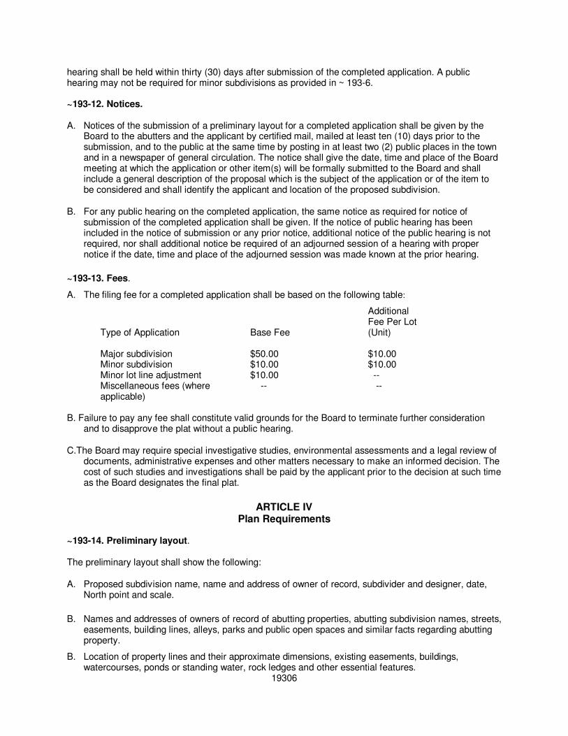
~193-13. Fees.
A. The filing fee for a completed application shall be based on the following table:
Additional Fee Per Lot
Type of Application Base Fee (Unit) Major subdivision $50.00 $10.00 Minor subdivision $10.00 $10.00 Minor lot line adjustment $10.00 -- Miscellaneous fees (where -- --
applicable) B. Failure to pay any fee shall constitute valid grounds for the Board to terminate further consideration
and to disapprove the plat without a public hearing.
C.The Board may require special investigative studies, environmental assessments and a legal review of documents, administrative expenses and other matters necessary to make an informed decision. The cost of such studies and investigations shall be paid by the applicant prior to the decision at such time as the Board designates the final plat.
ARTICLE IV Plan Requirements
~193-14. Preliminary layout. The preliminary layout shall show the following:
A. Proposed subdivision name, name and address of owner of record, subdivider and designer, date, North point and scale.
B. Names and addresses of owners of record of abutting properties, abutting subdivision names, streets,
easements, building lines, alleys, parks and public open spaces and similar facts regarding abutting property.
B. Location of property lines and their approximate dimensions, existing easements, buildings, watercourses, ponds or standing water, rock ledges and other essential features.
19306

D. Existing water mains, sewers, culverts, drains and proposed connections or alternative means of providing water supply and disposal of sewerage and surface drainage.
E. Location, name and widths of existing streets and highways. Proposed streets and highways with
their grades, profiles, cross-sections and elevations of sufficient points on the property to indicate the general topography of the property. Proposed streets shall be in accordance with road specifications in Article VII.
F. Where the topography is such as to make difficult the inclusion of any facilities mentioned above
within the public area so laid out, the preliminary layout shall show the boundaries of proposed permanent easements over or under private property. Such easements shall not be less than ten (10) feet in width and shall have satisfactory access to existing or proposed public ways.
G. Soil types according to Soil Conservation Service mapping Are we missing an “and” or “or” or
something here? Reads funny. laion-site soil survey may be required. H. Topography, with five-foot contour intervals. I. Flood hazard areas. J. Location of all parcels of land proposed to be dedicated to public use and the conditions of such
dedication and a copy of such private deed restrictions as are intended to cover all or part of the tract. K. Preliminary designs of any bridges or culverts which may be required. L. Where the preliminary layout submitted covers only a part of the subdivider’s entire holding, a sketch
of the prospective future street system of the unsubmitted part shall be furnished, and the street system of the submitted part will be considered in the light of adjustments and connections with the street system of the part not submitted.
~193-15. Final plat.
A. The subdivider, after official notification by the Board with respect to any revisions of the preliminary plan, shall file a final mylar plat in permanent black ink and street profiles, if required, along with three (3) paper copies. Sheet size may be eight and one-half by eleven (8 ½ x 11), eleven by seventeen (11 x 17), seventeen by twenty-two (17 x 22) or twenty-two by thirty-four (22 x 34) and shall have a three-inch margin for binding on the left side of the plat. Adequate space shall be provided for the necessary endorsements. The scale shall not exceed one hundred (100) feet to the inch and shall show:
(1) Proposed subdivision name or identifying title, the name and address of owner of record and
subdivider and the name, license number and seal of the designer, date scale and North point. (2) Boundary survey including bearings, distances and location of permanent markers, along with an
official surveyor’s stamp. (3) Lot lines, dimensions, acreage and numbering. (4) Setback lines.
(5) Topography at two-foot contour intervals.
(6) Existing and final proposed lines of streets, ways, lots, easements for utilities and/or drainage and
public areas within the subdivision. (7) Sufficient data to determine the exact location, direction and length of every street line, easement,
lot line and boundary line and to reproduce these lines upon the ground. All dimensions shall be 19307

shown to hundredths of a foot and bearings to at lease half minutes. The error of closure shall not exceed one to ten thousand (1:10,000). (8) Existing and proposed streets with names and right-of-way widths. (9) Final road cross sections and profiles, in accordance with the road specifications (Article VII). (10) Final drainage system. (11) Location of soils, groundwater and percolation test pits. (12) Buildings and other man-made features to remain. (13) Open space. (14) Deed restrictions.
B. Performance bond. The Planning Board may provide that, in lieu of the completion of street work and
utility installations prior to the final approval of the plat, the Planning Board shall accept a performance bond, irrevocable letter of credit or other type or types of security as shall be specified in the approval granted by the Planning Board. The Planning Board shall have the discretion to prescribe the type and amount of the bond or other security and specify a schedule for completion of the improvements and utilities to be expressed in the bond or other security and a schedule for a release of portions of the bond, in order to secure to the municipality the actual construction and installation of such improvements and utilities. The municipality shall have the power to enforce such bonds or other securities by all appropriate legal and equitable remedies.
(1)This bond shall be approved as to form and sureties by the Board of Selectmen and the Town Counsel and conditioned on the completion of such improvements within two (2) years of the date of the bond. Said bond may be:
(a) A surety bond, issued by a surety company authorized to do business in New Hampshire and filed with the Board in a manner and amount satisfactory to it; or
(b) Cash or appropriate letter of credit endorsed to the town and deposited with the Board.
(2) The amount of the performance bond shall include fees to cover the cost of periodic inspections. (3) Where electric lines or other utilities are to be installed by a corporation or municipal department
or public utility, a letter of intent shall be required stating that the work will be done in reasonable time and without expense to the town.
(4) Each approved plat shall contain a time limit for the completion of streets and public improvements.
(5) The performance bond shall not be released until the Board of Selectmen has certified
completion of the required improvements in accordance with approved subdivision plans and those deeds covering land to be used for public purposes, easements and rights-of-way and rights-to-drain are submitted in a form satisfactory to Town Counsel.
C. Instead of requiring a bond, the Board may grant approval of the final plat on condition that no lot in
the subdivision shall be sold and that no permit to build shall be issued by the town until:
(1) All street and utility requirements have been installed and completed at the subdivider’s expense in accordance with all applicable provisions of the final plat.
(2) A certificate of compliance covering all the applicable provisions of the final plat or portion thereof
has been singed by the Chairman of the Board of Selectmen and the Planning Board Chairman and a copy of such certificate has been recorded with the Coos County Register of Deeds.
19308

~193-16. Minor lot line adjustment or boundary line agreement.
A. The subdivider, after official notification by the Board with respect to any revisions of the preliminary plan, shall file a final mylar plat in permanent black ink and street profiles, if required, along with three (3) paper copies. Sheet size may be eight and one-half by eleven (8 ½ x 11), eleven by seventeen (11 x 17), seventeen by twenty-two (17 x 22) or twenty-two by thirty-four (22 x 34) and shall have a three-inch margin for binding on the left side of the plat. Adequate space shall be provided for the necessary endorsements. The scale shall not exceed one hundred (100) feet to the inch.
B. The final plat shall identify itself as a “minor lot line adjustment” or “boundary line agreement” and
shall contain the following statement: “The subdivision regulations of the Town of Gorham, New Hampshire, are a part of this plat, and approval of this plat is contingent on completion of all requirements of said subdivision regulations, excepting any variances or modifications made, in writing, by the Board and attached hereto.”
C. The final plat shall be based on an on the ground boundary survey with a maximum error of closure of
one (1) in five thousand (5,000) certified by a professional engineer or land surveyor registered/licensed in the State of New Hampshire. The subdivision’s boundary and survey shall be referenced to the nearest United States Geological Survey (USGS) survey benchmark.
D. The plat shall contain the following information:
(1) Names and addresses of all owners of lands involved.
(2) Names and addresses of all abutters [as indicated in town records not more than five (5) days
before the day of filing]. (3) Existing buildings, streets, rights-of-ways, streams and easements. (4) Lot areas and dimensions. (5) Natural features in the vicinity of the affected land. (6) Name, address and seal of surveyor or engineer. (7) A small locational map indicating parcels in relation to major streets and intersections, the tax
sheet and parcel numbers and the zoning district.
ARTICLE V Standards
~193-17. General requirements.
A. Land of such character that it cannot be safely used for building purposes because of exceptional danger to health or peril from fire, flood or other menace shall not be platted for residential occupancy nor for such other uses as may endanger health, life or property or aggravate the flood hazard until appropriate measures have been taken by the owner or his agent to lessen such hazards.
B. Scattered or premature subdivision of land as would involve danger or injury to health, safety or
prosperity by reason of the lack of water supply, drainage, transportation, schools, fire department or other public services or necessitate an excessive expenditure of public funds for the supply of such services shall not be approved.
C. The Board may require the installation or construction of any of the following improvements in the
subdivision, if warranted by the needs of the subdivision, its location and proximity to public services and the character of the land and the neighborhood: roads, water supply, sewage disposal, storm
19309

drainage, parks or open space or recreation facilities, fire protection facilities, street signs and sidewalks.
D. If the Board determines that the proposed subdivision will adversely affect existing off-site public
facilities such as highways, sidewalks, drainage, sewer and water so as to be inadequate to meet the additional needs created by the proposed subdivision, then the subdivider shall pay for such upgrading of the public facilities but only to the extent necessitated by the subdivision. If other properties would also benefit from the upgrading of such off-site improvements, then the Board shall determine the amount to be paid by the subdivider, taking into consideration the following: (1) The character of the area. (2) The extent that other public and private property will be benefited by the upgrading. (3) Any other factor that the Board deems appropriate to establish a rational connection to their
needs created by subdivision and the amount to be paid by the subdivider.
E. Pavement and drainage facilities, curbs and sidewalks, when required, shall be installed in accordance with the standard specifications of the Town of Gorham and in all cases must be constructed under the supervision of the Road Superintendent.
F. The minimum frontage per lot shall be one hundred (100) feet. Long, narrow lots or lots with very
irregular shapes shall not be accepted by the Board if, in the opinion of the Board, these lots will create unusable or inaccessible areas of land.
G. Any natural drainageways and their easements shall be so incorporated that no flooding will occur
and all stormwater can be disposed of properly. H. The Board shall indicate any requirements imposed upon the subdivider to preserve and protect the
existing features, trees, scenic views, brooks, streams, rock outcroppings, water bodies, stone walls, boundary markers, other natural resources and historic landmarks.
~193-18. Open space and recreation. Areas set aside for parks and playgrounds to be dedicated or to be reserved for the common use of all property owners by covenant in the deed, whether or not required by the Board, shall be of reasonable size and character for neighborhood playgrounds or other recreational uses. Park areas may be required in major subdivisions. ~193-19. Special flood hazard areas. See Appendix A.* ~193-20. Road standards.
See Appendix B.**
~193-21. Utilities. A. All subdivisions shall make adequate provisions for water supply, stormwater and sanitary sewage
disposal and required utilities and improvements. If existing public water and/or sewer lines are within a reasonable distance of a proposed subdivision, then, in the sole judgment of the Board, the Board may require the extension of public water and sewers to and within a proposed subdivision, without cost to the town.
*Editor's Note: For special flood hazard areas, see now Ch. 219, Zoning, Part, Floodplain Development. ** Editor's Note: Appendix B appears in this chapter as Art. VII, Road Standards.
19310

A. Sewage disposal. In areas not currently served by public sewer, the subdivider shall provide information to prove that the area of each lot is adequate to permit the installation and operation of an individual septic system. This shall consist of the Water Supply Pollution Control Commission subdivision application and approval and, if deemed necessary, a professional site assessment.
~193-22. Sediment and erosion control.
A. The purpose of this section is to control soil erosion and the resulting sedimentation from occurring in
subdivision areas by requiring proper provisions for water disposal and the protection of soil surfaces during and after construction in order to promote the public health, safety, convenience and general welfare of the community.
B. If the subdivision is less than two (2) acres, the following standards shall be observed by the
subdivider in the design, layout and engineering of the proposed subdivision in both the preliminary layout (~ 193-14) and the final plat (~ 193-15): (1) Stripping of vegetation, regrading or other development shall be done in such a way that will
minimize soil erosion. (2) Whenever practical, natural vegetation shall be retained, protected and supplemented. (3) The disturbed area shall be kept to a minimum and the duration of exposure shall be under a
maximum of six (6) months. In no case shall completed areas be left past October 1 without being seeded.
(4) Temporary seedings and/or mulching shall be used to protect exposed critical areas during
development. If the subdivision is over two (2) acres of land, refer to Alteration of Terrain, RSA 149-B.
(5) Provisions shall be made to accommodate the increased runoff caused by changed soil and surface conditions during and after development.
(6) Sediment in the runoff water shall be trapped until the disturbed area is stabilized by the use of
sediment basins or other acceptable methods. (7) Diversions, sediment basins and so forth shall be constructed prior to any on-site grading or
disturbance of existing surface vegetation.
ARTICLE VI Administration and Enforcement
~193-23. Administration. A. The Gorham Planning Board (or its duly authorized agent) shall administer and enforce these
regulations. B. Applications for subdivision approval shall be in a form as required by the Planning Board. ~193-24. Exceptions. Exceptions to the subdivision regulations may be permitted when, in the opinion of the Board, topography or other considerations warrant such exception, provided that public convenience, safety, health and welfare will not be adversely affected based on the Master Plan. The Planning Board may set higher requirements with respect to any of the standards if conditions, in the opinion of the Board, warrant such action. ~193-25. Penalties for transferring lots in unapproved subdivisions.
19311

An owner or agent of the owner of any land located within a subdivision who transfers or sells any land before a plat of said subdivision has been approved by the Planning Board and recorded or filed in the office of the appropriate Register of Deeds shall forfeit and pay a penalty of five hundred dollars ($500.) for each lot or parcel so transferred or sold; and the description by metes and bounds in the instrument of transfer or other document used in the process of selling or transferring shall not exempt the transaction from such penalties. Said municipality may enjoin such transfer or sale or agreement and may recover said penalty by civil action. In any such action, the prevailing party may recover reasonable court costs and attorneys’ fees as the same may be ordered by the court. ~193-26. Other penalties. Violations of these subdivision regulations will be subject to the penalties prescribed in RSA 676:15 and RSA 676:16. ~193-27. More restrictive provisions to prevail. Where a provision of these regulations is found to be in conflict with a provision of any other ordinance, regulations, code or covenant in effect in the Town of Gorham, the provision which is the more restrictive shall prevail. ~193-28. Amendments. These regulations may be amended or rescinded by the Planning Board, but only following public hearing on the proposed change. The Chairman or Secretary of the Planning Board shall transmit a record of any changes so authorized to the Registry of Deeds of Coos County. ~193-29. Severability.
If any portion of these regulations is found for any reason to be invalid by a court of competent jurisdiction, such decision shall not affect the validity of the remaining portion of these regulations. ~193-30. Appeals. An appeal may be taken from the decision of the Planning Board to the Superior Court, as provided in RSA 677:15.
ARTICLE VII Road Standards
~193-31. Purpose. The purpose of the Town of Gorham’s Road Standards is to create safe and convenient traffic circulation, promote economical road construction and to ensure that the town’s acceptance of private roadways will not burden the town with extensive maintenance or upgrading costs. These standards were established to provide the town with livable neighborhoods and to alleviate future burdens from unsafe and substandard roadways. ~193-32. Design guidelines. A. When designing a circulation system for a residential development, certain factors should be kept in
mind:
(1) Vehicular and pedestrian safety. (2) Efficient service for the appropriate users.
19312
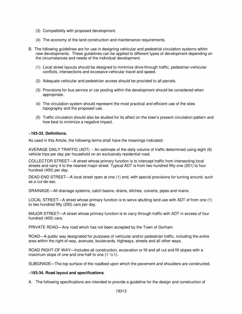
(3) Compatibility with proposed development.
(4) The economy of the land construction and maintenance requirements. B. The following guidelines are for use in designing vehicular and pedestrial circulation systems within
new developments. These guidelines can be applied to different types of development depending on the circumstances and needs of the individual development. (1) Local street layouts should be designed to minimize drive-through traffic, pedestrian-vehicular
conflicts, intersections and excessive vehicular travel and speed. (2) Adequate vehicular and pedestrian access should be provided to all parcels. (3) Provisions for bus service or car pooling within the development should be considered when
appropriate. (4) The circulation system should represent the most practical and efficient use of the sites
topography and the proposed use. (5) Traffic circulation should also be studied for its affect on the town’s present circulation pattern and
how best to minimize a negative impact.
~193-33. Definitions.
As used in this Article, the following terms shall have the meanings indicated: AVERAGE DAILY TRAFFIC (ADT) -- An estimate of the daily volume of traffic determined using eight (8) vehicle trips per day per household on an exclusively residential road.
COLLECTOR STREET—A street whose primary function is to intercept traffic from intersecting local streets and carry it to the nearest major street. Typical ADT is from two hundred fifty-one (251) to four hundred (400) per day.
DEAD-END STREET—A local street open at one (1) end, with special provisions for turning around, such as a cul-de-sac.
DRAINAGE—All drainage systems, catch basins, drains, ditches, culverts, pipes and mains.
LOCAL STREET—A street whose primary function is to serve abutting land use with ADT of from one (1) to two hundred fifty (250) cars per day.
MAJOR STREET—A street whose primary function is to carry through traffic with ADT in excess of four hundred (400) cars.
PRIVATE ROAD—Any road which has not been accepted by the Town of Gorham. ROAD—A public way designated for purposes of vehicular and/or pedestrian traffic, including the entire area within the right-of-way, avenues, boulevards, highways, streets and all other ways. ROAD RIGHT-OF-WAY—Includes all construction, excavation or fill and all cut and fill slopes with a maximum slope of one and one-half to one (1 ½:1). SUBGRADE—The top surface of the roadbed upon which the pavement and shoulders are constructed. ~193-34. Road layout and specifications.
A. The following specifications are intended to provide a guideline for the design and construction of
19313
private and public roadways. The town’s acceptance of these guidelines for its road work ensures the residents of Gorham a standard of construction that will ease future financial burden caused by upgrading substandard roadways.
B. All applications of these guidelines are subject to change or waiver by the Planning Board/Highway
Superintendent due to specific site characteristics or construction methods. These instances will be carefully reviewed by the Planning Board as not to jeopardize the integrity of the town’s roadways.
C. It is also recommended that privately constructed roadways attempt to meet these standards. Private
roads will be reviewed by the Planning Board on their ability to provide safe and adequate access to the proposed development.
D. The developer, landowners or homeowners association shall be responsible for the maintenance and
repair of private roadways. Any private roadway that is proposed for town maintenance must meet current road standards before town acceptance.
E. The Planning Board or Highway Superintendent’s approval of any private roadway’s design or
construction does not constitute any future acceptance of the roadway by the town. State statutes on town road acceptance must be followed by the town and the road owner/developer.
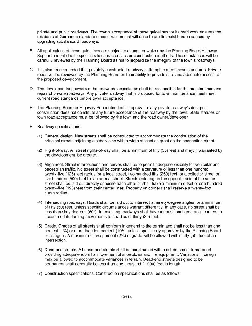
F. Roadway specifications.
(1) General design. New streets shall be constructed to accommodate the continuation of the
principal streets adjoining a subdivision with a width at least as great as the connecting street. (2) Right-of-way. All street rights-of-way shall be a minimum of fifty (50) feet and may, if warranted by
the development, be greater. (3) Alignment. Street intersections and curves shall be to permit adequate visibility for vehicular and
pedestrian traffic. No street shall be constructed with a curvature of less than one hundred twenty-five (125) feet radius for a local street, two hundred fifty (250) feet for a collector street or five hundred (500) feet for an arterial street. Streets entering on the opposite side of the same street shall be laid out directly opposite each other or shall have a minimum offset of one hundred twenty-five (125) feet from their center lines. Property on corners shall reserve a twenty-foot curve radius.
(4) Intersecting roadways. Roads shall be laid out to intersect at ninety-degree angles for a minimum
of fifty (50) feet, unless specific circumstances warrant differently. In any case, no street shall be less than sixty degrees (60°). Intersecting roadways shall have a transitional area at all corners to accommodate turning movements to a radius of thirty (30) feet.
(5) Grade. Grades of all streets shall conform in general to the terrain and shall not be less than one
percent (1%) or more than ten percent (10%) unless specifically approved by the Planning Board or its agent. A maximum of two percent (2%) of grade will be allowed within fifty (50) feet of an intersection.
(6) Dead-end streets. All dead-end streets shall be constructed with a cul-de-sac or turnaround
providing adequate room for movement of snowplows and fire equipment. Variations in design may be allowed to accommodate variances in terrain. Dead-end streets designed to be permanent shall generally be less than one thousand (1,000) feet in length.
(7) Construction specifications. Construction specifications shall be as follows:
19314
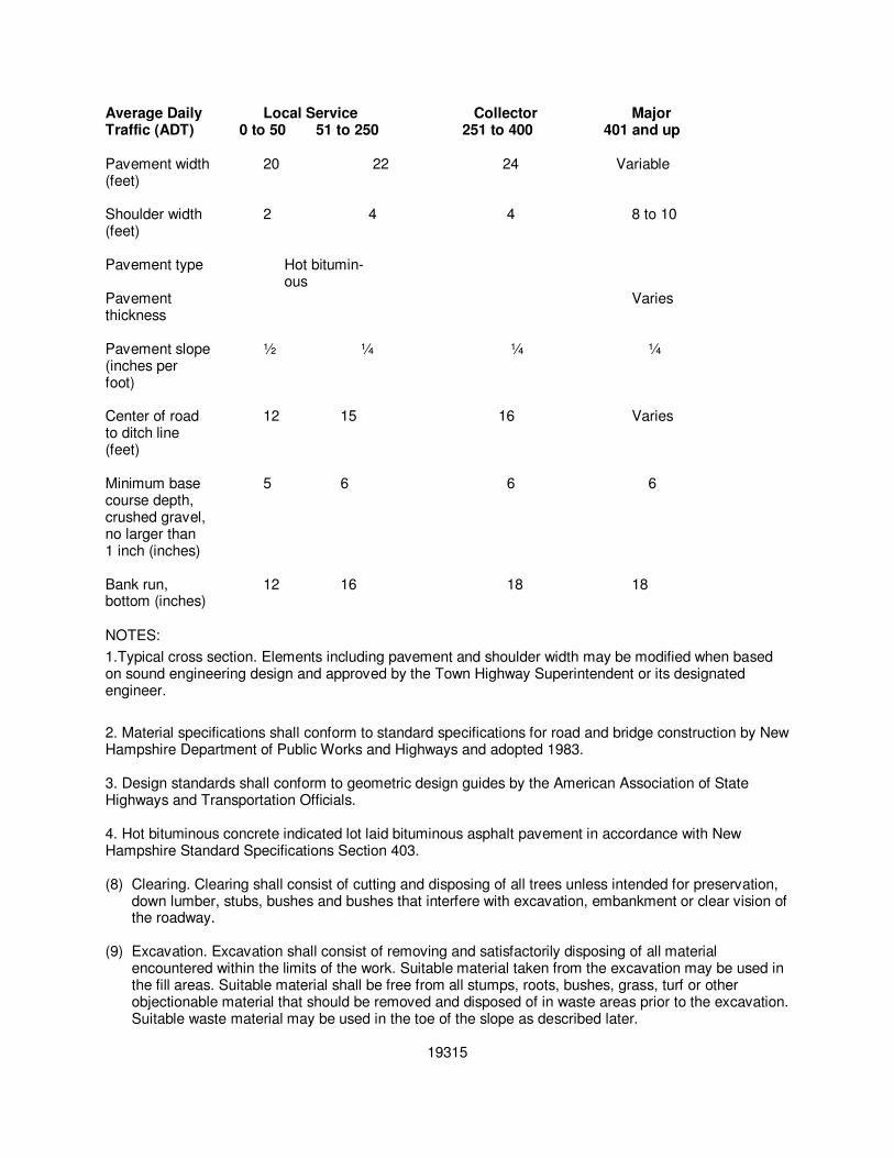
Average Daily Local Service Collector Major Traffic (ADT) 0 to 50 51 to 250 251 to 400 401 and up Pavement width 20 22 24 Variable (feet)
Shoulder width 2 4 4 8 to 10 (feet) Pavement type Hot bitumin- ous Pavement Varies thickness Pavement slope ½ ¼ ¼ ¼ (inches per foot) Center of road 12 15 16 Varies to ditch line (feet)
Minimum base 5 6 6 6 course depth, crushed gravel, no larger than 1 inch (inches)
Bank run, 12 16 18 18 bottom (inches)
NOTES:
1.Typical cross section. Elements including pavement and shoulder width may be modified when based on sound engineering design and approved by the Town Highway Superintendent or its designated engineer.
2. Material specifications shall conform to standard specifications for road and bridge construction by New Hampshire Department of Public Works and Highways and adopted 1983. 3. Design standards shall conform to geometric design guides by the American Association of State Highways and Transportation Officials. 4. Hot bituminous concrete indicated lot laid bituminous asphalt pavement in accordance with New Hampshire Standard Specifications Section 403.
(8) Clearing. Clearing shall consist of cutting and disposing of all trees unless intended for preservation,
down lumber, stubs, bushes and bushes that interfere with excavation, embankment or clear vision of the roadway.
(9) Excavation. Excavation shall consist of removing and satisfactorily disposing of all material
encountered within the limits of the work. Suitable material taken from the excavation may be used in the fill areas. Suitable material shall be free from all stumps, roots, bushes, grass, turf or other objectionable material that should be removed and disposed of in waste areas prior to the excavation. Suitable waste material may be used in the toe of the slope as described later.
19315
(10) Subgrade. The subgrade shall be maintained in such condition that the excavation shall be well drained at all times and shall be compacted, shaped and maintained to a tolerance of two (2) inches above or below the required grade before the application of the gravel base.
(11)Fill areas. In fill areas of five (5) feet or more in depth, measured from the subgrade to old ground,
stumps will be allowed to remain but shall be cut as close to the ground as practicable, but in no case will the stumps exceed a height of six (6) inches above the surrounding grounds. In fill areas of five (5) feet or less, measured from the subgrade to old ground, all stumps, bushes and objectionable material shall be removed and disposed of in waste areas prior to placing of the fill.
(12)Waste material. Waste material with all large stumps removed may be used in the toe of slopes in fill
areas. The “toe” of the slope area shall be defined as that area below the subgrade and outside of a two-to-one slope from the shoulder break. Suitable waste material shall not include trees and bushes cleared from the right-of-way.
(13)Road base. The road base shall consist of a foundation course of hard durable particles of granular
material, the type and source to be approved by the Superintendent prior to being used on the project. All base material shall be placed in two (2) layers, with the top layer not exceeding a compacted depth of nine (9) inches. No stone exceeding the maximum dimension shall be removed from each layer prior to addition of the next course. Each layer shall be placed uniformly over the full width of the subgrade. The base shall be thoroughly compacted, shaped and maintained to a tolerance of one (1) inch above or below the required grade before application of any surface course.
(14)Shoulders. Shoulder sections shall not be constructed in a separate operation from that of the gravel
base. The shoulder slope shall be constructed and compacted with the gravel base installation. (15)Backfill. Backfill shall be accomplished with the use of suitable material to fill all spaces excavated
and not occupied by drainage or other structures, and areas shall be filled up to elevation of the surrounding terrain.
(16)Ditching. The base level of the ditching shall be a minimum of thirty (30) inches below final grade
level. (17)Gravel surface. Gravel surface course shall consist of a wearing course or leveling course of
screened or crushed aggregate. This material shall be uniformly graded with one hundred percent (100%) passing the one-and-one-half-inch requirements can be obtained, screening or crushing shall not be required. When required, this course shall be treated with bituminous material of the type specified. The gravel surface course is for the fine grading operation to obtain the desired grade and good ridability. The quality of this material must allow for possible penetration of bituminous material; the gravel surface course shall be graded and loosened to a depth of one (1) inch with a power grader in order to allow uniform penetration of the bituminous material.
G. Drainage.
(1) Culverts.
(a) Structural excavation shall consist of excavating, removing and satisfactorily disposing of all
material encountered within the limits of the work as required for the construction of all drainage structures. All suitable material removed may be used for backfilling or within fill areas. In case the foundation material is soft or otherwise unsatisfactory, it may be necessary to excavate to a greater depth and backfill with granular material to establish a firm and suitable foundation for the drainage structure. If the foundation is solid rock, the trench should be excavated to a depth of six (6) inches below the flow line and backfilled with a granular material to ensure a cushion between the culvert and the rock foundation.
19316
(b) The foundation should be carefully shaped so that the culvert will have full support for the entire length. Shimming beneath the culvert with dirt, stones, wood, etc., to meet the designated grade will not be permitted.
(c) The trench should be excavated to a width of twelve (12) inches beyond each side of the
culvert to allow for proper backfill and compaction. The backfill material should be placed in layers and each layer thoroughly compacted by means of hand tamps and vibratory compactors, if available. The first layer should not exceed one-half (1/2) the diameter of the pie, with the following layers not exceeding twelve (12) inches. The layers shall be placed on all sides at the same time to prevent displacement of the structure. When the backfill reaches a sufficient depth, compaction may be obtained by running heavy equipment or trucks back and forth over the trench. A minimum depth of fifteen (15) inches of backfill shall be placed and compacted over the top of any culvert before using heavy equipment for compaction.
(d) Backfill material shall be of the same nature as that removed from the trench, i.e., granular
material should only be used when the material adjacent to the trench is granular. Caution should be taken so that no large stones come in contact with the culvert during backfilling.
(e) Culvert pipes shall extend for toe of slope, the pipes to be bedded in a foundation of uniform
density that is compacted and carefully shaped at the required grade to fit the lower part of the pipe exterior for at least ten percent (10%) of its overall height. Gravel or sand shall not be placed under the pipe unless the natural foundation material is required; it should be of uniform thickness.
(f) Laying of pipe will begin at the outlet; it shall be laid carefully in the prepared bed with the
outside laps of circumferential joints pointing upgrade. The longitudinal laps parallel to the center line of the pipe shall be placed on the side of the culvert with the outside laps pointing down. The ends of sections shall be fully and closely joined and true to the grade given. Each section of joint and pipe shall be securely attached to the adjoining section of joint and pipe with connecting bands. The bands shall be tightly drawn so that a rigid joint will be formed.
(g) In fills with five (5) feet or more in depth over the top of the pipe, all pipe culverts forty-eight
(48) inches in diameter and larger shall be elongated along the vertical diameter approximately three percent (3%) by means of timber struts. Struts shall be left in place until the fill is thoroughly compacted.
(h) The strutting may be accomplished by the use of a longitudinal timber at the bottom of a sill,
and one at the top of the pipe as a cap, with timber posts between the longitudinal members. The size of timbers to be used for strutting depends upon the size of pipe and amount of fill over the pipe. The minimum length of longitudinal timbers shall be twelve (12) feet of either four (4) inches, minimum stock. Vertical struts should be of the same material as the longitudinal timbers, with a maximumspacing of six (6) feet.
(i) New corrugated metal pipe with a minimum diameter of fifteen (15) inches shall be used under the roadway. Driveway culverts shall have a minimum length of twenty-four (24) feet and minimum diameter of twelve (12) inches or larger, depending upon local conditions, with a minimum cover of eighteen (18) inches.
(2) Catch basins.
(a) Catch basins and manholes shall be constructed of portland cement concrete blocks, precast
concrete sections or parts of both placed on a prepared eight-inch concrete base or prepared earth foundation for the precast bases. Blocks shall be machine-made solid segments not less than eight (8) inches in width.
19317
(b) Cement concrete blocks shall be laid on the prepared concrete base by a mason. The blocks shall be wet with water before laying. All joints shall be completely filled with mortar. No joint shall be greater than one-half (1/2) inch in thickness. Joints shall be neatly tooled on the inside of the structure. Mortar shall be composed of one (1) part portland cement and two (2) parts sand.
(c) Precast portland cement concrete catch basins or manholes shall conform to dimensions and
specifications described in the New Hampshire Standard Specifications for Road and Bridge Construction standards. Concrete blocks or their equivalent shall be used for the layers involved around the inlet and outlet pipes and may be used for the remaining upper section of the structure. Type E catch basins are preassembled from either twenty-four-inch or thirty-inch BCCMP and constructed on a six-inch concrete base. They shall conform to the dimensions as described in the current state standards.
(d) Underdrain lines shall be installed wherever underground water is encountered in the
subgrade or to avoid entrapment of water in the roadbed. A bed of required granular material six (6) inches in depth shall be placed in the bottom of the trench. On this prepared bed, a six-inch perforated metal pipe or equivalent shall be laid true to the line and grade with the perforations on the bottom side of the pipe. These pipes shall than be backfilled and firmly compacted to an adequate height.
(e) Granular material for the underdrain shall consist of uniformly graded clean sand or fine gravel
with one hundred percent (100%) passing a two-inch screen. All stones of two (2) inches or greater shall be removed during the backfilling process.
H. Erosion and sediment control.
(1) Erosion and sediment controls are an important aspect of any road construction proposal. In
general, erosion and sediment control should encompass these principles:
(a) The smallest practical area of land shall be exposed at any one (1) time during the development.
(b) Land shall not be left exposed during the winter months. (c) When land is exposed, it shall be for the shortest time period possible. (d) The development should be fitted to the existing topography to reduce erosion.
(2) Vegetation.
(a) Temporary. Temporary cover crops can be used to stabilize the soil when cover is only
needed for a few months. These cover crops can be used when the time of the year is unfavorable for establishing permanent cover.
(b) Permanent. Permanent cover crops should be selected on their ability to control erosion, with
little or no maintenance required. Permanent cover crops should be installed as soon as possible in the development.
(3) Seeding and loaming.
(a) The loaming and seeding of disturbed land shall take place with approved methods and
materials for the proper establishment and growth of grasses to be used as permanent cover. (b) Hydroseeding. Hydroseeding, in which seed, fertilizer and mulching are applied in a fast all-in-
one operation, is an acceptable form of permanent cover established.
19318

(4) Mulching.
(a) Straw mulch can be used to control erosion until a cover crop is established and doesn’t have to be removed. Hay is another mulch which can be used as a mulch that adds an additional source of seeds to the ground cover. Straw and hay are usually applied at one and one-half (1 ½) tons per acre.
(b) There are also a number of fibrous materials, such as jute or cotton netting, that can be used
to control erosion until permanent cover is established.
(5) Sediment basins. Sediment basins shall be installed and maintained to remove sediment from runoff waters. Usually sediment basins are temporary structures and are graded into the surrounding landscape after construction is completed and the area stabilized.
(6) Diversions.
(a) Diversions intercept and divert runoff so that it will not cause damage; they consist of a channel and edge construction across the slope. Diversions need a stable outlet to dispose of the runoff safely. Many times, if the slope is long enough, diversions are used in series to protect the slope and often seeded and blended into the landscape as permanent erosion control.
(b) In general, the State of New Hampshire Specifications for Road and Bridge Construction
Sections No. 646, Turf Establishment, and No. 650, Planting, provide accepted practices on erosion control and the establishment of ground covers. When used in conjunction with local practices, they will serve as a guideline for the Planning Board when reviewing erosion control proposals.
I. Embankments.
(1) Embankment construction will generally follow the procedures set forth in the State of New
Hampshire Department of Public Works and Highway specifications on road and bridge construction, Section 203, Excavation and Embankments, Subsection 3.7.
(2) Any alternative methods or materials for embankment construction will be explicitly stated in the
initial design submission and must receive approval by the Planning Board or designated engineer before construction proceeds.
J. Sidewalks. Sidewalks shall be installed at the expense of the subdivider where the subdivision abuts
or fronts on major streets or at such locations as the Planning Board or town deems necessary. K. Bond or escrow. If required by the Planning Board, no street or road construction shall begin until a
performance bond or the full amount of the construction cost based on the engineers estimate is submitted to the town. As a substitution for the performance bond, money for the full amount of the construction cost may be deposited in a savings account in escrow. As an alternative to both of the above, the owner(s) may build the road for its full length or in a phased construction in accordance with these standards and approved by the Planning Board before any construction of dwellings proceeds.
L. Submission data for road design.
(1) Road design shall be submitted in plan and profile on streets twenty-two by thirty-four (22 x 34)
inches in size and having a horizontal scale of one (1) inch equals fifty (50) feet and a vertical scale of one (1) inch equals ten (10) feet. Three (3) copies shall be submitted to the Planning Board for review and approval. In case of a subdivision, excluding private roadways, subdivision approval will not be granted until a satisfactory road design is approved.
19319
(2) The plan shall show:
(a) Title, including the name of the subdivision, name of the owner, name of road, date, scale and name of designer/engineer.
(b) Right-of-way lines. (c) Slope and drainage easements. (d) All center line data. (d) Edge of pavement lines. (f) Typical cross section. (g) Existing grade at each half station (on profile). (h) Proposed grade at each half station (on profile). (i) Length of vertical curves and date (on profile). (j) Utility locations. (k) Specific material or reference. (l) Drainage structure location, inverts, skew, station, length, slope and end treatments. (m)Design year. (n) Average daily traffic.
(3) A detailed engineer’s estimate of construction costs will be filed with the street plan when
submitted for approval.
Bibliography for Road Standards
1. Standard Specifications for Road and Bridge Construction. State of New Hampshire Department of Public Works and Highways, Concord, New Hampshire. 1983.
2. Time Saving Standards for Site Planning. Joseph DeChiara and Lee E. Koppelman. McGraw-Hill
Book Company, New York. 1984
19320