Embed Size (px)
Citation preview
Dating a 20th-Century Fault, Elk Summit Talus Apron, Big Creek Area, Valley County, Idaho
U.S. GEOLOGICAL SURVEY BULLETIN 2101
AVAILABILITY OF BOOKS AND MAPS OF THE U.S. GEOLOGICAL SURVEY
Instructions on ordering publications of the U.S. Geological Survey, along with prices of the last offerings, are given in the current-year issues of the monthly catalog "New Publications of the U.S. Geological Survey." Prices of available U.S. Geological Survey publications released prior to the current year are listed in the most recent annual "Price and Availability List." Publications that may be listed in various U.S. Geological Survey catalogs (see back inside cover) but not listed in the most recent annual "Price and Availability List" may no longer be available.
Reports released through the NTIS may be obtained by writing to the National Technical Information Service, U.S. Department of Commerce, Springfield, VA 22161; please include NTIS report number with inquiry.
Order U.S. Geological Survey publications by mail or over the counter from the offices listed below.
BY MAIL
Books
Professional Papers, Bulletins, Water-Supply Papers, Techniques of Water-Resources Investigations, Circulars, publications of general interest (such as leaflets, pamphlets, booklets), single copies of Earthquakes & Volcanoes, Preliminary Determination of Epicenters, and some miscellaneous reports, including some of the foregoing series that have gone out of print at the Superintendent of Documents, are obtainable by mail from
U.S. Geological Survey, Map Distribution Box 25286, MS 306, Federal Center
Denver, CO 80225
Subscriptions to periodicals (Earthquakes & Volcanoes and Preliminary Determination of Epicenters) can be obtained ONLY from the
Superintendent of Documents Government Printing Office
Washington, DC 20402
(Check or money order must be payable to Superintendent of Documents.)
Maps
For maps, address mail orders to
U.S. Geological Survey, Map Distribution Box 25286, Bldg. 810, Federal Center
Denver, CO 80225
Residents of Alaska may order maps from
U.S. Geological Survey, Earth Science Information Center 101 Twelfth Ave., Box 12
Fairbanks, AK 99701
OVER THE COUNTER
Books and Maps
Books and maps of the U.S. Geological Survey are available over the counter at the following U.S. Geological Survey offices, all of which are authorized agents of the Superintendent of Documents.
• ANCHORAGE, Alaska-Rm. 101, 4230 University Dr.
• LAKEWOOD, Colorado-Federal Center, Bldg. 810
• MENLO PARK, California-Bldg. 3, Rm. 3128, 345 Middlefield Rd.
• RESTON, Virginia-USGS National Center, Rm. 1C402, 12201 Sunrise Valley Dr.
• SALT LAKE CITY, Utah-Federal Bldg., Rm. 8105, 125 South State St.
• SPOKANE, Washington-U.S. Post Office Bldg., Rm. 135, West 904 Riverside Ave.
• WASHINGTON, D.C.-Main Interior Bldg., Rm. 2650, 18th and C Sts., NW.
Maps Only
Maps may be purchased over the counter at the following U.S. Geological Survey offices:
• FAIRBANKS, Alaska-New Federal Bldg, 101 Twelfth Ave.
• ROLLA, Missouri-1400 Independence Rd.
• STENNIS SPACE CENTER, Mississippi-Bldg. 3101

Dating a 20th-Century Fault, Elk Summit Talus Apron, Big Creek Area, Valley County, Idaho
By B.F. Leonard and Roger Rosentreter
U.S. GEOLOGICAL SURVEY BULLETIN 2101
U.S. GOVERNMENT PRINTING OFFICE, WASHINGTON: 1994

U.S. DEPARTMENT OF THE INTERIOR
BRUCE BABBITT, Secretary
U.S. GEOLOGICAL SURVEY
Gordon P. Eaton, Director
For sale by U.S. Geological Survey, Map Distribution Box 25286, MS 306, Federal Center
Denver, CO 80225
Any use of trade, product, or firm names in this publication is for descriptive purposes only and does not imply endorsement by the U.S. Government
Library of Congress Cataloging-in-Publication Data
Leonard, B. F. (Benjamin Franklin), 1921-Dating a 20th-century fault, Elk Summit talus apron, Big Creek area, Valley
County, Idaho I by B.F. Leonard and Roger Rosentreter. p. cm.-(U.S. Geological Survey bulletin: 2101)
Includes bibliographical references. Supt. ofDocs. no.: I 19.3:2101 1. Fault (Geology)-Idaho-Valley County. 2. Geochronometry
Idaho-Valley County. 3. Lichen-Idaho-Valley County. I. Rosentreter, Roger. II. Title. III. Series. QE75.B9 no. 2101 [QE606.5.U6] 557.3 s-dc20 94-21145 [551.8'7'09796] CIP

CONTENTS
Abstract................................................................................................................................ 1 Study Area .. ............ .......... .. .......... ... . . .. .... ... . .. ...... .. . . . . ........ ......... ........... ..... ... . . . . ........ .......... 1 Lichenometry at Elk Summit . . . . . . . . . .. . . . . . . . . . .. . . . . . . . . . .. . . . . . . . . . . .. . . . .. . . . . .. . . . . . . . . . .. . . . . . . . . . . .. . . . . . . . . . .. . . . . . 3 Lichenometry in Cemeteries . . . . .. . . . . .. . . . . . .. . . . . . . . . . . . . . . . . . . . .. . . . . .. . . . . . . . . . .. . . . . . . . . . .. . . . . . . . . . . .. . . . . . . . . . .. . . . .. 7 Dating the Elk Summit Fault by Lichenometry . . . .. . . . . ... ........ ............ ........ ... ........... ... ........ .. 8 Dating the Elk Summit Fault by Aerial Photography ........... ............ ... ........ ........... .. . .. ... . . . .. 10 Seismic Effects . . . . . . . .. . . . . .. . ... . . . . . .. . ... . . . . . . .. . . . . . . . . . . . . . . . . . . . . .. . . . . . . . . . . .. . .. . . . . . . .. . .. . . . . . . . . . . . . .. . . . .. . . .. . . . . . .. 11 Conclusion ........................................................................................................................... 12 References Cited.................................................................................................................. 12
FIGURES
1. Index map to area of Elk Summit, central Idaho......................................................................................................... 1 2. Photograph showing trace of the Elk Summit fault in 1991 ... . . . . ......... .. ... ...... .. . ................. .. . . . ............... ..... .. ..... ........ 2 3. H-mode very low frequency (VLF) profiles, Elk Summit talus apron........................................................................ 3 4. Diagram showing Fraser-filtered very low frequency (VLF) inclinations, Elk Summit talus apron.......................... 4 5. Diagram showing transects for lichenometry, Elk Summit talus apron...................................................................... 6
TABLES
1. Largest thalli of Rhizocarpon geographicum, Elk Summit talus apron...................................................................... 5 2. Largest thalli of Lecidea atrobrunnea, Elk Summit talus apron................................................................................. 5 3. Lichen species at Elk Summit and their relative abundance....................................................................................... 6 4. Climatic data for montane communities near Elk Summit......................................................................................... 7 5. Frequency of Rhizocarpon geographicum and Lecidea atrobrunnea on cemetery stones......................................... 8 6. Rhizocarpon geographicum on cemetery stones......................................................................................................... 9 7. Lee idea atrobrunnea on cemetery stones.................................................................................................................... 10 8. Lichen species on the cemetery stones of the McCall and Finnish cemeteries and their relative abundance............. 10
III


Dating a 20th-Century Fault, Elk Summit Talus Apron, Big Creek Area, Valley County, Idaho
By B .F. Leonard 1 and Roger Rosentreter2
ABSTRACT
A young fault cuts obliquely across the talus apron near Elk Summit in central Idaho. Twenty-five or thirty years ago, the fault was marked by a bare, brown, east-trending scarp that slashed across talus covered with lichens. The scarp, extending several hundred meters from a hinge point near Elk Summit, showed at its east end a maximum displacement of about 1 m, south block down, scarp dip perhaps 60°-70° S. The scarp has since degenerated to a narrow, discontinuous bench on which the talus blocks have few lichens. Comparative lichenometry of Rhizocarpon geographicum and Lecidea atrobrunnea from talus blocks at Elk Summit and headstones in local cemeteries indicates that the fault formed sometime between the 1960' s and the first decade of the century. Aerial photographs indicate that, though the fault may have begun to develop before 1946, its surface expression did not become conspicuous until sometime between 1954 and 1964. We believe that surface expression of the fault is earthquake related. No major earthquake epicenters have been reported from the Elk Summit area, but effects of the August 1959 earthquake at Hebgen Lake, Montana, were felt at an intensity VI (modified Mercalli scale) within 9-30 km of Elk Summit, 320 km distant from Hebgen Lake. Accordingly, the most likely date of the fault near ElkS ummit is 1959.
STUDY AREA
A young fault cuts the talus apron near Elk Summit (fig. 1), a road pass at 2,643 m elevation in the Wolf Fang Peak 7.5-minute quadrangle, Valley County, Idaho. When Leonard, the senior author, first recognized the fault 25 or 30
1 U.S. Geological Survey, MS 905 , Box 25046, Federal Center, Denver, Colorado 80225.
2Bureau of Land Management, 3380 Americana Terrace, Boise, Idaho 83706.
years ago, it was marked by a conspicuous, bare, brown, east-trending scarp that slashed across talus covered with lichens. The scarp, extending several hundred meters from a hinge point about 100 m east of Elk Summit, showed at its east end a maximum displacement of about 1 m, south block down, scarp dip perhaps 60°-70° S. Leonard thought at the time that the growth rate of the large colonies of dark lichens might be useful for dating the fault, but, knowing little about lichens and feeling pressed for time to finish some geologic mapping, he failed to collect them or to photograph the fault scarp. When next he visited the area, in 1991, he found that the scarp had degenerated to a narrow, discontinuous bench, 1-2 m wide, locally showing small bits of brownish rubble as well as sparsely lichen bearing talus slabs of 1-3 dm size, a few larger blocks from relatively stable talus upslope from the bench, and a little talus derived from recent rockfalls. The inner edge of the bench was defined by an almost continuous train of meter-size and smaller talus blocks liberally covered with dark lichens. The train of dark blocks, unimpressive at close quarters, is clearly visible at a distance (fig. 2).
To Lewiston
Chamberlain Basin •
0 Warren
eElk Summit OBigCreek (Edwardsburg)
OYellow Pine
• Meadow Creek Lookout
50 KILOMETERS
Figure 1. Index map to area of Elk Summit, central Idaho. Secondary roads not shown. Open circles represent settlements; filled circles indicate other geographic features .

2 DATING A 20th-CENTURY FAULT, BIG CREEK AREA, IDAHO
Figure 2. Trace of the Elk Summit fault in 1991. View from the ridge 0.8 km south of the talus apron. Elk Summit shows as a white patch of widened road near the left edge of the photograph.
The distant view of the train of dark blocks suggests that the train is separated into two segments, the shorter eastern one offset less than 20 m upslope from the longer western one. The offset, hardly noticeable to an observer on the talus apron, shows plainly on some pairs of 1:20,000-scale aerial photographs viewed stereoscopically (Richard B. Taylor, U.S. Geological Survey, oral commun., October 1992). The offset might be attributed to actual left -lateral offset along a northeast-striking line (a fault trace?) that Taylor saw distinctly on the photographs, or it might be attributed to independent development of the eastern segment of the dark train. In the present study, we treat the dark train and the narrow bench that accompanies it as features that for practical purposes mark a single fault.
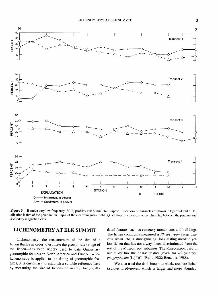
The now unexposed fault can be detected by measurement of the local electromagnetic field. Four H-mode very low frequency (VLF) traverses along our lichen transects (described later) were run by means of a standard resistivity device, the Geonics EM-16, tuned to the Lualualei, Hawaii, radio transmitter, frequency 23.4 kHz. The measured inclinations (fig. 3) show no crossovers indicative of a strong conductor, but the contoured Fraser-filtered inclinations (fig. 4) show trends of low positive values that indicate a weak conductor beneath the fault bench or 5-15 m south of it. Higher electrical conductivity may result from increased pore water in the fault zone. The low positive values coincide with or are parallel to the fault bench; they are not parallel to the topographic contours sketched in figure 5. Better
distance control for the VLF traverses gives an east strike for the fault trace, instead of the east-southeast strike sketched in figure 5, in which the relative positions of topographic contours and fault bench were approximated from elevations obtained using a pocket altimeter. The thickness of talus on the apron cannot be reliably estimated from the H-mode data, and the interpretation of conductors(?) north of the fault bench is uncertain, owing to the wide spacing of the VLF traverses. For the pros and cons of applying the simple numerical technique of date filtering introduced by Fraser (1969), see McNeill and Labson (1991, p. 614).
Curiosity about a fault that looked as if it had cut a talus apron "only yesterday" led us to try dating the Elk Summit fault by lichenometry. The fault is minuscule in comparison with other faults that are present within a few kilometers of the summit. Many of these faults strike north, parallel to or within the Eocene Profile-Smith Creek dike swarm (Leonard and others, 1968, p. C4-C5; Leonard and Marvin, 1982, fig. 1, table 1), a cross section of which is exposed on the ridge north of the talus apron. Talus from the dikes and the intervening screens of variably granulated, mylonitized, and granoblastic granite of the Idaho batholith forms the apron, whose largest dimensions are about 1,000 by 250 m. The blocks of the apron are mostly decimeters to 1-2 m in diameter, equant to slabby, without brownish, iron-stained, centimeter- to decimeter-size fragments of the sort found on parts of the fault bench and just downslope from it. The western half of the apron is devoid of trees and shrubs. We confined our lichen study to this area.
LICHENOMETRY AT ELK SUMMIT 3
N s 50
40 1-z 30 w u a: 20 LU
- -!::,._ - -6_ a.. - ...-b--10
1-
0
50
40
fi:i 30 u c::: w 0..
1-
10
0
50
40v-----~----~~
fi:i 30
---t:,_-
Transect 2
Transect 3
u - - ---6.- - -6-~ 20 ---6---- -b--- ~........._........_A~//
10 LS
0
Transect 4 1-z w u c::: w a..
/
r- -Lr-- -&- -~ / - -&- - -l:s- - -tr - -f'r- -&- - -1-r- - -~
2 3 4
EXPLANATION
0 -- Inclination, in percent
~- - Quadrature, in percent
5 6 7
STATION 8 9 10 11 12 13 14
10 METERS
Figure 3. H-mode very low frequency (VLF) profiles, Elk Summit talus apron. Locations of transects are shown in figures 4 and 5. Inclination is that of the polarization ellipse of the electromagnetic field. Quadrature is a measure of the phase lag between the primary and secondary magnetic fields.
LICHENOMETRY AT ELK SUMMIT
Lichenometry-the measurement of the size of a lichen thallus in order to estimate the growth rate or age of the lichen-has been widely used to date Quaternary geomorphic features in North America and Europe. When lichenometry is applied to the dating of geomorphic features, it is customary to establish a suitable reference base by measuring the size of lichens on nearby, historically
dated features such as cemetery monuments and buildings. The lichen commonly measured is Rhizocarpon geographicum sensu lato, a slow-growing, long-lasting areolate yellow lichen that has not always been discriminated from the rest of the Rhizocarpon subgenus. The Rhizocarpon used in our study has the characteristics given for Rhizocarpon geographicum (L.) DC. (Poelt, 1988; Benedict, 1988).
We also used the dark-brown to black, areolate lichen Lecidea atrobrunnea, which is larger and more abundant

4
~' \
+"' \ (.) Q) J ~M • • ctl ~ 00 N
j!: ..... .....
I I
'\
t) Q)
~N ctl j!:
...- N
DATING A 20th-CENTURY FAULT, BIG CREEK AREA, IDAHO
• • • '7 op N +
• 0 ~
\ ~\ I \ \ I l \
• •••• 0 0 0 0 0
..... ' .....
\ \
\ \ \ l \ I \ I \ I l I I I
"-·
10 co r-... oo en
NOI.l'v'.LS
(/) a: LLJ 1-L.LJ ~ 0 0 .....
0 10
0
Figure 4 (left column). Fraser-filtered very low frequency (VLF) inclinations (in percent), Elk Summit talus apron.
than Rhizocarpon geographicum at Elk Summit. Lecidea atrobrunnea has occasionally been used for the dating of geomorphic features. Carrara and Andrews (1973) gave data on thallus size, percentage of cover, and growth rate of this lichen, among others, in the San Juan Mountains, Colorado.
Neither Rhizocarpon geographicum nor Lecidea atrobrunnea is ideally suited for dating geomorphic features less than a century old. Faster growing lichens such as Xanthoria elegans, used in the Canadian Rockies by Osborn and Taylor (1975), and Pseudephebe minuscula, used at Spitsbergen by Werner ( 1990), are more appropriate. At Elk Summit, X. elegans is rare, and P. minuscula has not been found.
Rhizocarpon geographicum and Lecidea atrobrunnea are present separately or together, with or without other lichens in small amount, on talus blocks of the Elk Summit apron. No one of the rock types-rhyolite, latite, quartz latite, and granite-seems to be favored as a host for the lichens. However, the percentage of cover given by the two major species varies widely from one talus block to another. Estimated roughly for the area transected, the percentage of cover is about 1-15 percent for R. geographicum and about 3-40 percent (commonly 15-20 percent) for L. atrobrunnea upslope from the fault bench, but less than 1 percent for both species on the fault bench. Percentage of lichen cover has been used by some workers to estimate the age of geomorphic features, but our semiquantitative data are not suitable for that purpose. Talus blocks from two obviously quite recent rockfalls are barren of lichens; our lichen transects did not cross these rockfalls.
Four 70-meter-long transects spaced 100m apart were laid out across the fault trace in 1992 (fig. 5). A 6-meter-wide strip along each transect was scanned for large thalli of Rhizocarpon geographicum and Lecidea atrobrunnea, 8-15 of these were measured, and the 5 largest thalli of each species were accepted as indicators of maximum growth. The dimension measured is the diameter of the largest circle inscribable within a discrete thallus, one occurring in isolation or within a coalescing colony. The procedure for measurement is that recommended by Locke and others (1980). The lichen thalli that we measured showed no evidence of abrasion; the talus blocks were virtually in place before lichens grew on them. None of the blocks carrying measured lichens was a "bird rock," a perch on which chemical contamination from leached bird droppings might have promoted lichen growth.
The results for Rhizocarpon geographicum are given in table 1. At one standard deviation s, mean thallus size of R. geographicum does not differ significantly on upslope segments of the four transects (table 1). One thallus, diameter 54 mm on transect 4, might be taken as exceptionally large; if it is disregarded, thallus size on the upslope transect is 28-41

LICHENOMETRY AT ELK SUMMIT 5
Table 1. Largest thalli of Rhizocarpon geographicum, Elk Summit talus apron, Big Creek area, Valley County, Idaho.
Thi!llys diruneter (millimeter:!) n Range Mid-range Median x±s
Transect 1 Upslope segment 5 33-41 37 38 38.0±3.1 Fault bench 5 7-8 8 8 7.8±0.4 Downslope segment 5 32-45 38 35 37.2±6.0
Transect 2 Upslope segment 5 36-45 40 38 39.4±3.4 Fault bench 5 6-10 8 7 7.4±1.7 Downslope segment 5 26-39 32 32 31.8±4.9
Transect 3 Upslope segment 5 32-48 40 40 39.0±6.3 Fault bench 5 7-10 8 10 9.0±1.4 Downslope segment 5 24-38 31 31 29.8±5.6
Transect4 Upslope segment 5 32-54 43 34 38.6±9.4 Fault bench 5 7-9 8 8 7.8±0.8 Downslope segment 5 32-41 36 38 37.4±3.9
Combined data Upslope segment 20 32-54 43 38 38.8±5.6 Fault bench 20 6-10 8 8 8.0±1.3 Downslope segment 20 24-45 34 32,33 34.1±3.8
Table 2. Largest thalli of Lecidea atrobrunnea, Elk Summit talus apron, Big Creek area, Valley County, Idaho.
Thidlus diameter (millimeters) n Range Mid-range Median x±s
Transect 1 Upslope segment 5 59-82 70 62 65.4±9.5 Fault bench 3 5-33 19 7 15.0±15.6 Downslope segment 5 20-30 25 25 25.0±3.5
Transect 2 Upslope segment 5 66-89 78 72 75.8±8.9 Fault bench 5 13-25 19 18 18.6±4.6 Downslope segment 5 60-73 67 62 66.0±6.4
Transect 3 Upslope segment 5 68-92 80 72 76.8±9.6 Fault bench 5 12-26 19 12 14.8±5.2 Downslope segment 5 46-78 62 62 60.4±12.3
Transect4 Upslope segment 5 90-110 100 93 98.2±10.0 Fault bench 5 12-28 20 15 17.0±6.3 Downslope segment 5 95-110 102 100 102.0±7.6
Combined data Upslope segment 20 59-110 84 72,80 79.0±15.0 Fault bench 18 5-33 19 15 16.5±7.2 Downslope segment 20 20-110 65 62 63.4±29.0

6 DATING A 20th-CENTURY FAULT, BIG CREEK AREA, IDAHO
CJ) 2,750 a:: LU
~ 2,700 :2: z ;; 2,650 0
~ 2,600 LU -I LU
2,550
s
- 700-----2
N
PROFILE
Contour interval 50 m (approx.)
Figure 5. Transects for lichenometry, Elk Summit talus apron. The profile for transect 1 is representative.
mm, x ±s=33.4±4.8 mm. We doubt that the exception should be made. The combined data for thallus size on upslope segments of the four transects are accepted as reliable at x ±s=38.8±5.6 mm.
The maximum thallus size of Rhizocarpon geographicum on the fault bench is 8.0±1.3 mm, its coefficient of variation is the same as that for specimens measured upslope, and at three standard deviations there is no overlap in mean size. The lichen is not only sparser on the fault bench, it is much smaller-about one-fifth the size of thalli measured upslope.
Data for Lecidea atrobrunnea are given in table 2. This lichen is not only more abundant than Rhizocarpon geographicum, its thallus is about twice as large and, in proportion, shows greater variation. For L. atrobrunnea, the coefficient of variation is about 20-45 percent; for R. geographicum, it is about 10-15 percent. A few thalli of L. atrobrunnea approach or exceed 150 mm in diameter. These exceptionally large thalli have been excluded from consideration in table 2.
The combined data (table 2) for thallus size of L. atrobrunnea on the fault bench show a range from 5 to 33 mm. Within this range, 60 percent of the thalli are 12-18 mm
in diameter. We later refer to this range as the common range. It has, for n=11 thalli, a midrange of 15, a median of 14, and x±s=14.0±2.0 mm. The common range assumes some importance when we compare the data from Elk Summit with those obtained from cemetery stones of the region.
Owing to steepness of slope, the upslope, fault bench, and downslope segments of the transects may not yield equally reliable measurements of lichen size. Talus blocks upslope from the fault bench present no problem because the blocks constitute a single population. However, some slight, local contamination of the on-bench assemblage by talus blocks displaced from above, and of the below-bench assemblage by blocks displaced from the bench, is inevitable. Block size, position, and degree of weathering are aids in classifying lichen-bearing blocks as essentially in place or transported, but the application of these criteria is judgmental.
Paul Carrara (written commun., 1993) presented the hypothesis that two populations of lichens, differing in age, are present on the fault bench. He advanced this hypothesis as support for the two episodes of faulting discussed in the Conclusion of our report. However, the low coefficient of variation (12 percent) of the maximum thallus size of Rhizocarpon geographicum speaks against the hypothesis. For Lecidea atrobrunnea, the case is not so clear; the corresponding coefficient of variation is large ( 44 percent). By measuring at least 100 large thalli of this lichen one might find evidence of more than one size-age population, but we doubt that so many representatives are available for measurement. Thus, the Carrara hypothesis remains to be tested.
Other lichen species from the Elk Summit talus apron are given in table 3. The nomenclature follows that of Egan
Table 3. Lichen species at Elk Summit, Big Creek area, Valley County, Idaho, and their relative abundance.
Lichen species Abundance
Acarospora chlorophana Rare. Acarospora sp. (dark) Common. Aspicilia cinerea Common. Aspicilia gibbosa Common. Aspicilia sp. Abundant. Candelariella vitellina Rare. Lecanora sp. Rare. Lecidea atrobrunnea Abundant. Lecidea tessellata Common. Rhizocarpon geographicum Common. Rhizoplaca melanophthalma Rare. Tremolecia atrata Rare. Umbilicaria hyperborea Rare. Umbilicaria krascheninnikovii Rare. Xanthoparmelia sp. Rare. Xanthoria elegans Rare.

LICHENOMETRY IN CEMETERIES 7
(1987). Vouchers of these lichens are in the Snake River Plains Herbarium at Boise State University, Boise, Idaho.
LICHENOMETRY IN CEMETERIES
Before we interpret the data for thallus size on the Elk Summit talus apron, we present for comparison data on Rhizocarpon geographicum and Lecidea atrobrunnea from headstones in cemeteries of the region. Unfortunately, there are no dated, lichen-bearing features near Elk Summit. The three graves found at Big Creek (fig. 1) have concrete or metal markers. The cemeteries at Warren and Yellow Pine have few graves, and few of these have stone markers. Cemeteries in the McCall area, 60 km southwest of Elk Summit, have some selection of stones useful to the lichenometrist. Even so, these cemeteries are not favorably situated, in elevation, climate, or stone type, to provide the extensive data base that we hoped to get for Rhizocarpon geographicum and Lecidea atrobrunnea.
Cemetery elevations and locations are given in the notes accompanying table 6 (later). The cemetery at Warren, elevation 1,850 m, is the highest; it is nearly 800 m lower than Elk Summit, elevation 2,643 m. The other cemeteries are 1,100-1,400 m lower than Elk Summit. The scarcity of Rhizocarpon geographicum in cemeteries of the McCall area, the small size of its thalli, and the absence of this lichen from stones in the cemetery at Meadows suggest that the lower limit of elevation for R. geographicum is between 1,200 and 1,500 m under the climatic conditions prevailing here, at lat 45° N., during the last 100 years.
Climate at the cemeteries is broadly similar, in spite of differences in elevation (table 4). The montane climate at Warren and Big Creek is similar to the subalpine climate of Elk Summit, the high pass between those settlements, but the differences may be considerable. At Elk Summit, the mid-winter temperature may not be much lower than at Big Creek, but snow accumulates earlier in the fall (late August
to late September) and lasts about a month longer in the spring (late June to late July). Summer days are about 5°C cooler, and many of them are windy. Artificial watering of the McCall, Finnish, and Meadows Valley cemeteries keeps them damper than the Elk Summit talus apron and, with some shade, promotes the growth of foliose lichens. Rhizocarpon geographicum and Lecidea atrobrunnea on the cemetery stones are restricted to the cooler, less sunny north and east sides, as are most of the foliose lichens. One crustose lichen, Aspicilia calcarea, grows profusely on the tops and west sides of the stones.
Much stone used in the cemeteries after 1920 is chemically comparable to talus rock at Elk Summit: various red and gray granites, red granite gneiss, dark-gray hornblende quartz diorite and hornblende-biotite quartz diorite, and minor syenite and anorthosite in the cemeteries; rhyolite, latite, quartz latite, and deformed granite at Elk Summit. Texturally, however, there are differences: the cemetery stones are mostly medium to coarse grained; the talus rock is mostly fine grained, even where phenocryst bearing. The unfinished surfaces of cemetery stones less than 50-60 years old are virtually unweathered; the surfaces of talus blocks range from smooth to slightly rough, all blocks except those from very recent rockfalls show at least some weathering (usually as bleaching, or as limonitic staining), and thin weathering rinds have developed on some. Rhizocarpon geographicum and Lecidea atrobrunnea do not grow on the sanded or polished surfaces of cemetery stones; some other lichen species do.
The record for cemetery stones suitable for our lichenometry is a short one, about 70 years. Nearly all the stones bearing death dates earlier than the mid-1920's are gray or white marble, commonly lichen bearing but devoid of Rhizocarpon geographicum and Lecidea atrobrunnea. Considered as a whole, the cemeteries have no more than 10 or 15 percent of these old marble stones.
Another problem in the use of cemetery stones for lichenometry is also cultural. Most of the local graves are
Table 4. Climatic data for montane communities near Elk Summit, Big Creek area, Valley County, Idaho. [Data supplied by Idaho State Climatologist, written commun., September 1992]
Elevation Annual Mean January Mean July Years of Length of Community (meters) precipitation temp. temp. record record
Warren 1,800 67.4±15.8 -6.9±1.2 13.6±0.5 1962-1991 30
Big Creek 1,753 72.9±14.9 -6.8±1.6 14.7±0.4 1952-1967 16
Yellow Pine 1,451 66.1±17.1 -6.5±1.3 15.4±0.5 1971-1987 20 1989-1991
McCall 1,527 68.4±12.4 -6.6±1.7 16.9±0.5 1930-1955 61 1957-1991
New Meadows1 1,213 61.3±11.9 -7.3±2.0 17.3±0.7 1962 1991 30 1New Meadows is 3 km west of Meadows.

8 DATING A 20th-CENTURY FAULT, BIG CREEK AREA, IDAHO
Table 5. Frequency of Rhizocarpon geographicum and Lecidea atrobrunnea on cemetery stones. [See table 6 for elevation and location of cemeteries]
Number of stones Total number bearing measurable of stones Percent bearing
thalli examined the lichen
Rhizocarpon geographicum
Warren 4 8 50 Yellow Pine 1 5 20 McCall 12 380 3 Finnish 8 -250 3 Spink 3 62 5 Meadows 0 462 0
Lecidea atrobrunnea
Warren 0 8 0 Yellow Pine 0 5 0 McCall 20 380 5 Finnish 27 -250 11 Spink 4 62 6 Meadows 0 462 0
marked with headstones but no footstones for the individual graves in a plot; many headstones commemorate two members of a family and thus may bear two widely different death dates; and, judged from stone type and lettering, some stones were set years after the death date marked on them. Actual setting dates were sought but not found.
Rhizocarpon geographicum is sparse and small on stones in the cemeteries. Lecidea atrobrunnea is roughly twice as abundant and twice as large. Most prevalent is an areolate lichen that looks somewhat like L. atrobrunnea in form; it is Aspicilia calcarea, which is gray and prefers a calcareous substrate. We have not recognized A. calcarea at Elk Summit; there, all substrates are noncalcareous.
The frequency of Rhizocarpon geographicum and Lecidea atrobrunnea on cemetery stones, expressed as percent of stones bearing measurable thalli, is shown in table 5. (The frequency so expressed is not equivalent to percent of lichen cover, which-too low to be reliably measured-may be of the order of 1x1o-2-1x1o-5 percent.) The marked decrease in the frequency of R. geographicum from Warren to the McCall area suggests that Warren and Yell ow Pine, closer to Elk Summit, are more favorable for the growth of this lichen. Nevertheless, the growth rates calculated for the Warren samples differ but little from the rates calculated for samples from the McCall and Finnish cemeteries.
The scarcity of Rhizocarpon geographicum and Lecidea atrobrunnea on cemetery stones severely limits the collection of data on thallus size. Data for these lichens are given in tables 6 and 7. Some stones carry one of the two species but not the other; some stones carry both species. The absence of R. geographicum from stones bearing death dates later than 1959 or 1963 (?) suggests that this lichen may take
about 30 years to become established and grow to detectable size in the cemeteries. Small thalli of L. atrobrunnea are difficult to identify and for that reason were not sought.
Other lichens in the cemeteries are listed in table 8.
DATING THE ELK SUMMIT FAULT
BY LICHENOMETRY
Our first trial is a direct and simple one, that of matching the size of the largest thalli of Rhizocarpon geographicum on the fault bench and in the cemeteries. On the fault bench, it is 6-10 mm, x ±s=8.0±1.3, n=20 (table 1, combined data). The closest size match, given by the 1932 stone at Warren, is 7-10 mm, x ±s=8.0±1.4, n=5 (table 6). This would give a single date for the fault, 1932.
Matching for Lecidea atrobrunnea is not so simple because the size of the largest thalli on the fault bench has a wide range, 5-33 mm, x ±s=16.5±7.2, n=18 (table 2, combined data). The common range, however, is 12-18 mm, x ±s=14.0±2.0, n=11. We think it appropriate to seek a match based on the common range. At the cemeteries, a close match is 9-21 mm, median 14 (table 7, entry B), death dates on stones 1919-1951. We now have an estimate of the range of possible dates for the fault.
Growth-rate curves for Rhizocarpon geographicum and Lecidea atrobrunnea from the cemeteries cannot be constructed, owing to the scattering of data points given by highly discrepant dual death dates incised on many stones. Therefore, for R. geographicum we use growth rates from the few stones that have singular death dates or a pair not widely different. Growth rates so based are 0.12 or 0.13 mm per year (table 6, entries A and B). If we accept the value 0.13±0.04 because it has a wider range, and if we also take into account the standard deviation of the mean size of R. geographicum on the fault bench, the dates estimated for the fault range from 1913 to 1936, mean 1925±7.
Growth rates for Lecidea atrobrunnea in the cemeteries have a wide range, even if we eliminate from consideration the rates based on thalli smaller or larger than those in the range common for Elk Summit. The mean growth rate for thalli above the common range is not significantly different, at one standard deviation, from the mean growth rate for thalli in the common range (table 7, entries Band C); either value is usable. We shall use 0.28±0.06 mm per year, the average obtained by weighting the B and C values according to the number of stones bearing the lichen. Taking into account the standard deviation in thallus size of L. atrobrunnea on the Elk Summit fault bench, as well as the standard deviation of the growth rate, we estimate the dates for the fault to be 1919 to 1957, mean 1940±12.

DATING THE ELK SUMMIT FAULT BY LICHENOMETRY
Table 6. Rhizocarpon geographicum on cemetery stones.
Cemetery
Warren
Yellow Pine
McCall
Finnish
Spink
Meadows
Death dates on headstones
1920--1936 1920 1932
1938
1923-1959 1934, 1946 1943
1919-1947
1918-1942
Number of Number of stones bearing measured largest Thallus diameter (millimeters}
the lichen thalli per stone Range Midrange Median X±s
4 2-5 1.5-13 7 5, 7 1 5 3-13 8 5 6.2±3.9 1 5 7-10 8 7 8.0±1.4
5 5-8 6 5 5.8±1.6
12 1-5 2-14 8 6, 7 1 5 7-14 10 8 9.6±3.2 1 3 4-6 5 5 5.0±1.0
8 1-2 2-6 4 3
3 2-6 4
0 Growth rate summary (in millimeters per year)
n Range Midrange
9
Growth rate (millimeters
per year)
0.12 0.13
0.11
0.17, 0.21 0.10
Median x±s
A. Values from all individual stones (in calculating x, 5 0.10--0.21 0.16 0.13 0.13±0.04 death dates averaged for stone having two dates)
B. Values from individual stones having single death date 4 0.10--0.13 0.12 o:11, 0.12 o.12±0.01 Description of cemeteries
Warren Cemetery, Warren. Elevation 1,850 m, 150 m northeast of road (main street) and 45 m above it. Warren quadrangle. Moderate shade. Death dates on headstones 1900-1988; oldest death date on wooden markers 1870.
Pioneer Cemetery, Yellow Pine. Elevation 1,437 m, east bank of Johnson Creek, 1.0 km south-southwest of Yellow Pine Post Office. Yellow Pine quadrangle. No shade. Death dates on grave markers not recorded in field notes; 5 headstones, 17 markers of concrete or metal.
McCall Cemetery, McCall. Elevation 1 ,539 m, Mission Street, 1.0 km south of East Lake Street {main street). or 0.6 km north of airport. McCall quadrangle. Much shade. Death dates on headstones 1907-1992.
Finnish Memorial Cemetery. Elevation 1,524 m, Farm to Market Road, 9.8 km north of Roseberry, a hamlet 30 km south-southeast of McCall. Lake Fork quadrangle. Little shade. Death dates on headstones 1904-1992.
John Spink Memorial Cemetery. Elevation 1,500 m, Farm to Market Road, 7.4 km north of Roseberry. Lake Fork quadrangle. Little shade. Death dates on headstones 1900--1991.
Meadows Valley Cemetery, Meadows. Elevation 1,210 m, just east of Cemetery Road, 2.2 km north of Highway 55, Meadows quadrangle. Death dates on headstones 1886-1991.
So far, we have adhered as closely as possible to the currently recommended practice in lichenometry: base estimates of age on the mean diameter of the five largest thalli. Formerly, age estimates were based on the size of the single largest thallus. It is instructive to revert to the older practice to see what it gives for the age of the fault when we use Rhizocarpon geographicum. The largest thallus on talus of the fault bench has a diameter of 10 mm (table 1, combined data). The largest thallus in the cemeteries has a diameter of 14 mm; it is on a stone bearing two death dates, and the calculated growth rates are 0.24 and 0.30 mm per year (table 6,
McCall cemetery, dates 1934 and 1946). Obviously one of the growth rates is specious, but we do not know which. Therefore, the estimated date of the fault is either 1950 or 1959. Both dates are credible, the latter more so when we recall that the fault scarp looked fresh in the mid-1960's.
Lee idea atrobrunnea, treated in the same way, gives a much older date. The largest thallus on talus of the fault bench has a diameter of 33 mm (table 2, combined data). The largest thallus in the cemeteries has a diameter of 26 mm (table 7, entry C). This thallus is on the stone that also bears the largest Rhizocarpon thallus, the death date on the stone is

10
0 0
DATING A 20th-CENTURY FAULT, BIG CREEK AREA, IDAHO
00 VI
..... .....
..... II") 0'1
d: ..... 0'1 .....
N N
0 N
0 N
II") ('f') 0'1
:b ..... 0'1 -Q)
~ 8 8
Table 8. Lichen species on the cemetery stones of the McCall and Finnish cemeteries and their relative abundance.
Lichen species
Acarospora chlorophana Acarospora sp. (brown) Aspicilia calcarea Bacidia sp. Caloplaca holocarpa Candelariella rosulans Lecanora muralis Lecanora sp. Lecidea atrobrunnea Melanelia subelegantula Physcia caesia Physcia sp. Rhizocarpon geographicum Rhizoplaca chrysoleuca Rhizoplaca melanophthalma Staurothele clopimoides Toninia caeruleonigricans Umbilicaria hyperborea Umbilicaria krascheninnikovii Umbilicaria virginis Xanthoria elegans Xanthoria fallax Xanthoria polycarpa
McCall
Absent Rare Common Common Rare Common Common Rare Common Common Rare Rare Common Absent Rare Absent Absent Rare Common Absent Absent Rare Rare
Finnish
Rare. Rare. Common. Common. Rare. Common. Abundant. Rare. Common. Common. Rare. Rare. Common. Common. Common. Common. Rare. Common. Common. Common. Common. Abundant. Common.
1935, and the calculated growth rate of L. atrobrunnea is 0.46 mm per year. From this growth rate, the estimated date of the fault is 1920.
In summary, the comparative lichenometry of Rhizocarpon geographicum and Lecidea atrobrunnea gives a range of dates, 1913 to 1959, for the fault that cuts the Elk Summit talus apron. The precision of estimate for the limiting dates is not high. Inasmuch as the range is 1913-1919 for the earliest dates and 1950-1959 for the latest, it is reasonable to suppose that some few years might be subtracted from 1913 and added to 1959, placing the earliest date of faulting in the first decade of the century and the latest in the 1960's. Lichenometry and geologic observation are in agreement: the fault is young, formed sometime after settlements were established at Warren and Big Creek.
Comparative lichenometry also indicates that talus upslope from the fault trace (excluding talus from recent rockfalls) is about 250-300 years old. This unexpectedly ancient age points to considerable stability of the upper surface of the main part of the talus apron.
DATING THE ELK SUMMIT FAULT
BY AERIAL PHOTOGRAPHY
The range of dates given by lichenometry can be narrowed by examining a series of aerial photographs taken between 1946 and 197 4. The scale of the photographs ranges

SEISMIC EFFECTS 11
from 1:20,000 to 1:60,000. Contact film negatives were required for resolution of critical features on the 1946 and 1954 photographs; positive prints were adequate for photographs taken subsequently. Photographs taken on September 29, 1946, show the talus apron covered with snow. Nevertheless, a poorly defined, east-trending linear feature is visible on the west half of the talus apron, and a better defined linear feature is visible at the east edge of the apron. The features are collinear, though separated by a gap. A faint northeasttrending zone can be projected into the gap, but the zone does not appear to offset the east-trending features. Photographs taken July 31, 1954, also show snow on the talus apron. A barely visible break in slope defines the western linear feature, the eastern one is not evident, and the northeast-trending zone is obscure. Photographs taken on August 24, 1964, clearly show straight, dark lines marking the segmented fault trace, though the talus apron has some snow cover. The offset of the segments, estimated perpendicular to their length, is about twice the 4-meter width of the nearby forest road, or about 10m. (Compare figure 2.) Photographs taken on August 20, 1969, still show straight, dark lines marking the segmented fault trace. Photographs taken on September 2, 1974, also show the dark lines, but the lines are slightly crinkly or wavy, distorted a little by local movement of talus. Richard B. Taylor (oral commun., October and December 1992) reported the foregoing observations after examining the whole series of photographs stereoscopically.
The evidence from the series of aerial photographs indicates that the Elk Summit fault had some surface expression as early as 1946, little changed in 1954 but conspicuous by 1964. The major change in surface expression is thus narrowed to the interval1954-1964.
SEISMIC EFFECTS
Most young faults that have surface expression have resulted from earthquakes or are known to be associated with them. Is the Elk Summit fault earthquake related? The seismicity map of Idaho (Stover and others, 1991) shows no epicenters close to Elk Summit. Only one earthquake centered within 100 km of Elk Summit is reported to have had an intensity as high as VII on the modified Mercalli scale. That moderately strong earthquake, of magnitude 6.1 mb, occurred in 1944 in the Sheep Mountain area 60 km southeast of Elk Summit (Stover and others, 1991). We have no information on effects that might have been felt in the Big Creek-Yell ow Pine area.
Major earthquakes commonly have effects that extend far from their epicenters. One such earthquake, felt at Big Creek and near Yellow Pine, was the August 18, 1959, earthquake at Hebgen Lake, Montana. The magnitude of the principal shock was 7.1 mb (Reagor and others, 1985). The effects of the earthquake were felt over an area of -6x10⁵
mi2 (Murphy and Brazee, 1964, p. 15), equivalent to -1.6x1 06 km2. The seismologists' August 18 date is referred to Coordinated Universal Time (06:37:15 UCT); the equivalent in Mountain Standard Time is 11:37 p.m., August 17.
At Big Creek, Robin McRae was sleeping in a twostory frame house set on concrete blocks on Quaternary deposits of the valley floor. He awoke about 2:30a.m. when "an earthquake almost tore the cabin apart. He thought it was a bear trying to get into the house. [McRae] thought that it was the same earthquake that struck in Montana on the Madison river" (James Collord, written commun., August 14, 1992). The discrepancy in time between the 11:37 p.m. shock and McRae's sensing of it at 2:30 the next morning may be significant, but we are inclined to discount the discrepancy.
Also at Big Creek, the Wiles cabin close to the McRae house was shaken. "The quake of 1959 shook my cabin * * * rattled stovepipe, windows etc. It also cut the flow of a spring on Mountal [Monumental] Cr. to about 'h what it was" (Wilbur Wiles, written commun., September 22, 1992). The spring is at the mouth of an unnamed creek 0.3 km northeast of Diamond Creek, 22 km east of Elk Summit. The estimated intensity of the earthquake's effect at the spring is VIII (modified Mercalli scale), in contrast to VI at Big Creek.
At Chamberlain Basin, 30 km northeast of Elk Summit, Earl Dodds was awakened during the night when his woodfloored frame tent was severely shaken twice within a short time span. He thought that a bear was the shaker, but his searches for the bear showed no evidence that one had been present (Earl F. Dodds, former U.S. Forest Service District Ranger, Big Creek district, oral commun., October 16, 1992).
At Meadow Creek Lookout, a one-story frame building set on the bedrock of Meadow Ridge 13.3 km southeast of Yellow Pine, the Forest Service observer was awakened when canned goods stored on the rafters rained down upon him. Quite distraught, he burst into Leonard's camp 2 km southeast of the lookout early next morning to report the accident. Leonard, his field assistant, and his packer had slept peacefully on the ground on their air mattresses; no one felt the shock, and it did not "spook" the horses and mules grazing nearby. Everyone agreed that the accident at the lookout was caused by an earthquake, but no one knew until a newspaper became available some days later that the epicenter of the earthquake was at Hebgen Lake, 320 km east of the lookout.
At the Cox Ranch, 14.4 km south of Yellow Pine, Emma Cox (written commun., November 4, 1992) "felt [the earthquake while] standing in the kitchen and some of the cabinet doors came open. Later we noticed the cement on the fireplace chimney on the outside had a crack clear through that had not been there before."
These examples of earthquake effects felt or later observed near Elk Summit indicate the wide-ranging effect of the Hebgen Lake earthquake. Was the effect great enough

12 DATING A 20th-CENTURY FAULT, BIG CREEK AREA, IDAHO
to develop a fault across the Elk Summit talus apron? No one can say, because an understanding of the intensity of earthquake effects that occur far distant from an earthquake focus is only now developing.
Was there, at the time of the Hebgen Lake earthquake, a discrete earthquake centered much closer to Elk Summit-an earthquake not detected instrumentally because its signal was irresolvable from those given by the Hebgen Lake shocks? The question arises, but it is unanswerable.
An initially puzzling feature of the size distribution of fragments on the talus apron is consistent with an earthquake origin for the fault, whatever its date. This feature is the brownish, iron-stained fines that are restricted to the fault bench and a narrow zone downslope from it. The fines, mostly of centimeter size, are very likely the analog of the sand and gravel erupted as sand boils or sand spouts along earthquake-induced faults in unconsolidated sediments. (For a description of the sand spouts caused by the Hebgen Lake earthquake, see Swenson, 1964, p. 162-163.) On the Elk Summit talus apron, fines that had been eluviated from the surface and deposited at shallow depth were forced upward when snowmelt stored in the talus was squeezed out along the fault during local compaction of the talus blocks. The finest material so erupted has been dispersed, as it has been from sand spouts in soft sediments, but centimeter-size fragments remain to give the material on the fault bench its anomalous, iron-stained, screelike character.
CONCLUSION
The lichenometry of Rhizocarpon geographicum and Lecidea atrobrunnea gives a wide range of 20th century dates, including 1959, for the Elk Summit fault. The evidence from aerial photographs narrows the range of dates for conspicuous surface expression of the fault to 1954-1964. A 1959 date is consistent with the fresh appearance of the fault scarp in the mid-1960's, and with the obliteration of the scarp sometime between the 1960's and 1991. If the scarp degenerated to an inconspicuous bench in a period of 25 or 30 years, it is unlikely that the scarp persisted for 25 or 30 years before the 1960's. We believe that the Elk Summit fault dates from 1959, the year of the Hebgen Lake, Montana, earthquake. The effects of that far-distant earthquake were felt strongly or observed later within 9-30 km of Elk Summit. This fact suggests that the Elk Summit fault resulted from the Hebgen Lake earthquake or from some attendant shock, not detected instrumentally, that may have occurred closer to Elk Summit. The earthquake may have served only as a trigger for surface faulting related to a bedrock fault of far greater age.
We readily admit that neither a 1959 date for the fault nor an earthquake origin for it can be proved by our study, provocative as the facts and inferences may be. We also admit that we are puzzled by the poorly defined linear
feature visible on 1946 air photographs of the talus apron. The feature suggests that an episode of surface faulting may have occurred sometime between the first and fifth decades of this century. Judged from lichenometry, an earlier date is unlikely. It is tempting to relate this enigmatic episode of faulting to the 1944 Sheep Mountain earthquake, but to do so is conjectural. We set out to date the fault that had conspicuous surface expression during the 1960's; that date is most likely 1959.
Acknowledgments.-We are grateful to many people for their help: to U.S. Geological Survey members Robert C. Bucknam and Henry Spall for information on seismic events in central Idaho, Ann Donovan and Steven Johnson for tracking down a series of aerial photographs of Elk Summit and its environs, Richard B. Taylor for stereoscopic examination of the photographs, and David L. Campbell for helpful comments on the VLF survey; to Scott Lemberes, Payette National Forest, for the loan of air photographs taken for the U.S. Forest Service; to Jerry Jacoby, U.S. Forest Service, Ogden, Utah, Wayne London, Agricultural Stabilization and Conservation Service, Salt Lake City, and EROS Data Center, Sioux Falls, South Dakota, for the preparation of contact film negatives of air photographs; to Sherri K. Pittam, formerly of National Museum of Natural History, for encouraging Leonard's interest in lichens, putting him in touch with lichenologist and co-author Rosentreter, and supplying references on Lecidea atrobrunnea; to Paul Carrara, U.S. Geological Survey, and J.T. Andrews, University of Colorado, for a discussion of their lichenometric work in the San Juan Mountains; to Big Creek residents James Collord, Robin McRae, Jack and Sally Walker, and Wilbur Wiles, and former resident Earl Dodds, for information on earthquakes felt in the Big Creek area; to Lafe and Emma Cox for information on 1959 earthquake effects felt at the Cox Ranch near Yell ow Pine; to Leroy Yoakum, caretaker of the McCall Cemetery, for information on headstones; to Loti Harp, McCall, for directions to the cemetery at Warren; and to Eleanor V. Leonard for assistance in the field.
REFERENCES CITED
Benedict, J.B., 1988, Techniques in lichenometry-Identifying the yellow Rhizocarpons: Arctic and Alpine Research, v. 20, p. 285~291.
Carrara, P.E., and Andrews, J.T., 1973, Problems and applications of lichenometry to geomorphic studies, San Juan Mountains, Colorado: Arctic and Alpine Research, v. 5, p. 373-384.
Egan, R.S., 1987, A fifth checklist of the lichen-forming, lichenicolous and allied fungi of the continental United States and Canada: The Bryologist, v. 90, no. 2, p. 77-173.
Fraser, D.C., 1969, Contouring of VLF-EM data: Geophysics, v. 34, p. 958-967.
Leonard, B.F., and Marvin, R.F., 1982 [1984], Temporal evolution of the Thunder Mountain caldera and related features, Idaho, in Bonnichsen, Bill, and Breckenridge, R.M., eds., Cenozoic

REFERENCES CITED 13
geology of Idaho: Idaho Bureau of Mines and Geology Bulletin 26, p. 23-41.
Leonard, B.F., Mead, C.W., and Conklin, Nancy, 1968, Silver-rich disseminated sulfides from a tungsten-bearing quartz lode, Big Creek district, central Idaho: U.S. Geological Survey Professional Paper 594-C, 24 p.
Lock[e], W.W., Andrews, J.T., and Webber, P.J., 1980, A manual for lichenometry: British Geomorphological Research Group Technical Bulletin 26, 4 7 p.
McNeill, J.D., and Labson, V.F., 1991, Geological mapping using VLF radio fields, in Nabighian, M.N., ed., Electromagnetic methods in applied geophysics, v. 2, Applications, part B: Society of Exploration Geophysicists Investigations in Geophysics 3, p. 521-640.
Murphy, L.M., and Brazee, R.J., 1964, Seismological investigations of the Hebgen Lake earthquake, in The Hebgen Lake, Montana, earthquake of August 17, 1959: U.S. Geological Survey Professional Paper 435, p. 13-17.
Published in the Central Region, Denver, Colorado Manuscript approved for publication May 24, 1994 Edited by Judith Stoeser Graphics and photocomposition by Marl L. Kauffmann Tables typeset by Judith Stoeser
-trU.S. ~ PRINriR; OFFICE: 1994-673-046/86061
Osborn, Gerald, and Taylor, John, 1975, Lichenometry on calcareous substrates in the Canadian Rockies: Quaternary Research, v. 5, p. 111-120.
Poelt, J., 1988, Rhizocarpon Ram. em. Th. Fr. subgen. Rhizocarpon in Europe: Arctic and Alpine Research, v. 20, p. 292-298.
Reagor, B.G., Stover, C.W., and Algermissen, S.T., 1985, Seismicity map of the State of Montana: U.S. Geological Survey Miscellaneous Field Studies Map MF-1819, scale 1:1,000,000.
Stover, C.W., Reagor, B.G., and Algermissen, S.T., 1991, Seismicity map of the State of Idaho: U.S. Geological Survey Miscellaneous Field Studies Map MF-1857, scale 1:1,000,000.
Swenson, F.A., 1964, Ground-water phenomena associated with the Hebgen Lake earthquake, in The Hebgen Lake, Montana, earthquake of August 17, 1959: U.S. Geological Survey Professional Paper 435, p. 159-165.
Werner, Al, 1990, Lichen growth rates for the northwest coast of Spitsbergen, Svalbard: Arctic and Alpine Research, v. 22, p.129-140.


SELECTED SERIES OF U.S. GEOLOGICAL SURVEY PUBLICATIONS
Periodicals
Earthquakes & Volcanoes (issued bimonthly). Preliminary Determination of Epicenters (issued monthly).
Technical Books and Reports
Professional Papers are mainly comprehensive scientific reports of wide and lasting interest and importance to professional scientists and engineers. Included are reports on the results of resource studies and of topographic, hydrologic, and geologic investigations. They also include collections of related papers addressing different aspects of a single scientific topic.
Bulletins contain significant data and interpretations that are of lastin~ scientific interest but are generally more limited in scope or geographic coverage than Professional Papers. They include the results of resource studies and of geologic and topographic investigations; as well as collections of short papers related to a specific topic.
Water-Supply Papers are comprehensive reports that present significant interpretive results of hydrologic investigations of wide interest to professional geologists, hydrologists, and engineers. The series covers investigations in all phases of hydrology, including hydrology, availability of water, quality of water, and use of water.
Circulars present administrative information or important scientific information of wide popular interest in a format designed for distribution at no cost to the public. Information is usually of short-term interest.
Water-Resources Investigations Reports are papers of an interpretive nature made available to the public outside the formal USGS publications series. Copies are reproduced on request unlike fonnal USGS publications, and they are also available for public inspection at depositories indicated in USGS catalogs.
Open-File Reports include unpublished manuscript reports, maps, and other material that are made available for public consultation at depo~itories. They are a nonpermanent form of publication that may be cited m other publications as sources of information.
Maps
Geologic Quadrangle Maps are multicolor geologic maps on topographic bases in 7 1/2- or 15-minute quadrangle formats (scales mainly 1:24,000 or 1 :62,500) showing bedrock, surficiaL or engineering geology. Maps generally include brief texts; some maps include structure and columnar sections only.
Geophysical Investigations Maps are on topographic or planimetric bases at various scales, they show results of surveys using geoph~sical techniques, such as gravity, magnetic, seismic, or radioactivity, ~h~ch reflect subsurface structures that are of economic or geologic sigmficance. Many maps include correlations with the geology.
Miscellaneous Investigations Series Maps are on planimetric or topographic bases of regular and irregular areas at various scales; they present a wide variety of format and subject matter. The series also includes 7 1/2-minute quadrangle photogeologic maps on planimetric bases which show geology as interpreted from aerial photographs. The series also includes maps of Mars and the Moon.
Coal Investigations Maps are geologic maps on topographic or planimetric bases at various scales showing bedrock or surficial geology, stratigraphy, and structural relations in certain coal-resource areas.
Oil and Gas Investigations Charts show stratigraphic information for certain oil and gas fields and other areas having petroleum potential.
Miscellaneous Field Studies Maps are multicolor or black-andwhite maps on topographic or planimetric bases on quadrangle or irregular areas at various scales. Pre-1971 maps show bedrock geology in relation to specific mining or mineral-deposit problems; post-1971 maps are primarily black-and-white maps on various subjects such as environmental studies or wilderness mineral investigations.
Hydrologic Investigations Atlases are multicolored or black-andwhite maps on topographic or planimetric bases presenting a wide range of geohydrologic data of both regular and irregular areas; the principal scale is 1:24,000, and regional studies are at 1:250,000 scale or smaller.
Catalogs
Permanent catalogs, as well as some others, giving comprehensive listings of U.S. Geological Survey publications are available under the conditions indicated below from USGS Map Distribution, Box 25286, Building 810, Denver Federal Center, Denver, CO 80225. (See latest Price and Availability List.)
"Publications of the Geological Survey, 1879-1961" may be purchased by mail and over the counter in paperback book form and as a set microfiche.
"Publications of the Geological Survey, 1962-1970" may be purchased by mail and over the counter in paperback book form and as a set of microfiche.
"Publications of the U.S. Geological Survey, 1971-1981" may be purchased by mail and over the counter in paperback book form (two volumes, publications listing and index) and as a set of microfiche.
Supplements for 1982, 1983, 1984, 1985, 1986, and for subsequent years since the last permanent catalog may be purchased by mail and over the counter in paperback book form.
State catalogs, "List of U.S. Geological Survey Geologic and Water-Supply Reports and Maps For (State)," may be purchased by mail and over the counter in paperback booklet form only.
"Price and Availability List of U.S. Geological Survey Publications," issued annually, is available free of charge in paperback booklet form only.
Selected copies of a monthly catalog "New Publications of the U.S. Geological Survey" is available free of charge by mail or may be obtained over the counter in paperback booklet form only. Those wishing a free subscription to the monthly catalog "New Publications of the U.S. Geological Survey" should write to the U.S. Geological Survey, 582 National Center, Reston, VA 22092.
Note.-Prices of Government publications listed in older catalogs, announcements, and publications may be incorrect. Therefore, the prices charged may differ from the prices in catalogs, announcements, and publications.


![Closed total (pan-talar) dislocation of the talus with ... · series of 228 talus injuries was published by Coltart,[2] who was the first to propose a concise classification of talus](https://img.pdfslide.us/doc/110x75/5b9ba5f709d3f2aa588d7f68/closed-total-pan-talar-dislocation-of-the-talus-with-series-of-228-talus.jpg)