Embed Size (px)
Citation preview

National Roads Authority
DATEX 2 V1.0
SUBSCRIBER GUIDE
JUNE 2013
I B I G R O U P D A T E X 2 V 1 . 0
S U B S C R I B E R G U I D E
DOCUMENT CONTROL
June 2013
Page i
Client: National Roads Authority
Project: DATEX 2 v1.0
31999 - 05
Report: Subscriber Guide
Date of Issue: June 2013
Version: 2.1
File Reference: 31999 05 MTCC DATEX2 v1.0 Subscriber Guide v2.1.docx
Originator: Caz Thomson, Robin Williams, Paul Redfern
Reviewed by: Paul Redfern
Authorised by: Duncan Elder
Circulation: To File
David Laoide-Kemp, NRA Kevin O’Sullivan, ERTO
Document History: V2.0 issued 03/07/2008 V2.1 Issued 19/07/2013
Quality Certification: ISO9001:2008 certification
I B I G R O U P D A T E X 2 V 1 . 0
S U B S C R I B E R G U I D E
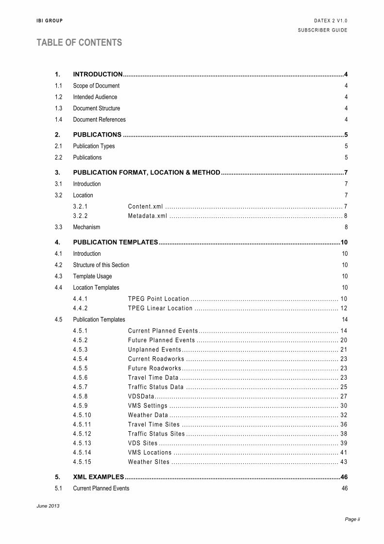
TABLE OF CONTENTS
June 2013
Page ii
1. INTRODUCTION ............................................................................................................................ 4
1.1 Scope of Document 4
1.2 Intended Audience 4
1.3 Document Structure 4
1.4 Document References 4
2. PUBLICATIONS ............................................................................................................................ 5
2.1 Publication Types 5
2.2 Publications 5
3. PUBLICATION FORMAT, LOCATION & METHOD ..................................................................... 7
3.1 Introduction 7
3.2 Location 7
3.2 .1 Con ten t . xml . . . . . . . . . . . . . . . . . . . . . . . . . . . . . . . . . . . . . . . . . . . . . . . . . . . . . . . . . . . . . . . . . . . . . . . . . . . . . . . . . . . . . 7
3.2 .2 Metadata .xml . . . . . . . . . . . . . . . . . . . . . . . . . . . . . . . . . . . . . . . . . . . . . . . . . . . . . . . . . . . . . . . . . . . . . . . . . . . . . . . . . . . 8
3.3 Mechanism 8
4. PUBLICATION TEMPLATES ...................................................................................................... 10
4.1 Introduction 10
4.2 Structure of this Section 10
4.3 Template Usage 10
4.4 Location Templates 10
4.4 .1 TPEG Po in t Locat ion . . . . . . . . . . . . . . . . . . . . . . . . . . . . . . . . . . . . . . . . . . . . . . . . . . . . . . . . . . . . . . . . . . . . . . . 10
4.4 .2 TPEG L inear Locat ion . . . . . . . . . . . . . . . . . . . . . . . . . . . . . . . . . . . . . . . . . . . . . . . . . . . . . . . . . . . . . . . . . . . . . 12
4.5 Publication Templates 14
4.5 .1 Current P lanned Events . . . . . . . . . . . . . . . . . . . . . . . . . . . . . . . . . . . . . . . . . . . . . . . . . . . . . . . . . . . . . . . . . . . 14
4.5 .2 Future Planned Even ts . . . . . . . . . . . . . . . . . . . . . . . . . . . . . . . . . . . . . . . . . . . . . . . . . . . . . . . . . . . . . . . . . . . . 20
4.5 .3 Unp lanned Events . . . . . . . . . . . . . . . . . . . . . . . . . . . . . . . . . . . . . . . . . . . . . . . . . . . . . . . . . . . . . . . . . . . . . . . . . . . 21
4.5 .4 Current Roadworks . . . . . . . . . . . . . . . . . . . . . . . . . . . . . . . . . . . . . . . . . . . . . . . . . . . . . . . . . . . . . . . . . . . . . . . . . 23
4.5 .5 Future Roadworks . . . . . . . . . . . . . . . . . . . . . . . . . . . . . . . . . . . . . . . . . . . . . . . . . . . . . . . . . . . . . . . . . . . . . . . . . . . 23
4.5 .6 Trave l T ime Data . . . . . . . . . . . . . . . . . . . . . . . . . . . . . . . . . . . . . . . . . . . . . . . . . . . . . . . . . . . . . . . . . . . . . . . . . . . . 23
4.5 .7 Traf f ic S ta tus Data . . . . . . . . . . . . . . . . . . . . . . . . . . . . . . . . . . . . . . . . . . . . . . . . . . . . . . . . . . . . . . . . . . . . . . . . . 25
4.5 .8 VDSData . . . . . . . . . . . . . . . . . . . . . . . . . . . . . . . . . . . . . . . . . . . . . . . . . . . . . . . . . . . . . . . . . . . . . . . . . . . . . . . . . . . . . . . . 27
4.5 .9 VMS Set t ings . . . . . . . . . . . . . . . . . . . . . . . . . . . . . . . . . . . . . . . . . . . . . . . . . . . . . . . . . . . . . . . . . . . . . . . . . . . . . . . . . 30
4.5 .10 Weather Data . . . . . . . . . . . . . . . . . . . . . . . . . . . . . . . . . . . . . . . . . . . . . . . . . . . . . . . . . . . . . . . . . . . . . . . . . . . . . . . . . 32
4.5 .11 Trave l T ime Si tes . . . . . . . . . . . . . . . . . . . . . . . . . . . . . . . . . . . . . . . . . . . . . . . . . . . . . . . . . . . . . . . . . . . . . . . . . . . 36
4.5 .12 Traf f ic S ta tus Si tes . . . . . . . . . . . . . . . . . . . . . . . . . . . . . . . . . . . . . . . . . . . . . . . . . . . . . . . . . . . . . . . . . . . . . . . . . 38
4.5 .13 VDS Si tes . . . . . . . . . . . . . . . . . . . . . . . . . . . . . . . . . . . . . . . . . . . . . . . . . . . . . . . . . . . . . . . . . . . . . . . . . . . . . . . . . . . . . . 39
4.5 .14 VMS Locat ions . . . . . . . . . . . . . . . . . . . . . . . . . . . . . . . . . . . . . . . . . . . . . . . . . . . . . . . . . . . . . . . . . . . . . . . . . . . . . . . 41
4.5 .15 Weather SI tes . . . . . . . . . . . . . . . . . . . . . . . . . . . . . . . . . . . . . . . . . . . . . . . . . . . . . . . . . . . . . . . . . . . . . . . . . . . . . . . . 43
5. XML EXAMPLES ......................................................................................................................... 46
5.1 Current Planned Events 46
I B I G R O U P D A T E X 2 V 1 . 0
S U B S C R I B E R G U I D E
June 2013
Page iii.
5.2 Future Planned Events 51
5.3 Unplanned Events 53
5.4 Travel Time Data 57
5.5 VDS Data 58
5.6 VMS Settings 60
5.7 Weather Data 63
5.8 Travel Time Sites 66
5.9 VDS Sites 71
5.10 VMS Locations 75
5.11 Weather Sites 77
I B I G R O U P D A T E X 2 V 1 . 0
S U B S C R I B E R G U I D E
June 2013
Page 4.
1. INTRODUCTION
1.1 Scope of Document
This document is intended to provide enough information regarding Datex2 publications to allow
subscribers to set up receiver applications with which the publications can be received and
processed. Detailed information regarding how the publication templates are built up and
examples of the data they may contain are laid out within the document for this purpose.
1.2 Intended Audience
This document is intended to be a guide for all potential subscribers to the Datex2 publications
feed.
1.3 Document Structure
The structure of this document is as follows:
Section 1, this section, details the document scope and structure
Section 2 lists all of the publications that can be made available via the Publisher
application if the underlying data exists to do so.
Section 3 explains the general format of Datex publications, the method by which they are
published and their locations.
Section 4 describes all of the publications in detail, including the templates upon which each
one is based.
Section 5 outlines XML examples of each of the publications relevant to the NRA Datex
feed.
1.4 Document References
The following documents are referred to:
http://www.DATEX II.eu/DATEX-model/index.htm - the DATEX 2 Data Model Version
1.0.
http://www.DATEX II.eu/files/DATEXIISchema_1_0_1_0.zip – the DATEX 2 XML
Schema Version 1.0
http://www.DATEX II.eu/files/DATEXIIv1.0-ExchangePSM_v1.0.zip - the DATEX 2
Exchange Platform Specific Model (PSM) Version 1.0.
All of the above documents are publicly available on the official Datex website.

I B I G R O U P D A T E X 2 V 1 . 0
S U B S C R I B E R G U I D E
June 2013
Page 5.
2. PUBLICATIONS
The following table contains a list of all the publications can be made available via the Datex2
feed. The publications that are applicable to the NRA Datex2 publisher application are marked
as such.
2.1 Publication Types
There are two types of Datex publications - Dynamic and Static.
Dynamic Publications contain data that changes frequently (e.g. Travel Time Data), whereas
Static Publications, represent data that does not (e.g. Travel Time Sites).
The content of both publications is checked approximately every five minutes to see whether the
underlying data has changed (see section 3.2.1).
2.2 Publications
Publication Name Description Datex Publication
Payload
Static/
Dynamic
Applicable?
Current Planned
Events
Current (active) planned
events. Can include
Roadworks and events
such as sports and
concerts.
SituationPublication Dynamic Yes
Future Planned
Events
Future planned events. Can
include Roadworks and
events such as sports and
concerts.
SituationPublication Dynamic Yes
Unplanned Events Incidents, roadworks and
road conditions that are
unplanned.
SituationPublication Dynamic Yes
Current Roadworks Current (active) planned
roadworks.
SituationPublication Dynamic No
Future Roadworks Future planned roadworks. SituationPublication Dynamic No
Travel Time Data Travel times/Journey times. MeasuredDataPublication Dynamic Yes
Traffic Status Data Data related to the state of
traffic flow at the time of
publication.
MeasureDataPublication Dynamic No
VDS Data Data from Vehicle Detector
Stations.
MeasuredDataPublication Dynamic Yes
VMS Settings Current settings on
Variable Message Signs.
SituationPublication Dynamic Yes
Weather Data Readings from weather
stations.
MeasureDataPublication Dynamic Yes
Travel Time Sites Details of travel time links. MeasurementSiteTable Static Yes
I B I G R O U P D A T E X 2 V 1 . 0
S U B S C R I B E R G U I D E
June 2013
Page 6.
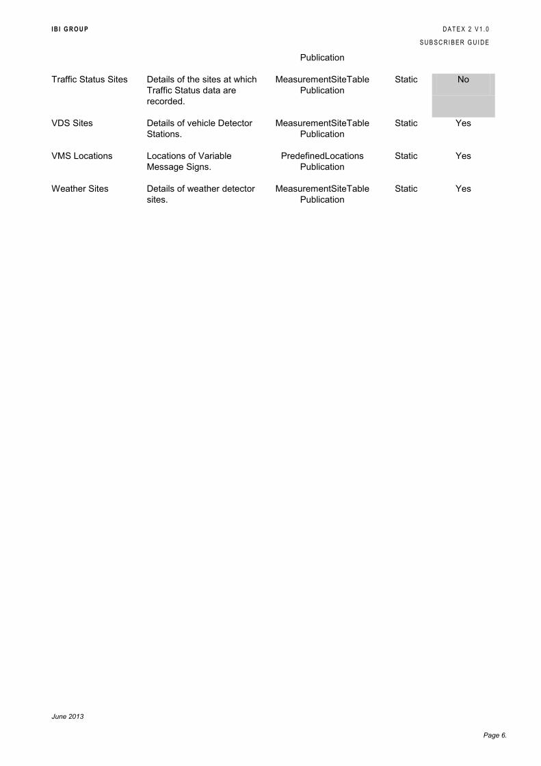
Publication
Traffic Status Sites Details of the sites at which
Traffic Status data are
recorded.
MeasurementSiteTable
Publication
Static No
VDS Sites Details of vehicle Detector
Stations.
MeasurementSiteTable
Publication
Static Yes
VMS Locations Locations of Variable
Message Signs.
PredefinedLocations
Publication
Static Yes
Weather Sites Details of weather detector
sites.
MeasurementSiteTable
Publication
Static Yes
I B I G R O U P D A T E X 2 V 1 . 0
S U B S C R I B E R G U I D E
June 2013
Page 7.
3. PUBLICATION FORMAT, LOCATION & METHOD
3.1 Introduction
This section describes the manner in which the data is published and from where it is available.
3.2 Location
Individual publications can be accessed via their sub-directories within the Datex site. The
general format of the Datex publication URLs is:
http://datex2.nratraffic.ie/publications/<publication>/content.xml
Example: http://datex2.nratraffic.ie/publications/VDSData/content.xml
For convenience the site includes an index page which provides links to metadata and content
for all publications at http://www.n7.ie/d2/publications
For further information regarding the NRA Datex feed, contact [email protected].
Each publication comprises 2 files:
content.xml
metadata.xml
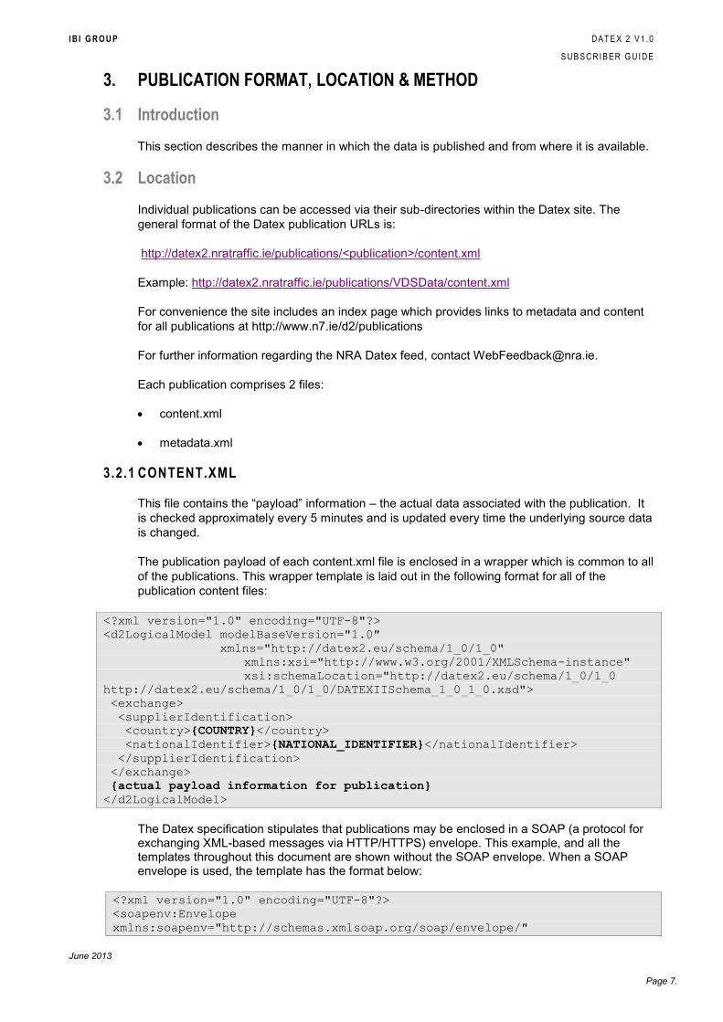
3.2.1 CONTENT.XML
This file contains the “payload” information – the actual data associated with the publication. It
is checked approximately every 5 minutes and is updated every time the underlying source data
is changed.
The publication payload of each content.xml file is enclosed in a wrapper which is common to all
of the publications. This wrapper template is laid out in the following format for all of the
publication content files:
<?xml version="1.0" encoding="UTF-8"?>
<d2LogicalModel modelBaseVersion="1.0"
xmlns="http://datex2.eu/schema/1_0/1_0"
xmlns:xsi="http://www.w3.org/2001/XMLSchema-instance"
xsi:schemaLocation="http://datex2.eu/schema/1_0/1_0
http://datex2.eu/schema/1_0/1_0/DATEXIISchema_1_0_1_0.xsd">
<exchange>
<supplierIdentification>
<country>{COUNTRY}</country>
<nationalIdentifier>{NATIONAL_IDENTIFIER}</nationalIdentifier>
</supplierIdentification>
</exchange>
{actual payload information for publication}
</d2LogicalModel>
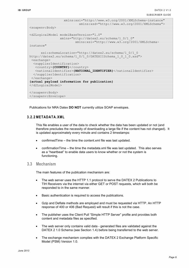
The Datex specification stipulates that publications may be enclosed in a SOAP (a protocol for exchanging XML-based messages via HTTP/HTTPS) envelope. This example, and all the templates throughout this document are shown without the SOAP envelope. When a SOAP envelope is used, the template has the format below:
<?xml version="1.0" encoding="UTF-8"?>
<soapenv:Envelope
xmlns:soapenv="http://schemas.xmlsoap.org/soap/envelope/"
I B I G R O U P D A T E X 2 V 1 . 0
S U B S C R I B E R G U I D E
June 2013
Page 8.
xmlns:xsi="http://www.w3.org/2001/XMLSchema-instance"
xmlns:xsd="http://www.w3.org/2001/XMLSchema">
<soapenv:Body>
<d2LogicalModel modelBaseVersion="1.0"
xmlns="http://datex2.eu/schema/1_0/1_0"
xmlns:xsi="http://www.w3.org/2001/XMLSchema-
instance"
xsi:schemaLocation="http://datex2.eu/schema/1_0/1_0
http://datex2.eu/schema/1_0/1_0/DATEXIISchema_1_0_1_0.xsd">
<exchange>
<supplierIdentification>
<country>{COUNTRY}</country>
<nationalIdentifier>{NATIONAL_IDENTIFIER}</nationalIdentifier>
</supplierIdentification>
</exchange>
{actual payload information for publication}
</d2LogicalModel>
</soapenv:Body>
</soapenv:Envelope>
Publications for NRA Datex DO NOT currently utilize SOAP envelopes.
3.2.2 METADATA.XML
This file enables a user of the data to check whether the data has been updated or not (and
therefore precludes the necessity of downloading a large file if the content has not changed). It
is updated approximately every minute and contains 2 timestamps:
confirmedTime – the time the content.xml file was last updated.
confirmationTime – the time the metadata.xml file was last updated. This also serves
as a “heartbeat” to enable data users to know whether or not the system is
functioning.
3.3 Mechanism
The main features of the publication mechanism are:
The web server uses the HTTP 1.1 protocol to serve the DATEX 2 Publications to
TIH Receivers via the internet via either GET or POST requests, which will both be
responded to in the same manner.
Basic authentication is required to access the publications.
Gzip and Deflate methods are employed and must be requested via HTTP. An HTTP
response of 400 or 406 (Bad Request) will result if this is not the case.
The publisher uses the Client Pull “Simple HTTP Server” profile and provides both
content and metadata files as specified.
The web server only contains valid data - generated files are validated against the
DATEX 2 1.0 Schema (see Section 1.4) before being transferred to the web server.
The exchange mechanism complies with the DATEX 2 Exchange Platform Specific
Model (PSM) Version 1.0.
I B I G R O U P D A T E X 2 V 1 . 0
S U B S C R I B E R G U I D E
June 2013
Page 9.
The format of the published files complies with the DATEX 2 Data Model Version 1.0
(see Section 1.4).
I B I G R O U P D A T E X 2 V 1 . 0
S U B S C R I B E R G U I D E
June 2013
Page 10.
4. PUBLICATION TEMPLATES
4.1 Introduction
This section provides a detailed description of the publications currently available via the full IBI
Datex 2 service, which comprises a generic set of templates on which the publications are built.
4.2 Structure of this Section
Within this section the publications are discussed in terms of the templates that make each of
them up.
Each template is laid out in its XML format, with the key replacement tokens outlined in bold text
and usually as values within curly braces; e.g. {FromX}. Thereafter follows a table of these
tokens and their possible replacement values within the context of generic data or per specific
publication as might be the case. Where templates are nested, as is the case with location-
based templates, a top-down approach is used so that the containing template is described
prior to any nested templates within it.
4.3 Template Usage
The templates in this document include entries which are optional. Where there is no data
available for any particular record, the relevant part of the publication described by the template
will not be present.
4.4 Location Templates
The content described in these templates is nested within other templates where it is necessary
to detail the locations affected by the data being published. The TPEG Point Location template
is used by the VDS Sites, VMS Locations and Weather Sites publications, the TPEG Linear
Location template by the Travel Time Sites and Traffic Status Sites publications, while the Event
publications may make use of both.
Certain fields within these templates are mandatory, while others may be optional. Please see
the DATEX 2 Data Model Version 1.0 for details of which fields are of which type.
Please also note that some of the Datex elements are only used for certain types of point
(TPEGSimplePoint.point, TPEGLinearLocation.to or TPEGLinearLocation.from). The DATEX
elements junctionName, tpegILCName1, tpegILCName2, tpegILCName3 and intersectionName
are only applicable to points with a tpegLocationType of TPEGJunction. The DATEX elements
linkName and nonLinkedPointName are only applicable to points with a tpegLocationType of
TPEGNonJunctionPoint.
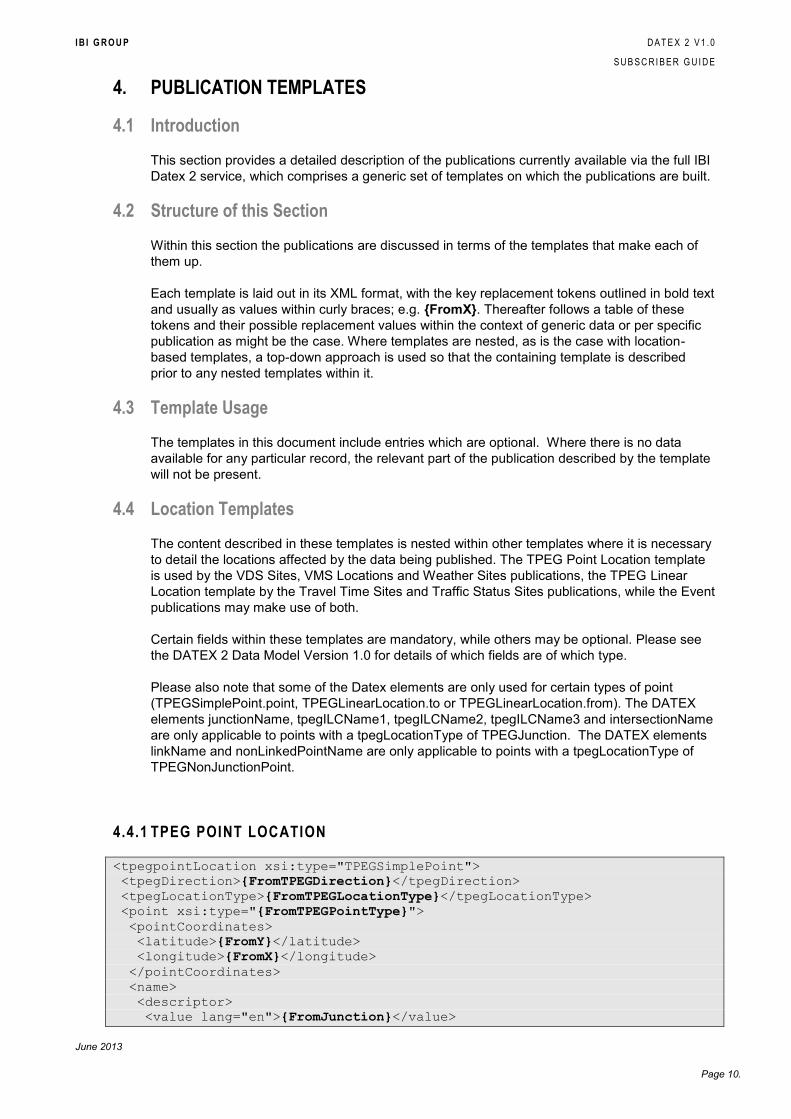
4.4.1 TPEG POINT LOCATION
<tpegpointLocation xsi:type="TPEGSimplePoint">
<tpegDirection>{FromTPEGDirection}</tpegDirection>
<tpegLocationType>{FromTPEGLocationType}</tpegLocationType>
<point xsi:type="{FromTPEGPointType}">
<pointCoordinates>
<latitude>{FromY}</latitude>
<longitude>{FromX}</longitude>
</pointCoordinates>
<name>
<descriptor>
<value lang="en">{FromJunction}</value>

I B I G R O U P D A T E X 2 V 1 . 0
S U B S C R I B E R G U I D E
June 2013
Page 11.
</descriptor>
<tpegDescriptorType>junctionName</tpegDescriptorType>
</name>
<ilc>
<descriptor>
<value lang="en">{FromRoad}</value>
</descriptor>
<tpegDescriptorType>tpegILCName1</tpegDescriptorType>
</ilc>
<ilc>
<descriptor>
<value lang="en">{FromIntersectingRoad}</value>
</descriptor>
<tpegDescriptorType>tpegILCName2</tpegDescriptorType>
</ilc>
<ilc>
<descriptor>
<value lang="en">{FromIntersectingRoad2}</value>
</descriptor>
<tpegDescriptorType>tpegILCName3</tpegDescriptorType>
</ilc>
<otherName>
<descriptor>
<value lang="en">{FromPointName}</value>
</descriptor>
<tpegDescriptorType>intersectionName</tpegDescriptorType>
</otherName>
<name>
<descriptor>
<value lang="en">{FromRoad}</value>
</descriptor>
<tpegDescriptorType>linkName</tpegDescriptorType>
</name>
<name>
<descriptor>
<value lang="en">{FromPointName}</value>
</descriptor>
<tpegDescriptorType>nonLinkedPointName</tpegDescriptorType>
</name>
</point>
</tpegpointLocation>
Token Value
{FromTPEGDirection} This is a Datex TPEGLoc02DirectionTypeEnum. See the DATEX 2
Data Model Version 1.0 for details of this enumeration.
{FromTPEGLocationType} The is a Datex TPEGLoc01SimplePointLocationSubtypeEnum.
See the DATEX 2 Data Model Version 1.0 for details of this
enumeration.
{FromTPEGPointType} See the DATEX 2 Data Model Version 1.0 for details of these classes.
{FromY} The latitude of the point as a wgs84 co-ordinate.
{FromX} The longitude of the point as a wgs84 co-ordinate.
I B I G R O U P D A T E X 2 V 1 . 0
S U B S C R I B E R G U I D E
June 2013
Page 12.
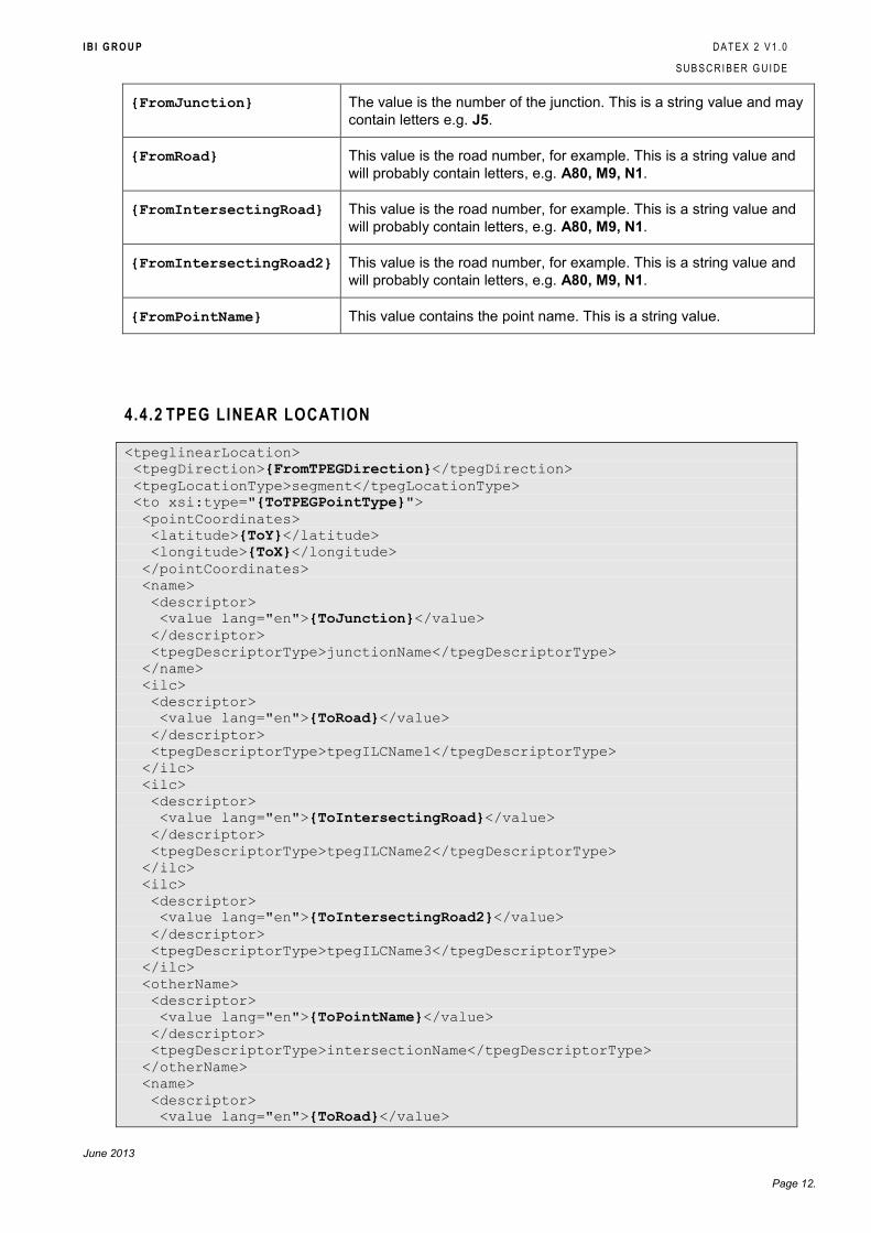
{FromJunction} The value is the number of the junction. This is a string value and may
contain letters e.g. J5.
{FromRoad} This value is the road number, for example. This is a string value and
will probably contain letters, e.g. A80, M9, N1.
{FromIntersectingRoad} This value is the road number, for example. This is a string value and
will probably contain letters, e.g. A80, M9, N1.
{FromIntersectingRoad2} This value is the road number, for example. This is a string value and
will probably contain letters, e.g. A80, M9, N1.
{FromPointName} This value contains the point name. This is a string value.
4.4.2 TPEG LINEAR LOCATION
<tpeglinearLocation>
<tpegDirection>{FromTPEGDirection}</tpegDirection>
<tpegLocationType>segment</tpegLocationType>
<to xsi:type="{ToTPEGPointType}">
<pointCoordinates>
<latitude>{ToY}</latitude>
<longitude>{ToX}</longitude>
</pointCoordinates>
<name>
<descriptor>
<value lang="en">{ToJunction}</value>
</descriptor>
<tpegDescriptorType>junctionName</tpegDescriptorType>
</name>
<ilc>
<descriptor>
<value lang="en">{ToRoad}</value>
</descriptor>
<tpegDescriptorType>tpegILCName1</tpegDescriptorType>
</ilc>
<ilc>
<descriptor>
<value lang="en">{ToIntersectingRoad}</value>
</descriptor>
<tpegDescriptorType>tpegILCName2</tpegDescriptorType>
</ilc>
<ilc>
<descriptor>
<value lang="en">{ToIntersectingRoad2}</value>
</descriptor>
<tpegDescriptorType>tpegILCName3</tpegDescriptorType>
</ilc>
<otherName>
<descriptor>
<value lang="en">{ToPointName}</value>
</descriptor>
<tpegDescriptorType>intersectionName</tpegDescriptorType>
</otherName>
<name>
<descriptor>
<value lang="en">{ToRoad}</value>
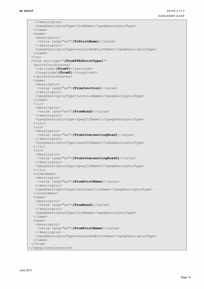
I B I G R O U P D A T E X 2 V 1 . 0
S U B S C R I B E R G U I D E
June 2013
Page 13.
</descriptor>
<tpegDescriptorType>linkName</tpegDescriptorType>
</name>
<name>
<descriptor>
<value lang="en">{ToPointName}</value>
</descriptor>
<tpegDescriptorType>nonLinkedPointName</tpegDescriptorType>
</name>
</to>
<from xsi:type="{FromTPEGPointType}">
<pointCoordinates>
<latitude>{FromY}</latitude>
<longitude>{FromX}</longitude>
</pointCoordinates>
<name>
<descriptor>
<value lang="en">{FromJunction}</value>
</descriptor>
<tpegDescriptorType>junctionName</tpegDescriptorType>
</name>
<ilc>
<descriptor>
<value lang="en">{FromRoad}</value>
</descriptor>
<tpegDescriptorType>tpegILCName1</tpegDescriptorType>
</ilc>
<ilc>
<descriptor>
<value lang="en">{FromIntersectingRoad}</value>
</descriptor>
<tpegDescriptorType>tpegILCName2</tpegDescriptorType>
</ilc>
<ilc>
<descriptor>
<value lang="en">{FromIntersectingRoad2}</value>
</descriptor>
<tpegDescriptorType>tpegILCName3</tpegDescriptorType>
</ilc>
<otherName>
<descriptor>
<value lang="en">{FromPointName}</value>
</descriptor>
<tpegDescriptorType>intersectionName</tpegDescriptorType>
</otherName>
<name>
<descriptor>
<value lang="en">{FromRoad}</value>
</descriptor>
<tpegDescriptorType>linkName</tpegDescriptorType>
</name>
<name>
<descriptor>
<value lang="en">{FromPointName}</value>
</descriptor>
<tpegDescriptorType>nonLinkedPointName</tpegDescriptorType>
</name>
</from>
</tpeglinearLocation>
I B I G R O U P D A T E X 2 V 1 . 0
S U B S C R I B E R G U I D E
June 2013
Page 14.
Token Value
{FromTPEGDirection} This is a Datex TPEGLoc02DirectionTypeEnum. See the DATEX
2 Data Model Version 1.0 for details of this enumeration.
{ToTPEGPointType} See the DATEX 2 Data Model Version 1.0 for details of these
classes.
{ToY} The latitude of the point as a wgs84 co-ordinate.
{ToX} The latitude of the point as a wgs84 co-ordinate.
{ToJunction} The value is the number of the junction. This is a string value and
may contain letters e.g. J5.
{ToRoad} This value is the road number, for example. This is a string value
and will probably contain letters, e.g. A80, M9, N1.
{ToIntersectingRoad} This value is the road number, for example. This is a string value
and will probably contain letters, e.g. A80, M9, N1.
{ToIntersectingRoad2} This value is the road number, for example. This is a string value
and will probably contain letters, e.g. A80, M9, N1.
{ToPointName} This value contains the point name. This is a string value.
{FromTPEGPointType} As for {ToTPEGPointType}.
{FromJunction} As for {ToJunction}.
{FromRoad} As for {ToRoad}.
{FromIntersectingRoad} As for {ToIntersectingRoad}.
{FromIntersectingRoad2} As for {ToIntersectingRoad2}.
{FromPointName} As for {ToPointName}.
4.5 Publication Templates
These templates detail all of the possible data that may be output for the various publications.
As with the Location templates above, certain fields within the templates will be mandatory,
while others may be optional. The templates are designed to capture the largest data set
available to each publication and it is therefore very likely that the NRA Datex feed does not
output every field. In the underlying tables below each publication the fields that are in use for
each template have been indicated.
The availability column in the following tables indicates whether the fields are available within
the NRA publication. If all the fields are marked as unavailable then the publication itself is not
available as part of the current NRA Datex2 feed.
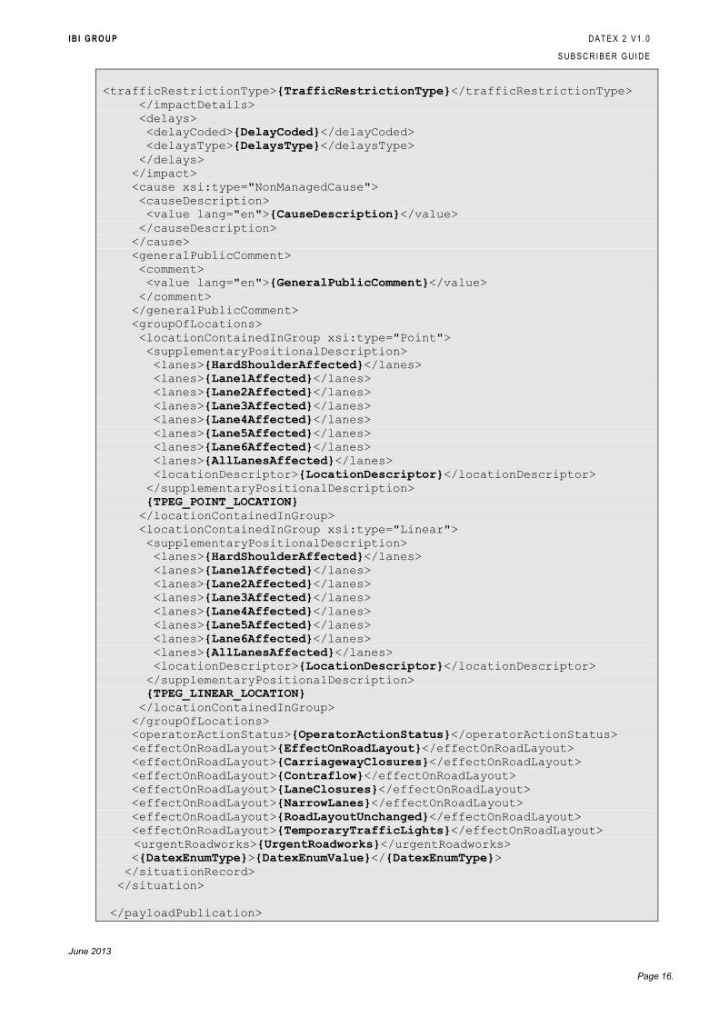
4.5.1 CURRENT PLANNED EVENTS
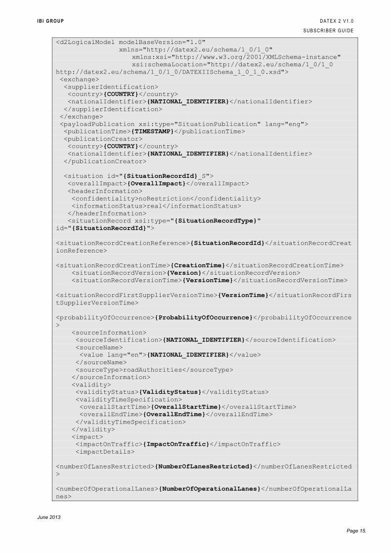
<?xml version="1.0" encoding="UTF-8"?>
I B I G R O U P D A T E X 2 V 1 . 0
S U B S C R I B E R G U I D E
June 2013
Page 15.
<d2LogicalModel modelBaseVersion="1.0"
xmlns="http://datex2.eu/schema/1_0/1_0"
xmlns:xsi="http://www.w3.org/2001/XMLSchema-instance"
xsi:schemaLocation="http://datex2.eu/schema/1_0/1_0
http://datex2.eu/schema/1_0/1_0/DATEXIISchema_1_0_1_0.xsd">
<exchange>
<supplierIdentification>
<country>{COUNTRY}</country>
<nationalIdentifier>{NATIONAL_IDENTIFIER}</nationalIdentifier>
</supplierIdentification>
</exchange>
<payloadPublication xsi:type="SituationPublication" lang="eng">
<publicationTime>{TIMESTAMP}</publicationTime>
<publicationCreator>
<country>{COUNTRY}</country>
<nationalIdentifier>{NATIONAL_IDENTIFIER}</nationalIdentifier>
</publicationCreator>
<situation id="{SituationRecordId}_S">
<overallImpact>{OverallImpact}</overallImpact>
<headerInformation>
<confidentiality>noRestriction</confidentiality>
<informationStatus>real</informationStatus>
</headerInformation>
<situationRecord xsi:type="{SituationRecordType}"
id="{SituationRecordId}">
<situationRecordCreationReference>{SituationRecordId}</situationRecordCreat
ionReference>
<situationRecordCreationTime>{CreationTime}</situationRecordCreationTime>
<situationRecordVersion>{Version}</situationRecordVersion>
<situationRecordVersionTime>{VersionTime}</situationRecordVersionTime>
<situationRecordFirstSupplierVersionTime>{VersionTime}</situationRecordFirs
tSupplierVersionTime>
<probabilityOfOccurrence>{ProbabilityOfOccurrence}</probabilityOfOccurrence
>
<sourceInformation>
<sourceIdentification>{NATIONAL_IDENTIFIER}</sourceIdentification>
<sourceName>
<value lang="en">{NATIONAL_IDENTIFIER}</value>
</sourceName>
<sourceType>roadAuthorities</sourceType>
</sourceInformation>
<validity>
<validityStatus>{ValidityStatus}</validityStatus>
<validityTimeSpecification>
<overallStartTime>{OverallStartTime}</overallStartTime>
<overallEndTime>{OverallEndTime}</overallEndTime>
</validityTimeSpecification>
</validity>
<impact>
<impactOnTraffic>{ImpactOnTraffic}</impactOnTraffic>
<impactDetails>
<numberOfLanesRestricted>{NumberOfLanesRestricted}</numberOfLanesRestricted
>
<numberOfOperationalLanes>{NumberOfOperationalLanes}</numberOfOperationalLa
nes>
I B I G R O U P D A T E X 2 V 1 . 0
S U B S C R I B E R G U I D E
June 2013
Page 16.
<trafficRestrictionType>{TrafficRestrictionType}</trafficRestrictionType>
</impactDetails>
<delays>
<delayCoded>{DelayCoded}</delayCoded>
<delaysType>{DelaysType}</delaysType>
</delays>
</impact>
<cause xsi:type="NonManagedCause">
<causeDescription>
<value lang="en">{CauseDescription}</value>
</causeDescription>
</cause>
<generalPublicComment>
<comment>
<value lang="en">{GeneralPublicComment}</value>
</comment>
</generalPublicComment>
<groupOfLocations>
<locationContainedInGroup xsi:type="Point">
<supplementaryPositionalDescription>
<lanes>{HardShoulderAffected}</lanes>
<lanes>{Lane1Affected}</lanes>
<lanes>{Lane2Affected}</lanes>
<lanes>{Lane3Affected}</lanes>
<lanes>{Lane4Affected}</lanes>
<lanes>{Lane5Affected}</lanes>
<lanes>{Lane6Affected}</lanes>
<lanes>{AllLanesAffected}</lanes>
<locationDescriptor>{LocationDescriptor}</locationDescriptor>
</supplementaryPositionalDescription>
{TPEG_POINT_LOCATION}
</locationContainedInGroup>
<locationContainedInGroup xsi:type="Linear">
<supplementaryPositionalDescription>
<lanes>{HardShoulderAffected}</lanes>
<lanes>{Lane1Affected}</lanes>
<lanes>{Lane2Affected}</lanes>
<lanes>{Lane3Affected}</lanes>
<lanes>{Lane4Affected}</lanes>
<lanes>{Lane5Affected}</lanes>
<lanes>{Lane6Affected}</lanes>
<lanes>{AllLanesAffected}</lanes>
<locationDescriptor>{LocationDescriptor}</locationDescriptor>
</supplementaryPositionalDescription>
{TPEG_LINEAR_LOCATION}
</locationContainedInGroup>
</groupOfLocations>
<operatorActionStatus>{OperatorActionStatus}</operatorActionStatus>
<effectOnRoadLayout>{EffectOnRoadLayout}</effectOnRoadLayout>
<effectOnRoadLayout>{CarriagewayClosures}</effectOnRoadLayout>
<effectOnRoadLayout>{Contraflow}</effectOnRoadLayout>
<effectOnRoadLayout>{LaneClosures}</effectOnRoadLayout>
<effectOnRoadLayout>{NarrowLanes}</effectOnRoadLayout>
<effectOnRoadLayout>{RoadLayoutUnchanged}</effectOnRoadLayout>
<effectOnRoadLayout>{TemporaryTrafficLights}</effectOnRoadLayout>
<urgentRoadworks>{UrgentRoadworks}</urgentRoadworks>
<{DatexEnumType}>{DatexEnumValue}</{DatexEnumType}>
</situationRecord>
</situation>
</payloadPublication>
I B I G R O U P D A T E X 2 V 1 . 0
S U B S C R I B E R G U I D E
June 2013
Page 17.
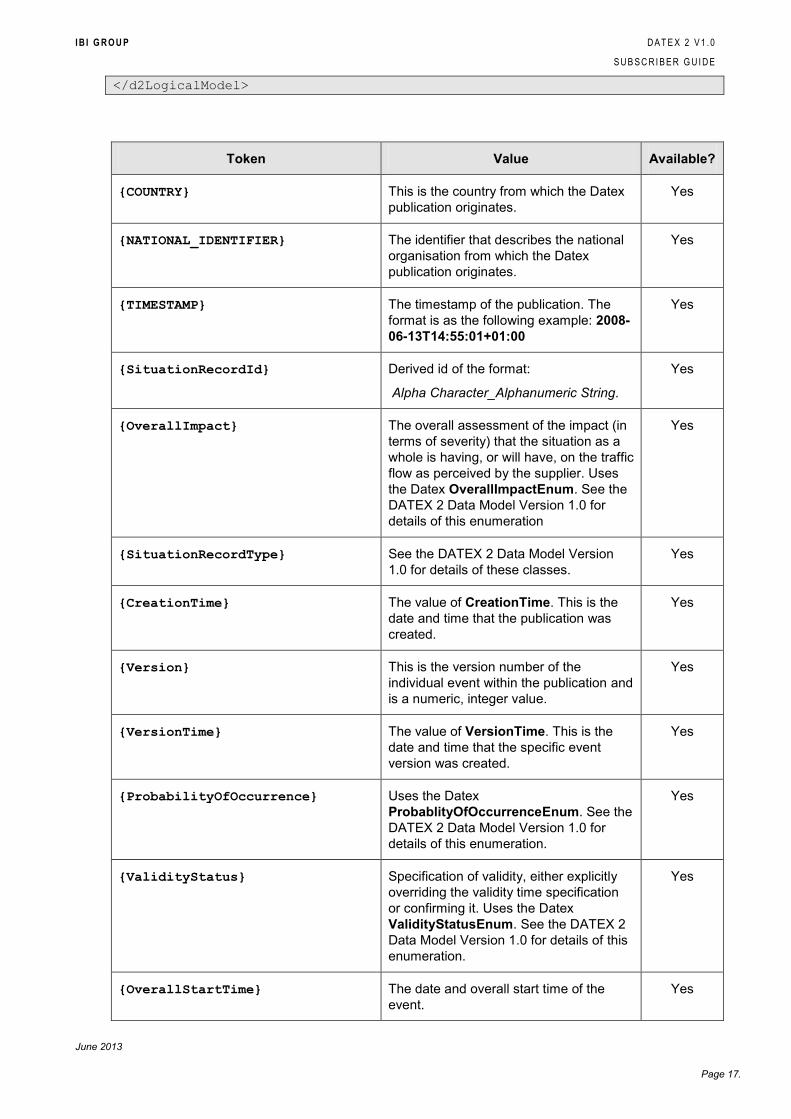
</d2LogicalModel>
Token Value Available?
{COUNTRY} This is the country from which the Datex
publication originates.
Yes
{NATIONAL_IDENTIFIER} The identifier that describes the national
organisation from which the Datex
publication originates.
Yes
{TIMESTAMP} The timestamp of the publication. The
format is as the following example: 2008-
06-13T14:55:01+01:00
Yes
{SituationRecordId} Derived id of the format:
Alpha Character_Alphanumeric String.
Yes
{OverallImpact} The overall assessment of the impact (in
terms of severity) that the situation as a
whole is having, or will have, on the traffic
flow as perceived by the supplier. Uses
the Datex OverallImpactEnum. See the
DATEX 2 Data Model Version 1.0 for
details of this enumeration
Yes
{SituationRecordType} See the DATEX 2 Data Model Version
1.0 for details of these classes.
Yes
{CreationTime} The value of CreationTime. This is the
date and time that the publication was
created.
Yes
{Version} This is the version number of the
individual event within the publication and
is a numeric, integer value.
Yes
{VersionTime} The value of VersionTime. This is the
date and time that the specific event
version was created.
Yes
{ProbabilityOfOccurrence} Uses the Datex
ProbablityOfOccurrenceEnum. See the
DATEX 2 Data Model Version 1.0 for
details of this enumeration.
Yes
{ValidityStatus} Specification of validity, either explicitly
overriding the validity time specification
or confirming it. Uses the Datex
ValidityStatusEnum. See the DATEX 2
Data Model Version 1.0 for details of this
enumeration.
Yes
{OverallStartTime} The date and overall start time of the
event.
Yes
I B I G R O U P D A T E X 2 V 1 . 0
S U B S C R I B E R G U I D E
June 2013
Page 18.
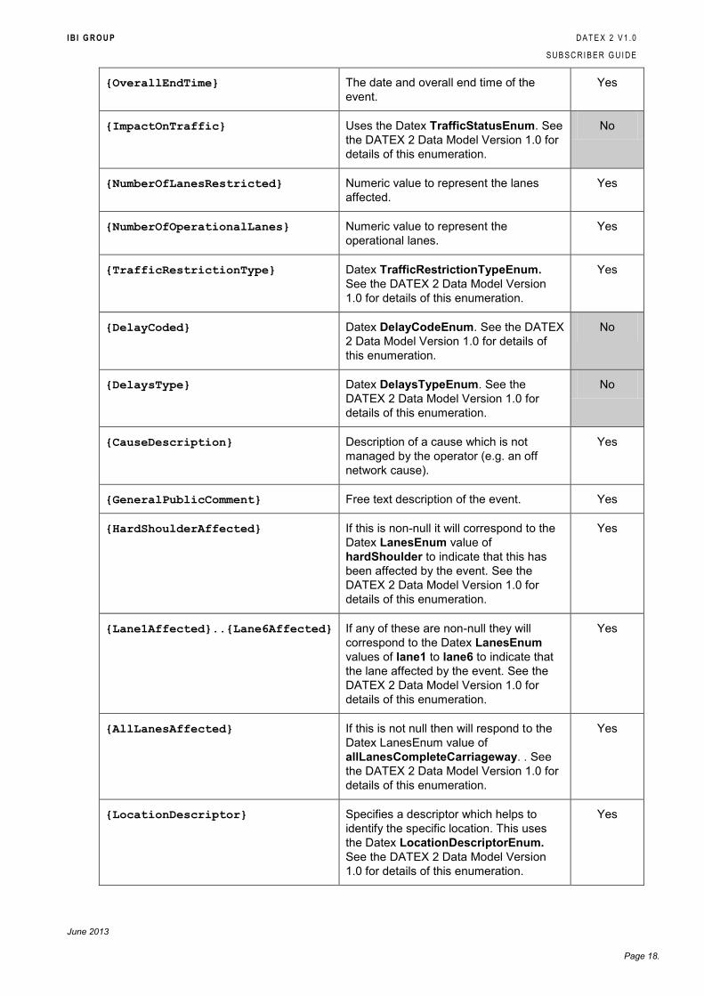
{OverallEndTime} The date and overall end time of the
event.
Yes
{ImpactOnTraffic} Uses the Datex TrafficStatusEnum. See
the DATEX 2 Data Model Version 1.0 for
details of this enumeration.
No
{NumberOfLanesRestricted} Numeric value to represent the lanes
affected.
Yes
{NumberOfOperationalLanes} Numeric value to represent the
operational lanes.
Yes
{TrafficRestrictionType} Datex TrafficRestrictionTypeEnum.
See the DATEX 2 Data Model Version
1.0 for details of this enumeration.
Yes
{DelayCoded} Datex DelayCodeEnum. See the DATEX
2 Data Model Version 1.0 for details of
this enumeration.
No
{DelaysType} Datex DelaysTypeEnum. See the
DATEX 2 Data Model Version 1.0 for
details of this enumeration.
No
{CauseDescription} Description of a cause which is not
managed by the operator (e.g. an off
network cause).
Yes
{GeneralPublicComment} Free text description of the event. Yes
{HardShoulderAffected} If this is non-null it will correspond to the
Datex LanesEnum value of
hardShoulder to indicate that this has
been affected by the event. See the
DATEX 2 Data Model Version 1.0 for
details of this enumeration.
Yes
{Lane1Affected}..{Lane6Affected} If any of these are non-null they will
correspond to the Datex LanesEnum
values of lane1 to lane6 to indicate that
the lane affected by the event. See the
DATEX 2 Data Model Version 1.0 for
details of this enumeration.
Yes
{AllLanesAffected} If this is not null then will respond to the
Datex LanesEnum value of
allLanesCompleteCarriageway. . See
the DATEX 2 Data Model Version 1.0 for
details of this enumeration.
Yes
{LocationDescriptor} Specifies a descriptor which helps to
identify the specific location. This uses
the Datex LocationDescriptorEnum.
See the DATEX 2 Data Model Version
1.0 for details of this enumeration.
Yes
I B I G R O U P D A T E X 2 V 1 . 0
S U B S C R I B E R G U I D E
June 2013
Page 19.
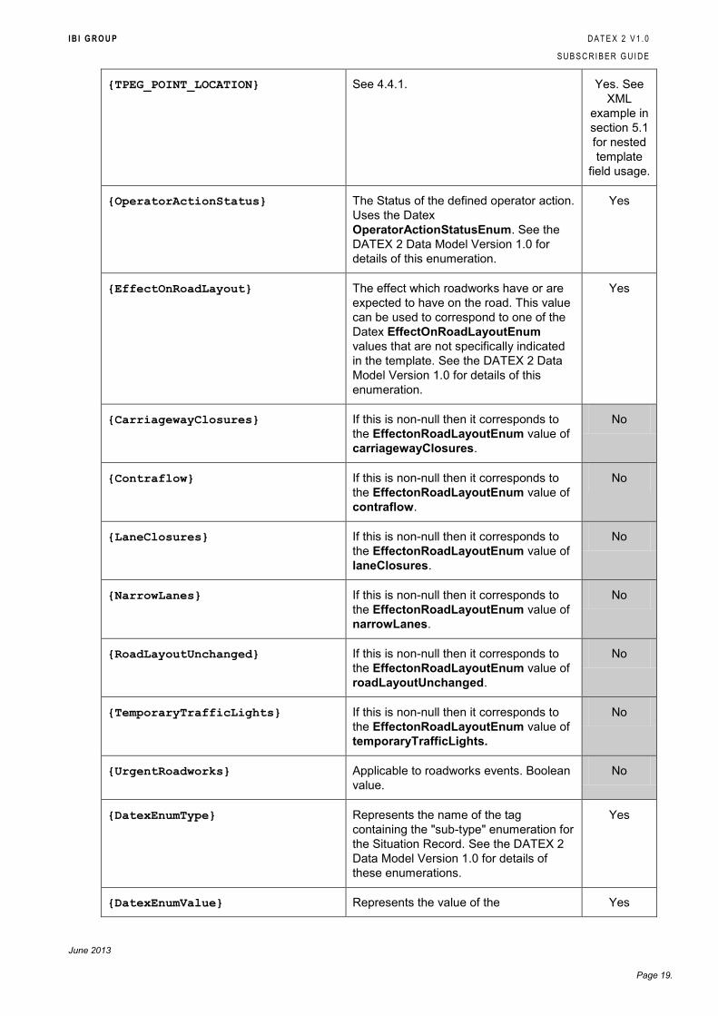
{TPEG_POINT_LOCATION} See 4.4.1. Yes. See
XML
example in
section 5.1
for nested
template
field usage.
{OperatorActionStatus} The Status of the defined operator action.
Uses the Datex
OperatorActionStatusEnum. See the
DATEX 2 Data Model Version 1.0 for
details of this enumeration.
Yes
{EffectOnRoadLayout} The effect which roadworks have or are
expected to have on the road. This value
can be used to correspond to one of the
Datex EffectOnRoadLayoutEnum
values that are not specifically indicated
in the template. See the DATEX 2 Data
Model Version 1.0 for details of this
enumeration.
Yes
{CarriagewayClosures} If this is non-null then it corresponds to
the EffectonRoadLayoutEnum value of
carriagewayClosures.
No
{Contraflow} If this is non-null then it corresponds to
the EffectonRoadLayoutEnum value of
contraflow.
No
{LaneClosures} If this is non-null then it corresponds to
the EffectonRoadLayoutEnum value of
laneClosures.
No
{NarrowLanes} If this is non-null then it corresponds to
the EffectonRoadLayoutEnum value of
narrowLanes.
No
{RoadLayoutUnchanged} If this is non-null then it corresponds to
the EffectonRoadLayoutEnum value of
roadLayoutUnchanged.
No
{TemporaryTrafficLights} If this is non-null then it corresponds to
the EffectonRoadLayoutEnum value of
temporaryTrafficLights.
No
{UrgentRoadworks} Applicable to roadworks events. Boolean
value.
No
{DatexEnumType} Represents the name of the tag
containing the "sub-type" enumeration for
the Situation Record. See the DATEX 2
Data Model Version 1.0 for details of
these enumerations.
Yes
{DatexEnumValue} Represents the value of the Yes
I B I G R O U P D A T E X 2 V 1 . 0
S U B S C R I B E R G U I D E
June 2013
Page 20.
DatexEnumType tag.
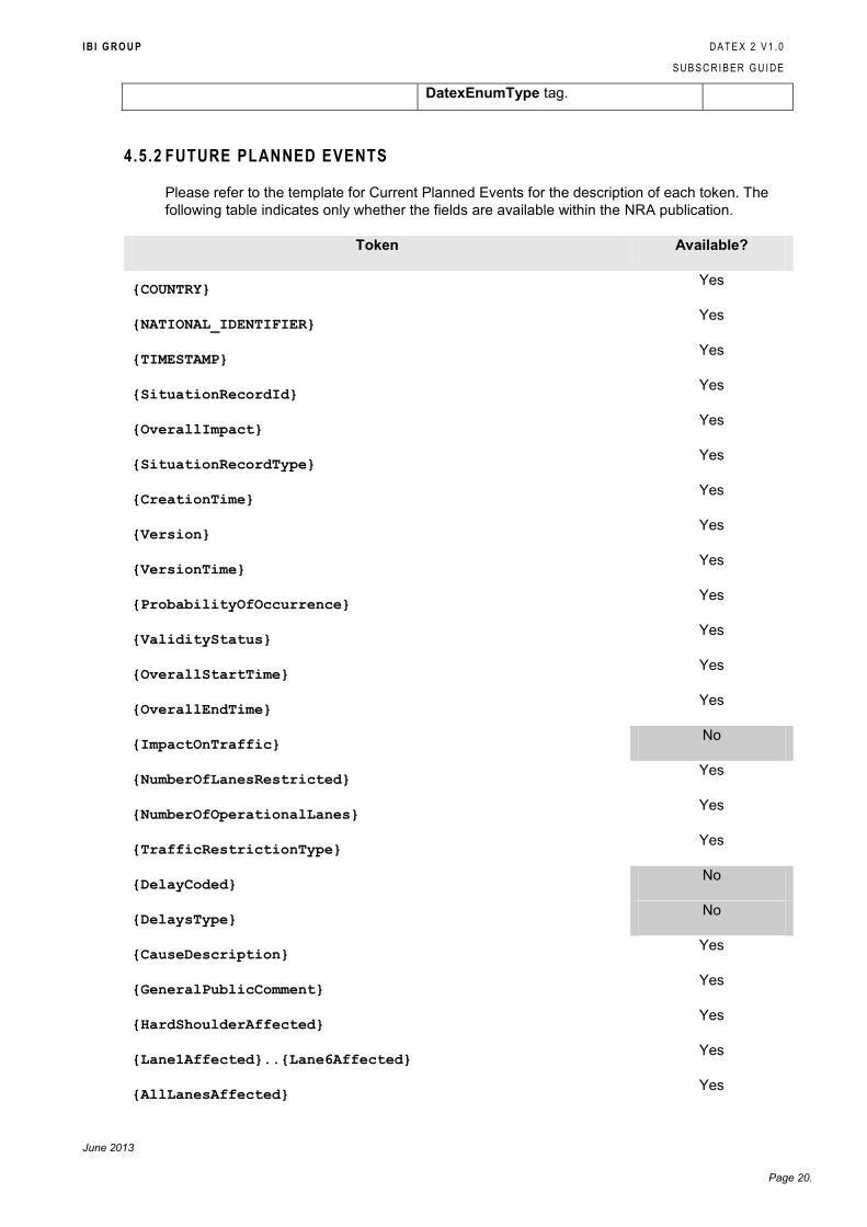
4.5.2 FUTURE PLANNED EVENTS
Please refer to the template for Current Planned Events for the description of each token. The
following table indicates only whether the fields are available within the NRA publication.
Token Available?
{COUNTRY} Yes
{NATIONAL_IDENTIFIER} Yes
{TIMESTAMP} Yes
{SituationRecordId} Yes
{OverallImpact} Yes
{SituationRecordType} Yes
{CreationTime} Yes
{Version} Yes
{VersionTime} Yes
{ProbabilityOfOccurrence} Yes
{ValidityStatus} Yes
{OverallStartTime} Yes
{OverallEndTime} Yes
{ImpactOnTraffic} No
{NumberOfLanesRestricted} Yes
{NumberOfOperationalLanes} Yes
{TrafficRestrictionType} Yes
{DelayCoded} No
{DelaysType} No
{CauseDescription} Yes
{GeneralPublicComment} Yes
{HardShoulderAffected} Yes
{Lane1Affected}..{Lane6Affected} Yes
{AllLanesAffected} Yes
I B I G R O U P D A T E X 2 V 1 . 0
S U B S C R I B E R G U I D E
June 2013
Page 21.
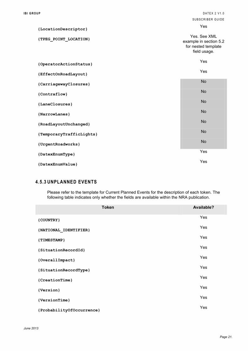
{LocationDescriptor} Yes
{TPEG_POINT_LOCATION} Yes. See XML
example in section 5.2
for nested template
field usage.
{OperatorActionStatus} Yes
{EffectOnRoadLayout} Yes
{CarriagewayClosures} No
{Contraflow} No
{LaneClosures} No
{NarrowLanes} No
{RoadLayoutUnchanged} No
{TemporaryTrafficLights} No
{UrgentRoadworks} No
{DatexEnumType} Yes
{DatexEnumValue} Yes
4.5.3 UNPLANNED EVENTS
Please refer to the template for Current Planned Events for the description of each token. The
following table indicates only whether the fields are available within the NRA publication.
Token Available?
{COUNTRY} Yes
{NATIONAL_IDENTIFIER} Yes
{TIMESTAMP} Yes
{SituationRecordId} Yes
{OverallImpact} Yes
{SituationRecordType} Yes
{CreationTime} Yes
{Version} Yes
{VersionTime} Yes
{ProbabilityOfOccurrence} Yes
I B I G R O U P D A T E X 2 V 1 . 0
S U B S C R I B E R G U I D E
June 2013
Page 22.
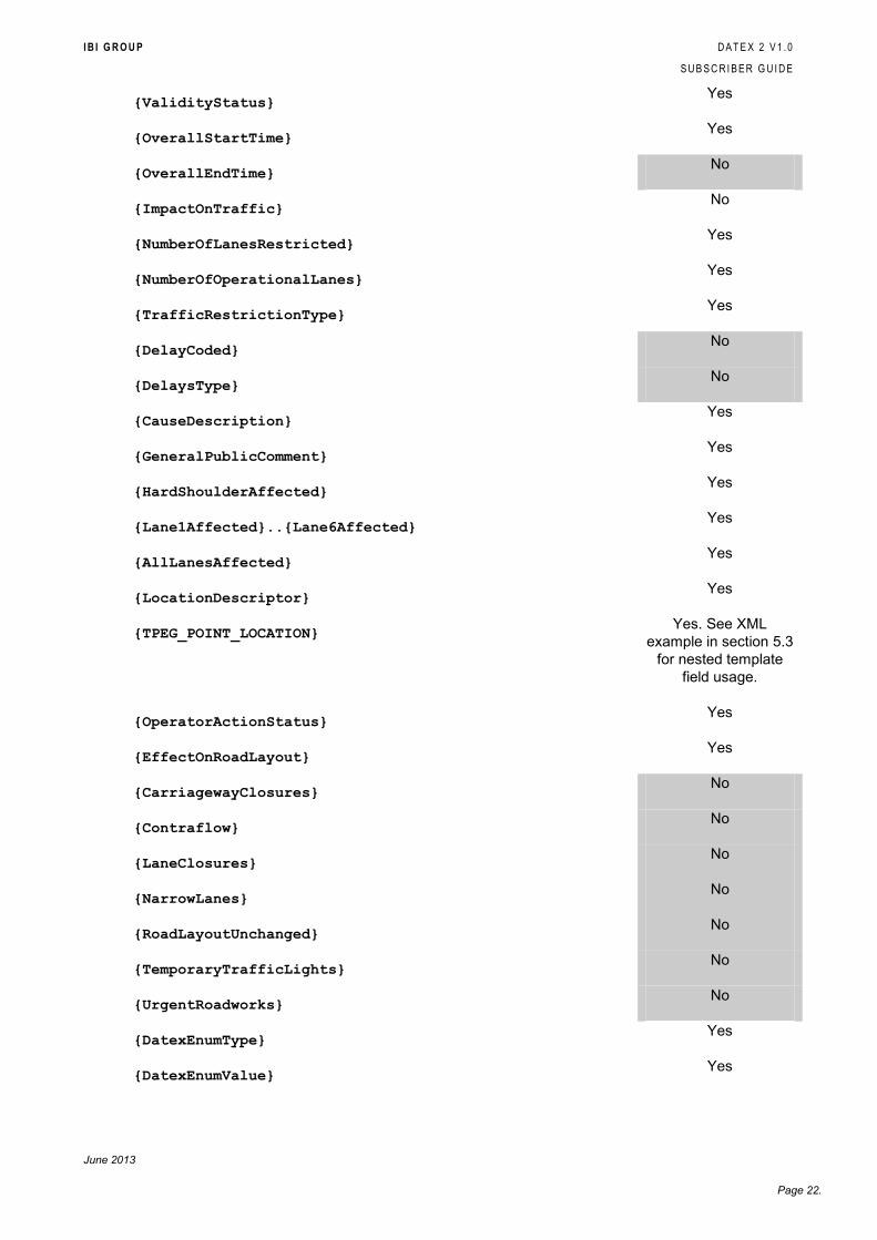
{ValidityStatus} Yes
{OverallStartTime} Yes
{OverallEndTime} No
{ImpactOnTraffic} No
{NumberOfLanesRestricted} Yes
{NumberOfOperationalLanes} Yes
{TrafficRestrictionType} Yes
{DelayCoded} No
{DelaysType} No
{CauseDescription} Yes
{GeneralPublicComment} Yes
{HardShoulderAffected} Yes
{Lane1Affected}..{Lane6Affected} Yes
{AllLanesAffected} Yes
{LocationDescriptor} Yes
{TPEG_POINT_LOCATION} Yes. See XML
example in section 5.3
for nested template
field usage.
{OperatorActionStatus} Yes
{EffectOnRoadLayout} Yes
{CarriagewayClosures} No
{Contraflow} No
{LaneClosures} No
{NarrowLanes} No
{RoadLayoutUnchanged} No
{TemporaryTrafficLights} No
{UrgentRoadworks} No
{DatexEnumType} Yes
{DatexEnumValue} Yes
I B I G R O U P D A T E X 2 V 1 . 0
S U B S C R I B E R G U I D E
June 2013
Page 23.
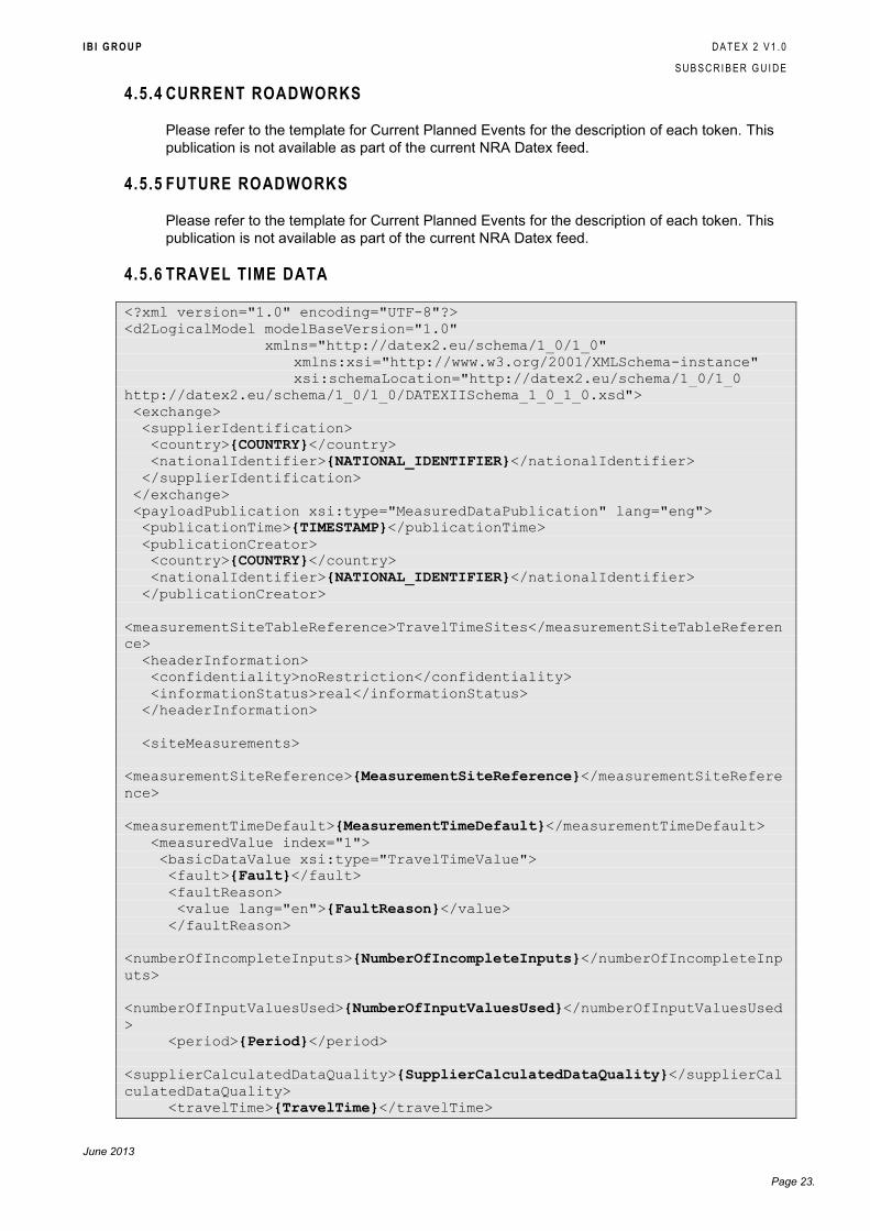
4.5.4 CURRENT ROADWORKS
Please refer to the template for Current Planned Events for the description of each token. This
publication is not available as part of the current NRA Datex feed.
4.5.5 FUTURE ROADWORKS
Please refer to the template for Current Planned Events for the description of each token. This
publication is not available as part of the current NRA Datex feed.
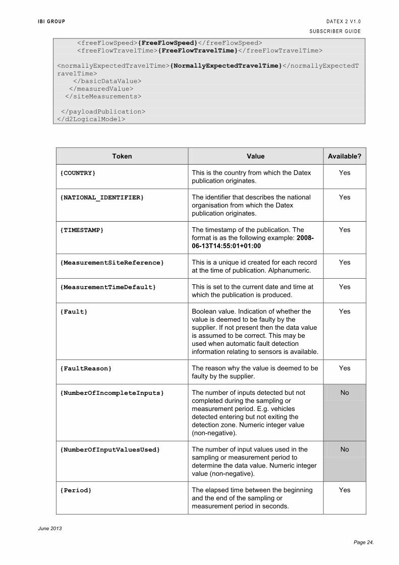
4.5.6 TRAVEL TIME DATA
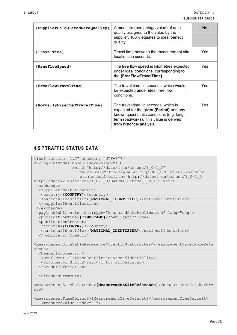
<?xml version="1.0" encoding="UTF-8"?>
<d2LogicalModel modelBaseVersion="1.0"
xmlns="http://datex2.eu/schema/1_0/1_0"
xmlns:xsi="http://www.w3.org/2001/XMLSchema-instance"
xsi:schemaLocation="http://datex2.eu/schema/1_0/1_0
http://datex2.eu/schema/1_0/1_0/DATEXIISchema_1_0_1_0.xsd">
<exchange>
<supplierIdentification>
<country>{COUNTRY}</country>
<nationalIdentifier>{NATIONAL_IDENTIFIER}</nationalIdentifier>
</supplierIdentification>
</exchange>
<payloadPublication xsi:type="MeasuredDataPublication" lang="eng">
<publicationTime>{TIMESTAMP}</publicationTime>
<publicationCreator>
<country>{COUNTRY}</country>
<nationalIdentifier>{NATIONAL_IDENTIFIER}</nationalIdentifier>
</publicationCreator>
<measurementSiteTableReference>TravelTimeSites</measurementSiteTableReferen
ce>
<headerInformation>
<confidentiality>noRestriction</confidentiality>
<informationStatus>real</informationStatus>
</headerInformation>
<siteMeasurements>
<measurementSiteReference>{MeasurementSiteReference}</measurementSiteRefere
nce>
<measurementTimeDefault>{MeasurementTimeDefault}</measurementTimeDefault>
<measuredValue index="1">
<basicDataValue xsi:type="TravelTimeValue">
<fault>{Fault}</fault>
<faultReason>
<value lang="en">{FaultReason}</value>
</faultReason>
<numberOfIncompleteInputs>{NumberOfIncompleteInputs}</numberOfIncompleteInp
uts>
<numberOfInputValuesUsed>{NumberOfInputValuesUsed}</numberOfInputValuesUsed
>
<period>{Period}</period>
<supplierCalculatedDataQuality>{SupplierCalculatedDataQuality}</supplierCal
culatedDataQuality>
<travelTime>{TravelTime}</travelTime>
I B I G R O U P D A T E X 2 V 1 . 0
S U B S C R I B E R G U I D E
June 2013
Page 24.
<freeFlowSpeed>{FreeFlowSpeed}</freeFlowSpeed>
<freeFlowTravelTime>{FreeFlowTravelTime}</freeFlowTravelTime>
<normallyExpectedTravelTime>{NormallyExpectedTravelTime}</normallyExpectedT
ravelTime>
</basicDataValue>
</measuredValue>
</siteMeasurements>
</payloadPublication>
</d2LogicalModel>
Token Value Available?
{COUNTRY} This is the country from which the Datex
publication originates.
Yes
{NATIONAL_IDENTIFIER} The identifier that describes the national
organisation from which the Datex
publication originates.
Yes
{TIMESTAMP} The timestamp of the publication. The
format is as the following example: 2008-
06-13T14:55:01+01:00
Yes
{MeasurementSiteReference} This is a unique id created for each record
at the time of publication. Alphanumeric.
Yes
{MeasurementTimeDefault} This is set to the current date and time at
which the publication is produced.
Yes
{Fault} Boolean value. Indication of whether the
value is deemed to be faulty by the
supplier. If not present then the data value
is assumed to be correct. This may be
used when automatic fault detection
information relating to sensors is available.
Yes
{FaultReason} The reason why the value is deemed to be
faulty by the supplier.
Yes
{NumberOfIncompleteInputs} The number of inputs detected but not
completed during the sampling or
measurement period. E.g. vehicles
detected entering but not exiting the
detection zone. Numeric integer value
(non-negative).
No
{NumberOfInputValuesUsed} The number of input values used in the
sampling or measurement period to
determine the data value. Numeric integer
value (non-negative).
No
{Period} The elapsed time between the beginning
and the end of the sampling or
measurement period in seconds.
Yes
I B I G R O U P D A T E X 2 V 1 . 0
S U B S C R I B E R G U I D E
June 2013
Page 25.
{SupplierCalculatedDataQuality} A measure (percentage value) of data
quality assigned to the value by the
supplier. 100% equates to ideal/perfect
quality.
No
{TravelTime} Travel time between the measurement site
locations in seconds.
Yes
{FreeFlowSpeed} The free flow speed in kilometres expected
under ideal conditions, corresponding to
the {FreeFlowTravelTime}.
Yes
{FreeFlowTravelTime} The travel time, in seconds, which would
be expected under ideal free flow
conditions.
Yes
{NormallyExpectedTravelTime} The travel time, in seconds, which is
expected for the given {Period} and any
known quasi-static conditions (e.g. long-
term roadworks). This value is derived
from historical analysis.
Yes
4.5.7 TRAFFIC STATUS DATA
<?xml version="1.0" encoding="UTF-8"?>
<d2LogicalModel modelBaseVersion="1.0"
xmlns="http://datex2.eu/schema/1_0/1_0"
xmlns:xsi="http://www.w3.org/2001/XMLSchema-instance"
xsi:schemaLocation="http://datex2.eu/schema/1_0/1_0
http://datex2.eu/schema/1_0/1_0/DATEXIISchema_1_0_1_0.xsd">
<exchange>
<supplierIdentification>
<country>{COUNTRY}</country>
<nationalIdentifier>{NATIONAL_IDENTIFIER}</nationalIdentifier>
</supplierIdentification>
</exchange>
<payloadPublication xsi:type="MeasuredDataPublication" lang="eng">
<publicationTime>{TIMESTAMP}</publicationTime>
<publicationCreator>
<country>{COUNTRY}</country>
<nationalIdentifier>{NATIONAL_IDENTIFIER}</nationalIdentifier>
</publicationCreator>
<measurementSiteTableReference>TrafficStatusSites</measurementSiteTableRefe
rence>
<headerInformation>
<confidentiality>noRestriction</confidentiality>
<informationStatus>real</informationStatus>
</headerInformation>
<siteMeasurements>
<measurementSiteReference>{MeasurementSiteReference}</measurementSiteRefere
nce>
<measurementTimeDefault>{MeasurementTimeDefault}</measurementTimeDefault>
<measuredValue index="1">
I B I G R O U P D A T E X 2 V 1 . 0
S U B S C R I B E R G U I D E
June 2013
Page 26.
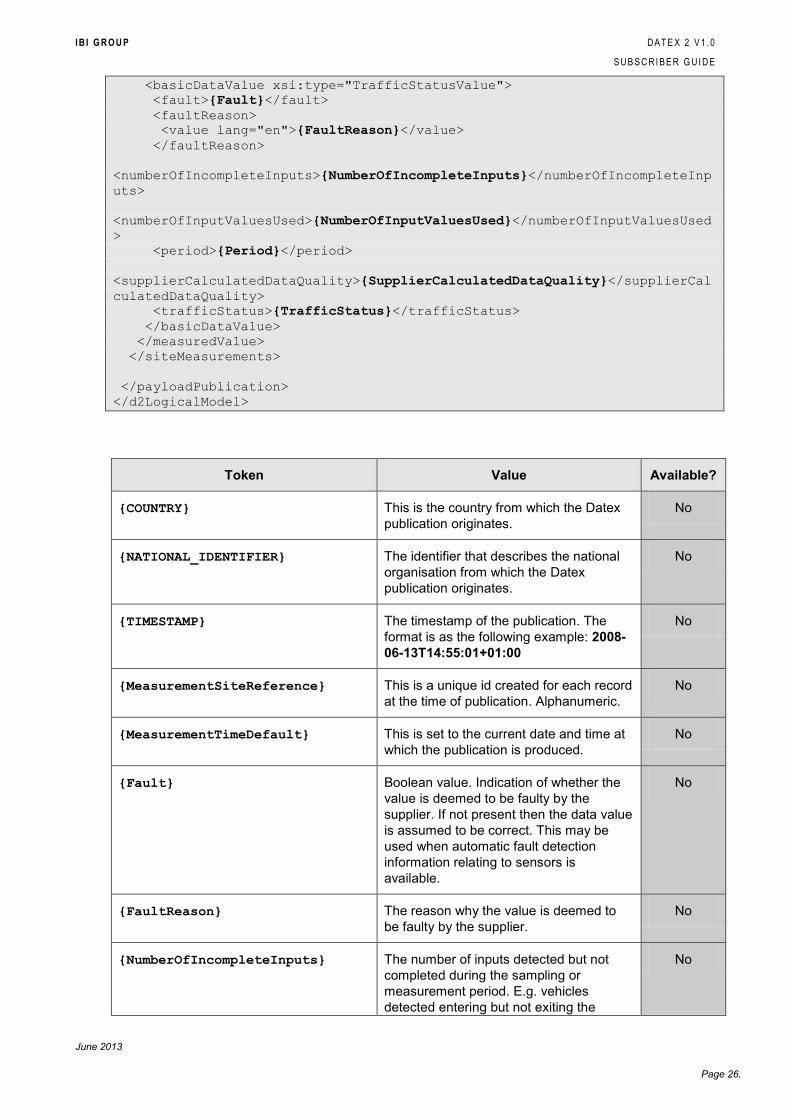
<basicDataValue xsi:type="TrafficStatusValue">
<fault>{Fault}</fault>
<faultReason>
<value lang="en">{FaultReason}</value>
</faultReason>
<numberOfIncompleteInputs>{NumberOfIncompleteInputs}</numberOfIncompleteInp
uts>
<numberOfInputValuesUsed>{NumberOfInputValuesUsed}</numberOfInputValuesUsed
>
<period>{Period}</period>
<supplierCalculatedDataQuality>{SupplierCalculatedDataQuality}</supplierCal
culatedDataQuality>
<trafficStatus>{TrafficStatus}</trafficStatus>
</basicDataValue>
</measuredValue>
</siteMeasurements>
</payloadPublication>
</d2LogicalModel>
Token Value Available?
{COUNTRY} This is the country from which the Datex
publication originates.
No
{NATIONAL_IDENTIFIER} The identifier that describes the national
organisation from which the Datex
publication originates.
No
{TIMESTAMP} The timestamp of the publication. The
format is as the following example: 2008-
06-13T14:55:01+01:00
No
{MeasurementSiteReference} This is a unique id created for each record
at the time of publication. Alphanumeric.
No
{MeasurementTimeDefault} This is set to the current date and time at
which the publication is produced.
No
{Fault} Boolean value. Indication of whether the
value is deemed to be faulty by the
supplier. If not present then the data value
is assumed to be correct. This may be
used when automatic fault detection
information relating to sensors is
available.
No
{FaultReason} The reason why the value is deemed to
be faulty by the supplier.
No
{NumberOfIncompleteInputs} The number of inputs detected but not
completed during the sampling or
measurement period. E.g. vehicles
detected entering but not exiting the
No
I B I G R O U P D A T E X 2 V 1 . 0
S U B S C R I B E R G U I D E
June 2013
Page 27.
detection zone. Numeric integer value
(non-negative).
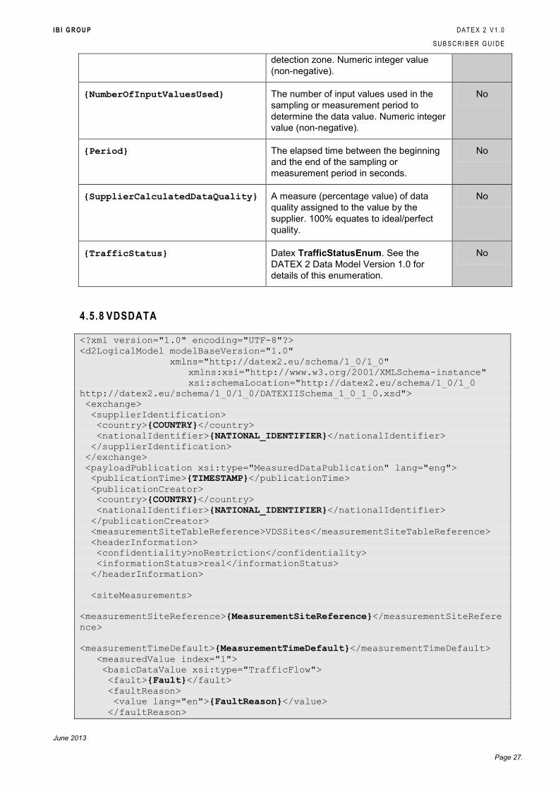
{NumberOfInputValuesUsed} The number of input values used in the
sampling or measurement period to
determine the data value. Numeric integer
value (non-negative).
No
{Period} The elapsed time between the beginning
and the end of the sampling or
measurement period in seconds.
No
{SupplierCalculatedDataQuality} A measure (percentage value) of data
quality assigned to the value by the
supplier. 100% equates to ideal/perfect
quality.
No
{TrafficStatus} Datex TrafficStatusEnum. See the
DATEX 2 Data Model Version 1.0 for
details of this enumeration.
No
4.5.8 VDSDATA
<?xml version="1.0" encoding="UTF-8"?>
<d2LogicalModel modelBaseVersion="1.0"
xmlns="http://datex2.eu/schema/1_0/1_0"
xmlns:xsi="http://www.w3.org/2001/XMLSchema-instance"
xsi:schemaLocation="http://datex2.eu/schema/1_0/1_0
http://datex2.eu/schema/1_0/1_0/DATEXIISchema_1_0_1_0.xsd">
<exchange>
<supplierIdentification>
<country>{COUNTRY}</country>
<nationalIdentifier>{NATIONAL_IDENTIFIER}</nationalIdentifier>
</supplierIdentification>
</exchange>
<payloadPublication xsi:type="MeasuredDataPublication" lang="eng">
<publicationTime>{TIMESTAMP}</publicationTime>
<publicationCreator>
<country>{COUNTRY}</country>
<nationalIdentifier>{NATIONAL_IDENTIFIER}</nationalIdentifier>
</publicationCreator>
<measurementSiteTableReference>VDSSites</measurementSiteTableReference>
<headerInformation>
<confidentiality>noRestriction</confidentiality>
<informationStatus>real</informationStatus>
</headerInformation>
<siteMeasurements>
<measurementSiteReference>{MeasurementSiteReference}</measurementSiteRefere
nce>
<measurementTimeDefault>{MeasurementTimeDefault}</measurementTimeDefault>
<measuredValue index="1">
<basicDataValue xsi:type="TrafficFlow">
<fault>{Fault}</fault>
<faultReason>
<value lang="en">{FaultReason}</value>
</faultReason>
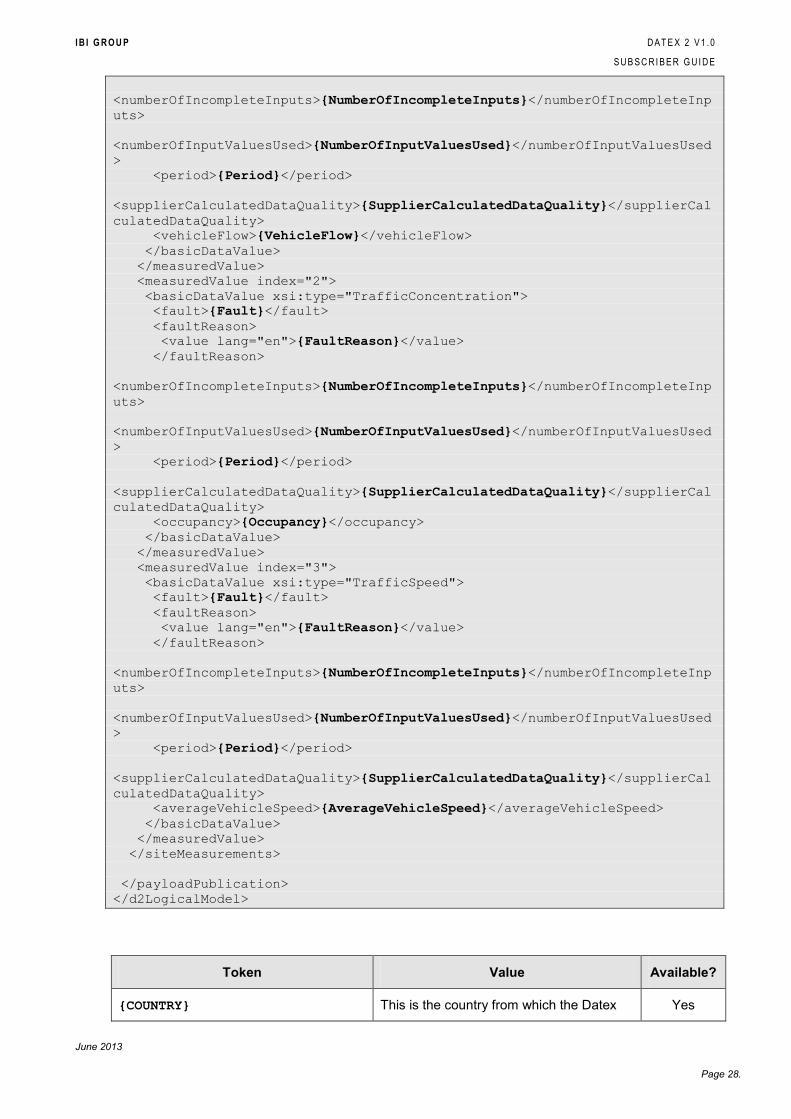
I B I G R O U P D A T E X 2 V 1 . 0
S U B S C R I B E R G U I D E
June 2013
Page 28.
<numberOfIncompleteInputs>{NumberOfIncompleteInputs}</numberOfIncompleteInp
uts>
<numberOfInputValuesUsed>{NumberOfInputValuesUsed}</numberOfInputValuesUsed
>
<period>{Period}</period>
<supplierCalculatedDataQuality>{SupplierCalculatedDataQuality}</supplierCal
culatedDataQuality>
<vehicleFlow>{VehicleFlow}</vehicleFlow>
</basicDataValue>
</measuredValue>
<measuredValue index="2">
<basicDataValue xsi:type="TrafficConcentration">
<fault>{Fault}</fault>
<faultReason>
<value lang="en">{FaultReason}</value>
</faultReason>
<numberOfIncompleteInputs>{NumberOfIncompleteInputs}</numberOfIncompleteInp
uts>
<numberOfInputValuesUsed>{NumberOfInputValuesUsed}</numberOfInputValuesUsed
>
<period>{Period}</period>
<supplierCalculatedDataQuality>{SupplierCalculatedDataQuality}</supplierCal
culatedDataQuality>
<occupancy>{Occupancy}</occupancy>
</basicDataValue>
</measuredValue>
<measuredValue index="3">
<basicDataValue xsi:type="TrafficSpeed">
<fault>{Fault}</fault>
<faultReason>
<value lang="en">{FaultReason}</value>
</faultReason>
<numberOfIncompleteInputs>{NumberOfIncompleteInputs}</numberOfIncompleteInp
uts>
<numberOfInputValuesUsed>{NumberOfInputValuesUsed}</numberOfInputValuesUsed
>
<period>{Period}</period>
<supplierCalculatedDataQuality>{SupplierCalculatedDataQuality}</supplierCal
culatedDataQuality>
<averageVehicleSpeed>{AverageVehicleSpeed}</averageVehicleSpeed>
</basicDataValue>
</measuredValue>
</siteMeasurements>
</payloadPublication>
</d2LogicalModel>
Token Value Available?
{COUNTRY} This is the country from which the Datex Yes
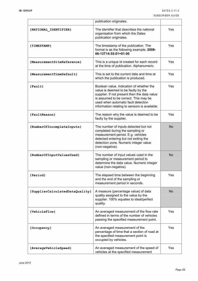
I B I G R O U P D A T E X 2 V 1 . 0
S U B S C R I B E R G U I D E
June 2013
Page 29.
publication originates.
{NATIONAL_IDENTIFIER} The identifier that describes the national
organisation from which the Datex
publication originates.
Yes
{TIMESTAMP} The timestamp of the publication. The
format is as the following example: 2008-
06-13T14:55:01+01:00
Yes
{MeasurementSiteReference} This is a unique id created for each record
at the time of publication. Alphanumeric.
Yes
{MeasurementTimeDefault} This is set to the current date and time at
which the publication is produced.
Yes
{Fault} Boolean value. Indication of whether the
value is deemed to be faulty by the
supplier. If not present then the data value
is assumed to be correct. This may be
used when automatic fault detection
information relating to sensors is available.
Yes
{FaultReason} The reason why the value is deemed to be
faulty by the supplier.
Yes
{NumberOfIncompleteInputs} The number of inputs detected but not
completed during the sampling or
measurement period. E.g. vehicles
detected entering but not exiting the
detection zone. Numeric integer value
(non-negative).
No
{NumberOfInputValuesUsed} The number of input values used in the
sampling or measurement period to
determine the data value. Numeric integer
value (non-negative).
No
{Period} The elapsed time between the beginning
and the end of the sampling or
measurement period in seconds.
Yes
{SupplierCalculatedDataQuality} A measure (percentage value) of data
quality assigned to the value by the
supplier. 100% equates to ideal/perfect
quality.
No
{VehicleFlow} An averaged measurement of the flow rate
defined in terms of the number of vehicles
passing the specified measurement point.
Yes
{Occupancy} An averaged measurement of the
percentage of time that a section of road at
the specified measurement point is
occupied by vehicles.
Yes
{AverageVehicleSpeed} An averaged measurement of the speed of
vehicles at the specified measurement
Yes
I B I G R O U P D A T E X 2 V 1 . 0
S U B S C R I B E R G U I D E
June 2013
Page 30.
point.
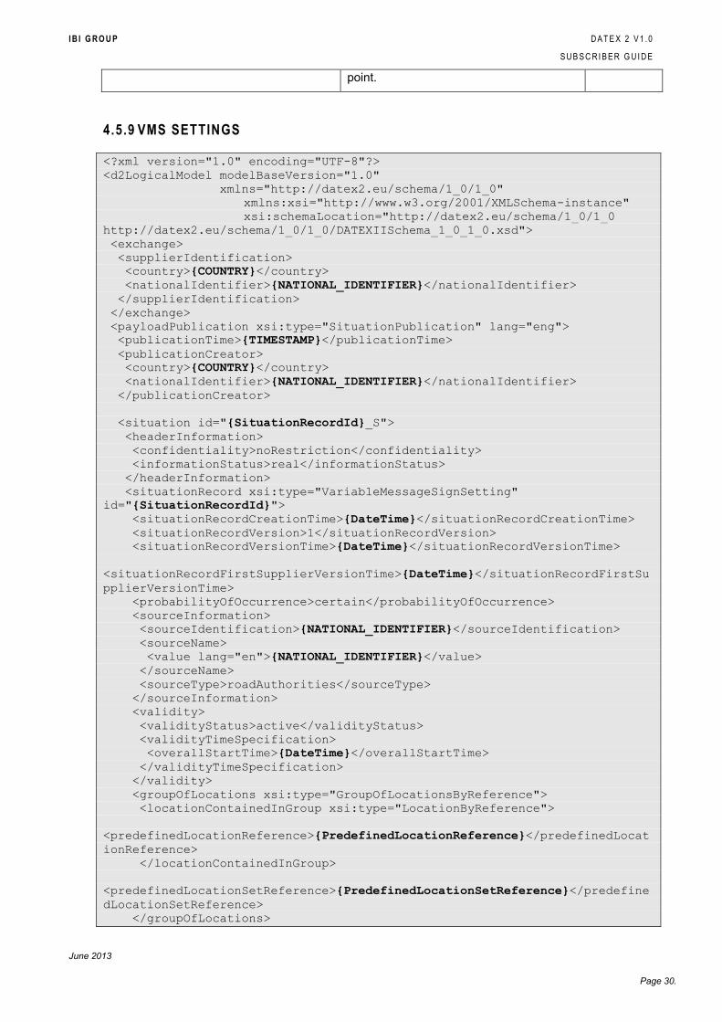
4.5.9 VMS SETTINGS
<?xml version="1.0" encoding="UTF-8"?>
<d2LogicalModel modelBaseVersion="1.0"
xmlns="http://datex2.eu/schema/1_0/1_0"
xmlns:xsi="http://www.w3.org/2001/XMLSchema-instance"
xsi:schemaLocation="http://datex2.eu/schema/1_0/1_0
http://datex2.eu/schema/1_0/1_0/DATEXIISchema_1_0_1_0.xsd">
<exchange>
<supplierIdentification>
<country>{COUNTRY}</country>
<nationalIdentifier>{NATIONAL_IDENTIFIER}</nationalIdentifier>
</supplierIdentification>
</exchange>
<payloadPublication xsi:type="SituationPublication" lang="eng">
<publicationTime>{TIMESTAMP}</publicationTime>
<publicationCreator>
<country>{COUNTRY}</country>
<nationalIdentifier>{NATIONAL_IDENTIFIER}</nationalIdentifier>
</publicationCreator>
<situation id="{SituationRecordId}_S">
<headerInformation>
<confidentiality>noRestriction</confidentiality>
<informationStatus>real</informationStatus>
</headerInformation>
<situationRecord xsi:type="VariableMessageSignSetting"
id="{SituationRecordId}">
<situationRecordCreationTime>{DateTime}</situationRecordCreationTime>
<situationRecordVersion>1</situationRecordVersion>
<situationRecordVersionTime>{DateTime}</situationRecordVersionTime>
<situationRecordFirstSupplierVersionTime>{DateTime}</situationRecordFirstSu
pplierVersionTime>
<probabilityOfOccurrence>certain</probabilityOfOccurrence>
<sourceInformation>
<sourceIdentification>{NATIONAL_IDENTIFIER}</sourceIdentification>
<sourceName>
<value lang="en">{NATIONAL_IDENTIFIER}</value>
</sourceName>
<sourceType>roadAuthorities</sourceType>
</sourceInformation>
<validity>
<validityStatus>active</validityStatus>
<validityTimeSpecification>
<overallStartTime>{DateTime}</overallStartTime>
</validityTimeSpecification>
</validity>
<groupOfLocations xsi:type="GroupOfLocationsByReference">
<locationContainedInGroup xsi:type="LocationByReference">
<predefinedLocationReference>{PredefinedLocationReference}</predefinedLocat
ionReference>
</locationContainedInGroup>
<predefinedLocationSetReference>{PredefinedLocationSetReference}</predefine
dLocationSetReference>
</groupOfLocations>
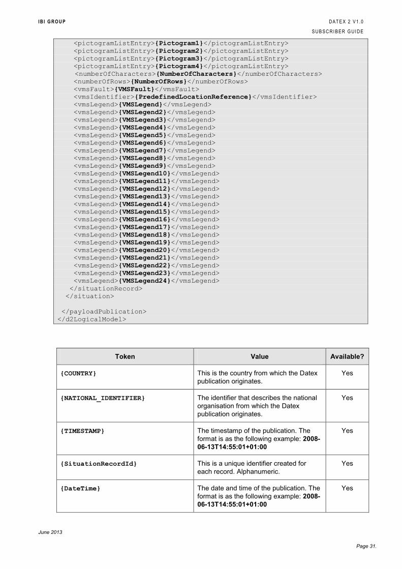
I B I G R O U P D A T E X 2 V 1 . 0
S U B S C R I B E R G U I D E
June 2013
Page 31.
<pictogramListEntry>{Pictogram1}</pictogramListEntry>
<pictogramListEntry>{Pictogram2}</pictogramListEntry>
<pictogramListEntry>{Pictogram3}</pictogramListEntry>
<pictogramListEntry>{Pictogram4}</pictogramListEntry>
<numberOfCharacters>{NumberOfCharacters}</numberOfCharacters>
<numberOfRows>{NumberOfRows}</numberOfRows>
<vmsFault>{VMSFault}</vmsFault>
<vmsIdentifier>{PredefinedLocationReference}</vmsIdentifier>
<vmsLegend>{VMSLegend}</vmsLegend>
<vmsLegend>{VMSLegend2}</vmsLegend>
<vmsLegend>{VMSLegend3}</vmsLegend>
<vmsLegend>{VMSLegend4}</vmsLegend>
<vmsLegend>{VMSLegend5}</vmsLegend>
<vmsLegend>{VMSLegend6}</vmsLegend>
<vmsLegend>{VMSLegend7}</vmsLegend>
<vmsLegend>{VMSLegend8}</vmsLegend>
<vmsLegend>{VMSLegend9}</vmsLegend>
<vmsLegend>{VMSLegend10}</vmsLegend>
<vmsLegend>{VMSLegend11}</vmsLegend>
<vmsLegend>{VMSLegend12}</vmsLegend>
<vmsLegend>{VMSLegend13}</vmsLegend>
<vmsLegend>{VMSLegend14}</vmsLegend>
<vmsLegend>{VMSLegend15}</vmsLegend>
<vmsLegend>{VMSLegend16}</vmsLegend>
<vmsLegend>{VMSLegend17}</vmsLegend>
<vmsLegend>{VMSLegend18}</vmsLegend>
<vmsLegend>{VMSLegend19}</vmsLegend>
<vmsLegend>{VMSLegend20}</vmsLegend>
<vmsLegend>{VMSLegend21}</vmsLegend>
<vmsLegend>{VMSLegend22}</vmsLegend>
<vmsLegend>{VMSLegend23}</vmsLegend>
<vmsLegend>{VMSLegend24}</vmsLegend>
</situationRecord>
</situation>
</payloadPublication>
</d2LogicalModel>
Token Value Available?
{COUNTRY} This is the country from which the Datex
publication originates.
Yes
{NATIONAL_IDENTIFIER} The identifier that describes the national
organisation from which the Datex
publication originates.
Yes
{TIMESTAMP} The timestamp of the publication. The
format is as the following example: 2008-
06-13T14:55:01+01:00
Yes
{SituationRecordId} This is a unique identifier created for
each record. Alphanumeric.
Yes
{DateTime} The date and time of the publication. The
format is as the following example: 2008-
06-13T14:55:01+01:00
Yes
I B I G R O U P D A T E X 2 V 1 . 0
S U B S C R I B E R G U I D E
June 2013
Page 32.
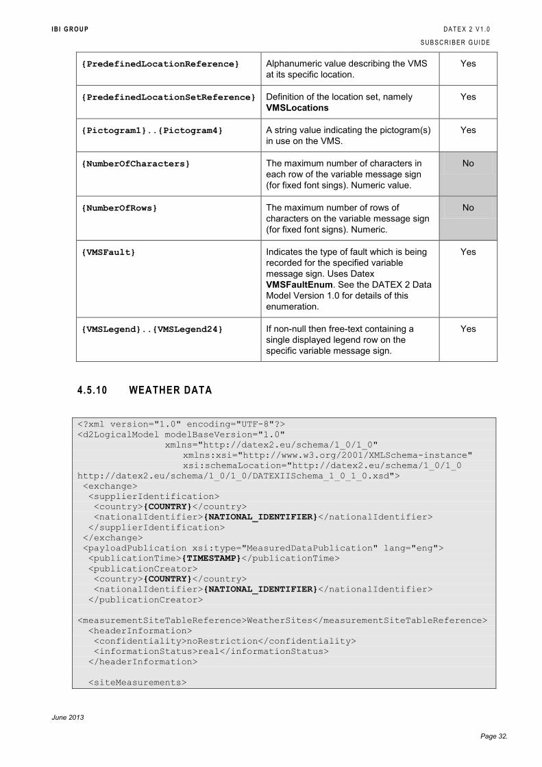
{PredefinedLocationReference} Alphanumeric value describing the VMS
at its specific location.
Yes
{PredefinedLocationSetReference} Definition of the location set, namely
VMSLocations
Yes
{Pictogram1}..{Pictogram4} A string value indicating the pictogram(s)
in use on the VMS.
Yes
{NumberOfCharacters} The maximum number of characters in
each row of the variable message sign
(for fixed font sings). Numeric value.
No
{NumberOfRows} The maximum number of rows of
characters on the variable message sign
(for fixed font signs). Numeric.
No
{VMSFault} Indicates the type of fault which is being
recorded for the specified variable
message sign. Uses Datex
VMSFaultEnum. See the DATEX 2 Data
Model Version 1.0 for details of this
enumeration.
Yes
{VMSLegend}..{VMSLegend24} If non-null then free-text containing a
single displayed legend row on the
specific variable message sign.
Yes
4.5.10 WEATHER DATA
<?xml version="1.0" encoding="UTF-8"?>
<d2LogicalModel modelBaseVersion="1.0"
xmlns="http://datex2.eu/schema/1_0/1_0"
xmlns:xsi="http://www.w3.org/2001/XMLSchema-instance"
xsi:schemaLocation="http://datex2.eu/schema/1_0/1_0
http://datex2.eu/schema/1_0/1_0/DATEXIISchema_1_0_1_0.xsd">
<exchange>
<supplierIdentification>
<country>{COUNTRY}</country>
<nationalIdentifier>{NATIONAL_IDENTIFIER}</nationalIdentifier>
</supplierIdentification>
</exchange>
<payloadPublication xsi:type="MeasuredDataPublication" lang="eng">
<publicationTime>{TIMESTAMP}</publicationTime>
<publicationCreator>
<country>{COUNTRY}</country>
<nationalIdentifier>{NATIONAL_IDENTIFIER}</nationalIdentifier>
</publicationCreator>
<measurementSiteTableReference>WeatherSites</measurementSiteTableReference>
<headerInformation>
<confidentiality>noRestriction</confidentiality>
<informationStatus>real</informationStatus>
</headerInformation>
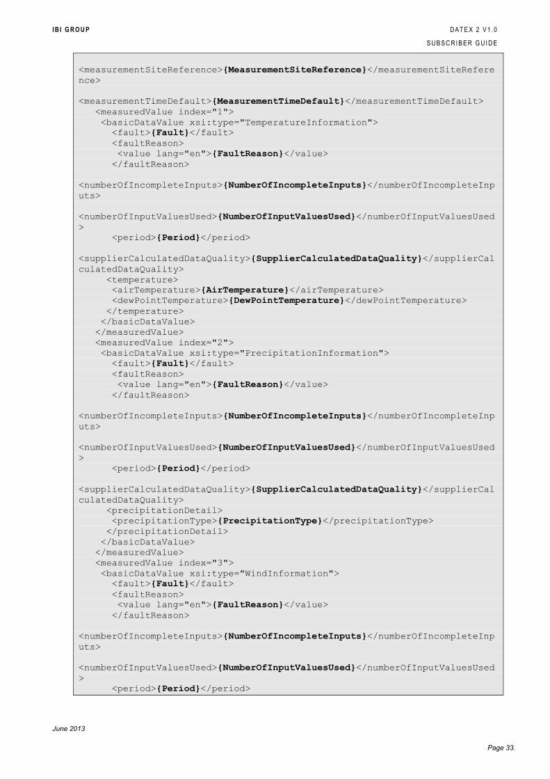
<siteMeasurements>
I B I G R O U P D A T E X 2 V 1 . 0
S U B S C R I B E R G U I D E
June 2013
Page 33.
<measurementSiteReference>{MeasurementSiteReference}</measurementSiteRefere
nce>
<measurementTimeDefault>{MeasurementTimeDefault}</measurementTimeDefault>
<measuredValue index="1">
<basicDataValue xsi:type="TemperatureInformation">
<fault>{Fault}</fault>
<faultReason>
<value lang="en">{FaultReason}</value>
</faultReason>
<numberOfIncompleteInputs>{NumberOfIncompleteInputs}</numberOfIncompleteInp
uts>
<numberOfInputValuesUsed>{NumberOfInputValuesUsed}</numberOfInputValuesUsed
>
<period>{Period}</period>
<supplierCalculatedDataQuality>{SupplierCalculatedDataQuality}</supplierCal
culatedDataQuality>
<temperature>
<airTemperature>{AirTemperature}</airTemperature>
<dewPointTemperature>{DewPointTemperature}</dewPointTemperature>
</temperature>
</basicDataValue>
</measuredValue>
<measuredValue index="2">
<basicDataValue xsi:type="PrecipitationInformation">
<fault>{Fault}</fault>
<faultReason>
<value lang="en">{FaultReason}</value>
</faultReason>
<numberOfIncompleteInputs>{NumberOfIncompleteInputs}</numberOfIncompleteInp
uts>
<numberOfInputValuesUsed>{NumberOfInputValuesUsed}</numberOfInputValuesUsed
>
<period>{Period}</period>
<supplierCalculatedDataQuality>{SupplierCalculatedDataQuality}</supplierCal
culatedDataQuality>
<precipitationDetail>
<precipitationType>{PrecipitationType}</precipitationType>
</precipitationDetail>
</basicDataValue>
</measuredValue>
<measuredValue index="3">
<basicDataValue xsi:type="WindInformation">
<fault>{Fault}</fault>
<faultReason>
<value lang="en">{FaultReason}</value>
</faultReason>
<numberOfIncompleteInputs>{NumberOfIncompleteInputs}</numberOfIncompleteInp
uts>
<numberOfInputValuesUsed>{NumberOfInputValuesUsed}</numberOfInputValuesUsed
>
<period>{Period}</period>
I B I G R O U P D A T E X 2 V 1 . 0
S U B S C R I B E R G U I D E
June 2013
Page 34.
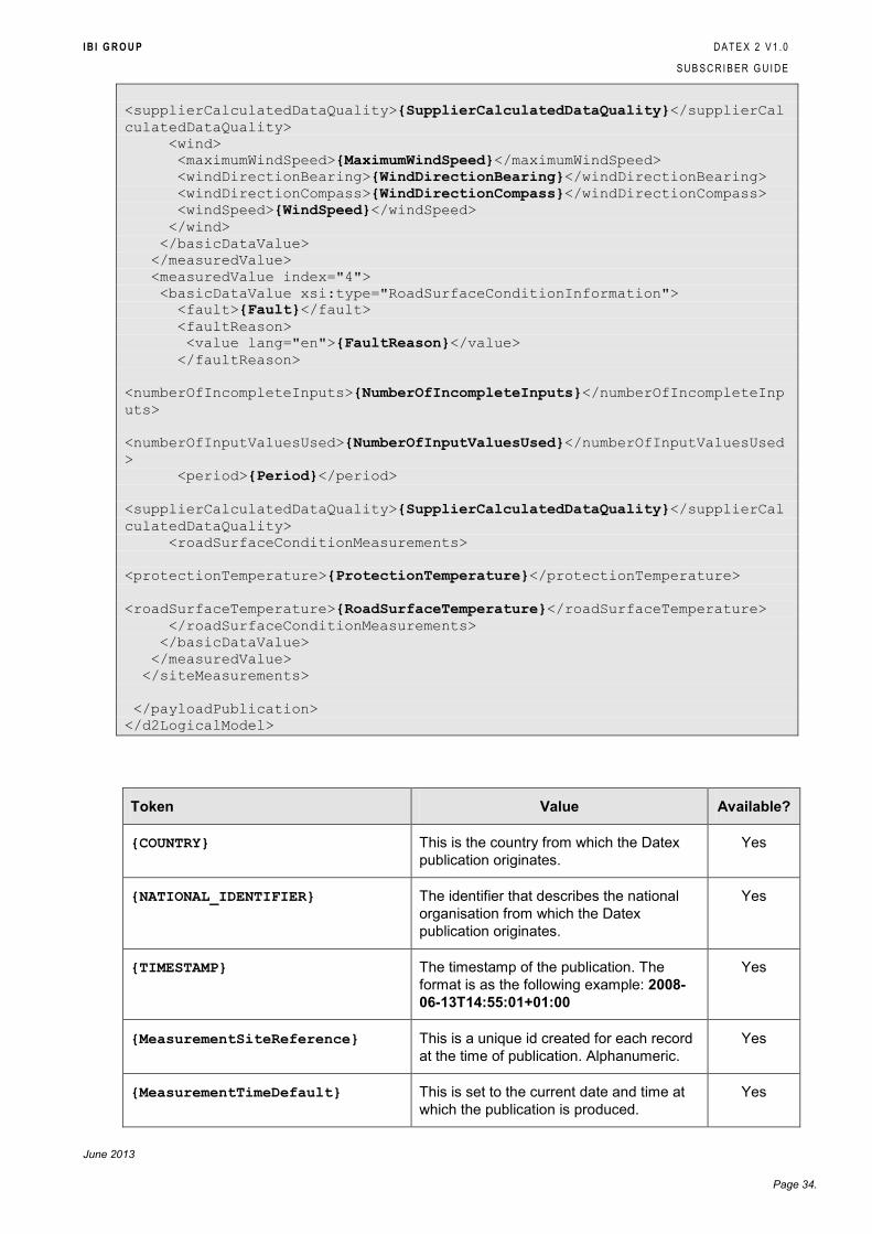
<supplierCalculatedDataQuality>{SupplierCalculatedDataQuality}</supplierCal
culatedDataQuality>
<wind>
<maximumWindSpeed>{MaximumWindSpeed}</maximumWindSpeed>
<windDirectionBearing>{WindDirectionBearing}</windDirectionBearing>
<windDirectionCompass>{WindDirectionCompass}</windDirectionCompass>
<windSpeed>{WindSpeed}</windSpeed>
</wind>
</basicDataValue>
</measuredValue>
<measuredValue index="4">
<basicDataValue xsi:type="RoadSurfaceConditionInformation">
<fault>{Fault}</fault>
<faultReason>
<value lang="en">{FaultReason}</value>
</faultReason>
<numberOfIncompleteInputs>{NumberOfIncompleteInputs}</numberOfIncompleteInp
uts>
<numberOfInputValuesUsed>{NumberOfInputValuesUsed}</numberOfInputValuesUsed
>
<period>{Period}</period>
<supplierCalculatedDataQuality>{SupplierCalculatedDataQuality}</supplierCal
culatedDataQuality>
<roadSurfaceConditionMeasurements>
<protectionTemperature>{ProtectionTemperature}</protectionTemperature>
<roadSurfaceTemperature>{RoadSurfaceTemperature}</roadSurfaceTemperature>
</roadSurfaceConditionMeasurements>
</basicDataValue>
</measuredValue>
</siteMeasurements>
</payloadPublication>
</d2LogicalModel>
Token Value Available?
{COUNTRY} This is the country from which the Datex
publication originates.
Yes
{NATIONAL_IDENTIFIER} The identifier that describes the national
organisation from which the Datex
publication originates.
Yes
{TIMESTAMP} The timestamp of the publication. The
format is as the following example: 2008-
06-13T14:55:01+01:00
Yes
{MeasurementSiteReference} This is a unique id created for each record
at the time of publication. Alphanumeric.
Yes
{MeasurementTimeDefault} This is set to the current date and time at
which the publication is produced.
Yes
I B I G R O U P D A T E X 2 V 1 . 0
S U B S C R I B E R G U I D E
June 2013
Page 35.
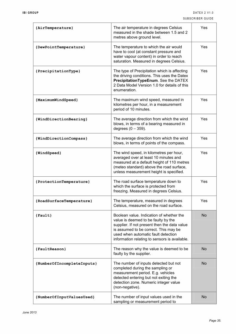
{AirTemperature} The air temperature in degrees Celsius
measured in the shade between 1.5 and 2
metres above ground level.
Yes
{DewPointTemperature} The temperature to which the air would
have to cool (at constant pressure and
water vapour content) in order to reach
saturation. Measured in degrees Celsius.
Yes
{PrecipitationType} The type of Precipitation which is affecting
the driving conditions. This uses the Datex
PrecipitationTypeEnum. See the DATEX
2 Data Model Version 1.0 for details of this
enumeration.
Yes
{MaximumWindSpeed} The maximum wind speed, measured in
kilometres per hour, in a measurement
period of 10 minutes.
Yes
{WindDirectionBearing} The average direction from which the wind
blows, in terms of a bearing measured in
degrees (0 – 359).
Yes
{WindDirectionCompass} The average direction from which the wind
blows, in terms of points of the compass.
Yes
{WindSpeed} The wind speed, in kilometres per hour,
averaged over at least 10 minutes and
measured at a default height of 110 metres
(meteo standard) above the road surface,
unless measurement height is specified.
Yes
{ProtectionTemperature} The road surface temperature down to
which the surface is protected from
freezing. Measured in degrees Celsius.
Yes
{RoadSurfaceTemperature} The temperature, measured in degrees
Celsius, measured on the road surface.
Yes
{Fault} Boolean value. Indication of whether the
value is deemed to be faulty by the
supplier. If not present then the data value
is assumed to be correct. This may be
used when automatic fault detection
information relating to sensors is available.
No
{FaultReason} The reason why the value is deemed to be
faulty by the supplier.
No
{NumberOfIncompleteInputs} The number of inputs detected but not
completed during the sampling or
measurement period. E.g. vehicles
detected entering but not exiting the
detection zone. Numeric integer value
(non-negative).
No
{NumberOfInputValuesUsed} The number of input values used in the
sampling or measurement period to
No
I B I G R O U P D A T E X 2 V 1 . 0
S U B S C R I B E R G U I D E
June 2013
Page 36.
determine the data value. Numeric integer
value (non-negative).
{Period} The elapsed time between the beginning
and the end of the sampling or
measurement period in seconds.
Yes
{SupplierCalculatedDataQuality} A measure (percentage value) of data
quality assigned to the value by the
supplier. 100% equates to ideal/perfect
quality.
No
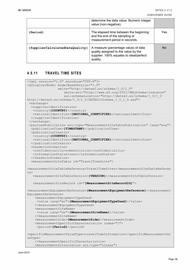
4.5.11 TRAVEL TIME SITES
<?xml version="1.0" encoding="UTF-8"?>
<d2LogicalModel modelBaseVersion="1.0"
xmlns="http://datex2.eu/schema/1_0/1_0"
xmlns:xsi="http://www.w3.org/2001/XMLSchema-instance"
xsi:schemaLocation="http://datex2.eu/schema/1_0/1_0
http://datex2.eu/schema/1_0/1_0/DATEXIISchema_1_0_1_0.xsd">
<exchange>
<supplierIdentification>
<country>{COUNTRY}</country>
<nationalIdentifier>{NATIONAL_IDENTIFIER}</nationalIdentifier>
</supplierIdentification>
</exchange>
<payloadPublication xsi:type="MeasurementSiteTablePublication" lang="eng">
<publicationTime>{TIMESTAMP}</publicationTime>
<publicationCreator>
<country>{COUNTRY}</country>
<nationalIdentifier>{NATIONAL_IDENTIFIER}</nationalIdentifier>
</publicationCreator>
<headerInformation>
<confidentiality>noRestriction</confidentiality>
<informationStatus>real</informationStatus>
</headerInformation>
<measurementSiteTable id="TravelTimeSites">
<measurementSiteTableReference>TravelTimeSites</measurementSiteTableReferen
ce>
<measurementSiteTableVersion>{VERSION}</measurementSiteTableVersion>
<measurementSiteRecord id="{MeasurementSiteRecordId}">
<measurementEquipmentReference>{MeasurementEquipmentReference}</measurement
EquipmentReference>
<measurementEquipmentTypeUsed>
<value lang="en">{MeasurementEquipmentTypeUsed}</value>
</measurementEquipmentTypeUsed>
<measurementSiteName>
<value lang="en">{MeasurementSiteName}</value>
</measurementSiteName>
<measurementSide>{MeasurementSide}</measurementSide>
<measurementSpecificCharacteristics index="1">
<period>{Period}</period>
<specificMeasurementValueType>travelTimeInformation</specificMeasurementVal
ueType>
</measurementSpecificCharacteristics>
<measurementSiteLocation xsi:type="Linear">
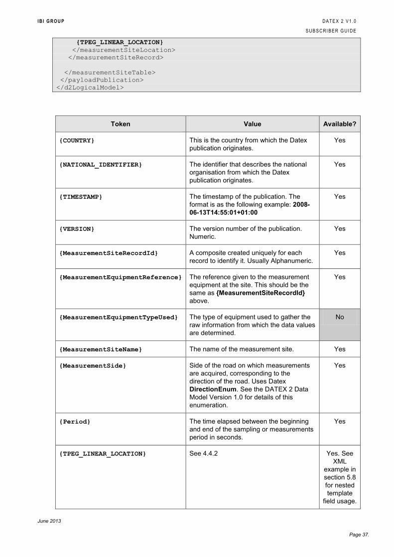
I B I G R O U P D A T E X 2 V 1 . 0
S U B S C R I B E R G U I D E
June 2013
Page 37.
{TPEG_LINEAR_LOCATION}
</measurementSiteLocation>
</measurementSiteRecord>
</measurementSiteTable>
</payloadPublication>
</d2LogicalModel>
Token Value Available?
{COUNTRY} This is the country from which the Datex
publication originates.
Yes
{NATIONAL_IDENTIFIER} The identifier that describes the national
organisation from which the Datex
publication originates.
Yes
{TIMESTAMP} The timestamp of the publication. The
format is as the following example: 2008-
06-13T14:55:01+01:00
Yes
{VERSION} The version number of the publication.
Numeric.
Yes
{MeasurementSiteRecordId} A composite created uniquely for each
record to identify it. Usually Alphanumeric.
Yes
{MeasurementEquipmentReference} The reference given to the measurement
equipment at the site. This should be the
same as {MeasurementSiteRecordId}
above.
Yes
{MeasurementEquipmentTypeUsed} The type of equipment used to gather the
raw information from which the data values
are determined.
No
{MeasurementSiteName} The name of the measurement site. Yes
{MeasurementSide} Side of the road on which measurements
are acquired, corresponding to the
direction of the road. Uses Datex
DirectionEnum. See the DATEX 2 Data
Model Version 1.0 for details of this
enumeration.
Yes
{Period} The time elapsed between the beginning
and end of the sampling or measurements
period in seconds.
Yes
{TPEG_LINEAR_LOCATION} See 4.4.2 Yes. See
XML
example in
section 5.8
for nested
template
field usage.
I B I G R O U P D A T E X 2 V 1 . 0
S U B S C R I B E R G U I D E
June 2013
Page 38.
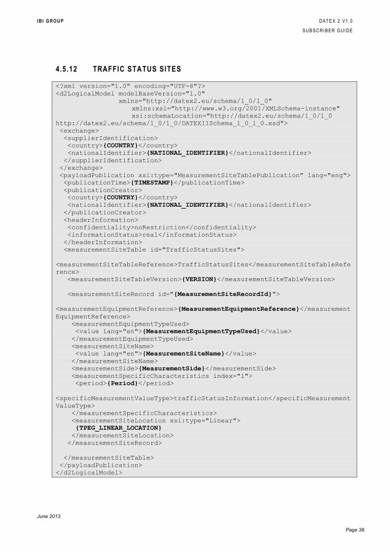
4.5.12 TRAFFIC STATUS SITES
<?xml version="1.0" encoding="UTF-8"?>
<d2LogicalModel modelBaseVersion="1.0"
xmlns="http://datex2.eu/schema/1_0/1_0"
xmlns:xsi="http://www.w3.org/2001/XMLSchema-instance"
xsi:schemaLocation="http://datex2.eu/schema/1_0/1_0
http://datex2.eu/schema/1_0/1_0/DATEXIISchema_1_0_1_0.xsd">
<exchange>
<supplierIdentification>
<country>{COUNTRY}</country>
<nationalIdentifier>{NATIONAL_IDENTIFIER}</nationalIdentifier>
</supplierIdentification>
</exchange>
<payloadPublication xsi:type="MeasurementSiteTablePublication" lang="eng">
<publicationTime>{TIMESTAMP}</publicationTime>
<publicationCreator>
<country>{COUNTRY}</country>
<nationalIdentifier>{NATIONAL_IDENTIFIER}</nationalIdentifier>
</publicationCreator>
<headerInformation>
<confidentiality>noRestriction</confidentiality>
<informationStatus>real</informationStatus>
</headerInformation>
<measurementSiteTable id="TrafficStatusSites">
<measurementSiteTableReference>TrafficStatusSites</measurementSiteTableRefe
rence>
<measurementSiteTableVersion>{VERSION}</measurementSiteTableVersion>
<measurementSiteRecord id="{MeasurementSiteRecordId}">
<measurementEquipmentReference>{MeasurementEquipmentReference}</measurement
EquipmentReference>
<measurementEquipmentTypeUsed>
<value lang="en">{MeasurementEquipmentTypeUsed}</value>
</measurementEquipmentTypeUsed>
<measurementSiteName>
<value lang="en">{MeasurementSiteName}</value>
</measurementSiteName>
<measurementSide>{MeasurementSide}</measurementSide>
<measurementSpecificCharacteristics index="1">
<period>{Period}</period>
<specificMeasurementValueType>trafficStatusInformation</specificMeasurement
ValueType>
</measurementSpecificCharacteristics>
<measurementSiteLocation xsi:type="Linear">
{TPEG_LINEAR_LOCATION}
</measurementSiteLocation>
</measurementSiteRecord>
</measurementSiteTable>
</payloadPublication>
</d2LogicalModel>
I B I G R O U P D A T E X 2 V 1 . 0
S U B S C R I B E R G U I D E
June 2013
Page 39.
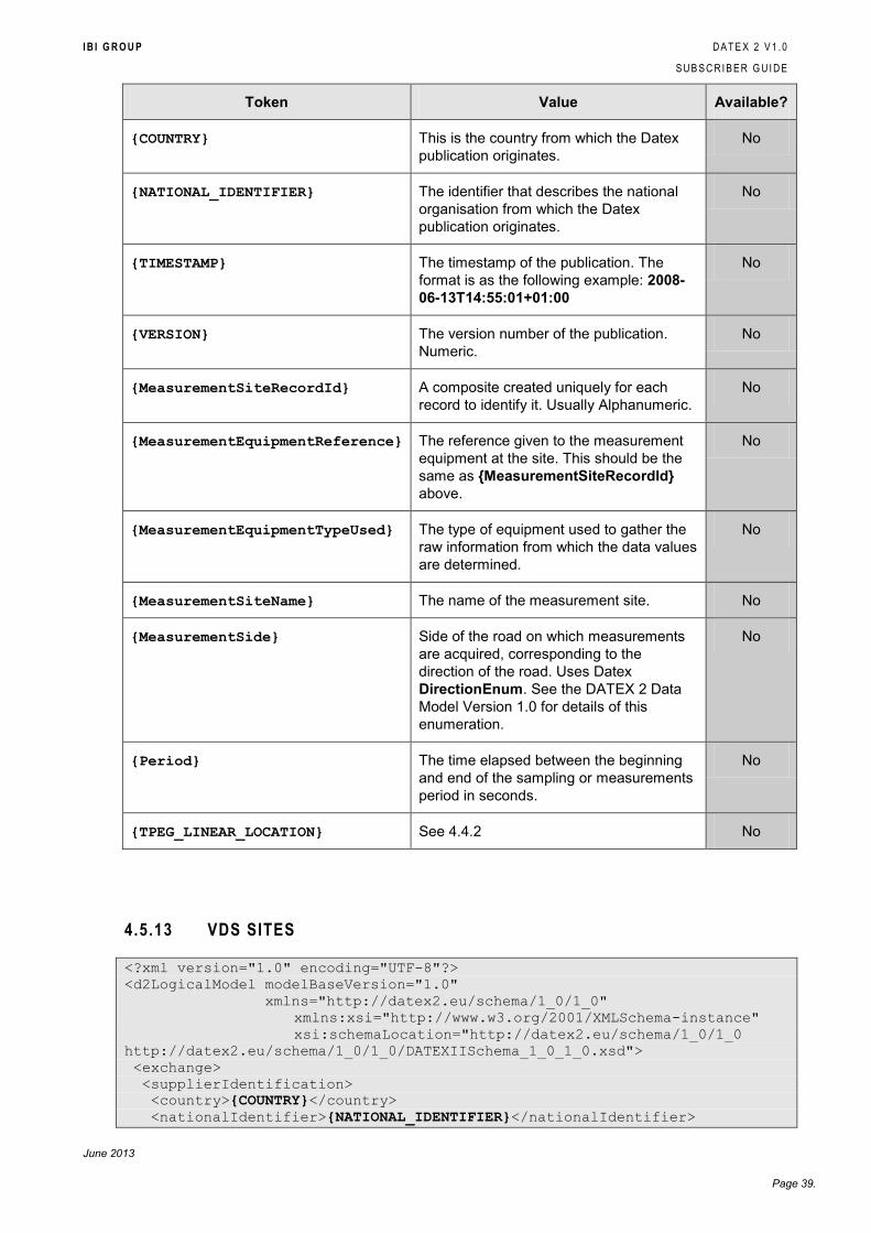
Token Value Available?
{COUNTRY} This is the country from which the Datex
publication originates.
No
{NATIONAL_IDENTIFIER} The identifier that describes the national
organisation from which the Datex
publication originates.
No
{TIMESTAMP} The timestamp of the publication. The
format is as the following example: 2008-
06-13T14:55:01+01:00
No
{VERSION} The version number of the publication.
Numeric.
No
{MeasurementSiteRecordId} A composite created uniquely for each
record to identify it. Usually Alphanumeric.
No
{MeasurementEquipmentReference} The reference given to the measurement
equipment at the site. This should be the
same as {MeasurementSiteRecordId}
above.
No
{MeasurementEquipmentTypeUsed} The type of equipment used to gather the
raw information from which the data values
are determined.
No
{MeasurementSiteName} The name of the measurement site. No
{MeasurementSide} Side of the road on which measurements
are acquired, corresponding to the
direction of the road. Uses Datex
DirectionEnum. See the DATEX 2 Data
Model Version 1.0 for details of this
enumeration.
No
{Period} The time elapsed between the beginning
and end of the sampling or measurements
period in seconds.
No
{TPEG_LINEAR_LOCATION} See 4.4.2 No
4.5.13 VDS SITES
<?xml version="1.0" encoding="UTF-8"?>
<d2LogicalModel modelBaseVersion="1.0"
xmlns="http://datex2.eu/schema/1_0/1_0"
xmlns:xsi="http://www.w3.org/2001/XMLSchema-instance"
xsi:schemaLocation="http://datex2.eu/schema/1_0/1_0
http://datex2.eu/schema/1_0/1_0/DATEXIISchema_1_0_1_0.xsd">
<exchange>
<supplierIdentification>
<country>{COUNTRY}</country>
<nationalIdentifier>{NATIONAL_IDENTIFIER}</nationalIdentifier>
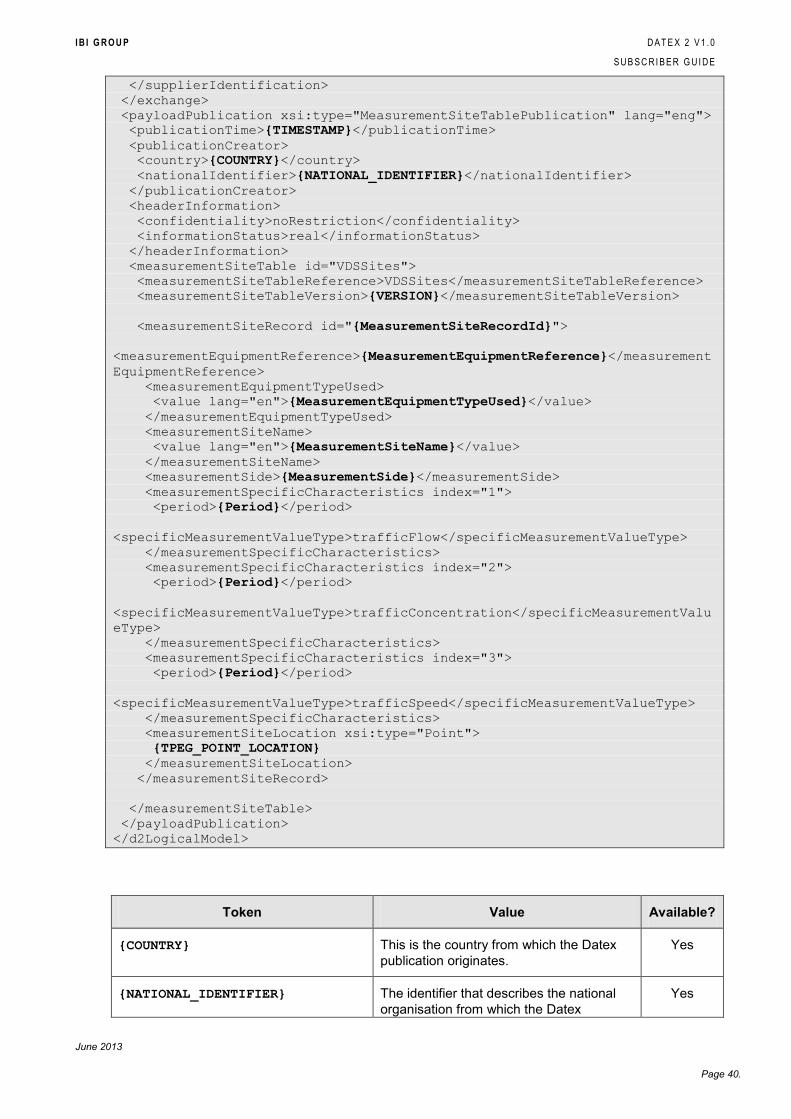
I B I G R O U P D A T E X 2 V 1 . 0
S U B S C R I B E R G U I D E
June 2013
Page 40.
</supplierIdentification>
</exchange>
<payloadPublication xsi:type="MeasurementSiteTablePublication" lang="eng">
<publicationTime>{TIMESTAMP}</publicationTime>
<publicationCreator>
<country>{COUNTRY}</country>
<nationalIdentifier>{NATIONAL_IDENTIFIER}</nationalIdentifier>
</publicationCreator>
<headerInformation>
<confidentiality>noRestriction</confidentiality>
<informationStatus>real</informationStatus>
</headerInformation>
<measurementSiteTable id="VDSSites">
<measurementSiteTableReference>VDSSites</measurementSiteTableReference>
<measurementSiteTableVersion>{VERSION}</measurementSiteTableVersion>
<measurementSiteRecord id="{MeasurementSiteRecordId}">
<measurementEquipmentReference>{MeasurementEquipmentReference}</measurement
EquipmentReference>
<measurementEquipmentTypeUsed>
<value lang="en">{MeasurementEquipmentTypeUsed}</value>
</measurementEquipmentTypeUsed>
<measurementSiteName>
<value lang="en">{MeasurementSiteName}</value>
</measurementSiteName>
<measurementSide>{MeasurementSide}</measurementSide>
<measurementSpecificCharacteristics index="1">
<period>{Period}</period>
<specificMeasurementValueType>trafficFlow</specificMeasurementValueType>
</measurementSpecificCharacteristics>
<measurementSpecificCharacteristics index="2">
<period>{Period}</period>
<specificMeasurementValueType>trafficConcentration</specificMeasurementValu
eType>
</measurementSpecificCharacteristics>
<measurementSpecificCharacteristics index="3">
<period>{Period}</period>
<specificMeasurementValueType>trafficSpeed</specificMeasurementValueType>
</measurementSpecificCharacteristics>
<measurementSiteLocation xsi:type="Point">
{TPEG_POINT_LOCATION}
</measurementSiteLocation>
</measurementSiteRecord>
</measurementSiteTable>
</payloadPublication>
</d2LogicalModel>
Token Value Available?
{COUNTRY} This is the country from which the Datex
publication originates.
Yes
{NATIONAL_IDENTIFIER} The identifier that describes the national
organisation from which the Datex
Yes
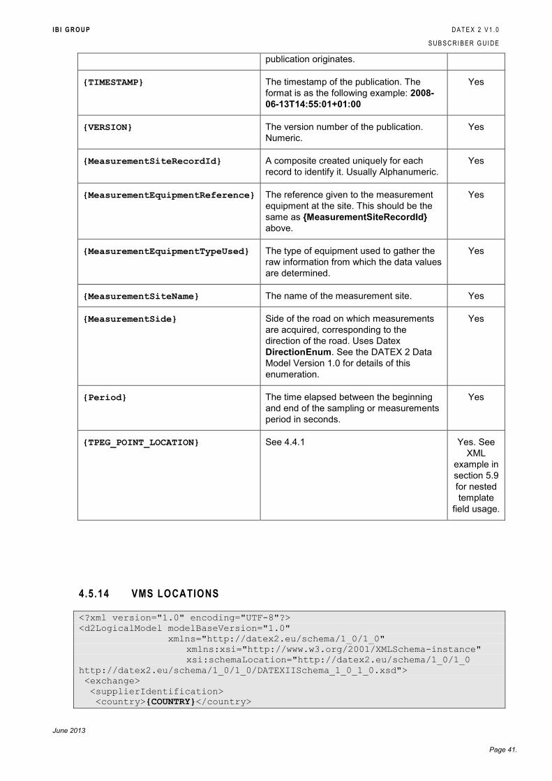
I B I G R O U P D A T E X 2 V 1 . 0
S U B S C R I B E R G U I D E
June 2013
Page 41.
publication originates.
{TIMESTAMP} The timestamp of the publication. The
format is as the following example: 2008-
06-13T14:55:01+01:00
Yes
{VERSION} The version number of the publication.
Numeric.
Yes
{MeasurementSiteRecordId} A composite created uniquely for each
record to identify it. Usually Alphanumeric.
Yes
{MeasurementEquipmentReference} The reference given to the measurement
equipment at the site. This should be the
same as {MeasurementSiteRecordId}
above.
Yes
{MeasurementEquipmentTypeUsed} The type of equipment used to gather the
raw information from which the data values
are determined.
Yes
{MeasurementSiteName} The name of the measurement site. Yes
{MeasurementSide} Side of the road on which measurements
are acquired, corresponding to the
direction of the road. Uses Datex
DirectionEnum. See the DATEX 2 Data
Model Version 1.0 for details of this
enumeration.
Yes
{Period} The time elapsed between the beginning
and end of the sampling or measurements
period in seconds.
Yes
{TPEG_POINT_LOCATION} See 4.4.1 Yes. See
XML
example in
section 5.9
for nested
template
field usage.
4.5.14 VMS LOCATIONS
<?xml version="1.0" encoding="UTF-8"?>
<d2LogicalModel modelBaseVersion="1.0"
xmlns="http://datex2.eu/schema/1_0/1_0"
xmlns:xsi="http://www.w3.org/2001/XMLSchema-instance"
xsi:schemaLocation="http://datex2.eu/schema/1_0/1_0
http://datex2.eu/schema/1_0/1_0/DATEXIISchema_1_0_1_0.xsd">
<exchange>
<supplierIdentification>
<country>{COUNTRY}</country>
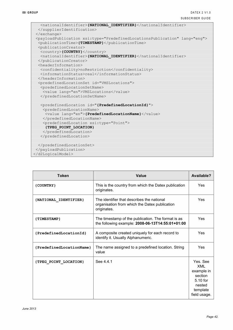
I B I G R O U P D A T E X 2 V 1 . 0
S U B S C R I B E R G U I D E
June 2013
Page 42.
<nationalIdentifier>{NATIONAL_IDENTIFIER}</nationalIdentifier>
</supplierIdentification>
</exchange>
<payloadPublication xsi:type="PredefinedLocationsPublication" lang="eng">
<publicationTime>{TIMESTAMP}</publicationTime>
<publicationCreator>
<country>{COUNTRY}</country>
<nationalIdentifier>{NATIONAL_IDENTIFIER}</nationalIdentifier>
</publicationCreator>
<headerInformation>
<confidentiality>noRestriction</confidentiality>
<informationStatus>real</informationStatus>
</headerInformation>
<predefinedLocationSet id="VMSLocations">
<predefinedLocationSetName>
<value lang="en">VMSLocations</value>
</predefinedLocationSetName>
<predefinedLocation id="{PredefinedLocationId}">
<predefinedLocationName>
<value lang="en">{PredefinedLocationName}</value>
</predefinedLocationName>
<predefinedLocation xsi:type="Point">
{TPEG_POINT_LOCATION}
</predefinedLocation>
</predefinedLocation>
</predefinedLocationSet>
</payloadPublication>
</d2LogicalModel>
Token Value Available?
{COUNTRY} This is the country from which the Datex publication
originates.
Yes
{NATIONAL_IDENTIFIER} The identifier that describes the national
organisation from which the Datex publication
originates.
Yes
{TIMESTAMP} The timestamp of the publication. The format is as
the following example: 2008-06-13T14:55:01+01:00
Yes
{PredefinedLocationId} A composite created uniquely for each record to
identify it. Usually Alphanumeric.
Yes
{PredefinedLocationName} The name assigned to a predefined location. String
value
Yes
{TPEG_POINT_LOCATION} See 4.4.1 Yes. See
XML
example in
section
5.10 for
nested
template
field usage.
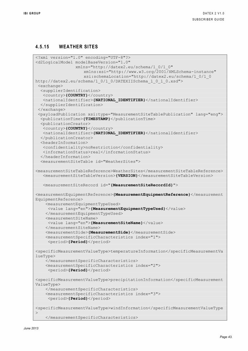
I B I G R O U P D A T E X 2 V 1 . 0
S U B S C R I B E R G U I D E
June 2013
Page 43.
4.5.15 WEATHER SITES
<?xml version="1.0" encoding="UTF-8"?>
<d2LogicalModel modelBaseVersion="1.0"
xmlns="http://datex2.eu/schema/1_0/1_0"
xmlns:xsi="http://www.w3.org/2001/XMLSchema-instance"
xsi:schemaLocation="http://datex2.eu/schema/1_0/1_0
http://datex2.eu/schema/1_0/1_0/DATEXIISchema_1_0_1_0.xsd">
<exchange>
<supplierIdentification>
<country>{COUNTRY}</country>
<nationalIdentifier>{NATIONAL_IDENTIFIER}</nationalIdentifier>
</supplierIdentification>
</exchange>
<payloadPublication xsi:type="MeasurementSiteTablePublication" lang="eng">
<publicationTime>{TIMESTAMP}</publicationTime>
<publicationCreator>
<country>{COUNTRY}</country>
<nationalIdentifier>{NATIONAL_IDENTIFIER}</nationalIdentifier>
</publicationCreator>
<headerInformation>
<confidentiality>noRestriction</confidentiality>
<informationStatus>real</informationStatus>
</headerInformation>
<measurementSiteTable id="WeatherSites">
<measurementSiteTableReference>WeatherSites</measurementSiteTableReference>
<measurementSiteTableVersion>{VERSION}</measurementSiteTableVersion>
<measurementSiteRecord id="{MeasurementSiteRecordId}">
<measurementEquipmentReference>{MeasurementEquipmentReference}</measurement
EquipmentReference>
<measurementEquipmentTypeUsed>
<value lang="en">{MeasurementEquipmentTypeUsed}</value>
</measurementEquipmentTypeUsed>
<measurementSiteName>
<value lang="en">{MeasurementSiteName}</value>
</measurementSiteName>
<measurementSide>{MeasurementSide}</measurementSide>
<measurementSpecificCharacteristics index="1">
<period>{Period}</period>
<specificMeasurementValueType>temperatureInformation</specificMeasurementVa
lueType>
</measurementSpecificCharacteristics>
<measurementSpecificCharacteristics index="2">
<period>{Period}</period>
<specificMeasurementValueType>precipitationInformation</specificMeasurement
ValueType>
</measurementSpecificCharacteristics>
<measurementSpecificCharacteristics index="3">
<period>{Period}</period>
<specificMeasurementValueType>windInformation</specificMeasurementValueType
>
</measurementSpecificCharacteristics>

I B I G R O U P D A T E X 2 V 1 . 0
S U B S C R I B E R G U I D E
June 2013
Page 44.
<measurementSpecificCharacteristics index="4">
<period>{Period}</period>
<specificMeasurementValueType>roadSurfaceConditionInformation</specificMeas
urementValueType>
</measurementSpecificCharacteristics>
<measurementSiteLocation xsi:type="Point">
{TPEG_POINT_LOCATION}
</measurementSiteLocation>
</measurementSiteRecord>
</measurementSiteTable>
</payloadPublication>
</d2LogicalModel>
Token Value Available?
{COUNTRY} This is the country from which the Datex
publication originates.
Yes
{NATIONAL_IDENTIFIER} The identifier that describes the national
organisation from which the Datex
publication originates.
Yes
{TIMESTAMP} The timestamp of the publication. The
format is as the following example: 2008-
06-13T14:55:01+01:00
Yes
{VERSION} The version number of the publication.
Numeric.
Yes
{MeasurementSiteRecordId} A composite created uniquely for each
record to identify it. Usually Alphanumeric.
Yes
{MeasurementEquipmentReference} The reference given to the measurement
equipment at the site. This should be the
same as {MeasurementSiteRecordId}
above.
Yes
{MeasurementEquipmentTypeUsed} The type of equipment used to gather the
raw information from which the data values
are determined.
Yes
{MeasurementSiteName} The name of the measurement site. Yes
{MeasurementSide} Side of the road on which measurements
are acquired, corresponding to the
direction of the road. Uses Datex
DirectionEnum. See the DATEX 2 Data
Model Version 1.0 for details of this
enumeration.
No
{Period} The time elapsed between the beginning
and end of the sampling or measurements
period in seconds.
Yes
{TPEG_POINT_LOCATION} See 4.4.1 Yes. See

I B I G R O U P D A T E X 2 V 1 . 0
S U B S C R I B E R G U I D E
June 2013
Page 45.
XML
example in
section
5.11 for
nested
template
field usage.
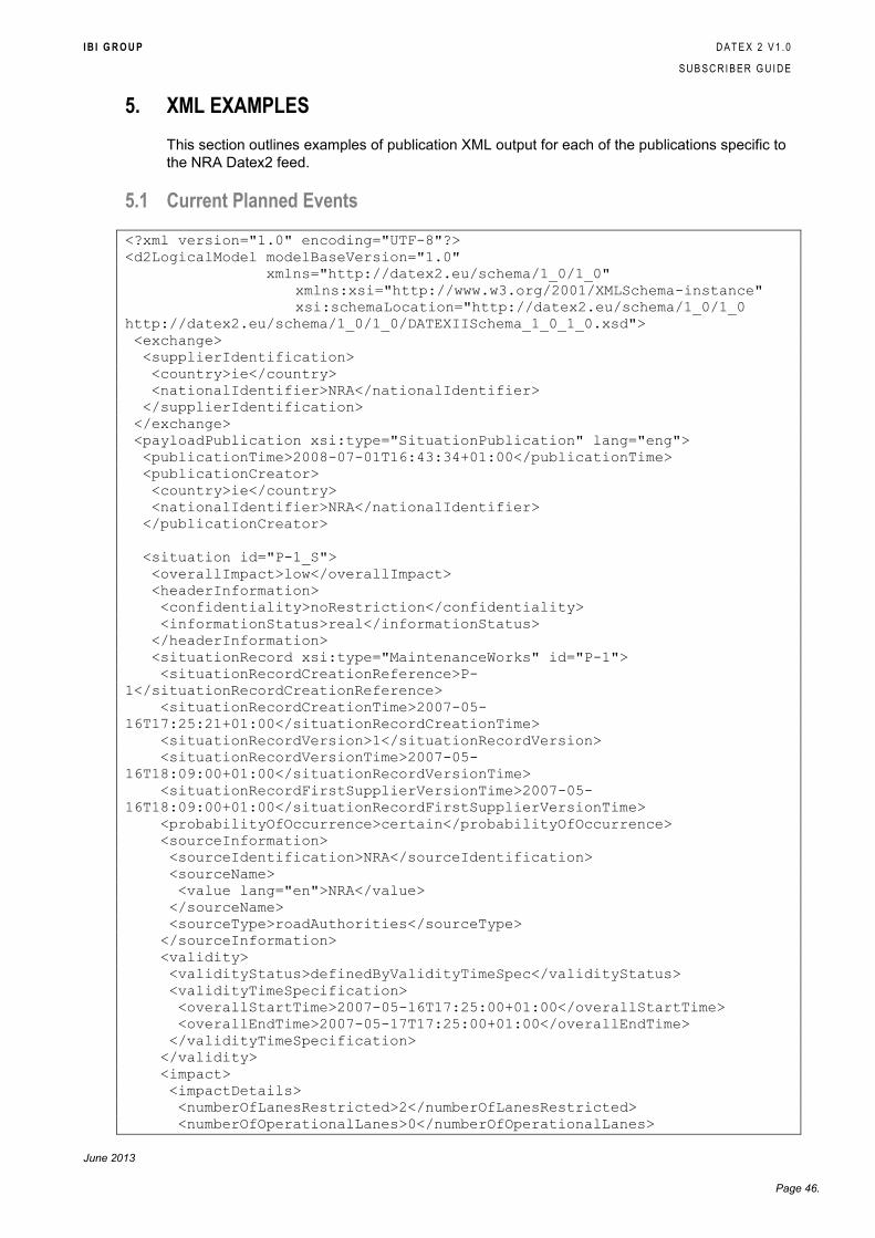
I B I G R O U P D A T E X 2 V 1 . 0
S U B S C R I B E R G U I D E
June 2013
Page 46.
5. XML EXAMPLES
This section outlines examples of publication XML output for each of the publications specific to
the NRA Datex2 feed.
5.1 Current Planned Events
<?xml version="1.0" encoding="UTF-8"?>
<d2LogicalModel modelBaseVersion="1.0"
xmlns="http://datex2.eu/schema/1_0/1_0"
xmlns:xsi="http://www.w3.org/2001/XMLSchema-instance"
xsi:schemaLocation="http://datex2.eu/schema/1_0/1_0
http://datex2.eu/schema/1_0/1_0/DATEXIISchema_1_0_1_0.xsd">
<exchange>
<supplierIdentification>
<country>ie</country>
<nationalIdentifier>NRA</nationalIdentifier>
</supplierIdentification>
</exchange>
<payloadPublication xsi:type="SituationPublication" lang="eng">
<publicationTime>2008-07-01T16:43:34+01:00</publicationTime>
<publicationCreator>
<country>ie</country>
<nationalIdentifier>NRA</nationalIdentifier>
</publicationCreator>
<situation id="P-1_S">
<overallImpact>low</overallImpact>
<headerInformation>
<confidentiality>noRestriction</confidentiality>
<informationStatus>real</informationStatus>
</headerInformation>
<situationRecord xsi:type="MaintenanceWorks" id="P-1">
<situationRecordCreationReference>P-
1</situationRecordCreationReference>
<situationRecordCreationTime>2007-05-
16T17:25:21+01:00</situationRecordCreationTime>
<situationRecordVersion>1</situationRecordVersion>
<situationRecordVersionTime>2007-05-
16T18:09:00+01:00</situationRecordVersionTime>
<situationRecordFirstSupplierVersionTime>2007-05-
16T18:09:00+01:00</situationRecordFirstSupplierVersionTime>
<probabilityOfOccurrence>certain</probabilityOfOccurrence>
<sourceInformation>
<sourceIdentification>NRA</sourceIdentification>
<sourceName>
<value lang="en">NRA</value>
</sourceName>
<sourceType>roadAuthorities</sourceType>
</sourceInformation>
<validity>
<validityStatus>definedByValidityTimeSpec</validityStatus>
<validityTimeSpecification>
<overallStartTime>2007-05-16T17:25:00+01:00</overallStartTime>
<overallEndTime>2007-05-17T17:25:00+01:00</overallEndTime>
</validityTimeSpecification>
</validity>
<impact>
<impactDetails>
<numberOfLanesRestricted>2</numberOfLanesRestricted>
<numberOfOperationalLanes>0</numberOfOperationalLanes>
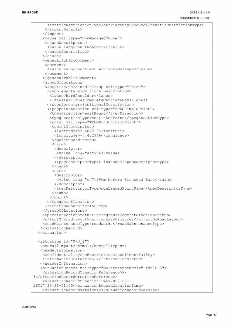
I B I G R O U P D A T E X 2 V 1 . 0
S U B S C R I B E R G U I D E
June 2013
Page 47.
<trafficRestrictionType>carriagewayBlocked</trafficRestrictionType>
</impactDetails>
</impact>
<cause xsi:type="NonManagedCause">
<causeDescription>
<value lang="en">Roadwork</value>
</causeDescription>
</cause>
<generalPublicComment>
<comment>
<value lang="en">Test AdvisoryMessage</value>
</comment>
</generalPublicComment>
<groupOfLocations>
<locationContainedInGroup xsi:type="Point">
<supplementaryPositionalDescription>
<lanes>hardShoulder</lanes>
<lanes>allLanesCompleteCarriageway</lanes>
</supplementaryPositionalDescription>
<tpegpointLocation xsi:type="TPEGSimplePoint">
<tpegDirection>eastBound</tpegDirection>
<tpegLocationType>nonLinkedPoint</tpegLocationType>
<point xsi:type="TPEGNonJunctionPoint">
<pointCoordinates>
<latitude>53.607518</latitude>
<longitude>-7.432946</longitude>
</pointCoordinates>
<name>
<descriptor>
<value lang="en">N4</value>
</descriptor>
<tpegDescriptorType>linkName</tpegDescriptorType>
</name>
<name>
<descriptor>
<value lang="en">29km before Kinnegad East</value>
</descriptor>
<tpegDescriptorType>nonLinkedPointName</tpegDescriptorType>
</name>
</point>
</tpegpointLocation>
</locationContainedInGroup>
</groupOfLocations>
<operatorActionStatus>inProgress</operatorActionStatus>
<effectOnRoadLayout>carriagewayClosures</effectOnRoadLayout>
<roadMaintenanceType>roadworks</roadMaintenanceType>
</situationRecord>
</situation>
<situation id="P-3_S">
<overallImpact>normal</overallImpact>
<headerInformation>
<confidentiality>noRestriction</confidentiality>
<informationStatus>real</informationStatus>
</headerInformation>
<situationRecord xsi:type="MaintenanceWorks" id="P-3">
<situationRecordCreationReference>P-
3</situationRecordCreationReference>
<situationRecordCreationTime>2007-05-
16T17:30:38+01:00</situationRecordCreationTime>
<situationRecordVersion>2</situationRecordVersion>
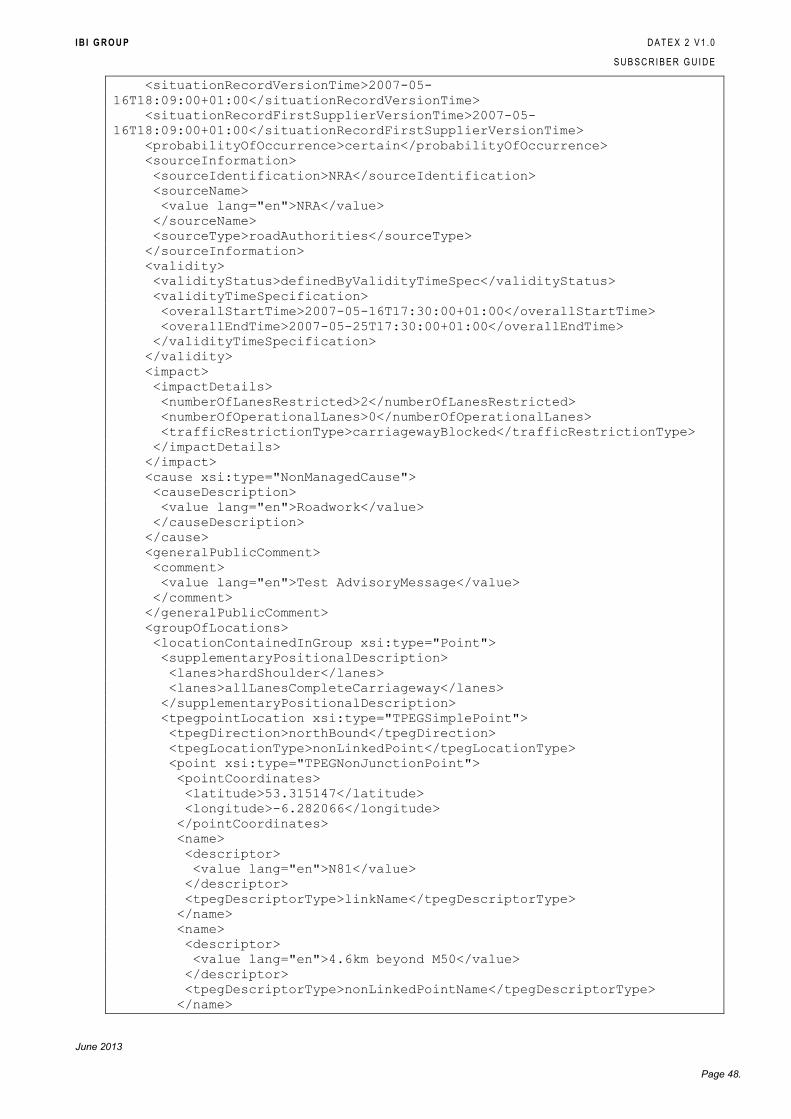
I B I G R O U P D A T E X 2 V 1 . 0
S U B S C R I B E R G U I D E
June 2013
Page 48.
<situationRecordVersionTime>2007-05-
16T18:09:00+01:00</situationRecordVersionTime>
<situationRecordFirstSupplierVersionTime>2007-05-
16T18:09:00+01:00</situationRecordFirstSupplierVersionTime>
<probabilityOfOccurrence>certain</probabilityOfOccurrence>
<sourceInformation>
<sourceIdentification>NRA</sourceIdentification>
<sourceName>
<value lang="en">NRA</value>
</sourceName>
<sourceType>roadAuthorities</sourceType>
</sourceInformation>
<validity>
<validityStatus>definedByValidityTimeSpec</validityStatus>
<validityTimeSpecification>
<overallStartTime>2007-05-16T17:30:00+01:00</overallStartTime>
<overallEndTime>2007-05-25T17:30:00+01:00</overallEndTime>
</validityTimeSpecification>
</validity>
<impact>
<impactDetails>
<numberOfLanesRestricted>2</numberOfLanesRestricted>
<numberOfOperationalLanes>0</numberOfOperationalLanes>
<trafficRestrictionType>carriagewayBlocked</trafficRestrictionType>
</impactDetails>
</impact>
<cause xsi:type="NonManagedCause">
<causeDescription>
<value lang="en">Roadwork</value>
</causeDescription>
</cause>
<generalPublicComment>
<comment>
<value lang="en">Test AdvisoryMessage</value>
</comment>
</generalPublicComment>
<groupOfLocations>
<locationContainedInGroup xsi:type="Point">
<supplementaryPositionalDescription>
<lanes>hardShoulder</lanes>
<lanes>allLanesCompleteCarriageway</lanes>
</supplementaryPositionalDescription>
<tpegpointLocation xsi:type="TPEGSimplePoint">
<tpegDirection>northBound</tpegDirection>
<tpegLocationType>nonLinkedPoint</tpegLocationType>
<point xsi:type="TPEGNonJunctionPoint">
<pointCoordinates>
<latitude>53.315147</latitude>
<longitude>-6.282066</longitude>
</pointCoordinates>
<name>
<descriptor>
<value lang="en">N81</value>
</descriptor>
<tpegDescriptorType>linkName</tpegDescriptorType>
</name>
<name>
<descriptor>
<value lang="en">4.6km beyond M50</value>
</descriptor>
<tpegDescriptorType>nonLinkedPointName</tpegDescriptorType>
</name>
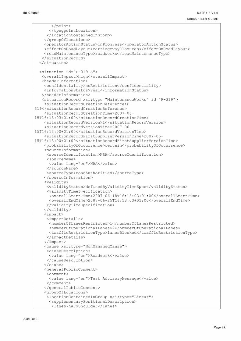
I B I G R O U P D A T E X 2 V 1 . 0
S U B S C R I B E R G U I D E
June 2013
Page 49.
</point>
</tpegpointLocation>
</locationContainedInGroup>
</groupOfLocations>
<operatorActionStatus>inProgress</operatorActionStatus>
<effectOnRoadLayout>carriagewayClosures</effectOnRoadLayout>
<roadMaintenanceType>roadworks</roadMaintenanceType>
</situationRecord>
</situation>
<situation id="P-319_S">
<overallImpact>high</overallImpact>
<headerInformation>
<confidentiality>noRestriction</confidentiality>
<informationStatus>real</informationStatus>
</headerInformation>
<situationRecord xsi:type="MaintenanceWorks" id="P-319">
<situationRecordCreationReference>P-
319</situationRecordCreationReference>
<situationRecordCreationTime>2007-06-
15T16:18:03+01:00</situationRecordCreationTime>
<situationRecordVersion>1</situationRecordVersion>
<situationRecordVersionTime>2007-06-
15T16:13:00+01:00</situationRecordVersionTime>
<situationRecordFirstSupplierVersionTime>2007-06-
15T16:13:00+01:00</situationRecordFirstSupplierVersionTime>
<probabilityOfOccurrence>certain</probabilityOfOccurrence>
<sourceInformation>
<sourceIdentification>NRA</sourceIdentification>
<sourceName>
<value lang="en">NRA</value>
</sourceName>
<sourceType>roadAuthorities</sourceType>
</sourceInformation>
<validity>
<validityStatus>definedByValidityTimeSpec</validityStatus>
<validityTimeSpecification>
<overallStartTime>2007-06-18T16:13:03+01:00</overallStartTime>
<overallEndTime>2007-06-25T16:13:03+01:00</overallEndTime>
</validityTimeSpecification>
</validity>
<impact>
<impactDetails>
<numberOfLanesRestricted>1</numberOfLanesRestricted>
<numberOfOperationalLanes>2</numberOfOperationalLanes>
<trafficRestrictionType>lanesBlocked</trafficRestrictionType>
</impactDetails>
</impact>
<cause xsi:type="NonManagedCause">
<causeDescription>
<value lang="en">Roadwork</value>
</causeDescription>
</cause>
<generalPublicComment>
<comment>
<value lang="en">Test AdvisoryMessage</value>
</comment>
</generalPublicComment>
<groupOfLocations>
<locationContainedInGroup xsi:type="Linear">
<supplementaryPositionalDescription>
<lanes>hardShoulder</lanes>
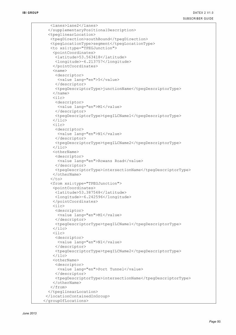
I B I G R O U P D A T E X 2 V 1 . 0
S U B S C R I B E R G U I D E
June 2013
Page 50.
<lanes>lane2</lanes>
</supplementaryPositionalDescription>
<tpeglinearLocation>
<tpegDirection>southBound</tpegDirection>
<tpegLocationType>segment</tpegLocationType>
<to xsi:type="TPEGJunction">
<pointCoordinates>
<latitude>53.563418</latitude>
<longitude>-6.213757</longitude>
</pointCoordinates>
<name>
<descriptor>
<value lang="en">5</value>
</descriptor>
<tpegDescriptorType>junctionName</tpegDescriptorType>
</name>
<ilc>
<descriptor>
<value lang="en">M1</value>
</descriptor>
<tpegDescriptorType>tpegILCName1</tpegDescriptorType>
</ilc>
<ilc>
<descriptor>
<value lang="en">N1</value>
</descriptor>
<tpegDescriptorType>tpegILCName2</tpegDescriptorType>
</ilc>
<otherName>
<descriptor>
<value lang="en">Rowans Road</value>
</descriptor>
<tpegDescriptorType>intersectionName</tpegDescriptorType>
</otherName>
</to>
<from xsi:type="TPEGJunction">
<pointCoordinates>
<latitude>53.387548</latitude>
<longitude>-6.242596</longitude>
</pointCoordinates>
<ilc>
<descriptor>
<value lang="en">M1</value>
</descriptor>
<tpegDescriptorType>tpegILCName1</tpegDescriptorType>
</ilc>
<ilc>
<descriptor>
<value lang="en">N1</value>
</descriptor>
<tpegDescriptorType>tpegILCName2</tpegDescriptorType>
</ilc>
<otherName>
<descriptor>
<value lang="en">Port Tunnel</value>
</descriptor>
<tpegDescriptorType>intersectionName</tpegDescriptorType>
</otherName>
</from>
</tpeglinearLocation>
</locationContainedInGroup>
</groupOfLocations>
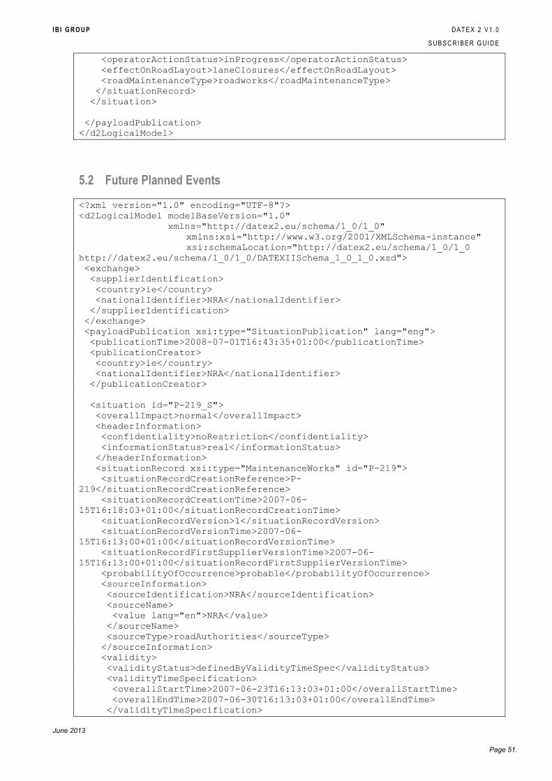
I B I G R O U P D A T E X 2 V 1 . 0
S U B S C R I B E R G U I D E
June 2013
Page 51.
<operatorActionStatus>inProgress</operatorActionStatus>
<effectOnRoadLayout>laneClosures</effectOnRoadLayout>
<roadMaintenanceType>roadworks</roadMaintenanceType>
</situationRecord>
</situation>
</payloadPublication>
</d2LogicalModel>
5.2 Future Planned Events
<?xml version="1.0" encoding="UTF-8"?>
<d2LogicalModel modelBaseVersion="1.0"
xmlns="http://datex2.eu/schema/1_0/1_0"
xmlns:xsi="http://www.w3.org/2001/XMLSchema-instance"
xsi:schemaLocation="http://datex2.eu/schema/1_0/1_0
http://datex2.eu/schema/1_0/1_0/DATEXIISchema_1_0_1_0.xsd">
<exchange>
<supplierIdentification>
<country>ie</country>
<nationalIdentifier>NRA</nationalIdentifier>
</supplierIdentification>
</exchange>
<payloadPublication xsi:type="SituationPublication" lang="eng">
<publicationTime>2008-07-01T16:43:35+01:00</publicationTime>
<publicationCreator>
<country>ie</country>
<nationalIdentifier>NRA</nationalIdentifier>
</publicationCreator>
<situation id="P-219_S">
<overallImpact>normal</overallImpact>
<headerInformation>
<confidentiality>noRestriction</confidentiality>
<informationStatus>real</informationStatus>
</headerInformation>
<situationRecord xsi:type="MaintenanceWorks" id="P-219">
<situationRecordCreationReference>P-
219</situationRecordCreationReference>
<situationRecordCreationTime>2007-06-
15T16:18:03+01:00</situationRecordCreationTime>
<situationRecordVersion>1</situationRecordVersion>
<situationRecordVersionTime>2007-06-
15T16:13:00+01:00</situationRecordVersionTime>
<situationRecordFirstSupplierVersionTime>2007-06-
15T16:13:00+01:00</situationRecordFirstSupplierVersionTime>
<probabilityOfOccurrence>probable</probabilityOfOccurrence>
<sourceInformation>
<sourceIdentification>NRA</sourceIdentification>
<sourceName>
<value lang="en">NRA</value>
</sourceName>
<sourceType>roadAuthorities</sourceType>
</sourceInformation>
<validity>
<validityStatus>definedByValidityTimeSpec</validityStatus>
<validityTimeSpecification>
<overallStartTime>2007-06-23T16:13:03+01:00</overallStartTime>
<overallEndTime>2007-06-30T16:13:03+01:00</overallEndTime>
</validityTimeSpecification>
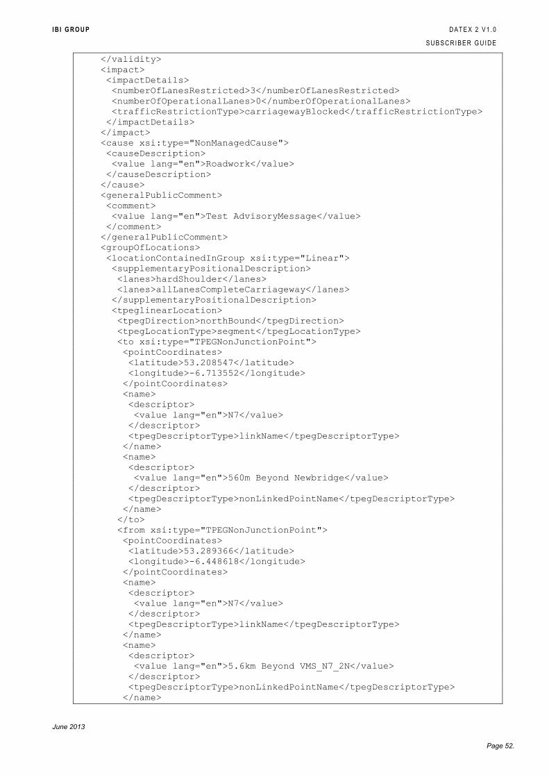
I B I G R O U P D A T E X 2 V 1 . 0
S U B S C R I B E R G U I D E
June 2013
Page 52.
</validity>
<impact>
<impactDetails>
<numberOfLanesRestricted>3</numberOfLanesRestricted>
<numberOfOperationalLanes>0</numberOfOperationalLanes>
<trafficRestrictionType>carriagewayBlocked</trafficRestrictionType>
</impactDetails>
</impact>
<cause xsi:type="NonManagedCause">
<causeDescription>
<value lang="en">Roadwork</value>
</causeDescription>
</cause>
<generalPublicComment>
<comment>
<value lang="en">Test AdvisoryMessage</value>
</comment>
</generalPublicComment>
<groupOfLocations>
<locationContainedInGroup xsi:type="Linear">
<supplementaryPositionalDescription>
<lanes>hardShoulder</lanes>
<lanes>allLanesCompleteCarriageway</lanes>
</supplementaryPositionalDescription>
<tpeglinearLocation>
<tpegDirection>northBound</tpegDirection>
<tpegLocationType>segment</tpegLocationType>
<to xsi:type="TPEGNonJunctionPoint">
<pointCoordinates>
<latitude>53.208547</latitude>
<longitude>-6.713552</longitude>
</pointCoordinates>
<name>
<descriptor>
<value lang="en">N7</value>
</descriptor>
<tpegDescriptorType>linkName</tpegDescriptorType>
</name>
<name>
<descriptor>
<value lang="en">560m Beyond Newbridge</value>
</descriptor>
<tpegDescriptorType>nonLinkedPointName</tpegDescriptorType>
</name>
</to>
<from xsi:type="TPEGNonJunctionPoint">
<pointCoordinates>
<latitude>53.289366</latitude>
<longitude>-6.448618</longitude>
</pointCoordinates>
<name>
<descriptor>
<value lang="en">N7</value>
</descriptor>
<tpegDescriptorType>linkName</tpegDescriptorType>
</name>
<name>
<descriptor>
<value lang="en">5.6km Beyond VMS_N7_2N</value>
</descriptor>
<tpegDescriptorType>nonLinkedPointName</tpegDescriptorType>
</name>
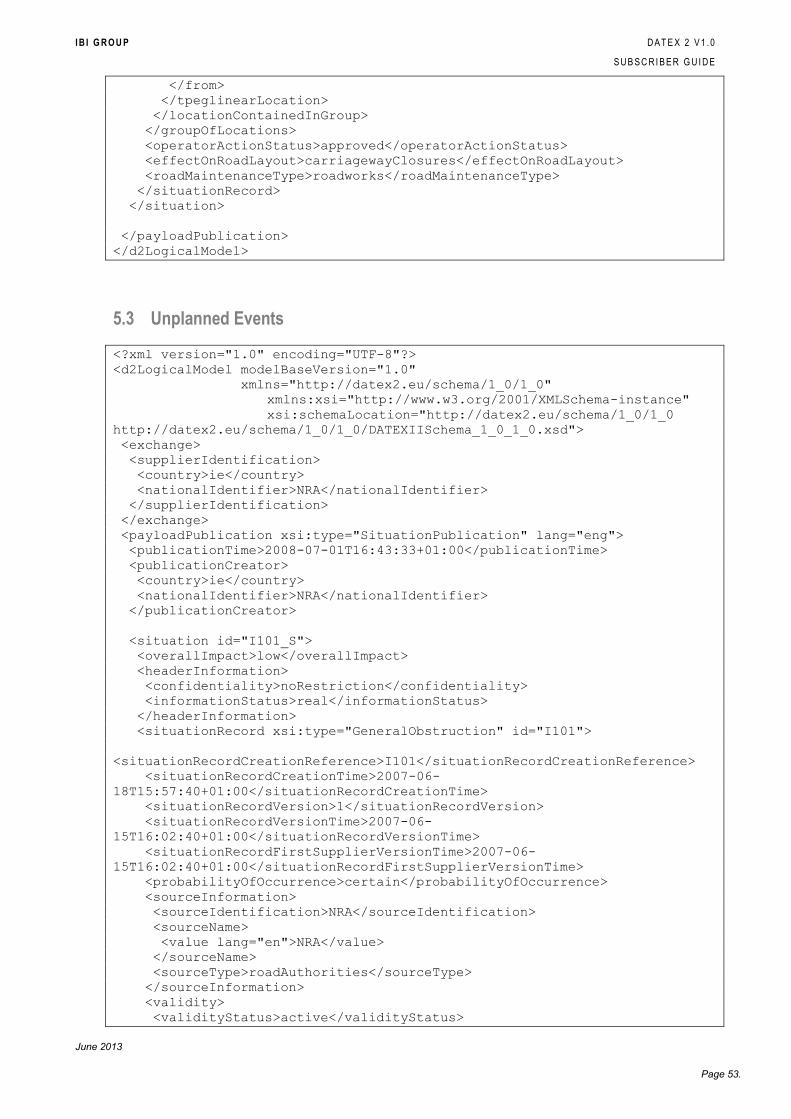
I B I G R O U P D A T E X 2 V 1 . 0
S U B S C R I B E R G U I D E
June 2013
Page 53.
</from>
</tpeglinearLocation>
</locationContainedInGroup>
</groupOfLocations>
<operatorActionStatus>approved</operatorActionStatus>
<effectOnRoadLayout>carriagewayClosures</effectOnRoadLayout>
<roadMaintenanceType>roadworks</roadMaintenanceType>
</situationRecord>
</situation>
</payloadPublication>
</d2LogicalModel>
5.3 Unplanned Events
<?xml version="1.0" encoding="UTF-8"?>
<d2LogicalModel modelBaseVersion="1.0"
xmlns="http://datex2.eu/schema/1_0/1_0"
xmlns:xsi="http://www.w3.org/2001/XMLSchema-instance"
xsi:schemaLocation="http://datex2.eu/schema/1_0/1_0
http://datex2.eu/schema/1_0/1_0/DATEXIISchema_1_0_1_0.xsd">
<exchange>
<supplierIdentification>
<country>ie</country>
<nationalIdentifier>NRA</nationalIdentifier>
</supplierIdentification>
</exchange>
<payloadPublication xsi:type="SituationPublication" lang="eng">
<publicationTime>2008-07-01T16:43:33+01:00</publicationTime>
<publicationCreator>
<country>ie</country>
<nationalIdentifier>NRA</nationalIdentifier>
</publicationCreator>
<situation id="I101_S">
<overallImpact>low</overallImpact>
<headerInformation>
<confidentiality>noRestriction</confidentiality>
<informationStatus>real</informationStatus>
</headerInformation>
<situationRecord xsi:type="GeneralObstruction" id="I101">
<situationRecordCreationReference>I101</situationRecordCreationReference>
<situationRecordCreationTime>2007-06-
18T15:57:40+01:00</situationRecordCreationTime>
<situationRecordVersion>1</situationRecordVersion>
<situationRecordVersionTime>2007-06-
15T16:02:40+01:00</situationRecordVersionTime>
<situationRecordFirstSupplierVersionTime>2007-06-
15T16:02:40+01:00</situationRecordFirstSupplierVersionTime>
<probabilityOfOccurrence>certain</probabilityOfOccurrence>
<sourceInformation>
<sourceIdentification>NRA</sourceIdentification>
<sourceName>
<value lang="en">NRA</value>
</sourceName>
<sourceType>roadAuthorities</sourceType>
</sourceInformation>
<validity>
<validityStatus>active</validityStatus>
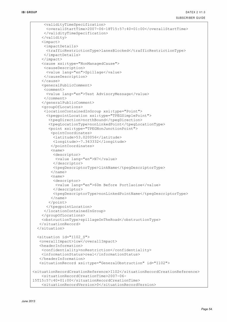
I B I G R O U P D A T E X 2 V 1 . 0
S U B S C R I B E R G U I D E
June 2013
Page 54.
<validityTimeSpecification>
<overallStartTime>2007-06-18T15:57:40+01:00</overallStartTime>
</validityTimeSpecification>
</validity>
<impact>
<impactDetails>
<trafficRestrictionType>lanesBlocked</trafficRestrictionType>
</impactDetails>
</impact>
<cause xsi:type="NonManagedCause">
<causeDescription>
<value lang="en">Spillage</value>
</causeDescription>
</cause>
<generalPublicComment>
<comment>
<value lang="en">Test AdvisoryMessage</value>
</comment>
</generalPublicComment>
<groupOfLocations>
<locationContainedInGroup xsi:type="Point">
<tpegpointLocation xsi:type="TPEGSimplePoint">
<tpegDirection>northBound</tpegDirection>
<tpegLocationType>nonLinkedPoint</tpegLocationType>
<point xsi:type="TPEGNonJunctionPoint">
<pointCoordinates>
<latitude>53.020056</latitude>
<longitude>-7.343332</longitude>
</pointCoordinates>
<name>
<descriptor>
<value lang="en">N7</value>
</descriptor>
<tpegDescriptorType>linkName</tpegDescriptorType>
</name>
<name>
<descriptor>
<value lang="en">60m Before Portlaoise</value>
</descriptor>
<tpegDescriptorType>nonLinkedPointName</tpegDescriptorType>
</name>
</point>
</tpegpointLocation>
</locationContainedInGroup>
</groupOfLocations>
<obstructionType>spillageOnTheRoad</obstructionType>
</situationRecord>
</situation>
<situation id="I102_S">
<overallImpact>low</overallImpact>
<headerInformation>
<confidentiality>noRestriction</confidentiality>
<informationStatus>real</informationStatus>
</headerInformation>
<situationRecord xsi:type="GeneralObstruction" id="I102">
<situationRecordCreationReference>I102</situationRecordCreationReference>
<situationRecordCreationTime>2007-06-
15T15:57:40+01:00</situationRecordCreationTime>
<situationRecordVersion>0</situationRecordVersion>
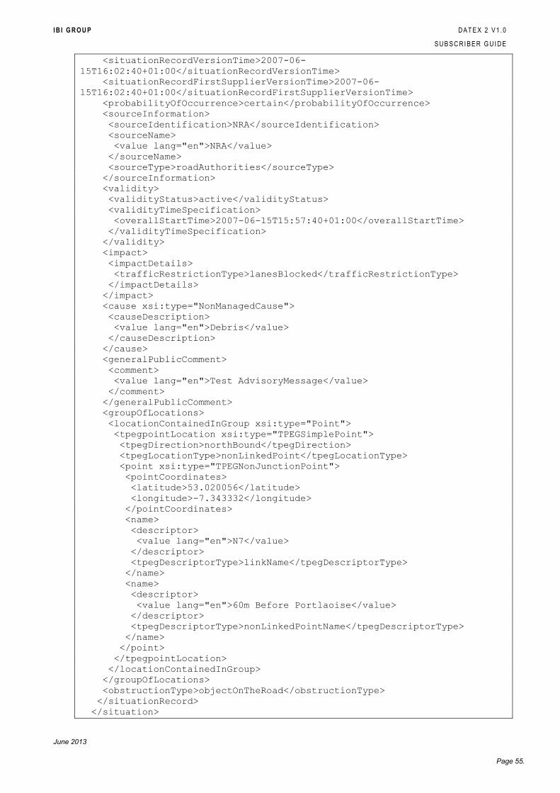
I B I G R O U P D A T E X 2 V 1 . 0
S U B S C R I B E R G U I D E
June 2013
Page 55.
<situationRecordVersionTime>2007-06-
15T16:02:40+01:00</situationRecordVersionTime>
<situationRecordFirstSupplierVersionTime>2007-06-
15T16:02:40+01:00</situationRecordFirstSupplierVersionTime>
<probabilityOfOccurrence>certain</probabilityOfOccurrence>
<sourceInformation>
<sourceIdentification>NRA</sourceIdentification>
<sourceName>
<value lang="en">NRA</value>
</sourceName>
<sourceType>roadAuthorities</sourceType>
</sourceInformation>
<validity>
<validityStatus>active</validityStatus>
<validityTimeSpecification>
<overallStartTime>2007-06-15T15:57:40+01:00</overallStartTime>
</validityTimeSpecification>
</validity>
<impact>
<impactDetails>
<trafficRestrictionType>lanesBlocked</trafficRestrictionType>
</impactDetails>
</impact>
<cause xsi:type="NonManagedCause">
<causeDescription>
<value lang="en">Debris</value>
</causeDescription>
</cause>
<generalPublicComment>
<comment>
<value lang="en">Test AdvisoryMessage</value>
</comment>
</generalPublicComment>
<groupOfLocations>
<locationContainedInGroup xsi:type="Point">
<tpegpointLocation xsi:type="TPEGSimplePoint">
<tpegDirection>northBound</tpegDirection>
<tpegLocationType>nonLinkedPoint</tpegLocationType>
<point xsi:type="TPEGNonJunctionPoint">
<pointCoordinates>
<latitude>53.020056</latitude>
<longitude>-7.343332</longitude>
</pointCoordinates>
<name>
<descriptor>
<value lang="en">N7</value>
</descriptor>
<tpegDescriptorType>linkName</tpegDescriptorType>
</name>
<name>
<descriptor>
<value lang="en">60m Before Portlaoise</value>
</descriptor>
<tpegDescriptorType>nonLinkedPointName</tpegDescriptorType>
</name>
</point>
</tpegpointLocation>
</locationContainedInGroup>
</groupOfLocations>
<obstructionType>objectOnTheRoad</obstructionType>
</situationRecord>
</situation>
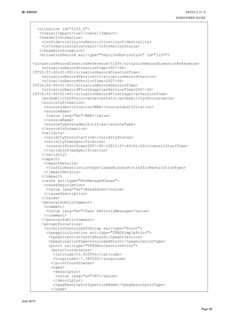
I B I G R O U P D A T E X 2 V 1 . 0
S U B S C R I B E R G U I D E
June 2013
Page 56.
<situation id="I103_S">
<overallImpact>low</overallImpact>
<headerInformation>
<confidentiality>noRestriction</confidentiality>
<informationStatus>real</informationStatus>
</headerInformation>
<situationRecord xsi:type="VehicleObstruction" id="I103">
<situationRecordCreationReference>I103</situationRecordCreationReference>
<situationRecordCreationTime>2007-06-
15T15:57:40+01:00</situationRecordCreationTime>
<situationRecordVersion>1</situationRecordVersion>
<situationRecordVersionTime>2007-06-
15T16:02:40+01:00</situationRecordVersionTime>
<situationRecordFirstSupplierVersionTime>2007-06-
15T16:02:40+01:00</situationRecordFirstSupplierVersionTime>
<probabilityOfOccurrence>certain</probabilityOfOccurrence>
<sourceInformation>
<sourceIdentification>NRA</sourceIdentification>
<sourceName>
<value lang="en">NRA</value>
</sourceName>
<sourceType>roadAuthorities</sourceType>
</sourceInformation>
<validity>
<validityStatus>active</validityStatus>
<validityTimeSpecification>
<overallStartTime>2007-06-15T15:57:40+01:00</overallStartTime>
</validityTimeSpecification>
</validity>
<impact>
<impactDetails>
<trafficRestrictionType>lanesBlocked</trafficRestrictionType>
</impactDetails>
</impact>
<cause xsi:type="NonManagedCause">
<causeDescription>
<value lang="en">Breakdown</value>
</causeDescription>
</cause>
<generalPublicComment>
<comment>
<value lang="en">Test AdvisoryMessage</value>
</comment>
</generalPublicComment>
<groupOfLocations>
<locationContainedInGroup xsi:type="Point">
<tpegpointLocation xsi:type="TPEGSimplePoint">
<tpegDirection>northBound</tpegDirection>
<tpegLocationType>nonLinkedPoint</tpegLocationType>
<point xsi:type="TPEGNonJunctionPoint">
<pointCoordinates>
<latitude>53.020056</latitude>
<longitude>-7.343332</longitude>
</pointCoordinates>
<name>
<descriptor>
<value lang="en">N7</value>
</descriptor>
<tpegDescriptorType>linkName</tpegDescriptorType>
</name>
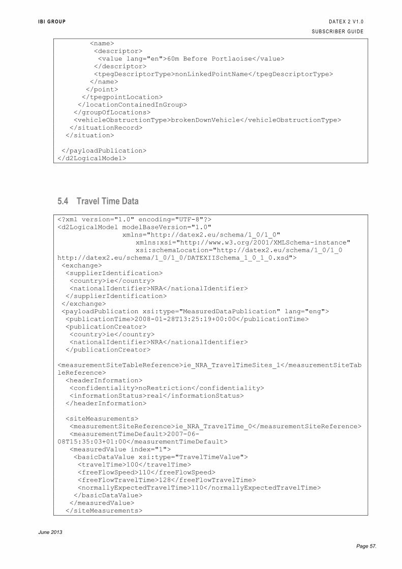
I B I G R O U P D A T E X 2 V 1 . 0
S U B S C R I B E R G U I D E
June 2013
Page 57.
<name>
<descriptor>
<value lang="en">60m Before Portlaoise</value>
</descriptor>
<tpegDescriptorType>nonLinkedPointName</tpegDescriptorType>
</name>
</point>
</tpegpointLocation>
</locationContainedInGroup>
</groupOfLocations>
<vehicleObstructionType>brokenDownVehicle</vehicleObstructionType>
</situationRecord>
</situation>
</payloadPublication>
</d2LogicalModel>
5.4 Travel Time Data
<?xml version="1.0" encoding="UTF-8"?>
<d2LogicalModel modelBaseVersion="1.0"
xmlns="http://datex2.eu/schema/1_0/1_0"
xmlns:xsi="http://www.w3.org/2001/XMLSchema-instance"
xsi:schemaLocation="http://datex2.eu/schema/1_0/1_0
http://datex2.eu/schema/1_0/1_0/DATEXIISchema_1_0_1_0.xsd">
<exchange>
<supplierIdentification>
<country>ie</country>
<nationalIdentifier>NRA</nationalIdentifier>
</supplierIdentification>
</exchange>
<payloadPublication xsi:type="MeasuredDataPublication" lang="eng">
<publicationTime>2008-01-28T13:25:19+00:00</publicationTime>
<publicationCreator>
<country>ie</country>
<nationalIdentifier>NRA</nationalIdentifier>
</publicationCreator>
<measurementSiteTableReference>ie_NRA_TravelTimeSites_1</measurementSiteTab
leReference>
<headerInformation>
<confidentiality>noRestriction</confidentiality>
<informationStatus>real</informationStatus>
</headerInformation>
<siteMeasurements>
<measurementSiteReference>ie_NRA_TravelTime_0</measurementSiteReference>
<measurementTimeDefault>2007-06-
08T15:35:03+01:00</measurementTimeDefault>
<measuredValue index="1">
<basicDataValue xsi:type="TravelTimeValue">
<travelTime>100</travelTime>
<freeFlowSpeed>110</freeFlowSpeed>
<freeFlowTravelTime>128</freeFlowTravelTime>
<normallyExpectedTravelTime>110</normallyExpectedTravelTime>
</basicDataValue>
</measuredValue>
</siteMeasurements>
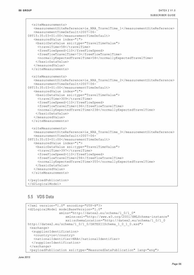
I B I G R O U P D A T E X 2 V 1 . 0
S U B S C R I B E R G U I D E
June 2013
Page 58.
<siteMeasurements>
<measurementSiteReference>ie_NRA_TravelTime_1</measurementSiteReference>
<measurementTimeDefault>2007-06-
08T15:35:03+01:00</measurementTimeDefault>
<measuredValue index="1">
<basicDataValue xsi:type="TravelTimeValue">
<travelTime>58</travelTime>
<freeFlowSpeed>110</freeFlowSpeed>
<freeFlowTravelTime>73</freeFlowTravelTime>
<normallyExpectedTravelTime>58</normallyExpectedTravelTime>
</basicDataValue>
</measuredValue>
</siteMeasurements>
<siteMeasurements>
<measurementSiteReference>ie_NRA_TravelTime_2</measurementSiteReference>
<measurementTimeDefault>2007-06-
08T15:35:03+01:00</measurementTimeDefault>
<measuredValue index="1">
<basicDataValue xsi:type="TravelTimeValue">
<travelTime>309</travelTime>
<freeFlowSpeed>110</freeFlowSpeed>
<freeFlowTravelTime>196</freeFlowTravelTime>
<normallyExpectedTravelTime>238</normallyExpectedTravelTime>
</basicDataValue>
</measuredValue>
</siteMeasurements>
<siteMeasurements>
<measurementSiteReference>ie_NRA_TravelTime_3</measurementSiteReference>
<measurementTimeDefault>2007-06-
08T15:35:03+01:00</measurementTimeDefault>
<measuredValue index="1">
<basicDataValue xsi:type="TravelTimeValue">
<travelTime>397</travelTime>
<freeFlowSpeed>110</freeFlowSpeed>
<freeFlowTravelTime>294</freeFlowTravelTime>
<normallyExpectedTravelTime>355</normallyExpectedTravelTime>
</basicDataValue>
</measuredValue>
</siteMeasurements>
</payloadPublication>
</d2LogicalModel>
5.5 VDS Data
<?xml version="1.0" encoding="UTF-8"?>
<d2LogicalModel modelBaseVersion="1.0"
xmlns="http://datex2.eu/schema/1_0/1_0"
xmlns:xsi="http://www.w3.org/2001/XMLSchema-instance"
xsi:schemaLocation="http://datex2.eu/schema/1_0/1_0
http://datex2.eu/schema/1_0/1_0/DATEXIISchema_1_0_1_0.xsd">
<exchange>
<supplierIdentification>
<country>ie</country>
<nationalIdentifier>NRA</nationalIdentifier>
</supplierIdentification>
</exchange>
<payloadPublication xsi:type="MeasuredDataPublication" lang="eng">
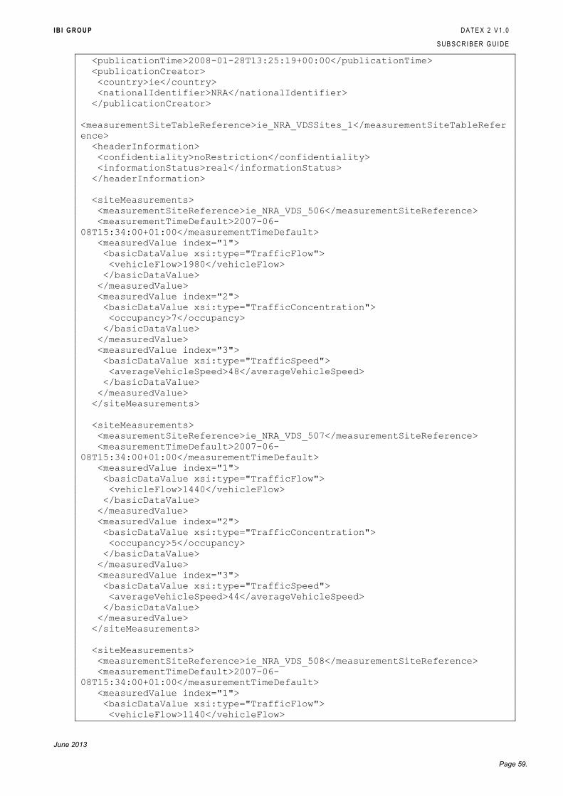
I B I G R O U P D A T E X 2 V 1 . 0
S U B S C R I B E R G U I D E
June 2013
Page 59.
<publicationTime>2008-01-28T13:25:19+00:00</publicationTime>
<publicationCreator>
<country>ie</country>
<nationalIdentifier>NRA</nationalIdentifier>
</publicationCreator>
<measurementSiteTableReference>ie_NRA_VDSSites_1</measurementSiteTableRefer
ence>
<headerInformation>
<confidentiality>noRestriction</confidentiality>
<informationStatus>real</informationStatus>
</headerInformation>
<siteMeasurements>
<measurementSiteReference>ie_NRA_VDS_506</measurementSiteReference>
<measurementTimeDefault>2007-06-
08T15:34:00+01:00</measurementTimeDefault>
<measuredValue index="1">
<basicDataValue xsi:type="TrafficFlow">
<vehicleFlow>1980</vehicleFlow>
</basicDataValue>
</measuredValue>
<measuredValue index="2">
<basicDataValue xsi:type="TrafficConcentration">
<occupancy>7</occupancy>
</basicDataValue>
</measuredValue>
<measuredValue index="3">
<basicDataValue xsi:type="TrafficSpeed">
<averageVehicleSpeed>48</averageVehicleSpeed>
</basicDataValue>
</measuredValue>
</siteMeasurements>
<siteMeasurements>
<measurementSiteReference>ie_NRA_VDS_507</measurementSiteReference>
<measurementTimeDefault>2007-06-
08T15:34:00+01:00</measurementTimeDefault>
<measuredValue index="1">
<basicDataValue xsi:type="TrafficFlow">
<vehicleFlow>1440</vehicleFlow>
</basicDataValue>
</measuredValue>
<measuredValue index="2">
<basicDataValue xsi:type="TrafficConcentration">
<occupancy>5</occupancy>
</basicDataValue>
</measuredValue>
<measuredValue index="3">
<basicDataValue xsi:type="TrafficSpeed">
<averageVehicleSpeed>44</averageVehicleSpeed>
</basicDataValue>
</measuredValue>
</siteMeasurements>
<siteMeasurements>
<measurementSiteReference>ie_NRA_VDS_508</measurementSiteReference>
<measurementTimeDefault>2007-06-
08T15:34:00+01:00</measurementTimeDefault>
<measuredValue index="1">
<basicDataValue xsi:type="TrafficFlow">
<vehicleFlow>1140</vehicleFlow>
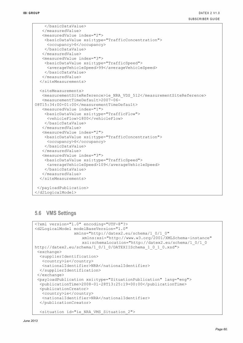
I B I G R O U P D A T E X 2 V 1 . 0
S U B S C R I B E R G U I D E
June 2013
Page 60.
</basicDataValue>
</measuredValue>
<measuredValue index="2">
<basicDataValue xsi:type="TrafficConcentration">
<occupancy>6</occupancy>
</basicDataValue>
</measuredValue>
<measuredValue index="3">
<basicDataValue xsi:type="TrafficSpeed">
<averageVehicleSpeed>99</averageVehicleSpeed>
</basicDataValue>
</measuredValue>
</siteMeasurements>
<siteMeasurements>
<measurementSiteReference>ie_NRA_VDS_512</measurementSiteReference>
<measurementTimeDefault>2007-06-
08T15:34:00+01:00</measurementTimeDefault>
<measuredValue index="1">
<basicDataValue xsi:type="TrafficFlow">
<vehicleFlow>1800</vehicleFlow>
</basicDataValue>
</measuredValue>
<measuredValue index="2">
<basicDataValue xsi:type="TrafficConcentration">
<occupancy>6</occupancy>
</basicDataValue>
</measuredValue>
<measuredValue index="3">
<basicDataValue xsi:type="TrafficSpeed">
<averageVehicleSpeed>109</averageVehicleSpeed>
</basicDataValue>
</measuredValue>
</siteMeasurements>
</payloadPublication>
</d2LogicalModel>
5.6 VMS Settings
<?xml version="1.0" encoding="UTF-8"?>
<d2LogicalModel modelBaseVersion="1.0"
xmlns="http://datex2.eu/schema/1_0/1_0"
xmlns:xsi="http://www.w3.org/2001/XMLSchema-instance"
xsi:schemaLocation="http://datex2.eu/schema/1_0/1_0
http://datex2.eu/schema/1_0/1_0/DATEXIISchema_1_0_1_0.xsd">
<exchange>
<supplierIdentification>
<country>ie</country>
<nationalIdentifier>NRA</nationalIdentifier>
</supplierIdentification>
</exchange>
<payloadPublication xsi:type="SituationPublication" lang="eng">
<publicationTime>2008-01-28T13:25:19+00:00</publicationTime>
<publicationCreator>
<country>ie</country>
<nationalIdentifier>NRA</nationalIdentifier>
</publicationCreator>
<situation id="ie_NRA_VMS_Situation_2">
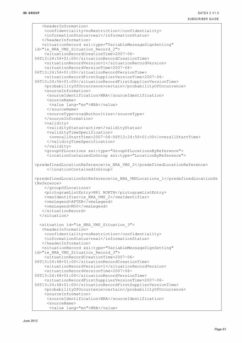
I B I G R O U P D A T E X 2 V 1 . 0
S U B S C R I B E R G U I D E
June 2013
Page 61.
<headerInformation>
<confidentiality>noRestriction</confidentiality>
<informationStatus>real</informationStatus>
</headerInformation>
<situationRecord xsi:type="VariableMessageSignSetting"
id="ie_NRA_VMS_Situation_Record_2">
<situationRecordCreationTime>2007-06-
06T13:24:56+01:00</situationRecordCreationTime>
<situationRecordVersion>1</situationRecordVersion>
<situationRecordVersionTime>2007-06-
06T13:24:56+01:00</situationRecordVersionTime>
<situationRecordFirstSupplierVersionTime>2007-06-
06T13:24:56+01:00</situationRecordFirstSupplierVersionTime>
<probabilityOfOccurrence>certain</probabilityOfOccurrence>
<sourceInformation>
<sourceIdentification>NRA</sourceIdentification>
<sourceName>
<value lang="en">NRA</value>
</sourceName>
<sourceType>roadAuthorities</sourceType>
</sourceInformation>
<validity>
<validityStatus>active</validityStatus>
<validityTimeSpecification>
<overallStartTime>2007-06-06T13:24:56+01:00</overallStartTime>
</validityTimeSpecification>
</validity>
<groupOfLocations xsi:type="GroupOfLocationsByReference">
<locationContainedInGroup xsi:type="LocationByReference">
<predefinedLocationReference>ie_NRA_VMS_2</predefinedLocationReference>
</locationContainedInGroup>
<predefinedLocationSetReference>ie_NRA_VMSLocations_1</predefinedLocationSe
tReference>
</groupOfLocations>
<pictogramListEntry>N81 NORTH</pictogramListEntry>
<vmsIdentifier>ie_NRA_VMS_2</vmsIdentifier>
<vmsLegend>AFTER</vmsLegend>
<vmsLegend>M50</vmsLegend>
</situationRecord>
</situation>
<situation id="ie_NRA_VMS_Situation_3">
<headerInformation>
<confidentiality>noRestriction</confidentiality>
<informationStatus>real</informationStatus>
</headerInformation>
<situationRecord xsi:type="VariableMessageSignSetting"
id="ie_NRA_VMS_Situation_Record_3">
<situationRecordCreationTime>2007-06-
06T13:24:48+01:00</situationRecordCreationTime>
<situationRecordVersion>1</situationRecordVersion>
<situationRecordVersionTime>2007-06-
06T13:24:48+01:00</situationRecordVersionTime>
<situationRecordFirstSupplierVersionTime>2007-06-
06T13:24:48+01:00</situationRecordFirstSupplierVersionTime>
<probabilityOfOccurrence>certain</probabilityOfOccurrence>
<sourceInformation>
<sourceIdentification>NRA</sourceIdentification>
<sourceName>
<value lang="en">NRA</value>
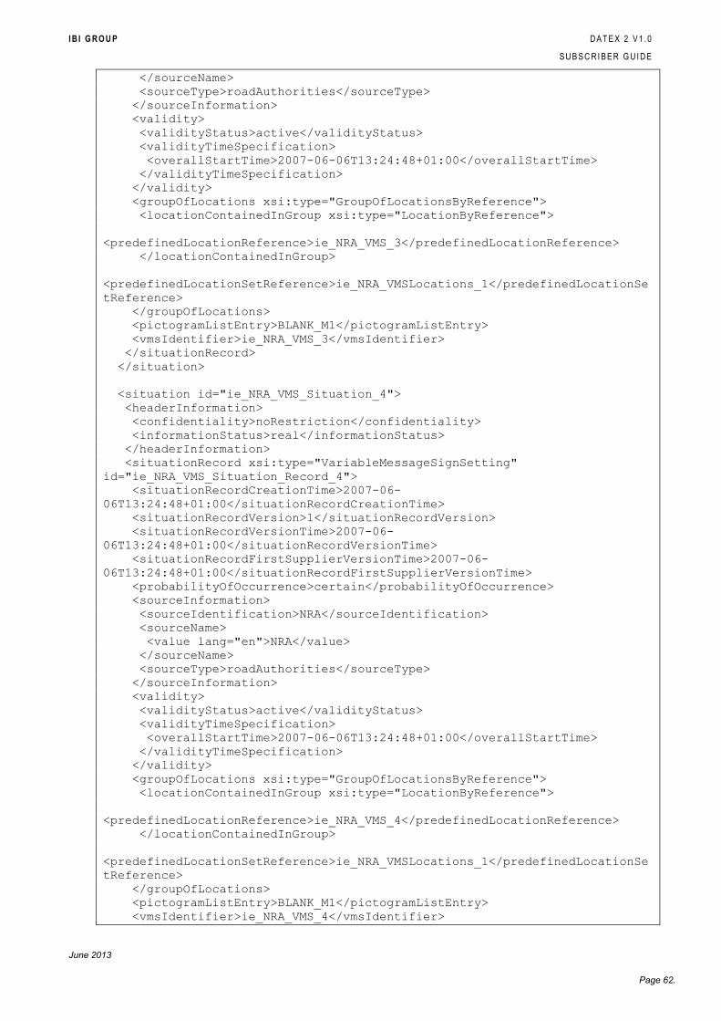
I B I G R O U P D A T E X 2 V 1 . 0
S U B S C R I B E R G U I D E
June 2013
Page 62.
</sourceName>
<sourceType>roadAuthorities</sourceType>
</sourceInformation>
<validity>
<validityStatus>active</validityStatus>
<validityTimeSpecification>
<overallStartTime>2007-06-06T13:24:48+01:00</overallStartTime>
</validityTimeSpecification>
</validity>
<groupOfLocations xsi:type="GroupOfLocationsByReference">
<locationContainedInGroup xsi:type="LocationByReference">
<predefinedLocationReference>ie_NRA_VMS_3</predefinedLocationReference>
</locationContainedInGroup>
<predefinedLocationSetReference>ie_NRA_VMSLocations_1</predefinedLocationSe
tReference>
</groupOfLocations>
<pictogramListEntry>BLANK_M1</pictogramListEntry>
<vmsIdentifier>ie_NRA_VMS_3</vmsIdentifier>
</situationRecord>
</situation>
<situation id="ie_NRA_VMS_Situation_4">
<headerInformation>
<confidentiality>noRestriction</confidentiality>
<informationStatus>real</informationStatus>
</headerInformation>
<situationRecord xsi:type="VariableMessageSignSetting"
id="ie_NRA_VMS_Situation_Record_4">
<situationRecordCreationTime>2007-06-
06T13:24:48+01:00</situationRecordCreationTime>
<situationRecordVersion>1</situationRecordVersion>
<situationRecordVersionTime>2007-06-
06T13:24:48+01:00</situationRecordVersionTime>
<situationRecordFirstSupplierVersionTime>2007-06-
06T13:24:48+01:00</situationRecordFirstSupplierVersionTime>
<probabilityOfOccurrence>certain</probabilityOfOccurrence>
<sourceInformation>
<sourceIdentification>NRA</sourceIdentification>
<sourceName>
<value lang="en">NRA</value>
</sourceName>
<sourceType>roadAuthorities</sourceType>
</sourceInformation>
<validity>
<validityStatus>active</validityStatus>
<validityTimeSpecification>
<overallStartTime>2007-06-06T13:24:48+01:00</overallStartTime>
</validityTimeSpecification>
</validity>
<groupOfLocations xsi:type="GroupOfLocationsByReference">
<locationContainedInGroup xsi:type="LocationByReference">
<predefinedLocationReference>ie_NRA_VMS_4</predefinedLocationReference>
</locationContainedInGroup>
<predefinedLocationSetReference>ie_NRA_VMSLocations_1</predefinedLocationSe
tReference>
</groupOfLocations>
<pictogramListEntry>BLANK_M1</pictogramListEntry>
<vmsIdentifier>ie_NRA_VMS_4</vmsIdentifier>
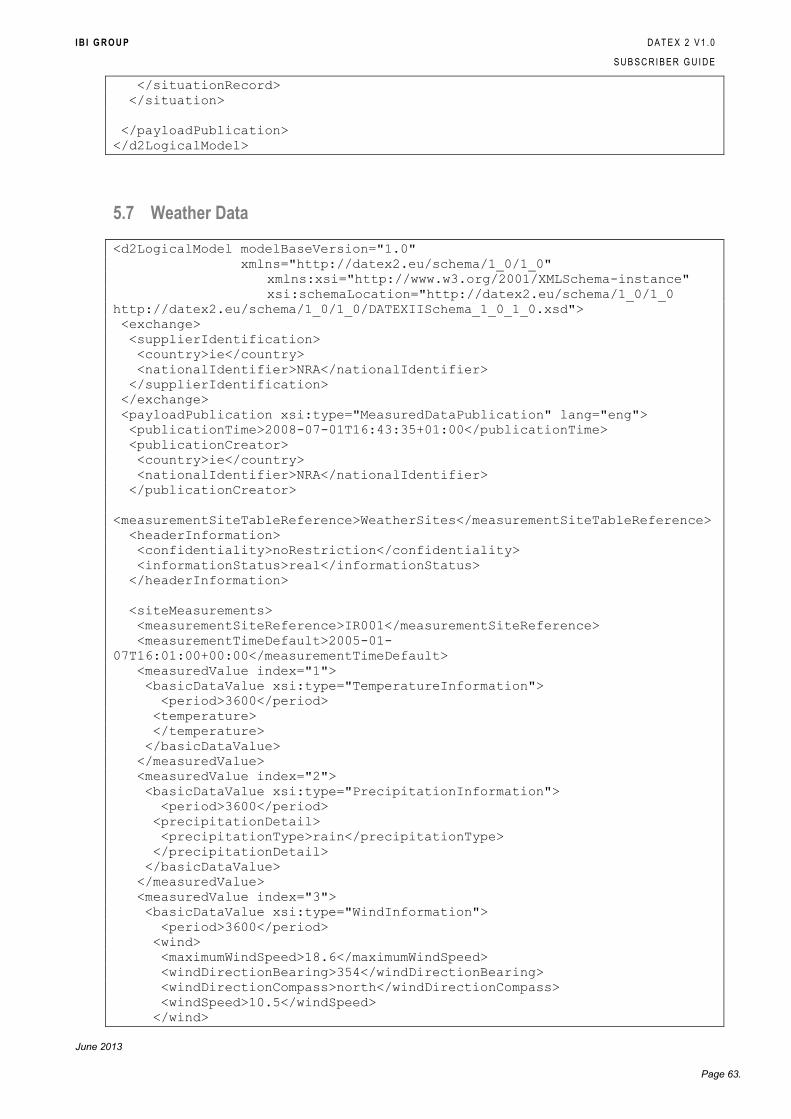
I B I G R O U P D A T E X 2 V 1 . 0
S U B S C R I B E R G U I D E
June 2013
Page 63.
</situationRecord>
</situation>
</payloadPublication>
</d2LogicalModel>
5.7 Weather Data
<d2LogicalModel modelBaseVersion="1.0"
xmlns="http://datex2.eu/schema/1_0/1_0"
xmlns:xsi="http://www.w3.org/2001/XMLSchema-instance"
xsi:schemaLocation="http://datex2.eu/schema/1_0/1_0
http://datex2.eu/schema/1_0/1_0/DATEXIISchema_1_0_1_0.xsd">
<exchange>
<supplierIdentification>
<country>ie</country>
<nationalIdentifier>NRA</nationalIdentifier>
</supplierIdentification>
</exchange>
<payloadPublication xsi:type="MeasuredDataPublication" lang="eng">
<publicationTime>2008-07-01T16:43:35+01:00</publicationTime>
<publicationCreator>
<country>ie</country>
<nationalIdentifier>NRA</nationalIdentifier>
</publicationCreator>
<measurementSiteTableReference>WeatherSites</measurementSiteTableReference>
<headerInformation>
<confidentiality>noRestriction</confidentiality>
<informationStatus>real</informationStatus>
</headerInformation>
<siteMeasurements>
<measurementSiteReference>IR001</measurementSiteReference>
<measurementTimeDefault>2005-01-
07T16:01:00+00:00</measurementTimeDefault>
<measuredValue index="1">
<basicDataValue xsi:type="TemperatureInformation">
<period>3600</period>
<temperature>
</temperature>
</basicDataValue>
</measuredValue>
<measuredValue index="2">
<basicDataValue xsi:type="PrecipitationInformation">
<period>3600</period>
<precipitationDetail>
<precipitationType>rain</precipitationType>
</precipitationDetail>
</basicDataValue>
</measuredValue>
<measuredValue index="3">
<basicDataValue xsi:type="WindInformation">
<period>3600</period>
<wind>
<maximumWindSpeed>18.6</maximumWindSpeed>
<windDirectionBearing>354</windDirectionBearing>
<windDirectionCompass>north</windDirectionCompass>
<windSpeed>10.5</windSpeed>
</wind>
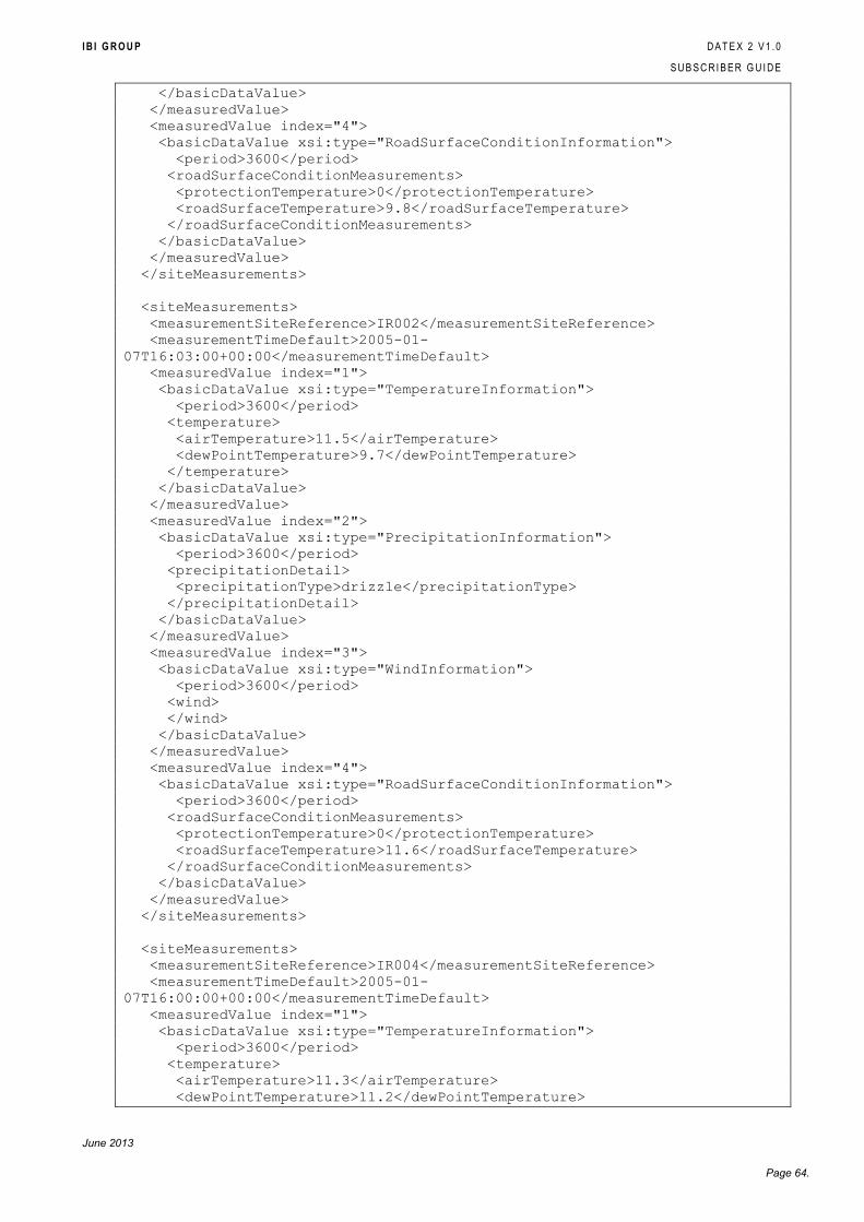
I B I G R O U P D A T E X 2 V 1 . 0
S U B S C R I B E R G U I D E
June 2013
Page 64.
</basicDataValue>
</measuredValue>
<measuredValue index="4">
<basicDataValue xsi:type="RoadSurfaceConditionInformation">
<period>3600</period>
<roadSurfaceConditionMeasurements>
<protectionTemperature>0</protectionTemperature>
<roadSurfaceTemperature>9.8</roadSurfaceTemperature>
</roadSurfaceConditionMeasurements>
</basicDataValue>
</measuredValue>
</siteMeasurements>
<siteMeasurements>
<measurementSiteReference>IR002</measurementSiteReference>
<measurementTimeDefault>2005-01-
07T16:03:00+00:00</measurementTimeDefault>
<measuredValue index="1">
<basicDataValue xsi:type="TemperatureInformation">
<period>3600</period>
<temperature>
<airTemperature>11.5</airTemperature>
<dewPointTemperature>9.7</dewPointTemperature>
</temperature>
</basicDataValue>
</measuredValue>
<measuredValue index="2">
<basicDataValue xsi:type="PrecipitationInformation">
<period>3600</period>
<precipitationDetail>
<precipitationType>drizzle</precipitationType>
</precipitationDetail>
</basicDataValue>
</measuredValue>
<measuredValue index="3">
<basicDataValue xsi:type="WindInformation">
<period>3600</period>
<wind>
</wind>
</basicDataValue>
</measuredValue>
<measuredValue index="4">
<basicDataValue xsi:type="RoadSurfaceConditionInformation">
<period>3600</period>
<roadSurfaceConditionMeasurements>
<protectionTemperature>0</protectionTemperature>
<roadSurfaceTemperature>11.6</roadSurfaceTemperature>
</roadSurfaceConditionMeasurements>
</basicDataValue>
</measuredValue>
</siteMeasurements>
<siteMeasurements>
<measurementSiteReference>IR004</measurementSiteReference>
<measurementTimeDefault>2005-01-
07T16:00:00+00:00</measurementTimeDefault>
<measuredValue index="1">
<basicDataValue xsi:type="TemperatureInformation">
<period>3600</period>
<temperature>
<airTemperature>11.3</airTemperature>
<dewPointTemperature>11.2</dewPointTemperature>
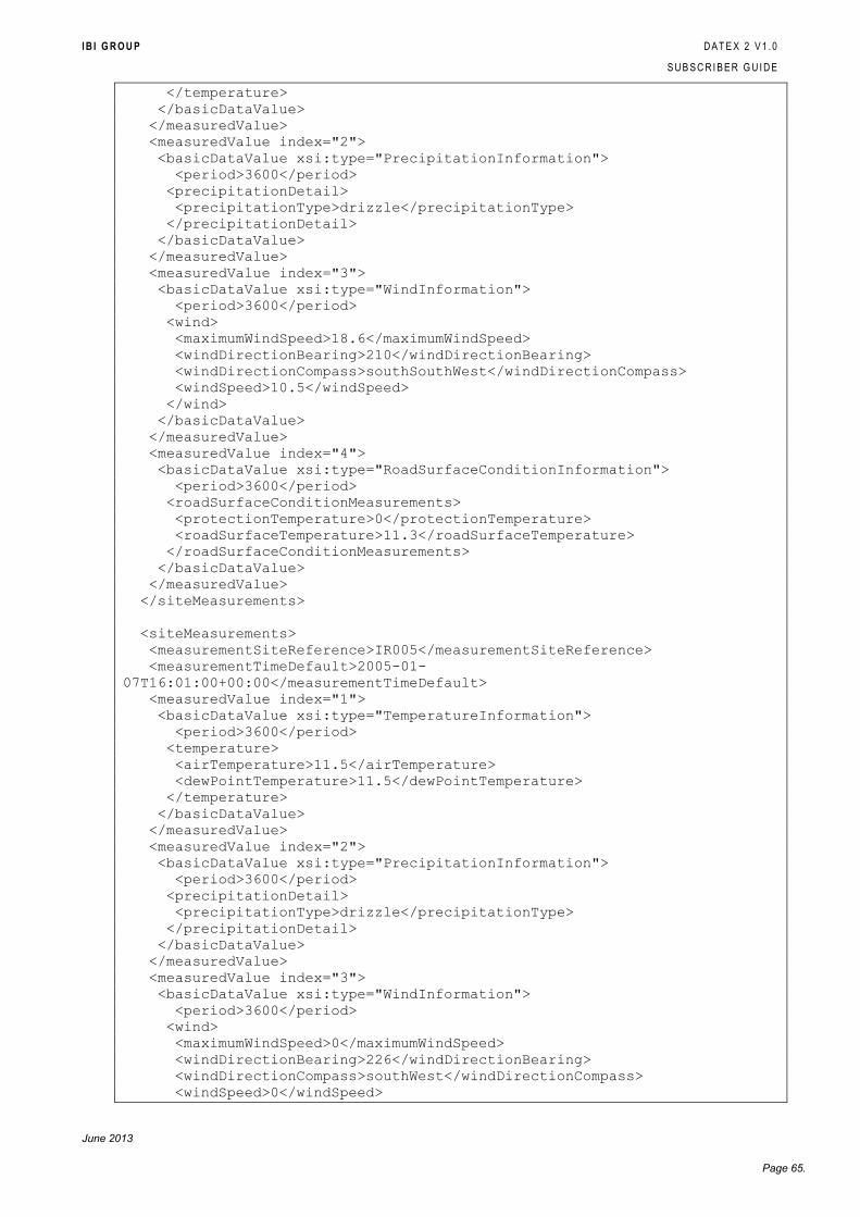
I B I G R O U P D A T E X 2 V 1 . 0
S U B S C R I B E R G U I D E
June 2013
Page 65.
</temperature>
</basicDataValue>
</measuredValue>
<measuredValue index="2">
<basicDataValue xsi:type="PrecipitationInformation">
<period>3600</period>
<precipitationDetail>
<precipitationType>drizzle</precipitationType>
</precipitationDetail>
</basicDataValue>
</measuredValue>
<measuredValue index="3">
<basicDataValue xsi:type="WindInformation">
<period>3600</period>
<wind>
<maximumWindSpeed>18.6</maximumWindSpeed>
<windDirectionBearing>210</windDirectionBearing>
<windDirectionCompass>southSouthWest</windDirectionCompass>
<windSpeed>10.5</windSpeed>
</wind>
</basicDataValue>
</measuredValue>
<measuredValue index="4">
<basicDataValue xsi:type="RoadSurfaceConditionInformation">
<period>3600</period>
<roadSurfaceConditionMeasurements>
<protectionTemperature>0</protectionTemperature>
<roadSurfaceTemperature>11.3</roadSurfaceTemperature>
</roadSurfaceConditionMeasurements>
</basicDataValue>
</measuredValue>
</siteMeasurements>
<siteMeasurements>
<measurementSiteReference>IR005</measurementSiteReference>
<measurementTimeDefault>2005-01-
07T16:01:00+00:00</measurementTimeDefault>
<measuredValue index="1">
<basicDataValue xsi:type="TemperatureInformation">
<period>3600</period>
<temperature>
<airTemperature>11.5</airTemperature>
<dewPointTemperature>11.5</dewPointTemperature>
</temperature>
</basicDataValue>
</measuredValue>
<measuredValue index="2">
<basicDataValue xsi:type="PrecipitationInformation">
<period>3600</period>
<precipitationDetail>
<precipitationType>drizzle</precipitationType>
</precipitationDetail>
</basicDataValue>
</measuredValue>
<measuredValue index="3">
<basicDataValue xsi:type="WindInformation">
<period>3600</period>
<wind>
<maximumWindSpeed>0</maximumWindSpeed>
<windDirectionBearing>226</windDirectionBearing>
<windDirectionCompass>southWest</windDirectionCompass>
<windSpeed>0</windSpeed>
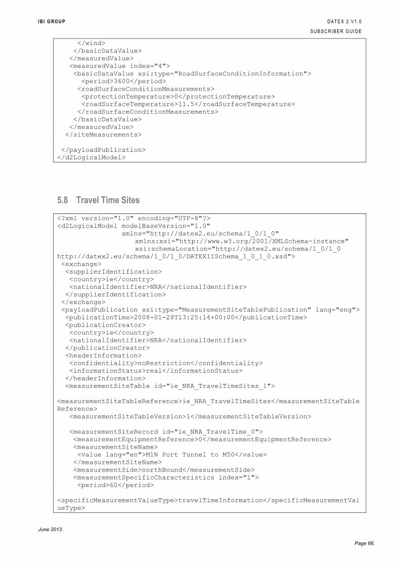
I B I G R O U P D A T E X 2 V 1 . 0
S U B S C R I B E R G U I D E
June 2013
Page 66.
</wind>
</basicDataValue>
</measuredValue>
<measuredValue index="4">
<basicDataValue xsi:type="RoadSurfaceConditionInformation">
<period>3600</period>
<roadSurfaceConditionMeasurements>
<protectionTemperature>0</protectionTemperature>
<roadSurfaceTemperature>11.5</roadSurfaceTemperature>
</roadSurfaceConditionMeasurements>
</basicDataValue>
</measuredValue>
</siteMeasurements>
</payloadPublication>
</d2LogicalModel>
5.8 Travel Time Sites
<?xml version="1.0" encoding="UTF-8"?>
<d2LogicalModel modelBaseVersion="1.0"
xmlns="http://datex2.eu/schema/1_0/1_0"
xmlns:xsi="http://www.w3.org/2001/XMLSchema-instance"
xsi:schemaLocation="http://datex2.eu/schema/1_0/1_0
http://datex2.eu/schema/1_0/1_0/DATEXIISchema_1_0_1_0.xsd">
<exchange>
<supplierIdentification>
<country>ie</country>
<nationalIdentifier>NRA</nationalIdentifier>
</supplierIdentification>
</exchange>
<payloadPublication xsi:type="MeasurementSiteTablePublication" lang="eng">
<publicationTime>2008-01-28T13:25:14+00:00</publicationTime>
<publicationCreator>
<country>ie</country>
<nationalIdentifier>NRA</nationalIdentifier>
</publicationCreator>
<headerInformation>
<confidentiality>noRestriction</confidentiality>
<informationStatus>real</informationStatus>
</headerInformation>
<measurementSiteTable id="ie_NRA_TravelTimeSites_1">
<measurementSiteTableReference>ie_NRA_TravelTimeSites</measurementSiteTable
Reference>
<measurementSiteTableVersion>1</measurementSiteTableVersion>
<measurementSiteRecord id="ie_NRA_TravelTime_0">
<measurementEquipmentReference>0</measurementEquipmentReference>
<measurementSiteName>
<value lang="en">M1N Port Tunnel to M50</value>
</measurementSiteName>
<measurementSide>northBound</measurementSide>
<measurementSpecificCharacteristics index="1">
<period>60</period>
<specificMeasurementValueType>travelTimeInformation</specificMeasurementVal
ueType>
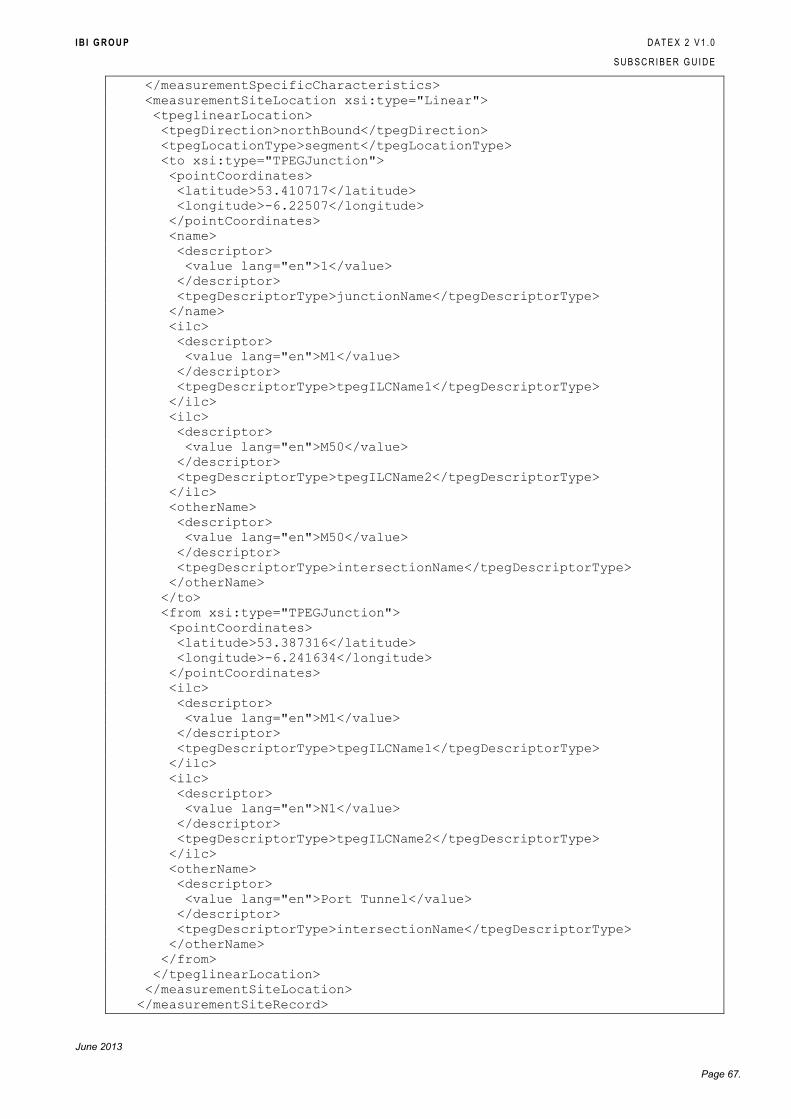
I B I G R O U P D A T E X 2 V 1 . 0
S U B S C R I B E R G U I D E
June 2013
Page 67.
</measurementSpecificCharacteristics>
<measurementSiteLocation xsi:type="Linear">
<tpeglinearLocation>
<tpegDirection>northBound</tpegDirection>
<tpegLocationType>segment</tpegLocationType>
<to xsi:type="TPEGJunction">
<pointCoordinates>
<latitude>53.410717</latitude>
<longitude>-6.22507</longitude>
</pointCoordinates>
<name>
<descriptor>
<value lang="en">1</value>
</descriptor>
<tpegDescriptorType>junctionName</tpegDescriptorType>
</name>
<ilc>
<descriptor>
<value lang="en">M1</value>
</descriptor>
<tpegDescriptorType>tpegILCName1</tpegDescriptorType>
</ilc>
<ilc>
<descriptor>
<value lang="en">M50</value>
</descriptor>
<tpegDescriptorType>tpegILCName2</tpegDescriptorType>
</ilc>
<otherName>
<descriptor>
<value lang="en">M50</value>
</descriptor>
<tpegDescriptorType>intersectionName</tpegDescriptorType>
</otherName>
</to>
<from xsi:type="TPEGJunction">
<pointCoordinates>
<latitude>53.387316</latitude>
<longitude>-6.241634</longitude>
</pointCoordinates>
<ilc>
<descriptor>
<value lang="en">M1</value>
</descriptor>
<tpegDescriptorType>tpegILCName1</tpegDescriptorType>
</ilc>
<ilc>
<descriptor>
<value lang="en">N1</value>
</descriptor>
<tpegDescriptorType>tpegILCName2</tpegDescriptorType>
</ilc>
<otherName>
<descriptor>
<value lang="en">Port Tunnel</value>
</descriptor>
<tpegDescriptorType>intersectionName</tpegDescriptorType>
</otherName>
</from>
</tpeglinearLocation>
</measurementSiteLocation>
</measurementSiteRecord>
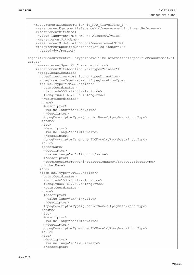
I B I G R O U P D A T E X 2 V 1 . 0
S U B S C R I B E R G U I D E
June 2013
Page 68.
<measurementSiteRecord id="ie_NRA_TravelTime_1">
<measurementEquipmentReference>1</measurementEquipmentReference>
<measurementSiteName>
<value lang="en">M1N M50 to Airport</value>
</measurementSiteName>
<measurementSide>northBound</measurementSide>
<measurementSpecificCharacteristics index="1">
<period>60</period>
<specificMeasurementValueType>travelTimeInformation</specificMeasurementVal
ueType>
</measurementSpecificCharacteristics>
<measurementSiteLocation xsi:type="Linear">
<tpeglinearLocation>
<tpegDirection>northBound</tpegDirection>
<tpegLocationType>segment</tpegLocationType>
<to xsi:type="TPEGJunction">
<pointCoordinates>
<latitude>53.424758</latitude>
<longitude>-6.218045</longitude>
</pointCoordinates>
<name>
<descriptor>
<value lang="en">2</value>
</descriptor>
<tpegDescriptorType>junctionName</tpegDescriptorType>
</name>
<ilc>
<descriptor>
<value lang="en">M1</value>
</descriptor>
<tpegDescriptorType>tpegILCName1</tpegDescriptorType>
</ilc>
<otherName>
<descriptor>
<value lang="en">Airport</value>
</descriptor>
<tpegDescriptorType>intersectionName</tpegDescriptorType>
</otherName>
</to>
<from xsi:type="TPEGJunction">
<pointCoordinates>
<latitude>53.410717</latitude>
<longitude>-6.22507</longitude>
</pointCoordinates>
<name>
<descriptor>
<value lang="en">1</value>
</descriptor>
<tpegDescriptorType>junctionName</tpegDescriptorType>
</name>
<ilc>
<descriptor>
<value lang="en">M1</value>
</descriptor>
<tpegDescriptorType>tpegILCName1</tpegDescriptorType>
</ilc>
<ilc>
<descriptor>
<value lang="en">M50</value>
</descriptor>
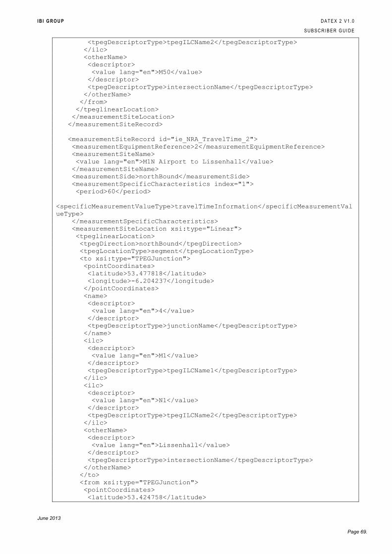
I B I G R O U P D A T E X 2 V 1 . 0
S U B S C R I B E R G U I D E
June 2013
Page 69.
<tpegDescriptorType>tpegILCName2</tpegDescriptorType>
</ilc>
<otherName>
<descriptor>
<value lang="en">M50</value>
</descriptor>
<tpegDescriptorType>intersectionName</tpegDescriptorType>
</otherName>
</from>
</tpeglinearLocation>
</measurementSiteLocation>
</measurementSiteRecord>
<measurementSiteRecord id="ie_NRA_TravelTime_2">
<measurementEquipmentReference>2</measurementEquipmentReference>
<measurementSiteName>
<value lang="en">M1N Airport to Lissenhall</value>
</measurementSiteName>
<measurementSide>northBound</measurementSide>
<measurementSpecificCharacteristics index="1">
<period>60</period>
<specificMeasurementValueType>travelTimeInformation</specificMeasurementVal
ueType>
</measurementSpecificCharacteristics>
<measurementSiteLocation xsi:type="Linear">
<tpeglinearLocation>
<tpegDirection>northBound</tpegDirection>
<tpegLocationType>segment</tpegLocationType>
<to xsi:type="TPEGJunction">
<pointCoordinates>
<latitude>53.477818</latitude>
<longitude>-6.204237</longitude>
</pointCoordinates>
<name>
<descriptor>
<value lang="en">4</value>
</descriptor>
<tpegDescriptorType>junctionName</tpegDescriptorType>
</name>
<ilc>
<descriptor>
<value lang="en">M1</value>
</descriptor>
<tpegDescriptorType>tpegILCName1</tpegDescriptorType>
</ilc>
<ilc>
<descriptor>
<value lang="en">N1</value>
</descriptor>
<tpegDescriptorType>tpegILCName2</tpegDescriptorType>
</ilc>
<otherName>
<descriptor>
<value lang="en">Lissenhall</value>
</descriptor>
<tpegDescriptorType>intersectionName</tpegDescriptorType>
</otherName>
</to>
<from xsi:type="TPEGJunction">
<pointCoordinates>
<latitude>53.424758</latitude>
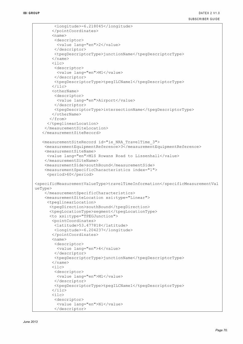
I B I G R O U P D A T E X 2 V 1 . 0
S U B S C R I B E R G U I D E
June 2013
Page 70.
<longitude>-6.218045</longitude>
</pointCoordinates>
<name>
<descriptor>
<value lang="en">2</value>
</descriptor>
<tpegDescriptorType>junctionName</tpegDescriptorType>
</name>
<ilc>
<descriptor>
<value lang="en">M1</value>
</descriptor>
<tpegDescriptorType>tpegILCName1</tpegDescriptorType>
</ilc>
<otherName>
<descriptor>
<value lang="en">Airport</value>
</descriptor>
<tpegDescriptorType>intersectionName</tpegDescriptorType>
</otherName>
</from>
</tpeglinearLocation>
</measurementSiteLocation>
</measurementSiteRecord>
<measurementSiteRecord id="ie_NRA_TravelTime_3">
<measurementEquipmentReference>3</measurementEquipmentReference>
<measurementSiteName>
<value lang="en">M1S Rowans Road to Lissenhall</value>
</measurementSiteName>
<measurementSide>southBound</measurementSide>
<measurementSpecificCharacteristics index="1">
<period>60</period>
<specificMeasurementValueType>travelTimeInformation</specificMeasurementVal
ueType>
</measurementSpecificCharacteristics>
<measurementSiteLocation xsi:type="Linear">
<tpeglinearLocation>
<tpegDirection>southBound</tpegDirection>
<tpegLocationType>segment</tpegLocationType>
<to xsi:type="TPEGJunction">
<pointCoordinates>
<latitude>53.477818</latitude>
<longitude>-6.204237</longitude>
</pointCoordinates>
<name>
<descriptor>
<value lang="en">4</value>
</descriptor>
<tpegDescriptorType>junctionName</tpegDescriptorType>
</name>
<ilc>
<descriptor>
<value lang="en">M1</value>
</descriptor>
<tpegDescriptorType>tpegILCName1</tpegDescriptorType>
</ilc>
<ilc>
<descriptor>
<value lang="en">N1</value>
</descriptor>
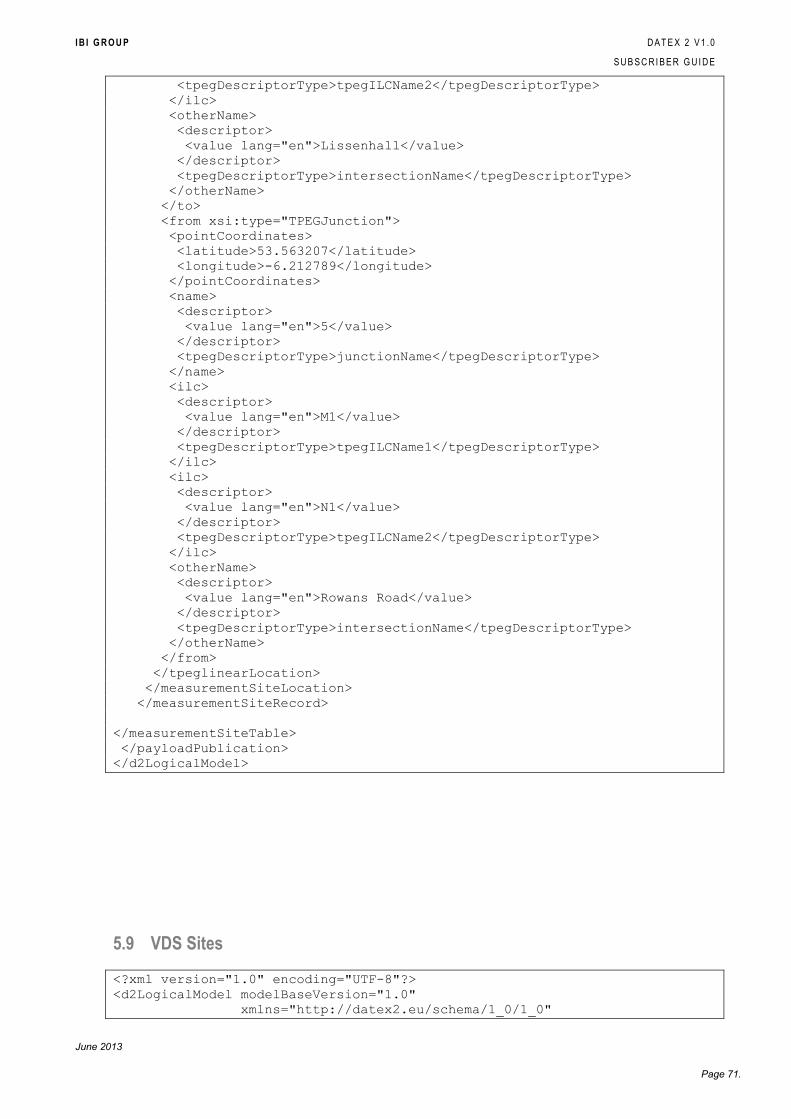
I B I G R O U P D A T E X 2 V 1 . 0
S U B S C R I B E R G U I D E
June 2013
Page 71.
<tpegDescriptorType>tpegILCName2</tpegDescriptorType>
</ilc>
<otherName>
<descriptor>
<value lang="en">Lissenhall</value>
</descriptor>
<tpegDescriptorType>intersectionName</tpegDescriptorType>
</otherName>
</to>
<from xsi:type="TPEGJunction">
<pointCoordinates>
<latitude>53.563207</latitude>
<longitude>-6.212789</longitude>
</pointCoordinates>
<name>
<descriptor>
<value lang="en">5</value>
</descriptor>
<tpegDescriptorType>junctionName</tpegDescriptorType>
</name>
<ilc>
<descriptor>
<value lang="en">M1</value>
</descriptor>
<tpegDescriptorType>tpegILCName1</tpegDescriptorType>
</ilc>
<ilc>
<descriptor>
<value lang="en">N1</value>
</descriptor>
<tpegDescriptorType>tpegILCName2</tpegDescriptorType>
</ilc>
<otherName>
<descriptor>
<value lang="en">Rowans Road</value>
</descriptor>
<tpegDescriptorType>intersectionName</tpegDescriptorType>
</otherName>
</from>
</tpeglinearLocation>
</measurementSiteLocation>
</measurementSiteRecord>
</measurementSiteTable>
</payloadPublication>
</d2LogicalModel>
5.9 VDS Sites
<?xml version="1.0" encoding="UTF-8"?>
<d2LogicalModel modelBaseVersion="1.0"
xmlns="http://datex2.eu/schema/1_0/1_0"
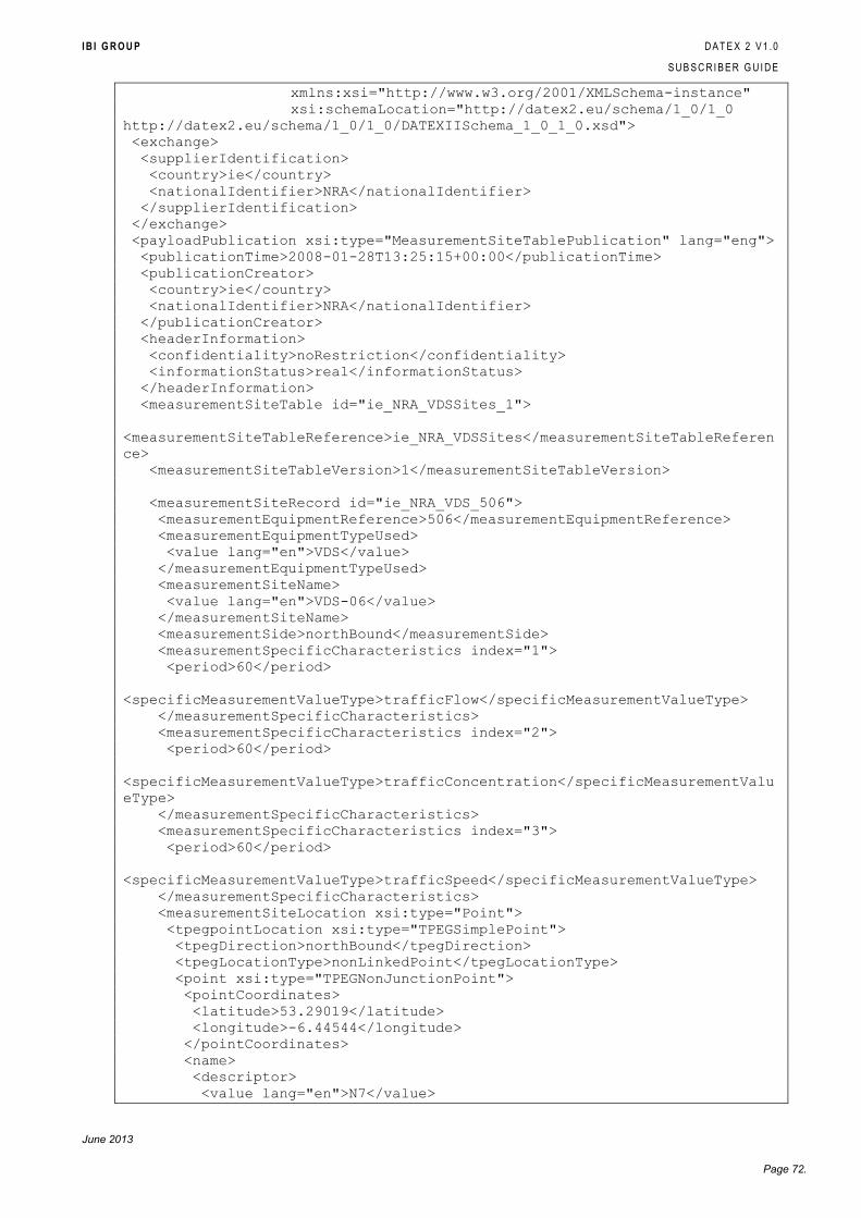
I B I G R O U P D A T E X 2 V 1 . 0
S U B S C R I B E R G U I D E
June 2013
Page 72.
xmlns:xsi="http://www.w3.org/2001/XMLSchema-instance"
xsi:schemaLocation="http://datex2.eu/schema/1_0/1_0
http://datex2.eu/schema/1_0/1_0/DATEXIISchema_1_0_1_0.xsd">
<exchange>
<supplierIdentification>
<country>ie</country>
<nationalIdentifier>NRA</nationalIdentifier>
</supplierIdentification>
</exchange>
<payloadPublication xsi:type="MeasurementSiteTablePublication" lang="eng">
<publicationTime>2008-01-28T13:25:15+00:00</publicationTime>
<publicationCreator>
<country>ie</country>
<nationalIdentifier>NRA</nationalIdentifier>
</publicationCreator>
<headerInformation>
<confidentiality>noRestriction</confidentiality>
<informationStatus>real</informationStatus>
</headerInformation>
<measurementSiteTable id="ie_NRA_VDSSites_1">
<measurementSiteTableReference>ie_NRA_VDSSites</measurementSiteTableReferen
ce>
<measurementSiteTableVersion>1</measurementSiteTableVersion>
<measurementSiteRecord id="ie_NRA_VDS_506">
<measurementEquipmentReference>506</measurementEquipmentReference>
<measurementEquipmentTypeUsed>
<value lang="en">VDS</value>
</measurementEquipmentTypeUsed>
<measurementSiteName>
<value lang="en">VDS-06</value>
</measurementSiteName>
<measurementSide>northBound</measurementSide>
<measurementSpecificCharacteristics index="1">
<period>60</period>
<specificMeasurementValueType>trafficFlow</specificMeasurementValueType>
</measurementSpecificCharacteristics>
<measurementSpecificCharacteristics index="2">
<period>60</period>
<specificMeasurementValueType>trafficConcentration</specificMeasurementValu
eType>
</measurementSpecificCharacteristics>
<measurementSpecificCharacteristics index="3">
<period>60</period>
<specificMeasurementValueType>trafficSpeed</specificMeasurementValueType>
</measurementSpecificCharacteristics>
<measurementSiteLocation xsi:type="Point">
<tpegpointLocation xsi:type="TPEGSimplePoint">
<tpegDirection>northBound</tpegDirection>
<tpegLocationType>nonLinkedPoint</tpegLocationType>
<point xsi:type="TPEGNonJunctionPoint">
<pointCoordinates>
<latitude>53.29019</latitude>
<longitude>-6.44544</longitude>
</pointCoordinates>
<name>
<descriptor>
<value lang="en">N7</value>
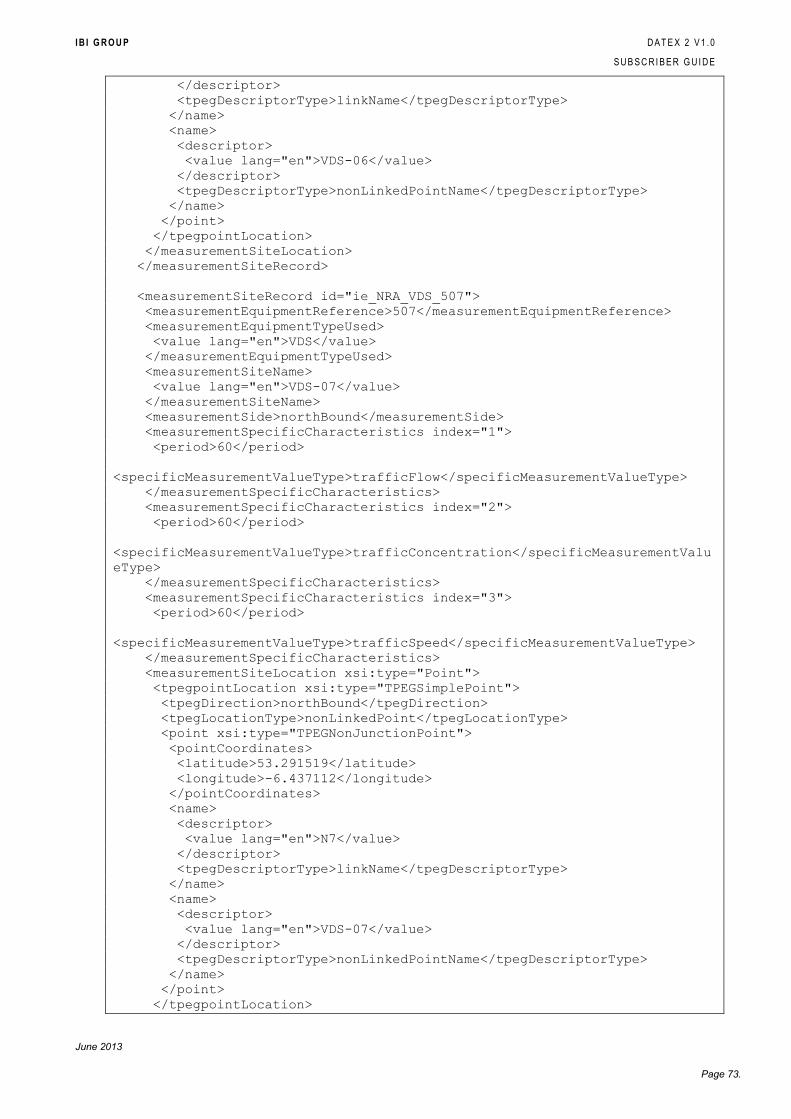
I B I G R O U P D A T E X 2 V 1 . 0
S U B S C R I B E R G U I D E
June 2013
Page 73.
</descriptor>
<tpegDescriptorType>linkName</tpegDescriptorType>
</name>
<name>
<descriptor>
<value lang="en">VDS-06</value>
</descriptor>
<tpegDescriptorType>nonLinkedPointName</tpegDescriptorType>
</name>
</point>
</tpegpointLocation>
</measurementSiteLocation>
</measurementSiteRecord>
<measurementSiteRecord id="ie_NRA_VDS_507">
<measurementEquipmentReference>507</measurementEquipmentReference>
<measurementEquipmentTypeUsed>
<value lang="en">VDS</value>
</measurementEquipmentTypeUsed>
<measurementSiteName>
<value lang="en">VDS-07</value>
</measurementSiteName>
<measurementSide>northBound</measurementSide>
<measurementSpecificCharacteristics index="1">
<period>60</period>
<specificMeasurementValueType>trafficFlow</specificMeasurementValueType>
</measurementSpecificCharacteristics>
<measurementSpecificCharacteristics index="2">
<period>60</period>
<specificMeasurementValueType>trafficConcentration</specificMeasurementValu
eType>
</measurementSpecificCharacteristics>
<measurementSpecificCharacteristics index="3">
<period>60</period>
<specificMeasurementValueType>trafficSpeed</specificMeasurementValueType>
</measurementSpecificCharacteristics>
<measurementSiteLocation xsi:type="Point">
<tpegpointLocation xsi:type="TPEGSimplePoint">
<tpegDirection>northBound</tpegDirection>
<tpegLocationType>nonLinkedPoint</tpegLocationType>
<point xsi:type="TPEGNonJunctionPoint">
<pointCoordinates>
<latitude>53.291519</latitude>
<longitude>-6.437112</longitude>
</pointCoordinates>
<name>
<descriptor>
<value lang="en">N7</value>
</descriptor>
<tpegDescriptorType>linkName</tpegDescriptorType>
</name>
<name>
<descriptor>
<value lang="en">VDS-07</value>
</descriptor>
<tpegDescriptorType>nonLinkedPointName</tpegDescriptorType>
</name>
</point>
</tpegpointLocation>
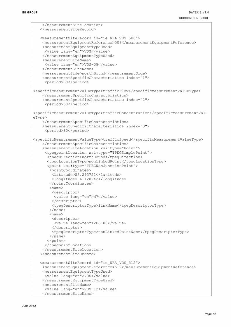
I B I G R O U P D A T E X 2 V 1 . 0
S U B S C R I B E R G U I D E
June 2013
Page 74.
</measurementSiteLocation>
</measurementSiteRecord>
<measurementSiteRecord id="ie_NRA_VDS_508">
<measurementEquipmentReference>508</measurementEquipmentReference>
<measurementEquipmentTypeUsed>
<value lang="en">VDS</value>
</measurementEquipmentTypeUsed>
<measurementSiteName>
<value lang="en">VDS-08</value>
</measurementSiteName>
<measurementSide>northBound</measurementSide>
<measurementSpecificCharacteristics index="1">
<period>60</period>
<specificMeasurementValueType>trafficFlow</specificMeasurementValueType>
</measurementSpecificCharacteristics>
<measurementSpecificCharacteristics index="2">
<period>60</period>
<specificMeasurementValueType>trafficConcentration</specificMeasurementValu
eType>
</measurementSpecificCharacteristics>
<measurementSpecificCharacteristics index="3">
<period>60</period>
<specificMeasurementValueType>trafficSpeed</specificMeasurementValueType>
</measurementSpecificCharacteristics>
<measurementSiteLocation xsi:type="Point">
<tpegpointLocation xsi:type="TPEGSimplePoint">
<tpegDirection>northBound</tpegDirection>
<tpegLocationType>nonLinkedPoint</tpegLocationType>
<point xsi:type="TPEGNonJunctionPoint">
<pointCoordinates>
<latitude>53.293721</latitude>
<longitude>-6.428242</longitude>
</pointCoordinates>
<name>
<descriptor>
<value lang="en">N7</value>
</descriptor>
<tpegDescriptorType>linkName</tpegDescriptorType>
</name>
<name>
<descriptor>
<value lang="en">VDS-08</value>
</descriptor>
<tpegDescriptorType>nonLinkedPointName</tpegDescriptorType>
</name>
</point>
</tpegpointLocation>
</measurementSiteLocation>
</measurementSiteRecord>
<measurementSiteRecord id="ie_NRA_VDS_512">
<measurementEquipmentReference>512</measurementEquipmentReference>
<measurementEquipmentTypeUsed>
<value lang="en">VDS</value>
</measurementEquipmentTypeUsed>
<measurementSiteName>
<value lang="en">VDS-12</value>
</measurementSiteName>
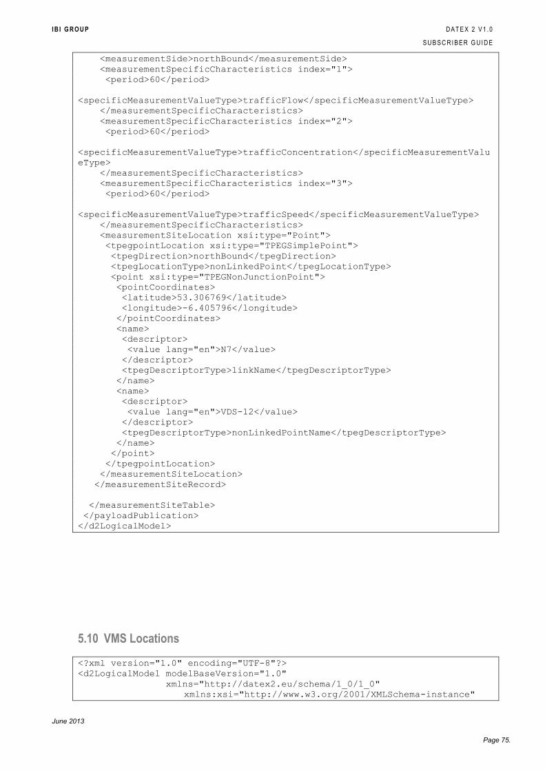
I B I G R O U P D A T E X 2 V 1 . 0
S U B S C R I B E R G U I D E
June 2013
Page 75.
<measurementSide>northBound</measurementSide>
<measurementSpecificCharacteristics index="1">
<period>60</period>
<specificMeasurementValueType>trafficFlow</specificMeasurementValueType>
</measurementSpecificCharacteristics>
<measurementSpecificCharacteristics index="2">
<period>60</period>
<specificMeasurementValueType>trafficConcentration</specificMeasurementValu
eType>
</measurementSpecificCharacteristics>
<measurementSpecificCharacteristics index="3">
<period>60</period>
<specificMeasurementValueType>trafficSpeed</specificMeasurementValueType>
</measurementSpecificCharacteristics>
<measurementSiteLocation xsi:type="Point">
<tpegpointLocation xsi:type="TPEGSimplePoint">
<tpegDirection>northBound</tpegDirection>
<tpegLocationType>nonLinkedPoint</tpegLocationType>
<point xsi:type="TPEGNonJunctionPoint">
<pointCoordinates>
<latitude>53.306769</latitude>
<longitude>-6.405796</longitude>
</pointCoordinates>
<name>
<descriptor>
<value lang="en">N7</value>
</descriptor>
<tpegDescriptorType>linkName</tpegDescriptorType>
</name>
<name>
<descriptor>
<value lang="en">VDS-12</value>
</descriptor>
<tpegDescriptorType>nonLinkedPointName</tpegDescriptorType>
</name>
</point>
</tpegpointLocation>
</measurementSiteLocation>
</measurementSiteRecord>
</measurementSiteTable>
</payloadPublication>
</d2LogicalModel>
5.10 VMS Locations
<?xml version="1.0" encoding="UTF-8"?>
<d2LogicalModel modelBaseVersion="1.0"
xmlns="http://datex2.eu/schema/1_0/1_0"
xmlns:xsi="http://www.w3.org/2001/XMLSchema-instance"
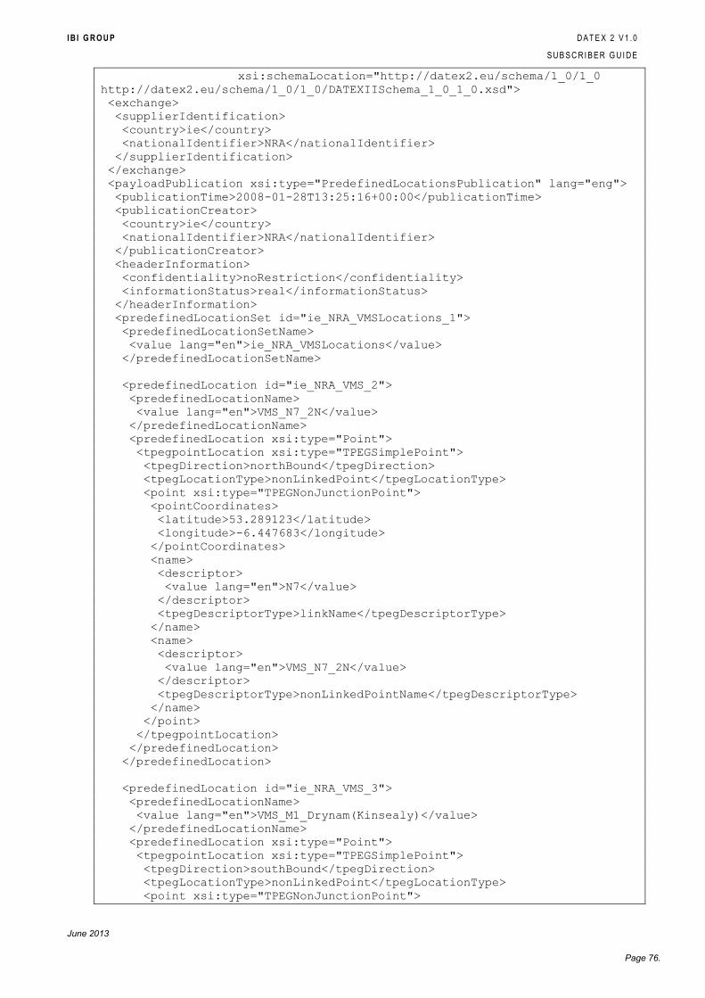
I B I G R O U P D A T E X 2 V 1 . 0
S U B S C R I B E R G U I D E
June 2013
Page 76.
xsi:schemaLocation="http://datex2.eu/schema/1_0/1_0
http://datex2.eu/schema/1_0/1_0/DATEXIISchema_1_0_1_0.xsd">
<exchange>
<supplierIdentification>
<country>ie</country>
<nationalIdentifier>NRA</nationalIdentifier>
</supplierIdentification>
</exchange>
<payloadPublication xsi:type="PredefinedLocationsPublication" lang="eng">
<publicationTime>2008-01-28T13:25:16+00:00</publicationTime>
<publicationCreator>
<country>ie</country>
<nationalIdentifier>NRA</nationalIdentifier>
</publicationCreator>
<headerInformation>
<confidentiality>noRestriction</confidentiality>
<informationStatus>real</informationStatus>
</headerInformation>
<predefinedLocationSet id="ie_NRA_VMSLocations_1">
<predefinedLocationSetName>
<value lang="en">ie_NRA_VMSLocations</value>
</predefinedLocationSetName>
<predefinedLocation id="ie_NRA_VMS_2">
<predefinedLocationName>
<value lang="en">VMS_N7_2N</value>
</predefinedLocationName>
<predefinedLocation xsi:type="Point">
<tpegpointLocation xsi:type="TPEGSimplePoint">
<tpegDirection>northBound</tpegDirection>
<tpegLocationType>nonLinkedPoint</tpegLocationType>
<point xsi:type="TPEGNonJunctionPoint">
<pointCoordinates>
<latitude>53.289123</latitude>
<longitude>-6.447683</longitude>
</pointCoordinates>
<name>
<descriptor>
<value lang="en">N7</value>
</descriptor>
<tpegDescriptorType>linkName</tpegDescriptorType>
</name>
<name>
<descriptor>
<value lang="en">VMS_N7_2N</value>
</descriptor>
<tpegDescriptorType>nonLinkedPointName</tpegDescriptorType>
</name>
</point>
</tpegpointLocation>
</predefinedLocation>
</predefinedLocation>
<predefinedLocation id="ie_NRA_VMS_3">
<predefinedLocationName>
<value lang="en">VMS_M1_Drynam(Kinsealy)</value>
</predefinedLocationName>
<predefinedLocation xsi:type="Point">
<tpegpointLocation xsi:type="TPEGSimplePoint">
<tpegDirection>southBound</tpegDirection>
<tpegLocationType>nonLinkedPoint</tpegLocationType>
<point xsi:type="TPEGNonJunctionPoint">
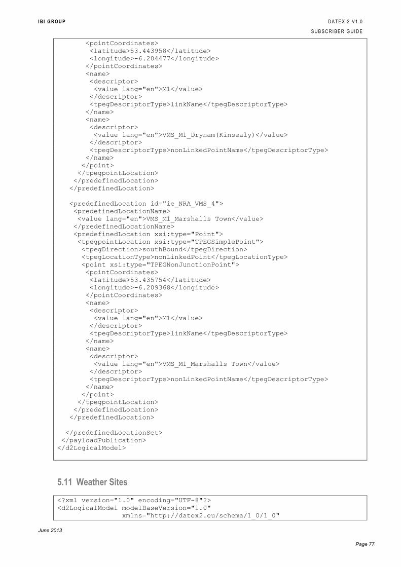
I B I G R O U P D A T E X 2 V 1 . 0
S U B S C R I B E R G U I D E
June 2013
Page 77.
<pointCoordinates>
<latitude>53.443958</latitude>
<longitude>-6.204477</longitude>
</pointCoordinates>
<name>
<descriptor>
<value lang="en">M1</value>
</descriptor>
<tpegDescriptorType>linkName</tpegDescriptorType>
</name>
<name>
<descriptor>
<value lang="en">VMS_M1_Drynam(Kinsealy)</value>
</descriptor>
<tpegDescriptorType>nonLinkedPointName</tpegDescriptorType>
</name>
</point>
</tpegpointLocation>
</predefinedLocation>
</predefinedLocation>
<predefinedLocation id="ie_NRA_VMS_4">
<predefinedLocationName>
<value lang="en">VMS_M1_Marshalls Town</value>
</predefinedLocationName>
<predefinedLocation xsi:type="Point">
<tpegpointLocation xsi:type="TPEGSimplePoint">
<tpegDirection>southBound</tpegDirection>
<tpegLocationType>nonLinkedPoint</tpegLocationType>
<point xsi:type="TPEGNonJunctionPoint">
<pointCoordinates>
<latitude>53.435754</latitude>
<longitude>-6.209368</longitude>
</pointCoordinates>
<name>
<descriptor>
<value lang="en">M1</value>
</descriptor>
<tpegDescriptorType>linkName</tpegDescriptorType>
</name>
<name>
<descriptor>
<value lang="en">VMS_M1_Marshalls Town</value>
</descriptor>
<tpegDescriptorType>nonLinkedPointName</tpegDescriptorType>
</name>
</point>
</tpegpointLocation>
</predefinedLocation>
</predefinedLocation>
</predefinedLocationSet>
</payloadPublication>
</d2LogicalModel>
5.11 Weather Sites
<?xml version="1.0" encoding="UTF-8"?>
<d2LogicalModel modelBaseVersion="1.0"
xmlns="http://datex2.eu/schema/1_0/1_0"
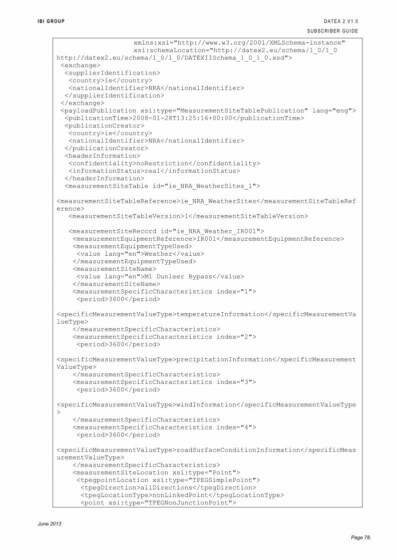
I B I G R O U P D A T E X 2 V 1 . 0
S U B S C R I B E R G U I D E
June 2013
Page 78.
xmlns:xsi="http://www.w3.org/2001/XMLSchema-instance"
xsi:schemaLocation="http://datex2.eu/schema/1_0/1_0
http://datex2.eu/schema/1_0/1_0/DATEXIISchema_1_0_1_0.xsd">
<exchange>
<supplierIdentification>
<country>ie</country>
<nationalIdentifier>NRA</nationalIdentifier>
</supplierIdentification>
</exchange>
<payloadPublication xsi:type="MeasurementSiteTablePublication" lang="eng">
<publicationTime>2008-01-28T13:25:16+00:00</publicationTime>
<publicationCreator>
<country>ie</country>
<nationalIdentifier>NRA</nationalIdentifier>
</publicationCreator>
<headerInformation>
<confidentiality>noRestriction</confidentiality>
<informationStatus>real</informationStatus>
</headerInformation>
<measurementSiteTable id="ie_NRA_WeatherSites_1">
<measurementSiteTableReference>ie_NRA_WeatherSites</measurementSiteTableRef
erence>
<measurementSiteTableVersion>1</measurementSiteTableVersion>
<measurementSiteRecord id="ie_NRA_Weather_IR001">
<measurementEquipmentReference>IR001</measurementEquipmentReference>
<measurementEquipmentTypeUsed>
<value lang="en">Weather</value>
</measurementEquipmentTypeUsed>
<measurementSiteName>
<value lang="en">M1 Dunleer Bypass</value>
</measurementSiteName>
<measurementSpecificCharacteristics index="1">
<period>3600</period>
<specificMeasurementValueType>temperatureInformation</specificMeasurementVa
lueType>
</measurementSpecificCharacteristics>
<measurementSpecificCharacteristics index="2">
<period>3600</period>
<specificMeasurementValueType>precipitationInformation</specificMeasurement
ValueType>
</measurementSpecificCharacteristics>
<measurementSpecificCharacteristics index="3">
<period>3600</period>
<specificMeasurementValueType>windInformation</specificMeasurementValueType
>
</measurementSpecificCharacteristics>
<measurementSpecificCharacteristics index="4">
<period>3600</period>
<specificMeasurementValueType>roadSurfaceConditionInformation</specificMeas
urementValueType>
</measurementSpecificCharacteristics>
<measurementSiteLocation xsi:type="Point">
<tpegpointLocation xsi:type="TPEGSimplePoint">
<tpegDirection>allDirections</tpegDirection>
<tpegLocationType>nonLinkedPoint</tpegLocationType>
<point xsi:type="TPEGNonJunctionPoint">
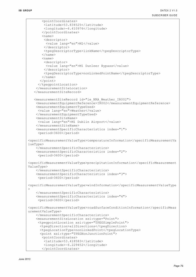
I B I G R O U P D A T E X 2 V 1 . 0
S U B S C R I B E R G U I D E
June 2013
Page 79.
<pointCoordinates>
<latitude>53.834525</latitude>
<longitude>-6.410976</longitude>
</pointCoordinates>
<name>
<descriptor>
<value lang="en">M1</value>
</descriptor>
<tpegDescriptorType>linkName</tpegDescriptorType>
</name>
<name>
<descriptor>
<value lang="en">M1 Dunleer Bypass</value>
</descriptor>
<tpegDescriptorType>nonLinkedPointName</tpegDescriptorType>
</name>
</point>
</tpegpointLocation>
</measurementSiteLocation>
</measurementSiteRecord>
<measurementSiteRecord id="ie_NRA_Weather_IR002">
<measurementEquipmentReference>IR002</measurementEquipmentReference>
<measurementEquipmentTypeUsed>
<value lang="en">Weather</value>
</measurementEquipmentTypeUsed>
<measurementSiteName>
<value lang="en">M1 Dublin Airport</value>
</measurementSiteName>
<measurementSpecificCharacteristics index="1">
<period>3600</period>
<specificMeasurementValueType>temperatureInformation</specificMeasurementVa
lueType>
</measurementSpecificCharacteristics>
<measurementSpecificCharacteristics index="2">
<period>3600</period>
<specificMeasurementValueType>precipitationInformation</specificMeasurement
ValueType>
</measurementSpecificCharacteristics>
<measurementSpecificCharacteristics index="3">
<period>3600</period>
<specificMeasurementValueType>windInformation</specificMeasurementValueType
>
</measurementSpecificCharacteristics>
<measurementSpecificCharacteristics index="4">
<period>3600</period>
<specificMeasurementValueType>roadSurfaceConditionInformation</specificMeas
urementValueType>
</measurementSpecificCharacteristics>
<measurementSiteLocation xsi:type="Point">
<tpegpointLocation xsi:type="TPEGSimplePoint">
<tpegDirection>allDirections</tpegDirection>
<tpegLocationType>nonLinkedPoint</tpegLocationType>
<point xsi:type="TPEGNonJunctionPoint">
<pointCoordinates>
<latitude>53.418583</latitude>
<longitude>-6.229452</longitude>
</pointCoordinates>
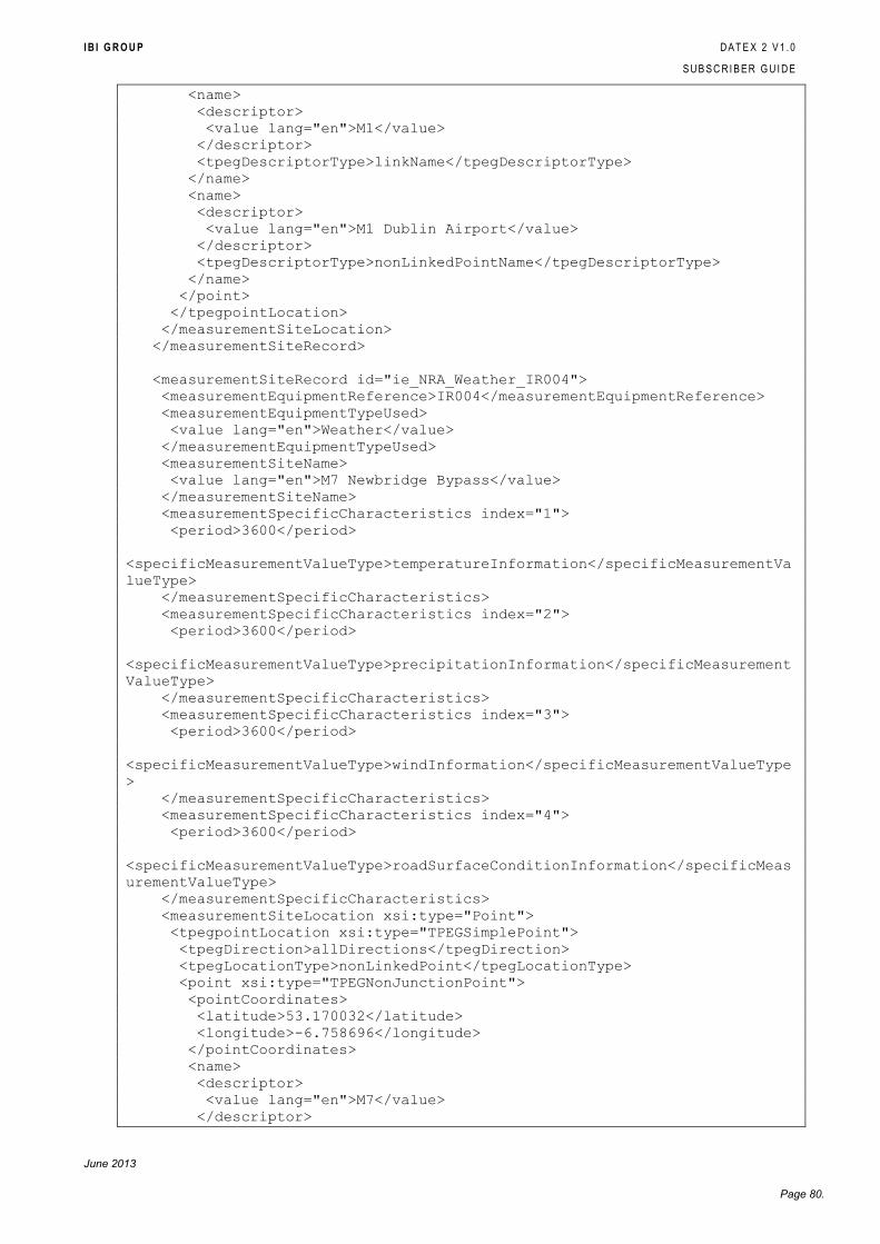
I B I G R O U P D A T E X 2 V 1 . 0
S U B S C R I B E R G U I D E
June 2013
Page 80.
<name>
<descriptor>
<value lang="en">M1</value>
</descriptor>
<tpegDescriptorType>linkName</tpegDescriptorType>
</name>
<name>
<descriptor>
<value lang="en">M1 Dublin Airport</value>
</descriptor>
<tpegDescriptorType>nonLinkedPointName</tpegDescriptorType>
</name>
</point>
</tpegpointLocation>
</measurementSiteLocation>
</measurementSiteRecord>
<measurementSiteRecord id="ie_NRA_Weather_IR004">
<measurementEquipmentReference>IR004</measurementEquipmentReference>
<measurementEquipmentTypeUsed>
<value lang="en">Weather</value>
</measurementEquipmentTypeUsed>
<measurementSiteName>
<value lang="en">M7 Newbridge Bypass</value>
</measurementSiteName>
<measurementSpecificCharacteristics index="1">
<period>3600</period>
<specificMeasurementValueType>temperatureInformation</specificMeasurementVa
lueType>
</measurementSpecificCharacteristics>
<measurementSpecificCharacteristics index="2">
<period>3600</period>
<specificMeasurementValueType>precipitationInformation</specificMeasurement
ValueType>
</measurementSpecificCharacteristics>
<measurementSpecificCharacteristics index="3">
<period>3600</period>
<specificMeasurementValueType>windInformation</specificMeasurementValueType
>
</measurementSpecificCharacteristics>
<measurementSpecificCharacteristics index="4">
<period>3600</period>
<specificMeasurementValueType>roadSurfaceConditionInformation</specificMeas
urementValueType>
</measurementSpecificCharacteristics>
<measurementSiteLocation xsi:type="Point">
<tpegpointLocation xsi:type="TPEGSimplePoint">
<tpegDirection>allDirections</tpegDirection>
<tpegLocationType>nonLinkedPoint</tpegLocationType>
<point xsi:type="TPEGNonJunctionPoint">
<pointCoordinates>
<latitude>53.170032</latitude>
<longitude>-6.758696</longitude>
</pointCoordinates>
<name>
<descriptor>
<value lang="en">M7</value>
</descriptor>
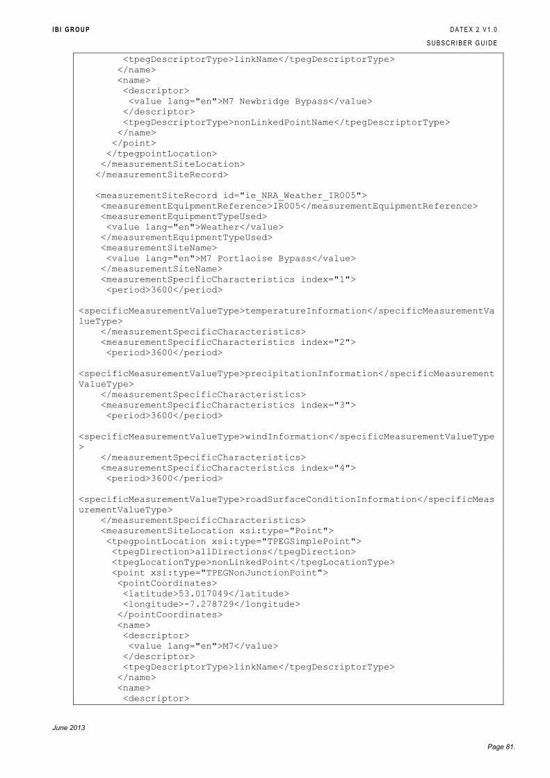
I B I G R O U P D A T E X 2 V 1 . 0
S U B S C R I B E R G U I D E
June 2013
Page 81.
<tpegDescriptorType>linkName</tpegDescriptorType>
</name>
<name>
<descriptor>
<value lang="en">M7 Newbridge Bypass</value>
</descriptor>
<tpegDescriptorType>nonLinkedPointName</tpegDescriptorType>
</name>
</point>
</tpegpointLocation>
</measurementSiteLocation>
</measurementSiteRecord>
<measurementSiteRecord id="ie_NRA_Weather_IR005">
<measurementEquipmentReference>IR005</measurementEquipmentReference>
<measurementEquipmentTypeUsed>
<value lang="en">Weather</value>
</measurementEquipmentTypeUsed>
<measurementSiteName>
<value lang="en">M7 Portlaoise Bypass</value>
</measurementSiteName>
<measurementSpecificCharacteristics index="1">
<period>3600</period>
<specificMeasurementValueType>temperatureInformation</specificMeasurementVa
lueType>
</measurementSpecificCharacteristics>
<measurementSpecificCharacteristics index="2">
<period>3600</period>
<specificMeasurementValueType>precipitationInformation</specificMeasurement
ValueType>
</measurementSpecificCharacteristics>
<measurementSpecificCharacteristics index="3">
<period>3600</period>
<specificMeasurementValueType>windInformation</specificMeasurementValueType
>
</measurementSpecificCharacteristics>
<measurementSpecificCharacteristics index="4">
<period>3600</period>
<specificMeasurementValueType>roadSurfaceConditionInformation</specificMeas
urementValueType>
</measurementSpecificCharacteristics>
<measurementSiteLocation xsi:type="Point">
<tpegpointLocation xsi:type="TPEGSimplePoint">
<tpegDirection>allDirections</tpegDirection>
<tpegLocationType>nonLinkedPoint</tpegLocationType>
<point xsi:type="TPEGNonJunctionPoint">
<pointCoordinates>
<latitude>53.017049</latitude>
<longitude>-7.278729</longitude>
</pointCoordinates>
<name>
<descriptor>
<value lang="en">M7</value>
</descriptor>
<tpegDescriptorType>linkName</tpegDescriptorType>
</name>
<name>
<descriptor>
I B I G R O U P D A T E X 2 V 1 . 0
S U B S C R I B E R G U I D E
June 2013
Page 82.
<value lang="en">M7 Portlaoise Bypass</value>
</descriptor>
<tpegDescriptorType>nonLinkedPointName</tpegDescriptorType>
</name>
</point>
</tpegpointLocation>
</measurementSiteLocation>
</measurementSiteRecord>
</measurementSiteTable>
</payloadPublication>
</d2LogicalModel>


![DATEX II V2.3 USER S GUIDE · [XML schema] DATEX II v2.3 schema 2.3 30-09-2014 Supporting documentation [User guide] DATEX II User’s guide 2.3 30-09-2014 [Software developers guide]](https://img.pdfslide.us/doc/110x75/60c5da18662b2664286eff84/datex-ii-v23-user-s-guide-xml-schema-datex-ii-v23-schema-23-30-09-2014-supporting.jpg)


![DATEX II V2.3 SOFTWARE DEVELOPER S GUIDE · [XML schema] DATEX II v2.3 schema 2.3 30-09-2014 Supporting documentation [User guide] DATEX II User’s guide 2.3 30-09-2014 [Software](https://img.pdfslide.us/doc/110x75/603b06de841dc2417a15eabd/datex-ii-v23-software-developer-s-guide-xml-schema-datex-ii-v23-schema-23-30-09-2014.jpg)