Embed Size (px)
Citation preview

Item 8D
1
DATE: June 24, 2019 TO: RMC Governing Board FROM: Mark Stanley, Executive Officer SUBJECT: Item 8D: Liaison and Activities Report
RMC ACTIVITIES Lower Los Angeles River Working Group (AB 530): With the completion of the Lower Los Angeles River Revitalization Plan, the Implementation Advisory Group (IAG) held its first meeting on August 22, 2018 at the Los Angeles County Department of Public Works headquarters in the City of Alhambra. The purpose and charge of the IAG is to:
1) provide a public venue for discussion of proposed projects/programs related to the Lower LA River; 2) Ensure proposed projects/programs are consistent with the goals and objectives of the Lower LA
River Revitalization Plan; and 3) Maximize multi-use opportunities and community benefits by encouraging collaboration among the
many project proponents and organizations in the project area. In its role as an advisory body, the IAG will provide guidance on issues presented before them, but ultimately, individual entities with jurisdiction along the river corridor including the LA County Flood Control District, the US Army Corps of Engineers, and the cities will continue to have decision-making authority. The IAG members and committees will work together to further define the roles and guidelines of the IAG in the upcoming months. The IAG will include four sub-committees, including:
1) Programs & Policies; 2) Public Realm, Environment, Water, Infrastructure; 3) Public Advisory & Community Engagement; and 4) Future Committee TBD (as-needed).
The committee meetings will first be comprised of members of the Lower LA River Revitalization Plan Working Group; however, the committees may choose to invite representatives of other agencies and organizations as needed to address committee needs. Steering and sub- committee meetings will be held quarterly. The next Steering Committee meeting is scheduled for August 21, 2019. The sub-committee meetings are scheduled for:
1) Programs & Policies a. Chair, Antonio Hicks, Public Counsel b. Vice Chair, Dan Knapp, Conservation Corps of Long Beach c. Meeting and Facility: TBD
2) Public Realm, Environment, Water, Infrastructure a. Chair, Kayla Kelly-Slatten, Conservation Corps of Long Beach b. Vice Chair, Kelsey Jessup, The Nature Conservancy c. Next Meeting: TBD

Item 8D
2
3) Public Advisory & Community Engagement a. Chair, Laura Cortez, East Yard Communities for Environmental Justice b. Vice Chair, TBD c. Next Meeting: TBD
All committees are continuing to work on establishing a project review process and will discuss how each committee can support the development and implementation of projects, programs, policies, and efforts. Regarding a review process, the two main objectives for the sub-committees will be to:
1) Allow projects that have been submitted for funding to present and retain feedback, which will then be delivered to a governing Board/reviewing body for consideration, and
2) Allow developing projects the opportunity to gain feedback on concepts and ideas, as well as to find additional partners and funding.
RMC is scheduling proposed project presentations by RMC grant applicants before the appropriate IAG committees to allow Lower LA River stakeholders the opportunity to provide feedback on proposed projects before they are recommended for funding to the RMC Board. Any comments received on projects will be included in recommendation reports.
The IAG consists of the District as the chair, the RMC, the United States Army Corps of Engineers, the fifteen Lower LA River cities and the chairs of the committees. The IAG and the committees will each meet quarterly. All meeting materials and schedules will be posted on the website – www.LowerLARiver.org
River Ranger Program (AB 1558- C. Garcia)
Since February 2018, The Rivers and Mountains Conservancy and the Santa Monica Mountains Conservancy and their respective JPA’s (WCA and MRCA) have been collaborating jointly on the implementation of the River Ranger Plan Development, intended to develop a framework for a network of River Rangers who assist the public at sites along the Los Angeles River and its tributaries. The bill was enacted in 2017 to address the limited contact with and responsibility for the river by communities, working in coordination with current revitalization programs to encourage engagement with the river as a welcoming community resource.
Under the bill, the program is intended to do the following: Establish a Los Angeles River identity; Improve public safety for visitors; Foster collaboration among those with jurisdiction over the river; Protect parks, open space, and other public space; Engage communities in the protection and preservation of the River and its resources; Promote diversity and inclusion; Promote equal access and equity among all communities along the River with regard to the development and placement of improvements along the river; Monitor the physical conditions, environmental health, and development of green space along the River, and Coordinate the work of river rangers with programs and services.
On May 31, 2019, the Los Angeles River Ranger Program Establishment Plan was delivered to the State Legislature. The full report and supplemental documents may be downloaded at rmc.ca.gov.

Item 8D
3
South & Southeast LA School Water Equity School Project (SLAWESP) A new water equity project for South LA and Southeast Schools is underway with a group of water solutions advocates and funders. After several planning meetings, it was decided that the first high school cohort of 30 students will begin an intense 4-week summer program called Water Interactions: Social, Economic and Environmental. The students will attend the STEAM High School Campus located in South Gate, CA, with classes beginning on June 20, 2019- July 24, 2019. Water topics and field trips have been added to the curriculum which will inform this group of students for future water related policy, education and future careers. RMC will continue to follow and engage school equity projects. Overall goals of this cohort include: 1) Identifying pilot schools/strategy 2) Identifying career exposure curricula and workforce opportunities 3) Identifying exemplar/potential green infrastructure/water projects 4) Framework for community engagement.
RMC ACTIVE PROJECTS Willowbrook Walking Path/Compton Creek (RMC14003): The RMC provided a grant in the amount of $300,000 to the Los Angeles Conservation Corps as part of the Willowbrook Walking Path Compton Creek extension. The LACC applied for an Urban Greening Grant through the Strategic Growth Council and was awarded the full request in the amount of $798,815. Additional matching funds were committed by other project partners including the State Coastal Conservancy and the Office of Supervisor Mark Ridley-Thomas (2nd District). Matching funds provided by the funding partners and the grant funds received by the Strategic Growth Council bring the total project cost to $1,698,815. This project includes the creation of a ½ mile permeable walking path and 2,700 linear foot by 6-foot riprap swale constructed with river rock to capture debris and treat runoff before it enters Compton Creek. Work began on this project in September 2018 with grubbing of the site. The LACC will continue the grading and move on to construction of a fence line, retaining wall, and landscaping for a targeted project completion in June 2020. View Park and Recycled Water System Development Project (RMC17001): The View Park and Recycled Water Development Project is underway. Project grant to the City is for $2,000,000 which includes a wildlife corridor project in the City of Signal Hill that will establish a new 1.86 acre park and the associated construction of a recycled water system. The project will reclaim a municipally owned industrial site and provide a recycled water system to serve the proposed park as well as retrofit three existing parks and the Promontory Home Owner's Association common landscaped areas, connect an urban trail system, prevent runoff pollution from contaminating the Los Angeles and San Gabriel Rivers and annually save approximately 40- acre feet of potable water. Recycled Water Campus, San Gabriel River Parkway (RMC 17004): Grant was approved by RMC Board and the project is underway. Grant from the RMC is for $1,000,000. This project supports low-impact development stormwater management features, such as swales, landscaping and permeable pavements and walkways; a stormwater capture system to augment the recycled water supply and reduce flood risk. In addition, this project will create habitat for Monarch butterflies, a migratory species proposed for endangered species candidate status; and create 3.5 acres of park-like open space with public access to the San Gabriel River. The project includes many interpretive and education aspects with an outdoor amphitheater, demonstration gardens for native plants, a working model of the San

Item 8D
4
Gabriel River, eco-friendly garden, multi-lingual signage, and other visitor facilities focused on water education, and provides multiple benefits to economically disadvantaged communities. This project is part of the Groundwater Reliability Improvement Project (GRIP), fully funded at $119 million. GRIP broke ground in July 2016 and is now known as the ARC Project. The WRD has requested a timeline extension through December 2019, due to a delay resulting from rain storms in 2017 that occurred when earth work was taking place at the construction site. In addition, compliance with American Iron and Steel requirements mandated by the project’s financing, made it necessary to change the source for some construction products. However, the project is scheduled to be completed in early July 2019. Installation of stormwater BMP (Task 1.1) in underway. Final grading has been completed and below-ground stormwater conduits, an infiltration basin, storm drain piping and bioswales have been installed. Construction of the Advanced water Treatment Facility (AWTF or Process Building) (Task 2) reached substantial completion as of December 31, 2018. Construction activities during this reporting period were focused on the Process Building, and the Administration and Learning Center. Additionally, WRD is working with a non-profit partner, Amigos de los Rios, to complete the interpretive signs and material for the outdoor spaces. WRD has requested additional time to close out the grant through December 2019. Bassett High School Campus Green Infrastructure Project (RMC 17005): Grant from the RMC is for $652,520, project is underway. This project will enhance campus “green infrastructure”, urban habitat, and demonstrate sustainable public landscaping in terms of water use, improved infiltration, and storm water management. Bassett High School is located in underserved area of La Puente, in San Gabriel River sub watershed. The region’s impervious grey infrastructure impairs groundwater recharge and infiltration. Proposed Green Infrastructure retrofits will reduce water use on campus by systematic turf grass reduction: planting over 2700 native, drought-tolerant trees & shrubs in mulched planters to enhance biodiversity, and absorb storm water and run-off. Creating a thriving Urban Forest on campus will clean air and sequester greenhouse gas emissions and reduce Urban Heat Island Effect through shade cover. Creation of bioswales, and strategic permeable surface retrofits will collect, capture, and infiltrate storm water from campus preventing runoff from entering storm drain systems and impacting our watershed’s health. Interpretive elements will raise awareness of water resources challenges and help create the next generation of environmental stewards. The project will encourage underserved students and community residents to participate in habitat restoration and water resources protection, explore and enjoy the campus, and learn how to connect to the region’s surrounding natural areas. Amigos has finalized an agreement with the school district and has worked with County Public Works to present plans and work with the school district. Amigos continued site preparation including:
• Grading and grubbing complete
• Bioswale by contractor (50% complete): Diversion structure and pipes to swales are complete
• Turf Removal by Youth Corps: Turf removed, trail trenching complete
• Temp Irrigation Drip Line: Installation in progress. Points of connection have been made, main line is installed, and lateral lines have begun.
Planning for the Urban Orchard Development (17006): Planning for the Urban Orchard Development grant to the Trust for Public Land is in the amount of $845,000 with an additional $1,387,401 that was approved at the Board meeting in May for design and construction of the wetlands component for the Orchard (RMC 18010). The project will transform 30 acres of unused, vacant land between the I-710 Freeway and the LA River into new, critically needed green infrastructure and an urban park, including an urban orchard and over one-mile of new riverfront walking and bike paths. Project deliverables include a detailed concept

Item 8D
5
plan for the 30-acre park site, a feasibility study to determine the most appropriate stormwater best management practices to be utilized at the site, and a complete set of construction drawings for the 7 acres park project area that include an orchard with culturally-relevant tree species, community gathering spaces, picnic areas, interpretive elements, native plants, and walking and bicycle paths that will eventually connect with the existing bike path along the LA River. The City continues to host public workshops to receive input from the community for this project and has also received grant funds for the project implementation. The most recent community design meeting was held on June 8, 2019 in the City of South Gate. In January, RMC Board Item 10 addresses TPL’s request for a grant amendment including a 1-year performance period extension from June 30, 2019 to June 30, 2020 and reduction in project scope. TPL is requesting to extend the grant to allow sufficient time to complete 100% construction drawings for the 7 acres and the stormwater management system that includes pumping water from the Bandini Channel and obtaining permits for the constructed wetland and diversion structure from the Bandini Channel. West Coyote Hills Open Space Acquisition (17007): Grant to the City is in the amount of $2,000,000 for this acquisition. The City of Fullerton informed the RMC that they were successful in obtaining $13 million in funds to acquire the 38.3 acres of available remaining undeveloped land. The City is working with the Seller and funders to update the appraisal and begin the land acquisition process. Long Beach Municipal Urban Stormwater Treatment (LB_MUST) Project (RMC 17009): The Long Beach Municipal Urban Stormwater Treatment (LB-MUST) Project is underway, this grant to the City is for $2,000,000 and will improve water quality by intercepting and treating the dry weather flows and a portion of the first flush of stormwater runoff normally discharging into the Los Angeles River. The byproduct of the LB-MUST water quality treatment is recycled water which can be used to sustain proposed wetlands riparian habitat. The wetlands will be part of the total treatment train of the LB-MUST as well as function as a storage basin for the recycled water. Delays were encounter in design and construction due to a site relocation of the project to accommodate bridge improvements by the City of Long Beach at the Shoemaker Bridge site. An extension was provided to the City to allow sufficient time to accommodate for this change in the design and construction timeline. Parkway Basin Water Quality Improvement Project (17011): The Parkway Basin Water Quality Improvement Project grant is to the County of Los Angeles is in the amount of $268,500 and includes the construction of 30 parkway basins in the unincorporated Los Angeles County. A Parkway is typically defined as the area between a road’s curb and the sidewalk. Parkway basins are designed to capture and treat stormwater and dry season flow (urban runoff), utilizing urban runoff for irrigation and facilitating infiltration to groundwater. These basins are constructed by excavating and lowering a portion of parkway, then cutting an opening in the curb to facilitate the flow of water from the street. The basins contain rock reinforced slopes to prevent erosion, along with the vegetation which will detain, remediate, and help infiltrate urban runoff. When a basin is full, any additional urban runoff will be unable to enter and will continue to travel in the gutter eventually to the storm drain system. Parkway basins have been successfully constructed for many years in numerous cities including: Tucson, Arizona; New York City; Portland, Oregon; and other municipalities. Locally, parkway basins have been constructed successfully in Panorama City and Studio City. The identification of priority sites and project locations (task 1) was completed in January 2018. Task 2 involves engaging residents and selecting the top 30 project sites. Due to a change in project sequencing,

Item 8D
6
the outreach effort to obtain 30 signed stewardship agreement at 30 project sites will be split into three different phases within three communities—this task is to be completed by June 2019. The remaining tasks which include soil testing (task 3) and design plans, permitting, and design review (task 4), will be phased like the outreach sequencing. The River Project has submitted a road construction permit application for its first site (Q3 2018) and will utilize the construction as an introductory workshop to demonstrate the project to other interested residents. It is anticipated that County will complete the outreach, design, and construction of the parkway basins through Summer 2019. Los Cerritos Wetlands Acquisition of the Bryant Properties (RMC 17013): This grant to the LCWA is in the amount of $1,000,000. The Los Cerritos Wetlands Authority (LCWA) currently owns approximately 177 acres of coastal wetland habitat within the Lower San Gabriel River watershed in the Cities of Seal Beach and Long Beach and the LCWA is seeking to acquire the frontage and remaining Bryant-Dakin, LLC Properties located along 2nd Street/Westminster Avenue in the City of Long Beach, totaling approximately 18 acres (Los County Assessor Parcel Nos 7237-020-053 and 7237-020-054). The LCWA is seeking to acquire the remaining two Bryant-Dakin LLC retained parcels that extend across the San Gabriel River and along the Haynes Cooling Channel at 2nd Street/Westminster Avenue. The west parcel is approximately 12 acres in size and is south along 2nd Street/Westminster Avenue and the east parcel is approximately 6 acres located on the isthmus just north of the LCWA Property on the east side of the San Gabriel River. LCWA received approval from the Department of General Services on an appraisal report on the Bryant Properties. LCWA is still negotiating with the land owner to acquire the properties. Los Cerritos Wetlands Planning and Restoration Project (17014): This grant is to the Los Cerritos Wetlands Authority (LCWA) in the amount of $500,000. The Los Cerritos Wetlands is one of the last remaining estuarine systems in southern California, located in the Cities of Long Beach and Seal Beach. The LCWA adopted the Final Los Cerritos Wetlands Complex Conceptual Restoration Plan (CRP) in August 2015 with the next step being environmental review of the CRP. The LCWA is seeking to complete the environmental review of the CRP which is required to satisfy the California Environmental Quality Act and the National Environmental Policy Act. A meeting with the Steering Committee, two Technical Advisory Meeting, and two public meetings have been held to solicit comments about an Optimized Restoration Plan, which is a hybrid alternative from the CRP’s three alternatives. The CEQA approach is to complete a Programmatic EIR for the entire 500-acre property. The CEQA process was initiated on March 8, 2019 with the filing of the Notice of Preparation and Initial Study. The LCWA anticipates releasing a Draft EIR in Fall 2019. Emerald Necklace Rio Hondo and Peck Park Water Conservation Project (RMC 17015): Grant to Amigos de los Rios in the amount of $617,385 for this project which will enhance biodiversity, water quality, stormwater & urban run-off management along Rio Hondo Emerald necklace & within Peck Park by adding green infrastructure elements along River Parkway. This area is located within eastern Los Angeles County’s underserved El Monte and is adjacent to County Bike Trail, residential areas and schools. Arterials cross the right of way and produce runoff and air pollution that negatively impacts river parkway and local ecosystems. The proposed multi-objective water quality project will improve watershed health, habitat, and trails along the Emerald Necklace’s Rio Hondo River. It will remove invasive plants and restore biodiversity by planting over 1175 native & drought-tolerant trees and shrubs suited to multi-year droughts. Significant invasive removal has been completed, with the monitoring, treating, and removing of previously removed areas continuing. 1205 shrubs and 120 trees have been planted. Tree stakes were installed for trees previously planted; shrubs cared for. Regarding the retrofit of Peck Park’s parking lot and creation of a

Item 8D
7
bioswale adjacent to the parking lot, Public Works has reviewed the permit package and provided comments back to Amigos; Amigos has responded to comments and resubmitted. Construction of the bioswale along the entrance drive to the park is 100% complete. Amigos continues to host regular Emerald Necklace stewardship events, provides weekly updates to their base of supporters (through email and Facebook) to boost awareness of green infrastructure work at Peck Road Park as well. All interpretive elements are completed and installed as of Q4 2018. Lynwood Park Infiltration, Restoration and Water Quality Improvement Project (RMC 17017): Grant to the City of Lynwood in the amount of $1,692,575. Upon conducting soil tests to check for water infiltration, the City found that this site was inadequate for the intended stormwater infiltration. Staff is discussing if the City can find an alternative location that will fulfill the same objectives and with a similar budget. Status pending. Phil and Nell Soto Park (RMC17018): On September 27, 2018, the City of Pomona conducted the official groundbreaking for the Phil and Nell Soto Park in the City of Pomona. The 1.76 acre park will provide for active and passive recreation opportunities and includes a variety of California native plants and trees throughout the park, a butterfly habitat, and a bird sanctuary.
The Rivers and Mountains Conservancy provided a grant for the acquisition of this park and the City has recently accepted an additional grant in the amount of $1 Million for the park construction from Proposition 1 (water bond). The park design includes natural systems to treat urban stormwater runoff, infiltration and retention of stormwater to mitigate flooding. The park was designed by Architerra Design Group and the Construction will be managed by CEM Construction. Completion is anticipated in Summer 2019.
San Gabriel Mountain Community Collaborative (RMC17024): The San Gabriel Mountains Community Collaborative (SGMCC) will hold its next meeting on Thursday May 23rd, 2019, from 9am-1pm, at the Altadena Community Center. At the previous meeting on March 28th, 2019, there was a request to have members give very short, 3-minute “lighting talks” at future meetings so that SGMCC can learn more about each other’s organizations, missions, and priorities. These are going to be built

Item 8D
8
into the meeting agendas for the rest of the year. The plan is to do approximately six lightning talks per meeting. Additionally, the Ad Hoc Committees presented their work plans for discussion. The SGMCC has a Steering Committee and four topical ad-hoc Committees working to enhance National Monument management and accessibility for local communities in four areas: Trails and Recreation, Transportation, Volunteer Engagement, and Conservation Education. Meeting occur every other month. Pacific Visions – Aquarium of the Pacific (RMC17026): The AOP completed its interactive series of exhibits and interactive experiences as part of its recent expansion, Pacific Visions that will allow visitors to explore the interactions with food, water, and energy in California. RMC Staff attended the media event held on May 16, 2019 and provided a few key points for the $1.9 million grant that it provided to the expansion effort. in addition to other key funders of Pacific Visions. Pacific Visions was officially opened to the public on May 24, 2019 with a variety of opening activities.
Compton Creek Walking Path Phase II (RMC 18001) Provide an extension of the walking/cycling path which leads to the Compton Bike Trail. Sleepy Lagoon Planning Project (RMC 18003) The outreach, design and planning process will involve a collaboration with a number of organizations and agencies including Communities for a Better Environment (CBE), La Cosecha Colectiva (the Collective Harvest) and various local homeowner associations near Bell and surrounding cities. Discussions with the grantee are underway to initiate this planning and implementation grant.
Item 8D
9
Trask Reservation Water System Improvement Project (RMC 18006) The Boy Scouts of America, Greater LA Area Council, (GLAAC BSA) requested funding from RMC to hire an engineering consultant to determine the camp's various water system needs and provide an engineering estimate of expected costs. The resulting report will enable GLAAC BSA to pursue additional funding opportunities to move forward with the necessary procurement, installation, and construction of the proposed improvements and upgrades, and ultimately restore the camp’s potable water access. RMC is awaiting notice if GLAAC BSA sent and received approval on the preliminary design by DDW to continue moving towards 30% design. Walnut Park Acquisition (RMC 18007) This grant was recently approved at the January 28, 2019 RMC Board meeting to provide a grant to the LA County Department of Parks and Recreation for the Walnut Park Acquisition. This acquisition includes a total of 0.5-acre parcels: APN 6201-028-014, 6201-028-016, and 6201-028-018, for the creation of a new pocket park located in the Walnut Park community. The grant is in the amount of $1,265,000 and the acquisition is expected to be completed in Summer 2019. Acquisition of the LA River Incubator Site (RMC 18008) This grant is to the Watershed Conservation Authority. As part of the Lower Los Angeles River Grant Sub-Program (Board Resolution 2018-02), the Green Incubator project will serve as a base and catalyst for the implementation of the plan by building capacity, providing coordination, and facilitating collaboration by and for all community stakeholders. The funding would cover acquisition of a site in the vicinity of the Lower Los Angeles River or the Los Angeles River and Rio Hondo River Confluence, and related build-out expenses, and project management for due diligence and site selection. Emerald Necklace San Gabriel River Habitat Restoration Project (RMC 18009) This project will restore a river parkway trail on the San Gabriel River between Live Oak Avenue and Peck Road that is part of the San Gabriel River Corridor Master Plan, the LA County Regional Bike Plan, and the Emerald Necklace Plan. This project will be implemented by Amigos de los Rios, and will improve watershed health, rain water and runoff infiltration, urban forest coverage and native habitat, and provide significant heat island reduction and recreation benefits to local communities and regional trail users of the San Gabriel River Trail. Urban Orchard Project Construction (RMC 18010) The Urban Orchard Development is a multi-benefit, passive park located along the LA River and the Rio Hondo Channel confluence in the City of South Gate. The Project is an identified priority (Project 155) in the Lower LA River Revitalization Plan and is part of a larger vision to transform 30-acres of unused, vacant land between the I-710 Freeway and the LA River into new, critically needed green infrastructure and an urban park, including an urban orchard and over one-mile of new riverfront walking and bike paths. The Phase 1 site comprises seven acres owned by the City of South Gate and will create one acre of functioning wetland habitat in a heavily developed, urban area that would treat and utilize stormwater from the adjacent Bandini Channel to irrigate the park and provide the community with a new greenspace.

Item 8D
10
Central Jefferson High Green Alley Multi-Benefit Stormwater Project (RMC 18011) The Central-Jefferson High Green Alley Multi-Benefit Stormwater Project will renovate a 54,446 square-foot public alley right of way in a high density 100-acre neighborhood block in South Los Angeles. Project improvements will include the installation of high albedo pavement, permeable pavers, permeable pavement, street tree planting, infiltration trenches, a dry well system, planting of native vines and trees, educational and mile marker signage, public art and traffic calming measures including planted bump-outs, crosswalk striping, lights and way finding signage. Of the total alley, 34,733 sq-ft will include stormwater Best Management Practices (BMPs) and an underground drywell system capturing a total tributary area of approximately 7.31 acres. The remaining 19,713 square feet of alley will include stormwater BMPs, comprised of native vine and tree plantings, and porous pavement. The green alley network in total will capture runoff and percolate at least 1,890,000 gallons of stormwater per year. The Community Center at DeForest Park (RMC 18012) In order to bring about positive changes to DeForest Park in North Long Beach, its wetlands, and the greater LLAR Region, the Conservation of Long Beach (CCLB) will develop a master plan for the entire DeForest Park, as well as design and install a satellite site at the DeForest Wetlands to better serve the needs of the LLAR while training youth as river stewards. By implementing a satellite site, CCLB will not only be able to oversee the master plan as it is carried out, but more importantly, have the resources to carry out necessary functions to sustain the health and vitality of the LLAR and its surrounding communities in the long term. During construction, the satellite site will function as a Lower LA River restoration center and crew training location. LA River Environmental Flows Study Supplemental Analysis (RMC 18013) The Supplemental Analysis has one overarching goal: To expand the currently funded Los Angeles River Environmental Flows Study to include analysis of potential recreation and wildlife impacts to the Lower Los Angeles River. The ultimate outcome of the Supplemental Analysis is to provide technically sound recommendations and alternatives to the Water Boards for consideration and implementation of a water flow standard that takes into consideration the existing and planned recreation and habitat uses of the Los Angeles River.

Item 8D
11
WATERSHED CONSERVATION AUTHORITY ACTIVITIES
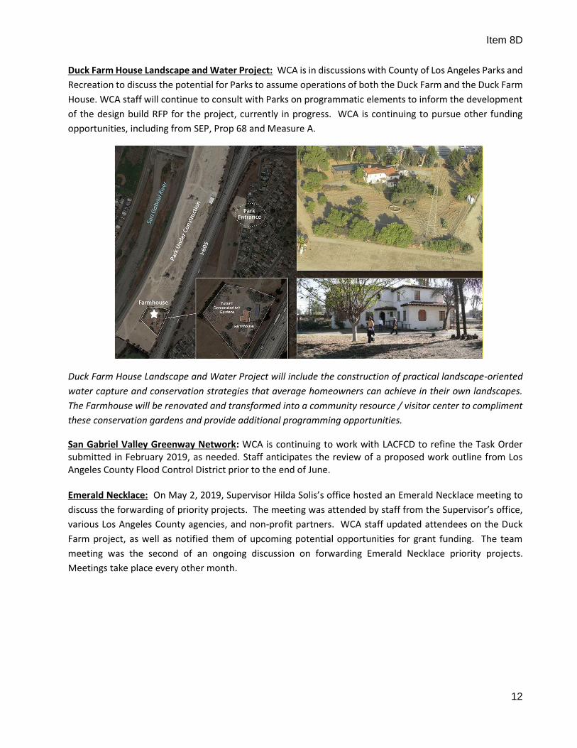
Duck Farm Project: Construction progress is on-going with earthwork and grading underway to develop the new entry drive, parking lot and landscape mound formations. Additionally, work on preparing the site for the delivery of the restroom facility kit to be installed in July has begun, including utilities, septic system and foundation work. Landscape Water Efficiency and Building Permits (Structures, Electrical and Plumbing) have been issued. Coordination with SCE on the removal and relocation of electrical service to the Caltrans on-ramp metering light continue. Construction schedule remains on target for principle completion by General Contractor at the end of October. Landscaping work by the Conservation Corps will continue through the end of this December. Staff is working with LA County Parks and Recreation related to potentially operating and maintaining the park starting in Fiscal Year 2020/2021.
Westside of the Park – sculpting the landscape mounds at the riparian area and the restroom taking shape. The Phase 1A Duck Farm project involves the development of a 30+ acre river adjacent park project that includes a neighborhood park entry, public access trails, riparian landscape, a native plant demonstration garden, native and low water meadows, a river overlook and interpretation features.
Item 8D
12
Duck Farm House Landscape and Water Project: WCA is in discussions with County of Los Angeles Parks and
Recreation to discuss the potential for Parks to assume operations of both the Duck Farm and the Duck Farm
House. WCA staff will continue to consult with Parks on programmatic elements to inform the development
of the design build RFP for the project, currently in progress. WCA is continuing to pursue other funding
opportunities, including from SEP, Prop 68 and Measure A.
Duck Farm House Landscape and Water Project will include the construction of practical landscape-oriented
water capture and conservation strategies that average homeowners can achieve in their own landscapes.
The Farmhouse will be renovated and transformed into a community resource / visitor center to compliment
these conservation gardens and provide additional programming opportunities.
San Gabriel Valley Greenway Network: WCA is continuing to work with LACFCD to refine the Task Order submitted in February 2019, as needed. Staff anticipates the review of a proposed work outline from Los Angeles County Flood Control District prior to the end of June. Emerald Necklace: On May 2, 2019, Supervisor Hilda Solis’s office hosted an Emerald Necklace meeting to
discuss the forwarding of priority projects. The meeting was attended by staff from the Supervisor’s office,
various Los Angeles County agencies, and non-profit partners. WCA staff updated attendees on the Duck
Farm project, as well as notified them of upcoming potential opportunities for grant funding. The team
meeting was the second of an ongoing discussion on forwarding Emerald Necklace priority projects.
Meetings take place every other month.

Item 8D
13
The Emerald Necklace is a 17-mile interconnected network of existing and envisioned bikeways, multi-use trails, parks, and greenways along the Rio Hondo and the San Gabriel River. Along the Rio Hondo the Emerald Necklace stretches from Peck Road Water Conservation Park in the north to the Whittier Narrows Recreation Areas in the south. Along the San Gabriel River, it stretches from Hanson Quarry in the north to Whittier Narrows Recreational Area in the south. The Emerald Necklace Implementation Plan – Phase 1 (Proposed Project) includes 15 related projects that would close gaps in a regional recreational trails network and increase access to the trails to hundreds of thousands of people in the project area. San Gabriel Mountains and Foothills Acquisition Master Plan: WCA continues to work with Trust for Public Land to shape a study that may be used in prioritizing future acquisitions of conservation lands. Appraisal, due diligence, and negotiations for access are underway for Parcel 001 “Vasquez Overlook”, which abuts the newly acquired Parcel 009 “WCA’s Vasquez”. Funding venues are being explored for the purchase of “Vasquez Overlook” and “Rainbow Ranch,” which would add to a cluster of publicly owned land centered around WCA’s River Wilderness Park. These parcels offer unique passive use opportunities. Rainbow Ranch offers a particularly significant opportunity to restore rare floodplain habitat. Final Transfer documents for the 128-acre Easley Canyon property (a donation the Board accepted in January 2019) have been submitted to San Gabriel Mountains Regional Conservancy (SGMRC). WCA is waiting to receive Conservation Easement documents from SGMRC for review.

Item 8D
14
San Gabriel Mountains and Foothills Acquisition Master Plan Project will develop a comprehensive prioritized acquisition strategy and a recommended resource management and operations strategy to preserve habitat and open space, improve watershed health, and increase public access for compatible uses such as multi-use trails and related passive recreational amenities along the foothills of the San Gabriel Mountains. Roberts Canyon Acquisition: A Rivers and Mountains Conservancy grant funded WCA’s due diligence for the potential acquisition of the parcels collectively known as Roberts Canyon. This site is located adjacent to WCA’s River Wilderness Park within the foothills of the San Gabriel Mountains at the entrance of Roberts Canyon in the city of Azusa. The property consists of unbuildable steep slopes surrounding the Mountain Cove Community residential development, which Lennar Homes is offering as a donation.
Because WCA would only have limited immunity in the case of a landslide that causes damage outside the boundaries of land we own in fee title, WCA has requested that Lennar Corporation consider two scenarios that would not expose a public agency to unnecessary risks or expenses: 1) Lennar Corporation conveys a conservation easement to WCA but holds the fee OR 2) WCA accepts the fee and is given an indemnity by Lennar Corporation should a landslide occur in the future. Lennar has responded that they do not want to continue to hold the fee title, therefore a conservation easement would not be appropriate. Nor would they provide indemnity. Lennar offered to provide an upfront payment to WCA to compensate for the cost of insuring the property. WCA is currently seeking estimate for general liability to present for Lennar’s consideration. Vasquez Acquisition: In March, the Board approved the award of a contract to Long Beach-based ecological consulting firm, Tidal Influence, to conduct a Spring Biological Survey of WCA’s “Vasquez” property. WCA’s “Vasquez” property [AIN 8684-024-907] is approximately 40 acres of undeveloped land in the San Gabriel Mountain Foothills above the City of Azusa. The biological survey commenced in March, and the last field survey will occur on June 18. Digitization of vegetation mapping is currently in progress. The team is compiling a species list and a narrative which will describe the biological resources on site and their significance, stages of post-fire recovery of coastal sage scrub habitat, recommendations for the management of invasive species, and potential restoration targets. The survey and accompanying report are expected to be submitted in July. The survey results and land management recommendations included in the report will form the basis of a land management plan which is expected to include a restoration component, and to be formed in dialogue with other foothills conservation stakeholders.

Item 8D
15
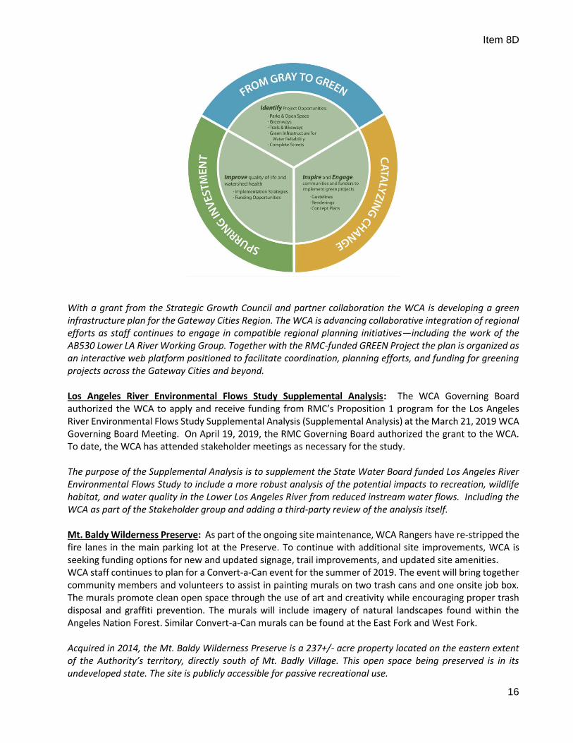
GREEN Project: WCA staff has been developing the functionality and structure of the GREEN project portal in conjunction with the content of the Gateway Cities and Rivers Urban Greening Master Plan. The GREEN project is a multipart effort by the agency to promote urban greening in the WCA / RMC territory. The GREEN portal website will be a tool that documents, complements, and amplifies these efforts. Most recently, WCA has been working on the GREEN Project Portal in conjunction with the Los Angeles County Regional Park and Open Space District on the specific content and outcomes of the Portal.
The Green Regional Environmental Enhancement Network (GREEN) Project is a planning and project implementation initiative supporting watershed-based greening efforts to help support collaboration in the wider Los Angeles and Orange County area. The scope of the project includes regional data collection and assessments, identification of priority projects, and community engagement strategies culminating in the launch of an online GREEN project portal to share data and information, and to catalyze investments and positive change. Gateway Cities and Rivers Urban Greening Master Plan: Conceptual design and imagery for the Greenspace tool is wrapping up this month. Staff are currently drafting and uploading written and visual content to the Gateway Greening website. Staff is also incorporating consultant data analysis into city-specific profile and region-wide recommendations. The design and development of the web portal is complete, although staff needs to continue to migrate material into new templates and user interfaces. The project is expected to launch in late Summer be complete by the end of 2019. The next Advisory Committee meeting will be held Tuesday, July 16th, 2019. WCA is also collaborating with the Gateway Cities COG and GWMA on Prop 68 grant applications to continue planning and implementation of urban greening in the Gateway Cities.
Item 8D
16
With a grant from the Strategic Growth Council and partner collaboration the WCA is developing a green infrastructure plan for the Gateway Cities Region. The WCA is advancing collaborative integration of regional efforts as staff continues to engage in compatible regional planning initiatives—including the work of the AB530 Lower LA River Working Group. Together with the RMC-funded GREEN Project the plan is organized as an interactive web platform positioned to facilitate coordination, planning efforts, and funding for greening projects across the Gateway Cities and beyond. Los Angeles River Environmental Flows Study Supplemental Analysis: The WCA Governing Board authorized the WCA to apply and receive funding from RMC’s Proposition 1 program for the Los Angeles River Environmental Flows Study Supplemental Analysis (Supplemental Analysis) at the March 21, 2019 WCA Governing Board Meeting. On April 19, 2019, the RMC Governing Board authorized the grant to the WCA. To date, the WCA has attended stakeholder meetings as necessary for the study. The purpose of the Supplemental Analysis is to supplement the State Water Board funded Los Angeles River Environmental Flows Study to include a more robust analysis of the potential impacts to recreation, wildlife habitat, and water quality in the Lower Los Angeles River from reduced instream water flows. Including the WCA as part of the Stakeholder group and adding a third-party review of the analysis itself. Mt. Baldy Wilderness Preserve: As part of the ongoing site maintenance, WCA Rangers have re-stripped the fire lanes in the main parking lot at the Preserve. To continue with additional site improvements, WCA is seeking funding options for new and updated signage, trail improvements, and updated site amenities. WCA staff continues to plan for a Convert-a-Can event for the summer of 2019. The event will bring together community members and volunteers to assist in painting murals on two trash cans and one onsite job box. The murals promote clean open space through the use of art and creativity while encouraging proper trash disposal and graffiti prevention. The murals will include imagery of natural landscapes found within the Angeles Nation Forest. Similar Convert-a-Can murals can be found at the East Fork and West Fork. Acquired in 2014, the Mt. Baldy Wilderness Preserve is a 237+/- acre property located on the eastern extent of the Authority’s territory, directly south of Mt. Badly Village. This open space being preserved is in its undeveloped state. The site is publicly accessible for passive recreational use.

Item 8D
17
Crystal Lake Redevelopment and San Gabriel Canyon Master Planning: The USFS, WCA, and consultant project team met on May 14th to discus new recreation opportunities in San Gabriel Canyon. The next meeting in late June will review new recreation opportunities in the Crystal Lake area. The project team will then develop conceptual alternatives for the San Gabriel Canyon and Crystal Lake areas for public review and feedback in August 2019. Crystal Lake Redevelopment and San Gabriel Canyon Master Planning, authorized by U.S. Forest Service under a Supplemental Project Agreement with WCA, to implement a redevelopment and enhancement conceptual planning effort for the Crystal Lake recreation area located in the Angeles National Forest, as well as, a recreation master plan for the San Gabriel Canyon area focusing on access, circulation, and recreational resources. River Wilderness Park: Staff is working with City of Azusa, Caltrans and Design team to restart and complete the design packages for the overlook and park entry improvement elements of the park. WCA is currently pursuing a strategy of developing the park without the Roundabout on Highway 39, as its 4th application for ATP funds was not successful. WCA will continue to advocate for Caltrans to develop the roundabout, but will develop the park in its absence in order to prevent further delays. Staff is preparing Prop 68 grant applications and will pursue other grant opportunities to fill funding gaps for park elements.
The RWP is an approx. 118-acre property envisioned to provide unique wilderness experiences in the lower San Gabriel River Canyon comprised of engaging landscapes, gathering spaces, thriving habitats, and a regional hub and welcome center for the San Gabriel Mountains National Monument. San Gabriel River Confluence with Cattle Canyon Project: Staff was successful in reapplying for funding from the National Forest Foundation (NFF) to complete the design of the Oaks River Access project along with already secured remaining funding from Resource Legacy Fund (RLF). WCA is meeting with the Angeles National Forest and consultant, BlueGreen, to finalize the concept design of the project prior to completing the full Construction Document package. WCA is awaiting a conference meeting with the RMC to update the status of the project for a pending award to fund construction.

Item 8D
18
U.S. Forest Service anticipates making a decision of record on the EIS/EIR for the project later this year.
Along a 2.5-mile segment of the East Fork San Gabriel River recreational use is highly concentrated. This heavy use combined with the lack of facilities has resulted in degraded conditions. In response, the Cattle Canyon Project seeks to better manage the recreational use, and balance the needs for resource project within this area of the San Gabriel Mountains. South Gate Habitat Restoration Project/Parque dos Rios: WCA is working with the Conservation Corps of Long Beach to complete the execution of the Construction contract and set a Notice to Proceed for early July. Additionally, staff is working with the City of South Gate to plan a ground-breaking event/photo opportunity with details and invitations to follow shortly.
Parque Dos Rios is a 7.8-acre site situated along the Lower Los Angeles River (LLAR) at the confluence with the Rio Hondo in the City of South Gate. The project will create a bike stop amenity for the LLAR trail, with overlook, shade structure, seating and interpretive graphics. The land will be planted with Natives and a raptor perch installed.

Item 8D
19
Walnut Creek Habitat & Open Space: Landscape designers BlueGreen have submitted stamped 100% landscape design documents. The City of San Dimas has finished with trail construction. Staff and consultants are working to forward the landscape design through the subsequent RFB and construction process.
WALNUT CREEK – WEST PHASE ONLY
Acquired in 2008, the Walnut Creek Habitat and Open Space Property is a total of approx. 60.8 acres. The location is directly east of Bonelli Regional Park and along the Walnut Creek riparian corridor. Approximately 6.7 acres are owned by the City of San Dimas and 54 acres are owned by the WCA. City of San Dimas the City secured County Proposition A funding in the amount of $850,000 to begin initial West Phase development. The initial phase includes site clean-up, trail development and amenities (interpretive signage, benches, etc.) for a looped spur trail, habitat enhancements, and the planting of a vegetated buffer for neighbors and connect to the Antonovich Trail via County-operated trail staging areas. River Ranger Program Implementation Project: The final Los Angeles River Ranger Program Establishment Plan was submitted to the Senate Committee on Natural Resources and Water and the Assembly Committee on Water, Parks, and Wildlife on May 31, 2019. The Los Angeles River Ranger Program Establishment Plan provides the framework and tools to facilitate the refinement and implementation of the Program. Included is an Executive Summary followed by six chapters: 1. Introduction, 2. Envisioning the River Ranger Program, 3. Outreach and Engagement, 4. Program Framework, 5. Governance and Funding, and 6. Program Rollout. Key recommendations of the plan include the following: 1. Anticipated programmatic needs of the River Ranger Program are best served by a tiered staffing approach containing Sworn Peace Officer Rangers, Resource Management & Maintenance Specialists and Interpretive Specialists, complemented by River Stewards. 2. Three possible governance models are: existing cooperative entities (i.e. Park District or Joint Powers Authorities), existing governmental agencies (i.e. County or municipalities), or a hybrid of the two models. 3. Funding for the River Ranger Program can be secured through state, local, and/or private sources. 4. A suggested next step is to roll-out the program in 3-mile segments referred to as River Education, Adventure, Community, and Habitat (REACH) Zones, which can eventually be expanded. 5. Immediate and ongoing collaboration with both community and agency partners are needed for successful implementation of the proposed River Ranger Program

Item 8D
20
WCA Satellite Office: WCA staff, in coordination with Conservation Corps of Long Beach, drafting an MOA/lease agreement to utilize office space at one or more of their facilities. WCA and RMC staff met with CCLB to discuss space needs, sharing of equipment and supplies, access considerations, etc. to aid in preparing the agreement. This item will be presented at a future Governing Board Meeting for consideration to enter into the agreement. Satellite Office Space currently under consideration are CCLB’s Nietos Ave. and Atlantic Ave. sites.


![F] F] IYæ— F] ECO F] @ ) RMC-HP2K RMC-HP3KD/RMC-HP3K RMC-HP3 MITSIBISHI @ (Blffi)](https://img.pdfslide.us/doc/110x75/5ae590b77f8b9a8b2b8c0615/f-f-iy-f-eco-f-rmc-hp2k-rmc-hp3kdrmc-hp3k-rmc-hp3-mitsibishi-blffi.jpg)