Embed Size (px)
Citation preview
Molloy Land Records 06-22-14.docx - 1 - [email protected]
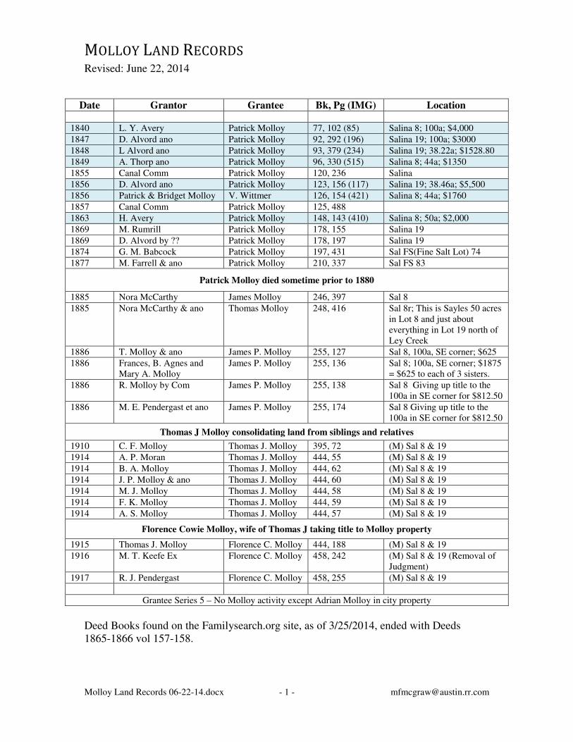
MOLLOY LAND RECORDS
Revised: June 22, 2014
Date Grantor Grantee Bk, Pg (IMG) Location
1840 L. Y. Avery Patrick Molloy 77, 102 (85) Salina 8; 100a; $4,000
1847 D. Alvord ano Patrick Molloy 92, 292 (196) Salina 19; 100a; $3000
1848 L Alvord ano Patrick Molloy 93, 379 (234) Salina 19; 38.22a; $1528.80
1849 A. Thorp ano Patrick Molloy 96, 330 (515) Salina 8; 44a; $1350
1855 Canal Comm Patrick Molloy 120, 236 Salina
1856 D. Alvord ano Patrick Molloy 123, 156 (117) Salina 19; 38.46a; $5,500
1856 Patrick & Bridget Molloy V. Wittmer 126, 154 (421) Salina 8; 44a; $1760
1857 Canal Comm Patrick Molloy 125, 488
1863 H. Avery Patrick Molloy 148, 143 (410) Salina 8; 50a; $2,000
1869 M. Rumrill Patrick Molloy 178, 155 Salina 19
1869 D. Alvord by ?? Patrick Molloy 178, 197 Salina 19
1874 G. M. Babcock Patrick Molloy 197, 431 Sal FS(Fine Salt Lot) 74
1877 M. Farrell & ano Patrick Molloy 210, 337 Sal FS 83
Patrick Molloy died sometime prior to 1880
1885 Nora McCarthy James Molloy 246, 397 Sal 8
1885 Nora McCarthy & ano Thomas Molloy 248, 416 Sal 8r; This is Sayles 50 acres in Lot 8 and just about everything in Lot 19 north of Ley Creek
1886 T. Molloy & ano James P. Molloy 255, 127 Sal 8, 100a, SE corner; $625
1886 Frances, B. Agnes and Mary A. Molloy
James P. Molloy 255, 136 Sal 8; 100a, SE corner; $1875 = $625 to each of 3 sisters.
1886 R. Molloy by Com James P. Molloy 255, 138 Sal 8 Giving up title to the 100a in SE corner for $812.50
1886 M. E. Pendergast et ano James P. Molloy 255, 174 Sal 8 Giving up title to the 100a in SE corner for $812.50
Thomas J Molloy consolidating land from siblings and relatives
1910 C. F. Molloy Thomas J. Molloy 395, 72 (M) Sal 8 & 19
1914 A. P. Moran Thomas J. Molloy 444, 55 (M) Sal 8 & 19
1914 B. A. Molloy Thomas J. Molloy 444, 62 (M) Sal 8 & 19
1914 J. P. Molloy & ano Thomas J. Molloy 444, 60 (M) Sal 8 & 19
1914 M. J. Molloy Thomas J. Molloy 444, 58 (M) Sal 8 & 19
1914 F. K. Molloy Thomas J. Molloy 444, 59 (M) Sal 8 & 19
1914 A. S. Molloy Thomas J. Molloy 444, 57 (M) Sal 8 & 19
Florence Cowie Molloy, wife of Thomas J taking title to Molloy property
1915 Thomas J. Molloy Florence C. Molloy 444, 188 (M) Sal 8 & 19
1916 M. T. Keefe Ex Florence C. Molloy 458, 242 (M) Sal 8 & 19 (Removal of Judgment)
1917 R. J. Pendergast Florence C. Molloy 458, 255 (M) Sal 8 & 19
Grantee Series 5 – No Molloy activity except Adrian Molloy in city property
Deed Books found on the Familysearch.org site, as of 3/25/2014, ended with Deeds 1865-1866 vol 157-158.
Molloy Land Records 06-22-14.docx - 2 - [email protected]
Date Grantor Grantee Bk, Pg
(IMG)
Location
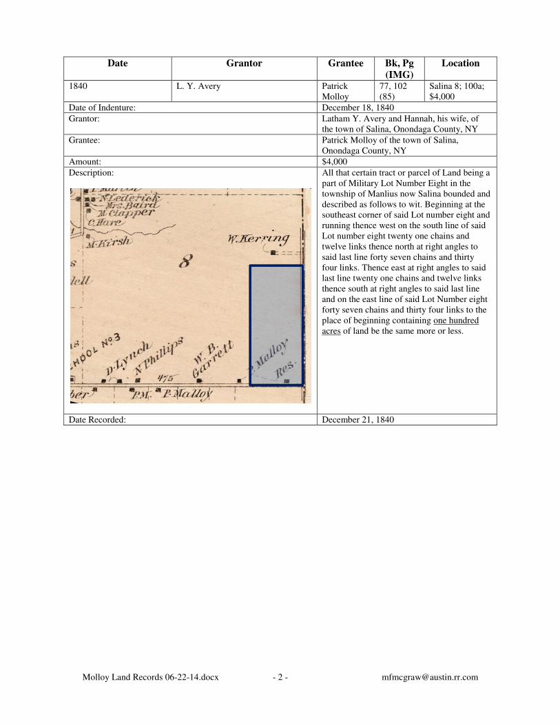
1840 L. Y. Avery Patrick Molloy
77, 102 (85)
Salina 8; 100a; $4,000
Date of Indenture: December 18, 1840
Grantor: Latham Y. Avery and Hannah, his wife, of the town of Salina, Onondaga County, NY
Grantee: Patrick Molloy of the town of Salina, Onondaga County, NY
Amount: $4,000
Description:
All that certain tract or parcel of Land being a part of Military Lot Number Eight in the township of Manlius now Salina bounded and described as follows to wit. Beginning at the southeast corner of said Lot number eight and running thence west on the south line of said Lot number eight twenty one chains and twelve links thence north at right angles to said last line forty seven chains and thirty four links. Thence east at right angles to said last line twenty one chains and twelve links thence south at right angles to said last line and on the east line of said Lot Number eight forty seven chains and thirty four links to the place of beginning containing one hundred acres of land be the same more or less.
Date Recorded: December 21, 1840
Molloy Land Records 06-22-14.docx - 3 - [email protected]
Date Grantor Grantee Bk, Pg
(IMG)
Location
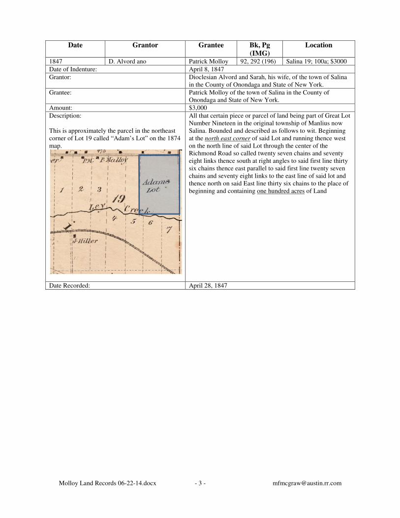
1847 D. Alvord ano Patrick Molloy 92, 292 (196) Salina 19; 100a; $3000
Date of Indenture: April 8, 1847
Grantor: Dioclesian Alvord and Sarah, his wife, of the town of Salina in the County of Onondaga and State of New York.
Grantee: Patrick Molloy of the town of Salina in the County of Onondaga and State of New York.
Amount: $3,000
Description: This is approximately the parcel in the northeast corner of Lot 19 called “Adam’s Lot” on the 1874 map.
All that certain piece or parcel of land being part of Great Lot Number Nineteen in the original township of Manlius now Salina. Bounded and described as follows to wit. Beginning at the north east corner of said Lot and running thence west on the north line of said Lot through the center of the Richmond Road so called twenty seven chains and seventy eight links thence south at right angles to said first line thirty six chains thence east parallel to said first line twenty seven chains and seventy eight links to the east line of said lot and thence north on said East line thirty six chains to the place of beginning and containing one hundred acres of Land
Date Recorded: April 28, 1847
Molloy Land Records 06-22-14.docx - 4 - [email protected]
Date Grantor Grantee Bk, Pg
(IMG)
Location
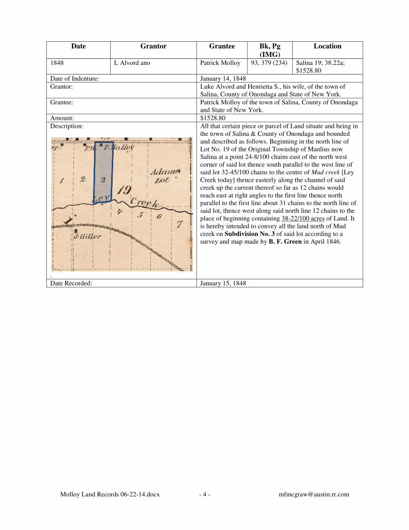
1848 L Alvord ano Patrick Molloy 93, 379 (234) Salina 19; 38.22a; $1528.80
Date of Indenture: January 14, 1848
Grantor: Luke Alvord and Henrietta S., his wife, of the town of Salina, County of Onondaga and State of New York.
Grantee: Patrick Molloy of the town of Salina, County of Onondaga and State of New York.
Amount: $1528.80
Description:
.
All that certain piece or parcel of Land situate and being in the town of Salina & County of Onondaga and bounded and described as follows. Beginning in the north line of Lot No. 19 of the Original Township of Manlius now Salina at a point 24-8/100 chains east of the north west corner of said lot thence south parallel to the west line of said lot 32-45/100 chains to the centre of Mud creek [Ley Creek today] thence easterly along the channel of said creek up the current thereof so far as 12 chains would reach east at right angles to the first line thence north parallel to the first line about 31 chains to the north line of said lot, thence west along said north line 12 chains to the place of beginning containing 38-22/100 acres of Land. It is hereby intended to convey all the land north of Mud creek on Subdivision No. 3 of said lot according to a survey and map made by B. F. Green in April 1846.
Date Recorded: January 15, 1848
Molloy Land Records 06-22-14.docx - 5 - [email protected]
Date Grantor Grantee Bk, Pg
(IMG)
Location
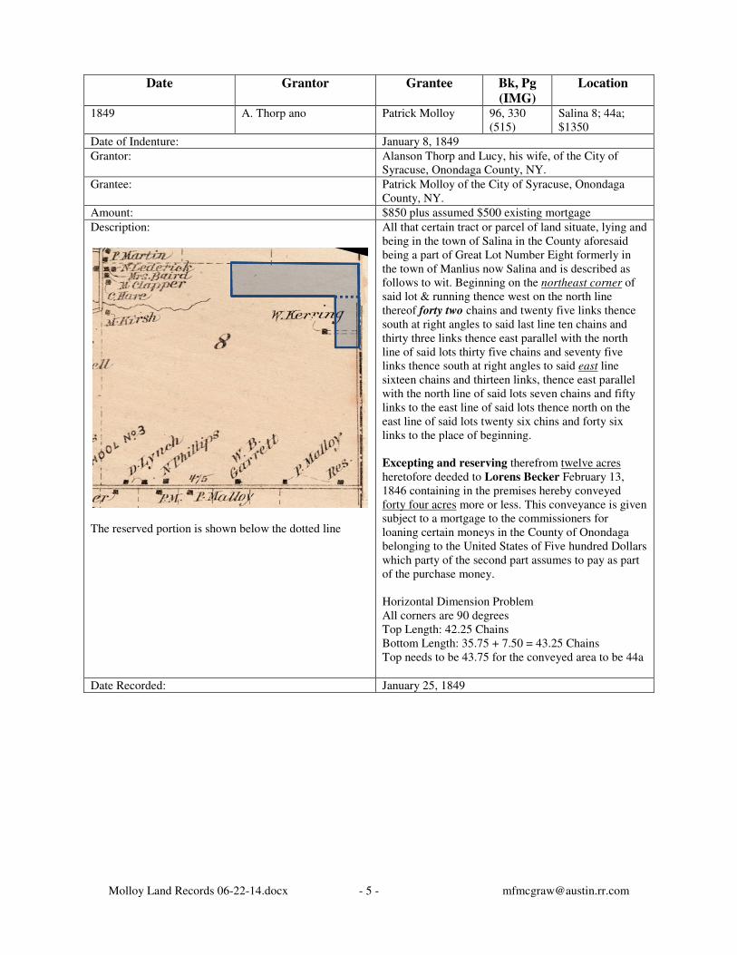
1849 A. Thorp ano Patrick Molloy 96, 330 (515)
Salina 8; 44a; $1350
Date of Indenture: January 8, 1849
Grantor: Alanson Thorp and Lucy, his wife, of the City of Syracuse, Onondaga County, NY.
Grantee: Patrick Molloy of the City of Syracuse, Onondaga County, NY.
Amount: $850 plus assumed $500 existing mortgage
Description:
The reserved portion is shown below the dotted line
All that certain tract or parcel of land situate, lying and being in the town of Salina in the County aforesaid being a part of Great Lot Number Eight formerly in the town of Manlius now Salina and is described as follows to wit. Beginning on the northeast corner of said lot & running thence west on the north line thereof forty two chains and twenty five links thence south at right angles to said last line ten chains and thirty three links thence east parallel with the north line of said lots thirty five chains and seventy five links thence south at right angles to said east line sixteen chains and thirteen links, thence east parallel with the north line of said lots seven chains and fifty links to the east line of said lots thence north on the east line of said lots twenty six chins and forty six links to the place of beginning.
Excepting and reserving therefrom twelve acres heretofore deeded to Lorens Becker February 13, 1846 containing in the premises hereby conveyed forty four acres more or less. This conveyance is given subject to a mortgage to the commissioners for loaning certain moneys in the County of Onondaga belonging to the United States of Five hundred Dollars which party of the second part assumes to pay as part of the purchase money. Horizontal Dimension Problem All corners are 90 degrees Top Length: 42.25 Chains Bottom Length: 35.75 + 7.50 = 43.25 Chains Top needs to be 43.75 for the conveyed area to be 44a
Date Recorded: January 25, 1849
Molloy Land Records 06-22-14.docx - 6 - [email protected]
Date Grantor Grantee Bk, Pg
(IMG)
Location
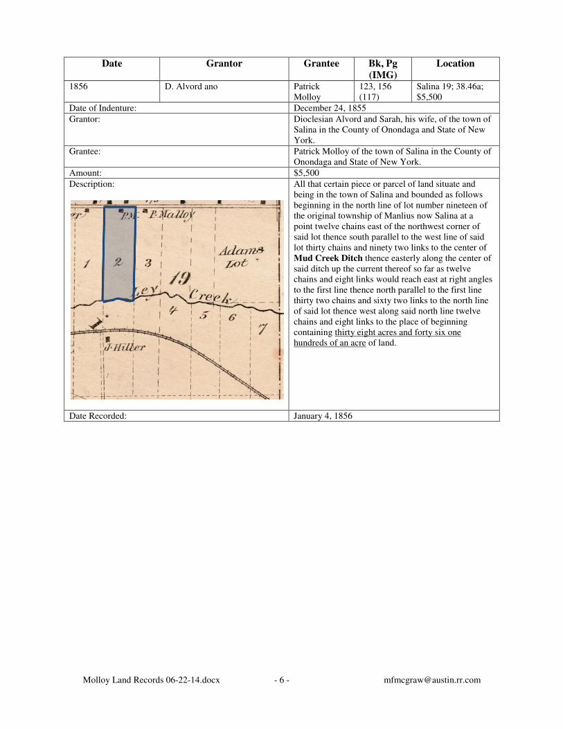
1856 D. Alvord ano Patrick Molloy
123, 156 (117)
Salina 19; 38.46a; $5,500
Date of Indenture: December 24, 1855
Grantor: Dioclesian Alvord and Sarah, his wife, of the town of Salina in the County of Onondaga and State of New York.
Grantee: Patrick Molloy of the town of Salina in the County of Onondaga and State of New York.
Amount: $5,500
Description:
All that certain piece or parcel of land situate and being in the town of Salina and bounded as follows beginning in the north line of lot number nineteen of the original township of Manlius now Salina at a point twelve chains east of the northwest corner of said lot thence south parallel to the west line of said lot thirty chains and ninety two links to the center of Mud Creek Ditch thence easterly along the center of said ditch up the current thereof so far as twelve chains and eight links would reach east at right angles to the first line thence north parallel to the first line thirty two chains and sixty two links to the north line of said lot thence west along said north line twelve chains and eight links to the place of beginning containing thirty eight acres and forty six one hundreds of an acre of land.
Date Recorded: January 4, 1856

Molloy Land Records 06-22-14.docx - 7 - [email protected]
Date Grantor Grantee Bk, Pg
(IMG)
Location
1856 Patrick & Bridget Molloy V. Wittmer 126, 154 (421)
Salina 8; 44a; $1760
Date of Indenture: August 5, 1856
Grantor: Patrick Molloy of the town of Salina and Bridget his wife
Grantee: Valentine Wittner of the town of Salina
Amount: $1760
Description:
All that certain tract or parcel of land situate lying and being in the town of Salina being part of great lot No. 8 formerly in the town of Manlius described as follows Beginning on the northeast corner of said lot and running thence west on the north line thereof forty two chains and twenty five links, thence south at right angles to said last line ten chains and thirty three links, thence East parallel to the north line of said lot thirty five chains and seventy five links, thence south at right angles to said last line sixteen chains & thirteen links, thence East parallel with the north line of said lot seven chains and fifty links to the East line of said lot thence north on the East line of said lot twenty six chains and forty six links to the place of beginning, Excepting and reserving theresfrom twelve acres heretofore deeded to Lorenze Becker February 18, 1846 containing in the premises hereby conveyed forty four acres more or less, subject to a mortgage on said premises to the Loan Commisioners of the County of Onondaga for the sum of five hundred dollars. Net = Total – 12a = 56a – 12a = 44a
Date Recorded:
Molloy Land Records 06-22-14.docx - 8 - [email protected]
Date Grantor Grantee Bk, Pg
(IMG)
Location
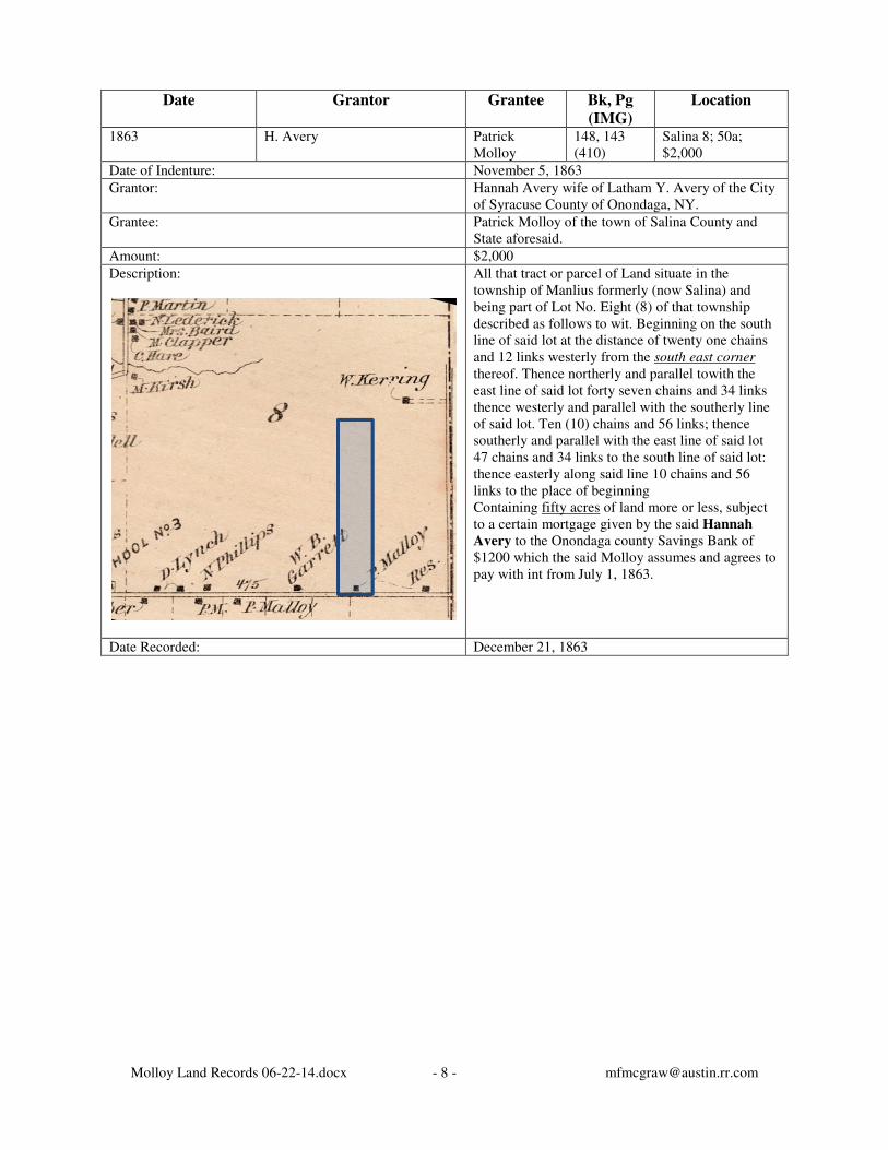
1863 H. Avery Patrick Molloy
148, 143 (410)
Salina 8; 50a; $2,000
Date of Indenture: November 5, 1863
Grantor: Hannah Avery wife of Latham Y. Avery of the City of Syracuse County of Onondaga, NY.
Grantee: Patrick Molloy of the town of Salina County and State aforesaid.
Amount: $2,000
Description:
All that tract or parcel of Land situate in the township of Manlius formerly (now Salina) and being part of Lot No. Eight (8) of that township described as follows to wit. Beginning on the south line of said lot at the distance of twenty one chains and 12 links westerly from the south east corner thereof. Thence northerly and parallel towith the east line of said lot forty seven chains and 34 links thence westerly and parallel with the southerly line of said lot. Ten (10) chains and 56 links; thence southerly and parallel with the east line of said lot 47 chains and 34 links to the south line of said lot: thence easterly along said line 10 chains and 56 links to the place of beginning Containing fifty acres of land more or less, subject to a certain mortgage given by the said Hannah
Avery to the Onondaga county Savings Bank of $1200 which the said Molloy assumes and agrees to pay with int from July 1, 1863.
Date Recorded: December 21, 1863
Molloy Land Records 06-22-14.docx - 9 - [email protected]
The following detailed description is included because it details all the former holdings of
Thomas Molloy which as a result of this filing belonged to Florence Cowie Molloy.
MOLLOY FORECLOSURE AGAINST WILLIAM AND CHESTER WIRT
The Syracuse Herald, Syracuse, NY, Wednesday, April 17, 1935 SUPREME COURT, County of Onondaga, State of New York – Florence C. Molloy, plaintiff, against William A. Wirt, Mildred Harter Wirt, his wife; Chester E. Wirt, Jennie Wirt, his wife; Robert Hammon, Marie Hammon, his wife, and Martha Ruth Wirt defendants. All that tract or parcel of land situate in the Town of Salina, County of Onondaga and State of New York, described as follows:
Commencing on the south line of Lot No. 8, 21 chains, 12 links westerly from the southeast
corner thereof: Thence northerly parallel with the east line of said lot 47 chains 34 links; Thence westerly parallel with the southerly line of said lot 10 chains 56 links; Thence southerly parallel with the east line of said lot 47 chains 34 links to the south line of said lot; Thence easterly along said line 10 chains 56 links to the place of beginning, containing 50
acres of land more or less.
All that tract or parcel of land situate in the Town of Salina, County of Onondaga and State of New York, described as follows:
Beginning on the northeast corner of Lot No. 19: Thence west on the north line of said lot through the center of the Richmond Road 27 chains
78 links; Thence south at right angles to said first line 36 chains; Thence east parallel to said first line 27 chains 78 links to the east line of said lot; Thence north on said east line 36 chains to the place of beginning, containing 100 acres of land.
All that tract or parcel of land situate in the Town of Salina, County of Onondaga and State of New York, described as follows:
Beginning in the north line of Lot No. 19, 48 chains 16 links south 86-1/2 degrees east from the northwest corner thereof; Thence south 86-1/4 degrees east, 8 chains 36 links; Thence south 3-1/4 degrees west, 36 chains 84 links;
Thence south 86-1/4 degrees east, 3 chains and 38 links; Thence south 3-1/4 degrees west, 4 chains and 50 links to the center of Mud Creek; Thence north 69-3/4 degrees west, 97 links; Thence north 35-3/4 degrees west, 5 chains and 68 links; Thence north 17-3/4 degrees east, 1 chain and 25 links; Thence north 25 degrees west, 2 chains and 11 links; Thence north 71-3/4 degrees west, 6 chains and 89 links; Thence south 80-3/4 degrees west, 35 links;
Thence north 3-1/4 degrees east, 33 chains and 40 links to the place of beginning, containing 32-17/100 acres of land.
All that tract or parcel of land situate in the Town of Salina, County of Onondaga and State of New York, described as follows:
Molloy Land Records 06-22-14.docx - 10 - [email protected]
Beginning in the north line of said Lot No. 19, 36 chains 8 links south 85-1/4 degrees east from the northwest corner thereof: Thence south 86-1/4 degrees east, 12 chains 8 links; Thence south 3-3/4 degrees west, 33 chains and 40 links to the center of the creek;
Thence south 80-3/4 degrees west, 2 chains 46 links; Thence south 57-1/2 degrees west, 1 chain; Thence north 85-1/2 degrees west, 1 chain; Thence north 54-1/2 degrees west, 2 chains; Thence north 34-1/2 degrees west 1 chain; Thence north 65-1/2 degrees west 1 chain; Thence north 22 degrees west, 1 chain; Thence north 37 degrees west, 1 chain 19 links; Thence north 45 degrees west, 1 chain 55 links; Thence south 31-3/4 degrees west, 2 chains 50 links;
Thence north 3-3/4 degrees east, 30 chains 48 links to the place of beginning, containing 39-35/100 acres.
All the following has to do with the right of way for the Syracuse Lighting Company
to place power transmission lines on the Molloy property and right of ways within
these areas and access to Ley Creek to be maintained by William A. Wirt.
Excepting and reserving from the above described premises: All that tract or parcel of land situate in the Town of Salina, County of Onondaga and State of New York, being part of Lot No. 19 in said town, bounded and described as follows:
Beginning at a point in the center line of the Malloy Road north eighty six degrees (86o) seven minutes (7’) east thirty-six hundred forty-eight and sixty one hundredths (3,648.66) feet from the northwest corner of said Lot No. 19: Thence south three degrees (3o) forty-three minutes (43’) east twenty-three hundred sixty-one and six-tenths (2,361.6) feet to the center of Ley Creek; Thence easterly along the center of Ley Creek to a point one hundred sixty (160) feet measured at right angles to the first described line; Thence north three degrees (3o) forty-three minutes (43’) west parallel with and distant one hundred sixty (160) feet from the first described line, twenty-three hundred seventy (2,370) feet more or less to the center line of the Molloy Road; Thence south eighty-six degrees (86o) seven minutes (7’) west along the center of the Molloy
Road to the place of beginning, containing eight and sixty-nine hundredths (8.69) acres of land, more or less.
Also all that tract or parcel of land situate in the Town of Salina, County of Onondaga and State of New York, being part of Lot No. 8 in said town, bounded and described as follows:
Beginning at a point in the center line of the Molloy Road north eight-six degrees (86o) seven minutes (7’) east thirty-six hundred forty eight and sixty-six hundredths (3,648.66) feet from the northwest corner of Lot No. 19; Thence north three degrees (3o) forty-three minutes (43’) west thirty-one hundred twenty five and seven tenths (3,125.7) feet to the south line of lands of John Wierzbicki; Thence north eighty-five degrees (85o) fifty-three minutes (53’) east along said line one hundred ten (110) feet; Thence south three degrees (3o) forty-three minutes (43’) east parallel with and distant one hundred ten (110) feet from the first described line thirty-one hundred twenty-six and fourteen one hundredths (3,126.14) feet to the center line of the Molloy Road; Thence south eighty-six degrees (86o) seven minutes (7’) west one hundred ten (110) feet to the place of beginning, containing seven and nine-tenths (7.9) acres of land, more or less, with the privilege to the parties of the first part (said parties of the first part being William A.
Molloy Land Records 06-22-14.docx - 11 - [email protected]
Wirt and Martha Ruth Wirt, the grantors named in a deed to The Syracuse Lighting
Company, Inc., recorded September 10, 1924, in Book 543 at Page 63, etc.) of constructing and maintaining across the premises described in an easterly and westerly direction two streets in the southerly parcel, that is southerly from the highway known as the Molloy Road, and one street in the northerly parcel, that is northerly from the highway known as the Molloy
Road, but such street shall be constructed and maintained so as not to interfere in any manner with any of the structures, wires, cables, appurtenances or appliances which the party of the second part (The Syracuse Lighting Company, Inc.) may not at any time hereafter construct or erect upon the premises herein described, or with the use of such structures, wires, cables, appurtenances by the party of the second part.
Also excepting and reserving from the said above described premises: Also all that tract or parcel of land situate in the Town of Salina, County of Onondaga and State of New York, being part of Lot No. 19 in said town, bounded and described as follows:
Beginning at a point in the westerly line of the first parcel of land conveyed by William A.
Wirt and Martha Ruth Wirt to The Syracuse Lighting Company, Inc., by deed dated August 14, 1924, and recorded in the Onondaga County Clerk’s office September 10, 1924, in Book of Deeds 543 at Page 63, said point being south three degrees (3o) forty-three minutes (43’) east two thousand two hundred sixty-five and six-tenths (2,265.6) feet from the center line of the Molloy Road and running thence north eighty-eight degrees (88o) forty-six minutes (46’) west four hundred eighty (480) feet to the center of the Ley Creek; Thence up the center of Ley Creek as it winds and turns to the southwesterly corner of said parcel of land conveyed by the said William A. Wirt and Martha Ruth Wirt to the Syracuse Lighting Company, Inc., by said deed dated August 14, 1924; Thence north three degrees (3o) forty-three minutes (43’) west ninety six (96) feet to the place of beginning, containing three hundred eighty-eight one thousandths (0.388) of an acre of land, be the same more or less, according to a map thereof made by G. E. Higgins Engineering Co., Excepting and Reserving therefrom to the party of the first part (said party of the first part being William A. Wirt, one of the grantors named in a deed to The Syracuse Lighting
Company, Inc., recorded February 14, 1929, in Book 607, at Page 51, etc.) a right of way or easement sixty (60) feet in width across the above described land in a generally northerly and southerly direction for the passing and repassing of all manner of vehicles and conveyances, animals and men, the location of said right of way to be determined by agreement between the parties to said deed, and also excepting and reserving unto the party of the first part the right to take water from the creek in unlimited quantities and to use the creek for drainage and sewage purposes, all said reservations and restrictions to run with the land. JAMES W. HICKEY, Referee Dated at Syracuse, NY, this 3rd day of April, 1935.
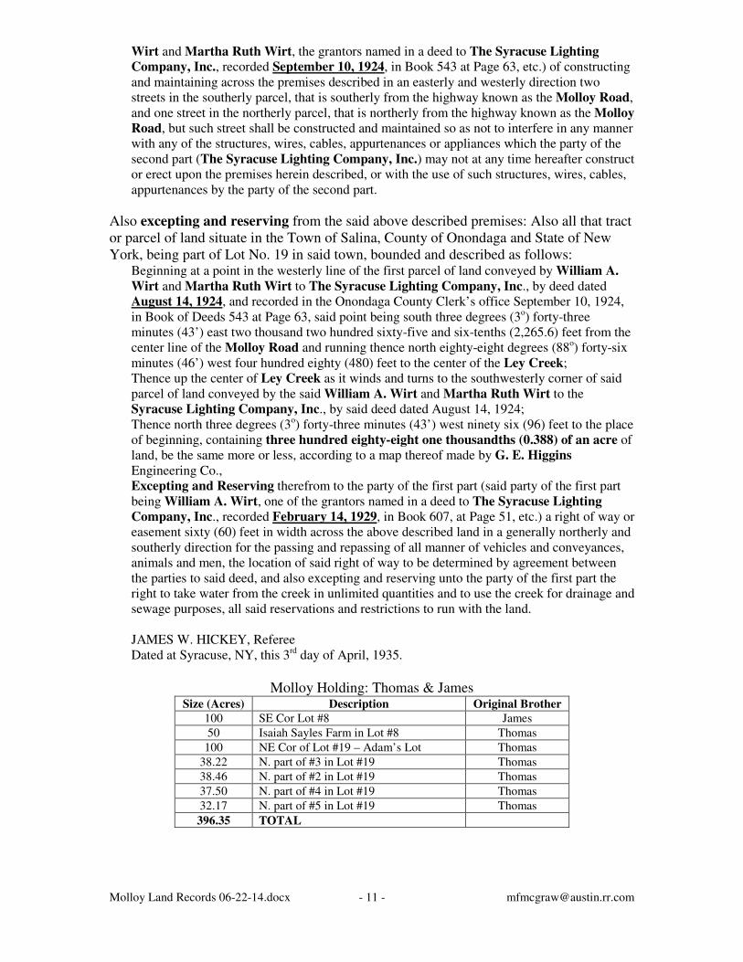
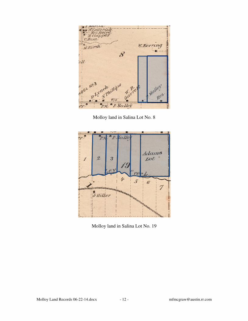
Molloy Holding: Thomas & James
Size (Acres) Description Original Brother
100 SE Cor Lot #8 James
50 Isaiah Sayles Farm in Lot #8 Thomas
100 NE Cor of Lot #19 – Adam’s Lot Thomas
38.22 N. part of #3 in Lot #19 Thomas
38.46 N. part of #2 in Lot #19 Thomas
37.50 N. part of #4 in Lot #19 Thomas
32.17 N. part of #5 in Lot #19 Thomas
396.35 TOTAL
Molloy Land Records 06-22-14.docx - 12 - [email protected]
Molloy land in Salina Lot No. 8
Molloy land in Salina Lot No. 19