Embed Size (px)
Citation preview
Data Production and Management Process as Spatial Strategic Plan
Experience: Kadikoy Example
Burcu SARI, Nazim AKKOYUN and Tayfun KAYA, Turkey
Key words: Spatial Strategic Plan, Participation, Geographic Information Systems, Large
Data
SUMMARY
The main aim is to share experiences related to currently ongoing spatial strategic planning
studies including identification of data sources, data collection methods , correlation among
data collected and establishing their relationship to the space; evaluation methods for analysis
and synthesis together with the problems related.
Second aim is to discuss and analyse the risks and opportunities of Big Data as a new
alternative to the ineffieciencies of traditional methods of data collection and analysis of
present cities.
Finally, the opportunities of Spatial Strategic Plan studies which are not among the
responsibilities of district municipalities according to our country's planning hierarchy, will be
discussed on the basis of Kadikoy Spatial Strategic Plan as an example that it allows to detect
problems of the district, development trends, use of tools for social and economic analysis, in
particular, use of potential resources for a sustainable and participatory decision-making
process for creating a city vision.
The spatial strategic plan requires a continuous flow of data in order to be sustainable one.
Thus, the critisisim will be based not only on institutional transformation of spatial planning
but also on how it can be used as a strategic tool for driving concrete data, tranperency in data
collecting and for continuous flow of data out of institutional transformation of it.
Spatial Strategic Plan as Data Production and Management Process Experience: Kadıköy Example (9578)
Burcu Sari, Tayfun Kaya and Nazim Akkoyun (Turkey)
FIG Congress 2018
Embracing our smart world where the continents connect: enhancing the geospatial maturity of societies
Istanbul, Turkey, May 6–11, 2018

Data Production and Management Process as Spatial Strategic Plan
Experience: Kadikoy Example
Burcu SARI, Nazim AKKOYUN and Tayfun KAYA, Turkey
1. METHOD
The urban planning development system in Turkey is based on the bottom top hierarchy of
urban plans at different scales co-existingly. The Planning Process according to Spatial
Planning Regulations is constituted by making researchs, detecting problems, collecting data
and analysing them, gathering and synthesizing informations, evaluating and finaly
developing planning decisions.
A scientific research technique is the base of this study in order to create a guide to identify
the current situation, decision making process and potentials of the city that is changing
rapidly. The scope of this study is needed to be defined primarily for the identification of the
data source and how to obtain it. It has been investigated that what will be the scope of the
study, main topics, subtitles, sources of data and how far to go into details. And the original
data request form has been created to be sent to the relevant institutions for collecting data
according to internal and external data source classification.
The second step is defined as establishing infrastructure for storing data to be collected,
creating database architecture to establish the spatial relationship, updating and establishing
backup mechanism.
Database used by the present geographical information system applications were converted to
a format that data demanded can be added into and also can work on the various applications.
First of all, analysis and synthesis maps were prepared according to the Spatial Planning
Regulations by obtaining data. Meanwhile, new technological improvements also led to
increase and diversification of data sources. New analysis and synthesis maps are prepared by
benefitting from opportunities created by "Big Data" where traditional analysis and synthesis
tools are insufficient for certain topics. The planning decision making stage became the next
stage depending on the report created according to Analysis and Synthesis studies. For the
internal stakeholders, a workshop has been organized in to obtain a participatory decision
making model. Structural decisions regarding the organization of the planning process were
taken at the workshop, and accordingly, three key projects called MAK (Smart Spatial
Kadikoy), EKIP(Integration, Participation, Collaboration, Planning) and Project Performance,
which will ensure the sustainability of the planning process have been created.
MAK (Smart Spatial Kadikoy) includes collecting data on a scientific basis; EKIP
(Integration, Participation, Collaboration, Planning) defines participatory planining process
Spatial Strategic Plan as Data Production and Management Process Experience: Kadıköy Example (9578)
Burcu Sari, Tayfun Kaya and Nazim Akkoyun (Turkey)
FIG Congress 2018
Embracing our smart world where the continents connect: enhancing the geospatial maturity of societies
Istanbul, Turkey, May 6–11, 2018

and Project Performance is on the monitoring of the performance of the project
implementation.
2. DEFINING THE SCOPE OF THE STUDY
The decisions on spatial environment which directly affect daily life, can lead to interventions
on environment that cost economicaly high. Local Authorities , because of the complex nature
of cities today, are in need of a participatory organizational structure that is supported by
accurate ,actual data and based on the information. In this case, the spatial decision making
process requires a transparent and participatory approach. In line with this requirement, at the
Kadıköy Municipality a task towards the preparation of the Spatial Strategic Plan have been
identified depending on the Institutional Strategic Plan that has been made by a participatory
model.
Preparation of Spatial Strategic Plan consist of the following steps: Identification of the
process, the creation of data infrastructure, collection of data with traditional data collection
tools, the use of innovative data collection and analysis methods, determination of trends and
the current situation of the district; the creation of decision-making process ; production of
strategic decisions and creation of a sustainable feedback mechanism.
The Strategic Spatial Planning has been introduced by Spatial Planning Regulations, in 2014
year. Although the practical planning takes place for the first time in legislation, Spatial
Strategic Planning consists of plans with sectoral and thematic report layouts made at
metropolitan and regional scale.
As the sectoral and thematic report layout issues, settlements and urbanization, transportation
system, water, risk, infrastructure, urban economy and specializations by regions,
development restricted areas, areas to be developed according to certain rules and regulations.
The content of the report covers vision and priorities, principles, objectives, scope, goals and
strategies, sectoral and thematic resolutions, planning decisions and actions. Since the Spatial
Strategic Plan refers to a metropolitan or for more than it, Spatial Plans Regulations will be
inadequate in terms of understanding and developing urban planning objectives at district
level.
Therefore, the data and data analysis are varied by using new technologies and techniques.
3. DATA TRANSFORMATION
In the description made by the regulation on data and information resources, the titles
determined by the Spatial Strategic Planning Scale indicate the data produced by the relevant
institutions and organizations.On the other hand, today, data sources have diversified and
expanded their boundaries. Within the scope of the Spatial Strategic Planning process, data
collection process which consist of 4 steps is planned. First step is the editing of existing datas
which produced in municipality’s own constitution. Second step is collection of data with
Spatial Strategic Plan as Data Production and Management Process Experience: Kadıköy Example (9578)
Burcu Sari, Tayfun Kaya and Nazim Akkoyun (Turkey)
FIG Congress 2018
Embracing our smart world where the continents connect: enhancing the geospatial maturity of societies
Istanbul, Turkey, May 6–11, 2018
traditional data collection methods. Third step is take advantage of innovative data collection
methods and the last step is sythesis (production of new datas from existing datas) stage.
Urban Information System Office which is the coordinator of the work has been primarily
carrying out studies to harmonize existing spatial data with national and international
standards. Firstly the existing spatial datas are edited in accordance with the standarts for
associating the datas which provided from central institutions via services with location. For
example, when the project starts, the compatibility of verbal adress data in the National
Adress Database and geometrical address data which located in database was found to be
about 60%. The compliance rate has been increased to 97% as a result of a yearly effort to
remedy this situation, which is also extremely problematic for the municipality in terms of its
internal functioning.
When the data can be obtained from the institutions by the demand form, a small part of it
provide the certain standards. Therefore, the obtained data was required to go through specific
arrangements to standardize the databate architecture in accordance with national and
international standards (INSPIRE).
After the standardized data is added to the database, the process of associating the verbal data
with the location is performed. Spatial relationship of the data are generally made through
SQL queries on the database. Thus, more than one data is associated wit each other and the
continuity of the relationship is ensured.
4. ANALYSIS AND SYNTHESIS
The data obtained from the municipality and from other instittuions are analyzed under the
nine topics and these are Location and Surroundings Relations, Historical Process, Natural
Building and Environment, Demographical Structure, Socio - Economical Structure, Housing,
Urban Services, Technical Infrastructure and Transportation constitutes headers. Location and
Surroundings Relations constitutes the location of the district within İstanbul, its neighboring
districts and relations with them, and transport connections. This introductory information
related to the identification of the district gives a genearal information about the district.
Spatial Strategic Plan as Data Production and Management Process Experience: Kadıköy Example (9578)
Burcu Sari, Tayfun Kaya and Nazim Akkoyun (Turkey)
FIG Congress 2018
Embracing our smart world where the continents connect: enhancing the geospatial maturity of societies
Istanbul, Turkey, May 6–11, 2018
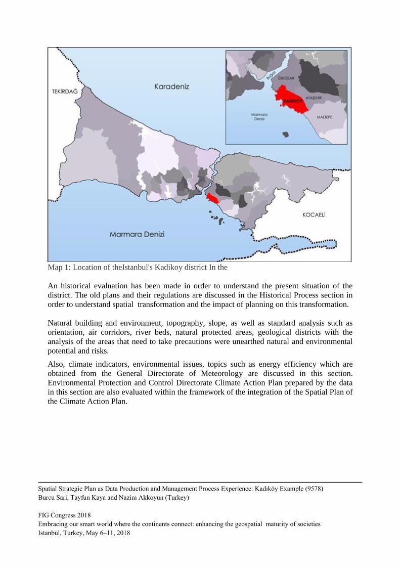
Map 1: Location of theIstanbul's Kadikoy district In the
An historical evaluation has been made in order to understand the present situation of the
district. The old plans and their regulations are discussed in the Historical Process section in
order to understand spatial transformation and the impact of planning on this transformation.
Natural building and environment, topography, slope, as well as standard analysis such as
orientation, air corridors, river beds, natural protected areas, geological districts with the
analysis of the areas that need to take precautions were unearthed natural and environmental
potential and risks.
Also, climate indicators, environmental issues, topics such as energy efficiency which are
obtained from the General Directorate of Meteorology are discussed in this section.
Environmental Protection and Control Directorate Climate Action Plan prepared by the data
in this section are also evaluated within the framework of the integration of the Spatial Plan of
the Climate Action Plan.
Spatial Strategic Plan as Data Production and Management Process Experience: Kadıköy Example (9578)
Burcu Sari, Tayfun Kaya and Nazim Akkoyun (Turkey)
FIG Congress 2018
Embracing our smart world where the continents connect: enhancing the geospatial maturity of societies
Istanbul, Turkey, May 6–11, 2018
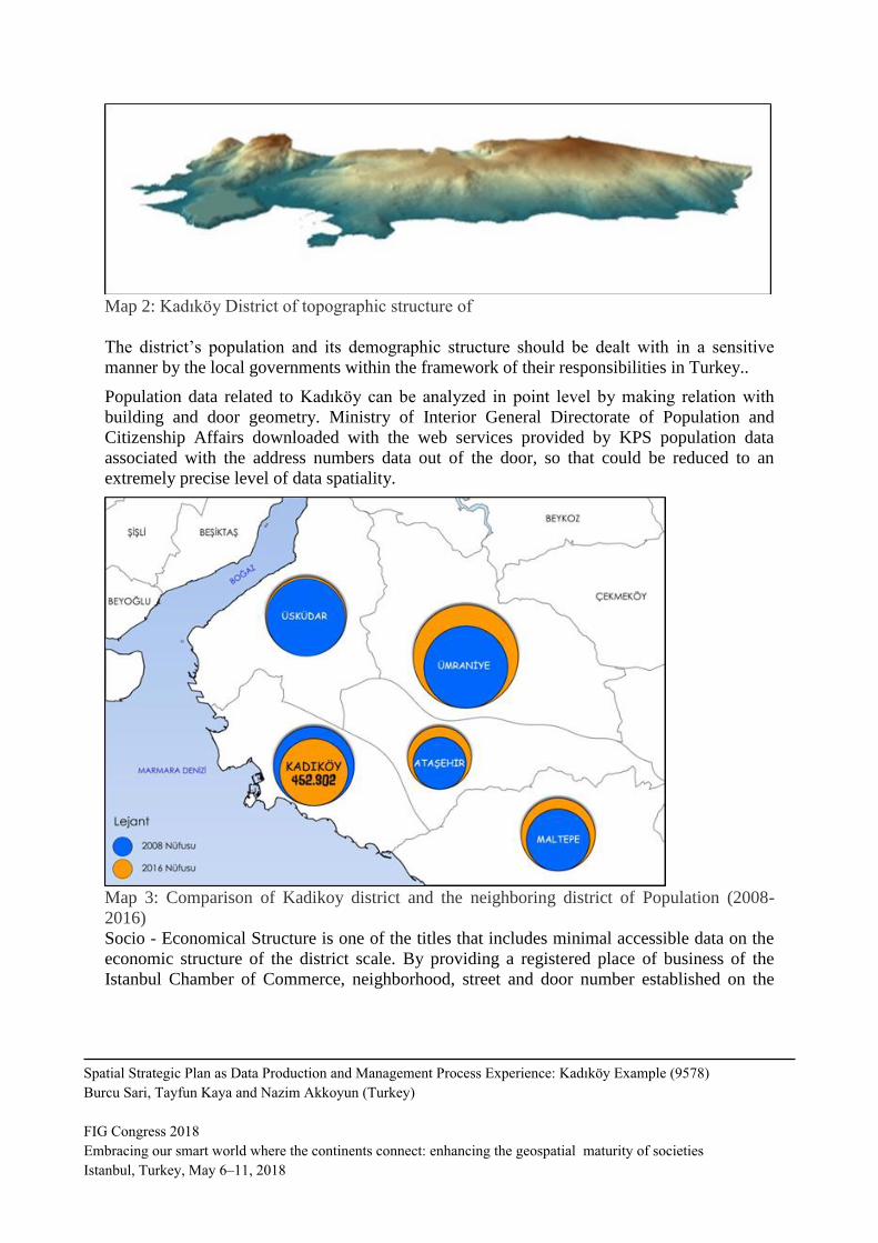
Map 2: Kadıköy District of topographic structure of
The district’s population and its demographic structure should be dealt with in a sensitive
manner by the local governments within the framework of their responsibilities in Turkey..
Population data related to Kadıköy can be analyzed in point level by making relation with
building and door geometry. Ministry of Interior General Directorate of Population and
Citizenship Affairs downloaded with the web services provided by KPS population data
associated with the address numbers data out of the door, so that could be reduced to an
extremely precise level of data spatiality.
Map 3: Comparison of Kadikoy district and the neighboring district of Population (2008-
2016)
Socio - Economical Structure is one of the titles that includes minimal accessible data on the
economic structure of the district scale. By providing a registered place of business of the
Istanbul Chamber of Commerce, neighborhood, street and door number established on the
Spatial Strategic Plan as Data Production and Management Process Experience: Kadıköy Example (9578)
Burcu Sari, Tayfun Kaya and Nazim Akkoyun (Turkey)
FIG Congress 2018
Embracing our smart world where the continents connect: enhancing the geospatial maturity of societies
Istanbul, Turkey, May 6–11, 2018

spatial relationships, such that the economic activities in the district, according to the spatial
analysis were put forward by industry and type of activity.
Street fair value of the data within the institution for the economic structure has been
associated with street geometry. Thus the change in the district of the county's real estate
value has been demonstrated in the streets of scale.
Map 4: Spatial Density of Commercial Activities Involved in Kadikoy district
Spatial Strategic Plan as Data Production and Management Process Experience: Kadıköy Example (9578)
Burcu Sari, Tayfun Kaya and Nazim Akkoyun (Turkey)
FIG Congress 2018
Embracing our smart world where the continents connect: enhancing the geospatial maturity of societies
Istanbul, Turkey, May 6–11, 2018

Map 5: Performed in Kadikoy district of Spatial DensityWelfare
Collecting data on social structure at district level one of the more problematic data. Defined
in relation to the organization by obtaining specific data on associations with civil society
organizations are classified according to their field of activity. Kadikoy district is the district
experiencing the most urban transformation applications depending on Transformation of
Disaster Areas Law No. 6306 enacted in 2012.
New opportunities and challenges along the spatial period of rapid transformation has been
brought in. The process can be run better by following the necessary precautions by accessing
to current and accurate data. In this context, all in relation with the risk database structures
and building parcel geometry it is reduced to the space.
Spatial Strategic Plan as Data Production and Management Process Experience: Kadıköy Example (9578)
Burcu Sari, Tayfun Kaya and Nazim Akkoyun (Turkey)
FIG Congress 2018
Embracing our smart world where the continents connect: enhancing the geospatial maturity of societies
Istanbul, Turkey, May 6–11, 2018

Map 6: Kadikoy district Structures Involved in Risk and High Risk Areas
Also, data on rental real estate and its sales and payback period of the investment were
analyzed according to e- information declared by real estate sector. Data for urban services
whish ara one of the main investment areas of local governments, were obtained from the
Kadıköy Municipality and other public institutions.
Data collected on Health, Education and Culture and the Arts in Kadikoy Municipality area,
public instituions, Istanbul Metropolitan Municipality and its private sectors were established
on the spatial relationship database.
In terms of technical infrastructure facilities Kadikoy district with its central location exhibit
an improved structure. Electricity, drinking water, waste water, rain water, and natural gas
infrastructure has been transferred to the database by obtaining data from relevant institutions.
Neighborhood geometry could be associated with amounts of consumption can be obtained
while at the neighborhood level.
Spatial Strategic Plan as Data Production and Management Process Experience: Kadıköy Example (9578)
Burcu Sari, Tayfun Kaya and Nazim Akkoyun (Turkey)
FIG Congress 2018
Embracing our smart world where the continents connect: enhancing the geospatial maturity of societies
Istanbul, Turkey, May 6–11, 2018
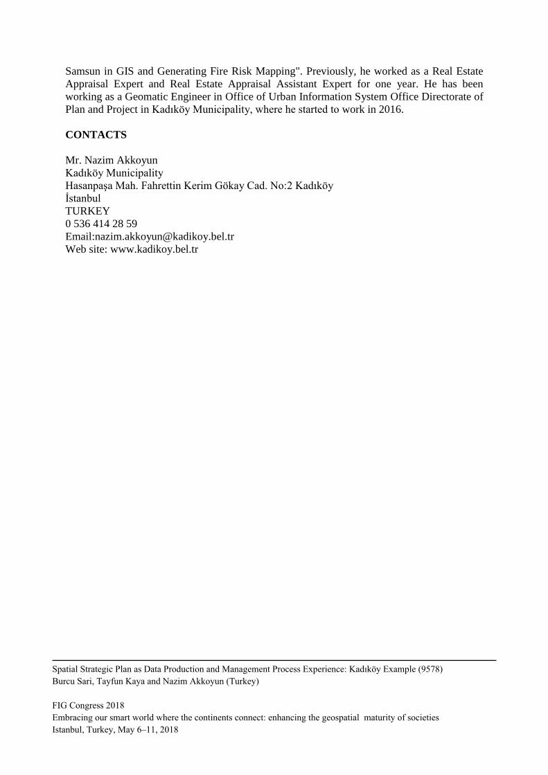
Transport stands out as the main problem of both Kadıköy and Istanbul. Kadikoy district is
also one of the centers where there is an intense traffic and parking problems. On the other
hand, public transport facilities are advanced compared to other parts of the city. Data for
transportaitons are clsassified under the topics called highways, seaways, railways, cycling
and walking, and all were transferred to the database.
,
Map 7: Urban Transformation System
5. MECHANISM OF PLANNING
Spatial Strategic Plan as a living planning process, it consists of three basic elements. These
projects are Smart Spatial Kadikoy, EKIP and Project Performance. These three projects have
emerged with the participation of relevant managers and employees on Spatial Strategic Plan
Spatial Strategic Plan as Data Production and Management Process Experience: Kadıköy Example (9578)
Burcu Sari, Tayfun Kaya and Nazim Akkoyun (Turkey)
FIG Congress 2018
Embracing our smart world where the continents connect: enhancing the geospatial maturity of societies
Istanbul, Turkey, May 6–11, 2018

Workshop. There were three sub-group, spatial decision making directorates, directorates
producing spatial projects and directorates affected by spatial decisions. By identifying the
problems mentioned groups have sorted out the solutions to these problems and voting results
of all participants has increased the recommended five projects forward. These five projects
were combined then under three headings.
Smart Spatial Kadıköy involves transforming data into meaningful analysis by relating it to
space. EKIP is considered as a mechanism of participation in which the spatial decision in the
direction of the data obtained from the MAC can be taken jointly by the relevant stakeholders.
Performance of the project is in line with kriti are determined by monitoring the performance
of actual applications and the data obtained for assessing a project.
Spatial Smart Kadıköy is designed to provide a solution to the problem of quick and easy
access to the up-to-date and accurate data within the organization, to establish a scientific
basis for the Spatial Strategic Plan / spatial decisions and to pre-determine the probable
effects of decisions made by central organizations on the city. Accordingly, it involves the
establishment of a database where everyone can easily access the data and also a platform
where one can display and query this data in a meaningful way. Within the Project, it is aimed
to publish the collected data as annual reports involving significant and comparative analyses
before it is transformed into a platform. Thereby, it is expected that the collection,
standardization and interpretation methods of the data will reach a stable status.
The EKIP project is planned as a commission by which the related parties can participate in
the evaluation and decision-making processes through the scientific platform produced by the
Spatial Smart Kadıköy. The Commission Secretariat will be coordinated by the Directorates
of Urban Design and Survey Project. Spatial decision making departments are the permanent
members of the commission. Participation of the other directorates, different public
organizations, professional associations, NGOs and citizens will be enabled by invitation of
the commission secretariat according to their relevancy. Commission agenda will be
distributed to the participants in advance, and the data on the agenda will be acquired in report
format from Spatial Smart Kadıköy. Commission decisions will be communicated to the
relevant directorates, organizations and persons and will be made available to the public
through a platform.
By means of Project Performance, the data to be collected on the efficiency, environmental
impact and citizen satisfaction of the project/implementations based on the decisions will be
evaluated according to the pre-determined criteria. This data and evaluations will be directed
to the Spatial Smart Kadıköy and once again reintegrated to the Planning Process.
6. CONCLUSION
Spatial Strategic Planning process as being the first in Turkey at district scale is expected to
strengthen the relationship between data and planning. Hence, it is considered that demand for
the data will be kept alive and compliance with standards and analysis methods will be
Spatial Strategic Plan as Data Production and Management Process Experience: Kadıköy Example (9578)
Burcu Sari, Tayfun Kaya and Nazim Akkoyun (Turkey)
FIG Congress 2018
Embracing our smart world where the continents connect: enhancing the geospatial maturity of societies
Istanbul, Turkey, May 6–11, 2018

increased and diversified, while a stable data structure will be reached over time. Moreover,
data sharing culture will eventually be improved through regular data demands at regular
intervals.
The transformation of the Spatial Strategic Plan into a living process through data flows as
well as updates and evaluations in light of this data is foreseen another important outcome.
Ensuring quick access to accurate and up-to-date data will improve the legitimacy and
efficiency of the spatial decisions and investments.
Spatial Strategic Planning tool will contribute to the elimination of the internal
communication problems and to the improvement of the joint decision-making culture since it
can work on the collective decision making process. The process is aimed to be transformed
into the one ensuring continuous participation rather than providing limited participation
mechanisms.
Replacing the existing planning tools which are inadequate in understanding and directing the
current complex structure of the cities and which also have long-term restrictions, Spatial
Strategic Plan is expected to be institutionalized as the new planning tool and to become best
practice for other areas of the district.
REFERENCES
Mekansal Planlar Yapım Yönetmeliği (Spatial Plans Implement Regulations)
http://mevzuat.basbakanlik.gov.tr/Metin.Aspx?MevzuatKod=7.5.19788&MevzuatIliski=0&so
urceXmlSearch=MEKAN-
INSPIRE Directive, https://inspire.ec.europa.eu
BIOGRAPHICAL NOTES
Burcu Sari Basman graduated from Urban and Regional Planning Program in Yildiz
Technical University in 2012. After graduation, she worked as a urban planner in the private
sector for 5 years. She is currently a graduate student at the same university in the Urban
Design and Environment Organization Master Degree Program and working as a urban
planner at Directorate of Plan and Project in Kadikoy Municipality since June, 2017.
Nazım Akkoyun is an urban planner at Kadikoy Municipality. He has been menaging Urban
Information System for last three years. He studied GIS(geographic information Systems)
Projects. He made a board membership at the Chamber of City Planners. He graduated from
City And Region Planning at Mimar Sinan Fine Art University in 2004 and received his
master degree at the same University in 2007. He still continue his doctorate in Mimar Sinan
Fine Art University.
Tayfun Kaya graduated from the Department of Geomatic Engineering in Ondokuz Mayıs
University in 2014. He completed his graduation project entitled "Examination of the fires in
Spatial Strategic Plan as Data Production and Management Process Experience: Kadıköy Example (9578)
Burcu Sari, Tayfun Kaya and Nazim Akkoyun (Turkey)
FIG Congress 2018
Embracing our smart world where the continents connect: enhancing the geospatial maturity of societies
Istanbul, Turkey, May 6–11, 2018
Samsun in GIS and Generating Fire Risk Mapping". Previously, he worked as a Real Estate
Appraisal Expert and Real Estate Appraisal Assistant Expert for one year. He has been
working as a Geomatic Engineer in Office of Urban Information System Office Directorate of
Plan and Project in Kadıköy Municipality, where he started to work in 2016.
CONTACTS
Mr. Nazim Akkoyun
Kadıköy Municipality
Hasanpaşa Mah. Fahrettin Kerim Gökay Cad. No:2 Kadıköy
İstanbul
TURKEY
0 536 414 28 59
Email:[email protected]
Web site: www.kadikoy.bel.tr
Spatial Strategic Plan as Data Production and Management Process Experience: Kadıköy Example (9578)
Burcu Sari, Tayfun Kaya and Nazim Akkoyun (Turkey)
FIG Congress 2018
Embracing our smart world where the continents connect: enhancing the geospatial maturity of societies
Istanbul, Turkey, May 6–11, 2018