Embed Size (px)
Citation preview
ISO 19131 Canada Land Inventory (CLI) – Data Product Specification
Revision: A
Agriculture and Agri-food Canada Data Product Specification (ISO 19131)
Page 2 of 31
Data specification: Canada Land Inventory (CLI) – Table of Contents –
1. OVERVIEW 4
1.1 Informal description 4
1.2 Data product specification metadata 4
1.3 Terms and definitions 4
1.4 Abbreviations 4
2. SPECIFICATION SCOPE 5
3. DATA PRODUCT IDENTIFICATION 6
3.1 Data Series Identification 6
3.2 Data product identification 7
3.2.1 Canada Land Inventory (CLI) 1:1,000,000 - Land Capability for Agriculture 7
3.2.2 Canada Land Inventory (CLI) 1:250,000 - Land Capability for Agriculture 7
3.2.3 Canada Land Inventory (CLI) 1:50,000 - Land Capability for Agriculture 8
3.2.4 Canada Land Inventory (CLI) 1:1,000,000 - Land Capability and Limitation for Agriculture 9
3.2.5 Canada Land Inventory (CLI) 1:1,000,000 - Land Limitation for Agriculture 10
4. DATA CONTENT AND STRUCTURE 12
4.1 Feature-based application schema 12
4.2 Feature catalogue – Canada Land Inventory (CLI) – Land Capability 13
4.2.1 Feature Attributes 13 4.2.1.1 MAJOR1 13 4.2.1.2 MINOR1 13 4.2.1.3 CLASS_A 14 4.2.1.4 PERCENT_A 14 4.2.1.5 SUBCLASS_A1 15 4.2.1.6 SUBCLASS_A2 16 4.2.1.7 CLASS_B 16 4.2.1.8 PERCENT_B 17 4.2.1.9 SUBCLASS_B1 17 4.2.1.10 SUBCLASS_B2 18 4.2.1.11 CLASS_C 18 4.2.1.12 PERCENT_C 19 4.2.1.13 SUBCLASS_C1 19 1.1.1.1 SUBCLASS_C2 20 4.2.1.14 CLASS_D 20 4.2.1.15 PERCENT_D 21 4.2.1.16 SUBCLASS_D1 21 4.2.1.17 SUBCLASS_D2 22 4.2.1.18 CLASS_E 22 4.2.1.19 PERCENT_E 23

Agriculture and Agri-food Canada Data Product Specification (ISO 19131)
Page 3 of 31
4.2.1.20 SUBCLASS_E1 23 4.2.1.21 SUBCLASS_E2 24 4.2.1.22 CLASS_F 25 4.2.1.23 PERCENT_F 25 4.2.1.24 SUBCLASS_F1 26 4.2.1.25 SUBCLASS_C2 26 4.2.1.26 IRRIGATED 27
4.3 Feature catalogue – Canada Land Inventory (CLI) – Land Capability and Limitation 27
4.3.1 Feature Attributes 27 4.3.1.1 MAJOR1 27 4.3.1.2 MINOR1 28
4.4 Feature Catalogue - Canada Land Inventory (CLI) - Agricultural Limits 28
4.4.1 Feature Attributes 28 4.4.1.1 MAJOR1 28 4.4.1.2 MINOR1 29
5. REFERENCE SYSTEM 30
5.1 Spatial reference system 30
5.2 Temporal reference system 30
6. DATA QUALITY 30
6.1 Completeness 30
6.2 Logical consistency 30
6.3 Positional accuracy 30
6.4 Temporal accuracy 30
6.5 Thematic accuracy 30
6.6 Lineage statement 30
7. DATA CAPTURE 31
8. DATA MAINTENANCE 31
9. PORTRAYAL 31
10. DATA PRODUCT DELIVERY 31
11. METADATA 31
Agriculture and Agri-food Canada Data Product Specification (ISO 19131)
Page 4 of 31
Data specification: Canada Land Inventory (CLI)
1. OVERVIEW
1.1 Informal description
These agricultural capability and limitation maps can be used at the regional level for making decisions on land improvement and farm consolidation, for developing land-use plans, and for preparing equitable land assessments.
1.2 Data product specification metadata
This section provides metadata about the creation of this data product specification.
Data product specification title: Canada Land Inventory (CLI)
Data product specification reference date: January 5, 2013
Data product specification responsible party: Agriculture and Agri-Food Canada, Government of Canada, Science and Technology Branch
Data product specification language: English, French
Data product specification topic category: Farming
1.3 Terms and definitions
Feature attribute o characteristic of a feature
Class o description of a set of objects that share the same attributes, operations,
methods, relationships, and semantics [UML Semantics] o NOTE: A class does not always have an associated geometry (e.g. the metadata class).
Feature o abstraction of real world phenomena
Object o entity with a well-defined boundary and identity that encapsulates state and behaviour
[UML Semantics] o NOTE: An object is an instance of a class.
Package o grouping of a set of classes, relationships, and even other packages with a view to
organizing the model into more abstract structures
1.4 Abbreviations
AAFC Agriculture and Agri-Food Canada CLI Canadian Land Inventory
Agriculture and Agri-food Canada Data Product Specification (ISO 19131)
Page 5 of 31
2. SPECIFICATION SCOPE
This data specification has only one scope, the general scope.
NOTE: The term ‘specification scope’ originates from the International Standard ISO19131. ‘Specification scope’ does not express the purpose for the creation of a data specification or the potential use of data, but identifies partitions of the data specification where specific requirements apply.
Agriculture and Agri-food Canada Data Product Specification (ISO 19131)
Page 6 of 31
3. DATA PRODUCT IDENTIFICATION
3.1 Data Series Identification
Title Canada Land Inventory (CLI) Alternate Title Abstract This product contains the Canada Land Inventory (CLI) - Multiple
scales of Land Capability / Limitation for Agriculture. Purpose These agricultural capability and limitation maps can be used at the
regional level for making decisions on land improvement and farm consolidation, for developing land use plans, and for preparing equitable land assessments.
Topic Category Farming Spatial Reference Type vector Spatial Resolution Range from 1:50,000 to 1:1,000,000 Geographic Description North Bounding Coordinate:
60 West Bounding Coordinate: -132 East Bounding Coordinate: -52. South Bounding Coordinate: 36
Supplemental Information The Canada Land Inventory is a comprehensive multi-disciplinary land inventory of rural Canada, covering over 2.5 million square kilometers of land and water. Land capability for agriculture, forestry, wildlife, recreation, wildlife (ungulates and waterfowl) was mapped.
Constraints Anyone may use these data free of charge, provided they acknowledge Agriculture and Agri-food Canada's authorship. AAFC retains exclusive rights, title, and ownership of this data. Copying and redistribution of part or all of this dataset is acceptable, provided that the contents of this file are included with the redistribution. AAFC may be unable to answer queries about these data if they were obtained through a third party. Data are subject to the Government of Canada Open Data License Agreement: https://open.canada.ca/en/open-government-licence-canada
Keywords Thesaurus: Government of Canada Core Subject Thesaurus (https://canada.multites.net/cst/index.htm)
Date: February 1, 2000
Keywords: Agriculture, Biomass, Earth Science, Land Inventory, Land Management, Landscape Management, Soil, Vegetation Atlantic provinces, Western provinces
Scope identification series
Agriculture and Agri-food Canada Data Product Specification (ISO 19131)
Page 7 of 31
3.2 Data product identification
3.2.1 Canada Land Inventory (CLI) 1:1,000,000 - Land Capability for Agriculture
Title Canada Land Inventory (CLI) 1:1,000,000 - Land Capability for Agriculture
Alternate Title Abstract The Canada Land Inventory (CLI), 1:000,000, Land Capability for
Agriculture dataset illustrates the varying potential of a specific area for agricultural production. Classes of land capability for agriculture are based on mineral soils grouped according to their potential and limitations for agricultural use. The classes indicate the degree of limitation imposed by the soil in its use for mechanized agriculture.
Purpose The Canada Land Inventory (CLI), Land Capability for Agriculture dataset can be used at the regional level for making decisions on land improvement and farm consolidation, for developing land use plans, and for preparing equitable land assessments.
Topic Category Farming Spatial Reference Type vector Spatial Resolution 1:1,000,000 Geographic Description North Bounding Coordinate:
60 West Bounding Coordinate: -132 East Bounding Coordinate: -52. South Bounding Coordinate: 36
Constraints Anyone may use these data free of charge, provided they acknowledge Agriculture and Agri-food Canada's authorship. AAFC retains exclusive rights, title, and ownership of this data. Copying and redistribution of part or all of this dataset is acceptable, provided that the contents of this file are included with the redistribution. AAFC may be unable to answer queries about these data if they were obtained through a third party. Data are subject to the Government of Canada Open Data License Agreement: https://open.canada.ca/en/open-government-licence-canada
Keywords Thesaurus: Government of Canada Core Subject Thesaurus (https://canada.multites.net/cst/index.htm) Date: February 1, 2000 Keywords: Agriculture, Biomass, Earth Science, Land Inventory, Land Management, Landscape Management, Soil, Vegetation Atlantic provinces, Western provinces
Scope Identification dataset Feature Attribute Names
MAJOR1, MINOR1, DESC_EN, DESC_FR
3.2.2 Canada Land Inventory (CLI) 1:250,000 - Land Capability for Agriculture
Title Canada Land Inventory (CLI) 1:250,000 - Land Capability for Agriculture
Alternate Title
Agriculture and Agri-food Canada Data Product Specification (ISO 19131)
Page 8 of 31
Abstract The Canada Land Inventory (CLI), 1:250,000, Land Capability for Agriculture dataset illustrates the varying potential of a specific area for agricultural production. Classes of land capability for agriculture are based on mineral soils grouped according to their potential and limitations for agricultural use. The classes indicate the degree of limitation imposed by the soil in its use for mechanized agriculture. The subclasses indicate the kinds of limitations that individually or in combination with others, are affecting agricultural land use. Classes are based on characteristics of the soil as determined by soil surveys.
Purpose The Canada Land Inventory (CLI), Land Capability for Agriculture dataset can be used at the regional level for making decisions on land improvement and farm consolidation, for developing land-use plans, and for preparing equitable land assessments.
Topic Category Farming Spatial Reference Type vector Spatial Resolution 1:250,000 Geographic Description North Bounding Coordinate:
60 West Bounding Coordinate: -132 East Bounding Coordinate: -52. South Bounding Coordinate: 36
Constraints Anyone may use these data free of charge, provided they acknowledge Agriculture and Agri-food Canada's authorship. AAFC retains exclusive rights, title, and ownership of this data. Copying and redistribution of part or all of this dataset is acceptable, provided that the contents of this file are included with the redistribution. AAFC may be unable to answer queries about these data if they were obtained through a third party. Data are subject to the Government of Canada Open Data License Agreement: https://open.canada.ca/en/open-government-licence-canada
Keywords Thesaurus: Government of Canada Core Subject Thesaurus (https://canada.multites.net/cst/index.htm) Date: February 1, 2000 Keywords: Agriculture, Biomass, Earth Science, Land Inventory, Land Management, Landscape Management, Soil, Vegetation Atlantic provinces, Western provinces
Scope Identification dataset Feature Attribute Names
CLASS A,PERCENT A,SUBCLASS A1,SUBCLASS A2,CLASS B, PERCENT B, SUBCLASS B1,SUBCLASS B2,CLASS C ,PERCENT C, SUBCLASS C1,SUBCLASS C2, CLASS D, PERCENT D, SUBCLASS D1, SUBCLASS D2, CLASS_E, PERCENT E, SUBCLASS E1, SUBCLASS E2, CLASS F, PERCENT F, SUBCLASS F1, SUBCLASS F2, IRRIGATED, DESC_EN, DESC_FR
3.2.3 Canada Land Inventory (CLI) 1:50,000 - Land Capability for Agriculture
Title Canada Land Inventory (CLI) 1:50,000 - Land Capability for Agriculture Alternate Title Abstract The Canada Land Inventory (CLI), 1:50,000, Land Capability for
Agriculture dataset illustrates the varying potential of a specific area for agricultural production. Classes of land capability for agriculture are based on mineral soils grouped according to their potential and
Agriculture and Agri-food Canada Data Product Specification (ISO 19131)
Page 9 of 31
limitations for agricultural use. The classes indicate the degree of limitation imposed by the soil in its use for mechanized agriculture. The subclasses indicate the kinds of limitations that individually or in combination with others are affecting agricultural land use. Classes are based on characteristics of the soil as determined by soil surveys.
Purpose The Canada Land Inventory (CLI), Land Capability for Agriculture dataset can be used at the regional level for making decisions on land improvement and farm consolidation, for developing land-use plans, and for preparing equitable land assessments.
Topic Category Farming Spatial Reference Type vector Spatial Resolution 1:50,000 Geographic Description North Bounding Coordinate:
60 West Bounding Coordinate: -132 East Bounding Coordinate: -52. South Bounding Coordinate: 36
Constraints Anyone may use these data free of charge, provided they acknowledge Agriculture and Agri-food Canada's authorship. AAFC retains exclusive rights, title, and ownership of this data. Copying and redistribution of part or all of this dataset is acceptable, provided that the contents of this file are included with the redistribution. AAFC may be unable to answer queries about these data if they were obtained through a third party. Data are subject to the Government of Canada Open Data License Agreement: https://open.canada.ca/en/open-government-licence-canada
Keywords Thesaurus: Government of Canada Core Subject Thesaurus (https://canada.multites.net/cst/index.htm) Date: February 1, 2000 Keywords: Agriculture, Biomass, Earth Science, Land Inventory, Land Management, Landscape Management, Soil, Vegetation Atlantic provinces, Western provinces
Scope Identification Dataset Feature Attribute Names
CLASS A,PERCENT A,SUBCLASS A1,SUBCLASS A2,CLASS B, PERCENT B, SUBCLASS B1,SUBCLASS B2,CLASS C ,PERCENT C, SUBCLASS C1,SUBCLASS C2
3.2.4 Canada Land Inventory (CLI) 1:1,000,000 - Land Capability and Limitation for Agriculture
Title Canada Land Inventory (CLI) 1:1,000,000 - Land Capability and Limitation for Agriculture
Alternate Title Abstract The Canada Land Inventory (CLI), 1:1,000,000, Land Capability and
Limitation for Agriculture dataset is a combination of land capabilities and limitations primarily to define prime and marginal lands. Further classifications define limitations that individually or in combination with others are affecting agricultural land use. Classes are based on characteristics of the soil as determined by soil surveys.
Purpose The Canada Land Inventory (CLI), Land Capability and Limitation for Agriculture dataset can be used at the regional level for making decisions on land improvement and farm consolidation, for developing land use plans, and for preparing equitable land assessments.
Agriculture and Agri-food Canada Data Product Specification (ISO 19131)
Page 10 of 31
Topic Category Farming Spatial Reference Type Vector Spatial Resolution 1: 1,000,000 Geographic Description North Bounding Coordinate:
60 West Bounding Coordinate: -132 East Bounding Coordinate: -52. South Bounding Coordinate: 36
Constraints Anyone may use these data free of charge, provided they acknowledge Agriculture and Agri-food Canada's authorship. AAFC retains exclusive rights, title, and ownership of this data. Copying and redistribution of part or all of this dataset is acceptable, provided that the contents of this file are included with the redistribution. AAFC may be unable to answer queries about these data if they were obtained through a third party. Data are subject to the Government of Canada Open Data License Agreement: https://open.canada.ca/en/open-government-licence-canada
Keywords Thesaurus: Government of Canada Core Subject Thesaurus (https://canada.multites.net/cst/index.htm) Date: February 1, 2000 Keywords: Agriculture, Biomass, Earth Science, Land Inventory, Land Management, Landscape Management, Soil, Vegetation Atlantic provinces, Western provinces
Scope Identification dataset Feature Attribute Names
MAJOR1, MINOR1, DESC_EN, DESC_FR
3.2.5 Canada Land Inventory (CLI) 1:1,000,000 - Land Limitation for Agriculture
Title Canada Land Inventory (CLI) 1:1,000,000 - Land Limitation for Agriculture
Alternate Title Abstract The Canada Land Inventory (CLI), 1:1,000,000, Land Limitation for
Agriculture dataset illustrates the limiting characteristics of a specific area for agricultural production. Classes indicate the kinds of limitations that individually or in combination with others are affecting agricultural land use. Classes are based on characteristics of the soil as determined by soil surveys.
Purpose The Canada Land Inventory (CLI), Land Limitation for Agriculture dataset can be used at the regional level for making decisions on land improvement and farm consolidation, for developing land-use plans, and for preparing equitable land assessments.
Topic Category Farming Spatial Reference Type Vector Spatial Resolution 1: 1,000,000
Agriculture and Agri-food Canada Data Product Specification (ISO 19131)
Page 11 of 31
Geographic Description North Bounding Coordinate: 60 West Bounding Coordinate: -132 East Bounding Coordinate: -52. South Bounding Coordinate: 36
Constraints Anyone may use these data free of charge, provided they acknowledge Agriculture and Agri-food Canada's authorship. AAFC retains exclusive rights, title, and ownership of this data. Copying and redistribution of part or all of this dataset is acceptable, provided that the contents of this file are included with the redistribution. AAFC may be unable to answer queries about these data if they were obtained through a third party. Data are subject to the Government of Canada Open Data License Agreement: https://open.canada.ca/en/open-government-licence-canada
Keywords Thesaurus: Government of Canada Core Subject Thesaurus (https://canada.multites.net/cst/index.htm) Date: February 1, 2000 Keywords: Agriculture, Biomass, Earth Science, Land Inventory, Land Management, Landscape Management, Soil, Vegetation Atlantic provinces, Western provinces
Scope Identification dataset Feature Attribute Names
MAJOR1, MINOR1, DESC_EN, DESC_FR
Agriculture and Agri-food Canada Data Product Specification (ISO 19131)
Page 12 of 31
4. DATA CONTENT AND STRUCTURE
4.1 Feature-based application schema
TO BE INSERTED
Agriculture and Agri-food Canada Data Product Specification (ISO 19131)
Page 13 of 31
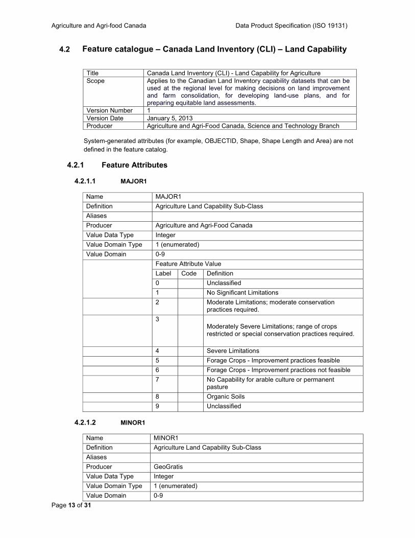
4.2 Feature catalogue – Canada Land Inventory (CLI) – Land Capability
Title Canada Land Inventory (CLI) - Land Capability for Agriculture Scope Applies to the Canadian Land Inventory capability datasets that can be
used at the regional level for making decisions on land improvement and farm consolidation, for developing land-use plans, and for preparing equitable land assessments.
Version Number 1 Version Date January 5, 2013 Producer Agriculture and Agri-Food Canada, Science and Technology Branch
System-generated attributes (for example, OBJECTID, Shape, Shape Length and Area) are not defined in the feature catalog.
4.2.1 Feature Attributes
4.2.1.1 MAJOR1
Name MAJOR1
Definition Agriculture Land Capability Sub-Class
Aliases
Producer Agriculture and Agri-Food Canada
Value Data Type Integer Value Domain Type 1 (enumerated)
Value Domain 0-9
Feature Attribute Value
Label Code Definition
0 Unclassified
1 No Significant Limitations
2 Moderate Limitations; moderate conservation practices required.
3 Moderately Severe Limitations; range of crops restricted or special conservation practices required.
4 Severe Limitations
5 Forage Crops - Improvement practices feasible
6 Forage Crops - Improvement practices not feasible
7 No Capability for arable culture or permanent pasture
8 Organic Soils
9 Unclassified
4.2.1.2 MINOR1
Name MINOR1
Definition Agriculture Land Capability Sub-Class
Aliases
Producer GeoGratis
Value Data Type Integer
Value Domain Type 1 (enumerated)
Value Domain 0-9
Agriculture and Agri-food Canada Data Product Specification (ISO 19131)
Page 14 of 31
Feature Attribute Value
Label Code Definition
0 Unclassified
1 No Significant Limitations
2 Moderate Limitations; moderate conservation practices required.
3 Moderately Severe Limitations; range of crops restricted or special conservation practices required.
4 Severe Limitations
5 Forage Crops – Improvement practices feasible
6 Forage Crops – Improvement practices not feasible
7 No Capability for arable culture or permanent pasture
8 Organic Soils
9 Unclassified
4.2.1.3 CLASS_A
Name CLASS_A
Definition The primary and/or dominant CLI class
Aliases
Producer Agriculture and Agri-Food Canada
Value Data Type CHARACTER
Value Domain Type 1 (enumerated)
Value Domain
Feature Attribute Value
Label Code Definition
1 No Significant Limitations
2 Moderate Limitations; moderate conservation practices required.
3 Moderately Severe Limitations; range of crops restricted or special conservation practices required.
4 Severe Limitations
5 Forage Crops - Improvement practices feasible
6 Forage Crops - Improvement practices not feasible
7 No Capability for arable culture or permanent pasture
0 Organic Soils
8 Unclassified areas
W Water
4.2.1.4 PERCENT_A
Name PERCENT_A
Definition The proportion (% base 10) of the polygon in Class_A (blank = 0%)
Agriculture and Agri-food Canada Data Product Specification (ISO 19131)
Page 15 of 31
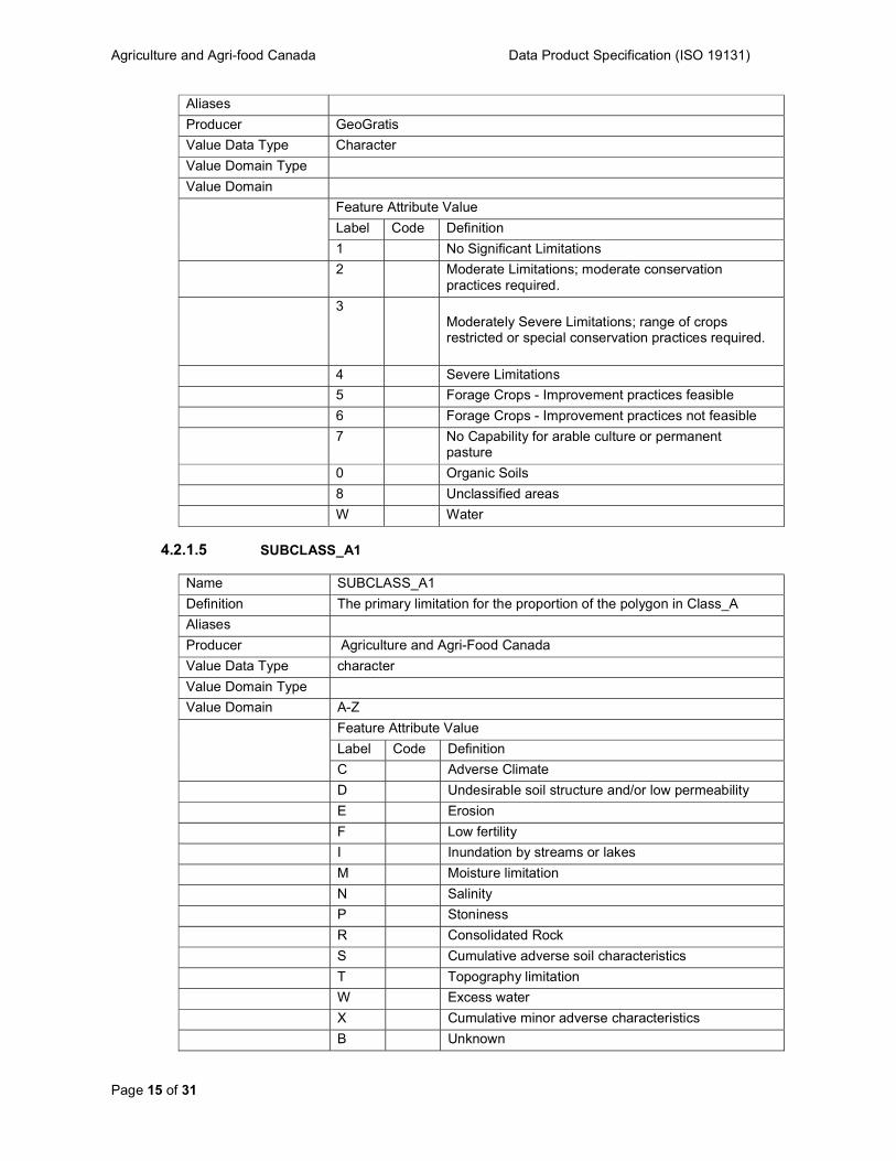
Aliases
Producer GeoGratis
Value Data Type Character
Value Domain Type
Value Domain
Feature Attribute Value
Label Code Definition
1 No Significant Limitations
2 Moderate Limitations; moderate conservation practices required.
3 Moderately Severe Limitations; range of crops restricted or special conservation practices required.
4 Severe Limitations
5 Forage Crops - Improvement practices feasible
6 Forage Crops - Improvement practices not feasible
7 No Capability for arable culture or permanent pasture
0 Organic Soils
8 Unclassified areas
W Water
4.2.1.5 SUBCLASS_A1
Name SUBCLASS_A1
Definition The primary limitation for the proportion of the polygon in Class_A
Aliases
Producer Agriculture and Agri-Food Canada
Value Data Type character
Value Domain Type
Value Domain A-Z
Feature Attribute Value
Label Code Definition
C Adverse Climate
D Undesirable soil structure and/or low permeability
E Erosion
F Low fertility
I Inundation by streams or lakes
M Moisture limitation
N Salinity
P Stoniness
R Consolidated Rock
S Cumulative adverse soil characteristics
T Topography limitation
W Excess water
X Cumulative minor adverse characteristics
B Unknown
Agriculture and Agri-food Canada Data Product Specification (ISO 19131)
Page 16 of 31
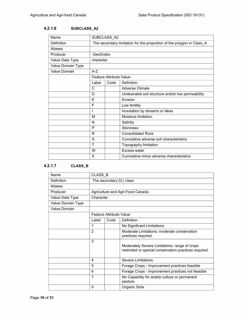
4.2.1.6 SUBCLASS_A2
Name SUBCLASS_A2
Definition The secondary limitation for the proportion of the polygon in Class_A
Aliases
Producer GeoGratis
Value Data Type character
Value Domain Type
Value Domain A-Z
Feature Attribute Value
Label Code Definition
C Adverse Climate
D Undesirable soil structure and/or low permeability
E Erosion
F Low fertility
I Inundation by streams or lakes
M Moisture limitation
N Salinity
P Stoniness
R Consolidated Rock
S Cumulative adverse soil characteristics
T Topography limitation
W Excess water
X Cumulative minor adverse characteristics
4.2.1.7 CLASS_B
Name CLASS_B
Definition The secondary CLI class
Aliases
Producer Agriculture and Agri-Food Canada
Value Data Type Character
Value Domain Type
Value Domain
Feature Attribute Value
Label Code Definition
1 No Significant Limitations
2 Moderate Limitations; moderate conservation practices required.
3 Moderately Severe Limitations; range of crops restricted or special conservation practices required.
4 Severe Limitations
5 Forage Crops - Improvement practices feasible
6 Forage Crops - Improvement practices not feasible
7 No Capability for arable culture or permanent pasture
0 Organic Soils
Agriculture and Agri-food Canada Data Product Specification (ISO 19131)
Page 17 of 31
8 Unclassified areas
W Water
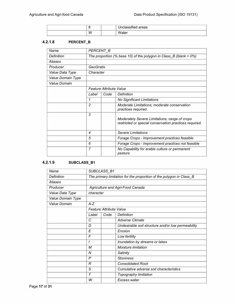
4.2.1.8 PERCENT_B
Name PERCENT_B
Definition The proportion (% base 10) of the polygon in Class_B (blank = 0%)
Aliases
Producer GeoGratis
Value Data Type Character
Value Domain Type
Value Domain
Feature Attribute Value
Label Code Definition
1 No Significant Limitations
2 Moderate Limitations; moderate conservation practices required.
3 Moderately Severe Limitations; range of crops restricted or special conservation practices required.
4 Severe Limitations
5 Forage Crops - Improvement practices feasible
6 Forage Crops - Improvement practices not feasible
7 No Capability for arable culture or permanent pasture
4.2.1.9 SUBCLASS_B1
Name SUBCLASS_B1
Definition The primary limitation for the proportion of the polygon in Class_B
Aliases
Producer Agriculture and Agri-Food Canada
Value Data Type character
Value Domain Type
Value Domain A-Z
Feature Attribute Value
Label Code Definition
C Adverse Climate
D Undesirable soil structure and/or low permeability
E Erosion
F Low fertility
I Inundation by streams or lakes
M Moisture limitation
N Salinity
P Stoniness
R Consolidated Rock
S Cumulative adverse soil characteristics
T Topography limitation
W Excess water
Agriculture and Agri-food Canada Data Product Specification (ISO 19131)
Page 18 of 31
X Cumulative minor adverse characteristics
B Unknown
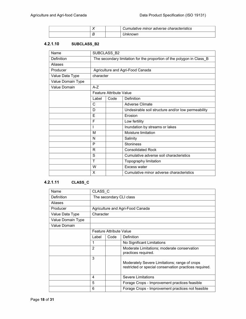
4.2.1.10 SUBCLASS_B2
Name SUBCLASS_B2
Definition The secondary limitation for the proportion of the polygon in Class_B
Aliases
Producer Agriculture and Agri-Food Canada
Value Data Type character
Value Domain Type
Value Domain A-Z
Feature Attribute Value
Label Code Definition
C Adverse Climate
D Undesirable soil structure and/or low permeability
E Erosion
F Low fertility
I Inundation by streams or lakes
M Moisture limitation
N Salinity
P Stoniness
R Consolidated Rock
S Cumulative adverse soil characteristics
T Topography limitation
W Excess water
X Cumulative minor adverse characteristics
4.2.1.11 CLASS_C
Name CLASS_C
Definition The secondary CLI class
Aliases
Producer Agriculture and Agri-Food Canada
Value Data Type Character
Value Domain Type
Value Domain
Feature Attribute Value
Label Code Definition
1 No Significant Limitations
2 Moderate Limitations; moderate conservation practices required.
3 Moderately Severe Limitations; range of crops restricted or special conservation practices required.
4 Severe Limitations
5 Forage Crops - Improvement practices feasible
6 Forage Crops - Improvement practices not feasible
Agriculture and Agri-food Canada Data Product Specification (ISO 19131)
Page 19 of 31
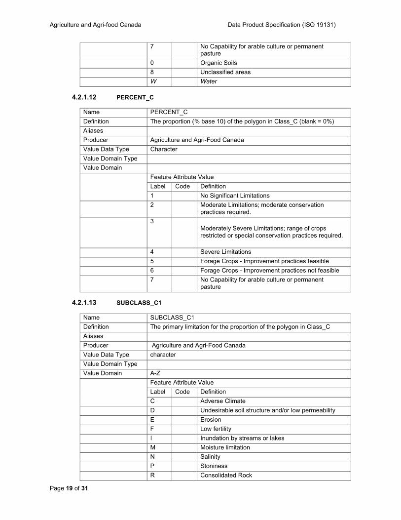
7 No Capability for arable culture or permanent pasture
0 Organic Soils
8 Unclassified areas
W Water
4.2.1.12 PERCENT_C
Name PERCENT_C
Definition The proportion (% base 10) of the polygon in Class_C (blank = 0%)
Aliases
Producer Agriculture and Agri-Food Canada
Value Data Type Character
Value Domain Type
Value Domain
Feature Attribute Value
Label Code Definition
1 No Significant Limitations
2 Moderate Limitations; moderate conservation practices required.
3 Moderately Severe Limitations; range of crops restricted or special conservation practices required.
4 Severe Limitations
5 Forage Crops - Improvement practices feasible
6 Forage Crops - Improvement practices not feasible
7 No Capability for arable culture or permanent pasture
4.2.1.13 SUBCLASS_C1
Name SUBCLASS_C1
Definition The primary limitation for the proportion of the polygon in Class_C
Aliases
Producer Agriculture and Agri-Food Canada
Value Data Type character
Value Domain Type
Value Domain A-Z
Feature Attribute Value
Label Code Definition
C Adverse Climate
D Undesirable soil structure and/or low permeability
E Erosion
F Low fertility
I Inundation by streams or lakes
M Moisture limitation
N Salinity
P Stoniness
R Consolidated Rock

Agriculture and Agri-food Canada Data Product Specification (ISO 19131)
Page 20 of 31
S Cumulative adverse soil characteristics
T Topography limitation
W Excess water
X Cumulative minor adverse characteristics
B Unknown
1.1.1.1 SUBCLASS_C2
Name SUBCLASS_C2
Definition The secondary limitation for the proportion of the polygon in Class_C
Aliases
Producer Agriculture and Agri-Food Canada
Value Data Type character
Value Domain Type
Value Domain A-Z
Feature Attribute Value
Label Code Definition
C Adverse Climate
D Undesirable soil structure and/or low permeability
E Erosion
F Low fertility
I Inundation by streams or lakes
M Moisture limitation
N Salinity
P Stoniness
R Consolidated Rock
S Cumulative adverse soil characteristics
T Topography limitation
W Excess water
X Cumulative minor adverse characteristics
4.2.1.14 CLASS_D
Name CLASS_D
Definition The primary CLI class for irrigated regions within the polygon.
Aliases
Producer Agriculture and Agri-Food Canada
Value Data Type Character
Value Domain Type
Value Domain
Feature Attribute Value
Label Code Definition
1 No Significant Limitations
2 Moderate Limitations; moderate conservation practices required.
3 Moderately Severe Limitations; range of crops restricted or special conservation practices required.
Agriculture and Agri-food Canada Data Product Specification (ISO 19131)
Page 21 of 31
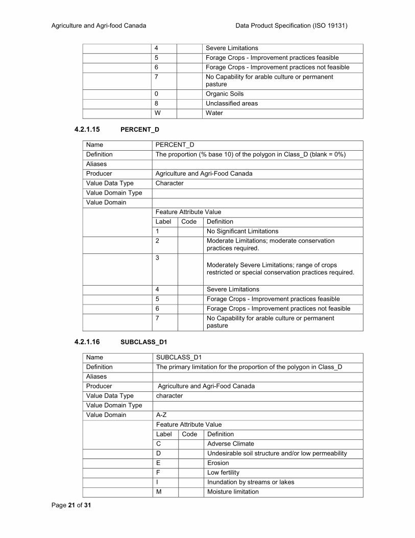
4 Severe Limitations
5 Forage Crops - Improvement practices feasible
6 Forage Crops - Improvement practices not feasible
7 No Capability for arable culture or permanent pasture
0 Organic Soils
8 Unclassified areas
W Water
4.2.1.15 PERCENT_D
Name PERCENT_D
Definition The proportion (% base 10) of the polygon in Class_D (blank = 0%)
Aliases
Producer Agriculture and Agri-Food Canada
Value Data Type Character
Value Domain Type
Value Domain
Feature Attribute Value
Label Code Definition
1 No Significant Limitations
2 Moderate Limitations; moderate conservation practices required.
3 Moderately Severe Limitations; range of crops restricted or special conservation practices required.
4 Severe Limitations
5 Forage Crops - Improvement practices feasible
6 Forage Crops - Improvement practices not feasible
7 No Capability for arable culture or permanent pasture
4.2.1.16 SUBCLASS_D1
Name SUBCLASS_D1
Definition The primary limitation for the proportion of the polygon in Class_D
Aliases
Producer Agriculture and Agri-Food Canada
Value Data Type character
Value Domain Type
Value Domain A-Z
Feature Attribute Value
Label Code Definition
C Adverse Climate
D Undesirable soil structure and/or low permeability
E Erosion
F Low fertility
I Inundation by streams or lakes
M Moisture limitation
Agriculture and Agri-food Canada Data Product Specification (ISO 19131)
Page 22 of 31
N Salinity
P Stoniness
R Consolidated Rock
S Cumulative adverse soil characteristics
T Topography limitation
W Excess water
X Cumulative minor adverse characteristics
B Unknown
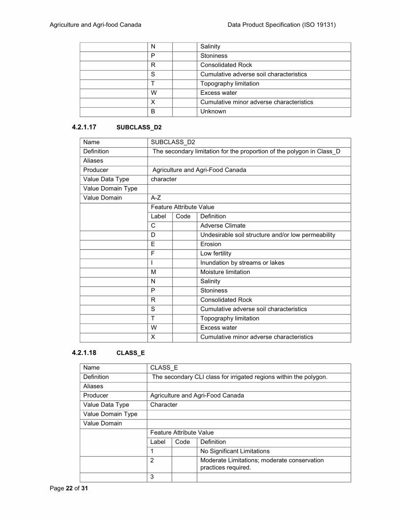
4.2.1.17 SUBCLASS_D2
Name SUBCLASS_D2
Definition The secondary limitation for the proportion of the polygon in Class_D
Aliases
Producer Agriculture and Agri-Food Canada
Value Data Type character
Value Domain Type
Value Domain A-Z
Feature Attribute Value
Label Code Definition
C Adverse Climate
D Undesirable soil structure and/or low permeability
E Erosion
F Low fertility
I Inundation by streams or lakes
M Moisture limitation
N Salinity
P Stoniness
R Consolidated Rock
S Cumulative adverse soil characteristics
T Topography limitation
W Excess water
X Cumulative minor adverse characteristics
4.2.1.18 CLASS_E
Name CLASS_E
Definition The secondary CLI class for irrigated regions within the polygon.
Aliases
Producer Agriculture and Agri-Food Canada
Value Data Type Character
Value Domain Type
Value Domain
Feature Attribute Value
Label Code Definition
1 No Significant Limitations
2 Moderate Limitations; moderate conservation practices required.
3

Agriculture and Agri-food Canada Data Product Specification (ISO 19131)
Page 23 of 31
Moderately Severe Limitations; range of crops restricted or special conservation practices required.
4 Severe Limitations
5 Forage Crops - Improvement practices feasible
6 Forage Crops - Improvement practices not feasible
7 No Capability for arable culture or permanent pasture
0 Organic Soils
8 Unclassified areas
W Water
4.2.1.19 PERCENT_E
Name PERCENT_E
Definition The proportion (% base 10) of the polygon in Class_E (blank = 0%)
Aliases
Producer GeoGratis
Value Data Type Character
Value Domain Type
Value Domain
Feature Attribute Value
Label Code Definition
1 No Significant Limitations
2 Moderate Limitations; moderate conservation practices required.
3 Moderately Severe Limitations; range of crops restricted or special conservation practices required.
4 Severe Limitations
5 Forage Crops - Improvement practices feasible
6 Forage Crops - Improvement practices not feasible
7 No Capability for arable culture or permanent pasture
4.2.1.20 SUBCLASS_E1
Name SUBCLASS_E1
Definition The primary limitation for the proportion of the polygon in Class_E
Agriculture and Agri-food Canada Data Product Specification (ISO 19131)
Page 24 of 31
Aliases
Producer Agriculture and Agri-Food Canada
Value Data Type character
Value Domain Type
Value Domain A-Z
Feature Attribute Value
Label Code Definition
C Adverse Climate
D Undesirable soil structure and/or low permeability
E Erosion
F Low fertility
I Inundation by streams or lakes
M Moisture limitation
N Salinity
P Stoniness
R Consolidated Rock
S Cumulative adverse soil characteristics
T Topography limitation
W Excess water
X Cumulative minor adverse characteristics
B Unknown
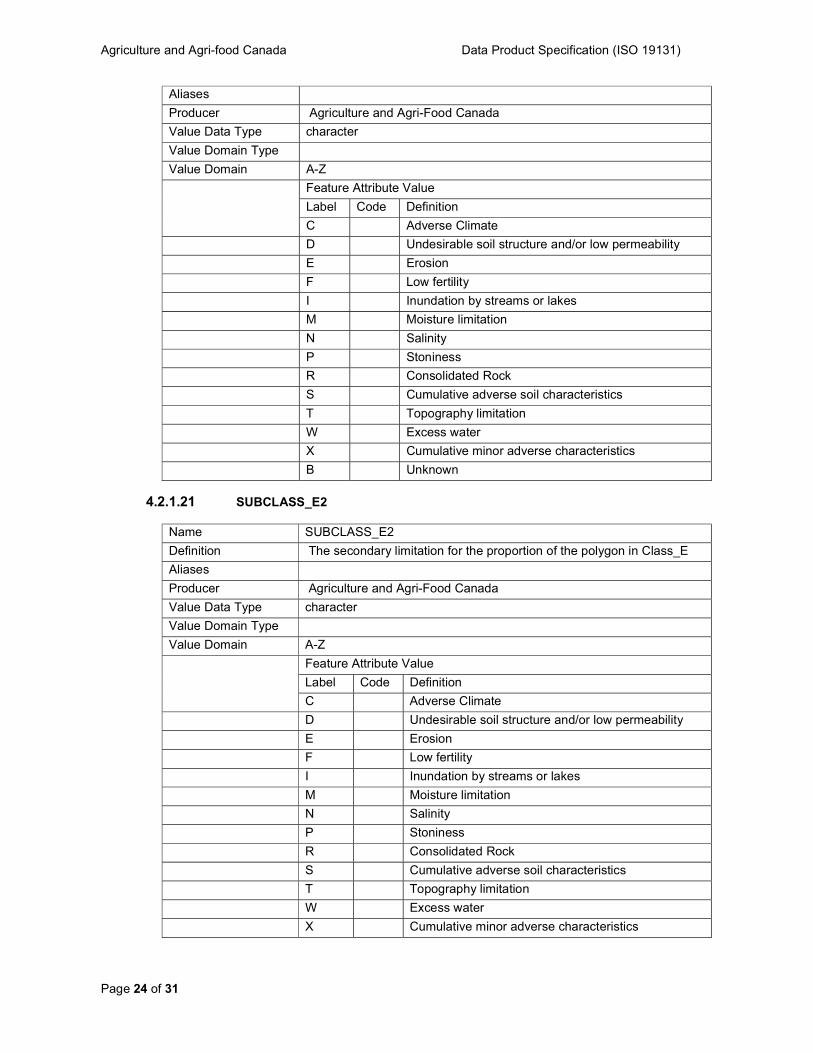
4.2.1.21 SUBCLASS_E2
Name SUBCLASS_E2
Definition The secondary limitation for the proportion of the polygon in Class_E
Aliases
Producer Agriculture and Agri-Food Canada
Value Data Type character
Value Domain Type
Value Domain A-Z
Feature Attribute Value
Label Code Definition
C Adverse Climate
D Undesirable soil structure and/or low permeability
E Erosion
F Low fertility
I Inundation by streams or lakes
M Moisture limitation
N Salinity
P Stoniness
R Consolidated Rock
S Cumulative adverse soil characteristics
T Topography limitation
W Excess water
X Cumulative minor adverse characteristics
Agriculture and Agri-food Canada Data Product Specification (ISO 19131)
Page 25 of 31
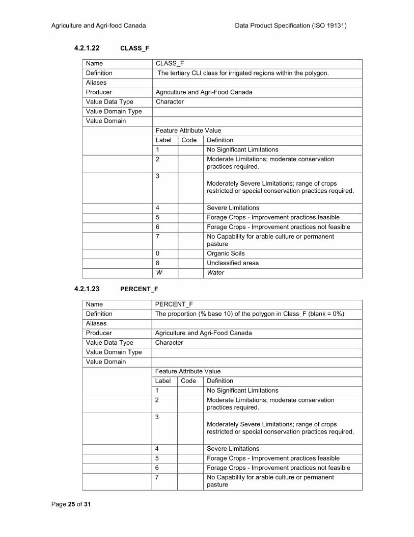
4.2.1.22 CLASS_F
Name CLASS_F
Definition The tertiary CLI class for irrigated regions within the polygon.
Aliases
Producer Agriculture and Agri-Food Canada
Value Data Type Character
Value Domain Type
Value Domain
Feature Attribute Value
Label Code Definition
1 No Significant Limitations
2 Moderate Limitations; moderate conservation practices required.
3 Moderately Severe Limitations; range of crops restricted or special conservation practices required.
4 Severe Limitations
5 Forage Crops - Improvement practices feasible
6 Forage Crops - Improvement practices not feasible
7 No Capability for arable culture or permanent pasture
0 Organic Soils
8 Unclassified areas
W Water
4.2.1.23 PERCENT_F
Name PERCENT_F
Definition The proportion (% base 10) of the polygon in Class_F (blank = 0%)
Aliases
Producer Agriculture and Agri-Food Canada
Value Data Type Character
Value Domain Type
Value Domain
Feature Attribute Value
Label Code Definition
1 No Significant Limitations
2 Moderate Limitations; moderate conservation practices required.
3 Moderately Severe Limitations; range of crops restricted or special conservation practices required.
4 Severe Limitations
5 Forage Crops - Improvement practices feasible
6 Forage Crops - Improvement practices not feasible
7 No Capability for arable culture or permanent pasture
Agriculture and Agri-food Canada Data Product Specification (ISO 19131)
Page 26 of 31
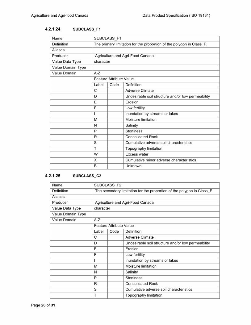
4.2.1.24 SUBCLASS_F1
Name SUBCLASS_F1
Definition The primary limitation for the proportion of the polygon in Class_F.
Aliases
Producer Agriculture and Agri-Food Canada
Value Data Type character
Value Domain Type
Value Domain A-Z
Feature Attribute Value
Label Code Definition
C Adverse Climate
D Undesirable soil structure and/or low permeability
E Erosion
F Low fertility
I Inundation by streams or lakes
M Moisture limitation
N Salinity
P Stoniness
R Consolidated Rock
S Cumulative adverse soil characteristics
T Topography limitation
W Excess water
X Cumulative minor adverse characteristics
B Unknown
4.2.1.25 SUBCLASS_C2
Name SUBCLASS_F2
Definition The secondary limitation for the proportion of the polygon in Class_F
Aliases
Producer Agriculture and Agri-Food Canada
Value Data Type character
Value Domain Type
Value Domain A-Z
Feature Attribute Value
Label Code Definition
C Adverse Climate
D Undesirable soil structure and/or low permeability
E Erosion
F Low fertility
I Inundation by streams or lakes
M Moisture limitation
N Salinity
P Stoniness
R Consolidated Rock
S Cumulative adverse soil characteristics
T Topography limitation
Agriculture and Agri-food Canada Data Product Specification (ISO 19131)
Page 27 of 31
W Excess water
X Cumulative minor adverse characteristics
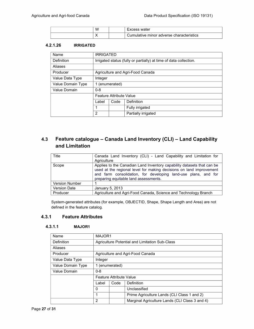
4.2.1.26 IRRIGATED
Name IRRIGATED
Definition Irrigated status (fully or partially) at time of data collection.
Aliases
Producer Agriculture and Agri-Food Canada
Value Data Type Integer Value Domain Type 1 (enumerated)
Value Domain 0-8
Feature Attribute Value
Label Code Definition
1 Fully irrigated
2 Partially irrigated
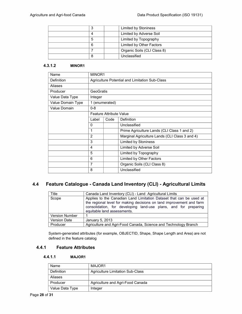
4.3 Feature catalogue – Canada Land Inventory (CLI) – Land Capability and Limitation
Title Canada Land Inventory (CLI) - Land Capability and Limitation for Agriculture
Scope Applies to the Canadian Land Inventory capability datasets that can be used at the regional level for making decisions on land improvement and farm consolidation, for developing land-use plans, and for preparing equitable land assessments.
Version Number 1 Version Date January 5, 2013 Producer Agriculture and Agri-Food Canada, Science and Technology Branch
System-generated attributes (for example, OBJECTID, Shape, Shape Length and Area) are not defined in the feature catalog.
4.3.1 Feature Attributes
4.3.1.1 MAJOR1
Name MAJOR1
Definition Agriculture Potential and Limitation Sub-Class
Aliases
Producer Agriculture and Agri-Food Canada
Value Data Type Integer Value Domain Type 1 (enumerated)
Value Domain 0-8
Feature Attribute Value
Label Code Definition
0 Unclassified
1 Prime Agriculture Lands (CLI Class 1 and 2)
2 Marginal Agriculture Lands (CLI Class 3 and 4)
Agriculture and Agri-food Canada Data Product Specification (ISO 19131)
Page 28 of 31
3 Limited by Stoniness
4 Limited by Adverse Soil
5 Limited by Topography
6 Limited by Other Factors
7 Organic Soils (CLI Class 8)
8 Unclassified
4.3.1.2 MINOR1
Name MINOR1
Definition Agriculture Potential and Limitation Sub-Class
Aliases
Producer GeoGratis
Value Data Type Integer
Value Domain Type 1 (enumerated)
Value Domain 0-8
Feature Attribute Value
Label Code Definition
0 Unclassified
1 Prime Agriculture Lands (CLI Class 1 and 2)
2 Marginal Agriculture Lands (CLI Class 3 and 4)
3 Limited by Stoniness
4 Limited by Adverse Soil
5 Limited by Topography
6 Limited by Other Factors
7 Organic Soils (CLI Class 8)
8 Unclassified
4.4 Feature Catalogue - Canada Land Inventory (CLI) - Agricultural Limits
Title Canada Land Inventory (CLI) - Land Agricultural Limits Scope Applies to the Canadian Land Limitation Dataset that can be used at
the regional level for making decisions on land improvement and farm consolidation, for developing land-use plans, and for preparing equitable land assessments.
Version Number 1 Version Date January 5, 2013 Producer Agriculture and Agri-Food Canada, Science and Technology Branch
System-generated attributes (for example, OBJECTID, Shape, Shape Length and Area) are not defined in the feature catalog
4.4.1 Feature Attributes
4.4.1.1 MAJOR1
Name MAJOR1
Definition Agriculture Limitation Sub-Class
Aliases
Producer Agriculture and Agri-Food Canada
Value Data Type Integer
Agriculture and Agri-food Canada Data Product Specification (ISO 19131)
Page 29 of 31
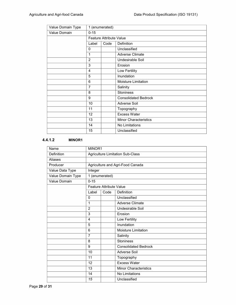
Value Domain Type 1 (enumerated)
Value Domain 0-15
Feature Attribute Value
Label Code Definition
0 Unclassified
1 Adverse Climate
2 Undesirable Soil
3 Erosion
4 Low Fertility
5 Inundation
6 Moisture Limitation
7 Salinity
8 Stoniness
9 Consolidated Bedrock
10 Adverse Soil
11 Topography
12 Excess Water
13 Minor Characteristics
14 No Limitations
15 Unclassified
4.4.1.2 MINOR1
Name MINOR1
Definition Agriculture Limitation Sub-Class
Aliases
Producer Agriculture and Agri-Food Canada
Value Data Type Integer
Value Domain Type 1 (enumerated)
Value Domain 0-15
Feature Attribute Value
Label Code Definition
0 Unclassified
1 Adverse Climate
2 Undesirable Soil
3 Erosion
4 Low Fertility
5 Inundation
6 Moisture Limitation
7 Salinity
8 Stoniness
9 Consolidated Bedrock
10 Adverse Soil
11 Topography
12 Excess Water
13 Minor Characteristics
14 No Limitations
15 Unclassified
Agriculture and Agri-food Canada Data Product Specification (ISO 19131)
Page 30 of 31
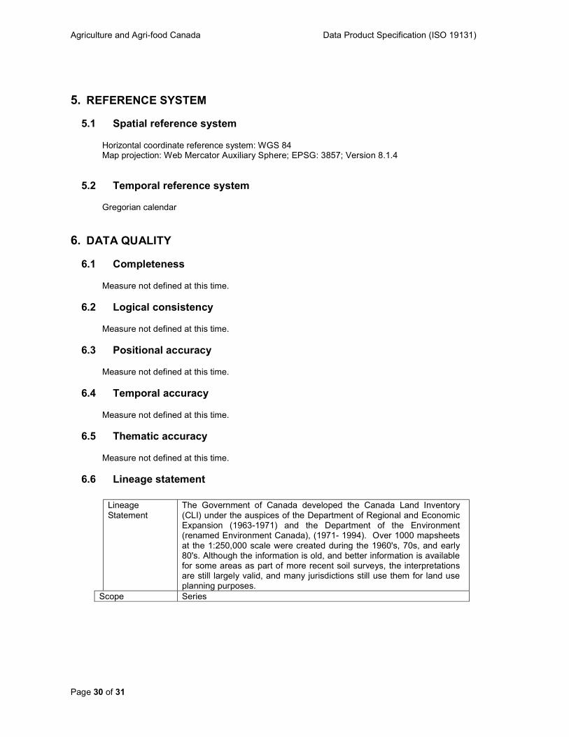
5. REFERENCE SYSTEM
5.1 Spatial reference system
Horizontal coordinate reference system: WGS 84 Map projection: Web Mercator Auxiliary Sphere; EPSG: 3857; Version 8.1.4
5.2 Temporal reference system
Gregorian calendar
6. DATA QUALITY
6.1 Completeness
Measure not defined at this time.
6.2 Logical consistency
Measure not defined at this time.
6.3 Positional accuracy
Measure not defined at this time.
6.4 Temporal accuracy
Measure not defined at this time.
6.5 Thematic accuracy
Measure not defined at this time.
6.6 Lineage statement
Lineage Statement
The Government of Canada developed the Canada Land Inventory (CLI) under the auspices of the Department of Regional and Economic Expansion (1963-1971) and the Department of the Environment (renamed Environment Canada), (1971- 1994). Over 1000 mapsheets at the 1:250,000 scale were created during the 1960's, 70s, and early 80's. Although the information is old, and better information is available for some areas as part of more recent soil surveys, the interpretations are still largely valid, and many jurisdictions still use them for land use planning purposes.
Scope Series
Agriculture and Agri-food Canada Data Product Specification (ISO 19131)
Page 31 of 31
7. DATA CAPTURE
1) agrcfins.zip was downloaded from http://geogratis.cgdi.gc.ca/download/cli_1m/e00_pro/
2) The file was unzipped and the agrcfins.e00 coverage was imported using the import command
3) Coverage was then re-projected using the project command from Lambert Conformal, with parallels at 49 and 77, and an origin at 95 longitude and 60 latitude - to GCS_North_American_1983
4) Data was converted into a feature class, renamed - and certain unnecessary fields were dropped (<coverage-id>,<coverage-Area>,<coverage-perimeter>,<coverage#>) 5) New spatial extent was defined and Metadata was created
The data was further conditioned and prepared with metadata for loading and publishing within the AAFC N-GIS enterprise Geodatabase based on the Geodataset Life Cycle (GDLC) guidelines.
8. DATA MAINTENANCE
Frequency: As Needed
9. PORTRAYAL Not applicable.
10. DATA PRODUCT DELIVERY
File Geodatabase Format name: Esri Geodatabase (File-based) format version: 10.1 Specification: A collection of various types of GIS datasets held in a file system folder.
(https://arcgis.com) Languages: eng Character set: utf8
11. METADATA
The metadata requirements follow the Government of Canada’s Treasury Board Standard on Geospatial Data (ISO 19115).