Embed Size (px)
Citation preview
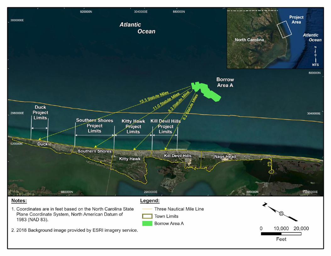
Dare County 2022 Beach Renourishment Project
Project Overview The Dare County, North Carolina 2022 beach renourishment project plans to place sand within the Towns of Duck, Southern Shores, Kitty Hawk, and Kill Devil Hills. The project will utilize sand from 1 borrow site located off of the Kill Devil Hills that was used during the 2017 beach nourishment project. The project will be bid under 1 contract.
We recently performed a topo/bathy survey of all the project areas and will be updating the designs based on the recent survey. The project volumes may change depending on the conditions at the time of construction, but current design estimates are:
• The Town of Duck project will include placement of approximately 550,000 cubic yards of sand along 1.6 miles of shoreline,
• The Town of Southern Shores project will include placement of approximately 878,300 cubic yards of sand along 3.8 miles of shoreline,
• The Town of Kitty Hawk project includes placement of approximately 645,000 cubic yards of sand along 3.97 miles of shoreline,
• The Town of Kill Devil Hills includes placement of approximately 720,000 cubic yards of sand along 2.74 miles.
Construction Items 1. The construction window to construct the 4 projects is 1 year; is there a preference regarding the
bid date or start of construction? Ideally, the construction dates would be Jan 1, 2022 to Dec 31, 2022.
2. During the construction of the landward portion of the beach profile, private and publicly owned dune overwalks may be present. What specifications regarding the construction of the beach profile in the vicinity of overwalks are preferred?
3. In general, there is less sand needed to be placed than was placed during the original projects. Is there a minimum placement density or berm width that is preferred for constructability purposes?
4. From a constructability standpoint, are there any concerns with constructing a 1V:10H seaward berm slope versus a 1V:15H seaward berm slope?
5. We have been asked by the permitting agencies to use a dune slope of 1V:4H versus a 1V:5H. From a constructability standpoint are there any concerns constructing a 1V:4H or even a 1V:3H dune slope?
6. Compensatory slope adjustment is typically provided below MHW. This assumes that the contractor will be able to grade the beach fill material using equipment above MHW. Would a slope adjustment more landward on the profile lead to a significant cost savings?
Dare County 2022 Beach Renourishment Project
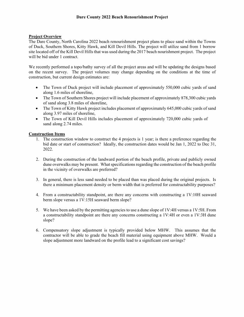
7. For the Town of Duck, the FRF has required that beach fill material not be directly placed within
their property limits with the use of heavy equipment. The taper at the south end of the project was revised to accommodate this. Additional material was placed within the template within the southern 1,500 feet to allow for the natural transport of material to the FRF property limits. Are there any concerns regarding the geometry of the taper at the south end, is there an alternate preference for the geometry of the taper?
Dare County 2022 Beach Renourishment Project
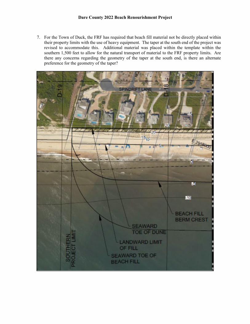
8. Town of Duck Staging Area General Discussion – Several staging areas are being considered for
the Duck project. One potential area is located at the Barrier Island Station Resort, approximately 4,000 feet south of the southern extent of the project limits and on the south side of the USACE FRF pier. A portion of the area is currently vegetated and would need an access created through the dune to the beach.
Dare County 2022 Beach Renourishment Project
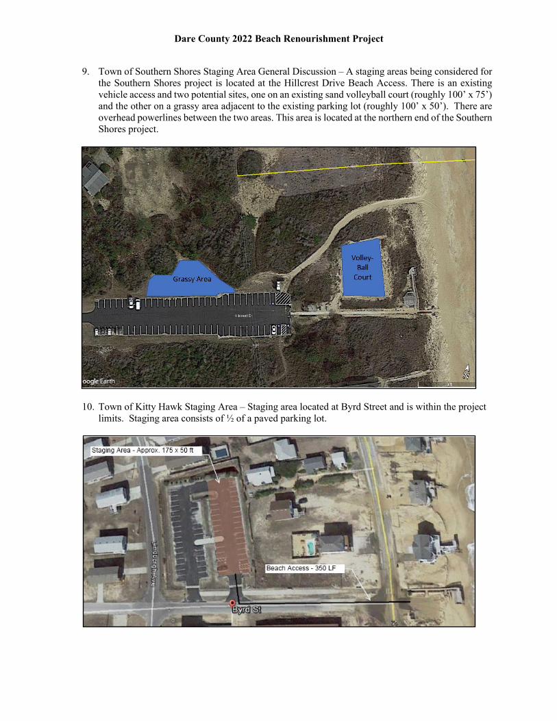
9. Town of Southern Shores Staging Area General Discussion – A staging areas being considered for the Southern Shores project is located at the Hillcrest Drive Beach Access. There is an existing vehicle access and two potential sites, one on an existing sand volleyball court (roughly 100’ x 75’) and the other on a grassy area adjacent to the existing parking lot (roughly 100’ x 50’). There are overhead powerlines between the two areas. This area is located at the northern end of the Southern Shores project.
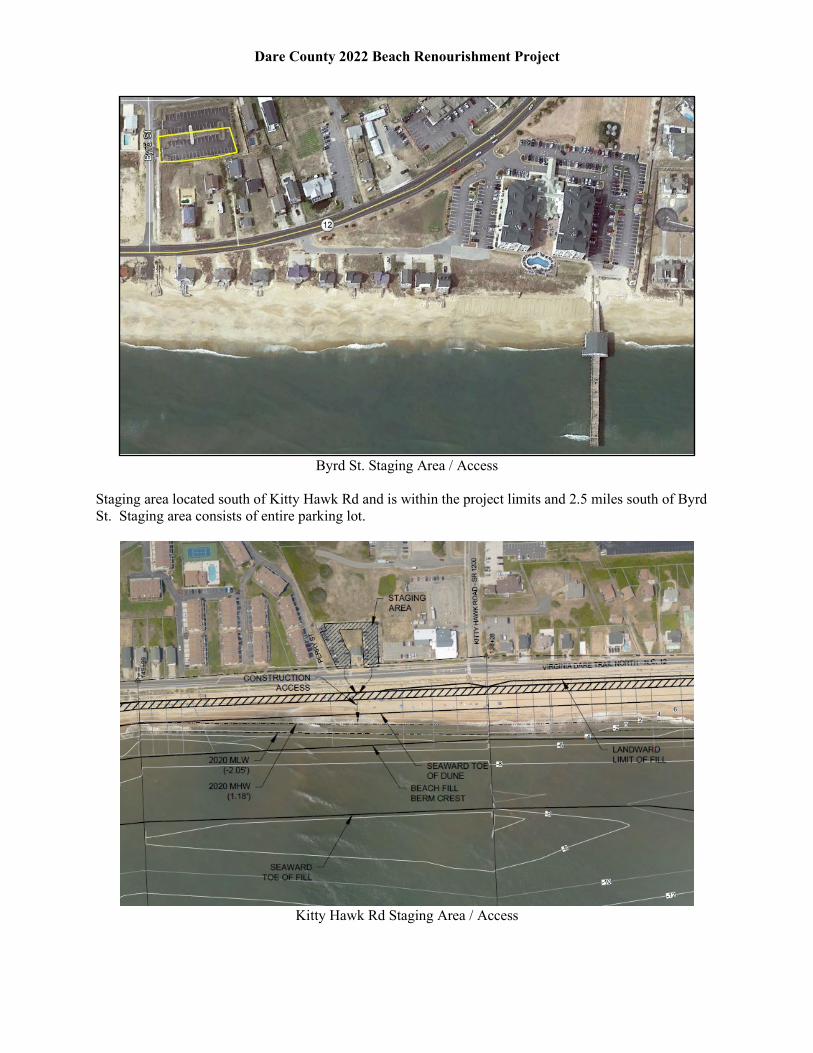
10. Town of Kitty Hawk Staging Area – Staging area located at Byrd Street and is within the project limits. Staging area consists of ½ of a paved parking lot.
Dare County 2022 Beach Renourishment Project
Byrd St. Staging Area / Access
Staging area located south of Kitty Hawk Rd and is within the project limits and 2.5 miles south of Byrd St. Staging area consists of entire parking lot.
Kitty Hawk Rd Staging Area / Access
Dare County 2022 Beach Renourishment Project
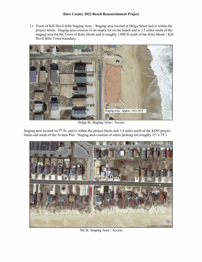
11. Town of Kill Devil Hills Staging Area – Staging area located at Helga Street and is within the project limits. Staging area consists of an empty lot on the beach and is 3.5 miles south of the staging area for the Town of Kitty Hawk and is roughly 1,000 ft south of the Kitty Hawk / Kill Devil Hills Town boundary.
Helga St. Staging Area / Access
Staging area located on 5th St. and is within the project limits and 1.4 miles north of the KDH project limits and south of the Avalon Pier. Staging area consists of entire parking lot (roughly 15’ x 75’).
5th St. Staging Area / Access
Dare County 2022 Beach Renourishment Project
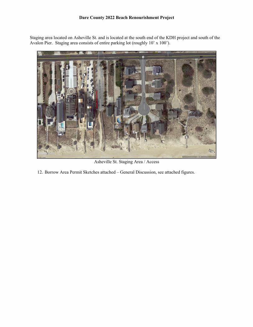
Staging area located on Asheville St. and is located at the south end of the KDH project and south of the Avalon Pier. Staging area consists of entire parking lot (roughly 10’ x 100’).
Asheville St. Staging Area / Access
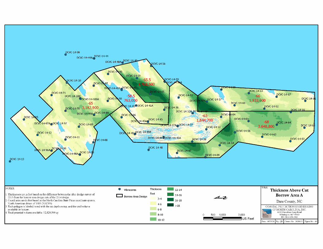
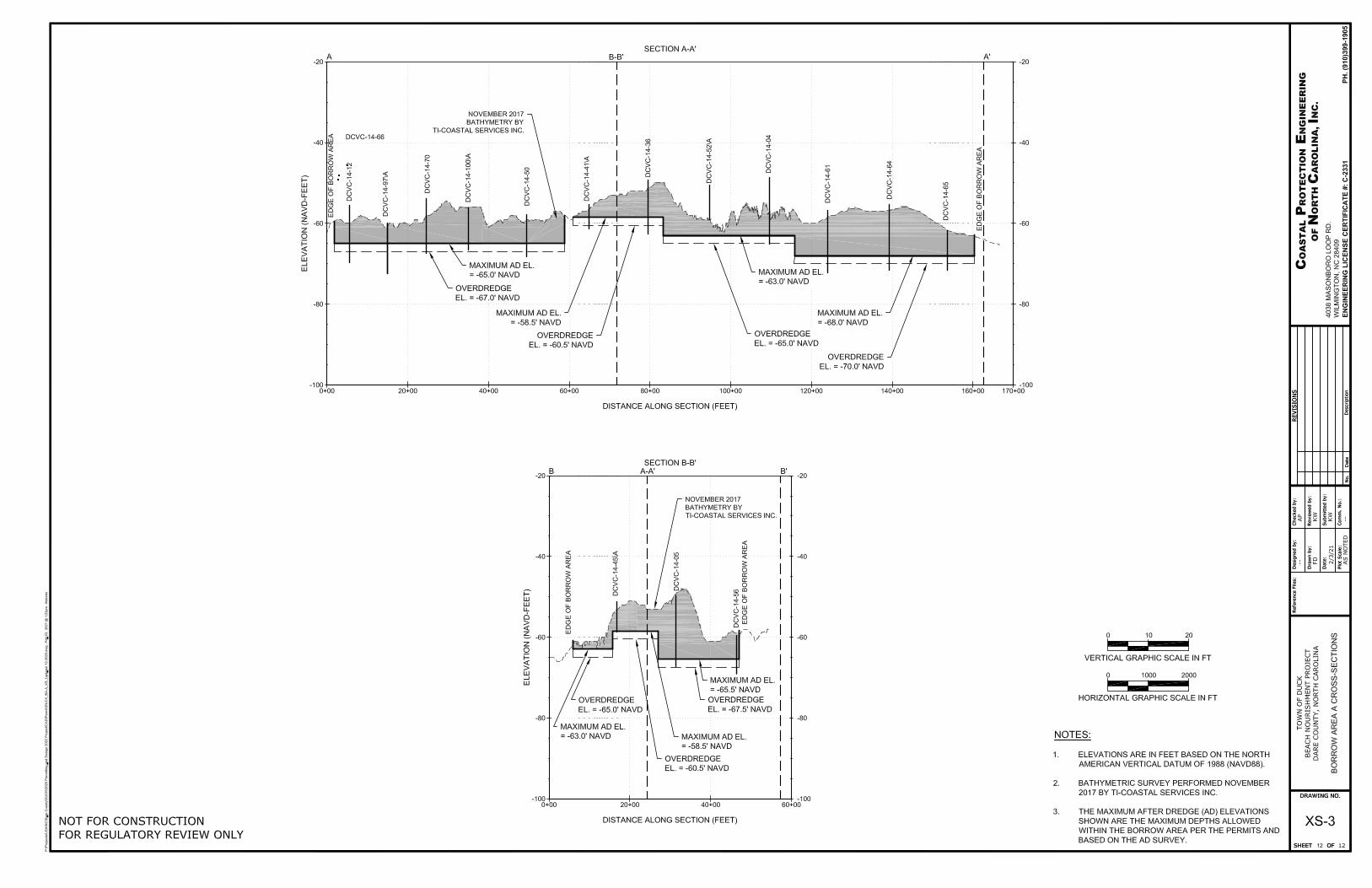
12. Borrow Area Permit Sketches attached – General Discussion, see attached figures.
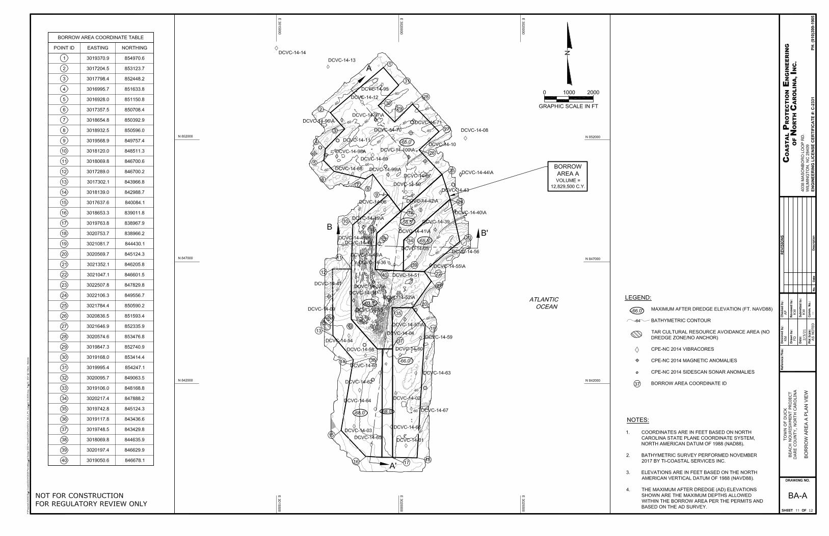
Volume Above CutBorrow Area A
COASTAL PROTECTION ENGINEERINGOF NORTH CAROLINA, INC.
4038 Masonboro Loop RoadWilmington, NC 28409
PH (910) 399-1905
Date: 03/18/21 By: QR Comm No.: 2020045 Figure No.: V1
TITLE:NOTES:
1. Elevations are in feet based on the North American Vertical Datum of 1988(NAVD88).
2. Coordinates are in feet based on the North Carolina State Plane coordinate system,North American datum of 1983 (NAD83).
3. Each polygon is labeled in red with the borrow area letter and number and cutdepth on top, and the total volume available on bottom.
4. Total potential volume available: 12,829,500 cy.
Dare County, NC
A3: -58.5763,000
A4: -65.51,456,500
A7: -661,933,600
A1: -653,182,900
A5: -682,934,200
A2: -631,844,700
A6: -68714,600
Dare Design 01/28/21
Dare Avoidance Areas
Borrow Area A
NAVD88 FT
-51.2 - -47.1
-53 - -51.3
-54.7 - -53.1
-55.8 - -54.8
-56.6 - -55.9
-57.2 - -56.7
-57.9 - -57.3
-58.4 - -58
-58.8 - -58.5
-59.2 - -58.9
-59.6 - -59.3
-60 - -59.7
-60.4 - -60.1
-60.8 - -60.5
-61.4 - -60.9
-62 - -61.5
-62.8 - -62.1
-63.8 - -62.9
-65.3 - -63.9
-74.2 - -65.4
0 1,000 2,000500
US Feet
Pat
h: E
:\P
roje
cts\
US
A\N
C\D
are\
2020
045_
2022
_Per
mit
ting
Des
ign\
aprx
\Per
mit
ting
Des
ignB
aseM
ap.a
prx
0.29 mm 0.44 mm
0.35 mm
0.32 mm
0.48 mm
0.32 mm
0.32 mm