Embed Size (px)
Citation preview
1
Danube Reference Data and Services Infrastructure
Danube_Net (D1)
State-of-play and organisational context of the data
infrastructure in the Czech Republic
Tomas Mildorf
Revised by Karel Charvát
May 2015
2
Contents List of figures ..................................................................................................................................................... 2
List of tables ....................................................................................................................................................... 2
List of acronyms ................................................................................................................................................. 3
1 Introduction .............................................................................................................................................. 4
1.1 Outline of the task ............................................................................................................................. 4
1.2 Outline of the document ................................................................................................................... 4
1.3 Context of the country and the main players.................................................................................... 4
2 Data providers .......................................................................................................................................... 5
3 Policy-making organisations ................................................................................................................... 10
4 Research organisations ........................................................................................................................... 14
5 Stakeholder engagement organisations and networks .......................................................................... 16
6 Conclusions ............................................................................................................................................. 17
List of figures
Figure 1 Schema of basic registers in the Czech Republic ............................................................................ 5
Figure 2 Centrope region ............................................................................................................................ 19
Figure 3 CentropeMAP thematic map (Population density and migration) ............................................... 19
Figure 4 Location Evaluator application ..................................................................................................... 20
Figure 5 Location Evaluator – regional report ............................................................................................ 21
List of tables
Table 1 List of data providers ....................................................................................................................... 6
Table 2 List of policy-making organisations ................................................................................................ 10
Table 3 Support for the national data infrastructure ................................................................................. 13
Table 4 List of research organisations ........................................................................................................ 14
Table 5 List of stakeholder engagement organisations .............................................................................. 16
3
List of acronyms
API application programming interface
DMVS Digital Map of Public Administration
DRDSI Danube Reference Data and Services Infrastructure
EIA Environmental Impact Assessment
ESA European Space Agency
EU European Union
EUSDR EU Strategy for the Danube Region
HTML Hyper Text Markup Language
INSPIRE Infrastructure for Spatial Information in the European Community
LPIS Land Parcel Information System
NSDI national data infrastructure
OGC Open Geospatial Consortium
ROB Register of Inhabitants
ROS Business Register
RPP Register of Rights and Responsibilities of Public Authorities
RUIAN Register of Territorial Identification, Addresses and Real Estates
SEA Strategic Impact Assessment
SDI spatial data infrastructure
SME small and medium enterprises
UNESCO United Nations Educational, Scientific and Cultural Organization
4
1 Introduction
1.1 Outline of the task
This activity aims to characterise the state-of-play of the Czech national spatial data infrastructures (NSDI)
with respect to the Danube Reference Data and Services Infrastructure (DRDSI) vertical priorities. The
DRDSI is an initiative of the Joint Research Centre to provide scientific support to the EU Strategy for the
Danube Region (Danube Strategy or EUSDR) aiming to provide a reference data and services platform
(DRDSI Platform) to support decision making mechanisms in the countries of the Danube region.
The deliverable sets out comparable content between the countries participating in the EUSDR, covering
details of organisations that could become key stakeholders from the region, including:
potential metadata/data providers to the DRDSI Platform,
key policy-making organisations in the participating countries related to data infrastructures and
lists of relevant projects,
research organisations that could have useful projects with data or data harmonisation activities,
organisations that could support wider stakeholder engagement, including SMEs.
1.2 Outline of the document
The document lists key public and private sector data providers including the types of provided data, policy-
making organisations, research organisations and organisations who can aid stakeholder engagement
working within the Czech Republic, in cross-border contexts or at the regional level. The current legal
context and funding of initiatives aiming at building a national data infrastructure are described. A list of
completed and current projects related to the vertical priorities (either for data production or providing
tools to support data-sharing) is also included.
1.3 Context of the country and the main players
Public Sector Information in the Czech Republic
Public sector information in the Czech Republic is still fragmented. Data are being collected by respective
public administrations. Data sharing is limited due to historical development and data are collected several
times and maintained at different levels of public administration. This can be seen to be against the basic
INSPIRE principles.
However, the situation has improved significantly by introducing the INSPIRE Directive, the reuse of Public
Sector Information (PSI) Directive, other legislation and eGovernment strategies. A major step was the set-
up of four basic registers. In order to prevent duplication in data collection and maintenance of PSI, central-
ised basic registers were designed and implemented. The centralised solution keeps actual and widely used
data and information. Basic registers are a central information source for information systems of public
authorities.
The concept of basic registers is based on the need for secure data interchange between thousands of
information systems of public administration. Basic registers contain reference data about inhabitants,
companies, buildings, parcels, etc.
There are 4 basic registers:
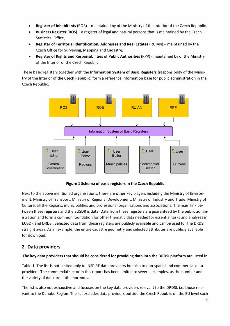
5
Register of Inhabitants (ROB) – maintained by of the Ministry of the Interior of the Czech Republic,
Business Register (ROS) – a register of legal and natural persons that is maintained by the Czech
Statistical Office,
Register of Territorial Identification, Addresses and Real Estates (RUIAN) – maintained by the
Czech Office for Surveying, Mapping and Cadastre,
Register of Rights and Responsibilities of Public Authorities (RPP) - maintained by of the Ministry
of the Interior of the Czech Republic.
These basic registers together with the Information System of Basic Registers (responsibility of the Minis-
try of the Interior of the Czech Republic) form a reference information base for public administration in the
Czech Republic.
Figure 1 Schema of basic registers in the Czech Republic
Next to the above mentioned organisations, there are other key players including the Ministry of Environ-
ment, Ministry of Transport, Ministry of Regional Development, Ministry of Industry and Trade, Ministry of
Culture, all the Regions, municipalities and professional organisations and associations. The main link be-
tween these registers and the EUSDR is data. Data from these registers are guaranteed by the public admin-
istration and form a common foundation for other thematic data needed for essential tasks and analyses in
EUSDR and DRDSI. Selected data from these registers are publicly available and can be used for the DRDSI
straight away. As an example, the entire cadastre geometry and selected attributes are publicly available
for download.
2 Data providers
The key data providers that should be considered for providing data into the DRDSI platform are listed in
Table 1. The list is not limited only to INSPIRE data providers but also to non-spatial and commercial data
providers. The commercial sector in this report has been limited to several examples, as the number and
the variety of data are both enormous.
The list is also not exhaustive and focuses on the key data providers relevant to the DRDSI, i.e. those rele-
vant to the Danube Region. The list excludes data providers outside the Czech Republic on the EU level such
6
as European Environmental Agency (e.g. Urban Atlas, Corine Land Cover), EUROSTAT or European Space
Agency (ESA).
Table 1 List of data providers
Id. Organisation Organisation Type Data Types
1
Czech Office for Surveying,
Mapping and Cadastre
(http://geoportal.cuzk.cz)
Public
- Cadastral data including buildings (ISKN - Infor-
mation System of the Cadastre of Real Estate)
- Topographic data (Fundamental Base of Geo-
graphic Data)
- Geographical names
- Imageries (orthophotomaps)
- Boundaries (administrative)
- Geodetic control
- Altimetry
- Addresses
2 Czech Statistical Office
(http://www.czso.cz) Public
- Statistical data (foreigners, education, criminali-
ty, migration, demography, employment, health
care, …)
- Macroeconomic data
- Register of business
- External trade data – data on import and export
3
Czech Environmental
Information Agency
(http://www.cenia.cz)
Public, an institu-
tion of the Ministry
of the Environment
- INSPIRE Geoportal – central hub for all INSPIRE
spatial data themes
- Environmental and strategic impact assessment
data (EIA, SEA)
- Environmental pollution (e.g. chemical)
- Waste management data and indicators
- Soil protection data
- Emissions
- Bioenergy
3.1
Czech Hydrometeorologi-
cal Institute
(www.chmi.cz)
Public, an institu-
tion of the Ministry
of the Environment
- Weather data
- Water quality
- Air quality
3.2 Czech Geological Survey
(http://www.geology.cz)
Public, an institu-
tion of the Ministry
of the Environment
- Geology
- Hydrogeology
- Soils
- Natural resources
- Quarries and mines
- Radon
- Geohazards (e.g. landslides)
- Geophysical and geochemical data
- Drills,
7
Id. Organisation Organisation Type Data Types
3.3
Nature Conservation
Agency of the Czech
Republic (www.nature.cz)
Public, an institu-
tion of the Ministry
of the Environment
- national parks
- preserved landscape areas
- (national) wildlife parks and beauty spots
- memorable trees
- UNESCO Biosphere Reserves
- NATURA 2000
- habitats and biotopes
- Rights and responsibilities related with the
above mentioned features
3.4
T. G. Masaryk Water
Research Institute
(http://www.vuv.cz/index.
php/en/)
Public, an institu-
tion of the Ministry
of the Environment
- Water protection data
- Hydrology data (e.g. rivers, ponds, reservoirs,
dams, wetlands)
- Flood zones
- Water power plants and other features (e.g.
weirs, sluices, ship locks, waterfalls, monitoring
stations, water treatment stations)
3.5
Cave Administration of the
Czech Republic
(http://www.jeskynecr.cz/
?lang=en)
Public, an institu-
tion of the Ministry
of the Environment - Data on karsts and caves
9
Podyjí National Park
(http://www.nppodyji.cz/?
lang=2)
Public, created by
the Ministry of the
Environment - Nature protection and management
10
Morava River Basin Au-
thority
(http://www.pmo.cz/)
Public
- Various hydrology data (surface water)
- Water quality
- Flood zones and models
- Water level monitoring
11
Ministry of the Interior of
the Czech Republic
(http://www.mvcr.cz/mvcr
en/)
Public - Register of Inhabitants – see the previous chap-
ter
12
Ministry of Transport of
the Czech Republic
(http://www.mdcr.cz/en)
Public - Transport related data – road, air, water and
train transport
- Cycling routes
12.1
Road and Motorway
Directorate of the Czech
Republic
(http://www.rsd.cz/en)
Public, an institu-
tion of the Ministry
of Transport
- Roads and motorways and related objects such
as tunnels and bridges
12.2
Railway Infrastructure
Administration
(http://www.szdc.cz/en/in
dex.html)
Public, an institu-
tion of the Ministry
of Transport - Railway network related data
12.3 Directorate of Waterways
(http://www.rvccr.cz/)
Public, an institu-
tion of the Ministry
of Transport - Waterways
8
Id. Organisation Organisation Type Data Types
13.
Geographic Service of the
Armed Forces of the Czech
Republic
(www.geoservice.army.cz)
Public - Topographic maps
- Digital model of territory (DMU-25)
14.
Ministry of Regional
Development
(http://www.mmr.cz/en/H
omepage)
Public - Public contracts
(http://www.isvz.cz/ISVZ/Podpora/ISVZ.aspx)
- Spatial planning data
14.1
Institute for Spatial Devel-
opment
(http://www.uur.cz/?id=9
48)
Public, an institu-
tion of the Ministry
of Regional Devel-
opment
- Spatial planning data – links to spatial plans of
municipalities and regions (http://portal.uur.cz/)
15.
Ministry of Agriculture of
the Czech Republic
(http://eagri.cz/public/we
b/en/mze/)
Public - Land Parcel Information System (LPIS)
- Agriculture data (food and livestock production,
vineyards, orchards, etc.)
15.1
Forest Management
Institute
(http://www.uhul.cz/)
Public, an institu-
tion of the Ministry
of Agriculture
- Forest data including boundaries, species, classi-
fications, hunting zones, etc.
- Biomass data
15.2
Forests of the Czech
Republic
(http://www.lesycr.cz)
Public, an institu-
tion created by the
Ministry of Agricul-
ture
- Forest management plans
16
Institute of Health Infor-
mation and Statistics of
the Czech Republic
Public, an institute
created by the
Ministry of Health
of the Czech Re-
public
- Health statistical data
(http://www.uzis.cz/cz/dps/english/index.html)
17
Research Institute for Soil
and Water Conservation
(http://www.vumop.cz)
Public research
institute
- Soil exposure to water and air erosion
- Hydrological characteristics of soil
- Physical and chemical characteristics of soil and
land including exposition, granularity, slope and
type.
- Price of agriculture land
- Land protection
18 Regions of the Czech
Republic Public
- Spatial planning data
- Utilities
- Renewable energies
19 Geodis
(http://www.geodis.cz/en) Private - Imagery (orthophoto maps)
- Digital terrain model
20 TopGis
(http://www.topgis.cz/en) Private - Geospatial data for Mapy.cz (http://mapy.cz/)
21 Hydrosoft
(http://www.hydrosoft.cz) Private - Flood zones – updated yearly for the Ministry of
the Environment
9
There are many data providers, some data are collected by several organisations (duplication in data collec-
tion and maintenance), some data are not centralised and are stored locally but the way of data access
differs. This includes some examples of OGC web services as often used by INSPIRE (e.g. cadastral data,
geological data), HTML tables and Excel files, as well as data with no remote access at all. Most data that
should be considered for the DRDSI come from the public sector.
It is rather difficult to estimate what data might be missing for the DRDSI platform. In terms of
reference data, the coverage given in
Table 1 seems to cover the most important datasets. There is probably no need for additional data collec-
tion, but rather for integration of data from various sources. For example, health data are stored by several
health institutes. All of them categorise data slightly differently, they have different coverage and are in
general heterogeneous. The primary focus should be on existing data which are decentralised. DRDSI could
help to address insufficiently documented data, which are difficult to discover and reuse.
The Czech Republic has several open data initiatives. Some of them are driven by groups of individuals and
organisations, such as OpenData.cz1 or Otakar Motejl Fund2 (Open Society Fund Prague3). Others are driven
by public administrations through European and national legislation and other measures. It has received
widespread attention, for example in the ePSI Platform: “In the middle of April, the pilot version of the
Czech National Open Data Catalogue4 was launched. After two years of waiting, Czech state institutions and
local municipalities now have their own space where they can put their own open data.”5
Considering that 90% of data, sometimes claimed to be as much as 99% of data, have a spatial character, it
is notable that there are no links between the open data initiatives and the geospatial community in the
Czech Republic. Spatial data should make a basis for all non-spatial data and be linked to them. It seems
that open data initiatives work independently from INSPIRE and other initiatives. This is also obvious from
the previously quoted article. Making links between the geospatial and open data communities would,
therefore, be beneficial.
Moreover, data published usually do not comply with any standard and therefore it is hard to reuse them.
From the public administration or governmental point of view, there are several documents underlying
access to open data and their reuse, mainly the Free Access to Information Act from 1999. This Act provides
citizens free access to public sector information. However, sharing information with citizens (or others
outside of government) requires certain organisational changes, some investment and extra effort. These
are the main barriers to making information accessible through the Internet.
1 http://opendata.cz/en
2 http://www.motejl.cz
3 http://www.osf.cz/home-eng
4 http://portal.gov.cz/portal/obcan/rejstriky/data/97898/
5 http://www.epsiplatform.eu/content/open-data-guidelines-czech-republic
10
The Czech Republic joined the Open Government Partnership6 in 2011. The implementation of the open
data policy is not as fast as foreseen and the Czech Republic is behind the schedule in most of the activities.
3 Policy-making organisations
As stated in the contribution of the Czech Republic to the Danube Strategy7: “the Czech Republic sees the
EUSDR as an overarching framework for efficient and closer cooperation which will help us to tackle com-
mon problems, drawbacks and bottlenecks which hinder the socio-economic advancement.”
The party responsible for the Danube Strategy in the Czech Republic is the Office of the Government of the
Czech Republic. The Office of the Government is the central body of state administration. According to the
Act No. 2/1969 Coll., the Office of the Government of the Czech Republic fulfils tasks connected to the
expert, organisational and technical provision of the activities of the government of the Czech Republic and
its bodies.
The main contact person for the EU Strategy for the Danube Region is:
Eliška Gerthnerová, [email protected], tel. +420 224 002 166
The Czech Republic is the coordinator of the Priority Area 2: “To encourage more sustainable energy”. The
Czech citizens and organisations are being informed about the Danube Strategy through a website8.
There many policy-making organisations in the Czech Republic. The core organisations include all the minis-
tries which are listed in Table 2. The table include also the Czech national mapping agency as one of the key
players in the area of spatial data related policies.
Table 2 List of policy-making organisations
Id. Organisation Organisation
Type Policy area
Projects
1
Office of the Govern-
ment of the Czech
Republic
(http://www.vlada.cz/en
/urad-vlady/)
Central body
of the
government
- expert, organizational and technical
provision of the activities of the gov-
ernment of the Czech Republic and
its bodies
- EUSDR
2
Ministry of Education,
Youth and Sports of the
Czech Republic
(http://www.msmt.cz/?l
ang=2)
Central
government
- education
- research and development policy
- sport and tourism
- Priority Area 9
Available at
http://www.ms
mt.cz/file/3423
8_1_1/
3
Ministry of Industry and
Trade of the Czech
Republic
(http://www.mpo.cz/def
Central
government
- national industry policy
- trade policy
- foreign economic policy
- integrated raw material policy
-
6 http://www.opengovpartnership.org/country/czech-republic/
7 http://ec.europa.eu/regional_policy/archive/consultation/danube/doc/countries/cz_contribution.pdf
8 http://podunajskastrategie.webnode.cz/ (only in Czech)
11
Id. Organisation Organisation
Type Policy area
Projects
ault_en.html) - use of mineral resources, energy, gas
and heat production, mining, crude
oil, natural gas, solid fuels, nuclear
materials, and other commodities
- technical standardisation, metrology
and state quality control
- industrial research, engineering and
technology development
- electronic communication and postal
services
4
Ministry of the Environ-
ment of the Czech
Republic
(http://www.mzp.cz/en)
Central
government
- water resources management and
protection
- air protection
- nature and landscape protection
- farmland protection
- geological service
- mineral resources, mining and quar-
rying supervision
- waste management
- assessment of activities and their
impact on environment including
cross-border activities
- hunting, fishing and forest manage-
ment in national parks
National IN-
SPIRE Geoportal
(http://geoport
al.gov.cz)
5
Ministry of the Interior
of the Czech Republic
(http://www.mvcr.cz/mv
cren/)
Central
government
- internal security including supervi-
sion of road traffic protection
- register of inhabitants, travel docu-
ments and residency
- registration of organizations with in-
ternational links
- firearms and ammunition
- fire protection
- Digital Map of
Public Admin-
istration
6
Ministry of Transport of
the Czech Republic
(http://www.mdcr.cz/en)
Central
government - Transport policies
Czech Space
Portal
http://www.cze
chspacepor-
tal.cz/en/
7
Ministry of Regional
Development
(http://www.mmr.cz/en/
Homepage)
Central
government
- regional business support
- housing policy
- territorial (spatial) planning
- building rules
- housing-related legislation
- investment policy
- tourism
-
8
Ministry of Agriculture of
the Czech Republic
(http://eagri.cz/public/w
eb/en/mze/)
Central
government
- agriculture
- water management and quality
- food industry
-

12
Id. Organisation Organisation
Type Policy area
Projects
9
Ministry of Labour and
Social Affairs of the
Czech Republic
(http://www.mpsv.cz/en
)
Central
government - social and labour policies
-
10
Ministry of Foreign
Affairs
(http://www.mzv.cz/jnp/
en/index.html)
Central
government
- foreign policy
- relations of the Czech Republic with
other states, international organiza-
tions and integrative blocks
- coordination of activities resulting
from bilateral and multilateral coop-
eration
-
11
Ministry of Defence of
the Czech Republic
(http://www.army.cz/en
)
Central
government
- Armed forces and military training
- military defence policy
-
12
Ministry of Health of the
Czech Republic
(http://www.mzcr.cz/En)
Central
government
- health care, public health protection
- health research activities
- natural spas and mineral water re-
sources
-
13
Ministry of Justice of the
Czech Republic
(http://portal.justice.cz)
Central
government
- courts and public prosecutor's offic-
es
-
14
Ministry of Finance of
the Czech Republic
(www.mfcr.cz/en/)
Central
government
- state budget and taxes
- pension funds
- state property privatization
- insurance companies
-
15
Ministry of Culture of
the Czech Republic
(http://www.mkcr.cz/en)
Central
government
- arts
- cultural and educational activities
- cultural monuments
- press, radio and television broad-
casting
- Copyright Act
- production and trade in the culture
area
-
16
Czech Office for Survey-
ing, Mapping and Cadas-
tre
(http://geoportal.cuzk.cz
)
Central body
of public
administra-
tion
- surveying and cadastre
-
17
Czech Telecommunica-
tion Office
(http://www.ctu.eu/mai
n.php?pageid=178)
Central body
of public
administra-
tion
- Telecommunications
-
18
State Office for Nuclear
Safety
(http://www.sujb.cz/en)
Central body
of public
administra-
tion
- Nuclear safety
- Protection of citizens from radiation
-
13
Id. Organisation Organisation
Type Policy area
Projects
19 State Mining Administra-
tion (http://cbusbs.cz/)
Central body
of public
administra-
tion
- Mining activities and safety
-
20
Czech Office for Stand-
ards, Metrology and
Testing
(http://www.unmz.cz/off
ice/en)
Central body
of public
administra-
tion
- Standardisation
-
Table 3 focuses on data related infrastructures, not only general public administration services but also
their modernisation, including Smart Administration or the general concept of eGovernment.
Table 3 Support for the national data infrastructure
Id. Organisation Key legal acts Key initiatives Funding
1
Ministry of the Interior, Czech
Office for Surveying, Mapping
and Cadastre, Ministry of De-
fence, Ministry of the Environ-
ment, Ministry of Transport,
Ministry of Finance, Ministry of
Regional Development
Resolution of the
Government of
the Czech Repub-
lic No. 815 from
8th
October 2014
The Strategy for the Devel-
opment of the Spatial
Information Infrastructure
in the Czech Republic to
2020 (GeoInfoStrategy)
- Not known yet,
state budget and
EU funds
2
Ministry of the Environment,
other organisations involved in
the implementation
Act No. 380/2009
Coll., amending
Act No. 123/1998
Coll., establishing
the right to
information on
the environment
- INSPIRE
- State budget, EU
funds
3 Ministry of the Interior Various acts and
strategies
Digital Map of Public Admin-
istration (DMVS)
European Regional
Development Fund,
Integrated Opera-
tional Programme
other national
sources
4 Ministry of the Interior
Act No. 111/2009
Coll., on basic
registers
- Information System of
Public Administration (basic
registers) – a part of the
eGovernment initiative
- European Regional
Development Fund,
state budget
5 Ministry of the Interior
Government
Resolution No. 39
from 16th
January
2013
Open Government Partner-
ship
(http://www.opengovpartne
rship.org/country/czech-
republic)
-
14
The most important initiative, next to the INSPIRE implementation, is the recent activity coordinated by the
Ministry of Interior of the Czech Republic – The Strategy for the Development of the Spatial Information Infra-
structure in the Czech Republic to 2020 (GeoInfoStrategy). The GeoInfoStrategy was approved by Resolution of
the Government of the Czech Republic No. 815 from 8th
October 2014. The network of organisations involved
in the GeoInfoStrategy definition includes the key players needed for the DRDSI. Currently, the Action Plan
for the GeoInfoStrategy is being defined. It is the most active support for the national data infrastructure
which is covering not only INSPIRE data but also other data. Such work takes place alongside developments
in base registers, as highlighted above, and efforts to promote open data, which may have datasets of
relevance to the EUSDR that could be presented via the DRDSI.
4 Research organisations
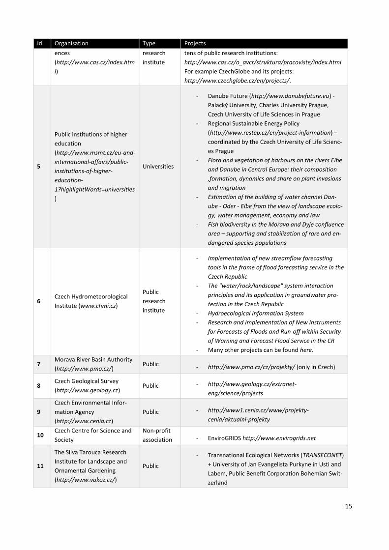
There are many research institutes in the Czech Republic including public research centres, universities,
private and non-profit organisations. Table 4 is an overview of the key ones which might be relevant to the
Danube Region. However, the research tackles specific aspects ranging from historical development to
social issues associated with ICT. The list of research organisations and projects that are somehow related
to the Danube Region can be very extensive (hundreds of research organisations and thousands of pro-
jects). The table includes only an overview and a selection of projects relevant to the Danube Region - some
of them very specific, whereas others are creating a general framework which can be used anywhere else
outside the Danube Region.
There are also several networks and education centres (non-profit) which are not research organisations.
Some of them are supporting the EUSDR, for example the Bridge to Education organisation involved in the
CE-Ageing Platform project9.
There are also many organisations involved in international projects specialised on biomass, for example
the Czech Biomass Association10.
Table 4 List of research organisations
Id. Organisation Type Projects
1
T. G. Masaryk Water Research
Institute
(http://www.vuv.cz/index.php
/en/)
Public
research
institute
http://www.vuv.cz/files/pdf/projekty/anotace/list_of_proje
cts_2013.pdf
2
Research Institute of Geode-
sy, Topography and Cartog-
raphy (http://www.vugtk.cz/)
Public
research
institute
New Technologies for the Information Society
(http://www.isvav.cz/projectDetail.do?rowId=ED1.1.00%2F
02.0090)
Other specific projects listed at
http://www.vugtk.cz/vyzkum/
3
Research Institute for Soil and
Water Conservation
(http://www.vumop.cz)
Public
research
institute
Specific research in the field of landscape, soil and water
protection and exploitation.
4 The Czech Academy of Sci- Public The Czech Academy of Sciences is set up as a complex of
9 http://www.ce-ageing.eu
10 http://czbiom.cz/en/projects
15
Id. Organisation Type Projects
ences
(http://www.cas.cz/index.htm
l)
research
institute
tens of public research institutions:
http://www.cas.cz/o_avcr/struktura/pracoviste/index.html
For example CzechGlobe and its projects:
http://www.czechglobe.cz/en/projects/.
5
Public institutions of higher
education
(http://www.msmt.cz/eu-and-
international-affairs/public-
institutions-of-higher-
education-
1?highlightWords=universities
)
Universities
- Danube Future (http://www.danubefuture.eu) -
Palacký University, Charles University Prague,
Czech University of Life Sciences in Prague
- Regional Sustainable Energy Policy
(http://www.restep.cz/en/project-information) –
coordinated by the Czech University of Life Scienc-
es Prague
- Flora and vegetation of harbours on the rivers Elbe
and Danube in Central Europe: their composition
,formation, dynamics and share on plant invasions
and migration
- Estimation of the building of water channel Dan-
ube - Oder - Elbe from the view of landscape ecolo-
gy, water management, economy and law
- Fish biodiversity in the Morava and Dyje confluence
area – supporting and stabilization of rare and en-
dangered species populations
6 Czech Hydrometeorological
Institute (www.chmi.cz)
Public
research
institute
- Implementation of new streamflow forecasting
tools in the frame of flood forecasting service in the
Czech Republic
- The "water/rock/landscape" system interaction
principles and its application in groundwater pro-
tection in the Czech Republic
- Hydroecological Information System
- Research and Implementation of New Instruments
for Forecasts of Floods and Run-off within Security
of Warning and Forecast Flood Service in the CR
- Many other projects can be found here.
7 Morava River Basin Authority
(http://www.pmo.cz/) Public - http://www.pmo.cz/cz/projekty/ (only in Czech)
8 Czech Geological Survey
(http://www.geology.cz) Public - http://www.geology.cz/extranet-
eng/science/projects
9
Czech Environmental Infor-
mation Agency
(http://www.cenia.cz)
Public - http://www1.cenia.cz/www/projekty-
cenia/aktualni-projekty
10 Czech Centre for Science and
Society
Non-profit
association - EnviroGRIDS http://www.envirogrids.net
11
The Silva Tarouca Research
Institute for Landscape and
Ornamental Gardening
(http://www.vukoz.cz/)
Public
- Transnational Ecological Networks (TRANSECONET)
+ University of Jan Evangelista Purkyne in Usti and
Labem, Public Benefit Corporation Bohemian Swit-
zerland

16
Id. Organisation Type Projects
12
Research Institute of Agricul-
tural Engineering
(http://www.vuzt.cz/?L=EN)
Public - http://www.vuzt.cz/index.php?I=A21&L=EN
13
Institute of Agricultural,
Economics and Information
(http://www.iaei.cz/)
Public - http://www.iaei.cz/research-and-projects/
14
Crop Research institute
(http://www.vurv.cz/?p=index
&site=default_en)
Public - http://www.vurv.cz/?p=index&site=vyzkum_en
15
Czech Academy of Agricultural
Sciences
(http://www.cazv.cz/default.a
sp?lang=en)
Public
16 Institute of Forest Ecosystem
Research (http://www.ifer.cz) Private - http://www.ifer.cz/page/?page=projects_running
In general, there are many projects related somehow to the Danube Region. However, the number of
projects which are directly connected to the EUSDR in a cross-border context is limited.
Data sources used by individual research organisations are usually provided through respective data pro-
viders. The conditions for using data for research purposes differ. In general, however, data providers are
willing to provide data for no cost. However, the use of data is limited purely for the research or project
purposes. Many research organisations are also collecting their own data and creating an organisational
database. The willingness to share such collected data is limited.
5 Stakeholder engagement organisations and networks
The key organisations and networks are listed in Table 5. There is major overlap of the INSPIRE stakeholder
group and the DRDSI stakeholders including data providers and users.
Table 5 List of stakeholder engagement organisations
Id. Organisation Coverage Areas of interest Other details
1 Nemoforum national
A network of public, professional (pri-
vate) and academic institutions. The aim
is to support communication in the field
of land- and real estate information
between public administration and
citizens.
http://www.cuzk.cz/Englis
h/About-
us/Nemoforum/Nemoforu
m-uvod.aspx
2 Czech Association
for Geoinformation National
- An association of legal entities and
individuals acting in the field of geoin-
formation technologies.
Members:
http://www.cagi.cz/clenov
e-cagi
3 OpenData.cz National - An initiative for transparent data
infrastructure in the Czech Republic.
Members are individuals:
http://opendata.cz/en/con
tacts
4 Czech INSPIRE
community National - INSPIRE
Managed by CENIA
(http://cenia.cz/)
5 Open Geoinfra- National - An organisation supporting free and Members are individuals:
17
Id. Organisation Coverage Areas of interest Other details
structure
(http://osgeo.cz/)
open source software and open data in
the field of geomatics.
http://osgeo.cz/clenove/
6
Association of
Regions of the
Czech Republic
(http://www.asocia
cekraju.cz/associati
on-of-regions-of-
the-czech-republic/)
National
The main aim is to promote the regions'
joint interests, especially overseeing the
overall development of the territory and
tending to the needs of its citizens
Members are all Czech
regions and the City of
Prague.
Most of the above mentioned organisations provide an umbrella body for various kinds of actors. These
bodies usually provide coordination in different topics related to data, software or services. Members of
these bodies can better coordinate activities towards public authorities and create a space for discussion.
Apart from the Czech INSPIRE community, there is no intention of the organisations to collect data. The
INSPIRE community is built based on the INSPIRE legislation, which is also the main driver. OpenData.cz
aims mainly at educating university students, as well as providing training and media coverage on open
data, helping to encourage its use in practice.
Data are in the possession of public administration. There is a push from many organisations to make it
available. However, due to historical developments, public administrations in the Czech Republic are not as
flexible when compared to countries such as Norway, Finland, Denmark, Netherlands or the UK.
6 Conclusions
The analysis of the current situation has been performed based on the author’s knowledge of the situation
in the Czech Republic in the field of data infrastructures and data sharing. Several persons were consulted
in order to clarify some issues, for example the party responsible for the EUSDR implementation in the
Czech Republic.
The information on the progress in the EUSDR implementation in the Czech Republic is not easily accessible
through the internet and exists mainly as internal documents which cannot be shared. Based on the con-
versation with Mrs Gerthenrová, the Office of the Government is preparing a new website that should have
this kind of information. The website should be set up during 2015.
For the purposes of dissemination and awareness-raising of the DRDSI in the Czech Republic, the following
website was set-up11.
The DRDSI aims and ideas were presented at the Czech and Slovak INSPIRE conference held in Prague in
November 2014. Several questions were raised. The main issue was that data providers are not willing to
publish their data for other parties without being involved in projects that use their data. In other words,
some data providers are willing to share data only when they receive some financial contribution.
There is a big potential for the DRDSI exploitation in the Czech Republic. The problem to engage data pro-
viders seems to be mainly financial support for the implementation of necessary services and also lack of
11 http://drdsi.webnode.cz (only in Czech)
18
any legislative support. This is true especially for public data providers whose mission and work is steered
by existing legislation. They usually only do the things they are obliged to do by law, due to the limited
budget they receive.
Most data providers are implementing INSPIRE. It is a long term process and takes a lot of resources. Intro-
ducing another initiative that they should support is difficult. The DRDSI should be seen as a support to
INSPIRE implementation as INSPIRE metadata are reused in the DRDSI platform’s catalogue. This could
encourage other organisations to submit metadata/data into INSPIRE, provide endpoints to other existing
metadata catalogues and, where/if relevant, endpoints for open data portals.
How to proceed further? The recommendation is to start from small and achieve a quick win. It would be
good to base the platform on existing projects such as the CentropeMAP12 whose objectives were similar to
the DRDSI and there are data, methodologies and tools to build on:
- Development and further extension of spatial and attribute data for the entire Centrope region
(Figure 2)
- Harmonisation of data formats and procedures for common data use
- Implementation of a basic online data catalogue
- Visualisation of regional spatial data
- Consulting on the potential for integrating spatial monitoring data for planning purposes
- Networking and international communication with stakeholders from all parts of the Centrope re-
gion
The availability of statistical data and spatial reference data such as statistical units is good in most coun-
tries and can serve as a good starting point for data harmonisation, visualisation and publication in differ-
ent formats and through different APIs. Also, these datasets are crucial reference data for many applica-
tions such as logistics, traffic volumes, renewable energy production and energy consumption. Figure 3
shows an example of a map from the Centrope region covering a cross-border area of the Czech Republic,
Austria, Slovakia and Hungary. There are follow up initiatives based in the Cetrope region, e.g. cen-
trope_tt13.
12 http://centropemap.org
13 http://www.centrope-tt.info

19
Figure 2 Centrope region
Figure 3 CentropeMAP thematic map (Population density and migration)
20
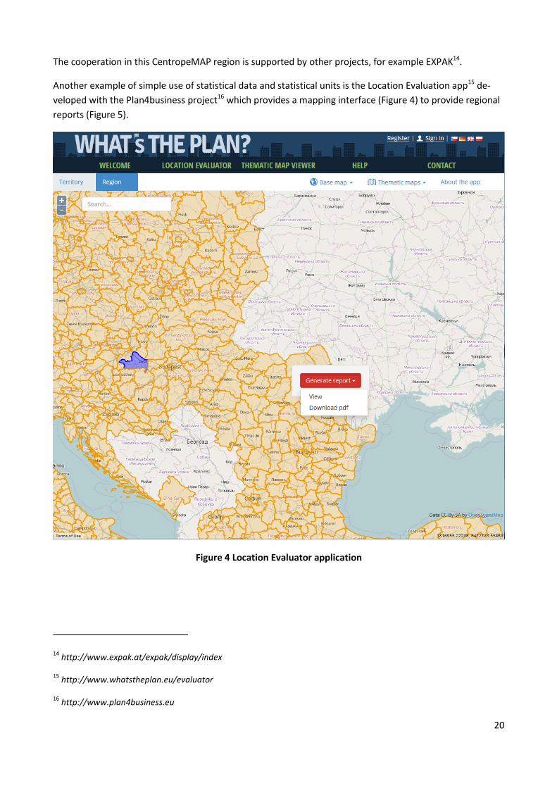
The cooperation in this CentropeMAP region is supported by other projects, for example EXPAK14.
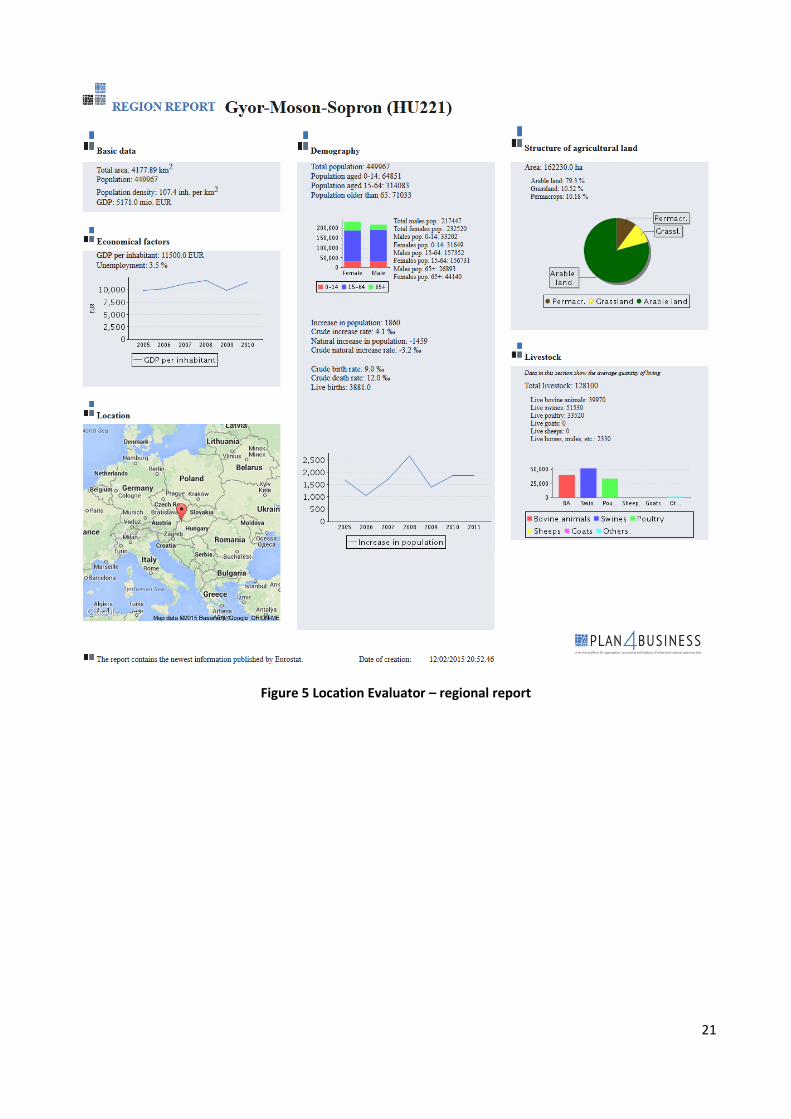
Another example of simple use of statistical data and statistical units is the Location Evaluation app15 de-
veloped with the Plan4business project16 which provides a mapping interface (Figure 4) to provide regional
reports (Figure 5).
Figure 4 Location Evaluator application
14 http://www.expak.at/expak/display/index
15 http://www.whatstheplan.eu/evaluator
16 http://www.plan4business.eu
21
Figure 5 Location Evaluator – regional report