Embed Size (px)
Citation preview


DisclaimerWhile this publication has been prepared with care, the Queensland Government accepts no liability for any decisions or actionstaken on the basis of this document. However, any memorandums of understanding that are signed as a result of the release ofthis document will bind those parties to proposed actions.
Information given in this document does not necessarily represent Queensland Government policy. However, the strategy will beused as an interim statement on policy and a basis for developing a Recreation Area Management Plan.
Note also that implementation of some strategies might need to be phased in according to the availability of resources.
Publication of this Danbulla–Lake Tinaroo Management Strategy is a major opportunity for public involvement in helping tomanage this area. The strategy indicates proposals are under consideration and are open for discussion.
Danbulla–Lake Tinaroo Management Strategy
ISBN 0-7242-9365-5
© The State of Queensland. Environmental Protection Agency, 2002.
Copyright protects this publication. Except for purposes permitted by the Copyright Act, reproduction of all or any part bywhatever means is prohibited without the prior written permission of the Environmental Protection Agency. Direct enquiries to PO Box 155 BRISBANE ALBERT STREET QLD 4002.
RE432 March 2002Produced by the Environmental Protection Agency.Visit us online at www.epa.qld.gov.au

Danbulla–Lake Tinaroo Management Strategy • March 2002 • ISBN 0-7242-9365-5 i
IntroductionThis Danbulla–Lake Tinaroo Management Strategy containsproposals for managing the use of Danbulla State Forest andLake Tinaroo. It sets out the considerations, outcomes andstrategies proposed to form the basis on which day-to-daymanagement decisions will be made.
The strategy has been developing over a number of years(1989–2000). A draft was published for public comment inAugust 2000 and 196 public submissions were received. Thesteering committee incorporated the community views andendorsed this Danbulla–Lake Tinaroo Management Strategy.
Publication of the strategy was approved by the Minister forEnvironment in March 2002.
For further information on the Danbulla–Lake TinarooManagement Strategy or the planning process, please contactthe Senior Planner, Queensland Parks and Wildlife Service, PO Box 2066, CAIRNS QLD 4870 or the Manager, QueenslandParks and Wildlife Service, PO Box 975, ATHERTON QLD 4883.
Note: In February 2001, the forest managementresponsibilities of the former Department of Natural Resources(Forest Resources) were transferred to the EnvironmentalProtection Agency (Queensland Parks and Wildlife Service).Most of the Danbulla State Forest is proposed to be gazettedas forest reserve. The Forestry Act 1959 and relatedRegulations will apply to Danbulla Forest Reserve until the newprotected area status is finalised when the NatureConservation Act 1992 and related Regulations will then apply.
Need for the strategyAs the land and water components of the Danbulla–LakeTinaroo area received increasing pressure from user groups, itwas recognised that an integrated management approach wasneeded to minimise impacts, maintain the area’s integrity andto achieve impartial resource sharing. In order to plan for thepresent and prepare for the future, it was recognised that amanagement strategy would provide clear managementresponsibility and facilitate a partnership approach betweenmanaging agencies and the community.
Management philosophy
VisionThe Danbulla–Lake Tinaroo area is sustainably managed toprovide a balance between conservation, recreation andother resource use through the co-operation andcontributions of community and government.
The Danbulla–Lake Tinaroo Management Strategy will providean objective framework for decision making and sustainablemanagement of the natural and cultural resources within theManagement Area. The strategy will establish guidelines toensure co-operative, responsible and accountable decisionmaking by current and prospective management authorities,reflecting a commitment to community expectations andecological sustainable development. A pro-active approachwill be used to resolve conflict.
Document structureThe Danbulla–Lake Tinaroo Management Strategy is presentedin three parts:
PART A — Strategy overview: This section includes the overall purpose and process that hasdirected the strategy for the management of land and water inthe area. The broad values of the area are described and themanagement objectives outlined.
PART B — Management intent: This section defines the management details of the strategy.
Initially, an assessment was made of the broad values of:• natural values• cultural values• ecotourism and nature-based recreation values• open space resource uses
The different combinations of the land and/or water values,along with the tenure arrangements, were used to form thebasis of the ten Management Units (Map 3). Guidingprinciples were developed for each Management Unit ensuringconsistency with current Government policies and legislation.Examples of compatible, non-compatible and those activitiesrequiring consent for each Management Unit are presented intables in this section.
PART C — Issue statements: This section includes the issues that were raised throughpublic submissions, workshops and meetings. Intendedmanagement actions have been summarised and listed, alongwith the agency responsible for undertaking that action, inTable 11. In the spirit of co-operation and integratedprocedural arrangements, departments and agencies are likelyto refer to the implementation schedule to prioritise andinteract with other agencies to deliver outcomes throughvarious means and within timelines.
AcknowledgementsThis Management Strategy is the result of an initiative jointlyfunded initially by the Department of Natural Resources, WetTropics Management Authority and Atherton Shire Council andsupported more recently by the Environmental ProtectionAgency and the Queensland Parks and Wildlife Service.
The key individuals of the planning team responsible forproducing the Danbulla–Lake Tinaroo Management Strategywere the Department of Natural Resources (Forest Resources)now Queensland Parks and Wildlife Service staff.
The following government agencies were members of theSteering Committee during the most recent development ofthe Danbulla–Lake Tinaroo Management Strategy:
Atherton Shire CouncilDepartment of Natural ResourcesDepartment of Primary IndustriesQueensland Parks and Wildlife ServiceWet Tropics Management AuthoritySunWater Corporation
The Tinaroo Dam Management Committee, the TinarooRecreation Advisory Committee, the Barron River IntegratedCatchment Management Upper Community Zone Forum,School for Field Studies, the Lake Tinaroo Action Group andother community members have played a key role in thedevelopment of the strategy. This has been achieved bycollating information from public workshops, communitysurveys and public submissions to form the issues statementsand the basis of the strategy.
Scientific Information was generously provided by:Australian MuseumCommonwealth Science and Industry ResearchOrganizationEnvironmental Protection AgencyJames Cook UniversityBirds Australia (Royal Australian Ornithological Union)Queensland MuseumQueensland HerbariumThe University of QueenslandWet Tropics Management Authority
We thank the many individuals, organizations and groups thathave contributed to the development of this document.

ii Danbulla–Lake Tinaroo Management Strategy • March 2002 • ISBN 0-7242-9365-5
ContentsIntroduction . . . . . . . . . . . . . . . . . . . . . . . . . . . . . . . . . . . . . . . . i
Need for the strategyManagement philosophyDocument structure
Acknowledgements . . . . . . . . . . . . . . . . . . . . . . . . . . . . . . . . . . i
Contents . . . . . . . . . . . . . . . . . . . . . . . . . . . . . . . . . . . . . . . . . . iiSummary . . . . . . . . . . . . . . . . . . . . . . . . . . . . . . . . . . . . . . iiiManagement Units . . . . . . . . . . . . . . . . . . . . . . . . . . . . . . . iiiBroad management strategy outcomes . . . . . . . . . . . . . . . iii
Part A 1 Foreword . . . . . . . . . . . . . . . . . . . . . . . . . . . . . . . . . . . . . . . 1
1.1 Introduction . . . . . . . . . . . . . . . . . . . . . . . . . . . . . . . . 11.2 Outstanding issues . . . . . . . . . . . . . . . . . . . . . . . . . . . 11.3 Alternative management options . . . . . . . . . . . . . . . . 4
1.3.1 Recreation area management (RAM) plans . . . 41.3.2 Waterway transport management plans . . . . . . 41.3.3 SunWater management plans . . . . . . . . . . . . . . 4
1.4 Purpose . . . . . . . . . . . . . . . . . . . . . . . . . . . . . . . . . . . . 51.5 Aim . . . . . . . . . . . . . . . . . . . . . . . . . . . . . . . . . . . . . . . 51.6 Background . . . . . . . . . . . . . . . . . . . . . . . . . . . . . . . . . 51.7 Management boundary . . . . . . . . . . . . . . . . . . . . . . . 51.8 Native title implications . . . . . . . . . . . . . . . . . . . . . . . 51.9 Wet Tropics World Heritage Area permits . . . . . . . . . . 51.10 Far North Queensland Regional Plan 2000 . . . . . . . . 61.11 Wet Tropics Nature Based Tourism Strategy . . . . . . . . 61.12 Wet Tropics Walking Strategy . . . . . . . . . . . . . . . . . . . 61.13 Species management profiles . . . . . . . . . . . . . . . . . . 61.14 Code of practice . . . . . . . . . . . . . . . . . . . . . . . . . . . . . 61.15 Guide to the decision-making process . . . . . . . . . . . . 61.16 Consultation . . . . . . . . . . . . . . . . . . . . . . . . . . . . . . . . 71.17 Amendments . . . . . . . . . . . . . . . . . . . . . . . . . . . . . . . 71.18 Management Unit mapping . . . . . . . . . . . . . . . . . . . . 7
2 Resource values . . . . . . . . . . . . . . . . . . . . . . . . . . . . . . . . . 72.1 Natural values . . . . . . . . . . . . . . . . . . . . . . . . . . . . . . . 7
2.1.1 Management objectives for natural values . . 72.2 Cultural heritage values . . . . . . . . . . . . . . . . . . . . . . . 7
2.2.1 Management objectives for culturalheritage values . . . . . . . . . . . . . . . . . . . . . . . . 8
2.3 Ecotourism and recreation values . . . . . . . . . . . . . . . 82.3.1 Management objectives for ecotourism
and recreation values . . . . . . . . . . . . . . . . . . . 82.4 Other resource use values . . . . . . . . . . . . . . . . . . . . . 8
2.4.1 Management objectives for other resource use values . . . . . . . . . . . . . . . . . . . . . . . . . . . 9
Part B 3 Management units . . . . . . . . . . . . . . . . . . . . . . . . . . . . . . 10
3.1 Management Unit A1 (special conservation) . . . . . . 103.2 Management Unit A (broad conservation) . . . . . . . . 113.3 Management Unit B (special conservation) . . . . . . . 113.4 Management Unit C (special conservation) . . . . . . . 123.5 Management Unit D (recreation) . . . . . . . . . . . . . . . . 123.6 Management Unit E (recreation) . . . . . . . . . . . . . . . . 133.7 Management Unit F (recreation) . . . . . . . . . . . . . . . . 133.8 Management Unit G (other resource use) . . . . . . . . . 143.9 Management Unit H (water management) . . . . . . . . 143.10 Management Unit I (resource use) . . . . . . . . . . . . . . 15
Part C4 Issue statements . . . . . . . . . . . . . . . . . . . . . . . . . . . . . . . 16
4.1 Natural resource management . . . . . . . . . . . . . . . . . . 164.1.1 Water quality . . . . . . . . . . . . . . . . . . . . . . . . . . 164.1.2 Land revegetation and rehabilitation . . . . . . . 164.1.3 Fire management . . . . . . . . . . . . . . . . . . . . . . 164.1.4 Fisheries . . . . . . . . . . . . . . . . . . . . . . . . . . . . . 174.1.5 Endangered and vulnerable species . . . . . . . . 174.1.6 Pests and weeds . . . . . . . . . . . . . . . . . . . . . . . 18
4.2 Cultural heritage . . . . . . . . . . . . . . . . . . . . . . . . . . . . . 184.2.1 Cultural sites and management . . . . . . . . . . . 18
4.3 Resource use . . . . . . . . . . . . . . . . . . . . . . . . . . . . . . . . 184.3.1 Water production and supply . . . . . . . . . . . . . 184.3.2 Timber production . . . . . . . . . . . . . . . . . . . . . . 19
4.3.3 Grazing . . . . . . . . . . . . . . . . . . . . . . . . . . . . . . 194.3.4 Removal of miscellaneous forest products . . 204.3.5 Quarrying, mining and fossicking . . . . . . . . . . 20
4.4 Visitor use — Land-based recreational activities . . . . 204.4.1 Driving . . . . . . . . . . . . . . . . . . . . . . . . . . . . . . . 214.4.2 Camping . . . . . . . . . . . . . . . . . . . . . . . . . . . . . 214.4.3 Picnicking . . . . . . . . . . . . . . . . . . . . . . . . . . . . 224.4.4 Walking and walking tracks . . . . . . . . . . . . . . 224.4.5 Non-motorised bicycle riding . . . . . . . . . . . . . 224.4.6 Horse riding . . . . . . . . . . . . . . . . . . . . . . . . . . 224.4.7 Bird watching . . . . . . . . . . . . . . . . . . . . . . . . . 234.4.8 Spotlighting . . . . . . . . . . . . . . . . . . . . . . . . . . 234.4.9 Rock climbing and abseiling . . . . . . . . . . . . . . 234.4.10 Hang gliding . . . . . . . . . . . . . . . . . . . . . . . . . . 24
4.5 Visitor use — Water-based recreational activities . . . 244.5.1 Fishing . . . . . . . . . . . . . . . . . . . . . . . . . . . . . . 254.5.2 Canoeing and kayaking . . . . . . . . . . . . . . . . . 254.5.3 Horse swimming . . . . . . . . . . . . . . . . . . . . . . . 254.5.4 Swimming . . . . . . . . . . . . . . . . . . . . . . . . . . . . 254.5.5 Power boating water skiing, jet skiing and
para sailing . . . . . . . . . . . . . . . . . . . . . . . . . . . 264.5.6 Sailing, wind surfing and houseboats . . . . . . 264.5.7 Model aeroplanes and model boats . . . . . . . 264.5.8 Seaplanes . . . . . . . . . . . . . . . . . . . . . . . . . . . . 274.5.9 Pontoons ski jumps and slalom courses . . . . 27
4.6 Other uses . . . . . . . . . . . . . . . . . . . . . . . . . . . . . . . . . . 274.6.1 Tourism operators . . . . . . . . . . . . . . . . . . . . . . 274.6.2 Visitor information . . . . . . . . . . . . . . . . . . . . . 284.6.3 Educational values . . . . . . . . . . . . . . . . . . . . . 284.6.4 Scientific . . . . . . . . . . . . . . . . . . . . . . . . . . . . . 294.6.5 Military . . . . . . . . . . . . . . . . . . . . . . . . . . . . . . 294.6.6 Roads and vehicular access . . . . . . . . . . . . . . 294.6.7 Boat launching access . . . . . . . . . . . . . . . . . . 30
4.7 Implementation schedule . . . . . . . . . . . . . . . . . . . . . . 304.7.1 Natural resource management . . . . . . . . . . . . 304.7.2 Resource use . . . . . . . . . . . . . . . . . . . . . . . . . . 314.7.3 Visitor use . . . . . . . . . . . . . . . . . . . . . . . . . . . . 324.7.4 Water-based recreational opportunities . . . . . 334.7.5 Other uses . . . . . . . . . . . . . . . . . . . . . . . . . . . 34
Glossary . . . . . . . . . . . . . . . . . . . . . . . . . . . . . . . . . . . . . . . . . 35
AppendicesAppendix A Methodology (benefits-based approach) . . . . . 37Appendix B Landscape classification system . . . . . . . . . . . 38Appendix C Management areas on the water . . . . . . . . . . . 44Appendix D Legislative basis . . . . . . . . . . . . . . . . . . . . . . . . 46Appendix E Species lists . . . . . . . . . . . . . . . . . . . . . . . . . . . 47Appendix F Weeds along Danbulla Forest Drive . . . . . . . . . . 47Appendix G Emergency action plan . . . . . . . . . . . . . . . . . . . 47Appendix H QPWS philosophy for assessing activities . . . . 48
TablesTable 1. Technical specifications of Lake Tinaroo and
Tinaroo Falls Dam . . . . . . . . . . . . . . . . . . . . . . . . . . . ivTable 2. Activities in Management Unit A1 . . . . . . . . . . . . . . 10 Table 3. Activities in Management Unit A . . . . . . . . . . . . . . . 11Table 4. Activities in Management Unit B . . . . . . . . . . . . . . . 12Table 5. Activities in Management Unit C . . . . . . . . . . . . . . . 12Table 6. Activities in Management Unit D . . . . . . . . . . . . . . . 13Table 7. Activities in Management Unit E . . . . . . . . . . . . . . . 13Table 8. Activities in Management Unit F . . . . . . . . . . . . . . . 14Table 9. Activities in Management Unit G . . . . . . . . . . . . . . . 14Table 10. Activities in Management Unit H . . . . . . . . . . . . . . . 15Table 11. Implementation schedule . . . . . . . . . . . . . . . . . . . 30Table 12. Landscape classification system (land-based) . . . . 40Table 13. Landscape classification system (water-based) . . . 45
MapsRegional context . . . . . . . . . . . . . . . . . . . . . . . . . . . . . . . . . . . . vMap 1. Locality . . . . . . . . . . . . . . . . . . . . . . . . . . . . . . . . . . . 49Map 2. Tenure . . . . . . . . . . . . . . . . . . . . . . . . . . . . . . . . . . . . 50Map 3. Management Units . . . . . . . . . . . . . . . . . . . . . . . . . 51Map 4a. Water management — Transport Operations
(Marine Safety) Act 1994 . . . . . . . . . . . . . . . . . . . . 52Map 4b. Water management — hazards on Lake Tinaroo . . . 53Map 4c. Water management — future management intent . 54Map 5. Landscape classification system . . . . . . . . . . . . . . 55
Danbulla–Lake Tinaroo Management Strategy • March 2002 • ISBN 0-7242-9365-5 iii
SummaryThe Danbulla–Lake Tinaroo Management Strategy has beendeveloped to provide both the community and interested landand water management agencies with the direction tosustainably manage and use the resources of the area inperpetuity.
Governments today are committed, either by agreement or assignatories, to a number of sustainable resource sharingprinciples and practices. Primary among these are thecommitments to ecological sustainable development andcommunity involvement in decision-making processes(Agenda 21, Earth Summit, Rio de Janeiro 1992; NationalForest Policy Statement 1992). Without community acceptanceand equity in resource sharing, management strategies andplans are rarely successful.
In this case, sustainable management focuses on theparticular “values” of the area which include natural, cultural,ecotourism and recreation, and other resources uses such astimber production. Each of these values has been researchedand mapped, to create six broad Management Units — specialconservation, broad conservation, ecotourism and recreation,water management, other resource uses, and freehold lands.These broad Management Units are further distinguishedaccording to tenure arrangements to create 10 specificManagement Units.
The unique combination of values within each ManagementUnit is protected by a set of guiding principles derived fromcurrent Commonwealth, State and local government policyand existing legislation. Management decisions are based onthe directions set by the guiding principles. Recommendationswill be made to pursue new or change existing policies andlegislation where a management decision is not covered bycurrent policy and legislation.
The strategy will be used to implement management on StateGovernment-controlled lands and waters, and by the AthertonShire Council for consideration in the Atherton Shire PlanningScheme.
The management strategy does not affect rural freeholdlandowners directly. The strategy aims to provide guidanceand encouragement for sustainable and complementary ruralland management.
Several management issues remain unresolved after thepublic consultation and planning process. These include,adequately locating and marking the channel, zoning the lakefor different recreational experiences as well as safety andhabitat protection, funding and constructing more boat rampsand appropriate activities at School Point.
Several alternative management frameworks have beendiscussed by the steering committee. These include thecreation of a recreation area under the Recreation AreasManagement Act 1988, waterway transport management plansunder the Transport Infrastructure Act 1994, or a SunWatermanagement plan using common law agreements.
Management Units
The six broad Management Units are:
Special Conservation UnitAn area containing World Heritage-listed and non-WorldHeritage-listed State forest/forest reserve (Map 3; Ref: 3.1Management Unit A1), 3.3 (Management Unit B), 3.4 (Management Unit C)) predicted to be essential to theconservation of presumed extinct, endangered and vulnerablespecies listed in the Schedules to the Nature Conservation
(Wildlife) Regulation 1994. It also includes plant communitiesprotected by legislation or those known to contain or supportlisted endangered or vulnerable species of plants or animals.
Broad Conservation Unit An area containing World Heritage-listed State forest/forestreserve (Map 3; Ref: 3.2 (Management Unit A)) predicted to beessential to the conservation of rare and common specieslisted in the Schedules to the Nature Conservation (Wildlife)Regulation 1994. Also includes plant communities protectedby legislation, or known to contain or support listed rare orcommon species of plants or animals.
Ecotourism and Recreation Unit An area of Government-owned freehold lands outside the WetTropics World Heritage Area (Map 3; Ref: 3.5 (ManagementUnit D) and land within the Danbulla State Forest, includingthe Robson Creek catchment, where recreation has beenassessed as the primary value. Areas within the Wet TropicsWorld Heritage-listed State forest/forest reserve (Map 3; Ref:3.6 (Management Unit E), and non-Wet Tropics World Heritagelisted State forest/forest reserve3 (Map 3; Ref: 3.7(Management Unit F). Recreation value assessment andlandscape classification system analysis (Appendix B andAppendix C) are techniques used to assess the landscapesettings and activities so that a diverse range of safesustainable recreation opportunities can be provided.
Other Resource Use Unit A non-World Heritage-listed State forest managed primarily forother resources such as timber and mineral production (Map3; Ref: 3.8 (Management Unit G)). The protection of thewatershed is a primary objective of this Unit.
Water Management Unit Contains Service and SunWater lands and impoundment atLake Tinaroo including the Flood Margin Reserve, where waterproduction, including quantity and quality, is the primaryvalue (Map 3; Ref: 3.9 (Management Unit H)).
Freehold Lands UnitAn area of freehold lands managed primarily for agriculturalproduction and other uses (for example, grazing). These landsare known to contain good quality agricultural lands (Map 3;Ref: 3.10 (Management Unit I)).
Broad management strategy outcomes
The desired outcomes outlined in the Danbulla–Lake TinarooManagement Strategy will be achieved through the actionslisted in the implementation schedule Table 11.
In general1 The area is managed under a zoning system that
distinguishes Management Units according to theindividual values and tenure arrangements, to provide thehighest net social benefit within a multi-purposemanagement objective.
2 Forest values are identified and managed according to theprinciples of ecologically sustainable development.
3 Partnerships and/or memorandums of understandingbetween agencies and spheres of government areestablished to promote co-ordination, reducefragmentation and duplication, and ensure focus andaction is on key issues and priority needs.
4 Shortcomings in monitoring and research programs areidentified and increased and effective use ofinformation/database/GIS systems ensures effectivemanagement.

iv Danbulla–Lake Tinaroo Management Strategy • March 2002 • ISBN 0-7242-9365-5
Nature conservation1 Rare and threatened species are identified protected and
managed according to the principles of ecologicalsustainability and in association with recovery andconservation plans, species management profiles andcodes of practice.
2 Co-operative monitoring and management processes areestablished for rehabilitation, fire management and thecontrol of threatening processes.
3 Management practices related to activities in the areaensure the protection of water quality by implementingappropriate erosion, sediment and stormwater controls.
Cultural heritage1 Cultural groups have the opportunity to identify, assess,
interpret and contribute to the management of importantcultural areas.
2 Cultural heritage is managed in accordance with relevantprotocols, legislation and the wishes of the traditionalgroups involved and according to best practice.
Ecotourism and recreation1 A diverse range of safe and sustainable, nature-based
recreational opportunities, which are attuned tocommunity needs are provided in the area. Ecotourismand recreation values are provided where they are alignedto the principles of national and international obligationsto sustainable development.
2 Ecotourism and recreation opportunities are consistentwith the landscape classification system criteria.
Other resource use1 Other resource values are allocated in such a way as to
ensure the sustainable use and development of thoseresources in perpetuity.
2 Current research is documented and monitoring programsare established to ensure resources are being managed ina sustainable manner.
3 Guidance is provided for rural land management, andactions by adjacent landholders, which do not threatenthe integrity of the Management Area, are encouraged.
Table 1. Technical specifications Lake Tinaroo andTinaroo Falls Dam
Catchment area 53,697 hectares or 545sq.kmStorage capacity approximately 440,000 megalitresReservoir area 3,500 hectaresFull supply level 670 metres above sea levelLength of storage 15 kilometresLength of shoreline 209 kilometresDam wall height 45·1 metres
Period of construction 1953–1958
VViissiittoorr ddaattaa ((aavveerraaggee aannnnuuaall uussee)) 11999977 11999988
Tinaroo – Dam wall 536,806 526,617

Danbulla–Lake Tinaroo Management Strategy • March 2002 • ISBN 0-7242-9365-5 v

vi Danbulla–Lake Tinaroo Management Strategy • March 2002 • ISBN 0-7242-9365-5

Danbulla–Lake Tinaroo Management Strategy • March 2002 • ISBN 0-7242-9365-5 1
Part A
1. Foreword
1.1 IntroductionA steering committee, made up of those agencies with fiscaland administrative powers on Lake Tinaroo and DanbullaState Forest, reviewed the draft Danbulla Lake TinarooManagement Strategy 1996 and agreed to release it for publiccomment. The intention was to revisit community needs andto form partnerships with the community to resolveoutstanding issues relating to the management of LakeTinaroo.
The draft Danbulla–Lake Tinaroo Management Strategy wasreleased for public comment on 7 August 2000. Submissionson the draft proposal closed on 15 September 2000 and 196responses were received. A letter of reply was posted to eachperson who provided a submission in December 2000 in anattempt to address any of the issues raised.
Public meetings were held in Yungaburra and Tinaroo. Ameeting was also held in Cairns in response to a specificrequest. Facilitators and steering committee representativeswere in attendance at each public meeting.
The steering committee has finalised the strategy with theassistance of individual stakeholder representatives andpublic submissions. There is consensus between the steeringcommittee and the public on most issues but some preferredoptions are difficult to apply using the current legislation.These unresolved issues are outlined in the outstandingissues section of this foreword.
Three alternative management frameworks were discussed atthe steering committee meetings. These were to developeither a recreation plan under the Recreation AreasManagement Act 1988, a waterways transport managementplan under the Transport Infrastructure Act 1994 or a SunWatermanagement plan on the basis of common law agreements.
The steering committee consensus is to give consideration todeveloping a Recreation Area for Lake Tinaroo and the Stateforest camping areas under the Recreation Area ManagementAct 1988. The outstanding issues are considered to be bestaddressed under this legislation.
1.2 Outstanding issuesThe steering committee held four meetings on 6 and 21November and 11 December 2000 and 23 January 2001 toreview the public comments. Straightforward issues wereendorsed and options were put forward for the outstandingissues.
The steering committee determined that a working or advisorygroup, comprised of agency and community members, shouldbe set up to further address unresolved issues and that thedraft strategy be modified to indicate that position.
The four main unresolved issues included the mostappropriate use at School Point, the creation of noiserestriction and speed zones on the lake; marking the channel;and choosing and building boat ramps.
The steering committee review was centred on four key issues:School Point: The draft strategy proposed a noise restrictionzone for School Point and a number of public submissionssuggested that the zoning should be altered to allow for waterskiing to continue in this inlet.Speed and noise restriction zones: The draft strategyidentified only two six-knot zones on Lake Tinaroo andcommunity interest was expressed in increasing the numberand extent of such zones.
Channel marking: The draft strategy recommended that themain channel be marked in accordance with internationallyrecognised navigational standards. The communitysubmissions proposed a clearer channel marking systemincluding placing buoys in pairs and making Tinaburra theport. However, it is difficult to locate the channel and mark itadequately at various water levels. Boat ramps: The draft strategy recommended the locationsfor new boat ramps and that funding for them needed to beexplored. Public submissions recommend more boat ramps bebuilt and that costs could be minimised if the communityprovided labour and equipment.
1 School Point: The draft strategy proposed a noiserestriction zone for School Point and a number of publicsubmissions suggested that the zoning should be alteredto allow for water skiing to continue in this inlet.
BackgroundPrevious and current submissions and consultation processesidentified a community interest in the provision of quietcamping areas around Lake Tinaroo. School Point lends itselfto this position more than any other existing State forestcamping area around the lake because of its location andlandscape classification system class. The draft strategyrecommended that the School Point (Robson Creek) inletshould be a noise restriction area. This recommendationwould have restricted power boating use including waterskiing.
The following positions relate to the issue and emanate fromboth the steering committee and the community.
a) Closure will add to congestion at other alreadyovercrowded skiing areas and increase danger.
School Point is a small area and boating users need to bemindful of the Transport Operations (Marine Safety)Regulation 1995 of maintaining a 30 metre buffer from aperson in the water, a ship either at anchor, moored or madefast to the shore or ground, a boat ramp or pontoon in or onthe water. A “personal watercraft”, including jet skis, must notoperate at a speed of more than six knots in water within 60metres of a person in the water. It is considered that, even atfull supply level, no more than approximately four vessels atany one time can use the area safely.
b) No net social benefit is achieved by facilitating a smallnumber of quiet users with plenty of opportunityelsewhere.
The net social benefit also means providing experience for arange of users. Providing a quiet area for a relatively smallnumber of people does in fact assist in achieving net socialbenefit in an area where other State forest camping parkscater for larger numbers of boating users. Alternatively, somepeople considered it a waste of money to create so fewcamping sites at School Point given that School Point couldnot be a quiet area because noise intrudes from Fong-On Bay.
c) School Point should be open to power boating activitiesespecially water skiing.
Many of the public submissions shared the view that “LakeTinaroo is the only freshwater skiing area in the region, thereare plenty of timbered areas that skiers can’t use on the lakeand School Point inlet is a good training area for learners andkids”. Standing dead timber was cleared form the SchoolPoint area for skiing because calm water conditions exist inthe inlet when other areas are too rough. Submissionresponses also indicated a concern that skiers have beenhistorically moved out of Lakes Barrine and Eacham and theymay be moved out of other areas on Tinaroo.

2 Danbulla–Lake Tinaroo Management Strategy • March 2002 • ISBN 0-7242-9365-5
d) There is a perception that School Point is predominantlyused by skiers and powered fishing craft and thatcanoeists and birdwatchers rarely use the area.
Submission responses indicated a perception that skierscontributed more to the economy than other users andwithout skiers the School Point camping are would be under-used. It was felt that there were plenty of other timbered areasfor quiet activities and that powerboats kept the weeds downin Robson Creek inlet. It was felt that campsite developmentsat Kuall Inlet and Severin Creek would help meet thecommunity’s need for quiet areas. The steering committee isaware that State resources for additional parks are limited andhence the areas in question are unlikely to be developed inthe immediate future.
e) Alternative positions state that School Point should be outof bounds for skiers.
Several submissions approved of the proposal to implement anoise restriction area at School Point. These submissionsstated that to allow water skiing rights over the whole lake didnot reflect the community decision to cater for all users. Thereis a belief that School Point is an ideal place for electric-boatguided tours and canoe hire and it is a safe fishing area forfamilies.
RecommendationsThe steering committee considers that the proposed zoningshould be modified to enable water skiing to continue in theSchool Point inlet up to and including the island in RobsonCreek.
A noise restriction area will apply from approximately 100metres upstream of the island in Robson Creek for morepassive uses and the option of a canoe trail will beinvestigated.
The steering committee supports opportunities for areas suchas Severin Creek to cater for more passive uses. This may bevia a privately owned camping area.
This decision should be reviewed during the review of thestrategy to ensure best use policy.
2 Speed and noise restriction zones: The draft strategyidentified only two six-knot zones on Lake Tinaroo. hecommunity has expressed interest in increasing thenumber and extent of such zones.
BackgroundThe community has constantly expressed a need for anincrease in the number and extent of speed restriction zoneson Lake Tinaroo. The public consultation phase identified aneed to zone Lake Tinaroo to provide a safe operatingenvironment, a diversity of environments conducive to thedifferent experiences sought by a broad spectrum of user, tominimise noise in adjoining residential areas and to protectwildlife habitats. In some cases speed limits were considereduseful on areas close to natural sites and low-intensity ruralproperties.
Under the Transport Operations (Marine Safety) Act 1994responsibility for safety is given to the master and owner ofthe vessel rather than through the regulation of vessel speed.The exceptions are that a six-knot speed limit still applieswithin 30m of a person in the water, a ship either at anchor,moored or made fast to the shore or ground, a jetty, wharf,boat ramp or pontoon in or on the water, a float or structureexhibiting a code or a flag or other commonly accepted signalindicating the presence of a diver in the water. A “personalwatercraft”, including jet skis, must not operate at a speed ofmore than six knots in water within 60m of a person in thewater. As a consequence the draft strategy identified only twosix-knot zones under the current statutory guidelines.
A number of options were put to the steering committee.
a) Kauri CreekImplement a six-knot speed zone across the mouth of KauriCreek because: • Kauri Creek is a small, quiet area and skiers do not go in
there because it is uncleared and unsafe for skiing; • it is considered the ideal quiet area because established
walking tracks and canoe access are located close-by; and • the six-knot rule naturally applies based on safety for other
users such as family, fishers and red-claw enthusiasts whouse the area.
b) Brady Creek, Old Boar Pocket Road, Severin Creek Implement a six-knot speed zone across the mouth of BradyCreek and across the mouth of Severin Creek and put in anoise restriction zone in Severin Creek about 100m up fromthe mouth of Surprise Creek because: • skiers and personalised watercraft disturb the residents in
this area particularly at sunset and sunrise;• this is a wildlife habitat where brolgas roost; • prevailing south-easterly winds limit skiers here; and• landholders can still access from freehold properties.
c) Stewarts Gully and Petersen CreekImplement a six-knot area from the water intake boundary intoPetersen Creek and Stewarts Gully because: • this area is a significant bird and platypus habitat;• canoeists and swimmers regularly use the area;• there is increased evidence of escalating erosion of
environmental qualities in the area;• noise disturbs residents; and• the area is small and limits the turning circle for
powerboats.
d) Tinaroo Recreation ParkImplement a six-knot area in front of the Tinaroo RecreationPark because: • the area is used extensively for families who swim and
canoe; day-use facilities are already located there.
e) Kuall Inlet Implement a noise restriction areas across the mouth of KuallInlet because: • the area is unsuitable for skiing; and• the area is ideal for bush camping.
f ) Robson CreekImplement a noise restriction area upstream of the island inRobson Creek because:• skiers do not use the area;• it is an ideal canoe trail; and• it is located close to walking tracks for nature
appreciation.
g) Barrabadeen to Tinaroo township Implement a six-knot area along the fish barrier net fromBarrabadeen to Tinaroo township because:• school groups and Scouts use the area regularly for
swimming and canoeing; and• a noise buffer is required for the residential area.
h) Black Gully and Pelican PointThe six-knot line should extend from the Tinaroo RecreationPark to the Presbyterian Church peninsula and then into BlackGully, but drop back to allow access from the sailing club andthen on to Pelican Point because:• the boundary at Black Gully will help to protect platypus
habitat; and• to minimise noise and maintain peaceful ambiance and
environmental conditions for residents.

Danbulla–Lake Tinaroo Management Strategy • March 2002 • ISBN 0-7242-9365-5 3
RecommendationWith significant community support the steering committeehas identified the following areas as six-knot areas in additionto the two sections in Wrights Creek:
Barrabadeen to Tinaroo township inside the fish barriernet boundary but outside the exclusion area in front of thedam wallKauri CreekSeverin Creek from the mouth of the inlet up to 100 metresabove Surprise CreekBrady Creek inlet from a line east of Tinaroo Park to PowleyRoadPetersen Creek and Stewarts Gully from the water intake atTinaburraBlack Gully to Pelican Point and the inlets throughout tothe Tinaroo township including the Tinaroo RecreationPark, but set back from the sailing club between BlackGully and the Presbyterian Church Peninsula.
The following areas have been identified as potential noiserestriction areas:
Upper end of Robson Creek 100m upstream of the islandKuall Inlet from the mouthSeverin Creek inlet 100m upstream of Surprise Creek
Vessels with electric motors are allowed to use noiserestriction areas. Exceptions may be made for regulatory,emergency and monitoring purposes.
The Transport Operations (Marine Safety) Act 1994 is theinstrument used to manage safe vessel operations on LakeTinaroo. However, zoning areas on Lake Tinaroo for six-knotspeed limits and for noise restriction not only relates to safetybut also to other social and environmental needs. Currentlythere is no other statutory authority empowered to implementthis.
The ensuing consensus between the community andmanaging agencies to zone Lake Tinaroo according to vesselspeed means that an alternative management option must befound.
3 Channel marking: The draft strategy recommended themain channel be marked in accordance withinternationally recognised navigational standards. Thecommunity submissions proposed a clearer channelmarking system including placing buoys in pairs andmaking Tinaburra the port. However, it is difficult tolocate the channel and mark it adequately at variouswater levels.
BackgroundSubmissions supported channel marking as outlined in thedraft strategy except where this could hinder power boatingactivities in open waters.
The difficulty lies in actually locating a safe channel in allwater levels. Although some areas on Lake Tinaroo have beencleared of standing dead timber a significant proportion oftimber remains in the lake. Contour maps may be used tolocate the river and tributaries but standing dead timber mayalso line and overhang the old river courses. Surveyingmethods are costly and may not provide a truly accurateprofile of the standing timber and other hazards. Locating thechannel over the river course does not necessarily lead to asafe operating environment.
Marking the channel is also difficult with fluctuating waterlevels. Marker buoys need to be secured in position todelineate safe boating corridors but need to be flexibleenough to rise and fall with the water levels.
The alignment of the channel markers is also causing concern.Currently the Tinaroo Falls Dam wall is regarded as the port.
However, the upper limits of the river are traditionallyrecognised as the port.
a) The consultation process identified the need for accurateand appropriate channel marking on the lake and achannel marking system focusing on hazard areas.
Marking the channel is problematic with the water levelvariations experienced at Lake Tinaroo and the conventionalsystem as used in marine areas will not work here.
b) Open the channel for skiing from Tinaburra to Tinaroo andfrom Downfall Creek to Tinaroo.
Safety is an issue, particularly at low water levels, where two-way traffic is moving along the channel. Skiers may not seeon-coming boats and vice versa.
c) Align the channel markers to a port at Tinaburra ratherthan the Tinaroo Falls Dam wall.
RecommendationsTinaburra is proposed to become the port on Lake Tinaroo andsigns at boat access points need to reflect the channelconfigurations. The channel is not easily marked becausetributaries run into the main north–south Barron River channelfrom an easterly direction. As a result traversing vessels donot necessarily run in one direction.
Channel markers will comply with the InternationalAssociation of Lighthouse Marking System (IALMS). Cardinalmarkers may be located in pairs on either side of the channelor a central deep water mark and in hazard areas in particular.The physical alignment of the channel markers is likely to bealong the Barron River and its tributaries. Hazards will bemarked using a different buoy.
Water skiing will not be allowed in the marked channel areas.However, no such restriction will apply in open waters wherechannel markers are not in place.
The issues for the proposed advisory committee are: definingthe channel marking system; determining how to locate thechannel markers; and ongoing maintenance to the channelmarking system.
4 Boat ramps: The draft strategy recommended locationsfor new boat ramps and that funding for them needed tobe explored. Public submissions recommend more boatramps be built and that costs could be minimised if thecommunity provided labour and equipment.
BackgroundThe need for additional boat ramps around Lake Tinaroo hasbeen evident throughout the previous consultation processes.
Selected areas for boat ramps included Downfall Creek, KauriCreek, School Point, Fong-On Bay and Tinaroo Park at Old BoarPocket Road and Powley Road.
The Department of Transport provides funding to establishboat ramps on a five-year rolling plan across the state andlocal government, and authorities submit for that funding.Associated facilities such as toilets are the responsibility ofthe land manager or local government.
The general public would appreciate many more boat rampsand have offered to assist in their funding and construction ofboat ramps. Facilities such as toilets were an identified needat Bruce Road and Old Boar Pocket Road.
RecommendationTwo new boat ramps and upgrades on three others arerecommended by the steering committee. Submissions havebeen made to the Department of Transport (Marine

4 Danbulla–Lake Tinaroo Management Strategy • March 2002 • ISBN 0-7242-9365-5
Operations) to fund the construction of a new boat ramp atTinaroo Park and at Fong-On Bay. In addition submissionswere presented to upgrade and widen the Tinaburra andTinaroo boat ramps, and the Black Gully boat ramp will beupgraded.
1.3 Alternative management optionsThe unresolved issues of zoning areas for noise restriction,environmental protection and safety, of satisfactorily markingthe channel, providing adequate boat entry points andappropriate management at School Point indicate the currentmanagement regimes do not adequately meet the communityand management agency needs at Lake Tinaroo.
Three alternative management frameworks were discussed atthe steering committee meetings. These were to develop arecreation plan under the Recreation Areas Management Act1988, a waterways transport management plan under theTransport Infrastructure Act 1994 or a SunWater managementplan on the basis of common law agreements.
1.3.1 Recreation area management (RAM) plansA recreation area management plan is authorised under theRecreation Areas Management Act 1988. The principalobjective of the Act is to co-ordinate and improve recreationalplanning, facilities and management while taking into accountconservation, recreational education and production valuesand the interests of the proprietors. It also allows for thecollection of funds made on the recreation area to be spent onthe area.
The authority for the Recreation Areas Management Act 1988consists of the Ministers charged with the administration ofthe Forestry Act 1959 and the Nature Conservation Act 1992respectively. The authority is known as the QueenslandRecreation Areas Management Authority (RAM Authority).
The RAM Authority takes advice from a Queensland RecreationAreas Management Board (RAM Board). The RAM Boardconsists of the chief executives or nominees who administerthe Forestry Act 1959 and the Nature Conservation Act 1992.RAM Board functions include administering provisions of theRecreation Area Management Act 1988 and subordinatelegislation to collect, recover and expend monies, to provideand maintain buildings, improvements and other works, andto accept any grant or appropriation of money to the Board.
The RAM Board has the powers to issue permits to personsdesiring access to use public facilities and to commercial touroperations. It may also set fees for the issue of those permits,enter any agreements, plan, establish, improve and maintainpublic recreation facilities, publish and disseminateinformation relating to the Act, set up foundations, close partsof the area for management or maintenance, and do anythingincidental to the proper discharge of the functions of the RAMBoard.
The RAM Board may delegate its functions and powers exceptto make by-laws to any person. By-laws are subordinatelegislation and are only made by the RAM Board under theRecreation Areas Management Act 1988.
The rights and obligations held by the proprietor of any landor water forming part of a recreation area are not affectedother than under agreement between the RAM Board and theproprietor.
Actions required:• Recreation Areas Management Authority to define the RAM
area.• Queensland Recreation Areas Management Board to
prepare a proposal to declare that includes:- a Statement of Intent- the written consent of all landholders- implementation and management strategies.
• Area to be declared by Regulation. This may require aRegulatory Impact Statement.
• Preparation of Management Plan.
1.3.2 Waterway transport management plansAmendments to the Transport Infrastructure Act 1994 allow thedevelopment of waterway transport management plans forQueensland waterways. Activities can be restricted under theplans to achieve equitable access to the waterways and toaddress potential conflicts. Waterway transport managementplans apply to the waters of the planning area, the watercraftusing the waters and the infrastructure associated with a plan.They do not apply to adjoining lands. Administration of the Actis the responsibility of Department of Transport (MarineOperations).
The development and implementation of waterway transportmanagement plans represent a significant change in themanagement of boating and related transport activities onwaterways throughout the state. Waterway transportmanagement plans extend the speed limit powers of theTransport Operations (Marine Safety) Act 1994 to effectivelymanage maritime behaviour other than through safetyprovisions.
Other matters that are applicable under the waterway transportmanagement plans include mooring and anchoring watercraft,determining the types of watercraft allowed to use areas orcertain marine infrastructure, length of stay, recreationalactivities, nuisances caused by watercraft or persons on boardwatercraft, the appointment of authorised persons and therecovery of expenses incurred as a result of a contravention ofa waterway transport management plan.
Issues such as marking navigational channels and vesselcontrols in the vicinity of dead standing timber are matters ofnavigational safety and are the responsibility of the RegionalHarbour Master. It is considered that the effective marking ofthe channel is a difficult exercise. These matters are consideredseparate from a waterways transport management plan.
Delegations to other authorities to permit activities are notavailable under the waterway transport management plans butfees can be charged for commercial activities and those feesmay be retained in the area providing successful negotiationsare carried out with Queensland Treasury.
One outcome of the consultation process for Danbulla–LakeTinaroo is the need to set up an advisory committee to includerepresentation of the spectrum of stakeholders in the area.There is no specific power under the Transport InfrastructureAct 1994 to establish an advisory committee under a waterwaytransport management plan. Hence waterway transportmanagement plans do not appear to satisfy the communityand management needs for Lake Tinaroo.
The Department of Transport (Marine Operations) considers itappropriate to monitor the effectiveness of these existingwaterway transport management plans before embarking onadditional planning projects. As a result, the Department ofTransport (Marine Operations) recommends theimplementation of a recreation area under the Recreation AreasManagement Act 1988 for Lake Tinaroo. The Department alsorecommends the adoption of the concepts used in thewaterway transport management plans be taken forward intothe recreation area management plan.
1.3.3 SunWater management plansSunWater is now a Government-owned corporation and it isproposed that the corporation will operate under a perpetuallease arrangement over the storage area, including the landunderneath the water and to the top of the flood marginreserve. Access to the lake entails crossing SunWater property.Therefore common law agreements would be used to regulateuse on the lake and the flood margin reserve.

Danbulla–Lake Tinaroo Management Strategy • March 2002 • ISBN 0-7242-9365-5 5
A SunWater management plan would aim to permit activities,and the authority to regulate those activities could be adelegated body. However, the only mechanism for dealingwith issues is by use of common law. This is considered aparticularly cumbersome means of dealing with such issues.Hence the SunWater management plan does not meet thedesired outcome of the Danbulla–Lake Tinaroo ManagementStrategy.
RecommendationAn analysis of these three management options identifies therecreation area management plan as the most aligned to theidentified need for Lake Tinaroo and some of the landsadjoining the lake.
1.4 PurposeThis version of the Danbulla–Lake Tinaroo ManagementStrategy was commissioned as a joint initiative by theDepartment of Natural Resources, the Atherton Shire Counciland the Wet Tropics Management Authority. The purpose is todevelop a comprehensive and integrated managementstrategy for the Danbulla State Forest including 8150ha in thenorth and east proposed to be forest reserve and the LakeTinaroo area. A section of freehold land on the eastern side ofthe lake has been included to encourage compatible landmanagement practices on freehold lands (Map 2).
1.5 AimThe aim of this strategy is to: • identify a diversity of nature-based recreation
opportunities on both Lake Tinaroo and the Danbulla StateForest and forest reserve adjoining the northern andeastern sides of the lake;
• formulate strategies to ensure those opportunities are safe,ecologically sustainable and equitable while beingattuned to community needs;
• incorporate the national and international obligations toecologically sustainable development for all the identifiedvalues; and
• bring management options on the water in line with thoseon State forest and forest reserve lands.
1.6 BackgroundTinaroo Dam was constructed between 1953 and 1958 toprovide water for agricultural production in theMareeba–Dimbulah Irrigation Area. Over time, a regular andenthusiastic recreational culture developed on and around thewaters of Lake Tinaroo. By 1987, the then Water ResourcesCommission engaged consultants to collect data onrecreational and tourism uses with a view to developing a planto establish safe operating levels on the Dam. The planingoccurred in consultation with the Tinaroo Dam managementcommittee. Forty-four public submissions were received on theproposed plan in 1989 and this information formed the basisof the Issues statements in the draft documents.
By December 1990, the Water Resources Commission hadreleased a draft Tinaroo Falls Dam recreation managementplan for public comment. The terms of reference for the draftTinaroo Falls Dam recreation management plan were to“promote community understanding of the interactions ofrecreation, tourism, storage operations, environmental issues,public safety, water quality and surrounding land use”.
The Tinaroo recreation advisory group was then formed and itprovided input into the draft Tinaroo recreation managementplan (1992) along with eighty-four other public submissions.The draft was never implemented because of inconsistenciesbetween its proposed strategies and the guiding legislation,the Water Resources Act 1989. In addition, the plan did nottake into account activities on lands abutting Lake Tinarooand so public submissions were called again in 1993.
A steering committee was formed in 1995 and includedrepresentatives from the Department of Primary Industries(Resource Management) and (Water Commercial), AthertonShire Council, Wet Tropics Management Authority, and theSchool for Field Studies as community representative. Inconsultation with a forest planning team from the newlyformed Department of Natural Resources the steeringcommittee developed a first draft Danbulla–Lake TinarooManagement Strategy in 1996. The document was sent tomembers of the Upper Zone Forum, Tinaroo recreationadvisory committee, the Department of Environment and thesteering committee as well as to community interest groupssuch as the Tinaroo Environment Education Centre.
The draft Danbulla–Lake Tinaroo Management Strategy (1996)was never released for final public comment with therealisation that current statutory instruments could not deliverthe proposed outcomes.
This document has recently been updated to reflect changes inpolicy and was released for public comment in August 2000.
1.7 Management boundaryManagement area boundary (Map 2) includes:• Lake Tinaroo and other SunWater lands;• State forest areas including:
- Danbulla State Forest and forest reserve (SF185)- sections of Emerald Creek State Forest and forest reserve
(SF 607)- softwood timber plantations- Wet Tropics World Heritage Area
- non-World Heritage native forests- Robson Creek catchment- various recreation facilities- sections of the Gillies Range
• freehold lands in the vicinity of Boar Pocket Road
1.8 Native title implicationsThe Danbulla–Lake Tinaroo Management Strategy relates tomultiple-use management on Lake Tinaroo and the protectedarea estate on its northern shores. The Queensland Parks andWildlife Service has a lead responsibility for the managementof State-owned natural resources within the area. All forms ofindigenous animal life, nests and shelters and remains,artefacts or handicraft of Aboriginal origin are protected onState forest and forest reserves under the Forestry Act 1959.
All Service authorised activities in the management area willrecognise the requirements of all relevant legislation. Thegranting of permits to traverse or camping permits on Stateforests and forest reserves may proceed. However native titleimplications would need to be further considered in relation toother activities. The strategy does not alter native title anddeterminations are subject to existing legislation and policy.
1.9 Wet Tropics World Heritage Area permitsThe Wet Tropics Management Plan 1998 was gazetted on the18 May 1998. The Plan only applies to activities that occurwithin the Wet Tropics World Heritage Area and permittingprocedures are outlined in the Plan. Permits will generally beissued by the land management agency on behalf of the WetTropics Management Authority. For instance, activitiesregulated under the Forestry Act 1959 are issued by the Serviceas a delegate of the Wet Tropics Management Authority.Permits for seed collection and the use of motor vehicles onPresentation Restricted Roads, commercial activities andcamping on State forest and forest reserves are regulatedunder the Forestry Act 1959 and are issued by the Service.However, activities such as quarrying, construction and seedcollecting from protected plants require permission directlyfrom the Wet Tropics Management Authority as well as theService. Further advice can be obtained from the Wet TropicsManagement Authority.

6 Danbulla–Lake Tinaroo Management Strategy • March 2002 • ISBN 0-7242-9365-5
1.10 Far North Queensland Regional Plan 2000The Far North Queensland Regional Plan aims to provide abroad planning and policy framework to facilitate best-practiceplanning outcomes across the region. This comprehensiveplan is a joint Government and community initiative to guidedecision making related to growth, development andmanagement of the region over the next 20 years.
The regional plan is a non-statutory policy document. It isinstrumental in guiding all three levels of government whendeveloping future policies, priorities, work programs andresource allocation. The nine topic areas covered in theregional plan include: environment; natural resources; watermanagement; regional solid waste management; socialplanning and human services; economic development;tourism; urban growth and infrastructure; and integratedtransport.
The Danbulla–Lake Tinaroo Management Strategyincorporates the recommendations and strategies outlined inthe Far North Queensland Regional Plan 2000.
1.11 Wet Tropics Nature Based Tourism StrategyThe Danbulla–Lake Tinaroo area falls within Precinct F(Tablelands) on the site register of the Wet Tropics NatureBased Tourism Strategy, published in 2000. Therecommended outcomes of the Danbulla–Lake TinarooManagement Strategy are aligned to this strategy.
The Wet Tropics Nature Based Tourism Strategy provides astrategic framework for future management and thedevelopment of tourism in the Wet Tropics World HeritageArea. Land management agencies, conservation groups,Aboriginal people, the tourism industry and communitygroups are parties to the Strategy. Management agencyresponsibilities and actions will be identified in the strategy’simplementation schedule, which is currently being developed.
The Wet Tropics Nature Based Tourism Strategy emphasisesmanagement of potential and actual impacts of visitor use onWet Tropics World Heritage Area values rather thanmanagement of uses itself. The strategy uses a precinctplanning framework to distinguish districts, and sites withinthose districts. The site classification system provides a rangeof different site conditions across seven different classes. Thisincludes Core Natural 1 where opportunities exist toexperience Wet Tropics World Heritage Area values in theirnatural state in a self-reliant manner. Other classes includeCore Natural 2, Recreation 1, Recreation 2, Icon 1, Icon 2 andprivate classes. The site classification system is looselyaligned with the landscape classification system used in theDanbulla–Lake Tinaroo Management Strategy.
1.12 Wet Tropics Walking StrategyThe Wet Tropics Walking Srategy, published in 2001, has beendeveloped to formalise a system of walking trails and theirmanagement across the Wet Tropics World Heritage Area. Thesystem will enhance the co-operative effort of Governmentagencies, land managers, local councils, Aboriginal peopleand the tourism industry. Priorities have been set for trackmaintenance and upgrades and the assessment of newwalking opportunities.
Each walk will be managed according to a track classificationsystem and individual walk plans, and people will be able tochoose the experience they want from a variety or diversity ofwalks. Information on track lengths, difficulty and specialvalues or features will be readily available in brochures,guidebooks, on the Internet and through signs.
Walking tracks identified in the Danbulla–Lake TinarooManagement Strategy meet the standards and goals set out inthe Wet Tropics Walking Strategy.
1.13 Species management profilesThe Department of Natural Resources (Forest Resources)developed a species management information system tofacilitate the Department’s commitment to sustainable forestmanagement. The information system consists of speciesmanagement profiles for most forest dependent animals andplants that are listed as endangered, vulnerable or rare in theNature Conservation (Wildlife) Regulation 1994 (Appendix E.).In addition species management profiles have been preparedfor forest dependent species that are considered “sensitive”to forest management activities. The system will be integratedinto the Service’s information network.
The system provides information on species’ distribution,processes threatening a species and the measures, whichneed to be undertaken to protect that species. The protectivemeasures are based on the most current available informationand as such constitute “best management practice”. Theprotective measures and action statements set out in thespecies management profiles apply to all managementoperations carried out on State forests, forest reserves, timberreserves, forest entitlement areas managed for multiple-useunder the Forestry Act 1959, and to harvesting operations onother State lands.
1.14 Code of practiceAs a signatory to the National Forest Policy Statement (1992),Queensland through the Service has an obligation to ensureforest management conforms to the principles of ecologicallysustainable development. The Service is developing codes ofpractice for a variety of high impact forest operations tofacilitate this commitment.
The code of practice for native forest timber production hasbeen developed and is being administered in south-eastQueensland. Elsewhere the adoption of the code is currentlyvoluntary with adoption at the discretion of industry.
The code of practice defines the principles, procedures andstandards to be applied to forest operations. Guidelinesinclude the provision of environmentally sensitive access, theconstruction and use of roads, snig tracks and ramps andwatercourse crossings. Other guidelines include actions onoperationally effective harvesting operations, silviculturaltreatments, protection against pollution, degradation and theidentification of habitat trees and landscape, cultural heritageand visitor use values.
Codes of practice are also being developed by the Service inconsultation with stakeholders for:
plantations for wood production fire managementgrazing extractive industriesnature based recreation general forest productsinland cypress timber production
1.15 Guide to the decision-making processThe Danbulla–Lake Tinaroo Management Strategy is a“benefits-based” approach to multiple-objective management(Appendix A). It is aligned with the goals, principles andobjectives of ecologically sustainable development, to whichall levels of government in Australia are committed throughthe Inter-Government Agreement on the Environment.
A benefits based approach to resource managementemphasises the economic and non-economic benefits thataccrue to individuals, neighbouring communities, the largersociety and the environment as a result of providingopportunities for people to use that environment. The bestcombination of uses is determined to ensure that thecommunity receives the maximum net social benefit that can

Danbulla–Lake Tinaroo Management Strategy • March 2002 • ISBN 0-7242-9365-5 7
be derived from the resource while maintaining and protectingnatural processes.
Results of the public submissions and input from the LakeTinaroo recreation advisory committee, the Lake Tinarooaction group, the Upper Zone Forum and a number of othercommunity stakeholder groups were combined with thosefrom the principal public land management agencies to formthe basis of the strategy. These have been compiled in Part Cof this document and are referred to as “Issue statements”. Allsubmissions have been entered into a database for effectivemanagement and reference.
1.16 ConsultationIt is government policy to provide the community with a forumfor participating in decision-making processes. In keepingwith this policy, planned community consultation is achievedthrough the completion of three distinct stages:
Stage one: Submissions were called to identify the issues forthe Tinaroo Falls Dam recreation management plan in 1989. Adraft Tinaroo Falls Dam recreation management plan wasproduced in 1990 and the public was asked to comment onthe outcomes.
Stage two: Unresolved issues led to the formation of asteering committee in 1995 and, following a series of publicworkshops and in consultation with the forest planning team,the draft Danbulla–Lake Tinaroo Management Strategy (1996)was developed.
Stage three: The draft Danbulla–Lake Tinaroo ManagementStrategy was released for public comment in 2000 and, afterfinal editing and compilation, was presented to the Ministerfor Environment for endorsement and release as a workingdocument.
1.17 AmendmentsA process has been put in place to accommodate changes tothe Danbulla–Lake Tinaroo Management Strategy. As newinformation becomes available, for example changes tolegislation, policy or water matters, necessary amendmentscan be made.
Major changes require a renewed process of community,departmental and local authority consultation. Memorandumsof understandings between departments should also beconsolidated at this point.
The document should be reviewed every five years toaccommodate changes in government policy and legislationand to address community interests. However, the documentcan be amended by the steering committee if and when newinformation, that poses potential or real threats to any of thevalues, comes to light.
1.18 Management Unit mappingThe Management Unit map (Map 3) was developed usinggeographical information systems technology, through arigorous step-wise series of overlay maps, which detail thevalues of land and water resources. This approach isdescribed in detail in Appendix A.
2. Resource valuesValues associated with land and water in the ManagementArea are the distinctive attributes or qualities that make upthe landscape or ecosystem. They have value to thecommunity that derives benefit from their use and existence.
2.1 Natural valuesThe Danbulla–Lake Tinaroo management area isbiogeographically unique and important as the northern limitof the ‘southern block’ of the two distinctive Wet Tropics sub-regions. It contains an outstanding concentration of Wet Tropic
endemic vertebrate fauna with approximately 50 of the 70endemic species known to be present in the region fromCooktown to Townsville. It is an upland refugial areasupporting rare, high rainfall forests. Some of these forestsoccur at altitudes exceeding 1200 metres, and contain severalflora species that are related to the first flowering plants. Veryimportant habitats include wet sclerophyll forest andrainforest exceeding 1000 metres in altitude.
Rainforest fauna species of outstanding significance includethe southern cassowary, spotted-tailed quoll, golden bower-bird, Bellenden Ker spiny crayfish, Lumholtz tree kangaroo,Atherton antechinus, chameleon gecko and various frogspecies. Highly significant species in sclerophyll forestsinclude the northern bettong, squirrel gliders, brush-tailedphascogale, greater gliders, yellow-bellied gliders, northernquoll and the Mareeba rock wallaby. For a more extensive listrefer to Appendix E.
Several genetically isolated populations of birds also livehere, such as the eastern shrike tit, buff-rumped thornbill,white-naped honeyeater, white-cheeked honeyeater andeastern yellow robin.
Scenic amenity is outstanding in this area particularly wherehuge, house-sized granite boulders, covered in mosses andepiphytes, rest alongside undisturbed streams andrainforests. The distinctive Mareeba granite, south-east ofMareeba, and the Tinaroo granites, which form the mountainsnorth of Tinaroo Dam, have been dated at between 260 and270 million years old.
Geologically, the area provides a diversity of landscapesranging from sharply ridged mountains, valleys and corridors,which extend to the Mulgrave Valley. Lake Euramoo is ofspecial geological significance occupying a volcanic landformcalled a maar. Unlike other volcanic lakes, Lake Euramoo isunique because of its dumbbell rather than regular circularshape. This unusual formation is the result of two overlappingcraters, which were formed by double explosions, possibly atthe same time. Lake Euramoo’s steep sided rim forms aclosed catchment.
2.1.1 Management objectives for natural values• To manage all flora and fauna in accordance with all State
and Commonwealth legislation, international treatyobligations and the Inter-Government Agreement on theEnvironment, at State, regional and local levels.
• To manage all flora and fauna consistent with the WetTropics Management Plan 1998, Nature Conservation Act1992, Environmental Protection Act 1994, EnvironmentalProtection and Biodiversity Conservation Act 2000, codesof practice and the species management profiles.
To manage all activities to ensure their impacts on flora andfauna are minimised, with particular regard for water qualityand the possible barrier effects of access roads and activities.• To ensure that all decisions on flora and fauna are made in
the light of all available research information and, after fullconsultation with relevant authorities, to ensure thatattributes critical to the survival of species or ecosystemsare not compromised.
• To manage fires so that ecological diversity is maintained.• To present and interpret the natural values of the area with
special emphasis on its World Heritage significance.
2.2 Cultural heritage valuesCultural heritage values may be spiritual as well as social,historical, aesthetic, research and scientific or a combinationthereof. Indigenous cultural heritage values includes thenatural values mentioned in section 2.1 as well as the spiritualsignificance related to those natural values. Such spiritualityinvolves the interrelated processes of rebirth, regenerationand continuance.

8 Danbulla–Lake Tinaroo Management Strategy • March 2002 • ISBN 0-7242-9365-5
The cultural heritage values of the Management Area have notbeen fully investigated or systematically assessed. Manycultural heritage places, indigenous and non-indigenous, areknown. However, the locations of Aboriginal sites within theManagement Area are not given or mapped in this Strategy inaccordance with the wishes of the custodians.
While all groups may acknowledge places of historical orcultural significance, the relationship of Aboriginal peoplewith their traditional country is a special one, and the wholelandscape has important value to them.
Sites such as Robson’s Track, used originally as an Aboriginaltrail, and later as the coastal to tableland access route, is nowin parts a walking track. The Chimneys is all that remains ofthe first house built on the Danbulla blocks. Kulara Bridge isnow submerged below the waters of Lake Tinaroo, unless thewater falls to quite low levels. It is the subject of muchphotographic history depicting early European settlement andthe timber industry. The area contains a rich but littleinterpreted cultural history revolving around the soldiersettlement and timber harvesting eras.
2.2.1 Management objectives for cultural heritage values• To ensure cultural heritage is managed in accordance with
Protocols for Aboriginal involvement in the Wet TropicsWorld Heritage Area, the Burra Charter and the draftGuidelines for the Protection, Management and Use ofAboriginal and Torres Strait Islander Cultural HeritagePlaces (1994).
• To ensure management strategies and planning decisionare developed in cooperation with the custodians andcommunity interest groups.
• To ensure cultural places are protected and managed inaccordance with the wishes of identified custodians ofsuch sites and, if appropriate, made available forinterpretation to visitors.
To protect and manage cultural heritage places according totheir significance and using best practice.To involve Aboriginal traditional owners in management oftheir cultural heritage places.To present and interpret significant places to visitors, subjectto cultural and management constraints.
2.3 Ecotourism and recreation valuesThis unique and spectacularly diverse environment provides awide variety of ecotourism and nature-based recreationvalues. These values are dependent upon the landscapesettings around the Lake and the surrounding upland areas.The large expanse of water, grassy rural landscapes andrugged mountain backdrops provide many opportunities forpsychological refreshment in this large, varied and mostlynatural area.
Lake Tinaroo sits amid a diversity of backdrops includingnatural and plantation forests and rural and urbanlandscapes. Much of the Lake contains standing dead timberwhere opportunities such as fishing, canoeing and birdwatching are available while open waters provide sailing orwater skiing opportunities.
The various forested areas provide opportunities such aspleasure driving, camping, walking or bicycle riding.Ecotourism ventures take advantage of the relatively easyaccess to provide a diverse interpretative tour within a day’sdrive of Cairns.
Past geological events and a variety of terrestrial landscapesettings make the area a unique place to visit, and one withinwhich to learn and appreciate the natural environment.
2.3.1 Management objectives for ecotourism andrecreation values• To provide a diverse range of safe, ecologically sustainable
and nature-based outdoor recreational opportunitieswhich reflect the needs of the community.
• To ensure that appropriate access, activities, facilities andmanagement are within the sustainable capacity of eacharea.
• To manage all activities consistent with the Wet TropicsManagement Plan 1998, the Wet Tropics Nature BasedTourism Strategy 2000 and the Wet Tropics WalkingStrategy 2001 on the Wet Tropics World Heritage Area,codes of practice and the species management profiles.
• To ensure that all statutes and policies (including thoserelevant to health, safety and duty of care) be compliedwith in any existing or proposed activity.
• To present and interpret the natural and cultural valuesincluding the indigenous natural cultural association ofthe area with special emphasis on those features of theWet Tropics World Heritage Area.
2.4 Other resource use valuesThere are five elements with potential commercial andproductive values.
Forestry and other related products value: This includestimber production, grazing, nursery supplies, firewood andpropagative materials. Miscellaneous forest product removalis permitted on all non-World Heritage listed State forestsunder permit from Department of Primary Industries (Forestry).Only seeds and propagative material are allowed to becollected on Wet Tropics World Heritage-listed Stateforests/forest reserves. A permit to collect for scientificpurposes is obtained from the Service and a Cash Sales fromthe Department of Primary Industries (Forestry) is required forcommercial collection purposes.
State forest plantations (approximately 1147ha) are located onthe north-eastern and eastern edges of the lake in DanbullaState Forest, and support a mixture of native hoop pineAraucaria cunninghamii and exotic carribean pine Pinuscaribaea. Native pines are harvested on a 50–60 year rotationcycle while carribean pine is harvested on a 30–40 yearrotation cycle.
Farm forestry on rural lands is expected to support theproductive capital of commercial timber production and willbe further encouraged.
Water production and supply value: All of the ManagementArea has significant water catchment value and thoseactivities within the catchment that have the potential toimpact on water quality and quantity are subject to regulationby the Service. SunWater Corporation is the commercialvendors of water supplies in the area.
Mineral and quarry materials value: The gazettal of thecatchment area forms a mining exclusion zone over themajority of the Management Area. However, gravel quarriesare operated by the Service and the Department of PrimaryIndustries (Forestry) for use on roads in the Management Area.
Agricultural value: Grazing, pasture and horticulture are theprimary agricultural values on rural freehold lands within theManagement Area. The State Planning Policy 1/92Development and the Conservation of Agricultural Land isimplemented by local authorities and State Governmentdepartments for the purpose of ensuring that agricultural landis retained for agricultural use.
The area to the south-east of the Management Area has beenmapped by the Department of Natural Resources and Mines aspart of a Soils and Land Suitability Study of the Atherton

Danbulla–Lake Tinaroo Management Strategy • March 2002 • ISBN 0-7242-9365-5 9
Tablelands to identify the Good Quality Agricultural Lands inthe area.
Fisheries value: No commercial fishery production is carriedout in the Management Area but commercial fishing tours areestablished here. Recreational fishing is a favouriteoccupation of locals and visitors, particularly for barramundiand red claw.
2.4.1 Management objectives for other resource usevalues• Ensure resource use is sustainable and to maintain a
quality productive rural industry in the Management Area.• Manage all activities consistent with the Wet Tropics
Management Plan 1998 inside the Wet Tropics WorldHeritage Area taking into account the species managementprofiles and relevant codes of practice.
• Comply with the code of practice for plantations for woodproduction and other approval processes on other forests.
• Ensure appropriate resources and infrastructure areprovided to manage public land for its associated uses.
• Manage fires so that natural and cultural values and livesand property are protected, and ecological diversity ismaintained.
• Identify and practice appropriate weed and pest controland pasture management.
• Ensure that the management of lands and waters isconducted in a manner that is sensitive to environmentaland economic efficiency.
• Ensure the protection and, where appropriate,improvement of the quality of renewable resources.
• Minimise, or where practically possible exclude, anydetrimental impacts on the visual, environmental andcultural landscape.

10 Danbulla–Lake Tinaroo Management Strategy • March 2002 • ISBN 0-7242-9365-5
Part B
3. Management UnitsThis section of the strategy provides the fundamentalmanagement intent for each of the Management Units withinthe Danbulla–Lake Tinaroo management area. While the FarNorth Queensland Regional Strategy 2010, the Wet TropicsManagement Plan 1998, the Wet Tropics Nature Based TourismStrategy and the Wet Tropics Walking Strategy provide a broadmanagement basis for the area, the Danbulla–Lake TinarooManagement Strategy and the Atherton Shire PlanningScheme provide more site-specific management options.
Management Units are defined as homogenous areas of landor water and were developed to streamline differingmanagement procedures across the Management Area(Appendix A). The six broad Management Units within theManagement Area have been defined according to the highestorder resource value (natural, cultural heritage,ecotourism/recreation, other resource uses and freeholduses). The highest order value does not preclude othercompatible uses, on condition. These six broad units becometen individual Management Units when they are furtherdefined according to tenure arrangements (Map 3).
Not all of the cultural heritage values have been documentedor mapped in the Management Area but known sites are takeninto account in the same manner as other values.
A set of guiding principles has been developed for eachManagement Unit based on the current legislation andpolicies. The guiding principles provide the parameters forcurrent and future decision making to ensure thesustainability of the underlying values. Any activity proposedin a Management Unit should comply with the set guidingprinciples.
A table of compatible, compatible under permit, and non-compatible activities, has been suggested to indicate the usesthat can and cannot occur in each particular ManagementUnit. Listed activities are only meant to be indicative.
The Management Units are:
3.1 Management Unit A1 (special conservation)
DescriptionThis is an overlay on Management Unit A, the World Heritage-listed protected area, and represents areas containingsignificant vulnerable species such as members of theEuphorbiaceae and Proteaceae families. The overlay extendsinto Management Unit B, the non-World Heritage listed StateForest, and Management Unit C (other Government ownedlands) differing only because of tenure arrangement (Map 2and 3).
The area is of particular significance for endangered rainforeststream dwelling frogs and the northern bettong Bettongiatropica. It is characterised by the sub-catchments of Kauri,Robson and Emerald Creeks for frog species, and acombination of dry and wet sclerophyll forest types on theMareeba Granites for the northern bettong.
Habitat known to be critical for endangered frogs includesperennial rainforest streams above 300m. Endangered frogsinclude the sharp-snouted dayfrog Taudactylus acutirostris,the common mistfrog Litoria rheocola, mountain mistfrogLitoria nyakalensis, Australian lace-lid Nyctimystes dayi, andthe torrent treefrog Litoria nannotis which inhabits waterfallsin rainforest at 80–1300m (Appendix E).
Other noted species include the endangered southerncassowary Casuarius casuarius and vulnerable species,including the rufous owl Ninox rufa queenslandica and thespotted-tail quoll Dasyurus maculatus gracilis.
The majority of Management Unit A1 also lies over Zone B inthe Wet Tropics Management Plan 1998. Zone B is comprisedof land that is mostly of high integrity but not necessarilyremote from disturbance. Wet Tropics Zone A lands, which areconsidered high integrity lands remote from disturbance,fringe Management Unit A1 on the northern and easternedges.
Management intent for Management Unit A1To manage the area so that natural processes are protected tothe greatest possible extent and that all threatening processesare identified and measures undertaken to ensure theircontrol. Maintenance of the conservation values will be theoverriding management priority in this area.
Guiding principles for Management Unit A1 • The following statutes are particularly relevant: Wet Tropics
World Heritage Protection and Management Act 1993,Forestry Act 1959, Nature Conservation Act 1992,Environmental Protection Act 1994, Environment Protectionand Biodiversity Conservation Act 2000, Wet TropicsManagement Plan 1998, related regulations and otherrelevant State and Commonwealth legislation andinternational agreements and treaties. The principles ofthe Inter-Government Agreement on the Environment willapply.
• Any landuse activity carried out in the area will notcompromise natural and cultural values, and biologicaldiversity will be unaffected. Approval of any activitysuspected of compromising natural processes, culturalvalues or biodiversity, in or adjacent to the area will besubject to an environmental impact assessment.
• Guidelines from Environmental Protection Agency speciesrecovery and conservation plans will be adhered to whereapplicable.
• Guidelines from the Service’s species managementprofiles and codes of practice will be adhered to whereapplicable.
• Construction or resource use is generally considered notcompatible. Where appropriate, stringent application ofbest practice should be adhered to.
• Compatible ecotourism and recreational activities for thearea will be appropriate and consistent with thoseoutlined in the Wet Tropics Management Plan 1998, theWet Tropics Nature Based Tourism Strategy and the WetTropics Walking Strategy and dependent upon thepotential impact on the defined natural values and thelandscape classification system class.
• Any proposed activity applications will be assessed fortheir compatibility with the primary values of theManagement Unit.
Table 2. Activities in Management Unit A1
Compatible activity Examples of compatible activity under permit Examples of non-compatible activity
Self-reliant walking Scientific research Off-road motorised vehiclesNature study Seed collecting Off-road horse and bicycle riding Bird watching Fossicking and quarrying
Grazing and mining

Danbulla–Lake Tinaroo Management Strategy • March 2002 • ISBN 0-7242-9365-5 11
3.2 Management Unit A (broad conservation)
DescriptionManagement Unit A is described as significant for theconservation of tropical forest biological diversity, andincludes all of the World Heritage-listed protected area withinthe Management Area. Management priority for the areaconsiders the natural values and cultural, recreational andopen space resource values.
The particular significant features of Management Unit A arethe predicted habitats of rare and common species, and thefact that it adjoins critical Management Unit A1 in which noactivity that could in any manner depreciate the habitats ofendangered and vulnerable species will be permitted.
A range of species listed in the schedules of the NatureConservation (Wildlife) Regulation 1994 are known to occur inManagement Unit A. However, more research needs to beconducted to gain a better understanding of the habitatrequirements and location of these species. The area is ofparticular significance for rare plants such as Annonaceae,Apocynaceae, Euphorbaceae, Myrtaceae and Proteaceae. Rarefrogs include the green-eyed treefrog Litoria genimaculata andthe Bloomfield nursery-frog Cophixalus exiguus (Appendix E).
Besides an abundance of common bird species, rare birdspecies such as sooty owls Tyto tenebricosa and red goshawksErythrotriorchis radiatus occur in Management Unit A. Rarearboreal species such as Lumholtz’s tree-kangaroosDendrolagus lumholtzi, Herbert River ringtail Pseudocheirusherbertensis, green ringtail Pseudochirops archeri andlemuroid possums Hemibelideus lemuroides can be spottedin rainforest areas. Rarely seen reptile species include rustymonitors Varanus semiremex, Thornton Peak skinks Calyptotisthorntonensis and Bartle Frere skinks Bartleia jigurru.
The majority of Management Unit A also lies over Zone B inthe Wet Tropics Management Plan 1998. Zone B is comprisedof land that is mostly of high integrity but not necessarilyremote from disturbance. Wet Tropics Zone A lands, which areconsidered high integrity lands remote from disturbance,fringe Management Unit A on the eastern edges.
Management intent for Management Unit ATo manage the area so that natural processes are maintained,biological diversity is protected to the greatest extent andcultural values are preserved, while allowing for low impactrecreation and other activities which do not compromiseessential values in, or adjacent to, the area. Maintenance ofthe conservation values will be the overriding priority in thisarea.
Guiding principles for Management Unit A• The following statutes are particularly relevant: Wet Tropics
World Heritage Protection and Management Act 1993,Forestry Act 1959, Nature Conservation Act 1992,Environmental Protection Act 1994, Wet TropicsManagement Plan 1998, Environment Protection andBiodiversity Conservation Act 2000, related regulationsand other relevant State and Commonwealth legislationand international agreements and treaties. The principlesof the Inter-Government Agreement on the Environmentwill apply.
• Any landuse activity carried out in the area will notcompromise the processes of nature, and biologicaldiversity will be maintained. Approval of any activitysuspected of compromising natural processes orbiodiversity in or adjacent to the area will be subject toassessment. Significant activities may require anenvironmental impact assessment.
• Guidelines from Service’s species recovery or conservationplans will be adhered to where applicable.Guidelines from the Service’s species managementprofiles and codes of practice will be adhered to whereapplicable.
• Any construction or resource utilisation carried out in thearea will be according to codes of practice andenvironmental best practice.
• Compatible ecotourism and recreational activities for thearea will be consistent with those outlined in the WetTropics Management Plan 1998, the Wet Tropics NatureBased Tourism Strategy and the Wet Tropics WalkingStrategy and dependent upon the potential impact on thedefined natural values and the landscape classificationsystem setting analysis.
• Any proposed activity applications will be assessed fortheir compatibility with the primary values of theManagement Unit.
3.3 Management Unit B (special conservation)
DescriptionManagement Unit B consists of non-World Heritage-listedState forest/forest reserve, and is believed to be part of anarea supporting endangered northern bettongs Bettongiatropica. The distribution of wet sclerophyll communitiescontained within this Management Unit is considered to bemore restricted and therefore more vulnerable to disturbancethan the rainforests of the Wet Tropics World Heritage Area.The northern bettong habitat is believed to include the forestecotones between the rainforest and sclerophyll forests. A fireregime is thought to be crucial in this forest type to promotethe favoured bettong food source or spawning of truffles andthe production of grass shoots. Competition over grasses fromgrazing cattle is an issue currently being researched andevaluated. Threatening processes that may affect bettongpopulations include foxes, feral domestic animals, fireregimes and possibly grazing.
Management priority for the area considers the natural andcultural values above all others, followed by other resourceuses and recreation values. As a non-World Heritage-listedarea, Management Unit B is a multiple-use area and, as such,possesses secondary opportunities for other resource uses,such as mining, grazing, timber production, miscellaneousforest product removal, water catchment properties and somerecreational activities. Areas of cultural significance may occurin the area but, at this point, no such information isconfirmed.
Management intent for Management Unit BTo manage the area so that biological diversity is protectedand so that significant cultural values are identified andprotected while allowing for recreation and other activitieswhich do not compromise essential primary values.Maintenance of conservation values will be the overridingpriority in this area.
Table 3. Activities in Management Unit A
Compatible activity Examples of compatible activity under permit Examples of non-compatible activity
Self-reliant walking Scientific research Off-road motorised vehiclesNature study Forest products removal Off-road horse riding Bird watching Rock climbing, Abseiling Mining, quarrying, fossicking, Timber production

12 Danbulla–Lake Tinaroo Management Strategy • March 2002 • ISBN 0-7242-9365-5
Guiding principles for Management Unit B• The following statutes are particularly relevant: Forestry Act
1959, Nature Conservation Act 1992, EnvironmentalProtection Act 1994, other relevant State andCommonwealth legislation, and international agreementsand treaties. The principles of the Inter-GovernmentAgreement on the Environment will apply.
• Any landuse activity carried out in the area will notcompromise the processes of nature, and biologicaldiversity and cultural integrity will be maintained. Approvalof any activity suspected of compromising naturalprocesses or biodiversity, in or adjacent to the area will besubject to assessment. Significant activities may requirean environmental impact assessment.
• Guidelines from Service’s species recovery andconservation plans will be adhered to where applicable.Guidelines from the Service’s species managementprofiles and codes of practice will be adhered to whereapplicable.
• Compatible ecotourism and recreational activities for thearea will be dependent upon potential impact on thedefined natural values and the landscape classificationsystem setting analysis.
• Any construction or resource use carried out in the areawill be according to codes of practice and environmentalbest practice.
• Any proposed activity applications will be assessed fortheir compatibility with the primary values of theManagement Unit.
3.4 Management Unit C (special conservation)
DescriptionManagement Unit C is land under the control of SunWaterCorporation and is outside the Wet Tropics World HeritageArea. Management is primarily concerned with natural values,followed by cultural, recreational and other resource values.The area close to the Tinaroo Falls Dam is a critical habit fornorthern bettong Bettongia tropica, and will be managedaccordingly. The open eucalypt forest and woodlands here areconsidered to be more vulnerable than the Wet Tropics WorldHeritage listed rainforests and may have Aboriginal culturalsignificance.
Management intent for Management Unit CTo manage the area so that natural processes are protected tothe greatest possible extent and so that all threateningprocesses are removed. Maintenance of the conservationvalues will be the overriding priority in this area.
Guiding principles for Management Unit C• The following statutes are particularly relevant: Nature
Conservation Act 1992, Environmental Protection Act 1994,Water Resources Act 1989, other relevant State and
Commonwealth legislation and international agreementsand treaties. The principles of the Inter-GovernmentAgreement on the Environment will apply.
• Any land-use activity carried out in the area will notcompromise the processes of nature, and biologicaldiversity will be maintained. Approval of any activitysuspected of compromising natural processes orbiodiversity, in or adjacent to the area, will be subject toassessment. Significant activities may require anenvironmental impact assessment.
• Guidelines from the Service’s species recovery andconservation plans will be adhered to where applicable.
• Guidelines from the Service’s species managementprofiles and codes of practice will be adhered to whereapplicable.
• Compatible ecotourism and recreational activities for thearea will be dependent upon potential impact on thedefined natural values and the landscape classificationsystem setting analysis.Any construction or resource use carried out in the areawill be according to codes of practice and environmentalbest practice.
• Any proposed activity applications will be assessed fortheir compatibility with the primary values of theManagement Unit.
• Fire management will be undertaken to protectbiodiversity, habitat and ecosystem requirements.
3.5 Management Unit D (recreation)
DescriptionManagement Unit D covers all of the Government-ownedfreehold lands managed primarily for a diversity of nature-based recreational opportunities. Secondary values inManagement Unit D are the natural and cultural values.
Camping sites and picnicking areas around the Lake’s edgeare developed according to a landscape classification systemstandard (Appendix B). Each of these recreation areas isaccessible by road and each is located on the water’s edge.
Camping facilities are provided at Barrabadeen Peninsula,which is leased to Scout groups and other groups use thisarea for educational activities. SunWater Corporation owns theGovernment-owned freehold land at the lake’s edge off PowleyRoad. There is currently no authorised use on this parcel ofland.
Management intent for Management Unit DTo manage the area so that a diversity of safe, nature-basedrecreational opportunities are provided in a diversity of forestand lakeside settings. This mixture of activities provides thematerial for education and interpretation opportunities.
Table 4. Activities in Management Unit B
Compatible activity Examples of compatible activity under permit Examples of non-compatible activity
Self-reliant walking Orienteering and rogaining Off-road motorised vehicles,Nature study Quarrying and mining Off-road bicycling and horse ridingBird watching Scientific research, Forest product removal Hang gliding
Table 5. Activities in Management Unit C.
Compatible activity Examples of compatible activity under permit Examples of non-compatible activity
Walking Scientific research Off-road motorised vehicles,Nature study Bush camping Off-road bicycling and horse ridingPicnicking

Danbulla–Lake Tinaroo Management Strategy • March 2002 • ISBN 0-7242-9365-5 13
Guiding principles for Management Unit D• The following statutes are particularly relevant: Forestry Act
1959, Nature Conservation Act 1992, EnvironmentalProtection Act 1994, Water Act 2000 other relevant Stateand Commonwealth legislation and internationalagreements and treaties.
• Any proposed activity applications will be assessed forappropriateness and its effect on the values of theManagement Area and adjoining Management Unit.
• Any construction or resource use carried out in the areawill be according to codes of practice and environmentalbest practice and will be assessed for their compatibilitywith the primary values of the Management Unit.
• Compatible ecotourism and recreational activities for thearea will be dependent upon the landscape classificationsystem classification.
3.6 Management Unit E (recreation)
DescriptionManagement Unit E consists of World Heritage listed forestreserve that possesses high value opportunities for nature-based recreation. The management priority in ManagementUnit E, while simultaneously ensuring that adjacent values areprotected at all times, will consider recreation the primaryvalue and natural, cultural and other resource uses assecondary values.
Recreation opportunities in Management Unit E includedriving (under permit) and nature studies along the gravelsurfaced presentation restricted roads of Kauri Creek and MtEdith. They traverse a variety of vegetation types ranging fromopen eucalypt woodlands to upland tropical rainforest.
Also included in this Management Unit E are roads leading tothe Gillies Lookout, hang gliding site and the area leading tothe Breach. Bush camping and self-reliant walkingopportunities are available at the Breach and camping is notpermitted at the hang gliding site.
Management intent for Management Unit ETo manage the area for nature-based recreationalopportunities as the primary value while also ensuring thatnatural processes continue unaffected in both theManagement Unit and those Management Units adjacent.
Guiding principles for Management Unit E• The following statutes are particularly relevant: Wet Tropics
World Heritage Protection and Management Act 1993,Forestry Act 1959, Nature Conservation Act 1992,Environmental Protection Act 1994, Wet Tropics
Management Plan 1998, Environment Protection andBiodiversity Conservation Act 2000 and related regulationsand other relevant State and Commonwealth legislationand international agreements and treaties. The principlesof the Inter-Government Agreement on the Environmentwill apply.
• Any landuse activity carried out in the area will notcompromise the processes of nature, and biologicaldiversity will be maintained. Approval of any activitysuspected of compromising natural processes orbiodiversity in or adjacent to the area will be subject toassessment. Significant activities may require anenvironmental impact assessment.
• Any construction or resource use carried out in the areawill be according to codes of practice and environmentalbest practice.
• Compatible ecotourism and recreational activities for thearea will be consistent with those outlined in the WetTropics Management Plan 1998, the Wet Tropics NatureBased Tourism Strategy, the Wet Tropics Walking Strategyand will be dependent upon the potential impact ondefined natural values and aligned with the landscapeclassification system class.
• Any proposed activity applications will be assessed fortheir compatibility with the primary values of theManagement Unit.
3.7 Management Unit F (recreation)
DescriptionManagement Unit F covers all of the non-World Heritage-listedState forest managed primarily for the facilitation of a range ofdiverse nature-based recreational opportunities. Secondaryvalues in Management Unit E are the natural, cultural andother resource use values.
Self-registered camping sites and picnicking areas around thelake’s edge are developed according to a landscapeclassification system standard (Appendix B). Each of theserecreation areas is accessible by road and adjoining areas onthe water.
Other areas within Management Unit F provide less developedopportunities where infrastructure and the numbers of peoplein the area are minimal providing a spectrum of experiencesaccording to the landscape classification system standard.These areas include the bush camp at Curri Curri Pocket.Horse riding, non-motorised bicycling and walkingopportunities are provided on formed roads in areas aroundSkull Pocket, Curri Curri Pocket and Python Hill and each ofthese activities requires a permit from the Service.
Table 6. Activities in Management Unit D
Compatible activity Examples of compatible activity under permit Examples of non-compatible activity
Walking Abseiling and rock climbing Off-road motorised vehicles,Nature study Camping Off-road bicycling and horse ridingBird watching Scientific researchPicnicking
Table 7. Activities in Management Unit E
Compatible activity Examples of compatible activity under permit Examples of non-compatible activity
Self-reliant walking Spotlighting Off-road motorised vehicles,Nature study Driving Off-road bicycling and horse ridingBird watching Bicycling, Hang gliding, Bush camping, Timber production, Grazing, Mining, quarrying,
Scientific research fossicking

14 Danbulla–Lake Tinaroo Management Strategy • March 2002 • ISBN 0-7242-9365-5
Day-use areas are provided around the lake, and EmeraldCreek is a day-use site away from the lake on the Mareebaside of the Management Area. Pleasure driving is allowed onDanbulla Forest Drive without a permit to traverse. Motorisedvehicle use, bicycling and horse riding activities are confinedto formed roads and are not permitted off-road.
Management intent for Management Unit FTo manage the area so that a diverse range of safe, nature-based recreational opportunities are provided in a variety offorest and lakeside settings. Resource activities such astimber production and mining are also compatible in theManagement Unit in ways that don’t compromise therecreation values. This mixture of activities provides materialfor education and interpretation opportunities.
Guiding principles for Management Unit F• The following statutes are particularly relevant: Forestry Act
1959, Nature Conservation Act 1992, EnvironmentalProtection Act 1994, other relevant State andCommonwealth legislation and international agreementsand treaties.
• Any proposed activity application will be assessed forappropriateness, and their effects on the values of theManagement Area and adjoining Management Unit.
• Any construction or resource use carried out in the areawill be according to codes of practice and environmentalbest practice.
• Compatible ecotourism and recreational activities for thearea will be dependent upon the landscape classificationsystem classification.
• Other resource use will be consistent with andcomplementary to the recreation value.
• Any proposed activity applications will be assessed fortheir compatibility with the primary values of theManagement Unit.
3.8 Management Unit G (other resource use)
DescriptionManagement Unit G contains non-World Heritage-listed Stateforest where management is focused on timber productionand associated products. Due regard is also given to theconservation of soil, native vegetation and the protection ofthe watershed therein. Priority management options withinManagement Unit G are on other resource uses and recreationis a secondary value.
Land on the north-eastern side of Lake Tinaroo is managed forthe purpose of producing softwood plantation timbers, suchas Caribbean pine Pinus caribaea and hoop pine Araucariacunninghamii. While primarily managed for timber production,recreation activities such as horse riding and bicycling arealso compatible activities in this area at certain times but onlyon formed roads.
Management intent for Management Unit GTo manage the area for the long-term production of forestproducts while, in keeping with the principles of multiple-usemanagement, allowing for other activities such as recreationwhere they are compatible with the primary purpose.
Guiding principles for Management Unit G• The following statutes are particularly relevant: Forestry Act
1959, Nature Conservation Act 1992, EnvironmentalProtection Act 1994, other relevant State andCommonwealth legislation and international agreementsand treaties.
• Any landuse activity carried out in the area must beconsistent with the principles of ecologically sustainabledevelopment. The principles of the Inter-GovernmentAgreement on the Environment will apply.
Guidelines from the Service’s species management profilesand codes of practice will be adhered to where applicable.• Resource use, including plantation management, will be
carried out in the area according to codes of practice andenvironmental best practice.
• Compatible ecotourism and recreational activities for thearea will be dependent upon potential impact on thedefined natural values and the landscape classificationsystem setting analysis.
• Any proposed activity applications will be assessed fortheir compatibility with the primary values of theManagement Unit.
3.9 Management Unit H (water management)
DescriptionManagement Unit H is primarily managed for water productionand water quality, where recreation is a highly regardedsecondary value. The lake’s storage capacity is approximately440,000 megalitres. The reservoir area is 3500 hectares.
The declared catchment area boundary is Tinaroo Range to thenorth, Lamb Range to the east and the ridgeline thereafterpast Lake Barrine, Lake Eacham, Yungaburra and Kairi(Government Gazette, 01/09/1973). The purpose of a declaredcatchment area is to manage land subdivision, land uses,water pollution and protection of the environment.
Not only does Lake Tinaroo cater for the needs of irrigation,hydropower and town water supplies, but it also experiences ahigh demand for water-based recreational opportunities.
The north-eastern section of the lake has recently beengazetted as State forest. The catchment is surrounded by Stateforest. Gazettal was made under the Forestry Act 1959 in aneffort to streamline management on both land and water inthe area.
Table 8. Activities in Management Unit F
Compatible activity Examples of compatible activity under permit Examples of non-compatible activity
Walking Abseiling and rock climbing Off-road motorised vehicles,Nature study Self-registration camping Off-road bicycling and horse ridingBird watching Bush campingPicnicking Horse riding and bicycling
Table 9. Activities in Management Unit G
Compatible activity Examples of compatible activity under permit Examples of non-compatible activity
Timber production Horse and bicycle riding Off-road motorised vehiclesWalking Forest product removal Off-road horse and bicycle riding

Danbulla–Lake Tinaroo Management Strategy • March 2002 • ISBN 0-7242-9365-5 15
Recreational fishing enthusiasts must now pay a stockedimpoundment permit to fish in Lake Tinaroo. These fees gotowards the restocking of fish to ensure year-round and long-term fish stocks. Commercial fishing tours require a permitfrom the Service and a licence from Queensland FisheriesService. Commercial fishing is not allowed on the lake.
Platypus, two species of tortoise, the eastern water-rat andseven species of recreational fish are some of the aquaticfauna that inhabit the area. Many species of bird are attractedto the large water body, its tributaries and marshes, includingwaders, cormorants and ducks.
Management intent for Management Unit HTo manage the lake and associated catchment for waterproduction and water quality, while also providing forappropriate recreational opportunities that do notcompromise the primary value of the area.
Guiding principles for Management Unit H• The following statutes are particularly relevant: Water Act
2000, Transport Operations (Marine Safety) Act 1994,Fisheries Act 1994, Forestry Act 1959, Nature ConservationAct 1992, Environmental Protection Act 1994, Water QualityProtection Policy for the Tinaroo Falls Dam Catchment Area(1992), Nutrient Control Strategy for Tropical Environments(1998) and other relevant State and Commonwealthlegislation and international agreements and treaties. Theprinciples of the Inter-Government Agreement on theEnvironment will apply.
• Any recreational activity and other resource use must beconsistent with the principles of ecologically sustainabledevelopment, within the constraints of applicablelegislation, and avoid compromising the rights of otherusers.
• Any proposal to increase or decrease water levels shouldconsider other values even though the primary purpose ofthe water storage facility is for irrigation purposes.
• Any proposed activity applications will be assessed fortheir compatibility with the primary values of theManagement Unit.
3.10 Management Unit I (other resource use)
DescriptionManagement Unit I contains the rural freehold lands withinthe Management Area located to the east of Lake Tinaroo. Themajority of the area is included in the Rural (Good QualityAgricultural Lands) and Rural (Non-Good Quality AgriculturalLands) in the new Atherton Shire Planning Scheme.
The area has been mostly cleared of original forest vegetationand is predominantly used for grazing and general farming,including horticultural tree crops. Areas of Good QualityAgricultural Land are a valuable resource and should beretained for agricultural purposes unless there is an overridingneed for the development and a lack of alternative sites forthe development.
The survival of rural communities depends upon a healthyrural economy, and developments that support and enhancethe Strategy area’s values should be encouraged. Newindustries such as tourism not only offer significantopportunities to diversify the economic and employment basebut can assist in the protection of the natural environment. Other commercial ventures such as tree planting for futureharvest also ensure a supply of timber for future generationsand should be actively encouraged. Native vegetation clearingrequires approval from the Department of Natural Resourcesand Mines on freehold land in line with the VegetationManagement Act 1999.
Management intent for Management Unit ITo encourage landuse and land management practices whichminimise pollution of the waters of Lake Tinaroo, and retainthe natural appearance and landscape character of the LakeTinaroo Catchment Area. Continued use of the area foragricultural purposes, rural residential, host farmaccommodation and other ecotourism and nature-basedrecreation facilities and accommodation is envisaged. GoodQuality Agricultural Land is regarded as a finite and valuableresource and these soils are managed primarily for highestvalue agricultural production.
Guiding principles for Management Unit I• The following statutes are particularly relevant: Local
Government Act 1993, Integrated Planning Act 1997,Environmental Protection Act 1994, Water Act 2000,Vegetation Management Act 1999, State Planning Policy1/92, Atherton Shire Town Planning Scheme and the WaterQuality Protection Policy for the Tinaroo Falls DamCatchment Area 1992.
• Any ecotourism/recreational or resource activity carriedout in the area will not compromise the values of the landfor future use, the conservation values in adjacent areas,or affect watershed values.
• Depending on the scope of development within thedeclared catchment area, proposals will be subject toconsideration of, among other things, the potentialenvironmental impact including water quality impact,slope constraints, agricultural suitability, effluent disposalmethods, water supply and standard of road access.
• Landuse and development shall comply with theDepartment of Natural Resources and Mines’ Water QualityProtection Policy for Tinaroo Falls Dam Catchment Area.
• Forest retention is considered desirable, commensuratewith extensive farming practices. The clearing of naturalvegetation in, and adjoining watercourses in particular,requires a permit from the Department of NaturalResources and Mines. Participation in reforestationschemes on rural lands is encouraged.
Table 10. Activities in Management Unit H
Compatible activity Examples of compatible activity under permit Examples of non-compatible activity
Canoeing and kayaking Water production Commercial fishing Sailing, Power boating Houseboats, Commercial tourism, Specialand skiing, Fishing, events, Fishing toursSwimming, Bird watching

16 Danbulla–Lake Tinaroo Management Strategy • March 2002 • ISBN 0-7242-9365-5
Part C
4. Issue statementsThis section of the strategy deals with the specific issuesraised by the public and the different agencies in managingthe Danbulla–Lake Tinaroo area. All the users of the area wereencouraged to participate in the process and raise theirconcerns through public workshops and submissions.
4.1 Natural resource management
4.1.1 Water quality
Desired outcome(s)Lake Tinaroo and its tributaries contain water meeting orexceeding the National Standards set out in the Australiaand New Zealand Environment Conservation Councilguidelines which incorporate the range of “trigger” valuesconfirmed by local investigations.
Background informationLake Tinaroo is a man-made, water storage on the BarronRiver, distributing to the Mareeba–Dimbulah Irrigation Area foragricultural production, town water supplies, hydro electricalpurposes and recreational activities on and around the lakeitself.
Urban, agricultural and industrial run-off, topsoil from areasaffected by erosion and unsustainable agricultural practices,petroleum residues, bacteria, and effluent from sewage plantsand septic tanks may all impact on water quality in LakeTinaroo.
Since 1973, land close to Lake Tinaroo and within the damcatchment has been constituted as the Tinaroo Falls DamCatchment Area under the provision of the Water ResourcesAct 1989. The State Government has always had a policy ofmanaging sub-division and other forms of development tominimise impacts on the lake. The policy has been modifiedover time in recognition of growing community concerns forthe water quality of the lake.
The current Water Quality Protection Policy for the TinarooFalls Dam Catchment Area was released in 1992 afterextensive consultation with the community. The Department ofPrimary Industries has also released a Nutrient ControlStrategy for Tropical Catchments (1998).
A Waterwatch program has been initiated in the Upper Barroncatchment. This rapidly expanding community-based watermonitoring program is co-ordinated by the Department ofNatural Resources and Mines and uses community rosteredtesting kits to record water quality indicators.
Proposed guidelines and actions• Implement the approved Water Quality Protection Policy for
the Tinaroo Falls Dam Catchment Area 1992 and theNutrient Control Strategy for Tropical Catchments 1998.
• Develop a catchment-based approach to water qualitytesting and support community based Waterwatchprograms.
4.1.2 Land revegetation and rehabilitation
Desired outcome(s)Degraded public lands are identified and rehabilitated withnative species, and tree planting schemes andrehabilitation are encouraged on freehold lands.
Background informationThe health of tributaries flowing throughout the catchmentplays a major role in the water quality of the lake itself and to
water received by downstream users. Retention of nativevegetation along streams and rivers can reduce the run-off ofsoil and agricultural chemicals, stabilise riverbanks, providekey wildlife corridors and assist in reducing any rising water-tables. Replanting of substantially cleared edges of the BarronRiver and Mazlin, Brady, Wright and Severin Creeks isrecommended to stabilise soil erosion problems and toprevent the build-up of waterweeds.
The main tree planting initiatives currently being implementedin the Management Area use a range of techniques and treespecies from public and private nurseries. These operate inconjunction with current Commonwealth employmentschemes to carry out planting and maintenance works. Theyare:
Wet Tropics Tree Planting SchemeTrees for the Evelyn and Atherton Tablelands
The Department of Natural Resources and Mines hasdiscontinued the operational aspect of the CommunityRainforest Reforestation Program (1993–1999) but the Servicemaintains an advisory role to landholders. The program aimedto achieve four interrelated objectives: timber production;land conservation; water and waterway improvement; andtraining for employment.
The Wet Tropics Tree Planting Scheme is orientated aroundrehabilitating and reconstructing community lands while theTrees for the Evelyn and Atherton Tablelands consists ofvoluntary community members who work in association withthe Environmental Protection Agency on rehabilitationschemes.
The Department of Natural Resources and Mines and thecommunity-based tree planting group Trees for the Evelyn andAtherton Tablelands have jointly rehabilitated the PelicanPoint site on the south-western shores of Lake Tinaroo. Thissite is jointly managed as a nature conservation andenvironmental education site.
Proposed guidelines and actions• Provide information on the initiatives of tree planting
schemes to interested groups. • Identify degraded areas and revegetate with native species
where appropriate. • Ensure any construction, in or around natural vegetation, is
carried out with minimal disturbance and rehabilitationworks use local species where appropriate.
• Degraded areas should be planted with a cover crop andharvesting debris should be retained within theDepartment of Primary Industries (Forestry) plantations.
4.1.3 Fire management
Desired outcome(s)Fire management practices are used to protect lives andproperty, for hazard reduction and where appropriate tomaintain biological diversity. Fire sensitive habitats andspecies are protected from fire as far as possible.
Background informationIn the Wet Tropics World Heritage Area fuel reduction burningis carried out where necessary for hazard reduction,maintenance of biological diversity and the protection ofnatural and cultural heritage, but not in rainforest areas orother fire sensitive communities. The frequency of burning isan issue that requires further investigation because of itspotential impact on different habitat characteristics.
Grazing activities can assist forest management by loweringfuel loads in native forest and plantation areas. The presentfire management practice in some plantation areas is toconduct a cool winter burn when fuel loads reachunacceptable levels. Sections of the foreshore from BlackGully through Tinaroo and Barrabadeen to the plantation edge

Danbulla–Lake Tinaroo Management Strategy • March 2002 • ISBN 0-7242-9365-5 17
near Platypus Bay (Map 1) are burnt approximately every thirdyear (depending on conditions) to lower the fire riskassociated with recreational activities.
Prescribed burning practices sometimes help land managersto maintain biodiversity. At present there is significantinvasion of rainforest in wet sclerophyll forest that threatensthe extent of wet sclerophyll habitats. Fire is beinginvestigated as a management tool to assist eucalypt renewalin an attempt to maintain habitat characteristics of the wetsclerophyll forest type.
Rare high-intensity fires are thought to reduce the extent ofrainforest, giving wet sclerophyll a chance to be maintained orto re-establish. Several enclaves of wet sclerophyll forest existwithin rainforest on the upper slopes of the Lamb Range.These pockets provide an opportunity to experimentallymanipulate fire because they are surrounded by rainforest thatwill keep fire contained and they are readily accessiblebecause of their proximity to research and managementcentres.
Proposed guidelines and actions• Maintain hazard reduction practices that provide for the
protection of lives and property, cultural heritage,ecological diversity and threatened species.
• Develop a fire management plan for each of the vegetationcommunity types and the fire regime necessary to achievethose objectives, combined with a monitoring program todetermine if fire regimes are appropriate.
• Involve relevant Aboriginal people, through a consultativeforum, in research and management in accordance with fireaction plans.
• Encourage the development of a shared database and co-operative research into wet and dry sclerophyll forestmanagement.
4.1.4 Fisheries
Desired outcome(s)Lake Tinaroo is recognised and managed as a high-userecreational freshwater fishing destination and the fisheryis a valuable contribution to the local and regionaleconomy.
Background informationLake Tinaroo provides a recreational fishing resource for bothlocals and visitors. However, no detailed visitor surveys orstudies have been carried out on users to date. Although nocommercial fishing is allowed on the lake, commercial fishingtours are allowed under permit from the Service and theQueensland Fisheries Service. Permits are also provided forfish monitoring and research projects and this includes theuse of electro-fishing and netting methods acceptedworldwide.
Specific fisheries regulations have been introduced for theTinaroo fishery. These are the lifting of the closed season onbarramundi, removal of the upper size limit on barramundi,the imposition of a bag limit on red-claw and prohibition oftaking female red-claw carrying either eggs or young. In aneffort to prevent large fish kills during floods, a fish barrier nethas been installed which will be used during overflow periods.The regional Pest Fish Management Plan for the Barron Riverwill include Lake Tinaroo.
Fish management on Lake Tinaroo including the licensing offish stocking is the responsibility of the Queensland FisheriesService. In association with the Tablelands Fish StockingSociety they continue to stock Lake Tinaroo with a significantnumber of angling species. Stocked Impoundment Permitswere introduced on 12 July 2000 on Lake Tinaroo. The fees willhelp provide fingerlings to restock the fishery.
The Queensland Fisheries Service cannot declare fish habitatareas under the Fisheries Act 1994 on Lake Tinaroo but canadvise on areas that should be retained for habitat purposes.Some areas of standing dead timber on Lake Tinaroo areregarded as critical for such purposes.
Proposed guidelines and actions• Monitor water quality and fish biology and link the
databases.• Monitor the fisheries resources use and manage
accordingly.• Monitor the performance of the fish barrier net and its
associated Operational Plan.• Protect some areas of standing dead timber so that they
become fish habitat areas.• Develop a strategy to help prevent the potential spread of
pest fish species into other catchments via the irrigationsystem.
• Develop a contingency plan to manage fish stocks in timesof critical low water levels.
• Monitor the distribution and abundance of pest fishspecies.
• Investigate and develop control mechanisms for pestspecies.
4.1.5 Endangered and vulnerable species
Desired outcome(s)Endangered and vulnerable species and their habitats areprotected through appropriate management strategies andlegislation.
Background informationThe Management Area and its immediate environs have anumber of rare and threatened species (Appendix E). For thepurposes of this strategy, endangered and vulnerable specieshave been separated from rare and common species in linewith the differing management guidelines outlined in theNature Conservation Act 1994.
The previous Department of Natural Resources (ForestResources) developed species management profiles for anumber of threatened species in order to meet its obligationsto protect endangered species and maintain biodiversity. TheService has adopted the species management profiles thatoutline biological and ecological information, conservationstatus, geographic distribution, habitat information,threatening processes and protective measures to minimisethose threats. Codes of practice are also being developed toensure the sustainability of activities on State lands.
Most well known but little understood of the threatenedspecies in the area are the disappearing upland frogs. ARecovery plan for the stream-dwelling rainforest frogs of theWet Tropics has been developed and focuses on sevenspecies listed as endangered in the Nature Conservation(Wildlife) Regulation 1994.
The endangered northern bettong Bettongia tropica hasdisappeared from most of its native habitat and is presentlyknown for four discrete populations in the Wet Tropics region.The highest density population and therefore extremelyimportant for the species survival and recovery inhabits thewet and dry sclerophyll forests on the western slopes of LambRange between the Barron River and Bridle Creek.
This habitat, along with the bettong’s favoured food (a truffle),is thought to depend on fire regimes for regeneration. The fireregime most suited to the bettongs is the subject of on-goingresearch. The animal is also threatened by predation fromdogs, and possibly cats and foxes. Grazing is also a potentialthreat to bettongs and more research in this area is required.The Recovery plan for the northern bettong was published on6 August 2001.

18 Danbulla–Lake Tinaroo Management Strategy • March 2002 • ISBN 0-7242-9365-5
Proposed guidelines and actions• Develop an integrated computer database for all research
on endangered and vulnerable species. • Monitor and control pests that may threaten endangered
and vulnerable species.• Monitor endangered and vulnerable habitats to protect
against their decline and to maintain habitat diversity.• Implement actions outlined in recovery plans, conservation
plans, species management profiles and codes of practice.• Promote the dissemination of information on endangered
and vulnerable species through public education andinterpretation programs.
4.1.6 Pests and weeds
Desired outcome(s)Introduced pests and weeds are controlled within theManagement Area.
Background informationDeclared plants and animals are listed under the Rural LandProtection Act 1985. All landholders are legally bound underthis legislation to control declared plants and animals.Environmental weeds and animals on the other hand areplants and animals of concern but there is no statutoryrequirement to control them. Local governments can declarethese plants and animals under a local government by-law.
Local authorities are responsible for the control of declaredpest plants and animals on all State reserves, including roadreserves, camping reserves and stock routes under the directmanagement control of the councils. Local authorities are alsoresponsible for enforcing the provisions of the Act on freeholdland within the local authority boundary. Undeclared speciesare managed under local government pest management plans.Undeclared plants include lantana, coffee, turbinia, Japanesesunflower and tobacco bush.
The Department of Natural Resources and Mines (LandProtection) is responsible for overseeing the local authoritywith respect to this control, mainly through theimplementation of pest management plans. The Departmentof Natural Resources and Mines is also responsible forenforcing the control of declared plants and animals on Statelands including State forests and national parks. AthertonShire has completed a pest management plan for the areaunder its control, and reviews will be carried out every sixmonths.
Feral pigs are a declared species under the Rural LandProtection Act 1985 and are believed to have a significantimpact on the environment. They pose a risk by becomingvectors for a number of exotic diseases such as Japaneseencephalitis, foot and mouth and rabies. On State forestshunting is prohibited and trapping is the preferred means ofcontrol. In the Wet Tropics region of far north Queensland, acommunity-based trapping program has been implementedover the past six years.
A management plan for controlling aquatic weeds on LakeTinaroo has been developed by the Tinaroo Aquatic WeedsAdvisory Group. Biological control agents have been releasedby the Department of Natural Resources and Mines (LandProtection) and the Atherton Shire Council for all threedeclared floating weed species on Tinaroo — salvinia, waterhyacinth and water lettuce. Tilapia is a noxious fish under theFisheries Act 1994 and the Fisheries Regulation 1995. Controlof tilapia is the responsibility of the Queensland FisheriesService.
Proposed guidelines and actions• Implement and monitor a pests and weeds action plan to
control or eradicate pest species. • Promote education on the effects and control of pest
species on natural and rural values.
• Involve indigenous representatives in consultation,identification and control of pests and weeds.
4.2 Cultural heritage
4.2.1 Cultural sites and management
Desired outcome(s)Cultural heritage is protected and managed through aconsultative process and selected places are interpretedwith the full involvement of custodians.
Background informationThe key components of managing cultural heritage sites are:documenting the resource; assessing its significance;planning the management to conserve its significance;incorporating accepted conservation principles; visitormanagement and interpretation; and involving key interestgroups.
In the Management Area, Aboriginal, European and Chinesecultural groups have important past association with the land.Dulgubarra is one of the Aboriginal clan groups originallyliving in the Management Area and it is part of the tribal groupYidinji. Access to some known sites in the Management Areawill be restricted to some people because of the sensitivity ofvalues and/or the fragility of place.
Indigenous and non-indigenous cultural heritage places inQueensland are protected under the Cultural Record(Landscapes Queensland and Queensland Estate) Act 1987and the Queensland Heritage Act 1992 provides protection forlisted historical places. Both Acts are administered by theEnvironmental Protection Agency (Appendix D).
Management guidelines include the Burra Charter (1981) andthe Draft Guidelines for the Protection, Management and Useof Aboriginal and Torres Strait Cultural Heritage Places (1995).Protocols for Aboriginal involvement in the management of theWet Tropics World Heritage Area have been developed by theWet Tropics Management Authority, in consultation withindigenous representatives and reference groups.
Proposed guidelines and actions• Identify, assess, manage, protect or present where
appropriate, cultural sites with the involvement of theparticular cultural group connected to that site.
• Ensure cultural heritage values are conserved, managedand presented in accordance with current best practice.
• Liaise with custodians and community interest groups inthe development of an interpretation strategy.
• Undertake cultural heritage impact assessments fornew/upgraded facilities and activities.
• Develop management strategies derived from significanceassessments for cultural sites.
• Ensure cultural heritage protection is included in firemanagement plans.
4.3 Resource use
4.3.1 Water production and supply
Desired outcome(s)The water supply of Lake Tinaroo is managed to maximisethe benefits for the Mareeba-Dimbulah Irrigation Area whileproviding benefits for consumption, recreation and themaintenance of wildlife habitats.
Background informationIn 1952 approval was given for the construction of a dam onthe Barron River to form Lake Tinaroo and the associatedMareeba–Dimbulah Irrigation Area (Map 1). While it isimportant to remember that Lake Tinaroo was originallygazetted for the primary use of irrigation it has clearlydeveloped into and is managed as a multiple-use resource.

Danbulla–Lake Tinaroo Management Strategy • March 2002 • ISBN 0-7242-9365-5 19
In response to the issue of water allocation in both high andlow volume periods, the Department of Natural Resources andMines developed a Water Allocation and Management Plan forthe Barron River Catchment 2001. Water allocation under thisplan will be allocated on a percentage needs basis in times ofstress.
Water allocation will be managed by the newly corporatisedentity SunWater, previously the Department of NaturalResources (State Water Projects). SunWater has a communityobligation to maintain fishery and other resource values. Thetransfer of water and potentially pest species from LakeTinaroo to other catchments, such as the Mitchell Rivercatchment, is cause for concern in some sectors. Amemorandum of understanding between SunWater and theQueensland Fisheries Service has been suggested to maintainminimum water levels for other resource uses.
An emergency action plan (Appendix G) has been developedfor Lake Tinaroo to cover issues such as dam wall collapse.Issues, such as fish survival in low water periods need to beaddressed in a contingency plan.
Proposed guidelines and actions• Support community-based water-monitoring programs and
initiate and educate on water conservation programs.• Allocate water according to the Water Allocation and
Management Plan for the Barron River Catchment.• Ensure the minimum water levels are maintained to fulfil
community obligations. • Develop a contingency plan to manage fish stocks in times
of critical low water levels.
4.3.2 Timber production
Desired outcome(s)Forest products are grown for sustainable timberproduction on State forest and freehold lands within theManagement Area.
Background informationAs part of the National Forest Policy Statement 1992 and theDepartment of Primary Industries Native Species PlantationPolicy 1996 a number of initiatives have been proposed toencourage tree planting for timber production on private landsacross Australia.
The Department of Primary Industries (Forestry) will continueto manage and market plantation-grown timbers on Statelands in the Management Area. The Department managesapproximately 1147ha of timber plantation resource in thenon-Wet Tropic World Heritage State forest around LakeTinaroo (Map 2). Hoop pine Araucaria cunninghamii makes up686ha of this area, caribbean pine Pinus caribaea 423ha and28 hectares is made up of 21 mixed exotic and nativeplantings being trailed for their commercial potential.Caribbean pine is listed as an “undesirable plant” in the WetTropics World Heritage Area and the Wet Tropics ManagementPlan 1998 and species incursion into the protected area willneed to be monitored and managed accordingly.
As a requirement of the National Forest Policy Statement 1992the Service has developed a Code of practice for native timberharvesting which is not necessarily compulsorily applicable innorth Queensland, and a draft Code for plantations for woodproduction. The codes are intended to achieve environmentalgoals while ensuring productive management.
Non-World Heritage native forests other than rainforest canalso be selectively harvested where this action does notcompromise the Queensland Government’s native vegetationmanagement policy. The policy aims to avoid the loss ofbiodiversity and land degradation such as salinity and soilerosion while maintaining and protecting water quality withincatchments. The Department of Natural Resources and Mines
(Vegetation Management) administers vegetation clearingunder the Land Act 1994 on leasehold land and under theVegetation Management Act 1999 on freehold land. Localgovernment administers land clearing in urban areas underthe Vegetation Management Act 1999. Property vegetationmanagement plans will be required for assessment againstthe statewide policy or Regional Vegetation Management Planunder this legislation.
Proposed guidelines and actions• Encourage timber production with interested landholders in
and adjacent to the Management Area.• Manage plantations and native forests in accordance with
approved codes of practice • Implement Queensland’s native vegetation management
policy.• Continue to monitor soil erosion and sedimentation rates
in adjacent waterways. • Monitor and treat undesirable species incursion into the
Wet Tropics Word Heritage Area.
4.3.3 Grazing
Desired outcome(s)Cattle grazing is excluded from the Wet Tropics WorldHeritage rainforests and generally from the flood marginreserve, but permitted on selected State forest plantationsand native forest.
BBaacckkggrroouunndd iinnffoorrmmaattiioonnOutside the Wet Tropics World Heritage-listed protected area,the Service permits grazing on certain tracts of the nativeforest estate if consistent with the objectives of multiple-usemanagement of State forests. This practice provides formaximum use of the land resource and net social benefit.
There has been a history of grazing over native forest areasoutside the Wet Tropics World Heritage Area (ManagementUnit B, Map 3) but grazing opportunities will not continue tobe provided in this area because of unsustainablemanagement practice. Sustainable management practicesmust include appropriate grazing levels, minimal erosionlevels and consideration for threatened species such as thenorthern bettong.
The Department of Primary Industries (Forestry) managesstock grazing permits on the plantation estate and the Servicecan undertake the same action on native forest. Cattle grazingwas permitted around the plantation areas of Lake Tinaroo upuntil early 1995. Reduced feed under the mature treeplantations, in association with concerns over the impact ofcattle on water quality, led to the decision to stop this activityin plantation areas at Tinaroo. The Department of PrimaryIndustries (Forestry) is currently reviewing all stock grazingpermits on plantation areas with respect to operationalefficiency benefits only.
When Lake Tinaroo was first built, freehold property ownerswere given rights to graze cattle to the lake edge on the floodmargin reserve. The agency responsible for managing theflood margin reserve will continue to review grazing rights forthis land as the opportunity arises. Grazing is only likely to beretained where such activity is sustainable.
Proposed guidelines and actions• Review grazing permit conditions to ensure they are
compatible with codes of practice, species managementprofiles and recovery and conservation plans.
• Sustain moratorium on grazing the foreshore for newlandowners unless it is proven that grazing the foreshoresdoes not adversely affect water quality.
• Assess stock grazing carrying capacity to ensuresustainable management of all forest values includingenvironmental and water catchment values.

20 Danbulla–Lake Tinaroo Management Strategy • March 2002 • ISBN 0-7242-9365-5
4.3.4 Removal of miscellaneous forest products
Desired outcome(s)Permits are required for the removal of miscellaneous forestproducts on protected areas.
Background informationMiscellaneous forest products consist of products such asseeds, leaves, flowers, and small timber pieces (for example,for wood turning), and grass trees. Firewood, landscapematerial and fencepost cutting are included in this commercialcategory.
Currently the Department of Primary Industries (Forestry)manages commercial permits and the Service manages non-commercial permits.
Where timber salvage is proposed as a commercial operationin the Wet Tropics World Heritage Area, permission is currentlyrequired from the Commonwealth Minister for Environment.
Some genetic material is obtained from protected areas fortree planting programs on private and public lands includingthe Wet Tropics tree planting scheme.
Seed collecting for rehabilitation purposes or to maintaingenetic diversity and the collection of material for scientificpurposes is allowed in Wet Tropics World Heritage Areas undera permit to collect from the Service.
Approval must also be obtained from the Service for thecollection of species protected under the Nature ConservationAct 1992 and also the Wet Tropics Management Authorityinside the Wet Tropics World Heritage Area.
Proposed guidelines and actions• Monitor the impacts of the removal of miscellaneous forest
products, particularly in areas in, or adjacent to, specialconservation units.
• Promote interdepartmental liaison on the collection andpropagation of seeds and plants for rehabilitationpurposes and to supplement native stock.
4.3.5 Quarrying, mining and fossicking
Desired outcome(s)Quarrying, mining and fossicking activities are notencouraged in the Management Area.
Background informationThe FNQ 2010 Regional Planning Process has indicated thatsignificant quarry resources will be needed to supply apredicted increase in development in this region. However,quarry material is a non-renewable resource and its extractioninvariably causes a measure of environmental disturbance ordamage.
Quarrying, mining and fossicking are not encouraged in theWet Tropics World Heritage Area but where land managers areunable to source appropriate material from nearby sourcespermits may be approved under condition by the Wet TropicsManagement Authority.
Currently there are three sites available in the ManagementArea used by the Service and the Department of PrimaryIndustries (Forestry) in road maintenance for the Mt Edith andKauri Creek Roads, Danbulla Forest Drive and on theplantation estate. Until the draft code of practice for extractiveindustries is approved, adherence to the EnvironmentalProtection Agency’s licence conditions and quarry workingplans is required.
Impact assessments are required, prior to the siting of newoperations, and should consider proximity to visitor sites andnodes, cultural sites and sites of scientific significance as well
as erosion potential, visual amenity impairment and distancefrom watercourses.
The Fossicking Act 1994 provides for recreational and touristfossicking, but does not apply to State forest unless an area isdeclared a “General Permission Area”. No such area has beendesignated in the Management Area. Forms of fossicking thatrequire significant site disturbance are incompatible with arange of safe, nature-based recreational activities and wouldnot generally meet sustainability criteria under this strategy.
Proposed guidelines and actions• Identify quarry sites that provide the resource for the long-
term maintenance of roads in the Management Area. • Ensure management practices are carried out according to
the approved code of practice for extractive industries.• Ensure conflict with other forest values is minimised,
environmental safeguards are observed and rehabilitationof disturbed sites is effective.
• Develop working plans for each extraction site showing themethod of working and the final profile with batter slopes,stockpiling areas, drainage and rehabilitation stages.
• Monitor at key sites to determine the impacts of extractionon water quality.
4.4 Visitor use — Land-based recreationalactivities
Background informationThe Danbulla–Lake Tinaroo Management Area provides a widerange of recreational pursuits for an estimated 600,000visitors a year (Department of Natural Resources, 1996). Visitormanagement is aligned with the Wet Tropics Nature BasedTourism Strategy and Wet Tropics Walking Strategy inside theWet Tropics World Heritage Area.
Outdoor recreational activities in the Danbulla State Forest areprovided consistent with the Service’s activity assessmentpolicy (2001). Activities must be nature-based, safe,sustainable and attuned to community needs. Activities mustalso be compatible with other protected area uses, notrequiring exclusive use and appropriate to the definedlandscape classification system. Using management toolssuch as recreation value assessment and the landscapeclassification system, the Management Area has been zonedto provide a diverse range of nature-based recreationopportunities for a broad spectrum of users.
Landscape classification systemThe landscape classification system (Appendix B) describesthe land and water in terms of management, social andphysical criteria. The system provides a diversity of landscapesettings, which range from high encounter number 9 settingsto the more remote 1 and 2 landscape settings.
At one end of the spectrum the 1 and 2 settings arecharacterised by unmodified environments and theconcentration of users is one or two people per hectare. In thislandscape setting users can experience solitude and arereliant on outdoor skills to navigate the area. Three and 4settings are characterised by less than a 10 percentmodification in the landscape, structures are unobtrusive andno more than five groups a day should be encountered. Agroup is four persons. Five and 6 settings display a somewhatmodified landscape where evidence of other users is apparentand a sense of isolation is low. Seven, 8 and 9 settings arethose where large or moderately large numbers of people canbe expected and the associated infrastructure is provided.
Any development, upgrades and maintenance of key visitorsites and nodes within the World Heritage listed Stateforest/forest reserves will be according to the criteria in theWet Tropics Management Plan 1998. However, the Service isnot committed to the construction of facilities in the WetTropics World Heritage Area if those facilities do not meet the

Danbulla–Lake Tinaroo Management Strategy • March 2002 • ISBN 0-7242-9365-5 21
Service’s aims and objectives. Site development plans will beprepared in association with both the Wet TropicsManagement Agency and the Service in the World Heritage-listed protected areas. Master-planning exercises referred to inthe Wet Tropics Nature Based Tourism Strategy and the WetTropics Walking Strategy are aligned with this Strategy.
Recreation valueRecreation value assessment is a methodology that is used tolocate appropriate activities on the most appropriate sitewithin an area. This determination is based on the landscapeclassification system (Appendix B) and includes the sitequality for particular activities as well as demand and supplyfactors for those activities from a regional perspective.
4.4.1 Driving
Desired outcome(s)A diverse range of safe, ecologically sustainable, nature-based driving opportunities is provided to enable visitors toexperience the area’s scenic and environmental qualities.
Background informationDriving includes motorised two and four-wheel drive vehiclesas well as motorised bicycles. Danbulla Forest Drive is theunsealed gazetted road from the Dam wall to Boar PocketRoad. The road from the Dam wall to Mobo Creek is jointlymaintained by the Service and the Department of PrimaryIndustries (Forestry). Thereafter, the road becomes theresponsibility of the Atherton Shire Council (Map 1).
This gazetted road is mostly outside the Wet Tropics WorldHeritage Area, is open to two-way traffic and is maintained attwo-wheel-drive standards. This is a high-focus road providingthe main access route to four short distance walking tracks,two day-use areas and five State forest camping areas in theManagement Area.
The non-gazetted Mt Edith and Kauri Creek Roads provide a43km, seasonal, two-wheel drive access (Map 1). This road iswithin the Wet Tropics World Heritage Area and managementwill primarily focus on low-impact, low-encounter, nature-based visitation. The road is a presentation restricted roadunder the Wet Tropics Management Plan 1998 and permits totraverse are required from the Service to ensure safety andminimal habitat disturbance on this road.
The only signs along the road will be those necessary forresource protection according to the landscape classificationsystem specifications, and all visitor information is providedoff site. Monitoring of social and physical indicators over thenext five years will help determine an appropriate, sustainablecarrying capacity for the road.
Proposed guidelines and actions• Investigate the possibility of safe pullover viewing bays on
suitable areas along Danbulla Forest Drive, and Kauri Creekand Mt Edith Roads.
• Maintain a permit system on the Kauri Creek and Mt EdithRoads to maintain low encounter opportunity, safety andminimal habitat disturbance and to deliver high quality wetTropics World Heritage presentation opportunities.
• Ensure a monitoring program is developed to determine theappropriate future use of the Kauri Creek and Mt EdithRoads.
• Maintain seasonal two-wheel-drive access on the Mt Edithand Kauri Creek Roads.
• Revegetate degraded areas adjacent to Danbulla ForestDrive and Kauri Creek and Mt Edith Roads with nativeendemic species.
• Investigate upgrading Danbulla Forest Drive and Old BoarPocket Road.
4.4.2 Camping
Desired outcome(s)A diverse range of ecologically and socially sustainablecamping opportunities is provided and maintained.
Background informationA range of self-registration camping sites is provided on Stateforest along the north-eastern edge of Lake Tinaroo. They areaccessible from both land and water. The regulations underthe Forestry Act 1959 require users to complete a permit format each of the self-registered State forest camping areas.
If the demand for further camping opportunities arises,opportunities will be considered in Management Areas E and F(Map 3). Camping opportunities may also be available onfreehold lands, depending on the Atherton Shire PlanningScheme.
The demand for large or special group camping opportunitiesmay be provided behind the Euramoo School House or the oldnursery site on Danbulla Forest Drive. Conditions will apply onthese activities particularly where they are located close to theplantation estate. Fire and waste material deserve particularattention.
Bush camping permits are issued off-site, from the Service.Motorised access to bush camping sites at Curri Curri Pocket(Map 1) is possible from both land and water. As it implies,bush camping is a nature-based experience where facilityprovision is non-existent. People who book sites are expectedto take on site their basic camping needs and a portabletoilet. In addition, activity to and from the site is expected tobe minimal during the stay. Land-based non-motorised bushcamping opportunities are provided at the Breach on thenorth-eastern side of the Management Area.
Dogs (other than seeing/hearing dogs) and cats areconsidered “undesirable animals” in the Wet TropicsManagement Plan 1998 and are only allowed within the WetTropics World Heritage Area when they are passing through it.In 1991 the Department of Natural Resources introduced apolicy allowing dogs on State forest areas subject to strictmanagement conditions. Dogs are allowed on a leash inexisting day-use areas at Tinaroo township, Torpedo Bay, KauriCreek, and the Chimneys and on State forest generally.
In 1995 the flood margin reserve in the Robson Catchment wasconverted to State forest for the purpose of controllingrecreation activities. SunWater approved the conversionsubject to camping not being permitted on the land from thewater edge up to full supply level.
Firewood has been provided in the past at self-registeredcamping sites around Tinaroo at considerable cost to theService. Sharing firewood has been a difficult managementissue and the Service is now trying various distributionalstrategies to overcome the problem. Users are now able topurchase firewood for their own needs at each of the Stateforest campgrounds. Delivery times are advertised on noticesat the Tinaroo Dam wall.
Proposed guidelines and actions• Develop site plans and redesign camping sites according to
set physical and social carrying capacities. • Establish maximum group size numbers and monitor bush
camping sites on the basis of the limits of acceptablechange principles.
• Develop a system to prevent camping within the floodmargin reserve or full supply level in designated campingareas.
• Investigate the provision of showers at Platypus, DownfallCreek and Fong-On Bay camping areas.
• Investigate a suitable camping location for large groupsand for special events.

22 Danbulla–Lake Tinaroo Management Strategy • March 2002 • ISBN 0-7242-9365-5
• Investigate the provision of further bush campingopportunities.
4.4.3 Picnicking
Desired outcome(s)A range of picnicking opportunities is available, in adiversity of natural and built settings.
Background informationPicnicking opportunities have been provided in theManagement Area in a variety of landscape settings or areasthat have either a range, or lack of facilities. The provision ofdiverse settings promotes a socially sustainable productbecause people are able to choose the setting most suited totheir needs.
Popular picnicking opportunities exist at Kauri Creek, TheChimneys, School Point, Platypus Bay, Emerald Creek, andaround the Tinaroo township (Map 1). The Chimneys is theonly area where gas barbecues are provided with theremainder of barbecues being fuelled by wood. Barbecuefacilities are widespread around Tinaroo township, however,these facilities often do not have the associated supportfacilities such as toilets.
Potential impacts from picnicking include soil compaction,erosion, littering and vegetation disturbance. Providingfacilities such as toilets, picnic tables, barbecues and sheltersheds, helps to mitigate many of these impacts. Sitemanagement plans are being developed by the Service toaddress such issues and to enhance day-use and picnickingareas. Appropriate modifications to vehicular access, andplanted shrubs and trees, are expected to enhance the areawithout visually reducing the open nature or scenic qualitiesof the area.
Proposed guidelines and actions• Provide appropriate access to day-use facilities for people
with disabilities.
4.4.4 Walking and walking tracks
Desired outcome(s)A diverse range of walking tracks, to cater for people of allages and abilities is provided in the Management Area.
Background informationPermits are required for club walking activities but are notrequired for self-reliant walking opportunities anywhere in theManagement Area. Presently tour operators use three shortwell-developed walks at Lake Euramoo, Cathedral Fig andMobo Creek. Short access tracks for people with disabilitiesare located at Lake Euramoo and Cathedral Fig.
The 5km Kauri Creek walk traverses diverse forest types andlandforms. The Downfall to Kauri Creek track is locatedbetween Lake Tinaroo and Danbulla Forest Drive, providing agraded track between the two camping areas. Another walkingpath is maintained around the peninsula at Pelican Point, andit demonstrates a variety of tree species and growth rates onthis regenerated site.
Established walking tracks within the Management AreaKauri Creek (5km)Cathedral Fig Tree (100m) Mobo Creek Crater (600m)Emerald Creek Falls (900m)Downfall to Kauri Ck (3·5km)Revegetation Walk Pelican Point (3km) Rainforest Discovery Track – Lake Euramoo (600m)Mt Edith walking track
The Wet Tropics Management Authority, in conjunction withland managers, has developed a Wet Tropics Walking Strategyto provide a range of quality walking opportunities, whichhave different physical characteristics, facilities, access andexpected walker experience. In addition, the Service uses theAustralian Standards-Walking Tracks Infrastructure Designmanual and the Australian Walking Track Manual that outlinesstandards of walking tracks appropriate to protected areasthroughout Queensland.
All walking tracks will be managed consistent with theclassifications outlined in the Landscape ClassificationSystem. Low visual-impact restoration and stabilisationtechniques will be used on the longer developed walkingtracks and those in non-motorised areas.
Proposed guidelines and actions• Implement the Wet Tropics Walking Strategy.• Implement the Australian walking track standards for all
track construction and maintenance.• Develop a monitoring program, maintenance schedule and
grading system in accordance with the Wet Tropics WalkingStrategy and the Australian Walking Track Manual.
4.4.5 Non-motorised bicycle riding
Desired outcome(s)A diverse range of nature-based opportunities using non-motorised bicycle riding as a means of transport isprovided.
Background information Bicycles are described as vehicles under the Forestry Act 1959,and therefore require a permit to traverse State forest andforest reserves from the Service. Permits are not required forDanbulla Forest Drive.
Leisurely bicycle riding activities are considered appropriateon protected areas but competitive events are notencouraged. Impacts from bike riding depend upon thedegree of soil compaction, drainage, grade, types ofvegetation, soils and rocks, and the number of users on thetrack. Consideration will be given to competitive events only ifit can be proven that no other land is suitable or available toconduct the event. Permits are issued for such events on theunderstanding that any impacts are repaired at the expense ofthe club organising an event. Insurances and conditions arerequired because of the competitive nature of such events.
There are currently no formal tracks designed specifically forthe purpose of riding a non-motorised bicycle anywhere withinthe Management Area. Under this Management Strategy theprovision of non-motorised bicycle opportunities is consideredappropriate on designated roads in the Python Hill and CurriCurri Pocket area and the Mt Edith and Kauri Creek Roads(Map 1). Consideration will be given to cycling on other formedroads in the protected area that are considered safe, as longas the opportunity is in line with the recreational opportunitysetting. No bicycles are allowed on walking tracks.
Proposed guidelines and actions• Provide bicycle access on roads that have been assessed
and are considered safe and sustainable.
4.4.6 Horse riding
Desired outcome(s)A diverse range of horse riding opportunities is provided inthe Management Area.
Background informationHorses are defined as vehicles under the Forestry Act 1959,therefore people riding horses are required to obtain a Permitto Traverse from the Service if they want to travel throughState forest and forest reserves in this manner.

Danbulla–Lake Tinaroo Management Strategy • March 2002 • ISBN 0-7242-9365-5 23
possums, owls and tree kangaroos (Appendix E).
By virtue of its nature, spotlighting tends to be considered anexclusive activity. Spotlighting tends to disturb animals andthey move on after being spotlighted. This generally meansthat they are not available to a second spotlightingopportunity on the same night.
Little information is available on the long-term effects ofspotlighting on fauna. Research conducted by the CooperativeResearch Centre for Tropical Rainforest Ecology andManagement indicates that keeping light brightness lowbenefits spotlighting activities because more nocturnalmammals can be observed for longer periods of time andanimals also appear to be less agitated.
A code of practice has been developed by the Service and thiscode has identified principles for the sustainability ofspotlighting activities for commercial and non-commercialspotlighting activities.
Until research indicates otherwise, only one spotlightingactivity will be permitted in the same area in any one nightwithin the Management Area.
It is also proposed that commercial operators will be asked toleave Saturday night opportunities for free and independentand volunteer users alone in the Management Area.
Proposed guidelines and actions• Encourage, support and participate in research efforts to
gain a greater appreciation of the effects of spotlightingactivities.
• Monitor user numbers and allocate commercial andindependent opportunities.
• Allocate Saturday night to free and independent andvolunteer use on otherwise commercially used sites.
4.4.9 Rock climbing and abseiling
Desired outcome(s)Low-impact, safe rock climbing and abseiling opportunitiesare provided where it can be proved that alternative sitesare unavailable off the protected area.
Background informationRock climbing techniques were originally developed bymountaineers to conquer rock faces during the ascent ofalpine peaks. Similarly, abseiling has developed frommountaineering and rescue techniques and is now usedextensively in leadership training and as a recreation activity.
Activities such as abseiling can be conducted on State forestand forest reserves only if they remain within the parametersof safe, nature-based recreation and where it can be proventhat no other nearby site is available off the protected areaand that no environmental or cultural impacts are likely tooccur.
Potential impacts associated with these activities include bothsocial and physical impacts. Social impacts include theinherent dangers of the sport as well as the conflict that ariseswhen other users want to use the same site for anincompatible activity.
Access to a site can lead to unwanted tracks and roads beingcreated and walking paths developing from the bottom to thetop of the rock. Trees used as anchoring points and cliff orrock face vegetation can suffer damage with prolonged use.Other physical impacts include the placement of artificialanchor points and the interference or disturbance of culturalsites.
Abseiling is catered for at the Platypus Lookout and theTinaroo Dam wall, on rocks in the hills behind Torpedo Bay
To manage the environmental and social impacts associatedwith the activity, current policy is not to allow horses off-roadin protected areas. Horse riding is permitted only on formedroads and tracks but not on walking tracks because ofincompatibility and the safety risk to walkers.
Within the Management Area, non-competitive horse-ridingactivities are permitted on the formed roads in the SkullPocket, Curri Curri Pocket, Python Hill and the plantation areas(Management Unit E and F; Map 3). Horse riding activities arenot allowed in plantation areas at times when the roads arebeing used for management or timber extraction purposes.
The Far North Endurance Riders Association and theTablelands Horse Riding Club use the Kauri Creek and Mt EdithRoads (Map 1) for an annual competitive event under permit,subject to non-expansion of the activity. Roads are closedexclusively for these events to ensure the safety of riders andto reduce user conflicts. Competitive events are not nature-based activities and are considered inappropriate activities onState forests and forest reserves. These activities may beallowed on such protected areas subject to conditions wherean alternative venue cannot reasonably be sourced nearby.
In association with the event, camping facilities, hitching railsand watering troughs are provided in a more appropriaterecreational opportunity setting at the old Euramoo SchoolHouse. The activity can continue because it is an existingannual event and will only be permitted while it is proven thatthe activity cannot be provided elsewhere.
Proposed guidelines and actions • Investigate a suitable camping location for large groups
and for special events.
4.4.7 Bird watching
Desired outcome(s)The differing forest types, grasslands and wetlands aroundthe Danbulla–Lake Tinaroo area provide a diverse range ofbird watching opportunities.
Background informationThere are many opportunities available to people interested inobserving an estimated 212 bird species in the Danbulla-LakeTinaroo area.
The Lake is now a natural breeding site for many birds andother wildlife. Besides the resident species, many species aresummer or winter migrants. Palaearctic waders migrate toAustralia from breeding swamps in northern Europe andnorthern Asia and are most commonly seen on the lake fromAugust to December. Some of the migrant species are thewhiskered tern, red-necked stilt, little curlew, marsh sandpiperand the little ringed plover.
Alternatively, walking tracks and camping areas offer pleasant,safe bird watching opportunities. Nocturnal birds of preyinclude owls of all kinds; boobook, barking, rufous, barn andlesser sooty owls. The only bird of paradise resident in thearea is the Victoria rifle-bird.
Proposed actions and guidelines• Investigate the provision of a hide at Pelican Point.
4.4.8 Spotlighting
Desired outcome(s)Minimal impact spotlighting opportunities are provided forboth commercial tourists and the general public.
Background informationThe Management Area is particularly popular as a spotlightingvenue because of the abundance of high altitude, endemicfauna species. Arboreal animals common to the area include

24 Danbulla–Lake Tinaroo Management Strategy • March 2002 • ISBN 0-7242-9365-5
master and vessel owner responsibility. Commercial activityPermits are offered from the Service under head of agreementpowers from SunWater and/or the Forestry Act 1959.
Crown Law advice is that the land under the water in theRobson Creek catchment from the shoreline of the State forestto the submerged course of the Barron River is part of theDanbulla State Forest. The water overlaying that land isconsidered to be State forest. The Forestry Act 1959 andForestry Regulation 1998 can be applied to regulatecommercial activities carried out on this section of the Lake.This situation will remain in place when the Danbulla StateForest is gazetted as a forest reserve.
Map 4a illustrates areas of use in line with the TransportOperations (Marine Safety) Act 1994. It shows the exclusionzone around the Dam wall and the water intake at Tinaburra,the general use zone and two six-knot zones at the southernend of the Lake. Six-knot speed limits apply within a 30mbuffer from a person in the water, a ship at anchor, moored ormade fast to the shore or ground, a boat ramp or pontoon inor on the water including the fish barrier net and the waterintake at Tinaburra. A “personal watercraft” including jet skismust not operate at a speed of more than six knots in waterwithin 60m of a person in the water. A ‘No Entry’ area isdesignated for 100m around the Dam wall.
Map 4b illustrates the hazard areas on Lake Tinaroo. Hazardsrefer to standing dead timber. Under the Transport Operations(Marine Safety) Act 1994, the responsibility for safety andconsideration towards other users on the lake is a master andvessel owner responsibility. Map 4b illustrated those areaswhich are considered hazardous and where the master anddriver are ultimately responsible for the safety of users.
Hazardous areas comprise about 62 percent of the full supplyarea where standing dead timber could pose a threat to usersafety. The standing dead timber has been cut 10m below fullsupply level, and to 12m in the Severin Arm.
Future management intent Conflict sometimes arises between different users of the lake.The leading concern often revolves around the question ofequitable access on the lake. Fast boating enthusiasts wouldlike to see a further expansion of open waters to provide otherfast boating areas. Fish enthusiasts regard the areas ofstanding dead timber as essential to the maintenance of fishhabitats. Private landholders, houseboat operators andcanoeists often complain about noise and wave action fromcareless fast boating users and the careless use of spotlightsby fishermen in areas close to residential settlement.
Statutory changes are required to address the concernsmentioned above. Public comment on the proposals is criticalto guide the appropriate agencies towards making necessarychanges.
The management options outlined on Map 4c reflect an effortto reduce growing conflict and to streamline managementactions across the water and abutting lands as well as toprovide a diversity of recreational opportunities on the lake.
Map 4c identifies the general use areas where responsibilityfor safety lies with the master and owner of the vessel, thehazardous areas, the no entry areas and three areas thatrestrict noisy vessels. Noise restriction areas allow vesselspowered by electric motors and other non-motorised vesselssuch as canoes to use quiet areas and extend the diversity ofexperiences provided on the Lake. Users can expect to have adifferent experience in these areas on Lake Tinaroo.
Details of exclusion zones, hazardous areas and noiserestriction areas will be clearly displayed at boat ramps andinformation centres. Unsafe and illegal boating activities aresometimes reported on Lake Tinaroo. The public can help
and on the steep banks near Barrabadeen Point (Map 1).Abseiling is mainly conducted at these sites by educationalgroups, State Emergency Service, the Australian Army,Outward Bound and by a number of groups as an organisedactivity. Group activities require a permit from the Service anda booking system is operated for the use of Platypus Rock.Service policy states that any individual who wishes to abseilin a State forest or forest reserve does not require a Permit ifthe activity is not in contravention of a regulatory notice, doesnot use a vehicle to access the site, and is not associated witha club or group activity or other educational institution.
Proposed guidelines and actions• Ensure an ongoing process of risk assessment is carried
out by the appropriate authority on each identified rockface that is used by clubs for climbing and abseiling.
• Monitor the physical impacts associated with the currentabseiling sites.
4.4.10 Hang gliding
Desired outcome(s)Hang gliding opportunities are restricted to the currenthang gliding site at the Gillies Lookout.
Background informationHang gliding is not normally encouraged on State forest andforest reserves because it is not considered a nature-basedactivity and tends to be an exclusive use. Hang glidingrequires specific conditions and site requirements such as thecorrect elevation, wind speed, wind direction and thermalconditions for flight. In addition, the area required to set upand the exclusion requirements during take off often limit theopportunities that are available for this activity.
The Gillies Lookout is the only hang gliding site in theManagement Area. Foundation members of the Cairns HangGliding Club first used the site in 1981 and it continues to beused for this activity (Map 1). In this case the activity isallowed to continue because of its existing-use status andsuch an opportunity does not exist elsewhere. The Gillies siteis considered particularly important as it is the only inland sitenorth of Eungulla. In fact, during good flying condition pilotshave flown to Chillagoe from the Gillies Lookout.
The take-off and landing of a hang glider on State forest orforest reserve requires a permit from the Service. All hanggliding activities from the Gillies Lookout must be conductedin association with the Cairns Hang Gliding Club as it is theonly holder of an annual permit. Competitive hang glidingevents, run by the Cairns Hang Gliding Club, will continue tobe held only as an annual event.
In view of the physical, social and managerial criteriaassociated with the site (Appendix B), developedinfrastructure such as camping facilities are not allowed.Allowing larger numbers of spectators, visitors or competitorswould also be incompatible with the setting and may createconflict and unsafe practices.
Proposed guidelines and actions• Ensure infrastructure provision and carrying capacity for the
Gillies site is maintained in line with the landscapeclassification system and Australian Standards.
4.5 Visitor use — Water-based recreationalactivities
Background informationAll water-based activities on Lake Tinaroo must comply withthe regulations and requirements of the Department ofTransport’s Transport Operations (Marine Safety) Act 1994.Under this legislation, areas on the water are zoned for‘speeds’ of vessels and boating safety is considered to be a

Danbulla–Lake Tinaroo Management Strategy • March 2002 • ISBN 0-7242-9365-5 25
Background informationThe various educational centres, based around Tinaroo andthe Genazzano Centre in the Severin Creek arm (Map 1),appreciate the canoe and kayaking opportunities on LakeTinaroo. Members of the Tinaroo Canoe Club also conductregular club activities here as do individuals of the generalpublic.
Previously a degree of conflict has existed between somerecreation groups at key locations. For example, during highwater levels, School Point is ideally suited to both water skiingand canoeing but not at the same time. In an effort tominimise such conflict and to provide a safer environment anda diversity of opportunity, the Service has proposed that LakeTinaroo be zoned to provide diverse and graded recreationopportunities across the land and water (Map 4c).
Zoning the quiet secluded backwaters of Severin Creek, KuallInlet and Robsons Creek as noise restriction areas, providesanother special opportunity for visitors to enjoy canoeing orkayaking opportunities around Lake Tinaroo.
The feasibility of developing and promoting canoe trails willbe evaluated along at least one of the proposed noiserestriction inlets, with emphasis on eduction andinterpretation of surrounding natural values.
Proposed guidelines and actions• Implement noise restriction areas in Severin Creek, Robson
Creek and Kuall Inlet. • Investigate the feasibility of developing and promoting
canoe trails with an emphasis on education andinterpretation of surrounding natural values.
4.5.3 Horse swimming
Desired outcome(s)Restricted horse swimming opportunities are provided inLake Tinaroo.
Background informationLocal racing enthusiasts consider it necessary to swim horsesduring times of injury, when other training is not possible.Swimming is considered fundamental to a horse’s well-beingand essential to the industry. The criteria for this activity, asrequired by the industry, includes suitable areas containing ahard surface at all water levels and steep banks leading intodeep water which is free of obstacles. Conflicts have arisen inthe past between the sailing club and the horse swimmingusers in the area. Black Gully and the first bay to the north ofBlack Gully are used for horse swimming in the earlymornings, between 6am and 8.30am (Map 1).
4.5.4 Swimming
Desired outcome(s)Safe swimming opportunities are available in theManagement Area.
Background informationAn area of particular interest as a public swimming area isTorpedo Bay with its sandy style Lake edge and closeproximity to Tinaroo township.
Swimming is not permitted on Lake Euramoo because it isconsidered a significant cultural site, has shallow muddyforeshores, high water grasses and is environmentallysensitive.
Swimmer safety, particularly near boating areas, is providedunder the Transport Operations (Marine Safety) Act 1994.Swimming opportunities will not be provided within 30m ofboat launching areas.
reduce such behaviour by noting boat registration numbersand descriptions and notifying the Harbour Master,Department of Transport (Marine Operations).
4.5.1 Fishing
Desired outcome(s)Sustainable recreational fishing opportunities are availableon Lake Tinaroo.
Background informationLake Tinaroo has been stocked with a range of angling speciesincluding sleepy cod, sooty grunter, silver perch, archer-fish,eel-tailed catfish, red-claw crayfish, northern saratoga andbarramundi. Fish stocking by individuals is not allowed.
Commercial fishing tours need to be licensed by theQueensland Fisheries Service and a permit for commercialfishing tours is required from the Queensland FisheriesService and the Service. This is in addition to stockedimpoundment permits that are required for each person onthe tour.
A stocked impoundment permit scheme applies to LakeTinaroo and 24 other impoundments across the State.Community-based fish stocking groups have nominated thesefisheries and they raise funds to buy fingerlings to restock orto enhance them. From 12 July 2000 it is an offence forpersons over the age of 18 years to fish in any of the 25specified stocked impoundments without a stockedimpoundment permit. The proposed fee is $35 per year or $7week, and a 10 per cent discount applies to QueenslandSeniors card, concession card, Health Card and Gold Cardholders.
In response to pressure from fishing groups and in recognitionof significant stocking activities, the Queensland FisheriesService has lifted the closed fishing season on barramundi onLake Tinaroo. The exemption was provided on the basis thatthe stocked fish do not contribute to the spawning population.Similarly, the maximum size limit (120cm), introduced toprotect the large female barramundi, does not apply on LakeTinaroo but minimum size limits (58cm) and bag limits (five)do.
Tagging stations have been set up at Lake Eacham Hotel,Tinaroo Falls Caravan Park and Kairi Store. Anglers receive anofficial barramundi certificate of capture, and measurementdetails and records assist research into the maintenance andenhancement of the fisheries resource.
A fish barrier net has been installed near the Dam wall andoperates according to the operational plan agreed to by theDepartment of Primary Industries, the Service, Atherton ShireCouncil and the Tableland Fish Stocking Society.
Proposed guidelines and actions• Encourage research and monitoring to ensure adequate
stocking and habitat management of Lake Tinaroo forrecreational fishing purposes.
• Investigate, develop and implement methods to managenoxious species.
• Protect some areas of standing dead timber so that theybecome fish habitat areas.
• Develop a contingency plan for the survival of fish in lowwater periods.
• Maintain the open season on and monitor barramundistocks.
4.5.2 Canoeing and kayaking
Desired outcome(s)Safe canoeing and kayaking opportunities are available onLake Tinaroo.

26 Danbulla–Lake Tinaroo Management Strategy • March 2002 • ISBN 0-7242-9365-5
Buoying off areas on Lake Tinaroo is a management option forswimming opportunities. SunWater is currently developing apolicy for the implementation of pontoons on Lake Tinaroo.
Proposed guidelines and actions• Develop a site management plan for Torpedo Bay.
4.5.5 Power boating, water skiing, jet skiing and parasailing
Desired outcome(s)Suitable areas of Lake Tinaroo are managed to provide safepower boating, para sailing, water skiing and jet skiingopportunities while minimising potential conflicts withother user groups.
Background informationAs Lake Tinaroo and environs are becoming more popular forrural residential living and a range of recreational pastimes,there is a greater need to actively manage potential conflictsbetween different user groups. A zoning system is proposedfor the water in an effort to resolve potential conflict of useand to provide a safe and diverse set of recreationalopportunities (Map 4c).
A major volunteer hazard removal exercise in 1994 selectivelycut standing dead timber to greatly improve the safety ofskiers in traditional skiing areas on Lake Tinaroo. The exercisealso created a new area for water skiing to the southwest ofFong-On Bay. Fast boating activities were made safer whereunderlying stumps were cut at ten and twelve vertical metresbelow the spillway crest.
Boating speeds are a master and vessel owner responsibilityunder the Transport Operations (Marine Safety) Act 1994 andwater skiing is prohibited between sunset and sunrise.Boating of any kind is legally excluded within 100 metres ofthe dam wall and within 30m of the water intake at Tinaburra.Under the current legislation there are two six-knot areas atthe southern end of the Lake (Map 4a).
Noise restrictions also apply on Lake Tinaroo under theEnvironmental Protection (Noise) Policy 1997 and theEnvironmental Protection Regulation 1998.
Para sailing is not a common activity on Lake Tinaroo. Underdefinition it is not water skiing. However, conditions relatingto speedboats (licensing and boat regulations), safetyequipment (for pleasure craft) and water navigation rules mustbe observed. The activity is controlled under the AirNavigation Regulations, Council by-laws and the TransportOperations (Marine Safety) Act 1994 and subsequentRegulations and amendments.
In the case of commercial para sailing operations and aquaticevents such as speedboat trials, permission is required fromthe Harbour Master, Department of Transport (MarineOperations) and a permit must be issued from the Service.
Jet boats (jet skis, water scooters etc.) must be registered andfor commercial operations a jet boat can only operate duringdaylight hours and only within 400m radius of the hirer, whomust ensure the use area is marked with buoys. Permits areobtained from the Service in Atherton. Areas on Lake Tinaroowill not be buoyed specifically for the public use of jet skis.
Signs to advise users of conditions on the lake will bedeveloped by the Service and the Department of Transport(Marine Operations). Signs will be displayed at boat accesspoints indicating the proposed management intent, includinghazard areas, no entry and noise restriction areas. Places ofinterest and available opportunities will be documented in awater-based activities pamphlet to be developed.
Proposed guidelines and actions• Provide adequate signs to specify the locations of
approved boat-launching ramps. • Provide adequate signs on land and water to describe
speed zones, the channel, noise restriction areas, waterlevels and hazardous areas on the lake.
• Develop a water-based activities booklet for Lake Tinaroo.
4.5.6 Sailing, sailboards and houseboats
Desired outcome(s)Safe sailing, sailboarding and houseboat opportunities areprovided on Lake Tinaroo.
Background information Traditionally, much of the lake’s surface has been used byindividuals and groups who enjoy sailing pursuits. Many localsailors are members of the Tinaroo Sailing Club, which wasformed in 1963. The club uses a small occupational lease withclubhouse and other facilities at Black Gully, adjacent toTinaroo township.
Most sailing activities are concentrated in the open water areabetween Black Gully, Platypus Bay and the northern end of themain Barron Channel, where wind conditions are favourablefor most of the year (Map 4a).
During the low-water levels of 1993–94, sections of standingdead timber were cut off at water level in the vicinity of BlackGully to provide expanded sailing opportunities in the area.
A small number of commercially rented houseboats operateon the lake under a deed of agreement from the Departmentof Natural Resources and Mines and the Service. Owners orskippers of houseboats are not required to hold a speedboatdriver’s licence, provided the vessel does not exceed theconditions outlined in the Transport Operations (MarineSafety) Act 1994, Regulations and amendments.
Overnight stays are allowed on Lake Tinaroo but poseproblems due to the sullage discharge management fromvessels. Sullage management must comply with the WaterQuality Protection Policy for the Tinaroo Dam Catchment(1992) and the Environmental Protection Act 1994. Under theprovisions of the Environmental Protection Act 1994, thedischarge of wastes from any ships into non-tidal waters isprohibited.
Such best practice conditions are mandatory for commercialvessels on Lake Tinaroo. Privately owned vessels capable ofovernight stays should also be fitted with top-filling, top-emptying holding tanks to store waste water and ownersshould make arrangements for the reception of waste fromtheir vessels.
Official mooring sites must be approved by the HarbourMaster, Department of Transport (Marine Operations) andstandards apply under the Transport Operations (MarineSafety) Act 1994.
Proposed guidelines and actions• Locate appropriate mooring sites on Lake Tinaroo.• Ensure commercial activity fees reflect those on the
adjacent State forest or forest reserve.• Investigate appropriate policy options to manage
wastewater disposal for all vessels capable of overnightstays on the lake.
4.5.7 Model aeroplanes and model boats
Desired outcome(s)Opportunities for model aircraft flying and model boatingare provided on Lake Tinaroo with consideration given tothe safety of other users.

Danbulla–Lake Tinaroo Management Strategy • March 2002 • ISBN 0-7242-9365-5 27
Background informationModel aeroplanes and model boating require significant areasin order to be conducted safely (approximately 1·5ha formodel aeroplanes). The nature of the activities (speed, sizeand ability to control both type of craft) makes the sportpotentially dangerous to other users, and it is generally notconsidered a nature-based activity.
A permit to operate model planes may be granted by theService on State forest or forest reserve. Permits includeconditions to clearly mark the take-off, landing and flying areawith signs to exclude members of the public from entering thearea. Model aeroplanes are considered “ships” when they areoperating on the water and must comply with the TransportOperations (Marine Safety) Act 1994 and subsequentRegulations and amendments.
Model boats are “ships or vessels” and must comply with theprovisions of the Transport Operations (Marine Safety) Act1994 and subsequent Regulations and amendments. Speedlimits, noise levels, safe distances from swimmers andstructures and safe operations can be enforced. Since personsare not carried in the vessels, there is no need to carry thenormal safety equipment and normally motor size makes itunnecessary for the operator to possess a speedboat driver’slicense. Vessels do not need to be registered.
Proposed guidelines and actions• Investigate the provision of areas to conduct model
aeroplane and model boating activities outside theprotected estate if a need is identified.
4.5.8 Seaplanes
Desired outcome(s)Seaplane landings are prohibited on Lake Tinaroo except inexceptional circumstances.
Background informationThe area required to operate a plane safely on the water,along with the noise impact, considerably limits thisopportunity on Lake Tinaroo. Safely landing a seaplane onLake Tinaroo would require a significant area to be buoyedand made unavailable by other lake users.
As a result of the exclusivity of this activity and its impact onother users on the lake, the Service does not intend to allowthis activity on Lake Tinaroo unless special circumstancesapply.
Where the activity cannot be adequately provided elsewhereduring exceptional events such as a cyclone, landing aseaplane is conditionally possible in the areas on the lakewhere standing dead timber has been cut. All safetyrequirements must be met and expenses borne by theapplicant. The planes are classed as “ships” and musttherefore comply with the provisions of the TransportOperations (Marine Safety) Act 1994, Regulations andamendments, and all other legislation pertaining to theoperation of aeroplanes administered under the Civil AviationAuthority.
Any approval for landing a seaplane will be subject to adetailed risk assessment, and considered on a case-by-casebasis. In the event of the activity being deemed unsafe by riskassessment, the applicant has the responsibility of proposingsafe alternatives to meet safety requirements. Safetyconstraints on Lake Tinaroo indicate that this activity will notgenerally be provided.
Permission would be required from the Service under the headof agreement provision on behalf of the Department of NaturalResources and Mines, SunWater and the Harbour Master toland a seaplane on Lake Tinaroo.
4.5.9 Pontoons, ski-jumps and slalom courses
Desired outcome(s)Pontoons, ski-jumps and slalom courses on Lake Tinarooare managed to ensure visitor safety and to reduce thepossibility of litigation.
Background informationThere is a demand for the use of ski-jumps, slalom coursesand pontoons on Lake Tinaroo from various sectors of thecommunity.
Authorisation to install a permanent ski-jump will not begranted in consideration of the risk to essential infrastructureif the structure comes free of its moorings.
Pontoons, ski-jumps and slalom courses can pose a potentiallitigation risk and must have approval from SunWater to satisfysafety requirements. Applications for the establishment ofsuch structures must be lodged with SunWater and theDepartment of Transport (Marine Operations) where thestructure is anchored or constructed on pylons. Approval willbe subject to the maintenance of approved structuralstandards, adequate public liability insurance and non-exclusivity. All costs will be borne by the applicant.
SunWater and the Service will authorise, under permit, theinstallation of a ski-jump for special occasions where it isconducted by suitably qualified and registered clubs andorganisations. The ski-jumps must be removed from thestorage when not in use for an authorised event. The club ororganisation will be responsible for the proper maintenanceand operation of the ski-jump and must indemnify SunWaterand the Service for claims arising from the use of the ski-jump.
Slalom courses are currently used at various locations on thelake using non-standard buoys without authorisation or anydesign criteria. SunWater and the Service have no objection tothe installation of a permanent slalom course on condition thecourse is designed and maintained by an appropriatelyqualified person and does not interfere with SunWateroperations on the storage.
Proposed guidelines and actions• Remove all pontoons and ski-jumps which have not been
approved.• Develop guidelines for the installation, maintenance and
operation of pontoons within the Tinaroo Falls Dam storagearea.
• Investigate the viability of installing a permanent slalomcourse on Lake Tinaroo.
4.6 Other uses
4.6.1 Tourism operations
Desired outcome(s)Permit-approved commercial enterprises operate a range ofsafe, ecologically sustainable land/water-based activities inthe Management Area.
Background informationThe Management Area has the potential to provide a widevariety of activities in both the recreational and ecotourismspheres and in terms of economic development tourism hasthe potential to be a significant industry in the area if waterlevels remain relatively high.
The Wet Tropics Management Authority has initiated a WetTropics Nature Based Tourism Strategy and a Wet TropicsWalking Strategy, which form the basis for a co-ordinatedapproach between agencies and other stakeholders to nature-based tourism in the Wet Tropics World Heritage Area.

28 Danbulla–Lake Tinaroo Management Strategy • March 2002 • ISBN 0-7242-9365-5
The Service uses tools such as recreation value and thelandscape classification system (Appendix B) to estimatesustainable levels of visitation and to maintain visitorexperience. The numbers of tour operations, numbers ofvisitors and vehicle sizes on certain roads can be managed toallow a broad spectrum of experience, which in the long termcan mean an ongoing sustainable industry.
The Service administers the allocation and management ofcommercial activity permits on Lake Tinaroo on behalf ofSunWater and the Queensland Fisheries Service, formerly theQueensland Fish Management Authority.
Commercial activity permits are obtained from the Service forland-based commercial operations, which currently cater forspotlighting and day tours for bird and mammal watching atthe Cathedral Fig and along Danbulla Forest Drive (Map 1).
Proposed guidelines and actions• Review commercial permits to ensure consistency between
permits issued for water and for land.• Pursue legislation to regulate commercial activities on Lake
Tinaroo.• Pursue a commercial operator’s accreditation and training
schemes.• Develop a time scheduling system for all commercially-
used sites and establish a database of commercial tourismopportunities.
• Provide an equitable split in carrying capacity for free andindependent travellers and commercial operations.
• Implement the Wet Tropics Nature Based Tourism Strategyand the Wet Tropics Walking Strategy and monitor visitornumbers, including the ratio of independent andcommercial visitors.
4.6.2 Visitor information
Desired outcome(s)An interpretation strategy provides guidelines for theprovision of visitor information services.
Background informationWell-developed information packages help visitors identify theexperience they seek while unambiguous information can beused to modify behaviour through education rather thanenforcement. Visitor information should describe visitoropportunities available within the Management Area, givevisitors an appreciation of the area’s values, provideinformation on wise actions and the effects of unwiseactivities, and provide visitors with information on the landmanager’s goals and objectives.
Information packages normally take the form of: brochuresand displays; directional and interpretive displays; personalcontact with patrolling staff; school talks and other publicaddresses; and television, radio and newspaper media.
Current visitor information available for the Management Areaincludes a Danbulla State Forest brochure, and numerousleaflets regarding recreational opportunities from the Service.Interpretive signage has been developed at some of the keyvisitor facilities, such as the Cathedral Fig Tree, GilliesLookout, Downfall/Kauri and Pelican Point walking tracks, andthe Lookout on Tinaroo Dam wall. It is recognised that a wateractivities brochure, including codes of practice andnavigational marker system guidelines is required and shouldbe developed.
An office staffed by the Service is located on the southern endof the Dam wall. This building and the Old Euramoo SchoolHouse are not currently used as information centres. Howeverthe option is being considered. The Lookout next to Pensini’sRestaurant in Tinaroo township is another proposedinterpretation or information centre.
An interpretation strategy will be developed in associationwith the Wet Tropics Management Authority and culturalheritage custodians in the Wet Tropics World Heritage Area. Inparticular, attention will be paid to the site interpretation ofthe World Heritage status and values of the area.
Proposed guidelines and actions• Develop and implement an interpretation strategy for the
Management Area. • Ensure that locations, appropriate behaviour, safety
considerations and management controls on activities arepublicised.
• Investigate the preferred location and development of avisitor information centre close to Lake Tinaroo.
4.6.3 Education values
Desired outcome(s)Educational opportunities are provided for all communitymembers to increase awareness and understanding of thenatural and cultural environment.
Background informationLake Tinaroo and environs provide many excellentopportunities for community groups and individuals to learnabout the natural and cultural environment. Knowledgedetermines belief, attitudes and values, and appropriatelymanaged outdoor and environmental education programsassist the community to develop the skills and ethicsnecessary to use, appreciate and protect their environment.
Local residents and tourists alike take advantage of theclimate, facilities and natural environments around LakeTinaroo to participate in a variety of structured andunstructured education and recreation pursuits. Camps arerun and planned in collaboration with teachers at the TinarooEnvironmental Education Centre, Tinaroo Recreation Centre,the Genazzano Centre, Camp Tinaroo (Presbyterian),Barrabadeen Scouts and the State forest camping grounds.
The Tinaroo Environmental Education Centre at Black Gully isan Education Queensland establishment staffed by teachersoffering programs catering for pupils from pre-school to Year12. Through an increased enjoyment, appreciation andknowledge of the natural environment, pupils develop anunderstanding of and a caring attitude towards thepreservation and maintenance of the world around them.Programs range from hands-on skills in canoeing and teambuilding to studies of forest types, endangered species, waterquality and cultural heritage.
The Department of Innovation and Information Economy(Sport and Recreation Queensland) run the Lake TinarooOutdoor Recreation Centre, which provides a hall/gymnasium,tennis court, ropes course, barbecue, orienteering course,accommodation and campfire area. An activities officer is alsoon site at an additional cost to undertake activities such ashigh ropes, sailing, canoeing and abseiling.
Bushwalking, camping, abseiling and canoeing and many andother recreation activities are part of the Outward Boundprogram undertaken at Lake Tinaroo.
Proposed guidelines and actions• Provision of areas around/on the lake that can be safely
used by pupils completing educational studies andpursuing recreation opportunities.
• Establish procedures (surveying and monitoring) witheducational providers to ensure that educational outcomesspecified in this plan are achieved.

Danbulla–Lake Tinaroo Management Strategy • March 2002 • ISBN 0-7242-9365-5 29
4.6.4 Scientific
Desired outcome(s)All research activities are conducted in accordance withcodes of practice while management agencies assist incoordinating and directing relevant research.
Background informationThe wet tropical forests in and around the Management Areahave, and will continue to provide, important scientificinformation on rainforest evolution and ecology. Informationfrom such sources may lead to breakthroughs in medicine andhorticulture as well as leading to a deeper understanding ofclimatic, genetic and evolutionary processes. Research intovisitor use in the area has provided information on the effectof disturbance on flora and fauna assemblages and on visitorsatisfaction levels.
Scientists from the Commonwealth Scientific and IndustrialResearch Organization’s Division of Wildlife and EcologyTropical Forest Research Centre in Atherton monitor a 20km‘gradsect’ (gradient-orientated transect) on Mt Haig. The rapidchange in environmental variables on generally uniformgeology where annual rainfall ranges from 1200mm to3400mm a year makes the gradsect ideal for examining howthe distribution of plants and animals responds toenvironmental change.
A Cooperative Research Centre for Tropical Rainforest Ecologyand Management research project is monitoring patterns ofchange in wet sclerophyll forest distribution in order todetermine appropriate burning and grazing options toconserve this vegetation type. Research organizations mustobtain permits from the Service for forest reserve areas andfrom the Wet Tropics Management Authority inside the WetTropics World Heritage Area.
Since the 1940s forest research in the Management Area hasbeen conducted by the Department of Primary Industries(Queensland Forest Research Institute), now the Agency forFood and Fibre Sciences. Activities include under-planting,thinning or enrichment planting of rainforest species in nativeforests and testing the suitability of species for plantationestablishment on cleared sites. A number of experimentalplots that were used to develop a growth model, represent avaluable resource for monitoring forest change and for trainingin plot establishment and measurement.
The Queensland Fisheries Service has been conducting fishstocking trials on Lake Tinaroo since the 1970s. Fish speciessurvival and compatibility as well as water quality is the mainresearch and monitoring focus. Future research will includethe impact of pest species on native fish and theenvironmental control of tilapia.
Proposed actions and guidelines• Collate scientific information on one database in order to
co-ordinate research issues.• Promote interdepartmental, community and Indigenous
information exchanges.
4.6.5 Military
Desired outcome(s)Military activities within the Management Area arecompatible with that of the other users and values of thearea.
Background informationMilitary exercises, such as conventional manoeuvres, arecarried out in a variety of environments in order to preparepersonnel for action. State-managed lands provide anopportunity for less destructive exercises such as the use ofspecialised skills and equipment for surveying and
construction activities. Other activities include amphibioustraining, engineer bridging exercises, escape evasion survivaltraining, navigation and reconnaissance training.
The Commonwealth has powers to override the State systems.In peace times that power tends not to be used To ensureactivities can be sustained, and in recognition of other users,the military defence has developed a co-operative permitsystem with the Service. Authorisation for the use of landsmanaged by the Service for military exercises will be providedonly via a military exercise permit with appropriate conditionsattached.
The Wet Tropics Management Authority recognises existingCommonwealth processes in regard to military training whileat the same time seeking a high degree of environmentalprotection during activity training. Defence use within WetTropics World Heritage Areas will be based on an agreeddefence use management codes of practice and permissionfrom the land managers.
The use of lands within the Management Area for militaryexercises will be subject to:1. military use not causing significant conflict with other users
and values including environmental values and otherrecreational or commercial activities;
2. there being no other suitable venues outside theManagement Area (the Wet Tropics World Heritage Area willgenerally be specifically excluded);
3. adequate safety and liability arrangements are in place toprotect other forest users and the Primary IndustriesCorporation.
Proposed actions and guidelines• Restrict the use of military equipment to specific areas to
avoid risk to other users.• Manage military activities in accordance with the State and
North Queensland traversing policy, the military activitypolicy and the defence use management code of practice.
4.6.6 Roads and vehicular access
Desired outcome(s)Roads in the Management Area provide diverse drivingopportunities, while ensuring minimal impact on the area’svalues. Access to and within the Management Area isadequate for management purposes, private landholderand visitor use.
Background informationRoads in the Management Area provide access to visitorattractions and residences on freehold lands. Permits arerequired to travel on all State forest roads other than DanbullaForest Drive, the access roads to recreation areas and roadsthat are signposted as closed.
To provide recreation opportunities in a mostly undisturbednatural environment, permit numbers and conditions apply onthe Mt Edith and Kauri Creek Roads (Map 1). Permits willmaintain low inter-party encounters on this road.
Danbulla Forest Drive is subject to high levels of maintenance,management and information provision and caters for a largevolume of traffic. This road provides access to a host offeatures including walking tracks, day-use areas andcampsites. All roads leading to designated campsites andpicnic areas are all-weather roads, making them accessible bytwo-wheel-drives. Increasing levels of recreational and timberextraction on Danbulla Forest Drive warrant furtherassessment and a decision made on the need to upgrade theroad.
Boar Pocket Road is an all-season bitumen road while othertracks and roads within the Management Area are only

Table 11. Implementation schedule
Actions Relevant Agency Priority
4.7.1 Natural resource managementWater quality1 Implement the approved Water Quality Protection Policy for Tinaroo Falls Dam DNRM, DPI(F), QPWS, SW, A
Catchment Area (1992) ASC2 Implement the recommendations of the Nutrient Control Strategy for Tropical DNRM, DPI(F), QPWS, ASC, A
Catchments (1998) QFS3 Develop a catchment-based approach to water quality testing and support community- DNRM, ASC A
based Waterwatch programs
Land revegetation and rehabilitation1 Provide information on the initiatives of tree planting schemes to interested groups DNRM, QPWS, WTMA: DPI(F) A2 Identify degraded areas and revegetate with native species where appropriate DNRM, QPWS, WTMA: DPI(F) A3 Ensure any construction, in or around natural vegetation, is carried out with minimal DNRM, QPWS, ASC, WTMA A
disturbance and rehabilitation works use local species where appropriate4 Degraded areas should be planted with a cover crop and harvesting debris should DPI(F) A
be retained in DPI(F) plantations
30 Danbulla–Lake Tinaroo Management Strategy • March 2002 • ISBN 0-7242-9365-5
are located in sheltered waters. Possibilities for new boatramps in the Management Area include Fong-On Bay, Old BoarPocket Road, and Black Gully (Map 1). Local governments havelodged submissions with the Department of Transport (MarineOperations) to upgrade the Tinaburra and Tinaroo boat ramps.The Service has lodged a submission for Fong-On Bay.
Other privately owned boat ramps on the flood margin reserverequire permission from SunWater. Approved boat ramps willbe constructed in line with the landscape classificationsystem criteria.
Proposed guidelines and actions• Determine the appropriate locations for new boat ramps. • Investigate funding options to build new boat launching
facilities.
4.7 Implementation scheduleThe following actions are recommended to ensure ecologicallysustainable development of resources while providing net-benefits to the community. Memorandums of understandingbetween responsible agencies are recommended to ensureactions are appropriately prioritised in both fundingapplications and work plans. An implementation schedule ofactions that need to be undertaken has been developed forconvenient referral. The schedule also indicates the agencyand sub-program responsible for each action along with itsimplementation priority.
PriorityA Actions currently being undertaken and that are recurring.B Actions that need to be undertaken to ensure safety and
sustainability. C Actions that are highly desirable.
The following index relates to the agencies or sub-programsinvolved in implementing the recommended actions:
ASC Atherton Shire CouncilCSIRO Commonwealth Scientific and Industrial
Research Organization.DPI(F) Department of Primary Industries (Forestry)DNRM Department of Natural Resources and MinesDoT Department of Transport (Marine Operations)EPA Environmental Protection AgencyWTMA Wet Tropics Management AuthorityQDPI(B&F) Queensland Department of Primary Industries
(Boating and Fisheries)QFS Queensland Fisheries ServiceQPWS Queensland Parks and Wildlife Service SW SunWater Corporation Limited
seasonally accessible by two-wheel-drives. All restrictedvehicle access roads will be signposted.
Management considerations include vehicle sizes andnumbers, the disruption of fauna movement, thefragmentation of fauna populations, and the risk of erosionand increased sedimentation in the catchment should roadsnot be properly sited.
Proposed guidelines and actions• Investigate the funding options and upgrading of Danbulla
Forest Drive.• Restrict vehicle sizes where carrying capacity is exceeded.• Monitor the road system to ensure safe road conditions
and high standards of maintenance throughout theManagement Area.
4.6.7 Boat launching access
Desired outcome(s)Boat launching facilities are provided which allow safevessel and vehicle access during different water levels, withminimal impact on the foreshore environment.
Background informationThere are currently two official boat ramps located in theManagement Area — at Tinaroo Township and at Tinaburra(Map 4c). Boat launching access to the lake is inadequate,according to the public submissions received in 1993 and2000.
No access sites to the water are hardened at any of thecamping areas, which often leads to vehicles experiencingboggy conditions along the waterline when launching orcollecting boats. Problems also arise in camping areas wherevehicles are left parked across water access areas, thuspreventing access to other users.
Local governments must apply to the Department of Transport(Marine Operations) for the specifications to build andmaintain boat ramps, to construct these works and to carryout maintenance and administration of the ramps. However,local governments are responsible for funding and buildingassociated infrastructure such as car parks and access roadsto boat ramps on lands under their jurisdiction. TheDepartment of Transport (Marine Operations) does not fundmarine infrastructure for commercial ventures.
Priority for funding proposed boat ramps is based uponwhether there is a high (and real) demand for them in thearea, ramp suitability for all water levels and whether ramps

Danbulla–Lake Tinaroo Management Strategy • March 2002 • ISBN 0-7242-9365-5 31
Actions Relevant Agency Priority
Fire management on State lands1 Maintain hazard reduction practices that provide for the protection of lives and DNRM, QPWS, DPI (F), ASC A
property, cultural heritage and ecological diversity and threatened species such asthe northern bettong
2 Develop fire management plans for each vegetation community type, and a DNRM, QPWS, WTMA, CSIRO Bmonitoring program to determine whether fire regimes are appropriate
3 Involve relevant Aboriginal people, through a consultative forum, in research and DNRM, QPWS, WTMA Amanagement in accord with fire action plans
4 Encourage the development of a shared database and co-operative research into wet DNRM, QPWS, CSIRO, WTMA Cand dry sclerophyll forest management
Fisheries1 Monitor water quality and fish biology and link databases QFS B2 Monitor fisheries resources use and manage accordingly QFS B3 Monitor the performance of the fish barrier net and its associated operational plan QFS: ASC A4 Investigate and develop control mechanisms for pest species QFS, DNRM A5 Protect some areas of standing dead timber so they become fish habitat areas QFS, SW C6 Develop a strategy to help prevent the spread of pest fish species into other QFS, SW B
catchments via the irrigation system7 Develop a contingency plan to manage fish stocks in times of critical low-water levels QFS C8 Monitor the distribution and abundance of pest fish species QFS A
Endangered and vulnerable species1 Develop an integrated computer database for all research on endangered and WTMA, CSIRO, DNRM, QPWS C
vulnerable species2 Monitor and control pests that are threatening endangered and vulnerable species QPWS, WTMA, DNRM A3 Monitor endangered and vulnerable habitats, and habitat diversity, to ensure they QPWS, WTMA, DNRM B
are maintained4 Implement actions outlined in recovery plans, conservation plans, species QPWS, WTMA, DNRM A
management profiles and codes of practice5 Promote the dissemination of information on endangered and vulnerable species WTMA, ASC, DNRM, QPWS B
through public education and interpretation programs
Pests and weeds1 Implement a pests and weeds action plan to control or eradicate pest species DNRM, WTMA, ASC A2 Promote education on the effects and control of pest species on natural and rural DNRM, ASC, WTMA B
values3 Involve indigenous representatives in the consultation, identification and control of DNRM, ASC, WTMA, EPA B
pests and weeds
Cultural heritage1 Identify, assess, manage, protect, and present where appropriate, cultural sites with EPA, WTMA, DNRM A
the involvement of the particular cultural group connected to that site2 Ensure cultural heritage sites are conserved, managed and presented in accordance EPA, WTMA DNRM A
with current best practice3 Liaise with all custodians and community groups in the development of the EPA, WTMA, DNRM C
interpretation strategy4 Undertake cultural heritage impact assessments or new/upgraded facilities and EPA, WTMA, DNRM A
activities5 Develop management strategies derived from significance assessments for cultural sites EPA, WTMA, DNRM C6 Ensure cultural heritage protection is included in fire management plans EPA, DNRM, WTMA A
4.7.2 Resource useWater production and supply1 Support community-based water monitoring programs and initiate and educate on DNRM A
water conservation programs2 Allocate water according to water allocation management plan DNRM, SW A3 Ensure the minimum water levels are maintained to fulfil community obligations SW, QFS B4 Develop a contingency plan to manage fish stocks in times of critical low-water levels QFS, SW C
Timber production1 Encourage timber production with interested landholders in and adjacent to the DPI (F), DNRM, QPWS A
Management Area2 Manage plantations and native forests in accord with approved codes of practice QPWS, DPI(F) A3 Implement Queensland’s Native Vegetation Management Policy DNRM, EPA, QPWS B4 Continue to monitor soil erosion and sedimentation rates in adjacent waterways DNRM, EPA, ASC, QFS B5 Monitor and treat undesirable species incursion into the Wet Tropics Word Heritage Area DNRM, QPWS, DPI(F)m, EPA B

Actions Relevant Agency Priority
Grazing1 Review grazing permit conditions to ensure they are compatible with codes of practice, DNRM, QPWS, DPI(F) A
species management profiles and recovery and conservation plans2 Sustain a moratorium on grazing the foreshore until it is proven that grazing the DNRM, QPWS, DPI(F) A
foreshore does not adversely affect water quality3 Assess stock carrying capacities to ensure sustainable management of all forest values DNRM, QPWS B
including environmental and water catchment values
Removal of miscellaneous forest products1 Monitor the impacts of removal of miscellaneous forest products, particularly in areas DNRM, QPWS, DPI(F) B
in, or adjacent to Special Conservation Units2 Promote interdepartmental liaison on the collection and propagation of seeds and WTMA, QPWS, DPI(F) B
plants for rehabilitation purposes and to supplement native stock
Quarrying, mining and fossicking1 Identify quarry sites that provide resources for the long-term maintenance of roads in DPI(F), QPWS C
the Management Area2 Ensure management practices are carried out according to the approved Code of DPI(F), QPWS, EPA B
Practice for Extractive Industries3 Ensure conflict with other forest values is minimised, environmental safeguards are DNRM, QPWS, DPI(F) B
observed and rehabilitation of disturbed sites is effective4 Develop working plans for each extraction site showing working method, and profiling DPI(F), DNRM, QPWS B
batter slopes, stockpiling areas, drainage and rehabilitation stages5 Conduct monitoring at key sites to determine the impacts of extraction on water quality EPA, DNRM B
4.7.3 Visitor useDriving1 Investigate the possibility of safe pull-over viewing bays on suitable areas along QPWS, WTMA, ASC, DPI(F) B
Danbulla Forest Drive, Kauri Creek and Mt Edith Roads2 Maintain a permit system on Kauri Creek and Mt Edith Roads to maintain low encounter QPWS, WTMA A
opportunities, safety and minimal habitat disturbance, and to deliver high qualityWorld Heritage presentation opportunities
3 Ensure a monitoring program is developed to determine the appropriate future use of QPWS, WTMA BKauri Creek and Mt Edith Roads
4 Maintain seasonal two-wheel-drive access on Kauri Creek and Mt Edith Roads QPWS, WTMA A5 Revegetate degraded areas adjacent to Danbulla Forest Drive and Kauri Creek and QPWS, WTMA, ASC, DPI(F) C
Mt Edith Roads with native endemic species6 Investigate upgrading Danbulla Forest Drive and Old Boar Pocket Road QPWS, ASC, DPI(F) B
Camping1 Develop site plans and redesign camping sites according to set physical and social QPWS A
carrying capacities2 Establish maximum group size numbers and monitor bush camping sites on the basis QPWS A
of Limits of Acceptable Change principles3 Develop a system to prevent camping on the Flood Margin Reserve, or full supply level QPWS B
in designated camping areas4 Investigate the provision of showers at Platypus, Downfall Creek and Fong-On Bay QPWS C
camping areas5 Investigate a suitable camping location for large group or special events QPWS C6 Investigate providing further bush camping opportunities QPWS B
Picnicking1 Provide appropriate access for people with disabilities QPWS B
Walking and walking tracks1 Implement the Wet Tropics Walking Strategy. QPWS, WTMA B2 Implement the Service’s walking track standards QPWS A3 Develop a monitoring program, maintenance schedule and grading system in QPWS, WTMA A
accordance with the Wet Tropics Walking Strategy and the Service’s Walking TrackManual
Bicycle riding1 Provide bicycle access on all roads considered safe and sustainable QPWS B
Horse riding1 Investigate a suitable camping location for large groups and for special events QPWS C
Bird watching1 Investigate the provision of a hide at Pelican Point. QPWS C
32 Danbulla–Lake Tinaroo Management Strategy • March 2002 • ISBN 0-7242-9365-5

Danbulla–Lake Tinaroo Management Strategy • March 2002 • ISBN 0-7242-9365-5 33
Actions Relevant Agency Priority
Spotlighting1 Encourage, support and participate in research efforts to gain a greater appreciation QPWS, WTMA B
of the effects of spotlighting activities2 Monitor user numbers and allocate commercial and independent opportunities QPWS, WTMA B3 Allocate Saturday night to free and independent and volunteer use on otherwise QPWS B
commercially used sites
Rock climbing and abseiling1 Ensure ongoing risk assessments are carried out by appropriate authorities on each QPWS A
identified rock face that is used by clubs for climbing and abseiling2 Monitor the physical impacts associated with the current abseiling sites QPWS B
Hang gliding1 Ensure infrastructure provision and carrying capacity for the Gillies site is maintained in QPWS B
line with the Landscape Classification System and Australian Standards
4.7.4 Water-based recreational opportunitiesFishing1 Encourage research and monitoring to ensure adequate stocking and habitat QFS B
management of Lake Tinaroo for recreational fishing purposes2 Investigate, develop and implement methods to manage noxious species DNRM: QFS A3 Protect some areas of standing dead timber so they become fish habitat areas QFS C4 Develop a contingency plan for the survival of fish in low-water periods QFS C5 Maintain the open season on and monitor barramundi stocks QFS B
Canoeing1 Implement noise restriction areas in Severin Creek, Robson Creek and Kuall Inlet QPWS, DoT B2 Investigate the feasibility of developing and promoting canoe trails with an emphasis QPWS C
on education and interpretation of surrounding natural values
Swimming1 Develop a site management plan for Torpedo Beach. QPWS
Power boating, water skiing, jet skiing and para sailing1 Provide adequate signage specifying the location of formal boat launching ramps exist DoT, ASC B2 Provide adequate signage on land and water to describe speed zones, channel, noise DoT, ASC B
restriction areas, water levels and hazardous areas on the lake3 Develop a water-based activities booklet for Lake Tinaroo QPWS, DoT B
Sailing, windsurfing and houseboats1 Locate appropriate mooring sites on the lake DoT, SW A2 Ensure commercial activity fees reflect those on the Protected Area QPWS A3 Investigate appropriate policy options to manage waste-water disposal for all vessels QPWS, EPA, DNRM A
capable of overnight stays on the lake
Model aeroplanes and model boats1 Investigate the provision of areas to conduct model aeroplanes and model boating QPWS C
activities outside the Protected Area if a need is identified
Pontoons, ski jumps and slalom courses1 Remove all pontoons and ski-jumps which have not been approved SW, DoT A2 Develop guidelines for the installation, maintenance and operation of pontoons within SW, DoT, EPA B
the Tinaroo Falls Dam area3 Investigate the viability of installing a permanent slalom course on Lake Tinaroo SW, QPWS C
4.7.5 Other usesTourism operations1 Review commercial permits to ensure consistency between permits issued on both QPWS, WTMA C
water and land2 Pursue legislation to regulate commercial activities on Lake Tinaroo DoT, QPWS C3 Pursue commercial operators accreditation scheme and training schemes QPWS, WTMA C4 Develop a time scheduling system for all commercially-used sites and establish a
database of commercial tourism opportunities .5 Provide an equitable split in carrying capacity for free and independent travellers and QPWS, WTMA A
commercial operations6 Implement the Wet Tropics Nature Based Tourism Strategy and monitor visitor numbers QPWS, WTMA A
including the ratio of independent and commercial visitors

Actions Relevant Agency Priority
Visitor information1 Develop and implement an interpretation strategy for the Management Area QPWS, DoT, WTMA, EPA,: C
DPI(F), QFS, ASC2 Ensure that locations, appropriate behaviour, safety considerations and management QPWS, DoT, WTMA, EPA, B
controls on activities are publicised DPI(F), QFS, ASC3 Investigate the preferred location and development of a visitor information centre close QPWS, WTMA, ASC, DPI(F), C
to Lake Tinaroo DoT
Education values1 Provision of areas around/on the lake that can be safely used by pupils in completing QPWS, WTMA, ASC, DPI(F), C
educational studies and recreational opportunities DoT2 Establish procedures (surveying and monitoring) with educational providers to ensure QPWS, WTMA C
the outcomes of this strategy are achieved
Scientific1 Collate scientific information on one database to co-ordinate research issues QPWS, EPA, WTMA, DPI(F); C
QFS, CSIRO2 Promote interdepartmental and community information exchanges QPWS, SW, DPI(F), EPA, C
WTMA, CSIRO: ASC
Military1 Restrict the use of military equipment to specific areas to avoid risk to other users QPWS, DoT A2 Manage military activities in accordance with the State and North Queensland QPWS, WTMA A
Traversing Policy and Military Activity Policy and the Defence Use Code of Practice
Roads and vehicle access1 Investigate funding options and upgrading of Danbulla Forest Drive QPWS, ASC, SW, DPI(F), WTMA B2 Restrict vehicle sizes where carrying capacity is exceeded QPWS B3 Monitor the road system to ensure safe road conditions and high standards of QPWS: ASC: DPI(F) B
maintenance throughout the Management Area
Boat launching access1 Determine appropriate locations for new boat ramps DoT, QPWS, ASC C2 Investigate funding options to build new boat launching facilities ASC, DoT, QPWS C
34 Danbulla–Lake Tinaroo Management Strategy • March 2002 • ISBN 0-7242-9365-5

Danbulla–Lake Tinaroo Management Strategy • March 2002 • ISBN 0-7242-9365-5 35
GlossaryBiodiversity all aspects of biological diversity, including species richness, ecosystem complexity and genetic
variation.
Burra Charter known also as the Charter for the Conservation of Places of Cultural Significance, it is a voluntarystandard for the conservation of cultural heritage in Australia which was developed in 1979 byICOMOS.
Carrying capacity not a quantitative measure but an indicator of the “level of use an area can withstand whileproviding a sustained quality”.
Communications strategy includes interpretation, public relationship material, education on all values and sites signage.
Conservation protection and maintenance of nature while allowing for its ecologically sustainable use under theNature Conservation Act 1992.
Critical habitat a habitat that is essential for the conservation of a viable population of protected wildlife orcommunity of native wildlife, whether or not special management considerations and protection arerequired.
May include an area of land that is considered essential for the conservation of protected wildlife,even though the area is not presently occupied by the wildlife Nature Conservation Act 1992.
Cultural heritage places parts of the landscape that are important to the community (or sections of the community) becauseof their cultural significance which may include social, historical, spiritual, aesthetic, architecturalor archaeological values.
Day-use area an area where camping facilities are not provided, tables and firewood are provided and in someareas dogs (on a leash) are allowed.
Dedicated road any area of land set aside as a legally defined road for public access, but which is not necessarilysurveyed or constructed.
Degraded land seriously eroded land or land covered with noxious or declared weeds.
Ecologically sustainable the utilisation, conservation and the enhancement of a community’s development resources so thatecological processes, on which life depends, are maintained, and the total quality of life, now andin the future, can be increased.
Ecotourism ecologically sustainable nature-based tourism that fosters environmental and culturalunderstanding, appreciation and conservation and may involve education and interpretation.
Endangered any species in danger of extinction and unlikely to survive unless threats are removed.
Endemic a plant or animal species or other taxonomic group restricted to a particular geographic location.
Environmental impact ecological and environmental disruption including erosion, fragmentation, exotic species invasionsand pollution. The cumulative effect of these impacts lead to a degraded natural environment.
Environmental Impact an evaluation of the likely effects of a proposed or existing activity on the environment.Assessment
Environmentally sensitive a) critical area; or area b) buffer areas to critical areas; or
c) areas identified by local guidelines as environmentally sensitive; ord) areas declared under a regulation to be moderately vulnerable to degradation; ore) areas declared under a regulation to be of nature conservation value.
Feral animal animals other than native wildlife.
Fire regime pattern, frequency and intensity of previous fires within an area.
Fragmentation the disintegration or breakdown of habitat.
Habitat an area occupied by wildlife, including an area not presently occupied by wildlife.
Impact having an effect on the integrity of an area.
Infrastructure developments such as roads, buildings, water and power supplies, and visitor facilities whichsupport human use of an area.
Integrity the extent to which the natural heritage values of an area are in their natural ecological, physicaland aesthetic condition and are capable of sustaining themselves in the long term.

36 Danbulla–Lake Tinaroo Management Strategy • March 2002 • ISBN 0-7242-9365-5
Intergenerational equity resource access for future generations being the same or better than what we have today.
Joint management inclusion of Aboriginal peoples, where land is owned, or recognised under legislation (AboriginalLand Act 1991, Native Title Act 1993 or the Native Title (Queensland) Act 1993), in the managementof an area.
Landscape classification a combination of physical, biological, social and managerial conditions that gives value to a place. system The system is based on the assumption that the more variation in the environment, the more the
variation in the types of experiences a user could enjoy. The management application is toformulate various combinations of activity and setting opportunities to facilitate the widest possibleachievement of desired experiences.
Miscellaneous forest all vegetable growth and materials of vegetable origin whether living or dead and whether standing product or fallen. In relation to a State forest, timber reserve or forest entitlement area the term includes:
honeyall forms of indigenous animal lifeany nest, bower, shelter or structure of any form of indigenous animal lifefossil remainsAboriginal remains, artefacts or handicraft of Aboriginal origin or traces thereofrelicsquarry material
Multiple-use the sharing and use of forests in the most responsible and ecologically sustainable mannerpossible.
Open space land and water that has its surface area open to the sky and is totally or predominantlyunderdeveloped (that is 10% or less developed).
Protected area means a protected area of a class mentioned in section 14 Nature Conservation Act 1992.
Site hardening human constructions or management practices such as paved car parks, boardwalks and protectiverails that make a natural site more resilient to human impact.
State land all land in Queensland, other than land that is, for the time being:granted, or contracted to be granted, in fee simple;reserved and set apart for, or dedicated to a public purpose under the Land Act 1962;subject to a lease or licence granted under the Land Act 1962; subject to a mining interest.
Sustainability the ability for an activity to be carried out without damaging the long-term health and integrity ofnatural and cultural environments.
Threatened species that due to natural or other processes, may be in danger of extinction. This includesspecies of endangered, vulnerable and poorly known status.
Vulnerable species likely to become endangered in the near future unless threats are removed.

Danbulla–Lake Tinaroo Management Strategy • March 2002 • ISBN 0-7242-9365-5 37
Appendices
Appendix A
Methodology: A benefits-based approach to naturalresource management
A “benefits-based” approach to planning was adopted for thepurpose of this strategy. This entailed researching the natural,cultural, ecotourism/recreation and open space resourcevalues and plotting them on a series of maps. This approachwas adopted because it allowed all resource values to beassessed and ranked according to the benefit that societyplaces on each of those elements, including internationalobligations to ecological sustainability. It allows decisions tobe made about the actual allocation of lands and waters forany single or combination of uses, dependent upon all of theunderlying values including direct use, indirect use andexistence value. Information mapped for the purpose of thisstrategy was sourced from the following:
1 Natural valueNatural values reflect land and water attributes that are criticalto the survival and maintenance of presumed extinct,endangered, vulnerable, rare and common species andecosystems. Data has been collected for some of the speciesand associated habitats for native plants and animals listedunder the Nature Conservation (Wildlife) Regulation 1994.Significant value is mapped according to this process.
2 Cultural valueA place or an object has cultural significance if it hasaesthetic, historic, scientific or social significance or otherspecial values to the present community and futuregenerations (Queensland Heritage Act 1992). Aboriginal placesand objects are currently being researched and studied in thearea, but limited information exists and any availableinformation is subject to intellectual property rights. Europeanand Chinese places and objects of significance are not welldocumented or known. Further cultural heritage assessmentswill be needed to ensure adequate identification, recording,significance assessment and management of both indigenousand non-indigenous cultural heritage places.
3 Ecotourism/recreation valueThe landscape classification system (LCS) describes areas ofland and water in a very broad context in relation to the typeof management, social environments and physical surroundsthat exist within sight and sound of any particular site.Recreation value extends the landscape classification systemto identify a real and meaningful recreation value of a site fora particular activity, compared to all other sites capable ofsustaining that activity across the region. Recreation valueincludes the supply and demand relationship for that activity,and the site quality, along with the landscape classificationsystem rating.
4 Other resource use valueFive elements identify the current potential commercial andproductive values of the natural resources in an area:I Water production and water qualityII Forestry and related productsIII Mineral and quarry materialsIV AgricultureV Fisheries
I Water production and water qualityThis includes all avenues for producing or storing good qualitywater from a site. Examples include ground water recharge(that is land within a recognised groundwater recharge area),water storage (that is land within a potential damimpoundment) and water runoff (that is land within a stream’scatchment).
The value of both land and water for quality water catchmentand production (supply) is detailed in a dam’s physical andgazetted catchment. Otherwise all lands are considered to bewithin a broader water catchment, and thus are of value to theoverall health of a water catchment.
II Forestry and related productsThis includes grazing, timber production and the removal ofmiscellaneous forest products (for example nursery supplies,firewood and propagative materials).
III Mineral and quarry materialsThere are two sub-values within this heading. The first relatesto known existing or potential deposits, and the other to areasof geological prospect.
Information from the Department of Mines, the Atherton ShireCouncil and the Department of Natural Resources and Minesprovided insight into some of the locations containing mineraldeposits, or deposits that are currently being worked. Thisinformation did not detail the depths of deposit but providessome insight to the value of lands and minerals. Otherinformation, such as where mining and quarrying can andcannot occur, was made available from the Department ofMinerals and Energy.
IV AgricultureAgricultural land is defined as land suitable for crop or animalproduction, including tree crops and pasture but excludingintensive production facilities, such as feedlots, piggeries andpoultry farms based on imported feed, and plant nurseriesbased on hydroponics or imported growth media. The criteriaset in the State Planning Policy for Good Quality AgriculturalLand describes the principles for identifying lands that havepotential for agricultural purposes.
V FisheriesIt is hoped that fish stocking programs and the lifting of theclosed season on barramundi will ensure a substantial andsustainable fishery in Lake Tinaroo. Recreational fishing andcommercial fishing tours enhance the local and regionaleconomy and provide an excellent nature-based recreationalactivity. Mapping processThree of the forest value maps (natural, ecotourism/recreationand open space resource values) were overlaid to form one(composite) map that illustrates the combination of values atany one location. Cultural values were not mapped.
A tenure map was then used to identify the constraints andopportunities for use of lands and resource forecotourism/recreation and resource use.
A final map was drawn up to produce 10 individual‘Management Units’. A ranking of priorities for use or non-useare then determined using both current government policyand legislation, as well as input from the community (see PartC: Issue statements).
In keeping with the principles of ecologically sustainabledevelopment, areas that have high conservation and culturalvalues will be managed to ensure that these values are notdepreciated through resource use or ecotourism/recreation.
In summary, a “values-based approach” helps to maximisethe net social benefit to the community by obtaining the mostefficient use of a resource within the constraints ofecologically sustainable development. Managing according tothe values of an area, to supply rather than demand, ensuressustainability and intergenerational equity.

38 Danbulla–Lake Tinaroo Management Strategy • March 2002 • ISBN 0-7242-9365-5
Appendix B
Landscape classification system (land-based)In 1979 two officers in the American Forest Service developeda conceptual framework for planning and managing outdoorrecreation. They called this framework the recreationopportunity spectrum (ROS) (Clarke and Stankey, 1979). Therecreation opportunity spectrum describes lands and waters ina broad context in relation to their type of management, socialenvironments and physical surrounds. Basically it provides aset of criteria against which an area of land can be comparedin order to identify and classify its landscape setting or levelof naturalness.
The Department of Natural Resources adopted the ROSconcept in 1983 and by 1987 were in a position to genuinelyapply it to a management problem. The benefit of the conceptwas obvious but the Department of Natural Resources inconjunction with the Department of Tourism, Sport and Racingdeveloped the concept further and tailored it to meet localrequirements. In 1997 the Department of Natural Resourcesextended this tool to become a landscape classificationsystem (LCS) with a spectrum of nine classes (Table 12). Theclasses range from 1 or “primitive/remote” setting where onegroup or one self-reliant person per hectare uses the area to 9or “urban” criteria where the landscape is completely alteredand any number of people use the area at any one time(PAOT).
The landscape classification system was used in this planningexercise and has been adopted by the Queensland Parks andWildlife Service. The LCS does not describe the supply anddemand relationships between an activity and site, nor does itdescribe the potential of land and water to supply a particularactivity. The primary aim of the system is to provide a diversityof quality recreation experience through the provision ofdiverse landscape settings. Each opportunity class is definedin terms of characteristic activities, settings and probableexperiences. Each class can be further defined in terms ofindicators for setting conditions that might facilitate differentactivities and experience opportunities.
It assumes that by providing people with, and making peopleaware of, the range of possible settings they will be able tochoose the experience they desire. A recreational opportunityis defined as “the opportunity for an individual user toparticipate in a specific recreational activity, in a specificsetting so as to realise a specific experience”. The landscapeclassification system is therefore the management tool thatsystematically and explicitly describes the range ofrecreational opportunities available.
(1 and 2) or a Primitive non-motorised area is characterisedby a predominantly unmodified natural environment ofmoderate to large size. Motorised forms of transport cannotaccess it, but there may be some evidence of past use in theform of tracks, which are maintained to a low standard.Settings are unmodified with no evidence of buildings orstructures.
Concentration of users is low, but there is often evidence ofother users who are reliant upon outdoor survival skills tonavigate and survive in the area. This area is important forpeople seeking isolation from others, or to escape from thebuilt up human environment.
Areas included in this opportunity setting include most of theWorld Heritage listed forests in the northern and easternaspects of the Management Area, where most of these areaspossess outstanding natural landscape values. The primarymanagement objective for these areas is to sustain andenhance the natural ecosystem.
(3 and 4) or Semi-primitive motorised area is characterised bya predominantly unmodified natural environment of moderateto large size, and accessible by motorised forms of transport(seasonal conditions allow for conventional cars). Anymodifications made in these areas are concentrated to nodes,and are few and dispersed. Evidence of past use is restrictedto roads, tracks and camping areas. A moderate opportunity toexperience isolation in these areas is provided for, withopportunities for users to depend upon and apply theirsurvival and outdoors skills.
Management strategies are aimed at retaining and protectingthe semi-remote setting, while also allowing for motorisedrecreational use of the area. However, motorised use of thearea is restricted to roads and tracks.
Areas included in this opportunity class include the bufferzones (designated because of the noise from motorised use),around the Gillies Highway (even though the terrain makestravel difficult) and between private lands and Wet TropicsWorld Heritage listed forests. The Tinaroo/Lamb Range roadnetwork has been classed as a semi-remote motorised road.
(5) or Roaded natural areas are characterised bypredominantly natural environment with moderate evidence ofsights and sounds of humans, and these usually harmonisewith the natural environment. Concentration of users may below to moderate with facilities sometimes provided for groupactivity. This opportunity class describes areas that provideopportunities for a nature-based recreation experience whilealso having access to facilities and services. Evidence ofothers is quite obvious due to the presence of structures andfacilities and the people who use them. Facilities andstructures designed to cater for visitor use are concentrated tonodes, and may include day use sites, camping areas,lookouts and short walks along major tourist roads.
Access through the area is via an all weather road, howeverdue to the design of the roads, only the smaller coaster busesare able to navigate the road system safely. There are limitedopportunities for users to depend upon their skills andknowledge of the outdoors. The presence of signs andmanagement personnel has increased.
This class includes all of the timber plantations in theManagement Area, Emerald Creek Day-use area, School Point,Gillies Lookout, and buffers around Danbulla Forest Drive.
(6 and 7) or Rural area is characterised by substantiallymodified natural environment. Sights and sounds of humansare readily evident, and the concentration of users is oftenmoderate to high. Impact from human activity dominates thesetting, with typical land uses including broad acre improvedgrazing, rural retreats, mining and timber plantations of lessthan ten years old. Facilities and structures are dispersedthroughout the area and are readily apparent to the user.There is a low probability of experiencing solitude andisolation. Users would not be expected to depend upon theirknowledge or skills for outdoor survival.
Areas included in this opportunity class within the plan areaare all the private freehold lands, and currently all of the Stateforest camping areas.
(8 and 9) or Urban areas are characterised by a substantiallyurbanised environment, although the background may havenatural elements. Sights and sounds of humans on-site arepredominant. Large numbers of users can be expected bothon-site and in nearby areas. This opportunity class describesareas that have been highly modified and are structuredominated. Typical land uses are residential land subdivisionsand industrial centres. Access is via a major arterial road.Structures are provided to cater for large numbers of people,for example towns, major resorts and industrial sites. It wouldbe highly unlikely that the user would have the opportunity to

Danbulla–Lake Tinaroo Management Strategy • March 2002 • ISBN 0-7242-9365-5 39
feel isolated or experience solitude. Management is gearedtowards controlling, directing and providing for the masses.
Areas include the township of Tinaroo, areas around the Damwall (structure dominates the surrounds), and residentialsubdivisions in the Black Gully or Lakeside areas.
People at any one time (PAOT)Planning is not a static process. It provides guidelines aroundranges of acceptability, where setting parameters andmonitoring help determine appropriate management actions.Planning generally sets low-density opportunities to maintaina landscape setting, only increasing opportunities when it isproven that increased activity can be sustained. In determining carrying capacity numbers (PAOT) in any areaand in respect of the principles of ecological sustainabilityand intergenerational equality, the Service has set cautiousplanning targets in line with the physical, social andmanagerial criteria outlined in the Landscape ClassificationSystem analysis. The PAOT figures are speculative, notrigorous, but will be used as a guide until monitoring ensuresmanagers that capacity can remain the same, be reduced orincreased.
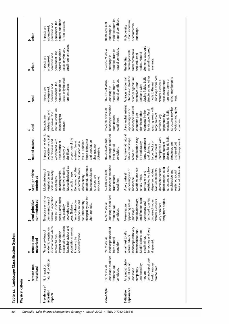
40 Danbulla–Lake Tinaroo Management Strategy • March 2002 • ISBN 0-7242-9365-5
Tabl
e 12
. La
ndsc
ape
Clas
sifi
cati
on S
yste
m
Phy
sica
l cri
teri
a 12
34
56
78
9re
mot
e no
n-re
mot
e no
n-se
mi-
prim
itiv
ese
mi-
prim
itiv
ero
aded
nat
ural
rura
lru
ral
urba
nur
ban
mot
oris
edm
otor
ised
non-
mot
oris
edm
otor
ised
Prev
alen
ce o
fN
o im
pact
onTe
mpo
rary
loss
ofTe
mpo
rary
or m
inor
Mod
erat
e lo
ssof
Impa
cts
on e
ndem
icIm
pact
sar
eIm
pact
sar
eIm
pact
sar
eIm
pact
sar
ere
crea
tion
natu
ralc
ondi
tion
en
dem
icve
geta
tion
perm
anen
t, lo
ssof
vege
tati
on a
ndve
geta
tion
and
soi
lw
ides
prea
d an
dw
ides
prea
d,
wid
espr
ead,
wid
espr
ead,
impa
cts
in s
mal
lare
asw
hich
ende
mic
vege
tati
onso
ilson
hea
vily
are
obvi
ous
and
perv
asiv
e. T
hepe
rvas
ive
and
perv
asiv
e an
dpe
rvas
ive
and
reco
ver t
o pr
e-an
d so
ilin
sm
all
used
are
as.
wid
espr
ead
wit
hna
tura
lcon
diti
onpe
rman
ent.
The
perm
anen
t. T
hepe
rman
ent.
The
impa
ctco
ndit
ion
area
s. S
ome
area
sIm
pact
spe
rsis
t.lit
tle
chan
ce o
fis
unlik
ely
tona
tura
lcon
diti
onna
tura
lcon
diti
onna
tura
lcon
diti
onse
ason
ally
. End
emic
only
part
ially
Sen
siti
ve e
ndem
icre
cove
ry. A
reco
ver.
ex
ists
only
in s
mal
lex
ists
only
in v
ery
isno
n-ex
iste
nt.
faun
a be
havi
our a
ndre
cove
ring
eac
hfa
una
disp
lace
d as
sign
ifica
ntre
mna
ntar
eas.
sm
allr
emna
ntar
eas.
popu
lati
ons
are
not
year
. End
emic
a re
sult
ofus
e.pr
opor
tion
oft
hekn
own
to b
efa
una
beha
viou
rB
ehav
iour
ofo
ther
ende
mic
faun
aaf
fect
ed b
yus
e.an
d po
pula
tion
sen
dem
icfa
una
isdi
spla
ced
asa
are
infr
eque
ntly
occa
sion
ally
resu
lt. E
ndem
icch
ange
d by
use
for
mod
ified
. End
emic
faun
a be
havi
our
shor
tper
iods
.fa
una
popu
lati
on
and
popu
lati
onch
ange
sar
e ch
ange
sar
eno
tice
able
.
obtr
usiv
e.
View
-sca
pe0
% o
fvis
ual
1% o
fvis
ual
1–5%
ofv
isua
l5–
10%
ofv
isua
l10
–25
% o
fvis
ual
25–
50%
ofv
isua
l50
–8
5% o
fvis
ual
85–
99%
ofv
isua
l10
0%
ofv
isua
lla
ndsc
ape
mod
ified
land
scap
e m
odifi
edla
ndsc
ape
mod
ified
land
scap
e m
odifi
edla
ndsc
ape
mod
ified
land
scap
e m
odifi
edla
ndsc
ape
isla
ndsc
ape
isla
ndsc
ape
isfr
om n
atur
alfr
om n
atur
alfr
om n
atur
alfr
om n
atur
alfr
om n
atur
alfr
om n
atur
alm
odifi
ed fr
om it
sm
odifi
ed fr
om it
sm
odifi
ed fr
om it
sco
ndit
ion.
co
ndit
ion.
cond
itio
n.co
ndit
ion.
co
ndit
ion.
co
ndit
ion.
na
tura
lcon
diti
on.
natu
ralc
ondi
tion
.na
tura
lcon
diti
on.
Indi
cati
ve
An
alm
ostt
otal
lyA
n al
mos
ttot
ally
A v
ery
natu
ral
A v
ery
natu
ral
A s
omew
hatn
atur
alA
som
ewha
tnat
ural
Acr
eage
resi
dent
ial
Resi
dent
ial
Hig
h de
nsit
yap
pear
ance
na
tura
lsit
e or
na
tura
lsit
e or
appe
arin
g si
te o
rap
pear
ing
site
or
site
or l
ands
cape
.ap
pear
ing
site
or
inte
nsiv
e cu
ltiva
tion
land
scap
esw
ith
urba
n, in
dust
rial
land
scap
e la
ndsc
ape
wit
h ve
ryla
ndsc
ape.
la
ndsc
ape.
Are
asof
land
scap
e. N
atur
alor
oth
er a
gric
ultu
re;
smal
lcom
mer
cial
or c
omm
erci
alco
mpl
etel
yfe
w m
odifi
cati
ons.
Mod
ifica
tion
sar
eM
odifi
cati
ons
are
mod
ifica
tion
may
elem
ents
just
exte
nsiv
e ur
ban
and
indu
stri
alla
ndsc
ape.
unaf
fect
ed b
yM
odifi
cati
ons
are
smal
l/m
inor
, sem
i-sm
all/
min
or,
be m
oder
atel
ydo
min
ate
othe
rpa
rkla
nd w
ith
node
s. N
atur
alm
oder
n sm
all/
min
or,
perm
anen
tand
perm
anen
tand
larg
e, p
erm
anen
tel
emen
tsin
the
play
ing
field
s. B
uilt
elem
ents
exis
tonl
yte
chno
logi
calu
se.
tem
pora
ryan
d ve
ryre
stri
cted
to a
few
rest
rict
ed to
a fe
wan
d ob
viou
s.la
ndsc
ape.
Rur
alst
ruct
ures
and
othe
ras
smal
lsca
tter
edA
wild
, nat
ural
, di
sper
sed.
disp
erse
d no
des.
disp
erse
d no
des.
Larg
e bl
ocks
ofgr
azin
g ar
eas
wit
hm
ods
to th
e na
t.re
mna
nts.
rem
ote
area
.
Nat
ural
elem
ents
Nat
ural
elem
ents
nati
ve fo
rest
larg
e ar
eas
ofla
ndsc
ape
dom
inat
e.ve
rydo
min
ant
dom
inat
e ou
tsid
ein
ters
pers
ed w
ith
rem
nant
veg.
N
atur
alel
emen
tsaw
ayfr
om n
odes
. th
ese
node
s. B
uilt
smal
lare
asof
sepa
rate
d by
exis
tas
scat
tere
dst
ruct
ures
are
rare
, cl
eare
d la
nd. B
uilt
gras
slan
d. B
uilt
rem
nant
sso
me
ofun
obtr
usiv
e an
d st
ruct
ures
are
stru
ctur
esm
aybe
whi
ch m
aybe
qui
teru
stic
. eg
roun
d di
sper
sed
but
obvi
ous
and
quit
ela
rge.
tim
bere
d ta
bles
etc
read
ilyap
pare
nt.
com
mon
.

Danbulla–Lake Tinaroo Management Strategy • March 2002 • ISBN 0-7242-9365-5 41
Phy
sica
l cri
teri
a (c
onti
nued
)
12
34
56
78
9re
mot
e no
n-re
mot
e no
n-se
mi-
prim
itiv
ese
mi-
prim
itiv
ero
aded
nat
ural
rura
lru
ral
urba
nur
ban
mot
oris
edm
otor
ised
non-
mot
oris
edm
otor
ised
Prev
alen
ce o
fN
atur
al la
ndsc
ape
Pre
dom
inan
tlyP
redo
min
antly
Re
gene
rati
ng n
atur
alP
art
natu
ral
Part
natu
ral
A w
ide
rang
e of
land
A w
ide
rang
e of
land
Impa
cts
are
non-
recr
eati
onw
ith
no
natu
ral l
ands
cape
natu
ral l
ands
cape
land
scap
e w
ith
land
scap
e. L
and
land
scap
e. L
and
uses
that
mod
ify
the
uses
that
mod
ify
the
wid
espr
ead,
impa
cts
mod
ifica
tion
, and
with
evi
denc
e of
with
evi
denc
e of
obvi
ous
evid
ence
of
uses
(eg
sm
all
uses
(eg
inte
nsiv
ena
tura
llan
dsca
pe a
rena
tura
llan
dsca
pepe
rvas
ive
and
no h
isto
ry o
fpa
st m
oder
n,pa
st m
oder
n,pa
st la
nd u
se (
egsc
ale
min
eral
min
eral
expl
orat
ion,
wid
espr
ead.
ar
e ac
tive
. Im
pact
spe
rman
ent.
Lan
dm
oder
n,
tech
nolo
gica
l lan
dte
chno
logi
cal l
and
rege
nera
ting
min
eral
expl
orat
ion,
qu
arry
ing,
sel
ecti
vepe
rvas
ive
and
are
wid
espr
ead,
us
e ha
ste
chno
logi
cal
use
(eg
min
ing,
use
limite
d to
som
eex
plor
atio
n, s
elec
tive
quar
ryin
g, s
elec
tive
logg
ing,
gra
zing
, pe
rman
ent.
Par
tof
perv
asiv
e an
d co
mpl
etel
yla
nd u
se.
sele
ctiv
e lo
ggin
g,sm
all s
ites
that
are
logg
ing,
gra
zing
,lo
ggin
g, g
razi
ng,
flow
er h
arve
stin
g,
the
natu
rall
ands
cape
pe
rman
ent.
Ver
ych
ange
d th
egr
azin
g, f
low
erre
gene
ratin
g. N
one
flow
er h
arve
stin
g).
flow
er h
arve
stin
g,ho
usin
g) c
urre
ntly
rem
ains
butm
osto
fsm
alla
reas
ofth
ena
tura
lha
rves
ting,
api
ary)
of t
hese
land
use
s S
ome
of t
hese
land
disp
erse
d ru
ral
acti
ve in
a la
rge
this
ism
odifi
ed to
na
tura
llan
dsca
pe
land
scap
e.lim
ited
to a
few
acti
ve.
uses
may
be a
ctiv
e.ho
usin
g) c
urre
ntly
prop
orti
on o
fthe
som
e ex
tent
.re
mai
n bu
tmos
tare
isol
ated
sm
all s
ites
acti
ve in
a s
mal
lla
ndsc
ape.
obvi
ousl
ym
odifi
ed.
that
are
rege
nera
ting
.pr
opor
tion
oft
heN
one
of t
hese
land
land
scap
e.us
es a
ctiv
e.
Nat
ural
ness
100
% o
fnat
ural
99–
100
% o
fnat
ural
95–
99%
% o
fnat
ural
90–
95%
inta
ctor
70–
90%
inta
ctor
50–
70%
inta
ctor
30–
15%
inta
ctor
<15%
inta
ctor
N/A
ofov
erst
orey
vege
tati
on in
tact
.ve
geta
tion
inta
ct.
vege
tati
on in
tact
.re
gene
rati
ng.
rege
nera
ting
.re
gene
rati
ng.
rege
nera
ting
.re
gene
rati
ng.
1% c
lear
ed o
r<5
% c
lear
ed o
rRe
mai
nder
cle
ared
Rem
aind
er c
lear
edRe
mai
nder
cle
ared
Rem
aind
er c
lear
edRe
mai
nder
cle
ared
rege
nera
ting
.re
gene
rati
ng.
or n
on-e
ndem
icss
p.
or n
on-e
ndem
icss
p.
or n
on-e
ndem
icss
p. o
r no
n-en
dem
icss
p.or
non
-end
emic
ssp.
Nat
ural
ness
100
% o
fnat
ural
99–
100
% o
fnat
ural
95–
99%
% o
fnat
ural
90–
95%
inta
ctor
70–
90%
inta
ctor
50–
70%
inta
ctor
30–
15%
inta
ctor
<15%
inta
ctor
N/A
ofun
ders
tore
yve
geta
tion
inta
ct.
vege
tati
on in
tact
.ve
geta
tion
inta
ct.
rege
nera
ting
.re
gene
rati
ng.
rege
nera
ting
.re
gene
rati
ng.
rege
nera
ting
.1%
cle
ared
or
<5%
cle
ared
or
Rem
aind
er c
lear
edRe
mai
nder
cle
ared
Rem
aind
er c
lear
edRe
mai
nder
cle
ared
Rem
aind
er c
lear
edre
gene
rati
ng.
rege
nera
ting
.or
non
-end
emic
ssp.
or
non
-end
emic
ssp.
or
non
-end
emic
ssp.
or
non-
ende
mic
ssp.
or n
on-e
ndem
icss
p.
Wat
er q
ualit
yN
o de
tect
ible
effe
ctN
o de
tect
ible
eff
ect
Sho
rtte
rm a
ndS
hort
term
and
Long
term
and
/or
Long
term
and
/or
Perm
anen
tcha
nges
Perm
anen
tcha
nges
Perm
anen
tcha
nges
on w
ater
qua
lity
oron
wat
er q
ualit
yor
rela
tive
lym
inor
rela
tive
lym
inor
perm
anen
tcha
nges
perm
anen
tcha
nges
to n
atur
alst
ream
to n
atur
alst
ream
to n
atur
alst
ream
aqua
tic
ecos
yste
m.
aqua
tic
ecos
yste
m.
chan
ges
to n
atur
alch
ange
sto
nat
ural
to n
atur
alst
ream
to n
atur
alst
ream
dyna
mic
s, s
truc
ture
sdy
nam
ics,
str
uctu
res
dyna
mic
s,
stre
am d
ynam
ics
and/
stre
am d
ynam
ics
and/
dyn
amic
san
d/or
dy
nam
ics
and/
or
and/
or w
ater
and/
or w
ater
stru
ctur
esan
d/or
or w
ater
che
mis
try
or w
ater
che
mis
try
wat
er c
hem
istr
y(e
gw
ater
che
mis
try
(eg
chem
istr
y(e
g ch
emis
try
(eg
wat
er c
hem
istr
y(e
g(e
g in
crea
sed
(eg
incr
ease
d in
crea
sed
turb
idit
y,in
crea
sed
turb
idit
y,in
crea
sed
turb
idit
y,in
crea
sed
turb
idit
y,in
crea
sed
turb
idit
y,tu
rbid
ity,
nut
rien
ttu
rbid
ity,
nut
rien
tnu
trie
ntlo
ad o
rnu
trie
ntlo
ad o
rnu
trie
ntlo
ad,
nutr
ient
load
,nu
trie
ntlo
ad,
load
or s
edim
ent
load
or s
edim
ent
sedi
men
tloa
d).
sedi
men
tloa
d).
chan
nelis
atio
n or
ch
anne
lisat
ion
orch
anne
lisat
ion
orlo
ad).
Aqu
atic
load
). A
quat
icA
quat
icec
osys
tem
Aqu
atic
ecos
yste
mse
dim
entl
oad)
.se
dim
entl
oad)
.se
dim
entl
oad)
.ec
osys
tem
isec
osys
tem
isis
subs
tant
ially
issu
bsta
ntia
llyA
quat
icec
osys
tem
Aqu
atic
ecos
yste
m
Aqu
atic
ecos
yste
msu
bsta
ntia
llyna
tura
l. su
bsta
ntia
llyna
tura
l.m
odifi
ed.
mod
ified
.is
subs
tant
ially
issu
bsta
ntia
llyis
com
plet
ely
mod
ified
.m
odifi
ed.
mod
ified
.

42 Danbulla–Lake Tinaroo Management Strategy • March 2002 • ISBN 0-7242-9365-5
Soc
ial c
rite
ria
12
34
56
78
9re
mot
e no
n-re
mot
e no
n-se
mi-
prim
itiv
ese
mi-
prim
itiv
ero
aded
nat
ural
rura
lru
ral
urba
nur
ban
mot
oris
edm
otor
ised
non-
mot
oris
edm
otor
ised
Evid
ence
of
Non
-exi
sten
t. N
oS
hort
term
and
Min
or p
erm
anen
tSu
bsta
ntia
lRe
adily
appa
rent
Read
ilyap
pare
ntW
ides
prea
d,W
ides
prea
dW
ides
prea
d,us
e by
othe
rev
iden
ce p
rese
nt.
rela
tive
lym
inor
evid
ence
atn
odes
perm
anen
tevi
denc
e ev
iden
ce o
fuse
(ie
evid
ence
ofu
se (
iepe
rvas
ive
and
perv
asiv
e an
dpe
rvas
ive
and
peop
leev
iden
ce a
tnod
esan
d al
ong
mai
nat
node
san
d al
ong
sigh
ts, s
ound
san
d si
ghts
, sou
nds
and
perm
anen
texc
epti
npe
rman
ent.
perm
anen
t.an
d al
ong
mai
nro
utes
. Nod
essm
all,
mai
n ro
utes
. Nod
essm
ells
) pe
rvad
esus
esm
ells
) pe
rvad
esre
lati
vely
smal
lro
utes
. Nod
essm
all,
low
impa
ctan
dm
aybe
mod
erat
e an
dno
des,
mai
n ro
utes
use
node
s, m
ain
rem
nant
area
s.
low
impa
ctan
ddi
sper
sed.
Neg
ligib
leco
ncen
trat
e ac
tivi
ties
and
thei
r sur
roun
ds.
rout
esan
d th
eir,
di
sper
sed.
No
evid
ence
(si
ghts
,an
d pe
ople
. Som
eN
odes
may
be
surr
ound
s. N
odes
evid
ence
(si
ghts
,so
unds
, sm
ells
) of
evid
ence
(si
ghts
,ex
tens
ive
wit
h he
avy
may
be e
xten
sive
soun
ds, s
mel
ls)
use
else
whe
re.
soun
ds, s
mel
lsof
conc
entr
atio
nsof
wit
h he
avy
else
whe
re.
peop
le)
else
whe
re.
peop
le a
nd a
ctiv
itie
s.co
ncen
trat
ions
ofpe
ople
and
acti
vite
s.
Sen
se o
fVe
ryhi
ghH
igh
Mod
erat
eM
oder
ate–
low
Low
Very
low
Infr
eque
ntan
dRa
re o
ppor
tuni
ties
No
or v
ery
rare
isol
atio
n an
dus
ually
shor
tfo
r sol
itude
.op
port
unit
esfo
rop
port
unit
yop
port
unit
ies
for
solit
ude.
for
solit
ude
solit
ude
duri
ngda
ylig
htho
urs.
Inte
r-pa
rty
Non
-exi
sten
t.Lo
w. u
sers
are
mos
tLo
w to
mod
erat
e.M
oder
ate
to h
igh.
Hig
h. In
freq
uent
Very
high
. Alm
ost
Cont
inuo
usan
dCo
ntin
uous
and
Cont
inuo
usan
den
coun
ters
Chan
ce e
ncou
nter
sof
ten
alon
e an
dFr
eque
ntFr
eque
ntop
port
unit
yfo
rno
opp
ortu
nity
for
unav
oida
ble
cont
acts
unav
oida
ble
unav
oida
ble
whi
le a
tnod
esw
ith
othe
rsar
e ra
resh
ould
be
surp
rised
oppo
rtun
ties
for
oppo
rtun
itie
sfo
rso
litud
e du
ring
the
solit
ude
duri
ng th
esh
ould
be
expe
cted
.co
ntac
tssh
ould
be
cont
acts
shou
ld b
eor
des
tina
tion
san
d us
ually
to h
ave
to s
hare
solit
ude
butc
onta
ctso
litud
e bu
tcon
tact
day.
Con
tact
shou
ld
day.
Con
tinu
ous
expe
cted
.ex
pect
ed.
avoi
dabl
e.lo
cati
ons
wit
h ot
hers
.w
ith
othe
rssh
ould
shou
ld b
e ex
pect
edbe
exp
ecte
d an
d an
d un
avoi
dabl
ebe
exp
ecte
d.an
d us
ually
cann
otus
ually
cann
otbe
co
ntac
tssh
ould
be a
void
ed.
avoi
ded.
be e
xpec
ted.
Inte
r-pa
rty
Very
few
. <1
grou
pLo
w. <
5 gr
oups
per
Low
–m
oder
ate,
Mod
erat
e to
hig
h.H
igh.
30
–50
gro
ups
Very
high
.U
sual
lyco
nsta
ntA
lway
sco
nsta
ntA
lway
sco
nsta
nten
coun
ters
per d
ay.
day.
5–10
gro
ups
per d
ay.
10–
30 g
roup
spe
r day
.pe
r day
.>5
0 g
roup
spe
r day
.w
hile
tra
velli
ng
Dep
ende
nce
Tota
lVe
ryhi
ghH
igh
Mod
erat
eM
oder
ate–
low
Low
Low
N/A
N/A
on o
utdo
orsk
ills
Dep
ende
nce
<1<3
3–5
5–10
10–
6060
–20
0>2
00
Unl
imit
edU
nlim
ited
PAO
T

Danbulla–Lake Tinaroo Management Strategy • March 2002 • ISBN 0-7242-9365-5 43
Man
agem
ent
crit
eria
12
34
56
78
9re
mot
e no
n-re
mot
e no
n-se
mi-
prim
itiv
ese
mi-
prim
itiv
ero
aded
nat
ural
rura
lru
ral
urba
nur
ban
mot
oris
edm
otor
ised
non-
mot
oris
edm
otor
ised
Acc
ess
No
road
s. O
nly
No
curr
ently
used
Roug
h an
d
Wel
lmai
ntai
ned
Gra
velr
oads
wit
hM
ostr
oads
and
Road
san
d tr
acks
are
All
road
s, p
aths
and
All
road
s, p
aths
,un
form
ed a
nd
vehi
cle
trac
ks. S
ome
infr
eque
ntly
road
san
d tr
acks
. en
gine
ered
and
trac
ksar
e se
aled
usua
llyse
aled
. tr
acks
are
seal
ed o
rsp
aces
are
seal
edun
mar
ked
trai
ls.
form
ed a
ndm
aint
aine
d ro
ads.
Gra
velr
oads
follo
win
gm
odifi
ed a
lignm
ents
. an
d m
aint
aine
d.
unse
aled
road
san
dpa
ved.
Mot
oris
edor
pav
ed. M
otor
ised
mai
ntai
ned
trai
ls.
Gra
vels
urfa
ce.
natu
ralf
eatu
res
wit
hS
ome
narr
ow s
eale
dTw
o la
ne ro
ads
are
trac
ksar
e m
aint
aine
dac
cess
ever
ywhe
re.
acce
ssev
eryw
here
.so
me
stee
p gr
ades
road
s.
com
mon
.at
a hi
gh s
tand
ard.
an
d ti
ghtc
orne
rs.
Evid
ence
of
Min
imum
usu
ally
toM
inim
umRa
re c
onst
ruct
ion
Occ
asio
nal
Com
mon
Com
mon
Freq
uent
and
regu
lar
Man
agem
enta
ndM
anag
emen
tand
man
agem
ent
mon
itor
reso
urce
man
agem
ent
and
mai
nten
ance
cons
truc
tion
and
cons
truc
tion
and
cons
truc
tion
and
pres
ence
of
enfo
rcem
ent
enfo
rcem
ent
pers
onne
lco
ndit
ions
.pr
esen
ce -
only
asac
tivi
ty. R
are
part
olm
aint
enan
ce a
ctiv
ity.
mai
nten
ance
act
ivit
y.m
aint
enan
cem
anag
emen
tand
pers
onne
lare
pers
onne
lare
nece
ssar
yto
ach
ieve
byen
forc
emen
tO
ccas
iona
lpat
rol
Com
mon
pat
rolb
yac
tivi
ty. C
omm
onen
forc
emen
tsta
ff.ob
viou
san
dob
viou
san
dm
inim
um
staf
f.by
enfo
rcem
ent
enfo
rcem
ents
taff.
patr
olby
perm
anen
t.pe
rman
ent.
man
agem
ent
staf
f.en
forc
emen
tsta
ff.ob
ligat
ions
.
Pres
ence
and
Non
e.S
igns
may
only
be
Min
imum
road
and
Road
ant
trac
kna
mes
Inte
rpre
tati
on,
Inte
rpre
tati
on,
Inte
rpre
tati
on s
igns
,U
nlim
ited
.U
nlim
ited
.ex
tent
ofpr
esen
tfor
reso
urce
trac
kna
mes
, co
mm
on. R
egul
ator
yre
gula
tory
noti
ces,
regu
lato
ryno
tice
s,re
gula
tory
noti
ces,
sign
age
prot
ecti
on -
few
and
re
gula
tory
noti
ces
and
dire
ctio
nals
igns
boun
dary
, and
boun
dary
, and
boun
dary
, and
disp
erse
d.an
d di
rect
iona
llo
cate
d at
key
poin
ts.
dire
ctio
nals
igns
dire
ctio
nals
igns
dire
ctio
nals
igns
atsi
gnag
e.M
inim
umsu
ffic
ient
to
suff
icie
ntto
alli
nter
sect
ions
and
inte
rpre
tati
onor
ient
ate
and
info
rm
orie
ntat
e an
d re
gula
rly
alon
g ro
ads
sign
age.
allv
isit
ors.
info
rm a
llvi
sito
rs.
and
trac
ks.
Adv
ertis
ing
sign
sm
aybe
pre
sent
.
Rule
s,Co
mm
unic
ated
off
Com
mun
icat
ed o
ffCo
mm
unic
ated
off
On-
site
sig
nage
and
A s
tron
g an
d vi
sibl
eA
str
ong
and
visi
ble
A s
tron
g, v
isib
leCo
nsta
nton
-sit
eCo
nsta
nted
ucat
ion
regu
lati
ons
site
. No
evid
ence
site
. Min
imum
pat
rol
site
. Min
imum
pat
rol
supe
rvis
ion
asm
anag
emen
tm
anag
emen
tm
anag
emen
ted
ucat
ion
or
or e
nfor
cem
ent.
aand
law
ofm
anag
emen
tfo
r sus
tain
abili
tyfo
r sus
tain
abili
tyas
requ
ired
for s
afet
ypr
esen
ce. E
vide
nce
pres
ence
. Evi
denc
epr
esen
ce. E
vide
nce
enfo
rcem
ent.
enfo
rcem
ent
on-s
ite.
mon
itor
ing
and
life
mon
itor
ing
and
life
and
sust
aina
bilit
y.of
man
agem
ent
ofm
anag
emen
tof
man
agem
ent
pres
erva
tion
.pr
eser
vati
on.
Evid
ence
of
on-s
ite
isco
mm
on.
on-s
ite
isfr
eque
nt.
on-s
ite
isvi
rtua
llyEv
iden
ce o
fEv
iden
ce o
fm
anag
emen
ton-
site
cons
tant
.m
anag
emen
ton-
site
man
agem
ento
n-is
occa
sion
al.
isne
glig
ible
.si
te is
rare
.
Man
agem
ent
Nil
Onl
yco
nstr
ucte
dRa
re, d
ispe
rsed
and
Few
, sm
all,
disp
erse
dS
truc
ture
sar
e S
truc
ture
sar
e B
uilt
stru
ctur
esar
eB
uilt
stru
ctur
esar
eLa
rge,
obv
ious
,an
d vi
sito
rw
here
no
othe
run
obtr
usiv
est
ruct
ures
are
read
ilyap
pare
ntre
adily
appa
rent
read
ilyap
pare
ntan
dre
adily
appa
rent
and
atte
ntio
n gr
abbi
ng,
infr
astr
uctu
real
tern
ativ
e ca
n be
stru
ctur
es.
appa
rent
, but
blen
dan
d ca
n be
qui
tean
d ca
n be
qui
teof
ten
desi
gned
toof
ten
desi
gned
todo
min
atin
g al
lfo
und
(eg
into
nat
ural
larg
e bu
tble
ndla
rge
butb
lend
stan
d ou
t.
stan
d ou
t.se
nses
.co
mm
unic
atio
nsba
ckgr
ound
.in
to n
atur
alin
to n
atur
alIn
fras
truc
ture
isIn
fras
truc
ture
isU
navo
idab
le.
tow
ers)
. Str
uctu
res
back
grou
nd.
back
grou
nd.
usua
llypr
ovid
ed in
usua
llypr
ovid
ed in
are
disp
erse
d an
d al
lpub
licsp
aces
.al
lpub
licsp
aces
.un
obtr
usiv
e.
44 Danbulla–Lake Tinaroo Management Strategy • March 2002 • ISBN 0-7242-9365-5
Appendix C
Management areas on the water Lake Tinaroo provides a diversity of landscape settings andconditions for a variety of recreational and environmentalobjectives. Stretches of calm open water provide excellentconditions for water skiing, while areas exposed to prevailingwinds provide perfect sailing opportunities. In other sectionsof the lake, the retention of standing dead timber provideshabitat for fish and other wildlife.
In an effort to reduce conflict between different user groupsand to provide diverse opportunities, it is proposed to zoneLake Tinaroo. Three management areas have been definedaccording to the managerial, social and physical aspects ofthe area, which specify limits to access and travel on the lake(Map 5). These zones are based on the LandscapeClassification System classes (Table 13).
“High-focus” areas, at both the northern and southern end ofthe lake in front of Tinaroo township through to Fong-On bayand Tinaburra up to Lakeside and through to Tinaroo Park.These are high-density recreation areas. The sights andsounds of modern technology are obvious here including
powerboats vehicles and large numbers of people.Management regimes include the obvious presence of signsand management personnel.
“Moderate-focus” areas are provided between the high-focusareas and between Barrabadeen and Tinaroo township, KauriCreek, Severin Creek, Brady Creek, Wrights Creek, PetersenCreek, Stewarts Gully and the area between Pelican Point,Black Gully, Presbyterian Point and the Tinaroo township boatramp. (Map 5).
“Low-focus” areas on Lake Tinaroo include Kuall Inlet, RobsonCreek inlet and the Severin Creek inlet. These areas aretypically free from the sights and sounds of moderntechnology and inter-party encounters are low. Vessels withelectric motors will be able to use these areas but noisy fuelpowered vessels are not allowed. These areas are regarded asnoise restricted areas.
Generally Lake Tinaroo is managed according to the Water Act2000 and the Transport Operations (Marine Safety) Act 1994and associated regulations and amendments. An area of Stateforest has been gazetted in the Robson Creek catchment (Map2) and in this particular area the Forestry Act 1959 will apply.

Tabl
e 13
. W
ater
-bas
ed la
ndsc
ape
clas
sifi
cati
on s
yste
m
* G
roup
con
stitu
tes
on a
vera
ge fo
ur p
eopl
e or
the
equi
vale
ntto
one
boa
t.
MMaann
aaggeemm
eenntt
LLooww
MMoodd
eerraatt
eeHH
iigghh
Acc
ess
Form
sof
acce
ssth
atar
e fr
ee fr
om s
ound
sFo
rms
ofac
cess
that
isno
tdom
inat
ed b
yFo
rms
ofac
cess
are
dom
inat
ed b
yso
unds
ofof
tech
nolo
gy.
soun
dsof
tech
nolo
gy- s
low
spe
eds
tech
nolo
gy, h
igh
spee
d (t
ypic
ally
spee
ds(t
ypic
ally
less
than
6 k
nots
).
grea
ter
than
6 k
nots
)
nfor
mat
ion
prov
isio
n (a
bout
the
site
) Pr
edom
inan
tly
offs
ite.
D
ispe
rsed
sig
ns.
Bro
chur
esan
d si
gns
Rule
s, re
gula
tion
san
d la
w e
nfor
cem
ent
Com
mun
icat
ed o
ffsi
te, c
ode
ofet
hics
.Co
mm
unic
ated
via
sig
ns- r
outi
ne c
heck
sCo
mm
onpl
ace
pres
ence
ofs
igns
, per
mit
san
dS
igns
may
be p
rese
ntfo
r res
ourc
e m
ade.
man
agem
entp
erso
nnel
to e
nsur
e vi
sito
r saf
ety
prot
ecti
on o
nly.
and
com
plia
nce
to li
cenc
e/pe
rmit
cond
itio
ns.
PPhhyyss
iiccaall
LLoo
ww
MMoodd
eerraatt
ee HH
iigghh
Envi
ronm
enta
lset
ting
-app
eara
nce
Pred
omin
antl
yna
tura
lapp
eari
ng
Mos
tly
natu
rala
ppea
ring
- co
ntai
nsno
des
Nat
ural
elem
ents
may
play
an im
port
antr
ole
envi
ronm
entw
ith
mod
ifica
tion
sfe
w a
ndth
atha
ve b
een
subs
tant
ially
mod
ified
tobu
tare
vis
ually
subo
rdin
ate.
di
sper
sed.
cate
r for
, or a
sa
resu
ltof
, use
.
SSooccii
aall
LLooww
MM
ooddeerr
aattee
HHiigg
hh
Evid
ence
ofo
ther
sRe
stri
cted
to b
oatl
aunc
hing
are
as.
Evid
ence
ofo
ther
sco
mm
on a
tcha
nnel
s,
Read
ilyap
pare
nt—
evi
denc
e do
min
ates
the
boat
ram
ps.
surr
ound
s.
Sen
se o
fiso
lati
on a
nd s
olitu
de
Hig
h to
mod
erat
e.
Mod
erat
e to
low
. Lo
w to
ver
ylo
w.
Inte
r-pa
rty
enco
unte
rsov
er th
e w
hole
are
a Lo
w to
mod
erat
e - l
ess
than
10
gro
ups/
day.
Lo
w to
mod
erat
e be
twee
n 10
-20
gro
ups/
day.
H
igh
to v
ery
high
- gr
eate
r tha
n 20
–40
gr
oups
/day
.
Know
ledg
e ap
plic
atio
n an
d de
pend
ence
H
igh
to m
oder
ate.
Mod
erat
e to
low
.Lo
w to
ver
ylo
w.
upon
out
door
sur
viva
lski
lls
Den
sity
/hec
tare
(gr
oups
atan
yon
e ti
me)
1–
2 3–
5 11
–50
Danbulla–Lake Tinaroo Management Strategy • March 2002 • ISBN 0-7242-9365-5 45

46 Danbulla–Lake Tinaroo Management Strategy • March 2002 • ISBN 0-7242-9365-5
Appendix D
Legislative basisMajor legislation used in the management of theDanbulla–Lake Tinaroo area includes:
Cultural Records (Landscapes Queensland and QueenslandEstate) Act 1987Administered by the Cultural heritage branch of the EPA, thisAct protects indigenous and non-indigenous cultural heritageplaces in Queensland, including sites of cultural significanceto Aboriginal people.
Environmental Protection Act 1994This Act is administered by the EPA to protect Queensland’senvironment, while allowing for development that improvesthe total quality of life for present and future generations in away that maintains the ecological processes on which lifedepends.
Environment Protection and Biodiversity Conservation Act1999 (Cwlth)The object of this legislation is to provide for the protection ofenvironments and in particular those with aspects of nationalimportance. The emphasis is on the conservation andecologically sustainable use of natural resources,conservation of biodiversity, the promotion of co-operativeapproaches to protection and management, and therecognition of the roles and knowledge indigenous peoplehave in regard to conservation and management.
Fisheries Act 1994Administered by the Department of Primary Industries topromote the development and welfare of the fishing industry,and to provide for the protection, conservation andmanagement of the fisheries resource of the State.
Forestry Act 1959This Act is administered by the Departments of NaturalResources and Mines, Department of Primary Industries(Forestry), and the Queensland Parks and Wildlife Service. Itprovides for forest reservations and the management of Stateforests, forest reserves and timber reserves. The cardinalprinciple in the management of State forests is for thepermanent reservation of such areas for the purpose ofproducing timber and associated products in perpetuity andfor watershed protection, while having regard for conservationof the environment, protection of water quality, grazing andrecreation. The sale and disposal of forest products andquarry material, the property of the State on State forests,some forest reserves, timber reserves and on other lands, areall administered under this Act.
Integrated Planning Act 1997The purpose of this Act is to seek to achieve ecologicalsustainability by co-ordinating and integrating planning at alocal, regional and State level, managing the process bywhich, development occurs, and managing the effects ofdevelopment on the environment. The Act fundamentallyrevises both the planning arrangements and developmentassessment processes of State and local governments.
Land Act 1994This Act is administered by the Department of NaturalResources and Mines on State land, and the sections relativeto the management area regulate the gazettal and de-gazettalof public roads, provide for the administration of leaseholdand reserve land, and control changes in land tenure. The Actallows for the regulation of vegetation clearing on State lands.This regulation also involves maintaining the land’sproductivity and allowing for its development, while at thesame time preventing degradation of the land, maintainingbiodiversity, environmental and amenity values of thelandscape, scientific, recreation and tourism values and toensure public safety.
Mineral Resources Act 1989This Act is administered by the Department of NaturalResources and Mines to provide for the assessment,development and utilisation of mineral resources to themaximum extent practicable consistent with sound economicand land use management.
Native Title Amendment Act 1997In accord with the Commonwealth Native Title Act, this Actprovides standards for dealings with native title. It establishesa State-based mechanism for determining claims and toconfirm certain rights. The administering unit is theDepartment of Natural Resources and Mines.
Nature Conservation Act 1992This Act is the primary legislation directing the conservation ofnature in Queensland. This Act is administered by theQueensland Parks and Wildlife Service and the EnvironmentalProtection Agency, and provides guidelines for the dedicationof protected areas, the preparation of management andconservation plans, conservation agreements, conservationcovenants and the proposed management intent for rare andthreatened species.
Queensland Heritage Act 1992This Act provides for the conservation of Queensland’shistorical cultural heritage places by providing, among otherthings, for the establishment of the Queensland HeritageCouncil, the maintenance of a register of places/objects ofsignificance and heritage agreements. The EnvironmentalProtection Agency is the unit administering the Act.
Recreation Areas Management Act 1988This legislation provides for the setting apart of land andwater throughout Queensland as and for recreational activitiesin recreation areas and for related purposes. It allows for jointmanagement and provides mechanisms to co-ordinate,integrate and improve recreational management taking intoaccount conservation, recreation, education and productionvalues and the interests of proprietors. The Minister/sresponsible for the Forestry Act 1959 and the NatureConservation Act 1992 comprise the Authority.
Transport Operations (Marine Safety) Act 1994Administered by the Department of Transport (MarineOperations), the objective of this Act is to regulate transportefficiency and marine safety on waterbodies.
Rural Lands Protection Act 1985This Act is administered by the Department of NaturalResources and Mines and primarily relates to the control ofdeclared plants and animals throughout Queensland.
Vegetation Management Act 1999The purpose of this Act is to regulate the clearing of vegetationon freehold land to preserve remnant endangered regionalecosystems, vegetation in areas of high nature conservationvalue and areas vulnerable to land degradation. The Actallows for ecologically sustainable land use, maintenance ofecological processes and the maintenance of or increase inbiodiversity. It is administered by the Department of NaturalResources and Mines.
Water Act 2000The Department of Natural Resources and Mines administersthis Act in relation to the rights to water. This Act provides forthe sustainable management of water and other resources, aregulatory framework for providing water and sewerageservices and the establishment and operation of waterauthorities, and for other purposes. It prescribes thedevelopment of water resource and operational plans,allocation of water, water licensing, declared catchment areas,riverine protection, quarrying, infrastructure and services,referrable dams, the establishment of water authorities andenforcement.

Danbulla–Lake Tinaroo Management Strategy • March 2002 • ISBN 0-7242-9365-5 47
bull kauri Agathis microstachyan.c.n. Antrophyum subfalcatumn.c.n. Austromyrtus lasiocladaJohnson River hardwood Backhousia bancroftiin.c.n. Bertya polystigman.c.n. Bobea myrtoidesn.c.n. Brasenia schreberin.c.n. Caesalpinia robustan.c.n. Casearia grayin.c.n. Croton densivestitusTreefern Cyathea baileyanaTreefern Cyathea celebicaRose silky oak Darlingia ferruginean.c.n. Eucalyptus lockyerivine Hypserpa smilacifolian.c.n Hypsophila halleyanan.c.n. Lastreopsis grayin.c.n. Lastreopsis tinarooensisa heath Leucopogon spathaceusn.c.n. Melodinus baccellianusa native lime Microcitrus inodoran.c.n. Pseuduvaria mulgraveana
var glabrescensn.c.n. Reediella endlicherianan.c.n. Rhamphicarpa australiensisWhite birch Schizomeria whiteiTinkling satinash Syzygium alatoramulumDaintree satinash Syzygium xerampelinumn.c.n. Thaleropia queenslandica
For declared management intent including significance andproposed management intent see Schedule 4, NatureConservation (Wildlife) Regulation 1994.
Appendix F
Weeds along Danbulla Forest Drivelantana Monroviabracken fern Tobacco treecat claw creeper Scotch thistleblue top Glycinecommon sensitive plant Rattle podyellow milk daisy Orange milk daisywild tomato Ureena burrfleabane Cobblers pegChinee burr Devils figapple of sodom
Treatment suggestionsA range of treatments exists for various declared andenvironmental weeds. The appropriate treatment will besought from recommendations of the Atherton Shire CouncilPest Management Plan and technical advice from Departmentof Natural Resources and Mines land protection officers.
Appendix G
Emergency action planThe Department of Natural Resources and Mines (IntegratedWater Management) is the agency responsible for developingemergency action plans for all departmental dams inQueensland as a matter of dam safety. These plans identifypotential emergency conditions at major water storages andlist procedures to be followed in an emergency. Local counterdisaster groups hold a copy of the plan, including inundationmaps of areas likely to be affected by dam failure, andinstructions on the plan’s use.
Typical emergency or potential problems include:1 Overtopping imminent — when the storage is full and the
water level is rising during periods of excessive rainfall—check water levels.
Wet Tropics World Heritage Protection and Management Act1998Australia is a signatory to the World Heritage Convention toprotect cultural and natural heritage of outstanding universalvalue. Under the Convention, this Act ensures the protection,conservation, presentation, rehabilitation and transmission tofuture generations, of the World Heritage values of an area.Under the Act, the Wet Tropics Management Authority isrequired to prepare a management plan for the Wet TropicsArea. The Wet Tropics Management Plan 1998 is subordinatelegislation under the Act. The plan provides the legalframework for management and for constraining potentiallydamaging activities in the Wet Tropics area.
Appendix E
Species lists
Endangered species list for the Management Areamountain mistfrog Litoria nyakalensis
(now locally extinct)waterfall frog Litoria nannotiscommon mistfrog Litoria rheocolaAustralian lace-lid Nyctimystes dayisharp-snouted dayfrog Taudactylus acutirostrisnorthern tinkerfrog Taudactylus rheophilussouthern cassowary Casuarius casuariusred goshawk Erythrotriorchis radiatuslarge moonbeam butterfly Philiris diana diananorthern bettong Bettongia tropicaspotted-tailed quoll Dasyurus maculatus gracilis
For declared management intent including significance andproposed management intent see Schedule 2, NatureConservation (Wildlife) Regulation 1994.
Vulnerable species list for the Management Arearufous owl Ninox rufa queenslandicabuff-breasted button-quail Turnix oliviiSermon’s leaf-nosed bat Hipposideros semonitube-nosed insect bat Murina floriumpurple brown-eye butterfly Chaetocneme porphyropisAustralian hedge blue butterfly Udara tenella tenellatree waratah Alloxylon flammeumpumpkin fruit Sauropus macranthus
For declared management intent including significance andproposed management intent see Schedule 3, NatureConservation (Wildlife) Regulation 1994.
Rare species list for the Management Areapealing chirper Sphenophryne robustacricket chirper Sphenophryne fryigreen-eyed treefrog Litoria genimaculataPalmerston frog Cophixalus infacetuslegless lizard Coeranoscincus frontalistiger skink Eulamprus tigrinusornamental snake Simoselaps warroRoberts litter skink Lampropholis robertsiMjoberg skink Glaphyromorphus mjobergiAtherton antechinus Antechinus godmaniLumholtz’s tree-kangaroo Dendrolagus lumholtzilemuroid ringtail possum Hemibelideus lemuroidesgreen ringtail possum Pseudocheirops archeriHerbert River ringtail possum Pseudocheirus herbertensisMareeba rock-wallaby Petrogale mareebagolden-tipped bat Kerivoula papuensiscotton pygmy-goose Nettapus coromandelianusgrey goshawk Accipiter novaehollandiaewhite-rumped swiftlet Collocalias spodiopygussquare-tailed kite Lophoictinia isurasooty owl Tyto tenebriosablue kauri pine Agathis atropurpurea

48 Danbulla–Lake Tinaroo Management Strategy • March 2002 • ISBN 0-7242-9365-5
2 Wave erosion — during or after long periods of strongwind, the upstream face of the embankment is inspectedfor beaching or notching by waves.
3 Toe erosion — during and after large flows theembankment toe must be inspected for erosion byspillway discharge or diversion flows.
4 Gullying — during routine inspection, the embankmentsmust be checked for damage to armouring or vegetationcover or poor drainage.
5 Loss of storage contents — during routine monitoring,notice of environmental changes such as vegetation killsor salt scalds may indicate contamination of groundwaterresources, excessive loss from the storage and/oroccasionally increased seepage or increased groundwaterlevels.
6 Seepage erosion or piping — unaccountable increases inseepage flows may indicate an emission point, the resultof progressive internal erosion of the embankment orfoundation which may form an open conduit or pipe.
7 New springs, seeps or boggy areas — may be evidence ofinternal changes in seepage control.
8 Rapid increase or cloudy appearance of seepage — pipingfailure has started.
9 Increase in gallery seepage — check for differentialmovement or cracking in concrete compartments.
10 Foundation failure — during routine inspections orimmediately after earthquakes checks are made onfoundation movement or displacement immediatelyadjacent to the dam.
11 Chemical spills — indicated by dead fish and other aquaticlife in the storage, or a strange odour or colouration.
12 Slide in downstream slope — cracks or scarps near thecrest and bulges at the toe.
13 Flow slide — collapse and soil flow around the storageperiphery.
14 Landslides — mass movements of soil or rock from slopesand valley walls around the storage.
15 Movement or cracking in structural concrete work — failureof mechanical components such as pipes, gates etc.
16 Failure of appurtenant structures or operating equipment— loss of ability to supply water or discharge floods safely.
17 Abnormal instrument reading — check for malfunction.18 Algal blooms — blue-green opaque nature of surface and
shallow water.
Appendix H
Queensland Parks and Wildlife Service — Philosophyfor assessing activities on protected areas
The philosophy adopted by the Service for assessing theappropriateness of proposed recreational activities inprotected areas is to consider favourably those activities thatare:1 nature-based,2 appropriate to the defined landscape classification
system,3 safe,4 sustainable;5 attuned to community needs;6 compatible with other State forest uses; and7 not requiring exclusive use.
Subject to all safety and sustainability guidelines being met,exemptions for specific activities on specific sites may beconsidered where significant community benefits can bedemonstratedand• the activity cannot reasonably be located off the protected
area, or• traditional use of the area for the activity would be very
difficult to displace.
Nature based recreational activities as defined by Servicepolicy and precedents are those which best meet the followingcriteria:• they do not require substantial modification of the natural
environment;.• the natural setting is critical to client participation; and• they foster an appreciation of natural resources or their
management.
Managers try to ensure that all users get maximum “benefit”from their experience. This maximisation is achieved when theusers’ experiences match or exceed their expectations atminimal cost to the experiences being sought by others.Managers strive to match clients and settings as closely aspossible.
An activity is demonstrably unsustainable if, after applyingnormal management standards to the activity, unplannedimpacts are detectable, persistent and increasing. If anactivity is unsustainable it must be made sustainable or beterminated as soon as practicable.
Sound practice indicatorsTo meet community needs for nature-based, publicly-ownedrecreational opportunities, standards have to be establishedwhich ensure that recreation areas are safe, well maintainedand have minimal impact on natural resources. Sound practiceindicators (SPI) identify and mitigate unacceptable visitorimpacts and significant hazards in high-use camping and day-use areas. The SPI assess the best practice in four categoriesof visitor-site management: • general organisation• health and safety• visitor experience• visitor impact
To thoroughly inspect and plot the assessment of facilities it isimportant to have a site map of each visitor area. Thefollowing details should be included on the plan:• facilities• boundaries• tracks• trees (number the large ones)• roads and parking• signs
PrinciplesThe Service is:1 primarily committed to providing nature-based
recreational opportunities. Non-nature-based activities willonly be considered where it can be shown that no otheralternative site is available outside protected areas.
2 committed to providing a diversity of recreationalopportunities based on the provisions within the entireregion; and
3 committed to managing natural and cultural resources inline with the principles of ecological sustainabledevelopment using management tools such as the Limitsof Acceptable Change and visitor impact management.
PermitsAnyone who wishes to traverse a protected area in a vehicleincluding a horse or bicycle, bush camp, collect biological orgeological material, conduct military exercises, conduct acompetitive event, conduct commercial photography, conducta commercial tour or hold a marriage or other civil or religiousceremony requires a permit from the Service to do so onprotected areas.

Danbulla–Lake Tinaroo Management Strategy • March 2002 • ISBN 0-7242-9365-5 49

50 Danbulla–Lake Tinaroo Management Strategy • March 2002 • ISBN 0-7242-9365-5

Danbulla–Lake Tinaroo Management Strategy • March 2002 • ISBN 0-7242-9365-5 51
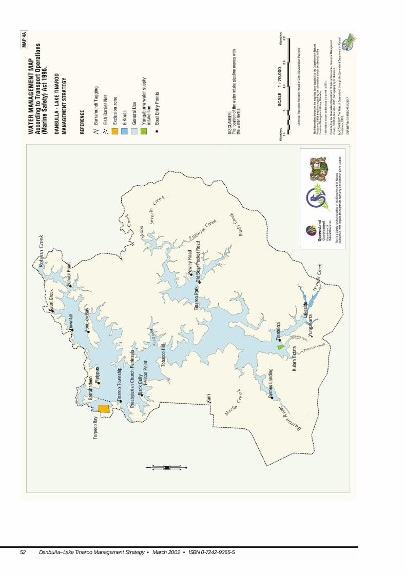
52 Danbulla–Lake Tinaroo Management Strategy • March 2002 • ISBN 0-7242-9365-5

Danbulla–Lake Tinaroo Management Strategy • March 2002 • ISBN 0-7242-9365-5 53

54 Danbulla–Lake Tinaroo Management Strategy • March 2002 • ISBN 0-7242-9365-5

Danbulla–Lake Tinaroo Management Strategy • March 2002 • ISBN 0-7242-9365-5 55