Embed Size (px)
Citation preview
!
!
!
!
!!
!
!
"
!
!
"
!
"
!
!
!!
!!!
!
"
!
!
!
!
!
!
!!
!
!
!
"
!
!
!
!
!
"g
!g
!g
!g
!g
!g
!g
!g
!
!
!
!
!
"
"
"
"
!
"
!
"
!
"
!
!
!
!
!
!
!
!!
!
!
!
!
"
! "
!
!
!
ElevationAbove
SeaLevel
5,000 m
2,500 m
0 m
Kunming
Hai Phong
Ba Da
Bai Lang
Bai Sheng
Chang Tian
Dachunhe (Erji) Dachunhe (Yiji)
Da Wan
Di Shui Ba
Fu Qing
Gelantan
Hou Hai
Huang Cao Ba
Huang Jia Ping
Jiezihe
Jufudu
Li Cun Ying
Longma
Lu Fang
Luo Shui DongMa Du Shan
Ma Lu Tang 1Ma Lu Tang 2
Man Gun
Meng Ye Jiang
Mofanghe
Mu Di He Shuiku
Na En
Nalan
Nan Gun
Nan Ning
Nansha
Pu Xi QiaoSan Jiang Kou
ShimenkanSinan Jiang
Tukahe
Xiao Guan Cun
Xiao He Gou
Xin Ping Zhai
Ya Yang Shan
Yu Guo
Zhong Ai Qiao
Bac Ha
Bac Me
Bac Yen
Ban Chat
Bao Lam
Bau Lay
Cam Son
Cay Da
Da Ong
Hoa Binh
Hong Linh
Houi Quang
Khuon Than
Lai Chau
Lang Thun
Muong Hum
Muong Khoa
Nam Chien 1
Nam Chien 2
Nam Muc
Nam Na 2
Nam Na 3
Nam Pia
Nho Que 1
Nho Que 2
Nho Que 3
Ngoi Phat
Nui Coc
Pa Chien
Sap Viet
Son La
Song Chay 5
Suoi Cay
Suoi Lum 1
Suoi Nua
Thac Ba
Trung Thu
Tuyen Quang
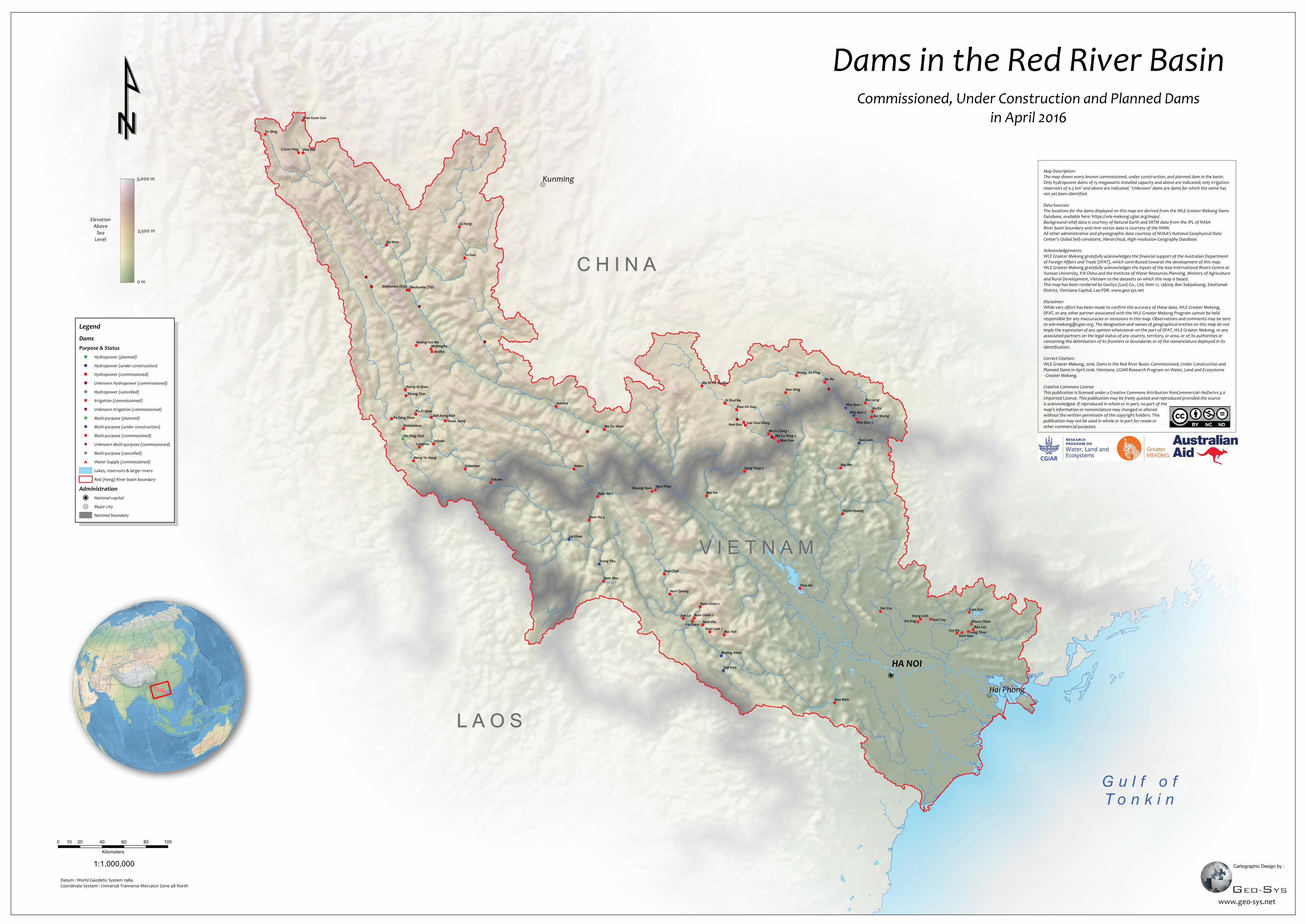
Dams in the Red River Basin
C H I N AC H I N A
V I E T N A MV I E T N A M
L A O SL A O S
0 20 40 60 80 10010
Kilometers
G u l f o fT o n k i n
1:1,000,000
Commissioned, Under Construction and Planned Damsin April 2016
Cartographic Design by :
Datum : World Geodetic System 1984Coordinate System : Universal Tranverse Mercator Zone 48 North
HA NOI
Legend
DamsPurpose & Status
! Hydropower (planned)
! Hydropower (under construction)
! Hydropower (commissioned)
!g Unknown Hydropower (commissioned)
! Hydropower (cancelled)
" Irrigation (commissioned)
"g Unknown Irrigation (commissioned)
Multi-purpose (planned)
Multi-purpose (under construction)
Multi-purpose (commissioned)
g Unknown Multi-purpose (commissioned)
Multi-purpose (cancelled)
# Water Supply (commissioned)
Lakes, reservoirs & larger rivers
Red (Hong) River basin boundary
Administration
P National capital
R Major city
National boundary
www.geo-sys.net
¹¹Map Description:The map shows every known commissioned, under construction, and planned dam in the basin.Only hydropower dams of 15 megawatts installed capacity and above are indicated; only irrigationreservoirs of 0.5 km2 and above are indicated. ‘Unknown’ dams are dams for which the name hasnot yet been identified.
Data Sources:The locations for the dams displayed on this map are derived from the WLE Greater Mekong DamsDatabase, available here: https://wle-mekong.cgiar.org/maps/.Background relief data is courtesy of Natural Earth and SRTM data from the JPL of NASARiver basin boundary and river vector data is courtesy of the IWMI.All other administrative and physiographic data courtesy of NOAA's National Geophysical DataCenter's Global Self-consistent, Hierarchical, High-resolution Geography Database
Acknowledgements:WLE Greater Mekong gratefully acknowledges the financial support of the Australian Departmentof Foreign Affairs and Trade (DFAT), which contributed towards the development of this map.WLE Greater Mekong gratefully acknowledges the inputs of the Asia International Rivers Centre atYunnan University, P.R China and the Institute of Water Resources Planning, Ministry of Agriculture and Rural Development, Vietnam to the datasets on which this map is based.This map has been rendered by GeoSys (Lao) Co., Ltd, Hom 11, 136/09, Ban Sokpaluang, SisattanakDistrict, Vientiane Capital, Lao PDR. www.geo-sys.net
Disclaimer:While very effort has been made to confirm the accuracy of these data, WLE Greater Mekong,DFAT, or any other partner associated with the WLE Greater Mekong Program cannot be heldresponsible for any inaccuracies or omissions in this map. Observations and comments may be sentto [email protected]. The designation and names of geographical entities on this map do notimply the expression of any opinion whatsoever on the part of DFAT, WLE Greater Mekong, or anyassociated partners on the legal status of any country, territory, or area, or of its authorities orconcerning the delimitation of its frontiers or boundaries or of the nomenclature deployed in itsidentification.
Correct Citation:WLE Greater Mekong, 2016. Dams in the Red River Basin: Commissioned, Under Construction andPlanned Dams in April 2016. Vientiane, CGIAR Research Program on Water, Land and Ecosystems- Greater Mekong.
Creative Commons LicenseThis publication is licensed under a Creative Commons Attribution NonCommercial–NoDerivs 3.0Unported License. This publication may be freely quoted and reproduced provided the sourceis acknowledged. If reproduced in whole or in part, no part of themap’s information or nomenclature may changed or alteredwithout the written permission of the copyright holders. Thispublication may not be used in whole or in part for resale orother commercial purposes.