Embed Size (px)
Citation preview
Dam-to-delta sediment inputs and storage in thelower trinity river, Texas
Jonathan D. Phillipsa,*, Michael C. Slatteryb, Zachary A. Musselmana
aTobacco Road Research Team, Department of Geography, University of Kentucky, Lexington, KY 40506-0027, USAbDepartment of Geological Sciences, Texas Christian University, Fort Worth, TX, USA
Received 18 September 2003; received in revised form 16 February 2004; accepted 17 February 2004
Available online 24 April 2004
Abstract
Livingston Dam on the Trinity River in SE Texas, USA disrupts the transport of sediment to the lower Trinity River and theTrinity Bay/Galveston Bay estuary. However, a sediment budget of the lower basin shows that the effects of this disruption areundetectable in the lower river. Sediment trapped in Lake Livingston is partly offset by channel erosion downstream of the damand by inputs from the lower basin. Most importantly, however, the lower coastal plain reaches of the Trinity are characterizedby extensive alluvial storage and are a bottleneck that buffers the bay from effects of upstream changes in sediment flux.Storage is so extensive that the upper Trinity basin and the lowermost river reaches were essentially decoupled (in the sense thatvery little upper-basin sediment reached the lower river) long before the dam was constructed. Whereas sediment storage inLake Livingston is extensive, alluvial storage on the Trinity flood plain is even more extensive. Dam-related sediment starvationeffects are noted for about 52 km downstream, and the sediment budget suggests that a majority of the sediment in this reach islikely derived from channel scour and bank erosion. The capacious alluvial storage in the lower Trinity not only limits flux tothe bay, but the large amount of remobilizable alluvium also allows the system to adjust to localized sediment shortages, asillustrated in the dam-to-Romayor reach. Internal adjustments within the lower Trinity River valley thus buffer the bay fromchanges in sediment supply upstream.D 2004 Elsevier B.V. All rights reserved.
Keywords: Sediment budget; Trinity River; Alluvial storage; Dam effects; Buffering
1. Introduction
The lower Trinity River, Texas is a dynamic, low-gradient coastal plain river influenced in the recentgeological past by rising Holocene sea levels andQuaternary climate change and more recently by a
major impoundment and water withdrawals. In recentdecades, the lower Trinity has experienced erosionand subsidence of its delta, rapid channel shifting andbank erosion, channel scour (which has imperilledbridge crossings), and damaging floods. This combi-nation of geological, climatic, and anthropic forcings,along with the resource management issues associatedwith recent events, motivate our efforts to understandthe recent geomorphic evolution and dynamics of thelower Trinity River system. The purpose of this studyis to determine the fluvial sediment budget for the
0169-555X/$ - see front matter D 2004 Elsevier B.V. All rights reserved.
doi:10.1016/j.geomorph.2004.02.004
* Corresponding author. Tel.: +1-859-257-6950; fax: +1-859-
323-1969.
E-mail address: [email protected] (J.D. Phillips).
www.elsevier.com/locate/geomorph
Geomorphology 62 (2004) 17–34
Trinity River from Livingston Dam and Lake Living-ston to the Trinity River delta and Trinity Bay (Fig. 1).
Two critical issues in this study are the downstreamgeomorphic effects of dams and the extent to whichupper-basin sediment is delivered to lower riverreaches in drainage basins such as the Trinity thatcross extensive coastal plains. The contemporarysediment regime of the river and effects of LakeLivingston are embedded within the legacies and thecontinuing influences of climate fluctuations and sealevel change.
Dams typically have significant geomorphic effectsdownstream, but impacts vary according to size of theriver and dam, hydrologic regime, environmentalsetting, history, and channel morphology, as well aswith the purpose and operation of the impoundment(Williams and Wolman, 1984; Friedman et al., 1998;Brandt, 2000; Phillips, 2001, 2003; Graf, 2001). Insome cases, dams dramatically reduce sediment trans-port for a considerable distance downstream, whereasin other cases impact on sediment regimes is notapparent except in the reach immediately downstreamof the dam (Brandt, 2000). Phillips (1992a,b, 1995)has documented this pattern in large rivers of theNorth Carolina coastal plain, and more recently on a
small east Texas stream and the Sabine River, Texas/Louisiana (Phillips, 2001, 2003; Phillips and Marion,2001). Extracting any generalizations is difficult evenwithin Texas, as the downstream effects of impound-ments appear to differ qualitatively (Solis et al., 1994;Phillips, 2001).
Some river systems, particularly where coastalplains are extensive, are characterized by upper- andlower-basin decoupling, at least during periods suchas the Holocene which has been characterized byrising sea level. That is, relatively little upper-basinsediment is delivered to the river mouth, instead beingstored as alluvium on flood plains or in channels.Upper-basin sediment delivered to the lower river issometimes overwhelmed by lower-basin sources. Thispattern has been documented in some rivers of theU.S. south Atlantic Coastal Plain, including systemswith and without major dams and reservoirs (Phillips,1991, 1992a,b, 1993, 1995; Slattery et al., 2002).Upper- and lower-basin decoupling also appears tobe the case in some east Texas streams, includingLoco Bayou (in the Angelina River system) and theSabine River (Phillips and Marion, 2001; Phillips,2003). The decoupling phenomenon is not confined tothe southern US and has been shown in drainagebasins in the Great Lakes region and in Australia aswell (Beach, 1994; Brizga and Finlayson, 1994; Oliveet al., 1994; Fryirs and Brierly, 1999). If sedimentdelivery from the upper basin is indeed small com-pared to lower-basin sediment sources, then geomor-phic changes in the lower river are likely to be linkedto controls within the lower basin (as opposed tochanges in sediment delivery from the upper basin,including those associated with sediment trappingbehind dams).
2. Background
The Trinity River drainage basin has an area of46,100 km2, with the headwaters in north Texas, westof Fort Worth. It drains to the Trinity Bay, part of theGalveston Bay system on the Gulf of Mexico (Fig. 1).Most of the basin (and all of the lower basin) has ahumid subtropical climate and a generally thick,continuous soil and regolith cover. Soils on stableupland sites are mainly Ultisols and Alfisols. Most ofthe drainage area (42,950 km2; 95%) lies upstream ofFig. 1. Study area map showing locations referred to in the text.
J.D. Phillips et al. / Geomorphology 62 (2004) 17–3418
Livingston Dam, which was completed in 1968 toform Lake Livingston. The lake has a conservationpool capacity of >2.2 billion m3; its primary purposeis water supply for Houston. The dam has no floodcontrol function and Livingston is basically a flow-through reservoir.
White and Calnan (1991) and Solis et al. (1994)have examined sediment records for the Trinity Rivergage at Romayor, 51 km downstream of Lake Living-ston. This evidence suggests that the dam has signif-icantly reduced downstream sediment inputs. Changesin historical aerial photographs show that the coastalzone near the mouth of the Trinity is experiencingerosion along barrier beaches and subsidence andwetland loss in its estuaries. Along Galveston Island57% of the shoreline has experienced erosion ratesaveraging 0.6 m year! 1 or more in recent years, whileon Bolivar Peninsula the figure is 86%. In the Gal-veston Bay estuarine system, which includes theTrinity Bay and Trinity River delta, shoreline retreatof 1.5 to >3 m year! 1 is common in recent years, andconversion of marshes to open water at a rate of 47 hayear! 1 has been documented for the Trinity Delta(Morton and Paine, 1990; White and Calnan, 1991;Morton, 1993; GLO, 2002). The erosion and land losshas, in many cases, accelerated within the past 50years. White et al. (2002) note that the Trinity RiverDelta was prograding through most of the 20thcentury, with a transition to degradation beginningbetween 1956 and 1974. Beach erosion in Texasshows an apparent increase beginning in the 1960s(Morton, 1977, Morton and Paine, 1990; Davis,1997). The increase in erosion and land loss roughlycoincides with the impoundment of the Trinity andother Texas rivers and suggests the possibility that, inaddition to the other factors that influence coastalgeomorphology, human modifications of both coastalsystems and the fluvial systems draining to them maybe contributing to erosion and coastal land loss.
Recent lateral and vertical channel erosion has alsooccurred in the lower Trinity. The flood plain containsnumerous oxbow lakes, meander scars, and otherevidence of Holocene and historical channel change;and abundant evidence of Pleistocene channel migra-tion is preserved on upper parts of the flood plain andthe lower alluvial terraces. The contemporary riverhas ample evidence of bank erosion and point baraccretion. Thus, the lower river is an actively migrat-
ing channel and has been throughout the Quaternary.Additionally, studies of planimetric channel changes(Wellmeyer et al., 2003) suggest that claims by localresidents that bank erosion and channel shifting hasincreased in recent years may be correct and possiblylinked to fluctuations in precipitation. Problems asso-ciated with channel scour are evident immediatelydownstream of the dam (where boat ramps and otherfeatures have been damaged or destroyed) and atbridge crossings near Goodrich and Romayor, neces-sitating bridge repairs and replacements.
Channel erosion, as well as erosion and subsidencein the delta and bay, are possibly linked to changes inthe sediment budget, particularly those that reducesediment inputs from tributaries, upland erosion, orthe upper basin (upstream of Livingston Dam). Thiswould not only reduce sediment input but also poten-tially increase the erosive activity of flow if sedimentsupply is less than transport capacity. Reduced riversediment loads or delivery to the lower river couldstarve the delta and bay area of sediment, reducing itsability to keep pace with sea level rise. This changecould also trigger a remobilization of stored alluviumvia bank erosion.
Information is inadequate to determine whether theTrinity River has been characterized by stable sedi-ment yields over Quaternary time scales. The Colo-rado River, Texas has apparently experienced a majordecline in sediment yields, based on a comparison ofdated Quaternary deltaic accumulations offshore andcontemporary and historical sediment yields (Blumand Price, 1994). Estimates of long-term sedimentbudgets and yields for coastal plain rivers such as theTrinity are difficult because of the migration of depo-centers as sea level varies. Fluvial and deltaic depositsassociated with the Trinity River are found welloffshore of the current coastline and evidence existsthat sea level rise may have influenced aggradation upto 130 km upstream of the highstand shoreline(Thomas and Anderson, 1994). Thus the ‘‘mouth’’of the river may have varied in location by as much as200 km in the upstream–downstream direction, con-siderably complicating efforts to define an accumula-tion basin. At present, the distance from the point nearLiberty, where the channel bed is below sea level, tothe river mouth at Trinity Bay is 60 km.
The alluvial morphology and stratigraphy of thelower Trinity (and the nearby and similar Sabine
J.D. Phillips et al. / Geomorphology 62 (2004) 17–34 19
River) and the deposits and paleochannels now sub-merged in Trinity and Galveston Bays and the Gulf ofMexico preserve evidence of climate, sea level, andupstream sediment delivery changes (Anderson et al.,1992; Thomas and Anderson, 1994; Blum et al., 1995;Anderson and Rodriguez, 2000; Rodriguez andAnderson, 2000; Rodriguez et al., 2001; Phillips,2003; Phillips and Musselman, 2003). Therefore,contemporary modifications to flow and sedimentregimes are superimposed on long-term changes con-trolled primarily by climate and sea level change.
3. Methods
A sediment budget is an accounting of the produc-tion or input of sediment to a geomorphic system, theloss or output, and additions to or losses of storage. Inthe lower Trinity, our budget attempts to account fortributary inputs and upland erosion within the lowerTrinity Basin (the drainage area of the portion of theriver downstream of Lake Livingston), inputs fromupstream of the lake, and sediment delivery to thefluvial/estuarine transition zone downstream of Liber-ty. We do not attempt to account for colluvial storageor other sediment dynamics between the originalsource and delivery to the fluvial system. We acknowl-edge that sediment storage at field edges, in uplanddepressions and tributary valleys, and in other loca-tions is no doubt significant; but data and field evi-dence are not yet sufficient to address these processes.
3.1. Sediment supply to the lower trinity
Estimates of sediment delivery to streams are basedon two sources. First, daily suspended sedimentsamples were collected for the 1964–1989 period ata gaging station on Long King Creek (see next sectionfor sampling methods and data conversions). TheLong King Creek gaging station at Livingston, TXhas an upstream drainage area of 365 km2, represent-ing about 16% of the drainage area for the riverdownstream of the lake. Dividing the mean annualsediment yield by this area gives a figure for sedimentdelivery per unit area.
Independent estimates of sediment delivery tostreams in the lower Trinity basin are available fromreservoir surveys conducted by the Texas Water De-
velopment Board (TWDB). The surveys documentchanges in reservoir capacity, which are assumed tobe the result of sedimentation. Dividing the capacitychange by the number of years between surveys gives avolume of sediment accumulation per year. This isfurther adjusted for drainage areas to produce a virtualrate in m3 km! 2 year! 1. Bulk density of newlydeposited lake sediments in Texas range from 0.5 to0.9 Mg m! 3, and those of older, more compacted lakesediments are typically 1.1 to 1.3 (Welborn, 1967;Williams, 1991). Thus, we assume a density of 1 Mgm! 3, a conservative estimate that follows the practiceof Smith et al. (2002). Data were averaged for 27 lakesin east and central Texas, in the same land resourceareas as those encompassing the Trinity drainage basin.
3.2. Sediment transport in the lower trinity
The TWDB collected daily suspended sedimentsamples at three stations on the Trinity River (Libertyand Romayor downstream and Crockett upstream ofLake Livingston) and Long King Creek over the1964–1989 period. All sampling locations are U.S.Geological Survey (USGS) gaging stations, and themeasured concentrations were converted to dailytransport values based on the mean daily flowsrecorded at the gaging stations. The samples weretaken with the ‘‘Texas Sampler’’, a point-sampler thatyields results lower than, but systematically related to,yields based on depth-integrated sampling using stan-dard USGS methods (Welborn, 1967; Andrews,1982). Values at the Romayor station were comparedto same-day samples collected by the USGS, indicat-ing that a multiplier of 2.37 should be used to convertTWDB values to equivalent depth-integrated values.Similar results were obtained in comparing the Texassampler to USGS depth-integrated samples by Wel-born (1967) and Andrews (1982).
The suspended sediment measurements underesti-mate transport by not accounting for bed load. It isconventional in many studies to add 10% to accountfor bed load. At the Romayor station on the TrinityRiver, on 12 occasions between 1972 and 1975 theU.S. Geological Survey measured suspended and bedload on the same day. Bed load represented 1.4% to21.4% of total sediment load, with a mean of 9.7%.Thus, sediment transport estimates based on sus-pended measurements alone were increased by 10%.
J.D. Phillips et al. / Geomorphology 62 (2004) 17–3420
3.3. Alluvial storage
Measuring rates of alluvial storage over large areasis difficult, particularly over periods of decades orlonger for constructing an average annual sedimentbudget. We infer alluvial storage magnitudes based onthe difference between sediment delivered to thestream and sediment yield. We also estimate the totalquantity of stored alluvium based on the width of theflood plain measured from digital orthophotoquadswith a 2.5 m resolution, combined with field measure-ments of the elevation of the flood plain above thechannel at 12 cross sections between Livingston Damand the delta. Assuming that this represents the depthor thickness of potentially mobile alluvium, thisallows an estimate of flood plain volume that weconvert to mass using a bulk density of 1.4 g cm! 3,based on data from soil surveys of Polk, San Jacinto,and Liberty Counties in the lower Trinity region.
In addition, dendrogeomorphic estimates of alluvialstorage were made at several sites. These are notextensive enough to produce reliable quantitative stor-age estimates, but do provide independent evidence toexamine implications of other estimates. Flood plainsurface sedimentation rates were measured using 14trees at three sites based on the principle that upongermination tree root crowns and basal flares areapproximately flush with the ground surface. All treeswere above, but within 50 m of, the bank top. Sub-stantial amounts of sedimentation may bury thesefeatures. By measuring the distance from the presentsurface to the root crown, the depth of burial may beestimated. Ring count determination of tree ages (usingan increment borer to extract cores) allows the timeframe of accretion to be determined and a minimummean rate to be estimated. The rate is a minimum inthat it assumes sedimentation began immediately after
tree establishment. In some cases, buried tree basessend out adventitious roots; these may allow someadditional discrimination of sedimentation rates andtiming. Dendrogeomorphic methods for measuringalluvial sedimentation are described in more detailand illustrated by Hupp and Bazemore (1993), Martens(1993), and Hupp and Osterkamp (1996). These tech-niques have previously been used in east Texas (Phil-lips, 2001; Phillips and Marion, 2001).
Dendrogeomorphic measurements were made atthe Goodrich, Moss Hill, and Liberty sites. Addition-ally, field assessments of vegetation burial (excava-tions to confirm burial but without ring counts) were
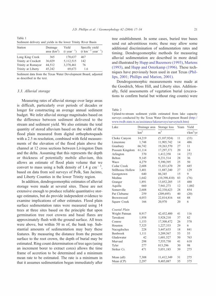
Table 1
Sediment delivery and yields in the lower Trinity River Basin
Station Drainage
area (km2)
Yield
(t year! 1)
Specific yield
(t km! 2 year! 1)
Long King Creek 365 170,637 467
Trinity at Crockett 36,029 5,112,515 142
Trinity at Romayor 44,512 3,378,461 76
Trinity at Liberty 45,242 69,673 1.6
Sediment data from the Texas Water Development Board, adjusted
as described in the text.
Table 2
Upland-to-stream sediment yields estimated from lake capacity
surveys conducted by the Texas Water Development Board (http://
www.twdb.state.tx.us/assistance/lakesurveys/surveytech.htm)
Lake Drainage area Storage loss Years Yield
km2 m3 t/km2/yr
Choke Canyon 14,219 (5,107,924) 11 (33)
Limestone 1,748 11,905,742 14 486
Granbury 66,742 19,263,570 27 11
Possum Kingdom 61,114 17,297,371 20 14
Arlington 370 1,412,358 14 272
Belton 9,145 9,231,514 28 36
Waco 4,279 5,390,395 25 50
Cedar Creek 2,608 51,831,670 29 685
Stillhouse Hollow 3,401 11,887,240 27 129
Georgetown 640 86,345 15 9
Medina 1,642 (10,398,410) 83 (76)
Granger 1,891 13,852,205 15 488
Aquilla 660 7,941,273 12 1,002
Somerville 2,608 62,338,623 28 854
Pat Cleburne 259 (209,695) 40 (20)
Brownwood 4,053 22,814,816 64 88
Squaw Creek 166 20,970 20 6
Coastal Plain
Wright Patman 8,917 42,432,400 41 116
Tawakoni 1,958 5,928,210 37 82
Conroe 1,153 17,308,472 26 578
Houston 7,325 1,227,333 29 6
Nacogdoches 228 3,447,633 18 841
Benbrook 1,111 3,209,567 53 55
Gladewater 42 1,601,527 50 763
Murvaul 298 7,555,730 41 618
Tyler 277 813,296 30 98
Striker Cr. 471 5,051,183 39 275
Mean (all) 7,308 11,412,349 31 275
Mean (CP) 2,297 9,485,087 35 375
J.D. Phillips et al. / Geomorphology 62 (2004) 17–34 21
made at the mouth of Menard Creek, Romayor, andPort of Liberty (two sites).
4. Results
4.1. Sediment production and delivery
The Trinity River has apparently experienced somerecent changes in sediment delivery to the lowerreaches of the river as a consequence of Lake Living-ston and Livingston Dam. Channel scour and alluvialremobilization immediately downstream of the damare apparent. Suspended sediment monitoring shows areduction in sediment loads at Romayor, approximate-ly 50 km downstream (Solis et al., 1994), although noprevious studies have examined trends in sedimentyield further downstream.
The gaging station on Long King Creek at Living-ston has a drainage area of 365 km2 and a meanannual sediment yield of 467 t km! 2 year! 1. Asshown in Table 1, this is considerably higher thansediment yield per unit area for any of the stations onthe lower Trinity River, including the Crockett stationupstream of Lake Livingston. At Liberty, where thegage datum is 0.7 m below sea level, the specificsediment yield is < 1.6 t km2 year! 1. The inverserelationship between drainage area and sediment yieldper unit area evident in Table 1 is consistent withmany other studies in humid perennial streams wherethe major source of sediment is upland erosion andtributary inputs within the basin (this literature is
reviewed by Meade, 1982; Walling, 1983; Sutherlandand Bryan, 1991; Ferro and Minacapilla, 1995).
Field reconaissance shows that Long King Creekand its tributaries have significant flood plain devel-opment and alluvial storage both upstream and down-stream of the gaging station, suggesting significantalluvial storage buffering of basin sediment produc-tion and delivery to the river.
The lake surveys suggest sediment yields of 6 to1002 t km2 year! 1, with a mean of 275 (Table 2).These data include three cases where measured stor-age capacities increased as a result of dredging,flushing, or increasing dam heights. Of the lakesshown in Table 2, the coastal plain lakes are insettings similar to those in the lower Trinity Basin.These lakes have specific sediment yields rangingfrom 6 to 841 t km! 2 year! 1, with a mean of 375.The lakes upstream of Livingston Dam, or in similarenvironmental settings, have a mean annual sedimentyield of 265 t km! 2 when the three lakes withincreases in capacity are excluded.
If reductions in reservoir capacity are indeed dueto fluvial sedimentation, these data represent areasonable, conservative estimate of sediment deliv-ery to the fluvial system as lake sediments includebed load as well as suspended loads, and reflectsediment actually delivered to the fluvial system.The estimates are conservative in the sense that thelakes are likely not all perfect sediment traps. Thelake storage loss data will not accurately reflectfluvial sediment input if there are other majorsediment sources such as aeolian input or lakeshore
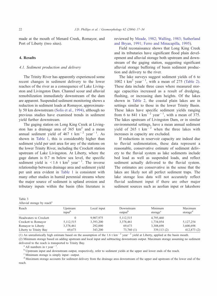
Table 3
Alluvial storage by reacha
Reach Upstream
inputbLocal input Downstream
outputbMinimum
storagecMaximum
storaged
Headwaters to Crockett 0 9,907,975 5,112,515 4,795,460
Crockett to Romayor 5,112,515 3,393,200 3,378,461 1,734,054 5,127,254
Romayor to Liberty 3,378,461 292,000 69,673 3,308,698 3,600,698
Liberty to Trinity Bay 69,673 343,200 73,760 (1) 339,113 (2) 412,873 (2)
(1) An unrealistically high estimate based on the assumption of the 1.6 t km! 2 year! 2 yield at Liberty, applied at the basin mouth.
(2) Minimum storage based on adding upstream and local input and subtracting downstream output. Maximum storage assuming no sediment
delivered to the reach is transported to Trinity Bay.a All numbers in t year! 1.b Upstream input and downstream output, respectively, refer to sediment yields at the upper and lower ends of the reach.c Minimum storage is simply input–output.d Maximum storage accounts for sediment delivery from the drainage area downstream of the upper and upstream of the lower end of the
reach.
J.D. Phillips et al. / Geomorphology 62 (2004) 17–3422
erosion and mass wasting. Major aeolian inputs areunlikely in the well-vegetated humid areas of eastTexas. Lakeshore erosion occurs but is minor in thelakes visited in the field (Lake Livingston and thefollowing included in Table 2: Nacogdoches, Con-roe, Somerville).
Based on the lake and Long King Creek data,sediment loadings within the lower Trinity basin areestimated at 400 t km! 2 year! 1. Loadings for theTrinity basin upstream of Lake Livingston are esti-mated as 265 t km! 2 year! 1.
4.2. Alluvial storage
Comparison of average annual sediment yields inTable 1 shows the apparent effects of alluvial storage.
Yields at Crockett are >1.7 million t year! 1 greaterthan at Romayor, with Lake Livingston presumablyaccounting for much of the intervening storage. Sed-iment yields at Romayor are almost 50 times those atLiberty.
The amount of average annual alluvial storage canbe constrained as shown in Table 3. The minimumstorage is simply the upstream input as measured atthe gaging stations minus the downstream output.Maximum storage assumes that all sediment deliveryto channels (estimated at 265 for the upper basin and400 t km! 2 year! 1 for the lower basin) is transportedto the Trinity River. Thus, the estimate of maximumstorage for reaches between Livingston Dam andLiberty is based on upstream input plus sedimentproduced in the drainage area between the upstream
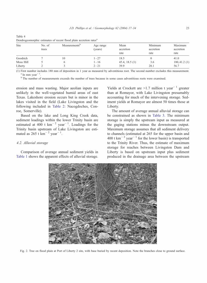
Fig. 2. Tree on flood plain at Port of Liberty 2 site, with base buried by recent deposition. Note the branches close to ground surface.
Table 4
Dendrogeomorphic estimates of recent flood plain accretion ratesa
Site No. of
trees
Measurementsb Age range
(years)
Mean
accretion
rate
Minimum
accretion
rate
Maximum
accretion
rate
Goodrich 7 10 1–27 18.5 0 41.0
Moss Hill 5 6 1–16 45.4, 18.5 (1) 3.6 180,41.2 (1)
Liberty 2 3 2–21 39.9 28.1 56.7
(1) First number includes 180 mm of deposition in 1 year as measured by adventitious root. The second number excludes this measurement.a In mm year! 1.b The number of measurements exceeds the number of trees because in some cases adventitious roots were examined.
J.D. Phillips et al. / Geomorphology 62 (2004) 17–34 23
and downstream ends of the reach, minus downstreamoutput. Estimates for the upper basin (headwaters toCrockett reach) are for alluvial storage within theentire basin, as opposed to the river itself. Estimatesfor the unmeasured coastal reach of the river, fromLiberty to Trinity Bay, are based on extrapolations ofper unit area sediment yield at Liberty to the rivermouth, which would produce an unrealistically highestimate. The maximum storage for this reach is basedon the assumption that no sediment is exported toTrinity Bay. Thus, the minimum and maximumstorage estimates for the lowermost reach of the river(being unrealistically low and high, respectively)should constrain or bracket the actual value.
Several trends are apparent from Table 3. First,alluvial sediment storage is extensive. Storage isparticularly apparent in the lowermost reaches. Sec-ond, more alluvial sediment is stored betweenRomayor and Liberty—that is, in the lower CoastalPlain portion of the river above tidal influences—thanin Lake Livingston. Third, in the lowermost river,alluvial storage dwarfs sediment yield.
The Trinity valley from Livingston Dam to thehead of Trinity Bay extends 174 km. The averagewidth of the flood plain is f 5 km. Channel surveysat 12 locations indicate a mean bank height of ~7 m.Taking the latter as an effective thickness of potentialactivation of alluvium (a reasonable assumption, as
the Trinity is near bedrock at many locations belowLake Livingston) yields a total volume of potentiallyremobilizable alluvium of 6.1"109 m3. At a typicalbulk density of 1.4 t m! 3, 8.52" 109 t are available.At recent rates of sediment yield at Liberty, thisvolume is equivalent to >87,000 years of sedimentdischarge.
From Romayor downstream, the mean annualalluvial storage is 5.4 to 9.1 million t year! 1. Thetotal amount of alluvium estimated above representsabout 1000 years of net input at this rate (666 to 1131years), recalling that storage rates from the dam toRomayor are not accounted for.
These estimates suggest active flood plain sedi-mentation in the lower Trinity. This is confirmed bythe dendrogeomorphic evidence. As shown in Table 4,significant accretion is occurring at all sites in recent
Table 5
Sediment yield and storage as percentage of total input to the fluvial
system
Reach Total input
(t year! 1)
Percent
yield
Percent
alluvial
storage
Headwaters to Crockett 9,907,975 46.9 53.1
Crockett–Romayor 8,505,715 39.7 60.3
Romayor–Liberty 3,670,461 1.9 98.1
Liberty–Bay 412,873 < 2 >98
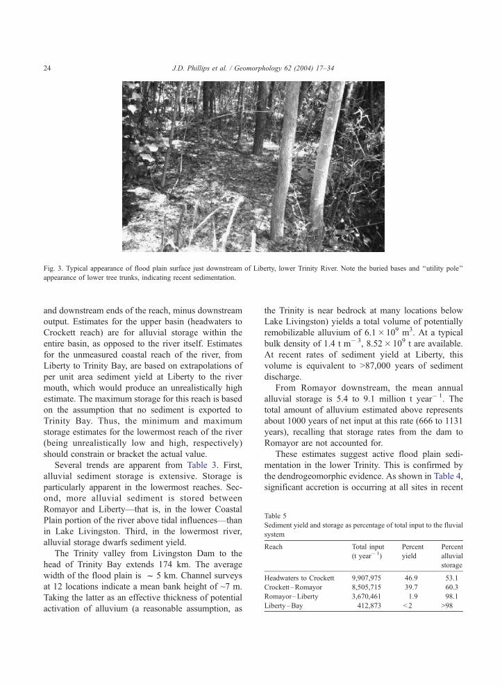
Fig. 3. Typical appearance of flood plain surface just downstream of Liberty, lower Trinity River. Note the buried bases and ‘‘utility pole’’
appearance of lower tree trunks, indicating recent sedimentation.
J.D. Phillips et al. / Geomorphology 62 (2004) 17–3424
years. Typical accretion rates of 18 to 40 mm year! 1
are consistent with vertical accretion rates in alluvialflood plains elsewhere in the US Atlantic and Gulf
coastal plains, which range from < 1 to 61 mm year! 1
over periods of 1 to 25 years (Phillips, 2001: Table 3).Obvious burial of vegetation indicating recent sedi-mentation was also noted at the mouth of MenardCreek, Romayor, and Port of Liberty 2 sites (see Figs.2 and 3).
4.3. Sediment budget
Between Romayor and Liberty, a dramatic increasein alluvial storage occurs, and a corresponding de-crease in river sediment transport (Tables 5 and 6).
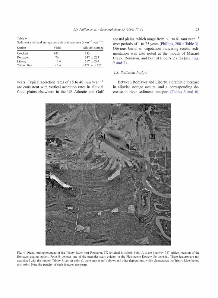
Fig. 4. Digital orthophotoquad of the Trinity River near Romayor, TX (original in color). Point A is the highway 787 bridge, location of the
Romayor gaging station. Point B denotes one of the meander scars evident in the Pleistocene Deweyville deposits. These features are not
associated with the modern Trinity River. At point C, there are several oxbows and other depressions, which characterize the Trinity River below
this point. Note the paucity of such features upstream.
Table 6
Sediment yield and storage per unit drainage area (t km! 2 year! 1)
Station Yield Alluvial storage
Crockett 142 133
Romayor 76 147 to 223
Liberty 1.6 217 to 299
Trinity Bay < 1.6 >221 to < 302
J.D. Phillips et al. / Geomorphology 62 (2004) 17–34 25
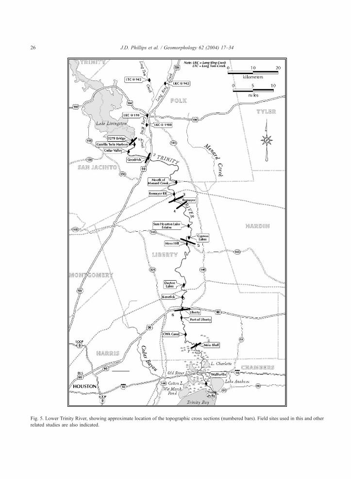
Fig. 5. Lower Trinity River, showing approximate location of the topographic cross sections (numbered bars). Field sites used in this and other
related studies are also indicated.
J.D. Phillips et al. / Geomorphology 62 (2004) 17–3426

Though the reach boundaries are defined by thesediment-monitoring stations, a profound change inflood plain morphology indeed occurs a short distance
downstream from Romayor. The flood plain becomeswider, lower in elevation, and characterized by agreater size and number of oxbows and other depres-
Fig. 6. Flood plain cross sections derived from digital elevation models. Numbers correspond to sites in Fig. 5.
J.D. Phillips et al. / Geomorphology 62 (2004) 17–34 27
sions (Fig. 4). This is evident from a number of floodplain cross sections derived from digital elevationmodels (Figs. 5 and 6).
The greater frequency of overbank flooding in thelowermost reaches can be illustrated by examining therecurrence interval of flood-stage discharges atRomayor and Liberty. The 2364 m3 s! 1 dischargeassociated with the flood stage at Romayor has anannual exceedence probability of 29%. By contrast,the flood stage discharge of 989 m3 s! 1 at Liberty isexceeded in 60% of all years.
4.4. Sediment sources
Because much of the upstream sediment load iscaptured in Lake Livingston, questions arise as to thesource of sediments in the lower Trinity. Of the totaldrainage area at Romayor, 717 km2 are downstream ofthe lake. At 400 t km! 2 year! 1, this would yield286,800 t year! 1, or only about 8.5% of the sedimentyield at Romayor. This implies that much of thesediment transported at Romayor comes from up-stream of the dam—e.g., is transported through thelake—or is derived from channel erosion downstreamof the dam.
Trap efficiency of reservoirs is often estimatedfrom the capacity/inflow ratio via a relationship de-
veloped by Brune (1953) and Verstraeten and Poesen(2000):
E ¼ 100ð0:970:19logC=I Þ ð1Þ
where E is trap efficiency in %, C is reservoircapacity, and I is inflow. The C/I ratio for LakeLivingston is 0.316, yielding a trap efficiency of81%. If sediment yield per unit area at Crockett isextrapolated to the entire 42,950 km2 upstream of thedam, sediment inputs of about 6 million t year! 1
would result. If 19% of this is transported through thelake, it could account for 1.14 million t year! 1, about34% of the yield at Romayor.
Unless trap efficiency of Lake Livingston is signif-icantly overestimated or sediment input between Liv-ingston Dam and Romayor is markedly underesti-mated, this implies that more than half the sedimenttransport at Romayor is derived from channel erosion.We believe that, if anything, trap efficiency of the lakeis underestimated by the capacity–inflow ratio, basedon observations of essentially clear water immediatelydownstream of the dam, even at high flows.
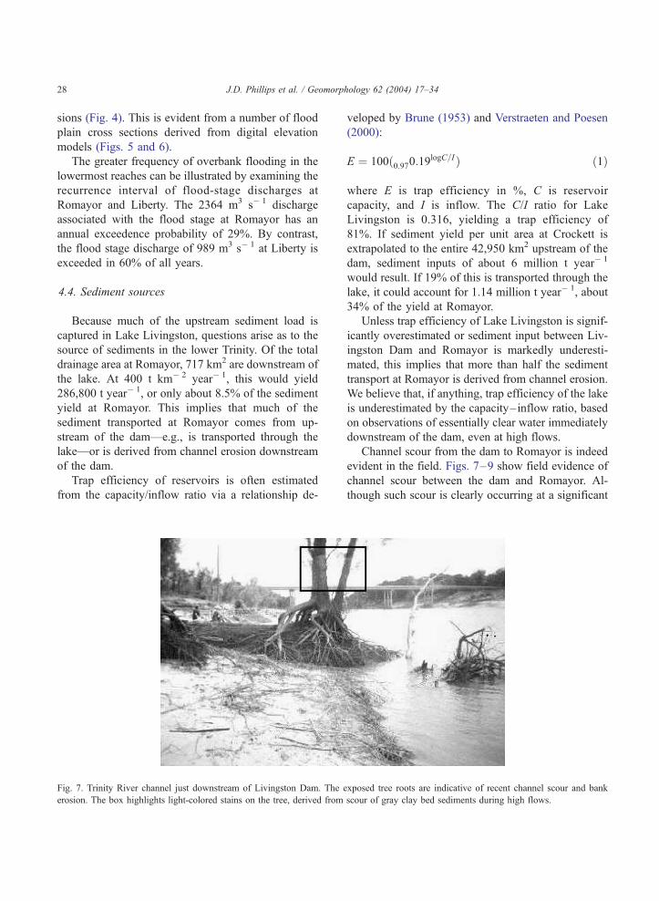
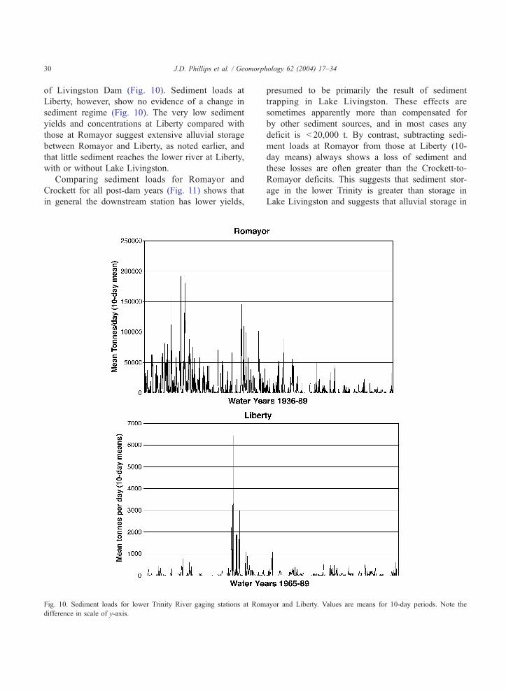
Channel scour from the dam to Romayor is indeedevident in the field. Figs. 7–9 show field evidence ofchannel scour between the dam and Romayor. Al-though such scour is clearly occurring at a significant
Fig. 7. Trinity River channel just downstream of Livingston Dam. The exposed tree roots are indicative of recent channel scour and bank
erosion. The box highlights light-colored stains on the tree, derived from scour of gray clay bed sediments during high flows.
J.D. Phillips et al. / Geomorphology 62 (2004) 17–3428
pace, the amount, rates, and timing are not wellunderstood and deserve further investigation. Interest-ingly, results from a study on channel change con-ducted on the Trinity below Lake Livingston suggestcontributions from channel erosion may exceed 50%(Wellmeyer et al., 2003). In this report, the authors usehistoric aerial photographs from 1938 to 1995, digi-tized and imported into a GIS, to quantify long-term
channel bank stability. Mean annual channel erosionwas computed at 30.2 ha year! 1. Using the averagechannel depth of 7 m and a mean bulk density of 1.4Mg m! 3 yields a possible 2.96" 106 Mg of sedimentper year, which is equivalent to 87.6% of the annualsediment load measured at Romayor.
Data from the Romayor station show a cleardecline in sediment transport following completion
Fig. 9. Exposed bedrock in the Trinity River channel just downstream of the Romayor gaging station.
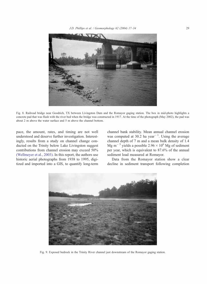
Fig. 8. Railroad bridge near Goodrich, TX between Livingston Dam and the Romayor gaging station. The box in mid-photo highlights a
concrete pad that was flush with the river bed when the bridge was constructed in 1917. At the time of the photograph (May 2002), the pad was
about 2 m above the water surface and 5 m above the channel bottom.
J.D. Phillips et al. / Geomorphology 62 (2004) 17–34 29
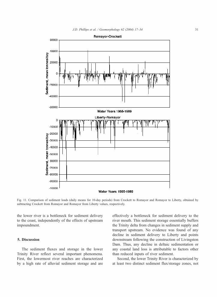
of Livingston Dam (Fig. 10). Sediment loads atLiberty, however, show no evidence of a change insediment regime (Fig. 10). The very low sedimentyields and concentrations at Liberty compared withthose at Romayor suggest extensive alluvial storagebetween Romayor and Liberty, as noted earlier, andthat little sediment reaches the lower river at Liberty,with or without Lake Livingston.
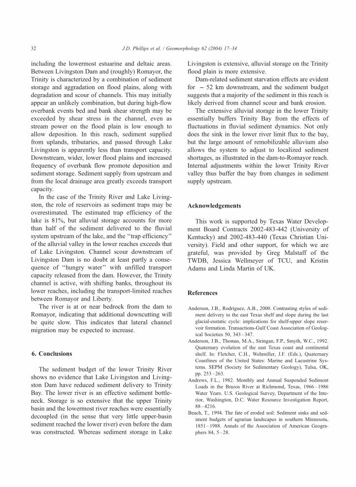
Comparing sediment loads for Romayor andCrockett for all post-dam years (Fig. 11) shows thatin general the downstream station has lower yields,
presumed to be primarily the result of sedimenttrapping in Lake Livingston. These effects aresometimes apparently more than compensated forby other sediment sources, and in most cases anydeficit is < 20,000 t. By contrast, subtracting sedi-ment loads at Romayor from those at Liberty (10-day means) always shows a loss of sediment andthese losses are often greater than the Crockett-to-Romayor deficits. This suggests that sediment stor-age in the lower Trinity is greater than storage inLake Livingston and suggests that alluvial storage in
Fig. 10. Sediment loads for lower Trinity River gaging stations at Romayor and Liberty. Values are means for 10-day periods. Note the
difference in scale of y-axis.
J.D. Phillips et al. / Geomorphology 62 (2004) 17–3430
the lower river is a bottleneck for sediment deliveryto the coast, independently of the effects of upstreamimpoundment.
5. Discussion
The sediment fluxes and storage in the lowerTrinity River reflect several important phenomena.First, the lowermost river reaches are characterizedby a high rate of alluvial sediment storage and are
effectively a bottleneck for sediment delivery to theriver mouth. This sediment storage essentially buffersthe Trinity delta from changes in sediment supply andtransport upstream. No evidence was found of anydecline in sediment delivery to Liberty and pointsdownstream following the construction of LivingstonDam. Thus, any decline in deltaic sedimentation orany coastal land loss is attributable to factors otherthan reduced inputs of river sediment.
Second, the lower Trinity River is characterized byat least two distinct sediment flux/storage zones, not
Fig. 11. Comparison of sediment loads (daily means for 10-day periods) from Crockett to Romayor and Romayor to Liberty, obtained by
subtracting Crockett from Romayor and Romayor from Liberty values, respectively.
J.D. Phillips et al. / Geomorphology 62 (2004) 17–34 31
including the lowermost estuarine and deltaic areas.Between Livingston Dam and (roughly) Romayor, theTrinity is characterized by a combination of sedimentstorage and aggradation on flood plains, along withdegradation and scour of channels. This may initiallyappear an unlikely combination, but during high-flowoverbank events bed and bank shear strength may beexceeded by shear stress in the channel, even asstream power on the flood plain is low enough toallow deposition. In this reach, sediment suppliedfrom uplands, tributaries, and passed through LakeLivingston is apparently less than transport capacity.Downstream, wider, lower flood plains and increasedfrequency of overbank flow promote deposition andsediment storage. Sediment supply from upstream andfrom the local drainage area greatly exceeds transportcapacity.
In the case of the Trinity River and Lake Living-ston, the role of reservoirs as sediment traps may beoverestimated. The estimated trap efficiency of thelake is 81%, but alluvial storage accounts for morethan half of the sediment delivered to the fluvialsystem upstream of the lake, and the ‘‘trap efficiency’’of the alluvial valley in the lower reaches exceeds thatof Lake Livingston. Channel scour downstream ofLivingston Dam is no doubt at least partly a conse-quence of ‘‘hungry water’’ with unfilled transportcapacity released from the dam. However, the Trinitychannel is active, with shifting banks, throughout itslower reaches, including the transport-limited reachesbetween Romayor and Liberty.
The river is at or near bedrock from the dam toRomayor, indicating that additional downcutting willbe quite slow. This indicates that lateral channelmigration may be expected to increase.
6. Conclusions
The sediment budget of the lower Trinity Rivershows no evidence that Lake Livingston and Living-ston Dam have reduced sediment delivery to TrinityBay. The lower river is an effective sediment bottle-neck. Storage is so extensive that the upper Trinitybasin and the lowermost river reaches were essentiallydecoupled (in the sense that very little upper-basinsediment reached the lower river) even before the damwas constructed. Whereas sediment storage in Lake
Livingston is extensive, alluvial storage on the Trinityflood plain is more extensive.
Dam-related sediment starvation effects are evidentfor f 52 km downstream, and the sediment budgetsuggests that a majority of the sediment in this reach islikely derived from channel scour and bank erosion.
The extensive alluvial storage in the lower Trinityessentially buffers Trinity Bay from the effects offluctuations in fluvial sediment dynamics. Not onlydoes the sink in the lower river limit flux to the bay,but the large amount of remobilizable alluvium alsoallows the system to adjust to localized sedimentshortages, as illustrated in the dam-to-Romayor reach.Internal adjustments within the lower Trinity Rivervalley thus buffer the bay from changes in sedimentsupply upstream.
Acknowledgements
This work is supported by Texas Water Develop-ment Board Contracts 2002-483-442 (University ofKentucky) and 2002-483-440 (Texas Christian Uni-versity). Field and other support, for which we aregrateful, was provided by Greg Malstaff of theTWDB, Jessica Wellmeyer of TCU, and KristinAdams and Linda Martin of UK.
References
Anderson, J.B., Rodriguez, A.B., 2000. Contrasting styles of sedi-
ment delivery to the east Texas shelf and slope during the last
glacial-eustatic cycle: implications for shelf-upper slope reser-
voir formation. Transactions-Gulf Coast Association of Geolog-
ical Societies 50, 343–347.
Anderson, J.B., Thomas, M.A., Siringan, F.P., Smyth, W.C., 1992.
Quaternary evolution of the east Texas coast and continental
shelf. In: Fletcher, C.H., Wehmiller, J.F. (Eds.), Quaternary
Coastlines of the United States: Marine and Lacustrine Sys-
tems. SEPM (Society for Sedimentary Geology), Tulsa, OK,
pp. 253–263.
Andrews, F.L., 1982. Monthly and Annual Suspended Sediment
Loads in the Brazos River at Richmond, Texas, 1966–1986
Water Years. U.S. Geological Survey, Department of the Inte-
rior, Washington, D.C. Water Resource Investigation Report,
88–4216.
Beach, T., 1994. The fate of eroded soil: Sediment sinks and sed-
iment budgets of agrarian landscapes in southern Minnesota,
1851–1988. Annals of the Association of American Geogra-
phers 84, 5–28.
J.D. Phillips et al. / Geomorphology 62 (2004) 17–3432
Blum, M.D., Price, D.M., 1994. Glacio-eustatic and climatic con-
trols on Quaternary alluvial plain deposition, Texas coastal
plain. Transactions-Gulf Coast Association of Geological Soci-
eties 44, 85–92.
Blum, M.D., Morton, R.A., Durbin, J.M., 1995. Deweyville terra-
ces and deposits of the Texas Gulf coastal plain. Transactions-
Gulf Coast Association of Geological Societies 45, 53–60.
Brandt, S.A., 2000. Classification of geomorphological effects
downstream of dams. Catena 40, 375–401.
Brizga, S.O., Finlayson, B.L., 1994. Interactions between upland
catchment and lowland rivers: an applied Australian case study.
Geomorphology 9, 189–201.
Brune, G.M., 1953. Trap efficiency of reservoirs. Transactions-
American Geophysical Union 34, 407–418.
Davis, R.A., 1997. Regional coastal morphodynamics along the
U.S. Gulf of Mexico. Journal of Coastal Research 13, 595–604.
Ferro, V., Minacapilla, M., 1995. Sediment delivery processes at
basin scale. Hydrological Sciences Journal 40, 703–717.
Friedman, J.M., Osterkamp, W.R., Scott, M.L., Auble, G.T., 1998.
Downstream effects of dams on channel geometry and bottom-
land vegetation: regional patterns in the Great Plains. Wetlands
18, 619–633.
Fryirs, K., Brierly, G.J., 1999. Slope-channel decoupling in
Wolumla catchment New South Wales Australia: the changing
nature of sediment sources following European settlement. Ca-
tena 35, 41–63.
GLO (Texas General Land Office), 2002. Shoreline Erosion Rates.
http://www.glo.state.tx.us/coastal/erosion/erosionrates.html,
accessed 12/17/02.
Graf, W.L., 2001. Damage control: restoring the physical integrity
of America’s rivers. Annals of the Association of American
Geographers 91, 1–27.
Hupp, C.R., Bazemore, D.E., 1993. Temporal and spatial patterns
of wetland sedimentation, west Tennessee. Journal of Hydrolo-
gy 141, 179–196.
Hupp, C.R., Osterkamp, W.R., 1996. Riparian vegetation and flu-
vial geomorphic processes. Geomorphology 14, 277–295.
Martens, D.M., 1993. Hydrologic influences from tree-ring studies
on the Hawkesbury River, Sydney, Australia. Geomorphology
8, 147–164.
Meade, R.H., 1982. Sources, sinks, and storage of river sediment in
the Atlantic drainage of the United States. Journal of Geology
90, 235–252.
Morton, R.A., 1977. Historical shoreline changes and their causes.
Transactions-Gulf Coast Association of Geological Societies 27,
353–363.
Morton, R.A., 1993. Shoreline Movement Along Developed
Beaches of the Texas Gulf Coast: A Users’ Guide to Analyzing
and Predicting Shoreline Changes. Bureau of Economic Geolo-
gy, University of Texas at Austin, Open-File Report 93-1. 79 pp.
Morton, R.A., Paine, J.G., 1990. Coastal land loss in Texas—an
overview. Transactions-Gulf Coast Association of Geological
Societies 40, 625–634.
Olive, L.J., Olley, J.M., Murray, A.S., Wallbrink, P.J., 1994. Spatial
variability in suspended sediment transport in the Murrum-
bidgee River, New South Wales, AustraliaVariability in Stream
Erosion and Sediment Transport, vol. 224. International Asso-
ciation of Hydrological Sciences Publication, Wallingford, U.K.,
pp. 241–249.
Phillips, J.D., 1991. Fluvial sediment delivery to a coastal plain
estuary in the Atlantic drainage of the United States. Marine
Geology 98, 121–134.
Phillips, J.D., 1992. The source of alluvium in large rivers of the
lower Coastal Plain of North Carolina. Catena 19, 59–75.
Phillips, J.D., 1992. Delivery of upper-basin sediment to the lower
Neuse River, North Carolina. Earth Surface processes and Land-
forms 17, 699–709.
Phillips, J.D., 1993. Pre- and post-colonial sediment sources and
storage in the lower Neuse River basin, North Carolina. Physical
Geography 14, 272–284.
Phillips, J.D., 1995. Decoupling of sediment sources in large
river basinsEffects of Scale on Interpretation and Manage-
ment of Sediment and Water Quality, vol. 226. International
Association of Hydrological Sciences Pub., Wallingford,
U.K., pp. 11–16.
Phillips, J.D., 2001. Sedimentation in bottomland hardwoods
downstream of an east Texas dam. Environmental Geology
40, 860–868.
Phillips, J.D., 2003. Toledo Bend Reservoir and geomorphic re-
sponse in the lower Sabine River. River Research and Applica-
tions 19, 137–159.
Phillips, J.D., Marion, D.F., 2001. Residence times of alluvium in
an east Texas stream as indicated by sediment color. Catena 45,
49–71.
Phillips, J.D., Musselman, Z.A., 2003. The effect of dams on fluvial
sediment delivery to the Texas coast. Proceedings of Coastal
Sediments. American Society of Civil Engineers, New York,
pp. 1–14.
Rodriguez, A.B., Anderson, J.B., 2000. Mapping bay-head deltas
within incised valleys as an aid for predicting the occurrence of
barrier shoreline sands: an example from the Trinity/Sabine in-
cised valley. Transactions-Gulf Coast Association of Geological
Societies 50, 755–758.
Rodriguez, A.B., Fassell, M.L., Anderson, J.B., 2001. Variations in
shoreface progradation and ravinement along the Texas coast,
Gulf of Mexico. Sedimentology 48, 837–853.
Slattery, M.C., Gares, P.A., Phillips, J.D., 2002. Slope-channel link-
age and sediment delivery on North Carolina coastal plain crop-
land. Earth Surface Processes and Landforms 27, 1377–1387.
Smith, S.V., Renwick, W.H., Bartley, J.D., Buddemeier, R.W.,
2002. Distribution and significance of small, artificial water
bodies across the United States landscape. Science of the Total
Environment 299, 2–36.
Solis, R.S., Longley, W.L., Malstaff, G., 1994. Influence of inflow
on sediment deposition in delta and bay systems. In: Longley,
W.L. (Ed.), Freshwater Inflows to Texas Bays and Estuaries.
Texas Water Development Board, Austin, pp. 56–70.
Sutherland, R.A., Bryan, R.B., 1991. Sediment budgeting: a case
study in the Katiorin drainage basin, Kenya. Earth Surface Pro-
cesses and Landforms 16, 383–398.
Thomas, M.A., Anderson, J.B., 1994. Sea-level controls on the
facies architecture of the Trinity/Sabine incised-valley system,
Texas continental shelf. In: Dalrymple, R.W., Boyd, R., Zaitline,
B.Z. (Eds.), Incised-Valley Systems: Origin and Sedimentary
J.D. Phillips et al. / Geomorphology 62 (2004) 17–34 33
Sequences. SEPM (Society for Sedimentary Geology), Tulsa,
OK, pp. 63–82.
Verstraeten, G., Poesen, J., 2000. Estimating trap efficiency of small
reservoirs and ponds: methods and implications for the assess-
ment of sediment yield. Progress in Physical Geography 24,
219–251.
Walling, D.E., 1983. The sediment delivery problem. Journal of
Hydrology 65, 209–237.
Welborn, C.T., 1967. Comparative Results of Sediment Sampling
with the Texas Sampler and the Depth-Integrating Samplers and
Specific Weight of Fluvial Sediment Deposits in Texas Texas
Water Development Board, Austin.
Wellmeyer, J.L., Slattery, M.C., Phillips, J.D., 2003. Quantifying
downstream impacts of impoundment on flow regime and chan-
nel activity, Lower Trinity River, Texas. Report to the Texas
Water Development Board, Austin, TX, 1–67.
White, W.A., Calnan, T.C., 1991. Submergence of vegetated wet-
lands in fluvial-deltaic area, Texas Gulf coast. Coastal Deposi-
tional Systems of the Gulf of Mexico. 12th Annual Research
Conference. Society of Economic Paleontologists and Mineral-
ogists, Gulf Coast Section, Tulsa, OK, pp. 278–279.
White, W.A., Morton, R.A., Holmes, C.W., 2002. A comparison of
factors controlling sedimentation rates and wetland loss in flu-
vial-deltaic systems, Texas Gulf coast. Geomorphology 44,
47–66.
Williams, H.F.L., 1991. Character and growth of deltaic deposits in
Lewisville Lake, Texas. Texas Journal of Science 43, 377–389.
Williams, G.P., Wolman, M.G., 1984. Downstream effects of dams
on alluvial rivers. U.S. Geological Survey Professional Paper
1286, 1–61 (Washington, D.C.).
J.D. Phillips et al. / Geomorphology 62 (2004) 17–3434