Embed Size (px)
Citation preview

DEEP-DAM-FRM-002 Page 1 of 27 Rev. 02/11/2014
DAM SAFETY PROGRAMDAM INSPECTION REPORT FORM – FOR REGULATORY
INSPECTIONPlease complete this form in accordance with the instructions (DEEP-DAM-INST-002).
Part I: Summary of Dam Inspection
Dam Name: Knofla’s Pond Dam Inspection Date(s): 5/14/2015
Alternate Dam Name(s): CT Dam ID #: 14203
Location (Municipality): Tolland Temperature / Weather: 70º Sunny
Registered?: Yes or No If yes, provide the 9 digit registration number found on the notification letter.
Yes 9/18/2002 (attached)
Pool Level:See Instructions
4” above drop Inlet crest elevation
Emergency Action Plan?: Yes or No If Yes, see instructions
NoImpoundment Use: use options listed in instructions
aesthetics/conservation
Hydraulic and Hydrologic Analysis?: Yes or NoIf Yes, see instructions
Yes for original designStability Analysis?:Yes or NoIf Yes, see instructions
No
Overall Condition: (refer to Appendix A located at the end of this form) Satisfactory
Persons present at the inspection (select the tab button in the last cell to the right to create another row)Name Title/Position RepresentingPhil MoreschiBill Dwinells, P.E. Town Engineer TollandLinda Farmer, AICP Town Planner Tolland

Knofla’s Pond Dam ID#14203 May 14, 2015
DEEP-DAM-FRM-002 Page 2 of 27 Rev. 02/11/2014
Owners and Operators: If there is more than one owner or operator, copy the empty table below for each owner or operator and paste right below the previous table, then complete the information for each
*By providing this e-mail address you are agreeing to receive official correspondence from DEEP, at this electronic address, concerning the subject report. Please remember to check your security settings to be sure you can receive e-mails from “ct.gov” addresses. Also, please notify DEEP if your e-mail address changes by email via [email protected].
Indicate if Owner or Operator: Operator
Name: Bill Dwinells, P.E.
Mailing Address: 21 Tolland Green
City/Town: Tolland State: CT Zip Code: 06084
Phone: 860-871-3604 ext.:
Emergency Phone: 860-324-6293
*E-mail: [email protected]

Knofla’s Pond Dam ID#14203 May 14, 2015
DEEP-DAM-FRM-002 Page 3 of 27 Rev. 02/11/2014
Part II: General Dam Information
General Description: Earthen Embankment Dam
Hazard Classification: BB Dam Height (ft): 9’
Dam Length (ft): 115’ Spillway Length (ft): 45’
Spillway Type: drop inlet Normal Freeboard (ft): 3 ½’
Drainage Area (square miles): 0.58
Impoundment Area (at principal spillway crest, in acres):
5.65
Watercourse(s): Cemetery Brook
OTHER INFORMATION: (see instructions)
Attached at end:
Registration
o Construction Photos
o 2010 Flood Photos
Tolland Property Boundary

Knofla’s Pond Dam ID#14203 May 14, 2015
DEEP-DAM-FRM-002 Page 4 of 27 Rev. 02/11/2014
Part III: Aerial Photo/Location Map (insert the aerial photo and location map under this Part. See instructions for details.)
Copyright:© 2013 National Geographic Society, i-cubed
p
PROJ. No. 20150499.A10
DATE: JULY 2015
CONNECTICUT
SITE LOCATION MAP0 1,000 2,000
Feet FIG. 1146 HARTFORD ROADMANCHESTER CT, 06040(860) 646-2469www.fando.com
Pat
h: F
:\P20
15\0
499\
A10
\Fig
1_Lo
cus_
KN
OFL
AS
PO
ND
DA
M.m
xd
TOWN OF TOLLAND
TOLLAND
QUADRANGLE LOCATION
DAM NAME: KNOFLA'S POND DAMTOWN: TOLLANDLATITUDE: 41.899744LONGITUDE: -72.379867
KNOFLA'S POND DAM
KNOFLA'S POND DAMLAT: 41.899744LONG: -72.379867

p
PROJ. No. 20150499.A10
DATE: JULY 2015
CONNECTICUT
AERIAL MAP0 100 200
Feet FIG. 2146 HARTFORD ROADMANCHESTER CT, 06040(860) 646-2469www.fando.com
Pat
h: K
:\P20
15\0
499\
A10
\Fig
2_A
eria
l_K
NO
FLA
S P
ON
D D
AM
.mxd
TOWN OF TOLLAND
TOLLAND
QUADRANGLE LOCATION
DAM NAME: KNOFLA'S POND DAMTOWN: TOLLANDLATITUDE: 41.899744LONGITUDE: -72.379867
KNOFLA'S POND DAM
KNOFLA'S POND DAMLAT: 41.899744LONG: -72.379867

Copyright:© 2013 National Geographic
p
PROJ. No. 20150499.A10
DATE: JULY 2015
CONNECTICUT
DRAINAGE AREA MAP0 750 1,500
Feet FIG. 3146 HARTFORD ROADMANCHESTER CT, 06040(860) 646-2469www.fando.com
Pat
h: K
:\P20
15\0
499\
A10
\Fig
3_D
rain
ageA
rea_
KN
OFL
AS
PO
ND
DA
M.m
xd
TOWN OF TOLLAND
TOLLAND
QUADRANGLE LOCATION
DAM NAME: KNOFLA'S POND DAMTOWN: TOLLANDLATITUDE: 41.899744LONGITUDE: -72.379867
KNOFLA'S POND DAM
KNOFLA'S POND DAMLAT: 41.899744LONG: -72.379867
DRAINAGE AREA BOUNDARY SIZE = 0.58 SQ MI

Knofla’s Pond Dam ID#14203 May 14, 2015
DEEP-DAM-FRM-002 Page 5 of 27 Rev. 02/11/2014
Part IV: Dam/Embankment/Dike InformationNumber of Dam/Embankments/Dikes: 1 (if there is more than one dam/embankment or dike, reproduce this section and paste right below the previous section)
Dam/Embankment/Dike Name (see instructions): One Eastern EmbankmentGeneral Description: Typical earth embankment with approximately 3:1 u/s slope and 2:1 d/s slopeGeneral Condition: GoodConcrete Condition: N/AStone Masonry: N/ASettlement/Alignment/Movement: Embankment somewhat irregular in crest width and horizontal and vertical alignmentSeepage/Foundation Drainage: Seepage/Wet Area noted on d/s slope on left embankment and right embankment. Clay Well Tile 12” diameter on right d/s abutment contact. Water level approximately 6” below ground surface Riprap: None observedErosion/Burrows: None observed. A little soil missing on left side of end wall.Vegetative Cover: Turf - Well established and 3” highOther: Photos/Graphics/Sketches (insert either below this Part or in Parts XIII and XIV, refer to the instructions under Parts XIII and XIV for additional details)
Part V: Principal Spillway, Training Walls, ApronNumber of Principal Spillways: 1 (if there is more than one principal spillway, reproduce this section and paste right below the previous section)
Spillway Type (see instructions): (square concrete structure) Drop inlet spillway. Auxiliary vegetated/overflow spillwayGeneral Description: General Condition: Good condition. Minor spilling visible on interior of drop inlet.Concrete Condition: GoodStone Masonry: N/ASettlement/Alignment/Movement: None observed.Cracks: None observedScouring/Undermining: None observedSeepage/Foundation Drainage: Water ponded on d/s side so seepage/leakage not visibleOther: Chain link fence surrounding drop inlet as debris screen. In good condition since recently installed.Photos/Graphics/Sketches (insert either below this Part or in Parts XIII and XIV, refer to the instructions under Parts XIII and XIV for additional details)
Part VI: Auxiliary Spillway, Training Walls, ApronNumber of Auxiliary Spillways: 1 (if there is more than one auxiliary spillway, reproduce this section and paste right below the previous section)
Auxiliary Spillway Type (see instructions): Vegetated overflow spillwayGeneral Description: Graded into natural grade at left end of dam.General Condition: GoodConcrete Condition: N/AStone Masonry: N/A

Knofla’s Pond Dam ID#14203 May 14, 2015
DEEP-DAM-FRM-002 Page 6 of 27 Rev. 02/11/2014
Settlement/Alignment/Movement: Looks uniformly gradedCracks: N/AScouring/Undermining: None observed.Vegetative Cover: Good stand of turf 3” tallRiprap: N/ASeepage/Foundation Drainage: N/AOther: Minimal debris at end of spillway and some saplings and brush crowding outlet end.Photos/Graphics/Sketches (insert either below this Part or in Parts XIII and XIV, refer to the instructions under Parts XIII and XIV for additional details)
Part VII: Downstream ChannelNumber of Downstream Channels: 1 (if there is more than one downstream channel, reproduce this sectionand paste right below the previous section)
Channel Name (see instructions), include Watercourse Name: Cemetery BrookGeneral Description: Brook channelGeneral Condition: Reasonably clearScouring: None observedDebris: Minimal woodRiprap: None observedOther: Photos/Graphics/Sketches (insert either below this Part or in Parts XIII and XIV, refer to the instructions under Parts XIII and XIV for additional details)
Part VIII: Intake Structure(s)Number of Intake Structures: 1 (if there is more than one intake structure, reproduce this section and paste right below the previous section)
Intake Structure Type (see instructions): Valve on pipe to drop inlet structure based on construction photo andconstruction documentation indicating installation of a shear gate (see attached Registration Document).General Description: Not visibleGeneral Condition: Not visibleConcrete Condition: Not visibleStone Masonry: N/ASettlement/Alignment/Movement: Not visibleCracks: Not visibleOther: Not operated in a long timePhotos/Graphics/Sketches (insert either below this Part or in Parts XIII and XIV, refer to the instructions underParts XIII and XIV for additional details)
Part IX: Outlet Structure(s)Number of Outlet Structures: 1 (if there is more than one outlet structure, reproduce this section and paste right below the previous section)
Outlet Structure Type (see instructions): Corrugated metal pipeGeneral Description: General Condition:

Knofla’s Pond Dam ID#14203 May 14, 2015
DEEP-DAM-FRM-002 Page 7 of 27 Rev. 02/11/2014
Concrete Condition: N/AStone Masonry: End wall is make shift stone masonry and concrete block with concrete slurry and asphalt covering. Fair condition.Settlement/Alignment/Movement: Scouring/Undermining: None observed; however, some soil loss to left of outlet pipe.Other: Photos/Graphics/Sketches (insert either below this Part or in Parts XIII and XIV, refer to the instructions under Parts XIII and XIV for additional details)
Part X: Miscellaneous Features
List miscellaneous features: (e.g., access roads, bridges, etc.):
Access road from Bakos Road is accessible by pickup truck.
Photos/Graphics/Sketches (insert either below this Part or in Parts XIII and XIV, refer to the instructions under Parts XIII and XIV for additional details)
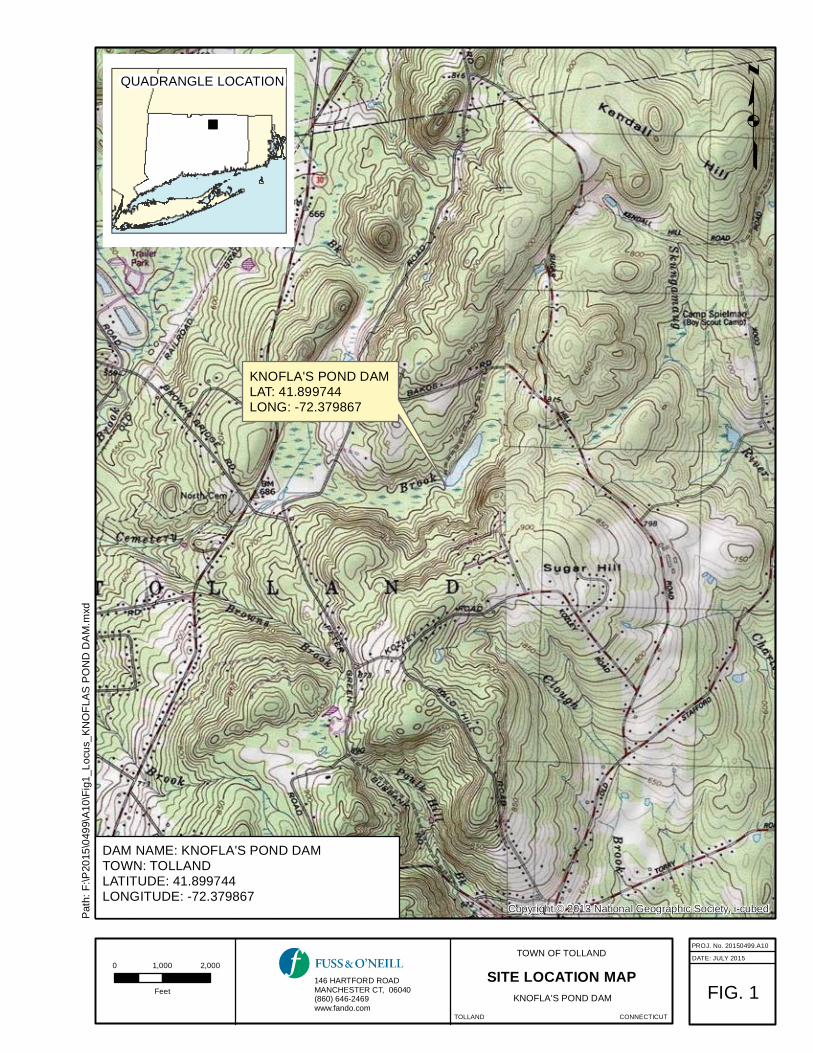
Part XI: Downstream Hazard Classification Reassessment
Downstream Hazard Classification: (provide recommendation for the hazard class based on the Dam Safety regulation. See Instructions and Appendix B.)
Hunter Road is first downstream crossing. Dam should be no greater than a Class BB Hazard. With moredetailed analyses, it might be shown to be a Class A or AA Hazard. See attached screening level Hazard Classification evaluation.
Part XII: Recommendations (See instructions for identifying recommendations)
Recommendations: (Each item should be numbered)
1. Keep drop inlet clear of debris.2. Remove debris in auxiliary channel at woody vegetation crowding channel outlet end.3. Plan to remove all trees within 25 feet of dam components.4. Explore restoring operability of low level outlet valve.5. Longer term, plan to camera inspect the corrugated metal pipe in dry to assess degree of corrosion. It is
to be expected that at some point future pipe will need to be repaired (proper slip lining) or replaced.


Knofla’s Pond Dam ID#14203 May 14, 2015
DEEP-DAM-FRM-002 Page 8 of 27 Rev. 02/11/2014
Part XIII: Photographs/Graphics (see instructions and Appendix C)
1. Overview of dam(s)/dike(s) from upstream
2. Overview of dam(s)/dike(s) from downstream

Knofla’s Pond Dam ID#14203 May 14, 2015
DEEP-DAM-FRM-002 Page 9 of 27 Rev. 02/11/2014
3. Overview of upstream face from right abutment
4. Overview of upstream face from left abutment

Knofla’s Pond Dam ID#14203 May 14, 2015
DEEP-DAM-FRM-002 Page 10 of 27 Rev. 02/11/2014
5. Overview of dam crest from right abutment
6. Overview of dam crest from left abutment

Knofla’s Pond Dam ID#14203 May 14, 2015
DEEP-DAM-FRM-002 Page 11 of 27 Rev. 02/11/2014
7. Overview of downstream face from right abutment
8. Overview of downstream face from left abutment

Knofla’s Pond Dam ID#14203 May 14, 2015
DEEP-DAM-FRM-002 Page 12 of 27 Rev. 02/11/2014
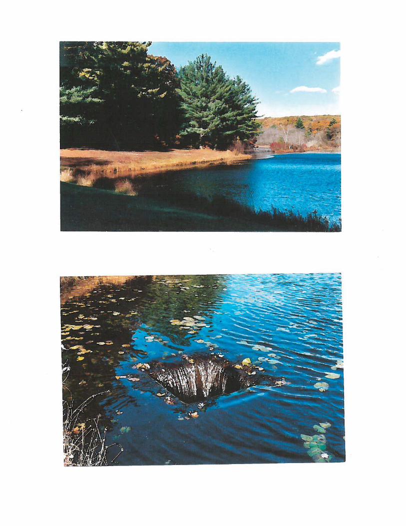
9. Overview of spillway(s) from upstream
10. Overview of spillway(s) from upstream (auxiliary spillway)

Knofla’s Pond Dam ID#14203 May 14, 2015
DEEP-DAM-FRM-002 Page 13 of 27 Rev. 02/11/2014
11. Overview of spillway(s) from upstream (auxiliary spillway)
12. Overview of spillway(s) from upstream (auxiliary spillway)

Knofla’s Pond Dam ID#14203 May 14, 2015
DEEP-DAM-FRM-002 Page 14 of 27 Rev. 02/11/2014
13. Overview of spillway(s) from downstream (tailrace or channel area)
14. Overview of weir

Knofla’s Pond Dam ID#14203 May 14, 2015
DEEP-DAM-FRM-002 Page 15 of 27 Rev. 02/11/2014
15. Overview of stilling basin
16. Outlet inlets and discharge points

Knofla’s Pond Dam ID#14203 May 14, 2015
DEEP-DAM-FRM-002 Page 16 of 27 Rev. 02/11/2014
17. Overview of reservoir area
18. View of outlet conduit – note areas of corrosion

Knofla’s Pond Dam ID#14203 May 14, 2015
DEEP-DAM-FRM-002 Page 17 of 27 Rev. 02/11/2014
19. View of vertical clay tile
20. View of vertical clay tile
Knofla’s Pond Dam ID#14203 May 14, 2015
DEEP-DAM-FRM-002 Page 18 of 27 Rev. 02/11/2014
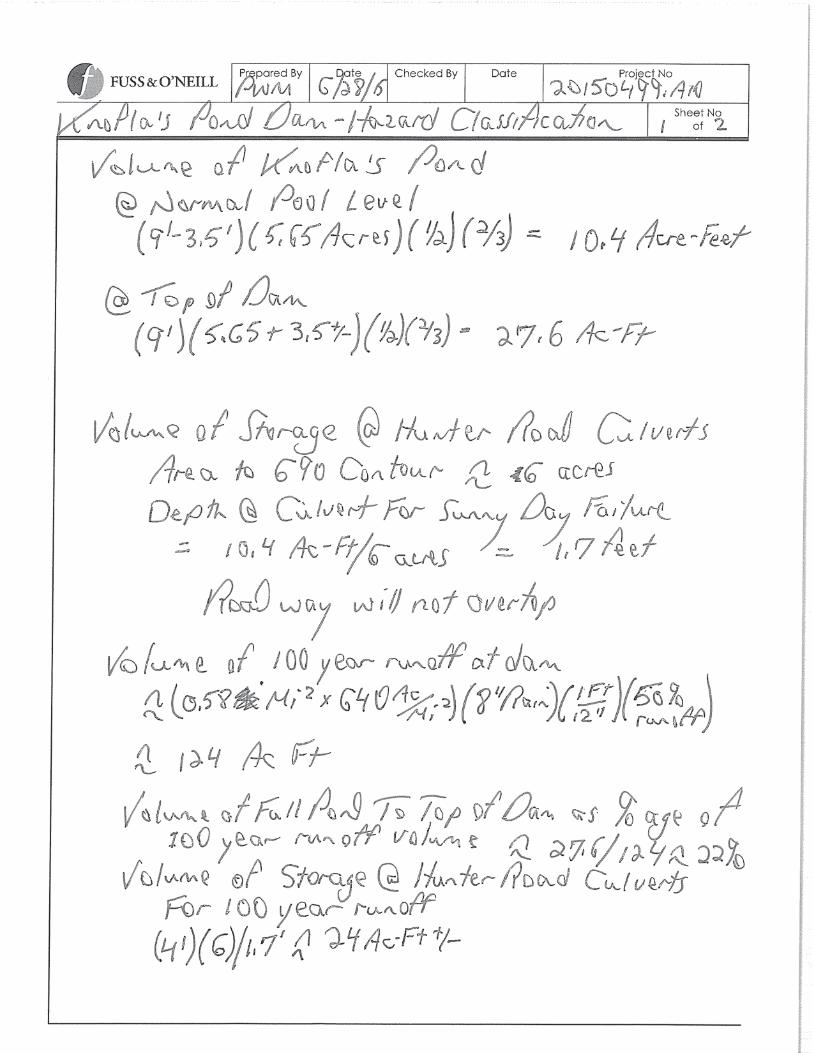
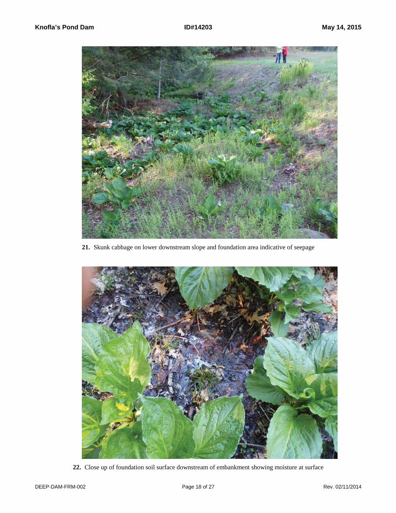
21. Skunk cabbage on lower downstream slope and foundation area indicative of seepage
22. Close up of foundation soil surface downstream of embankment showing moisture at surface

Knofla’s Pond Dam ID#14203 May 14, 2015
DEEP-DAM-FRM-002 Page 19 of 27 Rev. 02/11/2014
23. Minimal seepage at the embankment toe
24. First road crossing at Hunter Road

Knofla’s Pond Dam ID#14203 May 14, 2015
DEEP-DAM-FRM-002 Page 20 of 27 Rev. 02/11/2014
25. First road crossing at Hunter Road
26. First road crossing at Hunter Road

Knofla’s Pond Dam ID#14203 May 14, 2015
DEEP-DAM-FRM-002 Page 21 of 27 Rev. 02/11/2014
27. Some brush and saplings crowding auxiliary spillway outlet channel

Knofla’s Pond Dam ID#14203 May 14, 2015
DEEP-DAM-FRM-002 Page 22 of 27 Rev. 02/11/2014
Part XIV: SketchesThis completed report must include a sketch of the plan view of the dam to aid in the description of its condition. Refer to the instructions for more detail and an example.
[insert sketches here if not included in each part above].


Knofla’s Pond Dam ID#14203 May 14, 2015
DEEP-DAM-FRM-002 Page 23 of 27 Rev. 02/11/2014
Part XV: Professional Engineer CertificationThe following certification must be signed by a Professional Engineer
“I hereby certify that the information provided in this report has been examined by me and found to be true and correct in my professional judgment.”
Signature of Professional Engineer Date
Philip W. Moreschi, P.E. Vice President 12823Printed Name of Professional Engineer Title
Fuss & O’Neill, Inc.Name of Firm
CT P.E. Number
Affix P.E. Stamp Here
January 11, 2016


Knofla’s Pond Dam ID#14203 May 14, 2015
DEEP-DAM-FRM-002 Page 25 of 27 Rev. 02/11/2014
Appendix A: Overall Dam Condition Selection Standards
Condition Definition
Good Through file research and after a thorough visual inspection it has been determined that the dam is well maintained and no existing dam safety deficiencies are recognized. Only continued routine maintenance is required.
Satisfactory Through file research and after a thorough visual inspection it has been determined that no significant deficiencies are recognized. Only minor maintenance is required and only minor flaws are noted.
Fair Through file research and after a thorough visual inspection it has been determined that there are no critical deficiencies with the dam that would require engineering analysis with the following exception: the engineer may recommend that a hydrologic and hydraulic analysis be conducted due to the lack of adequate freeboard and/or the lack of spillway capacity documentation. A condition exists at the dam that may require some sort of additional monitoring.
Poor Through file research and after a thorough visual inspection it has been determined that deficiencies are recognized that require engineering analysis and/or remedial action.
Unsatisfactory Through file research and after a thorough visual inspection it has been determined that a deficiency is recognized that requires immediate or emergency action. Administrative/Enforcement action may be required as determined by the Dam Safety Program. Reservoir level restrictions may be necessary until the problem is resolved.

Knofla’s Pond Dam ID#14203 May 14, 2015
DEEP-DAM-FRM-002 Page 26 of 27 Rev. 02/11/2014
Appendix B - Hazard Classification of Dams
I. A Class AA dam is a negligible hazard potential dam which, if it were to fail, wouldresult in the following:
(i) no measurable damage to roadways;(ii) no measurable damage to land and structures;(iii) negligible economic loss.
II. A Class A dam is a low hazard potential dam which, if it were to fail, would result inany of the following:
(i) damage to agricultural land; (ii) damage to unimproved roadways (less than 100 ADT);(iii) minimal economic loss.
III.A Class BB dam is a moderate hazard potential dam which, if it were to fail, wouldresult in any of the following:
(i) damage to normally unoccupied storage structures;(ii) damage to low volume roadways (less than 500 ADT);(iii) moderate economic loss.
IV. A Class B dam is a significant hazard potential dam which, if it were to fail, would result in any of the following:
(i) possible loss of life;(ii) minor damage to habitable structures, residences, hospitals, convalescent homes, schools, etc;(iii) damage to or interruption of the use of service of utilities;(iv) damage to primary roadways (less than 1500 ADT) and railroads;(v) significant economic loss.
V. A Class C dam is a high hazard potential dam which, if it were to fail, would result inany of the following:
(i) probable loss of life;(ii) major damage to habitable structures, residences, hospitals, convalescent homes, schools, etc;(iii) damage to main highways (greater than 1500 ADT);(iv) great economic loss.

Knofla’s Pond Dam ID#14203 May 14, 2015
DEEP-DAM-FRM-002 Page 27 of 27 Rev. 02/11/2014
Appendix C - PHOTOGRAPH INSTRUCTIONSAll photographs shall be color photographs. Photographs shall be clear and include scale references where applicable. Photographs shall include, but not be limited to the following:
28. Overview of dam(s)/dike(s) from upstream
29. Overview of dam(s)/dike(s) from downstream
30. Overview of upstream face from right abutment
31. Overview of upstream face from left abutment
32. Overview of dam crest from right abutment
33. Overview of dam crest from left abutment
34. Overview of downstream face from right abutment
35. Overview of downstream face from left abutment
36. Overview of spillway(s) from upstream
37. Overview of spillway(s) from downstream (tailrace or channel area)
38. Overview of right training wall(s)
39. Overview of left training wall(s)
40. Overview of weir
41. Overview of stilling basin
42. Overview of downstream channel
43. Overview of gatehouse exterior
44. Overview of gatehouse interior
45. Overview of operators
46. Outlet inlets and discharge points
47. Overview of reservoir area
48. Areas of specific deficiencies (e.g., cracks, erosion, displacement, seeps, deterioration, etc.)

Other Informationfrom Part II


Town of Tolland May 27, 2015
1" = 1119 ft
Property InformationProperty ID 10/D/010Location 119 BAKOS ROADOwner TOWN OF TOLLAND
MAP FOR REFERENCE ONLYNOT A LEGAL DOCUMENT
The Town makes no claims and no warranties,expressed or implied, concerning the validity oraccuracy of the GIS data presented on this map.
Parcels updated October 1, 2013