Embed Size (px)
Citation preview
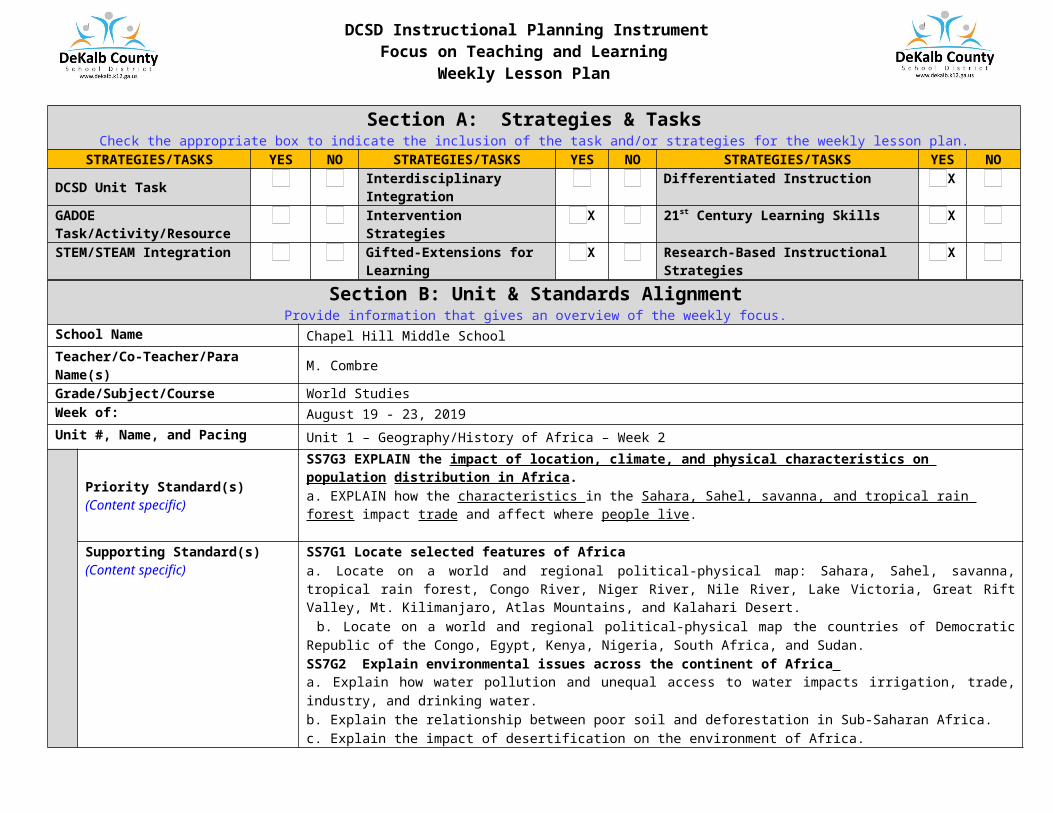
DCSD Instructional Planning InstrumentFocus on Teaching and Learning
Weekly Lesson Plan
Section A: Strategies & TasksCheck the appropriate box to indicate the inclusion of the task and/or strategies for the weekly lesson plan.
STRATEGIES/TASKS YES NO STRATEGIES/TASKS YES NO STRATEGIES/TASKS YES NODCSD Unit Task Interdisciplinary Integration Differentiated Instruction XGADOE Task/Activity/Resource Intervention Strategies X 21st Century Learning Skills XSTEM/STEAM Integration Gifted-Extensions for Learning X Research-Based Instructional Strategies X
Section B: Unit & Standards AlignmentProvide information that gives an overview of the weekly focus.
School Name Chapel Hill Middle SchoolTeacher/Co-Teacher/Para Name(s) M. CombreGrade/Subject/Course World Studies Week of: August 19 - 23, 2019Unit #, Name, and Pacing Unit 1 – Geography/History of Africa – Week 2
FOR
THE
WEE
K
Priority Standard(s)(Content specific)
SS7G3 EXPLAIN the impact of location, climate, and physical characteristics on population distribution in Africa. a. EXPLAIN how the characteristics in the Sahara, Sahel, savanna, and tropical rain forest impact trade and affect where people live.
Supporting Standard(s)(Content specific)
SS7G1 Locate selected features of Africaa. Locate on a world and regional political-physical map: Sahara, Sahel, savanna, tropical rain forest, Congo River, Niger River, Nile River, Lake Victoria, Great Rift Valley, Mt. Kilimanjaro, Atlas Mountains, and Kalahari Desert. b. Locate on a world and regional political-physical map the countries of Democratic Republic of the Congo, Egypt, Kenya, Nigeria, South Africa, and Sudan. SS7G2 Explain environmental issues across the continent of Africa a. Explain how water pollution and unequal access to water impacts irrigation, trade, industry, and drinking water. b. Explain the relationship between poor soil and deforestation in Sub-Saharan Africa. c. Explain the impact of desertification on the environment of Africa.
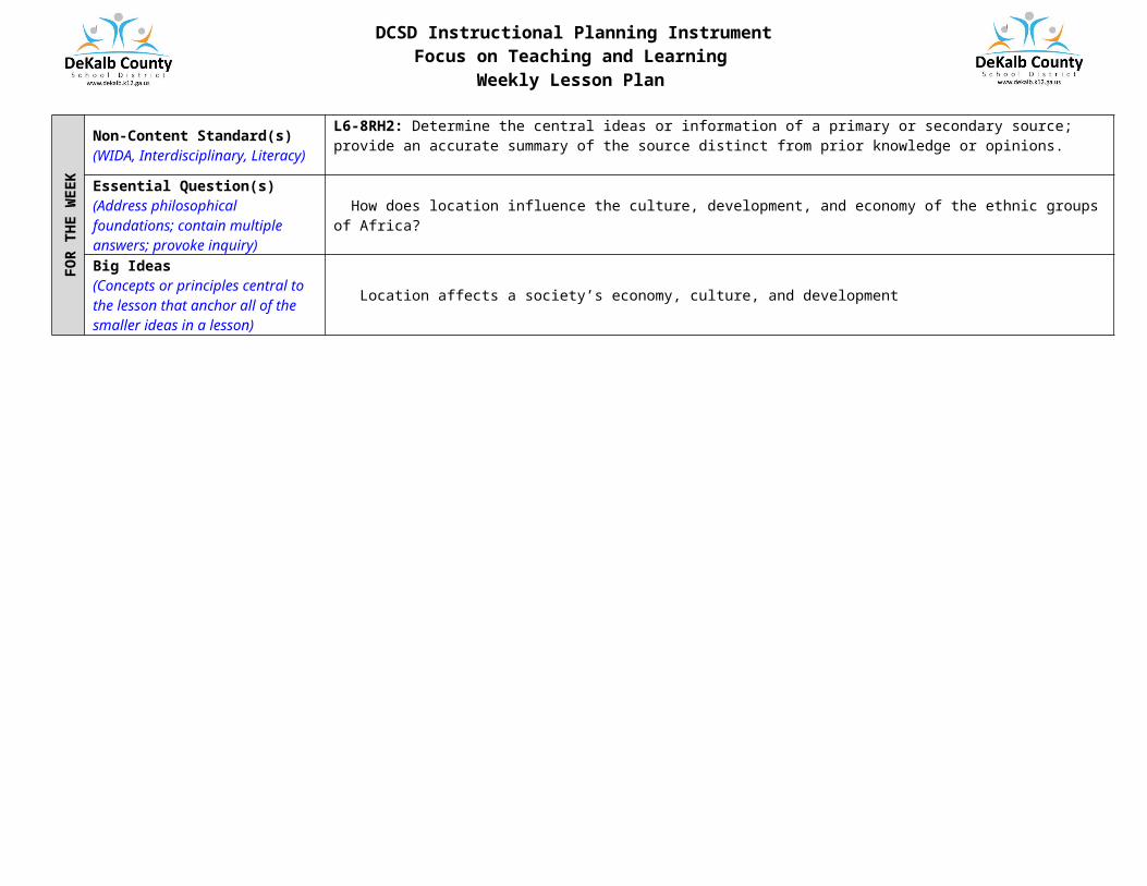
Non-Content Standard(s)(WIDA, Interdisciplinary, Literacy)
L6-8RH2: Determine the central ideas or information of a primary or secondary source; provide an accurate summary of the source distinct from prior knowledge or opinions.
Essential Question(s)(Address philosophical foundations; contain multiple answers; provoke inquiry)
How does location influence the culture, development, and economy of the ethnic groups of Africa?
Big Ideas(Concepts or principles central to the lesson that anchor all of the smaller ideas in a lesson)
Location affects a society’s economy, culture, and development
DCSD Instructional Planning InstrumentFocus on Teaching and Learning
Weekly Lesson Plan
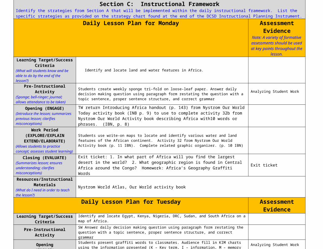
Section C: Instructional FrameworkIdentify the strategies from Section A that will be implemented within the daily instructional framework. List the specific strategies as provided on the strategy chart found at the end of the DCSD Instructional Planning Instrument.
Daily Lesson Plan for Monday Assessment Evidence Note: A variety of formative
assessments should be used at key points throughout the lesson.
Learning Target/Success Criteria(What will students know and be able to do by the end of the lesson?)
Identify and locate land and water features in Africa.
Pre-Instructional Activity(Sponge; bell-ringer; journal; allows attendance to be taken)
Students create weekly sponge tri-fold on loose-leaf paper. Answer daily decision making question using paragraph form restating the question with a topic sentence, proper sentence structure, and correct grammar
Analyzing Student Work
Opening (ENGAGE)(Introduce the lesson; summarizes previous lesson; clarifies misconceptions)
TW return Introducing Africa handout (p. 143) from Nystrom Our World Today activity book (INB p. 9) to use to complete activity 32b from Nystrom Our World Activity book describing Africa with10 words or phrases. (IBN, p. 8)
Work Period(EXPLORE/EXPLAIN
EXTEND/ELABORATE)(Allows students to practice concept; assesses student learning)
Students use write-on maps to locate and identify various water and land features of the African continent. Activity 32 from Nystrom Our World Activity book (p. 11 IBN). Complete related graphic organizer. (p. 10 IBN)
Closing (EVALUATE)(Summarizes lesson; ensures understanding; clarifies misconceptions)
Exit ticket: 1. In what part of Africa will you find the largest desert in the world? 2. What geographic region is found in Central Africa around the Congo? Homework: Africa’s Geography Graffiti Words Exit ticket
Resources/Instructional Materials(What do I need in order to teach the lesson?)
Nystrom World Atlas, Our World activity book
Daily Lesson Plan for Tuesday Assessment Evidence Learning Target/Success Criteria Identify and locate Egypt, Kenya, Nigeria, DRC, Sudan, and South Africa on a map of Africa.
Pre-Instructional Activity SW Answer daily decision making question using paragraph form restating the question with a topic sentence, proper sentence structure, and correct grammar
Opening(ENGAGE)
Students present graffiti words to classmates. Audience fill in KIM charts using the information presented (K – Key term, I – information, M – memory clue visual or diagram).
Analyzing Student Work
Work Period(EXPLORE/EXPLAIN
EXTEND/ELABORATE)
TW introduce the countries of Africa using a map of the continent displayed on the eboard pointing out the six countries in SS7G1 – Egypt, Kenya, Nigeria, DRC, Sudan, and South Africa. SW label these countries on their outline map handout and color coding them. Students use desk atlases and textbooks to label and color the rest of the countries on outline maps
Closing(EVALUATE)
TW demonstrate the use of the website Sheppard’s Software as a study/practice tool for learning maps. Students complete outline maps for HW if necessary. (p. 13 IBN)
Resources/Instructional Materials Outline maps, handouts, maps, eboard
Daily Lesson Plan for Wednesday Assessment Evidence Learning Target/Success Criteria Identify physical features of Africa on a map - Sahara, Sahel, savanna, tropical rain forest, Congo River,
Niger River, Nile River, Lake Victoria, Great Rift Valley, Mt. Kilimanjaro, Atlas Mountains, and Kalahari Desert
Pre-Instructional Activity SW Answer daily decision making question using paragraph form restating the question with a topic sentence, proper sentence structure, and correct grammar
Opening(ENGAGE) Review the location of African countries in the standard using Sheppard’s Software. Analyzing Student Work
Work Period(EXPLORE/EXPLAIN
EXTEND/ELABORATE)TW distribute outline map handout with physical features labeled. (p. 15 IBN) SW write a description of each geographic features location. (p. 14 IBN) Color outline map and create a key for each geographic region.
DCSD Instructional Planning InstrumentFocus on Teaching and Learning
Weekly Lesson Plan
DCSD Instructional Planning InstrumentFocus on Teaching and Learning
Weekly Lesson Plan
This page is for informational purposes only as lesson plans are developed. Do not attach this page to the weekly lesson plan.
Section D: Strategy Chart
Research-Based Instructional
Strategies(weekly strategies chosen to guide
teaching and learning)
Opening Work Period ClosingActivate Prior KnowledgeProvide FeedbackQuestioning (Raises questions)Scaffold InstructionClarify Previous LessonCreate InterestPhenomenonOther…
Facilitate LearningDemonstrate/ModelAcademic DiscussionsHigh-level QuestioningCooperative LearningIndependent LearningInterdisciplinary WritingExplain/Apply/Extend concepts and skillsGenerating and Testing HypothesesOther...
Summarize LessonsAllow students to assess their own learningProvide Alternative ExplanationsQuick WriteRespond to Essential Questions3-2-1/K-W-LOther…
21st Century Learning Skills
(weekly strategies chosen to guide student engagement)
Teamwork and CollaborationInitiative and LeadershipCuriosity and Imagination
Innovation and CreativityCritical Thinking and Problem SolvingFlexibility and Adaptability
Accessing and Analyzing InformationEffective Oral and Written CommunicationOther…
Intervention Strategies
Intervention Strategies(Tiers 1, 2, 3)
Additional Support in Classroom
Specially Designed Instruction for Exceptional Education Students
Strategies for English Language Learners
Re-VoicingExplainingPrompting for ParticipationChallenging or counteringAsking “Why?” or “How?”RereadPractice new academic vocabularyAssistive technologyPre-teach & re-teach in a different wayUse of manipulativesCollaborative workCreate differentiated text sets
ConferencingAdditional timeSmall group collaborationModify quantity of workTake student’s dictationScaffold informationDifferentiated (content/process/product)Consistent reward systemRefer to students’ IEP or 504 planAssistive technology
Visuals/RealiaFront-loadingEchoing/Choral responseColor-codingMultiple exposures in different mediaPair-shareModelingLanguage scaffolds: example: sentence framesDeconstruct complex sentencesIncrease student-to-student talkStrategies vocabulary instructionAdditional think time
GiftedExtensions for
Learning
Tier 1 Tier 2 Tier 3 Tier 4Flexible-Learning GroupsChoice of BooksHomework OptionsUse of Reading BuddiesVarious Journal PromptsStudent/Teacher Goal SettingVaried Pacing with Anchor OptionsWork Alone or TogetherFlexible SeatingVaried ScaffoldingVaried Computer ProgramsDesign-A-DayVaried Supplemental MaterialsComputer MentorsThink-Pair-ShareOpen-ended ActivitiesExplorations by InterestOptions for Competition
Gifted Edu. Cluster ClassesGifted Edu. Collaboration ClassesTiered Activities and ProductsUse of Literature ClubsMultiple Testing OptionsMultiple TextsAlternative AssessmentsSubject Advancement within classCurriculum CompactingTiered CentersSpelling by ReadinessVarying OrganizersCommunity MentorshipsStationsGroup InvestigationsAssess Students in Multiple WaysStudent ChoiceSimulations
Advanced Content (all core content)Resource ClassesIndependent/Directed StudySocratic Seminars
Above grade level accelerated (all core content)Advanced Placement ClassesInternational Baccalaureate ClassesInternshipsMentorships
Assessment Evidence
(Formative)
Analyzing Student WorkRound Robin ChartsStrategic Questioning3-Way Summaries
Think-Pair-Share3-2-1 CountdownClassroom PollsExit/Admit Tickets
One-Minute PaperMetacognition TableFour CornersSelf-Evaluation
Stop and GoClasswork Trade/Peer ReviewLearning LogsDocument Observations