Embed Size (px)
Citation preview
D. Flood Management 1. Introduction
2. Managing floods in The Netherlands 2.1 Flood frequency and protection. 2.2 The Rhine river basin 2.3 Problems and solutions 2.4 Managing risk 2.5 Dealing with uncertainties 2.6 Summary
3. Flood management on the Mississippi
3.1 General history 3.2 Other considerations 3.3 Interactions among user groups 3.4 Creating a flood management strategy 3.5 The role of the government and NGOs
4. Decision support and prediction 4.1 Floodplain modeling
4.2 Integrated 1D-2D modeling
5. Conclusions
6. References
Floods are always in conflict with floodplain development. No amount of structural
protection will remove the risk of being damaged by flood flows and the mud and debris
and pollution that accompanies them. Hence the challenge is to be prepared to manage
floods and mitigate the resulting damage when floods occur. In short this means
allowing space for floods when they occur and keeping that space available when they
are not occurring. The challenge is finding the mix of open space and development on
floodplains that maximize the net expected monetary, environmental, and social benefits
derived from them. This chapter discusses some floodplain management approaches
being considered in Europe and in North America, both motivated by the extreme flood
events that occurred in the mid 1990s and early 2000s. Time will tell if any of these
approaches are successfully implemented. 1. Introduction Just as droughts are defined as unusual scarcities or deficits of water, floods are defined as
unusual surpluses or excesses of water. The result is higher than usual water levels that
extend out onto floodplains. They occur in river basins usually as the result of a lot of rain.

They occur along coastal areas usually as the result of severe storms, and rarely as the result
of earthquakes. Floods are natural events. Flood damage usually results because humans and
their structures occupy the space needed to store the excessive amounts of water. When a
flood comes, as it will, these objects get wet. To the extent structures occupy some of the
space floods need, flood levels increase, thereby flooding larger areas. The occurrence of
flood events is not often enough to keep reminding people that flood plains can and do get
wet. Flooded buildings and sandbags, such as shown in Figures D.1 and D.3, are symbolic of
what happens on occasion when flood plains are used, and often beneficially used, for other
incompatible activities.
In mid August 2002 it rained a lot in Central Europe. Floodwaters inundated floodplains
along three major rivers, claiming around 100 lives and causing over 10 billion euros of
damage to property in Germany, Russia, Austria and the Czech Republic. The upper left
image in Figure D.1 illustrates a small but particularly damaging part of that flood in the
historic portion of Dresden, Germany. The map in Figure D.2 shows the affected rivers.
Figure D.1 Scenes of flooding, the efforts made to prevent flood damage, and coping at
times of high flows and water levels.

Figure D.2. The Rivers Danube, Elbe and Vltava in Central Europe experienced their most
extreme flood of record in August 2002
The top image in Figure D.1 shows the River Elbe (Figure D.2) flooding the historic portion
of Dresden in mid August 2002. This flood of record exceeded the highest of floods in 157
years of records. Central Europe was not the only place getting flooded in the summer of
2002. By August of that year, flooding across Asia had claimed an estimated 1,800 lives.
The waters of Dongting Lake and the Xiangjiang River (Figure D.3), which flows through the
provincial capital of Changsha, were near all-time highs. If the sandbag dikes (middle image
of Figure D.1) had failed around the 2,800 square-kilometer (1,070 square-mile) Dongting
Lake, that acts as a giant overflow for the flood-prone Yangtze River, over 10 million people
and 667,000 hectares (1.6 million acres) of fertile crop land would have been flooded.
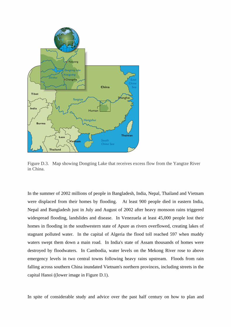
Figure D.3. Map showing Dongting Lake that receives excess flow from the Yangtze River in China.
In the summer of 2002 millions of people in Bangladesh, India, Nepal, Thailand and Vietnam
were displaced from their homes by flooding. At least 900 people died in eastern India,
Nepal and Bangladesh just in July and August of 2002 after heavy monsoon rains triggered
widespread flooding, landslides and disease. In Venezuela at least 45,000 people lost their
homes in flooding in the southwestern state of Apure as rivers overflowed, creating lakes of
stagnant polluted water. In the capital of Algeria the flood toll reached 597 when muddy
waters swept them down a main road. In India's state of Assam thousands of homes were
destroyed by floodwaters. In Cambodia, water levels on the Mekong River rose to above
emergency levels in two central towns following heavy rains upstream. Floods from rain
falling across southern China inundated Vietnam's northern provinces, including streets in the
capital Hanoi ((lower image in Figure D.1).
In spite of considerable study and advice over the past half century on how to plan and

manage floods and in spite of increasing amounts of money being spent on flood protection,
annual flood damages are increasing almost everywhere. In some years, like 2002, the
damages can be quite substantial.
Of the major floods that occurred in last decade of the last century, one (in 1993) was on the
Mississippi River and some of its tributaries in central US, and two (in 1993 and 1995) were
on the Rhine River. Both rivers are major multipurpose waterways serving many different
interests, including barge transport, which is critical to the economy of the regions they flow
through.
How can floods be managed? How can humans live with floods that some believe are
becoming more frequent and more severe? This chapter discusses approaches to floodplain
management in The Netherlands and in some parts of the United States. In both cases the
goal is to avoid the continuing spiral of increasing costs, both for flood protection, and then
for flood damage recovery when the protection measures fail. (Additional information on
flood modeling and risk assessment is in Chapters VIII (A and C) and X.)
2. Managing floods in The Netherlands
2.1 Flood frequency and protection.
Much of the land surface in The Netherlands is below sea level. Thus it is not a surprise that
those who live in The Netherlands place a high priority on safety against flooding. Levees
(dikes) protect the economically important low-lying part of the Netherlands – roughly the
western half of the country. The design levels of these levees are linked to the frequency of
occurrence of a certain flood stage. The particular frequencies of occurrence, or risk levels,
are determined by the national Parliament. Levees along the coasts of densely-populated and
highly industrialized parts of the country are to be designed to protect from all storms whose
magnitudes would be exceeded only once in 10,000 years on average. In other words, the
levees could fail but only for storms that exceed that 10,000-year storm. The probability of
such a failure happening in any year is 1/10,000 or 0.0001. Of course there is no guarantee it
could not happen two successive years in a row. Based on methods discussed in Chapter VIII
(A), the probability of having at least one storm that exceeds the design capacity of the levee
at least once in a 50-year period is 0.005. While considerably greater than the probability

(0.0001) of it happening in any particular year, this is still a low probability. The Dutch are
not risk prone when it pertains to floods.
For the less densely populated coastal areas the design risk level is increased to storms
expected once per 4,000 years, i.e., those having a probability of 0.00025 of being exceeded
in any given year. Along the Rhine and Meuse Rivers, the flood frequency is once per 1,250
years, or a probability of 0.0008 of being exceeded in any given year. These so-called design
floods also constrain all landscape planning projects in the floodplain. Proposed river works
for nature restoration, sand mining or any other purpose, need formal approval as stated in the
River Act.
The condition of flood control works, levees and fairways is monitored regularly. Every 5
years a formal report on flood safety is made. This involves re-determining the design floods
using statistical analysis of river flows in the period 1900 to date. Furthermore, data
regarding river cross-sections and vegetation types and densities are updated. Based on that
information, the design flood levels are assessed, taking into account effects of wind set-up
and a freeboard margin of half a meter (20") for overtopping of the levee crests. If pre-
established flood risk level tolerances are being exceeded, actions must be taken to reduce
these excess risks.
While the principal objective is to protect places where people live, work and spend their
leisure time, a secondary objective is to preserve the quality of the spatial environment
including natural as well as cultural and historical sites. The socio-economic interests of
many sectors of society are considered when designing alternatives for flood risk reduction.
2.2 The Rhine river basin The Rhine, one of the largest rivers in Europe, extends 1,320 km through Switzerland, France,
Germany and The Netherlands. Its flow enters The Netherlands at Lobith and travels another
170 km until it reaches the North Sea. The Rhine catchment area, shown in Figure D.4,
covers some 185,000 km2, draining parts of nine countries.

Figure D.4 River Rhine drainage basin. The river enters The Netherlands at Lobith.
The River Rhine now has a combined rainfall-snow melt driven flow regime. The winter
season shows the largest discharges originating from precipitation in the German and French
parts of the basin. Summer discharges originate mainly from melting snow in the Swiss Alps
when evaporation surpasses precipitation in the lowland region. Modern climate scenarios
show a temperature rise combined with a rainfall increase during winter in the basin.

According to these scenarios the river Rhine could change from a combined snowmelt - rain-
fed river into an almost completely rain-fed river. If that happens, both floods and dry spells
could become more frequent.
To maintain the same flood safety standards, additional flood protection measures will be
necessary in future. Water supplies in future will be limited when they are most needed and
dry spells will likely occur more often. Also water quality may decrease both due to higher
concentrations of pollutants and longer residence times of the water behind weirs. This
means that preservation of water for use in dry periods could become necessary. Flood
plains may be more frequently inundated.
The Netherlands is at the end of the Rhine. It contains the Rhine Delta. That delta comprises
more than half of The Netherlands. A river often divides into multiple branches in its delta.
The River Rhine is no exception. In this case, the so-called Rhine Branches are the Waal, the
Neder-Rijn/Lek and the Ijssel, as shown in Figure D.5. Along the Rhine branches, flood
levels are fully determined by the Rhine discharge. The area where the water levels are no
longer determined solely by river discharge, but are also under the influence of the tidal effect
of the sea, is referred to as the lower river region. In total the low flow channel and the flood
plains in the Netherlands cover an area of approximately 500 km2.

Figure D.5 The Rhine Branches and their floodplains in The Netherlands. The purple areas
shown on the map of The Netherlands are subject to flooding and hence need dike protection.
To make and keep inhabitable that portion of The Netherlands that is below sea level, dikes
have been built. As early as the mid-14th century, a nearly completely connected system of
dikes arose that created the landscape of The Netherlands up to the present day. There are
two dikes on each side of a floodplain: the summer dikes and the winter (flood season) dikes.
These are shown in Figure D.6.

Figure D.6 Two-tier dike structures and groynes for flood protection along the rivers in The
Netherlands.
Design flow water levels in the river are mostly determined by the room that is present in the
riverbed and by the flow resistance that the water encounters from embankments and
vegetation and other obstacles in the floodplain. The relation between design discharge and
design water levels is therefore not entirely fixed, but is dependent upon the width and depth
of the riverbed, the height of the floodplains, and the flow resistance, and the wind and wave
effects. Finally, an extra height is added to the dike to equip it with an inspection path that
keeps the dike passable, and to compensate for any subsidence of the embankment. In the
lower river region, the design water levels are calculated using computer simulation models
based on a large number of combinations of Rhine and Maas discharges, the sea level and the
possible failure of the coastal flood barriers in the Rotterdam area.
The design height of a dike is the water level whose chance of occurrence is linked to the
level of protection that has been chosen for the protected regions. As already mentioned,
practically all of the dikes along the Rhine Branches have a protection level of 1/1250 per
year. This means that the chance that the water level in a particular year will be higher than
the design water level is less than 1/1250. In the western part of The Netherlands, the
protection levels are higher, namely 1/2000 up to 1/10,000 per year for ’Central Holland’
where large cities such as Rotterdam and The Hague are located. Here the population density
and economic interests are larger, but also so is the difficulty of predicting a storm at sea.

Floods from seawater can result in substantial casualties and economic damage due not only
to getting wet, but also getting salty.
Two movable gates protect the entrance to the Rotterdam harbor, as shown in Figure D.7.
Each gate is about as long as the Eiffel tower is tall and contains over twice the weight of
steel.
Figure D.7. A drawing and photograph of the waterway storm surge barrier in the closed
position at Rotterdam, the largest hydraulic project in The Netherlands.
In 1995 – after a long period of relative freedom from floods – the River Rhine region
witnessed a flood. That flood was not only the highest one since 1926, it was also one that
was long in duration. Approximately 250,000 people were evacuated for a little under a week
due to the questionable stability of saturated dikes that had been exposed to long-term
flooding. This flood – together with the flood of 1993 and the comparable events along the
River Maas (Meuse), the second largest river in The Netherlands – motivated government
agencies to give some priority to flood safety and flood risk reduction in the river regions.
Thanks in part to its location in the Rhine Delta The Netherlands has been able to flourish
economically. Rotterdam is one of the largest harbors in the world with a large and rich
hinterland. Agriculture in The Netherlands has been able to profit from the rich soils that the
Rhine has deposited. The economically strong position of The Netherlands is also due in part
to the dikes. At the same time, the dikes have now come to represent a sort of Achilles’ heel
for The Netherlands.
A large part of The Netherlands lies below the high-water level of the major rivers. The sea
level currently is gradually rising as a result of climate change. This same climate change
together with watershed land use changes within and upstream of The Netherlands can cause
the peak discharges on the Rhine and Maas to increase. In the meantime, the area protected
by the dikes has been sinking, primarily due to subsidence and oxidation of peat, because the
soil is so ‘well’ drained. This has increased the difference between water levels in the area
protected by the dikes and the area outside of the dikes.
The population in the area protected by the dikes, the land use intensity, and the capital
investment have all rapidly increased. As a result, the adverse economic and emotional
consequences of a flood, or even an evacuation due to flood risk, have increased substantially.
Yet there is a limit on just how much more heightening and reinforcing of dikes is reasonable.
The public has made it clear they do not want dike heights increased. Many feel too boxed in
as it is, in this crowded country. Today a more natural solution is sought.
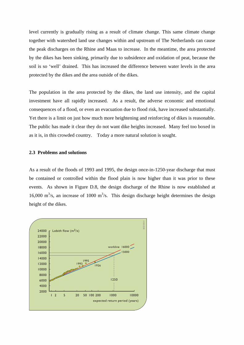
2.3 Problems and solutions
As a result of the floods of 1993 and 1995, the design once-in-1250-year discharge that must
be contained or controlled within the flood plain is now higher than it was prior to these
events. As shown in Figure D.8, the design discharge of the Rhine is now established at
16,000 m3/s, an increase of 1000 m3/s. This design discharge height determines the design
height of the dikes.

Figure D.8. Re-evaluation of design flood flows for the River Rhine in The Netherlands.
Without further measures, this means higher dikes. Due to climate change, the design
discharge will most probably further increase to 18,000 m3/s by 2050 – 2100. At the same
time, the sea level is expected to rise, causing backwater effects in the estuaries and rivers.
Given this increase in the design water level, one could argue that the dikes should be made
higher and stronger. If this is not done, the probability of floods toping the dikes will
increase. However, the higher the dikes, the more severe the impacts will be once a dike fails.
The dikes protect often low-lying ‘polders’, whose potential flooding depths already exceed
several meters. If nothing is done to change the available room that exists for the Rhine river
flood flow, this will lead to 20 to 30 cm higher design water levels in the short run, and up to
90 cm higher design water levels in the long run factoring in climate change impacts. This
will necessitate higher dikes in order to maintain the current level of flood protection. The
higher the river water level, the larger the consequences should a major flood occur that
exceeds the dike capacity. But higher flood protection dikes are not going to be a problem,
since the public has made it clear they are against that option. So, how to provide the extra
protection needed to meet the design risk criteria established by the Dutch Parliament?
The challenge is to create and execute measures that – despite the higher design discharge
that must be contained – negates the need for additional dike heightening. The only way to
do that is to create more space for water to flow at existing dike levels. This means increasing
the widths or depths of the rivers or their floodplains and by providing flood overflow areas
outside the diked floodplain for use when the space within the dikes is full. Specific
floodplain planning and designs needed to cope with the design flow of 16,000 m3/s are be
implemented by 2015.
2.4 Managing risk
There is always the possibility that the water level along a river will exceed the design dike
capacity. The desired level of safety is a matter of societal choice. If society would want
complete and total safety the only way to achieve that would be to move out of the flood

plain. For natural phenomena such as wind, rain and river discharge, there are no absolute
known upper limits. There are thus no absolute protection guarantees; a finite risk of flooding
will always exist. What society can do however is to protect to the extent they deem
appropriate and to prepare for flood events that exceed the design capacity of any
implemented protection works. Controlled flooding in emergency overflow areas is one way
to manage flood events that exceed the design water levels.
The notion of flood risk considers both the chance of a flood and the adverse consequences of
that flood. Minimizing the chance of getting wet is not the only possible risk reduction
option. Diminishing the adverse consequences of getting wet also reduces risk. This idea in
particular underlies the design of emergency overflow areas: better a controlled flood with
minor damage than an uncontrolled flood with major damage.
It is technically possible to continue raising dike heights, now and on into the future, just as
has been done in the past. But Dutch society has made it clear that this is undesirable. Dike
reinforcements bring with them increasingly more negative consequences for landscape,
nature and cultural historical values. And as the difference in height between the water level
in the river and the area protected by (behind) the dikes continues to increase, the flood risk
also increases. The larger population and capital investment in the area protected by the dikes
already make uncontrolled floods more drastic events than they were some 20 to 50 years ago.
Moreover, the perception of safety increases as the dikes are made higher and more heavily
reinforced, which leads to an increase in infrastructure investment, which leads to greater land
value and hence potential loss should a flood occur, which justifies further flood protection
investments, …. and so on.
It is for this reason that a policy is needed for breaking this trend. Such a policy needs to:
• anticipate floods instead of only reacting to them;
• make more room to water, besides relying on technical measures such as dike
heightening; and
• prevent the transfer of water problems to downstream areas by means of the
succession: detain – store – discharge.

This requires river widening and deepening measures to prevent new design flood flow water
levels from exceeding current dike heights.
Past human interventions have resulted in 1) erosion of the low flow channel in upstream
sections in reaction to maintaining the navigation channel, 2) sedimentation in the low flow
channel in the downstream sections after closing off estuaries, and 3) the silting-up of flood
plains due to constructing dikes and summer embankments. These processes increase the
elevation of the flood plains with respect to the low flow channel. At the same time the area
protected by the dikes is subsiding due to drying out and oxidation of the peat soils. All of
this results in higher river levels above the surface of the land protected by (behind) the dikes
than they are above the land adjacent to the river in front of the dikes.
There are several ways to maintain design water levels as design discharges increase in the
Rhine:
• keep water in the catchment area upstream of The Netherlands;
• store (extra) water along the Rhine Branches in The Netherlands; and
• discharge (extra) water via the Rhine Branches.
The first alternative attempts to ensure that the upstream precipitation does not lead to higher
discharges downstream at a later time. This requires measures in the catchment area upstream
of The Netherlands - namely in Germany, such as changes in land use or detention.
Comparable measures in The Netherlands may also help to reduce the additional flow to the
Rhine Branches from tributary streams and canals.
Alternatives for storing and discharging floodwaters can be implemented in The Netherlands.
The storage of river water in detention areas along the Rhine Branches leads to lower peak
flows. This lowers the water levels downstream of the detention areas. On the contrary,
measures that increase the discharge capacity of the riverbed reduce the water levels upstream
of the measure. Examples include the removal of obstacles in the winter bed such as high
lying areas, ferry ramps, or bridge abutments, excavation of the flood plains, lowering of
groynes or wing dikes, dredging of the low flow channel, and setting back the dikes. Some of
these options are illustrated in Figures D.9, D.10 and D.11.

Figure D.9. Alternatives to dike heightening for increasing flood flow capacity of rivers.

Figure D.10. Alternatives to dike heightening are, from top to bottom, setting back dikes,
deepening low flow channel, detention reservoirs, removal of hydraulic bottle necks, lowering
groynes, and lowering floodplains.

Figure D.11 Bridge abutments and supporting structure, before (left) and after (right)
floodway modification.
An important condition for such projects as illustrated in Figures D.9 through D.11 is that
they must allow at least an increase in the design flow from 15,000 to 16,000 m3/s. A further
condition is that they cannot change the proportions of river flow that enter each of the Rhine
Branches in The Netherlands.
2.4.1 Storage
Storage reduces discharge. Storage is helpful for practically the entire area downstream of
the storage basin. For controlled flooding in a way that limits damage, emergency overflow
and temporary storage areas are being considered. A segment of the discharge peak could be
attenuated by temporarily storing it in a diked area. After the flood peak has passed through,
the temporarily stored water can be released.
Since the desired effect of a detention area occurs downstream from the area itself, a location
as far upstream as possible is preferred. In The Netherlands, detention areas close to the
German border are thus the most appealing.
The total detention (storage) capacity necessary to maintain a given flood height depends on
the shape and duration or length of a flood wave. For example, a storage capacity of more
than 150 million m3 would be required to reduce the peak flow by 1,000 m3/s of a flood wave
lasting several days and having an ‘average’ shape. This in turn would require a detention
area of some 3,000 hectares (30 km2) flooded to a depth of 5 meters. In areas with less
depth, the surface area must be proportionately larger.
Detention areas require enclosure dikes and intakes, both of which can be extensive.
Implementing detention areas also usually involves landowner evacuation and compensation
for any damage occurring during occasional flooding. All of these factors add to the cost of
detention measures.
Detention areas are seldom necessary, and in this case the probability of them being needed in
any year is approximately 1/500, as seen from Figure D.8. This low probability can be a
problem. The less often an area overflows, the more the societal pressure will be to develop it
and safeguard it against flooding. After many years without floods, people may begin to
think that these detention areas will never be needed for flood detention. The result: flood
flow restricting activities will begin to encroach on that land. The additional flood protection
provided by that detention area would then be decreased if not entirely lost. Perhaps this
suggests the need to periodically let some water flow into these areas during high river flows,
even when it need not have been necessary, and/or alternatively to allow it to become an open
recreation or nature area.
For detention areas to be effective during flood events a reasonable amount of precision in
their operation is required. They must not fill up too soon, because they run the risk of being
full before the actual peak discharge has arrived. If it cannot store some of the peak flow,
when the peak flow arrives, it will have no effect in lowering the maximum flood stage. A
similar danger exists for a very lengthy, flattened flood wave, or when a second peak occurs
soon after the first, and the detention area has not emptied.
Detention basins must also not fill up too late, because the discharge peak will already be
over. All these considerations imply that accurate predictions for the timing and shape of the
discharge must be available if detention basins are to be used effectively.
In the past, detention basins were usually filled via a fixed sill, a lowered section of the dike
that allows overflow to take place in a ‘controlled’ manner, ideally uniformly over the entire
length of the sill. It is still very difficult to design a sill that will insure a uniform overflow
over a substantial length. By employing a human operated (regulated) intake, this problem

may be overcome. However people have had bad experiences with regulated intakes. The
residents of an area are never in favor of the idea that inundation might occur, and if some
person is making it occur a conflict with the responsible organization or agency, if not the
operator, is inevitable.
2.4.2 Discharge increasing measures
Measures taken to increase the discharge capacity can also reduce water levels while
maintaining the same design discharge. In contrast to storage, however, increasing the
discharge capacity is only advantageous for a limited river section.
With discharge-increasing measures, it is not only the height reduction but also the distance a
measure covers that is important. The distance depends on factors such as the steepness of
the water level slope, the location of the dikes on the floodplain, other obstacles are in the
area, the hydraulic roughness of the vegetation in flood plains, and so on.
There are many measures available for reducing the stage of a particular design discharge.
Three major ones include:
• increasing the flow capacity in the low flow channel;
• increasing the flow capacity in the floodplains; and
• providing flood storage capacity in the areas protected by (behind) the dikes (such as
setting back dikes, detention basins, etc.).
As mentioned earlier, in downstream sections sedimentation occurs and this requires regular
dredging. Dredging to deepen the low flow channel in the downstream sections can lead to a
water level reduction. However, dredging the low flow channel can accelerate erosion
upstream. Thus to maintain the desired design water level, continual dredging may be
required.
Alternatives to dredging include groynes or wing dikes (Figures D.6, D.9, and D.10).
Groynes were constructed in the past to ensure that the river retained a sufficient depth
without continual dredging. They also tend to prevent sand banks. Groynes guide the river

flow to the middle of the channel and ensure that the depth of the river is maintained for a
pre-determined width. This is particularly important for navigation.
Removal of the groynes would result in a decrease in flow velocities and the river would
become shallower in places. Sandbanks might even form in the middle of the river. With few
exceptions shortening or removing groynes is an option only if the shipping function of the
river were to be discontinued, and of course in the Rhine River it is not.
It appears from simulations that lowering of groyne heights can contribute to a reduction
varying from 5 to 15 cm in the water level on the Waal and the IJssel. On the Neder-Rijn, the
maximum reduction is 10 cm. This may not seem like much, but on the other hand, the costs
of groyne lowering are relatively low. Thus this measure is relatively cost effective.
Excavation of the flood plains and the removal of hydraulic bottlenecks can also be
considered. Flood plain excavation is a measure by which the gradual height increase caused
by sedimentation on flood plains may be counteracted. Floodplain excavation may be
combined with clay mining, and dike reinforcement, and/or with nature development. Nature
development is often a reasonable use of an excavated floodplain since excavation makes land
less profitable for agriculture, particularly if the summer embankments are also removed in
the process. Moreover it appears that after excavation, nature development produces a result
that is valued by many. Nature development without floodplain excavation however pushes
water levels upward since rough vegetation, scrub, and wooded areas can slow down the
discharge. Thus nature development requires additional excavation to compensate for the
backwater effect of the vegetation.
While floodplain excavation is an effective way to reduce flood heights it is also the most
expensive measure. If floodplain excavation were to be implemented along all three Rhine
Branches, the costs involved would total between 3 and 4 billion euros. Soil excavation is
expensive in and of itself, but it is the necessary storage and containment of contaminated soil
that substantially increases the costs. Roughly 15 to 20% of the soil on the Rhine floodplains
is actually contaminated and another 40 to 50% is unusable as building materials.
Storing the contaminated soil safely and locally in existing deep ponds or in sand excavation

pits after usable material has been removed, so-called ‘earth-swapping’, can achieve
substantial cost savings, from 1 to 1.5 billion Euros.
The removal of hydraulic obstacles in the floodplain is another way to increase its discharge
capacity without increasing its water level. Examples of hydraulic bottlenecks include ferry
ramps, bridge abutments (Figure D.11), high-lying areas (Figure D.12), summer
embankments that are high and/or perpendicular to the flow direction, narrowing of
winterbeds (Figure D.13) and other obstacles. Hydraulic bottlenecks may be identified by
studying the water level slope of the river. Typically there is a direct relation with structures
and a change in the water level slope.
Figure D.12. Removal of high lying areas on a floodplain
Removing bottlenecks can decrease design flow water levels. This decrease together with its
cost can be calculated. The costs of replacing bridge abutments by bridge sections (Figure
D.11) and the removal of ferry ramps vary from less than 2.5 million euros to more than 75
million euros for a large bridge. The costs of removing embankments and small-scale setting
back of dikes (Figure D.13) are usually on the order of 5 million euros per project, but they
can run up to over 15 million if many houses must be expropriated. The costs for removing
high-lying areas (Figure D.12) can amount to 30 million Euros, especially in those cases
where contaminated lands exist.

Figure D.13. Opening up a narrowing by setting dikes back farther, and at the same time
creating a nature area.
Substantial water level reductions may be achieved with widening and deepening measures at
an urban bottleneck. Such measures are typically very expensive, as a sizeable area is often
needed in times of flooding. Despite their high costs, the measures at the urban bottlenecks
can be cost effective due to the relatively large reduction in water levels that may be achieved
from their implementation.
On average, the removal of about 60 bottlenecks can reduce the water level by 20 cm on the
Waal and 10 cm on the Neder-Rijn/Lek and the IJssel. However, actual water level
reductions can vary considerably over the length of the river branches.
There are some 40 locations, not including urban bottlenecks, where large-scale setting back
of dikes can lead to a substantial decrease in the water levels. Setting back of dikes is
particularly effective in situations where the winter bed is very narrow and causes backwater
effects quite a distance upstream. In such a case, this decrease in the water level also
continues to work relatively far upstream. Some setting back of dikes can in fact decrease the
water level up to half a meter. There are other sites where such measures produce only
several centimeters worth of reduction.
Setting back of dikes cost from 5 to 65 million euros for a single setting back of a dike.
While rather expensive, particularly if considerable urban or industrial development is present
on or just behind the dike, these measures are cost effective compared to many other
hydraulic bottleneck reductions. Along the Waal and the Neder-Rijn/Lek, all of the setting
back of dikes together can result in a maximum reduction of 60 cm.

2.4.3 Green rivers
If setting back the dike is not possible, or if the effect is too small, then a so-called green river
alternative may be an effective way to reduce flood levels. Green rivers are floodplains
between two dikes where water would flow only during floods. Green rivers may be used for
agricultural purposes or may be designed for nature and/or recreational areas: they are, in
short, ‘green.’ This does not exclude the possibility, for example, of digging a channel or
lake into such an area for the sake of recreation. How such a green river may be designed
depends upon the location. Figure D.14 shows a section of a river floodplain converted to a
green river.
Figure D.14. Floodplain between guiding dikes used as a green river during floods but for
agricultural (left) or recreational (right) uses during non-flood periods.
Green rivers can lead to significant reductions in water levels at and upstream of those
locations. This means that other flood height reducing measures along these river sections
may not be necessary, but it may change the discharge distribution over the three Rhine
Branches.
Green rivers offer options for agriculture, water-based recreation, and nature development.
This land is seldom flooded, and if it is, this usually occurs ‘off-season’ (outside the
agricultural season) just as it currently occurs in the floodplains. One could say that the land
is temporarily loaned to the river every year, but is otherwise available for other compatible
activities. There is thus a definite practical value derived from green rivers.

Additionally, these measures offer what one could refer to as a future value for river
management. Efforts must be made to prevent such space from being used for incompatible
residential construction, business parks, greenhouse complexes and similar land developments
that would incur substantial damage, and indeed increase the flood height, should a flood
occur. While this limits the land use possibilities at this moment, it offers the possibility to
implement other river widening and deepening measures in future, such as flood plain
excavation.
Similar far-reaching measures may be taken to improve the quality of the surroundings such
as clean-ups of industrial areas and development of recreational areas.
2.4.4 Use of existing water courses
Where existing canals, brooks or creek remnants run parallel to the river, these may be
connected to the river channel to take on a portion of the discharge. Possibilities to do this
have been examined particularly in the lower Rhine Branches region. Also new, still-to-be
excavated channels are being studied with respect to their effectiveness and costs. In
practically all of the cases however water is guided in an entirely different direction and this
places increasing burdens on other rivers or sections situated further downstream.
2.4.5 The overall picture
It would appear that the large-scale setting back of dikes, construction of detention
basins/green rivers, and lowering of groynes result in the most water level reduction per euro
invested. The removal of hydraulic bottlenecks obtains an average score as does dredging the
low flow channel. Flood plain excavation is the most expensive and in this respect is the least
desirable type of measure.
Additionally, some measures are only really possible in upstream sections, such as lowering
of groynes and floodplain excavation, and others are more feasible downstream, such as
dredging of the low flow channel. Large-scale setting back of dikes and green rivers relieve
certain bottlenecks only, albeit with substantial carry-over upstream.

Finally, cost effectiveness is only one criterion. Sometimes floodplain excavation can involve
multiple objectives: nature development and even sand and clay mining may also profit from
it. The extent to which similar multiple objectives may be served by various flood capacity
enhancing alternatives must be explored.
Undoubtedly combinations of flood height reducing measures will be undertaken along the
Rhine River Branches. Models will be needed to assess their overall effectiveness. This
overall reduction in flood heights will not be simply the sum of their individual reductions
just by themselves. It is not possible to simply add up the water-level reducing effects of the
different measures. The discharge of a river is, after all, determined by the functioning of the
whole: one single bottleneck can negate the effect of a package of measures. On the other
hand, some measures are synergistic; their overall effectiveness can be greater than the sum of
all their individual water-level reductions. For this reason, a systems view is necessary to
effectively lower water levels across the entire length of the Rhine Branches. Not only the
combination of measures but also the possible changes in the shape of the flood wave must be
taken into account.
There are an innumerable number of alternatives that could be put together to safely contain
the design flow of 16,000 m3/s. It is a matter of preference which measures will be applied
first or most often.
To safely handle a discharge of 18,000 m3/s it appears that large-scale measures in the dike-
protected area would be necessary, such as setting back dikes and creating detention areas and
green rivers.
2.5 Dealing with uncertainties
There are many uncertainties when predicting flood levels, and sometimes there is little one
can do about them. One uncertainty involves the design discharge itself. Other uncertainties
exist regarding the shape of the flood wave, the distribution of River Rhine flow over the
three Rhine Branches, the bed level of the river and the roughness of the vegetation in the
flood plains along the three branches. All these uncertain factors affect the design water

levels. Hence the design water level is itself uncertain.
Secondly, we are at the mercy of changes that may occur in future and these are by definition
uncertain. We know climate will change, but we do not know how quickly or to what extent.
The climate models currently used all predict warming and more frequent extremes, but the
variations between predictions remain rather substantial. All of these issues present quite a
dilemma for the manager: on the one hand, safety is so vital that the river manager must
anticipate higher discharges that must be accommodated, yet on the other hand, the speed
with which situations change is very unsure. To wait around and see how new floods
influence design flow risk statistics seems unacceptable. Further research can do nothing to
change that.
Essentially, decisions must be made in spite of these uncertainties.
The design discharge for the Rhine is based upon an extrapolation of measurement data from
the past, currently from the period 1901 to 1995. Previously, the period was from 1901 to
1991. An extension of only 4 years, two of which had high discharges (namely 1993 and
1995) has caused the slope of the graph to change somewhat, as shown in Figure D.8. The
new design discharge has become 16,000 m3/s, an increase of 1000 m3/s. It appears that
several floods resulting from relatively wet years can substantially influence the design
discharge.
The most important reason for the large change in the design discharge is that it applies for
events that occur once every 1250 years, well beyond what has been observed during the 100
years of measurements. This means that the graph must be extrapolated beyond the measured
data to estimate the design flow associated with that 1/1250 risk level. This can result in
strange effects. For example, a plot of the annual peak flows of the Oder River catchment
area in Poland from 1901 to 1985 produces a fairly straight line without any large deviations.
In 1997 however, a discharge of 3300 m3/s was measured. This flow was the largest of
record. That one flood flow lead to the ‘new’ extrapolation line causing the 1/1250 discharge
to rise from 2500 to 2600 m3/sec. This is still far below the 3300 m3/s discharge that actually
occurred. While extreme discharges, perhaps such as that on the Oder, may be rare, they can
nonetheless occur in any year.
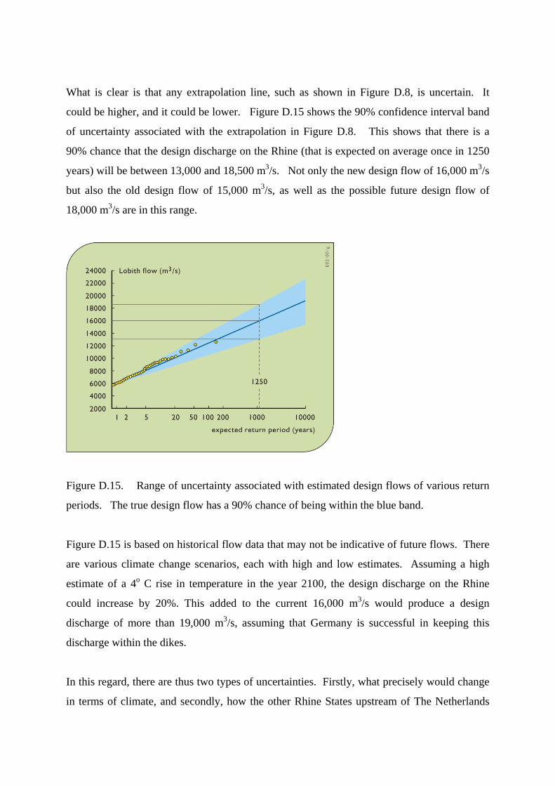
What is clear is that any extrapolation line, such as shown in Figure D.8, is uncertain. It
could be higher, and it could be lower. Figure D.15 shows the 90% confidence interval band
of uncertainty associated with the extrapolation in Figure D.8. This shows that there is a
90% chance that the design discharge on the Rhine (that is expected on average once in 1250
years) will be between 13,000 and 18,500 m3/s. Not only the new design flow of 16,000 m3/s
but also the old design flow of 15,000 m3/s, as well as the possible future design flow of
18,000 m3/s are in this range.
Figure D.15. Range of uncertainty associated with estimated design flows of various return
periods. The true design flow has a 90% chance of being within the blue band.
Figure D.15 is based on historical flow data that may not be indicative of future flows. There
are various climate change scenarios, each with high and low estimates. Assuming a high
estimate of a 4o C rise in temperature in the year 2100, the design discharge on the Rhine
could increase by 20%. This added to the current 16,000 m3/s would produce a design
discharge of more than 19,000 m3/s, assuming that Germany is successful in keeping this
discharge within the dikes.
In this regard, there are thus two types of uncertainties. Firstly, what precisely would change
in terms of climate, and secondly, how the other Rhine States upstream of The Netherlands

will react to these changes. No one today can answer that.
How can flood management proceed given this uncertain future? The answer is by building
into any adopted management strategy both flexibility (robustness) and resilience.
Flexibility is the ability to adapt with minimal cost to a wide range of possible futures.
Building in this flexibility may cost more, but may be still be desirable insurance against risks
society does not want to take. Regulating the discharge distribution over the Rhine Branches
could increase flexibility. Building temporary and emergency detention areas are other ways
of increasing flexibility.
The term resilience on the contrary, specifically involves the speed of recovery after a flood
and its accompanying damage has occurred. This is achieved much more easily if the
consequences of an above-design level flood are not permanent, but remain limited and may
be easily rectified. This requires that no uncontrolled flood occur – accompanied by possibly
extremely severe damage or even social disruption – but only controlled flooding that will
cause the least amount of damage. In this manner, resilience could be ‘built into’ a flood
safety system through disaster facilities, for example in the form of emergency spill areas or
by dividing large dike rings up into smaller sections – compartmentalizing – to limit flood
damage.
It is a major challenge for river managers and also for the water- and spatial-planning policy
makers to develop a strategy that will minimize future regret by taking into account the fact
that uncertainties will always exist concerning the expected discharges in rivers.
2.6 Summary Visions for future developments on the River Rhine in and upstream of The Netherlands
currently concentrate on flood mitigation and ecological restoration. Relatively little effort is
devoted to dealing with low flows including future water quality and navigation requirements.
The recent strategy in the past for flood prevention was to raise dikes (embankments) along
the floodplains. Currently this strategy has met social resistance and is thus thought to be too

inflexible to cope with an uncertain future. Alternative solutions focus on reducing water
levels during floods using retention basins along the River Rhine in Germany and the
lowering of floodplains in The Netherlands to enlarge the cross section of the river.
Meanwhile these floodplains are to be designed in such a manner that more natural
morphological and ecological processes in the floodplains can take place.
In the delta of the River Rhine future adaptation visions focus on a further widening of the
floodplains and the planning of "green rivers". These "green rivers" will only be used during
floods. In the upstream sections in Germany the focus is on landscape planning so that water
will flow less quickly to the river.
3. Flood Management on the Mississippi The Mississippi River, as shown in Figure D.16, is the major river of North America and the
United States. It is over 3700 km (2,300 miles) in length, flowing from the northwestern part
of the state of Minnesota south to the Gulf of Mexico, just below the city of New Orleans. It
drains 3.2 million km2 (1.2 million square miles), or about 40% of the United States. The
Mississippi River is the sixth largest river in the world in terms of discharge. Its annual
average flow rate is 14,000 m3/s and its freshwater discharge onto the continental shelf is 580
km3/yr. It is a significant transportation artery and when combined with its major tributaries
(the Missouri and Ohio rivers) it becomes the third largest river transportation system in the
world.
Typically the discharge at the mouth of the Mississippi River into the Gulf of Mexico varies
over the seasons, with highest flow occurring between March and May and lowest flow
occurring between August and October. However in August and September of 1993 it rained
a lot. Monthly mean discharges of April and May 1993 were approximately 50% higher than
their long-term monthly mean values. August and September 1993 discharges exceeded the
highest of those recorded in the previous 63 years. The result was a flood.

Figure D.16. Mississippi River Basin in the United States and the area affected by the 1993
flood.
The States of Minnesota, Iowa, Illinois, and Missouri were hardest hit (the darker blue area of
Figure D.16). At St. Louis, the river crested at about 15 meters (49.6 feet) – some 6 meters
(over 19 feet) above flood stage. This was about two meters (more than six feet) above the
old record set in 1973. The Mississippi remained over flood stage at St. Louis for over two
months. Farther north, record flooding occurred on the Des Moines River, a tributary of the
Mississippi (Figure D.17). At one point flooding disabled a major water plant, and Des
Moines, Iowa, a city of nearly 200,000 people, was without safe drinking water.
Figure D.17. Confluence of Des Moines and Mississippi Rivers during the 1993 flood.

The discharge of 35,700 m3/s (1,070,000 cubic feet per second) was the greatest discharge
ever measured during more then 130 years of data, exceeding the previous high by 26%.
Flood elevations exceeded the design flood stage of 9 meters (30 feet) on the St. Louis
gage for 80 consecutive days during the main portion of the flood, and for 148 days
during the calendar year. The previous record was 77 days above flood stage, both
consecutively and annually.
The duration of flooding at high stages was unprecedented. The flood was 3 meters (10
feet) or more over the design flood stage for 36 days, exceeded the "50-year flood" stage
for 23 days and exceeded the "100-year flood" stage for 8 days. Before 1993, there were
only 12 days total in the entire period of record, dating back to 1861, when floods
exceeded the design flood stage by this extent or more. The total water volume passing
St. Louis from June 26 to September 13 could cover the entire State of Missouri to a depth
of 0.75 meters (2.5 feet). The peak discharge at St. Louis has been estimated to have a
150-200 year average recurrence interval. At some upstream stations the flood exceeded
the 500-year average recurrence interval.
Transportation and industry along the Mississippi River was disrupted for months. Damages
to surface and river transportation in the region were the worst ever incurred in the United
States.
Over 1,000 of the 1,300 levees designed to hold back floodwaters failed, though major cities
along the rivers, like St. Louis, were protected from flooding by massive floodwalls. Floods
displaced over 70,000 people. Floods damaged or destroyed nearly 50,000 homes and over
31,000 km2 (12,000 square miles) of productive farmland. Fifty-two people died. The
estimated damage was between $12-20 billion (1993 US dollars), depending on what is
included in those estimates.
This flood provided a trigger, once again, for an evaluation of the existing flood protection
schemes and procedures for managing the rivers and floodplains in the Mississippi Basin. At
the same time, the future use of the rivers and floodplains, especially in the context of
economic development, coupled with the improvement of ecological habitats, became
important political issues.
Historically considerable attention has been given to solving problems associated with
particular interests. For the Mississippi Basin, these include navigation, hydropower gener-
ation, nature conservation and providing a certain flood safety for agricultural, industrial and
urban areas. Many structural and nonstructural measures have been implemented over the
years. Many of these have contributed to the economy of the region, the safety of the
inhabitants, and the protection of natural values. What was less strongly developed, however,
was a clear, concrete and widely accepted perspective (a policy or strategy) on the long-term
future water resources development in the Mississippi Basin as a whole.
Studies carried out by the Federal Interagency Floodplain Management Review Committee
(called the Galloway Committee), further supported by US Army Corps of Engineers
(USACE) studies, both prompted by the flood, have substantially contributed to debates over
future policies for river management. Various alternatives for floodplain management were
evaluated but detailed concrete proposals were not asked for nor included within the scope of
this floodplain management assessment.
Identifying alternative future river management strategies that could be implemented raises
two questions:
1. Should the river management strategy be based on a continuation of the historic practice
of river engineering works, using reservoirs and levees to provide a certain flood safety
level, in combination with dredging works for navigation? Or alternatively, should a
future strategy focus more on the use of the floodplain and the river in such a way that
environmental values are enhanced, while at the same time the potential flood damage is
reduced?
2. How and to what extent can the river and floodplain resources be further used by society
for the development of the regional and national economy, without compromising the
river ecosystem?
Associated with the need for a strategy for river basin management, additional questions
include:

1. How can federal and state agencies be organized in such a way that river basin manage-
ment can take place effectively?
2. How can management and development planning be structured so that stakeholders (in-
dustry, environmental groups, farmers, urban population, etc.) are actively involved in the
process?
3.1 General history
A sketch of some history of water resources development in the US may provide some
context for what has happened in the Mississippi River.
For more than a century, the federal government has been involved in developing water
projects for a variety of purposes including flood control, navigation, power generation, and
irrigation and settlement of the West. Most major water projects, such as large dams and
diversions, were constructed by government agencies: the Bureau of Reclamation or the U.S.
Army Corps of Engineers. Traditionally, the Corps has built and maintained projects
designed primarily for flood control, navigation, and power generation, whereas Bureau
projects were designed primarily to enhance storage capacity and provide reliable supplies of
water for irrigation and some municipal and industrial uses.
The Corps operates hundreds of flood control, navigation, and multipurpose works throughout
the country. While its navigational activities date back to foundation of the federal
government, the Corps' flood control activities did not begin until the mid-to-late 1800s and
then were primarily limited to studies and investigations. Although Congress authorized the
Corps to construct levees throughout the country in 1917, the modern era of federal
involvement in flood control did not fully get underway until enactment of the Flood Control
Act of 1936, when Congress declared that it was in the national interest to assist states with
flood control measures and that it was "a proper" federal activity. Prior to this time, flood
control was largely viewed as a local responsibility. In addition to its flood control
responsibilities, the Corps continued to construct navigational improvements, and later
expanded its activities to include construction of multipurpose water projects.
For decades, the federal government largely took a structural approach to flood control,
floodplain management, and water supply development. While the Corps was active in
building dams and levees throughout the country, channeling meandering rivers and streams
to move floodwaters quickly and efficiently "out of harms way," the Bureau was building
some of the largest water supply projects in the world. The Corps and the Bureau
consequently are substantially involved in the management of some of the country's largest
river systems, including the Colorado, the Columbia, the Missouri, and the Mississippi.
Project construction for all types of water works expanded greatly during the 1930s and
1940s, and continued rapidly until the late 1960s and early 1970s. By the late 1960s, a
combination of changing national priorities and local needs, increasing construction costs,
and the decreasing number of prime locations for water works all contributed to a decline in
new construction of major water works nationwide. Water supply for traditional off-stream
uses -- such as public supply, domestic, commercial, industrial and agricultural uses -- was
increasingly in direct competition with a growing interest in allocating water to maintain or
enhance in-stream uses, such as recreation, scenic enjoyment, and fisheries and wildlife
habitat.
During the 1970s, construction of new projects slowed to a handful of major works,
culminating in the completion of the Tellico dam project in Tennessee and the Tennessee
Tombigbee waterway through Alabama and Mississippi. These projects pitted conservation
and environmental groups, as well as some fiscal conservatives, against the traditional water
resources development community. New on the scene was the National Environmental
Policy Act of 1970 (NEPA) that for the first time required an assessment of the environmental
effects of federal projects, and provided for more public scrutiny of such projects.
In 1978, President Carter announced that future federal water policy would focus on
improving water resources management, constructing only projects that were economically
viable, cooperating with state and local entities, and sustaining environmental quality. The
subsequent Reagan Administration continued to oppose large projects, contending they were
fiscally unsound. Federal water research and planning activities were also reduced during the
early years of the Reagan Administration (early 1980s), which felt that states should have a

greater role in carrying out such activities. Consistent with this outlook, President Reagan
abolished the Water Resources Council, an umbrella agency established in 1968 to coordinate
federal water policy and to assess the status of the nation's water resource and development
needs.
Congress subsequently scaled back several remaining authorized projects, changed repayment
and cost-share structures, and passed laws that altered project operations and water delivery
programs. For example, in 1982 Congress passed the Reclamation Reform Act, which altered
the Bureau's water pricing policies for some users. The Act revised acreage limitation
requirements and charges for water received to irrigate leased lands. Congress soon passed
another landmark law, the Water Resources Development Act of 1986, which requires local
entities to share the construction costs of water resource projects built by the Corps. This act
did little to enhance comprehensive systems wide planning but did allow projects to be built,
especially if members of Congress wanted them to be built.
Over the last decade, both the Corps and the Bureau have undertaken projects or programs
aimed at mitigating or preventing environmental degradation due in part to the construction
and operation of large water projects. The agencies have pursued these actions through
administrative efforts and congressional mandates, as well as in response to court actions.
Currently, the federal government is involved in several restoration initiatives, including the
Florida Everglades, the California Bay-Delta, the Mississippi Delta, Lake Ontario and St.
Lawrence River, and the Columbia and Snake River basins in the Pacific Northwest.
Degradation processes in these river, lake and coastal systems have been occurring over many
years.
These restoration initiatives are not without controversy. Each involves many stakeholders at
the local and regional level (water users, landowners, farmers, commercial and sports
fishermen, urban water suppliers and users, navigational interests, hydropower customers and
providers, recreationists, and environmentalists) each having their own objectives and desires.
At the same time, demand for traditional or new water resource projects continues --
particularly for ways to augment local water supplies, maintain or improve navigation, and
control or prevent floods and shoreline erosion.

Now to the Mississippi.
Nature's design of the upper Mississippi was imperfect for human use. So Congress, with the
help of the US Army Corps of Engineers, remade it. For over a century the Corps has
responded to Congressional requests to provide for transportation and flood control – and
most recently for ecology as well – in the upper Mississippi.
Nature's Upper Mississippi was often less than four feet deep. Today's canalized version
handles the standard upper-Mississippi barge – 2.75 meters (9 feet) deep, 10.7 meters (35
feet) wide and some 60 meters (195 feet) long. They are tied three across (32 meters or 105')
and five deep (297 meters or 975'), and pushed (not towed) by a towboat, as shown in Figure
D.18. Most of the locks are 33.5 meters (110 feet) wide and 183 meters (600 feet) long. So a
standard setup is divided into two lengths, each locked through separately, and then retied. A
single lock-through takes about 20 minutes. Waiting, because of traffic, can sometimes take
20 hours. This is one of the reasons why the Corps of Engineers have been asked to build
more lock capacity.
Figure D.18. Barged cargo passing through a lock on the Upper Mississippi River.
Managing floods on the upper Mississippi, to the extent possible, is done using reservoirs and
levees. They will no doubt continue to be used.
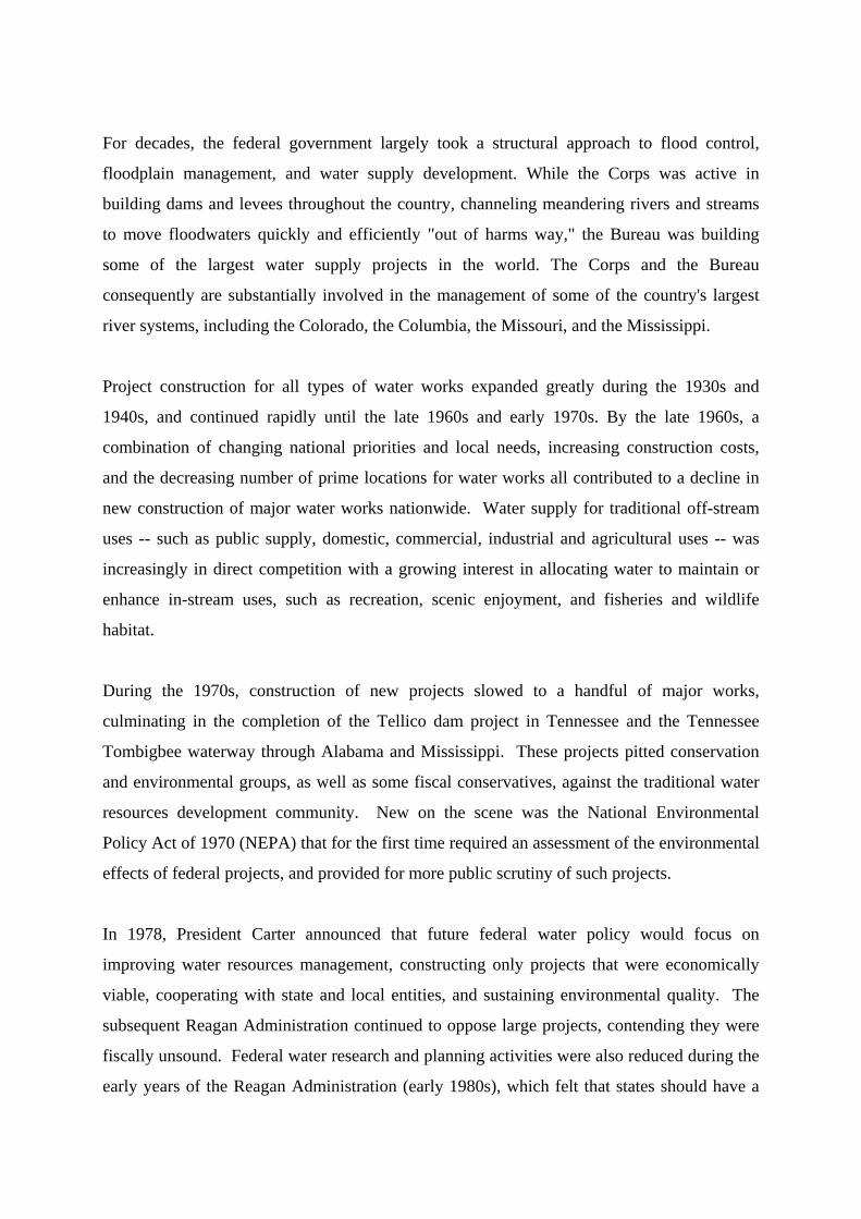
The upper Mississippi has 20 flood-control reservoirs, controlled by three Corps of Engineer
Districts: St. Paul (16), Rock Island (3), and St. Louis (1). More than a hundred smaller dams
and reservoirs on upper-Mississippi tributaries are for local use and not for flood control on
the main river. There are no flood control reservoirs on the river; the locks and dams on the
river above St. Louis control water levels primarily for transportation (Figure D.19).
Figure D.21. The Upper Mississippi River locks and navigation dams, known locally as
pools.
The Corps-controlled reservoirs serve several purposes. At each, a permanent minimum level
is kept for recreation and wildlife. In dry times, water is released to maintain minimum
levels in the tributary and the river. On a tributary that can flood any time, water is released

after a flood, to be ready for the next one. On a tributary with well-known flood seasons,
floodwater is held for release as needed by the tributary and the river. Hydropower is
produced at some reservoirs. Hydropower provides approximately 9 percent of the combined
energy used in the Mid-continent Area Power Pool, which includes Iowa, Minnesota, Ne-
braska, North Dakota, South Dakota, and portions of Illinois, Montana and Wisconsin.
Levees are for local flood control. They reduce flooding for one area but typically cause
problems elsewhere. A levee on one side causes higher floods on the other. Levees on both
sides narrow the channel, causing higher floods upstream. Levees protecting portions of the
fertile floodplain keep floodwaters from occupying and soaking into that natural floodplain
land. This increases the flood flow downstream.
The overall plan of reservoirs and levees includes the possibility that in extreme situations,
less valuable areas will be flooded to reduce the risk of losses in more valuable areas. From
the basic plan for the upper Mississippi, submitted to Congress by the Corps in 1940: "The
reservoir system proposed is not of sufficient capacity to completely control floods in the
upper Mississippi River." And: "The best method of operation of reservoirs ... often requires
that reservoirs be emptied as rapidly as practicable after a flood has passed in order to be in
readiness for a possible second large flood in the same season. ... Large discharges might be
superimposed upon the crest of a major flood at some point downstream."
Hydrological regimes in watersheds have been changed significantly by the construction of
dams, levees and channels. Drainage systems and other land-use changes have influenced the
runoff pattern. Watershed alterations promoted human welfare, and policy makers saw
opportunities to use water development as an engine for economic prosperity. The
achievements were impressive: improved safety against floods, expanded navigation on the
rivers, availability of floodplains for agricultural and commercial uses, production of
hydroelectric power, etc.
However, as in many rivers that are highly controlled, the floodplains of the Upper
Mississippi, Illinois and Missouri Rivers have been reduced in size by the construction of
levees. The remaining floodplains have slowly been rising due to silt deposition. River
runoff has increased due to the loss of upland cover in the basin. The construction of wing

dikes has made the low flow channel narrower and deeper. Plants and animal species have
slowly disappeared. Wetland areas have decreased gradually as land was converted to
agricultural use. However, even today the Upper Mississippi, Illinois and Missouri Rivers
still contain extensive and important ecological and landscape values. Figure D.20 illustrates
land cover changes over a century at two sites along the Upper Mississippi River.
Figure D.20. Land-cover/land-use comparisons at two sites on the Upper Mississippi. The
left images depict land uses in 1891 and the right images show the land uses at the same sites
nearly 100 years later (Wlosinski et al. 2002)
Comparison of the land-cover/land-use data between 1891 and 1989 in the dammed portion of
the Upper Mississippi River showed that open water and marsh habitats generally increased,
mostly at the expense of forested and agricultural classes (upper images in Figure D.20).
Where river dikes have been built, wetland and woody areas tended to be converted to
agricultural areas over the same period (lower images in Figure D.20).
In all, nearly 2,000 km (1,240 mi) of levees now isolate more than 400,000 ha (988,000 acres)
from the river during all but the highest discharge rates. Wing dams and levees, along with
other changes to the watershed, have also had a major effect on habitats by changing the

relationship between discharge and water-surface elevations. Wing dams have narrowed and
deepened the main channel so that water elevations at low discharges are now lower than they
were historically. Levees restrict flows and result in higher water elevations during high
discharges. Water-surface elevations at relatively low discharges (1700 m3/s or 60,000 cfs)
have dropped about 2.4 m (8.0 ft) over the record 133-year period at St. Louis, Missouri, 0.5
m (1.5 ft) over the 52-year record at Chester, Illinois, and 1.5 m (5.0 ft) over the 60-year
record at Thebes, Illinois. Water-surface elevations at relatively high discharges (22,000 m3/s
or 780,000 cfs), however, have risen about 2.7 m (9 ft) over the record period at St. Louis, 1.5
m (5.0 ft) at Chester, and 1.1 m (3.6 ft) at Thebes.
In the Upper Mississippi Basin, protection levels against flooding vary largely depending on
the use of the floodplain. Major urban areas are generally protected by levees that are strong
and high enough to withhold a flood like the 1993-flood. Many small towns and agricultural
areas in the Upper Mississippi Basin are protected by 50-year levees. Many of these levees
were overtopped or failed in 1993.
The 1993-flood refreshed everyone’s memory as to how damaging a river can be. The
damages caused by this 1993 flood were substantial but were much less than they might have
been without the upstream flood control works (reservoirs and levees), upland soil
conservation measures, terraces and ponds. Yet those flood damage reduction measures were
not sufficient. The issue addressed by Gilbert White (1945) over a half century ago, the issue
today, and no doubt the issue on into the future is how to effectively reduce the threat of
future flood damage while supporting continued economic development in the affected areas.
A variety of options are available to reduce flood risks. Many are similar to those being
considered in The Netherlands. They include raising or strengthening levees, relocation or
setback of levees, dredging of the main and/or side channels, and the lowering of floodplains.
These may have major or minor effects, be expensive or relatively inexpensive, be in line or
not in line with the current regulations or policies, and be more or less socially acceptable.
For sustainable protection against flooding, measures in the upstream and downstream part of
the river need to be considered together as a single system.
3.2 Other considerations
The Mississippi is an important waterway for inland navigation. The region’s economy
depends on the inexpensive transport of its bulk commodities. Much of the transport of
goods to and from the midwestern states is by barges through an extensive lock and dam
system. For maintenance of the navigation system periodic dredging is necessary at several
locations on the river.
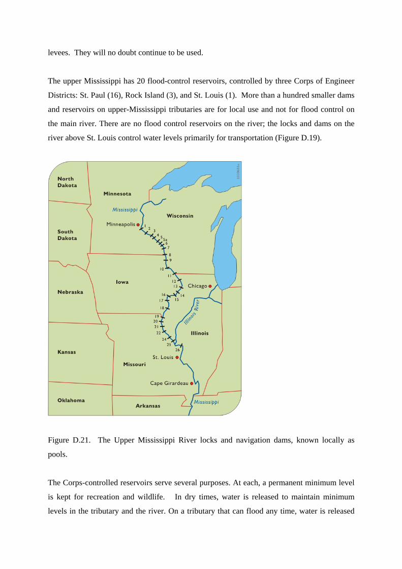
Safe, speedy and cheap navigation demands a channel of adequate depth and width, and locks
large enough to accommodate the 15-barge tows (Figure D.18). For such tows the length of
the present locks on the Upper Mississippi River and Illinois is limiting, often causing, as
mentioned above, considerable delays. Furthermore, the continued growth of commercial and
recreational traffic is approaching maximum lock capacities. The width of the navigation
channel is at many locations insufficient for two-way navigation. This further delays
navigation and adds to transportation costs. However, reliability and low cost still make
inland navigation a competitive means of transport. Other positive attributes of inland
navigation are the relatively low energy consumption and the large transport capacity with
few nuisance and safety problems. Air pollution by navigation per ton of cargo is far less
than that produced by the equivalent required number of trucks, or even by rail transport.
Both agriculture and industry compete for space on the floodplain. Agriculture is the leading
commercial user of the floodplains along the rivers in the Upper Mississippi Basin. About
70% of the total 2.4 million ha (6 million acres) of floodplain is used for agricultural producti-
on. Due to the fertile soils, the yield in well-drained floodplains is usually substantially
higher than in the upland areas.
Mainly in the direct vicinity of towns, a small but highly valuable portion of the floodplain is
occupied by industries. Floodplains well protected by levees offer industry the advantage of
immediate access to inland water transport to bring in raw materials and transport finished
products, and immediate access to cooling and process water.
Nature also competes for space on the floodplain. Originally, large wetland areas existed in
the Mississippi River Basin. Wetlands are unique links between land and water. Some
wetlands are almost continuously under water, whereas others may be flooded for only a short

period. This results in a variety of wetlands and their specific habitat types and functions.
Through these special conditions, wetlands are among the most biologically productive
natural ecosystems in the world.
In addition to being vital to the survival of various animals and plants, including threatened
and endangered species, wetlands play a role in the reduction of peak water levels during
smaller flood events (flood events that occurs every few years) because of their capability to
store floodwater and release it slowly. For large events like the 1993-flood, the effect of
wetlands on high water levels is much less because wetlands are usually saturated by rainfall
or already flooded in an earlier stage.
Starting in the mid 1800's the wetland areas were gradually decreased mainly to reduce the
occurrence of malaria and other water borne diseases. Wetlands were converted to agri-
cultural land and to a lesser extent to residential and industrial uses. Currently, wetlands
account for about 10% of the floodplain in the Upper Mississippi Basin.
Wetlands, storage lakes, and the river itself provide considerable opportunities for recreation.
Popular activities are hunting, fishing, camping, boating, sightseeing and bird watching.
River-related recreation is important for the economy of local communities. The locks and
dams provide many recreation lakes and the opportunity for boating, skiing, fishing and
hunting.
Floodplains along the rivers also contain numerous archaeological and historic sites. These
sites include historic architectural and engineering features and structures, and resources of
traditional cultural or heritage significance to Native Americans and other social or cultural
groups. Examples are forts, quarries, potteries and burial sites. Construction activities in and
along the river, streambank erosion and extreme floods all can adversely affect these values.
Some of these multiple uses of the floodplain are compatible with flood management and
obviously others are not. Yet all must be considered when developing a flood management
plan.
The river itself is a source of water for municipal and industrial use: drinking water, pro-

cessing and cooling water, and irrigation. The number of people that obtain drinking water
from the river and its tributaries is quite large. Yet the amount of water extracted for these
purposes is relatively small when compared with the river discharge. As long as the flow
withdrawn for water uses (after proper treatment) is returned to the rivers, this water use can
be considered of minor importance in the overall water balance of the rivers. The export of
water from the basin to other basins (such as diverting Missouri water all the way to Denver)
is another matter.
3.3 Interactions among user groups
Just as there are multiple purposes for the Upper Mississippi River water and floodplain,
some of which are complementary and others of which conflict, the same is true of the
different user groups or stakeholders.
Table D.1 provides a rough indication of the ranges of some of the more potentially conflict-
causing interactions. The table’s columns are the activities that affect the activities shown in
the rows. Scores of +1 and +2 indicate complementarities and positive interactions, 0 is
neutral and -1 and -2 are competing or negative interactions. These relative numbers can be
pushed towards the positive side of the ranges, representing fewer conflicts and more positive
interactions when participatory planning occurs.
Table D.1: Interactions among potentially conflicting river activities.

There are other important uses of water that are not mentioned in Table D.1 because the inter-
actions are obvious and straightforward. Supplying municipal and domestic public water
systems is one. Hydropower is another.
Some of the categories of conflicts indicated in Table D.1 create serious problems in the
Upper Mississippi Basin. Some of the potential positive interactions are only weakly
developed. The sharpest conflicts appear to be those between environmentalists and
agriculturalists, and with those who would develop industrial sites through flood control and
increased river shipping, but are constrained by legislation limiting land development in the

floodplain.
A significant number of farmers consider environmental concerns by and large as expressions
of urban outsiders, who have somehow gained the right to criticize the farmers’ activities on
their own land. In some cases, environmental regulations are viewed as threats to farm liveli-
hood. Furthermore, when the reasons for regulation involve the preservation of animal or
plant species that seem either insignificant or even to be nuisances to the agricultural
community, the regulations are perceived to be both insulting and an assault. Whatever the
pros and cons of the regulations, when the conflict of interests have reached the stage that
some of the parties feel threatened, willing compliance with regulations drops and conflict
resolution becomes far more difficult.
Table D.1 indicates only direct interactions. Indirect interactions are not listed, although they
may also be very important. For instance, the effect of industrial development in or near the
floodplain on river ecology is scored at 0 to -2 because industrial effects may vary between
environmentally neutral, moderately polluting to so badly polluting that they destroy habitats.
Industry is rarely directly complementary or positive to environmental concerns in
floodplains. However, if the commitment is made to use some of the revenues, through taxes
or other means, generated by industrial development to enhance environmental conditions
(e.g. using some funds to establish conservation areas) then the indirect effects of the indus-
trial development on the environment may be positive (score +1). Such indirect effects can
be important in negotiations among user groups.
There are serious conflicts over the degree and extent of flood control that should be provided
and the ways it should be provided. There are various possibilities between two extremes:
those who feel that flood protection levels should be raised significantly, primarily by
increasing the heights of levees all along the river; and those who believe that development in
the floodplain should be actively discouraged, and existing uses that restrict flood flows
should be reduced. Arguments for the first option are largely that economic development in
the region, particularly farming and industry will be greatly served by protection from floods.
The arguments for the latter are primarily that floodplain protection and compensation for
flood damages are very expensive and that there is no compelling reason for the nation to
subsidize floodplain development when alternative sites for agriculture and industry exist

outside the floodplain. Floodplain protection measures are also frequently not
environmentally friendly. Decreased floodplain development allows a return to more natural
conditions.
Both arguments are valid. In some cases, flood control measures are complementary to
environmental interests, particularly when the measures involve setting back levees, lowering
floodplains or making parallel, unregulated channels or levees that protect or encourage the
re-establishment of certain kinds of habitat. In general, however, environmental interests
favor less engineering and lower rather than higher levees. River dredging is highly
controversial. This puts environmental groups in strong conflict with those advocating
floodplain development.
Negotiating conflicts between different interest groups requires extensive data collection and
expert analyses of the impacts of different measures to control flooding. It requires
presentation of the results of the analyses in ways that are accessible and understandable to
stakeholders and decision-makers, and a process that encourages debate, negotiation and
compromises among stakeholders.
3.4 Creating a flood management strategy
The current (2002) approach to river management on the Upper and Middle Mississippi River
is not as integrated or as well balanced as it could be. This situation is not unique to this river
and there are reasons for this that could be eliminated if policies restricting comprehensive
integrated approaches were changed. The 1993 flood in the Upper Mississippi River basin
focused national attention to this problem, at least for a while. This national attention offered
the possibility for a reassessment and the creation of an integrated water resource
management strategy. One of the conclusions of the Galloway Committee (1994) was: “The
United States has a rare opportunity to make a change in floodplain management. It should
not be missed”. Many of the recommendations made by this Committee remain to be
seriously considered. It seems, once again, that the concerns generated by the flood and
identified by the Committee are fading from national attention. What began as a useful
debate following the 1993-flood seems to be dissipating without many substantial decisions
that will make it easier to manage or mitigate the damages when the next flood occurs.

An argument could be made that the resources offered by the river could be used considerably
more intensively than they are now without compromising the river’s ecological integrity.
The basin's potential for increased economic and ecological benefits are not fully developed.
A more active management of ecological values, including using options for ecological
restoration can serve environmental protection and at the same time allow sustainable
economic development. Active management of both economic and ecological values requires
some compromises, but they can also provide some important gains.
The economic advantage the river offers to the communities along the river and for the region
could and should be increased along with its ecological benefits. Navigation even from an
environmental point of view could be increased, given the relatively low air pollution and
high safety levels of river freight versus trucking and even rail. River transport of
containerized cargo in addition to bulk agricultural products, agro-chemicals, coal and steel
could be stimulated. Additional river ports and inter-modal transport facilities could be
developed. Such development would enhance the economies of the communities along the
river.
Similarly, the use of the river and the riverbanks for recreation (boating, fishing, hunting)
could be increased. This would benefit local economies and could lead to the provision of
guarantees for environmental conservation. Increased river-related recreation helps support
environmental integrity since a quality environment is a necessary condition for this activity.
An integrated water management strategy would address flood management issues and
uncertainties such as how levees influence upstream flood stages, how raising or setting back
levees affect water levels elsewhere, how floodplain vegetation (particularly trees) influences
flood stages, etc. In addition, the flood safety levels for different land uses on the floodplain
would be selected. The Galloway report (1994) emphasized flexibility and variations in flood
protection levels. Questions remain as to what flood protection levels are appropriate for
urban areas/industrial sites and agricultural lands, and how agreements on such protection
levels are to be reached.
3.5 The role of the government and NGOs
Public state and federal agencies are major players in water resources management in this as
well as most major river basins in the US. Without their leadership not much planning or
management takes place or is implemented. Yet there are limits as to what any particular
agency can do. Thus working together with each other and with private non-governmental
organizations (NGOs and other stakeholder groups) is absolutely necessary if any
approximation of an integrated water management plan or strategy is to be developed. If
institutional change can facilitate that process, such change should be considered. Indepen-
dent River Basin Commissions representing all stakeholders and being responsible for inte-
grated river management can work, assuming their recommendations are sought and would be
seriously considered in the higher level political decision making process.
Present regulations regarding benefit/cost analysis need to be revised to allow more types of
values, along with monetary values, to be considered. The nation's interest in the economic
development of the Upper Mississippi, Illinois and Missouri River basins is not reflected in
the restricted way future benefits are calculated in the benefit/cost considerations required for
federal investment plans in the river and floodplains. The omission of any estimates of the
growth of future economic benefits can undervalue economic development. Since
environmental benefits are not translated in monetary terms, they tend not to be fully
considered. The economic benefits derived from natural well-functioning ecosystems that
help to justify environmental protection are not made explicit either. The manner in which
future benefits are included in the benefit/cost calculation should be consistent for different
types of projects.
A balanced River Basin Development Plan for the Upper Mississippi, Illinois and Missouri
River basins, to be drafted interactively with wide participation of all parties concerned,
would improve the understanding of the complex interrelationships between environmental
protection, resource use, and river and floodplain development. Such a development plan
would not be a static plan, but would serve as a foundation to be revised on a regular basis
according to new developments and insights. In such an adaptive way this plan could
enhance the effective as well as efficient use of the river resources.
4. Decision support and prediction

To assist the decision makers in evaluating alternative solutions for problems encountered in
integrated river management, and communicating these solutions and their consequences to
the public, interactive computer-based decision support systems (DSS) can be of considerable
help. A DSS could consist of up-to-date river and floodplain information (using geographic
information systems and data base managers) and dynamic river models of the complete river
network. It could be used to simulate flooding scenarios in which water managers and
stakeholders could be involved in deciding what to do and noting the impacts or
consequences. Periodic simulation exercises such as this could serve as a reminder to the
public, especially during dry years, that floods can and will occur, and some may have to be
allowed to overflow levees and cause damage.
4.1 Floodplain modeling Efforts to identify improved flood management policies are almost always based on
predictions, admittedly uncertain, of impacts of specific structural or nonstructural measures.
These impact predictions come from models and their databases. Modeling and the
communication of model results to interested property owners, government planners, and
insurance companies are becoming increasingly important component of flood management.
In providing the desired information one must deal with uncertainties. Flood studies imply
extrapolation of model parameters and boundary data to situations that have never been
recorded. This raises the question of the reliability of current procedures of model
calibration. The quality of model results depends to a large extent on available data and its
relevance for future planning. Two-dimensional (2D) models require accurate digital terrain
models (DTM). The cost of collecting such data of sufficient accuracy for flood studies has
decreased significantly through the use of airborne laser altimetry. Moreover, research has
started to provide floodplain roughness data through complementary analysis of laser
altimetry data. Laser altimetry techniques are now also applied to the recording of flood
levels, which can further support the calibration of flood simulation models. The new data
collection techniques are also complemented by hydraulic laboratory investigations, such as
the derivation of laws and parameters describing flow resistance resulting from various
classes of vegetation.

New data collection techniques also show a distinct change in the type of data underlying
model development and model use. In general, there is a tendency to move from the
collection of point data to spatially distributed data. Whereas design flood hydrographs used
to form the basis for flood control studies, the rainfall radar data, together with river
catchment models allow the use of design storm patterns. The development of 2D models
based upon digital terrain models and roughness maps is becoming easier and more cost-
effective than the development of 1D models based upon point information of cross-sections
measured at selected intervals along the river axis.
This does not mean that the traditional 1D modeling of flood events will be fully replaced by
2D model applications. Although the development of an accurate 2D model supported by the
new data collection and processing techniques is becoming easier and cheaper for many
studies, 2D models require more computer time and this situation is not going to change
within a decade. Flood management planning and risk assessments typically require the
simulation of many floodplain management alternatives over large numbers of probabilistic or
stochastic events.
Both 1D and 2D models can be used together as appropriate. They can be integrated in many
applications to provide local refinement of the description, in particular the flooding of
normally dry land. A 2D model can be used as a support tool for the development of
accurate and extrapolatable 1D models through the transfer of discharge conveyance and
storage functions. The shift from constructing dikes or levees close to the main river to protect as much
agricultural, industrial and urban land as possible, to creating, if possible, green rivers and
larger floodplains or areas with a lower protection against flooding results in a need to
understand and predict the flood flows and heights resulting from such measures. This
requires data on the local topography and flow resistance.
The hydraulic roughness of floodplains can be based upon maps showing vegetation or land
use classes. Such habitat or land use compositions can be related to flow roughness
descriptions. Roughness values associated with each vegetation class are usually based upon a
combination of hydraulics laboratory experiments and expert judgment. The spatial

distribution of vegetation or land use classes subsequently leads to the assignment of
roughness values at the grid cells of 2D models. Flow resistance for each vegetation class can
be constant or expressed as a function of stage (flood height).
The 2D models incorporating these floodplain roughness parameters can be used to assist in
the calibration of 1D models. Both types of models can then be used for a variety of water
management studies and policy analyses.
The link between vegetation or land use classes and roughness provides a description of the
energy losses as a function of the flow blocking area in a specific region. This provides a
more accurate description of the losses as a function of the water level. Flow through reed
fields, for example, meets a high resistance as long as the vegetation is not overtopped or bent
over and laying on the bottom. Other more dense vegetation may even create laminar flow
before overtopping takes place. After drowning, the flow resistance reduces significantly. A
relation between vegetation or land use and flow resistance also allows for the introduction of
seasonal variations in flow resistance.
One software product developed at WL | Delft Hydraulics is the so-called Delft-1D2D
system. This software is currently in use for the simulation of large numbers of flooding
scenarios resulting from potential dike breaches. The approach followed in this software
provides many possibilities for the integrated simulation of river floods, tidal flow and urban
storms. A demonstration version of this model is included in the CD attached to this book.
4.2 Integrated 1D-2D modeling There are various ways in which one can couple hydrologic and hydraulic system simulation
models. These include:
1. sequential coupling of data flows if one process is completely independent of another
process such as from a rainfall-runoff module to a channel flow module;
2. on-line explicit coupling at a selected frequency in time, such as the link between a
surface water flow module and a water quality module. Such coupling works well if the
mutual dependence of processes described by the individual modules is not important, for
example, if the time scale of one process is quite different from the time scale of the other

process. If process time scales are quite similar, constraints in time stepping may have to
be satisfied;
3. on-line implicit coupling of modules. This approach requires not only the exchange of
data between various modules but also the exchange of complete sets of equations, which
are to be solved simultaneously.
The WL | Delft Hydraulics’ general 0D, 1D and partly 2D modeling system called SOBEK is
designed to integrate processes, such as rainfall-runoff, river-, channel- and pipe flow, water
quality and morphology. The hydrodynamic part handles sub- and supercritical flow,
including their transitions such as hydraulic jumps and tidal bores.
This approach to integration offers a range of modeling options. In an urban drainage model
one can combine pipe flow, river flow, tidal flow, street flow, and flow over parks and
parking places, for example (Bishop and Catalano, 2001). Another example is dam break
analysis that allows for any suitable combination of 1D and 2D flow, including zones with
supercritical flow. Finally, the creation of retention storage in flood control is modeled more
realistically than on the basis of a combined 0D and 1D schematization by itself.
The 1D2D integration can be illustrated by examining alternative flood scenarios for the
Geldersche Vallei in the center of The Netherlands (Figure D.21). The area modeled measures
approximately 35 * 20 km schematized with a 2D grid of 100 * 100 m and coupled to a 1D
schematization of the principal waterways and road culverts in the area. The model study had
the objective of assessing flood damage and establishing evacuation plans for a number of
flood scenarios. The most severe situation is caused by a possible breach in the Grebbedijk,
protecting the area from floods conveyed along the Lower Rhine.
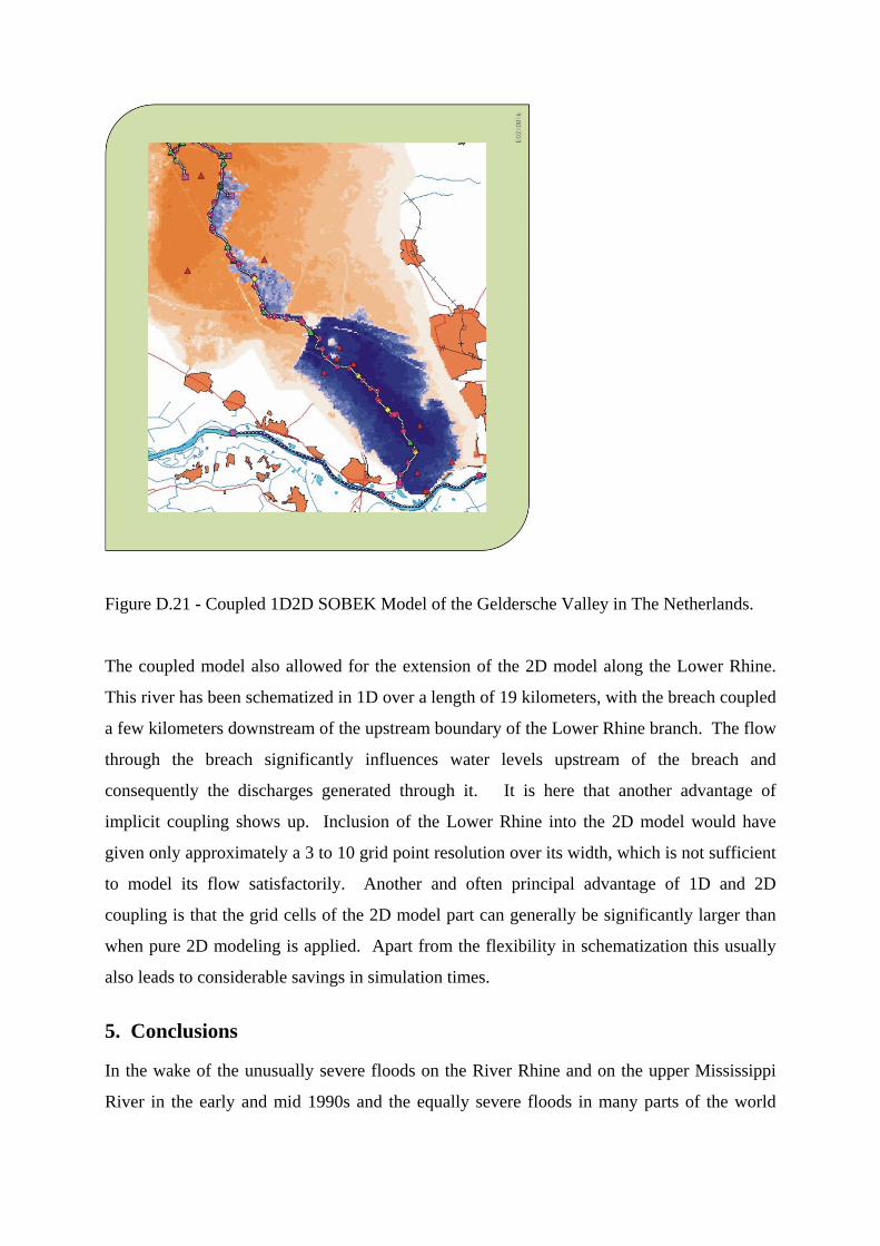
Figure D.21 - Coupled 1D2D SOBEK Model of the Geldersche Valley in The Netherlands.
The coupled model also allowed for the extension of the 2D model along the Lower Rhine.
This river has been schematized in 1D over a length of 19 kilometers, with the breach coupled
a few kilometers downstream of the upstream boundary of the Lower Rhine branch. The flow
through the breach significantly influences water levels upstream of the breach and
consequently the discharges generated through it. It is here that another advantage of
implicit coupling shows up. Inclusion of the Lower Rhine into the 2D model would have
given only approximately a 3 to 10 grid point resolution over its width, which is not sufficient
to model its flow satisfactorily. Another and often principal advantage of 1D and 2D
coupling is that the grid cells of the 2D model part can generally be significantly larger than
when pure 2D modeling is applied. Apart from the flexibility in schematization this usually
also leads to considerable savings in simulation times.
5. Conclusions In the wake of the unusually severe floods on the River Rhine and on the upper Mississippi
River in the early and mid 1990s and the equally severe floods in many parts of the world

since then, including those in Central Europe and in Asia that occurred as this chapter is being
written in 2002, an increasing consensus is emerging. Humans must provide space for floods
and when they occur. Floods must be managed better. This is not a new idea. The only
sustainable way to reduce the continuing cycle of increasing flood damages and increasing
flood protection costs is to restore the natural floodplains that contain the river’s floodwaters.
Floods have become a reason to restore rivers rather than dam or dike them. Many who have
traditionally advocated structural solutions to flood protection are increasingly embracing the
idea that rivers need to be given space to flood. Flood protection has joined clean drinking
water and recreation as reasons for restoring river ecosystems.
Governments can motivate more responsible floodplain management. National governments
can assume leadership and define clear roles and provide fiscal support for flood management
at lower levels of government. Governments can, as happened in the Upper Mississippi
River basin,
• provide relocation aid and buyout funding for those living in flood plains,
• stop disaster relief payments and subsidized flood insurance for those who continue to
live or develop in flood prone areas,
• where offered make flood insurance mandatory and have the premiums reflect flood
risks, and enforce building code requirements on floodplains.
In the US, the Army Corps of Engineers flood control program has had a major influence on
floodplain development. Many now might claim it to be a negative influence, but the Corps
did what Congress, and the public, asked them to do. Hundreds of dams and thousands of
miles of Corps levees and floodwalls were built for flood protection. The result, of course,
was to encourage further development in flood-prone areas. Existing Corps projects continue
to influence the management of most major rivers and their floodplains, including those of the
Mississippi, Missouri, Ohio and Columbia River basins. Although local government is
ultimately responsible for decisions regarding land use in the US, flood control projects
constructed by the Corps provide incentives for floodplain development. The Corps’ analyses
of benefits and costs have traditionally strongly favored structural flood control projects.
Engineers like to build things. Many within the Corps now recognize their regulations and
incentives need to be changed to enable them to take a more balanced view and allow non-
structural flood control projects to compete with structural flood projects.

In The Netherlands, a similar history can be told. There is an expression the Dutch like to
say: God made the Earth, but the Dutch made The Netherlands. Without structures, much of
that country would be permanently under water. But in this country, in the US, and in most
of the rest of the world where floods occur, flood management needs to become a part of
integrated water and land management. Multiple uses, multiple sectors of the economy, and
the interests of multiple stakeholders need to be considered when developing comprehensive
land use and water management plans and policies.
Options available to local governments for floodplain management include land use zoning.
Land zoning should be based on comprehensive land use plans that define a vision of how a
community should be developed (and where development should not occur). Through these
plans, uses of the land can be tailored to match the land’s economic benefits as well as its
hazards. For example, flood hazard areas can be reserved for parks, golf courses, backyards,
wildlife refuges, natural areas or similar uses that are compatible with the natural flooding
process. Open space preservation should not be limited to floodplains, because some sites in the
watershed (but outside the floodplain) may be crucial to controlling runoff that adds to the
flood problem. Areas that need to be preserved in a natural state should be listed in land use
and capital improvement plans. Zoning and open space preservation are ways to keep damage-prone development out of
hazardous or sensitive areas. Floodplain development regulations can include construction
standards on what can and cannot be built in the floodplain. They can serve to help protect
buildings, roads, and other projects from flood damage and prevent development from
aggravating the flood problem. The three most common types of floodplain regulations are
subdivision ordinances, building codes, and “stand-alone” floodplain ordinances. Several measures can help reduce runoff of stormwater and snowmelt throughout the
watershed. Retention and detention regulations, usually part of a subdivision ordinance,
require developers to build retention or detention basins to minimize the increases in runoff
caused by new impervious surfaces and new drainage systems. Best management practices
(BMPs) reduce polluted runoff entering waterways. Pollutants in runoff may include lawn
fertilizers, pesticides, farm chemicals, oils from street surfaces and industrial areas.

Wetlands filter runoff and adjacent surface waters to protect the quality of lakes, bays and
rivers, and protect many of our sources of drinking water. They can store large amounts of
floodwaters, slowing and reducing downstream flows. They can protect shorelines from
erosion. Wetlands serve as a source of many commercially and recreationally valuable species
of fish, shellfish, and wildlife. Moving a flood-prone building to higher ground is the surest and safest way to reduce its risk
from flooding. Acquisition of flood-prone property is undertaken by a government agency, so
the cost is not borne by the property owner. After any structures are removed, the land is
usually converted to public use, such as a park, or allowed to revert to natural conditions.
There are a variety of funding programs that can support a local acquisition project. For
example, more than 8000 homes were acquired or relocated by the US government after the
1993 Mississippi Flood. Based on lessons learned from floods and flood protection efforts throughout the world the
following principles are suggested:
1. Restore river systems and functions that improve flood management while at the same
time restore the natural waterway and its ecosystems.
a. Restore to a meaningful extent the historic capacity of rivers and their
floodplains to better accommodate floodwaters by setting back levees to widen
the floodway of the river channel.
b. Increase wetland and riverside forest habitat within the widened river zone.
c. Increase the use of planned floodplain flooding to reduce downstream flood
peaks.
d. Strengthen existing and properly sited levees at high risk that protect high
value floodplain uses that cannot be relocated from the floodplain.
e. Reassess the operations of reservoirs and waterworks to ensure the efficient,
reliable and prudent use of flood control space. In some cases, dams and
waterworks need to be structurally modified to improve their ability to release
water to avoid downstream flooding.
f. Improve use of weather forecasting and monitoring upstream conditions to
have a better “early warning system” of when a flood could be coming.
2. Manage the uses of floodplains to minimize taxpayer expense and maximize

environmental health:
a. Eliminate incentives or subsidies for development in the most dangerous parts
of the floodplain. No more people should be put in harm’s way.
b. Reform floodplain mapping programs so that they accurately portray the risks
and consequences of anticipated flooding. Ensure that people understand the
risk of flooding where they are located.
c. Ensure that new structures unavoidably being built in floodplains are designed
to resist damage from foreseeable future floods.
d. Educate people on the risks of living, working, or farming in areas prone to
floods and make sure they are willing to bear the appropriate financial
responsibility for such use.
e. Endeavor to relocate the most threatened people and communities who
volunteer to move to safer locations.
f. Ensure that state and local governments responsible for floodplain land use
decisions bear an increased financial responsibility for flood recovery efforts.
3. Manage the entire watershed to provide the most protection from floods in an
environmentally sensitive way:
a. Discourage development in remaining wetlands and floodplains. Wetlands and
functioning floodplains act as giant sponges to absorb and slow the progress of
floodwaters.
b. Use acquisition and easement programs to restore historical wetlands and
floodplain acreage and to promote functional restoration of associated river
systems.
c. Discourage clearcutting and road building in areas prone to landslides.
d. Where possible, replace non-native hillside annual vegetation with native
perennials to improve rainwater absorption and reduce hillside erosion.
Newly developed technologies are facilitating the development of models for studying the
propagation of floods through floodplains, coastal zones and urban areas. This includes the
use of airborne laser altimetry to provide cheaper and more accurate digital terrain models. In
addition, the technology is being used for an efficient assignment of flow resistance
parameters to flood models. It also offers further support to model calibration by monitoring
water levels during the passage of flood waves.
The descriptive capabilities of flood models have been extended significantly through the
implicit coupling of 1D and 2D schematizations. Integrated 1D-2D surface and sub-surface
modeling can be applied to floodplain and urban flooding investigations. These applications
can lead to a better understanding of the flood phenomena, more accurate predictions and
better planning.
7. References


Alvarez, F. and Verwey, A., 2000, Simulation of Wind Set-Up on Lakes in a One-Dimensional Model Schematisation, Hydroinformatics 2000 Conference, Cedar Rapids, Iowa, USA. Asselman, N.E.M., 2001, Laser Altimetry and Hydraulic Roughness of Vegetation, Report Q2701 prepared for RIZA of the Directorate-General for Public Works and Water Management, Arnhem, The Netherlands.

Asselman, N.E.M., Middelkoop, H., Ritzen, M.R., Straatsma, M.W., van Velzen, E.H. and Jesse, P., 2002, Assessment of the Hydraulic Roughness of River Floodplains using Laser Altimetry, IAHS International Symposium on the Structure, Function and Management Implications of Fluvial Sedimentary Systems, Alice Springs, Australia. Bishop, W.A. and Catalano, C.L., 2001, Benefits of Two-Dimensional Modelling of Urban Flood Projects, 6th Conference on Hydraulics in Civil Engineering, Hobart, Australia. Carlson E., 1996, Turn environmental confrontation into cooperation, LandOwner Newsletter, Dec 9
Collins, N. and Catalano, C.L., 2001, Specialised 2D Modelling in Floodplains with Steep Gradients, 6th Conference on Hydraulics in Civil Engineering, Hobart, Australia. Duel, H., Pedroli, B. and Laane, W.E.M., 1996, The habitat evaluation procedure in the policy analysis of inland waters in The Netherlands: towards ecological rehabilitation. In: Leclerc, M. et al., 1996: Proceedings of the second IAHR Symposium on habitat hydraulics, Ecohy-draulics 2000, Québec (INRS-Eau, Sainte-Foy, Qc), June 1996: A619-A630. Duff, I.S., Erisman, A.M. and Reid J.K., 1986, Direct Methods for Sparse Matrices, Claredon Press, Oxford, UK. Food and Agricultural Policy Research Institute (FAPRI), 1994: The Economic Impact of a Loss of Navigation on the Missouri River on Missouri Agriculture, College of Agriculture, Food and Natural Resources, FAPRI, September 1994. Hardin, G., 1968, The tragedy of the commons. Science 162, pp. 1243-1248. Interagency Floodplain Management Review Committee (Galloway Committee), 1994, Sharing the Challenge: Floodplain Management into the 21st Century. Frank, E., Ostan, A., Coccato, M. and Stelling, G.S., 2001, Use of an Integrated One Dimensional-Two Dimensional Hydraulic Modelling Approach for Flood Hazard and Risk Mapping, River Basin Management, Eds. R.A. Falconer & W.R. Blain, WIT Press, Southampton, UK, pp. 99-108. Golub, G.H. and Van Loan, C.F., 1983, Matrix Computations, North Oxford Academic,
Oxford, UK. Gomes Pereira, L.M. and Wicherson R.J., 1999, Suitability of Laser Data for Deriving Geographical Information - A Case Study in the Context of Management of Fluvial Zones, ISPRS Journal of Photogrammetry & Remote Sensing 54, pp. 105-114. Kates, W. and Burton, I., eds., 1986 Geography, Resources, and Environment. Volume I: Selected Writings of Gilbert White, Chicago: The University of Chicago Press, 1986, 443-459. Scientific Assessment and Strategy Team (SAST), 1994, A Blueprint for Change, part V,

Science for Floodplain Management into the 21st Century, Washington, DC, June Silva, W., Klijn, F., and Dijkman, J.P.M., 2001, Room for the Rhine Branches in The Netherlands, Directorate-General for Public Works and Water Management / WL | Delft Hydraulics, Arnhem / Delft, The Netherlands. Stelling, G.S., Kernkamp, H.W.J. and Laguzzi, M.M., 1998, Delft Flooding System: a Powerful Tool for Inundation Assessment Based upon a Positive Flow Simulation, Hydroinformatics ’98, Eds. Babovic and Larsen, Balkema, Rotterdam, pp. 449-456. USACE, 1992, Final Upper Mississippi River Navigation Study, Reconnaissance Report, Revised version, September USACE, 1994, Missouri River Master Water Control Manual Review and Update, Draft Environmental Impact Statement, Executive Summary, July Verwey, A., 1994, Linkage of Physical and Numerical Aspects of Models Applied in Environmental Studies, keynote lecture in: Proceedings of the Conference on Hydraulics in Civil Engineering, Brisbane, Australia. Verwey, A., 2001, Latest Developments in Floodplain Modelling - 1D/2D Integration The Institution of Engineers, Australia Conference on Hydraulics in Civil Engineering, Hobart 28 - 30 November 2001 Weltz, M.A., Ritchie, J.C. and Fox, H.D., 1994, Comparison of Laser and Field Measurements of Vegetation Height and Canopy Cover. Water Resources Research, 30, pp. 1311-1319. White, G., 1945, Human Adjustments to Floods, University of Chicago Press, Chicago. IL. Wlosinski, J., Olsen, D.A., Lowenberg, C., Owens, T.W., Rogala, J. and Laustrup, M., 2002, Habitat Changes in the Upper Mississippi River Floodplain, National Biological Service, http://biology.usgs.gov/s+t/noframe/m2136.htm


![Appendix D: Flood Management - [email protected]](https://img.pdfslide.us/doc/110x75/620652e68c2f7b173006a8ab/appendix-d-flood-management-emailprotected.jpg)