Embed Size (px)
Citation preview
Cycling Route
MA-A: City Tour II to Market and Government Area (CCT) Distance & cycling time: 4 to 5 km (45 min)Average speed: 14km/hEquipment / Level: / EasyRoute: Larantuka junction - Jalan Gajah Mada - Jalan Wairklau - turn right (mosque) to Jalan Anggrek - Jalan El Tari - first road to the left - Big city market (Alok) - Jalan Pantai Utara - Jalan Don Juan - Jalan Sugiopranoto - Jalan Nong Meak - Larantuka junction.
MA-B: Cycling trips on north-west coast, starting from Maumere with varying distances (B1 to Wuring /Wailiti and Hewuli/Gading or B2 to Wair Nokerua or B3 to Tiwu Bowu) (CT)Distance & cycling time: B1: 19km (1,5-2h), B2: 58-60km (4.5-5.5h), B3: 70-75km (6-7h)Average speed: B1: 18km/h, B2: 17km/h, B3: 16km/hAdditional Time: approx. 4km, uphill 1 to 1.5h; down 1h(hiking)Equipment / Level: / Easy to Medium (depending on distance)Route: B1) Maumere, junction to Larantuka - Jalan Nong Meak - Jalan Sugiopranoto - Jalan Don Juan - Mainroad to Mbay - Wuring - Wailiti - Mageulargawang - Hewuli.B2) Hewuli - Kolisia - Wair Nokerua - MagepandaB3) Reroroja - Ndete - Koro - Tiwu Bowu.
MA-C: Biking in the Egon area (Blidit and further) (CT/DT) Distance & cycling time: 32km or more (3.5 - 5.5h)Average speed: 10 - 12km/hEquipment / Level: / DemandingRoute: Waegete - Blidit - starting point to Mount Egon hike - saddlepoint - either return or proceed down to south coast (15km)
MA-D: Roundtrip in the eastern Sikka Highlands (Hikong) (RT) Distance & cycling time: around 40km (4 - 6h)Average speed: 10 to 12km/hEquipment / Level: | / Medium to AdvancedRoute: Nangahale - Talibura - Nebe - Hikong - Hila - Wolometang - Tuabao - junction with Flores Highway - Nangahale.
Start at the junction leading to Larantuka and go south on Jalan Gajah Mada (passing the stadium) turn right at the second possibility onto Jalan Wairklau and pass the Tourist information (on the right - you can find maps and other information about Flores there). Turn right just after the tourist information, pass the mosque and at the corner of Jalan Anggrek turn left through the residential and office area until reaching the junction on Jalan El Tari. Follow this avenue-like, wide road to the north and before the big building of Kantor Bupati Maumere turn left. Follow the road for around 1 km to reach the big Maumere market Alok (fresh food, dry food, livestock, ikat). After some time at this daily market (mostly busy early in the morning), take the road in front of the (pasar) market to the left in the direction of the beach in the north. Once you reach the main road to Mbay, turn right back to town on Jalan Don Juan. Near the Pelni office the road makes a big right curve and shortly after a big left curve you reach Maumere Cathedral. At Warung Dahlia on Jalan Sugiopranoto turn left and after 1km on Jalan Nong Meak the tour ends back at the junction to Larantuka.
Make sure to bring a swimsuit. At one of the resorts you will have the option of swimming in the sea, or if you prefer, to cool down in the pool. In case you like this beach, you can also add an overnight stay. All the routes are planned so the same way is taken back to Maumere.
B1) At the city centre take the road north (Jalan Nong Meak) and follow the road towards Mbay, first passing the cathedral, then following the harbour, generally heading to the west. After 4.5km you will reach Wuring and when you reach the power plant for Maumere, you will see a road sign on pointing to the right for the Wailiti beach resort (200m). Here you can rest and use the resort facilities including restaurant and pool or go to the sea. Back on the main road proceed for another 5km, passing the junction to Wailiti village and Mageulargawang to Hewuli. Between two small warungs at the main road you find the road sign to the left for Gading beach with its small resort (400m, passing a poultry farm). You can again relax in the resort and directly access the hotel beach.
B2) The next part of this tour is along the beautiful and mostly remote and unspoiled beaches. While biking, you can see beaches and nice landscapes on both sides of you. After Mageulargawan and Hewuli, you will pass more small villages, such as Kolisia. Stop at one of the beaches close to the road for a swim, and then proceed further west. After around 15 to 20km you have to climb the road over two cliffs but are rewarded with a breathtaking landscape. This place or area is known as Wair Nokerua. Before Magepanda you find Kajuwulu Beach close to the road in a left curve which is worth swimming at.
B3) After Magepanda you reach the junction to Ladubewa (to the left) or to the border to Ende district (straight). Depending on your energy and time you can explore both directions. The direction towards the border of Ende district is recommended. Passing another village, after the bridge you reach the Reroreja village and the forest like area towards Ndete and Koro. You can find some nice places to rest before finally reaching reaching the Tiwu Bowu area with a freshwater lake nice for bird watching (used for fish breeding).
(Take into account, that this coastal road, west of Maumere is frequently rough with scarce public transport facilities, so you will have to cycle back the way you came.)
Make your way to the starting point from Watumita, Geliting or Maumere by public transport or own bicycle.The junction is 25km east of Maumere at Waegete towards the south (road sign: towards Hale, Patiahu and Bola). After approximately 3km a demanding uphill road reaches the first houses of Blidit. The track is quite rough and very steep. (If interested this is the starting point for Mount Egon trekking. Ask for a local guide, also to take you to the hot springs or the village bathing place). Proceed the very steep stretch uphill to pass the starting point for the Egon trekking on the left side of the road (12.75km from Waegete junction) and keep heading uphill towards the ridge point on the right side of Mount Egon.
The landscape is very special landscape with big trees (eucalyptus) and bushes and lots of butterflies and birds. Within the forest you might be able to see some monkeys in the treetops, however the road can be slippery there. At an elevation of around 900m at the ridge area (approx. 16km from Waegete) you can decide to proceed (down to sea level of the Sawu Sea) or take a rest and have a picnic before returning the same way.
Arrive at the starting village of Nangahale from Maumere or from one of the resorts in the bay by public transport or even by bike.Follow the Transflores Highway towards Larantuka to Talibura and Nebe to reach the two bridges; A and B. After reaching the bridges, at a very big curve to the right, the uphill part begins. From there you make your way to Hikong, before the district border to Flores Timur. Ask the locals for the junction to Wolometang. The directions are not easy to find so make sure to ask frequently. The acessibility of following section depends on the weather. Pass Hila and when you reach Wolometang turn right at the junction for Tuabao (ask again). The downhill part provides you with stunning views and brings you back to sea level and the Highway junction. Turn left there and soon you will reach the village of Nangahale again, finishing the roundtrip.
City circular/round tripCity trip to point and back (same way) Day tripsRound tripTour cycle or Mountain Bike (MTB) Tour cycle or Mountain Bike (MTB), containing steeper uphill partsMTB highly recommended or a must
CCTCTDTRT
Note: Please pay attention to the traffic sign.
Tour A RouteTour B RouteTour C RouteTour D Route
Road access by carHiking Trail
www.florestourism.com
www.florestourism.com
Ikat Watublapi, Sikka
Main OfficeJl. Raya Kuta No. 40 Kuta, Bali Ph. +62 361-753045 Fax +62 361-753046
Branch OfficeJl. Soekarno-Hatta, Labuan Bajo Manggarai Barat, Flores, NTT
www.komodotour.com | www.manumadi.com Email: [email protected]
Discover Nature & Culture tHrough The Local Expert
Tourist Information Center
Tourist Information Center Labuan BajoJalan Mutiara, Kampung Ujung, Labuan Bajo 86554, Flores, NTT, Indonesia +62 385 41181 [email protected] [email protected]
Tourist Information Center BajawaJalan Jenderal Ahmad Yani No.75, Bajawa Ngada, Flores, NTT, Indonesia [email protected]
Tourist Information Center MoniDesa Koanara, Moni, Kab. Ende, Flores, NTT, Indonesia [email protected]
Tourist Information Center EndeJalan Bhakti No.1 Ende 86312, Flores, NTT, Indonesia +62 381 231 41 [email protected]
Tourist Information Center Flores TimurTaman Kota Larantuka, Flores, NTT, Indonesia +62 821 450 467 12 [email protected]
Tourist Information Center BaliJalan Batur Sari No. 20SB, Sanur 80227, Bali, Indonesia +62 361 271 145 [email protected]
3x9 speed transmissionAir pumpBar, handlebarBell, bike bellBike, bicycleBike computerBike lockBreak, disc breakChainChainringCogCog cassette, cog setCrankCromoly steelDerailleur (front and rear)FenderForkFrameGearHubLightsPedal, treadlePivotReflectorRimRim brakeSaddle, seat, riding stickSeatpostSeatpost clamp Shifter, changerSpoke, crossingStand, kickstandSteertubeStreetSuspensionTireTubingWater bottle mountWheel
GirPompa anginSetangBelSepeda gayung, sepedaKomputer sepeda/tachometerKunci pengaman sepeda, spiral lokRem, rem cakramRantai sepedaGir depanGir dengan gigiGir tumpuk belakangBandul pedal gir tumpuk depanBesi kromShifter Spakbor GarpuFremPosisi rantai (cepat/pelan)As rodaLampu depan & belakangPedalSepatu rem/rem karetReflektor, mata kucingPelekRem PelekJok sepeda, sadelPipa jokPengatur tinggi rendah jokPemindah rantai belakang/ depanJari-jariStand sepeda, standarPipa stangJalanShock, suspensiBan luarBan dalamDudukan botol minumRoda
Important NumbersGlossary
English Indonesian
Point of Interest
www.florestourism.com
District Health Care Center Dr. TC Hillers, Maumere (Puskesmas)Jalan Wairklau, Maumere, Flores, NTT, Indonesia +62 382 21413 http://rsudtchillers.net
March 2015 • Produced by Flores DMO, supported by Swisscontact and SECO (State Secretariat of Economic Affairs) of the Swiss Confederation • Distribution: Flores DMO • Photography: Swisscontact WISATA.
Flores DMO owns the copyrights of this print material.Any copying and/or reproducing fully or partially in any form by any means is prohibited without a permission from Flores DMO.
For more information:
Flores DMOJalan Bhakti No. 1 Ende, Kabupaten EndeFlores, NTT 86312, IndonesiaPhone. +62 381 23141Email: [email protected]
Flores DMO (Marketing Office)Jalan Batursari 20SB SanurBali 80227, IndonesiaPhone. +62 361 271145Email: [email protected]
www.florestourism.com
Immigration Office Class II MaumereJalan Adi Soetjipto No. 24 Maumere 86111, Flores, NTT, Indonesia +62 382 21150-51 / Fax. +62 382 211 80
Immigration Office Class III Labuan BajoJalan Gabriel Gampur, Labuan Bajo, Flores, NTT, Indonesia +62 385 421 34 Inquiry/complaint Phone: +62 8123 8554 899Inquiry/complaint Email: [email protected]
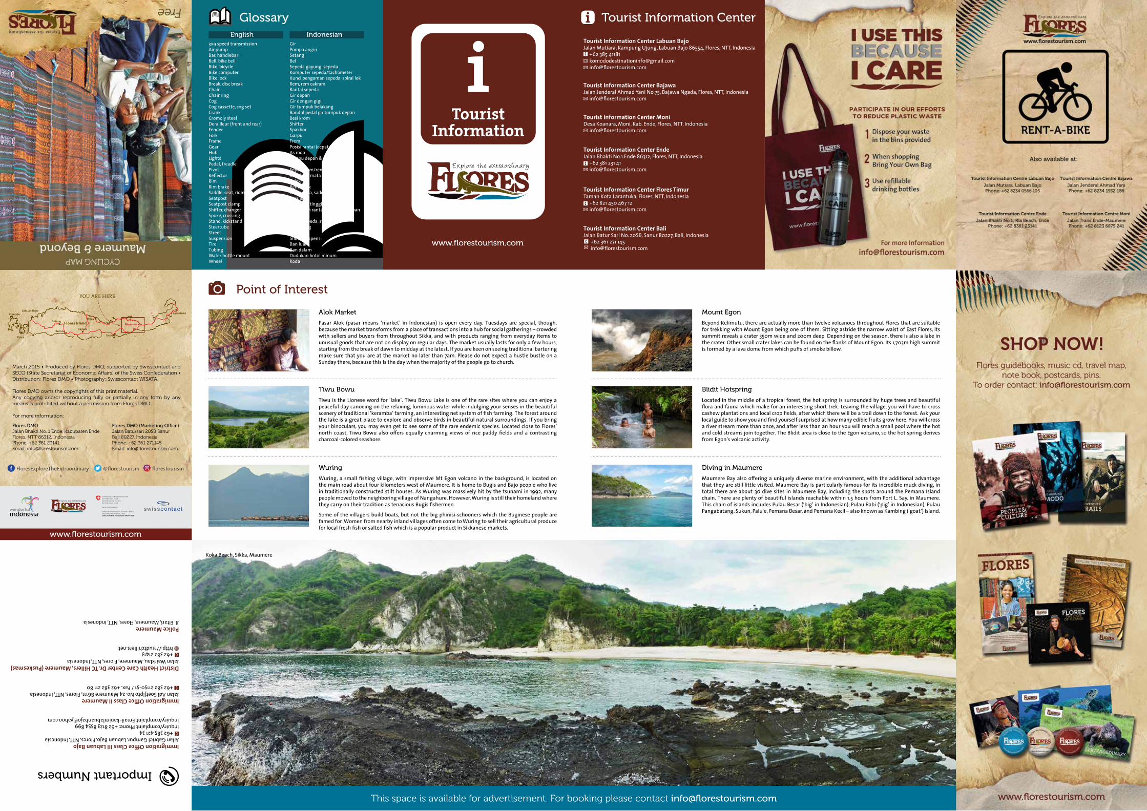
Alok Market
Pasar Alok (pasar means ‘market’ in Indonesian) is open every day. Tuesdays are special, though, because the market transforms from a place of transactions into a hub for social gatherings – crowded with sellers and buyers from throughout Sikka, and with products ranging from everyday items to unusual goods that are not on display on regular days. The market usually lasts for only a few hours, starting from the break of dawn to midday at the latest. If you are keen on seeing traditional bartering make sure that you are at the market no later than 7am. Please do not expect a hustle bustle on a Sunday there, because this is the day when the majority of the people go to church.
Mount Egon
Beyond Kelimutu, there are actually more than twelve volcanoes throughout Flores that are suitable for trekking with Mount Egon being one of them. Sitting astride the narrow waist of East Flores, its summit reveals a crater 350m wide and 200m deep. Depending on the season, there is also a lake in the crater. Other small crater lakes can be found on the flanks of Mount Egon. Its 1,703m high summit is formed by a lava dome from which puffs of smoke billow.
Blidit Hotspring
Located in the middle of a tropical forest, the hot spring is surrounded by huge trees and beautiful flora and fauna which make for an interesting short trek. Leaving the village, you will have to cross cashew plantations and local crop fields, after which there will be a trail down to the forest. Ask your local guide to show you and find yourself surprised at how many edible fruits grow here. You will cross a river stream more than once, and after less than an hour you will reach a small pool where the hot and cold streams join together. The Blidit area is close to the Egon volcano, so the hot spring derives from Egon’s volcanic activity.
Diving in Maumere
Maumere Bay also offering a uniquely diverse marine environment, with the additional advantage that they are still little visited. Maumere Bay is particularly famous for its incredible muck diving, in total there are about 30 dive sites in Maumere Bay, including the spots around the Pemana Island chain. There are plenty of beautiful islands reachable within 1.5 hours from Port L. Say. in Maumere. This chain of islands includes Pulau Besar (‘big’ in Indonesian), Pulau Babi (‘pig’ in Indonesian), Pulau Pangabatang, Sukun, Palu’e, Pemana Besar, and Pemana Kecil – also known as Kambing (‘goat’) Island.
Tiwu Bowu
Tiwu is the Lionese word for ‘lake’. Tiwu Bowu Lake is one of the rare sites where you can enjoy a peaceful day canoeing on the relaxing, luminous water while indulging your senses in the beautiful scenery of traditional ‘keramba’ farming, an interesting net system of fish farming. The forest around the lake is a great place to explore and observe birds in beautiful natural surroundings. If you bring your binoculars, you may even get to see some of the rare endemic species. Located close to Flores’ north coast, Tiwu Bowu also offers equally charming views of rice paddy fields and a contrasting charcoal-colored seashore.
Wuring
Wuring, a small fishing village, with impressive Mt Egon volcano in the background, is located on the main road about four kilometers west of Maumere. It is home to Bugis and Bajo people who live in traditionally constructed stilt houses. As Wuring was massively hit by the tsunami in 1992, many people moved to the neighboring village of Nangahure. However, Wuring is still their homeland where they carry on their tradition as tenacious Bugis fishermen.
Some of the villagers build boats, but not the big phinisi-schooners which the Buginese people are famed for. Women from nearby inland villages often come to Wuring to sell their agricultural produce for local fresh fish or salted fish which is a popular product in Sikkanese markets.
This space is available for advertisement. For booking please contact [email protected]
Koka Beach, Sikka, Maumere
Police MaumereJl. Eltari, Maumere, Flores, NTT, Indonesia
FloresExploreTheExtraordinary @florestourism florestourism