Embed Size (px)
Citation preview

Cyber Physical System – Smart Cloud Traffic Control
Vladimir Hahanov1, Wajeb Gharibi2, Abramova L.S.3, Svetlana Chumachenko1, Eugenia Litvinova1, Anna Hahanova1, Vladimir Rustinov1, Vladimir Miz1, Aleksey Zhalilo1,
Artur Ziarmand1 1National University of Radioelectronics, Kharkov, Ukraine,
[email protected] 2Jazan University, Kingdom of Saudi Arabia
[email protected] 3Kharkiv National Automobile and Highway University
Abstract
A cyber physical system for smart cloud traffic
control is proposed. It is an intellectual (smart) road
infrastructure for monitoring and control of traffic in
real-time through the use of global systems for
positioning and navigation, mobile gadgets and the
Internet in order to improve the quality and safety of
vehicle movement, as well as for minimizing the time
and costs when vehicles are moved at the specified
routes. The main innovative idea is step-by-step
transfer of traffic lights from the ground to a virtual
cloud space for vehicle management, equipped with a
mobile gadget or computer, which displays on the
screen map, route, coordinates of the road user and
real traffic signals. A set of innovative technologies to
address the social, humanitarian, economic, energy,
insurance, crime and environmental problems through
the creation and application of cloud-based digital
traffic monitoring and management is developed. All of
these technologies and functional components are
integrated into the system automaton model of cyber
physical system for interaction between an
infrastructure cloud of exact monitoring and digital
control and vehicle gadget or computer.
1. Introduction
Nanoelectronics, computer and cyberspace (the internet) are today the three-level hierarchy of the evolving digital world. Based on them, a third of all the intellectual resources of humanity are currently working on creating a digital map or mirror structural one-to-one correspondence between the processes, phenomena of the real and virtual worlds in order to improve the quality of human life through the creation of "green" cyber world. This means not only the digitization of all mobile and stationary objects, but
"pure" structured earth space for precise definition of processes and phenomena coordinates occurring in the real world. Digital map of it is constantly evolving from object stationary to the dynamics of real-time processes and has been used to create in cyberspace cloud services for accurate monitoring and optimal (UAV) control of (moving) mechanisms in the real world in dimensions: 1D, 2D, 3D.
Lately acceleration of the development of knowledge about the nature is associated with technological singularity or an explosion in the understanding of the laws of micro- and macro-world in a short period of time that will inevitably lead to the creation for two decades of global cyber-brain to control humanity, as well as the processes and phenomena of the real world.
This is made possible by the development of three components: bioengineering, cyberspace artificial intelligence and design nanotechnologies. Here is the view: 1) built-in and direct integration of human with computer or cyberspace by removing language barriers and interfaces between them; 2) the creation of artificial intelligence for self-learning and self-improvement of computer structures, programs and processes; 3) nano technology for “growing" computers by structuring atoms; 4) the most interesting solution is related to the inevitability of refusal of mankind from the control functions of biological, social and technical objects and processes in favor of cyber systems!
Market feasibility of "green" nano technologies for bottom-up design – building or growing calculator (quantum computer) by structuring atoms – lies in wastelessness, very-large-scale integration, ultra-low power consumption, minimum costs of materials, and in the future minimum worth, ultra-high speed and required scalability commensurable with the class of
delivered services. Modern technologies allow today not only scanning the atomic structures, but also consistently building or growing them. However, on the way of solving the problem of nano-technological-focused development of quantum computer, there are three attractive points in the market: 1) Development of technologies for high speed building required heterogeneous atomic structures in accordance with a given program specification of computer; 2) Creating an effective transactional engine to implement monitoring and control of quantum states of grown atomic computational structures with addressable components; 3) Provide the required stability over time of component states for atomic structure that implements memory.
Stages of cyberspace evolution illustrate successive periods of transition of scientific-technological fashion from monitoring (display) the physical, biological and social processes to their management based on the interaction of real and virtual structures: 1) the 1980s – formation of personal computers; 2) the 1990s – the introduction of Internet technologies in production processes and people's lives; 3) the 2000s – improving the quality of life through the introduction of mobile devices and cloud services; 4) the 2010s – the creation of a digital infrastructure for monitoring, control and interaction of moving objects (air, sea, ground transportation, and robots) [1-6]; 5) 2015-ies – the creation of a global digital infrastructure of cyberspace, where all the processes and phenomena are identified in time and in three-dimensional space, gradually turning into smart components for monitoring and control of cyber-physical space (Internet of Things, Smart Everything).
Where does it go real cyber world? Corporate networks, personal computers, as well as individual services (software), go to the "clouds" of the cyberspace, which have an obvious tendency to partition the Internet for specialized services [1-3]. If today 4 billion users are connected in the Internet (1
zettabytes = 7021 210 = bytes) by means of 50 billion
gadgets, in five years each active user will have at least 10 devices for connecting in cyberspace. Usage of personal computers without their partial or full mapping (synchronization) in the clouds of the Internet becomes impossible. This makes it possible to solve the problem of remote access to personal data and PC services when moving users in space. Economic factor of inefficient use of purchased applications installed in gadgets and personal computers forces the user to abandon their purchases in favor of almost free rent of services in the clouds. All above-mentioned is the essential argument and undeniable evidence of
imminent transition of all mankind in cyberspace of virtual networks and computers, located in professionally reliable cloud services. Advantages of virtual world lie in the fact that the micro-cells and macro-networks in the clouds are invariant with respect to numerous gadgets of each user or corporation. Cloud technologies eliminate almost all of the above problems of reliability, safety, service and virtually have no drawbacks. As far as global corporations and users go to the clouds there exist market feasible problem of protecting information and cyberspace components from unauthorized access, destructive penetrations and viruses. It is necessary to create reliable, testable and protected from unauthorized penetrations cyberspace infrastructure (virtual personal computers and corporate networks) by analogy with existing solutions in real cyber world. Thus, each service being developed in the real world should be placed in the appropriate cloud cell, which combines similar in functionality and useful for human components. The above applies directly to the road service, which has a digital representation in cyberspace for subsequent modeling all processes on the cloud to offer every driver quality conditions of movement, saving time and money.
Personal computer turns into a comfortable micro-miniature intelligent interface to access its own digital cell or to the desired cloud service of the cyberspace. To create a personal gadget-interface in the form of digital systems on chips the market of nano-electronic technology provides developers up to 1 billion gates, located on a chip of the dimension 2х2 sm with the substrate thickness 5 microns.
At that modern technologies allow creating a package (sandwich) containing up to 7 dies. Practically wireless connection of such chips is based on through-silicon vias (TSV) - the technological capability of drilling about 10 thousand through vias in 1 square centimeter of wafer or die. In addition, the emergence of FinFET transistors and 3D-technology based on them for implementation of digital systems provide new opportunities for creating high-speed devices by reducing delays. So, it is necessary to use hardware-focused models and methods for creating high-speed tools for parallel solving real world problems. Discreteness and multiple-valuedness of the alphabets for describing information processes, the parallelism, inherent in the quantum computing, are particularly important when developing effective and intelligent engines for cyberspace analysis, cloud structures Big Data and services of Internet.
Interaction of cloud management services with real earth sensors and activators forms a new concept of Traffic Cyber Physical Systems (TCS). Cyber-Physical
System is a set of interrelated physical and virtual components with distinct functions of adequate physical monitoring and optimal cloud management to ensure the quality of products, processes or services within the constraints on time and resources. One of its variants is a system of intelligent (smart) cloud traffic management. It is based on digital representation in cyberspace of earth road infrastructure and moving objects for subsequent modeling all processes on the cloud to offer every driver quality condition for the execution of the route, saving time and money, where sensors and activators of the system are the mobile gadgets or car computers. The technological environment, combining real and virtual components of the cybersystem for traffic optimizing on a global scale, is the Internet.
The phenomenon of its formation and development is characterized by integration of the interaction of physical and virtual objects in space and time by layering and subsequent deep mutual penetration of historically evolving Internet culture: 1) Layer for combining desktop computers into a single web to improve the computational and informational capacity of the world. 2) Layer for integrating mobile devices, enabling communication between users in social networks and access to the Internet, which is invariant to the location of the person. 3) Layer for combining all smart objects, processes and phenomena (Smart Everything) for their recognition, monitoring and control – Internet of Things. 4) A layer of integration services for all moving objects on the planet in order to monitor living things, positioning, navigation and unmanned control of artificial appliances and vehicles. All moving mechanisms autonomously interact with each other through the Internet, which services enable their precise positioning and quasi-optimal navigation without human intervention. Thus, the four layers of the Internet, created over the past 40 years, are a closed cyber-physical system of the world, which combines the physical and virtual worlds to improve the quality of human life. 5) Layer for integrating information accumulated by mankind in Big Data structures and filled with intelligence and history, and extra-high-power parallel computer services for their analysis have finished creating mankind cyber-brain, which will manage the cyber-physical space of the planet and its improvement.
Thus, the management of physical and social processes will gradually shift from the Earth in a cloudy cyberspace, which will lead to the creation of a virtual technology of legal control of humanity with a high level of collective trust, free of social subjectivism errors of managerial elites. As a result, cloud cybersystem will make fair global and local
management, and the planet – as green as possible, as the primary management objective is to maintain the planet's ecosystems and conditions for quality of life as a human and social formation.
2. Market feasibility of TCS
Every four years, the production technology of goods and services is changed in a particular market segment, which requires retraining of personnel, changing the infrastructure, improving the management and relationship systems, but the main thing - the direction of motion in the market of goods, scientific and educational services. Every 20 years the technologies of typical manufacturers in the leading industries are globally changed, which require billions of dollars of investment prohibitive even for the leaders in the market segments forming the core capital indexes on Wall Street. This means that a new technological structure is formed only on the basis of mutual co-operation of those companies and countries that have free capital, trained personnel and ideas coming into «top ten» of market fashion next 20th anniversary. Today the company and universities of Ukraine can make a technological breakthrough in the market of goods and services, including the most fashionable triad (bio- and nanotechnology, artificial intelligence), which form an important Cyber-Physical-Space- segment of the Nasdaq-market: Internet of Things, Smart Everything and Cyber-Physical Systems.
Ukrainian human resources should participate in the scientific and technological race of Euro-American-Asian companies to obtain in the future a high place on the podium of economic growth in Europe. The potential of the country is fantastically large (human resources, central location on the continent, research and education culture). To use it in the fashionable market segment Cyber Physical Space political will is necessary – control action, creating conditions for forming a comprehensive scientific and technological culture as the basis for the European future of Ukraine. The most interesting global projects today are performed on the basis of union of two spaces together. Cyber physical space is a metric of interaction (mutual integration) of physical, biological and social objects, processes and phenomena with virtual or cloud management technologies. It is designed to integrate the most advanced cyber physical technological solutions. The most interesting of them are related to the inevitability of failure of mankind from the control functions of biological, social and technical objects and processes in favor of cyber systems!

Sources of financing are: 1) State entities (Ministries of Education and Science, Transportation, Interior); 2) Private investors of Ukraine and abroad; 3) European and American interstate programs; 4) Start-up propositions for investment programs of leading world companies (Google, IBM, Microsoft, Apple); 5) Venture capital and automobile companies of developed countries. 6) Own funds of developers and project participants.
Sources of income: 1) The rent for the cloud traffic management service of drivers; 2) Fee for advertising; 3) The rent for corporate cloud service for monitoring and traffic management of transport enterprises; 4) Payment of public services for special service for monitoring and management of vehicles; 5) Payment of municipal public organizations for monitoring vehicles and management of (virtual) street traffic lights of urban infrastructure; 6) The sale of shares through capitalization of the business and open corporatization of the developer company of cloud service; 7) The sale of TCS Start-up to one of the companies Google, Apple or Samsung for $ 150 million.
Feasibility study of the project across the Ukraine and worldwide: 1) The country today has 120,000 companies, including 70 thousand related to IT-industry, more than 7000 - transport companies and government agencies, which are interested in the services of monitoring and management of corporate vehicles. In addition, there are 9 million vehicles in the country potentially in need of cloud services provided monitoring and control of the traffic situation on the booked traffic route. Further, maintenance and operating costs of one traffic light is about $ 50 a year, and its installation is from 1,000 to 10,000 dollars. The number of such devices in Ukraine is 80 000 units. Their one-time installation and operating costs (for 10 years of service) on average: (5500 + 500) x 80,000 = $ 480 million budget money. Half a billion dollars on the traffic lights can be turned to almost zero costs of virtual hosting and maintenence on a cloud service of traffic control devices. At a global scale it can be released for the needs of humanity about 500 billion dollars. In addition, the entire arsenal of physical traffic lights "devours" millions of kilowatt-hours of electricity that does not make the planet greener. Here we can add hundreds of thousands of tons of metal, hundreds of thousands of kilometers of cables and wires. Without all of the above we can do a simple transfer of traffic lights into a traffic control cyberspace, superimposed on a map of the earth road infrastructure. The economic benefits of the transfer on the scale of Ukraine are 500 million dollars just by eliminating the cost of maintaining and installing
intersection control devices. 2) The second part of a market-focused innovation of the project is a 15% savings in fuel consumption due to determination of quasi-optimal routes in real time by the cloud service, as well as a 15% decrease in execution time of route that have a significant impact on the cost of transportation of goods and passengers. Savings from using cloud service for one driver per year is 15000 UAH – the average cost of annual gasoline consumption x 0.15 = 2250 UAH or 200 dollars. Throughout the country, it will give the opportunity to keep in your purse car owners a tidy sum on the order of: 200 х 9 000 000 = 1.8 billion dollars. Approximately the same amount is obtained at the expense of 15% savings of the route executing time; throughout the country it provides an integrated savings in the amount of $ 3.6 billion per year. 3) The costs of creating the industrial layout scalable cloud cyber-physical traffic control system for urban fragments (street Klochkovska Kharkiv city) include the purchase and installation of software and hardware (M1 = $ 200,000), the development and verification of new software and hardware components of the cloud management, integrated with above industrial finished products (M2 = $ 500,000), equipping 100 vehicles involved in the experiments by monitors for cloud transport management (M3 = $ 100,000). Equipping a crossroad urban infrastructure fragment by microcontrollers with the transceiver to create a duplicate of the cloud street layout, synchronised with real traffic lights (M4 = $ 100,000). 4) Total costs for the actual experiments on a fragment of urban infrastructure are as follows: M = M1 + M2 + M3 + M4 = $ 900,000. Overhead is $ 100,000. On a scale of Ukraine the integral costs will not have an additive nature in the process of scaling, since the control system is created as invariant to the dimension of the infrastructure part of the road, but it will require the creation of a powerful data center cost $ 10 million. In addition, there are costs associated with the application and updating of all road traffic lights (road signs) on existing maps the order of $ 1,000,000. Thus, the integral cost of creating a scalable software-hardware cloud complex of cyber-physical control system, integrated with a fragment of urban infrastructure and experimental group of vehicles consists of: 900,000 + 10000000 + 1000000 + 100000 = 12 000 000 dollars. 5) Income of the resident company, in dollars, of the introduction of cloud-traffic control system will be determined by the following components: entering the rental payment for the cloud service from transport companies 7000x1000 = 7000000. Payment for traffic services is coming from the drivers of private cars 100 x 9,000,000 = 900,000,000. Given that a cyber system

for cloud traffic management will be equal to Google-services on the importance, the level of capitalization of the Internet layer is expected to be about 10-50 billion dollars. In this case, the expected revenue from advertising will be at least 5 percent ($ 500 million). For 5-10 years vehicle cyber layer of the Internet will unite in an intelligent network one thousand drivers with cars and 4 billion people on the planet. Capitalization of all the companies forming cyber-layer of traffic management can be integrated to reach $ 300-500 billion. A car with a monitor, computer and the Internet will become a work area and a sitting area where the driver can hold up to 20% of your life, solving industrial and social problems of communication in the process of movement.
Economically the introduction of a management service everybody benefits: to driver - fuel economy, and route time; to company - reducing the cost of delivering cargo and passengers; to nature and state - the reduction of crime, traffic offenses, the level of exhaust emissions and improve the traffic safety. However, apart from the financial costs of the development and implementation of cloud traffic management infrastructure it is necessary by government legislation and organizational measures to educate the people on the planet a new technological culture of movement of the streets and roads, based on the widespread use of mobile monitor, which in one form or another has 80% of the population Earth today.
Stages of innovation on the side of the cloud server and gadget-user are the following: 1) Creation of quantum data structures for parallel data storage and matrix analysis of Big Data cyberspace formats. 2) The development of quantum-like virtual parallel processor for high speed searching, recognition and quasi-optimal decision making for managing transport and infrastructure of the city. 3) Creating a set of software for the implementation of cloud services for monitoring and management of transport and traffic in real-time through the use of virtual cloud traffic lights. 4) The development and practical implementation of the model of the experimental section of the city for control of traffic by using cloud traffic lights, monitoring and management of vehicles with animated visualization of scalable processes on a computer screen. 5) Verification and implementation of software and hardware of a cloud service for monitoring and management of traffic by using virtual traffic lights, as well as the implementation of software tools for the driver when moving on a given route.
Own evaluation of the scientific and technical level of the project: 1) It has no analogues in Ukraine in terms of creating a cloud service for monitoring and
management of traffic, infrastructure of street traffic lights and providing a service for laying optimal routes in real time. 2) At the level of the existing analogues in the world – in terms of intelligent control of street traffic lights, it takes into account the traffic situation at every crossroad in real-time. 3) It has no analogues in the world in terms of the implementation of traffic management through the use of smart (virtual) cloud traffic lights displayed on the monitor screens of vehicles and managed by real traffic.
Stage of readiness of the business plan: 1) Conducting market research – 90% of the planned activities. 2) The level of description of business processes – 80%. 3) Feasibility Study – 90%. 4) Condition of economic calculations – 80%. 5) Schedule of the project – 80%. 6) The production plan of scalable virtual infrastructure of the city – 50%. 7) Marketing plan for virtual infrastructures of cities and cloud services – 70%.
Intellectual property rights: patent applications: 1) A model for automaton monitoring and management of traffic, based on the use of virtual street traffic light displayed on the screen of vehicle monitor. 2) An automaton model of cyber-physical system, which creates interaction between real and virtual traffic infrastructures, forming a service for physical monitoring, cloud management and laying quasi-optimal routes. 3) Interaction model of quantum-like data structures with a virtual processor for parallel processing information in order to control traffic lights and cars movement along the selected route in real-time. 4) A model of smart traffic light that generates together with vehicle computers or gadgets, a computer network for quasi-optimal moving the crossroad of all road users from the standpoint of minimizing the total time.
3. Intelligent virtual traffic light
A key innovative component of the infrastructure TCS is virtual and/or real smart traffic light (Smart-Streetlight, SS) that is a stationary microcontroller (digital system-on-chip) with the transceiver directly related to cloud of traffic management. It generates the wireless network to communicate with the vehicle computers (Car-Computer, CC) at distances up to 100 meters via Wi-Fi. Traffic light state is available for monitoring in a cloud Internet service and displayed on the screens of all vehicles, which according to the routes intersect the crossroad and are in the area of its competence. Traffic lights can be controlled remotely by special services or requests from vehicles crossing the intersection. Smart traffic light scans and processes all requests from vehicles coming through the TCS-
cloud in real time. It generates the appropriate control signals, which functionally dependent on the traffic situation on the sides of the crossroad. All the traffic lights of the city are united to a technological network layer of a cloud service that serves the infrastructure of streets and roads in the intellectual and/or off-line mode with manual and/or remote control.
A method for managing traffic light uses taking a Boolean derivative along the lines of movement. The last ones have linear diagrams of accumulating
bt*kN +=• and passing bt*kN +−=
o cars
through the crossroad – the bottleneck of road infrastructure – with the scan period of vehicles equal to 1 second. Here k is bandwidth or the number of vehicles passing through the crossroad per second; t is real time; b is the initial number of vehicles at the crossroad. Calculation, or update of the derivative along the lines of the movement for the intersection to generate traffic light signals is synchronized with the specified period, but changing its state in the presence of queues on all sides of the crossroad is delayed for minimizing conflicts (total downtime of vehicles) on all lines of traffic flow. The switching cycle of traffic lights has a minimum period equal to the time of movement of a car through a crossroad. The maximum period for the line of movement is limited by the occurrence (presence) of requests on movement through the crossroad from the intersections.
Traffic light as originally primitive tool for regulating traffic at a crossroad is gradually transformed into a specialized computer system for monitoring and control, including the following components: LED-monitor, video camera, Wi-Fi transceiver for communication with car computers and the Internet, software for intelligent traffic management. The last ones today use high mathematical culture: theories of automata, queuing and knowledge, Petri nets and neural networks, genetic algorithms and reinforcement learning. The system of traffic light agents or sensors for monitoring transport includes the following: relatively expensive video detectors and inductive loops embedded in the pavement, sound indicators of noise and microwave radars are used much less.
Eliminating all traffic agents is possible by digital identification of vehicles, based on the precise positioning of car gadget or computer. Today such agent may be a mobile phone of the car driver, which delegates its location to the cloud of traffic management by using global positioning system. In response, the mobile phone receives all services for traffic management: the signals of cloud virtual traffic light, synchronized with real traffic lights, the best
routes of movement, "green wave" with the non-intensive traffic, saving time and fuel.
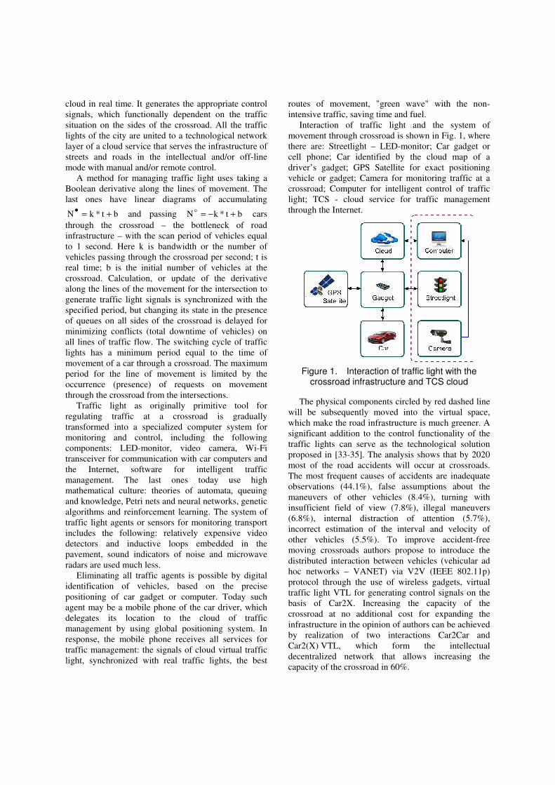
Interaction of traffic light and the system of movement through crossroad is shown in Fig. 1, where there are: Streetlight – LED-monitor; Car gadget or cell phone; Car identified by the cloud map of a driver’s gadget; GPS Satellite for exact positioning vehicle or gadget; Camera for monitoring traffic at a crossroad; Computer for intelligent control of traffic light; TCS - cloud service for traffic management through the Internet.
Figure 1. Interaction of traffic light with the crossroad infrastructure and TCS cloud
The physical components circled by red dashed line will be subsequently moved into the virtual space, which make the road infrastructure is much greener. A significant addition to the control functionality of the traffic lights can serve as the technological solution proposed in [33-35]. The analysis shows that by 2020 most of the road accidents will occur at crossroads. The most frequent causes of accidents are inadequate observations (44.1%), false assumptions about the maneuvers of other vehicles (8.4%), turning with insufficient field of view (7.8%), illegal maneuvers (6.8%), internal distraction of attention (5.7%), incorrect estimation of the interval and velocity of other vehicles (5.5%). To improve accident-free moving crossroads authors propose to introduce the distributed interaction between vehicles (vehicular ad hoc networks – VANET) via V2V (IEEE 802.11p) protocol through the use of wireless gadgets, virtual traffic light VTL for generating control signals on the basis of Car2X. Increasing the capacity of the crossroad at no additional cost for expanding the infrastructure in the opinion of authors can be achieved by realization of two interactions Car2Car and Car2(X) VTL, which form the intellectual decentralized network that allows increasing the capacity of the crossroad in 60%.

Further improvement of the street traffic light in the infrastructure of cities is due to its conversion into cyber physical traffic management system as it is shown in Figure 2.
Figure 2. Cyber physical system VTL for traffic management at a crossroad
The cyber VTL-system is designed to provide a «green wave» when driving a car at a crossroad and it contains two main components: the virtual one – Cyber Cloud and physical one – Crossroad Infrastructure. The first component is designed to generate the control actions, which form the traffic signals, depending on the history and real traffic at the crossroad. The second one monitors road conditions by using video cameras, smart sensors and automotive gadgets. Intercommunication of a cloud traffic light with the physical crossroad infrastructure is realized by means of telecommunication tools (TC): GPS Satellite, mobile Internet, and GSM/GPRS. At the same time, the cyber system has the ability to manually control the traffic lights by using input Mode, and also monitor its state during operation on an output VTL States. Two blocks of Intelligence and Security provides a realization of intelligent control algorithms depending on the actual traffic, as well as protection of traffic light from unauthorized access. Innovative value of cyber system VTL of transport management at the crossroads is to use a virtual traffic light, its intelligent control depending on road conditions, as well as monitoring road situation by collecting positioning signals and transport routing from car gadgets.
Schedule of the project is targeted at three years and represented below. 1) First year. Funding of $5 million. Organization and the establishment of a business entity in the form of laboratory «Traffic Cyber Systems» in Ukraine. Founders are: KhNURE and KhNAHU, as well as interested individuals, companies and organizations. Development of mathematical cyber layer of the project in the form of
models and methods, Big Data of structures, new virtual cloud (Memory-Transaction) MT-computers and tools for animation modeling traffic management cyberspace. Development and implementation of algorithms for quasi-optimal managing traffic lights, optimization of routes using history. Development of algorithms for ergonomic animation in order to monitor and control traffic situations at the crossroads on the side of the cloud (server). Development of algorithms for ergonomic visualization of management infrastructure by using existing maps to output graphical information on vehicle monitors. The software implementation of the algorithms in the cloud services of cyberspace transport layer. 2) Second year. Funding of $3 million. Development of a technological cyber layer of the project in the form of the interaction of software and hardware components of a cyber physical system, integrating existing and new developments: mapping, traffic lights, car computers into a single automaton model for traffic management in real time. Designing information, methodical and lingware of the cybersystem. Testing and verification of the virtual cybersystem part. 3) Third year. Financing of $4 million. Development of technical and organizational cyber layers of the project for subsequent integrating real road management infrastructure and vehicles with a virtual cyberspace. Development of deep multi-version protection of all software and hardware components of the cloud service for vehicle management and subsequent verification of the industrial prototype of the cloud traffic management system on a fragment of urban infrastructure by using specially equipped cars and smart cloud traffic lights synchronized with the real ones. Creating a data center (extra money $10M) and scaling the cyber system. Creating a data center (extra money $10M) and scaling the cyber system. Actualization of the cartography layer through virtual mapping the infrastructure of traffic lights and their synchronizing with the real control devices of crossroads for a transitional period. Development of an Internet banking system to support the accumulation of permanent, temporary and one-time rental payments. Design support documentation of the project, the advertising campaign on the benefits of cloud cyber traffic management system using press releases, television, the Internet, and international conferences.
4. Formal model of cyber system
The goal is to improve the quality and safety of traffic by creating a cyber physical system – intelligent traffic control system (TCS), which provides monitoring and control in real-time [1,3], based on the

use of vehicle mobile gadgets and cloud (virtual) traffic lights that makes it possible to improve the quality of life of the driver, to minimize the time and cost in the organization of traffic, and generate innovative solutions for social, human, economic and environmental problems.
The research object is cloud cyber system technologies for monitoring and management of vehicles through the use of virtual traffic lights, road signs and mobile gadgets for identification, radar and navigation of road users.
The subject of research includes traffic flows, the virtual infrastructure of traffic messages, software and hardware mobile systems for identification, monitoring and management of traffic through the use of virtual traffic lights.
The main point of the research is the creation of a cyber physical system in the form of Smart Cloud Traffic Control in real time on the basis of developing a cloud traffic infrastructure (see Fig. 2), integrated with the virtual street traffic lights and road signs, mobile tools for vehicle identification in order to improve the quality and safety of vehicle movement, minimizing the time and cost when performing the specified routes.
Innovative proposal: Smart Cloud Traffic Control has the purpose of the introducing the time parameter in the digital map of the planet, as well as the gradual transfer of traffic signs and traffic lights in the clouds, which radically improves of traffic infrastructure and creates the potential for savings thousands of tons of metal for the manufacture of traffic lights and unnecessary car numbers, million kilowatt hours of electricity, millions of dollars for the installation of traffic lights, road signs and operating costs as well as reducing the time to install and update the traffic lights in the virtual infrastructure of cities from a few days to a few minutes.
Formal cybersystem model is represented as two cloud components or engines: 1) f – monitoring and management; 2) g – executive infrastructural engines, which are interconnected by signals for monitoring, management and initiation of both components for implementing the services. Analytical form [1] for describing TCS-system and its structural equivalent are represented in Fig. 3.
In the model there are the following elements
)P,Y,R,X,,,g,f(A υµ= correspondingly: control
and execution units, monitoring and control signals, inputs of control tasks and executive resources, outputs for indicating status of algorithm of tasks execution and providing a service. Here also there are signals of
external traffic management )s,p,v(X = for
regulating movement of government person, police cars and special purpose vehicles, respectively.
Transport control signals L}L,L,L,L{ xhti ==υ
use a virtual traffic light working in the following modes: 1) intellectual one, functionally dependent on road conditions; 2) automatic one with fixed switching periods; 3) virtual manual mode based on digital monitoring of intersections on a screen of police computer, its analog is air traffic control by using the monitor of flying control officer at the airport; 4)
emergency stop υ∈xL of a vehicle on a digital
request of police, which is visualized on the screen of the car gadget. The following objects are subject to
cloud monitoring: ]P,M,L),k(G[=µ all mobile
gadgets of cars with their coordinates, states of traffic lights tied to terrain map M, as well as execution of ordered traffic routes.
A = (f,g,µ, υ, X, R, Y, P),
Yt = f[(X, R,µ)t, Yt−1];
Pt = g[(X, R, υ, Y)t ].{X = (v, p,s);Y = [G(k), L, M, P
ur];
R = (G, Pur
)R;P = (G(k), L, M, Pur
)P;
µ = [G(k), L, M, Pur
];
υ = {Li, Lt, Lh, Lx} = L;
G{R, P} = {G(k), L, M, Pur
}.
Figure 3. Analytical and automaton form for describing TCS-system
Transfer the traffic light }P,{L υ∈ from real
crossroads to cloud one completes the creation of a virtual infrastructure of the planet, forming a closed loop of monitoring and control system involving a single real component in the form of mobile gadget
}P,M,L),k(G{}P,R{G = of road user (RU). Gadget
realizes the interface function for communication with the cloud: R- Enter to the cloud – the order of service
R)P,G(R = (delegation of ID-gadget and movement
path to the cloud) and P-exit from it – obtaining
service ]L,P),k(G,M[P = (map, gadget coordinates,
the best route, traffic light). User receives a service for scrolling map window
and traffic lights in real-time on the way P if he (she) delegated gadget to the cloud. If way is ordered user receives additionally a quasi-optimal route of travel and priority traffic signals. Actually, in the view of user a system is created by two components: the cloud and the gadget. At that novelty and originality of the proposed system is in providing cloud service – traffic

lights on the screen of road user gadget. Everything else (maps, routes) already exists and work. Implementation of the proposed TCS-system will be through the creation of virtual traffic lights, which duplicate real ones in synchronous mode, and then the gradual eliminating all physical devices and signs of ground road infrastructure as drivers purchase new technological culture in an evolutionary way. Moreover, all the major cities already have virtually centralized computing (cloud) control traffic lights. Therefore, the transfer of traffic lights to the cloud will not be associated with substantial additional costs, but rather the opposite large operating costs for maintenance of traffic lights and signs of urban infrastructure in working condition are transformed to zero.
Mobile vehicle gadget G is the main control unit for TCS, as well as it is a major consumer of traffic light signals L of car motion control displayed on the
windshield, )P,D,T,V,G,L(F}L,L,L,L{L xhti == ,
where V – special control signals; T – programmable cycle of autonomous control of traffic lights; D – accumulated intellectual statistics on traffic lights (avenue, district), including taking into account the
time of year and day;. P – incoming orders on traffic routes.
Creating virtual system of traffic light allows practically no financial, time, material and energy costs add new traffic lights in the virtual space by programming, as well as remove them from the cloud in the modernization of infrastructure. Visualization of traffic lights on the windshield (mobile monitor) and voice dubbing will improve the quality and safety of traffic, reduce emergency situation for the driver and urban infrastructure in general. Cloud traffic light as a digital signal unlike analog perception of driver of the real traffic lights is a more reliable tool for managing vehicle, including for subsequent introduction the autopilot in traffic that perceives only deterministic control signals.
Road users are identified in the cloud by means of gadget or iPhone, which are matched, when he (she) gets in the car. User status increases with the passage of traffic lights, if the route to be ordered in advance. Other road users (pedestrians, motorcyclists and cyclists) also have the right to order the route, raising their status for use of traffic lights. Pedestrians are able to get service for ordering a combined route, including all kinds of ground and underground transport (bus, metro).
For vehicle a control system forms the functional for optimizing the quality of service, which depends on the following variables (time, length and route
quality): )K,P,T(fminQ = . For traffic light a control
system forms the functional, minimizing the total downtime of vehicles during the day (Z – switching cycle of traffic light):
1n
1i iii
iiiii
)J,V,P(Z
)J,L,V,P(T
n
1minQ
−
=∑
= , where the
numerator and the denominator show the functional dependence of downtime and cycle on the parameters in brackets.
Actually there are summed parts of traffic light cycles required for the passage of each vehicle through the crossroad. If the result is the evaluation of the quality, which is close to unity Q = 1, then the crossroad is functioning normally. Otherwise, it is necessary to modify the switching cycle or reconstruct the intersection. For urban infrastructure a control system forms a functional for optimizing the service quality of vehicles during the time interval (hour, day), depending on the total travel time of vehicles on specified routes on recommended speed, downtime of cars at traffic lights and in traffic jams, divided on the ideal passed routes on the permitted speed without delays at traffic lights and traffic jams:
1n
1i iii
iiiii
)V,P(T
)J,L,V,P(T
n
1minQ
−
=∑
= .
For avenue of a city a control system forms a functional, optimizing the total travel time of vehicles from the beginning to end of the street for a period of
time (hour, day):
1n
1i ii
iiii
)V(T
)J,L,V(T
n
1minQ
−
=∑
= .
5. Problems to be addressed in the
realization of TCS cloud
1) Improvement of digital radio-frequency positioning technology for vehicle (gadget) with an accuracy of 2 meters.
2) Creation of new system of mnemonic and accompanying audio signals of the monitor, which constitutes cloud traffic rules.
3) Development of operational and control automata, which combine all components of TCS into a common cloud-based system, where car gadget G(k) is input-output and represents a single communication interface with the cloud; it can be positioned in real time with the exact coordinates on the map M of the infrastructure with traffic lights L to control the movements of road user.
4) Designing a scalable system TCS for traffic light, avenue, district, city, country, and planet.
5) Development of client services (software applications) for vehicle, pedestrian, cyclist, motorcyclist aimed to optimal control transportation routes, including the video and audio signals linked to the infrastructure and received from TCS in real time.
6) Designing cloud (server) services for solving optimization problems of routing, managing traffic lights, modification of cloud and real infrastructure, as well as operational management of cloud traffic lights, based on traffic monitoring.
7) Development of qubit data structures and "quantum" matrix processors based on Big Data technologies for the simultaneous and parallel servicing TCS -cloud users in real time, the number of which in the limit can be equal to the number of inhabitants of the planet.
8) Creation of intelligent models, methods for synthesizing and analyzing the virtual infrastructure for evaluating traffic quality, modeling traffic, generating the optimal route taking into account technical, climatic, social factors, the quality of roads, the amount of traffic lights, left turns in order to create new and reconstruction of existing road infrastructure.
9) Provision of cloud services for trucking companies to improve the quality of passenger service, cargo, optimizing time and material costs.
10) Provision of cloud services for the driver in order to improve the quality of travel on a given route and optimize the time and material costs.
11) Collection of statistical information (intellectualization of global, corporate and personal infrastructure) by accumulating the history of traffic, changing its parameters in time and space for generating quasi-optimal routes of future trips.
12) Creation of information security and authorized access to personal and corporate data in the cloud. Each user sees only your car in the cloud and anonymous traffic flows. All transport identifiers can be accessed by only special government services by court order or decree of the investigating authorities.
13) Creation of TCS specification as a start-up project for subsequent proposal or sale to Apple and Google.
14) Search of valid partners and wealthy investors in developed countries (Russia, USA, Germany, Estonia, Iran, Saudi Arabia, Poland, France, Sweden, Norway) for the joint project Smart Cloud Traffic Control by obtaining grants in the framework of European and national programs for executing scalable prototype of the system within the city and country.
15) Patenting in Ukraine, the United States and other countries the virtual technology and traffic management infrastructure through the use of real-time cloud traffic lights displayed on the gadget monitors simultaneously used as sensors and activators.
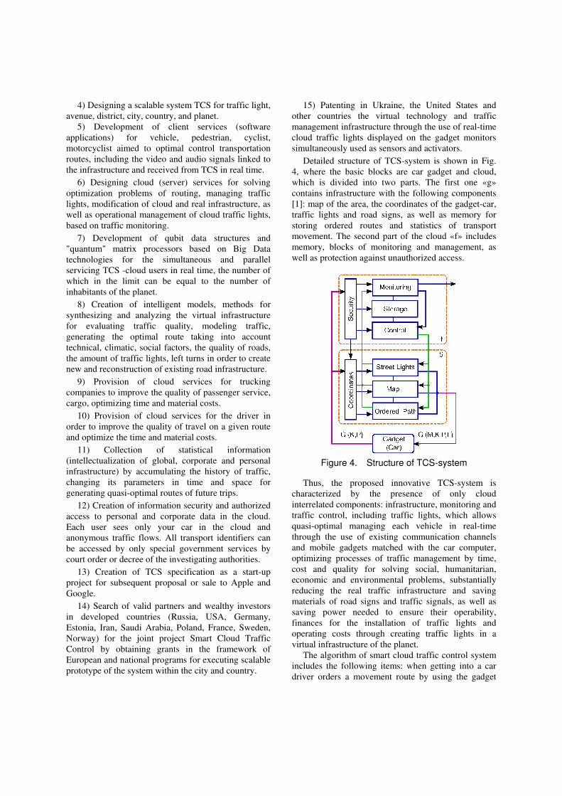
Detailed structure of TCS-system is shown in Fig. 4, where the basic blocks are car gadget and cloud, which is divided into two parts. The first one «g» contains infrastructure with the following components [1]: map of the area, the coordinates of the gadget-car, traffic lights and road signs, as well as memory for storing ordered routes and statistics of transport movement. The second part of the cloud «f» includes memory, blocks of monitoring and management, as well as protection against unauthorized access.
Figure 4. Structure of TCS-system
Thus, the proposed innovative TCS-system is characterized by the presence of only cloud interrelated components: infrastructure, monitoring and traffic control, including traffic lights, which allows quasi-optimal managing each vehicle in real-time through the use of existing communication channels and mobile gadgets matched with the car computer, optimizing processes of traffic management by time, cost and quality for solving social, humanitarian, economic and environmental problems, substantially reducing the real traffic infrastructure and saving materials of road signs and traffic signals, as well as saving power needed to ensure their operability, finances for the installation of traffic lights and operating costs through creating traffic lights in a virtual infrastructure of the planet.
The algorithm of smart cloud traffic control system includes the following items: when getting into a car driver orders a movement route by using the gadget
and query to TCS, which verifies the validity of the driver by using the block «Security» that authorizes access to the cloud; it defines the gadget or car coordinate in the window of area map, calculates the optimal path in time and space, and also provides support for transport in real time by providing management services by means of cloud traffic lights tied to the coordinates of crossroads on the movement route. In the absence of the ordered route the user receives only the window of area map with traffic lights on the current path of vehicle movement, but TCS-system may offer the most likely route, based on trip statistics stored in the history «Storage». The gadget can be used by pedestrian when crossing crossroads and avenues, as well as for ordering route based on usage of existing vehicles: bus, subway, train, and plane.
User modes of TCS-system are following: 1) maintenance of the road user by providing infrastructure map, coordinates, and traffic lights; 2) order of a movement route, when quasi-optimal path that minimizes the time, distance, quality of movement, including statistical traffic lights green wave along the line is added to the functionality; 3) custom order of a route by users )s,p,v(X = , when on
the way and ahead a special transport green wave is provided and guaranteed, offering to other road users don't impede movement of a special machine right up to stop by using digital and voice indication of appropriate control signals on gadget screen of a car in the area of mutual infrastructure impact of transport.
6. The grounds of TCS
1) Market feasibility. The capitalization of the business project in Ukraine after improvement of cyber cloud for transport management can amount $1-3 billion, on a global scale ¬ 200-500 billion.
2) The project is focused on providing services for 9 million drivers in Ukraine and 9000 companies. Analogues of such systems do not exist in the world. There are separate components for creating the infrastructure: electronic maps, satellite location and navigation systems, specialized databases in clouds, tools for monitoring, collecting and protecting information, car computers and gadgets with transceivers, centrally controlled traffic lights, cellular communications, as a part of the necessary infrastructure for the project. Tools for navigating, managing and monitoring vehicles are financially accessible to drivers. Software, hardware and network centralized management of traffic across the country, as well as cloud computing technologies are available. The technologies used in the infrastructure of roads
and cyberspace are continuously improved, and their cost is reduced. Computer, mobile and internet literacy of people is enhanced. The state government understands the need for creating and use of intellectual infrastructure and cloud service for qualitative and safety road.
3) State program «Road Safety» in the strategic plan of Ukraine «Prosperous society, competitive economy, effective government» for the period until 2016 with a planned budget of 5.43 billion hryvnas from March 25, 2012.
4) Theoretical basics of intelligent models, methods and software-hardware for analyzing cyberspace related to discrete optimization of searching, recognition and decision-making are represented in [1-4].
5) Experience in the development and implementation of embedded and RFID digital systems for road monitoring is described in [5-9].
6) Experience in the development and implementation of software and cloud services for optimizing vehicle routes of Ukrainian corporations in order to minimize the financial and time costs and improve the quality of passenger service is represented in [10-15].
7) The developed distributed road management system in large and major cities is based on highly reliable computing equipment [11-13].
8) The existing systems of traffic monitoring in the United States, Canada and Japan are OnStar and NEXCO Central. OnStar system is focused on monitoring individual vehicles, NEXCO Central provides global traffic monitoring on the busiest highways of the country. OnStar services are available for the following cars: Acura, Audi, Isuzu, Subaru, Volkswagen. Currently , there are about 4 million users of the service. The cost of one unit for monitoring is about $200. There used CDMA communication channel provided by Verizon Wireless in the USA and Bell Mobility in Canada. For determining position GPS is used. There is voice communication with the operators. Information from the sensors (mostly shock sensors and airbag deployment sensors) is automatically transferred to the call-centre. This allows informing rescue and law enforcement agencies about the location of the accident immediately. In addition, all vehicles equipped with this system have GPS transmitter that allows tracking a stolen car. There is also a possibility to obtain information about the speed, fuel consumption, direction and style of driving. This information is used by insurance companies to calculate the cost of individual insurance policies. New car models are equipped with a system of remote

engine stop. The car can only be started after entering a special secret code. Cost of services – Safe & Sound – is $18.95 per month. Tariff includes automatic notification of an accident, stolen vehicle monitoring, emergency services. Directions & Connections - $28.90 per month. Additionally, there is the ability to monitor the direction and style of driving.
The system NEXCO Central is designed by Japan Highway Public Corporation. The principle of operation is global traffic monitoring on the main highways of the country. The system covers about 2,000 km of roads. Data center processes data received from road sensors with minute intervals by using a global IP network. 744 access points are installed in the roads, which transmit information about the road situation by telephone lines.
9) Global infrastructure projects for several centuries combined countries. Transcontinental railways and highways, underwater tunnels and giant bridges, space and aviation projects serve as a strong catalyst for the development of the economies of many countries. Development of the Internet, mobile and cloud technologies have made possible the unlimited scaling of computer systems and data storage capacity. The next layer of cyberspace is Internet of Things, which involves communication between things themselves without human intervention, automated data collection, processing and analysis of big data, generated by intelligent sensors. It is possible to develop high-precision deterministic behavior models of the environment and life of the city, which become smarter and allow greatly improving the standard of living, comfort and safety due to the constant monitoring of indications of smart sensors in real time.
10) Improving Internet of things requires solving complex scientific and engineering problems in the field of computer engineering (http://eai.eu/, http://iot.ieee.org/), which are engaged in the global research community (IEEE, EAI) and companies (Intel, IBM, Apple, Google, Samsung, Dell, AT & T, CISCO, THALES, WorldSensing, Aguila technologies, Connit, SigFox, Guglielmo, DQuid, BitCarrier). Internet of things is based on the use of wireless heterogeneous networks operating in different frequency ranges according to the standards – ZigBEE, WiFi, LTE (3G, 4G, 5G), Bluetooth, which provide the distance and speed of data transfer and low power consumption. Internet of things functionality is the collection and analysis of data, based on the use of big data, open data, cloud computing. Big data are focused on the analysis of large volumes of unstructured data. Open data is a concept for formatting information in order to use it by computers without human intervention. Here, the data are open and protected not
by copyright, but free licensing. Cloud computing is infinitely scalable platform for processing and storage of big data, coming from the smart sensors in real time. Internet of Things involves machine-to-machine interaction M2M (a set of technologies and approaches for the exchange of information between the mechanisms for the creation of smart cities (http://www.android.com/auto/, https:// www.apple.com/ios/carplay/, http://java.dzone.com/ articles/car-wars-connectedcars.
Here the companies are indicated, which provide the platforms and complete hardware solutions: Connit, Aguila Technologies, WorldSensing. Project WorldSensing FastPrk is smart parking service, which allows the driver using a mobile device to quickly find free space, and the city government more efficient use of parking space. Parking sensor operates in the frequency range of Sub-GHz with a radius of 500 m.
11) Even today, the car is unthinkable without Internet services, focused on the combination of a pleasant trip, a comfortable stay and the implementation of business operations within the car that is a single favorite place with a full range of functional business services for a person (voice communication, messages and e-mail, banking and navigation, as well as music, games, videos). All this is made possible by connecting the vehicle to the Internet through synchronization of mobile phone and the monitor (PC) of the vehicle, allowing authentication of the driver in the real world and the virtual cyberspace. Here the leaders are Apple and Google. In 2014, they announced a platform of communication, navigation and entertainment, built-in car (Apple iOS CarPlay, Google Android Auto), which use microprocessor operating system Blackberry QNX. To install the system it is necessary to connect a smartphone to the car computer by Android or iOS USB cable. The appearance on the market of automobile operating system allows us to conclude that in 3-4 years all the vehicles will be connected to the global Internet services focused on improving the quality of human life when driving. Such an agreement is between the 31 leading automobile companies in the world. Almost everything that has been declared in the project iCTC [1-3], three years ago, is gradually being implemented in the services Aplle CarPlay, except one – the virtual street traffic lights at the windshield-monitor of the car. No traffic lights on the sea and in the air, they will not be on the ground in 5-10 years!
12) Market and scientific feasibility of the project «Smart Cloud Traffic Control» also confirmed by the updated structure of the IEEE World Society, which includes 38 communities, 9 committees and 7 boards including: IEEE Geoscience and Remote Sensing

Society, IEEE Intelligent Transportation Systems Society, IEEE Professional Communication Society, IEEE Systems, Man, and Cybernetics Society, IEEE Vehicular Technology Society, IEEE Cloud Computing Community, IEEE Electric Vehicles Community, IEEE Biometrics Council, IEEE Sensors Council.
7. The advantages of cybersystem cloud
services
1) For the planet – environmental conservation by reducing pollution, improving the length and quality of human life, save fuel and energy resources by reducing the travel time through the selection of the optimal route, reducing the amount and complexity of traffic jams due to the introduction of intelligent traffic lights into the infrastructure.
2) For government agencies – the police, traffic police – accurate identification of vehicles, precise digital monitor positioning of vehicles in time and space, including hijacking, collisions, unauthorized routes. Remote control via the cloud by emergency engine off, if transport poses a real danger to other road users. A significant reduction in accidents due to the calculation of maneuver security level, reducing the impact of road traffic accidents, increase safety and comfort of road users. Remote manual control of traffic signals due to the digital monitoring the traffic situation at the crossroad.
3) For transport companies – monitoring positioning and movement of vehicles, quasi-optimal execution of orders for the transport of passengers and goods in terms of minimizing the material and/or time-consuming.
4) For driver – providing services related to generating the quasi-optimal routes and timetable, taking into account the negative factors of the existing infrastructure in order to minimize the time and costs in real time; reduction of accidents due to digital monitoring closed parts of the road for visual viewing and definition of maneuver safety level.
5) For passenger – providing services to monitor the positioning and movement of passenger vehicles on stopping or transport terminals by using stationary monitors or mobile gadgets for communicating with the appropriate cloud services. Visualization on the car screen of the critical points of the vehicle route in real-time through the use of video cameras. Order of hybrid route to the destination through the use of a variety of vehicles.
6) For insurance company – automatic and accurate digital detecting in time and space all violations of traffic rules by the driver that entails withdrawals of
cash equivalent as fines, forms the history of all traffic accidents, and records them to the cloud cells of corresponding vehicles, which gives an opportunity to eliminate police involvement in the inspection procedures in the absence of accident victims.
8. Technical and functional features of the
TCS system
1) Monitoring (24/7) of the actual speed for all vehicles and informing the driver about areas of the speed limits; digital monitoring of passage on prohibiting signs and traffic lights.
2) Fuel economy, reduce of pollution, and reduce of travel time due to selecting the best route proposed by a cloud.
3) Prevention of traffic jams due to pre-planning of vehicle movement, taking into account the plans of the other traffic participants; adjustment of vehicle route in real-time when changing traffic conditions.
4) Intelligent management of the switching cycle of traffic lights depending on road conditions at crossroads.
5) Generation of reports and recommendations to improve the road infrastructure, placement of signs, traffic lights, and centralized programming the switching cycles.
6) Prevention of vehicle theft and unauthorized leaving the accident scene through the monitoring the location of each vehicle. Cloud digital registration for insurance companies of all the necessary details and dynamics of the accidents, which not injury-related, without the participation of the traffic police.
7) Informing of the special services through the panic button about the incidents, occurred on the road or in the car.
8) Alert of the driver about potential hazards on the route based on information obtained from the clouds during the movement.
9. Problems addressed by using digital
identification
Even today, there are many topical and practically focused problems, which can be solved by using radio-digital passports:
1) Identification of the product (subject or object) in a local or global coordinate system.
2) Saving the parameters characterizing the basic properties of the object.
3) Accumulation and saving the history of the object life cycle.

4) Transfer of the information about an object or phenomenon by the authorized request to the management cloud.
5) Receiving the authorized information, which make it possible to modify the individual properties of the electronic passport of the object.
6) Authorized interaction with electronic passports (gadgets) other objects in the field of radio visibility of the object.
7) The transmission of information on the object interaction with other identifiers within of radio visibility.
Thus, the electronic digital identifier of the object is a stand-alone digital system-on-chip with transceiver, which is able to store information about object identity, modify it at the command of a control center, as well as store information about the interactions with the environment and other digital IDs to transmit data to a management cloud. Other variants of ID communications are focused on the use of the following: 1) mobile telephony network; 2) satellite system for receiving and transmitting information.
10. Practical examples of implementing the
components of TCS-system
Software application for managing corporate transportations [1-3 ] is used for optimal planning of trips to deliver goods, leading to reduction in time and cost due to: 1) reduce the cost of fuel and lubricants (POL ); 2) the optimal distribution of orders between cars; 3) forecasting the supply of goods to reduce storage costs; 4) save staff time or reducing staff; 5) reducing the number of vehicles to execute the specified traffic; 6) monitoring and operational management of the delivery of goods vehicles in real time. Market feasibility of cloud service transport logistics lies in follows: wholesale companies, regional distributors of food and industrial goods (bakeries, dairies, meat packing, beer and soft factories, industries, road transport companies, retail chains, logistics operators, freight forwarding companies, vending companies, ambulance, collection service, courier services, online shopping, cleaning companies).
Telemetry module "SHERLOCK" [1-2] is designed for creating distributed monitoring and control systems, including mobile. The module is an electronic device, based on three new technologies Mobile-to-Mobile, GPS and GPRS. The problems solved by the module are: 1) Automatic vehicle location (AVL); 2) Vehicle fleet management, logistics; 3) Automation of taxi; 4) Monitoring the route and timetable of vehicle; 5) Monitoring the operation modes of vehicles.
Module specification is represented below. GPS is multi-channel receiver with high sensitivity and low power consumption, designed for utilizing in urban areas and at the presence of reflected signals. Access to the online monitoring service around the clock is realized from a page http://gps.rfid.com.ua. To access the service, the user must login with a username and password. On the main page of the service most of the screen occupies the window with the map, on which superimposed the location data of mobile objects. For visualization it is used the cartographic information of VISICOM Co. When rendering the icons display on the map the states of the objects and their movement routes for the selected time interval and duration of stay. The size and location of map can be changed by using the mouse and control elements. At the bottom of the home page there are control elements to quickly switch between the parts of the route and objects, as well as statistical information. If user chose to display only one object there is a feature for calculating distance. A set of telemetry modules includes antenna GPS, antenna GSM, connecting cable, user's manual, SIM-card.
11. Technology of high precise GNSS
navigation of vehicles
Navigation is defining the location of a moving object in a given coordinate system, as well as the velocity vector and angular orientation with accurate reference of time to the navigation parameters.
Since the functions of cyber system are only monitoring of vehicles, but also the management of their movement, the requirements for the accuracy and reliability of navigation operations must meet the current and future requirements of public navigation plans, as well as requirements for critical control objects in the typical and difficult road conditions. In this case, the signals of the global navigation satellite systems (GNSS) are used for control – GPS (USA), GLONASS (Russia), BeiDou/Compass (China), Galileo (EU), as well as their regional functional complements (XPD) – WAAS (USA) EGNOS (European Union), MSAS (Japan), QZSS (Japan), GAGAN (India) [16]. As the analysis of works [17-20] , the main trends of the navigation market in the world are determined by using satellite navigation technologies in transport, especially in roads. A good example of the use of satellite technology is the project of emergency response on roads "ERA-GLONASS" (Russian Federation).
Prospects for satellite navigation technologies lie in high-precision transport navigation, which will be available in 5 years, due to the differential
technologies RTK (Real Time Kinematic), PPP-RTK [21-24] for determining the trajectory of the object movement with centimeter (millimeter) accuracy. Method, based on Wide Area Augmentation [25, 26] – WAAS (USA), EGNOS (the European Union), MSAS (Japan), QZSS (Japan), GAGAN (India), allows creating Wide Area Differential Systems (WADGNSS). Broadcasting of the differential correction from satellites improves the accuracy of determining the plane coordinates up to 1.0 m. The classical differential method for correcting errors of GNSS measurements by using differential corrections from the individual GNSS stations allows increasing the accuracy of determining the plane coordinates to the level of 0.5-0.8 meters with less reliable navigation definitions compared with the method of wide area navigation.
Navigation equipment of vehicle (radio navigation receiver and radio modem) should provide: 1) the determination of the object coordinates with an accuracy of 0.5÷1.0 m in plan and 1.0÷2.0 m in height; 2) the determination of the velocity vector components with an accuracy 0.05÷0.10 m/s; 3) the determination of the angular orientation parameters of the object with an accuracy of 0.15÷0.30 angular deg. or 0.5÷1.0 angular deg. of pitch and/or roll; 4) the definition of drift of onboard time scale with an accuracy of 50÷100 ns. When controlling moving objects the on-board navigation equipment has to provide defining the coordinates of dynamic objects with an accuracy of 0.05 m (in the plan) and 0.1 m (in height). The above values of accuracy characteristics (tolerance levels) of navigation definitions correspond to 95% probabilistic confidence interval.
Requirements for the reliability of navigation definitions: 1) accessibility or availability with the probability 0.999; 2) integrity includes «Alert Limit» – 2 m, and the time interval up to the message about the characteristics out of tolerance «Time to Alarm» – 5 seconds; 3) continuity with probability 0.999 /hour.
To solve these problems with the specified requirements for this project it is proposed to create a prototype of integrated on-board high-precision navigation (GNSS + INS) system using network RTK/WADGNSS/DGNSS technologies [21-26]. If we need additional information about the parameters of the angular orientation of objects it is possible to use GNSS technology for determining the angular parameters in conjunction with the inertial subsystem [27-29], for example, one of the world leaders – NovAtel. Implementation of RTK technology requires the use of telecommunication tools (mobile Internet, GSM/GPRS) for obtaining differential corrections from a network of reference stations. Such a network
already exists in Ukraine and provides almost complete coverage of its territory. Navigation technology WADGNSS uses receiving corrections by consumer from both geostationary relay satellites in frequency L1 GPS, and Internet in terms of urban developments and high-rise buildings with masking signals from the relay satellites corrections.
Navigation technology WADGNSS uses receiving corrections by user from both geostationary relay satellites in frequency L1 GPS and through the Internet in the environment of urban housing, high-rise buildings and masking signals from relay satellites.
Failing to receive RTK-corrections, for example, in consequence of interruptions of communication with the network of reference GNSS stations or upon departure of the object from the active zone of the nearest GNSS RTK network, the receiver of the user switches to the mode WADGNSS, receiving correction signals directly from the geostationary satellite by using a receiving antenna GNSS. Both GNSS signals and corrective signals are received simultaneously from relay satellites. At that the accuracy of navigation definitions is decreased from a few centimeters up to 1 meter in horizontal coordinates.
Integration of GNSS+INS allows excluding the loss of navigational information in the area, where there are no tracking signals of navigation satellites: under bridges, in tunnels, in urban "canyons", and implement instant tracking recovery of GNSS navigation signals. GNSS sensor provides the initial conditions (current position and velocity components of the object) for inertial subsystems. If RTK definitions are supported the integration of GNSS+INS allows providing the required characteristics of the reliability of navigation definitions (Availability, Integrity, Continuity). At the present stage separately RTK-technology does not provide the necessary reliability of navigation definitions for cyber management problems. Inertial device INS may include a system of sensors-accelerometers and sensors-gyroscopes in various configurations to determine the location and angular orientation parameters. In recent years, for transport applications inexpensive micromechanical inertial sensors MEMS [28, 29] are used, which are integrated with GNSS OEM-modules.
Thus, the best variant of building an onboard subsystem of navigation definitions for transport monitoring and control is the following: 1) the integration of GNSS+INS based on the MEMS technology (coordinate and, if necessary, angular definitions); 2) multi-system approach – simultaneous receiving the signals from all four GNSS + correctional signals WADGNSS; 3) RTK/WADGNSS/DGNSS technology of precise

positioning/navigation; 4) the executability of angular definitions by GNSS signals with INS integration [27]. There exist equipment for implementing these functions with a given quality; its price is $ 15-20 thousand. After 5 years we can expect a reduction of price up to ~$ 1.0 thousand in mass production.
Development of on-board equipment prototype for vehicle control and experimental studies of the project may be performed by laboratory "Satellite network technologies for high precision positioning", KNURE [30], with 12 years of experience in the development of satellite-based precision positioning and navigation: FP7 «EEGS - EGNOS Extension to Eastern Europe» 31] – Grant number 247698; «EEGS2 – EGNOS Extension to Eastern Europe Applications» [32] – Grant number 287179.
12. Conclusion
It is difficult to forecast and enumerate all social, technological and technical positive effects of the revolutionary transformation of the existing world related to implementation of digital services of intellectual road cloud. In the limit, in 10-15 years, we should expect a service for automatically routing vehicles. In 10 years we should expect the unmanned transport would perform routes. For the near future below represented some obvious and demonstrative innovative scientific and technological solutions for social, humanitarian, economic and environmental problems associated with the emergence of cloud monitoring and traffic management.
Scientific novelty of the project «Traffic Cyber Physical Systems – Smart Cloud Traffic Control» is characterized by the introduction of the time parameter into a digital map of the planet and the transfer of traffic lights to a virtual cyberspace; these completes the creation of a virtual traffic infrastructure to improve quality of life for drivers, reducing travel time and fuel costs, saving thousands tons of metal for manufacturing traffic lights, hundreds of thousands of kilowatts of electricity for maintaining operability, millions of dollars for installing traffic lights and operating costs, as well as faster installation and updating traffic lights in the virtual urban infrastructure during a few minutes; in the aggregate all of which makes it possible to automate quasi-optimal traffic and road management in real time and to solve social, humanitarian, economic and environmental problems.
Practical value of research is defined by obtaining new services to road users, traffic police, special services and organizations:
1. Special control service for on-line switching traffic lights to provide free traffic on the route for special machines or tuples (children, important government officials, ambulance, fire department, military convoys, dangerous goods).
2. Optimal on-line control service for virtual traffic lights on the roads and crossroads with accurate digital monitoring traffic through the use of car gadgets, enabling to minimize the movement time of all road users.
3. Service for planning the best route to achieve one or more destinations by a car in time and space, that allows reducing time and cost for a given quality of movement comfort (time of day and year, road surfacing, left turns, weather, traffic jams, repairs).
4. Intellectual history service of car movement, based on car virtual model in cyberspace in the form of an individual cell of the cloud, which is invariant with respect to vehicle drivers. It allows tracking any vehicle movement in the past, and to predict the desired routes and future travels without the driver.
5. Service for intelligent managing traffic light controller, when switch signals are generated depending on the availability (quantity) of vehicles, which send the requests from car gadgets.
6. Cloud on-line monitoring service of mobile digital passports of vehicles that eliminates the license plates from the accounting system and has the following benefits: 1) In non-critical situations exclusion of the direct participation of the traffic police in commit traffic violations (speeding, travel to prohibit traffic lights, improper maneuvering, light collision). 2) Saving thousands of tones of metal to manufacture license plates and simplify registration of cars when buying from a few days to a few minutes. 3) Automated completing written reports about an accident without the traffic police by means of digital monitoring digital map of the incident that has been copied from the cloud. 4) Considerably reducing the staff of the traffic police, because the history of car movement and its traffic violations is completely transparent for the cloud, this will make it possible to automatically pay the penalties for violations in accordance with country laws. 5) Completely eliminate corruption in relation between the driver and traffic police due to inability to erase information about the violation in the cloud. 6) Virtually eliminate criminals in car theft, thanks to use built-in car digital mobile passport that provides on-line twenty-four-hour observability of vehicles, on condition that a car is not physically destroyed. 7) Simplify the legalization of driver by adding the driver's license to the list of authorized persons of car digital mobile passport via “Bluetooth”, which eliminates necessity of special
papers and power of attorney for others. 8) Reducing the number of accidents and considerably improving the quality of life for drivers and passengers due to total monitoring of violations and the certainty of punishment for them. 9) Decreasing automotive carbon emissions by reducing the idle time at crossroads and choosing the optimum mode of transport and routes of movement. 10) Ensuring high market feasibility of cloud services through selling the services to companies and individuals that guarantees high profits – from hundreds of millions up to tens of billions of dollars – which is scalable depending on the area of service coverage: cities, states, countries, entire world.
7) Economic interests. In the presence of 9 million cars in the country, and if annual cost of cloud service is equal to $100, the capitalization of the project is equal to 1-3 billion dollars; the cost of creating a scalable iCTC prototype is $12 million dollars plus the overhead of technical support and maintenance of cloud infrastructure – $ 10 million dollars a year for a country.
8) Directions of future research. The real world is in need of advanced and precise monitoring and management of cloud. The problem can be solved only by using radio frequency digital identification of all produce and natural sites on the planet, including humans and animals. The next steps are creating cloud virtual digital models of entities (objects) of the real world and all possible relations (natural, social, technical, technological) between them to create services for precise digital modeling, monitoring and management of processes and phenomena in the world.
9) Creating digital infrastructure for monitoring and traffic control, based on the usage of directed radio signals of high precision for control and monitoring is the future of transport without drivers, crashes, collisions on land, in water and air. For this it is necessary to provide technologically two- and three-dimensional standards of radio-digital measurements and identification of planetary space with the ability to monitor and control each of its cells with the size up to 0.20 m for 2D and 3D measurements.
13. References
[1] Hahanov V.I., Melikyan V.Sh., Saatchyan A.G., and Shakhov D.V., “Green Wave” – A Cloud for Traffic Monitoring and Management”, Armenia, Bulletin «Information technology,
electronics, radio engineering», 2013, Vol. 16 (№1), P. 53-60.
[2] Hahanov V.I., Guz O.A., Ziarmand A.N., Ngene Christopher Umerah, Arefjev A., “Cloud Traffic Control System”, Proc. of
IEEE East-West Design and Test Symposium, Rostov-on-Don, 27-30 September 2013, P.72-76.
[3] Hahanov V., Gharibi W., Baghdadi Ammar Awni Abbas, Chumachenko S., Guz O., Litvinova E., “Cloud traffic monitoring and control”, Proceedings of the 2013 IEEE 7th
International conference on intelligent data acquisition and
advanced computing systems (IDAACS), Berlin, September 12-14, 2013, P. 244-248.
[4] Bondarenko M.F., Hahanov V.I., Litvinova E.I., “Structure of logic associative multiprocessor”, Automation and Remote
Control, 2012, № 10, P. 71-92.
[5] Lu Antao, Li Yushan, Sun Yufang, Cao Chongzhen, Gao Kuigang, Xu Jing, “Research on the Integrated Management of Highway Based on Radio Frequency Identification Technology”, Third International Conference on Measuring
Technology and Mechatronics Automation (ICMTMA), 2011, Vol.3, P. 116-119.
[6] Pandit A.A., Talreja J., Mundra A.K., “RFID Tracking System for Vehicles (RTSV)”, First International Conference on
Computational Intelligence, Communication Systems and
Networks, 2009, P.160-165.
[7] Jiang Lin-ying, Wang Shuai, Zhang Heng, Tan Han-qing, “Improved Design of Vehicle Management System Based on RFID”, International Conference on Intelligent System Design
and Engineering Application (ISDEA), 2010, Vol. 1, P. 844-847.
[8] Chen Xue-Mei, Wei Zhong-Hua, “Vehicle management system based on multi-node RFID cards”, 30th Chinese Control
Conference (CCC), 2011, P. 5497-5499.
[9] Dudnikov C., Boenko I., “Contactless transport identification based on RFID”, Components and technologies, 2007, №1, http://www.kit-e.ru/assets/files/pdf/2007_01_140.pdf
[10] Manikonda P., Yerrapragada A.K., Annasamudram S.S., “Intelligent traffic management system”, IEEE Conference on
Sustainable Utilization and Development in Engineering and
Technology (STUDENT), 2011, P. 119-122.
[11] Samad T., “Perspectives in Control Engineering Technologies, Applications, and New Directions”, Intelligent Transportation
Systems: Roadway Applications, Wiley-IEEE Press, 2001, P. 348 -369.
[12] Schutte J., “Recent trends in automatic train controls”, IEEE Intelligent Transportation Systems, 2001, P. 813 -819.
[13] Zingirian N., Valenti C., “Sensor clouds for Intelligent Truck Monitoring”, IEEE Intelligent Vehicles Symposium (IV), 2012, P. 999-1004.
[14] Branisso L.B., Kato E.R.R., Pedrino E.C., Morandin O., Tsunaki R.H., “An Intelligent Autonomous Vehicle Management System”, Second Brazilian Conference on
Critical Embedded Systems (CBSEC), 2012, P. 42-47.
[15] Brizgalov V.V., Chukhantsev V., Fedorkin E., “Architecture of traffic control systems using cloud computing”, International
Conference and Seminar on Micro/Nanotechnologies and
Electron Devices (EDM), 2010, P. 215-216.
[16] Frank van Diggelen and Kathy Tan, “Interchangeability Accomplished. Tri-Band Multi-Constellation GNSS in Smartphones and Tablets”, GPS World, June 2014, P. 46-52.
[17] Babakov V.N. Precision navigation. http://www.gisa.ru/102286.html
[18] Roffe A. Possibility of high-precision navigation. http://www.gisa.ru/102624.html
[19] http://www.gisa.ru/103133.html [20] http://top.rbc.ru/economics/28/05/2014/926718.shtml [21] Leandro R., H. Landau, M. Nitschke, M. Glocker, S. Seeger,
X. Chen, A. Deking, M. Ben Tahar, F. Zhang, R. Stolz, N. Talbot, G. Lu, K. Ferguson, M. Brandl, V. Gomez Pantoja, A. Kipka, Trimble TerraSat GmbH, Germany (2011) “RTX Positioning: the Next Generation of cm-accurate Real-time GNSS Positioning”, ION-GNSS-2011, 2011, Portland, OR, USA.

[22] Vollath U., Buecherl A., Landau H., Pagels C., Wagner B. “Multi-Base RTK using Virtual Reference Stations”, Proceedings of ION GPS 2000, Salt Lake City, 2000, P. 19-22.
[23] http://www.leica-geosystems.com/en/Leica-GNSS-Spider_83498.htm
[24] http://www.systemnet.com.ua/ru/network/preimushchestva [25] http://gpsinformation.net/exe/waas.html [26] http://www.esa.int/Our_Activities/Navigation/The_present_-
_EGNOS/What_is_EGNOS [27] http://www.gisa.ru/103059.html
http://www.novatel.com/about-us/news-releases/news [28] http://www.novatel.com/products/span-gnss-inertial-
systems/mems-interface-card/ [29] http://www.novatel.com/products/span-gnss-inertial-
systems/span-combined-systems/span
[30] http://www.kharkovgnssgroup.net/ [31] http://www.eegs-project.eu/
[32] http://www.eegs2-project.eu/ [33] Alessandro Bazzi, Alberto Zanella, Barbara M. Masini, Gianni
Pasolini, “A Distributed Algorithm for Virtual Traffic Lights with IEEE 802.11p”, IEEE European Conference Networks
and Communications (EuCNC), 2014, P. 1-5.
[34] Ferreira M., d'Orey P.M., “On the Impact of Virtual Traffic Lights on Carbon Emissions Mitigation”, IEEE Transactions
on Intelligent Transportation Systems, Volume: 13, Issue: 1, 2012, P. 284-295.
[35] Conceicao H., Ferreira M., Steenkiste P., “Virtual traffic lights in partial deployment scenarios”, IEEE Intelligent Vehicles
Symposium (IV), 2013, P. 988-993.
[36] Ariane Hellinger, Ariane Hellinger, Heinrich Seeger, “Cyber-Physical Systems. Driving force for innovation in mobility, health, energy and production”. Acatech. National Academy of
Science and Engineering, 2011, 48 p.