Embed Size (px)
Citation preview

Name and designation of academic staff
Appointment status (full-time, part-time, contract, etc.)
Nationality Modules taught in this programme
Modules taught in other programmes
Academic Qualifications
Past Work Experience
Quallifications, Field of Specialisation, Year of Award
Name of awarding institution and Country
Posi-tions held
Emplo-yer
Years of Service (Start and End)
1
KHAIRUL
NIZAM TAHAR
(Sr Dr)
Full time Malaysian SUG615,
GLS615,
SUG651, GLS
654, SUG691
NONE PhD,
Geoinformatics,
2013
Universiti
Teknologi
Malaysia,
Skudai, Johor,
Malaysia
Part
Time
Full
Time
Lecturer
UiTM
Shah
Alam
and
Perak
2008-
2010
CV
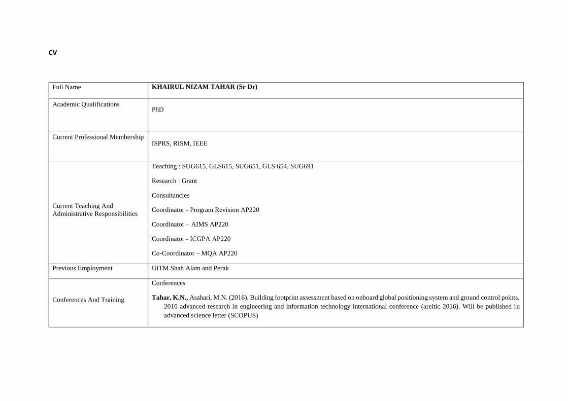
Full Name KHAIRUL NIZAM TAHAR (Sr Dr)
Academic Qualifications
PhD
Current Professional Membership
ISPRS, RISM, IEEE
Current Teaching And
Administrative Responsibilities
Teaching : SUG615, GLS615, SUG651, GLS 654, SUG691
Research : Grant
Consultancies
Coordinator - Program Revision AP220
Coordinator – AIMS AP220
Coordinator - ICGPA AP220
Co-Coordinator – MQA AP220
Previous Employment UiTM Shah Alam and Perak
Conferences And Training
Conferences
Tahar, K.N., Asahari, M.N. (2016). Building footprint assessment based on onboard global positioning system and ground control points.
2016 advanced research in engineering and information technology international conference (areitic 2016). Will be published in
advanced science letter (SCOPUS)
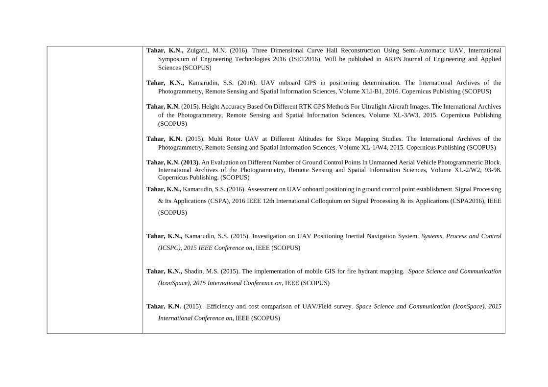
Tahar, K.N., Zulgafli, M.N. (2016). Three Dimensional Curve Hall Reconstruction Using Semi-Automatic UAV, International
Symposium of Engineering Technologies 2016 (ISET2016), Will be published in ARPN Journal of Engineering and Applied
Sciences (SCOPUS)
Tahar, K.N., Kamarudin, S.S. (2016). UAV onboard GPS in positioning determination. The International Archives of the
Photogrammetry, Remote Sensing and Spatial Information Sciences, Volume XLI-B1, 2016. Copernicus Publishing (SCOPUS)
Tahar, K.N. (2015). Height Accuracy Based On Different RTK GPS Methods For Ultralight Aircraft Images. The International Archives
of the Photogrammetry, Remote Sensing and Spatial Information Sciences, Volume XL-3/W3, 2015. Copernicus Publishing
(SCOPUS)
Tahar, K.N. (2015). Multi Rotor UAV at Different Altitudes for Slope Mapping Studies. The International Archives of the
Photogrammetry, Remote Sensing and Spatial Information Sciences, Volume XL-1/W4, 2015. Copernicus Publishing (SCOPUS)
Tahar, K.N. (2013). An Evaluation on Different Number of Ground Control Points In Unmanned Aerial Vehicle Photogrammetric Block.
International Archives of the Photogrammetry, Remote Sensing and Spatial Information Sciences, Volume XL-2/W2, 93-98.
Copernicus Publishing. (SCOPUS)
Tahar, K.N., Kamarudin, S.S. (2016). Assessment on UAV onboard positioning in ground control point establishment. Signal Processing
& Its Applications (CSPA), 2016 IEEE 12th International Colloquium on Signal Processing & its Applications (CSPA2016), IEEE
(SCOPUS)
Tahar, K.N., Kamarudin, S.S. (2015). Investigation on UAV Positioning Inertial Navigation System. Systems, Process and Control
(ICSPC), 2015 IEEE Conference on, IEEE (SCOPUS)
Tahar, K.N., Shadin, M.S. (2015). The implementation of mobile GIS for fire hydrant mapping. Space Science and Communication
(IconSpace), 2015 International Conference on, IEEE (SCOPUS)
Tahar, K.N. (2015). Efficiency and cost comparison of UAV/Field survey. Space Science and Communication (IconSpace), 2015
International Conference on, IEEE (SCOPUS)

Tahar, K.N., Ahmad, A., Akib, W.A.A.W.M and Mohd, W.M.N.W. (2014). A Generic Approach for Photogrammetric Survey using a
Six Rotor Unmanned Aerial Vehicle. 8th International Symposium of the Digital Earth (ISDE8), IOP Conf. Series: Earth and
Environmental Science 18 (2014) 012003, IOP Publishing (SCOPUS)
Tahar, K.N and Ahmad, A. (2013). An Evaluation on Fixed wing and Multi-Rotor UAV images using Photogrammetric Image
processing. International Conference on Computer Vision and Image Processing, Zurich, Switzerland, 391-395. World Academy
Science Engineering and Technology Publishing.
Tahar, K.N., Ahmad, A. and Wan Mohd Akib, W.A.A. (2012). Slope Gradient Analysis at Different Resolution using Terrestrial Laser
Scanner. 2012 IEEE 8th International Colloquium on Signal Processing and Its Applications, CSPA 2012, Malacca, Malaysia, 169-
173. IEEE Explore Publishing (SCOPUS)
Tahar, K.N., Ahmad, A., Wan Mohd Akib, W.A.A. and Wan Mohd, W.M.N. (2012). Aerial Mapping using Autonomous Fixed-Wing
Unmanned Aerial Vehicle. 2012 IEEE 8th International Colloquium on Signal Processing and Its Applications, CSPA 2012, Malacca,
Malaysia, 164-168. IEEE Explore Publishing(SCOPUS)
Tahar, K.N., Wan Mohd Akib, W.A.A., Ahmad, A., and Syahmi, M.Z. (2012). Terrain Slope Analyses between Terrestrial Laser Scanner
and Airborne Laser Scanner. 2012 3rd IEEE Control and System Graduate Research Colloquium, ICSGRC 2012, Shah Alam,
Malaysia, 242-247. IEEE Explore Publishing (SCOPUS)
Tahar, K.N. and Ahmad, A. (2011). Capability of Low Cost Digital Camera for Production of Orthophoto and Volume Determination.
2011 IEEE 7th International Colloquium on Signal Processing & Its Applications IEEE, CSPA 2011, Penang, Malaysia, 67-71. IEEE
Explore Publishing (SCOPUS)
Tahar, K.N. and Ahmad, A. (2011). UAV-Based Stereo Vision for Photogrammetric Survey in Aerial Terrain Mapping. 2011 IEEE
International Conference on Computer Applications and Industrial Electronics, ICCAIE 2011, Penang, Malaysia, 443-447. IEEE
Explore Publishing (SCOPUS)
Tahar, K.N., Ahmad, A., Wan Mohd Akib, W.A.A. and Wan Mohd, W.M.N. (2012). Unmanned Aerial Vehicle Photogrammetric Results
using Different Real Time Kinematic Global Positioning System Approaches. International Workshop on Geoinformation Advances,
UTM, Skudai, Malaysia. (Abstract)

Tahar, K.N. and Ahmad, A. (2011). Unmanned Aerial Vehicle Technology for Low Cost Landslide mapping. SEASC 2011 PWTC,
Kuala Lumpur, Malaysia.
Tahar, K.N., Ahmad, A., Wan Mohd Akib, W.A.A. and Udin, W.S. (2011). Unmanned Aerial Vehicle Technology for Large Scale
Mapping. ISG & ISPRS, SACC, Shah Alam, Malaysia.
SEMINAR/ WORKSHOP/ TRAINING
a) Attended Scientific talk on “Use of Remote Sensing Data & Geoinformation Tools for Natural Hazards Monitoring, Modeling,
Management & Mitigation”, talk by Dr Biswajeet Pradhan, Institute of Advanced Technology (ITMA), UPM. (7 th April 2011)
b) Attended Seminar on “Current Research in Photogrammetry within the CRC-SI and The University of Melbourne”, talk by Prof.
Dr. Clive Fraser, The University of Melbourne. (21st April 2011)
c) Attended Seminar on “Research Methodology in Geomatics”, talk by Prof. Dr. Clive Fraser, The University of Melbourne. (26 th
April 2011)
d) Attended Seminar on “Achieving Success with Research Proposal”, talk by Prof. Dr. Clive Fraser, The University of Melbourne.
(27th April 2011)
e) Attended Seminar on “Publishing in Leading Journal”, talk by Prof. Dr. Clive Fraser, The University of Melbourne. (28 th April
2011)
f) Attended seminar on “How to write impact factor paper” (February 2012) by Prof (em) Dr John Van Genderen from University
of Twente, Netherland
g) Attended seminar on “How to get published in impact factor Journal” ( Taylor and Francis Journal Publisher) – April 2012
h) Attended seminar on reality based 3D modeling “ from space to ground” (November 2012) by various expert around the globe
(ETH Zurich, Indonesia, Italy, Malaysia, Australia)

i) Attended several meeting with Prof John – Individual consultation- how to write impact factor paper (March 2012 – April 2012)
j) UAV training – Hexacopter (March 2012)
k) Program Orientasi Staf Baru Siri 1/2014 (lapor diri bulan Oct 2013– Feb2014), 5 – 6 Mac 2014, Dewan Al-Ghazali, Jabatan
Sumber Manusia, Pejabat Pendaftar
l) Siri Bicara professional bersama Tun Dr Mahathir, 12 Mac 2014, Dewan Agung Tuanku Chanselor
m) Bengkel ‘Publication in High Impact Journals’, 27 Mac 2014, Pusat IT, Perpustakaan Tun Abdul Razak 1, UiTM Shah Alam
n) Taklimat Vanguard Siri 2, 1 Apr 2014, Dewan Besar Intec, Seksyen 17
o) UAV/Drone seminar and podium, 14 Apr 2014, Seri Pacific Hotel Kuala Lumpur
p) Program Membangun Minda Mukmin Professional, 1 – 3 Mei 2014, UiTM Pulau Pinang
q) Taklimat galakan latihan sangkutan industri untuk staf akademik 2014/2015, 6 Mei 2014, Dewan seminar office of international
affairs (OIA)
r) Bengkel ‘Publish and Flourish: How to get your articles published’, 8 Mei 2014, Pusat IT, Perpustakaan Tun Abdul Razak 1,
UiTM Shah Alam
s) Bengkel “ Becoming professional editor – Editing Skills” ILQAM, 22 -23 Mei 2014, Audotorium ILQAM
t) Program Israk Mikraj – Masjid UiTM, 29 Mei 2014, Dewan Solat Utama UiTM
u) Hands-On Blended Learning, 11 Jun 2014, Pusat i-Learn HEA

v) Taklimat Dana Pembudayaan Penyelidikan (Rags) 2014 Sesi 1 Komuniti Penyelidikan (Core), 23 Julai 2014, Bilik Kuliah 4,
Fakulti Pengurusan Hotel & Pelancongan, Uitm Shah Alam
w) Program Transformasi Minda (PTM) UiTM Bil. 11/2014 (Oct- Nov 2014), 31 Oct – 7 Nov 2014, Institut Latihan Universiti,
Kg Gajah, Perak
x) Workshop and Briefing on Traning-of-Trainers for curriculum management module Academic information management system,
Dec 2014
y) Workshop on World UAV Conference at LIMA 2015, Langkawi, Mac 2015
z) Course on Aerial Survey and Mapping using UAV, UiTM, Organized by JUPEM, RISM, LJT (April 2015)
aa) Bengkel Laman Web Joomla Entiti Kecemerlangan Tier 4 & 5 Siri 1, Pusat IT, PTAR, UiTM (Mac 2016)
bb) Seminar Drone Kebangsaan 2016, NADES, organised by JUPEM, INSTUN, NRE
Nama Latihan Tarikh / Tempoh Tempat
Symposium of Engineering
Technologies 2016 (ISET 2016)
17/10/2016 / 1 hari
UiTM Kuala Terengganu
XXIII ISPRS Congress 2016 12/7/2016 – 19/07/2016 / 8 hari Prague, Czech Republic
UAV LiDAR by GPS Land Sdn Bhd 9/6/2016 / 1 hari PPSUG
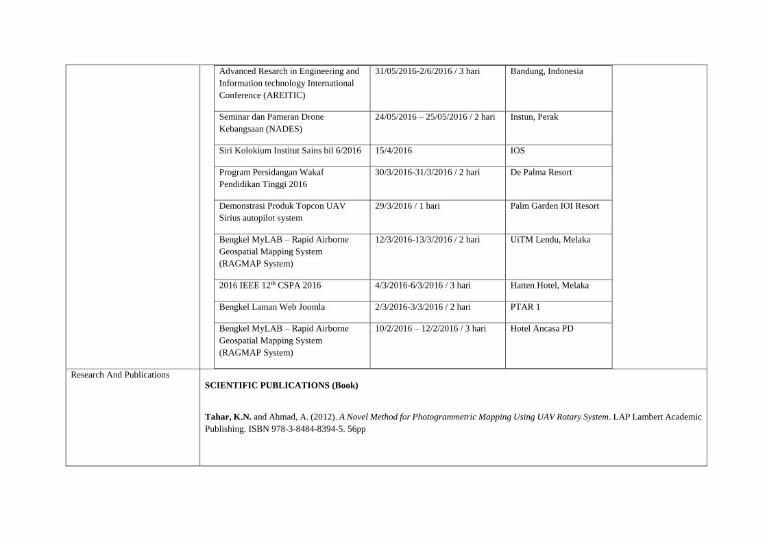
Advanced Resarch in Engineering and
Information technology International
Conference (AREITIC)
31/05/2016-2/6/2016 / 3 hari Bandung, Indonesia
Seminar dan Pameran Drone
Kebangsaan (NADES)
24/05/2016 – 25/05/2016 / 2 hari Instun, Perak
Siri Kolokium Institut Sains bil 6/2016 15/4/2016 IOS
Program Persidangan Wakaf
Pendidikan Tinggi 2016
30/3/2016-31/3/2016 / 2 hari De Palma Resort
Demonstrasi Produk Topcon UAV
Sirius autopilot system
29/3/2016 / 1 hari Palm Garden IOI Resort
Bengkel MyLAB – Rapid Airborne
Geospatial Mapping System
(RAGMAP System)
12/3/2016-13/3/2016 / 2 hari UiTM Lendu, Melaka
2016 IEEE 12th CSPA 2016 4/3/2016-6/3/2016 / 3 hari Hatten Hotel, Melaka
Bengkel Laman Web Joomla 2/3/2016-3/3/2016 / 2 hari PTAR 1
Bengkel MyLAB – Rapid Airborne
Geospatial Mapping System
(RAGMAP System)
10/2/2016 – 12/2/2016 / 3 hari Hotel Ancasa PD
Research And Publications
SCIENTIFIC PUBLICATIONS (Book)
Tahar, K.N. and Ahmad, A. (2012). A Novel Method for Photogrammetric Mapping Using UAV Rotary System. LAP Lambert Academic
Publishing. ISBN 978-3-8484-8394-5. 56pp

SCIENTIFIC PUBLICATIONS (Book Chapter)
Tahar, K.N., Ahmad, A., Wan Mohd Akib, W.A.A. and Wan Mohd, W.M.N. (2013). Unmanned Aerial Vehicle Photogrammetric Results
using Different Real Time Kinematic Global Positioning System Approaches. Developments in Multidimensional Spatial Data
Models, Lecture Notes in Geoinformation and Cartography, 123-134. Springer Berlin Heidelberg. DOI: 10.1007/978-3-642-36379-
5_8 (SCOPUS)
SCIENTIFIC PUBLICATIONS (International Journals-Refereed)
Tahar, K.N., Osman, M.R. (2016). 3D accident reconstruction using low-cost imaging technique. Advances in Engineering Software,
100, 231-237, Elsevier (SCOPUS) (IMPACT FACTOR: 1.673, SCOPUS) Q1
Tahar, K.N., Hassan, A.A. (2016). Evaluation of spatial risk factor for leptospirosis outbreak using GIS application. International Journal
of Advanced and Applied Sciences, 3(7), 60-68, AISE (Thomson Reuters - ISI)
Tahar, K.N., Asahari, M.N. (2016). Building footprint assessment based on onboard global positioning system and ground control points.
2016 advanced research in engineering and information technology international conference (areitic 2016). Will be published in
advanced science letter (SCOPUS)
Tahar, K.N., Zulgafli, M.N. (2016). Three Dimensional Curve Hall Reconstruction Using Semi-Automatic UAV, International
Symposium of Engineering Technologies 2016 (ISET2016), Will be published in ARPN Journal of Engineering and Applied
Sciences (SCOPUS)

Ya’acob, N., Ahmad Azmil, M.S., Tahar, K.N., Yusof, A.L., Ali, M.S.N., Mustafa, N., Mahmon, N.A. (2016). Geographical Information
System (GIS) Map For Fire And Rescue Application. Jurnal Teknologi 78(5-9). (SCOPUS)
Tahar, K.N., Kamarudin, S.S. (2016). UAV onboard GPS in positioning determination. The International Archives of the
Photogrammetry, Remote Sensing and Spatial Information Sciences, Volume XLI-B1, 2016. Copernicus Publishing (SCOPUS)
Tahar, K.N. (2015). Height Accuracy Based On Different RTK GPS Methods For Ultralight Aircraft Images. The International Archives
of the Photogrammetry, Remote Sensing and Spatial Information Sciences, Volume XL-3/W3, 2015. Copernicus Publishing
(SCOPUS)
Tahar, K.N. (2015). Multi Rotor UAV at Different Altitudes for Slope Mapping Studies. The International Archives of the
Photogrammetry, Remote Sensing and Spatial Information Sciences, Volume XL-1/W4, 2015. Copernicus Publishing (SCOPUS)
Tahar, K.N. (2015). Investigation on Different Scanning Resolutions for Slope Mapping Studies in Cameron Highlands, Malaysia.
Arabian Journal for Science and Engineering, 40(1), 245-255. ISSN 1319-8025. (IMPACT FACTOR: 0.367, SCOPUS) Q1
Azmil, M.S.A., Ya’akob, N., Tahar, K.N., Yusof, A.L. and Zainali, M.A. (2015). Wireless Fire Detection System with GIS Technology
for Fire and Rescue Application. ARPN Journal of Engineering and Applied Sciences, 10(3), 1039-1044. ISSN 1819-6608.
Khairon, K.F. and Tahar, K.N. (2014). Assessment on Slope Mapping Using Airborne Laser Scanning and Terrestrial Laser Scanning
Data. Built Environment, 11. ISSN 1675-5022
Hassan, A.A. and Tahar, K.N. (2014). The Evaluation of Spatial Risk Factors For Leptospirosis Outbreak Using GIS Application, Built
Environment, 11. ISSN 1675-5022

Hadi, M.H.A., Tahar, K.N., Khairon, K.F., Hassan, A.A., Amran, M.S. and Shadin, M.S. (2014). Use of Geodetic Laser Scanner for
Mapping Applications: A Review. Journal of Geotechnical Engineering. 32-37. ISSN 2394-1987.
Khairon, K.F., Tahar, K.N., Hadi, M.H.A., Amran, M.S., Shadin, M.S. and Hassan, A.A. (2014). Slope Mapping Development using
Airborne and Terrestrial Laser Scanner: A Review. Journal of Natural Science. ISSN 2308-5061.
Amran, M.S., Tahar, K.N., Hassan, A.A., Shadin, M.S., Khairon, K.F., and Hadi, M.H.A. (2014). Spatial Crime Pattern using
Geographical Information System : A Review. Recent Trends in Civil Engineering & Technology, 4(3). 1-5. ISSN 2249-8753.
Tahar, K.N. and Ahmad, A. (2013). An Evaluation on Fixed wing and Multi-Rotor UAV images using Photogrammetric Image
processing. International Science Index, World Academy of Science, Engineering and Technology 73 2013, 348-352. ISSN : 2010-
376X (SCOPUS)
Tahar, K.N. and Ahmad, A. (2013). Production of Orthophoto and Volume Determination using Low Cost Digital Camera. Pertanika
Journal Science and Technology, 21(2). 387-396. ISSN 0128-7680. (SCOPUS)
Tahar, K.N. (2013). An Evaluation on Different Number of Ground Control Points In Unmanned Aerial Vehicle Photogrammetric Block.
International Archives of the Photogrammetry, Remote Sensing and Spatial Information Sciences, Volume XL-2/W2, 93-98.
Copernicus Publishing. (SCOPUS)
Tahar, K.N. and Ahmad, A. (2012). A Simulation Study On The Capabilities Of Rotor Wing Unmanned Aerial Vehicle In Aerial Terrain
Mapping. International Journal of Physical Sciences, 7(8), 1300–1306, 2012. DOI: 10.5897/IJPS11.969. ISSN 1992-1950.
(IMPACT FACTOR: 0.554)
Tahar, K.N. (2012). Aerial Terrain Mapping Using Unmanned Aerial Vehicle Approach. International Archives of the Photogrammetry,
Remote Sensing and Spatial Information Sciences, Volume XXXIX-B7, 493-498. Copernicus Publishing. (SCOPUS)

Tahar, K.N., Ahmad, A. and Wan Mohd Akib, W.A.A. (2012). The Potential of Multi-Rotor UAV Technology in Landslide Mapping.
Journal of Modern Physics and Applications, 1, 23-37. ISSN 2051-5480
Tahar, K.N., Ahmad, A., Wan Mohd Akib, W.A.A. and Wan Mohd, W.M.N. (2012). Assessment on Ground Control Points in Unmanned
Aerial System Image Processing for Slope Mapping Studies. International Journal of Scientific & Engineering Research, 3(11), 1-
10. ISSN 2229-5518
Tahar, K.N., Ahmad, A., Wan Mohd Akib, W.A.A. and Wan Mohd, W.M.N. (2012). A New Approach on Production of Slope Map
using Autonomous Unmanned Aerial Vehicle. International Journal of Physical Sciences, 7(42), 5678-5686. DOI:
10.5897/IJPS12.142. ISSN 1992-1950.
Tahar, K.N. (2012). A New Approach on Slope Data Acquisition using Unmanned Aerial Vehicle. International Journal of Research
and Reviews in Applied Sciences, 13(3). 780-785. ISSN 2076-734X.
SCIENTIFIC PUBLICATIONS (International Article-Refereed)
Tahar, K.N., Kamarudin, S.S. (2016). Assessment on UAV onboard positioning in ground control point establishment. Signal Processing
& Its Applications (CSPA), 2016 IEEE 12th International Colloquium on Signal Processing & its Applications (CSPA2016), IEEE
(SCOPUS)
Tahar, K.N., Kamarudin, S.S. (2015). Investigation on UAV Positioning Inertial Navigation System. Systems, Process and Control
(ICSPC), 2015 IEEE Conference on, IEEE (SCOPUS)
Tahar, K.N., Shadin, M.S. (2015). The implementation of mobile GIS for fire hydrant mapping. Space Science and Communication
(IconSpace), 2015 International Conference on, IEEE (SCOPUS)
Tahar, K.N. (2015). Efficiency and cost comparison of UAV/Field survey. Space Science and Communication (IconSpace), 2015
International Conference on, IEEE (SCOPUS)
Tahar, K.N., Ahmad, A., Akib, W.A.A.W.M and Mohd, W.M.N.W. (2014). A Generic Approach for Photogrammetric Survey using a
Six Rotor Unmanned Aerial Vehicle. 8th International Symposium of the Digital Earth (ISDE8), IOP Conf. Series: Earth and

Environmental Science 18 (2014) 012003, IOP Publishing (SCOPUS)
Tahar, K.N and Ahmad, A. (2013). An Evaluation on Fixed wing and Multi-Rotor UAV images using Photogrammetric Image
processing. International Conference on Computer Vision and Image Processing, Zurich, Switzerland, 391-395. World Academy
Science Engineering and Technology Publishing.
Ahmad, A., Tahar, K.N., Udin, W.S., Hashim., K.A., Darwin, N., Room., M.H.M., Hamid., N.F.A., Azhar, N.A.M. and Azmi, S.M.
(2013). Digital Aerial Imagery of Unmanned Aerial Vehicle for Various Applications. 2013 IEEE International Conference on
Control System, Computing and Engineering, Penang, Malayia, 535-540. IEEE Explore Publishing (SCOPUS)
Tahar, K.N., Ahmad, A. and Wan Mohd Akib, W.A.A. (2012). Slope Gradient Analysis at Different Resolution using Terrestrial Laser
Scanner. 2012 IEEE 8th International Colloquium on Signal Processing and Its Applications, CSPA 2012, Malacca, Malaysia, 169-
173. IEEE Explore Publishing (SCOPUS)
Tahar, K.N., Ahmad, A., Wan Mohd Akib, W.A.A. and Wan Mohd, W.M.N. (2012). Aerial Mapping using Autonomous Fixed-Wing
Unmanned Aerial Vehicle. 2012 IEEE 8th International Colloquium on Signal Processing and Its Applications, CSPA 2012, Malacca,
Malaysia, 164-168. IEEE Explore Publishing(SCOPUS)
Tahar, K.N., Wan Mohd Akib, W.A.A., Ahmad, A., and Syahmi, M.Z. (2012). Terrain Slope Analyses between Terrestrial Laser Scanner
and Airborne Laser Scanner. 2012 3rd IEEE Control and System Graduate Research Colloquium, ICSGRC 2012, Shah Alam,
Malaysia, 242-247. IEEE Explore Publishing (SCOPUS)
Udin, W.S., Hassan, A.F., Ahmad, A. and Tahar, K.N. (2012). Digital Terrain Model Extraction using Digital Aerial Imagery of
Unmanned Aerial Vehicle. 2012 IEEE 8th International Colloquium on Signal Processing and Its Applications, CSPA 2012, Malacca,
Malaysia, 272-275. IEEE Explore Publishing (SCOPUS)
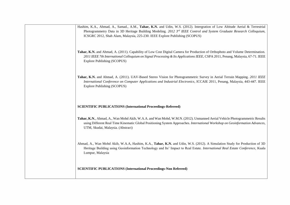
Hashim, K.A., Ahmad, A., Samad., A.M., Tahar, K.N. and Udin, W.S. (2012). Intergration of Low Altitude Aerial & Terrestrial
Photogrammetry Data in 3D Heritage Building Modeling. 2012 3rd IEEE Control and System Graduate Research Colloquium,
ICSGRC 2012, Shah Alam, Malaysia, 225-230. IEEE Explore Publishing (SCOPUS)
Tahar, K.N. and Ahmad, A. (2011). Capability of Low Cost Digital Camera for Production of Orthophoto and Volume Determination.
2011 IEEE 7th International Colloquium on Signal Processing & Its Applications IEEE, CSPA 2011, Penang, Malaysia, 67-71. IEEE
Explore Publishing (SCOPUS)
Tahar, K.N. and Ahmad, A. (2011). UAV-Based Stereo Vision for Photogrammetric Survey in Aerial Terrain Mapping. 2011 IEEE
International Conference on Computer Applications and Industrial Electronics, ICCAIE 2011, Penang, Malaysia, 443-447. IEEE
Explore Publishing (SCOPUS)
SCIENTIFIC PUBLICATIONS (International Proceedings-Refereed)
Tahar, K.N., Ahmad, A., Wan Mohd Akib, W.A.A. and Wan Mohd, W.M.N. (2012). Unmanned Aerial Vehicle Photogrammetric Results
using Different Real Time Kinematic Global Positioning System Approaches. International Workshop on Geoinformation Advances,
UTM, Skudai, Malaysia. (Abstract)
Ahmad, A., Wan Mohd Akib, W.A.A, Hashim, K.A., Tahar, K.N. and Udin, W.S. (2012). A Simulation Study for Production of 3D
Heritage Building using Geoinformation Technology and Its’ Impact to Real Estate. International Real Estate Conference, Kuala
Lumpur, Malaysia
SCIENTIFIC PUBLICATIONS (International Proceedings-Non Refereed)

Tahar, K.N. and Ahmad, A. (2011). Unmanned Aerial Vehicle Technology for Low Cost Landslide mapping. SEASC 2011 PWTC,
Kuala Lumpur, Malaysia.
Tahar, K.N., Ahmad, A., Wan Mohd Akib, W.A.A. and Udin, W.S. (2011). Unmanned Aerial Vehicle Technology for Large Scale
Mapping. ISG & ISPRS, SACC, Shah Alam, Malaysia.
Ahmad, A., Wan Mohd Akib, W.A.A., Tahar, K.N. and Udin, W.S. (2011). Capabilities of Unmanned Aerial Vehicle for Close Range
Photogrammetric Applications. ISG & ISPRS, SACC, Shah Alam, Malaysia.
Udin, W.S., Ahmad, A., Wan Mohd Akib, W.A.A. and Tahar, K.N. (2011). Close Range Photogrammetric Digital Technique for
Mapping Meandering Flume using Metric Digital Camera. ISG & ISPRS, SACC, Shah Alam, Malaysia.
SCIENTIFIC PUBLICATIONS (International Magazines)
Tahar, K.N. (2015). Modelling Slopes with TLS:Searching for the OptimalScan Resolution in Malaysia. GIM International, Geomares
Publishing.
SCIENTIFIC PUBLICATIONS (National Proceedings)
Tahar, K.N. and Ahmad, A. (2011). Production of Orthophoto and Volume Determination Using Amateur Digital Camera. FGRE PhD
Colloquium 2011, UTM Skudai, Malaysia.
SCIENTIFIC PUBLICATIONS (National Bulletins)

Tahar, K.N., Ahmad, A. and Wan Mohd Akib, W.A.A. (2012). A Generic Method in Production of Geographic Information System
Data using Unmanned Aerial Vehicle. Buletin GIS, Bil 1/2012, 15-21. ISSN 1394-5505
Tahar, K.N., Ahmad, A. and Wan Mohd Akib, W.A.A. (2011). Unmanned Aerial Vehicle Technology for Large Scale Mapping. Buletin
GIS, Bil 2/2011, 98-108. ISSN 1394-5505.
Consultancy
Consultations
a) Consultant for Automated Spatial Survey Information System at Grik, Perak (2009)
b) Surveyor Professional Services – at Tapak Cadangan Sekolah Rendah Islam Al Ummah, Manjung, Perak (2009)
c) Consultant for “ Kajian Penggabungan ICT Keseluruhan Jabatan dalam MPS dan MPN menjadi Majlis Bandaraya Seremban
serta Pemantauan Perlaksanaan Projek” (2015)
d) Consultant for Due Diligence Study on Bus Transportation Network and Terminal Requirement (2015)
e)
Community Service
SOCIAL INVOLVEMENTS
Involvements in Clubs, Seminars, Outdoor activities and Workshops in/out of the school and university.
1 May 2014 Program Selangkah Ke Manara Gading – SMK
Seksyen 7
Secretary

2 July 2014 -Program Melakar kerjaya Menggapai Impian –
SMK Seksyen 7
Secretary
Other Relevant Information
PROFESSIONAL/INDUSTRY/SOCIAL INVOLVEMENTS
Invited Speaker
a) Invited Speaker – Geographical Information System and Remote Sensing Short Course at UiTM, 2009
b) Invited Speaker – Geographical Information System and Remote Sensing Short Course at UiTM, 2010
c) Invited Speaker – Geographical Information System Short Course at Presscott Hotel, 2008
d) Invited Speaker – Geographical Information System Short Course at Genting View, 2009
e) Invited Speaker – Tree Mapping Short Course at Genting View, 2009
f) Invited Speaker – Introduction to Geographical Information System at Port Dickson, 2010
g) Invited Speaker – Introduction to Geographical Information System at Genting View, 2011
h) Invited Speaker – Quantum GIS Short Course at Tiara Beach Resort, Port Dickson, 2012
i) Invited Speaker – MapInfo Professional 10.5 Training Course at Intekma Resort and Convention Centre, Shah Alam, 2012
j) Invited Speaker – Geographical Information System (Quantum GIS) Short Course at Tiara Beach Resort, Port Dickson, 2013
k) Invited Speaker – ArcGIS 10.1 Short Course at Hotel Seri Costa, Melaka, 2013
l) Invited Speaker - Workshop on Application of Unmanned Aerial Vehicle for Mapping Scientific Research (Apr 2014)

m) Invited Speaker – Program PPI Akademik : Photogrammetry 2 (CG504) at Department of Civil Engineering, Politeknik Kuching,
Sawarak (Mac 2015)
n) Invited Speaker – Short Course UAV LiDAR Mapping, UiTM (July 2016)
o) Invited Speaker – Short Course on GIS and Remote Sensing (Nov 2016)
Consultations
f) Consultant for Automated Spatial Survey Information System at Grik, Perak (2009)
g) Surveyor Professional Services – at Tapak Cadangan Sekolah Rendah Islam Al Ummah, Manjung, Perak (2009)
h) Consultant for “ Kajian Penggabungan ICT Keseluruhan Jabatan dalam MPS dan MPN menjadi Majlis Bandaraya Seremban
serta Pemantauan Perlaksanaan Projek” (2015)
i) Consultant for Due Diligence Study on Bus Transportation Network and Terminal Requirement (2015)
Panel
a) Interviewer Panel – “Intake Session Mac2014- Programme Master in Geographical Information Science” (AP720) – Dec 2013
b) Panel – “Pemilihan pengambilan pelajar AP220 bagi sesi september 2014 lepasan diploma UiTM” (Jun 2014)
c) Panel of the PhD and Master Candidate – Research Progress Presentation (AP991 & AP781) – Apr 2014
d) Panel of the PhD and Master Candidate – Research Progress Presentation and Defence Research Proposal (AP991 & AP781) –
Nov 2014
p) Interviewer Panel – “Intake Session Mac2015 - Programme Master and PhD in Built Environment” (AP991 & AP781) – Dec
2014

Reviewer
a) Journal Reviewer, Advancement in Science and Technology Research, May 2014
b) Journal Reviewer, American Journal of Computation, Communication and Control, Mac 2015
c) Journal Reviewer, Journal of Intelligent and Robotic Systems, Mac 2015
d) Journal of Basic and Applied Research International, Jan 2015
Others
a) Manager for orienteering sport – Sukan antara Fakulti SAF 2014
b) Participate in Innovation, Invention and Design (IID) 2015 at Faculty of Architecture Planning and Surveying, Landslide
Monitoring using Light Aircraft (UAV), Apr 2015
c) Participate in Innovation, Invention and Design (IID) 2015 at Faculty of Architecture Planning and Surveying, Mobile GIS for
Fire Hyrant Mapping, Apr 2015
d) Manager for orienteering sport – Sukan antara Fakulti SAF 2015
e) Manager for orienteering sport – Sukan antara Fakulti SAF 2016
NATIONAL COMMITTEE

Appointed as Member of Centre of Excellence for Flight Technology and Test Centre (FTTC), Institute of Meachanical Engineering and
Technology Advancement, UITM
Appointed as Member of Research Initiative Group for Applied Remote Sensing and Geospatial, Research Management Centre, UiTM.
Appointed as Local Organizing Committee, International Conference on UAV in Geoinformation & Aeronautics, 2014
Appointed as Committee member of “Selangkah ke Menara Gading” Centre of Studies for Surevying and Geomatics, May 2014
Appointed as Committee member of “Program Melakar Kerjaya Menggapai Impian” Centre of Studies for Surveying and Geomatics,
July 2014
Appointed as 2nd Secretary, Organiser committee in National Geomatic/Geoinformatics Student Innovation Competation, NGGSIC 2015
INTERNATIONAL COMMITTEE
Appointed as International Scientific Committee, International Conference on Computer Information Systems and Industrial
Applications, CISIA 2015

Appointed as International Scientific Committee, International Conference on Environmental Science and Energy Engineering, ICESEE
2015
GRANTS
Project Leader, Feasibility Study on UAV Positioning for Establishment of Ground Control Points, Dec 2014- Nov 2016, RM 80000
Member, Rapid Airborne Geospatial Mapping System, MYLAB Project, Jan 2015-Dec 2016, RM +1.09mil.
Member, Research Entity Initiative (REI) Tier 5, Applied Remote Sensing and Geospatial, Jun 2014- May 2016, RM32000.
Member, Forest Microclimate Dynamics and Patterns with Functional Relation to Global Climate Condition Part 2, Dec 2013-Nov
2015, RM 60000
AWARDS/RECOGNITION
Hadiah Penerbitan Angkasa 2013 “Kategori 1: Kertas Kerja Professional dalam Bidang Sains Angkasa - Penerbitan di persidangan”,
MOSTI and Angkasa Malaysia (November 2014).
Hadiah Penerbitan Angkasa 2013 “Kategori 4: Buku Penerbitan Asli/Monograf dalam Bidang Angkasa”, MOSTI and Angkasa
Malaysia (November 2014).

Best Student Award (Postgraduate), Universiti Teknologi Malaysia, in conjunction with 51th Convocation Ceremony, 2013
Penyelidik Harapan Fakulti 2014, Fakulti Senibina Perancangan dan Ukur, Universiti Teknologi MARA (Disember 2015)
Silver Medal, Invention Innovation & Design (IIDEX) 2015, Lanslide Monitoring using Aircraft (UAV), Fakulti Senibina Perancangan
dan Ukur, Universiti Teknologi MARA.
Silver Medal, Invention Innovation & Design (IIDEX) 2015, Mobile GIS for Fire Hydrant Mapping, Fakulti Senibina Perancangan dan
Ukur, Universiti Teknologi MARA.
Best Paper Award, 2015 IEEE Conference on Systems, Process and Control (ICSPC 2015), Kuala Lumpur.
Excellent Researcher Award 2016 “Penyelidik Cemerlang, Anugerah Harapan”, Universiti Teknologi MARA, Reseacrh Summit Day
UiTM (January 2017)