Embed Size (px)
DESCRIPTION
This is the document obtained by Electronic Frontier Foundation (www.eff.org/) about Customs and Border Protection's Plan to weaponize drones on U.S. border
Citation preview

FOR OFFICIAL USE ONLY bAW ENFOI~CEMENT SENSITIVE
Message from the Secretary June 29,2010
I am pleased to present the following report, "Concept of Operations for U.S. Customs and Border Protection's (CBP) Predator 13 Unmanned Aircraft System." This report has been compiled in response to language in Section 544 of I louse Report I 11-298 accompanying the Fiscal Year 2010 Depar/ment of Homeland Securily Appropriations Act (P.L. 111 -83).
The report provides a revised Concept of Operations (CONOPS) for unmanned aircratl systems (UAS) in the U.S. national airspace system f()r the purposes of border and maritime security operations, and includes any foreseeable challenges to the CONOPS.
Pursuant to congressional requirements, this report is being provided to the fo llowing Members of Congress:
• The Honorable David E. Price Chairmru1, House Appropriations Subcommittee on Homeland Security
• The Honorable Harold Rogers Ranking Member, House Appropriations Subcommittee on Homeland Security
• The Honorable f rank R. Lautenberg Interim Chairman, Senate Appropriations Subcommittee on Homeland Security
• The Honorable George V. Voinovich Ranking Member, Senate Appropriations Subcommittee on Homeland Security
Inquiries relating to this report may be directed to me at (202) 282-8203 or to the Department's Deputy Chieffinaneinl Officer, Peggy Sherry, at (202) 447-5171.
Yours very truly,
Janet Napol itano
FOR OFFICIAL USE ONLY
FOR OFFICIAL USE ONLY LAW ENFORCEMENT SENSITIVE
Executive Summary
This document is a CONOPS, directed by the Assistant Commissioner of the Office of Air and Marine (OAM) in CBP, for the OAM Predator B UAS. It serves to articulate the employment concepts and high-level capabilities required for a UAS to be used in current and future OAM operations in direct support of U.S. Department ofHomeland Security (DHS) missions, and in coordinated operations with other Federal, state, local, and tribal agencies.
In addition to incorporating changes to the CONOPS provided in fiscal year (FY) 2009, this document includes the basic operating concept for a joint CBP-U.S. Coast Guard (USCG) maritime variant of the Predator B UAS, named the Guardian. The Guardian is scheduled to be ready to conduct maritime operations in the spring of this year, and CBP has already begun the necessary coordination with the Federal Aviation Administration (FAA) to ensure all required authorizations are in place to support the joint CBP/USCG operations.
In accordance with the OAM National Strategic Plan, OAM will develop a UAS national operational capability using an evolutionary acquisition strategy. The UAS will be an integrated System of Systems that will provide near-, mid-, and far-term reconnaissance, surveillance, targeting, and acquisition (RSTA) capability across all CBP areas of responsibility. The system architecture will consist of the following features:
• One or more land-based, medium-altitude, long-endurance unmanned aircraft (UA) that will conduct pre-planned missions while remaining dynamically re-taskable
• A suite of interactive mission payloads, optimized for the operating environment • A suite of communications and control systems with line-of-sight and
beyond-line-of-sight capabilities • A ground control station used for UA launch and recovery, mission execution including
sensor management, post-mission analysis, and training • A support system consisting of maintenance, technical and logistics support, UA pilots,
sensor operators, and/or other mission crew.
This CONOPS envisions UAS basing at OAM Operations Centers and Forward Operating Locations and conducting operations in three major operational areas:
• U.S. Southwest Border Region, including the land border from the west coast to the Gulf of Mexico
• U.S. Northern Border Region, including the Pacific Northwest, the Great Plains, the Great Lakes/St. Lawrence Seaway system, and the northeastern border
• U.S. Southeast Coastal Border Region, including the Gulf of Mexico, the northern Caribbean, and the Transit Zone.
FOR OFFICIA:L USE ONLY
II
FOR OFFICIAL USE ONLY LAW ENFORCE~4ENT SENSITIVE
Baseline and Maritime UAS variants will provide persistent RSTA coverage of land borders, inland seas, littoral waters, and the high seas with multiple sensors and networked datalinks. Radio frequency and optical sensors will be used during all mission phases for UA navigation, hazard avoidance, and air traffic services compliance. Once in the mission area, the UAS will perform surveillance, detection, and classification mission tasks, and will support identification and prosecution tasks. Mission payload data will be downlinked from the UA to the ground control station (GCS) land earth station and will be made available to federated networks using standardized protocols for further dissemination to ground units, vessels, aircraft, and exploitation sites. For logistics support, the UAS will use a Performance-Based Logistics solution.
In cooperation with the U.S. Department of Defense (DOD), the U.S. Department of Transportation, the FAA, and the National Aeronautics and Space Administration, DHS has agreed to join the UAS Executive Committee (EX COM) established in response to Section I 036 of the FY 2009 National Defense Authorization Act (P.L. 110-417). The EXCOM was established as a focal point for the resolution of issues surrounding the operation of unmanned aircraft in the National Airspace System (NAS). Though originally intended to act as a DOD and FAA executive forum, DHS accepted the DOD invitation to join and lend its unique homeland security experience to the combined deliberations on technical, procedural, regulatory, and policy issues surrounding UAS use in the NAS. The establishment of the EXCOM should provide an appropriate forum for continued consultation on the UAS CONOPS intended by the Act. DHS respectfully recommends that the Committees recognize the EXCOM as the preeminent, i~terdepartmental forum for addressing common issues on UAS airspace access.
The OAM UAS is a DHS force multiplier and is intended to be an integral component of a larger, integrated, and networked family of systems. CBP envisions the UAS as both an adjunct to OAM manned aircraft and as an independent RST A asset. In either case, the UAS will contribute to situational awareness (SA) and maritime domain awareness (MDA) of the land and maritime border regions surrounding the United States. This improved SA/MDA will, in turn, increase the effectiveness ofDHS and other Government agencies in performing their core homeland security, homeland defense, law enforcement, and civil support missions.
FOR OFFICIAL USE ONLY
Ill
FOR OFFICIAL US~ ONLY LAW ~NFORC~M~NT S~NSITIV~
CONOPS for CBP Predator B UAS
Table of Contents
I. Legislative Language ............................................................ .
II. Issue................................................................................. 2 A. Problem Statement............................................................ 2 B. Purpose .......................................................................... 2 C. Relationship to Other CONOPS.................. .. ...................... ... 3 D. Relationship to Strategic Plans...... ........................................ 3
III. Overview........................................................................... 6 A. UAS Program Background.................................................. 6 B. Program Stakeholders......................................................... 9 C. Homeland Security Initiatives and Capability Gaps..................... I 0
IV. Concepts for the Proposed System....................................... . . . . . . 15 A. System Trades .................................................................. 15 B. Unmanned Aircraft System Description .................................... 15 C. Concept Overview ............................................................. 18 D. Challenges ....................................................................... 22
FOR OFFICIAL US~ ONLY
iv
FOR OFFICIAL U8E ONLY LAW ENFORCEMENT 8EN8ITIVE ·
V. Mission Requirements . . ........................................... . ............... 23 A. UAS Missions ................................................................... 24 B. Targets of Interest. .. .. ......................................................... 25 C. Mission Tasks .................................................................. 26 D. Mission Profiles ... . ............................................................. 27 E. Ground Rules and Assumptions .............................. . ............... 28 F. UAS Capabilities ................................................................ 28
VI. UAS Employment. ................................................................. 33 A. Operating Areas ............................................................... 34 B. Southwest Border Region ..................................................... 37 C. Northern Border Region ...................................................... 38 D. Southeast Coastal Border Region .... ...... ................................. 46 E. Time-Phased CONOPS ................ . ...................................... 50
VII. Program Impacts .................................................................. 64 A. Doctrine, Organization, Training, Materiel, Leadership and
Education, Personnel, and Facilities Impacts .............................. 64 B. Intelligence Support Impacts ................................................ 66
Vlll. Appendices ........................................................................ 67 Appendix A. List of Abbreviations and Acronyms .......................... 67 Appendix B. References .................................. .. ...................... 72 Appendix C. Program Stakeholders ........................................... 74 Appendix D. Terms and Definitions ........................ ...... ............. 80 Appendix E. Airspace Coordination ........................................... 90 Appendix F. Signature Page for CONOPS .................................. .105
FOR OFFICIAL U8E ONLY
v
FOR OFFICIAL USE ONLY LAW ENFORCEl\tENT SENSITIVE
I. Legislative Language
This document responds to the reporting language set forth in Section 544 of House Report 111-298 accompanying the Fiscal Year (FY) 2010 Department of Homeland Security (DHS) Appropriations Act (P.L. 11 1-83).
Section 544 states:
(a) Not later than 3 months from the date of enactment of this Act, the Secretary of Homeland Security shall consult with the Secretaries of Defense and Transportation and develop a concept of operations for unmanned aerial systems in the United States national airspace system for the purposes of border and maritime security operations. (b) The Secretary of Homeland Security shall report to the Committees on Appropriations of the Senate and the House of Representatives not later than 30 days after the date of enactment of this Act on any foreseeable challenges to complying with subsection (a).
FOR OFFICIAL USE ONLY
II. Issue
FOR OFFICIAL USE ONLY LAW ENFORCEMENT 8~N8ITIVE
A. Problem Statement
CBP is the Federal agency principally responsible for the management and security of our Nation's borders. America's borders encompass over 19,800 miles, of which over 12,300 miles are coastline.1 To ensure security along these borders, CBP and other Government agencies (OGA) employ a comprehensive, "layered security" strategy? This strategy seeks to provide security at and between U.S. ports of entry while simultaneously extending the zone of security beyond the physical border to include the land and maritime approaches to the United States.
Current DHS and OAM capabilities are limited in their ability to provide pers istent RST A support to intra- and interagency assets committed to the interdiction of threats to our national security. These threats include illegal narcotics trafficking, weapons, terrorists/terrorist material, and potential weapons of mass destruction.
Today's complex and evolving threats place a great premium on knowledge and a shared understanding of the air, land, and maritime border domains. Achieving persistent awareness in these domains requires innovative solutions, one of which is the employment of an UAS in law enforcement and homeland security (HLS) applications. A UAS can provide pers istent RST A coverage of land borders, inland seas, littoral waters, and high seas with multiple sensors and networked datalinks. Its mission data can then be fused into a common operational picture and made available to operational commanders and other users throughout the United States Government (USG). The improved awareness resulting from the UAS will provide CBP and OGAs the ability to detect, monitor, track, and, if necessary, interdict Targets oflnterest (TOI) (e.g., personnel and conveyances possibly involved in il legal activity, a developing storm system, etc.). 3 This capability will, in turn, increase the effectiveness ofCBP and OGAs in performing their core HLS, homeland defense, law enforcement, and collateral missions.
B. Purpose
The purpose of this CONOPS document is to articulate CBP's assumptions and operational concepts for the employment of a UAS from 2004 - 2025. This CONOPS is a living document. As threats evolve and new intelligence is brought to light, CBP's operational components will review and, if necessary, adapt UAS CONOPS to ensure that CBP's highly mobile and
1 Central Intelligence Agency World Fact Book; United States land boundaries and coastline. Includes 50 States; does not include overseas possessions. 2 "Layered Security" is discussed in The National Strategy for Maritime Security, Section IV. 3 Interdiction, in terms of law enforcement, is "an action to divert, disrupt, delay, intercept, board, detain, or destroy, as appropriate, vessels, vehicles, aircraft, people, or cargo."
FOR OFFICIAL USE ONLY
I~§;§~=~··· I 2
FOR OFFICIAL USE ONLY LA\\' ENFORCEMENT SENSITIVE
integrated forces are focused on areas where its capabil ities will pay the highest operational dividend.
C. Relationship to Other CONOPS
The OAM UAS is intended to be an integral component of a larger, integrated, and networked family of systems (FoS) supporting USG HLS, homeland defense, and civil suppmt missions. This FoS will be composed of airborne elements, surface elements, command and control (C2) elements, data processing, exploitation and dissemination elements, airspace control authority elements, and their supporting infrastructure. This UAS CONOPS has the potential to impact, or be impacted by, CONOPS and requirements related to these FoS elements. As an examp le, UAS processing, exploitation, and dissemination requirements will impact future CONOPS and requirements for the CBP Air and Marine Operations Center (AMOC). Potential UAS CONOPS impacts include the following:
• DHS CONOPS o Current - Joint OAM-USCG Maritime UAS CONOPS o Current - CONOPS for OAM P-3 Airborne Early Warning (AEW) and Long Range
Tracking (LRT) Aircraft o Future - USCG CONOPS for a Land-Based UAS o Future - USCG CONOPS for a Cutter-Based UAS o Current - National CONOPS for MDA o Current - Broad Area Maritime Surveillance UAS CONOPS o Current - DOD Joint CONOPS for UASs o Current - DOD Joint Integrated Product Team Unmanned Aircraft System Airspace
Integration CONOPS o Current - Joint Planning and Development Office CONOPS for the Next Generation
Air Transportation System (NextGen).
D. Relationship to Strategic Plans
The OAM UAS wi ll be a key enabler of the OAM National Strategic Plan and will support, directly or indirectly, a number ofFederal agency level strategic plans related to HLS and maritime homeland security (MHLS). These supported plans include the following:
• National Strategic Plans: o The National Security Strategy of the United States of America o The National Defense Strategy of the United States of America o The National Strategy for Homeland Security o The National Strategy for Maritime Security o The National Strategy for Aviation Security o The National Drug Control Strategy
FOR OFFICIAL USE ONLY
~~~52E~·"·I 3
FOR OFFICIAL USE ONL¥ LAW ENFORCEMENT SENSITIVE
o The National Plan to Achieve Maritime Domain Awareness o The Global Maritime Intelligence Integration Plan o The Maritime Commerce Security Plan
• DHS Strategic Plans: o Securing Our Homeland: U.S. Department of Homeland Security Strategic Plan o Protecting America: U.S. Customs and Border Protection 2005- 20 I 0 Strategic Plan o OAM National Strategic Plan o National Border Patrol Strategy: Office of Border Patrol o Securing America's Borders at Ports of Entry: Office of Field Operations Strategic
Plan FY s 2007-2011 o USCG Maritime Strategy for Homeland Security o Container Security Initiative: 2006-20 11 Strategic Plan o DHS Intelligence Enterprise Strategic Plan, January, 2008 o Secure Border Strategic Plan, December, 2006 o DHS Northern Border Counternarcotics Strategy, 2008 o DHS Maritime Border and Transit Zone Counternarcotics Strategy, 2008.
• OGA Strategic Plans: o DOD Strategy for Homeland Defense and Civil Support o DOD Homeland Defense and Civil Support Joint Operating Concept.
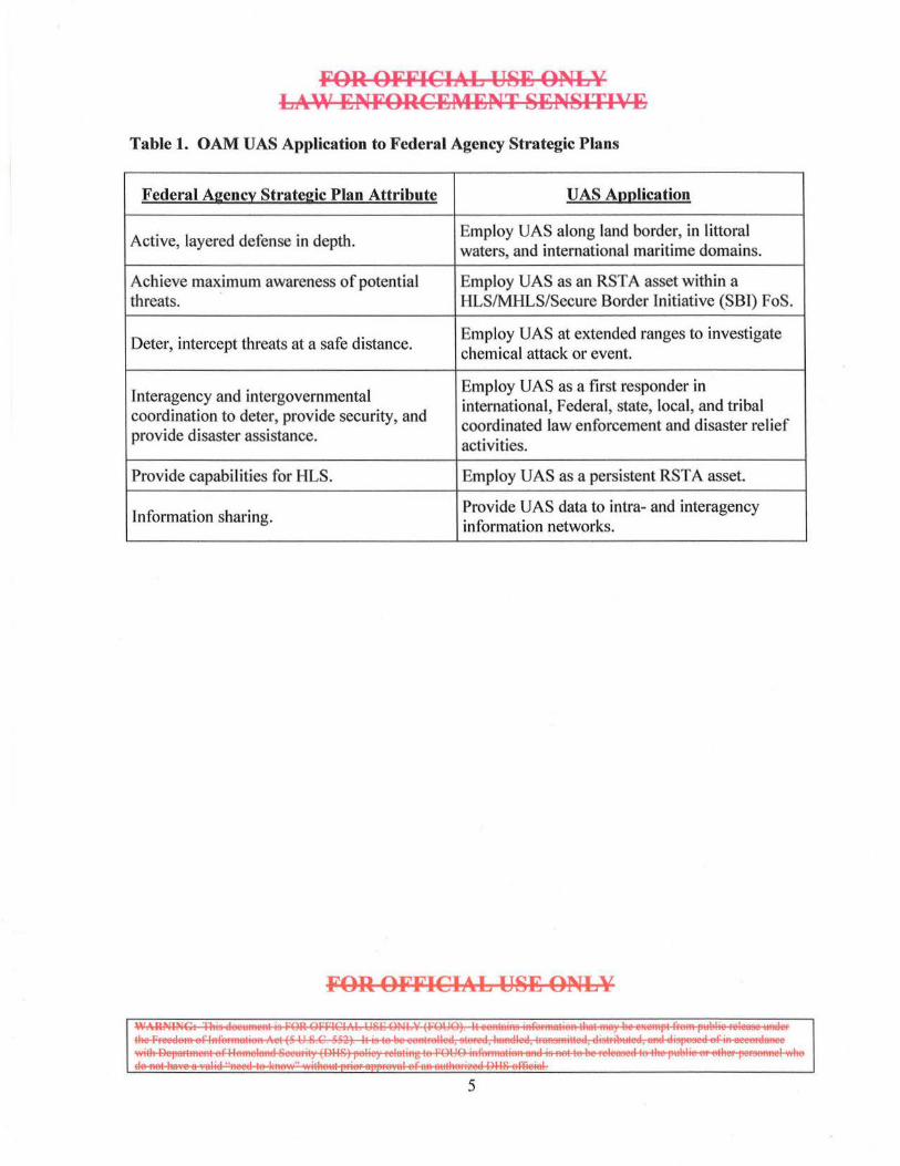
OAM UAS capabilities will enable key, recurring attributes articulated in these plans. These attributes are summarized in Table 1, which follows.
FOR OFFICIAL USE ONL¥
l~s;~==~·,·l 4
FOR OFFICIAL U8B ONLY LA\V :ENFORCEMENT 8BN81TIVE
Table 1. OAM UAS Application to Federal Agency Strategic Plans
Federal Agencl:: Strategic Plan Attribute UAS Annlication
Active, layered defense in depth. Employ VAS along land border, in littoral waters, and international maritime domains.
Achieve maximum awareness of potential Employ UAS as an RST A asset within a threats. HLS/MHLS/Secure Border Initiative (SBI) FoS.
Deter, intercept threats at a safe distance. Employ UAS at extended ranges to investigate chemical attack or event.
Interagency and intergovernmental Employ UAS as a first responder in international, Federal, state, local, and tribal
coordination to deter, provide security, and coordinated law enforcement and disaster relief
provide disaster assistance. activities.
Provide capabilities for HLS. Employ VAS as a persistent RST A asset.
Information sharing. Provide UAS data to intra- and interagency information networks.
FOR OFFICIAL U8B ONLY
~~~5~=-:E~M~ 5
FOR OFFICIAL USE ONLY LA\\1 ENFORCEMENT SENSITIVE
III. Overview
A. UAS Program Background
OAM began UAS operations in FY 2004 with a pilot study to determine the feasibility of using a UAS as an RSTA asset in the U.S. Southwest Border Region. This pilot study included the formulation of initial UAS CONOPS and an evaluation of UAS program needs.4 The pilot study proved successful in providing RSTA coverage of the Southwest border and actionable intelligence to Border Patrol ground agents. In addition, it concluded that a UAS provided unique law enforcement capabilities, including the ability to carry a variety of sensors and payloads and the ability to remain airborne for extended periods of time without the limitations imposed by requiring on-board pilots. As a result of this pilot study, UAS operations have become a permanent part of OAM Southwest Border Region operations.
Building upon its Southwest Border Region success, OAM has expanded CBP UAS operations to the Northern Border Region. In addition, faced with the challenge ofMHLS and law enforcement across the Nation's vast coastline, DHS plans to expand UAS operations into the maritime domain with Maritime UAS variants to be operated by OAM and USCG.5
1. Acquisition Strategy
The OAM UAS program is executing an evolutionary acquisition strategy guided by the CBP National Strategic Plan and the CBP Strategic Air and Marine Program execution plan. UAS capability is to be ·fielded in increments, described as follows:
• Increment I - Baseline UAS o Increment lA -Southwest Border Region o Increment IB - Northern Border Region
• Increment II - Maritime UAS o Increment IIA - U.S. Southeast Coastal Border Region o Increment liB - Great Lakes/St. Lawrence Seaway o Increment IIC - Extended Border/Transit Zone
To reduce UAS program cost, schedule, and technical risk, and to meet desired milestones, DHS selected the General Atomics Aeronautical Systems, Inc. (GA-ASI), Predator B, Model MQ-9CBP as the host platform for OAM UAS Increments I and II.
4 These initjal CONOPS are reflected in U.S. Customs and Border Protection Unmanned Aircraft System Concept of Operations, Draft Version 1.2, December 27,2007. 5 The USCG is collaborating with OAM in the development of Maritime UAS requirements, but has not yet finalized its land-based maritime UAS requirements.
FOR OFFICIAL USE ONLY
1~5~==2===··· 1 6
FOR OFFICIAL USE ONLY LA\\' ENFORCEMENT SENSITIVE
Future UAS Increments (III, IV, etc.) will provide more robust capabi lities and refine existing capabilities to fill emerging border or maritime security capability gaps. These increments will have specific cost, schedule, and performance goals, including entrance and exit criteria. Specific capabilities, attributes, and timelines for future increments will be documented in an intra- and interagency Joint Operational Requirements Document (JORD), or CBP Operational Requirements Document (ORD), as appropriate.
2. Program Execution
OAM UAS program execution requirements are based on elements contained within the DHS/USCG Major System Acquisition Manual and are highlighted in the fo llowing subsections.
a. Project Identification
• Identify capability gaps through mission analysis of the fo llowing: o Strategic plans that support national, DHS and CBP strategic goals and
objectives • Status: Plans identified and analyzed (refer to Section II.D)
o DHS Science and Technology Directorate (S&T) capability gap lists • Status: Relevant capability gap lists identified and analyzed
o OAM user community input • Status: User community input obtained through various stakeholder
meetings and summits • Perform targeted mission analysis (e.g., sensor capabilities assessments)
o Status: DHS S&T sensor studies, USCG sensor studies, and relevant program ORDs identified and analyzed
• Prioritize, collate, and document capability gaps through a Mission Analysis Report or other suitable documentation o Status: Capability gaps and potential solutions documented in CONOPS and
JORDs/ORDs6
6 Includes: ORD for U.S. Customs and Border Protection Unmanned Aircraft System, Version 2.0, December 27, 2007; US. Customs and Border Protection Unmanned Aircraft System Concept of Operations, Draft Version 1.2, December 27, 2007; Joint Operational Requirements Document (JORD) for U.S. Customs and Border Protection and US. Coast Guard Maritime Unmanned Aircraft System, Version 1.1 , November 7, 2008.
FOR OFFICIAL USE ONLY
1~55~==~: ... 1
7
FOR OFFICIAL U8E ONLY LAW ENFORCEMENT SENSITIVE
b. Project Initiation
• Capture mission analysis results through a Mission Needs Statement or other suitable documentation o Status: UAS mission needs were documented in the initial CBP UAS Mission
Needs Statement and ORD for the National Security Mission. Maritimespecific mission needs were documented in Joint CONOPS and JORD for Maritime UAS.
• Develop acquisition business case o Status: UAS business case was outlined in OAM Acquisition Strategy and
Acquisition Program Baseline documents. • Obtain project approval
o Status: Baseline UAS program was approved and funded by DHS. Maritime Variant Predator (MVP) UAS will undergo an operational test and evaluation in February 2010. If successful, the maritime UAS will deploy to maritime regions that represent the greatest threats/needs.
c. Concept and Technology Development
• Set technical requirements o Status: Technical requirements documented in JORDs/ORDs and the
Performance Specification for the US. Customs and Border Protection Unmanned Aircraft System, Version 2.31, October 29,2008.
• Explore alternative solutions o Status: Because of a compressed programmatic timeline and desire for a
low-to-moderate risk solution, OAM selected the GA-ASI Predator 8 as the host platform for UAS Increments 1 and II. Concept and Technology Development has focused on sensor(s) alternatives, selection criteria, and procurement strategies.
d. Concept Development and Demonstration
• Operate UAS in a relevant operational environment o Status: Routine UAS operations based at Ft. Huachuca/Sierra Vista, Arizona;
and Grand Forks, North Dakota, are occurring in the Southwest and Northern Border Regions ofthe United States.
• Perform initial operational test and evaluation (lOT &E) o Status: IOT&E complete for the Baseline variant. lOT &E for the MVP is
scheduled for February 2010. • Demonstrate UAS capabilities, systems integration, and interoperability with
existing infrastructure
FOR OFFICIA:L U8E ONLY
1~-5§5~~''"1 8
FOR OFFICIAL USE ONLY LA\\' ENFORCEMENT SENSITIVE
o Status: UAS operations have been integrated with the Office of Border Patrol and other CBP operations in the Southwest Border Region.
• Determine final production configuration ofUAS, including sensors. o Status: Baseline variant UASs are being procured with
electro-optical/infrared (EO/lR) and radio frequency (RF) sensors. MVP sensors have been selected and will be evaluated during IOT&E.
e. Production and Deployment
• Procure initial systems o Status: Baseline systems were procured in FY 2005- FY 2009 with funding
for additional systems requested for FY 2010 and beyond. A single MVP wi ll be deployed in mid-FY 20 I 0 with one additional maritime aircraft expected to be delivered later in the year.
• Achieve initial operational capability (IOC) by operating at a CBP OC or FOL7
o Status: Baseline variant IOC achieved at Ft. Huachuca/Sierra Vista, Arizona, and Grand Forks Air Force Base (AFB), North Dakota.
f. Operations and Support
• Achieve Full Operational Capability (FOC) by operating UASs on a routine, continuous basis at CBP OCs and FOLs o Status: Progressing towards FOC with expansion to the Southeast Coastal
Border Region • Support UAS
o Status: Baseline UAS support is provided through a PBL solution using CLS. Maritime UAS support will leverage existing infrastructure where practical.
B. Program Stakeholders
CBP works closely, on a continuous basis, with numerous Federal, state, local, and tribal agencies in enforcing U.S. trade, immigration, and other laws at the Nation's borders. The employment of a UAS in HLS, law enforcement, and civil suppOtt operations will assist many of these agencies in the fulfillment of their core missions. Operating organizations that are potentially impacted by the OAM UAS program are listed below and described in Appendix C.
7 FOLs are not bases, but staging airfields, owned and operated by the host nation as part of the international effort to stem the flow of illegal narcotics into the United States. FOLs fill the basing gap that resulted from the 1999 loss of Howard Air Force Base (AFB) concurrent with the withdrawal of U.S. forces from Panama.
FOR OFFICIAL USE ONLY
~~~5~=~: ... 1
9
FOR OFFICIAL USE ONLY LAW ENFORCEMENT SENSITIVE
• CBP offices, including OAM, Border Patrol, Field Operations, and Intelligence and Operations Coordination (OIOC)
• U.S. Coast Guard (USCG) • U.S. Immigration and Customs Enforcement (ICE) • Federal Emergency Management Agency (FEMA) • DHS Office of Intelligence and Analysis (I&A) • U.S. Secret Service • DHS Office of Infrastructure Protection (IP) • U.S. Drug Enforcement Administration (DEA) • Interagency Remote Sensing Coordination Cell (IRSCC) • Federal Bureau oflnvestigation (FBI) • U.S. Marshals Service • U.S. Department of Defense (DOD), including Joint Interagency Task Force- South
(JIATF-S) and U.S. Northern Command (USNORTHCOM) • National Oceanic and Atmospheric Administration (NOAA) • Federal Aviation Administration (FAA) • U.S. Forest Service • U.S. Bureau of Land Management • U.S. Department of Energy • State and local law enforcement.
C. HLS Initiatives and Capability Gaps
The OAM UAS program targets a number of USG HLS/MHLS strategic initiatives and operational level capability gaps. A discussion ofthese initiatives and capability gaps follows.
1. Strategic Initiatives
a. SBI
Effe.ctive security of America's borders is established through the proper mix of technology, personnel, and tactical infrastructure that will allow CBP to confront and appropriately resolve illegal cross border activity. The mix ofthese three components will vary depending on the challenges of the focus area.
• Technology provides situational awareness to enable an informed response and allows CBP to detect entries and identify and classify threats.
• Personnel provide the response to confront illegal cross border activity. • Tactical Infrastructure supports the response by facilitating agent access and
through persistent impedance by deterring or slowing the ability to easily cross the border and escape, thus extending the time for agents to respond.
FOR OFFICil~L USE ONLY
~~~sa~i~m·l 10
FOR OFFICIAL USE ONLY LAW ENFORCE~4ENT SENSITIVE
SBI is responsible for the acquisition, design, development, integration, and installation of technology solutions to help CBP agents and officers more effectively detect, identify, classify, and respond to illegal incursions at the border.
By providing persistent RSTA, the OAM UAS will contribute to SBl's long-term goals.
b. MDA
At the strategic level, a vital national security requirement exists to establish and maintain MDA around the U.S. landmass.8 Once established, MDA becomes a key enabler in the performance ofMHLS tasks (e.g., detecting, tracking, or apprehending a TOI) by providing timely, accurate, and actionable information.
The National Plan to Achieve Maritime Domain Awareness outlines core national defense and security priorities over the next decade and includes the following strategic goals:9
• Enhance transparency in the maritime domain to detect, deter, and defeat threats as early and distant from U.S. interests as possible.
• Enable accurate, dynamic, and confident decisions and responses to the fu ll spectrum of maritime threats.
• Sustain the full application of the law to ensure freedom of navigation and the efficient flow of commerce.
To enable the fulfillment of these goals, an MDA essential task list was developed that is intended to guide the development of capabilities that the USG will pursue and, when executed, will provide an effective understanding of the maritime domain. These essential tasks include: 10
• Persistently monitor in the global maritime domain: o Vessels and craft o Cargo o Vessel crews and passengers o All identified areas of interest
8 MDA, as defined in the National Plan to Achieve Maritime Domain Awareness, is "the effective understanding of anything associated with the maritime domain that could impact the security, safety, economy, or environment of the United States." 9 National Plan to Achieve Maritime Domain Awareness, October 2005, page 2. 10 Ibid. page 3.
FOR OFFICIAL USE ONLY
I~.J§§SF~===~·I II
FOR OFFICIAL USE ONLY Ll.c\\' ENFORCEMENT SENSITIVE
• Access and maintain data on vessels, facilities, and infrastructure • Collect, fuse, analyze, and disseminate information to decision makers to
facilitate effective understanding • Access, develop, and maintain data on MDA-related mission performance
The OAM maritime UAS variant (Increment II) is intended to contribute to these strategic goals and objectives, as well as improve MDA, by providing persistent RSTA of the maritime domain in its assigned OPAREA.
2. Operational Gaps
Within and external to DHS, numerous assessments, studies, and operational analyses have been performed to document current and emerging border and/or maritime security requirements. S&T maintains two capability gap lists relevant to the DHS UAS program: 11
• Border Security Integrated Product Team (IPT) Rank-Ordered Capability Gaps • Maritime Security Capstone IPT Rank-Ordered Capability Gaps
The OAM UAS program will provide capabilities that will alleviate some of these operational capability gaps. These targeted gaps are listed in Table 2, which fo llows.
11 Consult S&T Maritime Security Capstone and Border Security IPTs for the latest Capability Gaps databases.
FOR OFFICIAL USE ONLY
l~ssr:~=====,· l 12

CIA L USE ONLY
requirements.
FOR OFFICIAL U8~ ONLY LAW ~NFORC~M~NT 8~N81TIV~
FOR OFFICIAL U8~ ONLY
~~~~: .•. 1
14

FOR OFFICIAL USE ONLY LAW ENFORCEMENT SENSITIVE
IV. Concepts for the Proposed System
A. System Trades
Numerous system trades were considered in the UAS Project Identification, Project Initiation, and Concept and Technology Development phases. The desire to achieve IOC with low to moderate risk as soon as possible resulted in the selection of the GA-ASI Predator B for OAM UAS Increment I. The Predator B was also selected as the host platform for Increment II. This was based on a number of programmatic and operational factors, including operational commonality, ability to leverage existing infrastructure, and trained personnel and the desire to initiate JOT &E of a MVP in Calendar Year (CY) 2010. The OAM UAS Program Office utilizes DHS and DoD technology developmental offices to fulfill capability gaps resulting in potential sensor alternatives that utilize: Federal Acquisition Regulation (FAR) selection criteria, and competitive procurement strategies.
B. Unmanned Aircraft System Description
The UAS system architecture consists of:
• One or more land-based, medium-altitude, long-endurance UA that conduct pre-planned missions, from start, taxi, and takeoff through landing, taxi, and shutdown, while remaining dynamically re-taskable
• A suite of interactive mission payloads, optimized for the operating environment • A suite of communications and control systems with LOS and beyond line-of-sight
(BLOS) capabil ities • A GCS used for launch and recovery, mission execution, including sensor management,
post-mission analysis, and training • A support system consisting of maintenance, technical, and logistics support, UA pilots,
sensor operators, and/or other mission crew.
1. UAS Overview
CBP's Predator B UASs are manufactured by GA-ASI, San Diego, California. A UAS consists of one or more UA, a Grand Control Station (GCS), a C-band LOS ground data terminal (GOT), a Ku-band BLOS, broadband satellite system, a back-up narrowband Iridium satellite communications (SATCOM) terminal, and support equipment.
The UA is controlled by a pilot located in the GCS. Daylight television and IR nose cameras aligned with the aircraft's longitudinal axis provide the pilot with a visual reference for control ofthe UA. If required, the pilot can also employ the gimbaled
FOR OFFICIAL USE ONLY
1~52~~··· 1 15
FOR OFFICIAL USE ONLY LAW ENFORCEMENT SENSITIVE
EO/IR sensor for forward visibility. Control commands are transmitted from the GCS to the UA by a ground-based datalink terminal. The GCS incorporates workstations that allow pilots and sensor operators to plan missions, control and monitor the UA and its sensors, and exploit received images. The Ku-band SA TCOM system provides BLOS and redundant LOS control of the aircraft via satellite and enhances the voice/data communication capabilities of the GCS.
2. UA
The UA is a long-endurance, medium-altitude aircraft designed to support a variety of missions carrying various payloads. It is a mid-wing monoplane with a slender fuselage, high aspect ratio wing, V-empennage, ventral fin, and rudder. It has retractable tricycle landing gear and is powered by a rear-mounted turboprop engine driving a three-blade, variable-pitch propeller.
3. Datalink Equipment
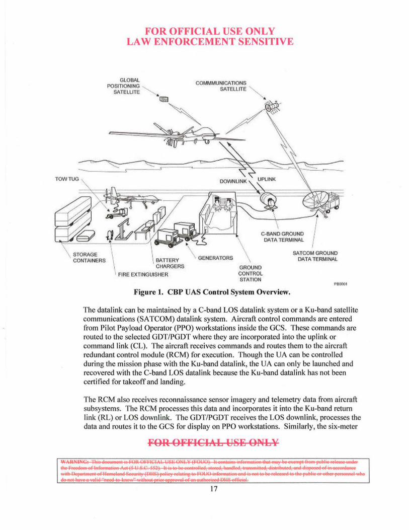
Datalink equipment in the aircraft maintains a radio frequency (RF) datalink with a GDT or Portable Ground Data Terminal(s) (PGDT(s)) associated with the GCS. The aircraft always carries a C-band LOS airborne datal ink terminal and is also capable of carrying a Ku-band airborne datal ink terminal. The datal ink control system, shown in Figure 1, ~hich follows, consists of an RF uplink and downlink, which establish full duplex communications between the airborne datalink terminal in the UA and the ground-based datalink terminals associated with the GCS. A continuous stream of control commands is transmitted to the UA, and the aircraft transmits a continuous stream of status and payload data to the GCS.
FOR OFFICIAL USE ONLY
I~§;§~~·'· I 16
TOW TUG
FOR OFFICIAL USE ONLY LAW ENFORCEMENT SENSITIVE
GLOBAL POStnONING
SATELLITE
c::::
COMMMUNICATIONS SATELLITE
C·BAND GROUND DATA TERMINAL
STORAGE CONTAINERS ' GENERATORS \
GROUND CONTROL STATION
SATCOM GROUND DATA TERMINAL
1>90001
Figure 1. CBP UAS Control System Overview.
The datalink can be maintained by a C-band LOS datalink system or a Ku-band satellite communications (SATCOM) datalink system. Aircraft control commands are entered from Pilot Payload Operator (PPO) workstations inside the GCS. These commands are routed to the selected GDT/PGDT where they are incorporated into the uplink or command link (CL). The aircraft receives commands and routes them to the aircraft redundant control module (RCM) for execution. Though the UA can be controlled during the mission phase with the Ku-band datalink, the UA can only be launched and recovered with the C-band LOS datalink because the Ku-band datalink has not been certified for takeoff and landing.
The RCM also receives reconnaissance sensor imagery and telemetry data from aircraft subsystems. The RCM processes this data and incorporates it into the Ku-band return link (RL) or LOS downlink. The GDT/PGDT receives the LOS downlink, processes the data and routes it to the GCS for display on PPO workstations. Similarly, the six-meter
FOR OFFICIAL USE ONLY
l~s~=~: .. J
17
FOR OFFICIAL USE ONLY LAW ENFORCEI\4ENT SENSITIVFJ
Ku-band SATCOM dish receives the BLOS return link and routes it to the GCS for processing and display.
4. GCS
The GCS houses the pilot, sensor operator, electronics technician, their workstations, and the system's electronic equipment racks. The PPO workstations are two control consoles that allow a pilot and a sensor operator to control and monitor the UA and its subsystems. The GCS has a Multi-Function Workstation that allows operators to program missions and manipulate sensor imagery. A radio/intercom system allows operators to communicate among workstations and use a Very High Frequency/Ultra High Frequency radio system, as well as a local-coverage Very High Frequency rad io.
5. Payload Sensors
The Baseline UAS (Increment I) carries a Raytheon Multi-Spectral Targeting System (MTS) model MTS-A or MTS-B and a Lynx Synthetic Aperture Radar (SAR) sensor. The MTS-A/8 consists of electron optical (EO) and infrared (IR) cameras, a spotter camera, and a laser designation and ranging capability. The EO/IR system is installed within a gyro-stabil ized, gimbaled platform enclosed in a ball-turret assembly mounted on the bottom ofthe UA fuselage. The Lynx SAR provides high-resolution, through-theweather SAR imagery, with a Ground Moving Target Indication (GMTI) mode. Collectively, both sensors provide long-range surveillance, target acquisition, and tracking, range finding, and laser designation.
Maritime UAS (Increment II) adds the Raytheon Sea Vue maritime and overland surveillance radar enhanced with the Naval Sea Systems Command's (NAVSEA) Ocean Surveillance Initiative (OSI) processing capability, and an Automatic Identification System (AIS) receiver to the Baseline UAS sensor suite. The Sea Vue radar will include long- and short-range search and track, small radar cross-section target detection, moving target indication, and synthetic and inverse synthetic aperture radar (SAR/JSAR) modes. It is capable of performing RSTA of maritime TO Is day and night, moving and stationary, in clear and adverse weather.
The Sea Vue radar has been integrated into the Maritime UA platform in a lower-fuselage pod.
C. Concept Overview
OAM defined UAS as a strategic asset requiring a more centralized organizational structure. While current UAS operations primarily respond to operational needs generated by local
FOR OFFICIAL USE ONLY
I~§~==~·-· I 18
FOR OFFICIAL USE ONLY LAW ENFORCEMENT SENSITIVE
interdiction/law enforcement operations, future operations will utilize centralized planning, tasking, and oversight.
The OAM UAS wi ll be used in direct support ofDHS operations, principally those relating to DRS's "Layered Security" strategy, and in coordinated operations with other Federal , state, local, and tribal agencies. DHS envisions the UAS as both an adjunct to existing manned aircraft and as an independent RSTA asset. 12 In both capacities, the UAS wi ll contribute to improving situational awareness (SA)/MDA of the land border and maritime domain regions surrounding the U.S. landmass in support of HLS, homeland defense, law enforcement, and civil support missions.
1. Operations Concept
The UAS will function primarily as a networked RSTA asset to satisfy internal and external DHS airborne support and law enforcement requests. In this role, OAM will function as the supporting command and the UAS will provide data in direct support of the requesting agency. CBP OIOC's Collection Manager (CM) begins the process by obtaining the necessary information in response to the request. If the CM determines that the request could be supported by an OAM asset, the CM then verifies that the requests are mission capable and collectible based on time, validity, capability of internal assets, and passes the request(s) to the Collection Operations Manager (COM)-AMOC. If the COM-AMOC determines the need to have a UAS fulfill the request, the AMOC will publish that mission request in the daily Air Schedule, tasking a national OAM UAS to satisfy the data collection requirement(s).
The COM-AMOC serves as the primary coordination and de-confliction entity for OAM UAS operations. As such, it provides to UAS missions system level efficiencies, mission planning, and asset prioritization throughout the entire CBP UAS system. In addition to its planning and coord ination responsibilities, it also serves as the central collection point for UAS operational utilization.
UAS units will be based at OAM OCs and potentially OGA facilities and will deploy and operate, as required, at downrange FOLs. OAM UAS operations will be focused in three OPAREAs: Southwest Border Region, Northern Border Region, and Southeast Coastal Border Region. Operations outside of these areas will occur as required to support other mission requirements (e.g., National Special Security Events, Disaster Relief, etc.). Future USCG Maritime UAS operations are expected to be more expansive in OPAREAs (e.g., Alaska, Hawaii, etc.) and missions (e.g., U.S. Exclusive Economic Zone law enforcement).
12 OAM manned aircraft include a variety of fixed-wing and rotary-wing aircraft. A complete list is available on the CBP Web site at: http://www.cbp.gov/xp/cgov/border security/air marine/air/aviation asset/
FOR OFFICIAL USE ONLY
1~5~===···1 19
FOR OFFICIAL U8JJ; ONLY LAW ENFORCEMENT 8EN8ITIVE
LOS control of the U A for takeoff and landing wi II be performed from a GCS located at the OC/FOL. Shortly after takeoff, control will transfer to a pilot at the AMOC who will exercise BLOS control for mission operations. BLOS control may also be performed from a GCS at an OC/FOL or other compatible OGA GCS.
While each VAS operation will be unique, in general the OAM UAS will be tasked to provide RST A of land borders, inland seas, littoral waters, and high seas with multiple sensors and networked datalinks. lts RSTA engagement construct wi ll be tailored to the mission, but will generally consist of performing surveillance, detection, classification, and identification mission tasks and to support prosecution tasks.
2. Mission Data Concept
UAS data collection requirements will normally originate with OIOC CM and then be prioritized by the AMOC collection management cell prior to UAS tasking. Collection requirements may also originate from DHS internal sources (e.g., DHS l&A, USCG Maritime Intelligence Fusion Centers (MIFCs)) or from external sources (e.g., JIATF-S, FBI, state, and local law enforcement) and will be articulated in the daily Air Schedule. Additionally, the UAS could be dynamically tasked by the AMOC to support high priority unscheduled internal and external RSTA requests. Collection priorities set by the AMOC will support CBP field commanders and internal and external partners requesting UAS collections.
Mission payload data collected by the UA platform's sensors will be downlinked and received at compatible ground teleports, including the AMOC and/or other compatible OGA Land Earth Station (LES) sites. The UAS mission crew and/or imagery analysts at the AMOC will review collected sensor data and conduct first phase analysis. 13
Following first phase analysis, correlated sensor data and information will be disseminated to the tactical users and/or the supported command for that mission.
UAS sensor data will be made available to OAM, USCG, and interagency information grids via teleports and standard protocols (e.g., the Homeland Secure Data Network) that allow near real time (NRT) access to mission data at Brocessing, exploitation, and dissemination centers (e.g., AMOC, USCG MIFCs). 4 UAS sensor data may also be made available within the interagency via DOD's Global Information Grid (GIG)/Defense Information Systems Network and therefore may be available for national and theater processing and use. Mission data should be available for commanders at most echelons of command.
13 First phase analysis is defined in Appendix D. 14 Near real time is defined in Appendix D.
FOR OFFICIAL U8E ONLY
~~~=2===···1 20
FOR OFFICIAL USE ONLY LA\\' ENFORCEMENT SENSITIVE
The mission data distribution concept will support improved SA/MDA by providing persistent RST A data that can be injected into distributed networks to support a common operational picture. Because sensor data will be persistently available, overall SA/MDA should be maintained to a higher degree. Access to this data may reduce operational tasking for other units and will be critical for intra- and interagency efforts. When mission data analysis ind icates that an interdiction is the appropriate course of action, the "sense-to-interdict" timeline will be reduced. The UAS will also be capable of transmitting some types of data directly to "on-scene" tactical forces (e.g., ground agents, vessels, aircraft, etc.) via remote video terminals (RVTs).
Data from some operationally sensitive sensors, such as Law Enforcement Technical Collection sensors, may pass directly through specialized teleports and will be exploited at other locations. This data will be analyzed and the derived intelligence will be disseminated to tactical users in accordance with the policies and procedures specific to these sensors. The collection and dissemination of some data may be hand led with discrete processes in order to protect information about the capabilities of the source sensor(s).
Organization
The AMOC will become the central funneling point for mission prioritization, flight planning, and post mission analysis of UAS fli ghts. The AMOC will be responsible for:
• Validating the imaging tasking requests • Assigning priorities to UAS assets for mission accomplishment • BLOS UA mission control element (MCE) flight operations • Participation in reviews associated with UAS product delivery • Recording and archiving data associated with UAS collection.
Current operational units consist of the UAS OC-Arizona, the UAS OC-North Dakota, the UAS OC-Florida, and the UAS OC-AMOC. Each OC will be responsible for:
• Responding to mission tasking by the AMOC • Local operations beyond AMOC mission tasking • Training and maintenance • Transmission of operational statistics and asset availability.
3. Support Concept
The UAS logistics support concept will provide an effective and suitable sustainment and
FOR OFFICIAL USE ONLY
~ ~~S~§:§::Es:-:::=== ... 1
2 1
FOR OF'FICIAL USE ONLY LAW ENFORCEMENT SENSITIVE
support system. This system will provide all necessary product support elements through a performance based logistics (PBL) solution. Using PBL will improve product support effectiveness, while reducing total ownership cost through incentives and empowerment to the support provider (organic, commercial, or public-private partnership). Specific performance requirements, including, but not limited to, reliability, availability, maintainability, and sortie generation rate, will be specified by DHS.
The UAS may operate from FOLs for extended durations, therefore the support concept will provide for basing flexibility. Adequate facilities will be provided at FOLs for operations, deployed maintenance, and support functions.
D. Challenges
Adding a capability as transformational as a UAS, and integrating that capability into CBP intra- and interagency operations, is a multi-dimensional challenge. Within the technical domain, the key challenges are centered on selecting and integrating effective UAS capabilities, including sensors optimized for the operating environment, datalinks that will provide effective C2, mission data access, and ancillary equipment that will enable required airspace access. Within the regulatory domain, the key challenges are centered on airspace access procedures and pilot qualifications. Within the safety domain, the key challenges are centered on appropriate levels of safety, hazard avoidance, and reliability. These key challenges are by no means a complete list, as underlying these challenges are dozens of other significant issues that cover the full spectrum of Doctrine, Organization, Training, Materiel, Leadership, Personnel, and Facilities (DOTMLPF). OAM's key operational challenges are summarized in Table 3.
Table 3. OAM's Key UAS Challenges
Challenge Issue
Command and AMOC must evolve to provide C2 at an increased UAS Operational Tempo, Control including multiple, simultaneous, domestic, and international UAS operations.
Mission Data Data dissemination infrastructure and protocols must evolve to support a broad base of intra- and interagency customers.
Land border and maritime domain regions present unique and frequently
Mission Sensors conflicting sensor requirements. The challenge is to provide Baseline and Maritime sensors that provide mission flexibility while ensuring detection and tracking of critical TO Is.
FOR OFFICIAL USE ONLY
1~2~~-·1 22
Airspace Access 15
Support System
FOR OFFICIAL US~ ONLY LAW ~NFORC~t\4~NT S~NSITIV~
Technical and regulatory challenges must be solved to enable safe, routine access to domestic, international, and foreign airspace requ ired for various missions.
Forward Operating Locations present new challenges for UAS PBL and CLS.
15 Refer to Appendix E for a detailed discussion of the Airspace Access challenge.
FOR OFFICIAL US~ ONLY
~~~~====:.,! 23
FOR OFFICIAL USE ONLY LAW ENFORCEMENT SENSITIVE
V. Mission Requirements
A. U AS Missions
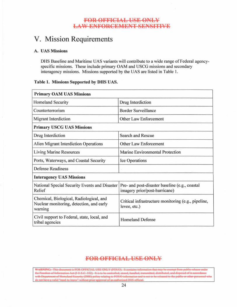
DHS Baseline and Maritime UAS variants will contribute to a wide range ofFederal agencyspecific missions. These include primary OAM and USCG missions and secondary interagency missions. Missions supported by the UAS are listed in Table I.
Table 1. Missions Suppor ted by DHS UAS.
Primary OAM UAS Missions
Homeland Security Drug Interdiction
Counterterrorism Border Surveillance
Migrant Interdiction Other Law Enforcement
Primary USCG UAS Missions
Drug Interdiction Search and Rescue
Alien Migrant interdiction Operations Other Law Enforcement
Living Marine Resources Marine Environmental Protection
Ports, Waterways, and Coastal Security lee Operations
Defense Readiness
Interagency UAS M issions
National Special Security Events and Disaster Pre- and post-disaster base line (e.g., coastal Relief imagery prior/post-hurricane)
Chemical, Biological, Radiological, and Critical infrastructure monitoring (e.g., pipeline,
Nuclear monitoring, detection, and early levee, etc.) warning
Civil support to Federal, state, local, and Homeland Defense
tribal agencies
FOR OFFICIAL USI; ONLY
~~~~=~:.,.1 24
FOR OFFICIAL U8~ ONLY LAW ~NFOR:C~~~~NT 8~N81TIV~
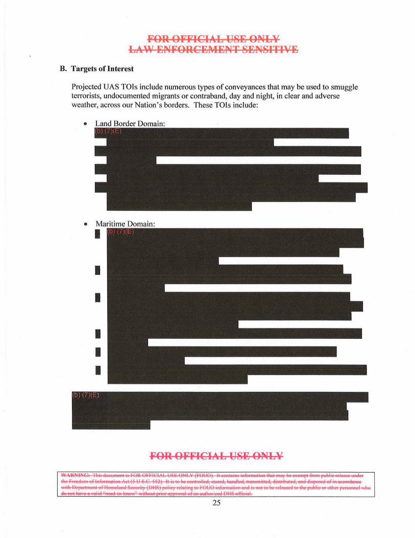
B. Targets of Interest
Projected UAS TO Is include numerous types of conveyances that may be used to smuggle terrorists, undocumented migrants or contraband, day and night, in clear and adverse weather, across our Nation's borders. These TOis include:
• Land Border Domain:
• Maritime Domain:
I
I
I
I
I I
FOR: OFFICIAL U8~ ONLY
I~§~~: ... I
25
C. Mission Tasks
F'OR OF'F'ICIAL USE ONLY LAW ENF'ORCEMENT SENSITIVE
As described in Section 3.3.1, the OAM UAS will use an RSTA mission construct and will perform or support mission essential surveillance, detection, classification, identification, and prosecution (SDCIP) tasks. Descriptions of these mission tasks follow:
l. Surveillance:
Surveillance is the employment of sensors (active and/or passive) to survey an area and to build/maintain domain SA. Dependent upon mission objectives and operating conditions, the UAS will operate at various altitudes/airspeeds and will employ various search profiles/techniques. Generation of on board sensor data and fusion with off-board data will be essential in establishing and maintaining SA/MDA of the assigned OPAREA.
2. Detection:
Probability of detection during a surveillance activity depends upon the capabilities of the UAS's sensors, the operating conditions, and the characteristics of the TOI. It is essential that the UAS provide capabilities to detect a wide of under ideal and adverse
small low-profile TOls, such as
3. Classification:
Classification is the determination of the to which a TOJ belongs, such as The determination of the current activity a target g., a m water, ing, smuggling contraband/undocumented aliens, discharging oil or hazardous substances, etc.) is also an element of this function. The classification task can be divided into initial and active classification.
Initial classification categorizes detections on the basis of parameters such as target size, course/speed, location, and other attributes. Initial classification will usually be accomplished without diverting from the patrol search pattern and is maintained as part ofthe local operational picture. Active classification involves the categorization of those targets that meet the general characteristics of the mission TOJ.
Performing classification tasks may involve directing the UA to close the distance or viewing angle to the TO I. Active classifications are reported as required to support the overall operational picture and to coordinate positioning of patrolling air or surface assets.
FOR OFFICIAL USE ONLY
1~5~==~ .. 1
26
4. Identification:
FOR OFFICIAL USE ONLY LAW ENFORCEMENT SENSITIVE
Identification is the determination of a characteristic or unique target, which differentiates a particular TOI from others in the same classification category. The name/registration numbers of a vessel are the most common discriminators, but comparison pictures, profiles, rigging, and electronic emissions may also be used. Identification is a further refinement of classification and aids the process by which targets are evaluated to differentiate a TOI from the larger population of legitimate, law-abiding targets.
Depending on the TOI, its unique attributes and the UA platform's sensor capabilities, the UAS may be able to perform the identification task. This may require the UA platform to fly in proximity to the TOI. If the UAS is unable to perform the identification task independently, its sensor data will be useful in cueing another identification asset, air or surface, to perform this task.
5. Prosecution:
Prosecution is the action the law enforcement unit takes on the basis of results of the target sorting process, consistent with the purpose of the mission (e.g., report sightings of TOI, continue surveillance of the OPAREA if a non-TOI, vector an intercept unit, interdict the TOI, etc.). The UAS cannot perform this task independently, but it may be required to collect EO/IR video, collect radar imagery, continue surveillance, illuminate the target with an IR illuminator or searchlight, provide real time data via an RVT, or other function, depending on the nature of the prosecution.
Highly accurate navigation information is a critical element to prepare prosecutorial evidence. Global Positioning System (GPS) navigation data is the most common source of precision position fixing data. Electronic evidence must be annotated and recorded with appropriate metadata (date/time, position, speed, course, etc., related to the TOI(s)).
D. Mission Profiles
To conduct the missions listed in Table 4, the UAS will employ a variety of mission profiles to perform SDCIP mission tasks. Mission profiles are expected to be one, or a combination of, the following:
• High Altitude: Above Flight Level (FL) 180 • Medium Altitude: Between 10,000 feet Mean Sea Level (MSL) and FL1 80 • Low Altitude: Below 10,000 feet MSL.
FOR OFFICIAL USE ONLY
1~5~=~: ... [ 27
FOR OFFICIAL USE ONLY LAW ENFORCEMENT 8EN81TIV~
Depending on transit distance to the OPAREA, desired time-on-station, airspace access, environmental conditions, and other factors, the UAS may transit to/from its OPAREA at altitudes that differ from is tactical operating altitude. Once in its OPAREA, it will seek to maximize sensor performance for the particular SDCIP task to be and the
lities ired to su ort that task.
's '-'V''"'"'""''"on in defining mission profiles.
E. Ground Rules and Assumptions
In order to develop comprehensive CONOPS that will serve as the foundation for DHS's investment leading to effective and suitable capabilities, ground rules, and assumptions have been made. These ground rules and assumptions reiterate OAM UAS management guidelines, serve to provide operational context clarification, specify the conditions under which requirements may be developed, and consider partner agency requirements. OAM's UAS program ground rules and assumptions are summarized in Table 5.
Table 2. UAS Ground Rules & Assumptions.
No. Ground Rule/Assumption
1 The UAS host platform for OAM UAS Increments I and II will be the GA-ASI Predator B, Model MQ-9CBP.
2 The UA, GCS, flight control data links and other flight- or safety-critical UAS elements will attain all necessary CBP certifications for flight operations.
4 UAS pilots, sensor operators, and maintainers will be trained and qualified to standards set forth by OAM, USCG, and/or other intra-/interagency agreements.
The UAS will have Continental United States (CONUS) support for maintenance, 5 training, testing, and depot level support. The AMOC, OAM UAS OCs, and OGA
facil ities will house primary un it personnel and equipment.
Baseline documents for OAM UAS flight operations will include General Operating
6 and Flight Ru les (Part 91), including FAA exemptions to OAM and the USCG, the OAM Aviation Operations Handbook (AOH), and USCG Instruction 3710. 1 (COMDTINST M3710. 1 Series).
FOR OFFICIAL USE ONLY
l~s~=s~.,.[ 28
FOR OFFICI!.o:L USE ONLY Ll ... W ENFORCEMENT SENSITIVE
The UAS will operate from land-based airfields with paved prepared surfaces that 7 function as DHS UAS OCs and FOLs deemed suitable for operations by the Executive
Director, Operations and/or CG-711.
An authorized and qualified pilot will have control or override authority of the UA at
8 all times during normal operations. When the UA is operating autonomously, the pilot will have the ability to take control of the UA. This CONOPS assumes one UAS pilot dedicated to controlling one airborne UA. The UAS will be able to operate similar to a manned aircraft under National Airspace
9 System (NAS) A TS and will have the ability to comply with applicable FAA operating rules, using standard ATC phraseology, consistent with its capabilities.
The airspace used by UASs will contain both cooperating (i.e., transponder-equipped
10 and operating) and non-cooperating aircraft. UAS policies, procedures, and technologies will be in place to allow operations in environments with all types of air traffic.
F. UAS Capabilities
The following paragraphs describe UAS capabilities required to support OAM UAS Increments I and II. The capabilities described illustrate the minimum, or threshold, capabilities required within a SoS/FoS solution set. The challenge is to provide a UAS set of capabilities, interoperable with other CBP, DHS, and OGA assets, which provide mission flexibility and employment options to national and local commanders.
1. Capability Attributes
The UAS will possess the following capability attributes:
• Adaptable/Tailorable: The UAS will be a multi-mission capable system, adaptable to changing conditions and environments, tailorable to a diverse mission set, and dynamically re-taskable to new missions.
• Enduring/Persistent: The UAS will provide assured monitoring of entities along land borders, inland seas, littorals, and high seas with sufficient frequency, continuity, accuracy, spectral diversity, and data content to produce actionable information.
• Interoperable: The UAS will be integrated into the Nation's HLS/MHLS/SBI force structure, and will be interoperable for interagency and multi-national operations.
• Networked: The UAS will enable effective processing, exploitation, and dissemination of mission data, in NRT, to support intra- and interagency operations. The UAS will capitalize on being networked by exploiting network
FOR OFFICIAL USE ONLY
~ ~~SF~==:=:s=m. l 29
FOR OFFICIAL U8E ONL¥ LA"' ENFORCEMENT 8EN8ITIVE
connectivity among dispersed force elements to improve information sharing, collaboration, SA/MDA, and coordinated maneuver.
• Expeditionary: The UAS will provide DHS and interagency forces a system capable of rapid deployment, employment, and sustainment. The UAS will provide persistent SA/MDA with mission-tailored capabilities that may be tasked from a variety of sources.
2. Critical Capabilities
a. Unmanned Aircraft (UA) Platform
The UA platform will provide payload capability, including structure, volume, power, and cooling, sufficient to support mission sensor and airspace access requirements. The UAS will be capable of performing its missions under a wide variety of natural environmental conditions, and system design will be resistant to the effects of environmental hazards (e.g., sand, dust, moisture, icing, rain, sleet, snow, hail, extreme temperature ranges, lightning, salt air environment, etc.).
b. Ground Control System (GCS)
The GCS will be used for launch and recovery, mission execution, including sensor management, post-mission analysis, and training.
For flight operations, the GCS will be capable of controlling the UA and its payload safely through all phases of flight. This includes transmitting telecommands to the UA, receiving telemetry confirmation that the command was executed, and continuously monitoring the health and status ofthe UA. The GCS will also be capable of communicating with ATS providers and the AMOC throughout all phases of flight. Depending on mission requirements, the UAS will need to be capable of operating under various levels of autonomy (e.g., in the event the control and/or communications link(s) become unavailable).
The GCS, as the main human interface, will include consideration of human-system integration. UAS controls, displays, and system interfaces will be provided in accordance with established or evolving military and/or commercial human-system integration standards for UA.
The GCS will provide a balanced mix of on-board and off-board, real and/or NRT data that can be rapidly and easily assimilated to provide the mission aircrew with high-quality information to maximize mission effectiveness.
FOR OFFICIAL U8E ONLY
~~~==~.] 30
FOR OFFICIAL US~ ONLY LA~' ~NFORC~M~NT 8~NSITIVE
c. Mission Datalinks
Mission datalinks will provide LOS and BLOS communications and control channels with sufficient bandwidth, reliability, and availability to transmit and to receive mission essential information exchanges, including, but not limited to, telecommand uplink to transmit UA and payload control data and telemetry downlink to receive UA health and status, navigation, and payload data.
d. Mission Sensors
The UAS sensor suite will provide the capability to perform search, detection, and classification ofTOis day and night, moving and stationary, located on land, at sea, or in a mooring field/port/harbor, un-obscured or partially obscured by atmospheric conditions, and radar reflective or non-radar reflective. TOis obscured by IS
highly
Passive sensors will include, at a minimum, a modern EO/IR day/night sensor capable of operation in the visible and portions of theIR spectrum and an AIS receiver. Passive sensors will produce high-resolution wide and narrow-field-of-view video, within required National Imagery Interpretability Rating Scale (NIIRS) levels, including color video from the EO sensor. Other passive sensors, such as passive RF sensors which provide electronic support measures (ESM) capability, may be considered for inclusion if suitable and if a significant benefit to mission effectiveness can be demonstrated.
Active sensors will include a multi-mode radar, a laser rangefinder and an fR illuminator. For the Increment I Baseline UAS, the radar will be the Lynx SAR system. The Increment II Maritime UAS will use the Raytheon Sea Vue multi-mode radar with the NA VSEA OSI enhancement. These radars, along with their added target processing capabilities, will provide mode agility, scan agility, frequency agility, range agility, high resolution imaging, operator interface, and sensor integration attributes.
The Maritime UAS Sea Vue/NA VSEA OSI radar will include long- and short-range search and track, small radar cross section target detection, maritime moving target indication (MMTI), SAR for strip and spot SAR imaging, and ISAR for ship imaging and range profiling. Returns from the AIS receiver will be integrated and fused onto the radar display through the NA VSEA OSI processor.
The radar will be the backbone of the UAS sensor suite because it will provide broad area surveillance, detection, and tracking of multiple TO Is. This initial activity will
FOR OFFICIAL US~ ONLY
~~~=====···I 31
FOR OFFICIAL USE ONLY LAW ENFORCEMENT SENSITIVE
build the " picture," or plot in the UA 's area, and target data will be available for cueing high-resolution radar modes and/or EO/JR sensors, for target classification. SAR sensors will provide capability during periods of adverse weather when EO/IR sensors may be degraded because of cloud cover or atmospheric conditions.
e. Communications Navigation Surveillance/Air Traffic Management
The UAS will include baseline Communications, Navigation, Surveillance/ Air Traffic Management (CNS/ A TM) capabilities that will enable access to planned OPAREAs, including the NAS, international, and potentially foreign airspace. OAM's Strategic Plan calls for OAM the northwest world hemisphere
. This access mandates compliance with
The UAS will be able to communicate with all domestic and international ATS providers appropriate for its designated OPAREA and this CONOPS. The UAS will also be able to communicate with other aircraft (i.e., "participate within the talk group," similar to manned aircraft, as well as other mission-essential operations facilities).
The UAS wi ll include robust and red undant navigation capabil ities that can meet all mission requirements. Navigation mission requirements include, but are not necessarily limited to:
• UA air navigation capabilities required to comply with airspace regulatory authority requirements for Visual Flight Rules (VFR) and Instrument Flight Rules (JFR) flight in the NAS, international (including due regard), and foreign airspace
• Navigation sufficient to support sensor operations, including bore sighting, sensor search and track operations, sensor slaving, cueing, and high-resolution radar imaging
• Nav igation capability suffic ient to provide sensor target data, sensor target location error, and target geodetic requirements, including target data accuracy requirements necessary to meet law enforcement prosecution standards
• Navigation sufficient to provide sensor and/or target metadata usefu l to off-board operations faci lities, including C2 sites, processing, exploitation, and dissemination sites and "end-game" interdiction/ prosecution assets.
16 Northwest world hemisphere is defined as the Equator to 90 degrees north latitude, Prime Meridian to 180 degrees west longitude.
FOR OFFICIAL USE ONLY
1~55§5?~~.1 32
f. Training
FOR OFFICIAL USE ONLY LAW ENFORCEMENT SENSITIVE
OAM will transition from contractor supplied UAS training to an organic UAS training capability, similar to .its current manned aircraft training model. The National Air Training Center in Oklahoma City, Oklahoma, under the purview of the OAM Training, Safety, and Standards (TSS) Directorate in Washington, DC, will administer national UAS training programs and establish training priorities based on operational requirements. These programs and priorities will inc lude internal and external crew training requirements. Agreements with the USCG, Navy, U.S. Air Force (USAF) (including the Air National Guard), and the National Aeronautics and Space Administration are in various stages of development that would incur additional training requirements. CBP will continue to leverage USAF training initiatives for the foreseeable future to gain organic training efficiencies. UAS operational sites will plan and conduct Pilot and Sensor Operator training. These UAS operational sites will be evaluated for the optimum training environment for UAS operations. This optimum operational training site will satisfy the bulk of OAM training requirements for the near term.
FOR OFFICIAL USE ONL¥
~~~~=~~·I 33
FOR OFFICIA:L US~ ONLY LAW ~NFORC~t\IENT S~NSITIVE
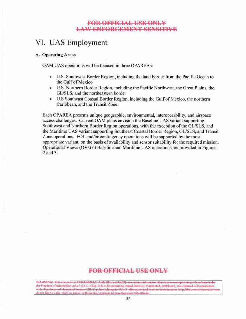
VI. UAS Employment
A. Operating Areas
OAM UAS operations will be focused in three OPAREAs:
• U.S. Southwest Border Region, including the land border from the Pacific Ocean to the Gulf of Mexico
• U.S. Northern Border Region, including the Pacific Northwest, the Great Plains, the GL/SLS, and the northeastern border
• U.S Southeast Coastal Border Region, including the Gulf of Mexico, the northern Caribbean, and the Transit Zone.
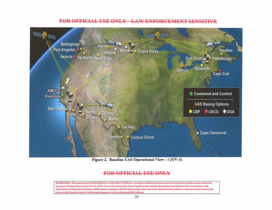
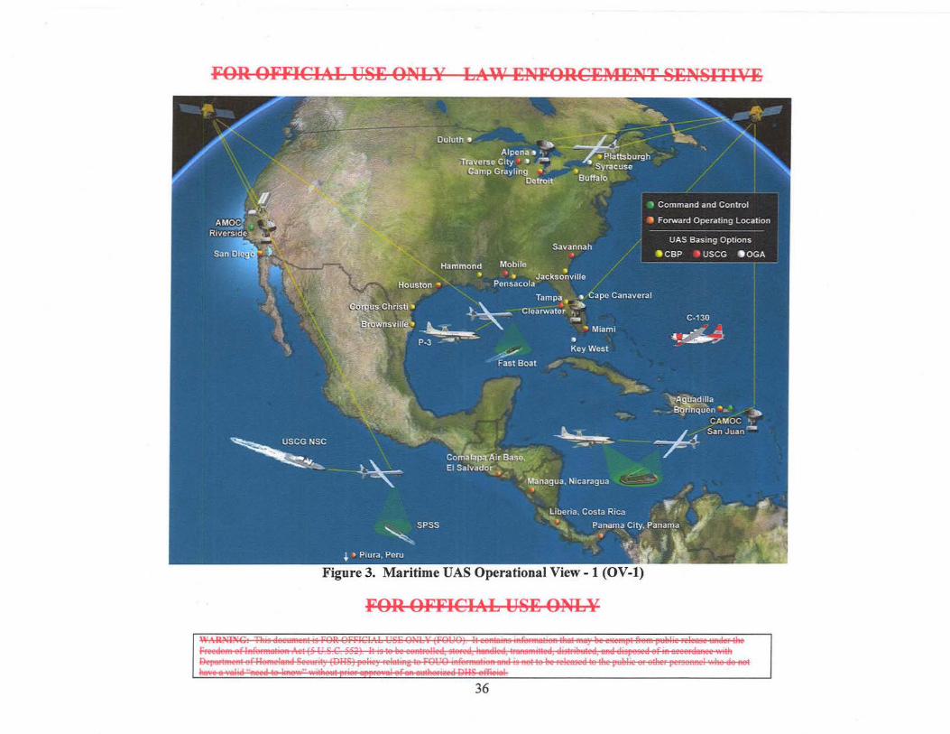
Each OPAREA presents unique geographic, environmental, interoperability, and airspace access challenges. Current OAM plans envision the Baseline UAS variant supporting Southwest and Northern Border Region operations, with the exception of the GLISLS, and the Maritime UAS variant supporting Southeast Coastal Border Region, GLISLS, and Transit Zone operations. FOL and/or contingency operations will be supported by the most appropriate variant, on the basis of availability and sensor suitability for the required mission. Operational Views (OVs) of Baseline and Maritime UAS operations are provided in Figures 2 and 3.
FOR OFFICIAL US~ ONLY
~~~~===:= ... j
34
- '1""'4 I
:> 0 '-
"
'1""'4
~ ·-:> -; =
0 :c ~
""' ~ c. V
)
0 M
00. <
i=l ~
.s ~ ~ ~ = M
~
""' =
biJ
ri:
FOR OFFICIAL USE ONLY LAW ENFORCE~iENT SENSITIVE
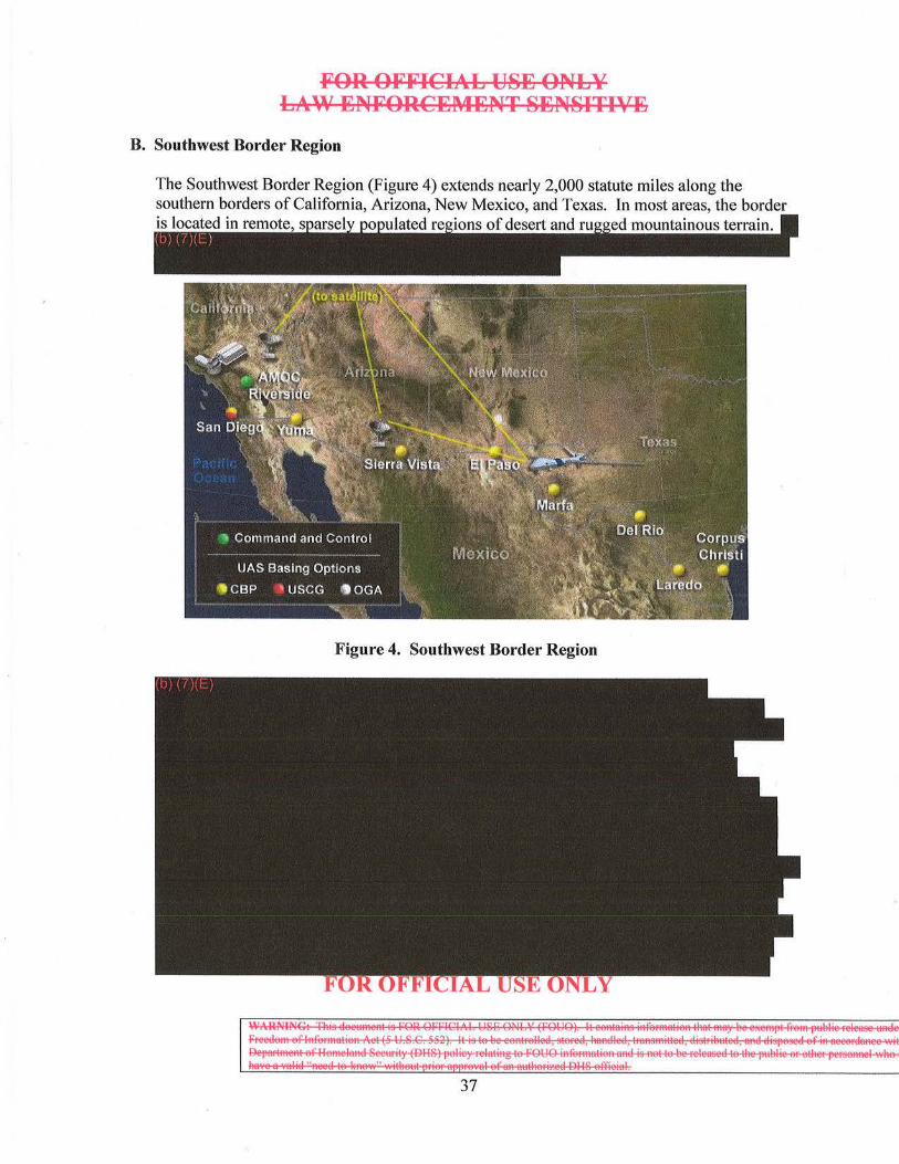
B. Southwest Border Region
The Southwest Border Region (Figure 4) extends nearly 2,000 statute miles along the southern borders of California, Arizona, New Mexico, and Texas. In most areas, the border is located in lated of desert and mountainous terrain.
Figure 4. Southwest Border Region
~~~===r=.::~ 37
FOR OFFICIAL USE ONLY LAW ENFORCEI\4ENT SENSITIVE
Southwest Border Region basing options include:
• DHS: o CBP Air and Marine Locations: Sierra Vista, Tucson, and Yuma, Arizona; El
Paso, Marfa, Corpus Christi, Laredo, and Del Rio Texas; San Diego, California o USCG Air Station: San Diego, Californ ia.
Southwest Border Region operational challenges include:
• Environmental factors: o Extremely hot summer temperatures and dry, arid climate
•
FOR OFFICIAL USE ONLY
~~~~== 38
FOR OFFICIAL USE ONLY LAW ENFORCEMENT SENSITIVE
C. Northern Border Region
The Northern Border Region extends approximately 3,000 statute miles from the Pacific Ocean to the Atlantic Ocean. OAM UAS operations in the Northern Border Region are broken into four geographical areas:
• Pacific Northwest • Great Plains • Great Lakes/Saint Lawrence Seaway • Northeastern Border
The topography along the U.S. Northern border varies greatly. The Pacific Northwest Region is wooded and mountainous, but also contains numerous urban centers. The Great Plains Region is desolate, dry, and windy. The Northeastern Border Region is highly agricultural with low hills and ificant vegetation. Whereas most illegal traffic comes across the U.S. Southwest bo Northern Border trafficki
-~rsvia
CBP performs on-going spectrum coordination with the National Telecommunications and Information Administration (NTIA) to ensure spectrum is available so that UAS systems may operate and support CBP operations.
In summary, the Northern Border Region presents varied and demanding operational challenges to CBP, and in turn on the UAS program in the Region. Specific Northern Border Region operational challenges include:
• Environmental factors:
•
0
0
0
extreme winter cold and icing
FOR OFFICIA:L USE ONLY
~~~==~ 39
FOR OFFICIAL USE ONLY LAW ENFORCE~iENT SENSITIVE
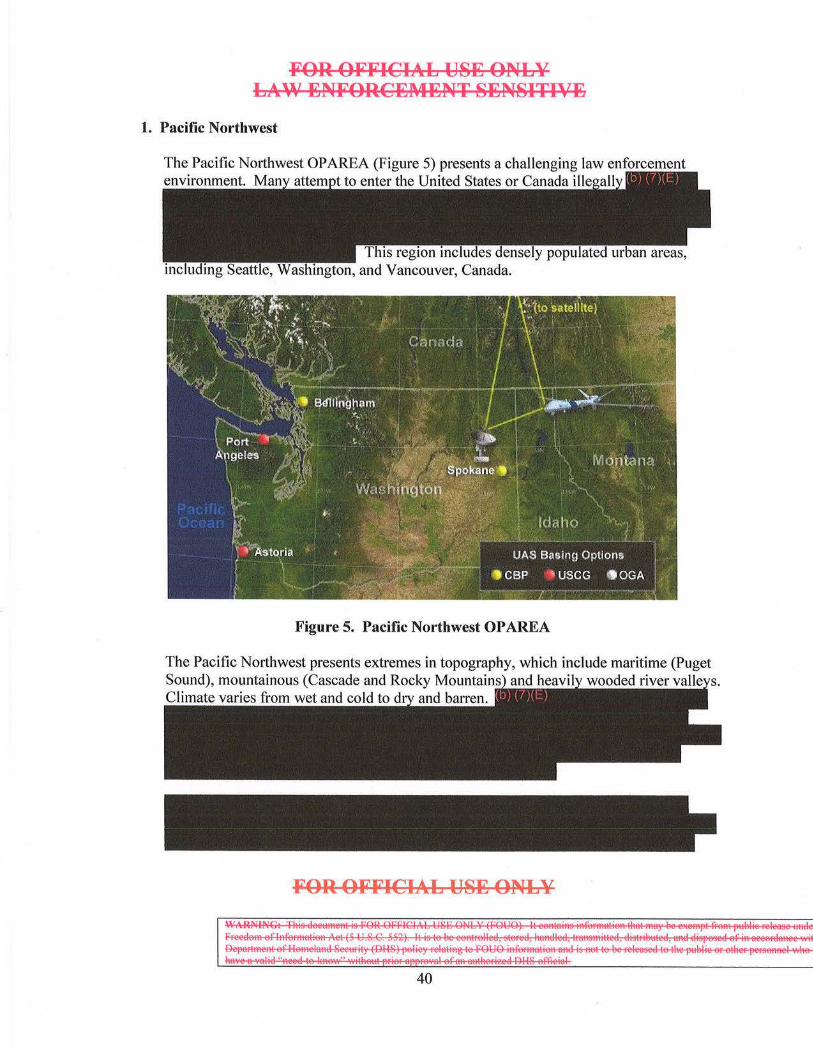
1. Pacific Northwest
The Pacific Northwest OPAREA (Figure 5) presents a challenging law enforcement environment. to enter the United States or Canada i
Figure 5. Pacific Northwest OP AREA
The Pacific Northwest presents extremes in topography, which include maritime (Puget Sound), mountainous (Cascade and Rocky Mountain and heavi wooded river val Climate varies from wet and cold to d and barren.
FOR OFFICIAL USE ONLY
I~&~==~== 40
FOR OFFICIAL USE ONLY Ll,.\\' ENFORCEMENT SENSITIVE
Pacific Northwest basing options include:
• DHS: o CBP Air and Marine Branches in Bellingham and Spokane, Washington o USCG Air Station Astoria, Oregon
Pacific Northwest operational challenges include:
• Environmental effects:
•
•
0
0
mountainous terrain of the Cascade Mountains
2. Great Plains
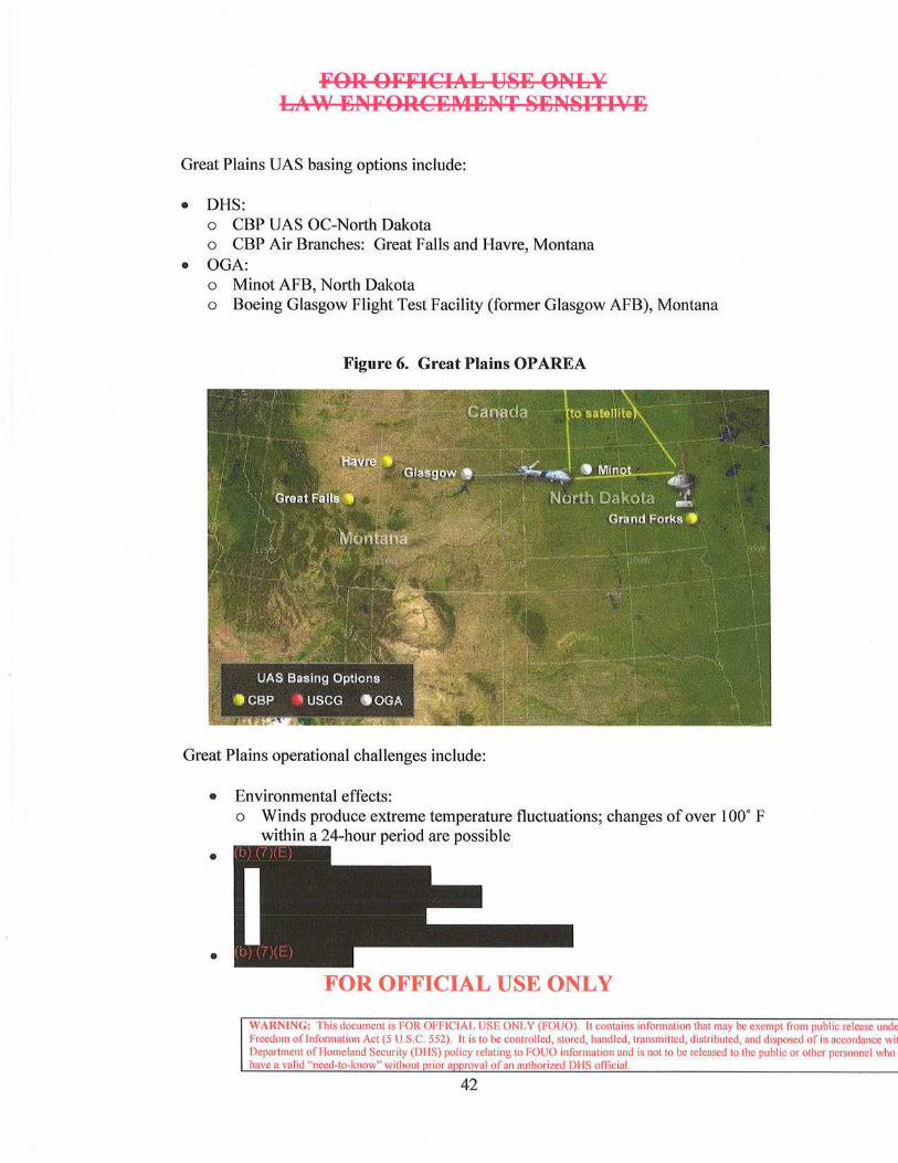
The Great Plains OPAREA (Figure 6) lies between the Pacific Northwest and the Great Lakes. This OPAREA is characterized by more than 1,000 statute miles of relatively flat terrain with some rolling hills and numerous lakes and rivers that traverse the U.S.-Canada border. There are no major urban of border crossings
50- 100 statute miles and
FOR OFFICIAL USE ONLY
WARNING: This document is FOR OFFICIAL USE ONLY (FOUO). It contains information that may be exempt !rom public release undc1 Freedom of Information Act (5 U.S.C. 552). It is to be controlled, stored, handled, transmitted, distributed, and disposed of in accordance wit Department of l-lomeland Security (DI-IS) pol icy relating to FOUO information and is not to be released to the public or other personnel who c have a valid "need-to-know" without rior a roval of an authorized Dl-JS official.
41
FOR OFFICIAL U8E ONLY LAW ENFORCEMENT 8EN8ITIVE
Great Plains UAS basing options include:
• DHS: o CBP UAS OC-North Dakota o CBP Air Branches: Great Falls and Havre, Montana
• OGA: o Minot AFB, North Dakota o Boeing Glasgow Flight Test Facility (former Glasgow AFB), Montana
Figure 6. Great Plains OP AREA
Great Plains operational challenges include:
• Environmental effects:
•
•
o Winds produce extreme temperature fluctuations; changes of over l oo· F within a 24-hour period are possible
FOR OFFICIAL USE ONLY
WARNING: This document is fOR OFFICIAL USE ONLY (FOUO). It contains information that may be exempt from publ ic release undc Freedom oflntbnnation Act (5 U.S.C. 552). It is to be controlled, stored, handled, transmitted, distributed, and disposed of in accordance wil Department of llomcland Security (OilS) policy relating to FOUO information and is not to be released to the public or other personnel who have a valid "need-to-know" without rior a roval of an authorized DHS oftlcial.
42
FOR OFFICIAL US~ ONLY LAW ~NFORC~M~NT S~NSITIV~
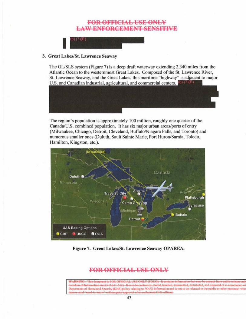
I 3. Great Lakes/St. Lawrence Seaway
The GLISLS system (Figure 7) is a deep draft waterway extending 2,340 miles from the Atlantic Ocean to the westernmost Great Lakes. Composed of the St. Lawrence River, St. Lawrence Seaway, and the Great Lakes, this maritime "highway" is to major U.S. and Canadian industrial ltural and commercial centers.
The region's population is approximately 100 million, roughly one quarter of the Canada/U.S. combined population. It has six major urban areas/ports of entry (Milwaukee, Chicago, Detroit, Cleveland, Buffalo/Niagara Falls, and Toronto) and numerous smaller ones (Duluth, Sault Sainte Marie, Port Huron/Sarnia, Toledo, Hamilton, Kingston, etc.).
Figure 7. Great Lakes/St. Lawrence Seaway OPAREA.
FOR OFFICIAL US~ ONLY
~-~=;=;? 43
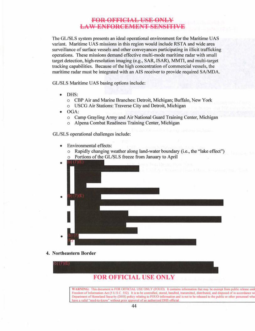
FOR OFFICIAL USE ONLY LAW ENFORCEMENT SENSITIVE
The GLISLS system presents an ideal operational environment for the Maritime UAS variant. Maritime UAS missions in this region would include RST A and wide area survei llance of surface vessels and other conveyances participating in illicit trafficking operations. These missions demand effective multi-mode maritime radar with small target detection, high-resolution imaging (e.g., SAR, ISAR), MMTI, and multi-target tracking capabilities. Because of the high concentration of commercial vessels, the maritime radar must be integrated with an AIS receiver to provide required SA/MDA.
GLISLS Maritime UAS basing options include:
• DHS: o CBP Air and Marine Branches: Detroit, Michigan; Buffalo, New York o USCG Air Stations: Traverse City and Detroit, Michigan
• OGA: o Camp Grayling Army and Air National Guard Training Center, Michigan o Alpena Combat Readiness Training Center, Michigan
GLISLS operational challenges include:
• Environmental effects: o Rapidly changing weather along land-water boundary (i.e., the " lake effect") o Portions of the GL/SLS freeze from January to April
•
•
•
4. Northeastern Border
FOR OFFICIAL USE ONLY
W \RNING: Th1s document1s !"OR 01· HCIAL USF ONLY (FOUO). lt contams mformntion that may be exempt from pubhc release unde Freedom of lnfom1ation Act (5 U.S C. 552). lt1s to be controlled, stored. handled, transm•tted, distributed, and disposed of 10 accordance wit Department of Homeland Secunty (DfiS) policy relating to FOUO information and 1s not to be released to the public or other personnel who have u valid ''need-to-know" Without 1101 a rovnl of an authorized DIIS omcinl
44
FOR OFFICIAL USE ONLY LAW ENFORCEMENT SENSITIVE
The Northeastern Border OPAREA has no major urban areas/ports of entry, although Montreal, is on 50 miles north of the border and 100 miles fi·om Burl Vermont
Northeastern Border OPAREA basing options include:
• DHS: o CBP Air Branch Plattsburgh, New York o CBP Air and Marine Branches: Buffalo, New York; Houlton, Maine
• OGA: o U.S. Army Fort Drum, New York o Hancock Field Air National Guard Base, Syracuse, New York
FOR OFFICIAL USE ONLY
~~~==: 45
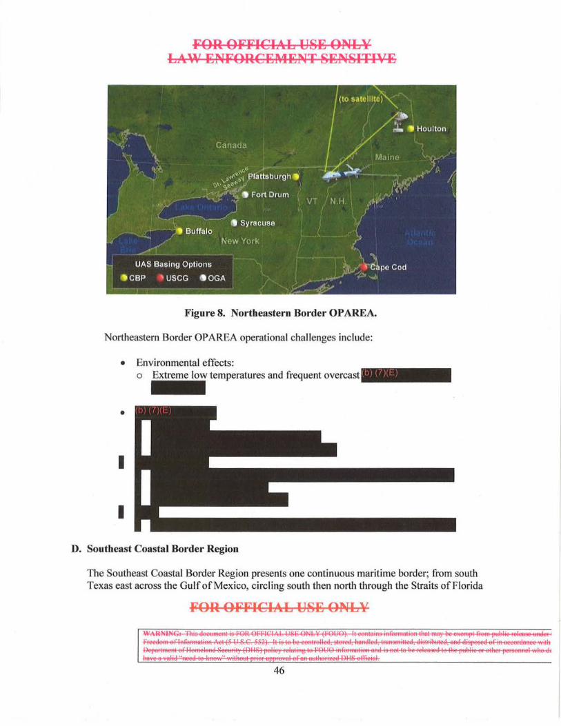
FOR OFFICil .. L USB ONLY LAW BNFORCEMBNT SENSITIVE
Figure 8. Northeastern Border OPAREA.
Northeastern Border OPAREA operational challenges include:
• Environmental effects: o Extreme low temperatures and frequent overcast -
•
I
I
D. Southeast Coastal Border Region
The Southeast Coastal Border Region presents one continuous maritime border; from south Texas east across the Gulf of Mexico, circling south then north through the Straits of Florida
FOR OFFICIAL USB ONLY
~~~=:::! 46

FOR OFFICIAL USB ONLY LAW 15NFORCB~4ENT SENSITIVE
and then north to the mid-Atlantic states. This maritime region is an ideal operational environment for the Maritime UAS variant. Southeast Coastal Border Region UAS operations will be focused in three OPAREAs:
• U.S. Southeastern Coast • Northern Caribbean • Transit Zone
Southeast Coastal Border Region operational challenges include:
•
•
•
CBP performs ongoing spectrum coordination with the NTIA to ensure UAS spectrum availability required for CBP unmanned operations.
1. U.S. Southeastern Coast/Northern Caribbean
FOR OFFICIAL USE ONLY
~~~::EE~-== 47
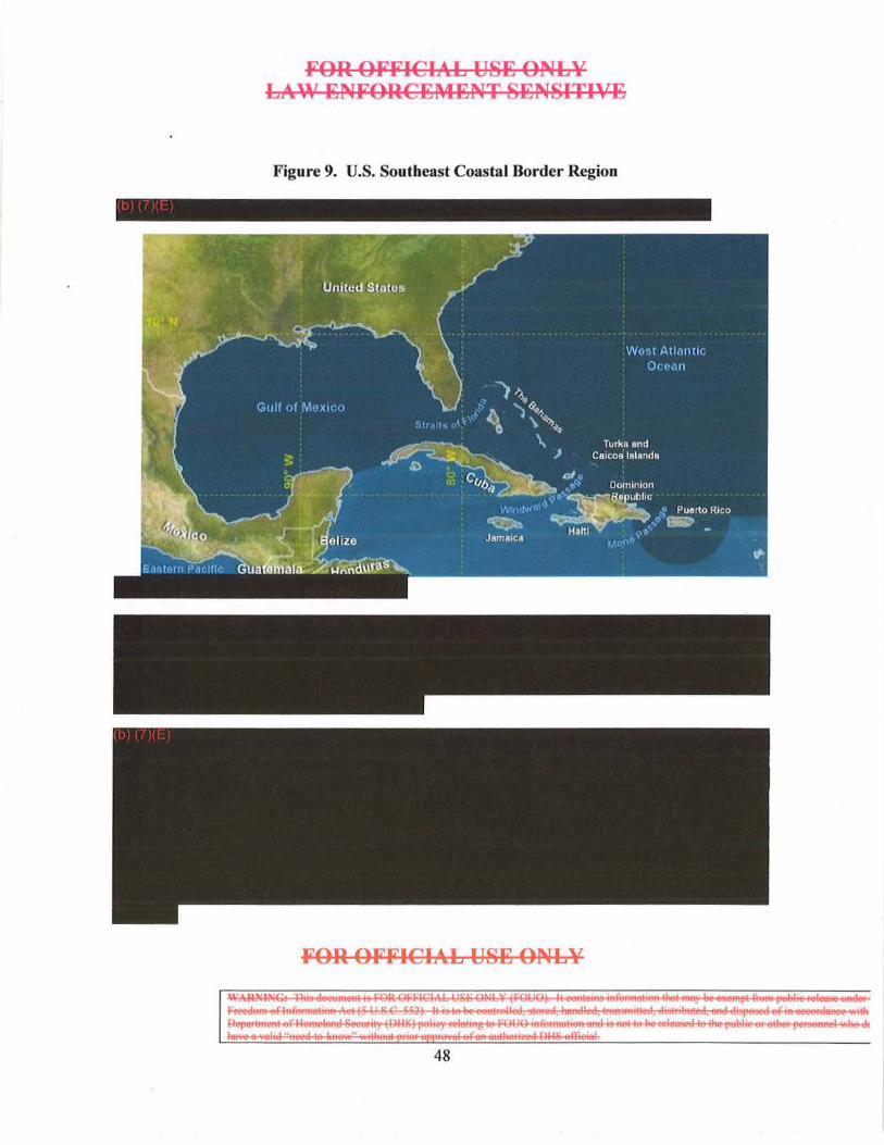
FOR OFFICIAL USE ONLY LAW ENFORCEMENT SENSITIVE
Figure 9. U.S. Southeast Coastal Border Region
FOR OFFICIAL USE ONLY
IS't:"~SEE=~== 48
FOR OFFICIAL US~ ONLY LAW ENFORCEMENT SENSITIVE
U.S. Southeastern Coast/Northern Caribbean Maritime UAS basing options include:
• DHS: o CBP Air and Marine Branches: Jacksonville, Tampa and Miami, Florida;
New Orleans, Louisiana; Houston, Texas; Aguadilla, Puerto Rico o CBP Air Units: Pensacola, Florida o P-3 Operations Centers: Corpus Christi, Texas, and Jacksonville, Florida o USCG Air Stations: Mobile, Alabama; Savannah, Georgia; Miami and
Clearwater, Florida; New Orleans, Louisiana; Borinquen, Puerto Rico • OGA:
o Naval Air Stations: Key West, Florida; Guantanamo Bay, Cuba
FOR OFFICIAL USE ONLY
~~~~ 49
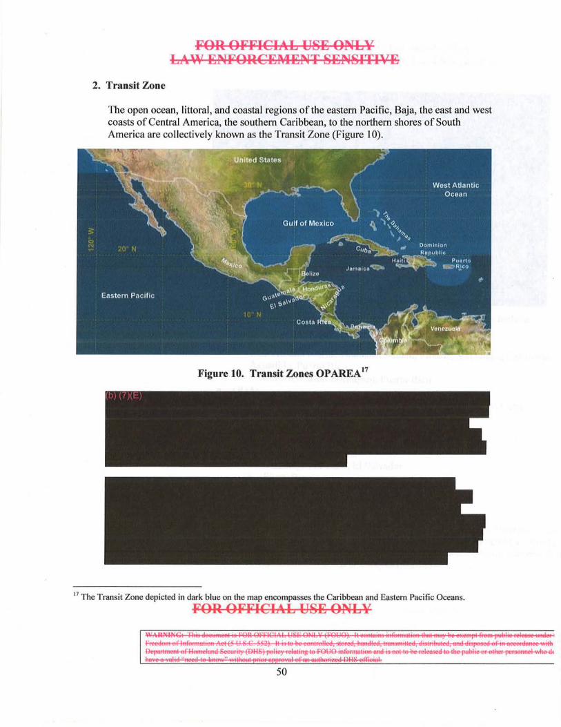
2. Transit Zone
FOR OFFICIAL USE ONLY LA~' ENFORCEMENT SENSITIVE
The open ocean, littoral, and coastal regions of the eastern Pacific, Baja, the east and west coasts of Central America, the southern Caribbean, to the northern shores of South America are collectively known as the Transit Zone (Figure 1 0).
Figure 10. Transit Zones OP AREA 17
17 The Transit Zone depicted in dark blue on the map encompasses the Caribbean and Eastern Pacific Oceans.
FOR OFFICIAL USE ONLY
IS?~~~=~ 50
FOR OFFICIAL USE ONLY LAW ENFORCEMENT SENSITIVE
Transit Zone Maritime UAS basing options and supporting elements include:
• DHS: o CBP Air and Marine Branches: Miami, Florida; San Diego, California;
Aguadilla, Puerto Rico o USCG Air Station Borinquen, Puerto Rico
• OGA: o Naval Air Stations: Key West, Florida; Guantanamo Bay, Cuba o Host Nation FOLs:
• Liberia, Costa Rica • Managua, Nicaragua • Panama City, Panama • Comalapa Air Base, El Salvador • Piura, Peru
E. Time-Phased CONOPS
This CONOPS illustrates OAM's UAS evolutionary acquisition strategy (Section 2.1.1) through the incremental addition of capabilities to Baseline and Maritime UAS variants. These variants will provide RST A capabilities targeted to documented gaps (Section 2.3), while addressing key UAS operational challenges (Section 3.4).
FOR OFFICIAL USE ONLY
IS§f~~ 51
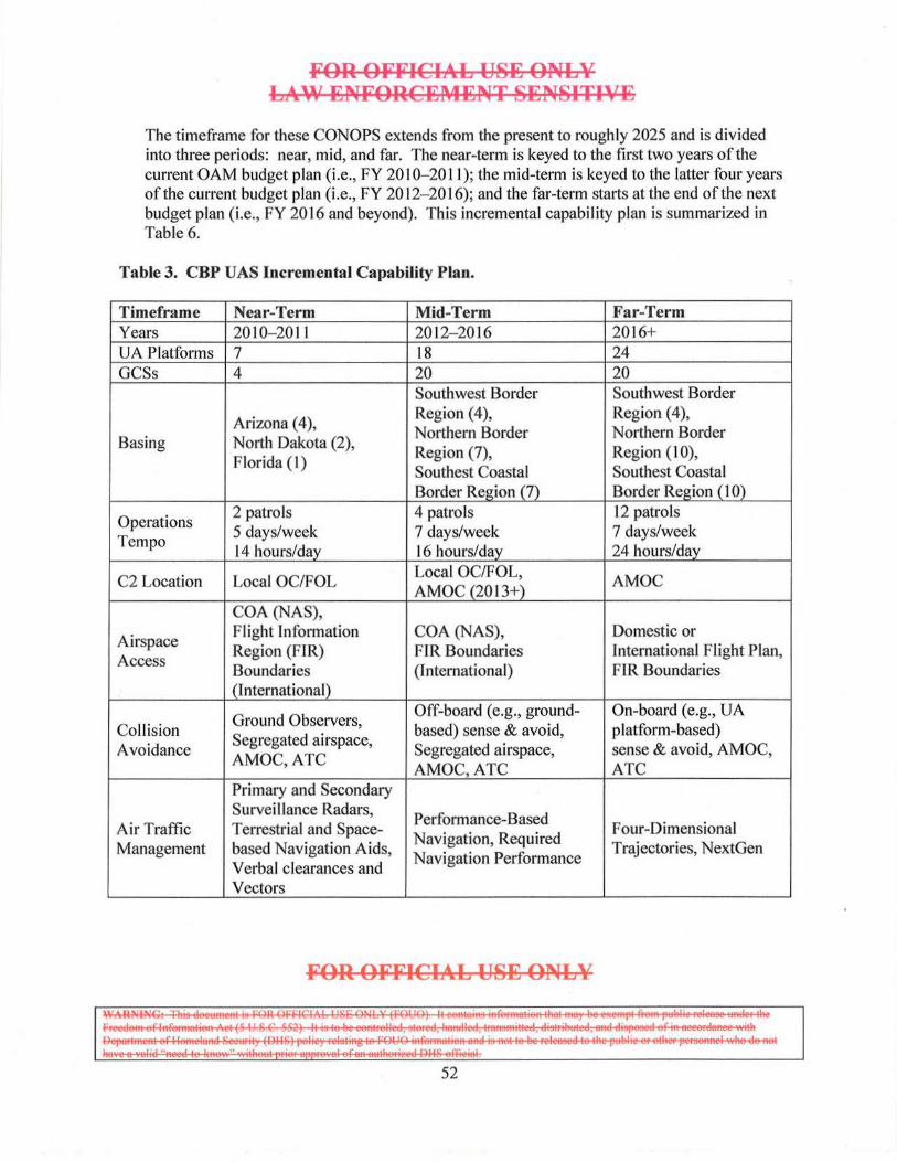
FOR OFFICIAL USE ONLY LAW ENFORCEMENT SENSITIVE
The timeframe for these CONOPS extends from the present to roughly 2025 and is divided into three periods: near, mid, and far. The near-term is keyed to the first two years of the current OAM budget plan (i.e., FY 20 I 0-20 11 ); the mid-term is keyed to the latter four years of the current budget plan (i.e., FY 2012- 20 16); and the far-term starts at the end of the next budget plan (i.e., FY 2016 and beyond). This incremental capabil ity plan is summarized in Table 6.
Table 3. CBP UAS Incremental Capability Plan.
Timeframe Near-Term Mid-Term Far-Term Years 2010- 2011 2012- 2016 2016+ UA Platforms 7 18 24 GCSs 4 20 20
Southwest Border Southwest Border
Arizona ( 4), Region (4), Region (4), Northern Border Northern Border
Basing North Dakota (2), Region (7), Region ( 1 0),
Florida (I) Southest Coastal Southest Coastal Border Region (7) Border Region (1 0)
Operations 2 patrols 4 patrols 12 patrols 5 days/week 7 days/week 7 days/week
Tempo 14 hours/day 16 hours/day 24 hours/day
C2 Location Local OC/FOL Local OC/FOL, AMOC AMOC (20 13+)
COA (NAS),
Airspace Flight Information COA (NAS), Domestic or Region (FIR) FIR Boundaries International Flight Plan,
Access Boundaries (International) FIR Boundaries (International)
Ground Observers, Off-board (e.g., ground- On-board (e.g., UA
Collision Segregated airspace, based) sense & avoid, platform-based) Avoidance Segregated airspace, sense & avoid, AMOC,
AMOC,ATC AMOC,ATC ATC Primary and Secondary Surveillance Radars,
Performance-Based Air Traffic Terrestrial and Space- Navigation, Required
Four-Dimensional Management based Navigation Aids,
Navigation Performance Trajectories, NextGen
Verbal clearances and Vectors
FOR OFFICIAL USE ONLY
Is=~~~~· I 52
FOR OFFICIAL USE ONLY LAW ENFORCEMENT SENSITIVE
1. Near-Term CONOPS
a. Overview
Near-term CONOPS are constrained by existing or rapidly acquired capabilities, currently programmed resources and the existing airspace regulatory environment. Current UAS program plans ca11 for continued operations in the Southwest I Northern Border Regions and in CY 2010 the Guardian maritime UAS will become fully operationalized.
Baseline variant and MVP operations will support the following near-term objectives:
• 0
o Southwest Border Region operational tempo including increased sorties and two UAs airborne simultaneously
o Refinement of Southwest Border Region CONOPS and Tactics, Techniques, and Procedures (TTPs)
o Development of AMOC BLOS C2 CONOPS
0 transition to AMOC BLOS Ku-band control when feasible
o Development ofN01thern Border Region CONOPS and TTPs, including integration with other CBP and Federal, State, local, and tribal assets
• Maritime Variant Prototype: o Operate in the U.S. Southeast Coastal Border Region and Extended Border
OPAREAs o Support Increment H Concept Development and Demonstration Phase by
demonstrating Maritime UAS capabilities, systems integration, sensor performance, and interoperability
o CommenceMVP IOT&E
FOR OFFICIAL USE ONLY
IS~~~· I 53
FOR OFFICIAL USE ONLY LAW ENFORCEl\IENT SENSITIVE
o Refine Operational Requirements to define the Maritime UAS production configuration
o Refine Maritime UAS CONOPS and TIPs, including AMOC C2 and processing, exploitation, and dissemination CONOPS
o Contribute to MDA of the U.S southeastern coast and littorals, and provide law enforcement and MHLS support when not undergoing test
o Deploy as required to the GLISLS and/or the Transit Zone
• AMOC: o UAS Command and control through the Ku satellite antenna o Integrated CBP OIOC and AMOC Collection Management team
executing its corresponding VAS tasking effort o Expanded Maritime Domain Awareness through data links with CBP,
USCG, and DOD assets o Blue Force tracking ofCBP/USCG airborne, maritime, and ground assets o DHS, DOD and host nation liaison partnerships providing increased global
visibility
b. Payloads
The Baseline variant's payload will include the MTS-A/B and the Lynx SAR. The MVP's payload suite will include maritime radar, complimented by an EO/IR sensor, and an AIS receiver. The radar will provide long and short-range search and track, small radar cross-section target detection, SAR/lSAR high resolution imaging modes, and MMTI to perform and/or to support SDCIP mission tasks.
c. Datalinks
In the near term, it is expected that the FAA will continue to require dual, independent UA platform control links. For the OAM UAS, these links will consist of a C-band LOS link and a Ku-band satellite relay datalink that may be used for either LOS or BLOS operations. Both links can provide control commands (low bandwidth) and sensor data download (high bandwidth). Ku-band, however, can be susceptible to adverse weather. To provide redundancy and comply with FAA requirements, the UA will either carry a second satellite link, such as INMARSAT, or rely on a terrestrial communications network to ensure link redundancy and continuity of service.
d. Airspace Access
Airspace access is the dominant factor in defining basing options and mission profiles to execute these CONOPS. In the near term, access to mission essential airspace,
FOR OFFICIAL USE ONLY
~~~====::. , 54
FOR OFFICIAL USE ONLY LAlA' ENFORCEMENT SENSITIVE
including land border regions, offshore Warning Areas, and FAA Flight Information Regions (FIRs) will be achieved through one or more of the following:
• FAA issued COA • Use of SUA; Restricted and/or Warning Areas • Issuance of a Temporary Flight Restriction (TFR) for transition to mission
airspace
e. Basing
Basing to support Northern Border Region and southeastern United States/Northern Caribbean operations will be determined from the locations listed in Sections 5 (e.g., the OAM Branch Miami, Florida). Currently, Northern Border Region operations are based at Grand Forks AFB. MVP detachments may occur to other CONUS locations (e.g., the GLISLS OPAREA) or FOLs in the Transit Zone.
f. Mission Profiles
I
I
FOR OFFICIAL USE ONLY
~~~===:. , 55
•
FOR OFFICIAL USE ONLY LAW ENFORCEMENT SENSITIVE
In all cases, once the UA is established in its OPAREA (COA defined or offshore in SUA), the UA wi ll establish an RSTA pattern appropriate for the mission assignment and environmental conditions and begin SDCIP mission tasks. Near-term, the local OC will provide both LOS and BLOS C2. When the mission period is complete, the UA will return to base per COA requirements. Near-term CONOPS for a Maritime UAS are illustrated in Figure 12, which follows.
Figure 12. Near-Term Maritime UAS CONOPS Illustration
FOR OFFICIAL USE ONLY
~~~s~==:· l 56
FOR OFFICIAL USB ONLY LAW ENFORCEl\4ENT SBNSITIVE
g. Vignettes
2. Mid-Term CONOPS
a. Overview
The mid-term CONOPS period includes the latter four years of the current budget cycle, a period in which resources within the current plan can be reprogrammed to provide increased capability, assets, services, and manpower. Current UAS program plans call for continued Southwest Border Region operations, further expansion of Northern Border Region operations to the Pacific Northwest and n01theastern border, and completion ofMVP IOT&E.
Baseline variant and MVP operations will support the fo llowing mid-term objectives:
• 0
o ncreased Southwest Border Region Operational Tempo (OPTEMPO), including 24/7 operations, and operations with two UA airborne simultaneously
o Refinement of Southwest Border Region CONOPS and TTPs o Refinement of AMOC BLOS C2 CONOPS, and development of AMOC
BLOS TTPs
FOR OFFICIAL USB ONLY
1-=-=;~:r:. I 57
0
0
FOR OFFICIAL USE ONLY LAW ENFORCEMENT SENSITIVE
o Dual UAS operations in selected OPAREAs o BLOS C2 from the AMOC.
• Maritime Variant Prototype: o Operate in the U.S. Southeastern Coast/Northern Caribbean OPAREA o Complete MVP lOT &E o Finalize Maritime UAS Operational Requirements o Develop Maritime UAS CONOPS and TTPs o Contribute to MDA of the U.S Southeastern Coast and littorals o Deploy as required to FOLs in the Transit Zone.
Although beyond the scope of this document, Maritime UAS operations has witnessed the introduction of the USCG's National Security Cutter and awaits USCG's feasibility studies for a utilization of a cutter-based UAS into DHS operations. In addition, the U.S. Navy 's Broad Area Maritime Surveillance system is scheduled to IOC in 2013. CONOPS and capabilities of these systems may impact Maritime UAS operations, especially relating to airspace access.
b. Payloads
UAS sensors wi ll continue to be refined, as high-resolution imaging, full-motion video (FMV), and payload data transmission requirements are met. This will include the ability to detect and track critical TOis such as-and possibly objects as small as a human in the water. Improved sensor fus10n algorithms, as well as Automatic Target Recognition/ Automatic Target Classification (ATRIA TC) features will be introduced. Airspace regulatory compliance will drive the introduction and/or activation ofUA platform-based "sense and avoid" capabilities (e.g., Traffic Collision A voidance System (TCAS) II ; ADS-B; additional active sensors to meet maritime "due regard" requirements; etc.).
c. Datalinks
C2 datalink requirements wi ll continue to evolve, specifically to address simultaneous operations in three OPAREAs. In addition, as CONOPS and SDCIP TIPs are refined, additional mission data download requirements may emerge (e.g., more FMV). Existing UAS datalinks will need to be updated or replaced as control and communications standards are established. Back-up terrestrial links should continue to evolve.
FOR OFFICIAL USE ONLY
IS§§C~~;22E==r:. I 58
FOR OFFICIAL USE ONLY LAW ENFORCEMENT SENSITIVE
d. Airspace Access
Airspace access will continue to be the dominant factor in executing mid-term CONOPS. In this period, access to mission-essential airspace, including land border regions, offshore Warning Areas, and Control Area/Flight Information Region (CTA/FIR) airspace, will be achieved through one or more of the following:
• FAA-issued COA • Use of SUA Restricted and/or Warning Areas • Introduction ofUAS airspace integration (AI) capabilities.
e. Basing
For future maritime UAS operations, potential locations include: Corpus Christi patrolling the Gulf of Mexico environmental spill in W-157; Fort Drum, New York to patrol R-5203 over Lake Ontario; A lpena, Michigan to patrol R-4207 over Lake Huron; or Traverse City, Michigan to patrol R-4305 over Lake Superior.
FOR OFFICIAL USE ONLY
~~~~~· I 59

FOR OFFICIAL USE ONLY LAW ENFORCEMENT SENSITIVE
f. Mission Profiles
g. Vignettes
-FOR OFFICIAL USE ONLY
WAR:"'ING: ll1is document 1s FOR OFFICIAL USE ONLY (FOliO) It contains infonnation that may be exempt from public release under the Freedom of lnfonnation Act (5 U.S C 552) It IS to be controlled, stored, handled, tmnsm1tted, distributed, and d1sposed of in accordance w1th Department of Homeland Secunty (DIIS) policy relating to FOUO mformauon and is not to be released to the public or other personnel who do not have a valid "need-to-know" without prior approval of an uuthoritcd Oi lS officull
60

Ab 118-EONL¥ FOR OFF~~MENT 8-ENSITIVI; LA\\' :ENFOR
OFFICIAb 118-E ONLY
FOR OFFICIAL USE ONLY LAW ENFORCEt\4ENT SENSITIVE
3. Far-Term CONOPS
a. Overview
The far-term CONOPS period is defined as those years beyond the current budget cycle, a period in which programmatic funding is undefined and new starts are possible. Resource planning focuses on development of new or improved capabilities that take advantage of emergent technologies to fill current or emergent capability gaps. The far-term period will be characterized by:
• Expansion ofUAS operations to FOLs in the Transit Zone • Publication of various UAS AI standards, including sense-and-avoid
performance standards, which will impact UAS equipment requirements • The initial phase ofNextGen, the FAA's modernization of the NAS • Modernization of CBP UAS C2 through AMOC improvements • Use of UAS as host for other agency projects on a not to interfere with
operational mission's basis • Modernization of the OAM UASs through Block upgrades • Determination of CBP UAS Increment III requirements.
Although beyond the scope of this document, Maritime UAS operations in the farterm will witness the introduction of the USCG's National Security Cutter, Offshore Patrol Cutter, land-based UAS capable of meeting additional USCG missions, and cutter-based UAS, into DHS operations. In addition, OGAs such as DOD and NOAA will continue to expand UAS operations and introduce new types ofUAS.
FOR OFFICIAL USE ONLY
~~~§§==:;=:~ I 62
FOR OFFICIAL USE ONLY LAW ENFORCEMENT SENSITIVE
The UAS program has resource planning that supports a robust modernization program, driven by an integrated product roadmap. New capabilities, including improved sensors, may be leveraged from DOD or OGA Block upgrade efforts.
b. Payloads
The most significant impact to payloads in the far-term will be the finalization of UAS AI performance standards and procedures. The FAA mandated technical standards for UAS hazard avoidance have the potential to impact UA platform CNS/ A TM equipment, as well as sensors and ancillary systems that support airspace compliance. GCS datalinks may also be impacted in terms of rel iability, redundancy, latency, security, and/or spectrum compliance requirements.
Mission sensor upgrades could include improving SAR point target resolution to well below one foot, a simultaneous SAR-GMTIIMMTI mode and advanced ATR/ATC algorithms. Visual and IR band sensors will be updated with newer generation arrays. The addition of an Electronic Support Measures suite with specific emitter identification will increase mission effectiveness by enabling the UAS to independently perform the SDCIP Identification task. Additional payload upgrades could include expendables or non-lethal weapons designed to immobilize TOis.
c. Datalinks
C2 datalink requirements will continue to evolve and may include collaborative C2 with OGAs. Improved C2 resulting from AMOC expansion wi ll enable mission flexibil ity and interoperability with OGAs. Upgrades may adopt or leverage DOD datalink and satellite architectures to further improve interoperability.
d. Airspace Access
FOR OFFICIAL USE ONLY
1ss~==a::s:a:. 1 63
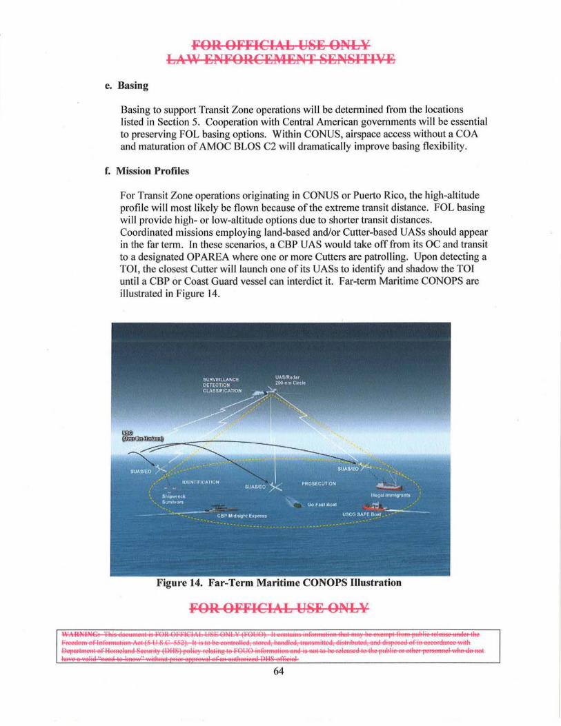
e. Basing
FOR OFFICIAL USE ONLY LAW ENFORCEl\IENT SENSITIVE
Basing to support Transit Zone operations will be determined from the locations listed in Section 5. Cooperation with Central American governments will be essential to preserving FOL basing options. Within CONUS, airspace access without a COA and maturation of AMOC BLOS C2 wi ll dramatically improve basing flexibility.
f. Mission Profiles
For Transit Zone operations originating in CONUS or Puerto Rico, the high-altitude profile will most likely be flown because of the extreme transit distance. FOL basing will provide high- or low-altitude options due to shorter transit distances. Coordinated missions employing land-based and/or Cutter-based UASs should appear in the far term. In these scenarios, a CBP UAS would take off from its OC and transit to a designated OPAREA where one or more Cutters are patroll ing. Upon detecting a TOI, the closest Cutter will launch one of its UASs to identify and shadow the TOI until a CBP or Coast Guard vessel can interdict it. Far-term Maritime CONOPS are illustrated in Figure 14.
Figure 14. Far-Term Maritime CONOPS Illustration
FOR OFFICIAL USE ONLY
I E~=f:E:g§~=::;:. I 64
FOR OFFICIAL USE ONLY LAW Jj;NFORCI!lMENT SENSITIVE
VII. Program Impacts
A. Doctrine, Organization, Training, Materiel, Leadership and Education, Personnel and Facilities (DOTMLPF) Impacts
The introduction of the Predator B UAS has impacted nearly all DHS DOTMLPF areas. Effective UAS employment will require DOTMLPF changes in supporting systems and organizations to maximize this new and transformational capability.
For all UAS materiel or non-materiel solutions, a cost/benefit analysis has been performed utilizing:
• Potential impact on the CBP force of the proposed capability • lnteroperabi lity impacts on intra- and interagency stakeholders • Acquisition and life cycle costs • Current state of airspace access • DOTMLPF implications of the proposed solution.
1. Doctrine
• UASs will continue to increase as a percentage ofCBP's airborne force and, as such, will require increased access to the NAS and international airspace for operations and training.
• The UAS's long endurance, coupled with its ability to be dynamically re-tasked, will enable the system to be responsive to emergent mission requirements. New procedures and training will be developed to exploit this dynamic re-tasking capability and to minimize "sense-to-interdict" timelines.
• TTPs will evolve to reflect the increasing significance of UASs in nearly all aspects ofDHS operations, including HLS, homeland defense, civil support, humanitarian assistance, etc.
• Joint OHS and OGA combined operations will become the norm at successively lower organizational hierarchical levels.
• Development ofUAS doctrine will be more dynamic and collaborative and will be driven increasingly by experimentation and lessons learned.
2. Organization
The effective application ofUASs in support ofDHS operations relies on long standing organizational relationships within OHS (e.g., CBP and USCG) and between DHS and OGAs (e.g., DOD, FEMA, DEA, FBI, NOAA, etc.).
FOR OFFICIAL USE ONLY
~~~=E:: I 65
3. Training
FOR OFFICIAL USE ONLY LAW ENFORCEMENT SENSITIVE
• Training standards for UAS pilots will be established by OAM, the FAA, and/or DOD and for maritime applications with USCG. While UAS pilots are performing similar functions as their manned aircraft counterparts, their tasking and job environment are qualitatively different in fundamental ways from that of a manned aircraft pilot. This will impact personnel requirements, training, and overall system performance.
• Training curriculum will be updated or developed to produce the knowledge, experience, and desired performance behaviors for operating CBP's UASs safely, routinely, and effectively.
• The curriculum change process will be responsive to rapidly transforming TTPs, introduction of new UAS capabilities and changes to the airspace operating environment brought forth through NextGen and/or other regulatory authority changes.
• Migration to organic OAM training will require significant investment.
4. Materiel
• GCSs should be designed to be dual capable for use in both controlling actual missions and conducting simulated flights for training.
• Mission datalink requirements will need to be continuously updated as bandwidth requirements grow (e.g., requirements for FMV and higher resolution imagery) and commercial/DOD satellite architectures evolve.
• AI technologies, including those that support hazard avoidance (i.e., "sense and avoid") are maturing rapidly. The UAS program must determine the optimal time to insert these technologies.
5. Leadership and Education
• Leadership must embrace the aviation cultural change required to operate UASs as a significant percentage ofOAM's force.
• Leadership must work closely with the FAA to facilitate and expedite insertion of OAM UASs into the NAS without compromising safety, and must bolster its connectivity with OGAs (e.g., DOD) involved in UAS AI.
• Leadership should ensure that the determination and refinement of UAS force requirements and capabilities necessary to meet CBP HLS/MHLS requirements are congruent and synergistic with OGA efforts.
FOR OFFICIAL USE ONLY
~~~~~· I 66
6. Personnel
FOR OFFICIAL USE ONLY LA\\' ENFORCEl\4ENT SENSITIVE
• The proliferation ofUASs in DHS will require Components to develop new career specialties and manpower career paths. As with manned aviation, UAS personnel will cover the spectrum from highly experienced to new hires. Specialists of many types will emerge to exploit this transformational force multiplier.
• Expertise not organic to units may be provided by CBP supporting units and/or OGAs, either virtually or through actual presence. Through the use of reach back, distributed UAS operations should be enabled, which would result in smaller deployed footprints and enhanced mobility for the force.
7. Facilities
Bases and facilities will require continued DHS investment and partnership with commercial and foreign entities to provide UAS unique infrastructure and support. OAM UASs may operate from FOLs for extended durations. Adequate facilities must be provided at FOL's for operations, deployed maintenance, and personnel support.
B. Intelligence Support Impacts
Specific UAS impacts on CBP and DHS intelligence support requirements are beyond the scope of this document, but UAS operations will potentially impact the following areas:
• Intelligence Manpower: VAS operations will require intelligence manpo\Yer to support mission planning, mission execution and processing, and exploitation and dissemination. In concert with AMOC expansion, UAS intelligence manpower impacts must be analyzed to determine the quantity and skill set mix required to support UAS operations at predicted OPTEMPOs.
• Intelligence Resources: To maximize the intelligence value ofUAS sensor data, OAM funding will continue to be required to support analysis and the end-to-end processing, exploitation, and dissemination of UAS sensor data.
The CBP UAS program office will interface with the OIOC Collection Management office to ensure customer requirements that are associated with an intelligence product are documented and vetted.
¥OR O¥¥ICIAL USE ONLY
I §~~~:EE!?~;?£==-r:. I 67
FOR OFFICIAL USE ONLY LAW EN¥0RCEl\4ENT SENSITIVE
VIII. Appendices
Appendix A - List of Abbreviations and Acronyms
ADIZ ADS-B AEW AFB AGL AI AIS AMOC AOH ARTCC ASR ATC ATCAA ATM ATRIATC ATS ATV AWACS
BLOS
C2 CBP CBSA ceo CFR Chicago Convention CIKR CL CLS CM CNS
A Air Defense Identification Zone Automatic Dependent Surveillance - Broadcast Airborne Early Warning Air Force Base Above Ground Level Airspace Integration Automatic Identification System Air and Marine Operations Center Aviation Operations Handbook Air Route Traffic Control Center Airport Surveillance Radar Air Traffic Control Air Traffic Control Assigned Airspace Air Traffic Management Automatic Target Recognition/ Automatic Target Classification Air Traffic Service All Terrain Vehicle Airborne Warning and Control System
B Beyond Line of Sight
c Command and Control U.S. Customs and Border Protection Canada Border Services Agency Camouflage, Concealment, and/or Deception Code of Federal Regulations The Convention on International Civil Aviation of 1944 Critical infrastructure and key resources Command Link Contractor Logistics Support Collection Manager Communications, Navigation, and Surveillance
FOR OFFICIAL USE ONLY
~~~~~~· I 68
COA COM CONEMP CONOPS CONUS CTA CY
DEA DHS DOD DOTMLPF
DTO
ECEF EMS EO ESM EX COM
FAA FACSFAC FAR FBI FEMA FIR FL FMV FOC FOL FoS FY
GA-ASI GBSAA GCS GOT
FOR OFFICL~L USE ONLY LAW ENFORCEl\IENT SENSITIVE
Cettificate of Waiver or Authorization Collection Operations Manager Concept of Employment Concept of Operations Continental United States Control Area Calendar Year
D U.S. Drug Enforcement Administration U.S. Department of Homeland Security Department of Defense Doctrine, Organization, Training, Materiel, Leadership and Education, Personnel, and Facilities Drug Trafficking Organization
E Earth-Centered, Earth-Fixed Electromagnetic Spectrum Electro-Optical Electronic Support Measures Executive Committee
F Federal Aviation Administration Fleet Area Control and Surveillance Facilities Federal Aviation Regulation Federal Bureau of Investigation Federal Emergency Management Agency Flight Information Region Flight Level Full Motion Video Full Operational Capability Forward Operating Location Family of Systems Fiscal Year
G General Atomics Aeronautical Systems Inc. Ground-Based Sense and A void Ground Control Station Ground Data Terminal
FOR OFFICIAL USE ONLY
ISE~s==~=~:. I
69

GIG GL GMT! GPS
HIDTA HLS
l&A IBET ICAO ICE IFE IFR IMC IOC IOT&E IP IR IRSCC ISAR IPT
JIATF-S JORD
K
LES LMR LOP LOS LRT
MCE MDA MHLS MlFC
FOR OFFICIAL USE ONLY LA\¥ ENFORCEl\4ENT SENSITIVE
Global Information Grid Great Lakes Ground Moving Target Indication Global Positioning System
H High Intensity Drug Trafficking Area Homeland Security
I Office oflntelligence and Analysis (DHS) Integrated Border Enforcement Team International Civil Aviation Organization U.S. Immigration and Customs Enforcement In-flight Emergency Instrument Flight Rules Instrument Meteorological Conditions Initial Operational Capability Initial Operational Test & Evaluation Office of Infrastructure Protection (DHS) Infrared Interagency Remote Sensing Coordination Cell Inverse Synthetic Aperture Radar Integrated Product Team
J Joint Interagency Task Force - South Joint Operational Requirements Document
K Thousands
L Land earth station L iving Marine Resources Letters of Procedure Line-of-Sight Long Range Tracking
M Mission Control Element Maritime Domain Awareness Maritime Homeland Security Maritime Intelligence Fusion Center (USCG)
FOR OFFICIAL USE ONLY
IS:~==~· I 70
MMTI MOA MSL MTS MVA MVP
NAS NAVAID NAVSEA NextGen NIIRS NM NOAA NRT NSA NTIA NVD
OAA OAM oc OGA OIOC OPAREA OPTEMPO ORO OSI ov
PBL PGDT PIC PICAO PPO PWCS
RCM
FOR OFFICIA:L USE ONLY LA>A' ENFORCEl\4ENT SENSITIVE
Maritime Moving Target Indicator Military Operations Area Mean Sea Level Multi-Spectral Targeting System Minimum Vectoring Altitude Maritime Variant Prototype
N National Airspace System Radio Aid to Navigation Naval Sea Systems Command Next Generation Air Transportation System National Imagery Interpretability Rating Scale Nautical miles National Oceanic and Atmospheric Administration Near Real Time National Security Area National Telecommunications and Information Administration Night Vision Device
0 Offshore Airspace Area Office of Air and Marine Operating Center Other Government Agency Office oflntelligence and Operations Coordination Operational Area Operational Tempo Operational Requirements Document Ocean Surveillance Initiative Operational Views
p
Performance Based Logistics Portable Ground Data Terminal Pilot-in-Command Provisional International Civi I Aviation Organization Pilot Payload Operator Ports, Waterways and Coastal Security
R Redundant Control Module
FOR OFFICIAL USE ONLY
IS~::JS§~~:a:. I 71
RCMP RF RL RSTA RTB RVT
S&T SA SAR SARPS SATCOM SBI SDCIP SLS SoS SPA SPSS SUA
TCAS TFR TOI TRACON TSS TTP
UA UAS USCG USG USNORTHCOM
VFR
FOR OFFICIAL USB ONLY LAW ENFORCEMENT SENSITIVE
Royal Canadian Mounted Police Radio Frequency Return Link Reconnaissance, Surveillance, Targeting, and Acquisition Return to Base Remote Video Terminal
s Science and Technology Directorate (DHS) Situational Awareness Synthetic Aperture Radar Standards and Recommended Practices Satellite Communications Secure Border Initiative Surveillance, Detection, Classification, Identification, and Prosecution St. Lawrence Seaway System of Systems Special Purpose Airspace Self-Propelled Semi-Submersible Special Use Airspace
T Traffic Collision and Avoidance System Temporary Flight Restriction Target oflnterest Terminal Radar Approach Control Training, Safety and Standards Tactics, Techniques and Procedures
u Unmanned Aircraft Unmanned Aircraft System United States Coast Guard United States Government U.S. Northern Command
v Visual Flight Rules
FOR OFFICIAL USE ONLY
~ ~~==2".i?'E==a:. I
72
FOR OFFICIAL USE ONLY LAW ENFORCEI\tENT SENSITIVE
Appendix B - References
The fo llowing sources were reviewed in the development of this document:
National-level documents:
The National Security Strategy of the United States of America, March, 2006.
The National Strategy for Homeland Security, October, 2007.
The National Strategy for Maritime Security, September, 2005.
The National Strategy for Aviation Security, March, 2007.
National Plan to Achieve Maritime Domain Awareness for the National Strategy for Maritime Security, October, 2005.
The Global Maritime Intelligence Integration Plan, October, 2005.
The Maritime Commerce Security Plan, October, 2005.
The National Concept of Operations for Maritime Domain Awareness, December, 2007.
DHS documents:
Securing Our Homeland: US. Department of Homeland Security Strategic Plan, 2004.
United States Coast Guard (USCG) Major System Acquisition Manual (MSAM), Commandant Instruction M5 000.1 OA, October 17, 2008.
United States Coast Guard Maritime Strategy for Homeland Security, December, 2002.
DHS S&T Maritime Security Capstone IPT Rank-Ordered Capability Gap List, June 26,2008.
DHS S&T Border Security IPT Rank-Ordered Capability Gap List, January 30, 2007.
CBP documents:
Protecting America: US. Customs and Border Protection 2005-2010 Strategic Plan, 2005.
National Border Patrol Strategy: Office of Border Patrol, 2004.
FOR OFFICIAL USE ONLY
~~~~===· I 73
FOR OFFICIAL US'E ONLY LAW ENFORCEMENT SENSITIVE
Securing America's Borders at Ports of Entry: Office of Field Operations Strategic Plan FY 2007-2011,2007.
Container Security Initiative: 2006-2011 Strategic Plan, 2006.
Operational Requirements Document (ORD) for the US. Customs and Border Protection Unmanned Aircraft System, Version 2.0, December 27,2007.
US. Customs and Border Protection Unmanned Aircraft System Concept of Operations, Draft Version 1.2, December 27, 2007.
US. Customs and Border Protection Concept ofOperationsfor Customs and Border Protection Air and Marine P-3 Airborne Early Warning (AEW) and Long Range Tracking (LRT} Aircraft, (undated).
DOD documents:
National Defense Strategy of the United States of America, March, 2005.
National Military Strategy of the United States of America, 2004.
DoD Strategy for Homeland Defense and Civil Support DoD Homeland Defense and Civil Support Joint Operating Concept.
Capability Development Document for Broad Area Maritime Surveillance Unmanned Aircraft System Increment: I, U.S. Navy PMA-263, May 21,2007.
OGA documents:
14 Code of Federal Regulations (CFR), Subchapter F, Air Traffic and General Operating Rules, Part 91, General Operating and Flight Rules.
International Civil Aviation Organization, Convention on International Civil Aviation, Ninth Edition, 2006.
FOR OFFICIAL USE ONLY
~~~~~===. , 74
FOR OFFICIAL USE ONLY LAW ENFORCEMENT SENSITIVE
Appendix C - Program Stakeholders
Descriptions of Federal agencies that may be impacted by the CBP UAS program follow.
1. DHS Components
A. U.S. Customs and Border Protection
CBP is the unified border agency within DHS. CBP includes more than 58,000 employees who manage, secure and protect the Nation's borders, at and between the official ports of entry. Organizations within CBP include the OAM, the Office of Border Patrol, the Office ofField Operations, and the OIOC.
B. U.S. Coast Guard
The USCG 's overall mission is to protect the public and the Nation's economic and security interests in any maritime region in which those interests may be at risk, including international waters, and America's coasts, ports, and waterways. The USCG functions as the Nation's principal maritime law enforcement authority and the lead Federal agency for the maritime component ofHLS. As the designated lead agency for maritime drug interdiction under the National Drug Control Strategy and the co-lead agency with OAM for air interdiction operations, the USCG works closely with CBP and OGAs in the maritime domain, and as such, is a key stakeholder in any UAS program that may contribute to the fulfillment of its maritime missions.
The USCG basic roles and statutory missions, as found in the Homeland Security Act, are as follows?0
(l) NON-HOMELAND SECURITY MISSIONS: (A) Marine safety (B) Search and rescue (C) Aids to navigation (D) Living marine resources (fisheries law enforcement) (E) Marine environmental protection (F) lee operations
(2) HOMELAND SECURITY MISSIONS: (A) Ports, waterways and coastal security
20 Section 888(a)(2) ofThe Homeland Security Act of2002 (P.L. 107-296 ofNovember 25, 2002), which established DHS.
FOR OFFICIAL USE ONLY
~~~~e===~~. 1
75
:FOR OF:FICIAL USE ONLY LAW ENFORCEl\4ENT SENSITIVE
(B) Drug interdiction (C) Migrant interdiction (D) Defense readiness (E) Other law enforcement
C. U.S. Immigration and Customs Enforcement
ICE is the largest investigative arm ofDHS and is composed of two law enforcement divisions and one support division. They are charged with preventing terrorist and criminal activity by targeting the people, money, and materials that support terrorist and criminal organizations and the smart and effective enforcement of U.S. immigration laws. ICE investigations cover a broad range of areas, including national security threats, illegal immigration, financial and smuggling violations (including illegal arms exports), financial crimes, commercial fraud, human trafficking, narcotics smuggling, child pornography/exploitation, and immigration fraud.
D. Federal Emergency Management Agency
The primary mission ofFEMA is to support our citizens and first responders to ensure that as a nation we work together to build, sustain, and improve our capability to prepare for, protect against, respond to, recover from, and mitigate all hazards.
E. Office of Intelligence and Analysis (I&A)
l&A's mission is to analyze intelligence and information about homeland security threats and serve as the two-way interface between the national Intelligence Community and state, local, tribal and private sector partners on homeland security intelligence and information - including warnings, actionable intell igence, and analysis - to ensure that frontline law enforcement have the tools they need to confront and disrupt terrorist threats.
F. U.S. Secret Service
The U.S. Secret Service is mandated by statute and executive order to carry out two significant missions: protection and criminal investigations. The Secret Service protects the President and Vice President, their families, heads of state, and other designated individuals; investigates threats against these protectees; protects the White House, Vice President's Residence, Foreign Missions, and other buildings within Washington, DC; and is the lead Federal agency for planning and implementing the security designs for designated National Special Security Events. The Secret Service also investigates violation of laws relating to counterfeiting of obligations and securities of the United States; financial crimes that include, but are not limited to, access device fraud, financial
FOR OFFICIAL USE ONLY
1~5~~~=:. J 76
FOR OFFICIAL USE ONLY LAW ENFORCEMENT SENSITIVE
institution fraud, identity theft, computer fraud; and computer-based attacks on our financial, banking and telecommunications infrastructure.
G. Office of Infrastructure Protection (IP)
DHS IP leads the coordinated national program to reduce risks to the Nation's critical infrastructure and key resources (CIKR) posed by acts of terrorism and to strengthen national preparedness, timely response and rapid recovery in the event of an attack, natural disaster or other emergency.
FOR OFFICIAL USE ONLY
~~~~~;:t. [ 77
FOR OFFICIAL USE ONLY LAW ENFORCEl\4ENT SENSITIVE
2. OGA Components
A. Drug Enforcement Agency
The DEA is the Federal agency whose mission is to enforce the controlled substances laws and regulations of the United States and to bring to the criminal and civil justice system those organizations and principal members of organizations involved in the growing, manufacture, or distribution of controlled substances appearing in or destined for illicit traffic in the United States. CBP works closely with the OEA in countering ill icit narcotics smuggling and in the sharing of intelligence and mission data in support of counter-drug operations. The DEA 's U.S. Embassy attaches work with host nations to obtain basing privi leges for CBP FOLs.
B. Interagency Remote Sensing Coordination Cell
Coordination of remote sensing capabilities in support of disaster response is accomplished through the Interagency Remote Sensing Coordination Cell (IRSCC). The IRSCC provides a common picture of remote sensing collection activities to support disaster response operations, e.g., during Hurricane Ike, OAM flew the Predator B in support of FEMA and their hurricane relief efforts. This was the first time DHS was able to provide a geospatial depiction of the civilian remote sensing picture to emergency responders and the remote sensing community .
C. Federal Bureau of Investigation
The mission of the FBI is to protect and defend the United States against terrorist and foreign intelligence threats, to uphold and enforce the criminal laws of the United States, and to provide leadership and criminal justice services to Federal, state, municipal, and international agencies and partners. CBP works closely with the FBI in countering illicit narcotics smuggling and in the sharing of intelligence and mission data in support of counter-drug operations.
D. U.S. Marshals Service
The U.S. Marshals occupy a uniquely central position in the Federal justice system. As the enforcement arm of the Federal courts, they are involved in virtually every Federal law enforcement initiative. More than 3,320 Deputy U.S. Marshals and Criminal Investigators form the backbone of the agency. Among their many duties, they apprehend more than half of all Federal fugitives, protect the Federal judiciary, operate the Witness Security Program, transport Federal prisoners, and seize property acquired by criminals through illegal activities.
FOR OFFICIAL USE ONLY
I~_JE§~. I 78
FOR OFFICIAL USE ONLY LAW ENFORCEM~NT SENSITIV~
E. Department of Defense
Within DOD, UASs have become a significant and transformational force multiplier across the fu ll range of military operations, including combating terrorism, HLS, Homeland Defense, and Defense Support of Civil Authorities. CBP works closely with DOD through agencies such as U.S. Southern Command's JIATF-S and USNORTHCOM. USNORTHCOM provides command and control of DOD's homeland defense efforts and coordinates defense support of civil authorities (e.g., CBP). USNORTHCOM's civil support mission includes domestic disaster relief operations that occur during fires, hurricanes, floods, and earthquakes. Support also includes counter-drug operations and managing the consequences of a terrorist event employing a weapon of mass destruction. The command provides assistance to a Primary Agency (e.g., CBP) when tasked by DOD. Per the Posse Comitatus Act, military forces can provide civil support but cannot become directly involved in law enforcement. In providing civil support, USNORTHCOM generally operates through established Joint Task Forces subordinate to the command. An emergency must exceed the capabilities of Federal, state, and local agencies before USNORTHCOM becomes involved. In most cases, support will be limited, localized, and specific. When the scope of the disaster is reduced to the point that the Primary Agency can again assume fu ll control and management without military assistance, USNORTHCOM will exit, leaving on-scene experts to finish the job.
In addition to operations coordination, CBP's Increment I and 11 Predator B aircraft are derived from a similar DOD model. DOD is a stakeholder in the OAM UAS program due to platform and training commonality and interoperability in the two-way sharing of mission data on interagency networks.
F. National Oceanic and Atmospheric Administration
NOAA is the Federal agency focused on the condition of the oceans and the atmosphere. NOAA recognizes that UASs can revolutionize their ability to monitor the global maritime environment, and has initiated investment in regional UAS test beds for research and operations for climate change, hurricanes, storms, fisheries enforcement, and protection of marine sanctuaries and endangered species: As the Nation's fifth largest law enforcement agency, NOAA is focused on interdicting illegal marine life and natural resources activities.
G. Federal Aviation Administration
The FAA UAS office is the principal e lement within the Air Traffic Airspace Management Program responsible for authorizing UA operations in the NAS. This office
FOR OFFICIAL USE ONLY
~~--~~. , 79
FOR OFFICIAL USE ONLY LAW ENFORCEl\4ENT SENSITIV~
works in close coordination with Aviation Safety's Unmanned Aircraft Program Office to review proposed applications and ensure that approvals to fly unmanned aircraft, regardless of size, do not compromise the high level of safety for other aviation, the public and property on the ground. The UAS office is charged with:
• Issuing COA for UA to fly in the NAS • Participating in the development of future policies and regulations governing UA • Collaborating with international Civil Aviation Authorities to ensure global
harmonization ofUA operations • Assisting DOD and other U.S. public agencies, including CBP, operating UA.
H. U.S. Forest Service
The U.S. Forest Service is an agency within the U.S. Department of Agriculture. The Forest Service manages public lands in national forests and grasslands. Major divisions of the agency include the National Forest System, State and Private Forestry, and the Research and Development branch. The mission of the Forest Service is to sustain the health, diversity, and productivity of the Nation's forests and grasslands to meet the needs of present and future generations.
I. Bureau of Land Management
The Bureau of Land Management is an agency within the U.S. Department of the Interior and is responsible for carrying out a variety of programs for the management and conservation of resources on 258 million surface acres, as well as 700 million acres of subsurface mineral estate. These public lands make up about 13 percent of the total land surface of the United States and more than 40 percent of all land managed by the Federal Government.
J. U.S. Department of Energy
The Department of Energy (DOE) has four overriding National Security priorities: (l) ensuring the integrity and safety of the country's nuclear weapons; (2) promoting international nuclear safety; (3) advancing nuclear non-proliferation; and (4) continuing to provide safe, efficient and effective nuclear power plants for the USN. DOE plays an integral part in nu~lear nonproliferation, countering terrorism, and responding to incidents involving weapons of mass destruction. They provide technology, analysis, and expertise to aid the USG in preventing the spread or use of weapons of mass destruction.
FOR OFFICIAL USE ONLY
ISS2~~==:. I
80
FOR OFFICIAL USE ONLY LAW ENFORCEMENT SENSITIVE
K. State and local law enforcement
OAM provides important hemispheric detection, surveillance, interdiction, and enforcement capabilities that allow it to be a force multiplier to State and local law enforcement and disaster recovery efforts. With mission-appropriate assets combined with proven detection and monitoring, intelligence gathering capabilities, law enforcement data fusing capabilities, longrange communications and highly mobile tactical units, OAM continues to be a unique and critical player in a defense-in-depth strategy used to conduct strategic law enforcement operations at and beyond our borders.
FOR OFFICIAL USE ONLY
~~~~=-=~==.:. I 81
FOR OFFICIAL US~?; ONLY LAW ENFORCEl\4ENT S~?;NSITI\'E
Appendix D - Terms and Definitions
CONOPS described in this document are based on the following definitions:
Adverse Weather: Unfavorable environmental conditions including fog, lightning, precipitation, sand, humidity, temperature, high sea state, and inverse atmospheric/water conditions, etc.
Airborne Communications Relay: Communications and data relay is defined as the capability to link two or more nodes that are not within LOS of each other, but are within LOS of the UA; or one or more nodes that are within LOS of the UA and a CBP collaborative services access point such as an Internet teleport.
Area Target: A target with a diameter larger than 10 NM. Area target categories include Broad Area Search, Directed Search Area, Large Area, and Lines of Communication.
Assessment: The determination of the effects of the natural environmental or man-made actions on a TOI and/or area.
Availability: A system's capability to maintain full operations, to include allocation of requirements, imaging, and data delivery.
Average Transit Speed: The total distance covered in the cruise portion of a flight divided by the time elapsed during cruise.
Built In Test: An integral capability designed into a product, which provides an automated test capability to detect or isolate failures.
Collaborative Exploitation/Production.: An environment which permits dialog and data/information exchange among multiple patties, independent of physical location, allowing parallel work and merging of results to provide timely and tailored support and/or products to the user.
Collaborative Information Environment: The collaborative information environment provides tools and protocols to enable the sharing of quality information among and across disparate organizations. The CIE is a shared, adaptable view of the operations space that provides the ability to share information in near real-time, facilitates the formation of cohesive teams of joint, interagency, and multinational partners, and is an enabler ofthe collaborative decision-making process. The CIE consists of five key elements: infrastructure, people, architecture, rules and information.
FOR OFFICIAL US~?; ONLY
~~~==: I 82
FOR OFFICIAL USE ONLY LAW ENFORCE1\4ENT SENSITIVE
Collection Requirement: A statement of expression of the need for imagery of a certain type, quality, and frequency that defines how the imagery is to be taken.
Command and Control (C2): The exercise of authority and direction by a properly designated commander over assigned and attached forces in the accomplishment of the mission. C2 functions are performed through an arrangement of personnel, equipment, communications, facilities, and procedures employed by a commander in planning, directing, coordinating, and controlling forces and operations in the accomplishment of the mission.
Common Operational/Operating Picture: A single, identical display of relevant information shared by more than one organization. A common operational picture facilitates collaborative planning and assists all echelons to achieve situational awareness.
Communications: Provision of connectivity paths for voice and data communications.
Contiguous Area Coverage: The capability to collect imagery and produce imagery products within specific boundaries without gaps and with sufficient overlap to produce mosaics. Contiguous area coverage allows the logical presentation of imagery of the entire area of interest without significant differences in perspective.
Continuous Coverage: The capability to observe an entire sequence of events. The capability to collect imagery for a specified length of time, typically from 30 images per minute (motion-imagery) to one image every 30 minutes.
Day/Night Coverage: The capability to collect data regardless of lighting conditions.
Data: Any representations, such as characters or analog quantities to which meaning is or might be assigned (e.g., digits in binary code [Os and Is]), are data that can be used to represent an image (information).
Data Fusion: The processing of single or multiple sensor data into a state usable for starting the identification/exploitation process.
Detection: The discovery of an object's existence without complete recognition or accurate identification.
Diagnostics: The process of determining the state or capability of a component to perform its function( s ).
Dissemination: The distribution or delivery of information or material. For the purposes of this . CONOPS, dissemination refers to transmission by any electronic or physical means.
FOR OFFICIAL USE ONLY
~~~~======~:. I 83
FOR OFFICIAL USE ONLY LAW ENFORCEl\tENT SENSITIV~
Downtime: The time that a system is unavailable for use in performing its intended functions/miss ions because of system or component fai lures and repair of those failures.
Dwell: The time a platform has available for collection over a point or area target during a given collection opportunity.
End-to-End Timeline: The time sensitivity of user information needs, measured in terms ofthe maximum acceptable time (minutes, hours or days) between activation of the imagery collection requirement and the initial delivery of the requested imagery derived information to the most demanding user.
Failure: The event or inoperable state, in which an item or part of an item does not, or would not, perform as previously specified.
First Phase Analysis: The rapid exploitation of newly acquired imagery and reporting of imagery-derived information within a specified time from receipt of imagery. This phase satisfies priority requirements of immediate need and/or identifies changes or activity of immediate significance. First Phase imagery analysis results in an Initial Phase Imagery Report (IPIR).
Flexibility: The capability to quickly expand imagery support in specific geographic areas. The capability of a system to adapt to unplanned changes in tasking requirements such as changes in gee-location of target distributions, changes in terrain features and background, and changes in user missions.
Full Mission Capable Rate: The material condition of the Maritime UAS that can perform all assigned missions. FMC is calculated as Uptime/(Uptime + Downtime).
Geo-Location Accuracy: The degree of accuracy of a system's capability to provide the imagery and support data to determine the position of a target with reference to the WGS reference datum.
Global Information Grid: The globally interconnected, end-to-end set of information capabilities, associated processes, and personnel for collecting, processing, storing, disseminating, and managing information on demand to operators, policy makers, and support personnel. The GIG includes all owned and leased communications and computing systems and services, software (including applications), data, security services, and other associated services necessary to achieve information superiority. The GIG supp01ts all DOD, National Security, and related intelligence community missions and functions (strategic, operational, tactical, and business) in war and in peace. The GIG provides capabilities from all operating locations (bases, posts, camps, stations, facilities, mobile platforms, and deployed sites). The GIG provides interfaces to coalition, allied, and non-DOD users and systems.
FOR OFFICIAL USE ONLY
~~~~==:. j 84
FOR OFFICIAL USE ONLY LAW ENFORCEl\iENT SENSITIVE
Health Monitoring: The process of monitoring the state or condition of a component.
Ill I
I
Identification: (1) The process of determining the friendly or other-than-friendly character of an unknown detected contact, and (2) The process of attaining an accurate characterization of detected objects to the extent that high confidence, timely application of tactical options and resources can occur.
Imagery: Collectively, the representation of objects reproduced electronically or by optical means on film, electronic display devices, or other media.
Information: The meaning that a human assigns to data by means of the known conventions used in their representation (e.g., an image is information provided by the binary code [Os, ls] of sensor data).
Information Assurance: Information operations that protect and defend information and information systems by ensuring their availabi lity, integrity, authentication, confidentiality and non-repudiation. This includes providing for restoration of information systems by incorporating protection, detection, and reaction capabilities.
Infrared Imagery: That imagery produced as a result of sensing electromagnetic radiation emitted or reflected from a given target surface in the infrared portion of the electromagnetic spectrum (approx. 0.75 to 12.4 microns).
Intelligence: The product resulting from the collection, processing, integration, analysis, evaluation, and interpretation of available information concerning an adversary or areas.
Joint Force Commander: A general term applied to a combatant commander, sub-unified commander, or Joint task force commander authorized to exercise command authority or operational control over a Joint Force (e.g., JIA TF-S).
FOR OFFICIAL USE ONLY
IS?.~~=~· I 85
FOR OFFICIAL USE ONLY LAW ENFORCEMENT SENSITIVE
Littoral Area of Operations: Contains two parts: ( 1) The seaward area from the open ocean to the shore, which must be controlled to support operations ashore, and (2) the landward area inland from the shore that can be influenced directly from the sea.
Maritime Domain Awareness: The effective understanding of anything associated with the maritime domain that could impact the security, safety, economy, or environment of the United States.
Mensuration: The act of deriving object measurements from an image.
Mensuration Accuracy: The capability of the architecture to provide the data necessary to determine spatial and orientation accuracy of objects.
Metadata: The information describing the characteristics of data, data or information about data, and descriptive information about an organization's data, data archives, systems, and holdings.
Mission Planning: Compiling and detailing execution data for carrying out guidance contained in the operations plans. Tasks include selecting and assigning specific objectives to specific assets, establishing routes to and from the objective area (and associated profiles along those routes), setting launch times for sorties, etc. A method use to collect, generate, and disseminate mission-planning data to conduct flight/training operations. This includes planning tasks normally performed and managed at the OC and individual level. The mission plan data generated includes route plans, contingency/divert plans, communications plans (including crypto), sensor plans (including sensor libraries), collection plans, mission briefs, ATS flight plans, and contingency/divert plans. The output data can be used to file a flight plan, load a mission plan file, conduct mission briefings, and perform mission rehearsals.
Mission Radius: The distance the UA can travel away from its base along a given course with a full payload configuration, delay on station, and return without refueling, allowing for safety and operational factors.
Narrow Bandwidth: Communications Links that provide data rates at or below 64 kilobits per second, which represents the highest data rate in the narrow bandwidth definition.
National Imagery Interoperability Rating Scale: A comparative scale developed for the intelligence community for each sensor type: visible, radar, and infrared. The scale ranges from 0 to 9 and represents a subjective assessment by imagery analysts of the interpretability or information potential for intelligence and geospatial information purposes. An NIIRS value of 0 indicates that the image provides no intelligence value or geospatial information value. NIIRS values from 1 to 9 represent increasing levels of detail and value to intelligence and geospatial information providers and users.
FOR OFFICIAL USE ONLY
I§§.~~~· I 86
FOR OFFICIAL USE ONLY LAW ENFORCEMENT SENSITIVE
Near Real-Time: (I) Pertaining to the timeliness of data or information that has been delayed by the time required for electronic communication and automatic data processing. This implies that there are no significant delays; (2) within five seconds to five minutes of occurrence (DOD definition); (3) Data or information delayed by the time required for electronic communication and automatic data processing. Data are older than real time due to data processing, but do not impact the current planning cycle- no significant delays.
Network-Centric Operations: An information superiority-enabled CONOPS that generates increased operational power by networking sensors, decision makers, and operators to achieve shared awareness, increased speed of command, higher tempo of operations, greater effectiveness, increased survivability, and a degree of self-synchronization. In essence, NCO translates information superiority into operational power by effectively linking knowledgeable entities in the operational space.
Objective: An operationally significant increment above the threshold. An objective value may be the same as the threshold when there is no operationally useful increment above the threshold.
Operating Altitude: The maximum altitude capability for routine operations, in compliance with flight clearance and airworthiness requirements.
Operational Area: The geographical area associated with an operational command within which an operational commander has the authority to plan and conduct operations.
Operational Availability: The probability that the system is capable of performing its specified function when called for at a random point in time.
Operational M ission Failure: A hardware failure or software fault that prevents the system from performing its intended mission. These missions are defined in the Mission Essential Subsystem Matrices or equivalent.
Optical: Sensor using the visible portion of the electromagnetic spectrum.
Operation and Support Costs: Operation and Support Costs are calculated on the basis of the following elements:
• Mission Personnel • Support System • Unit Level Consumption • Intermediate Maintenance Activity (if applicable) • Depot Maintenance Activity • Contractor Support
FOR OFFICIAL USE ONLY
~~~==~· I 87
FOR OFFICIAL USE ONL¥ LAW ENFORCEI\4ENT SENSITIVE
• Sustaining Support • Indirect Support.
Or-thorectification: The process by which the geometric distortions of an image are modeled and accounted for, resulting in a planimetrically correct image.
Periodicity: The frequency at which a TOl is due to be visited for collection; also referred to as revisit rate.
Persistent Surveillance: The assured monitoring of entities and environments with sufficient frequency, continuity, accuracy, precision, spectral diversity and data content to obtain desired information, even in the presence of denial (e.g. , from natural environment factors) and deception (e.g., from criminal behavior).
Persistently Monitor: The integrated management of a diverse set of collection and processing capabilities, operated to detect and understand the activity of interest with sufficient sensor dwell, revisit rate, and required quality to expeditiously assess adversary actions, predict adversary plans, deny sanctuary to an adversary, and assess results of U.S./coalition actions.
Processing: The processes, equipment, and attributes that convert raw collected image data into usable image data or imagery for use in the production process. Alternatively, the manipulation of data from one form to another that does not alter the information content of the data but changes the format, generally from one that is not human readable/usable to a form that is usable.
Prognostics: The process of determining the remaining life or time span of proper operation of a component.
Quality: The capability to provide a specified degree of precision performance. The capability . of a system to provide image resolution in terms of spatial quality, positional accuracy, spectral resolution, and accuracy, etc. Image quality means there is sufficient detail to perform an exploitation task such as detection, identification, and/or location determination.
Radar Imagery: An image formed by sending out radar pulses and recording the energy that returns to the sensor. It is often referred to as "non-literal" because an object may appear different on a radar image than it does visually. This imagery can be collected day or night and in adverse weather.
Reach-Back: The process of obtaining products, services, applications, forces, equipment, or material from organizations that are not forward deployed.
Real Time: (I) Perta ining to the timeliness of data or information delayed only by the time required for electronic communication (this implies there are no noticeable delays) and
FOR OFFICIAL USE ONL¥
Is=~~==:. I 88
FOR OFFICIAL USE ONLY LAW ENFORCEl\~ENT SENSITIVE
(2) timeliness of data or information delayed only by the time required for electronic communication this implies there are no noticeable delays). Data are real time when current active tracks show current location, updates occur immediately and the only delay is of electronic communication.
Recognition: The ability to determine details of equipment, such as aircraft, ships, vehicles, communication or electronic patterns, personnel, and installations.
Reconnaissance: Obtaining information about the activities and resources of an enemy or potential enemy that may include collection of meteorological/hydrographic characteristics of an area. Implies focused areas of interest and limited duration.
Required Navigation Performance: A statement of the navigation performance accuracy necessary for operation within a defined airspace.
Responsiveness: Readily reacting to or recovering from changing situations and conditions in real time and near real time. The effective use of responsive and resilient planning, execution and assessment enables rapid deployment or redirection of assets when various "windows of opportunity" occur. Ideally, systems with this attribute are designed to function at their normal operational standard upon recovery from or reaction to changing situations and conditions.
Revisit: The capabi lity of the architecture to achieve a specified time between the end of one access to the beginning of the next access with any specified sensor combination.
Revisit T ime: The total time between two valid imaging accesses (the amount oftime from the end of the last access to a target to the start of the next access to that same target). Terms similar to revisit are periodicity, refresh rate, and update frequency.
Robustness: The capability to handle equipment fa ilures, unauthorized intrusion, or natural disasters and still provide minimum essential sensor support.
Scalability: The capability to augment or decrease functions quickly with minimum disruption to efficiency.
Situational Awareness: The degree of accuracy by which one's perception of their current environment mirrors reality. It is the knowledge, cognition and anticipation of events, factors, and variables affecting the safe, expedient, and effective conduct of the mission. It is developed through the continuous integration of new observations into recurring mental assessments.
Spatial: The literal detail in an image. Information concerning the shape, location, orientation and layout of a ground scene.
FOR OFFICIAL USE ONLY
ISS:~~=:;: I
89
FOR OFFICIAL US~ ONLY LAW ~NFORC~l\4~NT S~NSITIV~
Spatial Resolution: The capability to provide required object resolution.
Spectral Band: A contiguous region of the Electromagnetic Spectrum (EMS) over which a sensor detects and measures reflections of emissions from the earth. Data are collected in the ultraviolet, visible, and infrared portions of the EMS.
Spectral Data: Data that may be categorized as multi-spectral, hyper spectral, or ultra-spectral. Each sub-category of data can be distinguished by bandwidth and number of spectral bands. A multi-spectral sensor has a relatively broad bandwidth and "tens" of spectral bands. Hyper spectral sensors have a narrow bandwidth and "hundreds" of bands. Ultra-spectral sensors have a very narrow bandwidth and "thousands" of bands. The key is the number and width of the bands that a sensor records across a wavelength region.
Stare: The capability to view a target or activity continuously for a specified period of time.
Surveillance: Systematic observation of areas, places, persons or things by visual, aural, electronic, photographic, and/or other means. rmplies persistence.
Synchronization: (1) The arrangement of actions in time, space, and purpose to produce maximum relative effectiveness at a decisive place and time and (2) in the intelligence context, application of intelligence sources and methods in concert with the operation plan (DOD definition).
Target Classification: The ability to distinguish between categories of platforms: ship vs. aircraft, container ship vs. speedboat, friend ly vs. unknown, etc.
Target Detection: The ability to determine the presence of a TOI or signal of interest.
Targeting: Detection, identification, and location of a target in sufficient detail to permit assignment of action.
Target Localization: The ability to determine the current or near-current position of a detected contact or target.
Target Location: The target location is defined by coordinates. Coordinates are "linear or angular quantities which designate the position that a point occupies in a given reference frame or system."
Target Location Error: The difference between the actual location of the target and the expected location.
FOR OFJ'ICIAL US~ ONLY
l~aEE~=~~ I 90
FOR OFFICIAL USE ONLY LAW ENFORCE~4ENT SENSITIVE
Threshold: The minimum acceptable operational value below which the utility of the system becomes questionable.
Timeliness: The capability to collect against a target with the temporal frequency and duration required and to deliver the resultant end product to the user within the time needed.
Tracking: The precise and timely continuous position finding of targets by a sensor. The attributes to detect and follow a moving target.
Turbulence:
• Light. Turbulence that momentarily causes slight, erratic changes in altitude and/or attitude.
• Moderate. Turbulence that causes changes in altitude and/or attitude, but with the aircraft remaining in positive control at all times. It usually causes variations in indicated airspeeds.
Wide Bandwidth: Communications Links that provide data rates at or above 64-kilo bits per second, which represents the lowest data rate in the wide bandwidth definition.
World Geodetic System: Provides the basic reference frame and geometric figure for the Earth, models the Earth gravimetrically and provides the means for relating positions on various local geodetic systems to an Earth-Centered, Earth-Fixed (ECEF) coordinate system. WGS 84 is currently the ECEF system officially authorized for DOD use. (Note: WGS is the preferred designation, rather than WGS 84, which is not the currency date). WGS represents the National Geospatial-lntelligence Agency's modeling of the earth from a geometric, geodetic, and gravitational standpoint.
FOR OFFICIAL USE ONLY
ISt:-~~~=:a: I 91
FOR OFFICIAL USI' ONLY LAW I'NFORCEMENT SI'NSITJYF;
Appendix E - Airspace Coordination
1. Airspace Access
The airspace environment within which the OAM UAS is planned to operate presents a unique operational challenge, in that it consists of airspace above:
• Land border regions o Airspace within the U.S. border including Controlled (Class A-E), Uncontrolled
(Class G) and SUA o Territorial borders with Canada and Mexico
• Maritime regions o Seas out to 12 NM that define U.S. territorial waters o Seas out to 200 NM that define the Exclusive Economic Zone o Inland seas such as the Great Lakes o International Straits (e.g., the Florida Straits) o Archipelagic States (e.g., The Commonwealth of the Bahamas) o High Seas
The airspace above these land and maritime border regions is governed either by domestic law (i.e., 14 Code ofFederal Regulations [CFR]) or international agreements (i.e., the United Nations Convention on the Law of the Sea and the Convention on International Civil Aviation of 1944). FAA and/or lCAO regulations define what operations aircraft can perform in different classes of airspace and prescribe the aircraft capabilities and procedures required to gain airspace access. These capability requirements and procedures are well documented for manned aircraft. Current UA, however, lack the same capabilities as manned aircraft to safely and efficiently integrate into domestic, international, and foreign airspace.
Current FAA policies limit CBP UAS NAS operations to Restricted Area and/or Warning Area SUA. Outside ofthese areas, UAS operations may only occur under an FAA COA. COA requests must be submitted well in advance (60 days suggested) of the intended flight date, are valid for at most one year and constrain the UA to flight along certain routes, at specific altitudes, within certain hours, and in benign weather/lighting conditions. COAs often impose additional requirements (e.g., ground observers) to comply with 14 CFR 91.113, "Right-of-Way Rules: Except Water Operations." This is the CFR section that contains the phrase "see and avoid," and is a significant challenge to routine UAS NAS operations.
UAS flight without a COA may be performed when wholly conducted within Warning Area and/or Restricted Area SUA. Restricted Areas require schedule deconfliction with the controlling authority, but once accessed, UAS flight within the Restricted Area is relatively unconstrained, as non-participating aircraft are prohibited from entering. Warning Areas also
FOR OFFICIAL USI' ONLY
~~~===· I 92
FOR OFFICIAL U8E ONLY LAW ENFORCEMENT 8EN81TIVE
require scheduling, but because these areas are located for the most part over international waters, flight by non-participating aircraft cannot be prevented?' These non-participating aircraft are a stressing condition for compliance with "see and avoid" and "due regard" requirements.
These airspace restrictions, and/or the COA process, present a formidable operational challenge in the near- and mid-term, and are not a viable long-term solution to CBP UAS NAS and international airspace operations at current or projected OPTEMPO rates. Without routine NAS and international airspace access, the capabilities ofCBP's UAS force wi ll be degraded.
The OAM UAS is intended to operate in many different types and classes of airspace. The fo llowing sections describe this airspace.
2. National Airspace System
The NAS consists of many elements, and is more than "airspace." NAS elements include airports, FAA facilities such as Control Towers, Terminal Radar Approach Controls (TRACONs), Air Traffic Organization Service Areas, Air Route Traffic Control Center (ARTCC), Oceanic Control Centers, Flight Service Stations, and the Air Traffic Control System Command Center. In addition, the NAS also consists of radio navigation aids, radars, radio sites, weather sites, aeronautical charts, and the ru les, regulations, and procedures that enable safe and routine flight operations in the airspace about sovereign U.S. territory.
2.1 Air Traffic Services
A TS is a generic term meaning variously, flight information service, alerting service, air traffic advisory service, A TC service, area control service, approach control service, or airport control service. In the NAS, A TS may be performed by the FAA or DOD. As defined in the NAS Architecture 6 Service View, ATS includes:22
• A TC Advisory • ATC Separation Assurance • Airspace Management • Emergency and Alerting • Flight Planning • Infrastructure/Information Management • Navigation
2 1 Some Warning Areas begin 3 NM off the U.S. coast. These are Warning Areas that were not redefined following President Reagan's 1988 expansion of sovereign waters from 3 NM to 12 NM. 22 FAA. National Airspace System Architecture 6. http://nas-architecture. faa. gov!nas/view service/displavServiceGroup.cfm? svhid= 1
FOR OFFICIAL U8E ONLY
~-~E:. , 93
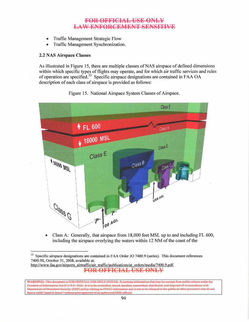
FOR OFFICIAL USE ONLY LAW ENFORCEMENT SENSITIVE
• Traffic Management Strategic Flow • Traffic Management Synchronization.
2.2 NAS Airspace Classes
As illustrated in Figure 15, there are multiple classes ofNAS airspace of defined dimensions within which specific types of flights may operate, and for which air traffic services and rules of operation are specified? 3 Specific airspace designations are contained in FAA OA description of each class of airspace is provided as follows:
I I I I
Figure 15. National Airspace System Classes of Airspace.
ctass E
,.o'-' tOO
crsssf
• Class A: Generally, that airspace from 18,000 feet MSL up to and including FL 600, including the airspace overlying the waters within 12 NM of the coast of the
23 Specific airspace designations are contained in FAA Order JO 7400.9 (series). This document references 7400.9S, October 31,2008, available at: . http://www.faa.gov/airports airtraffic/air traffic/publications/at orders/media/7400.9.pdf.
FOR OFFICIAL USE ONLY
~~~==~aEE:=:;:. I 94

FOR OFFICIAL USE ONLY LAW ENFORCEI\4ENT SENSITIVE
48 contiguous states and Alaska. Unless otherwise authorized, all persons must operate their aircraft under IFR. Class A airspace also includes specific offshore airspace areas that are designated in international airspace within areas of domestic radio navigational signal or A TC radar coverage and within which domestic ATC procedures are applied.
• Class B: Generally, that airspace from the surface to 10,000 feet MSL surrounding the Nation's busiest airports in terms of airport operations or passenger enplanements. The configuration of each Class B airspace area is individually tailored, consists of a surface area and two or more layers, and is designed to contain all published instrument procedures. An A TC clearance is required for all aircraft to operate in the area and all aircraft that are so cleared receive separation services within the airspace. The cloud clearance requirement for VFR operations is "clear of clouds."
• Class C: Generally, that airspace from the surface to 4,000 feet above the airport elevation (charted in MSL) surrounding those airports that have an operational control tower, are serviced by a radar approach control, and that have a certain number of IFR operations or passenger enplanements. Although the configuration of each Class C area is individually tailored, the airspace usually consists of a surface area with a 5-NM radius, an outer circle with a 10-NM radius that extends from no lower than 1,200 feet up to 4,000 feet above the airport elevation. Each person must establish two-way radio communications with the A TC facility providing air traffic services prior to entering the airspace and thereafter maintain those communications while within the airspace.
• Class D: Generally, that airspace from the surface to 2,500 feet above the airport elevation (charted in MSL) surrounding those airports that have an operational control tower. The configuration of each Class D airspace area is individually tailored and when instrument procedures are published, the airspace will normally be designed to contain the procedures. Arrival extensions for instrument approach procedures may be Class D or Class E airspace. Unless otherwise authorized, each person must establish two-way radio communications with the A TC facility providing air traffic services prior to entering the airspace and thereafter maintain those communications while in the airspace. No separation services are provided to VFR aircraft.
• Class E: Generally, if the airspace is not Class A, Class B, Class C, or Class D, and it is controlled airspace, it is Class E airspace. The types of Class E airspace areas are: o Surface Area Designated for an Airport
Extension to a Surface Area: There are Class E airspace areas that serve as extensions to Class B, Class C, Class D, and Class E surface areas designated for an airp01t. Such airspace provides controlled airspace to contain standard instrument approach procedures without imposing a communications requirement on pilots operating under VFR.
FOR OFFICIAL USE ONLY
ISE:--~=~.: I 95
FOR OFFICIAL USE ONLY LAW ENFORCEl\4ENT SENSITIVE
o Airspace Used for Transition. There are Class E airspace areas beginning at either 700 or 1,200 feet AGL used to transition to/from the terminal or en route environment.
o En Route Domestic Areas: There are Class E airspace areas that extend upward from a specified altitude and are en route domestic airspace areas that provide controlled airspace in those areas where there is a requirement to provide IFR en route ATC services, but the Federal airway system is inadequate.
o Federal Airways: The Federal airways are Class E airspace areas and, unless otherwise specified, extend upward from 1 ,200 feet to, but not including, 18,000 fe.et MSL. The colored airways are green, red, amber, and blue. The VOR airways are classified as Domestic, Alaskan, and Hawaiian.
o Unless designated at a lower altitude, Class E airspace begins at 14,500 feet MSL to, but not including, 18,000 feet MSL overlying: the 48 contiguous States including the waters within 12 miles from the coast of the 48 contiguous States; the District of Columbia; Alaska, including the waters within 12 miles from the coast of Alaska, and that airspace above FL 600; excluding the Alaska peninsula west of longitude 160 degrees west, and the airspace below l ,500 feet above the surface of the earth unless specifically so designated.
o Offshore/Control Airspace Areas: Offshore/Control Airspace Areas are locations designated in international airspace (between the United States 12-mile territorial limit and the CTA/FIR boundary, and within areas of domestic radio navigational signal or A TC radar coverage) wherein domestic A TC procedures may be used for separation purposes. These areas provide controlled airspace where there is a requirement to provide IFR en route A TC services, and to permit the application of domestic A TC procedures in that airspace. As noted above, Offshore/Control Airspace Areas may be Class A or Class E.
• Class G: Airspace that has not been designated as Class A, Class B, Class C, Class D, or Class E airspace.
ICAO defines an additional Class of airspace which is not currently used in the NAS:
• Class F. Operations may be conducted under IFR or VFR. A TS separation will be provided, so far as practical, to aircraft operating under IFR. Traffic information may be given, as far as is practical in respect to other flights.
In summary, Classes B, C, and D relate to airspace surrounding airports (terminal areas) where increased mid-air collision potential exists; Classes A, E, and G primarily relate to enroute flight and are defined in terms of altitude and the nature of flight operations that commonly occur at those altitudes. A TS provides separation services to all flights in Classes A and B, and participating flights in Class C. They provide it to some flights in Class E and do not provide service in Class G.
FOR OFFICIAL USE ONLY
[ §§i~§:=E;?E;S:?£: I 96
FOR OFFICIAL USE ONLY LAW ENFORCEl\4ENT SENSITIVE
2.3 Special Use Airspace (SUA)
SUA is airspace of defined dimensions wherein activities must be confined because of their nature, or wherein limitations may be imposed upon aircraft operations that are not a part of those activities. The types of SUA areas are:24
• Regulatory: o Prohibited Area o Restricted Area
• Nonregulatory: o Military Operations Area o Warning Area o Alert Area o Controlled Firing Area o National Security Area
2.3.1 Regulatory Special Use Airspace
• Restricted Area: A restricted area is airspace established under 14 CFR part 73 provisions, within which the flight of aircraft, while not wholly prohibited, is subject to restriction. Restricted areas are established when determined necessary to confine or segregate activities considered hazardous to nonparticipating aircraft. Aircraft may not operate within 3 NM of a restricted area unless authorized under the provisions of 14 CFR Part 73.13. Most restricted areas are designated joint use and IFRIVFR operations in the area may be authorized by the controlling ATS facility when it is not being utilized by the scheduling agency.
• Prohibited Area: A prohibited area is airspace established under 14 CFR part 73 provisions, within which no person may operate an aircraft without permission of the using agency. Prohibited areas are established when necessary to prohibit flight over an area on the surface in the interest of national security and welfare.
2.3.2 Nonregulatory Special Use Airspace
• Warning Area: A warning area is airspace of defined dimensions (extending from 3 NM outward from the coast of the United States), designated to contain activity that may be hazardous to nonparticipating aircraft. The purpose of a warning area is to warn nonparticipating pilots of the potential danger from activities being conducted. A warning area may be located over domestic waters, international waters, or both.
24 FAA Order JO 7400.2G, Procedures for Handling Airspace Matters, Part 5. Special Use Airspace. April 10, 2008.
FOR OFFICIAL USE ONLY
~~~==~~~ ~ 97
FO·R OFFICIAL USE ONLY LAW ENFORCEMENT SENSITIVE
• Military Operations Area (MOA): A MOA is airspace designated outside of Class A airspace to separate or segregate certain non-hazardous military activities from IFR traffic and to identify for VFR traffic where these activities are conducted. MOAs are designated to contain nonhazardous, military flight activities including, but not limited to, air combat maneuvers, air intercepts, low altitude tactics, etc.
• Alert Area: An alert area is airspace wherein a high volume of pilot training activities or an unusual type of aeronautical activity is conducted. Alert areas are designated to inform nonparticipating pilots of areas that contain a high volume of pilot training operations, or an unusual type of aeronautical activity, that they might not otherwise expect to encounter. Pilots are advised to be particularly alert when flying in these areas.
• Controlled Firing Area: A controlled firing area is airspace designated to contain activities that if not conducted in a controlled environment would be hazardous to nonparticipati ng aircraft. Controlled firing areas provide a means to accommodate, without impact to aviation, certain hazardous activities that can be immediately suspended if a nonparticipating aircraft approaches the area.
• National Security Area (NSA): An NSA consists of airspace of defined vertical and lateral dimensions established at locations where there is a requirement for increased security of ground facilities. Pilots are requested to voluntarily avoid flying through an NSA. When it is necessary to provide a greater level of security, flight in an NSA may be temporarily prohibited pursuant to the provisions of 14 CFR 99.7, Special Security Instructions. Where there is a need to restrict flight operations in an NSA, the required restriction will be issued by Airspace and Rules and disseminated via Notice to Airmen postings.
ICAO defines an additional type of SUA which is not currently used in the NAS:
• Danger Area: An airspace of defined dimensions within which activities dangerous to the flight of aircraft may exist at specified times. The term "Danger Area" is not used in reference to areas within the United States or any of its possessions or territories.
2.4 Other NAS Airspace
Other types of controlled or regulated airspace that are potentially applicable to BAMS operations include:
• Air Traffic Control Assigned Airspace (ATCAA): ATCAA is airspace of defined vertical/lateral limits, assigned by A TS, for the purpose of providing air traffic segregation between the specified activities being conducted within the assigned airspace, and other IFR air traffic.
FOR OFFICIAL USE ONLY
l-==i32E=o:a:. I 98
FOR OFFICIAL USE ONLY LAW ENFORCEl\4ENT SENSITIVE
• Temporarily Flight Restriction (TFR): A TFR is a type of Notice to Airmen and it defines an area restricted to air travel due to a hazardous condition, a special event or, a general warning for the entire FAA airspace. The text of the actual TFR contains the details of the restriction.
2.5 UAS Operations in the National Airspace System
UASs typically operate under a FAA COA. A COA is required because UASs are currently unable to substantially comply with 14 CFR Part 91.113's requirement to "see and avoid" other aircraft when conditions permit.
A COA is a detailed set of procedures that ensure the safety ofthe UAS and aircraft that are operating within the NAS. These aircraft may be operating VFR or IFR, and if VFR, may be participating in ATS or non-participating. In order to ensure safety, UAS operations are typically conducted in airspace sanctuaries where positive control or issued clearances are required; including Class D airspace, Restricted Areas and Class A airspace. This is the construct currently employed during operations along the U.S. southwest border conducted from Libby Army Airfield, Fort Huachuca, Arizona.
As UAS programs seek to develop and fie ld technologies that will substantially comply with 14 CFR Part 9 1.113 through materiel means, CBP wi ll continue to coordinate with the FAA new Concepts of Employment (CONEMPs) such as the below described procedures to ensure safety during an emergency return to an operating location when the prescribed airspace sanctuary is unavailable.
2.5.1 Near-Term
In the near term, emergency Return-to-Base (RTB) profiles will leverage ATC surveillance services, AMOC radar monitoring and visual observation to the maximum extent possible.
• The Pilot-in-C9mmand (PIC) shall command the UA to squawk 7700 and attempt to navigate the UA to the closest flight termination point location identified within the COA. If required to transit through multiple operating areas, the UA shall be flown to successive Flight Termination points in the event flight termination becomes required. These Flight Termination points are locations where the underlying terrain has been surveyed to permit the aircraft to ditch without hazard to persons or property.
• The UA shall avoid flight over populated or congested areas if possible. (Note: as with manned operations, the UA may not be able to proceed in a controlled fashion to a Flight Termination point).
FOR OFFICIAL USE ONLY
~-~~~ ~ 99
FOR OFFICIAL USE ONLY LAW ENFORCEMENT SENSITIVE
• Verbally declare an emergency to A TC and inform A TC of the following as soon as possible:
o Nature of In-flight Emergency (IFE) condition and intentional emergency squawk.
o Intended Flight Termination point or route of successive flight termination points (Specify Radio Aid to Navigation (NA V AID) and Radial/DME from NAVAID).
o Other Information as time/workload permits.
2.5.2 Radar Services
The UA shall remain IFR in Class A airspace as long as possible. The UA can expect priority handing following the declaration of an emergency. When the UA is approximately 50 NM from its intended landing site, it shall request an IFR en-route descent to continue receiving radar services.
Continued radar service to the Minimum Vectoring Altitude (MVA) overhead the intended landing site wiU increase safety of flight by ensuring radar separation with other IFR aircraft. Traffic advisories and safety alerts are provided to the UAS and participating aircraft from FL 180 to the minimum radar coverage altitude. Because 14 CFR Part 91.215 requires transponder usage above 10,000 feet MSL, there should be little risk of an undetected, non-participating aircraft from at least FL 180 to 10,000 feet MSL. In the event a non-squawking aircraft is operating in violation of 14 CFR Part 91.215 above 10,000 feet MSL, ARTCC and/or Radar Approach Control surveillance radars can detect primary radar targets and provide traffic advisories and safety alerts to the UAS.
2.5.3 Validation ofUA Performance Prior to Desce11t
Prior to the descent, the PIC will validate that the performance of the flight control and propulsion systems are sufficient to execute a safe descent and landing. If in the judgment of the PIC and the OAM operational chain of command, the UAS does not exhibit sufficient performance to safely descend and land, consideration will be given to ditching the aircraft at one of the COA specified Flight Termination points.
2.5.4 Use of UA EO/IR Sensors
During the entire profile, the Sensor Operator will be assigned to use the onboard EO/IR sensors to scan the flight path of the UAS to detect and report traffic to the PIC. Though 14 CFR Part 91.113 states that the UAS has right of way while experiencing an JFE, if on-board sensor detected traffic is a non-pa1ticipating aircraft that is not detected by
FOR OFFICIAL USE ONLY
~~~=~· I 100
FOR OFFICIAL USE ONLY LAW ENFORCEMENT SENSITIVE
ATC, the PIC will request permission from ATC to maneuver to avoid the traffic, or simply maneuver ifthere is insufficient time to coord inate such a request.
2.5.5 CBP AMOC
CBP will use the AMOC to partially mitigate the risk of descent out of Class A airspace to the surface. The AMOC monitors all UAS flights from the time the UA leaves SUA Restricted Airspace. This includes monitoring the flight segment that the UA is operating in, notifying the PIC of any observed targets and identify ing any potential deviations from the COA operating area boundaries. Specifically, the AMOC shall:
• Perform radar monitor all UA flights from takeoff until landing. Radar monitoring will be from a dedicated operating position and not combined with any other operating position
• Maintain constant communication with the UAS PIC. Primary means of communication will be via a dedicated telephone line
• Coordination with the respective ARTCC • Provide radar services to include but not be limited to:
o Radar contact/lost/terminated calls o Traffic advisories o Monitoring the UA within its operating area along the border o Identify any potential UA deviations from the border operating area.
• Request ARTCC to use USCG or other appropriate frequency to contact and advise military aircraft of a UAS lost link or other IFE that may cause the UAS to depart its COA defined airspace.
Maintain a track log on all UA flights, to be completed at the end of each flight. Track logs will indicate when the UA enters a particular route segment.
2.5.6 Use of Night Vision Devices
Once at the MY A and in the vicinity of the airfield, A TC will terminate IFR and the UAS will continue VFR. At this point, ground-based Visual Observers should have the ability to detect and visually monitor the UAS to landing. Unaided Visual Observers are currently authorized in COAs to monitor airspace around the landing site to 2.5 NM laterally and 3,000 feet vertically.
CBP will equip and train UAS Visual Observers with third-generation monocular Night Vision Devices (NVDs), and will conduct visual observation tests during UAS night flights to quantify PVS-14 NVD performance. NVD-Aided Visual Observers should increase the vertical and/or lateral limits to higher than the current unaided 2.5-NM
FOR OFFICIAL USE ONLY
IS~:5E~=5:. I 101
FOR OFFICIAL USE ONLY LAW ENFORCEMENT SENSITIVE
Jateral/3,000-feet vertical limits, and relieve the one-hour dark adaptation requirement. During the VFR portion of the flight, the Sensor Operator will continue to scan and report traffic and the PIC will maneuver to avoid traffic as required.
2.6 Mid-Term
In the mid-term, new capabilities that would incrementally increase safety are feasible, but require sponsorship, resourcing, interagency coordination, and procedural development.
To increase A TC surveillance coverage and situational awareness, potential landing sites should have Airport Surveillance Radar (ASR) data fed to TRACONs, ARTCCs, and the AMOC. ASRs provide both primary and secondary radar coverage, and typically operate 24/7. Providing ASR data to TRACONs and ARTCCs would provide increased primary and secondary alerts to air traffic over a larger volume of airspace than is currently available. This would improve safety for all airports in the region.
In addition to increased air traffic situational awareness, providing ASR feeds to the AMOC would augment the AMOC's ability to provide radar traffic advisories (if authorized by the FAA) to a UAS on an emergency RTB profile in areas where NAS A TC is not available.
2.7 Far-Term
For far-term CONEMPS, CBP continues to evaluate all possible options to enhance the safety of UAS operations. Increased A TC surveillance capabilities will continue to be the dominant factor in emergency RTB profiles in the foreseeable future, as on-board "sense and avoid" technologies are not sufficiently mature. Numerous USG and industry efforts are in progress to develop standards and technology to meet this unique UAS operational requirement.
3. International Airspace
By international law, a nation's sovereign airspace corresponds with the maritime definition of territorial waters as being 12 NM out from a nation's coastline. Airspace not within any country's territorial limit is considered international, analogous to the "high seas" in maritime law. Freedom of the high seas includes the right of aircraft of all nations to use the airspace over the high seas. In accordance with the United Nations Convention on the Law of the Sea, 1982, and other international agreements, this freedom must be exercised by all countries with reasonable regard for the interests of other nations.
FOR OFFICIAL USE ONLY
~~~=:;::, , 102
Ji'OR Oli'FICIAL US:E ONLY LAW :ENJi'ORC:EMI)NT SENSITIVE
There are different classifications of international airspace that potentially impact CBP UAS operations.25 The first type of airspace outside ofthe 12 NM sovereign limit is known as an Offshore Airspace Area (OAA). OAAs typically overlap portions of Warning Areas. These areas are international airspace, but through international agreement have been designated for the application of domestic A TC services of a nearby nation. In an OAA assigned to and controlled by the United States, the FAA applies domestic A TS rules and procedures (i.e., 14 CFR) out to radio navigation signal and/or A TS radar coverage limits?6 One example of this is the northern Gulf of Mexico, which has been assigned to the Houston ARTCC. One benefit of an adjacent nation controlling an OAA is that it allows that sovereign nation better management of ADIZ operations. Farther offshore, international airspace is divided into CT A/FIRs. The CT A/FIR boundary is important as it defines the line between where domestic (i.e., 14 CFR) flight procedures end and where ICAO flight procedures begin.
3.1 Convention on International Civil Aviation of 1944
The Convention on International Civil Aviation of 1944 (hereafter referred to as the Chicago Convention) was formed to promote the safe and orderly development of international civil aviation, specifically following the turmo il of World War II. The Chicago Convention was signed on December 7, 1944, by 52 States. Pending ratification of the Convention by 26 other nations, the Provisional International Civil Aviation Organization (PICAO) was established. It functioned until the 26th ratification was received, and the International Civil Aviation Organization (ICAO) came into being in April 1947. In October of that same year, ICAO became a specialized agency of the United Nations.
The Chicago Convention produced International Standards and Recommended Practices (SARPs) aimed at standardizing international civil aviation operational practices and services. Currently, these SARP's are contained in 18 Annexes to the Chicago Convention. Annex 2 (Rules of the Air) and Annex 11 (ATS) are pertinent to CBP manned and UA operations as they relate to aircraft operations, the establishment of airspace and A TS in international airspace.
3.2 Due Regard
As a signatory to the Chicago Convention of 1944, when flight in international airspace is not being conducted under ICAO flight procedures, the USG still has obligations relating to aircraft (including UASs) and abides by the following Articles:27
[From Article 3]: The contracting States undertake, when issuing regulations for their
25 FAA Document, Air Trq!Jic Bulletin Issue 00-1 WINTER 1999- 2000, Warning Areas and Offshore Airspace. 26 These procedures are contained in FAAO 7110.65, Chapter 8, Oceanic/Offshore Procedures. 27 ICAO document, Convention on International Civil Aviation, Ninth Edition, 2006.
FOR OFFICIAL US:E ONLY
l§§eE-ES~==:. I 103
FOR OFFICIAL U8E ONLY LA\\7 ENFORCEMENT 8ENSITIVE
State aircraft, that they will have due regard for the safety of navigation of civil aircraft.
[From Article 8]: Pilot-less aircraft- Each contracting State undertakes to ensure that the flight of such aircraft without a pilot in regions open to civil aircraft shall be so controlled as to obviate danger to civil aircraft.
Article 3 exempts State (includes public) aircraft from the provisions ofiCAO SARPs Annex 11 previous mentioned, but does require that flight operations not conducted under ICAO flight procedures be conducted under the "due regard" provision.
In accordance with the CBP AOH, CBP aircraft will be operated as public aircraft in accordance with accepted Parts of the Federal Aviation Regulations (FAR) and, as appropriate, with provisions established by DOD. When operating outside the United States, ICAO rules will be observed anytime they are more restrictive than the F ARs.28
OAM policy is to operate under U.S. Federal Regulations and the ICAO rules, as applicable. However, there are several operational situations that are potentially incompatible with ICAO flight procedures. Operations not conducted under the ICAO flight procedures in international airspace are conducted under the "due regard" or "operational" prerogative of State aircraft. Such operations will comply with one or more of the following OAM conditions:29
• The aircraft shall be operated in Visual Meteorological Conditions • The aircraft shall be operated within radar surveillance and radio communications of
a surface or airborne radar facility • The aircraft shall be equipped with airborne radar that is sufficient to provide
separation between itself, the aircraft it may be controlling and other aircraft o Note: The APG-63 and APG-66 radar are not sufficient for these requirements
• The aircraft shall be operated outside controlled airspace
Flight(s) under the "due regard" option obligates the PIC to be his or her own A TC agency, and to separate his or her aircraft from all other air traffic. Operations conducted in sovereign airspace must follow the procedures negotiated with the particular country.
The above conditions provide for a level of safety equivalent to that normally given by ICAO A TC agencies, and fulfill USG obligations under Article 3, which stipulates that there must be "due regard for the safety of navigation of civil aircraft" when flight is not being
28 CBP Air and Marine Aviations Operations Handbook, Chapter 3, Section 3. 1.1. 29 CBP Air and Marine Aviations Operations Handbook, Chapter 5, Section 5.7.
FOR OFFICIAL U8E ONLY
IS~~~~=;:. I
104
FOR OFFICIAL USE ONLY LAW ENFORCEMENT SENSITIVE
conducted under ICAO flight procedures. Flight under the "due regard" or "operational" option obligates the aircraft commander (i.e., the UA pilot) to be their own ATC agency, and to separate their aircraft from all other air traffic. UAS operations however, are conducted under the control of domestic or foreign A TC that provides continuous ground based radar coverage of the UA and its associated control at the GCS ..
Flights under "due regard" are considered deviations from normally accepted operating procedures and practices. "Due regard" operations are routine with USCG and U.S. Navy aviation capable ships, and will be very common with CBP UAS operations in the maritime domain. Given UAS technological advances that could provide an appropriate level of safety, UAS pilots should consider the following before flying "due regard."30
1. The due regard option can only be flown over international waters. The aircraft must be over water and 12 NM or greater from the shores of another nation.
2. UASs operating "due regard" at altitudes between FL290- FL41 0 in airspace where Reduced Vertical Separation Minimum is applied are flying at altitudes which are now used for air traffic. There is no longer a guarantee of I ,000 feet separation from other aircraft on these air traffic routes. Maintaining 500 feet separation (i.e., "well clear") is insufficient to prevent civil traffic from receiving a TCAS Traffic Advisory and Resolution Advisory. The protected volume of airspace, which surrounds each TCAS equipped aircraft, is based on the speed and relative heading of the aircraft involved. Flying at 500 feet above or below normal flight levels will trigger a TCAS Traffic Advisory and/or Resolution Advisory if the protected volume of airspace is entered.
3. An increasing amount of the world's airspace is controlled and is getting denser every year. Additionally, the daily relocation of oceanic tracks, user preferred and random routings, as well as dynamic re-routings will make it very difficult for UAS pilots/operators to know where high-density areas are, much less p lan a route that will avoid them.
4. To fu lfill the "surface radar facil ity" requirement, DOD operates a series of Fleet Area Control and Surveillance Facilities (FACSFACs) which provide radar separation services to aircraft operating in coastal Warning Areas. In addition, airborne surveillance aircraft (e.g., Airborne Warning and Control System [A WACS], E-2) can fulfill the "airborne radar facility" requirement and can be utilized for separation services. When flying "due regard," TCAS could provide a contributing source of situational awareness for cooperative targets. The non-TCAS equipped UA essentially becomes the "non-cooperative" target.
30 Major Eric Cain, HQ/ AFFSA XOP, Due Regard, USAF Flying Safety Magazine, December, 2004.
FOR OFFICIAL USE ONLY
~~~==;=:Es:a:. I
105
FOR OFFICIAL U8E ONLY LA\\' ENFORCEl\4ENT 8EN8ITI'lE
5. Currently, no specific language is published for notifying a controlling agency that an aircraft is exercising the "due regard" option. UAS pilots must ensure that the affected controlling agency understands their intentions. Prior coordination can help limit potential communication problems. If possible, a brief comment should be included in the "Remarks" section of the flight plan. Oceanic controlling agencies have expressed a desire to have the point or fix from which the aircraft will proceed due regard annotated on the flight plan. If the intention is to return to the same point later in the flight and to pick up an IFR clearance, then file the flight plan similar to an enroute delay. If the intention is to proceed to a different point and pick up an IFR clearance, it may be best to file two separate flight plans.
6. While under "due regard," airspace structure, standards and recommended practices are still a critical factor in the expected tracks and activity for other targets. While TCAS can contribute to situational awareness, it is not a substitute for A TS for cooperative traffic.
The "due regard" prerogative is a potentially valuable tool to help CBP UAS pilots complete their missions, but due regard presents some unique technological and procedural challenges for UAS airspace integration. A thorough understanding of when and how to declare "due regard" will aid in mission accomplishment and enhance overall safety.
3.3 International Airspace Considerations
In summary, for UAS airspace integration operations in international, offshore airspace, it is essential to understand where domestic, 14 CFR, requirements and procedures apply, where ICAO requirements and procedures apply or when "due regard" requirements and procedures have been invoked. In all cases, CBP aircraft should follow the procedures outlined in the Aviation Operations Handbook.
Warning Areas exist over both domestic and international waters. The rules that apply (FAA or ICAO) to Warning Areas depend on whether the area lies within domestic or international airspace, inside or outside of an OAA. FAA 14 CFR flight rules always apply within Warning Area airspace located between three and 12 NM from the coast, and from 12 NM out within an FAA managed OAA, up to the CTA/FIR boundary. Within aCTA/FIR, ICAO procedures apply.
FOR OFFICIAL U8E ONLY
~~~~==.::. I 106
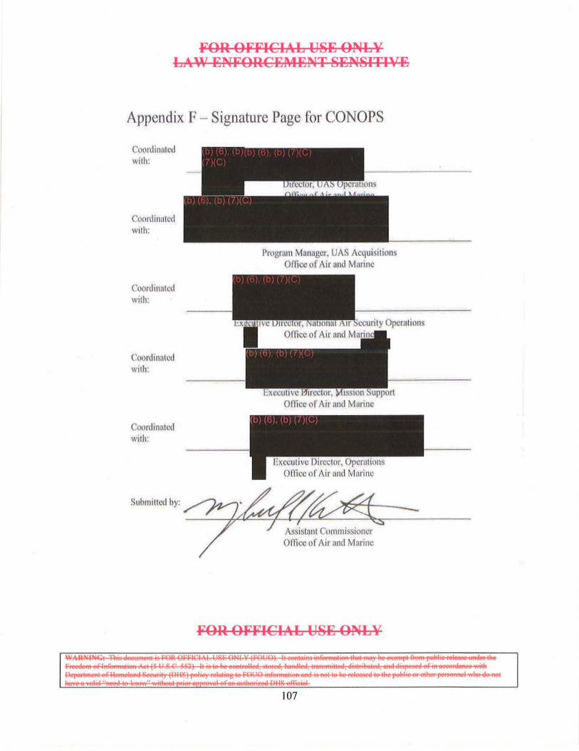
FOR OFFICIAL US~ ONLY LAW ENFORC~M~NT SENSITIV~
Appendix F- Signature Page for CONOPS
Coordinutcd with:
Coordinated with:
Coordinated With:
C'oordinntcd with:
Coordinated with:
Submitted by:
Progrnm Manager, UAS Acquisitions Ofticc of Air and Marine
FOR OFFICIAL USE ONLY
~~~~· I 107