Embed Size (px)
Citation preview
135
Mediterranean Experiences in Connectivity
Current situation and proposals for improving functionalityin the Guadiamar fluvial corridor
José Mª Arenas Cabello
Introduction
Over the last few years, Nature Conservation policies are becoming
increasingly based on the establishment of networks of protected areas, in which
an important role is played by the ecological corridors as elements of a system
that facilitates connection and contributes to the diminution of the effects of the
progressive fragmentation of the landscape and the natural areas. These networks
had already been devised, at an European level, back in the seventies, but such
devising was purely theoretical, since their development would not start until the
late nineties (Fernández, 1999). Among the different types of corridors, fluvial
corridors, linked to fluvial axes and to their flood plains, stand out due to their
importance. It thence follows that, among the main conservation strategies, the
establishment of ecological corridors based on the restoration of the fluvial
systems is becoming more important every day (Naiman et al., 1993; Naiman and
Roger, 1997; Montes, 1999).
In this context, in which ecological corridors are playing and increasingly
leading role, the spillage from the mines at Aznalcóllar, which happened in April
1998, brought about the putting into effect of a pioneering project consisting in
the creation of an ecological corridor in the hope that it could be used as a
standard for other basins in the region, and that it could contribute to the
transformation of the Andalusian Network of Natural Protected Areas (RENPA)
into a real functional system of interconnected natural areas (Montes, 1999). It is
true that the response from the regional government could have been limited to
the removal of the polluting elements and to try to bring the area back to the
situation existing prior to the spillage. But, as the sludge removal operation was
Environmental Connectivity: Protected Areas in the Mediterranean Basin, García Mora, M.R. (Coord.)© 2003, Junta de Andalucía. ISBN - 84-95785-33-1
136
Environmental Connectivity: Protected Areas in the Mediterranean Basin
coming to an end, and taking as a starting point the reports prepared by groups
of experts on the Regeneration of the Land Affected and on Environmental
Monitoring, in view of the fact that neither the health of the ecosystems nor
human health were in any way guaranteed, the acquisition by the government of
the land affected with a view to establishing a green corridor free from any
farming - related activity, was recommended as the most sensible solution
(Consejería de Medio Ambiente, 1999).
This decision will mean a magnificent opportunity for adopting a longer - term
restoration project, which consists in the Guadiamar Green Corridor Project. Such
a project takes again into consideration and old aspiration, which had been
demanded for a long time by the Andalusian ecological movement, namely to
transform the Guadiamar basin into an ecological corridor as a solution to the
serious problem posed by the isolation of Doñana. The process of fragmentation
that the ecosystems located North of Doñana are being subject to, which has
taken place over the last few decades, has not only spread in a North - South
direction, but also along the East - West axis (Serrano and Molina, 1998) and, in
conjunction with the creation of new artificial barriers, is jeopardizing the viability
of the dispersal routes of some of the most emblematic species of this protected
area (Delibes, 1999).
The following lines basically state the criteria which have been used as the
basis for the design and the functionality of the Guadiamar green corridor; they
expound how the recolonization processes affecting fauna communities are being
developed, by taking as a starting point the results provided by the different
research groups related to the project; finally, a series of measures or lines of
action are suggested which are deemed to be necessary to increase or improve
the operativeness of the corridor.
The process of landscape fragmentation in the Guadiamar basin
Among the actions approved by the Council of Government in order to
counteract the effects of the spillage from the mine, the setting on foot was
envisaged of a research programme aimed at facing the complex situation
brought about by the spillage, and at providing an answer to the knowledge
needs at an ecological, territorial and social and economic level for the
development of the project of the Green Corridor (Consejería de Medio Ambiente,
137
Mediterranean Experiences in Connectivity
1999). This was how a highly ambitious programme of multidisciplinary research
took shape, the Green Corridor Research Programme (PICOVER), which is one of
the main distinguishing marks of this project, and which has made it possible for
the Guadiamar basin, in spite of its small dimensions, to become one of the most
widely researched areas in our country (Consejería de Medio Ambiente, 2000).
Among the researches which are being carried out within the PICOVER
framework, related to the corridor’s functionality, we should draw attention to
those concerning the lines of action for the Design of the Ecological Corridor and
those aimed at Ecological Restoration. To have a better knowledge of the basin’s
connectivity, understanding by it the capability of organism dispersal (Taylor,
1993), and the process of landscape fragmentation which has led to the isolation
of the forestal ecosystems laying North of Doñana from those in Sierra Morena,
the studies deserve special mention which have been carried out within the
PICOVER on the recent evolution of the landscape linked to the changes in the
use of land in the Guadiamar basin since the American flight in 1956, until the
current situation (Jiménez, 2002), and on the structure and functionality of the
linear elements in the landscape (De Lucio, 2002).
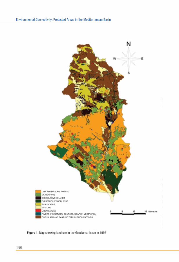
From the comparison between the maps showing the land use in the Guadiamar
basin during the nineteen - fifties, and those for the late nineties, very important
changes emerge in the structure of the landscape which reveal a progressive loss
of connectivity. In the image for 1956 (Figure 1) it can be clearly seen how the
breach between Sierra Morena and the forestal ecosystems laying North of the
Doñana marshland was already in existence, through the wide space taken by the
dry - farmed herbaceous crops in Campo de Tejada, and their extension through
the Gerena countryside. This breach will have been even further amplified during
the last decades due to a standardization process of the agricultural space in the
countryside, resulting in an absolute supremacy of herbaceous crops to the
detriment of other crops. This situation is fundamentally linked to a gradual
reduction of the area occupied by olive groves. Even though this crop intensifies in
the high ground’s most favourable areas, through the replacement of old olive
groves by early - harvest olive tree varieties and the establishment of new plantation
frameworks of a more geometrical shape, the introduction of irrigation, etc., there
is also a replacement of olive groves in countryside soil by yearly herbaceous crops,
which brings about the diminution of the wooded land. At the same time, the
presence of certain linear elements of natural vegetation which existed in 1956 and
which enabled certain connectivity - related functions (small riparian formations
138
Environmental Connectivity: Protected Areas in the Mediterranean Basin
Figure 1. Map showing land use in the Guadiamar basin in 1956
DRY HERBACEOUS FARMING
OLIVE GROVE
QUERCUS WOODLANDS
CONIFEROUS WOODLANDS
SCRUBLANDS
PASTURE
URBAN AREAS
RIVERS AND NATURAL COURSES. RIPARIAN VEGETATION
SCRUBLAND AND PASTURE WITH QUERCUS SPECIES
kilometers
139
Mediterranean Experiences in Connectivity
linked to some tributaries of the Guadiamar, such as the Ardachón, and small
thicket patches scattered throughout the countryside) completely disappears
converting this agricultural cerealic matrix into an increasingly poorer and more
homogeneous landscape from the biological point of view.
It is quite striking that in 1956 there was a connection link between the
Mediterranean forest formation in Sierra Morena and the forestal areas lying North
of Doñana through a series of meadow patches (thicket and ilex - covered grazing
land), which created an almost unbroken stretch on the right bank of the
Guadiamar, and North of its confluence with the Agrio river. It is very likely that
this connection strip consisting less of riparian forest, with a variable development
depending on the individual stretch, than of these Mediterranean forest
formations with interspersed meadows, should facilitate the connection between
both areas in a North - South direction.
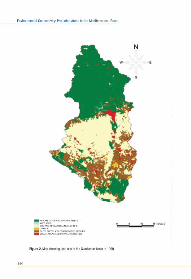
In the land - use maps drawn in the nineties (Figure 2) a large degree of
fragmentation of the meadow areas close to the Guadiamar can already be seen,
the said areas being reduced to just two unlinked patches. If that were not
enough, the connectivity function between these fragments is greatly diminished
as a result of new soil uses standing in the way and acting as true barriers, such
as the two second - home housing developments (Ranchos del Guadiamar and
Encinares de Sanlúcar) and the whole mining area South of Aznalcóllar which,
due to its dimensions and associated activities (the fencing of the mining
compound, infrastructures, excavations, huge dumps and heavy machinery
traffic), finally breaks the connection with the first forest formations in Sierra
Morena (Carcahuesos and Perro Dehesas).
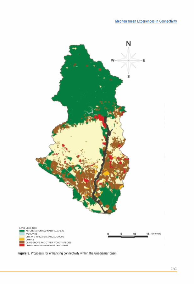
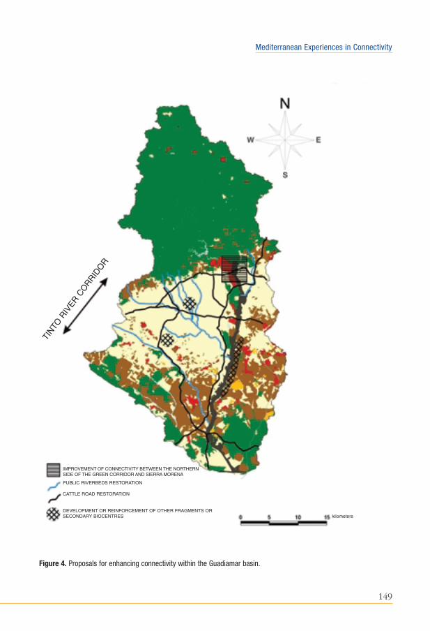
As can be perceived by looking at Figure 3, the creation of a fluvial corridor
through the Guadiamar succeeds in re - establishing this lost connectivity function
within the basin by means of the restoration of a more than 40 Km. - long stretch
and an area close to 5000 hectares, which coincides to a great extent with the
area affected by the spillage, whose width ranges between 700 and 1200 m.
depending on the individual stretch (Consejería de Medio Ambiente, 2001).
However, in order to succeed in making this corridor really effective, it is
necessary to overcome the enormous barrier represented by the large intensive
agricultural matrix laying in the central sector of the basin, where guaranteeing
good connectivity exclusively on the basis of a single linear axis is deemed to be
140
Environmental Connectivity: Protected Areas in the Mediterranean Basin
Figure 2. Map showing land use in the Guadiamar basin in 1999
kilometers
AFFORETATION AND NATURAL AREASWETLANDSDRY AND IRRIGATED ANNUAL CROPSCITRICSOLIVE GROVE AND OTHER WOODY SPECIESURBAN AREAS AND INFRAESTRUCTURES
141
Mediterranean Experiences in Connectivity
Figure 3. Proposals for enhancing connectivity within the Guadiamar basin
kilometersAFFORETATION AND NATURAL AREASWETLANDSDRY AND IRRIGATED ANNUAL CROPSCITRICSOLIVE GROVE AND OTHER WOODY SPECIESURBAN AREAS AND INFRAESTRUCTURES
LAND USES 1999
142
Environmental Connectivity: Protected Areas in the Mediterranean Basin
extremely difficult. Because of that, the corridor is envisioned as a weft of
relations not only in a vertical direction but also in an horizontal one, where, in
addition to the Guadiamar fluvial corridor as the main axis, connection through
other secondary corridors must be improved by means of the restoration of small
riparian copses, vegetal hedgerows, cattle routes and other linear elements
consisting in natural vegetation.
A natural laboratory for the study of recolonization processes
In addition to the importance attached to the criteria of functionality and
territorial connectivity in designing the Guadiamar Corridor, an aspect of the
utmost importance is the one related to the area recolonization processes. We
must always bear in mind that this project arises as a response by the Andalusian
Government aimed at dealing with the environmental catastrophe created by the
spillage from the Aznalcóllar mine. From this point of view, this restoration
project does not even stem from what could be conceived as a highly advanced
state of ecosystem degradation, but, rather, from a situation of extreme
degradation or collapse of all ecological functions in a sixty - two kilometre
stretch of the river, which amounts to the whole middle and lower courses of the
basin.
On top of the immediate effect of the flooding by sludge and acid waters,
which entailed the destruction of the habitats, we must add the perturbation
effects resulting from the works aiming at removing the sludge, the elimination of
crops, the introduction of correction measures and the harrowing of the soil, etc.,
which involved the use of a large set of mechanical resources, which lasted
almost uninterruptedly for the first year and a half. Accordingly, in a first stage,
the Guadiamar will have to work as what it currently is: a drain, a new
recolonization area, up to the moment when it comes back into operation as a
corridor.
These circumstances invest the project of the Guadiamar Green Corridor with
a special scientific interest as a natural laboratory for the study of processes for
the recolonization of the environment in areas which have been subject to
extreme changes in the conditions of the environment and the uses of land.
Besides, based on the scientific basis of the project, the idea has been conceived
that the restoration of the ecosystems must be achieved by means of natural
143
Mediterranean Experiences in Connectivity
recolonization processes, by encouraging it through the improvement of habitat
conditions and through the elimination of barriers and other disruption factors
which render such processes difficult. It is thought that as the environment
recovers the appropriate conditions, it shall make possible the gradual settlement
of the different faunistic communities (Arenas et al., 2002).
In order to facilitate this monitoring of the recolonization processes in a
coordinated manner by the different research groups, several common reference
areas were established in the PICOVER known as Monitoring Plots, which are
scattered throughout the damaged area. In addition to these plots, depending on
the specific needs of each group, samplings have been carried out in the possible
source areas located at the ends of the corridor (Sierra Morena, in the North) and
in forestal areas in Aznalcázar, Puebla, Villamanrique and Hinojos (Doñana
Natural Park), as well as in side areas which were unaffected by the spillage.
Nowadays, in spite of the short time gone by, quite remarkable recolonization
processes are already starting to become apparent, although widely varying from
one faunistic group to the next (Table 1). Such variations depend, in the main,
on three factors: on the different recovery rhythm of the habitats, on the dispersal
capability of the species and on their ecological requirements. As regards the
aquatic milieu, the important recolonization experienced by the river’s fish and
amphibian population, specially over the last year, deserves special mention as
well as the presence of stable populations of American crab in different spots in
the Guadiamar, particularly in the Entremuros sector. The recovery of these
groups, which perform an important function as the base of trophic chains, is
becoming a key factor for the preservation of mammals such as the otter, which
again has a presence in the whole of the river stretch which was affected by the
spillage, and the spread towards the North of bird communities characteristic of
wet lands, among which several species of storks, which are beginning to be
abundant, stand out: the common egret (Egretta garcetta) and the imperial heron
(Ardea cinerea), as well as rallidae such as the bald coot (Fulica atra), the
common wood - cock (Gallinula chloropus) and even the purple coot (Porphyrio
porphyrio), whose distribution is reaching quite northerly sectors of the river.

Table 1. Current situation of the corridor’s recolonization process
FAUNISTIC GROUPS DEGREE OF OCCUPATION PROBLEMS AND COLONIZATION GUIDELINES
FISH Medium - high Gradual colonization from the northern and southern ends. Highly sensitive populations topollution incidents
BIRDS Medium - high Expansion process towards the North occupying pools and gravel bars.Increase in the number of birds of preyusing the corridor as a hunting ground.
REPTILES AquaticMauremys leprosaNatrix maura High Abundant throughout the river
TerrestrialLacerta lepidaPsammodromus algirusMalpolon monspessulanus Incipient Decreasing from the rim sectors
towards the centre of the corridor.Increased presence in the areas adjoining mature ecosystems
MAMMALS GeneralVulpes vulpes Medium Increase in their numbers
AquaticLutra lutra Alto Presence everywhere in the river
except for the marshland.
Moderate MobilityHerpestes ichneumon Meles meles, Genetta genetta, Felis silvestris Low Present, above all, in the southern
half of the corridor.Probable tendency to increase
High Mobility Cervus elaphus,Sus scrofa. Without presence Their presence can only be expected
once the vegetation reaches an adequate size.
Source: prepared on the basis of data provided by the PICOVER Research Groups
144
Environmental Connectivity: Protected Areas in the Mediterranean Basin
145
Mediterranean Experiences in Connectivity
With regard to the group of reptiles, a difference can be appreciated, again, in
the speed of recolonization, it being much faster in the species linked to the
aquatic milieu such as the leper turtle (Mauremys leprosa) and the viperine adder
(Natrix maura), which have sizeable populations throughout the river. Terrestrial
reptiles are quite a different case, for they are one of the groups whose recovery
is being much slower. This is explained, among other things, by their more
reduced dispersal capability and by the negative and disturbing effect resulting
from the intensive work involved in eliminating the sludge and from the
operations carried out at a later stage to clear and repair the soil, together with
the scarcity of natural refuges, which has turned this area into a hardly
appropriate habitat for the settlement of reptiles. Among the first members of this
group to colonize the area, the following should be mentioned: the ocellated
lizard (Lacerta lepida), the long - tailed wall - lizard (Psammodromus algirus) and
the bastard snake (Malpolon monspessulanus).
As a rule, the samplings carried out with regard to reptiles show a diminution
in their number from rim sectors towards the river (with the exception of the well
- preserved riparian areas) and an increased presence in the areas adjoining the
corridor that have thicket and ilex forest ecosystems, which indicates that the
recolonization process is still incipient and that its intensity depends on how far
away the thicket and meadow areas, which operate as source areas, are. Taking
these results as a starting point, with the advice of the Bird and Reptile Research
Group from the University of Granada, the Technical Department is developing a
project for the installation of artificial refuges using eucalyptus stumps to foster
the settlement of the reptile population. These refuges are being installed above
all in those zones being close to the source areas; the monitoring of these refuges
has been planned for the immediate future so that their rate of occupancy can be
known.
With regard to mammals, following the research that Dr. Delibes’ team is
carrying out concerning the effects of the Guadiamar Corridor on populations of
medium - sized and large mammals (Delibes et al, 2002), the existence can be
presumed of four types of situations: the first would be the one embodied by
general species which do not depend on the existence of consolidated forestal
areas, which species would experience an increase in their numbers as a result
of the reduction of human activity within the Corridor. A clear representative of
this group would be the fox (Vulpes vulpes).
146
Environmental Connectivity: Protected Areas in the Mediterranean Basin
A special case would be that of the species linked to the aquatic milieu, such
as the otter (Lutra lutra), which has quickly recolonized the river after the
cleaning operations. In this case, it is deemed to be quite probable, since the
presence of this species has been verified throughout the course of the
Guadiamar, that the corridor be fully operational for this species ahead of others
which may depend, above all, on the restoration of wooded and thicketed areas
in the adjoining zones of the alluvial plain.
A third group would be made up of those species being capable of surviving
in mainly agricultural areas, provided that they have refuge zones near by, as the
fluvial copses or scattered thicket areas could well be. Species such as the badger
(Meles meles), the genet (Genetta genetta) or the mongoose (Herpestes
ichneumon), can be considered as examples of this group. All of them have a
presence, above all, in the southern half of the corridor and it is highly probable
that their distribution through it continues to expand as the riparian vegetation
and that of the reafforested margins develops. The wild cat (Felis silvestris), whose
presence is currently limited to the ends of the corridor, must be added to this
list.
A fourth group consists of large - sized species that require greater
extensions of forestal habitat and that possess high mobility. These species,
currently not existing in the corridor, are expected to use it as dispersal route
once the vegetation reaches a certain level of development and the corridor
becomes fully operational. These species include the wild boar (Sus scrofa),
the deer (Cervus elaphus) and, probably, with certain restrictions, the Iberian
lynx (Lynx pardina).
From the studies carried out so far, it is deducted that there is a greater
richness of mammals in the corridor from the southern source area (Aznalcázar
pine forests and Dehesas de Villamanrique) than from Sierra Morena, probably
due to the existence of a larger side - contact zone between these areas, and to
the existence of small forestal fragments, whereas in the northern end there is less
permeability as a result of the barrier represented by the mining area and the
presence of quite degraded areas (dumps, eucalyptus forests, ploughed up areas,
etc.).
147
Mediterranean Experiences in Connectivity
Action proposals for enhancing the corridor’s functionality and theGuadiamar basin connectivity
Taking into account the limited amount of time elapsed since the end of the
restoration works, which is why the degree of development of vegetation in the
corridor still remains at a very early stage, it would be necessary to continue to
monitor the faunistic populations for the coming years, as the new forestal
landscape which constitutes the corridor is being consolidated. The results of this
monitoring plan will be determining factors in the assessment of its operativeness
and the detection of possible disfunctions.
In parallel, and taking as a starting point the first results of the monitoring
carried out so far, it is deemed to be appropriate to boost measures aimed at
improving the corridor’s functionality, specially in the basin’s central agricultural
sector, the most troublesome of them all, by creating new lines of natural
vegetation from the publicly owned areas, cattle ways and boundaries between
farms, or by improving the existing ones to enhance the corridor’s lateral
connectivity.
Some of these measures have already been set in motion by the Technical
Office of the Guadiamar Green Corridor, such as the construction of artificial
refuges or the improvement of the northern end linkage. Others are part of some
of the lines of action that the Department of the Environment is currently
developing, such as the Plan for the Recovery of Cattle Ways and the Inventory
of River Banks, as a stage prior to the development of a Programme for the
creation of ecological fluvial corridors. In the case of the elimination of the
barriers represented by transversal road infrastructures, it will be necessary to
encourage cooperation measures with the proper bodies. The justification and
opportunity of these actions is explained below
Improvement of the link between the northern end of the green corridorand Sierra Morena
The monitoring of the populations of middle and small - sized mammals shows
that up to now a low level of transfer can be detected from the northern source
area, which is probably related to the scarce permeability of this contact strip of the
corridor. With a view to correcting this situation, forest restoration works are going
148
Environmental Connectivity: Protected Areas in the Mediterranean Basin
to be started to widen the said contact strip, improving the connection through the
Arroyo de los Frailes and replacing some masses of eucalyptus forest by means of
the reafforestation of indigenous vegetation in some of the non - exploited sections
of the mining area which have recently become public property, and which,
accordingly could be integrated into the corridor.
Restoration of banks as secondary fluvial corridors
The restoration and recovery of small river stretches would contribute to
substantially improve connectivity conditions in the central sector of the basin. In
keeping with this same line of action, the preferential river beds to help these
processes would be the headwaters of the Guadiamar itself, upstream of the place
where it joins the Agrio, and the two right - bank main tributaries: the Alcarayón
stream and, specially, the Ardanchón, due to its strategic lay - out which runs
across the whole of the basin’s central agricultural sector. Within the fluvial
corridor section, it is necessary to point out the important function that the river
Tinto can perform as a fluvial corridor by complementing the Guadiamar river, an
area currently included in the proposal by Red Natura 2000.
Rehabilitation of the cattle - route network
Through the Plan for the Rehabilitation of cattle routes, a classification has
been established of this large network by identifying those tracks and trails which
due to the route they follow could play the role of small ecological corridors, as
connection ways between the different natural areas. Nowadays, work is being
carried out in the demarcation and the rehabilitation of some of these cattle ways,
such as the Carrascal royal cattle track, which runs parallel to the Guadiamar from
the Vado del Quemado to Aznalcóllar.
Permeabilization of transversal barriers
There is no doubt in anybody’s mind that the future operativeness of the
Guadiamar corridor will depend to a great extent on a greater permeabilization
of the road infrastructures transversally cutting it, for the impact of these barriers
will become more obvious as the corridor starts to operate as dispersal way.
149
Mediterranean Experiences in Connectivity
Figure 4. Proposals for enhancing connectivity within the Guadiamar basin.
IMPROVEMENT OF CONNECTIVITY BETWEEN THE NORTHERN SIDE OF THE GREEN CORRIDOR AND SIERRA MORENA
PUBLIC RIVERBEDS RESTORATION
CATTLE ROAD RESTORATION
DEVELOPMENT OR REINFORCEMENT OF OTHER FRAGMENTS OR SECONDARY BIOCENTRES kilometers
TINTO
RIV
ER C
ORRID
OR
150
Environmental Connectivity: Protected Areas in the Mediterranean Basin
Among the road infrastructures being important barriers stand out, above all, the
A - 49 Motorway and the Seville - Huelva railway line, for they run on continuous
platforms or embankments. In the latter’s case, the project of the new railway
route may be a good opportunity to replace the old route by a more permeable
viaduct. The Permeabilization of these infrastructures must not be limited to the
sector intersecting the Guadiamar corridor but it must also make possible the
unbrokenness of other secondary corridors, such as the Pilas stream.
Establishment and strengthening of other secondary biocentres
Other strategy that could be suggested to enhance the basin’s connectivity
must consist in encouraging the establishment of secondary biocentres (island
forests within the agricultural area) as stopover points. To that end, advantage
must be taken of the presence of public heritage properties (ox pastures,
woodlands owned by the municipalities), areas intended for afforestation or
specially protected areas intended for urban planning. In this regard, the
existence must be highlighted of a special – protection, exempt from
development strip of land at the West Corner of the high ground, a precipitous
area covering more than 15 Km. in which shrub - like vegetation is predominant,
which, should it be rehabilitated, it would noticeably enhance the function of the
Guadiamar corridor in its left bank.
References
Arenas, J.M.; Montes, C. and Borja, F., 2002. La restauración de los ecosistemas enel Corredor Verde del Guadiamar. Medioambiente 40: 14-19.
Consejería de Medio Ambiente, 1999. Informes de los grupos de trabajo creadosal amparo del convenio suscrito entre la Consejería de Medio Ambiente y lasuniversidades andaluzas. In: Informes Científicos sobre el seguimiento delaccidente de Aznalcóllar. Consejería de Medio Ambiente. pp. 59-64.
Consejería de Medio Ambiente, 1999. La Estrategia del Corredor Verde delGuadiamar. Fundamentos de la Estrategia y Conclusiones del SeminarioInternacional sobre Corredores Ecológicos y Restauración de Ríos y Riberas.Secretaría General Técnica de la Consejería de Medio Ambiente. 63 p.
Consejería de Medio Ambiente, 2000. Programa de Investigación del CorredorVerde del Guadiamar. PICOVER 1999-2002. Secretaría General Técnica de laConsejería de Medio Ambiente. 192 p.
151
Mediterranean Experiences in Connectivity
Consejería de Medio Ambiente, 2001. Corredor Verde del Guadiamar. Abril 1998-Abril 2001. Consejería de Medio Ambiente. 70 p.
De Lucio, J.V.; Martínez, C. and Sastre, P., In press. Caracterización de la estructuray funcionalidad de los elementos lineales del paisaje en la cuenca del ríoGuadiamar. In: Resultados del Programa de Investigación del Corredor Verdedel Guadiamar. Consejería de Medio Ambiente.
Delibes, M., 1999. El papel de los corredores ecológicos en la conservación de laspoblaciones de mamíferos en la cuenca mediterránea. El caso del corredorfluvial del Guadiamar. In: Seminario Internacional sobre Corredores Ecológicosy Restauración de Ríos y Riberas. Programas y Resúmenes de Ponencias.Consejería de Medio Ambiente. pp.22.
Delibes, M., Rodríguez, A.; Rivilla, J.C.; and Alís, S., In press. Situaciónpreoperacional de las poblaciones de mamíferos medianos y grandes quepuedan ser afectados por el corredor del Guadiamar. In: Resultados delPrograma de Investigación del Corredor Verde del Guadiamar. Consejería deMedio Ambiente.
Fernández, E., 1999. La red ecológica paneuropea. Corredores ecológicos paraEuropa. In: Seminario Internacional sobre Corredores Ecológicos yRestauración de Ríos y Riberas. Programas y Resúmenes de Ponencias.Consejería de Medio Ambiente, pp. 24.
Jiménez, Y.; Paniza, A. and Gómez, J., In press. Análisis de los paisajes delGuadiamar y de su evolución reciente como base para el diagnóstico territorialde su cuenca. In: Resultados del Programa de Investigación del Corredor Verdedel Guadiamar. Consejería de Medio Ambiente.
Montes, C., 1999. Corredores ecológicos. El Corredor Verde del Guadiamar:conexión entre espacios naturales. Medioambiente 31: 48-53.
Ontiveros, D.; Fernández-Cardenete, J.R. and Pleguezuelos, J.M., In press.Caracterización, restauración y conservación de las comunidades animales dela cuenca del río Guadiamar: seguimiento del proceso de recolonización deaves y reptiles. In: Resultados del Programa de Investigación del CorredorVerde del Guadiamar. Consejería de Medio Ambiente.
Serrano, J. and Molina, F., 1998. El Corredor Verde del Guadiamar. La conexiónde la sierra con la marisma. Medioambiente, 29: 6-15.
Taylor, P.; Fahrig, L.; Henein, K. and Merriam, G., 1993. Connectivity is a vitalelement of landscape structure. Oikos, 68 3: 571-573.


![[XLS] · Web viewHEALTH & NRSG SCI DEANS PROPOSALS UHP AND UNDERGRAD RSCH PROPOSALS HRIM PROPOSALS HOUSING PROPOSALS HUMAN SERVICES STUDENT SERVICES PROPOSALS INDIV & FAMILY STUDIES](https://img.pdfslide.us/doc/110x75/5add30f87f8b9aeb668c8f45/xls-viewhealth-nrsg-sci-deans-proposals-uhp-and-undergrad-rsch-proposals-hrim.jpg)