Embed Size (px)
Citation preview
1
Cumulative Environmental Effects of Contemporary Forest Management
Activities in Headwater Basins of Western Oregon
The Hinkle Creek Paired Watershed Study Arne E. Skaugset Robert E. Gresswell Oregon State University USGS Dept. of Forest Engineering Forest and Rangeland Ecosystem Science Center 213 Peavy Hall 3200 SW Jefferson Way Corvallis, Oregon 97331 Corvallis, Oregon 97331 Judith Li Michael Adams Oregon State University USGS Department of Fisheries and Wildlife Forest and Rangeland Ecosystem Science Center 104 Nash Hall 3200 SW Jefferson Way Corvallis, Oregon 97331 Corvallis, Oregon 97331
Kermit Cromack Oregon State University Department of Forest Science 321 Richardson Hall Corvallis, Oregon 97331
5/25/2004 Draft Hinkle Proposal 2/34
2
Cumulative Environmental Effects of Contemporary Forest Management Activities in Headwater Basins of Western Oregon Project Summary
The majority of the timber harvest in the Pacific Northwest comes from the minority of the
forested land base that is owned by the private industrial forest sector. Society is more dependent than ever on the productivity and culture of these forest lands for a continued supply of solid wood. One potential obstacle to the continued flow of solid wood from these lands is concern regarding the anticipated environmental effects of the intensive management of these lands. The anticipated environmental effects result from a lack of knowledge regarding the actual environmental effects caused by contemporary forest management activities at a watershed scale.
The Hinkle Creek Paired Watershed Study was designed and initiated to fill that gap in
knowledge. The watersheds for the Hinkle Creek study are owned by Roseburg Forest Products (RFP) that actively manages the young, harvest-regenerated stands of Douglas-fir on them. At Hinkle Creek, the landowner, a group of researchers and private industrial, state, and federal forest land managers have collaborated to develop a state-of-the-art paired watershed study. The study includes a control watershed, the North Fork of Hinkle Creek, and a treatment watershed, the South Fork. The planned harvest schedule allows comparisons before and after harvest as well as between harvested and unharvested streams and for small and large streams with and without fish. The research in these watersheds will address:
• the effects of forest management on the physical, chemical, and biological characteristics
and habitat quality in small streams without fish, • the influence of changes in the physical, chemical, and biological characteristics and habitat
quality on amphibian and invertebrate abundance, distribution, and movement, in headwater streams with and without fish, and
• the role of movement in maintaining abundance and diversity of fish and amphibians as habitat quality changes throughout the stream network.
A tremendous amount of research on the environmental effects of forestry has been carried out
using paired watershed studies and a tremendous amount of knowledge has been garnered from that research. However, the congruence of recent technological innovations and the location of this study provide an excellent opportunity to substantially increase the understanding of the environmental consequences of the management of forested watersheds. The research approach will employ a new generation of sensors including passive integrated transponders (PIT tags) that allow daily and seasonal tracking of the movement of fish using stationary readers as well as mobile antenna. Detailed and continuous measurement of discharge, temperature, and sediment load at spatially explicit locations will put the movement of the fish into a physical context. Finally, recent innovations in GIS technologies allow the spatially dynamic interactions between the physical and biological phenomena to be described. These advances in technology combined with the willingness of the landowner to allow them to be used in a managed landscape will set a new standard for what we can learn and how we may be able to truly better understand the environmental effects of forest management at a watershed and landscape scale.

5/25/2004 Draft Hinkle Proposal 3/34
3
Cumulative Environmental Effects of Contemporary Forest Management Activities in Headwater Basins of Western Oregon Introduction The Hinkle Creek Paired Watershed Study is the initial installation of the Watersheds Research Cooperative (WRC). The research cooperative and the Hinkle Creek Project were initiated to fill a critical gap in our knowledge regarding the environmental effectiveness of contemporary forest practices on intensively managed forest land. Current knowledge on this subject comes primarily from studies of historic practices used in the initial harvest of naturally grown forests. The needed knowledge must come from contemporary, state-of-the-art practices carried out on harvest-regenerated, young forests on forest land that will be managed intensively, in perpetuity, for the production of wood products. To gather this knowledge, the WRC was chartered to carry out research evaluating the effects of current and expected intensive forest management practices on hydrology, water quality, aquatic habitat, fish, amphibians, and aquatic insects. The WRC is a broad collaborative partnership of private timber companies, state and federal agencies, and county governments. Leadership for the cooperative comes from the Oregon State University (OSU) Colleges of Forestry and Agriculture. The ultimate goal of the WRC is to install multiple paired watershed studies across the Pacific Northwest to investigate the cumulative effects of contemporary forest practices on intensively managed industrial forest land over space and time. The different paired watershed studies will use shared methods and data bases across multiple disciplines. The Hinkle Creek Paired Watershed Study is the initial proof-of-concept installation for the WRC. Hinkle Creek is located in the foothills of the Cascade Mountain about 50 km northeast of Roseburg, Oregon. The study watersheds are almost wholly owned and managed by Roseburg Forest Products; these watersheds support a harvest-regenerated stand of 55-year old Douglas-fir, and have an existing road system. Two harvest entries are planned for the South Fork of Hinkle Creek, the treatment watershed. The first entry, planned for 2005, will consist of four harvest units all located along perennial, non-fish-bearing streams. The second entry, planned for 2007, will consist of four harvest units all located along the main stem or tributary fish-bearing streams. The research project will investigate the effect of these harvest entries and subsequent intensive management activities on local and cumulative effects on hydrology, water quality, aquatic habitat, fish, amphibians, and aquatic insects. The Hinkle Creek Paired Watershed Study will extend until 2011. The objectives of the Hinkle Creek Paired Watershed Study are:
• to determine the effects of forest management on the physical, chemical, and biological characteristics and habitat quality in small streams without fish,
• to determine the influence of changes in the physical, chemical, and biological characteristics and habitat quality on amphibian and invertebrate abundance, distribution, and movement, in headwater streams with and without fish, and
• to determine the role of movement in maintaining abundance and diversity of fish and amphibians as habitat quality changes throughout the stream network.
5/25/2004 Draft Hinkle Proposal 4/34
4
The Statement of the Problem Private Industrial Forestry During the last 15 years the philosophies of forest land management for federal forest land have bifurcated strongly with those of state and private forest lands. In response to listings of populations and stocks of fish as threatened or endangered under the Endangered Species Act (ESA), managers of federal forest land have increasingly concentrated on restoration activities and management of forest ecosystems over the scale of landscapes (FEMAT 1993). In response to these changes in federal policy, the supply of timber from federal forest lands was reduced markedly and thus, society is now increasingly dependent on state and private forest lands to provide needed solid wood products (OFRI 2003). Currently, over 75 per cent of the annual harvest in Oregon comes from the 22 per cent of the commercial forest land base that is owned by the private industrial forest sector (ODF 2004, OFRI 2003). Further, inventories of unmanaged residual timber and/or unmanaged, harvested-regenerated forest stands are declining and private, industrial forest land owners are more dependent than ever on forest stands that they have planted and cultivated for a future resource supply (Adams et al 2002). To sustain current levels of harvest into future decades, private, industrial forest land will have to be intensively managed. This intensive management includes maintaining access to the proportion of commercial forest land that is available to be actively managed and maintaining access to the suite of intensive forest management tools that can be carried out on that land. Environmental Effects of Forestry The fact that forest management activities, especially timber harvest, can include negative effects is well documented (Meehan 1991, Salo and Cundy 1987). The effects of forest management on stream ecosystems include alteration of the hydrology, solar insolation and stream temperature, habitat complexity, delivery and accumulation of large wood, sediment yield, and channel morphology (Hall and Lantz 1969; Everest et al 1987; Gregory et al 1987; Bilby and Ward 1991; Chamberlin et al 1991; Johnson and Jones 2000). The scale and magnitude of the environmental effects are affected by the extent and intensity of the harvest, logging methods, geology, topography, watershed size, and the timing and magnitude of large, infrequent post-harvest storms (Murphy and Hall 1981; Swanson et al 1989; Hicks et al 1991). The response of fish populations to forestry-induced effects on aquatic ecosystems has been linked to declines in the diversity and abundance of fish in the Pacific Northwest (Bisson et al 1987, 1992; Nehlsen et al 1991; Sedell and Beschta 1991; Reeves et al 1993). The persistence of native fishes in the Pacific Northwest is uncertain and many evolutionary groups of anadromous salmonids are threatened with extirpation (Nehlsen et al 1991; Frissell 1993; Thurow et al 1997). Over half the native taxa in the Columbia River basin are listed under the Endangered Species Act, are being considered for listing, or are deemed sensitive (Lee et al 1997; Thurow et al 1997). Coastal cutthroat trout are not currently listed under the Endangered Species Act, but this native salmonid is managed as a sensitive species in Oregon and California (Hall et al 1997). The environmental effects of intensive forest management activities are believed to be factors that led directly to declines in salmonid populations and ultimately their
5/25/2004 Draft Hinkle Proposal 5/34
5
listing under the Endangered Species Act (Independent Multidisciplinary Science Team [IMST] 1999, National Research Council 1996). Forest Practice Rules Because forest management activities can cause environmental effects that are considered detrimental and they are linked to declines in populations of fish, government policies and forest practice regulations have been promulgated and, over time, altered that govern and regulate forest practices on commercial forest land. These policies and rules have many objectives, but one stated objective has always been to minimize, to the extent feasible and practicable, the adverse impacts of forest management activities on aquatic ecosystems and fish. The site specific forest practice rules are called BMPs (Best Management Practices) and serve as a tactical framework for forest management. A key element of BMPs throughout the Pacific Northwest has been and continues to be unharvested buffers along riparian corridors (Bilby and Wasserman 1989; Chamberlin et al 1991, Bisson et al 1992). The Northwest Forest Plan and the Forest Practice Rules of all western timber producing states mandate such buffer strips. In Oregon, the Forest Practices Rules that mandated buffer strips were promulgated in 1973 and the latest amendment to these rules was implemented in 1994. The Oregon Forest Practice Rules require fixed width riparian management areas that exclude management on most fish-bearing streams and other buffer areas along fish-bearing streams where management activities are strictly regulated (Beschta et al 1995). The listing of the many species and stocks of salmonids in the Pacific Northwest in the early 1990’s caused changes to occur in policies and regulations that govern forest management on federal, state, and private forest land. As mentioned previously, the listing of the salmonids, in conjunction with other listings, resulted in dramatic changes in the management philosophy for federal forest land. Federal forest land management is now structured around principles of ecosystem management across large spatial scales and increasingly concentrates on restoration activities (FEMAT 1993). State regulatory agencies and state and private forest land managers also responded to the listings of threatened and endangered salmonids. Some state forest land managers and owners of private forest land developed Habitat Conservation Plans (HCPs) while forestry regulatory agencies in the individual states in the Pacific Northwest reviewed and upgraded their forest practice regulations. The HCPs and the upgraded forest practice rules are all intended to outline forest practices that will restore and maintain populations of salmonids while simultaneously allowing for forest management to occur. A key provision of these HCPs and forest practice rules is the inclusion of buffer strips along non-fish-bearing streams (Washington Department of Natural Resources 2004, Pacific Lumber Company 1999). Since 1994 the state of Oregon has reevaluated the forest practice rules as a part of the Governor’s Salmon Plan. Two review documents have been produced; “Recovery of wild salmonids in western Oregon forests: Oregon forest practices act rules and the measures in the Oregon plan for salmon and watersheds” authored by the Independent Multidisciplinary Science Team (IMST 1999) and the final report of the Forest Practices Advisory Committee on salmon and watersheds (FPAC). Additional changes in the forest practice rules have been recommended to the Board of Forestry as a result of this process and these documents.

5/25/2004 Draft Hinkle Proposal 6/34
6
Small, Non-Fish-Bearing, Headwater Streams Changes in existing forest practice rules and the HCPs written to protect and restore listed salmonid species on state and private forest land have dedicated a lot of effort to appropriate levels of stream protection. Increasingly in discussions regarding forest practices and stream protection, the focus is on small, non-fish-bearing, headwater streams that are either perennial or intermittent. All forest practice rules and HCPs recognize the importance of fish-bearing streams. A stream classification system is included in all the rules packages and HCPs along with a matrix or list of the appropriate protection measures to assign to each classification of stream. However, in recent HCPs (Pacific Lumber Company 1999), rule revisions (Washington Department of Natural Resources 2004), and in the review of Oregon’s forest practice rules (IMST 1999, FPAC), increasing attention is paid to the identification and formal protection of small, non-fish-bearing perennial and intermittent streams. This attention is warranted because small, non-fish-bearing headwater streams can make up more than 70 per cent of the cumulative length of stream channels in forested, mountain watersheds (Benda et al 1992). As mentioned previously, these small, non-fish-bearing streams can be directly affected by forest management activities (Gomi et al 2002); however the value of these small channels and their riparian habitats has rarely been addressed by existing forest management policies and forest practice rules (Beschta and Platts 1986; May and Gresswell 2003). Even though fish are not present in these streams, they still transport the water, sediment, and wood that are responsible for high quality aquatic habitat from hillslopes downstream to the larger, fish-bearing streams (Naiman et al. 1992; May and Gresswell 2003). Further, perennial and intermittent non-fish-bearing streams provide habitat for amphibians and invertebrates. Invertebrates produced in non-fish-bearing headwater streams man be an important food for fish downstream. In reviewing the need for and levels of protection necessary for small, non-fish-bearing streams, a first step is to review the existing literature on the subject. This can be problematic for two reasons. First of all, a preponderance of the existing literature on the effects of forest practices on aquatic habitat and fish are either research on individual stream reaches quantifying the effect of forest practices adjacent to perennial, fish-bearing streams or, in the case of paired watershed studies, are investigations of whole watersheds that are perennial and fish-bearing. Thus, the spatial scale of the research installation is inappropriate. Also, especially in the case of paired watershed studies, the studies investigating forest practices, hydrology, water quality, and aquatic habitat involve are outdated forest management practices. These research shortcomings are especially relevant to the management of state and private timber lands. These forests are often the product of intensive forest management practices focused on the production of wood resources. Much of the information pertaining to the environmental effects of forest management activities in these areas is based on forest practices prior to 1990 (Macdonald et al 1988; Hicks et al 1991). Existing research on the effects of forest management practices on water quality, fish, and aquatic habitat was carried out during a time when forest management involved the initial harvest of naturally grown primary forests and the conversion of old growth or mature forest stands to younger age forests. Such forest management practices required the initial construction of a road system, then the use of very large, heavy

5/25/2004 Draft Hinkle Proposal 7/34
7
machinery to harvest and transport very large logs. Until the early 1970s, there were virtually no forest practice rules in effect. Current practices have changed since these older studies were conducted and published. Today, smaller machinery harvests smaller, uniform logs from middle-age forests, using an existing road system that has been upgraded or constructed to higher standards under the guidance of a comprehensive set of forest practice rules that include streamside protections. Cumulative Effects A key issue involving the current understanding of the impacts of contemporary forest management practices is their effect on aquatic ecosystems at the scale of a complete watershed (IMST 1999). While some forest practice rules are intended to influence management at the watershed scale, for example rules governing harvest unit size limits and adjacency constraints, most forest practice rules, or BMPs, involve site- or stand-specific practices. The environmental impacts of these site-specific practices have been studied extensively at the scale of an individual site, stand or stream reach. However, the integrated environmental response of these chronic disturbances in space and time on a watershed scale are poorly understood. The subject of multiple environmental responses to forest management activities at multiple spatial scales falls under the definition of cumulative effects (see Reid 1993). A definition for cumulative effects is (CEQ Guidelines, 40 CFR 1508.7);
“. . . the impact on the environment which results from the incremental impact of the action when added to other past, present, and reasonably foreseeable future actions. . . Cumulative impacts can result from individually minor but collectively significant actions . . .”
This definition fits the problems encountered when investigating the environmental effects of contemporary forest practices on state and private forest land that is managed intensively. First of all, forest management activities are prescribed and applied on a site-specific or individual stand basis. Of course, in the current managed forest landscape, they are being applied to forest land that has experienced a previous impact from the initial harvest and in the reasonably foreseeable future should experience future impacts. The current BMPs that are the forest practice rules are intended to minimize on-site impacts to the extent practicable but, at the present time when carried out correctly, these impacts are considered to be individually minor. Thus, in the framework of small, non-fish-bearing, headwater streams, the paradigm is that when harvesting occurs adjacent to several of these streams the individual impacts may be minor but when they accumulate downstream at a fish-bearing stream they could become significant. This scenario obviously involves multiple spatial and temporal scales, but also involves multiple response variables. For example, a key response variable in the fish-bearing stream is the fish, which are not present upstream and on-site in the non-fish-bearing stream. Multiple response variables must be defined and investigated over multiple spatial and temporal scales to adequately investigate the cumulative effects of contemporary forest practices in a contemporary managed forest landscape.
5/25/2004 Draft Hinkle Proposal 8/34
8
Thus, the answers to many questions regarding the ecological effects of disturbance, be it natural or forest management related, are scale dependent (White and Picket 1985; Frissell et al 1986; Hicks et al 1991). An integrated, multi-scale approach will be necessary to correctly interpret spatially extensive phenomena (Poff and Allen 1995; Caselle and Warner 1996; Wiley et al 1997). For example, the spatial and temporal patterns of inputs of large wood to streams are important because they influence channel morphology, the storage and routing of water and sediment, and provide complex habitat for many aquatic organisms (May and Gresswell 2003). Or, in some cases the scale chosen for study may be inappropriate for the life history of the organism chosen for study. For example, many studies have focused on the relationship between physical habitat and anadromous salmonids (Nickelson et al 1992; Reeves et al 1995); however, strong inferences are difficult to develop because anadromous fish spend part of their life in the ocean where they are affected by an array of environmental variables that are not accounted for, which include commercial harvest (Hicks et al 1991). Freshwater fishes, i.e. sculpins and potamodromous coastal cutthroat trout, live in freshwater for their entire lives. Thus, they are likely to be more tightly linked to changes in terrestrial habitats than anadromous fishes, but much less effort has been expended to describe these linkages. The relationship between land management and aquatic habitat may be especially relevant for the coastal cutthroat trout because land management activities are among the factors that may have contributed to their decline (Williams and Nehlsen 1997). Uncertainties concerning the effects of forest management activities on aquatic ecosystems are linked to the methods used in evaluations (Hall and Knight 1981; Hicks et al 1991). Hicks et al (1991) suggested three approaches for improving this type of evaluation: (1) extensive studies that use space-for-time substitutions with numerous watersheds over a short period, (2) intensive long-term studies before and after logging, and (3) design innovations to improve data collection or inferences resulting from the data. In their elemental form, both the intensive and extensive approaches have shortcomings that have been well documented (Osenberg and Schmitt 1996), and both study designs are strongly affected by the spatial scale of observation in an individual watershed (Hicks et al 1991; Thrush et al 1996). For example, comparison of paired sites close together on the same stream channel may be adequate for assessing local disturbances, but this design is not appropriate for watershed-scale disturbances. For larger, watershed-scale assessments, a basin-wide survey design (Hankin and Reeves 1988) may be more appropriate (Hicks et al 1991). Further, movement may affect the results of any study that is focused on population abundance as the primary response variable (Gowan et al 1996), even when samples occur throughout the basin. Despite the call for innovative designs, however, there are no published examples of studies that have examined the abundance, distribution, and movement of stream salmonids in relation to forest management.

5/25/2004 Draft Hinkle Proposal 9/34
9
Objectives and Research Questions The overarching objective of this research project is to expand the understanding of physical and biological processes in streams that are subjected to chronic disturbances in the form of intensive forest management activities. This will be accomplished by studying the environmental effects of contemporary forest practices applied to a privately owned and intensively managed forested watershed in western Oregon. Interpreting the effects of forest management activities on aquatic habitat, and ultimately aquatic organisms, is difficult due to the complexity of the relationships between the physical, chemical, and biological characteristics of the terrestrial, riparian, and aquatic systems, especially at the scale of complete watersheds (White and Picket 1985; Frissell et al 1986; May 1994). Due to these complexities, an integrated research project is required that will extend across the landscape at several spatial scales and will continue for an extended period of time. To accomplish the overall objective of this project requires that several specific research tasks be undertaken. These specific tasks include understanding the site-specific response of multiple variables to forest management activities along small, non-fish-bearing streams as well as large, main stem, fish-bearing streams. The processes responsible for transporting or propagating these responses to other locations in the watershed also need to be understood. Finally, how these multiple responses to on-site activities coalesce in space and time and ultimately affect downstream variables, most importantly fish, needs to be understood. The specific objectives are: 1. To determine the on-site effects of contemporary forest management practices carried out
adjacent to small, non-fish-bearing, headwater streams on water quality, aquatic habitat and aquatic biota.
2. To determine the on-site effects of contemporary forest management practices carried out
adjacent to large, fish-bearing, main stem streams on water quality, aquatic habitat and aquatic biota.
3. To determine the cumulative off-site effects of contemporary forest management practices
carried out adjacent to four small, non-fish-bearing, headwater streams on water quality, aquatic habitat, aquatic biota, and fish downstream in a large, fish-bearing, main stem stream.
4. To identify the processes that propagate environmental affects downstream from non-fish-
bearing headwater streams to fish-bearing main stem streams and to quantify the relative magnitude of these processes.
To accomplish these objectives many critical questions pertaining to the chronic disturbance regime imposed by contemporary forest practices need to be answered. A fundamental question is how forest management activities in small, non-fish-bearing, headwaters streams affect fish behavior and assemblages throughout a stream network. Changes in water quality, habitat quality, or food supply should affect fish in a dynamic way and these spatially and temporally variable elements will be incorporated into the research plan by addressing the following research questions:

5/25/2004 Draft Hinkle Proposal 10/34
10
• How do forest practices affect changes in physical and biological characteristics of small tributary streams without fish?
• How do the changes in physical and biological characteristics of tributaries without
fish influence the quality of aquatic habitat in other parts of the stream network?
• Do forest practices adjacent to non-fish-bearing streams change food availability in fish bearing streams and if so how does that affect the behavior or growth of aquatic organisms in those streams?
• How do seasonal hydrologic changes in non-fish-bearing streams affect the
distributions of aquatic organisms in fish-bearing streams because of food supply of food or habitat quality?
• Does the abundance or diversity of aquatic organisms decline in response to changed
habitat quality, or do organisms relocate to areas where habitat quality remains high? Research Plan The experimental design for this project is a nested, paired watershed study. Paired watershed studies are a proven and robust experimental technique that has long been used to investigate the environmental effects of land use. Paired watershed studies are an integral part of our understanding on the environmental effects of forest management activities, especially timber harvest. The history of the use of paired watershed studies to evaluate the effect of forestry on water yield, streamflow, and water quality goes back almost a century and is long and varied. Paired watershed studies have also been used to investigate the effects of forestry on fish and aquatic habitat but the history and literature is less robust. The Alsea Watershed Study is a landmark paired watershed study that integrated research on the effects of forestry on hydrology and water quality as well as aquatic habitat and fish (Hall and Lantz 1969, Moring and Lantz 1975, Moring 1975). Carnation Creek on Vancouver Island in British Columbia was not a paired watershed study, but it was a watershed-scale investigation of the effects of forest practices on hydrology, water quality, aquatic habitat, and fish (Hartman 1982; Chamberlin 1988). The research site The study watersheds are the North and South Forks of Hinkle Creek, which are the headwater watersheds for the Hinkle Creek basin. Hinkle Creek is a tributary to Calapooya Creek, which drains into the Umqua River near Oakland, Oregon downstream of the confluence of the North and South Forks of the Umqua River. Hinkle Creek is located in the foothills of the Cascade Mountains approximately 50 km east of Sutherlin Oregon (Figure 1). The watershed is almost wholly owned and managed by Roseburg Forest Products (RFP) who plans to intensively manage the watershed for the production of solid wood products.
5/25/2004 Draft Hinkle Proposal 11/34
11
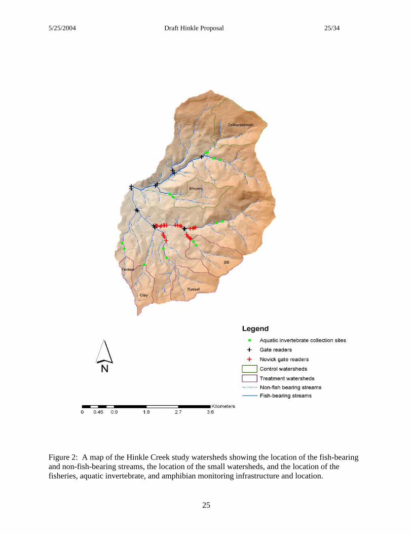
The geology of the watersheds is basalt from the Siletz volcanics formation. The soils are Typic Palehumults or Typic Haplohumults that are deep and well drained and have loamy textures ranging from extremely gravelly loams to silty clay loams. The forest is predominately Douglas-fir with some western hemlock. The understory is composed of swordfern, rhododendron, vine maple, salal, Oregongrape, and red huckleberry. Mean annual precipitation ranges from 1,400 mm at the mouth of the watershed up to 1,900 mm at the higher elevation. Hinkle Creek was chosen as the site of this study for a number of reasons. 1) First and foremost, because the landowner allowed it to take place on their land and even encouraged the project to occur. 2) The watershed is representative of the type of commercial forest land that will be managed intensively by the timber industry into the foreseeable future. The forest consists of a harvest-regenerated stand of small, uniformed size trees, primarily Douglas-fir, and the watershed has an existing road system in place. 3) Active manipulation of the forest stand will take place. Roseburg Forest Products has a harvest plan prepared for the watershed that spans the life of the project and the harvesting will be carried out using accepted, contemporary, state-of-the-art harvesting methods. For the harvest plan and the timber harvesting, RFP will meet or exceed all current and expected forest practice rules. 4) The harvest units will be aggressively and intensively managed. RFP will treat competing vegetation in the harvested areas using herbicides applied, primarily, by air and will reforest the harvested areas by hand-planting high quality growing stock. If the project lasts long enough, stand density will, undoubtedly, be managed by precommercial thinning. Finally, 5) There is considerable and growing physical infrastructure in place and a critical mass of data has been collected. The physical infrastructure includes: fish traps on the North and South Forks at the confluence, discharge measurement by the USGS at the North and South Forks at the confluence, approximately 1,000 coastal cutthroat trout have been tagged with PIT (passive integrated transponder) tags, 13 permanent antenna to monitor the movement of the tagged fish, six Montana flumes to measure discharge at small, non-fish-bearing, headwater streams, eight TTS (turbidity threshold system) stations to measure suspended sediment, 27 temperature sensors, two raingages, and a micrometeorological tower. Three summers of stream temperature data, three summers of fish abundance data, two years of fish movement data, and one winter of discharge and suspended sediment data have been collected to date. Thus, Hinkle Creek is a place that is representative of private, industrial forest land that will be intensively managed in the coming decade. The combination of a growing physical infrastructure, the guarantee of active manipulation, and the willingness of the landowner to participate have combined to make Hinkle Creek an excellent place to install this type of research project. Research Approach The experimental design for Hinkle Creek project is a nested, paired watershed study and the paired watershed component of the project will be installed at two spatial scales. The North and South Forks of Hinkle Creek are the study watersheds at the large spatial scale. They are fourth-order watersheds that have areas of 873 and 1,060 hectares, respectively. The North Fork is the control watershed and the South Fork is the treatment watershed. Six small, headwater

5/25/2004 Draft Hinkle Proposal 12/34
12
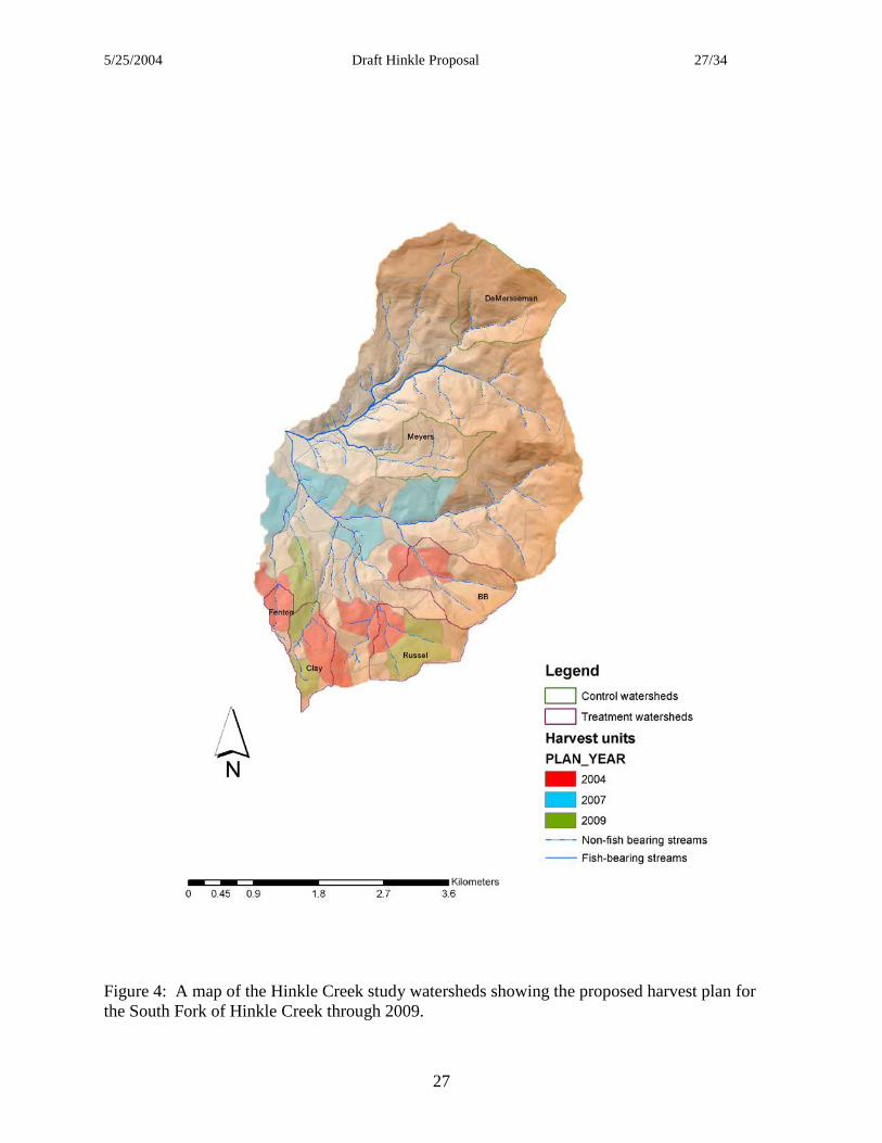
watersheds were selected as the study watersheds at the small spatial scale. The streams at the mouths of these small study watersheds are all perennial, non-fish-bearing streams. The watersheds range in size from 35 to 147 hectares and include a large first-order watershed, four second-order watersheds, and a small third-order watershed. Four of these watersheds, the four in the South Fork of Hinkle Creek, will be treated and the remaining two watersheds in the North Fork will be control watersheds. In addition to multiple spatial scales, the project is an integrated study that will investigate multiple, response variables. Two response variables are being measured at only the scale of the fourth-order watersheds and they are anadromous salmonids and coastal cutthroat trout. While winter steelhead are the anadromous salmonid with the highest likelihood of making it to the study watersheds, none of these fish have been observed in the North or South Forks of Hinkle Creek to date. Coastal cutthroat trout are present in the main stems of the North and South Fork and up most of the major tributaries. The extent of fish is shown on the map in Figure 2. The most common amphibian in Hinkle Creek is the Pacific giant salamander. They are found throughout the drainage from the confluence of the North and South Forks up into the headwaters well beyond the end of fish. Pacific giant salamanders can be a predator to invertebrates and fish and may also be prey to both groups (Parker 1993, 1994). They use aquatic and terrestrial habitats that multiply the potential impacts of timber harvest. Thus, other than fish, all the response variables will be measured throughout both watersheds at all spatial scales. In addition to the salamanders, these response variables include aquatic invertebrates, discharge, suspended sediment, stream temperature, and water chemistry. As additional watersheds are included in the WRC, other stream amphibians will be included. In the Hinkle Creek Paired Watershed Study, the treatments will be the application of contemporary intensive forest management activities. These activities include timber harvest and the subsequent activities needed to culture the next crop, which include reforestation, site preparation, and control of competing vegetation. Control of stand density through precommercial thinning may be included if the project lasts long enough but that activity is not foreseen during the planned life of the project at this time. Two entries to harvest timber are planned for the South Fork of Hinkle Creek during the life of the project, one entry is planned for the summer of 2005 and the second entry is planned for the summer of 2007. There are four harvest units planned for the first entry and they are all located upstream of the fish/no fish barriers. Thus, harvest in the initial entry will take place adjacent to small, non-fish-bearing, headwater streams only. Four harvest units are also planned for the 2007 entry and all four of these harvest units will be located adjacent to fish-bearing streams either the main stem or the tributaries. The size and location of the harvest units are the result of RFP’s regular harvest planning process. Constraints on the harvest units and their location are a part of the forest practice rules and include size limitations, buffer restrictions between harvest units, and green up constraints. Consideration was given to applying artificial restrictions to reduce the variability in treatment sizes or effects on streams, but these considerations were eventually discarded. Thus, the measured response will be a response to the true application of contemporary forest practice rules, which includes some rudimentary considerations for planning at a watershed or landscape scale. A map showing the two harvest entries is shown in Figure 4.

5/25/2004 Draft Hinkle Proposal 13/34
13
Discharge, suspended sediment, stream chemistry, and temperature data will be collected at the flume locations at each of the small, non-fish-bearing study watersheds and at the North and South Forks of Hinkle Creek at the confluence. Stream temperature will also be collected at numerous locations throughout both watersheds (see map, Figure 3). A number of response variables that will include, but are not limited to, storm peak flows, storm volumes, storm sediment yield, and maximum stream temperature will be calculated from the raw data. Calibration relationships between control and treatment watersheds will be developed for the time period before treatment begins. Calibration relationships will be standard linear models where the value of response variables in the treatment watersheds will be predicted as a function of values in the control watersheds. After treatment, a treatment affect will be determined by comparing the value of actual response variables with the value of predicted response variables using the calibration equations and values of the response variables from the control watersheds. Those response variables that include streamflow, sediment yield, and stream temperature, will be dependent variables for the analysis of the effects of forestry on physical parameters however, they will become independent variable for the analysis of the effects of forestry on the aquatic biota. Downstream propagation of stream temperature will be evaluated using energy and water budgets. Downstream propagation of sediment effects will be evaluated using a sediment budget. The cumulative effects of forest management activities on aquatic biota will be evaluated using a systems approach that combines watershed-scale and in-stream physical and biological variables, with the distribution and abundance of fish and aquatic invertebrates. Within-basin variation in physiography, climate, and land management will be assessed by examining the entire stream system at multiple levels in a spatial hierarchy (e.g. network, stream, segment, reach, and channel unit). The distribution, movement, and growth of coastal cutthroat trout (Oncorhynchus clarki clarki) and anadromous steelhead (Oncorhynchus mykiss) will be measured through mark-recapture and tracking studies. These two fish species have very different life histories and habitat requirements and may be affected in different ways by forest management (e.g., coastal cutthroat trout in Hinkle Creek may be nonmigratory, potamodromous, anadromous, or amphidromous, but all steelhead are anadromous). The abundance and movements of instream aquatic biota will be estimated using varied approaches. Fish and amphibian abundance in both watersheds will be estimated by electrofishing both basins annually. Changes in distribution of fish will be evaluated by monitoring fish implanted with passive integrated transponder (PIT) tags at stationary sites and mobile tracking units (Figure 2). Instream invertebrates will be sampled by capturing instream, emerging, and terrestrial invertebrates (litter inputs) that are indicators of riparian and aquatic habitat quality and are critical components of the diet of fish. The importance of aquatic and terrestrial invertebrates and amphibians to the diet of fish prior to timber harvest will be compared in headwater streams, where there are no fish, and downstream sites with only coastal cutthroat trout. The cumulative importance of these dynamics will be assessed before and after timber harvest. Estimates of the abundance of fish and amphibians, by age class, and physical characteristics of aquatic habitat will be used to characterize habitat condition. To detect changes in fish and

5/25/2004 Draft Hinkle Proposal 14/34
14
amphibian distribution associated with forest management activities in the watershed, relationships between fish and amphibians and their habitat will be examined at the spatial scales of geomorphic reach, stream segment, and watershed. The distribution and movement patterns of fish and amphibians (e.g., timing, direction, and distance) at fine spatial scales will be compared with substrate composition, water temperature, food availability, and geomorphic structure at the scale of stream reaches. PIT tag technology will be used to examine seasonal and annual changes in fish/habitat relationships at multiple spatial scales. Pacific giant salamanders tend to be more site philopatric so their movements will not be examined directly but rather reach-specific abundance and condition will be the focus using the electroshocking data. Continued sampling of fish, amphibians, and aquatic invertebrates provides the opportunity to incorporate natural variation in the project analysis. Beginning with the fish census during the summers of 2001 and 2002, the terrestrial and aquatic habitat conditions for coastal cutthroat trout demographics can be evaluated for four years prior to timber harvest and four years following harvest. Post-harvest analysis of amphibians, aquatic macroinvertebrates and steelhead will also encompass a 4-year period, but pre-harvest sampling will be limited to 3 years for macroinvertebrates (beginning in 2002) and 2 years for steelhead and amphibians. Analyses of aquatic biota data will be conducted hierarchically at three spatial scales. Initial analysis will be conducted at the watershed scale with the goal of identifying the spatial scale within each study watershed (North Fork and South Fork subbasins) that provides the most information about the distribution of aquatic biota prior to timber harvest. Baseline information on pretreatment habitat conditions and spatial patterns of aquatic biota will provide a basis for comparison as the study progresses. Preliminary data analysis will focus on univariate data, but ultimately the focus will be on multivariate relationships among fish species, amphibians, invertebrates and habitat variables at habitat-unit, reach, and segment scales (McCune and Grace 2002). A variety of parametric and nonparametric methods will be used to differentiate among habitat classes within hierarchical groups. Relative fish abundance and physical characteristics of instream habitat will be used to determine the usefulness of these relationships to evaluate differences in habitat preference between harvested and unharvested portions of the Hinkle Creek watershed. Relationships between fish, amphibians, invertebrates and habitat will be extended to stream segment and watershed scales in an effort to relate fish habitat to management activities. Logistic regression and nonparametric techniques will be used in an effort to define aquatic biota and habitat relationships at the various spatial scales (Hosmer and Lemeshow 1989; Trexler and Travis 1993). Multivariate, repeated-measures analysis of variance will be used to test for differences in response variables among watersheds and over time. The second level of analysis will explore watersheds in individual watershed classes (as defined in the initial stream classification). Principal components analysis (PCA) will identify watershed-scale characteristics most useful to discriminate factors that affect fish distribution (e.g., physical watershed characteristics, instream habitat characteristics, invertebrate distribution and influences of land management). Correlation matrices of physical variables will be used to reduce effects of scaling and unequal variances among variables. After preliminary analysis, variables that display low component loadings will be eliminated, and the remaining variables will be reanalyzed using varimax rotation (Tabachnick and Fidell 1989). This analytical

5/25/2004 Draft Hinkle Proposal 15/34
15
procedure will be repeated for variables that can be used to describe fish populations (e.g., age structure, growth, and abundance). Relationships between watershed variables and fauna distribution and abundance will be investigated further with ecological response surface analysis (Bartlein et al 1986). Predictor variables will be selected from the set of watershed variables that displays the highest component loadings for each of the first three components of the PCA (Gresswell et al 1997). Specific predictor variables will be chosen on the basis of relative component loading, ease of measurement, and accuracy and precision of variable measurement. A third level of analysis will differentiate patterns of fish, amphibians, and invertebrate abundance in treatment and control watersheds. Stream segment, stream reach, and channel-unit classes will be analyzed as discrete entities and ANOVA will be used to identify statistical differences in fish or invertebrate distribution and abundance that may exist among strata and between the two study watersheds in preliminary comparisons. Subsequent comparisons will apply repeated measures ANOVA to identify statistically significant temporal trends in fish abundance (Ramsey and Schafer 1997). Geographic analysis of fish movement and spatial patterns in fish distribution will focus on the identification of geomorphically distinct peaks in fish distribution (Angermeier et al 2002). Spatial overlays of fish distribution and stream habitat data on three-dimensional maps generated from digital elevation models will facilitate analysis of patterns of fish abundance and channel morphology in a landscape context. Channel gradient profiles will be developed for comparison with field measurements at the channel-unit scale. Landscape metrics (e.g., valley form, aspect, slope, and upslope disturbance potential) and channel gradient profiles will be used as spatially explicit explanatory variables in statistical models of habitat relationships for fish and amphibians. Spatial explicit maps of geology, soils, forest stand characteristics, road density, and landslide potential will be entered into the GIS and will be used to investigate the relationship between management activities and fish distribution. Additional analysis of spatial heterogeneity and the dominant scales of variation in fish and amphibian distribution will be conducted with geostatistics to identify how timber harvest may affect the spatial structure, or “patchiness”, of fish distribution in the stream network (Rossi et al 1992). Sampling methods
Hydrology – To quantify the effects of timber harvest and subsequent silvicultural activities on the hydrology of the managed watersheds, streamflow will be measured on six, headwater streams and two 4th-order streams. Streamflow at the confluence of the North and South forks of Hinkle Creek, the two 4th-order streams, is measured by the United States Geological Survey (USGS). The USGS has installed instrumentation that measures and records stream water level or ‘stage’ at the mouth of both streams. Values of stage are recorded using data-loggers that are housed on-site in instrument shelters and they are also broadcast to the USGS offices in Medford where they are displayed in real time on the USGS website (http://or.waterdata.usgs.gov/nwis). The USGS is also responsible for creating and maintaining the stage/discharge rating curve for the stream gauging stations. Throughout the year at a variety and range of streamflows, the discharge in the North and South Forks of Hinkle Creek is physically measured and these values are correlated with the value of stage at the time the discharge measurement was taken. In this manner, values of stage can be converted to discharge. This conversion also occurs in real time
5/25/2004 Draft Hinkle Proposal 16/34
16
and the current discharge at both streams is shown on the web page along with the value of stage. The USGS is responsible for collecting and maintaining the water level data base as well as creating and maintaining an appropriate stage vs. discharge rating curve. The raw data for stage, the stage/discharge rating curves, the data used to create the curves, and the discharge data are all available from the USGS. Streamflow is measured at the six, small, headwater streams using Montana flumes. Montana flumes are the upstream half of Parshall flumes and are used in situations when flooding of the outlet of the flume is not likely to occur. Flumes are valuable in this type of work because they readily pass sediment and organic debris so regular maintenance of the structure is not needed and they are pre-calibrated structures. Because they are pre-calibrated structures there is no need to develop stage/discharge rating curves and once stage in the structure is known, discharge can be calculated using a pre-determined relationship. Water level is measured in the Montana flumes using a pressure transducer and the water level data is stored in a data logger located on-site in an instrument shelter. Streamflow is also measured at nine locations along the main stem of both forks. Water level is measured and recorded using capacitance rods equipped with data loggers. The capacitance rods are installed in conjunction with the main PIT tag antennas or ‘gate readers’ in the fish-bearing main stems of the streams. Individual stage/discharge rating curves have been developed for each capacitance rod/gate reader location. The location of the capacitance rods is shown in Figure 3. Precipitation, solar radiation, air temperature, relative humidity, and wind speed are measured and recorded at micrometeorological tower located at the approximate geographic centroid of the watersheds. Precipitation intensity is also measured at a rain gauge near the Roseburg Forest Products (RFP) boundary (not shown on map). Water Quality – One of the primary water quality parameters of concern is suspended sediment discharge. Suspended sediment is measured using the Turbidity Threshold System (TTS) developed by the Redwood Sciences Laboratory of the Pacific Southwest Forest and Range Experiment Station (USFS Redwood Sciences Lab 2004). Suspended sediment is being measured at the six Montana flumes on the small, headwater watersheds and at the mouths of the North and South Forks of Hinkle Creek. It is measured by first measuring and recording a continuous record of turbidity using a turbidimeter that is suspended into the middle of the stream using a boom. Values of turbidity are stored in the data logger in the instrument shed. An intake to an ISCO water sampler is also connected to the boom and suspended in the stream. Water samples are taken by the ISCO and stored for later analysis of suspended sediment concentration. Water samples are taken at a time determined by a software program in the data logger that uses threshold values of discharge and turbidity to determine when to trigger the ISCO to take a water sample. There is also a probabilistic component to the timing of water sample collection thus the water samples are collected randomly. Suspended sediment concentration is correlated with the in-stream turbidity value when the water sample was collected to establish a suspended sediment/turbidity relationship. With this relationship, the continuous record of turbidity can be used to generate a continuous record of suspended sediment concentration. Suspended sediment/turbidity relationships are established on a storm

5/25/2004 Draft Hinkle Proposal 17/34
17
by storm basis to minimize the variability in the relationship and optimize its validity. Water samples are taken during every storm and suspended sediment/turbidity relationships are constantly updated. Stream temperature – A continuous record of stream temperature is collected at a minimum of 27 locations currently. The temperature is measured using commercially available thermistors with data loggers. Currently, VEMCO’s are being used but other brands are available and the technology is constantly being upgraded, thus almost certainly other brands will be used before the end of the project. The thermistors are located in the streams in the spring, most often during May, and retrieved in the fall during late September and October. The sampling frequency is set for 45 minutes. The thermistors are visited regularly during the summer to insure they are functioning and they are accurate. The locations of the thermistors are shown in Figure 3. Stream Chemistry –Water samples will be collected monthly at the eight locations where stream discharge is measured, which includes the six headwater streams and the main stems at the confluence of the North and South Forks of Hinkle Creek. Grab samples will be obtained using the protocol described by the Environmental Protection Agency for water sampling. Other sampling locations may be added as the results from the different streams become available. The location of the sample collection will be the same every time and correspond to the gauging stations in the streams. The samples will be collected in a one liter nalgene bottle that is acid washed, allowed to dry, and capped. The sample bottle will be rinsed three times with stream water before the sample is collected. Samples will be placed in a cooler with ice for transportation to Corvallis. Four samples will be taken per site. The samples will be iced and placed in coolers and transported immediately to the Cooperative Chemical Analytical Laboratory at Oregon State University for analysis. They will be stored in the dark at 4˚C. Analysis will include total nitrogen (N) and phosphorus (P), base cations (Ca, K, Mg, Na), dissolved inorganic carbon (DIC), dissolved organic N (DIN), and pH. Soil Nutrients –Soil samples will be collected in riparian zones and upslope areas corresponding with the various watersheds. Soil cores will be collected at sites selected using stratified random sampling. Representative soil pits will be dug for soil descriptions and parent materials. Samples will be placed in plastic bags and sealed. The sealed bags of soil will be transported to Corvallis and bulk density, porosity, moisture content, and hydraulic conductivity will be determined. The samples will then be sent to the Central Analytical Chemical Laboratory at Oregon State University in the Crop and Soils Department for determination of soil carbon (C), nitrogen (N), phosphorus (P), sulfer (S), base cations (Ca, Mg, K, Na), and cation exchange capacity (CEC). The availability of N and P will also be measured. Instream Habitat Evaluation - Hinkle Creek will be classified hierarchically into segments, geomorphic reaches, and channel units (e.g., pools and riffles). Stream segments will be defined as portions of a stream system that flow through a single bedrock type and are bound by tributary junctions or major waterfalls (Frissell et al. 1986). Prior to the initial survey of a basin, major stream segments will be identified in existing databases, topographic and geologic maps, aerial photographs, and by field reconnaissance. These stream segments will be used as the initial stratification for sampling. Stream gradient will be measured in the field (channel-unit scale)

5/25/2004 Draft Hinkle Proposal 18/34
18
with a clinometer and it will also be measured in a geographical information system (GIS) using 10-m digital elevation models (DEM). Channel slope, bedrock geology, valley sideslope, floodplain morphology, soil type, and vegetation will be determined for each stream segment and for the watershed. Geomorphic reaches in each segment will be classified in the field using procedures developed by Montgomery and Buffington (1997). For each stream reach, the criteria of Bisson et al (1982) will be used to delineate pools, riffles, and cascades. Extensive inventories of instream habitat will be conducted in the fish-bearing portions of the North and South Forks of Hinkle Creek during summer low flow when fish movement is limited and carrying capacity is limited by stream temperature and flow. Physical habitat variables, including the length, maximum depth, and wetted width of channels, dominant and subdominant substrate, channel type, valley segment type, and woody debris loading will be estimated or measured for all sampled habitat units. Visual estimates of the length and width of channel units will be corrected for observer bias with a subset of verified field measurements. An acoustic hypsometer and a global positioning system (GPS) will be used to increase the spatial accuracy of stream habitat surveys. To evaluate year to year variation in the quality and composition of aquatic habitat quality, the study streams will be surveyed annually for four years before and four years following timber harvest. These data in conjunction with discharge, sediment, and temperature data will provide the template for potential changes in abundance or distribution of aquatic biota prior to timber and after harvest has occurred. Aquatic biota distribution and movement - The distribution and abundance of salmonids and Pacific giant salamanders will be estimated each year during August and September with single-pass electrofishing throughout the North and South Forks of Hinkle Creek. Electroshocking at fine spatial resolution will be conducted in 12 km of both streams to examine patchiness in the distribution of fish and salamanders. Single-pass electrofishing without blocknets will be used because it minimizes the stress of multiple-pass removal methods (Jones and Stockwell 1995). Relative abundance of salmonids and salamanders will be assessed in all pools and cascades, and presence/absence will be recorded for lamprey, sculpin, tailed frogs, and crayfish. The condition of a subset of salamanders will be assessed based on length and mass. After collection, fish will be anesthetized in a solution of clove oil (Anderson et al 1997, Keene et al 1998). Salmonids will be identified to species, measured (fork length to ±1 mm), and weighed (± 0.1 g). Steelhead and cutthroat trout less than 80 mm will be unidentified trout. Scale samples will be collected from salmonids in each 10-mm length class between 80 and 200 mm for age and growth determination. Additional scales will be collected from 10 fish less than 80 mm and for 10 fish greater than 200 mm. Fish stomach contents be collected in sites where benthic invertebrates have been collected; 20 trout per site will be sampled. Using a lavage procedure, a fine stream of water will be squirted into the mouth of each fish and the contents of the stomach from each fish will be preserved in 75 per cent ethanol. The fish that die will be dissected, the otoliths will be colleted, and age will be determined from otoliths to compare with the age obtained from scale analysis.

5/25/2004 Draft Hinkle Proposal 19/34
19
PIT tags will be implanted in all coastal cutthroat trout and juvenile steelhead greater than100 mm fork length during the annual electrofishing surveys. Stationary (gate reader stations) and portable (mobile tracking units) remote tag-reading systems will monitor the movement of individual fish. A network of receiver antennas will be placed throughout the watershed (Figure 2) so that the movement of PIT-tagged fish can be monitored continuously. Mobile tracking units will be used to locate tagged individuals and obtain seasonal synoptic distribution data. Tagged fish that are recaptured during annual electrofishing surveys will be weighed and measured to assess growth rate and condition. Aquatic macroinvertebrates will be sampled annually at 12 reaches in the North Fork and the South Fork during summer low flow in the first and second years. Study reaches will be paired where fish are present and absent so that aquatic invertebrate diversity and abundance can be compared among sites (Figure 2). Samples will be taken in summer, fall, winter, and spring in subsequent years. Additional sites will be added to assess longitudinal distributions along two tributaries, particularly downstream of harvest units. Six benthic samples/reach/season will be taken with Surber samplers (500 micron mesh); sampling sites within each study reach will be positioned randomly (Li et al 2001). Availability of invertebrates for fish diet also requires sampling for other life stages and terrestrial sources of prey. Four emergent traps/study reach will be set for 1-2 weeks per season to collect emerging stream insects beginning in year three. Eight pan traps/study reach/season will be set for two 24-hr intervals to collect insects falling or flying into the stream. Leaf packs will be set out for 3-4 weeks to collect invertebrates attracted to decomposing leaves in the autumn. All invertebrates will be sieved, stored in 70 per cent ethanol, and identified under laboratory microscopes at OSU. The resolutions of identification will depend on the sampling source; benthic samples will be identified to genus level and organisms in the emergence samples will be identified to species where possible. Invertebrate input from litterfall will be identified to the family level. Geographic information system – Patterns of distribution and movement of fishes over the multiple-year study period will be monitored using a GIS that is able to georeference and co-register the different spatial and temporal data types: (1) extensive habitat and fish distribution surveys, (2) fixed-station PIT-tag reader detections of fish movement, and (3) mobile tracking relocations of fish with PIT tags. Before fish and habitat data were collected, colored survey markers were attached to trees at approximately 15-m intervals along the entire length of the fish-bearing portions of the study streams. These markers serve as spatial reference points and all three types of data are registered to them to insure that field observations of fish and aquatic habitat are spatially compatible throughout the study. A subset of the survey markers will be georeferenced using a mapping-grade Trimble GPS. These benchmark locations will be used in the GIS to associate field observations with locations on a map. Separate data tables describing habitat characteristics, fish distribution, fixed-antenna detections, and mobile tracking relocations will all be linked in a spatial database through a common linear routing system that relates any given field observation to a distance from a colored survey marker anywhere in the stream network.

5/25/2004 Draft Hinkle Proposal 20/34
20
Dynamic segmentation in Arc/Info GIS will be used to create maps of stream survey data in each watershed. Landmarks, such as bridge crossings, tributary junctions, and GPS coordinates collected in the field, will calibrate digital hydrography layers (USGS 1:24,000 topographic maps) to measurements of stream channel length (Jones et al 2001). Consecutively numbered habitat units and associated attributes, including habitat dimensions, wood, substrate, and fish numbers, will then be joined to the calibrated stream network in the GIS.
5/25/2004 Draft Hinkle Proposal 21/34
21
Timeline Past Activities The Hinkle Creek Paired Watershed Project was informally initiated in late summer, August, 2001. The gentleman’s agreement that we have with Roseburg Forest Products is that the project, in its current form, will last 10 years. This means that the life of the current project is, nominally, until August 2011. During the summer of 2001, stream temperature data was collected and a census of the fish was carried out in the study watersheds. In the spring of 2002, a $250,000 grant was awarded to the project by the Oregon Watershed Enhancement Board (OWEB), however it took over a year to get access to the funds. During the summer of 2002, stream temperature data was again collected and a census of the fish was again carried out, however this time PIT tags were implanted in approximately 600 fish. Fish traps were constructed at the confluence of the North and South Forks of Hinkle Creek. During the summer a research cooperative was chartered at OSU that gave the project an administrative home. The Watersheds Research Cooperative became reality in December 2002. In 2003, with access to the OWEB grant the balance of the research activities could be initiated. Accomplishments included:
• Permanent PIT tag readers or ‘gates’ were installed throughout the study watersheds, • Temperature data was collected, • USGS initiated stream gauging at the North and South Forks of Hinkle Creek, • A census of the fish was carried out and PIT tags were implanted in the ingrowth, • Kermit Cromack received a grant from the Fish & Wildlife Managed Forest Program at
OSU and started collecting stream chemistry data. • Montana flumes were ordered and installed in the six, small, headwater streams, • Turbidity Threshold System (TTS) hardware was ordered and installed at all eight stream
gauging stations, and went on-line by the onset of winter rains. Future Activities The first harvest entry is planned for summer 2005. Four units will be harvested all located above fish/no-fish barriers along perennial and intermittent non-fish-bearing streams. A second harvest entry is planned for 2007. Four units will again be harvested and this time they will all be adjacent to perennial, fish-bearing streams either the main stem of the South Fork Hinkle Creek or its main tributaries. There are units tentatively scheduled for harvest in 2009. The location of these units is interspersed with the 2005 harvest units in the headwaters above the flumes. No decisions or plans have been made regarding these harvest units or plans for the project at this time Funding for the stream chemistry project under the direction of Dr. Kermit Cromack is scheduled to run out in FY ’05. Plans are underway to get funding for a follow-up project on stream

5/25/2004 Draft Hinkle Proposal 22/34
22
chemistry that will continue Dr. Cromack’s data collection into the post-harvest years. Funding for the amphibian portion of this project lead by John Hayes and Michael Adams is scheduled to run out in FY ’09. All other programs are scheduled to continue until 2011. It is unlikely that the project will end abruptly in 2011. The end of the program will probably be extended in some manner. The manner of the extension will have to be negotiated and then the program curtailed in an orderly manner. Discussions regarding how this will take place have not commenced.

5/25/2004 Draft Hinkle Proposal 23/34
23
Budgets Budget projected for FY ‘05 Programmatic Budget Program Administration 140,000 Hydrology & Water Quality 228,500 Fisheries 276,000 Aquatic Invertebrates 59,000 Stream Chemistry 44,000 Amphibians 40,000 Total 787,500 Overhead (15%) 118,125 Grand Total 905,625 Categorical Budget Personnel Principal Investigators 50,000 Research Assistants 192,500 Field Technicians 159,000 Graduate Students 130,000 Clerical & Support 110,000 Laboratory Support 62,000 Total Personnel 703,500 Travel 41,000 Capital 29,000 Supplies & Services 14,000 Total 787,500 Overhead (15%) 118,125 Grand Total 905,625

5/25/2004 Draft Hinkle Proposal 24/34
24
Figure 1: A vicinity map of the Hinkle Creek study watersheds.
5/25/2004 Draft Hinkle Proposal 25/34
25
Figure 2: A map of the Hinkle Creek study watersheds showing the location of the fish-bearing and non-fish-bearing streams, the location of the small watersheds, and the location of the fisheries, aquatic invertebrate, and amphibian monitoring infrastructure and location.

5/25/2004 Draft Hinkle Proposal 26/34
26
Figure 3: A map of the Hinkle Creek study watersheds showing the location of the small watersheds and the location of the hydrologic infrastructure.
5/25/2004 Draft Hinkle Proposal 27/34
27
Figure 4: A map of the Hinkle Creek study watersheds showing the proposed harvest plan for the South Fork of Hinkle Creek through 2009.

5/25/2004 Draft Hinkle Proposal 28/34
28
Literature Cited
Adams, DM, R Schillinger, G Latta, and A Van Nalts. 2002. Timber Harvest Projections for Private Land in Western Oregon. Research Contribution 37, Forest Research Laboratory, Oregon State University, Corvallis. Anderson, WG, R Scott McKinley and Maria Colavecchia. 1997. The use of clove oil as an anesthetic for rainbow trout and its effects on swimming performance. North American Journal of Fisheries Management 17:301-307. Angermeier, PL, KL Krueger and CA Dolloff. 2002. Discontinuity in stream-fish distributions: Implications for assessing and predicting species occurrence. In: JM Scott, PJ Heglund, ML Morrison, JB Haufler, MG Raphael, WA Wall and FB Samson, editors. Predicting species occurrences: Issues of accuracy and scale. Island Press, Covelo, CA. pp 519-527. Bartlein, PJ, IC Prentice and T Webb III. 1986. Climatic response surfaces from pollen data for some eastern North American taxa. Journal of Biogeography 13:35-57. Benda, L, TJ Beechie, RC Wissmar and A Johnson. 1992. Morphology and evolution of salmonid habitats in a recently deglaciated river basin, Washington State, USA. Canadian Journal of Fisheries and Aquatic Sciences 79:1246-1256. Beschta, RL, JR Boyle, CC Chambers, WP Gibson, SV Gregory, J Grizzel, JC Hagar, JL Li, WC McComb, TW Parzybok, ML Reiter, GH Taylor, JE Warila. 1995. Cumulative effects of forest practices in Oregon: Literature and synthesis. Final Report to the Oregon Department of Forestry, Salem, Oregon. Beschta, RL and WS Platts. 1986. Morphological features of small streams: Significance and function. American Water Resources Bulletin 22: 369-379. Bilby, RE, and JW Ward. 1991. Characteristics and function of large woody debris in streams draining old-growth, clear-cut, and second-growth forests in southwestern Washington. Canadian Journal of Fisheries and Aquatic Sciences, 48:2499-2508. Bilby, RE and LJ Wasserman. 1989. Forest practices and riparian management in Washington state: data based regulation development. In: RE Gresswell, BA Barton and JL Kershner, editors. Practical approaches to riparian resource management. USDI Bureau of Land Management, Billings, Montana. pp 87-94. Bisson, PA, JL Nielsen, RA Palmason and LE Grove. 1982. A system of naming habitat types in small streams, with examples of habitat utilization by salmonids during low streamflow. In: NB Armantrout, editor. Acquisition and utilization of aquatic habitat inventory information. American Fisheries Society, Western Division, Bethesda, Maryland. pp 62-73. Bisson, PA, RE Bilby, MD Bryant, CA Dolloff, GB Greete, RA House, ML Murphy, KV Koski, and JR Sedell. 1987. Large woody debris in forested streams in the Pacific Northwest: past,

5/25/2004 Draft Hinkle Proposal 29/34
29
present, and future. In: EO Salo and TW Cundy, editors. Streamside management: forestry and fishery interactions. Institute of Forest Resources Contribution 57. University of Washington, College of Forest Resources, Seattle. pp 143-190. Bisson, PA, TP Quinn, GH Reeves and SV Gregory. 1992. Best management practices, cumulative effects, and long-term trends in fish abundance in Pacific Northwest river systems. In: RJ Naiman, editor. Watershed management: balancing sustainability and environmental change. Springer-Verlag, New York, NY. pp 189-232. Caselle, JE and RR Warner. 1996. Variability in recruitment of coral reef fishes: The importance of habitat at two spatial scales. Ecology 77(8):2488-2504. Chamberlin, TW (Ed). 1988. Proceedings of the Workshop: Applying 15 Years of Carnation Creek Results. Pacific Biological Station, Nanaimo, B.C., January 13-15, 1987. Chamberlin, TW, RD Harr, and FH Everest. 1991. Timber harvesting, silviculture, and watershed processes. In: WR Meehan, editor. Influences of forest and rangeland management on salmonid fishes and their habitats. Special Publication 19. American Fisheries Society, Bethesda, MD. pp 181-206. Everest, FH, RL Beschta, JC Scrivener, KV Koski, JR Sedell and CJ Cederholm. 1987. Fine sediment and salmonid production: A paradox. In; EO Salo and TW Cundy, editors. Stream side management: Forestry and fishery interactions. University of Washington, Institute of Forest Research, Contribution 57, Seattle, Washington. pp 98-142. FEMAT (Forest Ecosystem Management Assessment Team), 1993. Forest Ecosystem Management: an Ecological, Economic, and Social Assessment. U.S. Department of Agriculture and U.S. Department of the Interior, Portland, Oregon. Frissell, CA 1993. Topology of extinction and endangerment of native fishes in the Pacific Northwest and California (U. S. A.). Conservation Biology 7:342-354. Frissell, CA, WJ Liss, CE Warren and MD Hurley. 1986. A hierarchical framework for stream habitat classification: viewing streams in a watershed context. Environmental Management 10: 199-214. Gomi, T, RC Sidle and JS Richardson. 2002. Understanding processes and downstream linkages of headwater systems. BioScience 52:905-916. Gowan, C, MC Young, KD Fausch and SC Riley. 1994. Restricted movement in resident stream salmonids: A paradigm lost. Canadian Journal of Fisheries and Aquatic Sciences 51:2626-2637. Gregory, SV, GA Lamberti, DC Erman, KV Koski, ML Murphy, and JR Sedell. 1987. Influence of forest practices on aquatic production. In; EO Salo and TW Cundy, editors.

5/25/2004 Draft Hinkle Proposal 30/34
30
Streamside management: Forestry and fishery interactions. University of Washington, Institute of Forest Resources, Contribution 57. Seattle, Washington. pp. 233-255. Gresswell, RE, WJ Liss, GL Larson and PJ Bartlein. 1997. Influence of basin-scale physical variables on life-history characteristics of cutthroat trout in Yellowstone Lake. Transaction of the American Fisheries Society 17:1046-1064. Hall, JD and RL Lantz. 1969. Effects of logging on the habitat of coho salmon and cutthroat trout in coastal streams. In; TG Northcote, editor. Symposium on salmon and trout in streams. MacMillan Lectures in Fisheries, University of British Columbia, Vancouver, B.C. pp. 335-375 Hall, JD, PA Bisson and RE Gresswell, editors. 1997. Sea-run cutthroat trout: Biology, management, and future conservation. Oregon Chapter, American Fisheries Society, Corvallis. Hall, JD and NJ Knight. 1981. Natural variation in abundance of salmonid populations in streams and its implications for design of impact studies. U.S. Environmental Protection Agency EPA-600/S3-81-021. Hankin, DG and GH Reeves. 1988. Estimating total fish abundance and total habitat area in small streams based on visual estimation methods. Canadian Journal of Fisheries and Aquatic Sciences 45:834-844. Hartman, G. (Ed.) 1982. Proceeding of the Carnation Creek Workshop: A 10 Year Review. Pacific Biological Station, Nanaimo, British Columbia, February 24-26. Hicks, BJ, JD Hall, PA Bisson, and JR Sedell. 1991. Responses of salmonids to habitat changes. In: WR Meehan, editor. Influences of forest and rangeland management on salmonid fishes and their habitats. American Fisheries Society Special Publication 19, Bethesda, Maryland. pp 483-518. Hosmer, DW and S Lemeshow. 1989. Applied logistic regression. John Wiley and Sons, New York, N.Y. Independent Multidisciplinary Science Team. 1999. Recovery of Wild Salmonids in Western Oregon Forests: Oregon Forest Practices Act Rules and the Measures in the Oregon Plan for Salmon and Watersheds. Technical Report 1999-1 to the Oregon Plan for Salmon and Watersheds, Governor’s Natural Resources Office, Salem, Oregon. Johnson, SL, and JA Jones. 2000. Stream temperature responses to forest harvest and debris flows in western Cascades, Oregon. Canadian Journal of Fisheries and Aquatic Sciences, 57 (Supplement 2):30-39. Jones, KK, RL Flitcroft and BA Thom. 2001. Spatial patterns of aquatic habitat in Oregon. In: T Nishida, PJ Kailola and CE Hollingworth, editors. Proceedings of the First International Symposium on GIS in Fishery Science. Fishery GIS Research Group, Saitama, Japan. pp 266-280.
5/25/2004 Draft Hinkle Proposal 31/34
31
Jones, ML and JD Stockwell. 1995. A rapid assessment procedure for the enumeration of Salmonid populations in streams. North American Journal of Fisheries Management 15:551-562. Keene, JL, DLG Noakes, RD Moccia and CG Soto. The efficacy of clove oil as an anaesthetic for rainbow trout, Oncorhynchus mykiss (Walbaum). 1998. Aquaculture Research 29:89-101. Lee, D, J Sedell, B Rieman, R Thurow and J Williams. 1997. Broad-scale assessment of aquatic species and habitats, In: TM Quigley and SJ Arbelbide, editors. An assessment of ecosystem components in the Interior Columbia Basin and portions of the Klamath and Great Basins. General Technical Report PNW-GTR-405. US Department of Agriculture, Forest Service, Pacific Northwest Research Station, Portland, Oregon. Li, J, A Herlihy, W Gerth, P Kaufmann, S Gregory, S Urquhart and DP Larson. 2001. Variability in stream macroinvertebrates at multiple spatial scales. Freshwater Biology 46:87-97. May, CL and RE Gresswell. 2003. Processes and rates of sediment and wood accumulation in headwater streams of the central Oregon Coast Range. Earth Surface Processes and Landforms 28: 409-424. May, RM. 1994. The effects of spatial scale on ecological questions and answers. In: PJ Edwards, RM May and NR Webb, editors. Large-scale ecology and conservation biology. British Ecological Society, Blackwell Science Ltd., Oxford. pp 1-17. McCune, B and JB Grace. 2002. Analysis of ecological communities. MjM Software Design, Gleneden Beach, OR. Meehan, W. R. (Ed), 1991. Influences of Forest and Rangeland Management on Salmonid Fishes and Their Habitats. American Fisheries Society Special Publication 19. Montgomery, DR and JB Buffington. 1997. Channel-reach morphology in mountain drainage basins. Geographic Society of America Bulletin 109:596-611. Moring, JR. 1975. The Alsea Watershed Study: Effects of logging on the aquatic resources of three headwater streams of the Alsea River, Oregon. Part II – Changes in Environmental Conditions. Fishery Research Report No. 9. Oregon Department of Fish and Wildlife. Corvallis, OR. 39 pp. Moring, JR and RL Lantz. 1975. The Alsea Watershed Study: Effects of logging on the aquatic resources of three headwater streams of the Alsea River, Oregon. Part I – Biological Studies. Fishery Research Report No. 9. Oregon Department of Fish and Wildlife. Corvallis, OR. 66 pp. Murphy ML and JD Hall. 1981. Varied effects of predators and their habitat in small streams of the Cascade Mountains, Oregon. Canadian Journal of Fisheries and Aquatic Sciences 38:137-145.

5/25/2004 Draft Hinkle Proposal 32/34
32
Naiman, RJ, TJ Beechie, LE Benda, DR Berg, PA Bisson, LH MacDonald, MD O'Connor, PL Olson and EA Steel. 1992. Fundamental elements of ecologically healthy watersheds in the Pacific Northwest Coastal Ecoregion. In: RJ Naiman, editor. Watershed management: Balancing sustainability and environmental change. Springer-Verlag, New York. pp 127-188. Nation Research Council. 1996. Upstream: Salmon and Society in the Pacific Northwest. National Academy Press, Washington, DC. Nehlsen, W, JE Williams, JA Lichatowich. 1991. Pacific salmon at the crossroads: Stocks at risk from California, Oregon, Idaho, and Washington. Fisheries 16 (2), 4-21. Nickelson, TE, MF Solazzi, SL Johnson and JD Rodgers. 1992. Effectiveness of selected stream improvement techniques to create suitable summer and winter rearing habitat for juvenile coho salmon (Oncorhynchus kisutch) in Oregon coastal streams. Canadian Journal of Fisheries and Aquatic Sciences 49:790-794. ODF, 2004. 25-Year Harvest History. Available online from the Oregon Department of Forestry, http://www.odf.state.or.us/DIVISIONS/resource_policy/resource_planning/Annual_Reports/rpt25YearHistory.asp, Accessed 3-12-2004. OFRI, 2003. Forest Fact Book. Oregon Forest Resources Institute, Portland, Oregon. p. 24. Osenberg, CW and RJ Schmitt. 1996. Detecting ecological impacts caused by human activities. In: RJ Schmitt and CW Osenberg, editors. Detecting ecological impacts: Concepts and applications in coastal habitats. Academic Press, Inc., San Diego. pp 3-16. Pacific Lumber Company. 1999. Habitat Conservation Plan for the Properties of The Pacific Lumber Company, Scotia Pacific Holding Company, and Salmon Creek Corporation. Available online at http://www.palco.com/hcp.pdf. Accessed 5-11-04. Poff, NL and JD Allan. 1995. Functional organization of stream fish assemblages in relation to hydrological variability. Ecology 76: 606-627. Ramsey, FL and DW Schafer. 1997. The statistical sleuth: A course in methods of data analysis. Duxbury Press, Belmont, CA. Reeves, GH, FH Everest and JR Sedell. 1993. Diversity of juvenile anadromous salmonid assemblages in coastal Oregon basins with different levels of timber harvest. Transactions of the American Fisheries Society 122:309-317. Reeves, GH, LE Benda, KM Burnett, PA Bisson and JR Sedell. 1995. A disturbance-based ecosystem approach to maintaining and restoring freshwater habitats of evolutionarily significant units of anadromous salmonids in the Pacific Northwest. American Fisheries Society Symposium 17:334-349.
5/25/2004 Draft Hinkle Proposal 33/34
33
Reid, LM. 1993. Research and Cumulative Watershed Effects. USDA Forest Service, Pacific Southwest Research Station. General Technical Report PSW-GTR-141. 118 pp. Rossi, RE, DJ Mulla, AG Journel and EH. Franz. 1992. Geostatistical tools for modeling and interpreting ecological spatial dependence. Ecological Monographs 62:277-314. Salo, EO and TW Cundy. 1987. Streamside Management: Forestry and Fishery Interactions. University of Washington, Institute of Forest Resources, Contribution No. 57. Seattle, Washington. Sedell, JR, and RL Beschta. 1991. Bringing back the "bio" in bioengineering. American Fisheries Society Symposium 10:160-175. Swanson FJ, JL Clayton, WF Megahan, and G Bush. 1989. Erosional processes and long-term site productivity. In: DA Perry, R Meurisse, B Thomas, R Miller, J Boyle, J Means, CR Perry, and RF Powers, editors. Maintaining the long-term productivity of Pacific Northwest forest ecosystems. Timber Press, Portland, Oregon. p. 67-81. Tabachnick, BG and LS Fidell. 1989. Using multivariate statistics. HarperCollins, New York. Trexler, JC and J Travis. 1993. Nontraditional regression analysis. Ecology 74:1629-1637. Thrush, SF, RD Pridmore and JE Hewitt. 1996. Impacts on soft-sediment macrofauna. In: RJ Schmitt and CW Osenberg, editors. Detecting ecological impacts: Concepts and applications in coastal habitats. Academic Press, Inc., San Diego. pp 49-66. Thurow, RF, DC Lee and BE Rieman. 1997. Distribution and status of seven native salmonids in the interior Columbia basin and portions of the Klamath River and Great Basins. North American Journal of Fisheries Management 117:1094-1110. USFS Redwood Sciences Lab. 2004. Turbidity Threshold Sampling. http://www.fs.fed.us/pnw/topics/water/tts. Last accessed 5-11-04. Washington Department of Natural Resources. 2004. WAC-222 Forest Practices Rules. Available online at http://www.dnr.wa.gov/forestpractices/rules. Accessed 5-11-04. White, PS and STA Pickett. 1985. Natural disturbance and patch dynamics: An introduction. In: STA Pickett and PS White, editors. The ecology of natural disturbance and patch dynamics. Academic Press, San Diego. pp 3-13. Wiley, MJ, SL Kohler and PW Seelbach. 1997. Reconciling landscape and local views of aquatic communities: Lessons from Michigan trout streams. Freshwater Biology 37:133-148. Williams, JA and W Nehlsen. 1997. Status and trends of anadromous salmonids in the coastal zone with special reference to sea-run cutthroat trout. In: JD Hall, PA Bisson and RE Gresswell,

5/25/2004 Draft Hinkle Proposal 34/34
34
editors. Sea-run cutthroat trout: Biology, management, and future conservation. Oregon Chapter, American Fisheries Society, Corvallis, Oregon. pp 37-42.