Embed Size (px)
Citation preview
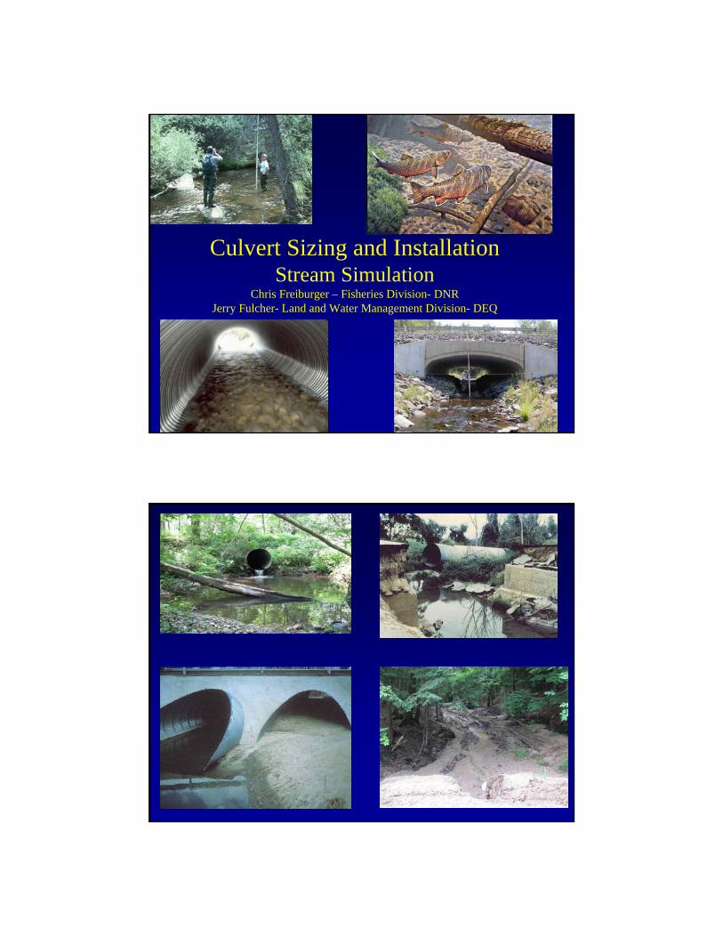
Culvert Sizing and InstallationStream Simulation
Chris Freiburger – Fisheries Division- DNRJerry Fulcher- Land and Water Management Division- DEQ

• Most culverts were placed and designed with the objective of moving water across a road alignment
• Little consideration given to ecosystem processes (hydrology, sediment transport, fish and wildlife passage or movement of woody debris)
• Not surprising then - that many culverts significantly disrupt movement of aquatic organisms and normal stream function
Hotchkiss, R.S. and Frei, C.M. 2007. Design for Fish Passage At Roadway Stream Crossings: Synthesis Report. U.S Department of Transportation, Federal Highway Administration, Office of Highway Infrastructure and Research. FHWA-HIM-07-033


Proper sizing is just as important in small headwater streams:- Accumulatively provide much more habitat for
aquatic organisms than large rivers
- Highly productive due to their relationship with adjacent upland habitat
- Provide cooler water temperatures due to shading and groundwater inputs
-Account for most of the total stream miles
Road Hydro Intersections = 67,511
Bridges = 6,811
Culverts = 60,700


FWHA Guidance
U.S. Department of Transportation, Federal Highway Administration, Office of Infrastructure Research and Development. June 2007. Design for Fish Passage at Roadway-Stream Crossings: Synthesis Report Publication No. FHWA-HIF-07-033
“The design of crossing structures has traditionally used hydraulic conveyance and flood capacity as the main design parameters. Design for hydraulic efficiency overlooks the impact of a roadway-stream crossing on the stream-channel aquatic ecosystem…. to provide stream reach connectivity for all wildlife, removal of road barriers or the installation of a bridge spanning the floodplain are ideal; however, this report presumes that a narrower, fish-friendly, installation is both permitted and desirable for economical or logistical reasons. This Guidance covers the topics of fish biology, culverts as barriers, fish passage hydrology, and design considerations aid in the selection of appropriate design techniques based on hydraulic, biologic, and geomorphic considerations”.
General DEQ Criteria
• Try to span the bottomlands• Avoid multiple culverts• Correct for scour and erosion problems• Proper alignment• Bury 6-12 inches• Avoid increases in upstream flooding

= Stream Width
> Stream Width < Stream
Width
Michigan Department of Natural Resources and Michigan Department of Environmental Quality
2007 Culvert Application Inventory
2007
Culvert applications reviewed 240
40%
48%
12%
Buried
Not Buried
Michigan Department of Natural Resources and Michigan Department of Environmental Quality
2007 Culvert Application Inventory
2007
Culvert applications reviewed 224
27%
73%

We need to do a better job of sizing our culverts to simulate streams.
Strive to maintain or create an un-fragmented stream bottom and bank edge habitat through the culvert.
This will address both fish passage as well as other wildlife that may use the stream corridor.
Dr. Sandy VerryChief Research Hydrologist
Forest Service
Sizing & Placement of Stream CulvertsThe Stream Will Tell You!
•Match Culvert Width to Bankfull Stream Width•Extend Culvert Length through side slope toe•Set Culvert Slope same as Stream Slope
•Bury Culvert 1/6th Bankfull Stream Width
•Offset Multiple Culverts (floodplain ~ splits lower buried one) (higher one ~ 1 ft. higher)
•Align Culvert with Stream (or dig with stream sinuosity)
•Consider Headcuts and Cut-Offs

Ordinary High Water Mark WidthOrdinary High Water Mark WidthBankfull ChannelBankfull Channel
Baseflow ChannelBaseflow Channel
Mesboac Culvert Design –
• Match Bankfull width0’
3’
1’
2’

Fundamental Stream and Culvert Interactions
• Fish and other aquatic organisms live and travel primarily along the channel margins. This is the environment under which they evolved and developed their swimming capabilities: 0 - 3 feet/sec
• When culverts less than the bankfull width restrict flow at a road prism, exit velocities from the culvert easily reach 5 feet/sec
• I have measured some up to 111/2 feet/sec
Bankfull Flow Shapes the Channel:
• Bankfull flow is the flow responsible for moving the most sediment and maintaining channel form (Dunne and Leopold 1978).
• That is why bankfull flow width is the minimum structure width required for simulating and maintaining form and functions through a crossing.
• The Bankfull Discharge (flow) on average is a 1.5 year event
• Average stream velocities at the bankfull stage are 3 – 6 feet/sec– Generally 3 ft/sec when channel slopes are less than 1%.– The average velocity goes up as channel slope increases above 1%


Avoid Width Measurements at the road on existing sites
Widening due to scour
Widening due to aggradation
Measure at the narrowest point on the channelaway from the existing crossing- normally at riffles
Mesboac Culvert Design –
• Set on Channel Slope
0’
3’
6’

Failure to set culverts on the same slope as the stream (and bury them 1/6th widthBKF)is the single reason that many culverts do not allow for fish passage!Slope can be measured as:Slope along the bank (wider variation, than thalweg)Slope of the water surface (big errors at low flow
or in flooded channels, goodat moderate to bankfull flows)
Slope of the thalweg (this, by far, is the best one)
Set SlopeSet Slope
riffleriffle
riffle
riffle
riffle riffle
Measure a longitudinal profile to allow the precise placement of culverts.
Precision Settingis the key to a fully functional culvert installation
Setting the elevationof the culvert invertupstream &downstream
assures success!
Measure Bankfull elevation, water surface elevation, and major thalweg topographic breaks (riffle top, riffle bottom, pool bottom), at each station, on the longitudinal profile
At each point1. Bankfull2. Water surface3. Thalweg
Benchmark
True North Backsight

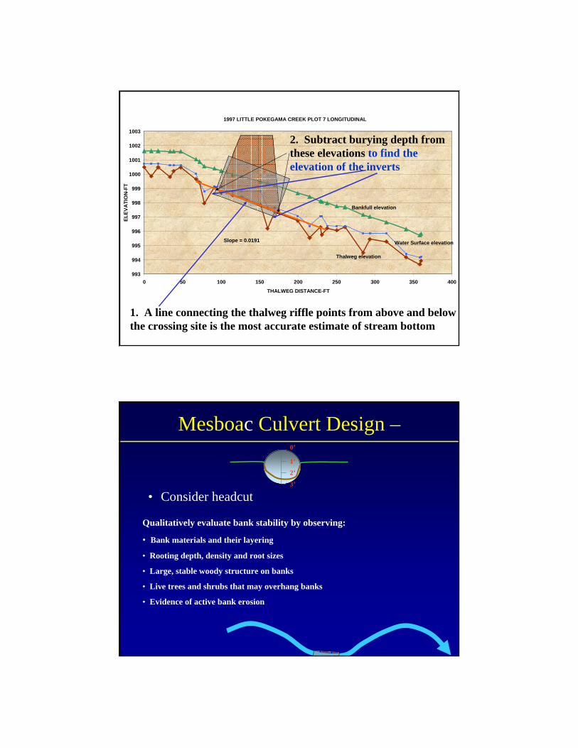
1997 LITTLE POKEGAMA CREEK PLOT 7 LONGITUDINAL
993
994
995
996
997
998
999
1000
1001
1002
1003
0 50 100 150 200 250 300 350 400THALWEG DISTANCE-FT
ELEV
ATI
ON
-FT
Slope = 0.0191
Bankfull elevation
Water Surface elevation
Thalweg elevation
1. A line connecting the thalweg riffle points from above and belowthe crossing site is the most accurate estimate of stream bottom
Mesboac Culvert Design –
• Bury 1/6th of Bankfull stream width
0’
3’
6’
Road Surface
1/6th width bkf

Why Bury? Many streams are naturally degrading
1998 – Siegel Ck, LNF
1979 – Siegel Ck, LNF
1979
1998
Bed inside culvert is about 1/6th the bankfull stream width
Up to a maximum of 2 feet
Let the bankfull discharge that lifts the stream bottom carry both the water and the sediment through the culvert,
mimicking the hydraulics of the channel
Mesboac Bury the Culvert
1997 LITTLE POKEGAMA CREEK PLOT 7 LONGITUDINAL
993
994
995
996
997
998
999
1000
1001
1002
1003
0 50 100 150 200 250 300 350 400THALWEG DISTANCE-FT
ELEV
ATI
ON
-FT
Slope = 0.0191
Bankfull elevation
Water Surface elevation
Thalweg elevation
1. A line connecting the thalweg riffle points from above and belowthe crossing site is the most accurate estimate of stream bottom
2. Subtract burying depth fromthese elevations to find the elevation of the inverts
Mesboac Culvert Design –
• Consider headcut
0’
3’
1’
2’
Qualitatively evaluate bank stability by observing:
• Bank materials and their layering
• Rooting depth, density and root sizes
• Large, stable woody structure on banks
• Live trees and shrubs that may overhang banks
• Evidence of active bank erosion
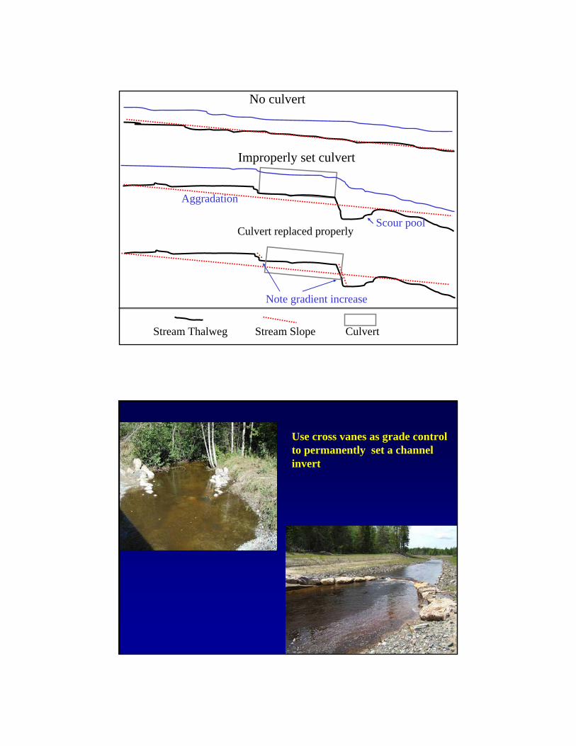
No culvert
Culvert replaced properly
Note gradient increase
Improperly set culvert
Aggradation
Scour pool
Stream Thalweg Stream Slope Culvert
Use cross vanes as grade control to permanently set a channel invert

Floodplain culvertsame size as stream culvert.Set same as floodplain slope
Stream culvert sizedTo bankfull width.Set same as thalweg riffle slope
High floodplain conveyance affects design. When conveyance is high it maybe necessary to install floodplain drainage or low areas across the road.
Objective being to avoid funneling over-bank flows through the main crossing structure which could destabilize the structure.
Economics ?
• The initial cost of designing for fish passage is higher, because the culvert is bigger. However, . .
• Failure risks are reduced
• Structural life is optimized
• Maintenance levels are reduced, and . . .
• Replacement frequency declines
• Creating opportunities for work at other sites
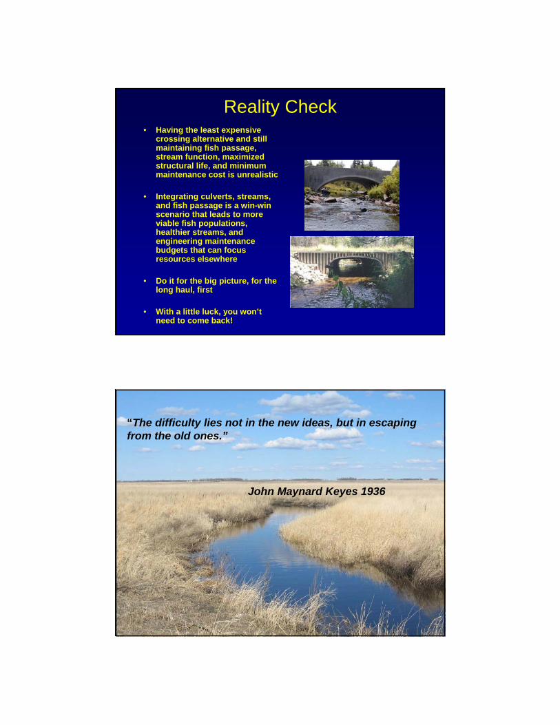
Reality Check• Having the least expensive
crossing alternative and still maintaining fish passage, stream function, maximized structural life, and minimum maintenance cost is unrealistic
• Integrating culverts, streams, and fish passage is a win-win scenario that leads to more viable fish populations, healthier streams, and engineering maintenance budgets that can focus resources elsewhere
• Do it for the big picture, for the long haul, first
• With a little luck, you won’t need to come back!
“The difficulty lies not in the new ideas, but in escaping from the old ones.”
John Maynard Keyes 1936