Embed Size (px)
Citation preview
THE RUSTLER ROCKSHELTER SITE (SBr-288), A CULTURALLY STRATIFIED SITEIN THE MHAVE DESERT, CALIFORNIA
CONTENTS
PREFACE . . . . *.
SITE LOCATION AND DESCRIPTION
GEOGRAPHIC CONSIDERATION .
CULTURE REMAINSPottery . .Milling and handstonesHammerstones . . .Abrading stones . .Stone pipe . . . .Projectile points . .Blades . . . . .Drills . . . . .*Discoidal core scrapers .
Flake scrapers . . .Lithic cores . . . *Debitage sample . .Shell bead . . . .Pointed bone implements .Bone bead . . . .Faunal remains . . .
. . . 0 0 0 0 0 0 27
* 00 0 0 0 . . 0 0 27
.0 0 0 0 0. 0 0. 29
0
6
0
0
0
0
0
e
0
0
0
0
0
0
0
0
0
0
0
0
0
0
0
0
0
0
0
0
0
0
0
0
0
0
0
0
0
0
0
0
0
0
0
0
01
0
0
0
0
0
0
0
0
0
0
0
0
0
e
0
0
0
0
0
0
0
0
0
0
0
0
0
0
0
0
0
0
S
0
. . . . 30. . .* 32. 0 0 330 0. 33
* 0 0 . 34. 0 .0 35
* 0 . 0 39* * 0 . 40* 0 * 0 40
. .0 40
.0 0 410 . 0 41
. 0 0 42
. . 0 42
. 0 0 42
.0 0 0 42
. . . 43ryan . . 45
. . 0 48
* 0. 50
* 0 0 0 55
AREAL AND TEMPORAL CONSIDERATIONSProvidence Complex of the Western Upland Pate
APPENDIX . * . . . . . . . . . . .
BIBLIOGRAPHY . *. . . . . *. .
EXPLANATION OF ILLUSTRATIONS . . . * *
ILLUSTRATIONS**. . . . . . . . . . following 56
[ 25 ]

THE RUSTLER ROCKSHELTER SITE (SBR-288), A CULTURALLY STRATIFIED SITEIN THE MOHAVE DESERT, CALIFORNIA
James T. Davis
PREFACE
The University of California Archaeological Research Facility wishesto express appreciation to Mr. Fleetwood Southcott and Mr. Nick Sanchez,owners of Gold Valley Ranch, Essex, California, for permission granted tothe Archaeological Survey in 1958 to establish camp and conduct excavationson their property; to the staff of Mitchell's Cavern State Park for cour-tesies extended to the field parties; and to Mr. Michael J. Harner, who wasin 1958 attached to the Arizona State University at Tempe, for kindly iden-tifying the pottery remains from the site.
Test excavations were carried out in the spring of 1958 during thecourse of a survey of the area. On the basis of evidence recovered fromthe test pits, it was believed that the site was "culturally stratified, "that is, pottery was lacking in the lower levels while being present in theupper levels. In November, 1958, a field party from the ArchaeologicalSurvey, under the direction of Mr. A. B. Elsasser, returned to the site andexpanded the previous excavations. As a result of the latter activity, itwas definitely established that the site presented "cultural stratigraphy."1
SITE LOCATION AND DESCRIPTION
The Rustler Rockshelter site (SBr-288)1 lies at an elevation of 4, 090feet on the eastern side of the mouth of Rustler Canyon which is located onthe southern side of the northwestern end of Woods Mountain in San BernardinoCounty, California.
1. Kelley (1934, Map 1) ascribes the territory in which the RustlerRockshelter is located to the Las Vegas band of Southern Paiute. However.,Kroeber (1959:307) says that the region may possibly have been inhabited fora brief period (sometime between ca. 1780-1810 A.D.) by a group of "DesertMohaves"; otherwise, since around 1750 A.D. it has been the home of the Chem-ehuevi (Southern Paiute). The linguistic affiliation of the inhabitants ofthis region of the Mohave Desert prior to this time is unknown.
[ 27 ]

28
The site is favorably situated on a small bench on the northernside of Black Canyon Wash, and has a direct southern exposure whichallows reception of maximum sunshine throughout the day. Rising immedi-ately along the rear of the deposit is an overhanging cliff, 54 feet highat the central and highest point above the site. The cliff is composedof a volcanic mudflow of yellowish rhyolitic tuff with inclusions of small,subspherical obsidian pebbles, sometimes referred to as "Apache tears."1Excellent shelter from northerly and northwesterly winds is afforded bythe cliff.
The deposit is composed of dark gray, loose, ashy, "greasy" middencontaining artifacts, stone chippage, and fire fractured rocks. Rockfallfrom the cliff face occurs throughout.
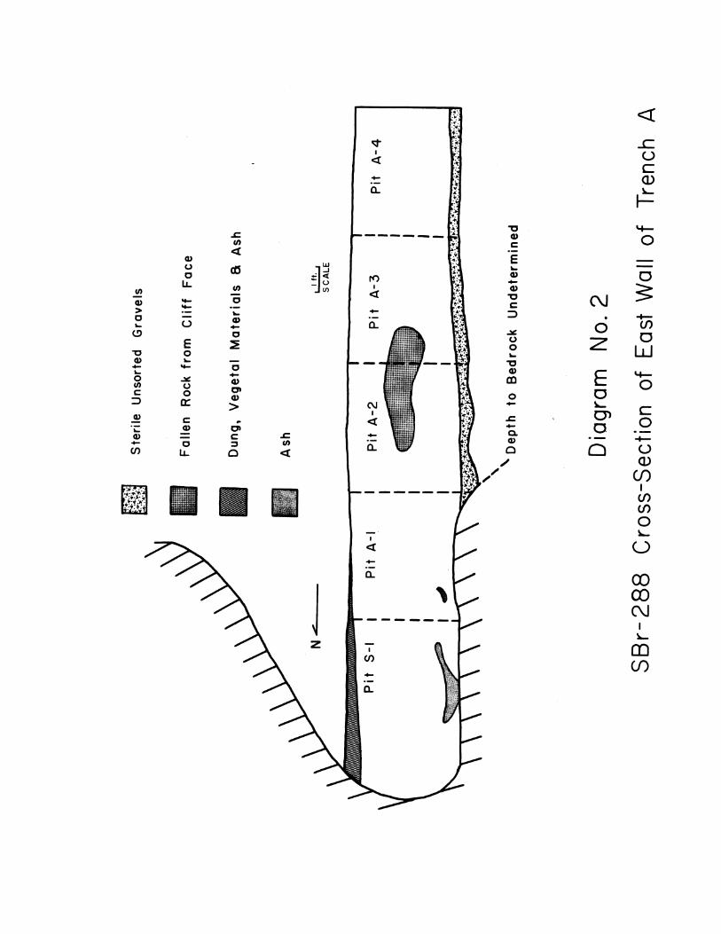
Underlying the cultural deposit (except in pit S-1) is an unsortedmixture of silt, sand, and gravel ranging from pea-size to quite largeangular and subangular cobbles (see Diagrams 1 and 2).
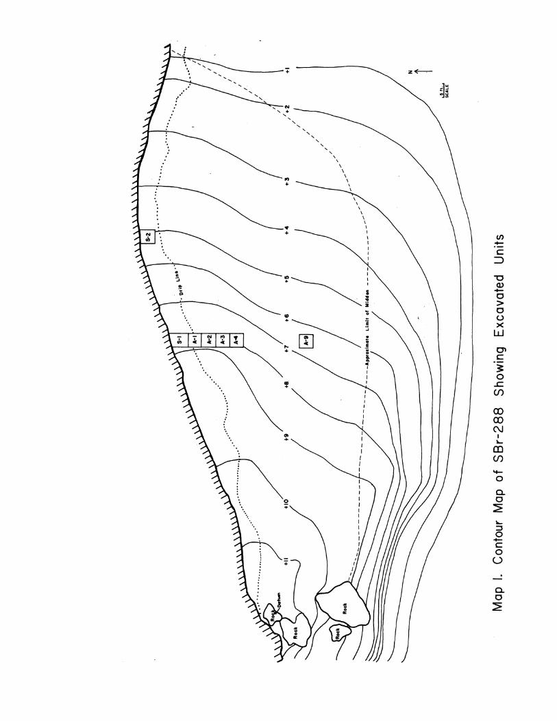
Stream action, possibly coupled to some degree with aeolian erosion,has obviously been responsible for the cutting of the three channels exhib-ited in the profile of the cliff face (see Diagram 1). In some manner, thestream must have become diverted from its original bed, perhaps by a fortu-itous rockfall from the overhanging cliff. Evidence of a fall which mayhave been sufficient to cause such diversion is prese'nt at the western edgeof the site (see Map 1). In any case, the original inhabitants of the sitewere well protected from wind and rain by the overhanging shelter of therock.
The rockshelter, although situated about 1/4 mile from an aguajewhich probably supplied the water needs of the occupants part of the time,is approximately one mile distant from a good spring. Campbell (1931:18)noted that the Indian campsites in the Twenty-Nine Palms desert region ofsouthern California were generally located from 1/4 to 1/2 mile from "openwater," and conjectures that the reason for camping such distance from thewater supply was to prevent animals which also used the water from beingfrightened away. Sites in other dry regions of the far west appear tohave been situated at even greater distances from water in aboriginaltimes: Humboldt Cave, Nevada, for example, is about four miles from water(Heizer and Krieger, 1956:5), and although not continuously inhabited,appears to have been lived in for brief periods, perhaps during inclementweather or possibly as a refuge from enemies; and the Coville Rockshelterin the Panamint Mountains, located high above the valley floor, is about1 1/4 miles from water (Meighan, 1953:172). Wallace (1958:14) notes thatrecent camps in Death Valley are also usually some distance removed from
29
the nearest water source, although Wallace and Taylor (1955b:89) state:"igenerally the camps [in Mesquite Flat] were in close proximity to recentor present-day waterholes." Steward (1938:10, passim) states that habi-tation sites in the Great Basin were near sources of water but the Indians,when camped near a spring, were careful not to frighten away the game whichalso made use of the watering place.
GEOGRAPHIC CONSIDERATIONS
The location of the Rustler Rockshelter lies well within what hasbeen termed the "yucca belt" of the Lower Sonoran Life Zone (Johnson et al.,1948, map facing p. 223; p. 228, Table 1; 231-232). Floral genera mostconspicuous in this habitat (ibid) are: Yucca mohavensis (Spanish dagger)and Y. baccata (Spanish bayonet); Larrea tridentata (creosote bush);Chilopsis linearis (desert willow); Acacia greggii (catclaw); Ephedra sp.(Mexican tea); Echinocactus cylindraceus (barrel cactus); Opuntia sp. (chollacactus); Atriplex (saltbush); Chrysothamnus (rabbit brush); Thamnosmamontana (turpentine broom); various herbs (esp. Sphaeralca and Gutierrezia)and grasses. Each of the above named genera was probably utilized to somedegree by the Indians, either as fuel, in various manufactures, or for food,drink, basketry, or medicine.
Numerous vertebrate animal species are represented in the yucca belt,the largest and perhaps most important of which are (ibid): Gopherusagassizi (desert tortoise); Taxidea taxus (badger); Vulpes macrotis (kitfox); Urocyon cinereoargenteus (gray fox); Canis latrans (coyote); Lynxrufus (bobcat); Lepus californicus (black-tailed jackrabbit); Sylvilasusauduboni (cottontail rabbit); Bassariscus astutus (ring-tailed cat); andSpilqgale gracilis (spotted skunk). Numerous small animals and birds areexcluded from this list.
The Mohave Desert region is characterized by aridity; precipitationoccurs principally during the months between late October and the middleof March and during midsummer thunderstorms (Jaeger, 1955:39).
Diurnal temperatures during the summer range from about 100 degreesduring the day to around 70 degrees at night. The winter diurnal range isabout twice as great-from around 70 degrees during the day to below freez-ing at night (ibid., p. 43). Violent windstorms are apt to occur at anytime throughout the year.
In spite of aridity and an apparently inhospitable environment, food
30
resources were reasonably plentiful although scattered over a wide area(cf. Barrows, 1900, passim). Undoubtedly the aboriginal inhabitants wereforced into a seminomadic existence, assuming that they dwelt in the re-gion throughout the year; however it is also possible that they returnedfrequently to a semipermanent village, following a subsistence patternsimilar to that described for the Paipai of Baja California by Owen (1959:56-57). In view of the abundance of yucca in the immediate vicinity andthe depth of the cultural deposit at the Rustler Rockshelter, it is sug-gested that the aboriginal inhabitants returned to the site for someperiod of time year after year for many generations.
CULTURE REMAINS
Pottery
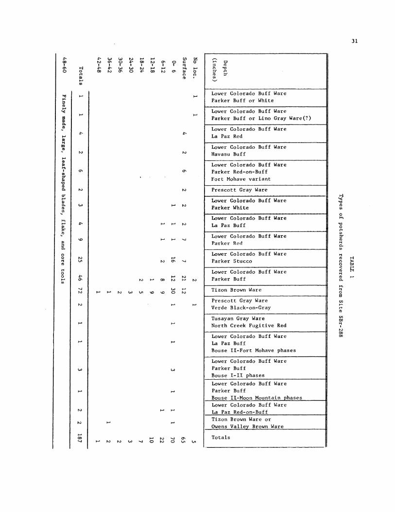
An interesting series of types and wares of potsherds was recov-ered from the deposit. Distribution of the various wares and types ispresented in Table 1 below. Specimens o'ccurring at the Rustler Rock-shelter and their approximate temporal ranges are:
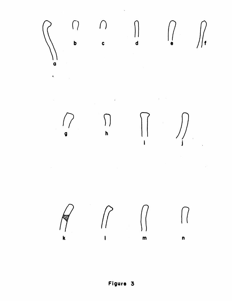
1. Tizon Brown Ware (fig. 3a-f): pre-900 to ca. 1900 A.D.(Harner, personal communication). Originally described by Colton (1939a:8) and dated by him at ca. 700-1890 A.D. A revised description by Dobynsand Euler appears in Colton (1958). Comments on the "ethnic variationsin Tizon Brown Ware" are presented by Euler (1959:41-42).
2. Lower Colorado Buff Ware: ca. 800-1910 A.D. (Harner, 1958:95;Kroeber and Harner, 1955:15). Originally described by Schroeder (1952:16-17) and dated by him at 800-1900 A.D. A revised description bySchroeder appears in Colton (1958).
a. Parker Buff (fig. 3&, h, 1-n): ca. 800 to ca. 1910 A.D.(Harner, personal communication). Described by Schroeder (1952:19-20)and dated by him at -900 to +1900 A.D. See also Kroeber and Harner (1955:16).
b. Parker Stucco: described by Schroeder (1952:21-22) anddated by him at -200(?) to 1840 A.D. Harner (1958:96) dates this typemuch later, ca. 1300-1700 A.D.
c. Parker Red, Bouse I-Moon Mountain phases: dated at ca.800-ca. 1700 A.D. (Harner, 1958:94 ff.).
31
aI0
H.
:3
m
H
Di
s
00CD
m
H
CD
H
Di
m
Hfi
H
03
oIr
100
H
en
@-
Fh
1fi
m4
uo
RD
rt003-
N) 0 0 -p- 0 a,% 0I I I I * 1 I I
M0 Ni 0 Pw- (0'H0atDiH-en)
cn z0 0H, HD) 00 0CD
-P
tla
HJ H tV.P
%-0
LA
rN)
En
Lower Colorado Buff WareParker Buff or White
Lower Colorado Buff WareParker Buff or Lino Gray Ware(?)
Lower Colorado Buff WareLa Paz Red
Lower Colorado Buff WareHavasu Buff
Lower Colorado Buff WareParker Red-on-BuffFort Mohave variant
Prescott Gray Ware
Lower Colorado Buff WareParker White
Lower Colorado Buff WareLa Paz Buff
Lower Colorado Buff WareParker Red
Lower Colorado Buff WareParker Stucco
Lower Colorado Buff WareParker Buff
Tizon Brown Ware
Prescott Gray WareVerde Black-on-Gray
Tusayan Gray WareNorth Creek Fugitive Red
Lower Colorado Buff WareLa Paz BuffBouse II-Fort Mohave phases
Lower Colorado Buff WareParker BuffBouse I-II phasesLower Colorado Buff WareParker BuffBouse Il-Moon Mountain phasesLower Colorado Buff WareLa Paz Red-on-BuffTizon Brown Ware orOwens Valley Brown Ware
Totals
Nl)H-ON -Ji
Hc-
En
0
(DFh
Po
0
CDFt
H
cn
r-
tD
CD-
ti
H
0
enH-a
CDenH
0000
N) H cO N)
Un)H- H-- N) L Lii '-0 %L 0
FNH-
N)
H
U) U)
H- H-
N)
-S H N) -4H N) -4 0 N) 0
0'NLi' Lii

32
d. Parker White: same date range as Parker Red (ibid.).
e. La Paz Buff: dated at ca. 800 to ca. 1910 A.D. (ibid.).
f. La Paz Red: same date range as Parker Red (ibid.)
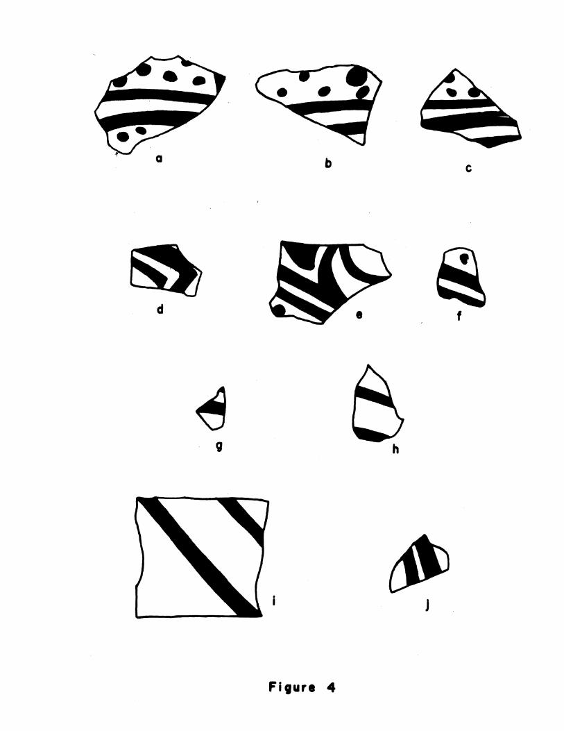
. La Paz Red-on-Buff (fig. 41, h): dated at ca. 1000 A.D.to ca. 1910 A.D. (ibid.).
h. Havasu Buff: dated at ca. 800 to ca. 1910 A.D. (ibid.).
i. Parker Red-on-Buff, Fort Mohave variant (figs. 3, 4a-f):dated at ca. 1700 to ca. 1910 A.D. (ibid.; Kroeber and Harner, 1955:15-16).
3. Prescott Gray Ware: dated by Caywood and Spicer (1935:42) at1000-1400 A.D. Described by Caywood and Spicer (Loc. cit.) and by Coltonand Hargrave (1937:184). Revised description by Colton (1939b:15-16; 1958),
a. Verde Black-on-Gray (fig. 4i, j): dated at 1050-1300 A.D.by Colton (1958). Described by Caywood and Spicer (1935) and by Gladwin(1930:140). Revised by Colton and Hargrave (1937:184-185) and by Colton(1958).
4. Tusayan Gray Ware: dated at ca. 500 to 1300 A.D. by Colton(1955). Described by Colton and Hargrave (1937:190). Revised by Colton(1955).
a. North Creek Fugitive Red (Virgin Series), Pueblo II-III(?).Dated by Colton (1952). Described by Spencer (1934:74). Revised byColton (1952:21-22).
5. Lino Gray (Teegi Series) (fig. 3k): dated at 500-750 A.D. byColton (1955). Described by Kidder and Guernsey (1919:153). Revised byColton and Hargrave (1937:191) and by Colton (1952:16; 1955).
6. Owens Valley Brown Ware: dated at -1550 to +1850 A.D. by H. S.Riddell (1951:23) and described by hm . cit., pp. 20-21).
Milling and handst2nesFragments of eleven milling stones were collected from the excava-
tions, and a complete specimen was found on the surface of the site.
The complete milling stone is of felsitic porphyry. A shallowgrinding surface 14 cm. wide and 24 cm. long is present on one face, Theentire stone measures 10 cm. in thickness, 27 cm. in width, and 32.5 cm.in length. No attempt had been made to shape any of the exterior surfaces.
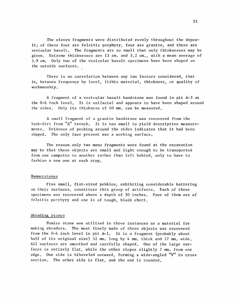
33
The eleven fragments were distributed evenly throughout the depos-it; of these four are felsitic porphyry, four are granite, and three arevesicular basalt. The fragments are so small that only thicknesses may begiven. Extreme thicknesses are 13 cm. and 3.2 cm., with a mean average of5.9 cm. Only two of the vesicular basalt specimens have been shaped onthe outside surfaces.
There is no correlation between any two factors considered, thatis, between frequency by level, lithic material, thickness, or quality ofworkmanship.
A fragment of a vesicular basalt handstone was found in pit A-3 atthe 0-6 inch level. It is uinifacial and appears to have been shaped aroundthe sides. Only its thickness of 40 mm. can be measured.
A small fragment of a granite handstone was recovered from theback-dirt from "A" trench. It is too small to yield descriptive measure-ments. Evidence of pecking around the sides indicates that it had beenshaped. The only face present was a working surface.
The reason only two mano fragments were found at the excavationmay be that these objects are small and light enough to be transportedfrom one campsite to another rather than left behind, only to have tofashion a new one at each stop.
Hammerstones
Five small, fist-sized pebbles, exhibiting considerable batteringon their surfaces, constitute this group of artifacts. Each of thesespecimens was recovered above a depth of 30 inches. Four of them are offelsitic porphyry and one is of tough, black chert.
Abrading s tones
Pumice stone was utilized in three instances as a material formaking abraders. The most finely made of these objects was recoveredfrom the 0-6 inch level in pit A-l. It is a fragment (probably abouthalf of its original size) 52 mm. long by 4 mm. thick and 17 mm. wide.All surfaces are smoothed and carefully shaped. One of the large sur-faces is entirely flat, while the other slopes slightly 7 mm. from oneedge. One side is bibeveled outward, forming a wide-angled "V" in crosssection. The other side is flat, and the end is rounded.
34
Two other less well-defined abraders are small, irregularly shapedpieces of pumice having a single smoothed, flat face. One of these was
obtained in pit A-4 at the 6-12 inch level, and the other was found inpit A-4 at the 12-18 inch level.
Stone pipe
A tubular, biconically drilled pipe of dark gray scoria was recov-ered from pit A-4 at a depth of 27 inches. Its over-all length is 79 mm.,and its original outside diameter was about 53 mm. The bowl is formed bya long, conically drilled hole extending from the distal end 68 mm. towardthe base where it joins the stem hole which is conically drilled a distanceof 11 mm. up from the base and tapers from a diameter of 11 nmn. at the baseto a diameter of 9 mm. where it joins the bowl. The walls thicken from 11mm. at the distal end to 18 mm. near the base in relation to the conicallydrilled bowl.
No trace of mastic is observable at the stem end, but it is likelythat either a bone or wooden stem was at one time inserted into andattached with gum to the stem hole (P1. lhh).
Incised stone
A thin fragment of slate bearing shallow random scratches wasfound on the surface of the site. It is a triangular-shaped fragment-,44 mm. long, 19 mm. wide at the point of fracture, and 3 mm. thick. Theedges have been purposely smoothed, and fine scratches of irregular lengthappear on both broad surfaces.
Another larger but similar fragment of basalt has a smoothed edgeand light scratches on both broad surfaces. This piece is 62 mm. long(both ends broken), 42 mm. wide (one side broken), and 7 mm. thick. Itwas recovered from pit A-2 at the 42-48 inch level.
Incised painted stone
A small fragment of a thin, flat, incised stone painted with a redpigment was found in pit A-2 at the 30-36 inch level. A simple geometricdesign consisting of crossing horizontal and vertical lines has beenworked into both the obverse and reverse faces of the object., apparentlyafter the faces had been painted. The specimen is 3 mm. thick. Othermeasurements are not possible because each side has been broken.

35
Incised slate tablets were assigned to the Amargosa I period byRogers (1939:63-64, P1. 17). They are frequently encountered in sitesin Death Valley (Wallace and Taylor, 1955a:362; 1956:10, figs. 2 and 3),as well as in other regions of the Mohave Desert (Peck and Smith, 1957:8, 18, 27, P1. 1), - occur also in the Panamint mountains (Lathrap andMeighan, 1951:24, fig. lc; Meighan, 1953:184, P1. 26B, C), and at theStahl site (Harrington, 1957:69, fig. 49d). Examples identical to thatrecovered from the Rustler Rockshelter, that is, having the designscratched into the stone after being painted with red ocher, are des-cribed by Meighan (1953:184, P1. 26B, C) for the Coville Rockshelter inthe Panamint Mountains.
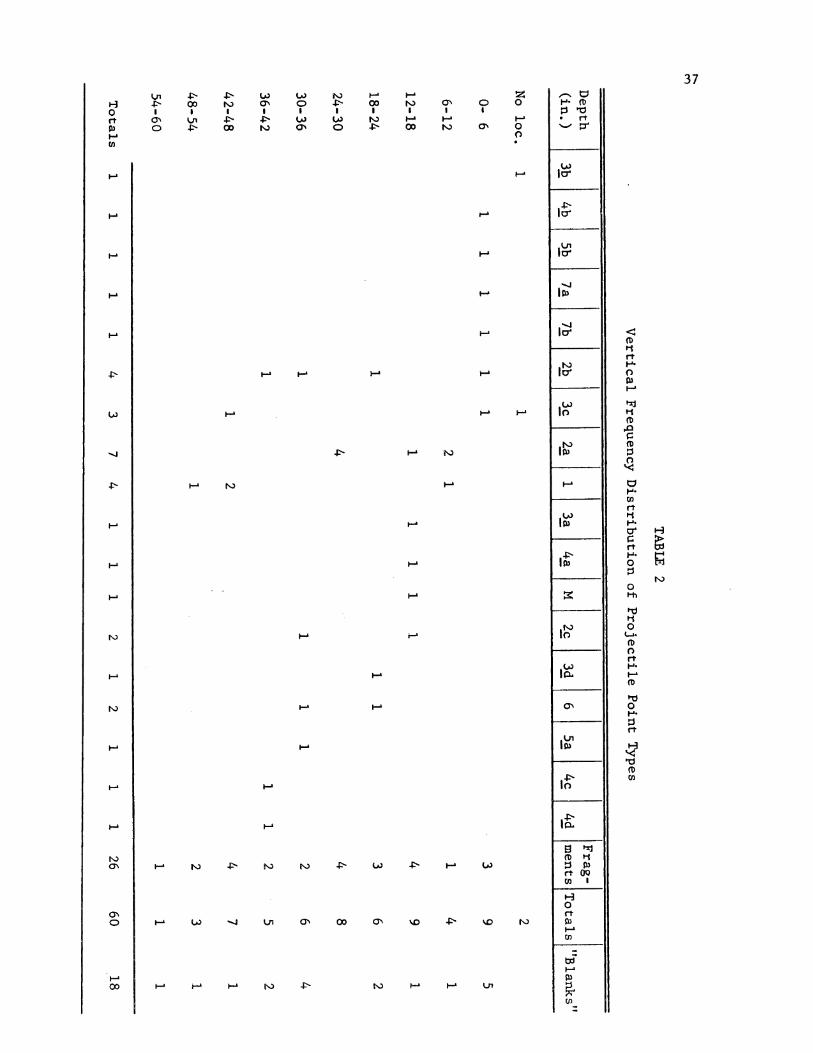
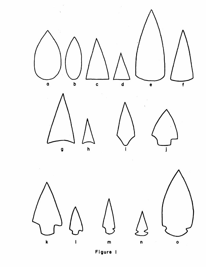
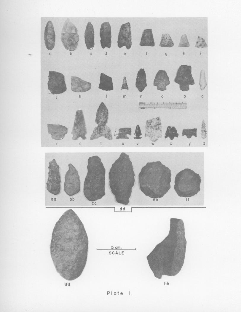
Prolectile points
Thirty-four classifiable projectile points were recovered fromthe excavations at site SBr-288. Unfortunately, most of the types arerepresented by only a single specimen, and practically all of the pointsare broken. As will be noted, only one type is statistically meaningfulin delineating cultural "strata." However, the following descriptivetypology may be useful for comparative purposes with projectile pointsfrom other locations.
Type 1. Leaf-shaped (P1. 1; Fig. la, b)
2. Triangular (P1. 1)a. Straight base (Fig. lc, d)b. Convex base (Fig. le, f)c. Concave base (Fig. 1g, h)
3. Shouldered (P1. 1)a. Contracting stem (Fig. ii)b. Parallel stem (Fig. 11)c. One shoulder, one corner notch (Fig. lk, 1)d. One shoulder, one side-notch (Fig. lm)
4. Side-notched (P1. 1)a. Shallow, contracting straight base (Fig. ln)b. Convex base (Fig. lo)c. Expanding concave base; width of base equal
to or less than width of body ("eared" base)(Fig. 2a)
d. Expanding concave base; width of base greaterthan width of body (Fig. 2b)
36
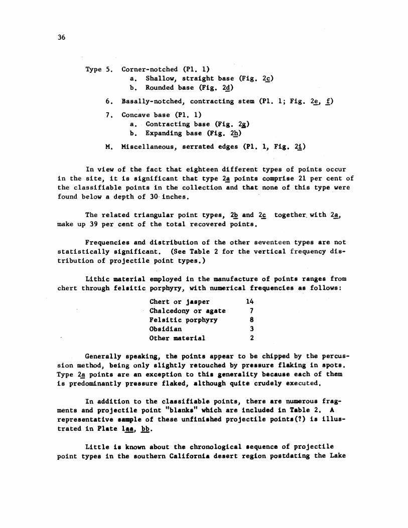
Type 5. Corner-notched (P1. 1)a. Shallow, straight base (Fig. 2c)b. Rounded base (Fig. 2d)
6. Basally-notched, contracting stem (Pl. 1; Fig. 2e, f)
7. Concave base (P1. 1)a. Contracting base (Fig. 25g)b. Expanding base (Fig. 2h)
M. Miscellaneous, serrated edges (P1. 1, Fig. 24)
In view of the fact that eighteen different types of points occurin the site, it is significant that type 2a points comprise 21 per cent ofthe classifiable points in the collection and that none of this type werefound below a depth of 30-inches.
The related triangular point types, 2b and 2c together with 2a,make up 39 per cent of the total recovered points.
Frequencies and distribution of the other seventeen types are notstatistically significant. (See Table 2 for the vertical frequency dis-tribution of projectile point types.)
Lithic material employed in the manufacture of points ranges fromchert through felsitic porphyry, with numerical frequencies as follows:
Chert or jasper 14Chalcedony or agate 7Felsitic porphyry 8Obsidian 3Other material 2
Generally speaking, the points appear to be chipped by the percus-sion method, being only slightly retouched by pressure flaking in spots.Type 2a points are an exception to this generality because each of themis predominantly pressure flaked, although quite crudely executed.
In addition to the classifiable points, there are numerous frag-ments and projectile point "blanks" which are included in Table 2. Arepresentative sample of these unfinished projectile points(?) is illus-trated in Plate laa bb.
Little is known about the chronological sequence of projectilepoint types in the southern California desert region postdating the Lake
37
H0ft
HCo
H
H
H
H
H
H
H
N)
H
H
H
-a'
H
00
ooA
> 00 0a a > 00 N a a oI . I U U 3 , * I I
o O>00 ) 0 4> 00 N cs 0
.'A
P-H
H N)
H-H N)
M'C
ftP r
i-c
Ln'
103
ir-
0
it
P3
In
N)
1-0
H
4>
N)
In
P0)
In
D1vr tOCo It
ft O
03HCo
H
% V
CD
rtI-A.00p
H
tt
rH.CK F
H.
N)0Ih
0
CD
ft
H.
rD
0ta.
Co
0
foAcn
H--
H-
H--
H-
N). N) 4 LA) 4>- H- (A)
Ln 0'% 00 a'% %JD 4> N
H N) 4>-
H (#w '4
H-- H H N) 4>- N) H H Ln
38
Mohave (ca. 8000-7000 B.C.) and Pinto-Gypsum (ca. 7000-1000 B.C.) com-plexes. However, some general comparisons of certain distinctive pro-jectile point types occurring at Rustler Rockshelter may be made withthose recovered by other investigators in surrounding regions.
Campbell and Campbell (1935:46, P1. 14m) believe a type of pointgenerally similar to our type 4c (fig. 2a) to be transitional betweenthe simple leaf-shaped point and the typically shouldered, parallel-stemmed, concave-based Pinto point. Type 4c is also generally similarto the Paradise River variety of Pinto point (Campbell et al., 1937:43-44). Harrington (1937:88) and Schroeder (1952) found a similar typehaving a narrower blade to be restricted to the prepottery levels at aphysically and culturally stratified site near Hoover Dam. At the LittleLake (Stahl) Pinto site, point type 4c occurred at depths of 0-42 inches(Harrington, 1957:86; App. II-E, fig. 39. lower left). Northward on theeastern California border of the Great Basin in Mono County, California,Meighan (1955:19, fig. 2) suggests that point types 4c and 7b are earlierthan the remainder of the types found in the region. Rogers (1939:68,P1. 20a, i) assigns type 4c projectile points to the Amargosa I period(dated by him at 200-700 A.D.). Wallace (1958, fig. 1) illustrates pro-jectile points similar to type 4c which he assigns to his Mesquite Flatcomplex (dated by him at 3000-1 B.C.). See also Wallace and Taylor(1955b, fig. 6, bottom row).
Type 4c points also occur at Newberry Cave, located about 80 milessouthwest of SBr-288, but neither their frequency, depth of occurrence,nor association is presented (Smith et al., 1957:19, P1. 13b, third row,5th and 7th points from left). They were also recovered from the IndianHill Rockshelter in the Anza-Borrego State Park, and were presumablyassigned to an earlier large projectile point tradition by Wallace andTaylor (1960: fig. 7, bottom row).
Type 2c points (fig. 1&, h) were found to be restricted to the pre-pottery levels of the stratified site near Hoover Dam referred to above(Harrington, 1937:88; Schroeder, 1952).
Projectile point types 3b and 3c (fig. 24, k) are generally similarin form to one of the principal Silver Lake types (Campbell et al..,1937:84, Pl. 42d) and were assigned to the pre-pottery horizon of a strati-fied camp site near Hoover Dam by Harrington (1937:88) and Schroeder (1952).
Rogers (1939:69, Pl. 20d, e) attributes projectile point type 4d(fig. 2b) to phase I (and presumably also phase II) of the Amargosa complex.

39.
Types Sb and 6 (fig. 2d, e, f) are assigned to phase II of theAmargosa industry by Rogers (1939:65, P1. 18a, d) and types 2a and 2care classed as being early Desert Mohave (ibid., P1. 18 m).
At the Stahl site near Little Lake, point type 7b (fig. 2h)occurred throughout the deposit (0-56 in.) (Harrington, 1957:86, App.II-E, fig. 40). Riddell and Riddell (1956:29) suggest that type 7bpoints "have a long and continuous history" in the region of the OwensValley Paiute.
From a study of Table 2, which presents the vertical frequencydistribution of projectile point types occurring at SBr-288, it is diffi-cult to arrive at any meaningful interpretation concerning the temporalaffinity of any of the projectile point types, mainly because most typesare represented by a single specimen; however, it will be noted that type2a points are restricted to the pottery yielding levels of the deposit.
Along the eastern California border of the Great Basin, as well as
in other regions, there has been noted a general trend for large, coarselychipped projectile points to be replaced by, or at least-emphasis shiftedto, smaller, lighter, finely flaked points (Heizer and Elsasser, 1953:12 ff.,19 ff.; Meighan, 1955:13: Riddell and Riddell, 1956:30; Riddell, 1958:46;Wallace and Taylor, 1960:74; Elsasser, 1960:29-30). Such a trend is alsoobservable at the Rustler Rockshelter, where small points, with one excep-tion, do not occur at depths below 30 inches, while nine of the sixteenlarge points recovered from the controlled excavations were found below a
depth of 30 inches.
Blades
Throughout the history of occupation at this site large, crudeblades (P1. 1cc, dd) were utilized, probably serving a variety of func-tions. Each of them, with one exception (PI. Iag), is flaked by the per-cussion method, and a few exhibit a slight degree of pressure retouchingalong the edge. Of the series of 54 blades, felsitic porphyry was util-ized in making 49 of them; the remaining 5 specimens were made from variouskinds of chert.
Two types may be distinguished on the basis of shape, but the typeshave no apparent diagnostic value at this site for delineating culturechange. Type I has a rounded base, and type 2 possesses a straight base.
Of the 54 specimens, 11 are type 1, 6 are type 2, 12 are unclassi-fiable fragments, and 25 are unfinished "blanks." One finely made type 1
40
specimen was recovered from a depth of 57 inches in test pit 2-S. It ismade from felsitic porphyry and is pressure flaked completely around thecutting edge on both faces.. Measurements of this specimen are: length,104 mm.; width, 53 mm.; thickness, 9 mm. (P1. 1i*).
Drills
No complete drills were recovered during the course of the exca-vations; however, 4 fragments of probable drills were collected. Eachfragment is percussion flaked and made from different material. Threetypes are distinguishable.
From the surface of the site two simple triangular drill fragmentswere recovered, one of red agate and the other of black chert.
In pit A-2, at the 6-12 inch level, was found a drill fragment ofwhite chert. The sides expand to distinct shoulders above a deeply con-cave expanding base.
In pit A-3, at the 6-12 inch level, another fragment was recovered;this has a broad, expanding, concave base.
Discoidal Sore scra2ersA series of 10 discoidal plano-convex core scrapers of felsitic
porphyry was collected from the site. Each is made from a percussionbulb, with the edges chipped back on the convex surface only.
These tools occur from the surface of the site to a depth of 54inches. Four specimens were concentrated at the 30-36 inch level (P1. lee.ff). Their approximate diameters range from 38 to 55 mm., with a meanaverage of 47 mm. Thicknesses range from 13 to 18 mm., with a meanaverage of 15 mm.
Flake scrapers
This class of artifact is made up of a variety of irregularlyshaped, nondescript flakes, both large and small, with secondary chippingon one or more edges.
A total of 53 specimens was recovered from all levels of the site.Felsitic porphyry was the lithic material predominantly employed in makingthese tools. In addition to 35 specimens made of this material, 12
41
scrapers of various kinds of chert, 3 of obsidian, 2 of agate, and oneof basalt were collected.
Lithic cores
This group of artifacts is comprised of 54 stone objects fromwhich large chips have been struck on all surfaces. Many of them showevidence of use on one or more edges, and it seems probable that theyserved a variety of functions, such as choppers, scrapers, "saws, "hammerstones, and the like. Some other specimens show evidence of littleor no use and may be merely the remains of material from which flakeswere struck to manufacture projectile points or other implements.
No typological segregation is presented here because one typegrades imperceptibly into another and each type occurs throughout thedeposit.
Fifty of the cores. are felsitic porphyry, 2 are chert, and 2 areagate.
Debitage sample
The predominant lithic material utilized in the manufacture ofchipped stone artifacts is a reddish-brown felsitic porphyry. In orderto determine objectively the relative use of other lithic material, a -chippage sample was obtained from pit A-4. The method of taking thesample was by saving all flakes other than felsitic porphyry not pass-ing through the screen, and segregating them by 6 inch depth intervals.The results domonstrate that chalcedony and agate were utilized slightlymore than chert and jasper, and each of these was used three times asoften as quartz and quartzite, while obsidian (pure black only) was usedabout one-third as often as quartz. Lithic materials other than thesewere very rarely employed in making chipped stone artifacts. The indi-vidual frequency of occurrence of the three most commonly utilizedmaterials remains consistently relative from the upper to the lower level.
A rather curious finding, for which we have no interpretation, isthat the average size and weight of individual flakes decreases steadilyfrom the top to the bottom of the deposit. In some manner change in sizeof waste flakes may reflect change in technique of manufacture,
42
Shell bead
A unique bead type was recovered from pit A-3 at the 0-6 inchlevel. It is a thin section cut from near the tip of an Olivella shellacross the transverse axis. A portion of the whorl is retained and allsurfaces have been highly polished. The bead is 2 nm. thick and 5 mn.in diameter.
Pointed bone implements
The flat, bluntly pointed tip of a calcined bone tool was foundin the 0-6 inch level of pit A-4. It is too blunt to have served as abasketry awl, but could have been used as a matting needle.
A tiny, apparently complete, calcined bone artifact was collectedfrom an unknown depth in test pit S-2. It is 24 mm. long, 6 mm. wide,and 2.5 nm. thick. One end is sharply pointed and the other is blunt.From one flat surface the two sides are roughly beveled to a slightlyconvex surface. The whole object has been carefully smoothed and pol-ished. It may have served as a barb for a rodent-hook (Mohr, 1951;Harrington, 1932).
Bone bead
From the 36-42 inch level in pit A-1 a small, calcined bird bonebead was recovered. It is fashioned from the ulna of a small bird. Theends are cut irregularly and have been only slightly trimed. It is 8mm. long and 5 mm. in diameter.
Faunal remains
Faunal remains are relatively abundant in the midden but are gen-erally such small fragments that accurate generic identification is im-possible. A few genera may be definitely identified, however. These are:coyote (Canis latrans probably); rabbit (probably Lepus lepus and Sylvila-. sp.); deer (Odocoileus hemionus hemionus); desert tortoise (Gopherusagassizi); and a variety of other rodents, large manmals, and birds.
Many of the mammal bone fragments are too thick-walled to be deeror antelope, and may be the remains of big horn sheep. Probably alsopresent are antelope and other large mamnals.
No attempt is made here to identify rodent species because of theabundance and variety of these desert creatures.
43
Bird bones are too fragmentary to attempt generic classification.
There is little doubt that practically any animal which could betaken was killed and utilized for food in this rather unfriendly environ-ment.
All bone retained by the quarter-inch mesh screen was tabulated.A total of 496 osseous. specimens was recovered from trench A (excludingpit A-9 which yielded none). Analysis by type of bone and frequency ofoccurrence by level reveals that all species are found throughout themidden in fairly constant ratios and no significant changes occur inthese frequencies. Beginning with the 0-6 inch level and continuing indescending order by level for all types of bone, we find frequencies of51, 68, 53, 67, 67, 78, 45, 57, 10. The last given number is the mixedmidden and sterile gravel layer from which it was anticipated fewer boneswould be recovered. Of the total of 496 specimens recovered, 51 aretortoise, 27 deer or antelope, 10 rabbit, 1 coyote, 54 bird, 99 rodent,and 254 are unidentifiable large ammnal bones, many of which presumablyare mountain sheep.
Of interest is the fact that no skull or rib fragments of largemamals are present in the collection, due perhaps to specialized but-chering techniques or religious ideas connected with the hunt.
AREAL AND TEMPORAL CONSIDERATIONS
The Rustler Rockshelter is near the northern limit of what hasbeen named the Patayan folk-tradition (Schroeder, 1957:177) which pre-sumably had its beginning about 750 A.D. and lasted until about 1700 A.D.in the Lowland (Colorado River) subarea (Harner, 1958:93 ff.). On thebasis of the vertical distribution of pottery types occurring at SBr-288,it presumably had relatively the same time-span in the upland region ofthe Mohave Desert.
The problems surrounding the concept of the Patayan folk-traditionare numerous in the upland region west of the Colorado River. In fact,Rogers (1945:179) took exception to the extension of the term Patayan tothe western periphery of this area. His main point of objection appearsto be well taken:
"My principal objection to the word Patayan is that it is presentedas a cultural entity when the material evidence indicates that it is made
44
up of ceramic fragments from diverse cultural complexes, in so far asthe western marginal components are concerned."
Perhaps, however, Schroeder's use of the term "folk-tradition,"presumably referring to the region as being marginal to and affected bythe greater southwestern agricultural complex, would reduce the objec-tions to the term Patayan. If the term as defined by Schroeder (1957:177) is accepted for the region, the remaining problem is to unravel thevarious complexes and their chronological relationships. As Colton(1945:121) remarked:
"The prehistoric culture west of the [Colorado] river should becorrelated with that east of the river and the culture of the Yuma areamust be correlated with that of the Needles area."
Fifteen years later the same tasks remain, for the most part, and as forestablishing a chronology west of the Colorado River, Bennyhoff (1958:102) remarks:
"It is impossible to set up any meaningful chronology for thisregion from the existent literature. More complete descriptions interms of rigorous typology, artifact association and frequency, andsite locations are needed for most of the cultural periods."
As a step toward defining archaeological subareas, complexes, andphases in the western uplands of the Patayan, it is suggested that theregion centering about the Providence Mountains, Mid Hills, and New YorkMountains be referred to as the Providence subarea of the Patayan CultureArea. The name Providence is chosen because it once referred to a uchlarger geographic region than at present, according to Gudde (1949:274)who states:
"Providence Mountains. ., . The name is shown on the maps after1857 for the entire range of New York Mountains, Mid Hills, and Provi-dence Mountains. . . . When the Geological Survey mapped the IvanpahQuadrangle in 1909-1910, it limited the name to the southern end of therange."
Perhaps it is premature to suggest the establishment of an archae-ological complex of the Patayan on the basis of artifact inventory from asingle site. However, considering the following conditions, it is felt
45
that such establishment is merited: (1) the deposit is culturally strat-ified from the earliest pottery horizon through the protohistoric period,that is, through the entire time-range of the Patayan; (2) a trait list,although limited, may be tentatively established for the various phases;(3) it is assumed that open sites representing the Patayan folk-traditionexcavated in this region in the future will yield a similar artifact in-ventory; (4) such inventory will be different in several respects, suchas relative abundance and variety of projectile points, from the LowlandPatayan phases described by Harner (1958), and will demonstrate a closerrelationship to regions to the north and northwest (Panamint Mountains,and Owens and Death valleys) in such traits as incised slate tablets andthe use of the metate in grinding foods rather than pounding them.
The tentative dates assigned to the Phases of the Providence Com-plex are based upon the presence of pottery types occurring in the LowlandPatayan phases as described by Harner (1958). The following trait listsof the Providence Complex may be compared to those described for thePatayan folk-tradition generally (Schroeder, 1957:177) and those enumer-ated for the Lowland Patayan phases by Harner (1958:94 ff.).
Providence Comrlex of the Western Upland Patayan
Phase I (ca. 800-1000 A.D.)
Subsistence: Hunting of large and small animals and gather-ing of wild vegetal foods and insects. Horticulturepresumably not practiced until historic times.
Food preparation: One-hand mano used in conjunction withboth shaped and unshaped slab metates in a grindingrather than a pounding process. Bones of large animalscracked presumably to extract the marrow.
Ceramic traits: A plain brown pottery (predominantly if notexclusively Tizon Brown Ware), coiled, walls thinned witha paddle and anvil.
Implements: Biconically drilled stone pipe (presuimably usedin smoking tobacco). Small, cylindrical bone beads. Pro-jectile point types 4c, d, 5a (P1. 1). Painted incisedslate "tablets."
Settlements: Scattered households in rockshelters in themountains; many small shelters have low, unmortared rockwalls constructed partially in front of the opening.Temporary camps in the open; houses presumably circular;brush enclosures braced with rocks around the perimeter.
46
Supernatural: Assumed cremation of the corpse.
External relationships: Ceramic traits derived predomin-antly if not exclusively from the northwestern Arizonaregion of the Eastern Upland Patayan. Subsistence pat-tern related to that of the Great Basin to the north andnorthwest rather than to the Lowland Patayan.
Phase II (ca. 1000-1300 A.D.)
Continuation of Phase I traits with the following additionsand exceptions:
Ceramic traits: Addition of a plain buff pottery from theLowland Patayan region.
Implements: Projectile point types 3a, 4a, M (P1. 1) re-place those noted in the preceeding phase. Bone beads,stone pipes, and painted incised slate tablets areabsent.
Phase III (ca. 1300-1700 A.D.)
Continuation of Phase II traits with the following additionsand exceptions:
Ceramic traits: Appearance of stucco treatment on surfaceof plain buff pottery, painted red designs on plainbuff pottery, and the introduction of numerous potterytypes from the Lowland Patayan and Upland ArizonaPatayan regions.
Implements: Expanding triangular based and concave basedchipped stone drills. Transversely cut OLjY01a3 shellbeads. Narrow, spatulate, pointed bone tool. Unpainted,incised slate "tablets." Projectile point types 4b, 5b,7a, b replace those noted in the preceding phase.
At present it is impossible to assign the authorship of the petro-glyphs in this region to any one of the described phases or to the peoplesinhabiting the region in pre-pottery times.
It is assumed that future work in the vicinity of the ProvidenceMountains will yield information which will necessitate revision of thepresently described complex and its phases.

47
In a recent report on the excavation of a rockshelter in Anza-Borrego Desert State Park, Wallace and Taylor (1960) reported an arti-fact inventory very similar to that unearthed at the Rustler Rockshelter.Not only is the list of culture remains closely similar, but so also isthe stratigraphic distribution of certain types of implements, such aspottery and small projectile points. On the basis of the stratigraphicsegration of artifacts recognized by them, Wallace and Taylor . cit.,p. 79) state:
"On the basis of these differences, two archaeological complexescan be recognized. The first, represented in the upper 18 inches, ischaracterized by pottery and small, light points; the other, restrictedto deeper levels, by a lack of these kinds of artifacts and by the pres-ence of larger, heavier points."
An examination of Wallace and Taylor's table, "Depth Distributionof Artifacts, Indian Hill Rockshelter" (22. eij. P. 76), does not bear outtheir verbal conclusions. Specifically, it will be noted that two phasesof archaeological culture, representing the Patayan folk-tradition, maybe delineated as follows:
Phase I (18-42 in.), in which potsherds, almost exclusively brownin color, are coupled with a tradition nearly exclusive of large projec-tile points. Possibly nonbasined milling stones are restricted to thisphase.
Phase II (0-18 in.), in which an abundance of brown and buffcolored pottery is present, as well as a small projectile point tradition.
An earlier, pre-Patayan phase is also present (42-72 in.) in whichpottery is apparently absent as well as small projectile points. Arti-facts in general are rare.
Thus it may be suggested that relatively the same sequence of occu-pation is represented at both the Ruster Rockshelter and the Indian HillRockshelter. -Whether or not these phases may be correlated chronologicallywith some of the phases of the Providence Complex or the Lowland Patayanphases must await future investigation, particularly a detailed analysis ofTizon Brown Ware pottery types. Tentatively, however, it may be suggestedthat Phase I at Indian Hill is approximately contemporaneous with Phase Iof the Providence Complex (ca. 800-1000 A.D.) and Phase II at Indian Hillpossibly overlaps Phases II and III of the Providence Complex (ca. 1000-ca. 1700 A.D.).
48
APPENDIX
ANIMAL TRAILS AND MOVEMENTS AS RELATED TO THE PRESENCE OF PETROGLYPHS
Until about 1875 small numbers of Rocky Mountain mule deer (Odocoi-leus hemionus hemionus) inhabited the Upper Sonoran Zone in the generalregion adjacent to Woods and Providence mountains and Mid Hills (Longhurst,Leopold and Dasmann, 1952:50-51). According to local residents, theseanimals had become practically extinct by about 1880. Recently the foragerange in the vicinity of the Providence Mountains has been restocked withthe original species variety of deer, and two other varieties have beenintroduced (Q. h. californicus and 0. h. fuliinatus) (. cit., p. 51).Local informants reported to the author that the introduced varieties ofdeer, as well as the wild burros and mules, travel through Woods Wash,about three miles east of the site, Wild Horse Canyon, about three milesto the west, and Black Canyon Wash, immediately in front of the site, toreach higher elevations in Mid Hills, Providence Mountains, and TableMountain.
Other nearby canyons, such as Burro and Grass canyons, and RustlerCanyon, at the mouth of which the site is located, all furnish relativelyeasy access to the northern elevations of Woods Mountains and are occa-sionally used by a few of these animals.
Table Mountain supports a small resident band of mountain sheepnumbering between six and eight head. Other small bands of mountain sheepreside on the northernmost peak of Woods Mountains and on an eastern out-lyer of the Providence Mountains north of Wild Horse Canyon. There isevidence that prior to settlement by Europeans mountain sheep were comonin the region (Johnson et jl., 1948:372). Movements of these small bandsof sheep are rather restricted and they seldom move from one peak toanother, although an occasional migration does occur, according to localinformants and Johnson (o. cit., p. 371).
The presence of water rather than abundance of forage is probablythe most important factor limiting a marked increase in the deer populationaccording to Longhurst (Longhurst et'alj., 1952:51). In this connection, itmight be suggested that the availability of water is also a main factor inrestricting game trails to a limited number of specific routes betweeninfrequent springs and aguajes. A spring in nearby Grass Canyon and anaguaje in Rustler Canyon could have attracted both men and game animals tothe vicinity of the site. According to local residents, deer, wild burros,and mules, as well as domesticated horses, utilize both of these naturalwatering places today.

49
Recently, Heizer and Baumhoff (1959) presented the interestingsuggestion that there exists an association between the occurrence ofpetroglyphs and deer migration trails in portions of the Great Basin.Specifically, they note:
"At certain points, especially at the mouths or along the coursesof washes or canyons through which the deer travel, are locations whichare ideal for hunting from ambush. . . . It is at such locations thatone finds petroglyphs in western and central Nevada.
"In arid valleys petroglyphs may be found in the close vicinityof a water tank or spring. Here the purpose was apparently to aid inthe taking of such animals (perhaps antelope) as came to the spot todrink."
On Map 2 of this report is shown the geographic relationship be-tween Indian camp sites, water sources, petroglyph locations, and generaltopographic features. It will be noted that petroglyph sites 120, 290,291, and 305 occur in the three specific contexts suggested by Heizer andBaumhoff (oR. cit.) as indicative of their association with narrow defilesalong game trails, at the mouths of canyons, or near watering places. Asearch for petroglyphs was made along the bluffs on either side of BlackCanyon Wash because local residents stated that animals followed its courseas well as Wild Horse Canyon and Woods Wash. No petroglyphs were found,however, and it is possible that their absence is due to the fact that thewash is approximately one mile in width, very open, and with no suitableambush hunting sites available along its course. Thus it may be suggestedthat evidence from the vicinity of the Rustler Rockshelter supports thehypothesis set forth by Heizer and Baumhoff.
It is significant to note that the petroglyph locations recordedby Wallace and Taylor (1955a, fig. 104) are situated only in the vicinityof the single hunting blind found during their survey of Wildrose Canyonin Death Valley National Monument.

50
BIBLIOGRAPHY
Abbreviations Used
AA American AnthropologistANT American AntiquityBAE Bureau of American Ethnology
-B BulletinMNA Museum of Northern Arizona
-B Bulletin-CS Ceramic Series
SWJA Southwestern Journal of AnthropologySWM Southwest Museum
-M Masterkey-P Papers
UC University of California-AR Anthropological Records-AS-R Archaeological Survey Report-PAAE Publications in American Archaeology and Ethnology-PZ Publications in Zoology
Barrows, D. P.1900 The Ethno-Botany of the Coahuilla Indians of Southern
California. University of Chicago Press, Chicago.
Bennyhoff, J. A.1958 The Desert West: A Trial Correlation of Culture and
Chronology. UCAS-R 42:98-112. Berkeley.
Campbell, E . W. C.1931 An Archaeological Survey of the Twenty Nine Palms Region.
SWM-P 7. Los Angeles.
Campbell, E. W. C. and W. H. Campbell1935 The Pinto Basin Site. SWM-P 9. Los Angeles.
Campbell, E. W. C. et al.1937 The Archaeology of Pleistocene Lake Mohave. SWM-P 11.
Caywood, L. R. and E. H. Spicer1935 Tuzigoot: The Excavation and Repair of a Ruin on the
Verde River near Clarkdale, Arizona. Field Division ofEducation, National Park Service, Berkeley.
51
Colton, H. S.1939a An Archaeological Survey of Northwestern Arizona, Includ-
ing the Description of Fifteen New Pottery Types. MNA-B 16.Flagstaff.
1939b Prehistoric Culture Units and Their Relationships inNorthern Arizona. MNA-B 17. Flagstaff.
1945
1952
1953
1955
1958
The Patayan Problem in the Colorado River Valley.SWJA 1:114-121. Albuquerque.
Pottery Types of the Arizona Strip and Adjacent Areas inUtah and Nevada. MNA-CS 1. Flagstaff.
Potsherds. The Northern Arizona Society of Science andArt. Flagstaff.
Pottery Types of the Southwest. MNA-CS 3a. Flagstaff.
Pottery Types of the Southwest. MNA-CS 3d. Flagstaff.
Colton, H. S.1937
and L. L. HargraveHandbook of Northern Arizona Pottery Wares.Flagstaff.
NA-B 11.
Elsasser, A. B.1960 The Archaeology of the Sierra Nevada in California and
Nevada. UCAS-R 51. Berkeley.
Euler R. C.1959 Comparative Comments on California Pottery. Archaeologi-
cal Survey Annual Report, 1958-59, pp. 41-42. Universityof California, Los Angeles.
Gladwin, W.1930
and H. S. GladwinAn Archaeological Survey of Verde Valley.Papers, No. 6. Globe, Arizona.
Medal lion
Gudde, E. G.1949
Harner, M. J.1958
California Place Names. University of California Press,Berkeley.
Lowland Patayan Phases in the Lower Colorado River Valleyand the Colorado Desert. UCAS-R 42:93-97. Berkeley.
52
Harrington, M. R.1932
1937
1957
Snakes on Depression Menus of Southwest Indians. ScienceNews Letter, Jan. 16, 1932.
A Stratified Camp Site Near Boulder Dam. SWM-M 11:86-89.Los Angeles.
A Pinto Site at Little Lake, California. SWM-P 17. LosAngeles.
Heizer, R. F. and M. A. Baumhoff1959 Great Basin Petroglyphs and Prehistoric Game Trails.
Science, Vol. 129, pp. 904-905.
Heizer, R. F. and A. B. Elsasser1953 Some Archaeological Sites and Cultures of the Central
Sierra Nevada. UCAS-R 21. Berkeley.
Heizer, R. F. and A. D. Krieger1956 The Archaeology of Humboldt Cave, Churchill County,
Nevada. UCPAAE 47:1-190. B¢rkeley.
Jaeger, E. C.1955 The California Deserts. Stanford University Press,
Stanford.
Johnson, D. H., M. D. Bryant and A. H. Miller1948 Vertebrate Animals of the Providence Mountains Area of
California. UCPZ 48:221-376. Berkeley.
Johnston, F. J. and P. H. Johnston1957 An Indian Trail Complex of the Colorado Desert.
UCAS-R 37:22-39. Berkeley.
Kelley, I. T.1934 Southern Paiute Bands. M 36:548-560.
Kidder, A. V. and S. J. Guernsey1919 Archaeological Explorations in Northeastern Arizona.
BAE-B 65. Washington, D.C.
Kroeber, A. L.1959 Ethnographic Interpretations 7-11. UCPAAE 47: 235-310.
Berkeley.
53
Kroeber, A. L. and M. J. Harner1955 Mohave Pottery. UCAR 16:1-30. Berkeley.
Lathrap, D. W. and C. W. Meighan1951 An Archaeological Reconnaissance in the Panamint
Mountains. UCAS-R 11:11-32. Berkeley.
Longhurst, W. M., A. S. Leopold and R. F. Dasmann1952 A Survey of California Deer Herds; Their Ranges and
Management Problems. California Department of Fishand Game, Bulletin No. 6. Sacramento.
Meighan, C. W.1953 The Colville Rockshelter, Ilnyo County, California.
UCAR 12:171-224. Berkeley.
1955 Notes -on' the Archaeology of Mono County, California.UCAS-R 28:6-28. Berkeley.
Mohr, A.1951 The Hunting Crook: Its Use and Distribution in the
Southwest. SWM-M 25:145-154. Los Angeles.
Owen, R. C.1959
Peck, S. L.1957
Riddell., F.1958
Semi-Sedentary "Nomads" in Baja California. Archaeo-logical Survey Annual Report, 1958-59, pp. 56-57.University of California, Los Angeles.
and G. A. SmithThe Archaeology of Seep Spring. San Bernardino CountyMuseum Assoc., Scientific Series, tao. 2. SanBernardino.
A.The Eastern California Border: Cultural and TemporalAffinities. UCAS-R 42:41-48. Berkeley.
Riddell, H. S.1951 The Archaeology of a Paiute Village Site in Owens Valley,
California. UCAS-R 12:14-28. Berkeley.
Riddell, H. S. and F. A. Riddell1956 The Current Status of Archaeological Investigations in
Owens Valley, California. UCAS-R 33:28-33. Berkeley.
54
Rogers, M. J.1939 Early Lithic Industries of the Lower Basin of the Colorado
River and Adjacent Desert Areas. San Diego Museum Papers,No. 3. San Diego.
1945 An Outline of Yuman Prehistory. SWJA 1:167-198. Albuquerque.
Schiroeder, A. H.1952 A Brief Survey of the Lower Colorado River from Davis Dam
to the International Border. National Park Service, RegionThree Office. Santa Fe.
1957
Smi th, G. A.1957
Spencer, J.1934
Steward, J.1938
Wallace, W.1958
Wallace, W.1955a
The Hakataya Cultural Tradition. AAnt 23:176-178.
et al.Newberry Cave, California. San Bernardino County MuseumAssoc., Scientific Series, No. 1. San Bernardino.
E.Pueblo Sites of Southwestern Utah. AA 36:70-80.
H.Basin-Plateau Aboriginal Sociopolitical Groups. BAE-B 120.Washington, D.C.
J.Archaeological Investigations in Death Valley NationalMonument, 1952-1957. UCAS-R 42:7-22. Berkeley.
J. and E. S. TaylorArcheology of Wildrose Canyon, Death Valley NationalMonument. AAnt 20:355-367.
1955b Early Man in Death Valley. Archaeology, Vol. 8, pp. 88-92.
1956 The Surface Archaeology of Butte Valley, Death ValleyNational Monument. Archaeological Research Associates,Contributions to California Archaeology. Los Angeles.
1960 The Indian Hill Rockshelter: Preliminary Excavations.SWM-M 34:66-82. Los Angeles.
55
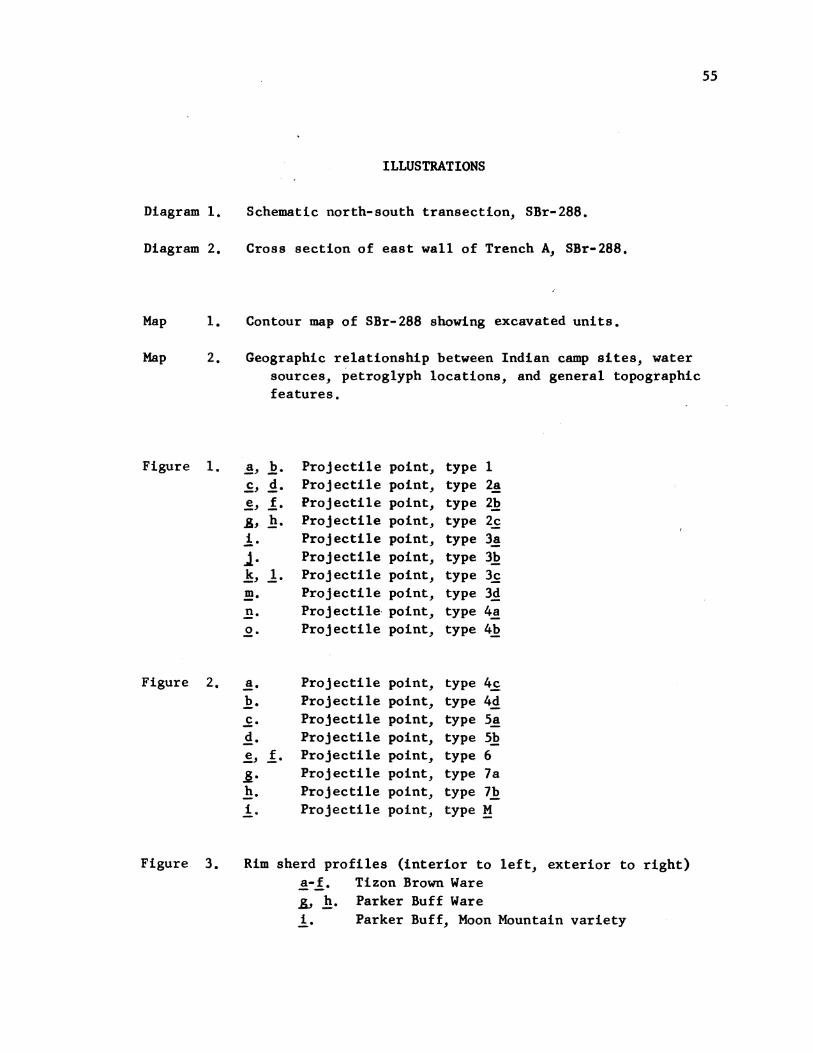
ILLUSTRATIONS
Diagram 1. Schematic north-south transection, SBr-288.
Diagram 2. Cross section of east wall of Trench A, SBr-288.
Map 1. Contour map of SBr-288 showing excavated units.
Map 2. Geographic relationship between Indian camp sites, watersources, petroglyph locations, and general topographicfeatures.
Figure 1.
Figure 2.
Figure 3.
a, b.
A, h.
i .
11k,. 1.m.n.0.
a.b.c.d.e, f.-
-
h.i.
Proj ectileProj ectileProj ectileProJectileProjectileProjectileProJ ectileProJectileProjectileProj ectile
ProjectileProjectileProjectileProjectileProjectileProjectileProj ectileProjectile
point,point,point,point,point,point,point,point,point,point,
point,point,point,point,point,point,point,point,
typetypetypetypetypetypetypetypetypetype
typetypetypetypetypetypetypetype
12a2b2c3a3b3c3d4a4b
4c4d5a5b67a7bH
Rim sherd profiles (interior to left, exterior to right)a-f. Tizon Brown Ware, h. Parker Buff Warei. Parker Buff, Moon Mountain variety

56
[Figure 31j.;.k.I-n.
ParkerParkerParker
Buff, Fort Mohave varietyBuff or Lino GrayBuff, Bouse I or II phase
Figure 4. Potsherds (catalogue numbers are those of the Robert H.Lowie Museum of Anthropology, Berkeley)
a-f. Parker Red-on Buff (UCMA 1-143075)-fi . La Paz Red-on-Buffh. La Paz Red-on-Buffi. Verde Black-on-Gray (UCMA 1-143028)j. Verde Black-on-Gray
Plate 1. a-c.d.e.f-i.
-m.n.0.
I.
r.
A-t.u.
v.
w.
z.
aa-bb.cc-dd.ee-ff.hh-hh.
ProjectileProj ectileProjecti leProjectileProjectileProjectileProjectileProjectileProjectileProj ectileProjectileProjectileProjectileProjectileProj ectileProj ectileProjectileProjectileProjectile
point, type 1point, type 7apoint, type 7bpoint, type 2apoint, type 2bpoint, type 2cpoint, type 3apoint, type 3bpoint, type 3cpoint, type 3dpoint, type 4bpoint, type 4¢point, type 4dpoint, type 5apoint, type 4apoint, type 5bpoint, type 6poin't, type Mpoint "blanks"
Crude "blades"Plano-convex "turtle-back" core scrapersLarge pressure retouched bladeStone pipe

I i 6--A
(aa
w4- JLO 0In
*
0z
Ea.-
a,I a
c0
00.-cnc
a4-
0U,
4--
0z
0.-
aE00U)
D
C,)
to
0
(D
'-1- aO Cgo -
D -
* C
C,)U
0Ii.Xao0
z
c-
I Q)
C\
0 '4-a) 0)
0 Ca) E
LL a4
U) a)a) ~- C ( co
4-\
a) -)
z
w
:J -j
cn4-
D
a)0
0o)U
CMc
U)00
L.
mCo0
4--
0
Q)
0
0Q.

- XI~ 1-
c
If -ICtv'-. c
0- -JE 4
IC- co
02-
CLE 0 c
a
c O C 4'4'.- - 3
- X 4en"a',,I %
}lsz%16
ala
7e 0 'f's*0 19
4.
4b
0V) 4 cm
0
sa ck Conyon
To Mid 4111I
1'
',!
"I",.
ToMid~4-it
- - - F - -
10"r41 % qgJo w.m
'.4 " 1-
4",
CC0 -
CC
o16. 0
40
C.,0)
'0VI
0o'0
a b c d e f
h9 I J
I m nk 0
Figure I
0 b c d
I0 f g h
Figure 2
a
b c d 0 "
29
k
h
I
VTI
m
n
n
Figure 3
a b c
d a f
9 h
i J
Figure 4
a b c d e f 9 h
1iqj k I m n o p
US V W: X
y zr s t
I
dd r
5cm. jSCALE
99 hh
Pl ate 1.