Embed Size (px)
Citation preview

Cultural Study Report
Empire Homes Project
(Tentative Tract Map 17231)
1584 E. Santa Clara Avenue
Santa Ana, Orange County, California
Prepared for: City of Santa Ana
Planning and Building Agency
20 Civic Center Plaza, Ross Annex (2nd Floor)
Santa Ana, CA 92701
Prepared by: Beth Padon, M.S.
Discovery Works, Inc.
10591 Bloomfield Street
Los Alamitos, California 90720
and: Judith Marvin, RPH No. 525
Foothill Resources, Ltd.
P.O. Box 2040
Murphys, California 95247
Date: September 5, 2008

Cultural Study Report
Empire Homes Project (TT 17231)
1584 E. Santa Clara Avenue
Santa Ana, California
September 2008
Page 2
Management Summary
This Cultural Study Report presents the archaeological, historical, and paleontological find-
ings and recommendations of the proposed Empire Homes Project, at 1584 East Santa Clara
Avenue, City of Santa Ana, California. The project area is located east of the intersection of
Grand Avenue and East Santa Clara Avenue on the northeast side of the City. This cultural
resources report was conducted under provisions of the California Environmental Quality Act
(CEQA) and the City of Santa Ana guidelines for historic resources.
On April 7, 2008, Beth Padon conducted the archaeological records review at the South
Central Coastal Information Center, which maintains archaeological records for Los Angeles,
Orange, and Ventura counties. On April 21, 2008, Judith Marvin conducted the architectural
evaluation of the existing residence located on the property and examined the local histori-
cal archives at the Santa Ana History Room (Santa Ana Library) and at the Orange County
archives (Old County Courthouse). Ms. Padon and Doug McIntosh conducted a systematic
archaeological field survey of the approximately 5-acre parcel on April 21, 2008.
Research into the known prehistory in the immediate vicinity revealed no significant recorded
archaeological sites located within two kilometers (approximately 1.25 miles) of the project
area, and the field survey found no surface indications of historic or prehistoric archaeologi-
cal resources. The Native American Heritage Commission reviewed their files and found no
Sacred Sites for the project. Review of the paleontological records showed fossil localities of
Ice-age mammals within a two mile-radius of the project site.
Based upon the contextual history of Santa Ana and its citrus industry and the architectural
history, the existing residence and property owned by the Sexlinger family is evaluated as not
eligible for the California Register of Historical Resources, and it is evaluated as not meeting
the requirements for listing in the Santa Ana Register of Historical Properties.
Based upon the known ethnographic and historical information for the region and the poten-
tial for finding buried remains in alluvium deposits, this project site is potentially sensitive for
prehistoric and possibly historic remains. Because buried remains often go undetected during
a pedestrian survey, archaeological monitoring during tree removal and grading is recom-
mended.
Based upon the potential for finding significant fossils in the older Quaternary sediments,
paleontological monitoring is recommended for excavations and removals that reach below
five feet at the project site. Specific mitigation measures for archaeological and paleontologi-
cal resources are provided in the following Cultural Study Report.

Cultural Study Report
Empire Homes Project (TT 17231)
1584 E. Santa Clara Avenue
Santa Ana, California
September 2008
Page 3
Table of Contents
Management Summary . . . . . . . . . . . . . . . . . . . . . . . . . . . . . . . . . . . . . . . . . . . . . i
Table of Contents . . . . . . . . . . . . . . . . . . . . . . . . . . . . . . . . . . . . . . . . . . . . . . . . . ii
Introduction . . . . . . . . . . . . . . . . . . . . . . . . . . . . . . . . . . . . . . . . . . . . . . . . . . . . . . 1
Project Description . . . . . . . . . . . . . . . . . . . . . . . . . . . . . . . . . . . . . . . . . . . . . 1
Project Setting . . . . . . . . . . . . . . . . . . . . . . . . . . . . . . . . . . . . . . . . . . . . . . . . . 1
Project Personnel . . . . . . . . . . . . . . . . . . . . . . . . . . . . . . . . . . . . . . . . . . . . . . . 1
Research Methods . . . . . . . . . . . . . . . . . . . . . . . . . . . . . . . . . . . . . . . . . . . . . . . . . 3
Field Methods and Archaeological Field Survey . . . . . . . . . . . . . . . . . . . . . . . . . 5
Overview of Prehistory . . . . . . . . . . . . . . . . . . . . . . . . . . . . . . . . . . . . . . . . . . . . 10
Historical Overview . . . . . . . . . . . . . . . . . . . . . . . . . . . . . . . . . . . . . . . . . . . . . . 12
Santa Ana . . . . . . . . . . . . . . . . . . . . . . . . . . . . . . . . . . . . . . . . . . . . . . . . . . . 12
Transportation . . . . . . . . . . . . . . . . . . . . . . . . . . . . . . . . . . . . . . . . . . . . . . . . 13
Agriculture and Settlement . . . . . . . . . . . . . . . . . . . . . . . . . . . . . . . . . . . . . . 14
Citrus Industry . . . . . . . . . . . . . . . . . . . . . . . . . . . . . . . . . . . . . . . . . . . . . . . . 14
Project Area . . . . . . . . . . . . . . . . . . . . . . . . . . . . . . . . . . . . . . . . . . . . . . . . . . 17
Sexlinger Residence and Property . . . . . . . . . . . . . . . . . . . . . . . . . . . . . . . . 17
Residential Architecture . . . . . . . . . . . . . . . . . . . . . . . . . . . . . . . . . . . . . . . . 19
Description of Architectural/Historical Resources . . . . . . . . . . . . . . . . . . . . . . . 21
Architectural Description . . . . . . . . . . . . . . . . . . . . . . . . . . . . . . . . . . . . . . . 21
Findings . . . . . . . . . . . . . . . . . . . . . . . . . . . . . . . . . . . . . . . . . . . . . . . . . . . . . . . 25
Paleontological Resources . . . . . . . . . . . . . . . . . . . . . . . . . . . . . . . . . . . . . . 25
Archaeological Resources . . . . . . . . . . . . . . . . . . . . . . . . . . . . . . . . . . . . . . . 25
Architectural/Historical Resources . . . . . . . . . . . . . . . . . . . . . . . . . . . . . . . . 25
Historical Evaluation/CEQA . . . . . . . . . . . . . . . . . . . . . . . . . . . . . . . . . . . . . 25
Historical Evaluation/Santa Ana Register of Historical Properties . . . . . . . 27
Recommendations . . . . . . . . . . . . . . . . . . . . . . . . . . . . . . . . . . . . . . . . . . . . . . . . 31
Recommendations for Architectural Resources . . . . . . . . . . . . . . . . . . . . . . 31
Recommendations for Archaeological Resources . . . . . . . . . . . . . . . . . . . . . 31
Recommendations for Paleontological Resources . . . . . . . . . . . . . . . . . . . . 32
Bibliography . . . . . . . . . . . . . . . . . . . . . . . . . . . . . . . . . . . . . . . . . . . . . . . . . . . . 33
Archaeological Resources . . . . . . . . . . . . . . . . . . . . . . . . . . . . . . . . . . . . . . . 33
Historical Resources . . . . . . . . . . . . . . . . . . . . . . . . . . . . . . . . . . . . . . . . . . . 34
Interviews . . . . . . . . . . . . . . . . . . . . . . . . . . . . . . . . . . . . . . . . . . . . . . . . . . . 36
Appendix 1. Department of Parks and Recreation 523 Forms . . . . . . . . . . . . . . 37
Appendix 2. Correspondence with Native American Heritage Commission . . . 41
Appendix 3. Paleontological archival review by Dr. Samuel McLeod,
Natural History Museum of Los Angeles County . . . . . . . . . . . . . . . . . . . . . 45

Cultural Study Report
Empire Homes Project (TT 17231)
1584 E. Santa Clara Avenue
Santa Ana, California
September 2008
Page 1
Introduction
This Cultural Study Report documents the
identification, recordation, and evaluation
efforts for cultural resources—archaeo-
logical, paleontological, and built environ-
ment—within the project area of the pro-
posed Empire Homes Project (Tentative Tract
Map 17231) at 1584 East Santa Clara Avenue
in the City of Santa Ana, California. This
report complies with the cultural resources
requirements of the City of Santa Ana, the
California Environmental Quality Act, and
professional standards. This study addresses
the requirements of the California Environ-
mental Quality Act (CEQA), by determining
California Register of Historical Resources
(California Register) eligibility; and Chap-
ter 30 of the City of Santa Ana’s Munici-
pal Code codified through Ord. No. 2739,
enacted April 2, 2007.
Project Description
The project is located within the northeast-
ern portion of the City of Santa Ana, about
a half-mile west of the intersection of Grand
Avenue and Santa Clara Avenue, at 1584 East
Santa Clara Avenue. The 4.8-acre parcel is
rectangular in shape and includes a remnant
orange grove and two structures, the Sex-
linger family home and garage. Specifically,
the project area covers an unsectioned por-
tion of Township 4 South, Range 9 West on
the USGS Orange 7.5’Quadrangle (Figure
1).
The proposed subdivision of the property
includes the development of 24-single family
residences, road construction between Santa
Clara Avenue and Lyon Street, landscaping,
and excavation for dry and wet utilities. The
project also involves the demolition of the
existing Sexlinger family house and garage
on the northwest corner of the property and
the removal of the remaining orange trees.
Project Setting
Topographically, the project varies slightly
in elevation from approximately 180 to
182 feet above sea level, from northwest to
southeast. The project also lies near the Santa
Ana River floodplain and south of Santiago
Creek. The Santa Ana River passes approxi-
mately two and a half miles to the west and
Santiago Creek flows approximately one mile
north of the project.
Geologically, the site contains Quaternary-
age alluvium deposits (GeoTex, Inc. 2007).
These alluvial deposits are eroded materials
from the Santa Ana Mountains. The alluvium
soils consist of interbedded layers of gray-
ish-brown silty sand, to sandy silt materials
and with some depth gravelly sand (GeoTex
2007:4).
Project Personnel
Beth Padon of Discovery Works, Inc. con-
ducted the archaeological archival review
and field evaluations for this study. Ms.
Padon meets all of the qualifications for Prin-
cipal investigator and manager as detailed in
“Archeological and Historic Preservation;
Secretary of Interior’s Standards and Guide-
lines” (Federal Register, Vol. 48, No. 190,

Cultural Study Report
Empire Homes Project (TT 17231)
1584 E. Santa Clara Avenue
Santa Ana, California
September 2008
Page 2
1983). She has a M.S. in Anthropology and
thirty years of cultural resources manage-
ment experience in California. Douglas S.
McIntosh, historical archaeologist, assisted
with the archaeological field survey and with
historical research of the property.
Judith Marvin of Foothill Resources, Ltd.
(Foothill Resources) conducted the ar-
chitectural study. Ms. Marvin conducted
the architectural survey and recordation,
the historical research for the project area
overview and the site-specific histories, and
prepared the historical study. Ms. Marvin is
a historian and architectural historian who
has been practicing in California since 1983.
She earned her Bachelor of Arts degree from
the University of California, Berkeley, with
special emphasis in California History. She
is listed in the California Council for the Pro-
motion of History Register of Professional
Historians (No. 525), and meets the Secretary
of the Interior’s Professional Qualifications
Standards as an architectural historian.
Dr. Samuel A. McLeod, Vertebrate Paleon-
tology Department at the Natural History
Museum of Los Angeles County, conducted
the paleontology archival review.
Figure 1. Project location map. Source: USGS Orange 7.5’ Quadrangle (1978, photorevised 1981). (This map is the most recent USGS map of the area. Locations on USGS topographic maps are required for the archaeology archives.)

Cultural Study Report
Empire Homes Project (TT 17231)
1584 E. Santa Clara Avenue
Santa Ana, California
September 2008
Page 3
Research Methods
Archival and oral-history research for the
project area was conducted on April 21 and
22, 2008 at repositories in the City of Santa
Ana, and in the files of Discovery Works and
Foothill Resources on April 28 and 29, 2008.
Research focused on examining historical
maps, written histories, the official records of
Orange County, and census data to determine
ownership, use, and dates of occupation for
the residence within the study area. The City
of Santa Ana, Planning Department, provided
site-specific information from previous stud-
ies (Heumann 2007).
For this project, Beth Padon conducted a re-
cords search of the project site and a 1/2-mile
radius at the South Central Coastal Informa-
tion Center (SCCIC). The archives contained
no records of cultural resources previously
identified within the project area boundaries,
and one record of an historic resource (the
Hasenyager House) within a 1/2-mile radius
of the project area. Three cultural resource
surveys had been conducted within one-mile
radius of the project area (Cason and Huey
1993, Drover 1976, and Padon 2001). Ms.
Padon also reviewed the following inven-
tories to identify historic resources in the
project area:
• Office of Historic Preservation Historic
Property Directory (12/03/07);
• California Inventory of Historic Resourc-
es (1976);
• Historical Landmarks (1990 et seq.);
• California Points of Historical Interest
(May 1992 et seq.);
• County of Orange Historical Landmarks
(1976); and
• City of Santa Ana Register of Historical
Properties (2007).
The Sexlinger residence was not listed on
any of the above inventories. A Craftsman
residence in the vicinity, the Hasenyager
House located at 2139 North Grand Avenue,
was listed in the Santa Ana Register of His-
torical Properties, and evaluated as potential-
ly eligible for listing in the National Register
of Historic Places (National Register), and
California Register of Historical Resources
(California Register) (Heumann 2002).
The County of Orange lists two local Histori-
cal Landmarks, No. 54 and No. 55, within a
two-mile radius of the project. These are both
campsites for Gaspar de Portolá’s 1769 ex-
pedition, a Spanish exploration of the coastal
and inland areas. On July 27, 1769, they
stopped on the east side of Santiago Creek,
near the present-day intersection of Chapman
and Walnut Avenues in Orange, and on July
28, 1769, they camped on the east side of the
Santa Ana River, near the historic town site
of Olive (Orange County Historical Land-
marks 1976).
In 1965, Helen Smith reviewed the several
campsites made by the Portolá expedition
in Orange County. She describes the Santa
Ana River campsite (Landmark No. 55) from
Portolá diary “as across from an Indian vil-
lage on the west bank” (Smith 1965:31). As a
source of water, natural resources, medicine,
and food, the Santa Ana River would have
been well known by the native people.

Cultural Study Report
Empire Homes Project (TT 17231)
1584 E. Santa Clara Avenue
Santa Ana, California
September 2008
Page 4
Foothill Resources conducted research in
the following repositories to identify historic
property uses and ownership:
• Orange County Archives, Santa Ana;
• Santa Ana History Room, Santa Ana
Public Library, Santa Ana;
• Discovery Works, Los Alamitos; and
• Foothill Resources, Murphys.
Also Ms. Marvin conducted oral interviews
and correspondence with local residents as
part of this study. These interviews provided
details about the property use and its history.
Persons interviewed included local residents
and historians Chris Jepson of the Santa Ana
Archives; Carolyn Schoff, Board of Direc-
tors, Orange County Historical Society; Phil
Brigandi, Historian; Skip Burch, former
grounds supervisor; and Chad Brown, current
property owner.
Published histories and the citrus industry
clipping files in the Santa Ana History Room
provided useful information on the back-
ground of the citrus industry, land use, and
change in Santa Ana. The official records,
historical maps, city directories, and census
data provided invaluable information on land
development, dates of construction, and the
Sexlinger family.

Cultural Study Report
Empire Homes Project (TT 17231)
1584 E. Santa Clara Avenue
Santa Ana, California
September 2008
Page 5
Field Methods and
Archaeological Field Survey
ments, midden soil, and other indicators of
prehistoric use. We also looked for historical
artifacts and features that could date to more
than fifty years ago, especially in the imme-
diate areas around the residence and garage
built in 1914. Ms. Padon kept the field notes,
and Mr. McIntosh took the photographs.
Figures 2 through 4 show the overall condi-
tions of the orange grove and property in two
overview photographs of the parcel, taken
from the southeast corner of the property. We
observed that many trees are in poor condi-
tion; a few trees, that appear to receive water
from the neighboring properties, are produc-
ing oranges. Improvements made to Santa
Clara Avenue removed the water connection
that had been used by the grove on the Sex-
linger property. Portola Park forms the east
side of the property and housing develop-
ments exist on the south and west boundar-
ies. Figure 5 shows approximately the center
of the property where there are no orange
trees, and shows the recent weed clearing
from disking. Mr. Skip Burch, local resident
and an individual interviewed as part of this
study, stated that he has provided weed clear-
ing for the Sexlinger family for the past 20
years (Skip Burch, personal communication,
April 16, 2008).
Discovery Works, Inc. and Foothill Re-
sources, Ltd. conducted their respective
field studies on April 21, 2008. Ms. Marvin
examined the architectural resources and Ms.
Padon and Mr. McIntosh proceeded with the
archaeological field survey, after an initial
field meeting with project representatives,
Bill Apple (City of Santa Ana), Chad Brown
(Empire Homes), and Youji R. Yasul (URS),
to share information regarding previous
meetings and discussions about the property.
Ms. Marvin examined the exterior of the
farm house structure, and recorded informa-
tion on California Department of Parks and
Recreation (DPR) 523 record forms. The
interior was not visible because the win-
dows and doorways were boarded over. Ms.
Marvin also conducted a windshield survey
of nearby streets in Santa Ana, Tustin, and
Orange to ascertain the location and relative
numbers of other Craftsman residences.
Ms. Padon and Mr. McIntosh conducted a
systematic and intensive survey of the entire
property by walking parallel transects, five
meters (about 15 feet) apart, in a north/south
direction from the east side of the parcel to
the west side. This survey sought to iden-
tify any archaeological sites, features, or
artifacts present on the surface. We looked
for chipped stone tools, grinding imple-

Cultural Study Report
Empire Homes Project (TT 17231)
1584 E. Santa Clara Avenue
Santa Ana, California
September 2008
Page 6
Figure 2. Looking north from the southeast corner of property. Portola Park is beyond the wall on the right.
Figure 3. Looking northwest from the southeast corner of property.

Cultural Study Report
Empire Homes Project (TT 17231)
1584 E. Santa Clara Avenue
Santa Ana, California
September 2008
Page 7
Figure 4. Looking west from the southeast corner of property. Residential area is beyond the fence on the left.
Figure 5. Looking northeast, from the western boundary of the property, showing the central portion that has no trees.

Cultural Study Report
Empire Homes Project (TT 17231)
1584 E. Santa Clara Avenue
Santa Ana, California
September 2008
Page 8
Along the west boundary and approximately
50 feet from the garage, Figures 6 and 7
show the remaining standpipe and gate valve
in the grove indicating the type of irrigation
system used. Immediately behind the house
and garage on the west side of the property,
we located a fifteen by fifteen foot concrete
pad with grape vines growing along the
east side of this pad. We also noted a pile of
modern debris near this concrete pad that in-
cluded tires, bricks, and modern trash (Figure
8). But we found no historic debris deposits
or items such as farming equipment, privies,
or refuse pits.
Figure 6. Doug McIntosh is inspecting the irrigation stand pipe and gate valve. View to the southwest.

Cultural Study Report
Empire Homes Project (TT 17231)
1584 E. Santa Clara Avenue
Santa Ana, California
September 2008
Page 9
Figure 8. Beth Padon is standing on the concrete pad, with modern debris in foreground. View to the south-west, from behind the garage.
Figure 7. Close-up of irrigation stand pipe and gate valve. View to the southwest.

Cultural Study Report
Empire Homes Project (TT 17231)
1584 E. Santa Clara Avenue
Santa Ana, California
September 2008
Page 10
Overview of Prehistory
sites representing this time period (7,000
year ago), typically yield large numbers of
“metates” and “manos” (milling stones) as
well as unique artifacts of unknown use,
called discoidals and cogged stones. Nu-
merous Milling Stone Horizon sites are
known in Orange County. One of these sites,
CA-ORA-83, known as the Cogged Stone
Site, is located on the Bolsa Chica Mesa, on
the northern side of Bolsa Chica Bay and
wetlands. Cogged stones are also recorded
for CA-ORA-145 and CA-ORA-163, located
south of the project.
By 5,000 years ago, coastal populations
begin exhibiting greater reliance on marine
resources. Along the coast, deep sea fishing
begins in earnest (Koerper and Drover 1983).
Circular fishhooks and perforated stones
(possibly associated with larger nets) appear.
Inland, and within the San Joaquin Hills
canyons, acorn processing technology ap-
pears. The Intermediate Horizon is followed
by the Late Prehistoric Horizon (Wallace)
or Shoshonean Tradition (Warren), begin-
ning around 1500 years ago (Bean and Smith
1978). Among the recognized archaeologi-
cal changes is the presence of arrowheads,
soapstone bowls, callus shell beads, steatite
effigies and cremations. These innovations
have been linked to the arrival of Shoshonean
peoples in the area.
By 1,000 years ago, smoking pipes and
Tizon brownware pottery also appear. This
late prehistoric period ends abruptly when
Spanish colonists begin establishing mis-
sions along the California coast. Disease and
The project is located within the general area
of the floodplain east of the Santa Ana River
and south of Santiago Creek. Early topo-
graphic maps show that the project site lies
between the natural courses of these rivers.
This general area was subject to seasonal
floods which created swamps and sloughs.
Prehistorically, the environmental condi-
tions would have been much the same. This
type of environment would have provided
abundant food and tool making resources,
and undoubtedly served as a procurement
area for regional prehistoric populations and
possible a seasonal settlement. Most of the
well-documented and investigated prehistoric
sites in Orange County that represent long-
term occupation and possible villages, are
located on the mesas around the coastal bays
and estuaries or on knolls above the flood-
plain. The archival research identified several
prehistoric sites located along the bluffs that
overlook the Santa Ana River. These loca-
tions were favored because they were more
secure and less subject to periodic destruc-
tion or disruption by flooding.
Some of the archaeological sites located
within several miles of the project site date to
the earliest identified prehistoric traditions,
termed either the Early Man Horizon (Wal-
lace 1955, 1978) or the San Dieguito Tradi-
tion (Warren 1968). The earliest, local cul-
tural tradition is a late San Dieguito compo-
nent at the Irvine Site (CA-ORA-64), on the
bluffs above middle Newport Bay. The San
Dieguito/Early Man traditions are followed
by the cultures termed either Milling Stone
Horizon or Encinitas Tradition. Prehistoric

Cultural Study Report
Empire Homes Project (TT 17231)
1584 E. Santa Clara Avenue
Santa Ana, California
September 2008
Page 11
forced mission labor greatly reduced native
populations and destroyed most traditional
cultural lifeways. Early Spanish missionar-
ies, soldiers and explorers, however, did keep
diaries and records that provide us with much
of our knowledge about the native inhabit-
ants in the area at the time of contact.
Ethnographically, the project site lies within
the territorial boundaries of the Gabrielino
Indians. The Gabrielinos were Shoshonean,
Takic language speakers, who resided in
the general Los Angeles Basin and adjacent
northern Orange County. Their name is
derived from their association with Mission
San Gabriel Arcangel. Spanish accounts and
historic interviews tell us that the Gabrielino
were intensive hunter-gatherers who used
both inland and coastal resources.
The Gabrielino people lived in either per-
manent or semi-permanent villages at two
types of locations, coastal estuaries or along
major inland watercourses, according to
detailed reconstructions of Gabrielino life
by Kroeber (1925), Johnson (1962), Bean
and Smith (1978), and McCawley (1996).
These researchers report that villages were
the focus of family life, with each individual
group linked to others by paternal kinship.
Kin groups affiliated into several village
clans. Villages were exogamous, and after
marriage the wife resided with her husband’s
kin group.
Each Gabrielino village had a headman who
paternally inherited his position. The vil-
lage headman was assisted in religious and
medical matters by a shaman, and in other
activities, such as hunting, by male special-
ists. The villages apparently were politically
independent despite inter-village marriage
and kinship ties. Gabrielino living near the
coast had different subsistence practices than
their inland relatives. Coastal Gabrielino (and
by implication their ancestors, the “proto-
Gabrielino”) were maritime hunter-gatherers,
exploiting bay and kelp bed fish, shellfish,
and even, on occasion, sea mammals. Inland
groups more intensively collected plants and
hunted terrestrial game such as deer, bear and
quail (Hudson 1971).

Cultural Study Report
Empire Homes Project (TT 17231)
1584 E. Santa Clara Avenue
Santa Ana, California
September 2008
Page 12
Historical Overview
Santa Ana Valley, which had become home
to numerous settlers attracted to the rich
cheap lands of the area. A school district
was formed that first year, with a Methodist
Episcopal Church South erected the follow-
ing (Marsh 1994, in Santa Ana Historic Time
Line 2008). Spurgeon became postmaster in
1870, and served as the first mayor when the
town was incorporated on June 1, 1886, with
a population of 2000. It was re-incorporated
under the Municipal Corporation Act the
following March, when an additional 500
residents had moved in (Goddard and God-
dard 1988).
Most of the improvements in Santa Ana were
directed or owned by Spurgeon, including
the construction of a road to Anaheim and the
original water system from an artesian well.
After Orange County was formed in 1889,
Santa Ana was selected as the County Seat,
with Spurgeon elected as president of the
Board of Supervisors. The new red Arizona
sandstone courthouse was completed in 1901
on one of Spurgeon’s lots, and is now listed
on the National Register of Historic Places
(Goddard and Goddard 1988). A hospital was
opened the following year, and the Santa Ana
City Hall erected in 1904.
According to the 1890 census, the popula-
tion of Santa Ana was 3,628 (about the same
as the City of Pasadena). The census defined
towns with populations over 2,500 as “ur-
ban,” (Gibson 1998) and Santa Ana certainly
fit this description. Although the surrounding
area was rural, Fourth Street in Santa Ana
was a thriving commercial center, with two-
The following has been abstracted from sev-
eral sources, and the reader is referred to the
referenced studies for additional information.
The economic and social development of the
Santa Ana Valley has centered around several
themes: Native American occupation, settle-
ment, agriculture, transportation, water, and
residential architecture and development. The
historical resources in the study area repre-
sent themes of settlement, agriculture, and
residential and architectural development.
Santa Ana
The area that is now the City of Santa Ana
was located on a portion of the Rancho San-
tiago de Santa Ana, granted to Jose Antonio
Yorba and his nephew Juan Pablo Peralta by
the King of Spain in 1810. The grant totaled
78,941 acres and included what later became
the community of Santa Ana (Beck and
Haase 1974:37; Hoover et al. 1990:252).
The town of Santa Ana was founded in Oc-
tober of 1869 by William Henry Spurgeon,
on a portion of a 750-acre parcel of land that
Jacob Ross Sr. purchased from the Yorba
family. Spurgeon, a native of Kentucky,
purchased 74.2 acres of land for $595 per
acre, dividing it into 24 blocks of ten lots
each. The community was bounded on the
south by First Street, West Street (Broadway)
on the west, Seventh Street on the north, and
Spurgeon Street on the east. He named his
city Santa Ana, for the rancho (Goddard and
Goddard 1988).
Spurgeon quickly set about constructing a
general store to serve the residents in the
Cultural Study Report
Empire Homes Project (TT 17231)
1584 E. Santa Clara Avenue
Santa Ana, California
September 2008
Page 13
story brick buildings housing stores, banks,
and professional offices (Marsh 1994:67)
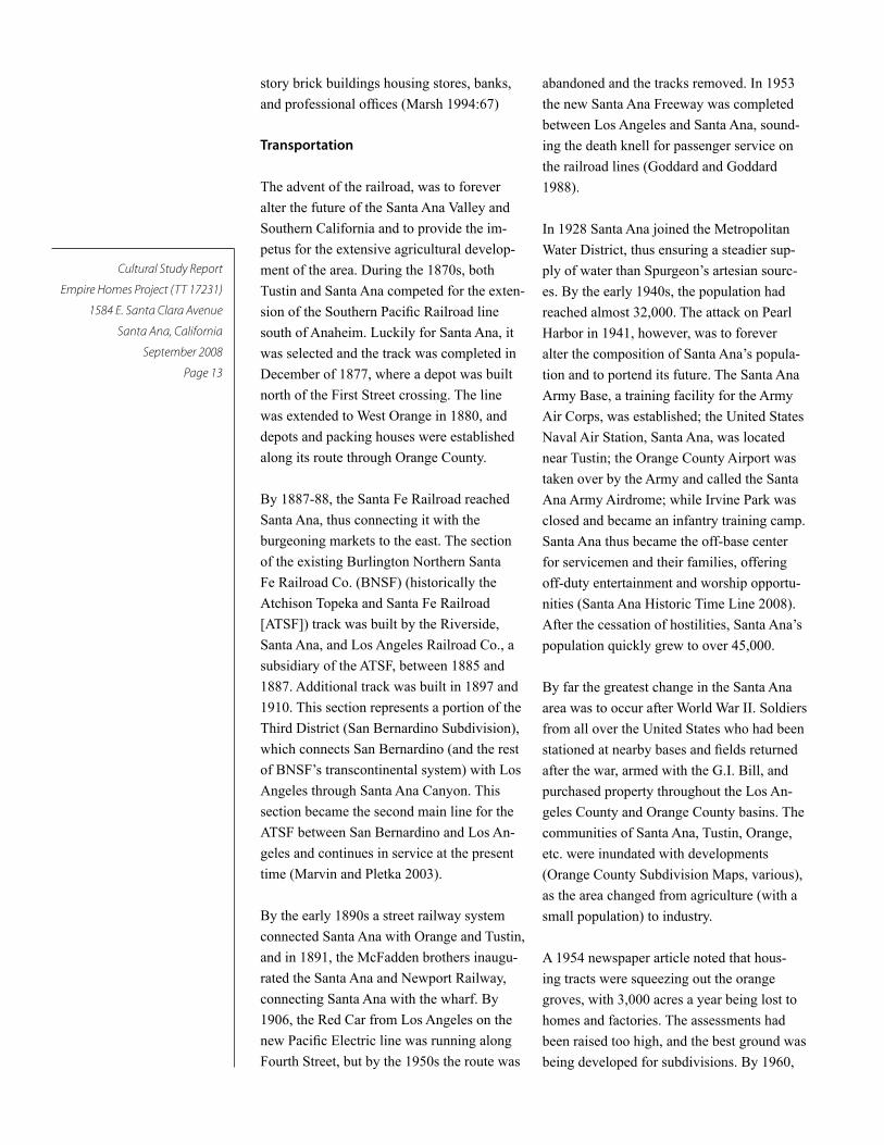
Transportation
The advent of the railroad, was to forever
alter the future of the Santa Ana Valley and
Southern California and to provide the im-
petus for the extensive agricultural develop-
ment of the area. During the 1870s, both
Tustin and Santa Ana competed for the exten-
sion of the Southern Pacific Railroad line
south of Anaheim. Luckily for Santa Ana, it
was selected and the track was completed in
December of 1877, where a depot was built
north of the First Street crossing. The line
was extended to West Orange in 1880, and
depots and packing houses were established
along its route through Orange County.
By 1887-88, the Santa Fe Railroad reached
Santa Ana, thus connecting it with the
burgeoning markets to the east. The section
of the existing Burlington Northern Santa
Fe Railroad Co. (BNSF) (historically the
Atchison Topeka and Santa Fe Railroad
[ATSF]) track was built by the Riverside,
Santa Ana, and Los Angeles Railroad Co., a
subsidiary of the ATSF, between 1885 and
1887. Additional track was built in 1897 and
1910. This section represents a portion of the
Third District (San Bernardino Subdivision),
which connects San Bernardino (and the rest
of BNSF’s transcontinental system) with Los
Angeles through Santa Ana Canyon. This
section became the second main line for the
ATSF between San Bernardino and Los An-
geles and continues in service at the present
time (Marvin and Pletka 2003).
By the early 1890s a street railway system
connected Santa Ana with Orange and Tustin,
and in 1891, the McFadden brothers inaugu-
rated the Santa Ana and Newport Railway,
connecting Santa Ana with the wharf. By
1906, the Red Car from Los Angeles on the
new Pacific Electric line was running along
Fourth Street, but by the 1950s the route was
abandoned and the tracks removed. In 1953
the new Santa Ana Freeway was completed
between Los Angeles and Santa Ana, sound-
ing the death knell for passenger service on
the railroad lines (Goddard and Goddard
1988).
In 1928 Santa Ana joined the Metropolitan
Water District, thus ensuring a steadier sup-
ply of water than Spurgeon’s artesian sourc-
es. By the early 1940s, the population had
reached almost 32,000. The attack on Pearl
Harbor in 1941, however, was to forever
alter the composition of Santa Ana’s popula-
tion and to portend its future. The Santa Ana
Army Base, a training facility for the Army
Air Corps, was established; the United States
Naval Air Station, Santa Ana, was located
near Tustin; the Orange County Airport was
taken over by the Army and called the Santa
Ana Army Airdrome; while Irvine Park was
closed and became an infantry training camp.
Santa Ana thus became the off-base center
for servicemen and their families, offering
off-duty entertainment and worship opportu-
nities (Santa Ana Historic Time Line 2008).
After the cessation of hostilities, Santa Ana’s
population quickly grew to over 45,000.
By far the greatest change in the Santa Ana
area was to occur after World War II. Soldiers
from all over the United States who had been
stationed at nearby bases and fields returned
after the war, armed with the G.I. Bill, and
purchased property throughout the Los An-
geles County and Orange County basins. The
communities of Santa Ana, Tustin, Orange,
etc. were inundated with developments
(Orange County Subdivision Maps, various),
as the area changed from agriculture (with a
small population) to industry.
A 1954 newspaper article noted that hous-
ing tracts were squeezing out the orange
groves, with 3,000 acres a year being lost to
homes and factories. The assessments had
been raised too high, and the best ground was
being developed for subdivisions. By 1960,
Cultural Study Report
Empire Homes Project (TT 17231)
1584 E. Santa Clara Avenue
Santa Ana, California
September 2008
Page 14
the population had increased to over 100,000,
although citrus was still the main industry.
With the flood of people, orange groves were
pulled out to meet the demand for houses,
resulting in the closure of most of the pack-
inghouses (Marvin and Pletka 2003).
A Civic Center, new Courthouse, and Library
were completed in the 1960s. A new City
Hall was erected in 1973, and the Orange
County Civic Center Plaza continued to
develop. During the 1980s, immigration
from Mexico, Latin America, and southwest
Asia spurred population growth, and in 1989
Orange County celebrated its centennial. In
the 1990s the City’s population increased
to over 293,000 and in the early 2000s had
reached about 338,000, 77 percent of whom
were Hispanics (Santa Ana Historic Time
Line 2008).
Today, Santa Ana’s historic core is being
redeveloped, and residential construction
continues at a rapid pace.
Agriculture and Settlement
With its rich Placentia Sandy Adobe soil
and inexpensive land, the Santa Ana Valley
quickly developed as an agricultural area.
Grapes, which had been planted in Anaheim
by the Anaheim colony in the late 1850s,
were also the staple crop of the region by the
1870s and 1880s. The phylloxera epidemic
of the 1880s was to kill most of the vines,
however, thus eliminating that agricultural
base (Carpenter 1977:72–73).
Apricots were planted ca. 1900, but went
out of favor when World War I destroyed
the market in Europe. Walnuts were planted
in the 1890s-1910s, and were an important
industry until they went into a decline in
the 1930s. Avocados were also an impor-
tant crop, as were truck gardens. The citrus
industry started in the 1880s, and after the
formation and growth of the exchanges in the
1890s, it grew rapidly to become the domi-
nant agricultural product in Orange County
until the late 1930s (Bergandi 1997:82).
Many Southern California communities grew
into important towns because of oranges.
These communities were filled with new set-
tlers who came to southern California from
distant places. They came by railroad rather
than covered wagon, and in greater numbers
and at faster rates than their predecessors.
They were the type of person who could
afford to buy a railroad ticket–merchants,
bankers, professional men, and farmers.
And when they purchased agricultural plots,
they did so as commercial enterprises, not as
homesteaders wanting to carve out a living
in the wilderness on a small family farm.
(McWilliams 1946:127-128
Some towns started as planned, agricul-
tural communities, such as Anaheim, and
George Chaffey’s planned model colony that
he named after his home town of Ontario,
Canada (Garcia 2001:28-31). Many other
communities grew into cities because of the
surrounding orchards, such as Riverside,
Pasadena, Fullerton, Placentia, and Orange,
even though they weren’t self-consciously
started as agricultural colonies. And still
other communities, such as Los Angeles,
Long Beach, and Santa Ana, grew because
they served as commercial and governmental
centers (Marsh 1994).
Citrus Industry
In 1880, the Valencia orange was introduced
into the area, planted by Richard Gilman of
Placentia, who budded five acres of orange
trees, the first commercial Valencia orchard
in California. The Portuguese (incorrectly
noted as from Spain) trees had been ordered
by Albert B. Chapman, the founder of the
City of Orange, from Thomas Rivers of Eng-
land. In 1883, the first fruit was shipped east,
and by 1909, 850 railroad cars of oranges
were shipped from the Fullerton-Placentia
area. During different eras, Caucasians,

Cultural Study Report
Empire Homes Project (TT 17231)
1584 E. Santa Clara Avenue
Santa Ana, California
September 2008
Page 15
Chinese, Japanese, and Mexican laborers
harvested the crops, with most of the area’s
residents working in the packinghouses.
The Valencia orange, which originated in
the Azores, was remarkably suited to the
area, as they were juicier and were eas-
ily stored on the trees and ripened for the
important summer market, but could stay on
the tree from May to October. When Valen-
cia oranges were planted locally, they were
protected from disease by grafting them onto
tougher “sour” rootstock, often lemons. At
first, basins were made around the trees, with
farmers carrying buckets to water them, but
irrigation systems were soon developed and
furrows dug in the orchards to flood-irrigate
the trees. Water was initially carried to the
groves through a series of open ditches, soon
replaced by concrete pipes to prevent evapo-
ration, then distributed to the trees through a
series of furrows between each row. Concrete
standpipes were connected to the system to
equalize the pressure.
An account written in 1947 noted that the
cost of planting was $1,000 for ten acres,
with total costs of $3,500 to the fifth year
when the orchards began producing. Origi-
nally, about 48 trees were planted to an acre,
but by the 1960s they were planting 200 to
the acre. Another account noted that a fair
orchard averaged 300 boxes per acre, with
a good one averaging 500 per acre, and a
few produced 800 per acre. A net return to
the grower was considerable when prices
were high, and even when not so good, were
enough to sustain the industry and the area
over a long period of time (Doig 1966:151).
Oranges were rather delicate, however, and
suffered dramatically from freezing tem-
peratures and desert winds, especially in the
freeze of 1913, when the Santiago Orange
Growers lost 25% of their crop, and in 1937,
when only 50% of the crop was salvageable.
To protect the orchards from freezing, many
orchardists used smudge pots, creating black
walls of smudge for miles around. Other
disasters included the “Riverside Winds,” or
Santa Anas, which could blow crops off the
trees. To counter this, numerous rows of Blue
Gum trees were planted as protection, but
were only partially effective. The floods of
1916 also decimated many of the orchards.
By far the biggest problem, however, was
the “Quick Decline,” or black scale, a virus,
which had to be controlled by fumigation and
spraying.
In the early years, the growers picked,
packed, and sold their citrus crops to inde-
pendent buyers or commission agents for
large commercial produce houses in Los
Angeles, San Francisco, New York, and
Chicago, who contracted to sell their crops.
Packinghouses were established in the 1880s
along the railroad lines for transshipment
to distant markets. The commission agents,
however, were the bane of growers, taking a
hefty commission, thus prompting the found-
ing of marketing organizations (Brigandi
1997:76-77).
The first cooperative association began in
1885, commencing the rapid development
of the associations in the 1890s–1920s.
The association did the harvesting, pack-
ing, shipping, and marketing for the grower,
with the most prominent growers sitting on
the boards of the co-ops. Two of the earli-
est organizations were the Orange Growers’
Protective Union and the Fruit Growers’
Union. In 1893, the Southern California Fruit
Growers’ Exchange was organized, with the
Orange Growers Association formed the fol-
lowing year. The California Fruit Growers’
Exchange was organized in 1905, combining
the associations from the north and south,
and adopted the trademark “Sunkist” in 1907.
Sunkist took over the advertising, sales, and
setting the standards for the fruit. In 1952 the
name was changed to Sunkist Growers, Inc.
(Teague 1944).

Cultural Study Report
Empire Homes Project (TT 17231)
1584 E. Santa Clara Avenue
Santa Ana, California
September 2008
Page 16
Closer to the project area, the Santiago
Orange Growers Association (SOGA) was
created on North Glassell Street in Orange
in 1893. The company originally contracted
with local private packinghouses to handle
the fruit, then built their own packinghouse
in 1899. In 1918 they constructed a massive
facility on South Cypress Street, and in 1929
shipped more than any other packing plant
in the world. By 1933 there were over 40
different packinghouses in the Orange area,
with over 200 packinghouses in the county
(Sleeper 1968).
The development of the orange industry
was fueled by the Southern Pacific Railroad,
which had land to sell and railroad cars to
fill with oranges shipping east. In a 1917
publication touting the citrus industry and
promoting Sunkist, the company stated that
one could make a net profit of 10% on an
acre valued at $2000 with 20% profit to be
made annually, as most of the oranges were
purchased for $1,000 an acre. Of course, the
value was in the railroad’s “quick shipping
over the Salt Lake Route.”
The company issued an “invitation to the
peoples of the world to come to Southern
California and see what it has to offer.” It
was the Arcadia of the West, playground for
the weary, sanitarium for the ailing, land
of outdoors, balmy breezes, genial skies of
hospitality and good cheer. The ideal home
of children, land of contrasts and achieve-
ments and Elysium of the artist. “It is God’s
Country—and man’s.” The booklet went on
to note that travelers would see 80 miles of
groves on the route from Cajon Pass to Los
Angeles, and that 50,000 carloads of or-
anges were shipped in the 1915-1916 season
(Southern Pacific Railroad 1917).
In the first decades of the twentieth century,
even more shivering easterners became
enchanted with the western weather and to
own an orange grove in Southern California
was the epitome of agricultural aristocracy.
The groves also proved to be a handsome
backdrop for a suburban home, and hundreds
were built in the 1930s. To be an orchardist
implied status, and the area was populated
with gentleman farmers on two-acre plots
calling themselves ranchers (Sleeper 1968).
As reflected upon in the 1960s:
Orange growing was an attractive oc-
cupation in many ways. The owner of
ten acres of unencumbered orange land,
with healthy trees in full bearing, was
a fortunate individual. The irrigation
and cultivation of the orchard could be
handled by one person with time to spare.
Harvesting was taken care of by the Cit-
rus Association. The beauty of a carefully
groomed orchard created an environment
for living which cannot be matched by
any of the fantastic arrays of residences
which now almost entirely cover the
land where orange trees once grew (Doig
1966:147-148).
By 1923, over 40,000 acres of oranges had
been planted in Orange County, with 1929
the biggest year ever for packinghouses. By
1932, 60,000 acres of Valencias had been
planted, with the peak in 1948 of 67,263
acres (Brigandi 1997:81). At that time the
SOGA was the largest packinghouse in the
world, and in 1963 had $19,678,900 in sales.
The SOGA folded in 1967. By 1970, most
of the packinghouses had closed, killed by
the economics of $2000 an acre for land.
The Villa Park Citrus Association, founded
in 1914, closed in 1982. Two years later the
Olive Heights Citrus Association shut down;
and in 1988, its building burned down. Freez-
ing and pests were big problems, but the
biggest impacts were the housing develop-
ments, which took the last major groves in
the 1980s.
With only small acreages remaining in
Orange County, the packers were no longer
interested, as the orchards were too small to
merit the time and costs. Some communi-
ties, however, determined to retain a least

Cultural Study Report
Empire Homes Project (TT 17231)
1584 E. Santa Clara Avenue
Santa Ana, California
September 2008
Page 17
a vestige of the crop that had provided the
sobriquet for the county and the basis of
its economy for over 50 years. In 1984 the
City of Orange established the Hoyt Grove
at Orange Park. In Tustin, the Nissan family
continued to operate their 1915 farm as late
as 1999. Irvine, which had 80,000 acres of
oranges at its peak, was reduced to 116 acres
by 2003, with a two-acre Incredible Edible
Park the only remaining orchard for public
viewing. There are, however, a number of
little pocket orchards still in production in
the area, the largest probably only an acre or
two. There are also a couple of larger groves
left in Orange County—in the Santa Ana
Canyon, and on the Irvine Ranch (Brigandi
2008).
Writing in 1968, Jim Sleeper noted that the
citrus industry was beset with “blight, bugs,
tracts, and taxes,” but that “with a century of
citrus behind it, Orange County is far from
reaping its last ‘Golden Harvest.’” The time,
however, is now, as the Santa Ana Valley,
once known as the best in the world for
oranges, has essentially been paved over and
developed for residential, commercial, and
industrial use.
Project Area
The lands in the project area were annexed
to the City of Santa Ana in 1888, but those
on the north side of East Santa Clara Avenue
were not annexed until the 1960s and 1970s,
as were those located to the east (City of San-
ta Ana Chronology of Annexations). As the
census enumerator identified the Sexlinger
family as residing in the Tustin Township,
they were evidently more closely aligned to
that community. The house is located in the
original A.B. Chapman tract, one of many
such developed by Chapman. Most of the
acreage was owned by small growers, with
five, ten, or twenty-acre farms.
By 1913, Perry V. Grout’s five-acre parcel on
Santa Clara Avenue (Block A, Section 5, Lot
5) had been purchased from Chapman and
was depicted on a map of the area (McBride
1913). As Grout was listed alternately as a
foreman and fieldman for SOGA, it appears
likely that the orchard had been planted by
that time. Grout was a resident of Orange,
so he evidently just planted and maintained
the orchard until it was purchased by the
Sexlinger family that year. During the years
1913-1918, Perry and his wife Flora sold
several parcels of land to other orange grow-
ers (Orange County Deeds, various).
Sexlinger Residence and Property
On November 18, 1913, Perry V. Grout
deeded the five-acre property on Santa Clara
Avenue to George and Sophia Sexlinger
(Deed Book 285:171), who constructed the
residence shortly thereafter. Grout evidently
sold the acreage to the Sexlinger family so
that they would operate the orchard and sell
their produce to the SOGA. As noted by
historian Phil Brigandi, five acres would have
been a rather small orchard to make a living
on, so perhaps the family had other sources
of income. One informant recalled that
George worked for the railroad at one time
(Skip Burch, personal communication, April
16, 2008).
In 1890, George Sexlinger was residing in
Saginaw, Michigan, where he was work-
ing as a clerk in the store of J. H. Shaw. Ten
years later the census listed him as aged 29, a
groceryman who rented a house. He evident-
ly followed the advice of the Southern Pacific
Railway and moved west to Southern Cali-
fornia shortly after 1910. By that time he had
married Anna Sophia Weber, also a native of
Michigan, and the couple had two daughters:
Esther Marie, born in 1903; and Martha M.,
born in 1908, both in Michigan.
In January of 1920, the Sexlinger family was
listed as residing on Santa Clara Avenue in
Tustin Township. George, aged 49, noted
his occupation as “farmer,” while Sophia,
also aged 49, was keeping house. The two
girls Esther, aged 16, and Martha, aged 11,

Cultural Study Report
Empire Homes Project (TT 17231)
1584 E. Santa Clara Avenue
Santa Ana, California
September 2008
Page 18
were residing in the household. The par-
ents of both George and Sophia were born
in Germany, and George and Sophia spoke
German. Residing nearby were numerous
others who listed their occupations as citrus
growers, general farmers, and farmers. Most
of them hailed from the Midwest: Ohio, Il-
linois, Iowa, Indiana, Michigan, etc., and the
majority were of German ancestry. George
was listed in the Orange County directories
in 1925 and 1927 as a rancher, residing on
Santa Clara Road, two miles north of Santa
Ana.
George died on November 7, 1929, and the
following year Sophia was noted as head of
household and an “orchard farmer.” Esther
was also residing in the house, but Martha
had moved to San Bernardino where she
worked as a maid in the household of the
Frank Currie family. The Sexlinger property
was still surrounded by numerous other farm-
ers, and extensive orchards were depicted
on maps of the area from Santa Ana on the
west, to Orange on the north, and Tustin on
the west (USGS 1949). In 1933 and 1940,
Sophia was listed in the Orange County
directories as an orange grower; Martha and
Esther were residing with her in the family
home. Many of the trees in the orchard are
dead or dying, and may have suffered from
the “Quick Decline” of the 1940s and 1950s,
or simply have reached their productive lifes-
pan, usually 30-50 years (Brigandi 2008).
Anna Sophia Sexlinger died on April 12,
1952, and the two daughters continued to
reside on the property. Although its citrus
production is unknown, the orchard was
regularly cared for by field supervisor Skip
Burch. Esther Marie died in Santa Ana in
February of 1995, and Martha in July of
2006. The house was then left to the vicissi-
tudes of time, weather, and vandals.
Although no site-specific information on the
Sexlinger orchard was located, an account of
the orchard of the neighbor to the east was
reported in a 1998 account and provides his-
torical comparison. This neighbor, Brennan
Ahern, was noted as one of the few remain-
ing orchardists in the county. He resided on
a six-acre parcel across from the Fairhaven
Cemetery gates on Santa Clara Avenue.
Ahern also cared for a 60-acre citrus orchard
on the grounds of the Fairhaven Memo-
rial Park, established in 1911 when orange
groves covered much of eastern Santa Ana
and nearly all of Tustin. In 1998, Ahern, then
aged 79, worked on the orchard two days a
week, watering the trees through furrows. He
noted that a light crop produced 250 cartons
of oranges an acre, and a heavy crop 700.
The cemetery was soon to bulldoze the trees,
as when they aged the “quality gave way”
(Lynch 1998). Ahern’s orchard was recently
developed as Portola Park.
The Sexlinger family orchard, at about five
acres, was a small-scale operation. Small
orchards typically had little influence upon
the citrus industry market or operations. A
contemporary historian, Carey McWilliams,
describes the roles of the fruit exchange and
small-scale orchards (1946:211-212):
The tendency of the exchange to domi-
nate all phases of production has been
furthered by the circumstance that
the typical orange–grove owner is a
gentleman-farmer who has purchased a
suburban estate as a means of acquiring
status. Today the local packing associa-
tions supply all the harvesting labor for
their members, furnishing picking crews,
hauling facilities, and all equipment, and
undertaking, upon request, to take charge
of pruning and insect control. Not only is
this procedure agreeable to the average
grower, but it enables the exchange to
rationalize production. Thus the harvest-
ing proceeds on a carefully worked out
schedule, area by area, zone by zone, as
a single collective year-round operation.
So thoroughly has management been di-
vorced from ownership that, in the words
of Dr. J. Eliot Coit, “there are many citrus
farmers who do no manual work on their
farms.”...

Cultural Study Report
Empire Homes Project (TT 17231)
1584 E. Santa Clara Avenue
Santa Ana, California
September 2008
Page 19
However, there are some real farmers in the
industry. These are the “commercial grow-
ers,” who operate citrus farms, not for status,
but for profit, the “determined agricultural-
ists” who put the industry on a paying basis.
Fabulously successful, these larger concerns
dominate the central exchange and its local
and district branches. For years the manageri-
al talent for the central, district,
and local exchanges has been
recruited from the personnel of
the large commercial producers.
Nor can there be any doubt that
these concerns dominate the in-
dustry. In 1930, 115 commercial
growers, constituting 3.4% of
the total number of growers, received 27.7%
of the $20,000,000 income from citrus farms
in Orange County.
People of many nationalities worked in the
citrus industry in Southern California. Ini-
tially, Native Americans, Chinese, Japanese,
and Filipinos supplied much of the labor.
This gradually changed, primarily as result
of the Chinese Exclusion Act and Geary Act,
and the turmoil of the Mexican Revolution.
After 1900, most of the field workers came
from Mexico. Many Mexican immigrants
did not stay permanently, since it was easy to
return the short distance for family concerns
or because they had earned enough money
in the U.S. The number of Mexican immi-
grants significantly declined during the Great
Depression of the 1930s, when growing
unemployment fed hostility to immigrant
workers. However, labor shortages during
World War II led the U.S. and Mexico to cre-
ate the bracero program, which brought new
Mexican laborers to Orange County.
World War II marked the beginning of many
significant changes in southern California,
which eventually affected the cultural land-
scape and ethnic mix of many communities.
The U.S. Census of 1930 created a one-time
designation of “Mexican” as a racial category
for all persons born in Mexico or whose
parents were born in Mexico. This category
was discontinued for the next census, but in
1970, the census began recording Hispanic
origin. The following table (from Gibson
and Jung 2005) shows that the proportion of
Santa Ana residents of Hispanic origin grew
at a smaller pace from 1930 to 1970 than it
did after 1970:
Thus it appears that the major increase in
Hispanic population for Santa Ana came after
the decline of small-scale orchards, such as
the Sexlinger family orchard.
Residential Architecture
The most dominant style in the decade of the
1910s, and continuing into the 1920s, was
the Craftsman Bungalow (also known as
the California Bungalow). The style origi-
nated in Southern California, inspired by the
work of Charles Sumner Greene and Henry
Mather Greene of Pasadena (McAlester and
McAlester 1984). With their low-pitched
gable roofs, wide eave overhangs, exposed
roof rafters and knee braces, full or partial
width porches, and roofs supported by square
columns, the homes were especially suited to
the California climate and more relaxed way
of life engendered by the reaction against the
flamboyance of the Victorian Era.
As described:
Craftsman (circa 1900–1925)
The craftsman movement, named after
a magazine published by Gustav Stick-
ley, was the American counterpart of
the English arts and crafts movement.
In part a reaction against the excesses,
both aesthetic and otherwise, of the
Year Total population Hispanic origin (of any race)
1930 30,322 3,633 (12%)
1970 (15% sample) 156,483 38,505 (24.6%)
1980 203,713 90,646 (44.5%)
1990 293,742 191,383 (65.2%)

Cultural Study Report
Empire Homes Project (TT 17231)
1584 E. Santa Clara Avenue
Santa Ana, California
September 2008
Page 20
Victorian era, Craftsman architecture
stressed the importance of simplicity, of
adapting form to function, and of relating
the building to its designer through the
incorporation of craftsmanship and to the
surrounding landscape through its hug-
ging of the ground, massing and siting.
It was an outgrowth of the Shingle Style
and certain variants were influenced by
Japanese architecture. The Craftsman
bungalow was usually characterized by a
rustic aesthetic of shallowly pitched over-
hanging gable roofs; earth-colored wood
siding; spacious, often L-shaped porches;
windows, both casement and double-hung
sash, grouped in threes and fours; exten-
sive use of natural wood in the interior
and for front doors; and exposed structur-
al elements such as beams, rafters, braces,
and joints. Cobblestone or brick was
favored for chimneys, porch supports,
and foundations. The heyday of Crafts-
man design was the decade between 1906
and 1916; after that the Craftsman style
was simplified, often reduced to signature
elements such as an offset front gable
roof, tapered porch piers, and extended
lintels over door and window openings.
In many cases, the Craftsman style incor-
porated distinctive elements from other
architectural styles, resulting in numerous
variations. During the 1910s and 1920s,
numerous companies sold plans and
complete construction kits for Craftsman
homes, including Wardway (Montgomery
Ward), Sears-Roebuck & Co., Wilson,
Aladdin, and others (Starzak 1993).
It appears likely that the Sexlinger House
was constructed from a kit, or, at least, used
pre-designed plans.
Cultural Study Report
Empire Homes Project (TT 17231)
1584 E. Santa Clara Avenue
Santa Ana, California
September 2008
Page 21
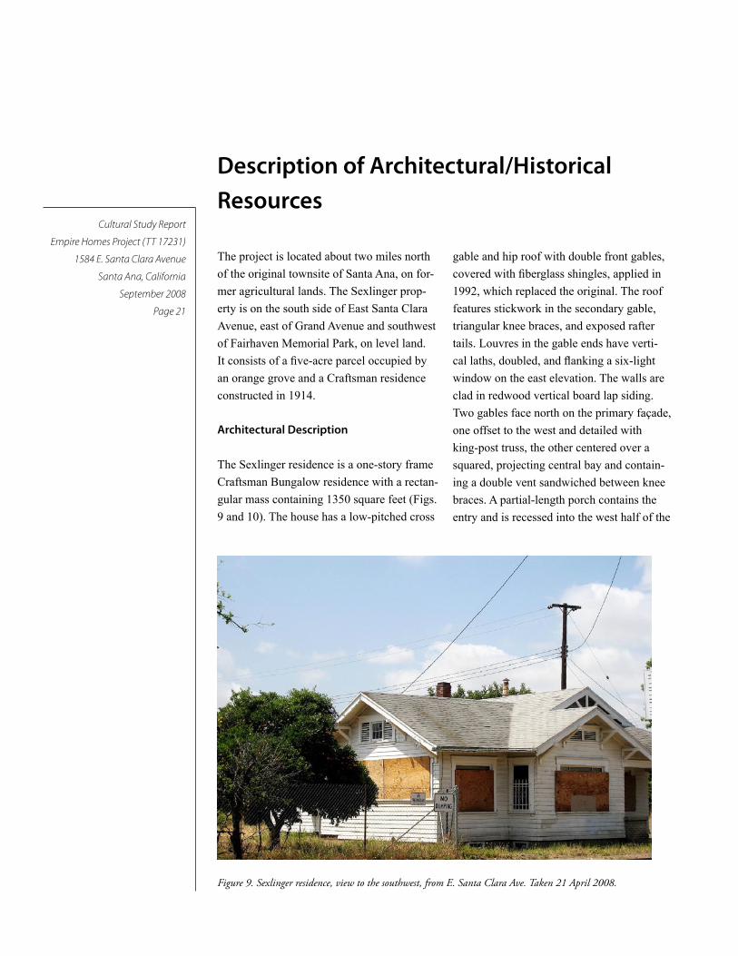
Description of Architectural/Historical
Resources
gable and hip roof with double front gables,
covered with fiberglass shingles, applied in
1992, which replaced the original. The roof
features stickwork in the secondary gable,
triangular knee braces, and exposed rafter
tails. Louvres in the gable ends have verti-
cal laths, doubled, and flanking a six-light
window on the east elevation. The walls are
clad in redwood vertical board lap siding.
Two gables face north on the primary façade,
one offset to the west and detailed with
king-post truss, the other centered over a
squared, projecting central bay and contain-
ing a double vent sandwiched between knee
braces. A partial-length porch contains the
entry and is recessed into the west half of the
The project is located about two miles north
of the original townsite of Santa Ana, on for-
mer agricultural lands. The Sexlinger prop-
erty is on the south side of East Santa Clara
Avenue, east of Grand Avenue and southwest
of Fairhaven Memorial Park, on level land.
It consists of a five-acre parcel occupied by
an orange grove and a Craftsman residence
constructed in 1914.
Architectural Description
The Sexlinger residence is a one-story frame
Craftsman Bungalow residence with a rectan-
gular mass containing 1350 square feet (Figs.
9 and 10). The house has a low-pitched cross
Figure 9. Sexlinger residence, view to the southwest, from E. Santa Clara Ave. Taken 21 April 2008.

Cultural Study Report
Empire Homes Project (TT 17231)
1584 E. Santa Clara Avenue
Santa Ana, California
September 2008
Page 22
façade. The porch, supported by
a square column of manufactured
concrete brick, has a concrete
floor and steps. The house has a
concrete perimeter foundation,
pierced with vents, and concrete
walkways. Fenestration consists
of frame windows, with large
tripartite windows in the primary
façade and 1/1 light frame sash
on the side and rear elevations.
Primary entry is via the origi-
nal oak door from the porch; it
features four vertical lights and
recessed panels and is covered
with a modern metal security
door (Figure 11). Entry to the
rear of the house is provided by
a frame door with four lights and
a recessed panel, accessed by a
concrete stoop and steps. A metal
security door also covers the rear
entry and the windows on the rear
elevation.
Figure 10. North façade facing E. Santa Clara Ave., showing intersecting gables with Craftsman details.
Figure 11. Front porch and corner post, view to the southeast.
Cultural Study Report
Empire Homes Project (TT 17231)
1584 E. Santa Clara Avenue
Santa Ana, California
September 2008
Page 23
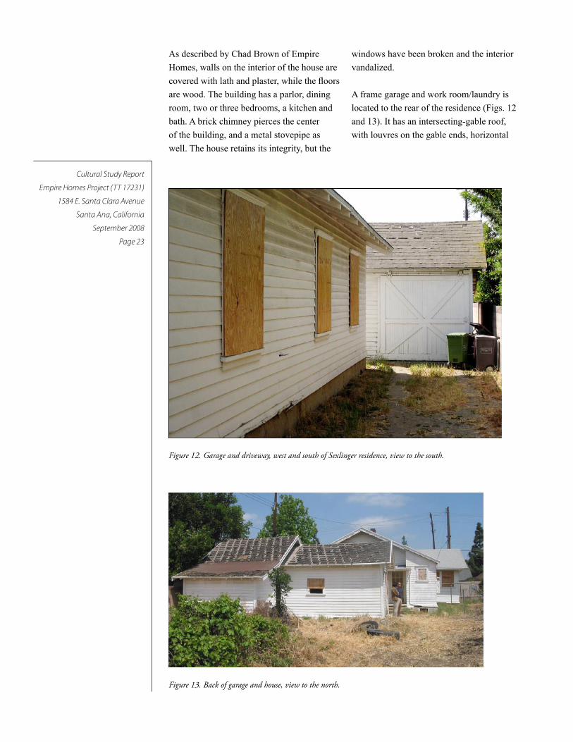
As described by Chad Brown of Empire
Homes, walls on the interior of the house are
covered with lath and plaster, while the floors
are wood. The building has a parlor, dining
room, two or three bedrooms, a kitchen and
bath. A brick chimney pierces the center
of the building, and a metal stovepipe as
well. The house retains its integrity, but the
windows have been broken and the interior
vandalized.
A frame garage and work room/laundry is
located to the rear of the residence (Figs. 12
and 13). It has an intersecting-gable roof,
with louvres on the gable ends, horizontal
Figure 12. Garage and driveway, west and south of Sexlinger residence, view to the south.
Figure 13. Back of garage and house, view to the north.

Cultural Study Report
Empire Homes Project (TT 17231)
1584 E. Santa Clara Avenue
Santa Ana, California
September 2008
Page 24
board lap siding, the original sliding sawbuck
door on a metal track, and a concrete floor.
The residence is located on the northwest
corner of the orchard, facing north towards
East Santa Clara Avenue and northeast to
Fairhaven Memorial Park.
The citrus orchard, with approximately 250
Valencia orange trees grafted to lemon root-
stock (Figure 13) are arranged in a plot ap-
proximately 20 rows wide (east to west) and
25 rows long (north to south), is located east
and south on the five-acre parcel. A concrete
standpipe and gate valve, were identified in
the orchard, approximately 50 feet south of
the garage.
Figure 13. Old orange tree in Sexlinger Orchard. View over existing chain link fence.
Cultural Study Report
Empire Homes Project (TT 17231)
1584 E. Santa Clara Avenue
Santa Ana, California
September 2008
Page 25
FindingsPaleontological Resources
Dr. McLeod, Vertebrate Paleontologist, con-
ducted the paleontological records review at
the Natural History Museum of Los Angeles
County for the Empire Homes Project. Dr.
McLeod’s letter report is included with this
report as Appendix 3. He identified no fossil
localities previously recorded for the project,
but the records show locality LACM 4943,
located near the intersection of Glassell
Street and Fletcher Avenue, in the City of
Orange. This locality yielded fossil horse
from the older Quaternary sediments; it was
found at a depth of 8 to 10 feet below the
ground surface. Significant vertebrate fossils
from this age include Ice-age mammals such
as extinct camels, mammoths, mastodons,
and ground sloths.
Archaeological Resources
The pedestrian survey found no archaeologi-
cal resources identified within the project
site. But recent plowing of the ground sur-
face for fire prevention has obscured ground
visibility. The field crew found little evidence
of past activities except for one remaining
standpipe and gate valve, which are typi-
cal of the orange groves, and one 15 by 15
foot concrete, flat pad, south of the existing
garage and laundry building. No early trash
deposits were noted, but the recent and past
plowing throughout the project site limited
the visibility of the original ground surface.
Architectural/Historical Resources
The Sexlinger residence, older than 50 years,
was evaluated for its eligibility for listing in
the California Register and for listing on the
Santa Ana Register of Historical Properties.
Currently, it is not listed on either directory.
Historical Evaluation/CEQA
According to CEQA, resources eligible for
the California Register of Historical Re-
sources (CRHR) must retain enough of their
historic character or appearance to be recog-
nizable as historical resources and to convey
the reasons for their significance. According
to the CRHR guidelines (Title 14, Chapter
11.5, California Code of Regulations (CCR)
§4852(c)), integrity is authenticity of physi-
cal identity of an historical resource. Integrity
means that characteristics survive from the
resource’s period of significance. Integrity
is evaluated with regard to the retention of
location, setting, feeling, association, design,
material and workmanship.
In addition to integrity, resources eligible
for the CRHR must meet at least one of the
criteria for significance. We evaluated the
Sexlinger house for historical significance,
as defined by the CEQA Guidelines. An
“historical resource,” as defined by Pub. Res.
Code 5020.1
(j) is any object, building, structure,
site, area, place, record, or manuscript
which is determined to be historically

Cultural Study Report
Empire Homes Project (TT 17231)
1584 E. Santa Clara Avenue
Santa Ana, California
September 2008
Page 26
significant in the architectural, engineer-
ing, scientific, economic, agricultural,
educational, social, political, military, or
cultural annals of California.
The criteria used for evaluation in these areas
include those criteria outlined in Pub. Res.
Code §5024.1, Title 14 CCR, Section 4852
for inclusion in the California Register of
Historical Resources (CRHR) and include
any resource that fits the following:
(1) Is associated with events that have made
a significant contribution to the broad
patterns of California’s history and cul-
tural heritage;
(2) Is associated with the lives of persons
important in our past;
(3) Embodies the distinctive characteristics
of a type, period, region, or method of
construction, or represents the work of
an important creative individual, or pos-
sesses high artistic values; or
(4) Has yielded, or may be likely to yield,
information important in prehistory or
history.
The Sexlinger residence, an architectural
resource older than fifty years, was recorded
on California DPR Form 523 as part of this
study (Appendix 1) and evaluated accord-
ing to the California Register of Historical
Resources criteria. The evaluation includes
the analysis of its integrity, then the analysis
of its historical significance.
The Sexlinger residence has its original form
and shape, and retains its historical setting.
However, the orchard is no longer viable,
having reached an age of diminished produc-
tion.
The property was assessed under CRHR
Criterion 1 for its potential significance as a
part of a historic trend that may have made a
significant contribution to the broad patterns
of local or regional history, or the cultural
heritage of California or the United States.
The Sexlinger residence is associated with
the development of the citrus industry in
the early decades of the twentieth century.
But small citrus operations, such as the
Sexlinger’s, are evaluated as not significant
contributors to that event. By the 1910s, large
commercial orchards dominated the citrus
industry. Therefore, the Sexlinger residence
and grounds are evaluated as ineligible for
the CRHR under Criterion 1.
CRHR Criterion 2, for its association with
the lives of persons important to local, Cali-
fornia, or national history.
The Sexlinger family occupied the property
during its period of significance. Careful
review of the archives at the Santa Ana
Library, History Room and at the County
Archives found no mention of the Sexlinger
family as prominent community leaders or
active members of local associations such as
church, school, or other community organi-
zations. No direct connections or references
to the Sexlinger family for the period of sig-
nificance were found. Recently, the estate of
Martha Sexlinger made donations to Concor-
dia University and to Orange Lutheran High
School (Ann Ashmon, Concordia University,
personal communication, June 27, 2008).
Further inquiries about the donations found
no more information about the Sexlinger
family and their association with the history
of Santa Ana or these institutions. Therefore,
the residence is evaluated as ineligible for the
CRHR under Criterion 2.
CRHR Criterion 3, for embodying the dis-
tinctive characteristics of a type, period, or
method of construction, or representing the
work of a master or possessing high artistic
values.
This residence was constructed in 1914 in
a modest Craftsman style. Residences such
as this one were built between the 1890s
and 1930s and these houses varied in size
and grandeur. The evaluated residence is an
Cultural Study Report
Empire Homes Project (TT 17231)
1584 E. Santa Clara Avenue
Santa Ana, California
September 2008
Page 27
example of the Craftsman, which was the
dominant architectural style from about the
late 1900-1910 years to the 1920s in South-
ern California. Although the building retains
its integrity, it is not the work of a master, nor
does it possess high artistic values or archi-
tectural significance. Like the other Crafts-
man houses in Santa Ana and its vicinity, the
Sexlingers could have built this house from
a kit or used pre-designed plans. Better ex-
amples of Craftsman period architecture can
be found throughout the City. The property is
evaluated as ineligible for the CRHR under
Criterion 3.
CRHR Criterion 4, for the potential to yield
or likelihood to yield information important
to prehistory or history of the local area,
California, or the nation.
In order for buildings, structures, and objects
to be eligible for this criterion, they would
need to “be, or must have been, the principal
source of important information.” This is not
the case with this property. Therefore, it is
evaluated as not eligible for the CRHR under
Criterion 4.
According to the criteria for historical re-
sources under CEQA, the Sexlinger property
would not be defined as an historical resource
and it is evaluated as ineligible for listing on
the California Register.
Historical Evaluation/Santa Ana Register of Historical Properties
For the City of Santa Ana, we applied the
Santa Ana Register of Historical Proper-
ties (SARHP), which is found in Sec. 30-2,
Criteria for Selection, Chapter 30, Places Of
Historical And Architectural Significance, of
the Municipal Code for Santa Ana (http://
www.ci.santaana.ca.us/pba/planning/His-
toricPreservation.asp).
Sec. 30-1. Register of historical properties.
The historic resources commission may,
by resolution and at a noticed public
hearing, designate as historical property
any building or part thereof, object,
structure, or site having importance to
the history or architecture of the city in
accordance with the criteria set forth in
section 30-2. The commission secretary
shall maintain a register which shall
consist of copies of each such resolu-
tion and which shall be known as the
city register of historical properties. The
historic resources commission may at
any time repeal, revise, or modify any
such resolution upon reconsideration of
the historical or architectural importance
of the places therein described.
(Ord. No. NS-1519, § 1, 3-17-80; Ord.
No. NS-2338, § 1, 12-1-97; Ord. No.
NS-2363, § 3, 8-3-98; Ord. No. NS-
2455, § 1, 12-4-00; Ord. No. NS-2521, §
3, 1-21-03)
Sec. 30-1.5. Definitions.
Certificate of appropriateness means the
method by which the historic resources
commission approves modifications to
a historic property pursuant to section
30-6.
Dangerous buildings shall have the
same definition as the Uniform Code
for the Abatement of Dangerous Build-
ings which may from time to time be
amended.
Historic property shall include a build-
ing, structure, object or site designated
as having historical significance and
listed on the federal, state or local reg-
ister of historical properties, as well as
those contributing properties located in
an historic district.
Local historic district means a collection
or group of historic properties within a
defined area.
Modification means any change, altera-
tion, restoration, remodeling, rehabilita-
tion, construction, or relocation of the

Cultural Study Report
Empire Homes Project (TT 17231)
1584 E. Santa Clara Avenue
Santa Ana, California
September 2008
Page 28
physical exterior of a historic structure.
Modification shall not include painting.
Register of historical properties means
the official list of historic properties in
the city.
(Ord. No. NS-2338, § 2, 12-1-97; Ord.
No. NS-2455, § 3, 12-4-00; Ord. No.
NS-2521, § 4, 1-21-03)
Sec. 30-2. Criteria for selection.
(a) Any person or group may request a
building, or part thereof, structure, object
or site, to be designated to be included
on the city register of historical proper-
ties (called “register” in this section).
The applicant must submit documenta-
tion that demonstrates how the nomi-
nated building, structure, object or site
satisfies the criteria for designation. A
building, structure, object, or site may be
designated for inclusion on the register
if the building, structure, object or site
is fifty (50) or more years old and if the
commission finds that one (1) or more of
the following conditions are met:
(1) Buildings, structures or objects with
distinguishing characteristics of an archi-
tectural style or period, that exemplify
a particular architectural style or design
features;
(2) Works of notable architects, build-
ers, or designers whose style influenced
architectural development;
(3) Rare buildings, structures, or objects
or original designs;
(4) Buildings, structures, objects or sites
of historical significance which include
places:
a. Where important events occurred;
b. Associated with famous people,
original settlers, renowned organizations
and businesses;
c. Which were originally present
when the city was founded; or
d. That served as important centers
for political, social, economic, or cul-
tural activity.
(5) Sites of archaeological importance;
(6) Buildings or structures that were con-
nected with a business or use which was
once common, but is now rare.
(b) The owner of a property(s) must be noti-
fied of its nomination upon receipt of an
application by the planning and building
agency. Upon adoption and placement of
the property on the register, the resolu-
tion of designation shall be recorded
with the county recorder’s office pursu-
ant to California Public Resources Code
section 5029, as it may be amended from
time to time.
(Ord. No. NS-1519, § 1, 3-17-80; Ord.
No. NS-2338, § 3, 12-1-97; Ord. No.
NS-2455, § 4, 12-4-00; Ord. No. NS-
2521, § 5, 1-21-03)
The Sexlinger property meets the City of
Santa Ana’s initial selection criteria for a
historic property because it is older than 50
years. It was constructed in 1914. But in ad-
dition, it must also meet one of the six, listed
conditions in order to be listed on the Santa
Ana Register of Historic Properties.
SARHP Condition (1) a structure or site with
distinguishing characteristics of an architec-
tural style or period, that exemplifies a par-
ticular architectural style or design features.
The Sexlinger residence is an example of a
Craftsman style house. It retains its his-
torical integrity, but it is not an important
or significant example of this architectural
style or period. It is evaluated as not meeting
Condition (1).
SARHP Condition (2) Works of notable
architects, builders, or designers whose style
influenced architectural development.
Based upon archival research, the Sexlinger
residence is not the work of a notable archi-
tect, builder or designer. It is evaluated as not
meeting Condition (2).

Cultural Study Report
Empire Homes Project (TT 17231)
1584 E. Santa Clara Avenue
Santa Ana, California
September 2008
Page 29
SARHP Condition (3) Rare buildings, struc-
tures, or objects or original designs.
As a Craftsman-style house, the Sexlinger
residence is a modest example of this very
popular style. In the 1910s through the
1930s, the Craftsman-style house was the
prominent housing type constructed through-
out southern California. This style appealed
to the local needs of costs, resources, and
ease of building. The Sexlinger house then is
not a rare or original designed structure, and
it is not architecturally significant to the City
of Santa Ana. It is evaluated as not meeting
Condition (3).
SARHP Condition (4) Buildings, structures,
objects or sites of historical significance,
which include places:
a. Where important events occurred;
b. Associated with famous people, original
settlers, renowned organizations and busi-
nesses;
c. Which were originally present when the
city was founded; or
d. That served as important centers for politi-
cal, social, economic, or cultural activity.
Historically, the City of Santa Ana started in
1869 by William H. Spurgeon. He laid out
the town of 24 blocks of ten lots each near
the Santa Ana River with Seventh Street
as the northern border. By 1910 when the
Sexlinger family arrived in Orange County,
Santa Ana had grown into the commercial
and civic center of the County. The Sexlinger
property lies two miles north of the found-
ing center of town. The area immediately to
the east and north of the Sexlinger property
remained outside of the City limits until the
1960s and 1970s. Agriculture served as the
primary industry in Orange County from the
early 1870s to the 1940s. Many crops were
grown, but citrus dominated from the 1890s
to the 1940s, with the Valencia oranges
introduced in 1880 in Anaheim. By 1914,
when the Sexlinger family bought the prop-
erty, the citrus industry was well-established
with grower associations, railroad lines, and
services in place for the harvesting, packing,
shipping, and marketing of the fruit.
When George Sexlinger worked the property
(1914 to 1929), large orchards dominated the
citrus industry, and controlled the exchanges
where marketing, employment, packing
and harvesting decisions were made. Larger
orchards could meet the growing demand for
oranges in the 1920s and 1930s. Colonias,
where immigrant Mexican families lived,
were located near the larger orchards, where
most of the workers were employed (O’Neil
1989:115).
Even though the citrus industry was impor-
tant in Orange County, the Sexlinger property
represents a minor part of that industry. Ar-
chival research showed that it was not a place
where important events occurred, or associ-
ated with famous people, original settlers,
renowned organizations and businesses, or
present when the City was founded or served
as an important center for political, social,
economic, or cultural activity. It is evaluated
as not meeting Condition (4).
SARHP Condition (5) Sites of archaeological
importance.
The period of significance of the Sexlinger
property ranges from 1914 to 1940s when
citrus played an important role in the ag-
riculture history of Orange County. Items
from this time period such as farm equip-
ment, tools, personal items, kitchenware,
and features such as privies, debris deposits,
cisterns, irrigation equipment would assist in
telling the story of the Sexlinger family and
its role in the citrus industry. Except for one
standpipe and an irrigation value, the archae-
ological field survey found no evidence for
these features or artifacts. There is a possibil-
ity for finding buried resources, but the past
disking between the remaining orange trees
and the deterioration to the house and garage
have obscured this evidence. It is evaluated
as not meeting Condition (5).

Cultural Study Report
Empire Homes Project (TT 17231)
1584 E. Santa Clara Avenue
Santa Ana, California
September 2008
Page 30
SARHP Condition (6) Buildings or structures
that were connected with a business or use,
which was once common, but is now rare.
The citrus industry was responsible for the
development of several towns and agricultur-
al areas in Orange County. In contrast, Santa
Ana developed as a commercial and civic
center that served the surrounding agribusi-
nesses, including the citrus industry. The City
was not a major center of orange production.
Small orchards did not play a significant
role in the development of Santa Ana, either
physically or culturally. The existence of
small family orchards such as the Sexlinger
orchard did not create an influx of immi-
grants; this migration came later, as result of
federal decisions and opportunities created
by large commercial enterprises.
Although it may be said that small orchard
operations were once common in Santa Ana,
small orchards such as the Sexlinger property
were not, in and of themselves, significant to
the growth and development of Santa Ana.
The Sexlinger property is evaluated as not
meeting Condition (6).
Because this property does not meet Condi-
tions 1-6 for historic properties, the Sexlinger
property is evaluated as not eligible for list-
ing on the Santa Ana Register of Historical
Properties.
The potential for a California or Santa Ana
Register District was also considered when
conducting research, survey, and evaluation,
but there were no extant concentrations of
architectural styles or temporal periods of
development in the vicinity of the Sexlinger
property. The Fairhaven Memorial Park was
located to the northeast, with the Portola Park
to the east, and modern residential subdi-
visions to the north, west, and east of the
property.

Cultural Study Report
Empire Homes Project (TT 17231)
1584 E. Santa Clara Avenue
Santa Ana, California
September 2008
Page 31
Recommendations
2. An Orange County Certified Archaeolo-
gist shall be retained to monitor grading
activities, to observe and retrieve any buried
prehistoric and historic artifacts or features
that may be uncovered.
3. If human remains are found during the
excavation, the Native American Graves Pro-
tection Act Guidelines and State law require
that construction personnel:
• Halt the work in the immediate area,
• Leave the remains in place,
• Contact the Manager, project personnel,
and the Orange County Coroner.
Until a representative of the Coroner’s office
reviews the remains in the field, they must
not be removed. If the Coroner determines
that the remains are prehistoric, the Coroner
contacts the Native American Heritage Com-
mission and the most likely descendent from
the Native American community is informed.
The final deposition of remains is coordinat-
ed by representatives of the property owner
and the most likely descendent.
4. If prehistoric or historic artifacts or
deposits are uncovered, the Orange County
Certified Archaeologist shall temporarily
halt construction activities for the immediate
area until the archaeologist can evaluate the
significance of the find. The archaeologist
would immediately contact the field man-
ager and project personnel. Implementation
of a recovery program would follow, if the
remains are determined potentially eligible to
the California Register.
Recommendations for Architectural Resources
Although the Sexlinger House is evaluated
as ineligible for the California or Santa Ana
registers, it is part of the history of the area.
It is recommended that copies of this report,
in hard copy and on disk, should be filed with
the Santa Ana Historical Society, the Santa
Ana History Room of the Santa Ana Library,
and made available to any other repositories
which request them.
Recommendations for Archaeological Resources
Based upon the GeoTex, Inc. report, it ap-
pears likely that previously undisturbed soils
will be reached during the over-excavation of
the project site. And because previous plow-
ing masked the ground surface, archaeologi-
cal monitoring is recommended to reduce the
project’s potential of impacting significant
cultural resources. The following mitigation
measures are recommended for new con-
struction at the Empire Homes Project. These
mitigation measures will reduce any project
impacts to unknown buried archaeological
and historical resources.
1. An Orange County Certified Archaeologist
shall be present at the pre-grade and at the
tree removal meetings to discuss the monitor-
ing, collecting and safety procedures for the
project. At this time, the archaeologist should
review the construction plans and schedule.
Cultural Study Report
Empire Homes Project (TT 17231)
1584 E. Santa Clara Avenue
Santa Ana, California
September 2008
Page 32
5. Any recovered artifacts shall be properly
collected with photographs, field notes, and
locations plotted on a USGS 7.5’topographic
quadrangle. Artifacts will be identified and
catalogued, and stabilized for curation. Any
recovered artifacts shall be offered, on a first
right-of-refusal basis, to a repository with a
retrievable collection system and an educa-
tional and research interest in the materials.
6. A final monitoring report, including an
itemized inventory and pertinent field data,
shall be sent to the Lead Agencies as well
as copies of the report to the South Central
Coastal Information Center at the California
State University at Fullerton.
Recommendations for Paleontological Resources
Based upon the soils report, the new develop-
ment for the Empire Homes Project probably
will not reach the older Quaternary (Pleis-
tocene) sediments that underlie the younger
Quaternary Alluvium, except for the con-
struction of sewerlines and utility lines that
may reach a depth of 8 to 10 feet below the
existing ground level. These deep trenches
may impact potentially sensitive sediments
for significant vertebrate fossils.
We recommend that paleontological moni-
toring would be appropriate for trenches or
other deep excavations that extend at least
five feet or more below the existing ground
surface. Paleontological monitoring includes:
1. During grading activities, a qualified pale-
ontologist shall be retained to conduct part-
time monitoring to observe and retrieve any
significant specimen that may be uncovered
in the older Quaternary sediments.
2. If vertebrate fossils or a buried deposit
is uncovered, the paleontological monitor
shall temporarily halt construction activi-
ties for the immediate area until the monitor
can evaluate the significance of the find. The
monitor would immediately contact the field
manager and project personnel. Implementa-
tion of a recovery program would follow, if
the fossils are determined significant.
3. Any recovered fossils shall be properly
collected with photographs, field notes, and
locations plotted on a USGS 7.5’topographic
quadrangle. Fossils will be identified and
catalogued, and stabilized for curation. Any
recovered fossils shall be offered, on a first
right-of-refusal basis, to a repository with a
retrievable collection system and an educa-
tional and research interest in the materials.
4. A final monitoring report, including an
itemized inventory and pertinent field data,
shall be sent to the Lead Agencies as well as
copies of the report to the Natural History
Museum of Los Angeles and to the Orange
County Curation Facility in Santa Ana.

Cultural Study Report
Empire Homes Project (TT 17231)
1584 E. Santa Clara Avenue
Santa Ana, California
September 2008
Page 33
BibliographyBibliography for Archaeological Resources
Bean, Lowell J., and C. R. Smith
1978 Gabrielino. In Handbook of North
American Indians, Vol. 8, California,
edited by R. F. Heizer, pp. 538-549.
Smithsonian Institution, Washington,
D.C.
Casen, George and Gene Huey
1993 Historic Property Survey Report for
Route 55 Measure M Improvements
from Route 22 to Route 91 in the
Cities of Orange, Anaheim, and Santa
Ana, Orange County, California.
On file at South Central Coastal
Information Center, California State
University at Fullerton, OR3115.
Drover, Chris E.
1976 Archaeological Reconnaissance for
the Santiago Creek Specific Plan.
Ms. on file, South Central Coastal
Information Center, California State
University at Fullerton, OR778.
GeoTek, Inc.
2007 Preliminary Geotechnical Evaluation
4.8 acres residential development,
City of Santa Ana, County of Orange,
California. Prepared for, and on file
with, Empire Homes, 20 Corporate
Park, Suite 240, Irvine, California.
Hudson, D. T.
1971 Proto-Gabrielino Patterns of
Territorial Organization in Southern
Coastal California. Pacific Coast
Archaeological Society Quarterly
7(2): 449-476.
Johnston, B. E.
1962 California’s Gabrielino Indians.
Frederick Webb Hodge Anniversary
Publication Fund 8, Southwest
Museum, Los Angeles.
Koerper, Hank C., and Chris E. Drover
1983 Chronology Building for Coastal
Orange County, The Case from
CA-Ora-119-A. Pacific Coast
Archaeological Society Quarterly
19(2):1-34.
Kroeber, A. L.
1925 Handbook of the Indians of
California. Bureau of American
Ethnology Bulletin No. 78.
Smithsonian Institution, Washington,
D.C. (Reprint, Dover Publications,
New York, 1976.)
McCawley, William
1996 The First Angelinos, The Gabrielino
Indians of Los Angeles. Malki
Museum Press/Ballena Press
Cooperative Publication, Novato,
California.
Padon, Beth
2001 Cultural Resource Assessment for
Grand Avenue Widening Project, City
of Santa Ana, Orange County. On file
at South Central Coastal Information
Center, California State University at
Fullerton, OR2452.
Cultural Study Report
Empire Homes Project (TT 17231)
1584 E. Santa Clara Avenue
Santa Ana, California
September 2008
Page 34
Smith, Helen
1965 The Portolá Expedition Revisited,
Pacific Coast Archaeological Society
Quarterly, Vol. I, No. 4, July, 1965.
Wallace, W. J.
1955 A Suggested Chronology for Southern
California Coastal Archaeology.
Southwestern Journal of Anthropology
11(3).
1978 Post Pleistocene Archaeology 9000-
2000 B.C. In Handbook of North
American Indians, Vol. 8, California
edited by R. F. Heizer, pp. 25-36.
Smithsonian Institution, Washington,
D.C.
Warren, C. N.
1968 Cultural Tradition and Ecological
Adaptations on the Southern
California Coast. Eastern New
Mexico University Contributions in
Anthropology 1(3):1-4.
Bibliography for Historical Resources, Books, Publications, and Maps
Beck, Warren A., and Ynez D. Haase
1974 Historical Atlas of California.
University of Oklahoma Press,
Norman and London.
Brigandi, Phil
1997 Orange, the City Round the Plaza.
Heritage Media Corporation,
Encinitas, California.
2008 Electronic Mail to Judith Marvin,
Foothill Resources, Ltd., May 1,
2008.
California Department of Transportation
(Caltrans)
2004 Programmatic Agreement Among
the Federal Highway Administration,
the Advisory Council on Historic
Preservation, the California State
Historic Preservation Officer,
and the California Department of
Transportation Regarding Compliance
With Section 106 of the National
Historic Preservation Act, as it
Pertains to the Administration of the
Federal-Aid Highway Program in
California. Caltrans, Sacramento.
Carpenter, Virginia Lee
1977 Placentia, A Pleasant Place. Friis-
Pioneer Press, Santa Ana, California.
Doig, Leroy L.
1966 The Town of Garden Grove. Pioneer
Press, Santa Ana, California.
Garcia, Matt
2001 A World of Its Own: Race, Labor, and
Citrus in the Making of Greater Los
Angeles, 1900-1970. The University
of North Carolina Press, Chapel Hill
and London.
Gebhard, David, and Robert Winter
1977 Guide to Architecture in Los Angeles
and Southern California. Peregrine
Smith, Inc., Santa Barbara and Salt
Lake City.
Gibson, Campbell
1998 Population of the 100 Largest Cities
and Other Urban Places in the United
States: 1790 to 1990. Population
Division Working Paper No. 76, U.S.
Census Bureau, Washington, D.C.
Accessed July 2, 2008 at <http://
www.census.gov/population/www/
documentation/twps0027/twps0027.
html>.
Gibson, Campbell, and Kay Jung
2005 Historical Census Statistics On
Population Totals By Race, 1790
to 1990, and By Hispanic Origin,
1970 to 1990, For Large Cities and
Other Urban Places In The United
States. Population Division Working
Paper No. 76, U.S. Census Bureau,
Washington, D.C.
Cultural Study Report
Empire Homes Project (TT 17231)
1584 E. Santa Clara Avenue
Santa Ana, California
September 2008
Page 35
Gleye, Paul, in Collaboration with the
Los Angeles Conservancy, Julius
Shulman, and Bruce Boehner
1981 The Architecture of Los Angeles.
Rosebud Books, Los Angeles.
Goddard, Francella B. and Allen W. Goddard
1988 A Hundred Years of Yesterdays: A
Centennial History of the People
of Orange County and their
Communities. Orange County
Centennial, Inc. In, Santa Ana
History, Santa Ana Historical
Preservation Society. Accessed April
2008 at <www.santaanahistory.com/
local_history.html>.
Hayes, Derek
2007 Historical Atlas of California,
With Original Maps. University
of California Press, Berkeley, Los
Angeles, London.
Heumann, Leslie
2002 Primary and Building, Structure,
and Object Record forms for the
Hasenyager House, 2139 North Grand
Avenue, Santa Ana, California. SAIC,
Pasadena, California.
2007 Memorandum for the Record.
Eligibility Assessment for the
Sexlinger Family Farmhouse and
Orange Grove, 1584 East Santa
Clara Avenue, Santa Ana, California.
Prepared by Leslie Heumann,
Sapphos Environmental, Inc., for
submittal to the City of Santa Ana
(Ms. Hally Soboleske).
Hoover, Mildred Brook, Hero Eugene
Rensch, Ethel Grace Rensch, William
N. Abeloe, revised by Douglas E.
Kyle
1990 Historic Spots in California. Stanford
University Press, Stanford.
Lynch, Stephen
1998 “Brennan Ahern, One of Few
Remaining Orchardists in County.”
Orange County Register, April 28,
1998.
Marsh, Diann
1994 Santa Ana, an Illustrated History.
Heritage Publishing.
Marvin, Judith, and Nicole Pletka
2003 Historic Resources Evaluation
Report for the Orange County
Gateway Project, Cities of Placentia,
Anaheim, and Yorba Linda, Orange
County, California. Prepared for
Praveen Gupta, Caltrans District
Environmental Branch Chief,
District 12, Irvine, California. LSA
Associates, Inc., Irvine, California.
McAlester, Virginia, & Lee McAlester
1984 A Field Guide to American Houses.
Albert A. Knopf, New York.
McBride, J.L., County Surveyor
1913 Plat Book of Orange County,
California. Compiled from County
and Government Surveys and
County Records. H.S. Crocker Co.,
Los Angeles, San Francisco, and
Sacramento. On file, History Room,
Santa Ana Public Library, Santa Ana.
McWilliams, Carey
1946 Southern California Country: An
Island on the Land. Buell, Sloan &
Pearce, New York.
O’Neil, Stephen
1989 The Role of Colonias in Orange
County, In, Proceedings of the
Conference of Orange County History
1988, edited by Robert A. Slayton
and Leland L. Estes, published by
Chapman College, Orange, California.

Cultural Study Report
Empire Homes Project (TT 17231)
1584 E. Santa Clara Avenue
Santa Ana, California
September 2008
Page 36
Orange, County of
var. Deed Books
var. Official Record Books
Orange County Directory
1925 South Orange County
1927 South Orange County
1933 South Orange County
1940 South Orange County
Santa Ana, City of
2007 Santa Ana Register of Historical
Properties.
2008 Historic Time Line. Accessed April
2008 at www.ci.santa-ana.ca.us/
library/history/timeline.asp.
Santa Ana Library, Santa Ana History Room
var. Citrus Industry Files.
Sleeper, Jim, Irvine Company Historian
1968 “Orange Empire, Then and Now.”
Orange County Register, November
17, 1968.
Southern Pacific Railroad
1917 The Story of the Orange. Published by
the Passenger Department of the Salt
Lake Branch of the Southern Pacific
Railroad. Los Angeles, California.
Starzak, Richard
1993 Historic Property Survey Report,
Riverside County: Interstate 215
Improvement Project, O8-RIV-
215/P.M. 37.9-43.9, 08-RIV-91/P.M.
20.3-21.6, and 09-RIV-60/P.M.
11.7-13.3. EA 466900, Contract No.
08218-466900. Prepared for Riverside
County Transportation Commission
(RCTC), California Department
of Transportation (CALTRANS)
– District 8, and Federal Highway
Administration (FHWA). Prepared by
Myra L. Frank & Associates, Inc., Los
Angeles.
Teague, Charles Collins
1944 Fifty Years a Rancher. The
Recollections of Half a Century
Devoted to the Citrus and Walnut
Industries of California and
to Furthering the Cooperative
Movement in Agriculture. California
Fruit Growers Exchange.
United States Federal Census
1900 Census of the United States, Orange
County, California. Accessed April
2008 at <www.Ancestry.com>.
1910 Thirteenth Census of the United
States, Orange County, California.
Accessed April 2008 at www.
Ancestry.com.
1920 Fourteenth Census of the United
States, Orange County, California.
Accessed April 2008 at www.
Ancestry.com.
1930 Fifteenth Census of the United States,
Orange County, California. Accessed
April 2008 at <www.Ancestry.com>.
United States Geological Survey
1949 Orange, California Quadrangle. 7.5
minute series.
Interviews (with Judith Marvin, notes on file, Foothill Resources, Ltd., Murphys, California, and Beth Padon, Discovery Works, Inc., Los Alamitos, California).
Burch, Skip (field supervisor, Sexlinger
property)
Interviewed 16 April 2008
Jepson, Chris (Orange County Archivist)
Interviewed 21 April 2008.
Schoff, Carolyn, Board of Directors, Orange
County Historical Society
Interviewed 21 April 2008.

Cultural Study Report
Empire Homes Project (TT 17231)
1584 E. Santa Clara Avenue
Santa Ana, California
September 2008
Page 37
Appendix 1. Department of Parks and
Recreation 523 Forms
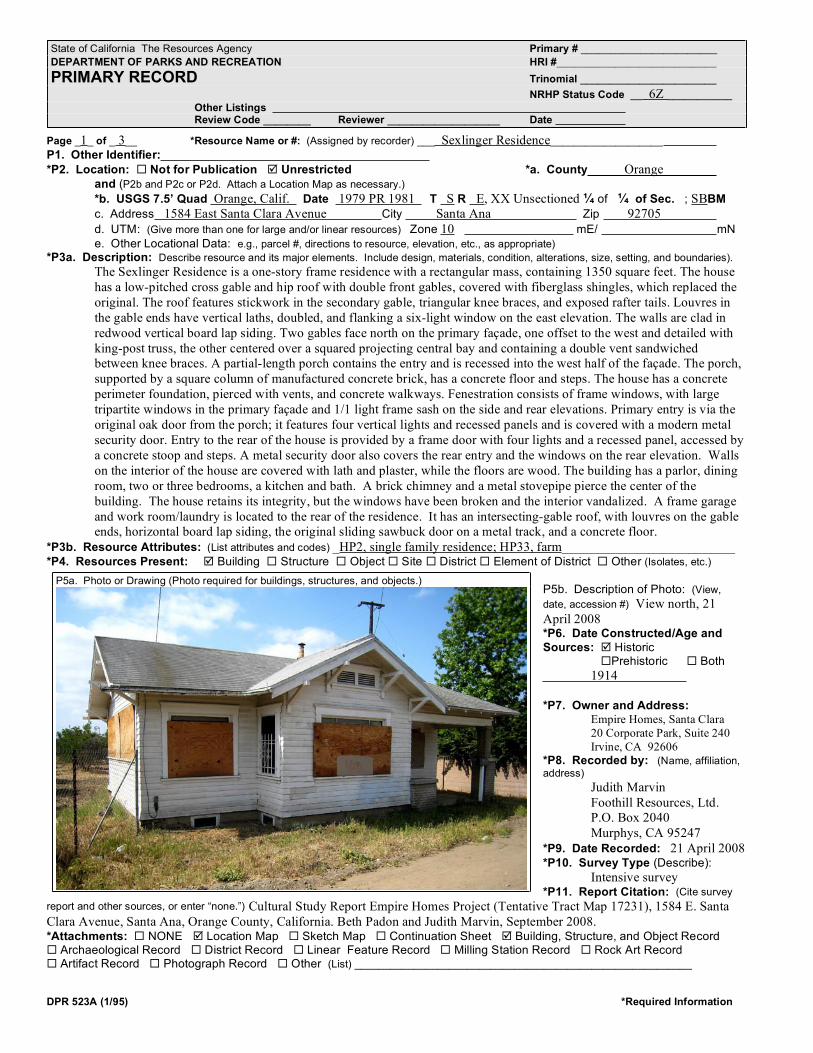
DPR 523A (1/95) *Required Information
Page _1_ of _ 3__ *Resource Name or #: (Assigned by recorder) ___ Sexlinger Residence___________________P1. Other Identifier:
*P2. Location: � Not for Publication � Unrestricted *a. County Orangeand (P2b and P2c or P2d. Attach a Location Map as necessary.)
*b. USGS 7.5’ Quad Orange, Calif. Date 1979 PR 1981 T S R E, XX Unsectioned � of � of Sec. ; SBBM
c. Address 1584 East Santa Clara Avenue City Santa Ana Zip 92705
d. UTM: (Give more than one for large and/or linear resources) Zone 10 mE/ mN
e. Other Locational Data: e.g., parcel #, directions to resource, elevation, etc., as appropriate)
*P3a. Description: Describe resource and its major elements. Include design, materials, condition, alterations, size, setting, and boundaries).
The Sexlinger Residence is a one-story frame residence with a rectangular mass, containing 1350 square feet. The house
has a low-pitched cross gable and hip roof with double front gables, covered with fiberglass shingles, which replaced the
original. The roof features stickwork in the secondary gable, triangular knee braces, and exposed rafter tails. Louvres in
the gable ends have vertical laths, doubled, and flanking a six-light window on the east elevation. The walls are clad in
redwood vertical board lap siding. Two gables face north on the primary façade, one offset to the west and detailed with
king-post truss, the other centered over a squared projecting central bay and containing a double vent sandwiched
between knee braces. A partial-length porch contains the entry and is recessed into the west half of the façade. The porch,
supported by a square column of manufactured concrete brick, has a concrete floor and steps. The house has a concrete
perimeter foundation, pierced with vents, and concrete walkways. Fenestration consists of frame windows, with large
tripartite windows in the primary façade and 1/1 light frame sash on the side and rear elevations. Primary entry is via the
original oak door from the porch; it features four vertical lights and recessed panels and is covered with a modern metal
security door. Entry to the rear of the house is provided by a frame door with four lights and a recessed panel, accessed by
a concrete stoop and steps. A metal security door also covers the rear entry and the windows on the rear elevation. Walls
on the interior of the house are covered with lath and plaster, while the floors are wood. The building has a parlor, dining
room, two or three bedrooms, a kitchen and bath. A brick chimney and a metal stovepipe pierce the center of the
building. The house retains its integrity, but the windows have been broken and the interior vandalized. A frame garage
and work room/laundry is located to the rear of the residence. It has an intersecting-gable roof, with louvres on the gable
ends, horizontal board lap siding, the original sliding sawbuck door on a metal track, and a concrete floor.
*P3b. Resource Attributes: (List attributes and codes) _HP2, single family residence; HP33, farm__________________________*P4. Resources Present: � Building � Structure � Object� Site � District� Element of District � Other (Isolates, etc.)
P5b. Description of Photo: (View,
date, accession #) View north, 21
April 2008*P6. Date Constructed/Age and
Sources: � Historic�Prehistoric � Both
1914
*P7. Owner and Address:Empire Homes, Santa Clara
20 Corporate Park, Suite 240
Irvine, CA 92606
*P8. Recorded by: (Name, affiliation,
address)
Judith Marvin
Foothill Resources, Ltd.
P.O. Box 2040
Murphys, CA 95247
*P9. Date Recorded: 21 April 2008*P10. Survey Type (Describe):
Intensive survey*P11. Report Citation: (Cite survey
report and other sources, or enter “none.”) Cultural Study Report Empire Homes Project (Tentative Tract Map 17231), 1584 E. Santa
Clara Avenue, Santa Ana, Orange County, California. Beth Padon and Judith Marvin, September 2008.*Attachments: � NONE � Location Map � Sketch Map � Continuation Sheet � Building, Structure, and Object Record� Archaeological Record � District Record � Linear Feature Record � Milling Station Record � Rock Art Record� Artifact Record � Photograph Record � Other (List) _________________________________________________________
State of California The Resources Agency Primary # _______________________
DEPARTMENT OF PARKS AND RECREATION HRI #___________________________
PRIMARY RECORD Trinomial _______________________
NRHP Status Code __ 6Z ___________
Other ListingsReview Code ________ Reviewer ___________________ Date
P5a. Photo or Drawing (Photo required for buildings, structures, and objects.)

��� ���� ������ ��������� �����������
���� 2 �� 3 ����� ������ ���� 6Z
��������� ���� �� � ��������� �� ��������� Sexlinger Residence
��� �������� ����� Sexlinger Residence��� ������ �����
��� �������� ���� Residence ��� ������� ���� Vacant
���� ������������� ������ Craftsman Bungalow���� ������������ �������� ������������� ����� ������������ ��� ���� �� ������������
Constructed 1914, original roofing replaced with fiberglass shingles, 1992; no other alterations noted.���� ������ � �� � ��� � ������� ����� �������� ���������
���� ������� ��������� Frame garage and work room/laundry, located to the south rear of the residence.
���� ���������� Unknown �� �������� Unknown
����� ������������� ����� Settlement, agriculture, residential and architectural development ���� Santa Ana
������ �� ������������ 1914-1950s �������� ���� Residence/orchard ���������� �������� N/A�������� ���������� �� ����� �� ���������� �� ������������� ������� �� ������� �� ������ ������� ��� ���������� ������ ���� ������� �����������
The lands on which the Sexlinger Residence was built were annexed to the City of Santa Ana in 1888 (City of Santa Ana
Chronology of Annexations). As the census enumerator identified the Sexlinger family as residing in the Tustin Township,
they were evidently more closely aligned to that community. The house is located in the original A.B. Chapman tract, one of
many such developed by Chapman. Most of the acreage was owned by small growers, with 5, 10, or 20-acre farms. By 1913,
Perry V. Grout purchased a 5-acre parcel on Santa Clara Avenue (Block A, Section 5, Lot 5) from Chapman and was
depicted on a map of the area (McBride 1913). During the years 1913-1918, Perry and his wife Flora sold several parcels of
land to other orange growers (Orange County Deeds, various). As Grout was listed alternately as a foreman and fieldman for
the Santiago Orange Growers Association (SOGA), it appears likely that the orchard had been planted by that time. Grout
was a resident of Orange so evidently just planted and maintained the orchard until it was purchased by the Sexlinger family
that year. On November 18, 1913, Grout deeded the 5-acre property on Santa Clara Avenue to George and Sophia Sexlinger
(Deed Book 285:171), who constructed the residence shortly thereafter. Grout evidently sold the acreage to the Sexlinger
family so that they would operate the orchard and sell their produce to the SOGA. Sexlinger, his wife and two daughters had
moved west to Southern California from their native Michigan shortly after 1910. The property remained in the Sexlinger
family after George’s death in 1929, Anna Sophia’s in 1952, until the last daughter passed in 2006. Under Criterion 1,
although the residence is associated with the development of small family citrus farms in the Santa Ana vicinity in the early
decades of the twentieth century, an important event in the history of the region, the house does not appear to be a significant
contributor to that event. There are much better architectural examples elsewhere in the community, and the orchard no
longer appears to be viable, having reached an age of diminished production. Under Criterion 2, the residence is not
associated with any persons important in history. Although retaining its integrity to its period of construction, the Craftsman
residence is a typical example of a common resource type, not the work of a master, nor does it exhibit high artistic values
(Criterion 3). There are a plethora of such residences in Santa Ana and the neighboring communities, most of which are
better prototypes. The farm is also lacking in historical context, as all of the original citrus orchards in the area have been
ripped out and replaced with residential development. Under Criterion 4, the information potential on the residence and
orchard has been recovered through this recording.���� ���������� �������� ����������� ����� ���������� ��� ������
����� ����������� Orange County Deeds, Maps, Official Records,
on file, History Room, Santa Ana Public Library and Office
of County Recorder, Santa Ana.
���� �������� Slated for demolition.
����� ���������� Judith Marvin, Foothill Resources, Ltd.
����� �� ����������� 2 May 2008
����� �� ���������� ��� ��������� ������ ������� �
���������� �� ����� ��� ���������� ��� �
��������� ���������� ��� ������ ������
������� ��� ���� ����� ����� ����������
����� ����� �������� ��� �������� ���������

���� �� � �� � � � ��������� ���� �� � ��������� �� ��������� ��������� ���������
���� ����� ������� ������ ������ ������� ���� �� ���� ���� �� ����
��� ���� ������ ��������� �����������
����� �� ���������� ��� ��������� ������ ������� �
���������� �� ����� ��� ���������� ��� �
�������� ��� ���������

Cultural Study Report
Empire Homes Project (TT 17231)
1584 E. Santa Clara Avenue
Santa Ana, California
September 2008
Page 41
Appendix 2. Correspondence with Native
American Heritage Commission

Man
agem
ent
O
utre
ach
&10591 Bloomfield StreetLos Alamitos, CA 90720
(562) 431-0300www.discoveryworks.com
DiscoveryWorks, Inc
Cultu
ral R
esou
rces
May 16, 2008
Native American Heritage Commission915 Capitol Mall, Room 364Sacramento, CA 95814
Dear Native American Heritage Commission,Subject: Sacred Lands File Search for a Five-acre project in Santa Ana, California
We would like to request a Sacred Lands file search for the Empire Homes project located in Santa Ana, California. It is located on the Orange USGS 7.5’ quadrangle in Township 5 South, Range 9 West, unsectioned portion of this quadrangle. The address is 1584 East Santa Clara Avenue, Santa Ana, California. Please see the attached map that indicates the specific project location.
This project includes construction of housing pads, streets, and utility lines for the develop-ment of the existing 5-acre property.
Please send the results of the Sacred Sites inventory to Discovery Works, Inc. 10591 Bloomfield Street, Los Alamitos, CA 90720. If you have any questions, please don’t hesitate to contact us at (562) 431-0300 or by e-mail at [email protected] you for your assistance.
Sincerely,
Beth PadonArchaeologist
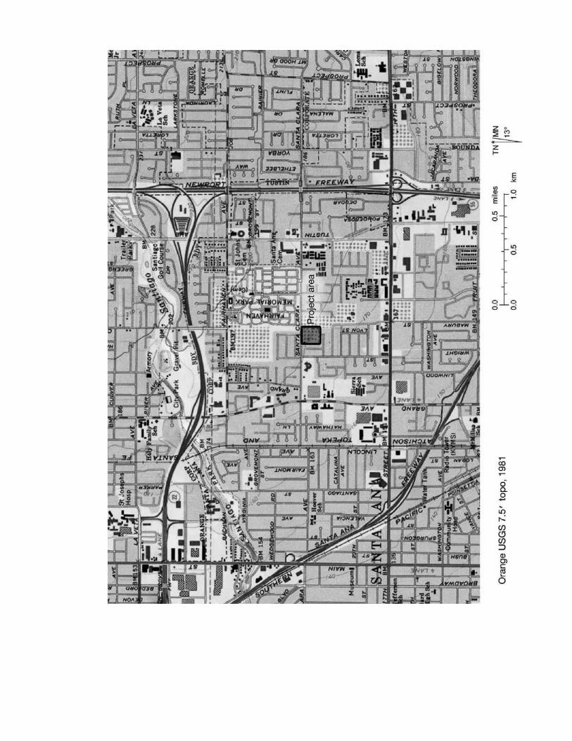


Cultural Study Report
Empire Homes Project (TT 17231)
1584 E. Santa Clara Avenue
Santa Ana, California
September 2008
Page 45
Appendix 3. Paleontological archival review
by Dr. Samuel McLeod, Natural History
Museum of Los Angeles County