Embed Size (px)
Citation preview
Computers, Environment and Urban Systems 54 (2015) 230–239
Contents lists available at ScienceDirect
Computers, Environment and Urban Systems
j ourna l homepage: www.e lsev ie r .com/ locate /ceus
Cultural heritage management and monitoring using remote sensingdata and GIS: The case study of Paphos area, Cyprus
A. Agapiou a,⁎, V. Lysandrou a, D.D. Alexakis b,a, K. Themistocleous a, B. Cuca a, A. Argyriou b,A. Sarris b, D.G. Hadjimitsis a
a Remote Sensing and Geo-Environment Laboratory, Department of Civil Engineering and Geomatics, Faculty of Engineering and Technology, Cyprus University of Technology, 2-6, Saripolou Str.,3603 Limassol, Cyprusb GeoSat ReSeArch Laboratory of Geophysical-Satellite Remote Sensing & Archaeo-environment, Institute for Mediterranean Studies, Foundation for Research & Technology, Hellas (F.O.R.T.H.), Greece
⁎ Corresponding author.E-mail addresses: [email protected] (A. Agapiou
(V. Lysandrou), [email protected], [email protected]@cut.ac.cy (K. Themistocleous), [email protected] (A. Argyriou), [email protected]@cut.ac.cy (D.G. Hadjimitsis).
http://dx.doi.org/10.1016/j.compenvurbsys.2015.09.0030198-9715/© 2015 Elsevier Ltd. All rights reserved.
a b s t r a c t
a r t i c l e i n f oArticle history:Received 28 January 2015Received in revised form 3 September 2015Accepted 4 September 2015Available online 21 September 2015
Keywords:Cultural heritageRemote sensing techniquesAnalytic Hierarchy Process (AHP)Risk assessmentGIS analysis
Cultural heritage (CH) sites are threatened from a variety of natural and anthropogenic factors. Innovative andcost effective tools for systematic monitoring of landscapes and CH sites are needed to protect them. Towardsthis direction, the article presents a multidisciplinary approach, based on remote sensing techniques andGeographical Information System (GIS) analysis, in order to assess the overall risk in the Paphos district(Cyprus). Paphos region has a great deal of archaeological sites and isolated monuments, which reflect thelong history of the area, while some of them are also listed in the UNESCO catalogue of World Cultural Heritagesites. Several natural and anthropogenic hazards have been mapped using different remote sensing data andmethodologies. All data were gathered from satellite images and satellite products. The results from each hazardwere imported into a GIS environment in order to examine the overall risk assessment based on the AnalyticHierarchy Process (AHP) methodology. The results found that the methodology applied was effective enough inthe understanding of the current conservation circumstances of the monuments in relation to their environmentas well as predicting the future development of the present hazards.
© 2015 Elsevier Ltd. All rights reserved.
1. Introduction
Cultural heritage (CH) monuments and sites are endangered byanthropogenic and natural threats such as earthquakes, flooding, firesand urbanization, with prevention actions sometimes being the onlyremedy (Jones, 1986; Stovel, 1998; Jokilehto, 2000; Wang, 2015;Rainieri et al., 2013; Drdácký, 2007). CH sector seeks innovative andcost effective tools for systematic monitoring so as to protect andpreserve CH sites, monuments and landscapes. In this framework,gathering data and information for vast areas can be time consumingand expensive, while sometimes data collection procedure might notbe possible due to the lack of the appropriate equipment and tools.
In contrast, remote sensing technologies have shown a greatpotential as an important tool for the protection and prevention ofmon-uments and sites (Spreafico et al., 2015; Agapiou et al., 2015; Cigna et al.,2014; Banerjee & Srivastava, 2013). In the last two decades, the devel-opment of ground, aerial and space technologies has successfully been
), [email protected] (D.D. Alexakis),@cut.ac.cy (B. Cuca),et.gr (A. Sarris),
applied to several CH applications (Casana et al., 2014; Agapiou et al.,2014; Chase et al., 2011; Deroin et al., 2011; Giardino, 2011;Lasaponara & Masini, 2009; Garrison et al., 2008; Lasaponara & Masini,2006). The technological achievements of space technology, such ashigher spatial resolution and hyperspectral data, offer new opportuni-ties for future archaeological discoveries (Sarris et al., 2013; GiacomoDi, Ditaranto & Scardozzi, 2011; Aqdus et al., 2008; De Laet et al.,2007; Cavalli et al., 2007).
Satellite remote sensing has become a common tool of investigation,prediction and forecast of environmental change and scenarios throughthe development of GIS-based models and decision-support instru-ments that have further improved and considerably supporteddecision-making strategies (Ayad, 2005; Hadjimitsis et al., 2011). Bycombining satellite remote sensing techniques with GIS, CH sites canbe efficiently monitored in a reliable, repetitive, non-invasive, rapidand cost-effective way (Alexakis et al., 2011).
Satellite imagery can provide a quick and relatively low costapproach for monitoring natural and anthropogenic hazards overlarge and inaccessible areas (Youssef et al., 2015; Kaiser et al., 2014;Pradhan, 2010; Rahman, Shi & Chongf, 2009; Biswajeet & Saro, 2007).It should be noticed however that the availability of cloud free satelliteimages for operational projects is critical. Mediterranean countries areideal for the use of optical remote sensing data as they are characterizedby clear weather conditions with availability of cloud-free images.
231A. Agapiou et al. / Computers, Environment and Urban Systems 54 (2015) 230–239
The aim of this paper is to present a methodological frameworkbased solely on remote sensing data and GIS analysis in order to extractvaluable information regarding natural and anthropogenic hazards aswell as to assess the overall risk for CH sites and monuments locatedin the Paphos district. Based on a variety of remote sensing data includ-ing low, medium and high resolution images (e.g. MODIS; Landsat;QuickBird), as well as ready satellite products (e.g. ASTER Global DigitalElevationModel, ASTER GDEM) each hazard examined in this paper hasbeen analysed while the overall risk was estimated based on theAnalytic Hierarchy Process (AHP) methodology. In contrary to previousstudies (Hadjimitsis et al., 2011) where the authors have used archiveinformation for each hazard for a limited number of sites (8 sites), themethodology presented here indicates that each hazard can be re-evaluated after a short period if deemed necessary (e.g. if stakeholdersrequire updated information relative to specific monument) appliedfor a wider area and sites. Therefore the overall benefit from theproposed approach is highlighted by the fact that the overall risk assess-ment of an area can be re-estimated based on new satellite data.
2. Study area
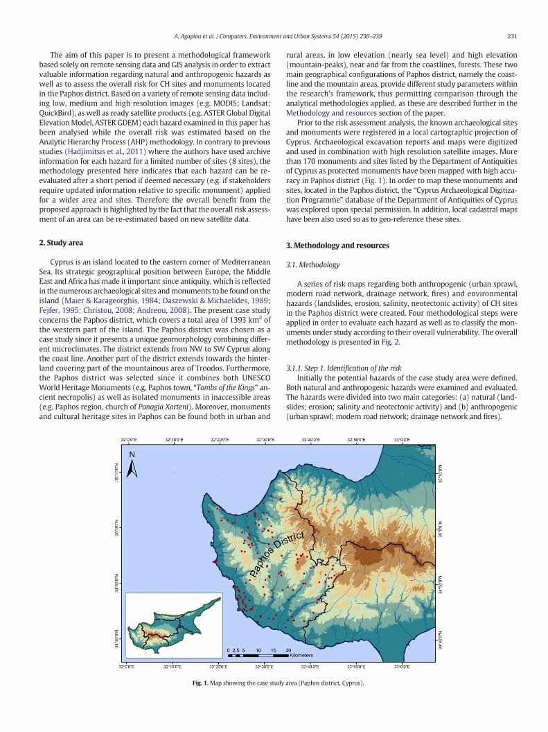
Cyprus is an island located to the eastern corner of MediterraneanSea. Its strategic geographical position between Europe, the MiddleEast and Africa hasmade it important since antiquity, which is reflectedin thenumerous archaeological sites andmonuments to be found on theisland (Maier & Karageorghis, 1984; Daszewski & Michaelides, 1989;Fejfer, 1995; Christou, 2008; Andreou, 2008). The present case studyconcerns the Paphos district, which covers a total area of 1393 km2 ofthe western part of the island. The Paphos district was chosen as acase study since it presents a unique geomorphology combining differ-ent microclimates. The district extends from NW to SW Cyprus alongthe coast line. Another part of the district extends towards the hinter-land covering part of the mountainous area of Troodos. Furthermore,the Paphos district was selected since it combines both UNESCOWorld Heritage Monuments (e.g. Paphos town, “Tombs of the Kings” an-cient necropolis) as well as isolated monuments in inaccessible areas(e.g. Paphos region, church of Panagia Xorteni). Moreover, monumentsand cultural heritage sites in Paphos can be found both in urban and
Fig. 1.Map showing the case study
rural areas, in low elevation (nearly sea level) and high elevation(mountain-peaks), near and far from the coastlines, forests. These twomain geographical configurations of Paphos district, namely the coast-line and themountain areas, provide different study parameters withinthe research's framework, thus permitting comparison through theanalytical methodologies applied, as these are described further in theMethodology and resources section of the paper.
Prior to the risk assessment analysis, the known archaeological sitesand monuments were registered in a local cartographic projection ofCyprus. Archaeological excavation reports and maps were digitizedand used in combination with high resolution satellite images. Morethan 170 monuments and sites listed by the Department of Antiquitiesof Cyprus as protected monuments have been mapped with high accu-racy in Paphos district (Fig. 1). In order to map these monuments andsites, located in the Paphos district, the “Cyprus Archaeological Digitiza-tion Programme” database of the Department of Antiquities of Cypruswas explored upon special permission. In addition, local cadastral mapshave been also used so as to geo-reference these sites.
3. Methodology and resources
3.1. Methodology
A series of risk maps regarding both anthropogenic (urban sprawl,modern road network, drainage network, fires) and environmentalhazards (landslides, erosion, salinity, neotectonic activity) of CH sitesin the Paphos district were created. Four methodological steps wereapplied in order to evaluate each hazard as well as to classify the mon-uments under study according to their overall vulnerability. The overallmethodology is presented in Fig. 2.
3.1.1. Step 1. Identification of the riskInitially the potential hazards of the case study area were defined.
Both natural and anthropogenic hazards were examined and evaluated.The hazards were divided into two main categories: (a) natural (land-slides; erosion; salinity and neotectonic activity) and (b) anthropogenic(urban sprawl; modern road network; drainage network and fires).
area (Paphos district, Cyprus).
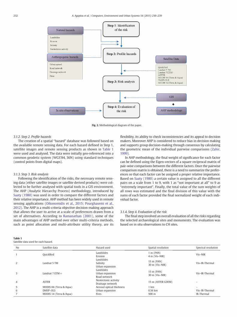
Fig. 2. Methodological diagram of the paper.
232 A. Agapiou et al. / Computers, Environment and Urban Systems 54 (2015) 230–239
3.1.2. Step 2. Profile hazardsThe creation of a spatial “hazard” database was followed based on
the available remote sensing data. For each hazard defined in Step 1,satellite images and remote sensing products as shown in Table 1were used and analysed. The data were initially geo-referenced into acommon geodetic system (WGS'84, 36N) using standard techniques(control points from digital maps).
3.1.3. Step 3. Risk analysisFollowing the identification of the risks, the necessary remote sens-
ing data (either satellite images or satellite derived products) were col-lected to be further analysed with spatial tools in a GIS environment.The AHP (Analytic Hierarchy Process) methodology, introduced bySaaty (1980) was used in order to compare the different factors andtheir relative importance. AHPmethod has been widely used in remotesensing applications (Oikonomidis et al., 2015; Pourghasemi et al.,2012). The AHP is a multi-criteria objective decision-making approachthat allows the user to arrive at a scale of preferences drawn from aset of alternatives. According to Ramanathan (2001), some of themain advantages of AHP method over other multi-criteria methods,such as point allocation and multi-attribute utility theory, are its
Table 1Satellite data used for each hazard.
No Satellite data Hazard used
1 QuickBirdLandslidesErosion
2 Landsat 5 TMLandslidesSalinityUrban expansion
3 Landsat 7 ETM+LandslidesUrban expansionRoad network
4 ASTERNeotectonic activityDrainage network
5 MODIS 04 (Terra & Aqua) Aerosol optical thick6 DMSP–OLS Urban expansion7 MODIS 14 (Terra & Aqua) Fires
flexibility, its ability to check inconsistencies and its appeal to decisionmakers. Moreover AHP is considered to reduce bias in decision makingand supports group decision-making through consensus by calculatingthe geometric mean of the individual pairwise comparisons (Zahir,1999).
In AHP methodology, the final weight of significance for each factorcan be defined using the Eigen-vectors of a square reciprocal matrix ofpair-wise comparisons between the different factors. Once the pairwisecomparisonmatrix is obtained, there is a need to summarize the prefer-ences so that each factor can be assigned a proper relative importance.Based on Saaty (1980) a certain value is assigned to all the differentpairs on a scale from 1 to 9, with 1 as “not important at all” to 9 as“extremely important”. Finally, the total value of the sum weights ofall rows was estimated and the final division of this value with thesums of each factor provided the final normalized weight of each indi-vidual factor.
3.1.4. Step 4. Evaluation of the riskThefinal step involved an overall evaluation of all the risks regarding
the selected archaeological sites and monuments. The evaluation wasbased on in situ observations to CH sites.
Spatial resolution Spectral resolution
1 m (PAN)4 m (Vis–NIR)
Vis–NIR
15 m (PAN)30 m (Vis–NIR)
Vis–IR-Thermal
15 m (PAN)30 m (Vis–NIR)
Vis–IR-Thermal
15 m (ASTER GDEM) –
ness 1 km –0.56 km Vis–IR-Thermal500 m IR-Thermal
233A. Agapiou et al. / Computers, Environment and Urban Systems 54 (2015) 230–239
3.2. Resources
For the aims of this study a multidisciplinary approach was applied.Remote sensing data from various sources were processed, in order todetermine each hazard. Table 1 indicates the satellite data sourcesused in this study aswell as some characteristics of the sensors. Low res-olutionMODIS images have been used in order to retrieve Burned Areasover the Paphos region. In addition medium resolution Landsat 5 TMand 7 ETM+ have been analysed for monitoring urban expansion,landslides, salinity and road network. High resolution QuickBird imageshave explored for calculating landslides and erosion parameters.Calibrated DMSP–OLS night-time data set for 2010 has been also usedfor mapping urban areas in Paphos district while ASTER GDEM hasbeen exploited for detecting neotectonic activity as well as mappingthe drainage network.
4. Natural and anthropogenic hazards
In the study, eight different factors (as shown in Fig. 2 and Table 1)with possible influence on the monuments were incorporated in thefinal GIS model and analysed for their potential contribution in the de-velopment of the final Hazard Assessmentmap. The appropriate remotesensing data set for each hazard as shown in Table 1 were used. A briefdescription of the analysis for each factor is mentioned below.
4.1. Natural factors
4.1.1. LandslidesLandslides are considered to be oneof themost extremenatural haz-
ards worldwide, causing both human losses and severe damages to themodern facilities. Human interventions to the landscape, geomorpholo-gic processes and climatic phenomena could trigger the occurrence of
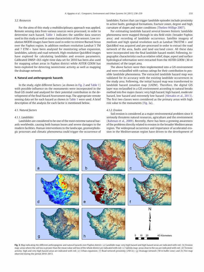
Fig. 3.Map indicating the different anthropogenic and natural hazards over Paphos district. (a)map: areaswhere the soil loss is greater than themean value soil loss of thewhole district are indactivity: high and very high hazard areas are indicated with red; (e) Urban expansion; (f) Roadobserved during the period 2010–2013.
landslides. Factors that can trigger landslide episodes include proximityto active faults, geological formations, fracture zones, degree and highcurvature of slopes and water conditions (Theilen-Willige 2007).
For estimating landslide hazard several known historic landslidephenomena were mapped through in situ field visits (broader Paphosarea) and recording of landslide occurrence. Satellite imagery ofmedium and high spatial resolution such as Landsat TM/ETM+ andQuickBird was acquired and pre-processed in order to extract the roadnetwork of the area, faults and land use/land cover. All these datawere incorporated into the final landslide hazard model. Following, to-pographic characteristics such as relative relief, slope, aspect and surfacehydrological information were extracted from the ASTER GDEM (30 mresolution) of the target area.
The above factors were then implemented into a GIS environmentand were reclassified with various ratings for their contribution to pos-sible landslide phenomena. The extracted landslide hazard map wasvalidated for its accuracy with the existing landslide occurrences inthe study area. Following, the initial hazard map was transformed tolandslide hazard zonation map (LHZM). Therefore, the digital GISlayer was reclassified in a GIS environment according to natural breaksmethod into fivemajor classes: very high hazard, high hazard,moderatehazard, low hazard and extremely low hazard (Alexakis et al., 2013).The first two classes were considered as the primary areas with highrisk value to the monuments (Fig. 3a).
4.1.2. ErosionSoil erosion is considered as amajor environmental problem since it
seriously threatens natural resources, agriculture and the environment(Rahman et al., 2009). Recently, there has been a growing awarenessof theproblemsdirectly related to erosion in the broaderMediterraneanregion. The widespread occurrence and importance of accelerated ero-sion in the Mediterranean region have driven to the development of
Landslidemap: very high hazard and high hazard areas are indicatedwith red; (b) Erosionicatedwith red; (c) Salinitymap: areas close to the sea are indicatedwith red; (d) Tectonicnetwork proximity (250 m); (g) Drainage network (50 m buffer zone) and (h) Fire map
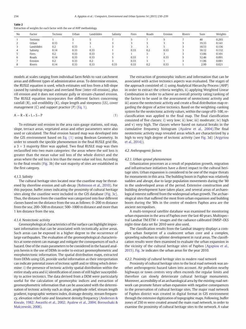
Table 2Extraction of weights for each factor with the use of AHP methodology.
No Factor Tectonic Urban Landslides Salinity Fires Roads Erosion Rivers Sum Weights
1 Tectonic 1 3 5 7 5 7 5 7 40 0.2932 Urban 0.33 1 3 3 3 3 3 3 19.33 0.1413 Landslides 0.2 0.33 1 3 3 3 5 3 18.53 0.1364 Salinity 0.14 0.33 0.33 1 0.33 0.2 0.33 3 18.12 0.1325 Fires 0.2 0.33 0.33 3 1 3 3 3 13.86 0.1016 Roads 0.14 0.33 0.33 5 0.33 1 0.33 5 12.46 0.0917 Erosion 0.2 0.33 0.2 3 0.33 3 1 3 11.06 0.0818 Rivers 0.14 0.33 0.33 0.33 0.33 0.2 0.33 1 2.99 0.021
234 A. Agapiou et al. / Computers, Environment and Urban Systems 54 (2015) 230–239
models at scales ranging from individual farm fields to vast catchmentareas and different types of administrative areas. To determine erosion,the RUSLE equation is used, which estimates soil loss from a hill-slopecaused by raindrop impact and overland flow (inter-rill erosion), plusrill erosion and it does not estimate gully or stream-channel erosion.The RUSLE equation incorporates five different factors concerningrainfall (R), soil erodibility (K), slope length and steepness (LS), covermanagement (C) and support practice (P) (Eq. 1).
A ¼ R � K � L � S � P ð1Þ
To estimate soil erosion in the area rain-gauge stations, soil map,slope, terrace areas, vegetated areas and other parameters were alsoused or calculated. The final erosion hazard map was developed intothe GIS environment based on Eq. (1) using Boolean Geometry. Inorder to smooth the speckle phenomenon in the final RUSLE grid file,a 3 × 3 majority filter was applied. Two final RUSLE map was thenreclassified into two main categories: the areas where the soil loss isgreater than the mean value soil loss of the whole district and theareas where the soil loss is less than themean value soil loss. Accordingto the final results (Fig. 3b) the vast majority of sites are established inthe first category.
4.1.3. SalinityThe cultural heritage sites located near the coastline may be threat-
ened by shoreline erosion and salt-decay (Robinson et al., 2010). Forthis purpose, buffer zones indicating the proximity of cultural heritagesites along the coastline were included in the GIS database (Fig. 3c).Thus, the distance from the coastline was categorized into four differentclasses based on the distance from the sea as follows: 0–200m distancefrom the sea; 200–500mdistance; 500–1000mdistance andmore than1 km distance from the sea.
4.1.4. Neotectonic activityGeomorphological characteristics of the surface can highlight impor-
tant information that can be associated with tectonically active areas.Such areas can be exposed in a higher degree to the occurrence oflarge earthquakes. The evaluation of the geomorphological characteris-tics at some extent canmanage andmitigate the consequences of such ahazard. One of themain parameters to be considered in the hazard anal-ysis herein is the use of DEMs in order to extract geomorphometric andmorphotectonic information. The spatial distribution maps, extractedfromDEMs using GIS, provide useful information as their interpretationcan indicate potential zones of tectonic uplift and/or tiltingwhich deter-mine: i) the presence of tectonic activity spatial distribution within theentire study area and ii) identification of zones of still higher susceptibil-ity to active tectonics. The data derived from a DEM were particularlyuseful for the calculation of geomorphic indices and extraction ofgeomorphometric information that can be associated with the determi-nation of tectonic activity such as slope, amplitude relief, stream lengthgradient, topographic wetness index, drainage density, stream frequen-cy, elevation relief ratio and lineament density/frequency (Anderson &Kneale, 1982; Awasthi et al., 2002; Ayalew et al., 2004; Boroushaki &Malczewski, 2008).
The extraction of geomorphic indices and information that can beassociated with active tectonics aspects was evaluated. The stages ofthe approach consisted of: i) using Analytical Hierarchy Process (AHP)in order to extract the criteria weights, ii) applying Weighted LinearCombination in order to achieve an overall priority rating/ranking ofthe factors to be used in the assessment of neotectonic activity andiii) assess the neotectonic activity and create a final distributionmap re-garding the degree of active tectonics. Based on the weighting–rankingsystem for the neotectonic activity values,within the range of 0–100, re-classification was applied to the final map. The final classificationconsisted of five classes: i) very low; ii) low; iii) moderate; iv) highand v) very high. The classes where based on natural breaks in thecumulative frequency histogram (Ayalew et al., 2004).The finalneotectonic activity map revealed areas which are characterized by ahigh to very high degree of tectonic activity (see Fig. 3d) (Argyriouet al., 2014)).
4.2. Anthropogenic factors
4.2.1. Urban sprawl phenomenonUrbanization processes as a result of population growth, migration
and infrastructure initiatives have a direct impact to the cultural heri-tage sites. Urban expansion is considered to be one of themajor threatsfor monuments in this area. The building boom in Paphos was relativelysudden and abrupt, due to large population movements during the '80in the undeveloped areas of the period. Extensive construction andbuilding development have taken place, and several areas of archaeo-logical interest suffered from thewidespread urban growth. The archae-ological sites that suffered themost from urban expansion and buildingboom during the '80s in the centre of modern Paphos area are theancient necropolises.
A multi-temporal satellite database was examined for monitoringurban expansion in the area of Paphos over the last 40 years. Multispec-tral Landsat TM/ETM+ images and the radiance calibrated DMSP–OLSnight-time data set for 2010 were also used.
The classification results from the Landsat imagery displays a com-plex urban footprint of a coalescent urban core and a complex,sprawling suburban to splinter development in rural areas. The classifi-cation results were then examined to evaluate the urban expansion inthe vicinity of the cultural heritage sites of Paphos (Agapiou et al.,2015). Fig. 3e indicates the urban areas for the year 2010.
4.2.2. Proximity of cultural heritage sites to modern road networkProximity of cultural heritage sites to the local road networkwas an-
other anthropogenic hazard taken into account. Air pollution nearbyhighways or town centres very often exceeds the regular limits andtherefore can slowly deteriorate cultural heritage monuments.Moreover, accessibility of an archaeological area by the existing road net-work can promote future urban expansion with negative consequencesto the preservation of cultural heritage sites. The major road networkof Paphos district was created in digital format in GIS environmentthrough the extensive digitization of topographicmaps. Following, bufferzones of 250 mwere created around the main road network, in order toexamine the proximity of cultural heritage sites to the network. A value
235A. Agapiou et al. / Computers, Environment and Urban Systems 54 (2015) 230–239
of one was assigned to the areas (zones) of more than 250m away fromthe road network and a value of zero was assigned to the areas (zones)within a distance of 250 m from the road network (Fig. 3f).
4.2.3. Drainage network proximityIn order to incorporate the parameter of “Drainage network
Proximity” the drainage network of Paphos district was digitized withthe complementary use of cadastral maps and DEM. Then the networkaccording to Strahler's order system was classified. Following, a bufferzone of 50mwas constructed around each part of the drainage network(Fig. 3g).
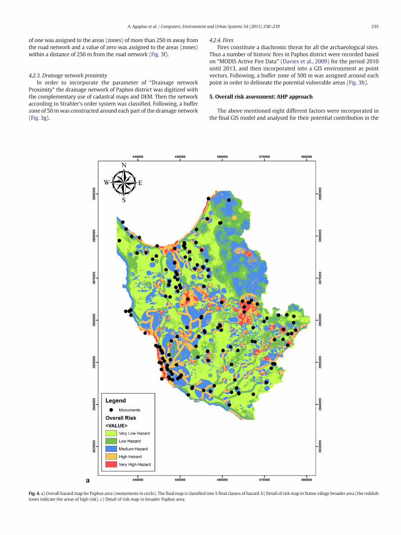
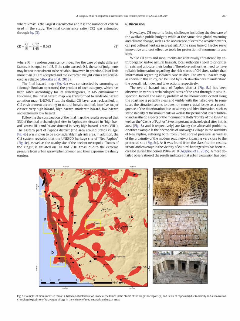
Fig. 4. a) Overall hazardmap for Paphos area (monuments in circle). Thefinalmap is classified itones indicate the areas of high risk). c) Detail of risk map in broader Paphos area.
4.2.4. FiresFires constitute a diachronic threat for all the archaeological sites.
Thus a number of historic fires in Paphos district were recorded basedon “MODIS Active Fire Data” (Davies et al., 2009) for the period 2010until 2013, and then incorporated into a GIS environment as pointvectors. Following, a buffer zone of 500 m was assigned around eachpoint in order to delineate the potential vulnerable areas (Fig. 3h).
5. Overall risk assessment: AHP approach
The above mentioned eight different factors were incorporated inthe final GIS model and analysed for their potential contribution in the
nto 5 final classes of hazard. b) Detail of riskmap in Statos village broader area (the reddish
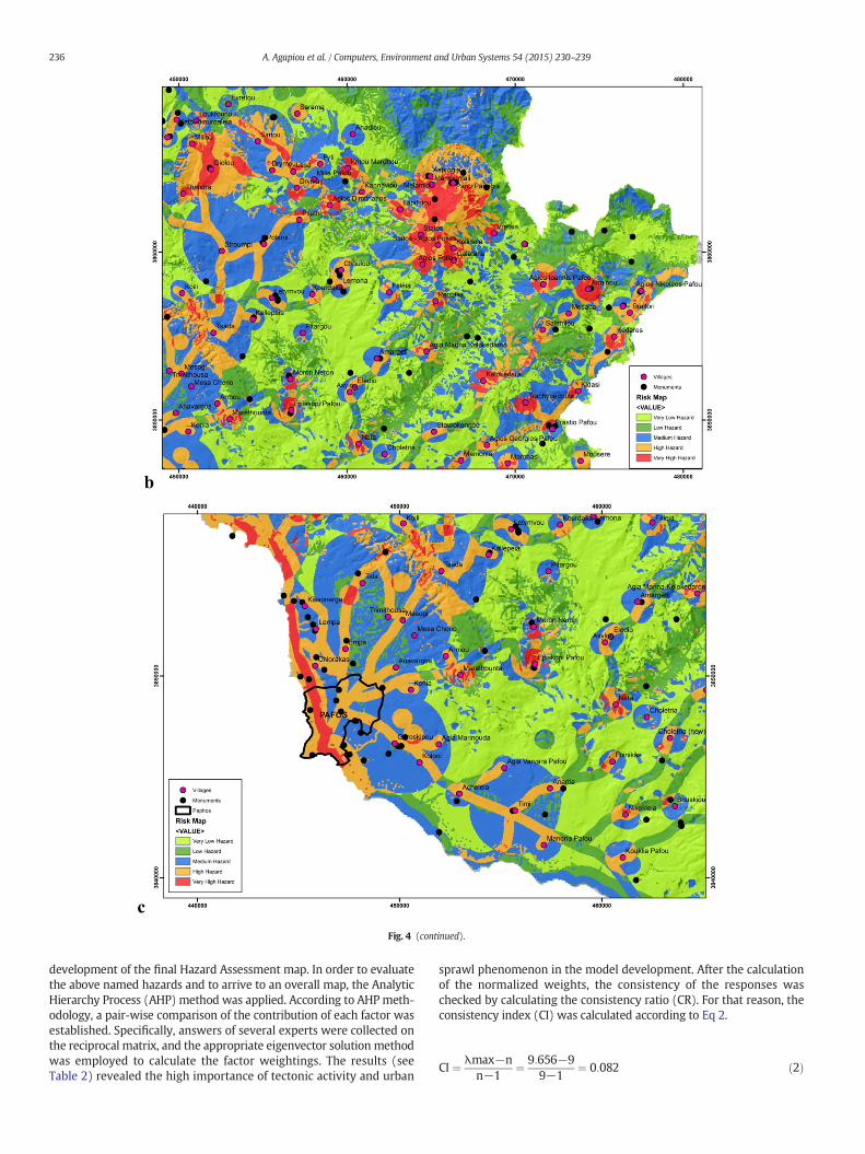
Fig. 4 (continued).
236 A. Agapiou et al. / Computers, Environment and Urban Systems 54 (2015) 230–239
development of the final Hazard Assessment map. In order to evaluatethe above named hazards and to arrive to an overall map, the AnalyticHierarchy Process (AHP) method was applied. According to AHPmeth-odology, a pair-wise comparison of the contribution of each factor wasestablished. Specifically, answers of several experts were collected onthe reciprocal matrix, and the appropriate eigenvector solution methodwas employed to calculate the factor weightings. The results (seeTable 2) revealed the high importance of tectonic activity and urban
sprawl phenomenon in the model development. After the calculationof the normalized weights, the consistency of the responses waschecked by calculating the consistency ratio (CR). For that reason, theconsistency index (CI) was calculated according to Eq 2.
CI ¼ λmax−nn−1
¼ 9:656−99−1
¼ 0:082 ð2Þ
237A. Agapiou et al. / Computers, Environment and Urban Systems 54 (2015) 230–239
where λmax is the largest eigenvector and n is the number of criteriaused in the study. The final consistency ratio (CR) was estimatedthrough Eq. (3):
CR ¼ CIRI
¼ 0:121:45
¼ 0:082 ð3Þ
where RI = random consistency index. For the case of eight differentfactors, it is equal to 1.45. If the ratio exceeds 0.1, the set of judgmentsmay be too inconsistent to be reliable. However, in practice, CRs of littlemore than 0.1 are accepted and the extracted weight values are consid-ered as reliable (Alexakis et al., 2013).
The final hazard map (Fig. 4a) was constructed by summing up(through Boolean operators) the product of each category, which hasbeen rated accordingly for its subcategories, in GIS environment.Following, the initial hazard map was transformed to landslide hazardzonation map (LHZM). Thus, the digital GIS layer was reclassified, inGIS environment according to natural breaks method, into five majorclasses: very high hazard, high hazard, moderate hazard, low hazardand extremely low hazard.
Following the construction of the finalmap, the results revealed that33% of the total archaeological sites in Paphos are situated in “high haz-ard” areas (HH) and 9% are situated in “very high hazard” areas (VHH).The eastern part of Paphos district (the area around Statos village,Fig. 4b) was shown to be a considerably high risk area. In addition, theGIS system revealed that the UNESCO heritage site of “Nea Paphos”(Fig. 4c), as well as the nearby site of the ancient necropolis “Tombs ofthe Kings”, is situated on HH and VHH areas, due to the extremepressure from urban sprawl phenomenon and their exposure to salinityerosion.
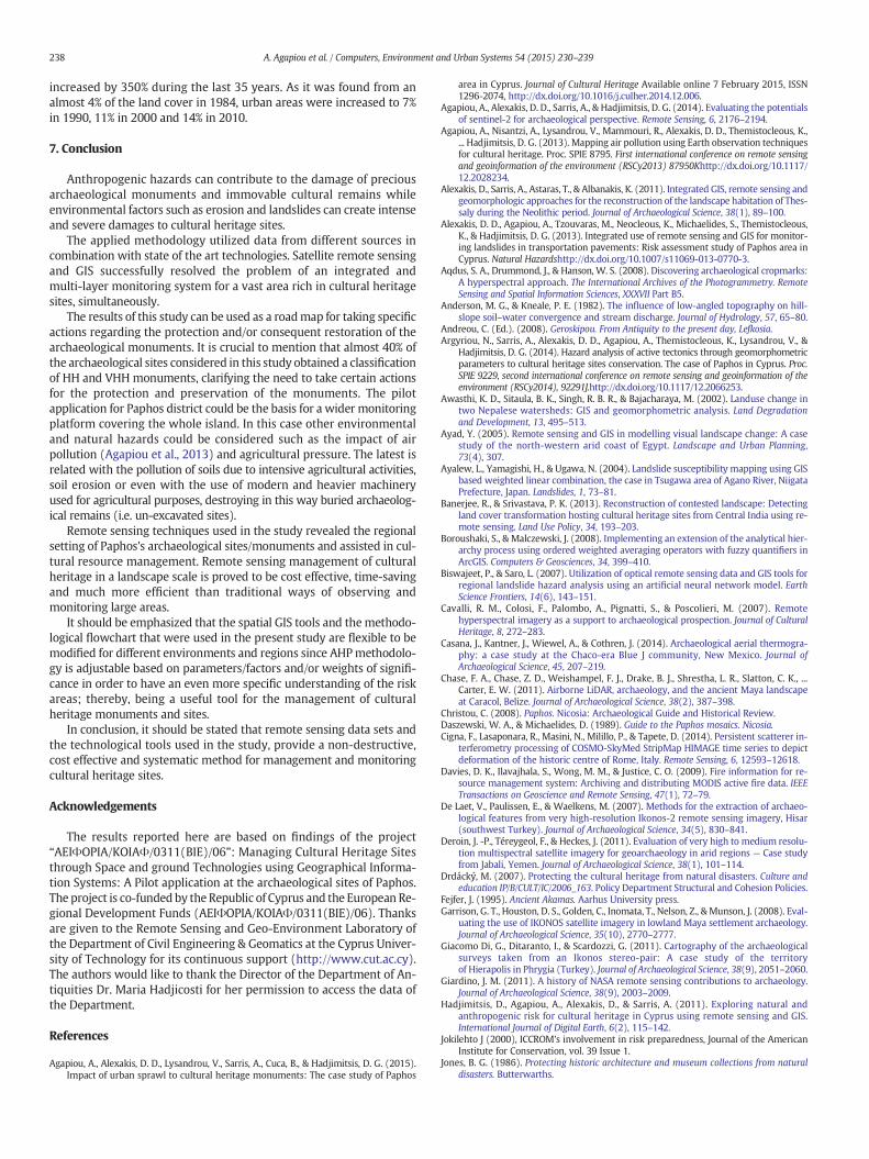
Fig. 5.Examples ofmonuments in threat. a–b) Detail of deterioration in one of the tombs in the “c) Archaeological site of Anavargos village in the vicinity of road network and urban areas.
6. Discussion
Nowadays, CH sector is facing challenges including the decrease ofthe available public budgets while at the same time global warmingand climate change, such as the occurrence of extreme weather events,can put cultural heritage in great risk. At the same time CH sector seeksinnovative and cost effective tools for protection of monuments andsites.
While CH sites and monuments are continually threatened by an-thropogenic and/or natural hazards, local authorities need to prioritizethreats and allocate their budget. Therefore authorities need to havereliable information regarding the risk status of CH sites, rather thaninformation regarding isolated case studies. The overall hazard map,as shown in this study, can be used by such stakeholders to understandthe overall risk index and take actions respectively.
The overall hazard map of Paphos district (Fig. 5a) has beenobserved in various archaeological sites of the area through in situ in-spection. Indeed, the salinity problem of the monuments located alongthe coastline is patently clear and visible with the naked eye. In somecases the situation seems to question more crucial issues as a conse-quence of the deterioration due to salinity and hive formation, such asstatic stability of themonuments aswell as thepermanent loss of histor-ic and aesthetic aspects of themonuments. Both “Tombs of the Kings” aswell as the “Castle of Paphos”, two important archaeological sites in thisarea (Fig. 5a and b respectively) are facing the aforesaid problems.Another example is the necropolis of Anavargos village in the outskirtsof Nea Paphos, suffering both from urban sprawl pressure, as well asof the proximity of the modern road network passing very close to theprotected site (Fig. 5c). As it was found from the classification results,urban land coverage in the vicinity of cultural heritage sites has been in-creased during the period 1984–2010 (Agapiou et al. 2015). A more de-tailed observation of the results indicates that urban expansion has been
Tomb of the Kings”necropolis (a) and Castle of Paphos (b) due to salinity and alveolization.
238 A. Agapiou et al. / Computers, Environment and Urban Systems 54 (2015) 230–239
increased by 350% during the last 35 years. As it was found from analmost 4% of the land cover in 1984, urban areas were increased to 7%in 1990, 11% in 2000 and 14% in 2010.
7. Conclusion
Anthropogenic hazards can contribute to the damage of preciousarchaeological monuments and immovable cultural remains whileenvironmental factors such as erosion and landslides can create intenseand severe damages to cultural heritage sites.
The applied methodology utilized data from different sources incombination with state of the art technologies. Satellite remote sensingand GIS successfully resolved the problem of an integrated andmulti-layer monitoring system for a vast area rich in cultural heritagesites, simultaneously.
The results of this study can be used as a roadmap for taking specificactions regarding the protection and/or consequent restoration of thearchaeological monuments. It is crucial to mention that almost 40% ofthe archaeological sites considered in this study obtained a classificationof HH and VHH monuments, clarifying the need to take certain actionsfor the protection and preservation of the monuments. The pilotapplication for Paphos district could be the basis for a wider monitoringplatform covering the whole island. In this case other environmentaland natural hazards could be considered such as the impact of airpollution (Agapiou et al., 2013) and agricultural pressure. The latest isrelated with the pollution of soils due to intensive agricultural activities,soil erosion or even with the use of modern and heavier machineryused for agricultural purposes, destroying in this way buried archaeolog-ical remains (i.e. un-excavated sites).
Remote sensing techniques used in the study revealed the regionalsetting of Paphos's archaeological sites/monuments and assisted in cul-tural resource management. Remote sensing management of culturalheritage in a landscape scale is proved to be cost effective, time-savingand much more efficient than traditional ways of observing andmonitoring large areas.
It should be emphasized that the spatial GIS tools and themethodo-logical flowchart that were used in the present study are flexible to bemodified for different environments and regions since AHPmethodolo-gy is adjustable based on parameters/factors and/or weights of signifi-cance in order to have an even more specific understanding of the riskareas; thereby, being a useful tool for the management of culturalheritage monuments and sites.
In conclusion, it should be stated that remote sensing data sets andthe technological tools used in the study, provide a non-destructive,cost effective and systematic method for management and monitoringcultural heritage sites.
Acknowledgements
The results reported here are based on findings of the project“ΑΕΙΦΟΡΙΑ/ΚΟΙΑΦ/0311(ΒΙΕ)/06”: Managing Cultural Heritage Sitesthrough Space and ground Technologies using Geographical Informa-tion Systems: A Pilot application at the archaeological sites of Paphos.The project is co-funded by the Republic of Cyprus and the European Re-gional Development Funds (ΑΕΙΦΟΡΙΑ/ΚΟΙΑΦ/0311(ΒΙΕ)/06). Thanksare given to the Remote Sensing and Geo-Environment Laboratory ofthe Department of Civil Engineering & Geomatics at the Cyprus Univer-sity of Technology for its continuous support (http://www.cut.ac.cy).The authors would like to thank the Director of the Department of An-tiquities Dr. Maria Hadjicosti for her permission to access the data ofthe Department.
References
Agapiou, A., Alexakis, D. D., Lysandrou, V., Sarris, A., Cuca, B., & Hadjimitsis, D. G. (2015).Impact of urban sprawl to cultural heritage monuments: The case study of Paphos
area in Cyprus. Journal of Cultural Heritage Available online 7 February 2015, ISSN1296-2074, http://dx.doi.org/10.1016/j.culher.2014.12.006.
Agapiou, A., Alexakis, D. D., Sarris, A., & Hadjimitsis, D. G. (2014). Evaluating the potentialsof sentinel-2 for archaeological perspective. Remote Sensing, 6, 2176–2194.
Agapiou, A., Nisantzi, A., Lysandrou, V., Mammouri, R., Alexakis, D. D., Themistocleous, K.,... Hadjimitsis, D. G. (2013). Mapping air pollution using Earth observation techniquesfor cultural heritage. Proc. SPIE 8795. First international conference on remote sensingand geoinformation of the environment (RSCy2013) 87950Khttp://dx.doi.org/10.1117/12.2028234.
Alexakis, D., Sarris, A., Astaras, T., & Albanakis, K. (2011). Integrated GIS, remote sensing andgeomorphologic approaches for the reconstruction of the landscape habitation of Thes-saly during the Neolithic period. Journal of Archaeological Science, 38(1), 89–100.
Alexakis, D. D., Agapiou, A., Tzouvaras, M., Neocleous, K., Michaelides, S., Themistocleous,K., & Hadjimitsis, D. G. (2013). Integrated use of remote sensing and GIS for monitor-ing landslides in transportation pavements: Risk assessment study of Paphos area inCyprus. Natural Hazardshttp://dx.doi.org/10.1007/s11069-013-0770-3.
Aqdus, S. A., Drummond, J., & Hanson, W. S. (2008). Discovering archaeological cropmarks:A hyperspectral approach. The International Archives of the Photogrammetry. RemoteSensing and Spatial Information Sciences, XXXVII Part B5.
Anderson, M. G., & Kneale, P. E. (1982). The influence of low-angled topography on hill-slope soil–water convergence and stream discharge. Journal of Hydrology, 57, 65–80.
Andreou, C. (Ed.). (2008). Geroskipou. From Antiquity to the present day, Lefkosia.Argyriou, N., Sarris, A., Alexakis, D. D., Agapiou, A., Themistocleous, K., Lysandrou, V., &
Hadjimitsis, D. G. (2014). Hazard analysis of active tectonics through geomorphometricparameters to cultural heritage sites conservation. The case of Paphos in Cyprus. Proc.SPIE 9229, second international conference on remote sensing and geoinformation of theenvironment (RSCy2014), 92291J.http://dx.doi.org/10.1117/12.2066253.
Awasthi, K. D., Sitaula, B. K., Singh, R. B. R., & Bajacharaya, M. (2002). Landuse change intwo Nepalese watersheds: GIS and geomorphometric analysis. Land Degradationand Development, 13, 495–513.
Ayad, Y. (2005). Remote sensing and GIS in modelling visual landscape change: A casestudy of the north-western arid coast of Egypt. Landscape and Urban Planning,73(4), 307.
Ayalew, L., Yamagishi, H., & Ugawa, N. (2004). Landslide susceptibility mapping using GISbased weighted linear combination, the case in Tsugawa area of Agano River, NiigataPrefecture, Japan. Landslides, 1, 73–81.
Banerjee, R., & Srivastava, P. K. (2013). Reconstruction of contested landscape: Detectingland cover transformation hosting cultural heritage sites from Central India using re-mote sensing. Land Use Policy, 34, 193–203.
Boroushaki, S., & Malczewski, J. (2008). Implementing an extension of the analytical hier-archy process using ordered weighted averaging operators with fuzzy quantifiers inArcGIS. Computers & Geosciences, 34, 399–410.
Biswajeet, P., & Saro, L. (2007). Utilization of optical remote sensing data and GIS tools forregional landslide hazard analysis using an artificial neural network model. EarthScience Frontiers, 14(6), 143–151.
Cavalli, R. M., Colosi, F., Palombo, A., Pignatti, S., & Poscolieri, M. (2007). Remotehyperspectral imagery as a support to archaeological prospection. Journal of CulturalHeritage, 8, 272–283.
Casana, J., Kantner, J., Wiewel, A., & Cothren, J. (2014). Archaeological aerial thermogra-phy: a case study at the Chaco-era Blue J community, New Mexico. Journal ofArchaeological Science, 45, 207–219.
Chase, F. A., Chase, Z. D., Weishampel, F. J., Drake, B. J., Shrestha, L. R., Slatton, C. K., ...Carter, E. W. (2011). Airborne LiDAR, archaeology, and the ancient Maya landscapeat Caracol, Belize. Journal of Archaeological Science, 38(2), 387–398.
Christou, C. (2008). Paphos. Nicosia: Archaeological Guide and Historical Review.Daszewski, W. A., & Michaelides, D. (1989). Guide to the Paphos mosaics. Nicosia.Cigna, F., Lasaponara, R., Masini, N., Milillo, P., & Tapete, D. (2014). Persistent scatterer in-
terferometry processing of COSMO-SkyMed StripMap HIMAGE time series to depictdeformation of the historic centre of Rome, Italy. Remote Sensing, 6, 12593–12618.
Davies, D. K., Ilavajhala, S., Wong, M. M., & Justice, C. O. (2009). Fire information for re-source management system: Archiving and distributing MODIS active fire data. IEEETransactions on Geoscience and Remote Sensing, 47(1), 72–79.
De Laet, V., Paulissen, E., & Waelkens, M. (2007). Methods for the extraction of archaeo-logical features from very high-resolution Ikonos-2 remote sensing imagery, Hisar(southwest Turkey). Journal of Archaeological Science, 34(5), 830–841.
Deroin, J. -P., Téreygeol, F., & Heckes, J. (2011). Evaluation of very high to medium resolu-tion multispectral satellite imagery for geoarchaeology in arid regions — Case studyfrom Jabali, Yemen. Journal of Archaeological Science, 38(1), 101–114.
Drdácký, M. (2007). Protecting the cultural heritage from natural disasters. Culture andeducation IP/B/CULT/IC/2006_163. Policy Department Structural and Cohesion Policies.
Fejfer, J. (1995). Ancient Akamas. Aarhus University press.Garrison, G. T., Houston, D. S., Golden, C., Inomata, T., Nelson, Z., &Munson, J. (2008). Eval-
uating the use of IKONOS satellite imagery in lowland Maya settlement archaeology.Journal of Archaeological Science, 35(10), 2770–2777.
Giacomo Di, G., Ditaranto, I., & Scardozzi, G. (2011). Cartography of the archaeologicalsurveys taken from an Ikonos stereo-pair: A case study of the territoryof Hierapolis in Phrygia (Turkey). Journal of Archaeological Science, 38(9), 2051–2060.
Giardino, J. M. (2011). A history of NASA remote sensing contributions to archaeology.Journal of Archaeological Science, 38(9), 2003–2009.
Hadjimitsis, D., Agapiou, A., Alexakis, D., & Sarris, A. (2011). Exploring natural andanthropogenic risk for cultural heritage in Cyprus using remote sensing and GIS.International Journal of Digital Earth, 6(2), 115–142.
Jokilehto J (2000), ICCROM's involvement in risk preparedness, Journal of the AmericanInstitute for Conservation, vol. 39 Issue 1.
Jones, B. G. (1986). Protecting historic architecture and museum collections from naturaldisasters. Butterwarths.
239A. Agapiou et al. / Computers, Environment and Urban Systems 54 (2015) 230–239
Kaiser, M. F., Aziz, A. M., & Ghieth, B. M. (2014). Environmental hazards and distributionof radioactive black sand along the Rosetta coastal zone in Egypt using airborne spec-trometric and remote sensing data. Journal of Environmental Radioactivity, 137, 71–78.
Lasaponara, R., & Masini, N. (2009). Special issue on “remote sensing for cultural heritagemanagement and documentation”. Journal of Cultural Heritage, 10(1), e1–e2.
Lasaponara R, Masini N (2006) Identification of archaeological buried remains based onnormalized difference vegetation index (NDVI) from Quickbird satellite data. IEEEGeoscience and Remote Sensing Letters, 3 (3): 325–328.
Maier, F. G., & Karageorghis, V. (1984). Paphos. Nicosia: History and Archaeology.Oikonomidis, D., Dimogianni, S., Kazakis, N., & Voudouris, K. (2015). A GIS/remote
sensing-based methodology for groundwater potentiality assessment in Tirnavosarea, Greece. Journal of Hydrology, 525, 197–208.
Pourghasemi, H. R., Pradhan, B., & Gokceoglu, C. (2012). Application of fuzzy logic and an-alytical hierarchy process (AHP) to landslide susceptibility mapping at Haraz water-shed, Iran. Natural Hazards, 63, 965–996.
Pradhan, B. (2010). Remote sensing and GIS-based landslide hazard analysis and cross-validation using multivariate logistic regression model on three test areas inMalaysia. Advances in Space Research, 45(10), 1244–1256.
Rainieri, C., Fabbrocino, G., & Verderame, G. M. (2013). Non-destructive characterizationand dynamic identification of a modern heritage building for serviceability seismicanalyses. 60. (pp. 17–31). NDT & E International.
Ramanathan, R. (2001). A note on the use of the analytic hierarchy process for environ-mental impact assessment. Journal of Environmental Management, 63, 27–35.
Rahman, M. R., Shi, Z. H., & Chongf, C. (2009). Soil erosion hazard evaluation: An integrat-ed use of remote sensing, GIS and statistical approaches with biophysical parameterstowards management strategies. Ecological Modelling, 220, 1724–1734.
Robinson,M. H., Alexander, C. R., Jackson, C.W., McCabe, C. P., & Crass, D. (2010). Threatenedarchaeological, historic, and cultural resources of the Georgia coast: Identification,prioritization and management using GIS technology. Geoarchaeology, 2, 312–326.
Sarris A, Papadopoulos N, Agapiou A, Salvi M.C, Hadjimitsis D G, ParkinsonWA, YerkesWR, Gyucha A, Duffy R P (2013) Integration of geophysical surveys, groundhyperspectral measurements, aerial and satellite imagery for archaeologicalprospection of prehistoric sites: the case study of Vésztő-Mágor Tell, Hungary. Journalof Archaeological Science, 40 (3): 1454–1470.
Saaty, T. L. (1980). The analytic hierarchy process. New York: McGraw Hill.Spreafico, M. C., Franci, F., Bitelli, G., Girelli, V. A., Landuzzi, A., Lucente, C. C., ... Borgatti, L.
(2015). Remote sensing techniques in a multidisciplinary approach for the preserva-tion of cultural heritage sites from natural hazard: The case of Valmarecchia RockSlabs (RN, Italy). Engineering Geology for Society and Territory, 8, 317–321.
Stovel, H. (1998). Risk preparedness: A management manual for World Cultural Heritage.ICCROM.
Theilen-Willige, B. (2007). Remote sensing and GIS contribution to natural hazard risksite detection — Demonstrated by examples from N-Venezuela, Central Italy andSW-Germany/NW-Switzerland. Proc. ‘Envisat Symposium 2007’, Montreux,Switzerland, 23–27 April 2007, ESA SP-636, July 2007.
Wang, J. -J. (2015). Flood risk maps to cultural heritage: Measures and process. Journal ofCultural Heritage, 16(2), 210–220.
Youssef, A. M., Pradhan, B., Al-Kathery, M., Bathrellos, G. D., & Skilodimou, H. D. (2015).Assessment of rockfall hazard at Al-Noor Mountain, Makkah city (Saudi Arabia)using spatio-temporal remote sensing data and field investigation. Journal of AfricanEarth Sciences, 101, 309–321.
Zahir, S. (1999). Clusters in group: decision making in the vector space formulation of theanalytic hierarchy process. European Journal of Operational Research, 112, 620–634.

本文献由“学霸图书馆-文献云下载”收集自网络,仅供学习交流使用。
学霸图书馆(www.xuebalib.com)是一个“整合众多图书馆数据库资源,
提供一站式文献检索和下载服务”的24 小时在线不限IP
图书馆。
图书馆致力于便利、促进学习与科研,提供最强文献下载服务。
图书馆导航:
图书馆首页 文献云下载 图书馆入口 外文数据库大全 疑难文献辅助工具