Embed Size (px)
Citation preview
Defense Environmental Restoration Program For
Formerly Used Defense Sites
Military Munitions Response Program
Supplemental Archives Search Report
CULEBRA, PUERTO RICO
Property Number – I02PR0068
September 2005
Prepared for US Army Corps of Engineers
Jacksonville District by
US Army Corps of Engineers St. Louis District
Instructions for Use of Supplemental Archives Search Report
This Final Version of the Supplemental Archives Search Report for Culebra consists of two parts. The first is the Huntsville Technical Advisory Group Review, which finalized the report. The second part is the Historical Activities Report, which details information concerning military activities on Culebra. The printed report should be used in conjunction with the attached digital data discs. Disc #1 contains the complete Final Report, the Report Plates, and Appendices A (which includes the references cited in the footnotes), B, and C. If you click on a footnote in the CD version of the report it will take you directly to the referenced document.
Disc #2 contains Appendix D (Historical Maps and Photographs). Appendix E, which contains historical air photos, is on Disc #3. Appendix F on Disc #4 has all of the research documents that were acquired during the archives search process. These are arranged in chronological order from oldest to newest. There are a number of documents for which a date could not be established. These are listed as “Undated”. Appendix G is a copy of the 1995 Archives Search Report.
Points of Contact for this report are:
US Army Corps of Engineers, Jacksonville District DERP-FUDS Program Manager Robert Bridgers (Phone - 904/232-3085)
US Army Corps of Engineers, St. Louis District Archives Report Technical Manager Tom Freeman (Phone - 314/331-8785)
Culebra, Puerto Rico DERP-FUDS Property # I02PR0068
Supplemental Archives Search Report (FINAL)
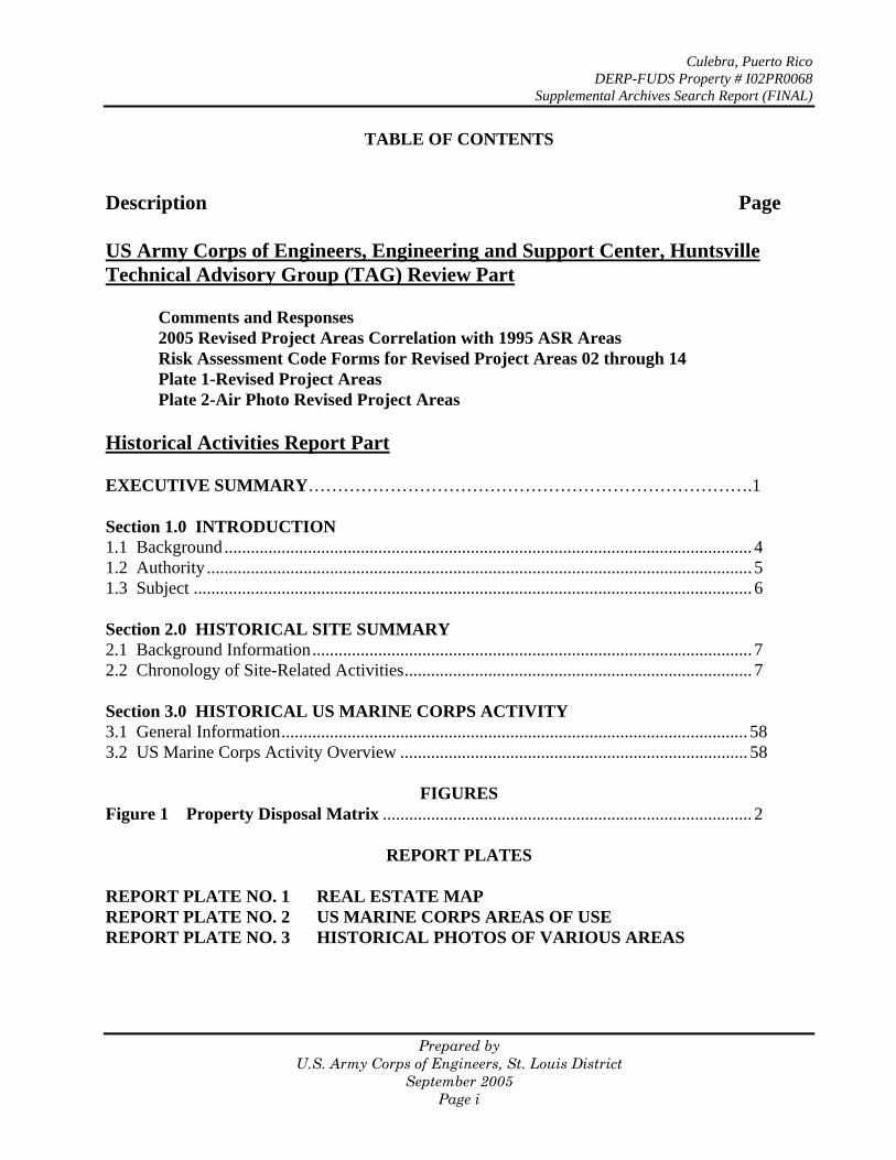
TABLE OF CONTENTS
Description Page
US Army Corps of Engineers, Engineering and Support Center, Huntsville Technical Advisory Group (TAG) Review Part
Comments and Responses 2005 Revised Project Areas Correlation with 1995 ASR Areas Risk Assessment Code Forms for Revised Project Areas 02 through 14 Plate 1-Revised Project Areas Plate 2-Air Photo Revised Project Areas
Historical Activities Report Part
EXECUTIVE SUMMARY………………………………………………………………….1
Section 1.0 INTRODUCTION 1.1 Background ........................................................................................................................ 4 1.2 Authority ............................................................................................................................ 5 1.3 Subject ............................................................................................................................... 6
Section 2.0 HISTORICAL SITE SUMMARY 2.1 Background Information .................................................................................................... 7 2.2 Chronology of Site-Related Activities............................................................................... 7
Section 3.0 HISTORICAL US MARINE CORPS ACTIVITY 3.1 General Information.......................................................................................................... 58 3.2 US Marine Corps Activity Overview ............................................................................... 58
FIGURES Figure 1 Property Disposal Matrix .................................................................................... 2
REPORT PLATES
REPORT PLATE NO. 1 REAL ESTATE MAP REPORT PLATE NO. 2 US MARINE CORPS AREAS OF USE REPORT PLATE NO. 3 HISTORICAL PHOTOS OF VARIOUS AREAS
Prepared by U.S. Army Corps of Engineers, St. Louis District
September 2005 Page i
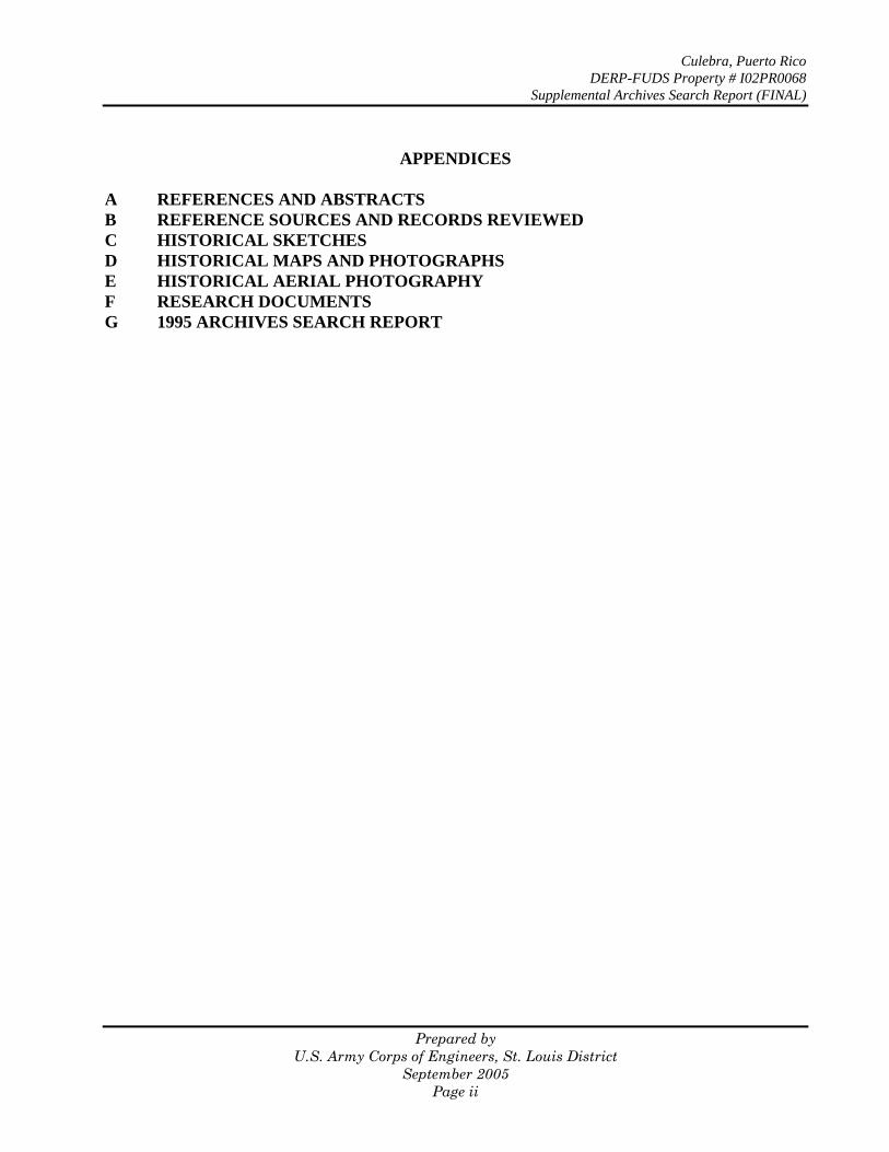
APPENDICES
A REFERENCES AND ABSTRACTS B REFERENCE SOURCES AND RECORDS REVIEWED C HISTORICAL SKETCHES D HISTORICAL MAPS AND PHOTOGRAPHS E HISTORICAL AERIAL PHOTOGRAPHY F RESEARCH DOCUMENTS G 1995 ARCHIVES SEARCH REPORT
Culebra, Puerto Rico DERP-FUDS Property # I02PR0068
Supplemental Archives Search Report (FINAL)
Prepared by U.S. Army Corps of Engineers, St. Louis District
September 2005 Page ii
Technical Advisory Group Part of the
Supplemental Archives Search Report for
Culebra, Puerto Rico
U. S. ARMY ENGINEERING AND SUPPORT CENTER, HUNTSVILLE CORPS OF ENGINEERS DESIGN REVIEW COMMENTS
PROJECT DERP FUDS
Culebra Island, Puerto Rico
I02PR006800
X� ASR/INPR TEAM REVIEW ASR TAG MMRP
DATE
15 March 2005
NAME
Ron Thornhill (918) 420-8395ITEM DRAWING
NO. OR REFERENCE
COMMENT
ACTION 1. General ASR and Supplemental ASR for Culebra Island, PuertoRico were reviewed for consistency, accuracy andcompleteness. Based on this review the followingcomments are provided:
2. General The ASR and Supplemental ASR are consistent in allrespects. The Supplement elaborates on the original,and does not contradict any original findings.
None Required
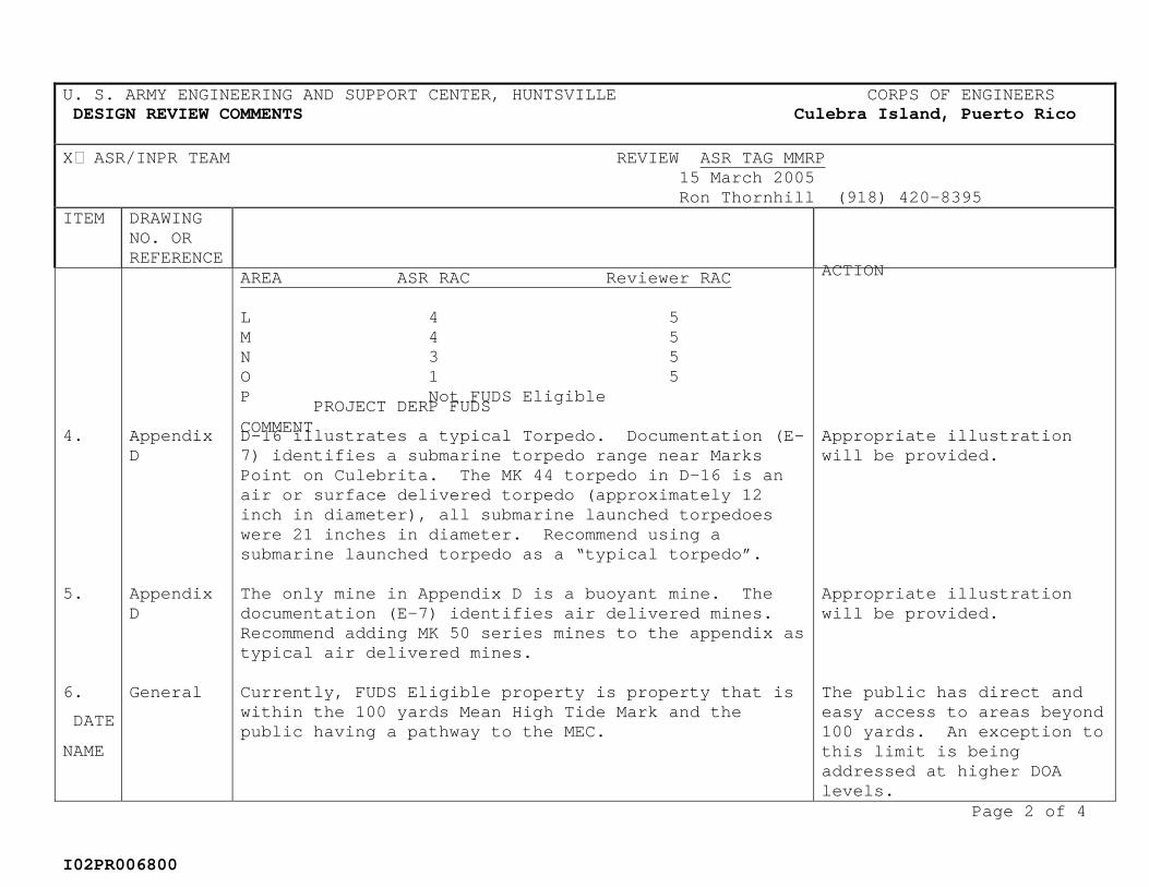
3. General The reviewer agrees with some of the Risk AssessmentCodes, (RAC) assigned by the ASR. No HNC assessment was found accompanying the ASR. The RACs are summaries as follows:
AREA ASR RAC Reviewer RAC
A 2 1 B 2 2 C 1 1 D 3 2 E 3 5 F 3 5 G 3 5 H 3 5 I 4 5 J 3 5 K 4 5
See response to Item 9below.
Page 1 of 4
U. S. ARMY ENGINEERING AND SUPPORT CENTER, HUNTSVILLE CORPS OF ENGINEERS DESIGN REVIEW COMMENTS
PROJECT DERP FUDS
Culebra Island, Puerto Rico
I02PR006800
X� ASR/INPR TEAM REVIEW ASR TAG MMRP
DATE
15 March 2005
NAME
Ron Thornhill (918) 420-8395ITEM DRAWING
NO. OR REFERENCE
COMMENT
ACTION AREA ASR RAC Reviewer RAC
L 4 5 M 4 5 N 3 5 O 1 5 P Not FUDS Eligible
4. AppendixD
D-16 illustrates a typical Torpedo. Documentation (E-7) identifies a submarine torpedo range near MarksPoint on Culebrita. The MK 44 torpedo in D-16 is anair or surface delivered torpedo (approximately 12inch in diameter), all submarine launched torpedoeswere 21 inches in diameter. Recommend using asubmarine launched torpedo as a “typical torpedo”.
Appropriate illustrationwill be provided.
5. AppendixD
The only mine in Appendix D is a buoyant mine. The documentation (E-7) identifies air delivered mines.Recommend adding MK 50 series mines to the appendix astypical air delivered mines.
Appropriate illustrationwill be provided.
6. General Currently, FUDS Eligible property is property that iswithin the 100 yards Mean High Tide Mark and thepublic having a pathway to the MEC.
The public has direct andeasy access to areas beyond100 yards. An exception tothis limit is beingaddressed at higher DOAlevels.
Page 2 of 4
U. S. ARMY ENGINEERING AND SUPPORT CENTER, HUNTSVILLE CORPS OF ENGINEERS DESIGN REVIEW COMMENTS
PROJECT DERP FUDS
Culebra Island, Puerto Rico
I02PR006800
X� ASR/INPR TEAM REVIEW ASR TAG MMRP
DATE
15 March 2005
NAME
Ron Thornhill (918) 420-8395ITEM DRAWING
NO. OR REFERENCE
COMMENT
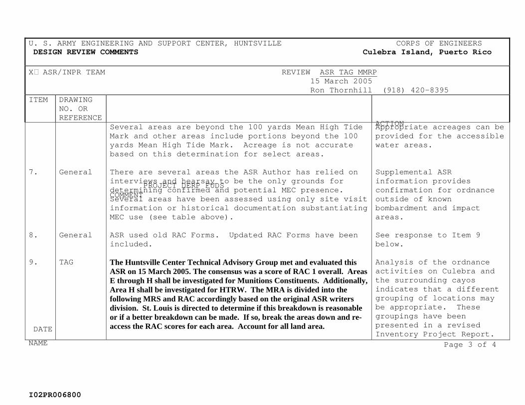
ACTION Several areas are beyond the 100 yards Mean High TideMark and other areas include portions beyond the 100yards Mean High Tide Mark. Acreage is not accuratebased on this determination for select areas.
Appropriate acreages can beprovided for the accessiblewater areas.
7. General There are several areas the ASR Author has relied on interviews and hearsay to be the only grounds fordetermining confirmed and potential MEC presence.Several areas have been assessed using only site visitinformation or historical documentation substantiatingMEC use (see table above).
Supplemental ASRinformation providesconfirmation for ordnance outside of known bombardment and impactareas.
8. General ASR used old RAC Forms. Updated RAC Forms have beenincluded.
See response to Item 9below.
9. TAG The Huntsville Center Technical Advisory Group met and evaluated this ASR on 15 March 2005. The consensus was a score of RAC 1 overall. Areas E through H shall be investigated for Munitions Constituents. Additionally, Area H shall be investigated for HTRW. The MRA is divided into the following MRS and RAC accordingly based on the original ASR writers division. St. Louis is directed to determine if this breakdown is reasonable or if a better breakdown can be made. If so, break the areas down and re-access the RAC scores for each area. Account for all land area.
Analysis of the ordnanceactivities on Culebra and the surrounding cayosindicates that a different grouping of locations maybe appropriate. These groupings have beenpresented in a revisedInventory Project Report.
Page 3 of 4
U. S. ARMY ENGINEERING AND SUPPORT CENTER, HUNTSVILLE CORPS OF ENGINEERS DESIGN REVIEW COMMENTS
PROJECT DERP FUDS
Culebra Island, Puerto Rico
I02PR006800
X� ASR/INPR TEAM REVIEW ASR TAG MMRP
DATE
15 March 2005
NAME
Ron Thornhill (918) 420-8395ITEM DRAWING
NO. OR REFERENCE
COMMENT
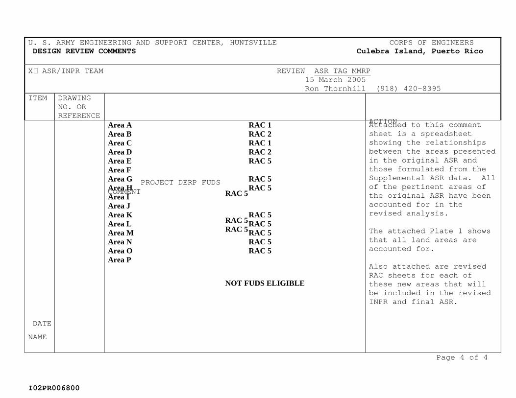
ACTION Area A RAC 1 Area B RAC 2 Area C RAC 1 Area D RAC 2 Area E RAC 5 Area F
RAC 5
Area G RAC 5 Area H RAC 5 Area I
RAC 5
Area J
RAC 5
Area K RAC 5 Area L RAC 5 Area M RAC 5 Area N RAC 5 Area O RAC 5 Area P
NOT FUDS ELIGIBLE
Attached to this comment sheet is a spreadsheetshowing the relationshipsbetween the areas presentedin the original ASR andthose formulated from the Supplemental ASR data. All of the pertinent areas ofthe original ASR have beenaccounted for in the revised analysis.
The attached Plate 1 shows that all land areas are accounted for.
Also attached are revised RAC sheets for each of these new areas that will be included in the revised INPR and final ASR.
Page 4 of 4
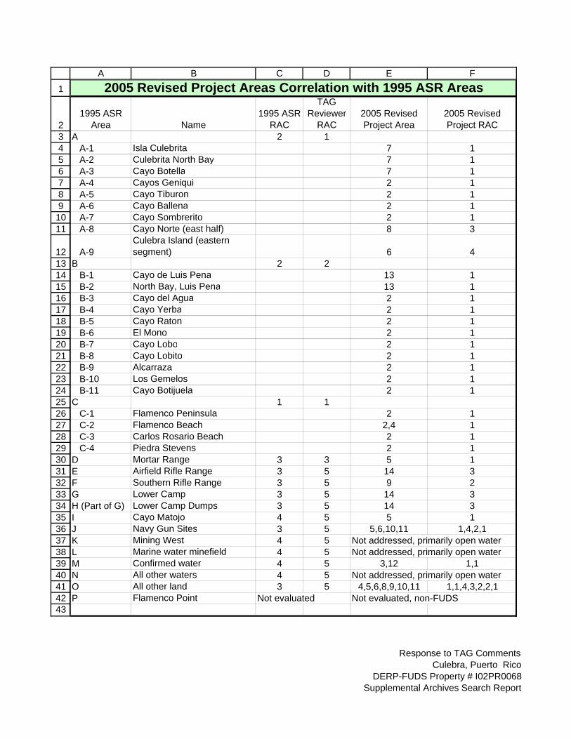
A B C D E F
1 2005 Revised Project Areas Correlation with 1995 ASR Areas
2 1995 ASR
Area Name 1995 ASR
RAC
TAG Reviewer
RAC 2005 Revised Project Area
2005 Revised Project RAC
3 A 2 1 4 A-1 Isla Culebrita 7 1 5 A-2 Culebrita North Bay 7 1 6 A-3 Cayo Botella 7 1 7 A-4 Cayos Geniqui 2 1 8 A-5 Cayo Tiburon 2 1 9 A-6 Cayo Ballena 2 1 10 A-7 Cayo Sombrerito 2 1 11 A-8 Cayo Norte (east half) 8 3
12 A-9 Culebra Island (eastern segment) 6 4
13 B 2 2 14 B-1 Cayo de Luis Pena 13 1 15 B-2 North Bay, Luis Pena 13 1 16 B-3 Cayo del Agua 2 1 17 B-4 Cayo Yerba 2 1 18 B-5 Cayo Raton 2 1 19 B-6 El Mono 2 1 20 B-7 Cayo Lobo 2 1 21 B-8 Cayo Lobito 2 1 22 B-9 Alcarraza 2 1 23 B-10 Los Gemelos 2 1 24 B-11 Cayo Botijuela 2 1 25 C 1 1 26 C-1 Flamenco Peninsula 2 1 27 C-2 Flamenco Beach 2,4 1 28 C-3 Carlos Rosario Beach 2 1 29 C-4 Piedra Stevens 2 1 30 D Mortar Range 3 3 5 1 31 E Airfield Rifle Range 3 5 14 3 32 F Southern Rifle Range 3 5 9 2 33 G Lower Camp 3 5 14 3 34 H (Part of G) Lower Camp Dumps 3 5 14 3 35 I Cayo Matojo 4 5 5 1 36 J Navy Gun Sites 3 5 5,6,10,11 1,4,2,1 37 K Mining West 4 5 Not addressed, primarily open water 38 L Marine water minefield 4 5 Not addressed, primarily open water 39 M Confirmed water 4 5 3,12 1,1 40 N All other waters 4 5 Not addressed, primarily open water 41 O All other land 3 5 4,5,6,8,9,10,11 1,1,4,3,2,2,1 42 P Flamenco Point Not evaluated Not evaluated, non-FUDS 43
Response to TAG Comments Culebra, Puerto Rico
DERP-FUDS Property # I02PR0068 Supplemental Archives Search Report
Culebra, Puerto Rico Culebra & Cayos (Area 02)
DERP-FUDS Project No. I02PR006802
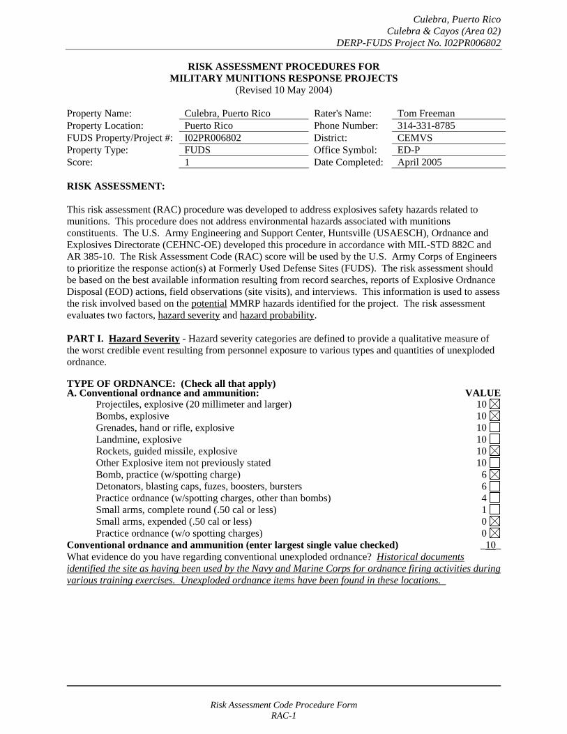
RISK ASSESSMENT PROCEDURES FOR MILITARY MUNITIONS RESPONSE PROJECTS
(Revised 10 May 2004)
Property Name: Culebra, Puerto Rico Rater's Name: Tom Freeman Property Location: Puerto Rico Phone Number: 314-331-8785 FUDS Property/Project #: I02PR006802 District: CEMVS Property Type: FUDS Office Symbol: ED-P Score: 1 Date Completed: April 2005
RISK ASSESSMENT:
This risk assessment (RAC) procedure was developed to address explosives safety hazards related to munitions. This procedure does not address environmental hazards associated with munitions constituents. The U.S. Army Engineering and Support Center, Huntsville (USAESCH), Ordnance and Explosives Directorate (CEHNC-OE) developed this procedure in accordance with MIL-STD 882C and AR 385-10. The Risk Assessment Code (RAC) score will be used by the U.S. Army Corps of Engineers to prioritize the response action(s) at Formerly Used Defense Sites (FUDS). The risk assessment should be based on the best available information resulting from record searches, reports of Explosive Ordnance Disposal (EOD) actions, field observations (site visits), and interviews. This information is used to assess the risk involved based on the potential MMRP hazards identified for the project. The risk assessment evaluates two factors, hazard severity and hazard probability.
PART I. Hazard Severity - Hazard severity categories are defined to provide a qualitative measure of the worst credible event resulting from personnel exposure to various types and quantities of unexploded ordnance.
TYPE OF ORDNANCE: (Check all that apply)A. Conventional ordnance and ammunition: VALUE
Projectiles, explosive (20 millimeter and larger) 10 Bombs, explosive 10
Grenades, hand or rifle, explosive 10 Landmine, explosive 10
Rockets, guided missile, explosive 10 Other Explosive item not previously stated 10 Bomb, practice (w/spotting charge) 6 Detonators, blasting caps, fuzes, boosters, bursters 6 Practice ordnance (w/spotting charges, other than bombs) 4 Small arms, complete round (.50 cal or less) 1 Small arms, expended (.50 cal or less) 0 Practice ordnance (w/o spotting charges) 0
Conventional ordnance and ammunition (enter largest single value checked) _10_ What evidence do you have regarding conventional unexploded ordnance? Historical documents identified the site as having been used by the Navy and Marine Corps for ordnance firing activities during various training exercises. Unexploded ordnance items have been found in these locations.
Risk Assessment Code Procedure Form RAC-1

Culebra, Puerto Rico Culebra & Cayos (Area 02)
DERP-FUDS Project No. I02PR006802
B. Pyrotechnics (for munitions not described above): VALUE
Munitions containing White Phosphorus (WP) 10 or other pyrophoric material (i.e., spontaneously flammable)
Munitions containing a flame or incendiary material 10 (i.e., Napalm, Triethylaluminum metal incendiaries)
Containers containing WP or other pyrophoric material or flame or 6 incendiary material
Flares, signals, simulators, screening/burning smokes (other than WP) 4
Pyrotechnics (enter the single largest value checked) _0_
What evidence do you have regarding pyrotechnics? None. The investigation team did not uncover evidence that these materials were used on this site.
C. Bulk Explosives (HE) (not an integral part of conventional ordnance; uncontainerized):
VALUE Primary or initiating explosives (Lead Styphnate, 10 Lead Azide, Nitroglycerin, Mercury Azide, Mercury Fulminate, Tetracene, etc.)
Secondary explosives (Demolition charges, PETN, Compositions A, B, C, 8 Tetryl, TNT, RDX, HMX, HBX, Black Powder, etc.)
Insensitive explosive substances (explosive contaminated soils, ammonium nitrate) 3
High explosives (enter the single largest value checked) _0_
What evidence do you have regarding bulk explosives? None. The investigation team did not uncover evidence that these materials were used on this site.
D. Bulk Propellants (not an integral part of rockets, guided missiles, or other conventional ordnance; uncontainerized):
VALUE Solid or liquid propellants 6
Bulk Propellants (select 6 or 0) _0_
What evidence do you have regarding bulk propellants? None. The investigation team did not uncover evidence that these materials were used on this site.
Risk Assessment Code Procedure Form RAC-2
Culebra, Puerto Rico Culebra & Cayos (Area 02)
DERP-FUDS Project No. I02PR006802
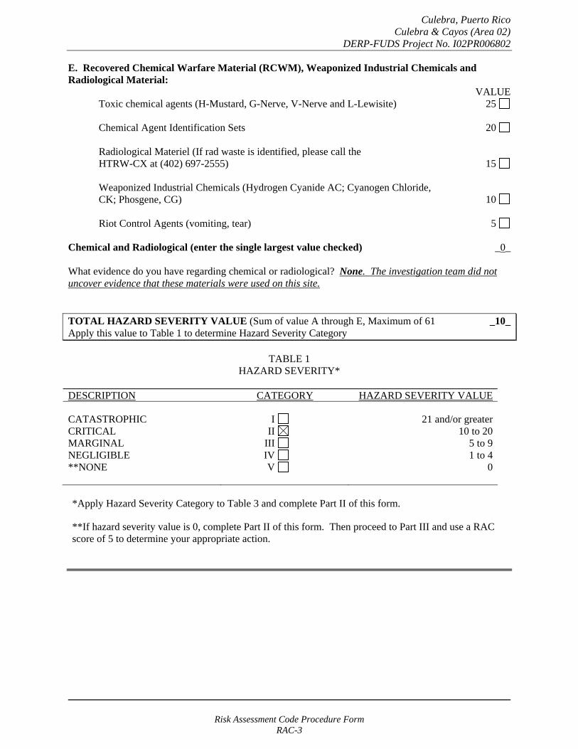
E. Recovered Chemical Warfare Material (RCWM), Weaponized Industrial Chemicals and Radiological Material:
VALUE Toxic chemical agents (H-Mustard, G-Nerve, V-Nerve and L-Lewisite) 25
Chemical Agent Identification Sets 20
Radiological Materiel (If rad waste is identified, please call the HTRW-CX at (402) 697-2555) 15
Weaponized Industrial Chemicals (Hydrogen Cyanide AC; Cyanogen Chloride, CK; Phosgene, CG) 10
Riot Control Agents (vomiting, tear) 5
Chemical and Radiological (enter the single largest value checked) _0_
What evidence do you have regarding chemical or radiological? None. The investigation team did not uncover evidence that these materials were used on this site.
TOTAL HAZARD SEVERITY VALUE (Sum of value A through E, Maximum of 61 _10_ Apply this value to Table 1 to determine Hazard Severity Category
TABLE 1 HAZARD SEVERITY*
DESCRIPTION CATEGORY HAZARD SEVERITY VALUE
CATASTROPHIC CRITICAL MARGINAL NEGLIGIBLE **NONE
I II
III IV V
21 and/or greater 10 to 20
5 to 9 1 to 4
0
*Apply Hazard Severity Category to Table 3 and complete Part II of this form.
**If hazard severity value is 0, complete Part II of this form. Then proceed to Part III and use a RAC score of 5 to determine your appropriate action.
Risk Assessment Code Procedure Form RAC-3

Culebra, Puerto Rico Culebra & Cayos (Area 02)
DERP-FUDS Project No. I02PR006802
PART II. Hazard Probability - The probability that a hazard has been, or will be, created due to the presence and other rated factors of unexploded ordnance, explosives, incendiary, pyrotechnic, radiological, or RCWM materials on a formerly used Department of Defense (DoD) site.
AREA, EXTENT, ACCESSIBILITY OF MMRP HAZARD (Check all that apply)
A. Locations of MMRP hazards: VALUE
On the surface 5 Within tanks, pipes, vessels, or other confined areas 4 Inside walls, ceilings, or other building/structure 3 Subsurface 2
Location (enter the single largest value checked) _5_
What evidence do you have regarding the location of MMRP? MMRP hazards could exist on the land and in the surrounding waters of these locations.
B. Distance to nearest inhabited location/structure likely to be at risk from MMRP hazard (road, park, playground, building etc.):
VALUE Less than 1,250 feet 5 1,250 feet to 0.5 mile 4 0.5 mile to 1.0 mile 3 1.0 mile to 2.0 Miles 2 Over 2 miles 1
Distance (enter the single largest value checked) _5_
What are the nearest inhabited structures/buildings? A heavily used public park and beach and a private resort are in the immediate vicinity of this site.
Risk Assessment Code Procedure Form RAC-4
Culebra, Puerto Rico Culebra & Cayos (Area 02)
DERP-FUDS Project No. I02PR006802
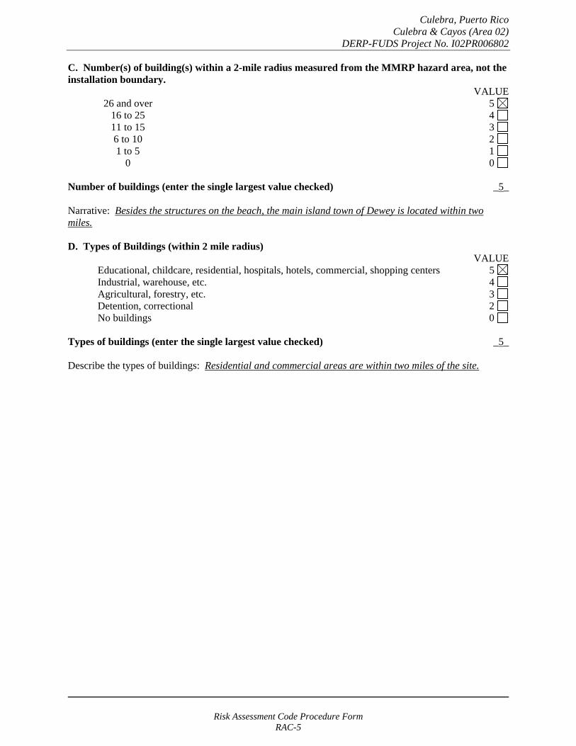
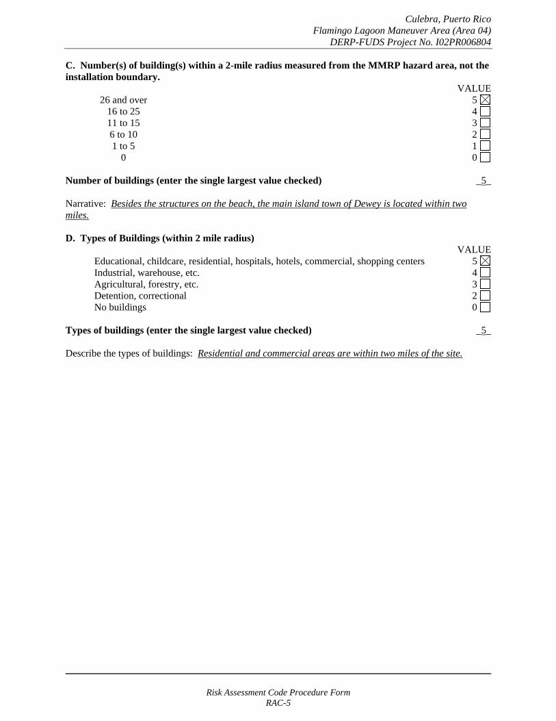
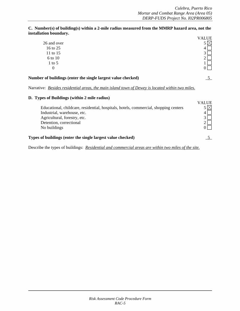
C. Number(s) of building(s) within a 2-mile radius measured from the MMRP hazard area, not the installation boundary.
VALUE 26 and over 5 16 to 25 4 11 to 15 3
6 to 10 2 1 to 5 1
0 0
Number of buildings (enter the single largest value checked) _5_
Narrative: Besides the structures on the beach, the main island town of Dewey is located within two miles.
D. Types of Buildings (within 2 mile radius) VALUE
Educational, childcare, residential, hospitals, hotels, commercial, shopping centers 5 Industrial, warehouse, etc. 4 Agricultural, forestry, etc. 3
Detention, correctional 2 No buildings 0
Types of buildings (enter the single largest value checked) _5_
Describe the types of buildings: Residential and commercial areas are within two miles of the site.
Risk Assessment Code Procedure Form RAC-5
Culebra, Puerto Rico Culebra & Cayos (Area 02)
DERP-FUDS Project No. I02PR006802
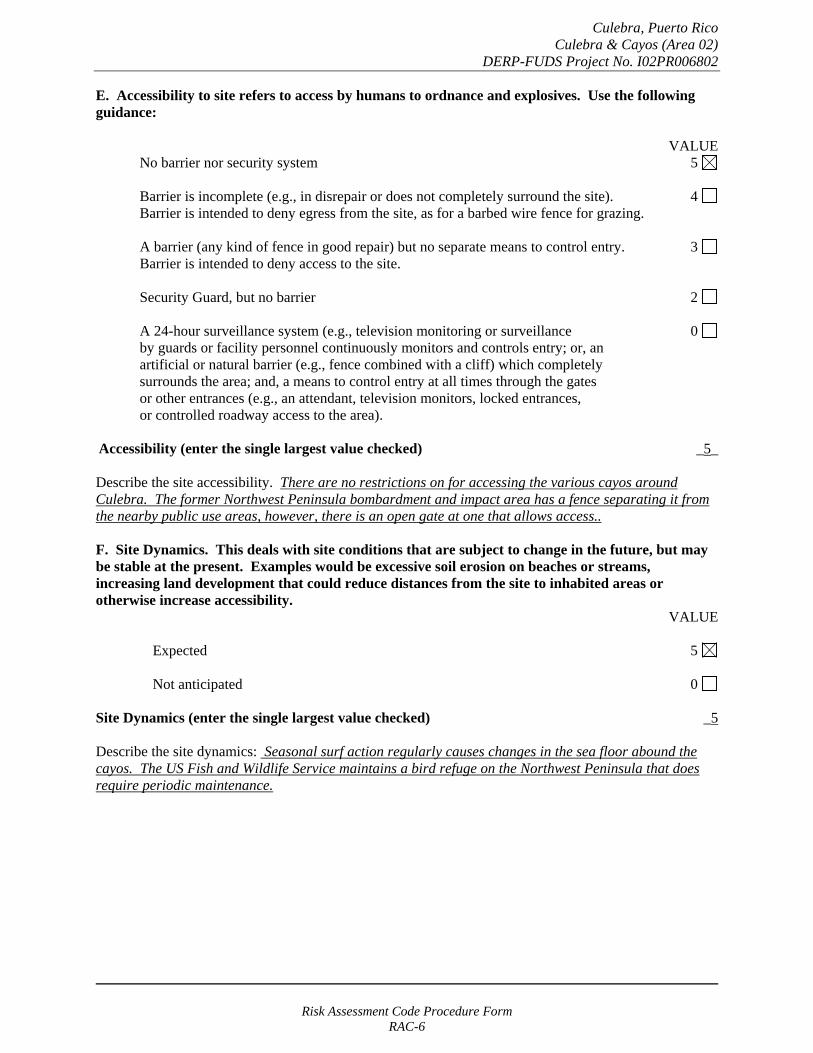
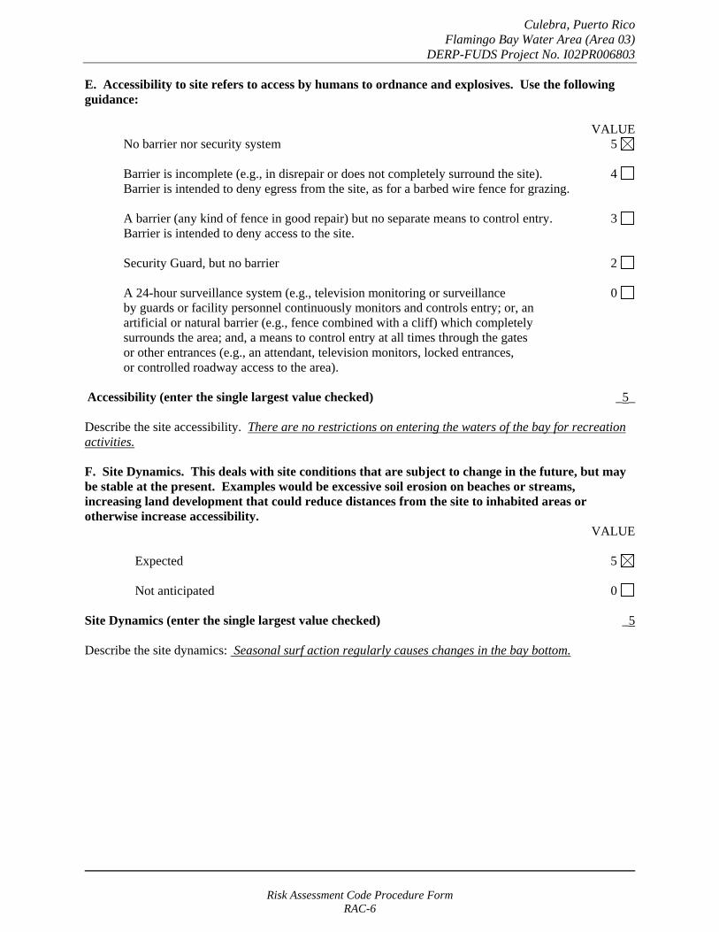
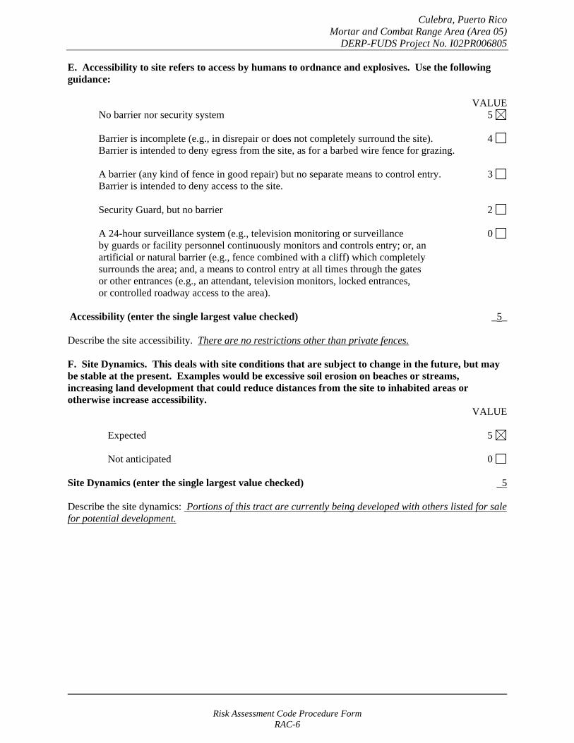
E. Accessibility to site refers to access by humans to ordnance and explosives. Use the following guidance:
VALUE No barrier nor security system 5
Barrier is incomplete (e.g., in disrepair or does not completely surround the site). 4 Barrier is intended to deny egress from the site, as for a barbed wire fence for grazing.
A barrier (any kind of fence in good repair) but no separate means to control entry. 3 Barrier is intended to deny access to the site.
Security Guard, but no barrier 2
A 24-hour surveillance system (e.g., television monitoring or surveillance 0 by guards or facility personnel continuously monitors and controls entry; or, an artificial or natural barrier (e.g., fence combined with a cliff) which completely surrounds the area; and, a means to control entry at all times through the gates or other entrances (e.g., an attendant, television monitors, locked entrances, or controlled roadway access to the area).
Accessibility (enter the single largest value checked) _5_
Describe the site accessibility. There are no restrictions on for accessing the various cayos around Culebra. The former Northwest Peninsula bombardment and impact area has a fence separating it from the nearby public use areas, however, there is an open gate at one that allows access..
F. Site Dynamics. This deals with site conditions that are subject to change in the future, but may be stable at the present. Examples would be excessive soil erosion on beaches or streams, increasing land development that could reduce distances from the site to inhabited areas or otherwise increase accessibility.
VALUE
Expected 5
Not anticipated 0
Site Dynamics (enter the single largest value checked) _5
Describe the site dynamics: Seasonal surf action regularly causes changes in the sea floor abound the cayos. The US Fish and Wildlife Service maintains a bird refuge on the Northwest Peninsula that does require periodic maintenance.
Risk Assessment Code Procedure Form RAC-6
Culebra, Puerto Rico Culebra & Cayos (Area 02)
DERP-FUDS Project No. I02PR006802
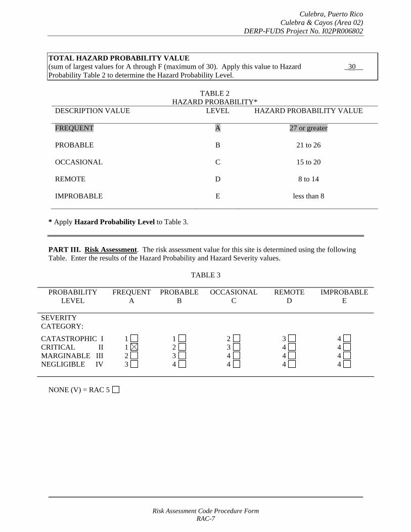
TOTAL HAZARD PROBABILITY VALUE (sum of largest values for A through F (maximum of 30). Apply this value to Hazard _30__ Probability Table 2 to determine the Hazard Probability Level.
TABLE 2 HAZARD PROBABILITY*
DESCRIPTION VALUE LEVEL HAZARD PROBABILITY VALUE
FREQUENT A 27 or greater
PROBABLE B 21 to 26
OCCASIONAL C 15 to 20
REMOTE D 8 to 14
IMPROBABLE E less than 8
* Apply Hazard Probability Level to Table 3.
PART III. Risk Assessment. The risk assessment value for this site is determined using the following Table. Enter the results of the Hazard Probability and Hazard Severity values.
TABLE 3
PROBABILITY LEVEL
FREQUENT A
PROBABLE B
OCCASIONAL C
REMOTE D
IMPROBABLE E
SEVERITY CATEGORY:
CATASTROPHIC I CRITICAL II MARGINABLE III NEGLIGIBLE IV
1 1 2 3
1 2 3 4
2 3 4 4
3 4 4 4
4 4 4 4
NONE (V) = RAC 5
Risk Assessment Code Procedure Form RAC-7
Culebra, Puerto Rico Culebra & Cayos (Area 02)
DERP-FUDS Project No. I02PR006802
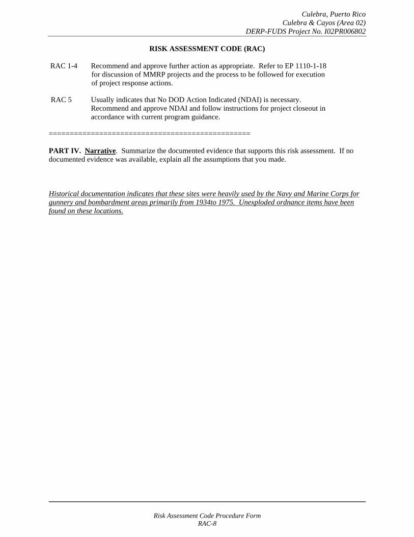
RISK ASSESSMENT CODE (RAC)
RAC 1-4 Recommend and approve further action as appropriate. Refer to EP 1110-1-18 for discussion of MMRP projects and the process to be followed for execution of project response actions.
RAC 5 Usually indicates that No DOD Action Indicated (NDAI) is necessary. Recommend and approve NDAI and follow instructions for project closeout in accordance with current program guidance.
================================================
PART IV. Narrative. Summarize the documented evidence that supports this risk assessment. If no documented evidence was available, explain all the assumptions that you made.
Historical documentation indicates that these sites were heavily used by the Navy and Marine Corps for gunnery and bombardment areas primarily from 1934to 1975. Unexploded ordnance items have been found on these locations.
Risk Assessment Code Procedure Form RAC-8
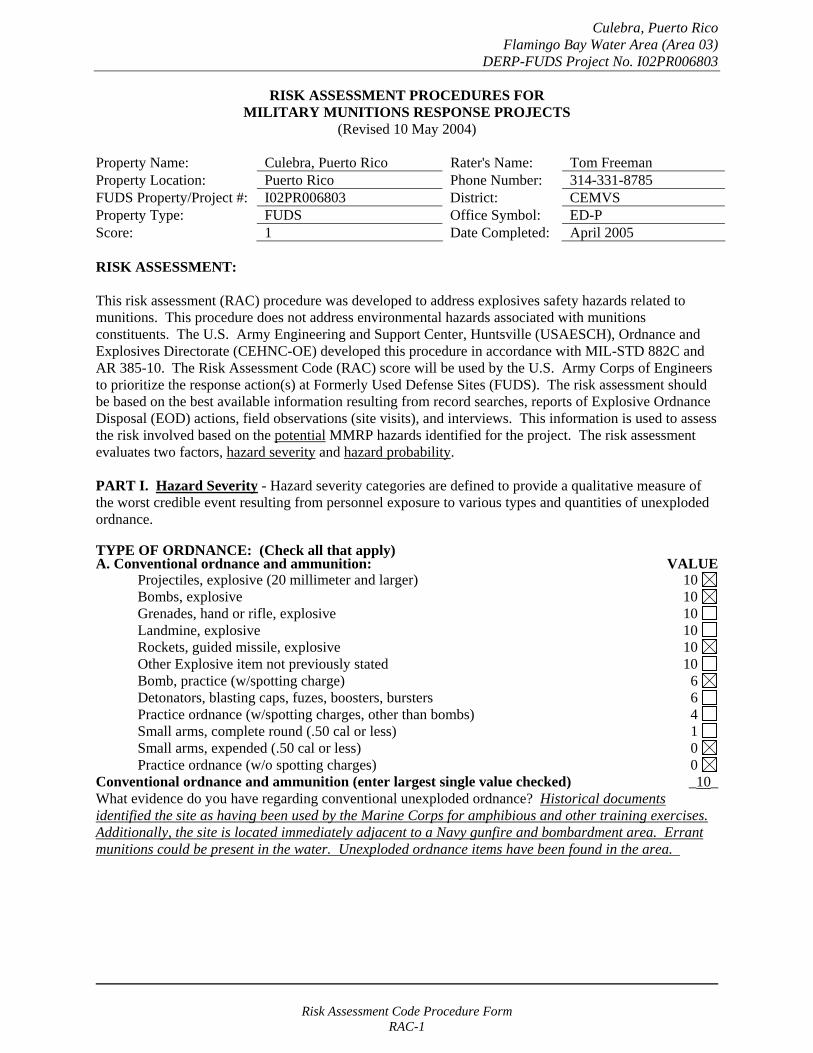
Culebra, Puerto Rico Flamingo Bay Water Area (Area 03)
DERP-FUDS Project No. I02PR006803
RISK ASSESSMENT PROCEDURES FOR MILITARY MUNITIONS RESPONSE PROJECTS
(Revised 10 May 2004)
Property Name: Culebra, Puerto Rico Rater's Name: Tom Freeman Property Location: Puerto Rico Phone Number: 314-331-8785 FUDS Property/Project #: I02PR006803 District: CEMVS Property Type: FUDS Office Symbol: ED-P Score: 1 Date Completed: April 2005
RISK ASSESSMENT:
This risk assessment (RAC) procedure was developed to address explosives safety hazards related to munitions. This procedure does not address environmental hazards associated with munitions constituents. The U.S. Army Engineering and Support Center, Huntsville (USAESCH), Ordnance and Explosives Directorate (CEHNC-OE) developed this procedure in accordance with MIL-STD 882C and AR 385-10. The Risk Assessment Code (RAC) score will be used by the U.S. Army Corps of Engineers to prioritize the response action(s) at Formerly Used Defense Sites (FUDS). The risk assessment should be based on the best available information resulting from record searches, reports of Explosive Ordnance Disposal (EOD) actions, field observations (site visits), and interviews. This information is used to assess the risk involved based on the potential MMRP hazards identified for the project. The risk assessment evaluates two factors, hazard severity and hazard probability.
PART I. Hazard Severity - Hazard severity categories are defined to provide a qualitative measure of the worst credible event resulting from personnel exposure to various types and quantities of unexploded ordnance.
TYPE OF ORDNANCE: (Check all that apply)A. Conventional ordnance and ammunition: VALUE
Projectiles, explosive (20 millimeter and larger) 10 Bombs, explosive 10
Grenades, hand or rifle, explosive 10 Landmine, explosive 10
Rockets, guided missile, explosive 10 Other Explosive item not previously stated 10 Bomb, practice (w/spotting charge) 6 Detonators, blasting caps, fuzes, boosters, bursters 6 Practice ordnance (w/spotting charges, other than bombs) 4 Small arms, complete round (.50 cal or less) 1 Small arms, expended (.50 cal or less) 0 Practice ordnance (w/o spotting charges) 0
Conventional ordnance and ammunition (enter largest single value checked) _10_ What evidence do you have regarding conventional unexploded ordnance? Historical documents identified the site as having been used by the Marine Corps for amphibious and other training exercises. Additionally, the site is located immediately adjacent to a Navy gunfire and bombardment area. Errant munitions could be present in the water. Unexploded ordnance items have been found in the area.
Risk Assessment Code Procedure Form RAC-1

Culebra, Puerto Rico Flamingo Bay Water Area (Area 03)
DERP-FUDS Project No. I02PR006803
B. Pyrotechnics (for munitions not described above): VALUE
Munitions containing White Phosphorus (WP) 10 or other pyrophoric material (i.e., spontaneously flammable)
Munitions containing a flame or incendiary material 10 (i.e., Napalm, Triethylaluminum metal incendiaries)
Containers containing WP or other pyrophoric material or flame or 6 incendiary material
Flares, signals, simulators, screening/burning smokes (other than WP) 4
Pyrotechnics (enter the single largest value checked) _0_
What evidence do you have regarding pyrotechnics? None. The investigation team did not uncover evidence that these materials were used on this site.
C. Bulk Explosives (HE) (not an integral part of conventional ordnance; uncontainerized):
VALUE Primary or initiating explosives (Lead Styphnate, 10 Lead Azide, Nitroglycerin, Mercury Azide, Mercury Fulminate, Tetracene, etc.)
Secondary explosives (Demolition charges, PETN, Compositions A, B, C, 8 Tetryl, TNT, RDX, HMX, HBX, Black Powder, etc.)
Insensitive explosive substances (explosive contaminated soils, ammonium nitrate) 3
High explosives (enter the single largest value checked) _0_
What evidence do you have regarding bulk explosives? None. The investigation team did not uncover evidence that these materials were used on this site.
D. Bulk Propellants (not an integral part of rockets, guided missiles, or other conventional ordnance; uncontainerized):
VALUE Solid or liquid propellants 6
Bulk Propellants (select 6 or 0) _0_
What evidence do you have regarding bulk propellants? None. The investigation team did not uncover evidence that these materials were used on this site.
Risk Assessment Code Procedure Form RAC-2

Culebra, Puerto Rico Flamingo Bay Water Area (Area 03)
DERP-FUDS Project No. I02PR006803
E. Recovered Chemical Warfare Material (RCWM), Weaponized Industrial Chemicals and Radiological Material:
VALUE Toxic chemical agents (H-Mustard, G-Nerve, V-Nerve and L-Lewisite) 25
Chemical Agent Identification Sets 20
Radiological Materiel (If rad waste is identified, please call the HTRW-CX at (402) 697-2555) 15
Weaponized Industrial Chemicals (Hydrogen Cyanide AC; Cyanogen Chloride, CK; Phosgene, CG) 10
Riot Control Agents (vomiting, tear) 5
Chemical and Radiological (enter the single largest value checked) _0_
What evidence do you have regarding chemical or radiological? None. The investigation team did not uncover evidence that these materials were used on this site.
TOTAL HAZARD SEVERITY VALUE (Sum of value A through E, Maximum of 61 _10_ Apply this value to Table 1 to determine Hazard Severity Category
TABLE 1 HAZARD SEVERITY*
DESCRIPTION CATEGORY HAZARD SEVERITY VALUE
CATASTROPHIC CRITICAL MARGINAL NEGLIGIBLE **NONE
I II
III IV V
21 and/or greater 10 to 20
5 to 9 1 to 4
0
*Apply Hazard Severity Category to Table 3 and complete Part II of this form.
**If hazard severity value is 0, complete Part II of this form. Then proceed to Part III and use a RAC score of 5 to determine your appropriate action.
Risk Assessment Code Procedure Form RAC-3
Culebra, Puerto Rico Flamingo Bay Water Area (Area 03)
DERP-FUDS Project No. I02PR006803
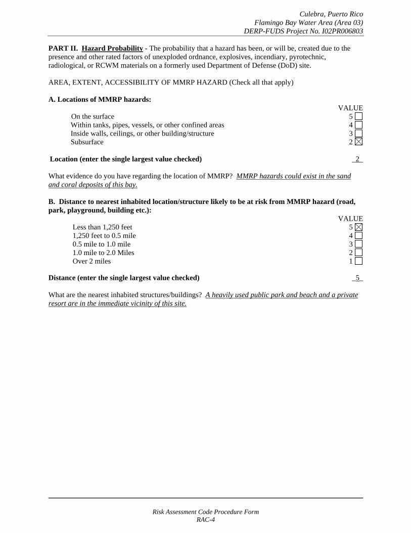
PART II. Hazard Probability - The probability that a hazard has been, or will be, created due to the presence and other rated factors of unexploded ordnance, explosives, incendiary, pyrotechnic, radiological, or RCWM materials on a formerly used Department of Defense (DoD) site.
AREA, EXTENT, ACCESSIBILITY OF MMRP HAZARD (Check all that apply)
A. Locations of MMRP hazards: VALUE
On the surface 5 Within tanks, pipes, vessels, or other confined areas 4 Inside walls, ceilings, or other building/structure 3 Subsurface 2
Location (enter the single largest value checked) _2_
What evidence do you have regarding the location of MMRP? MMRP hazards could exist in the sand and coral deposits of this bay.
B. Distance to nearest inhabited location/structure likely to be at risk from MMRP hazard (road, park, playground, building etc.):
VALUE Less than 1,250 feet 5 1,250 feet to 0.5 mile 4 0.5 mile to 1.0 mile 3 1.0 mile to 2.0 Miles 2 Over 2 miles 1
Distance (enter the single largest value checked) _5_
What are the nearest inhabited structures/buildings? A heavily used public park and beach and a private resort are in the immediate vicinity of this site.
Risk Assessment Code Procedure Form RAC-4

Culebra, Puerto Rico Flamingo Bay Water Area (Area 03)
DERP-FUDS Project No. I02PR006803
C. Number(s) of building(s) within a 2-mile radius measured from the MMRP hazard area, not the installation boundary.
VALUE 26 and over 5 16 to 25 4 11 to 15 3
6 to 10 2 1 to 5 1
0 0
Number of buildings (enter the single largest value checked) _5_
Narrative: Besides the structures on the beach, the main island town of Dewey is located within two miles.
D. Types of Buildings (within 2 mile radius) VALUE
Educational, childcare, residential, hospitals, hotels, commercial, shopping centers 5 Industrial, warehouse, etc. 4 Agricultural, forestry, etc. 3
Detention, correctional 2 No buildings 0
Types of buildings (enter the single largest value checked) _5_
Describe the types of buildings: Residential and commercial areas are within two miles of the site.
Risk Assessment Code Procedure Form RAC-5
Culebra, Puerto Rico Flamingo Bay Water Area (Area 03)
DERP-FUDS Project No. I02PR006803
E. Accessibility to site refers to access by humans to ordnance and explosives. Use the following guidance:
No barrier nor security system VALUE
5
Barrier is incomplete (e.g., in disrepair or does not completely surround the site). Barrier is intended to deny egress from the site, as for a barbed wire fence for grazing.
4
A barrier (any kind of fence in good repair) but no separate means to control entry. Barrier is intended to deny access to the site.
3
Security Guard, but no barrier 2
A 24-hour surveillance system (e.g., television monitoring or surveillance by guards or facility personnel continuously monitors and controls entry; or, an artificial or natural barrier (e.g., fence combined with a cliff) which completely surrounds the area; and, a means to control entry at all times through the gates or other entrances (e.g., an attendant, television monitors, locked entrances, or controlled roadway access to the area).
0
Accessibility (enter the single largest value checked) _5_
Describe the site accessibility. There are no restrictions on entering the waters of the bay for recreation activities.
F. Site Dynamics. This deals with site conditions that are subject to change in the future, but may be stable at the present. Examples would be excessive soil erosion on beaches or streams, increasing land development that could reduce distances from the site to inhabited areas or otherwise increase accessibility.
VALUE
Expected 5
Not anticipated 0
Site Dynamics (enter the single largest value checked) _5
Describe the site dynamics: Seasonal surf action regularly causes changes in the bay bottom.
Risk Assessment Code Procedure Form RAC-6
Culebra, Puerto Rico Flamingo Bay Water Area (Area 03)
DERP-FUDS Project No. I02PR006803
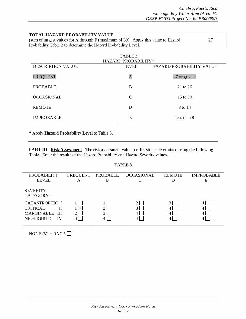
TOTAL HAZARD PROBABILITY VALUE (sum of largest values for A through F (maximum of 30). Apply this value to Hazard _27__ Probability Table 2 to determine the Hazard Probability Level.
TABLE 2 HAZARD PROBABILITY*
DESCRIPTION VALUE LEVEL HAZARD PROBABILITY VALUE
FREQUENT A 27 or greater
PROBABLE B 21 to 26
OCCASIONAL C 15 to 20
REMOTE D 8 to 14
IMPROBABLE E less than 8
* Apply Hazard Probability Level to Table 3.
PART III. Risk Assessment. The risk assessment value for this site is determined using the following Table. Enter the results of the Hazard Probability and Hazard Severity values.
TABLE 3
PROBABILITY LEVEL
FREQUENT A
PROBABLE B
OCCASIONAL C
REMOTE D
IMPROBABLE E
SEVERITY CATEGORY:
CATASTROPHIC I CRITICAL II MARGINABLE III NEGLIGIBLE IV
1 1 2 3
1 2 3 4
2 3 4 4
3 4 4 4
4 4 4 4
NONE (V) = RAC 5
Risk Assessment Code Procedure Form RAC-7

Culebra, Puerto Rico Flamingo Bay Water Area (Area 03)
DERP-FUDS Project No. I02PR006803
RISK ASSESSMENT CODE (RAC)
RAC 1-4 Recommend and approve further action as appropriate. Refer to EP 1110-1-18 for discussion of MMRP projects and the process to be followed for execution of project response actions.
RAC 5 Usually indicates that No DOD Action Indicated (NDAI) is necessary. Recommend and approve NDAI and follow instructions for project closeout in accordance with current program guidance.
================================================
PART IV. Narrative. Summarize the documented evidence that supports this risk assessment. If no documented evidence was available, explain all the assumptions that you made.
Historical documentation indicates that this site is immediately adjacent to a heavily used Navy gunnery and bombardment area that was used mainly from 1934to 1975. Unexploded ordnance items have been found in the area.
Risk Assessment Code Procedure Form RAC-8

Culebra, Puerto Rico Flamingo Lagoon Maneuver Area (Area 04)
DERP-FUDS Project No. I02PR006804
RISK ASSESSMENT PROCEDURES FOR MILITARY MUNITIONS RESPONSE PROJECTS
(Revised 10 May 2004)
Property Name: Culebra, Puerto Rico Rater's Name: Tom Freeman Property Location: Puerto Rico Phone Number: 314-331-8785 FUDS Property/Project #: I02PR006804 District: CEMVS Property Type: FUDS Office Symbol: ED-P Score: 1 Date Completed: April 2005
RISK ASSESSMENT:
This risk assessment (RAC) procedure was developed to address explosives safety hazards related to munitions. This procedure does not address environmental hazards associated with munitions constituents. The U.S. Army Engineering and Support Center, Huntsville (USAESCH), Ordnance and Explosives Directorate (CEHNC-OE) developed this procedure in accordance with MIL-STD 882C and AR 385-10. The Risk Assessment Code (RAC) score will be used by the U.S. Army Corps of Engineers to prioritize the response action(s) at Formerly Used Defense Sites (FUDS). The risk assessment should be based on the best available information resulting from record searches, reports of Explosive Ordnance Disposal (EOD) actions, field observations (site visits), and interviews. This information is used to assess the risk involved based on the potential MMRP hazards identified for the project. The risk assessment evaluates two factors, hazard severity and hazard probability.
PART I. Hazard Severity - Hazard severity categories are defined to provide a qualitative measure of the worst credible event resulting from personnel exposure to various types and quantities of unexploded ordnance.
TYPE OF ORDNANCE: (Check all that apply)A. Conventional ordnance and ammunition: VALUE
Projectiles, explosive (20 millimeter and larger) 10 Bombs, explosive 10
Grenades, hand or rifle, explosive 10 Landmine, explosive 10
Rockets, guided missile, explosive 10 Other Explosive item not previously stated 10 Bomb, practice (w/spotting charge) 6 Detonators, blasting caps, fuzes, boosters, bursters 6 Practice ordnance (w/spotting charges, other than bombs) 4 Small arms, complete round (.50 cal or less) 1 Small arms, expended (.50 cal or less) 0 Practice ordnance (w/o spotting charges) 0
Conventional ordnance and ammunition (enter largest single value checked) _10_ What evidence do you have regarding conventional unexploded ordnance? Historical documents identified the site as having been used by the Marine Corps ordnance training exercises. Additionally, the site is located immediately adjacent to a Navy gunfire and bombardment area. Errant munitions could be present in the area. No unexploded ordnance items have been reported in the area.
Risk Assessment Code Procedure Form RAC-1
Culebra, Puerto Rico Flamingo Lagoon Maneuver Area (Area 04)
DERP-FUDS Project No. I02PR006804
B. Pyrotechnics (for munitions not described above): VALUE
Munitions containing White Phosphorus (WP) 10 or other pyrophoric material (i.e., spontaneously flammable)
Munitions containing a flame or incendiary material 10 (i.e., Napalm, Triethylaluminum metal incendiaries)
Containers containing WP or other pyrophoric material or flame or 6 incendiary material
Flares, signals, simulators, screening/burning smokes (other than WP) 4
Pyrotechnics (enter the single largest value checked) _0_
What evidence do you have regarding pyrotechnics? None. The investigation team did not uncover evidence that these materials were used on this site.
C. Bulk Explosives (HE) (not an integral part of conventional ordnance; uncontainerized):
VALUE Primary or initiating explosives (Lead Styphnate, 10 Lead Azide, Nitroglycerin, Mercury Azide, Mercury Fulminate, Tetracene, etc.)
Secondary explosives (Demolition charges, PETN, Compositions A, B, C, 8 Tetryl, TNT, RDX, HMX, HBX, Black Powder, etc.)
Insensitive explosive substances (explosive contaminated soils, ammonium nitrate) 3
High explosives (enter the single largest value checked) _0_
What evidence do you have regarding bulk explosives? None. The investigation team did not uncover evidence that these materials were used on this site.
D. Bulk Propellants (not an integral part of rockets, guided missiles, or other conventional ordnance; uncontainerized):
VALUE Solid or liquid propellants 6
Bulk Propellants (select 6 or 0) _0_
What evidence do you have regarding bulk propellants? None. The investigation team did not uncover evidence that these materials were used on this site.
Risk Assessment Code Procedure Form RAC-2
Culebra, Puerto Rico Flamingo Lagoon Maneuver Area (Area 04)
DERP-FUDS Project No. I02PR006804
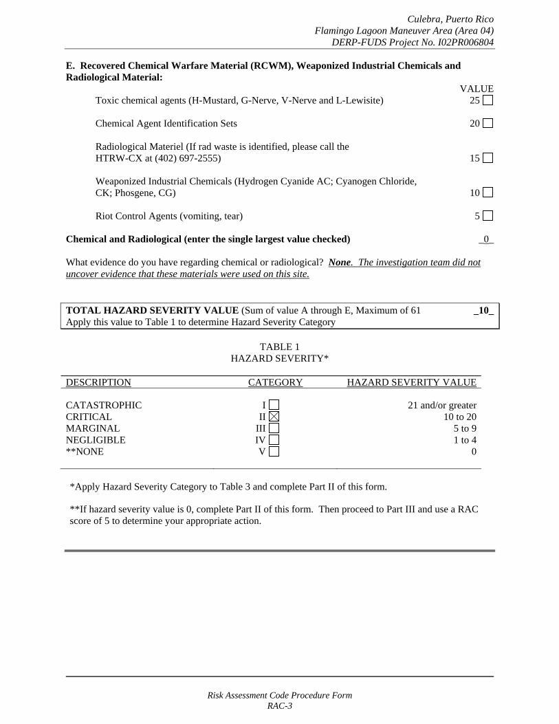
E. Recovered Chemical Warfare Material (RCWM), Weaponized Industrial Chemicals and Radiological Material:
VALUE Toxic chemical agents (H-Mustard, G-Nerve, V-Nerve and L-Lewisite) 25
Chemical Agent Identification Sets 20
Radiological Materiel (If rad waste is identified, please call the HTRW-CX at (402) 697-2555) 15
Weaponized Industrial Chemicals (Hydrogen Cyanide AC; Cyanogen Chloride, CK; Phosgene, CG) 10
Riot Control Agents (vomiting, tear) 5
Chemical and Radiological (enter the single largest value checked) _0_
What evidence do you have regarding chemical or radiological? None. The investigation team did not uncover evidence that these materials were used on this site.
TOTAL HAZARD SEVERITY VALUE (Sum of value A through E, Maximum of 61 _10_ Apply this value to Table 1 to determine Hazard Severity Category
TABLE 1 HAZARD SEVERITY*
DESCRIPTION CATEGORY HAZARD SEVERITY VALUE
CATASTROPHIC CRITICAL MARGINAL NEGLIGIBLE **NONE
I II
III IV V
21 and/or greater 10 to 20
5 to 9 1 to 4
0
*Apply Hazard Severity Category to Table 3 and complete Part II of this form.
**If hazard severity value is 0, complete Part II of this form. Then proceed to Part III and use a RAC score of 5 to determine your appropriate action.
Risk Assessment Code Procedure Form RAC-3

Culebra, Puerto Rico Flamingo Lagoon Maneuver Area (Area 04)
DERP-FUDS Project No. I02PR006804
PART II. Hazard Probability - The probability that a hazard has been, or will be, created due to the presence and other rated factors of unexploded ordnance, explosives, incendiary, pyrotechnic, radiological, or RCWM materials on a formerly used Department of Defense (DoD) site.
AREA, EXTENT, ACCESSIBILITY OF MMRP HAZARD (Check all that apply)
A. Locations of MMRP hazards: VALUE
On the surface 5 Within tanks, pipes, vessels, or other confined areas 4 Inside walls, ceilings, or other building/structure 3 Subsurface 2
Location (enter the single largest value checked) _2_
What evidence do you have regarding the location of MMRP? MMRP hazards could exist in the lagoon or land areas.
B. Distance to nearest inhabited location/structure likely to be at risk from MMRP hazard (road, park, playground, building etc.):
VALUE Less than 1,250 feet 5 1,250 feet to 0.5 mile 4 0.5 mile to 1.0 mile 3 1.0 mile to 2.0 Miles 2 Over 2 miles 1
Distance (enter the single largest value checked) _5_
What are the nearest inhabited structures/buildings? A heavily used public park and beach and a private resort are in the immediate vicinity of this site.
Risk Assessment Code Procedure Form RAC-4
Culebra, Puerto Rico Flamingo Lagoon Maneuver Area (Area 04)
DERP-FUDS Project No. I02PR006804
C. Number(s) of building(s) within a 2-mile radius measured from the MMRP hazard area, not the installation boundary.
VALUE 26 and over 5 16 to 25 4 11 to 15 3
6 to 10 2 1 to 5 1
0 0
Number of buildings (enter the single largest value checked) _5_
Narrative: Besides the structures on the beach, the main island town of Dewey is located within two miles.
D. Types of Buildings (within 2 mile radius) VALUE
Educational, childcare, residential, hospitals, hotels, commercial, shopping centers 5 Industrial, warehouse, etc. 4 Agricultural, forestry, etc. 3
Detention, correctional 2 No buildings 0
Types of buildings (enter the single largest value checked) _5_
Describe the types of buildings: Residential and commercial areas are within two miles of the site.
Risk Assessment Code Procedure Form RAC-5
Culebra, Puerto Rico Flamingo Lagoon Maneuver Area (Area 04)
DERP-FUDS Project No. I02PR006804
E. Accessibility to site refers to access by humans to ordnance and explosives. Use the following guidance:
VALUE No barrier nor security system 5
Barrier is incomplete (e.g., in disrepair or does not completely surround the site). 4 Barrier is intended to deny egress from the site, as for a barbed wire fence for grazing.
A barrier (any kind of fence in good repair) but no separate means to control entry. 3 Barrier is intended to deny access to the site.
Security Guard, but no barrier 2
A 24-hour surveillance system (e.g., television monitoring or surveillance 0 by guards or facility personnel continuously monitors and controls entry; or, an artificial or natural barrier (e.g., fence combined with a cliff) which completely surrounds the area; and, a means to control entry at all times through the gates or other entrances (e.g., an attendant, television monitors, locked entrances, or controlled roadway access to the area).
Accessibility (enter the single largest value checked) _5_
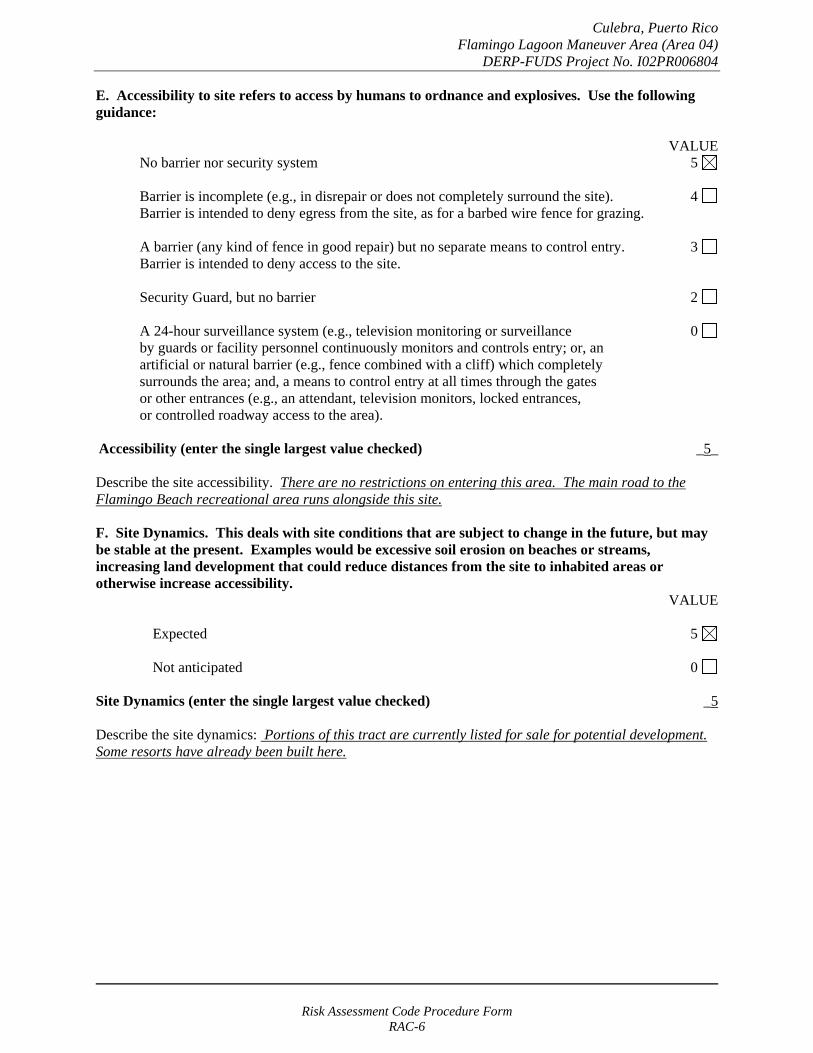
Describe the site accessibility. There are no restrictions on entering this area. The main road to the Flamingo Beach recreational area runs alongside this site.
F. Site Dynamics. This deals with site conditions that are subject to change in the future, but may be stable at the present. Examples would be excessive soil erosion on beaches or streams, increasing land development that could reduce distances from the site to inhabited areas or otherwise increase accessibility.
VALUE
Expected 5
Not anticipated 0
Site Dynamics (enter the single largest value checked) _5
Describe the site dynamics: Portions of this tract are currently listed for sale for potential development. Some resorts have already been built here.
Risk Assessment Code Procedure Form RAC-6
Culebra, Puerto Rico Flamingo Lagoon Maneuver Area (Area 04)
DERP-FUDS Project No. I02PR006804
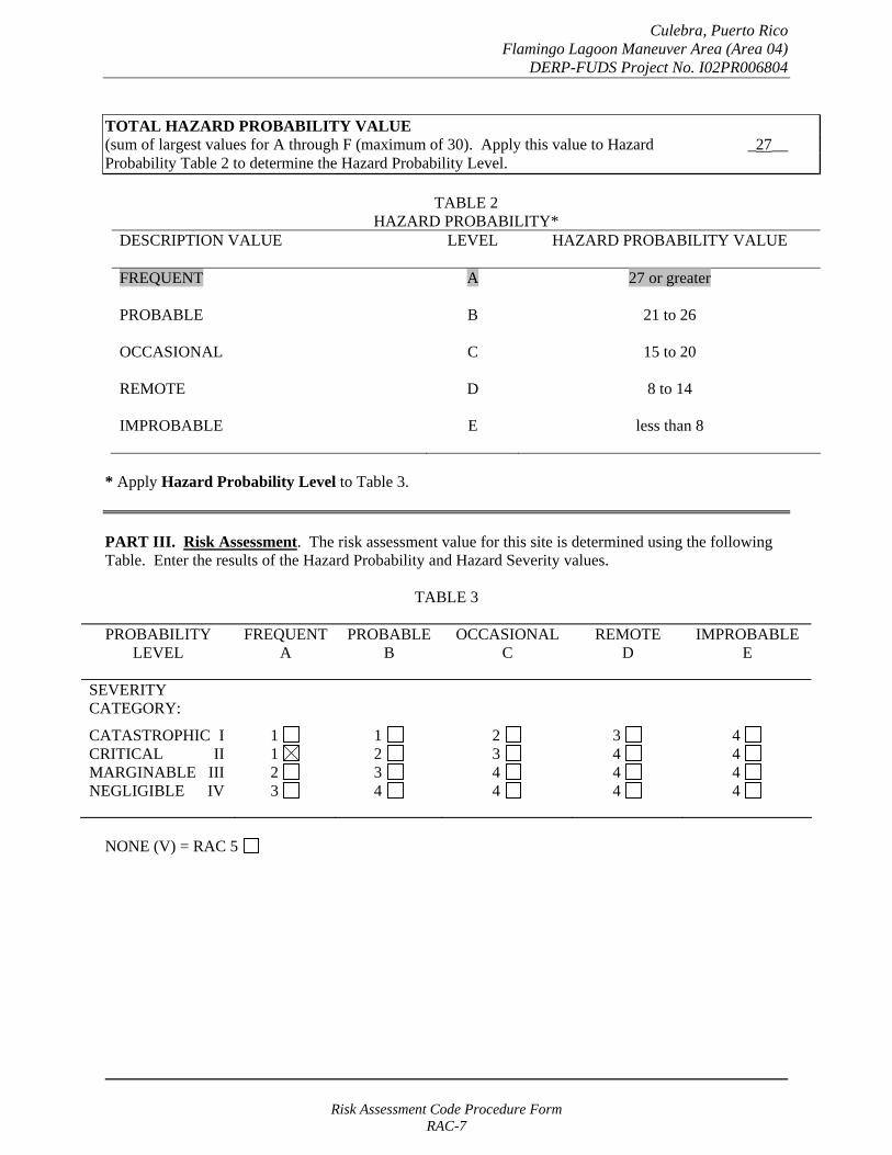
TOTAL HAZARD PROBABILITY VALUE (sum of largest values for A through F (maximum of 30). Apply this value to Hazard _27__ Probability Table 2 to determine the Hazard Probability Level.
TABLE 2 HAZARD PROBABILITY*
DESCRIPTION VALUE LEVEL HAZARD PROBABILITY VALUE
FREQUENT A 27 or greater
PROBABLE B 21 to 26
OCCASIONAL C 15 to 20
REMOTE D 8 to 14
IMPROBABLE E less than 8
* Apply Hazard Probability Level to Table 3.
PART III. Risk Assessment. The risk assessment value for this site is determined using the following Table. Enter the results of the Hazard Probability and Hazard Severity values.
TABLE 3
PROBABILITY LEVEL
FREQUENT A
PROBABLE B
OCCASIONAL C
REMOTE D
IMPROBABLE E
SEVERITY CATEGORY:
CATASTROPHIC I CRITICAL II MARGINABLE III NEGLIGIBLE IV
1 1 2 3
1 2 3 4
2 3 4 4
3 4 4 4
4 4 4 4
NONE (V) = RAC 5
Risk Assessment Code Procedure Form RAC-7
Culebra, Puerto Rico Flamingo Lagoon Maneuver Area (Area 04)
DERP-FUDS Project No. I02PR006804
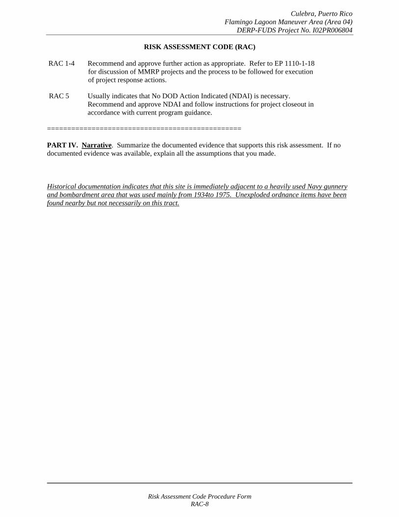
RISK ASSESSMENT CODE (RAC)
RAC 1-4 Recommend and approve further action as appropriate. Refer to EP 1110-1-18 for discussion of MMRP projects and the process to be followed for execution of project response actions.
RAC 5 Usually indicates that No DOD Action Indicated (NDAI) is necessary. Recommend and approve NDAI and follow instructions for project closeout in accordance with current program guidance.
================================================
PART IV. Narrative. Summarize the documented evidence that supports this risk assessment. If no documented evidence was available, explain all the assumptions that you made.
Historical documentation indicates that this site is immediately adjacent to a heavily used Navy gunnery and bombardment area that was used mainly from 1934to 1975. Unexploded ordnance items have been found nearby but not necessarily on this tract.
Risk Assessment Code Procedure Form RAC-8

Culebra, Puerto Rico Mortar and Combat Range Area (Area 05)
DERP-FUDS Project No. I02PR006805
RISK ASSESSMENT PROCEDURES FOR MILITARY MUNITIONS RESPONSE PROJECTS
(Revised 10 May 2004)
Property Name: Culebra, Puerto Rico Rater's Name: Tom Freeman Property Location: Puerto Rico Phone Number: 314-331-8785 FUDS Property/Project #: I02PR006805 District: CEMVS Property Type: FUDS Office Symbol: ED-P Score: 1 Date Completed: April 2005
RISK ASSESSMENT:
This risk assessment (RAC) procedure was developed to address explosives safety hazards related to munitions. This procedure does not address environmental hazards associated with munitions constituents. The U.S. Army Engineering and Support Center, Huntsville (USAESCH), Ordnance and Explosives Directorate (CEHNC-OE) developed this procedure in accordance with MIL-STD 882C and AR 385-10. The Risk Assessment Code (RAC) score will be used by the U.S. Army Corps of Engineers to prioritize the response action(s) at Formerly Used Defense Sites (FUDS). The risk assessment should be based on the best available information resulting from record searches, reports of Explosive Ordnance Disposal (EOD) actions, field observations (site visits), and interviews. This information is used to assess the risk involved based on the potential MMRP hazards identified for the project. The risk assessment evaluates two factors, hazard severity and hazard probability.
PART I. Hazard Severity - Hazard severity categories are defined to provide a qualitative measure of the worst credible event resulting from personnel exposure to various types and quantities of unexploded ordnance.
TYPE OF ORDNANCE: (Check all that apply)A. Conventional ordnance and ammunition: VALUE
Projectiles, explosive (20 millimeter and larger) 10 Bombs, explosive 10
Grenades, hand or rifle, explosive 10 Landmine, explosive 10
Rockets, guided missile, explosive 10 Other Explosive item not previously stated 10 Bomb, practice (w/spotting charge) 6 Detonators, blasting caps, fuzes, boosters, bursters 6 Practice ordnance (w/spotting charges, other than bombs) 4 Small arms, complete round (.50 cal or less) 1 Small arms, expended (.50 cal or less) 0 Practice ordnance (w/o spotting charges) 0
Conventional ordnance and ammunition (enter largest single value checked) _10_ What evidence do you have regarding conventional unexploded ordnance? Historical documents identified the site as having been used by the Marine Corps for mortar and combat range training areas. Additionally, the site falls within the safety fan of the artillery firing range. Unexploded ordnance items have been reported in the area.
Risk Assessment Code Procedure Form RAC-1

Culebra, Puerto Rico Mortar and Combat Range Area (Area 05)
DERP-FUDS Project No. I02PR006805
B. Pyrotechnics (for munitions not described above): VALUE
Munitions containing White Phosphorus (WP) 10 or other pyrophoric material (i.e., spontaneously flammable)
Munitions containing a flame or incendiary material 10 (i.e., Napalm, Triethylaluminum metal incendiaries)
Containers containing WP or other pyrophoric material or flame or 6 incendiary material
Flares, signals, simulators, screening/burning smokes (other than WP) 4
Pyrotechnics (enter the single largest value checked) _0_
What evidence do you have regarding pyrotechnics? None. The investigation team did not uncover evidence that these materials were used on this site.
C. Bulk Explosives (HE) (not an integral part of conventional ordnance; uncontainerized):
VALUE Primary or initiating explosives (Lead Styphnate, 10 Lead Azide, Nitroglycerin, Mercury Azide, Mercury Fulminate, Tetracene, etc.)
Secondary explosives (Demolition charges, PETN, Compositions A, B, C, 8 Tetryl, TNT, RDX, HMX, HBX, Black Powder, etc.)
Insensitive explosive substances (explosive contaminated soils, ammonium nitrate) 3
High explosives (enter the single largest value checked) _0_
What evidence do you have regarding bulk explosives? None. The investigation team did not uncover evidence that these materials were used on this site.
D. Bulk Propellants (not an integral part of rockets, guided missiles, or other conventional ordnance; uncontainerized):
VALUE Solid or liquid propellants 6
Bulk Propellants (select 6 or 0) _0_
What evidence do you have regarding bulk propellants? None. The investigation team did not uncover evidence that these materials were used on this site.
Risk Assessment Code Procedure Form RAC-2

Culebra, Puerto Rico Mortar and Combat Range Area (Area 05)
DERP-FUDS Project No. I02PR006805
E. Recovered Chemical Warfare Material (RCWM), Weaponized Industrial Chemicals and Radiological Material:
VALUE Toxic chemical agents (H-Mustard, G-Nerve, V-Nerve and L-Lewisite) 25
Chemical Agent Identification Sets 20
Radiological Materiel (If rad waste is identified, please call the HTRW-CX at (402) 697-2555) 15
Weaponized Industrial Chemicals (Hydrogen Cyanide AC; Cyanogen Chloride, CK; Phosgene, CG) 10
Riot Control Agents (vomiting, tear) 5
Chemical and Radiological (enter the single largest value checked) _0_
What evidence do you have regarding chemical or radiological? None. The investigation team did not uncover evidence that these materials were used on this site.
TOTAL HAZARD SEVERITY VALUE (Sum of value A through E, Maximum of 61 _10_ Apply this value to Table 1 to determine Hazard Severity Category
TABLE 1 HAZARD SEVERITY*
DESCRIPTION CATEGORY HAZARD SEVERITY VALUE
CATASTROPHIC CRITICAL MARGINAL NEGLIGIBLE **NONE
I II
III IV V
21 and/or greater 10 to 20
5 to 9 1 to 4
0
*Apply Hazard Severity Category to Table 3 and complete Part II of this form.
**If hazard severity value is 0, complete Part II of this form. Then proceed to Part III and use a RAC score of 5 to determine your appropriate action.
Risk Assessment Code Procedure Form RAC-3

Culebra, Puerto Rico Mortar and Combat Range Area (Area 05)
DERP-FUDS Project No. I02PR006805
PART II. Hazard Probability - The probability that a hazard has been, or will be, created due to the presence and other rated factors of unexploded ordnance, explosives, incendiary, pyrotechnic, radiological, or RCWM materials on a formerly used Department of Defense (DoD) site.
AREA, EXTENT, ACCESSIBILITY OF MMRP HAZARD (Check all that apply)
A. Locations of MMRP hazards: VALUE
On the surface 5 Within tanks, pipes, vessels, or other confined areas 4 Inside walls, ceilings, or other building/structure 3 Subsurface 2
Location (enter the single largest value checked) _5_
What evidence do you have regarding the location of MMRP? MMRP hazards could exist either on the surface or subsurface.
B. Distance to nearest inhabited location/structure likely to be at risk from MMRP hazard (road, park, playground, building etc.):
VALUE Less than 1,250 feet 5 1,250 feet to 0.5 mile 4 0.5 mile to 1.0 mile 3 1.0 mile to 2.0 Miles 2 Over 2 miles 1
Distance (enter the single largest value checked) _5_
What are the nearest inhabited structures/buildings? This tract contains several residential areas and the municipal waste management areas.
Risk Assessment Code Procedure Form RAC-4
Culebra, Puerto Rico Mortar and Combat Range Area (Area 05)
DERP-FUDS Project No. I02PR006805
C. Number(s) of building(s) within a 2-mile radius measured from the MMRP hazard area, not the installation boundary.
VALUE 26 and over 5 16 to 25 4 11 to 15 3
6 to 10 2 1 to 5 1
0 0
Number of buildings (enter the single largest value checked) _5_
Narrative: Besides residential areas, the main island town of Dewey is located within two miles.
D. Types of Buildings (within 2 mile radius) VALUE
Educational, childcare, residential, hospitals, hotels, commercial, shopping centers 5 Industrial, warehouse, etc. 4 Agricultural, forestry, etc. 3
Detention, correctional 2 No buildings 0
Types of buildings (enter the single largest value checked) _5_
Describe the types of buildings: Residential and commercial areas are within two miles of the site.
Risk Assessment Code Procedure Form RAC-5
Culebra, Puerto Rico Mortar and Combat Range Area (Area 05)
DERP-FUDS Project No. I02PR006805
E. Accessibility to site refers to access by humans to ordnance and explosives. Use the following guidance:
No barrier nor security system VALUE
5
Barrier is incomplete (e.g., in disrepair or does not completely surround the site). Barrier is intended to deny egress from the site, as for a barbed wire fence for grazing.
4
A barrier (any kind of fence in good repair) but no separate means to control entry. Barrier is intended to deny access to the site.
3
Security Guard, but no barrier 2
A 24-hour surveillance system (e.g., television monitoring or surveillance by guards or facility personnel continuously monitors and controls entry; or, an artificial or natural barrier (e.g., fence combined with a cliff) which completely surrounds the area; and, a means to control entry at all times through the gates or other entrances (e.g., an attendant, television monitors, locked entrances, or controlled roadway access to the area).
0
Accessibility (enter the single largest value checked) _5_
Describe the site accessibility. There are no restrictions other than private fences.
F. Site Dynamics. This deals with site conditions that are subject to change in the future, but may be stable at the present. Examples would be excessive soil erosion on beaches or streams, increasing land development that could reduce distances from the site to inhabited areas or otherwise increase accessibility.
VALUE
Expected 5
Not anticipated 0
Site Dynamics (enter the single largest value checked) _5
Describe the site dynamics: Portions of this tract are currently being developed with others listed for sale for potential development.
Risk Assessment Code Procedure Form RAC-6

Culebra, Puerto Rico Mortar and Combat Range Area (Area 05)
DERP-FUDS Project No. I02PR006805
TOTAL HAZARD PROBABILITY VALUE (sum of largest values for A through F (maximum of 30). Apply this value to Hazard _30__ Probability Table 2 to determine the Hazard Probability Level.
TABLE 2 HAZARD PROBABILITY*
DESCRIPTION VALUE LEVEL HAZARD PROBABILITY VALUE
FREQUENT A 27 or greater
PROBABLE B 21 to 26
OCCASIONAL C 15 to 20
REMOTE D 8 to 14
IMPROBABLE E less than 8
* Apply Hazard Probability Level to Table 3.
PART III. Risk Assessment. The risk assessment value for this site is determined using the following Table. Enter the results of the Hazard Probability and Hazard Severity values.
TABLE 3
PROBABILITY LEVEL
FREQUENT A
PROBABLE B
OCCASIONAL C
REMOTE D
IMPROBABLE E
SEVERITY CATEGORY:
CATASTROPHIC I CRITICAL II MARGINABLE III NEGLIGIBLE IV
1 1 2 3
1 2 3 4
2 3 4 4
3 4 4 4
4 4 4 4
NONE (V) = RAC 5
Risk Assessment Code Procedure Form RAC-7

Culebra, Puerto Rico Mortar and Combat Range Area (Area 05)
DERP-FUDS Project No. I02PR006805
RISK ASSESSMENT CODE (RAC)
RAC 1-4 Recommend and approve further action as appropriate. Refer to EP 1110-1-18 for discussion of MMRP projects and the process to be followed for execution of project response actions.
RAC 5 Usually indicates that No DOD Action Indicated (NDAI) is necessary. Recommend and approve NDAI and follow instructions for project closeout in accordance with current program guidance.
================================================
PART IV. Narrative. Summarize the documented evidence that supports this risk assessment. If no documented evidence was available, explain all the assumptions that you made.
Historical documentation indicates that this tract was the primary area used the Marine Corps for ordnance training on the island of Culebra. Unexploded ordnance items have been reportedly found here.
Risk Assessment Code Procedure Form RAC-8
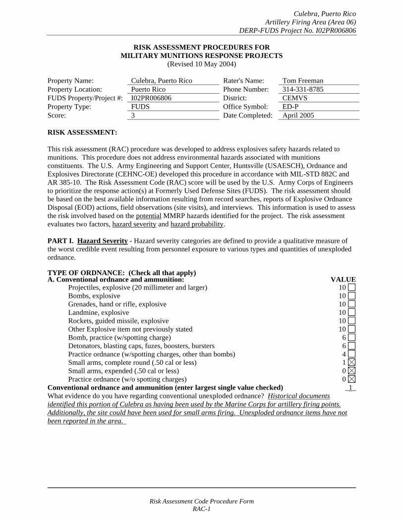
Culebra, Puerto Rico Artillery Firing Area (Area 06)
DERP-FUDS Project No. I02PR006806
RISK ASSESSMENT PROCEDURES FOR MILITARY MUNITIONS RESPONSE PROJECTS
(Revised 10 May 2004)
Property Name: Culebra, Puerto Rico Rater's Name: Tom Freeman Property Location: Puerto Rico Phone Number: 314-331-8785 FUDS Property/Project #: I02PR006806 District: CEMVS Property Type: FUDS Office Symbol: ED-P Score: 3 Date Completed: April 2005
RISK ASSESSMENT:
This risk assessment (RAC) procedure was developed to address explosives safety hazards related to munitions. This procedure does not address environmental hazards associated with munitions constituents. The U.S. Army Engineering and Support Center, Huntsville (USAESCH), Ordnance and Explosives Directorate (CEHNC-OE) developed this procedure in accordance with MIL-STD 882C and AR 385-10. The Risk Assessment Code (RAC) score will be used by the U.S. Army Corps of Engineers to prioritize the response action(s) at Formerly Used Defense Sites (FUDS). The risk assessment should be based on the best available information resulting from record searches, reports of Explosive Ordnance Disposal (EOD) actions, field observations (site visits), and interviews. This information is used to assess the risk involved based on the potential MMRP hazards identified for the project. The risk assessment evaluates two factors, hazard severity and hazard probability.
PART I. Hazard Severity - Hazard severity categories are defined to provide a qualitative measure of the worst credible event resulting from personnel exposure to various types and quantities of unexploded ordnance.
TYPE OF ORDNANCE: (Check all that apply)A. Conventional ordnance and ammunition: VALUE
Projectiles, explosive (20 millimeter and larger) 10 Bombs, explosive 10
Grenades, hand or rifle, explosive 10 Landmine, explosive 10
Rockets, guided missile, explosive 10 Other Explosive item not previously stated 10 Bomb, practice (w/spotting charge) 6 Detonators, blasting caps, fuzes, boosters, bursters 6 Practice ordnance (w/spotting charges, other than bombs) 4 Small arms, complete round (.50 cal or less) 1 Small arms, expended (.50 cal or less) 0 Practice ordnance (w/o spotting charges) 0
Conventional ordnance and ammunition (enter largest single value checked) _1_ What evidence do you have regarding conventional unexploded ordnance? Historical documents identified this portion of Culebra as having been used by the Marine Corps for artillery firing points. Additionally, the site could have been used for small arms firing. Unexploded ordnance items have not been reported in the area.
Risk Assessment Code Procedure Form RAC-1

Culebra, Puerto Rico Artillery Firing Area (Area 06)
DERP-FUDS Project No. I02PR006806
B. Pyrotechnics (for munitions not described above): VALUE
Munitions containing White Phosphorus (WP) 10 or other pyrophoric material (i.e., spontaneously flammable)
Munitions containing a flame or incendiary material 10 (i.e., Napalm, Triethylaluminum metal incendiaries)
Containers containing WP or other pyrophoric material or flame or 6 incendiary material
Flares, signals, simulators, screening/burning smokes (other than WP) 4
Pyrotechnics (enter the single largest value checked) _0_
What evidence do you have regarding pyrotechnics? None. The investigation team did not uncover evidence that these materials were used on this site.
C. Bulk Explosives (HE) (not an integral part of conventional ordnance; uncontainerized):
VALUE Primary or initiating explosives (Lead Styphnate, 10 Lead Azide, Nitroglycerin, Mercury Azide, Mercury Fulminate, Tetracene, etc.)
Secondary explosives (Demolition charges, PETN, Compositions A, B, C, 8 Tetryl, TNT, RDX, HMX, HBX, Black Powder, etc.)
Insensitive explosive substances (explosive contaminated soils, ammonium nitrate) 3
High explosives (enter the single largest value checked) _0_
What evidence do you have regarding bulk explosives? None. The investigation team did not uncover evidence that these materials were used on this site.
D. Bulk Propellants (not an integral part of rockets, guided missiles, or other conventional ordnance; uncontainerized):
VALUE Solid or liquid propellants 6
Bulk Propellants (select 6 or 0) _0_
What evidence do you have regarding bulk propellants? None. The investigation team did not uncover evidence that these materials were used on this site.
Risk Assessment Code Procedure Form RAC-2

Culebra, Puerto Rico Artillery Firing Area (Area 06)
DERP-FUDS Project No. I02PR006806
E. Recovered Chemical Warfare Material (RCWM), Weaponized Industrial Chemicals and Radiological Material:
VALUE Toxic chemical agents (H-Mustard, G-Nerve, V-Nerve and L-Lewisite) 25
Chemical Agent Identification Sets 20
Radiological Materiel (If rad waste is identified, please call the HTRW-CX at (402) 697-2555) 15
Weaponized Industrial Chemicals (Hydrogen Cyanide AC; Cyanogen Chloride, CK; Phosgene, CG) 10
Riot Control Agents (vomiting, tear) 5
Chemical and Radiological (enter the single largest value checked) _0_
What evidence do you have regarding chemical or radiological? None. The investigation team did not uncover evidence that these materials were used on this site.
TOTAL HAZARD SEVERITY VALUE (Sum of value A through E, Maximum of 61 _1_ Apply this value to Table 1 to determine Hazard Severity Category
TABLE 1 HAZARD SEVERITY*
DESCRIPTION CATEGORY HAZARD SEVERITY VALUE
CATASTROPHIC CRITICAL MARGINAL NEGLIGIBLE **NONE
I II
III IV V
21 and/or greater 10 to 20
5 to 9 1 to 4
0
*Apply Hazard Severity Category to Table 3 and complete Part II of this form.
**If hazard severity value is 0, complete Part II of this form. Then proceed to Part III and use a RAC score of 5 to determine your appropriate action.
Risk Assessment Code Procedure Form RAC-3
Culebra, Puerto Rico Artillery Firing Area (Area 06)
DERP-FUDS Project No. I02PR006806
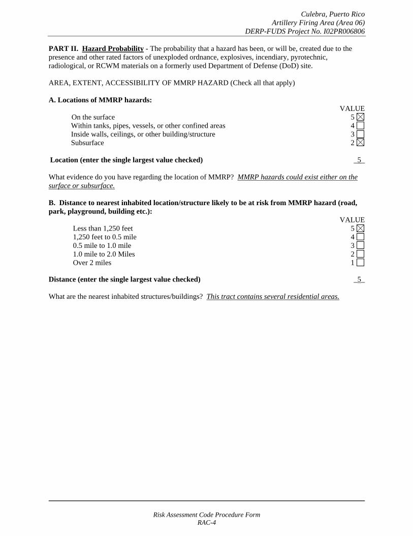
PART II. Hazard Probability - The probability that a hazard has been, or will be, created due to the presence and other rated factors of unexploded ordnance, explosives, incendiary, pyrotechnic, radiological, or RCWM materials on a formerly used Department of Defense (DoD) site.
AREA, EXTENT, ACCESSIBILITY OF MMRP HAZARD (Check all that apply)
A. Locations of MMRP hazards: VALUE
On the surface 5 Within tanks, pipes, vessels, or other confined areas 4 Inside walls, ceilings, or other building/structure 3 Subsurface 2
Location (enter the single largest value checked) _5_
What evidence do you have regarding the location of MMRP? MMRP hazards could exist either on the surface or subsurface.
B. Distance to nearest inhabited location/structure likely to be at risk from MMRP hazard (road, park, playground, building etc.):
VALUE Less than 1,250 feet 5 1,250 feet to 0.5 mile 4 0.5 mile to 1.0 mile 3 1.0 mile to 2.0 Miles 2 Over 2 miles 1
Distance (enter the single largest value checked) _5_
What are the nearest inhabited structures/buildings? This tract contains several residential areas.
Risk Assessment Code Procedure Form RAC-4
Culebra, Puerto Rico Artillery Firing Area (Area 06)
DERP-FUDS Project No. I02PR006806
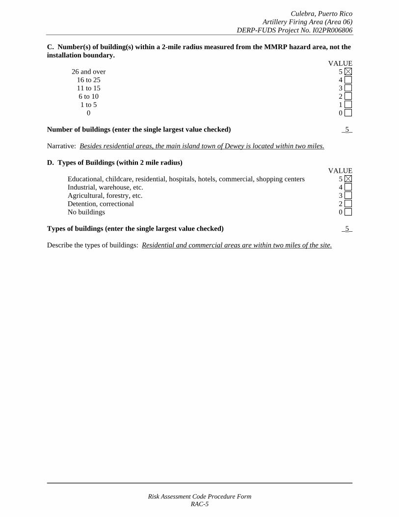
C. Number(s) of building(s) within a 2-mile radius measured from the MMRP hazard area, not the installation boundary.
VALUE 26 and over 5 16 to 25 4 11 to 15 3
6 to 10 2 1 to 5 1
0 0
Number of buildings (enter the single largest value checked) _5_
Narrative: Besides residential areas, the main island town of Dewey is located within two miles.
D. Types of Buildings (within 2 mile radius) VALUE
Educational, childcare, residential, hospitals, hotels, commercial, shopping centers 5 Industrial, warehouse, etc. 4 Agricultural, forestry, etc. 3
Detention, correctional 2 No buildings 0
Types of buildings (enter the single largest value checked) _5_
Describe the types of buildings: Residential and commercial areas are within two miles of the site.
Risk Assessment Code Procedure Form RAC-5
Culebra, Puerto Rico Artillery Firing Area (Area 06)
DERP-FUDS Project No. I02PR006806
E. Accessibility to site refers to access by humans to ordnance and explosives. Use the following guidance:
No barrier nor security system VALUE
5
Barrier is incomplete (e.g., in disrepair or does not completely surround the site). Barrier is intended to deny egress from the site, as for a barbed wire fence for grazing.
4
A barrier (any kind of fence in good repair) but no separate means to control entry. Barrier is intended to deny access to the site.
3
Security Guard, but no barrier 2
A 24-hour surveillance system (e.g., television monitoring or surveillance by guards or facility personnel continuously monitors and controls entry; or, an artificial or natural barrier (e.g., fence combined with a cliff) which completely surrounds the area; and, a means to control entry at all times through the gates or other entrances (e.g., an attendant, television monitors, locked entrances, or controlled roadway access to the area).
0
Accessibility (enter the single largest value checked) _5_
Describe the site accessibility. There are no restrictions other than private fences.
F. Site Dynamics. This deals with site conditions that are subject to change in the future, but may be stable at the present. Examples would be excessive soil erosion on beaches or streams, increasing land development that could reduce distances from the site to inhabited areas or otherwise increase accessibility.
VALUE
Expected 5
Not anticipated 0
Site Dynamics (enter the single largest value checked) _5
Describe the site dynamics: Portions of this tract are currently being developed with others listed for sale for potential development.
Risk Assessment Code Procedure Form RAC-6

Culebra, Puerto Rico Artillery Firing Area (Area 06)
DERP-FUDS Project No. I02PR006806
TOTAL HAZARD PROBABILITY VALUE (sum of largest values for A through F (maximum of 30). Apply this value to Hazard _30__ Probability Table 2 to determine the Hazard Probability Level.
TABLE 2 HAZARD PROBABILITY*
DESCRIPTION VALUE LEVEL HAZARD PROBABILITY VALUE
FREQUENT A 27 or greater
PROBABLE B 21 to 26
OCCASIONAL C 15 to 20
REMOTE D 8 to 14
IMPROBABLE E less than 8
* Apply Hazard Probability Level to Table 3.
PART III. Risk Assessment. The risk assessment value for this site is determined using the following Table. Enter the results of the Hazard Probability and Hazard Severity values.
TABLE 3
PROBABILITY LEVEL
FREQUENT A
PROBABLE B
OCCASIONAL C
REMOTE D
IMPROBABLE E
SEVERITY CATEGORY:
CATASTROPHIC I CRITICAL II MARGINABLE III NEGLIGIBLE IV
1 1 2 3
1 2 3 4
2 3 4 4
3 4 4 4
4 4 4 4
NONE (V) = RAC 5
Risk Assessment Code Procedure Form RAC-7
Culebra, Puerto Rico Artillery Firing Area (Area 06)
DERP-FUDS Project No. I02PR006806
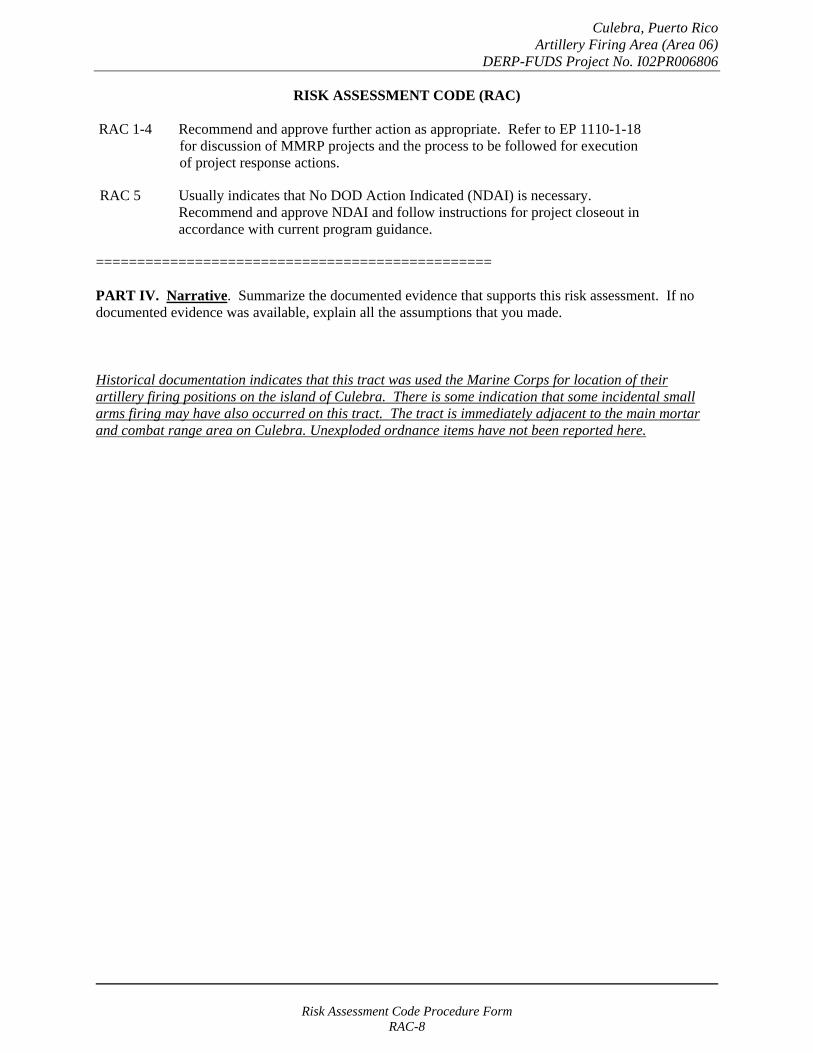
RISK ASSESSMENT CODE (RAC)
RAC 1-4 Recommend and approve further action as appropriate. Refer to EP 1110-1-18 for discussion of MMRP projects and the process to be followed for execution of project response actions.
RAC 5 Usually indicates that No DOD Action Indicated (NDAI) is necessary. Recommend and approve NDAI and follow instructions for project closeout in accordance with current program guidance.
================================================
PART IV. Narrative. Summarize the documented evidence that supports this risk assessment. If no documented evidence was available, explain all the assumptions that you made.
Historical documentation indicates that this tract was used the Marine Corps for location of their artillery firing positions on the island of Culebra. There is some indication that some incidental small arms firing may have also occurred on this tract. The tract is immediately adjacent to the main mortar and combat range area on Culebra. Unexploded ordnance items have not been reported here.
Risk Assessment Code Procedure Form RAC-8
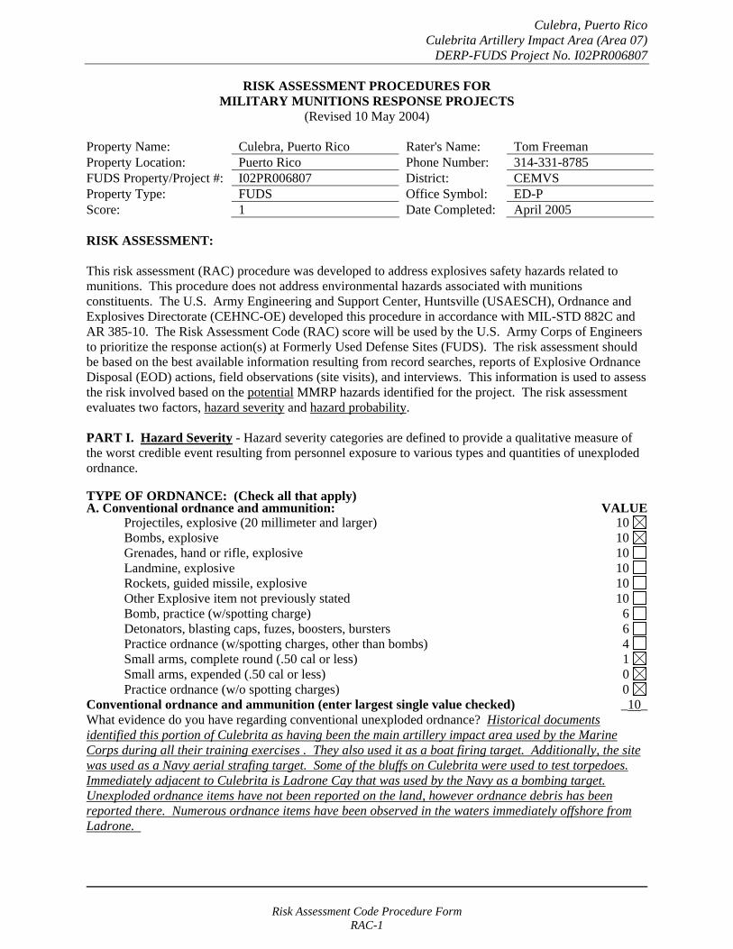
Culebra, Puerto Rico Culebrita Artillery Impact Area (Area 07)
DERP-FUDS Project No. I02PR006807
RISK ASSESSMENT PROCEDURES FOR MILITARY MUNITIONS RESPONSE PROJECTS
(Revised 10 May 2004)
Property Name: Culebra, Puerto Rico Rater's Name: Tom Freeman Property Location: Puerto Rico Phone Number: 314-331-8785 FUDS Property/Project #: I02PR006807 District: CEMVS Property Type: FUDS Office Symbol: ED-P Score: 1 Date Completed: April 2005
RISK ASSESSMENT:
This risk assessment (RAC) procedure was developed to address explosives safety hazards related to munitions. This procedure does not address environmental hazards associated with munitions constituents. The U.S. Army Engineering and Support Center, Huntsville (USAESCH), Ordnance and Explosives Directorate (CEHNC-OE) developed this procedure in accordance with MIL-STD 882C and AR 385-10. The Risk Assessment Code (RAC) score will be used by the U.S. Army Corps of Engineers to prioritize the response action(s) at Formerly Used Defense Sites (FUDS). The risk assessment should be based on the best available information resulting from record searches, reports of Explosive Ordnance Disposal (EOD) actions, field observations (site visits), and interviews. This information is used to assess the risk involved based on the potential MMRP hazards identified for the project. The risk assessment evaluates two factors, hazard severity and hazard probability.
PART I. Hazard Severity - Hazard severity categories are defined to provide a qualitative measure of the worst credible event resulting from personnel exposure to various types and quantities of unexploded ordnance.
TYPE OF ORDNANCE: (Check all that apply)A. Conventional ordnance and ammunition: VALUE
Projectiles, explosive (20 millimeter and larger) 10 Bombs, explosive 10
Grenades, hand or rifle, explosive 10 Landmine, explosive 10
Rockets, guided missile, explosive 10 Other Explosive item not previously stated 10 Bomb, practice (w/spotting charge) 6 Detonators, blasting caps, fuzes, boosters, bursters 6 Practice ordnance (w/spotting charges, other than bombs) 4 Small arms, complete round (.50 cal or less) 1 Small arms, expended (.50 cal or less) 0 Practice ordnance (w/o spotting charges) 0
Conventional ordnance and ammunition (enter largest single value checked) _10_ What evidence do you have regarding conventional unexploded ordnance? Historical documents identified this portion of Culebrita as having been the main artillery impact area used by the Marine Corps during all their training exercises . They also used it as a boat firing target. Additionally, the site was used as a Navy aerial strafing target. Some of the bluffs on Culebrita were used to test torpedoes. Immediately adjacent to Culebrita is Ladrone Cay that was used by the Navy as a bombing target. Unexploded ordnance items have not been reported on the land, however ordnance debris has been reported there. Numerous ordnance items have been observed in the waters immediately offshore from Ladrone.
Risk Assessment Code Procedure Form RAC-1

Culebra, Puerto Rico Culebrita Artillery Impact Area (Area 07)
DERP-FUDS Project No. I02PR006807
B. Pyrotechnics (for munitions not described above): VALUE
Munitions containing White Phosphorus (WP) 10 or other pyrophoric material (i.e., spontaneously flammable)
Munitions containing a flame or incendiary material 10 (i.e., Napalm, Triethylaluminum metal incendiaries)
Containers containing WP or other pyrophoric material or flame or 6 incendiary material
Flares, signals, simulators, screening/burning smokes (other than WP) 4
Pyrotechnics (enter the single largest value checked) _0_
What evidence do you have regarding pyrotechnics? None. The investigation team did not uncover evidence that these materials were used on this site.
C. Bulk Explosives (HE) (not an integral part of conventional ordnance; uncontainerized):
VALUE Primary or initiating explosives (Lead Styphnate, 10 Lead Azide, Nitroglycerin, Mercury Azide, Mercury Fulminate, Tetracene, etc.)
Secondary explosives (Demolition charges, PETN, Compositions A, B, C, 8 Tetryl, TNT, RDX, HMX, HBX, Black Powder, etc.)
Insensitive explosive substances (explosive contaminated soils, ammonium nitrate) 3
High explosives (enter the single largest value checked) _0_
What evidence do you have regarding bulk explosives? None. The investigation team did not uncover evidence that these materials were used on this site.
D. Bulk Propellants (not an integral part of rockets, guided missiles, or other conventional ordnance; uncontainerized):
VALUE Solid or liquid propellants 6
Bulk Propellants (select 6 or 0) _0_
What evidence do you have regarding bulk propellants? None. The investigation team did not uncover evidence that these materials were used on this site.
Risk Assessment Code Procedure Form RAC-2

Culebra, Puerto Rico Culebrita Artillery Impact Area (Area 07)
DERP-FUDS Project No. I02PR006807
E. Recovered Chemical Warfare Material (RCWM), Weaponized Industrial Chemicals and Radiological Material:
VALUE Toxic chemical agents (H-Mustard, G-Nerve, V-Nerve and L-Lewisite) 25
Chemical Agent Identification Sets 20
Radiological Materiel (If rad waste is identified, please call the HTRW-CX at (402) 697-2555) 15
Weaponized Industrial Chemicals (Hydrogen Cyanide AC; Cyanogen Chloride, CK; Phosgene, CG) 10
Riot Control Agents (vomiting, tear) 5
Chemical and Radiological (enter the single largest value checked) _0_
What evidence do you have regarding chemical or radiological? None. The investigation team did not uncover evidence that these materials were used on this site.
TOTAL HAZARD SEVERITY VALUE (Sum of value A through E, Maximum of 61 _10_ Apply this value to Table 1 to determine Hazard Severity Category
TABLE 1 HAZARD SEVERITY*
DESCRIPTION CATEGORY HAZARD SEVERITY VALUE
CATASTROPHIC CRITICAL MARGINAL NEGLIGIBLE **NONE
I II
III IV V
21 and/or greater 10 to 20
5 to 9 1 to 4
0
*Apply Hazard Severity Category to Table 3 and complete Part II of this form.
**If hazard severity value is 0, complete Part II of this form. Then proceed to Part III and use a RAC score of 5 to determine your appropriate action.
Risk Assessment Code Procedure Form RAC-3
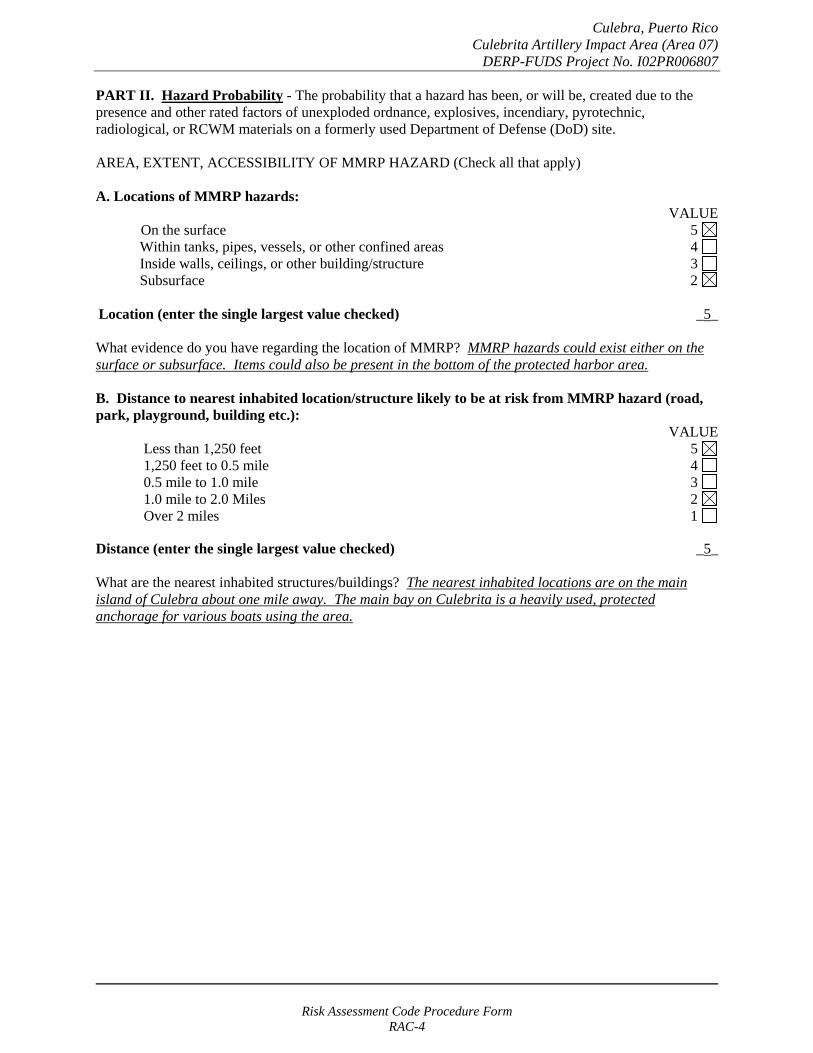
Culebra, Puerto Rico Culebrita Artillery Impact Area (Area 07)
DERP-FUDS Project No. I02PR006807
PART II. Hazard Probability - The probability that a hazard has been, or will be, created due to the presence and other rated factors of unexploded ordnance, explosives, incendiary, pyrotechnic, radiological, or RCWM materials on a formerly used Department of Defense (DoD) site.
AREA, EXTENT, ACCESSIBILITY OF MMRP HAZARD (Check all that apply)
A. Locations of MMRP hazards: VALUE
On the surface 5 Within tanks, pipes, vessels, or other confined areas 4 Inside walls, ceilings, or other building/structure 3 Subsurface 2
Location (enter the single largest value checked) _5_
What evidence do you have regarding the location of MMRP? MMRP hazards could exist either on the surface or subsurface. Items could also be present in the bottom of the protected harbor area.
B. Distance to nearest inhabited location/structure likely to be at risk from MMRP hazard (road, park, playground, building etc.):
VALUE Less than 1,250 feet 5 1,250 feet to 0.5 mile 4 0.5 mile to 1.0 mile 3 1.0 mile to 2.0 Miles 2 Over 2 miles 1
Distance (enter the single largest value checked) _5_
What are the nearest inhabited structures/buildings? The nearest inhabited locations are on the main island of Culebra about one mile away. The main bay on Culebrita is a heavily used, protected anchorage for various boats using the area.
Risk Assessment Code Procedure Form RAC-4
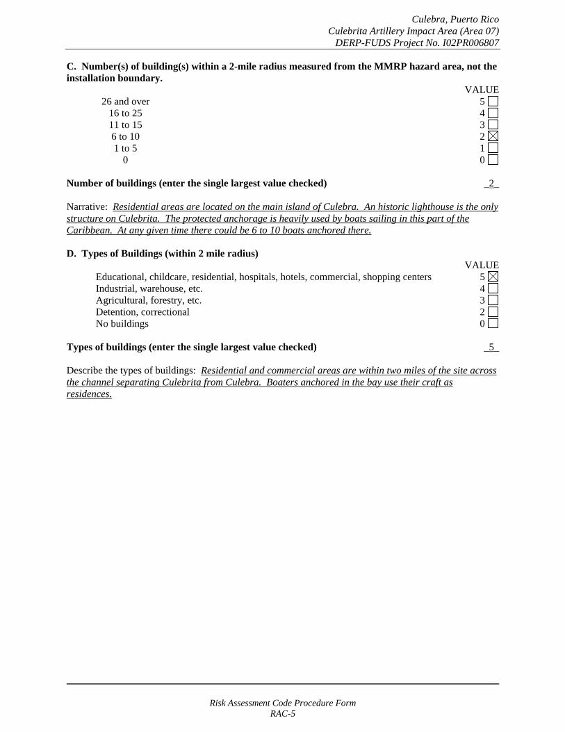
Culebra, Puerto Rico Culebrita Artillery Impact Area (Area 07)
DERP-FUDS Project No. I02PR006807
C. Number(s) of building(s) within a 2-mile radius measured from the MMRP hazard area, not the installation boundary.
VALUE 26 and over 5 16 to 25 4 11 to 15 3
6 to 10 2 1 to 5 1
0 0
Number of buildings (enter the single largest value checked) _2_
Narrative: Residential areas are located on the main island of Culebra. An historic lighthouse is the only structure on Culebrita. The protected anchorage is heavily used by boats sailing in this part of the Caribbean. At any given time there could be 6 to 10 boats anchored there.
D. Types of Buildings (within 2 mile radius) VALUE
Educational, childcare, residential, hospitals, hotels, commercial, shopping centers 5 Industrial, warehouse, etc. 4 Agricultural, forestry, etc. 3
Detention, correctional 2 No buildings 0
Types of buildings (enter the single largest value checked) _5_
Describe the types of buildings: Residential and commercial areas are within two miles of the site across the channel separating Culebrita from Culebra. Boaters anchored in the bay use their craft as residences.
Risk Assessment Code Procedure Form RAC-5
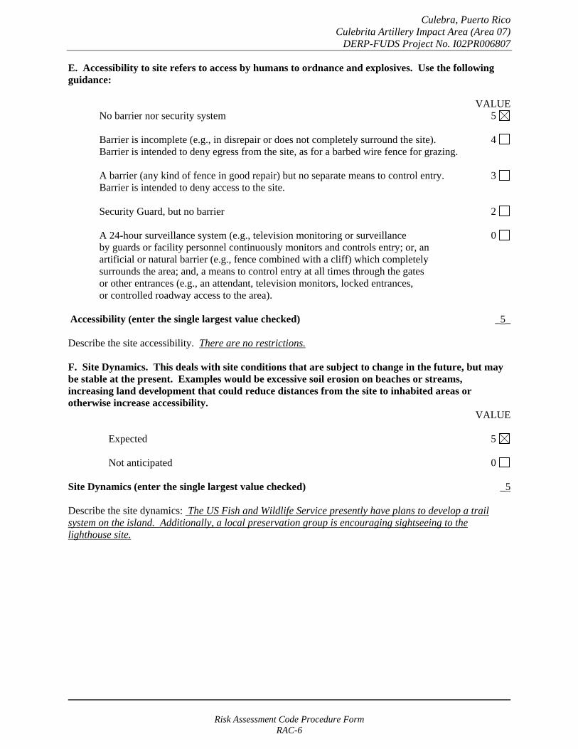
Culebra, Puerto Rico Culebrita Artillery Impact Area (Area 07)
DERP-FUDS Project No. I02PR006807
E. Accessibility to site refers to access by humans to ordnance and explosives. Use the following guidance:
VALUE No barrier nor security system 5
Barrier is incomplete (e.g., in disrepair or does not completely surround the site). 4 Barrier is intended to deny egress from the site, as for a barbed wire fence for grazing.
A barrier (any kind of fence in good repair) but no separate means to control entry. 3 Barrier is intended to deny access to the site.
Security Guard, but no barrier 2
A 24-hour surveillance system (e.g., television monitoring or surveillance 0 by guards or facility personnel continuously monitors and controls entry; or, an artificial or natural barrier (e.g., fence combined with a cliff) which completely surrounds the area; and, a means to control entry at all times through the gates or other entrances (e.g., an attendant, television monitors, locked entrances, or controlled roadway access to the area).
Accessibility (enter the single largest value checked) _5_
Describe the site accessibility. There are no restrictions.
F. Site Dynamics. This deals with site conditions that are subject to change in the future, but may be stable at the present. Examples would be excessive soil erosion on beaches or streams, increasing land development that could reduce distances from the site to inhabited areas or otherwise increase accessibility.
VALUE
Expected 5
Not anticipated 0
Site Dynamics (enter the single largest value checked) _5
Describe the site dynamics: The US Fish and Wildlife Service presently have plans to develop a trail system on the island. Additionally, a local preservation group is encouraging sightseeing to the lighthouse site.
Risk Assessment Code Procedure Form RAC-6

Culebra, Puerto Rico Culebrita Artillery Impact Area (Area 07)
DERP-FUDS Project No. I02PR006807
TOTAL HAZARD PROBABILITY VALUE (sum of largest values for A through F (maximum of 30). Apply this value to Hazard _27__ Probability Table 2 to determine the Hazard Probability Level.
TABLE 2 HAZARD PROBABILITY*
DESCRIPTION VALUE LEVEL HAZARD PROBABILITY VALUE
FREQUENT A 27 or greater
PROBABLE B 21 to 26
OCCASIONAL C 15 to 20
REMOTE D 8 to 14
IMPROBABLE E less than 8
* Apply Hazard Probability Level to Table 3.
PART III. Risk Assessment. The risk assessment value for this site is determined using the following Table. Enter the results of the Hazard Probability and Hazard Severity values.
TABLE 3
PROBABILITY LEVEL
FREQUENT A
PROBABLE B
OCCASIONAL C
REMOTE D
IMPROBABLE E
SEVERITY CATEGORY:
CATASTROPHIC I CRITICAL II MARGINABLE III NEGLIGIBLE IV
1 1 2 3
1 2 3 4
2 3 4 4
3 4 4 4
4 4 4 4
NONE (V) = RAC 5
Risk Assessment Code Procedure Form RAC-7
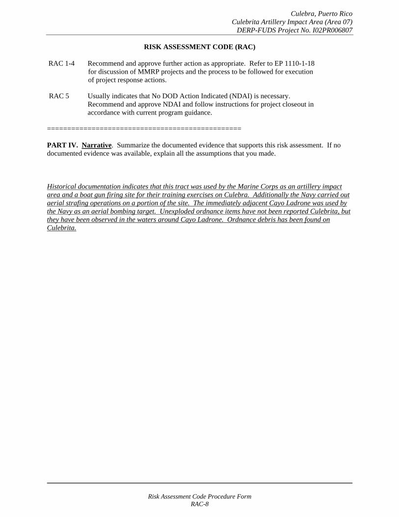
Culebra, Puerto Rico Culebrita Artillery Impact Area (Area 07)
DERP-FUDS Project No. I02PR006807
RISK ASSESSMENT CODE (RAC)
RAC 1-4 Recommend and approve further action as appropriate. Refer to EP 1110-1-18 for discussion of MMRP projects and the process to be followed for execution of project response actions.
RAC 5 Usually indicates that No DOD Action Indicated (NDAI) is necessary. Recommend and approve NDAI and follow instructions for project closeout in accordance with current program guidance.
================================================
PART IV. Narrative. Summarize the documented evidence that supports this risk assessment. If no documented evidence was available, explain all the assumptions that you made.
Historical documentation indicates that this tract was used by the Marine Corps as an artillery impact area and a boat gun firing site for their training exercises on Culebra. Additionally the Navy carried out aerial strafing operations on a portion of the site. The immediately adjacent Cayo Ladrone was used by the Navy as an aerial bombing target. Unexploded ordnance items have not been reported Culebrita, but they have been observed in the waters around Cayo Ladrone. Ordnance debris has been found on Culebrita.
Risk Assessment Code Procedure Form RAC-8
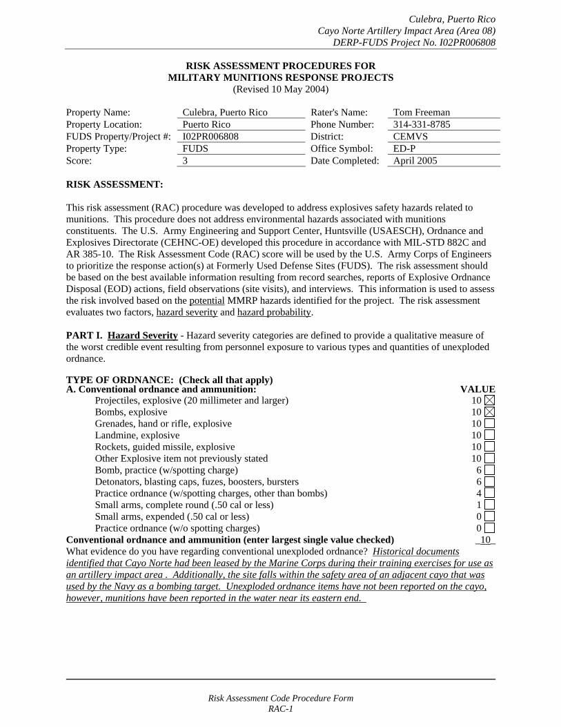
Culebra, Puerto Rico Cayo Norte Artillery Impact Area (Area 08)
DERP-FUDS Project No. I02PR006808
RISK ASSESSMENT PROCEDURES FOR MILITARY MUNITIONS RESPONSE PROJECTS
(Revised 10 May 2004)
Property Name: Culebra, Puerto Rico Rater's Name: Tom Freeman Property Location: Puerto Rico Phone Number: 314-331-8785 FUDS Property/Project #: I02PR006808 District: CEMVS Property Type: FUDS Office Symbol: ED-P Score: 3 Date Completed: April 2005
RISK ASSESSMENT:
This risk assessment (RAC) procedure was developed to address explosives safety hazards related to munitions. This procedure does not address environmental hazards associated with munitions constituents. The U.S. Army Engineering and Support Center, Huntsville (USAESCH), Ordnance and Explosives Directorate (CEHNC-OE) developed this procedure in accordance with MIL-STD 882C and AR 385-10. The Risk Assessment Code (RAC) score will be used by the U.S. Army Corps of Engineers to prioritize the response action(s) at Formerly Used Defense Sites (FUDS). The risk assessment should be based on the best available information resulting from record searches, reports of Explosive Ordnance Disposal (EOD) actions, field observations (site visits), and interviews. This information is used to assess the risk involved based on the potential MMRP hazards identified for the project. The risk assessment evaluates two factors, hazard severity and hazard probability.
PART I. Hazard Severity - Hazard severity categories are defined to provide a qualitative measure of the worst credible event resulting from personnel exposure to various types and quantities of unexploded ordnance.
TYPE OF ORDNANCE: (Check all that apply)A. Conventional ordnance and ammunition: VALUE
Projectiles, explosive (20 millimeter and larger) 10 Bombs, explosive 10
Grenades, hand or rifle, explosive 10 Landmine, explosive 10
Rockets, guided missile, explosive 10 Other Explosive item not previously stated 10 Bomb, practice (w/spotting charge) 6 Detonators, blasting caps, fuzes, boosters, bursters 6 Practice ordnance (w/spotting charges, other than bombs) 4 Small arms, complete round (.50 cal or less) 1 Small arms, expended (.50 cal or less) 0 Practice ordnance (w/o spotting charges) 0
Conventional ordnance and ammunition (enter largest single value checked) _10_ What evidence do you have regarding conventional unexploded ordnance? Historical documents identified that Cayo Norte had been leased by the Marine Corps during their training exercises for use as an artillery impact area . Additionally, the site falls within the safety area of an adjacent cayo that was used by the Navy as a bombing target. Unexploded ordnance items have not been reported on the cayo, however, munitions have been reported in the water near its eastern end.
Risk Assessment Code Procedure Form RAC-1
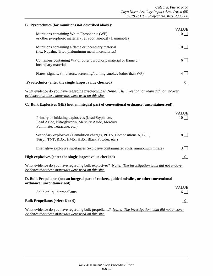
Culebra, Puerto Rico Cayo Norte Artillery Impact Area (Area 08)
DERP-FUDS Project No. I02PR006808
B. Pyrotechnics (for munitions not described above): VALUE
Munitions containing White Phosphorus (WP) 10 or other pyrophoric material (i.e., spontaneously flammable)
Munitions containing a flame or incendiary material 10 (i.e., Napalm, Triethylaluminum metal incendiaries)
Containers containing WP or other pyrophoric material or flame or 6 incendiary material
Flares, signals, simulators, screening/burning smokes (other than WP) 4
Pyrotechnics (enter the single largest value checked) _0_
What evidence do you have regarding pyrotechnics? None. The investigation team did not uncover evidence that these materials were used on this site.
C. Bulk Explosives (HE) (not an integral part of conventional ordnance; uncontainerized):
VALUE Primary or initiating explosives (Lead Styphnate, 10 Lead Azide, Nitroglycerin, Mercury Azide, Mercury Fulminate, Tetracene, etc.)
Secondary explosives (Demolition charges, PETN, Compositions A, B, C, 8 Tetryl, TNT, RDX, HMX, HBX, Black Powder, etc.)
Insensitive explosive substances (explosive contaminated soils, ammonium nitrate) 3
High explosives (enter the single largest value checked) _0_
What evidence do you have regarding bulk explosives? None. The investigation team did not uncover evidence that these materials were used on this site.
D. Bulk Propellants (not an integral part of rockets, guided missiles, or other conventional ordnance; uncontainerized):
VALUE Solid or liquid propellants 6
Bulk Propellants (select 6 or 0) _0_
What evidence do you have regarding bulk propellants? None. The investigation team did not uncover evidence that these materials were used on this site.
Risk Assessment Code Procedure Form RAC-2

Culebra, Puerto Rico Cayo Norte Artillery Impact Area (Area 08)
DERP-FUDS Project No. I02PR006808
E. Recovered Chemical Warfare Material (RCWM), Weaponized Industrial Chemicals and Radiological Material:
VALUE Toxic chemical agents (H-Mustard, G-Nerve, V-Nerve and L-Lewisite) 25
Chemical Agent Identification Sets 20
Radiological Materiel (If rad waste is identified, please call the HTRW-CX at (402) 697-2555) 15
Weaponized Industrial Chemicals (Hydrogen Cyanide AC; Cyanogen Chloride, CK; Phosgene, CG) 10
Riot Control Agents (vomiting, tear) 5
Chemical and Radiological (enter the single largest value checked) _0_
What evidence do you have regarding chemical or radiological? None. The investigation team did not uncover evidence that these materials were used on this site.
TOTAL HAZARD SEVERITY VALUE (Sum of value A through E, Maximum of 61 _10_ Apply this value to Table 1 to determine Hazard Severity Category
TABLE 1 HAZARD SEVERITY*
DESCRIPTION CATEGORY HAZARD SEVERITY VALUE
CATASTROPHIC CRITICAL MARGINAL NEGLIGIBLE **NONE
I II
III IV V
21 and/or greater 10 to 20
5 to 9 1 to 4
0
*Apply Hazard Severity Category to Table 3 and complete Part II of this form.
**If hazard severity value is 0, complete Part II of this form. Then proceed to Part III and use a RAC score of 5 to determine your appropriate action.
Risk Assessment Code Procedure Form RAC-3
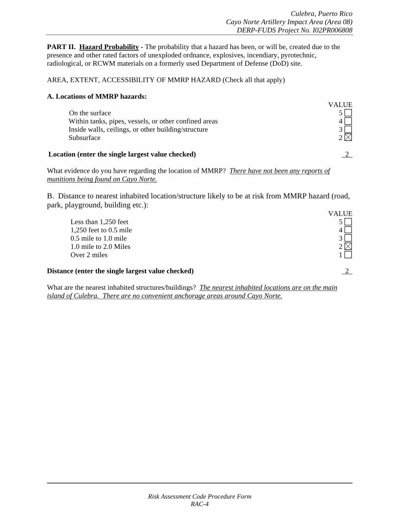
Culebra, Puerto Rico Cayo Norte Artillery Impact Area (Area 08)
DERP-FUDS Project No. I02PR006808
PART II. Hazard Probability - The probability that a hazard has been, or will be, created due to the presence and other rated factors of unexploded ordnance, explosives, incendiary, pyrotechnic, radiological, or RCWM materials on a formerly used Department of Defense (DoD) site.
AREA, EXTENT, ACCESSIBILITY OF MMRP HAZARD (Check all that apply)
A. Locations of MMRP hazards: VALUE
On the surface 5 Within tanks, pipes, vessels, or other confined areas 4 Inside walls, ceilings, or other building/structure 3 Subsurface 2
Location (enter the single largest value checked) _2_
What evidence do you have regarding the location of MMRP? There have not been any reports of munitions being found on Cayo Norte.
B. Distance to nearest inhabited location/structure likely to be at risk from MMRP hazard (road, park, playground, building etc.):
VALUE Less than 1,250 feet 5 1,250 feet to 0.5 mile 4 0.5 mile to 1.0 mile 3 1.0 mile to 2.0 Miles 2 Over 2 miles 1
Distance (enter the single largest value checked) _2_
What are the nearest inhabited structures/buildings? The nearest inhabited locations are on the main island of Culebra. There are no convenient anchorage areas around Cayo Norte.
Risk Assessment Code Procedure Form RAC-4
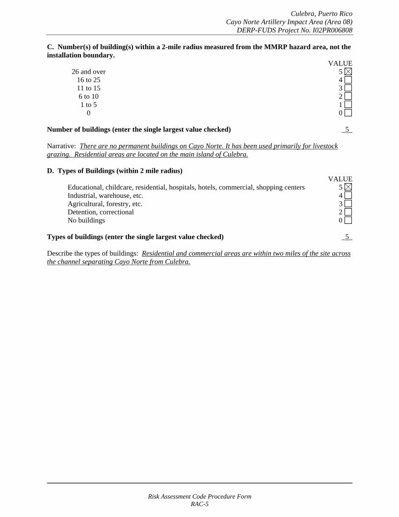
Culebra, Puerto Rico Cayo Norte Artillery Impact Area (Area 08)
DERP-FUDS Project No. I02PR006808
C. Number(s) of building(s) within a 2-mile radius measured from the MMRP hazard area, not the installation boundary.
VALUE 26 and over 5 16 to 25 4 11 to 15 3
6 to 10 2 1 to 5 1
0 0
Number of buildings (enter the single largest value checked) _5_
Narrative: There are no permanent buildings on Cayo Norte. It has been used primarily for livestock grazing. Residential areas are located on the main island of Culebra.
D. Types of Buildings (within 2 mile radius) VALUE
Educational, childcare, residential, hospitals, hotels, commercial, shopping centers 5 Industrial, warehouse, etc. 4 Agricultural, forestry, etc. 3
Detention, correctional 2 No buildings 0
Types of buildings (enter the single largest value checked) _5_
Describe the types of buildings: Residential and commercial areas are within two miles of the site across the channel separating Cayo Norte from Culebra.
Risk Assessment Code Procedure Form RAC-5
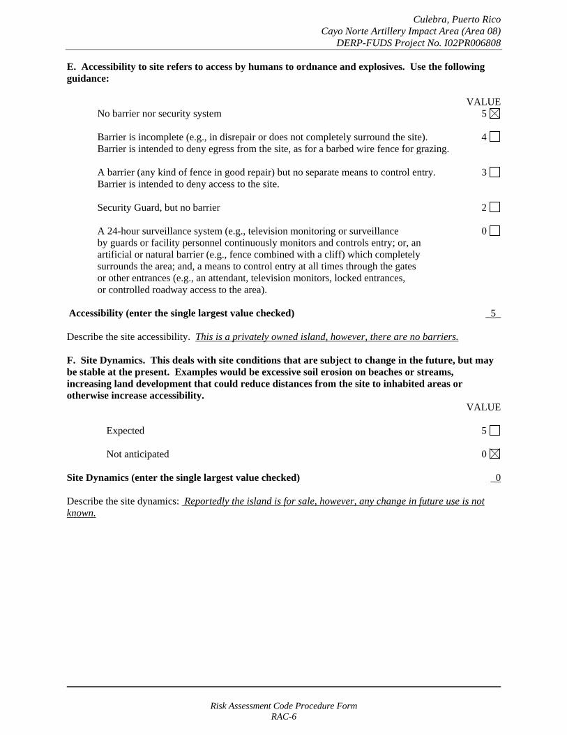
Culebra, Puerto Rico Cayo Norte Artillery Impact Area (Area 08)
DERP-FUDS Project No. I02PR006808
E. Accessibility to site refers to access by humans to ordnance and explosives. Use the following guidance:
No barrier nor security system VALUE
5
Barrier is incomplete (e.g., in disrepair or does not completely surround the site). Barrier is intended to deny egress from the site, as for a barbed wire fence for grazing.
4
A barrier (any kind of fence in good repair) but no separate means to control entry. Barrier is intended to deny access to the site.
3
Security Guard, but no barrier 2
A 24-hour surveillance system (e.g., television monitoring or surveillance by guards or facility personnel continuously monitors and controls entry; or, an artificial or natural barrier (e.g., fence combined with a cliff) which completely surrounds the area; and, a means to control entry at all times through the gates or other entrances (e.g., an attendant, television monitors, locked entrances, or controlled roadway access to the area).
0
Accessibility (enter the single largest value checked) _5_
Describe the site accessibility. This is a privately owned island, however, there are no barriers.
F. Site Dynamics. This deals with site conditions that are subject to change in the future, but may be stable at the present. Examples would be excessive soil erosion on beaches or streams, increasing land development that could reduce distances from the site to inhabited areas or otherwise increase accessibility.
VALUE
Expected 5
Not anticipated 0
Site Dynamics (enter the single largest value checked) _0
Describe the site dynamics: Reportedly the island is for sale, however, any change in future use is not known.
Risk Assessment Code Procedure Form RAC-6
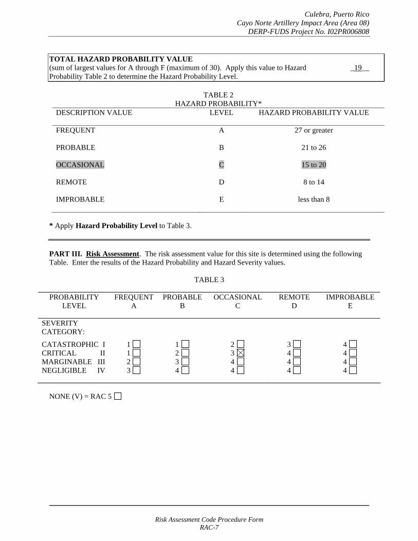
Culebra, Puerto Rico Cayo Norte Artillery Impact Area (Area 08)
DERP-FUDS Project No. I02PR006808
TOTAL HAZARD PROBABILITY VALUE (sum of largest values for A through F (maximum of 30). Apply this value to Hazard _19__ Probability Table 2 to determine the Hazard Probability Level.
TABLE 2 HAZARD PROBABILITY*
DESCRIPTION VALUE LEVEL HAZARD PROBABILITY VALUE
FREQUENT A 27 or greater
PROBABLE B 21 to 26
OCCASIONAL C 15 to 20
REMOTE D 8 to 14
IMPROBABLE E less than 8
* Apply Hazard Probability Level to Table 3.
PART III. Risk Assessment. The risk assessment value for this site is determined using the following Table. Enter the results of the Hazard Probability and Hazard Severity values.
TABLE 3
PROBABILITY LEVEL
FREQUENT A
PROBABLE B
OCCASIONAL C
REMOTE D
IMPROBABLE E
SEVERITY CATEGORY:
CATASTROPHIC I CRITICAL II MARGINABLE III NEGLIGIBLE IV
1 1 2 3
1 2 3 4
2 3 4 4
3 4 4 4
4 4 4 4
NONE (V) = RAC 5
Risk Assessment Code Procedure Form RAC-7
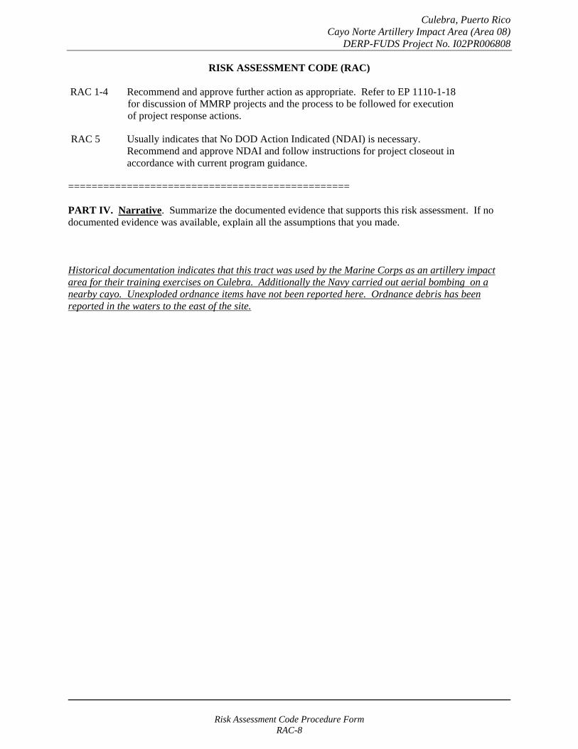
Culebra, Puerto Rico Cayo Norte Artillery Impact Area (Area 08)
DERP-FUDS Project No. I02PR006808
RISK ASSESSMENT CODE (RAC)
RAC 1-4 Recommend and approve further action as appropriate. Refer to EP 1110-1-18 for discussion of MMRP projects and the process to be followed for execution of project response actions.
RAC 5 Usually indicates that No DOD Action Indicated (NDAI) is necessary. Recommend and approve NDAI and follow instructions for project closeout in accordance with current program guidance.
================================================
PART IV. Narrative. Summarize the documented evidence that supports this risk assessment. If no documented evidence was available, explain all the assumptions that you made.
Historical documentation indicates that this tract was used by the Marine Corps as an artillery impact area for their training exercises on Culebra. Additionally the Navy carried out aerial bombing on a nearby cayo. Unexploded ordnance items have not been reported here. Ordnance debris has been reported in the waters to the east of the site.
Risk Assessment Code Procedure Form RAC-8
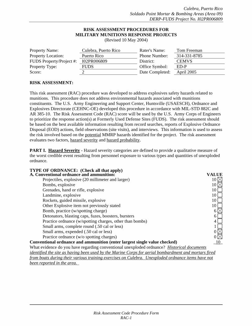
Culebra, Puerto Rico Soldado Point Mortar & Bombing Areas (Area 09)
DERP-FUDS Project No. I02PR006809
RISK ASSESSMENT PROCEDURES FOR MILITARY MUNITIONS RESPONSE PROJECTS
(Revised 10 May 2004)
Property Name: Culebra, Puerto Rico Rater's Name: Tom Freeman Property Location: Puerto Rico Phone Number: 314-331-8785 FUDS Property/Project #: I02PR006809 District: CEMVS Property Type: FUDS Office Symbol: ED-P Score: 2 Date Completed: April 2005
RISK ASSESSMENT:
This risk assessment (RAC) procedure was developed to address explosives safety hazards related to munitions. This procedure does not address environmental hazards associated with munitions constituents. The U.S. Army Engineering and Support Center, Huntsville (USAESCH), Ordnance and Explosives Directorate (CEHNC-OE) developed this procedure in accordance with MIL-STD 882C and AR 385-10. The Risk Assessment Code (RAC) score will be used by the U.S. Army Corps of Engineers to prioritize the response action(s) at Formerly Used Defense Sites (FUDS). The risk assessment should be based on the best available information resulting from record searches, reports of Explosive Ordnance Disposal (EOD) actions, field observations (site visits), and interviews. This information is used to assess the risk involved based on the potential MMRP hazards identified for the project. The risk assessment evaluates two factors, hazard severity and hazard probability.
PART I. Hazard Severity - Hazard severity categories are defined to provide a qualitative measure of the worst credible event resulting from personnel exposure to various types and quantities of unexploded ordnance.
TYPE OF ORDNANCE: (Check all that apply)A. Conventional ordnance and ammunition: VALUE
Projectiles, explosive (20 millimeter and larger) 10 Bombs, explosive 10
Grenades, hand or rifle, explosive 10 Landmine, explosive 10
Rockets, guided missile, explosive 10 Other Explosive item not previously stated 10 Bomb, practice (w/spotting charge) 6 Detonators, blasting caps, fuzes, boosters, bursters 6 Practice ordnance (w/spotting charges, other than bombs) 4 Small arms, complete round (.50 cal or less) 1 Small arms, expended (.50 cal or less) 0 Practice ordnance (w/o spotting charges) 0
Conventional ordnance and ammunition (enter largest single value checked) _10_ What evidence do you have regarding conventional unexploded ordnance? Historical documents identified the site as having been used by the Marine Corps for aerial bombardment and mortars fired from boats during their various training exercises on Culebra. Unexploded ordnance items have not been reported in the area.
Risk Assessment Code Procedure Form RAC-1
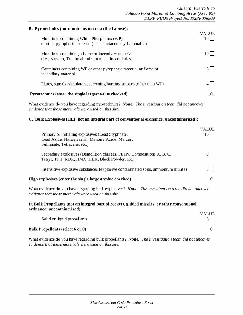
Culebra, Puerto Rico Soldado Point Mortar & Bombing Areas (Area 09)
DERP-FUDS Project No. I02PR006809
B. Pyrotechnics (for munitions not described above): VALUE
Munitions containing White Phosphorus (WP) 10 or other pyrophoric material (i.e., spontaneously flammable)
Munitions containing a flame or incendiary material 10 (i.e., Napalm, Triethylaluminum metal incendiaries)
Containers containing WP or other pyrophoric material or flame or 6 incendiary material
Flares, signals, simulators, screening/burning smokes (other than WP) 4
Pyrotechnics (enter the single largest value checked) _0_
What evidence do you have regarding pyrotechnics? None. The investigation team did not uncover evidence that these materials were used on this site.
C. Bulk Explosives (HE) (not an integral part of conventional ordnance; uncontainerized):
VALUE Primary or initiating explosives (Lead Styphnate, 10 Lead Azide, Nitroglycerin, Mercury Azide, Mercury Fulminate, Tetracene, etc.)
Secondary explosives (Demolition charges, PETN, Compositions A, B, C, 8 Tetryl, TNT, RDX, HMX, HBX, Black Powder, etc.)
Insensitive explosive substances (explosive contaminated soils, ammonium nitrate) 3
High explosives (enter the single largest value checked) _0_
What evidence do you have regarding bulk explosives? None. The investigation team did not uncover evidence that these materials were used on this site.
D. Bulk Propellants (not an integral part of rockets, guided missiles, or other conventional ordnance; uncontainerized):
VALUE Solid or liquid propellants 6
Bulk Propellants (select 6 or 0) _0_
What evidence do you have regarding bulk propellants? None. The investigation team did not uncover evidence that these materials were used on this site.
Risk Assessment Code Procedure Form RAC-2
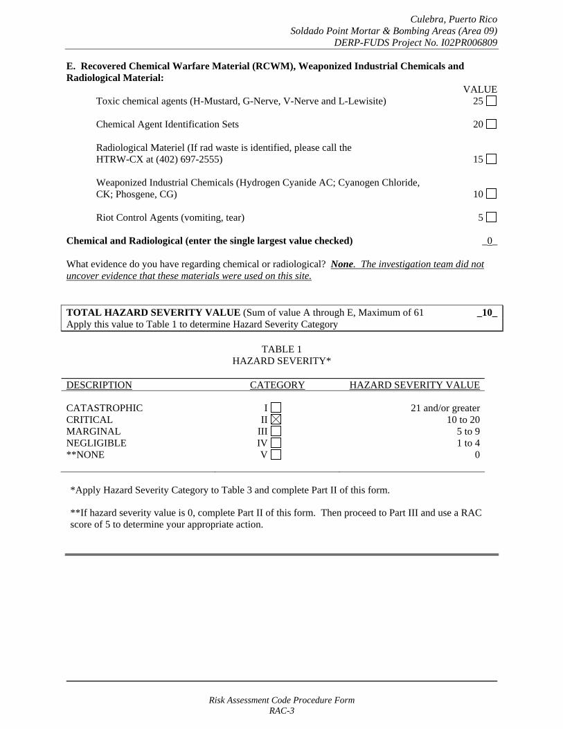
Culebra, Puerto Rico Soldado Point Mortar & Bombing Areas (Area 09)
DERP-FUDS Project No. I02PR006809
E. Recovered Chemical Warfare Material (RCWM), Weaponized Industrial Chemicals and Radiological Material:
VALUE Toxic chemical agents (H-Mustard, G-Nerve, V-Nerve and L-Lewisite) 25
Chemical Agent Identification Sets 20
Radiological Materiel (If rad waste is identified, please call the HTRW-CX at (402) 697-2555) 15
Weaponized Industrial Chemicals (Hydrogen Cyanide AC; Cyanogen Chloride, CK; Phosgene, CG) 10
Riot Control Agents (vomiting, tear) 5
Chemical and Radiological (enter the single largest value checked) _0_
What evidence do you have regarding chemical or radiological? None. The investigation team did not uncover evidence that these materials were used on this site.
TOTAL HAZARD SEVERITY VALUE (Sum of value A through E, Maximum of 61 _10_ Apply this value to Table 1 to determine Hazard Severity Category
TABLE 1 HAZARD SEVERITY*
DESCRIPTION CATEGORY HAZARD SEVERITY VALUE
CATASTROPHIC CRITICAL MARGINAL NEGLIGIBLE **NONE
I II
III IV V
21 and/or greater 10 to 20
5 to 9 1 to 4
0
*Apply Hazard Severity Category to Table 3 and complete Part II of this form.
**If hazard severity value is 0, complete Part II of this form. Then proceed to Part III and use a RAC score of 5 to determine your appropriate action.
Risk Assessment Code Procedure Form RAC-3
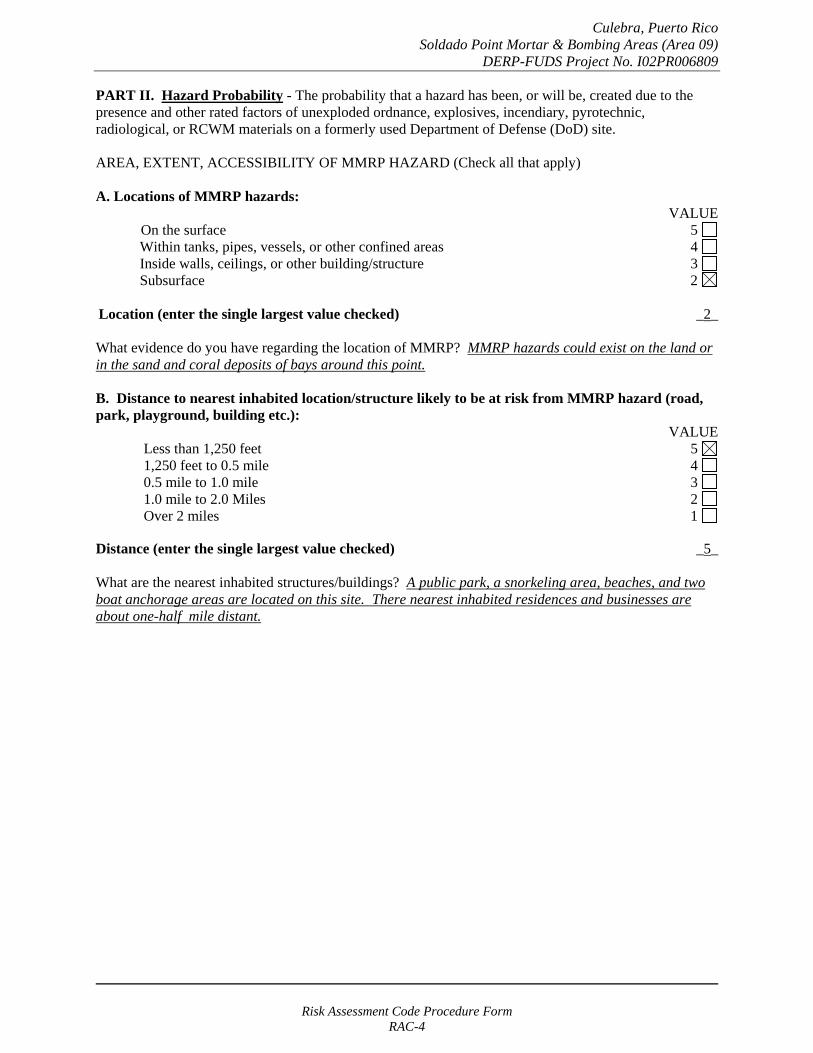
Culebra, Puerto Rico Soldado Point Mortar & Bombing Areas (Area 09)
DERP-FUDS Project No. I02PR006809
PART II. Hazard Probability - The probability that a hazard has been, or will be, created due to the presence and other rated factors of unexploded ordnance, explosives, incendiary, pyrotechnic, radiological, or RCWM materials on a formerly used Department of Defense (DoD) site.
AREA, EXTENT, ACCESSIBILITY OF MMRP HAZARD (Check all that apply)
A. Locations of MMRP hazards: VALUE
On the surface 5 Within tanks, pipes, vessels, or other confined areas 4 Inside walls, ceilings, or other building/structure 3 Subsurface 2
Location (enter the single largest value checked) _2_
What evidence do you have regarding the location of MMRP? MMRP hazards could exist on the land or in the sand and coral deposits of bays around this point.
B. Distance to nearest inhabited location/structure likely to be at risk from MMRP hazard (road, park, playground, building etc.):
VALUE Less than 1,250 feet 5 1,250 feet to 0.5 mile 4 0.5 mile to 1.0 mile 3 1.0 mile to 2.0 Miles 2 Over 2 miles 1
Distance (enter the single largest value checked) _5_
What are the nearest inhabited structures/buildings? A public park, a snorkeling area, beaches, and two boat anchorage areas are located on this site. There nearest inhabited residences and businesses are about one-half mile distant.
Risk Assessment Code Procedure Form RAC-4
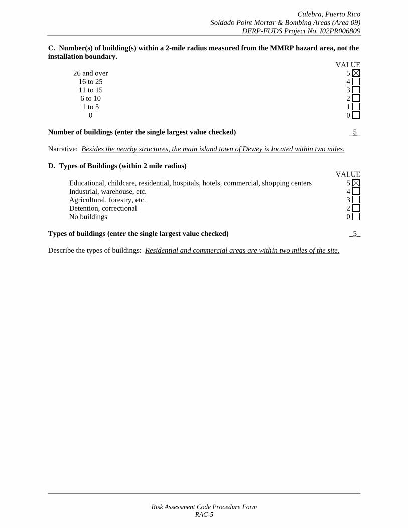
Culebra, Puerto Rico Soldado Point Mortar & Bombing Areas (Area 09)
DERP-FUDS Project No. I02PR006809
C. Number(s) of building(s) within a 2-mile radius measured from the MMRP hazard area, not the installation boundary.
VALUE 26 and over 5 16 to 25 4 11 to 15 3
6 to 10 2 1 to 5 1
0 0
Number of buildings (enter the single largest value checked) _5_
Narrative: Besides the nearby structures, the main island town of Dewey is located within two miles.
D. Types of Buildings (within 2 mile radius) VALUE
Educational, childcare, residential, hospitals, hotels, commercial, shopping centers 5 Industrial, warehouse, etc. 4 Agricultural, forestry, etc. 3
Detention, correctional 2 No buildings 0
Types of buildings (enter the single largest value checked) _5_
Describe the types of buildings: Residential and commercial areas are within two miles of the site.
Risk Assessment Code Procedure Form RAC-5
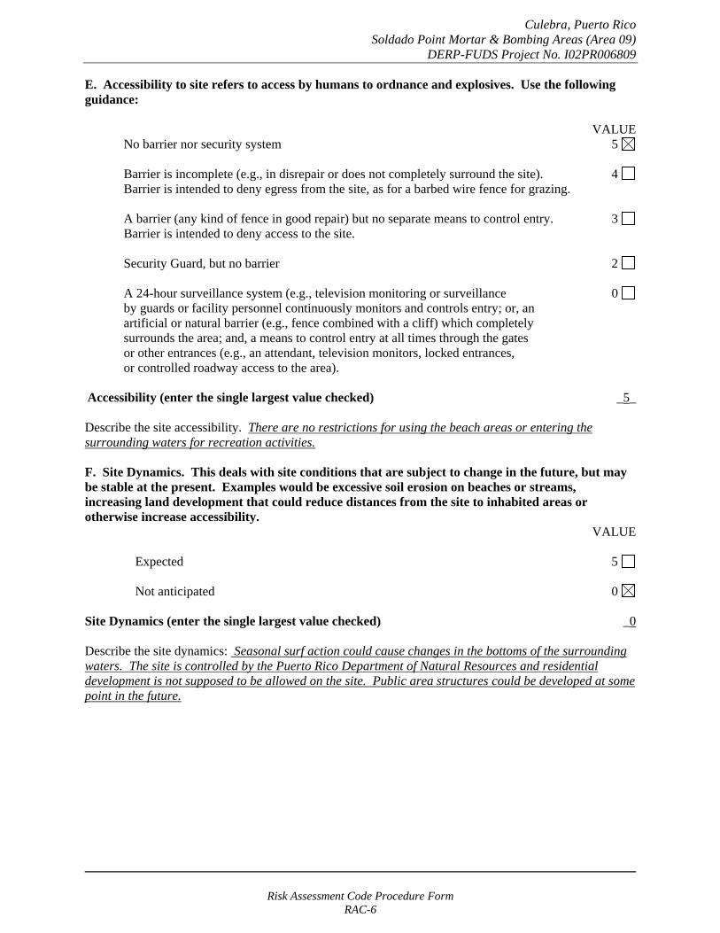
Culebra, Puerto Rico Soldado Point Mortar & Bombing Areas (Area 09)
DERP-FUDS Project No. I02PR006809
E. Accessibility to site refers to access by humans to ordnance and explosives. Use the following guidance:
VALUE No barrier nor security system 5
Barrier is incomplete (e.g., in disrepair or does not completely surround the site). 4 Barrier is intended to deny egress from the site, as for a barbed wire fence for grazing.
A barrier (any kind of fence in good repair) but no separate means to control entry. 3 Barrier is intended to deny access to the site.
Security Guard, but no barrier 2
A 24-hour surveillance system (e.g., television monitoring or surveillance 0 by guards or facility personnel continuously monitors and controls entry; or, an artificial or natural barrier (e.g., fence combined with a cliff) which completely surrounds the area; and, a means to control entry at all times through the gates or other entrances (e.g., an attendant, television monitors, locked entrances, or controlled roadway access to the area).
Accessibility (enter the single largest value checked) _5_
Describe the site accessibility. There are no restrictions for using the beach areas or entering the surrounding waters for recreation activities.
F. Site Dynamics. This deals with site conditions that are subject to change in the future, but may be stable at the present. Examples would be excessive soil erosion on beaches or streams, increasing land development that could reduce distances from the site to inhabited areas or otherwise increase accessibility.
VALUE
Expected 5
Not anticipated 0
Site Dynamics (enter the single largest value checked) _0
Describe the site dynamics: Seasonal surf action could cause changes in the bottoms of the surrounding waters. The site is controlled by the Puerto Rico Department of Natural Resources and residential development is not supposed to be allowed on the site. Public area structures could be developed at some point in the future.
Risk Assessment Code Procedure Form RAC-6
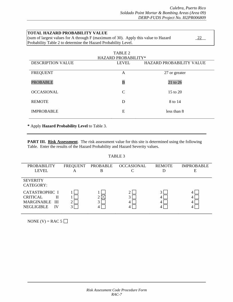
Culebra, Puerto Rico Soldado Point Mortar & Bombing Areas (Area 09)
DERP-FUDS Project No. I02PR006809
TOTAL HAZARD PROBABILITY VALUE (sum of largest values for A through F (maximum of 30). Apply this value to Hazard _22__ Probability Table 2 to determine the Hazard Probability Level.
TABLE 2 HAZARD PROBABILITY*
DESCRIPTION VALUE LEVEL HAZARD PROBABILITY VALUE
FREQUENT A 27 or greater
PROBABLE B 21 to 26
OCCASIONAL C 15 to 20
REMOTE D 8 to 14
IMPROBABLE E less than 8
* Apply Hazard Probability Level to Table 3.
PART III. Risk Assessment. The risk assessment value for this site is determined using the following Table. Enter the results of the Hazard Probability and Hazard Severity values.
TABLE 3
PROBABILITY LEVEL
FREQUENT A
PROBABLE B
OCCASIONAL C
REMOTE D
IMPROBABLE E
SEVERITY CATEGORY:
CATASTROPHIC I CRITICAL II MARGINABLE III NEGLIGIBLE IV
1 1 2 3
1 2 3 4
2 3 4 4
3 4 4 4
4 4 4 4
NONE (V) = RAC 5
Risk Assessment Code Procedure Form RAC-7
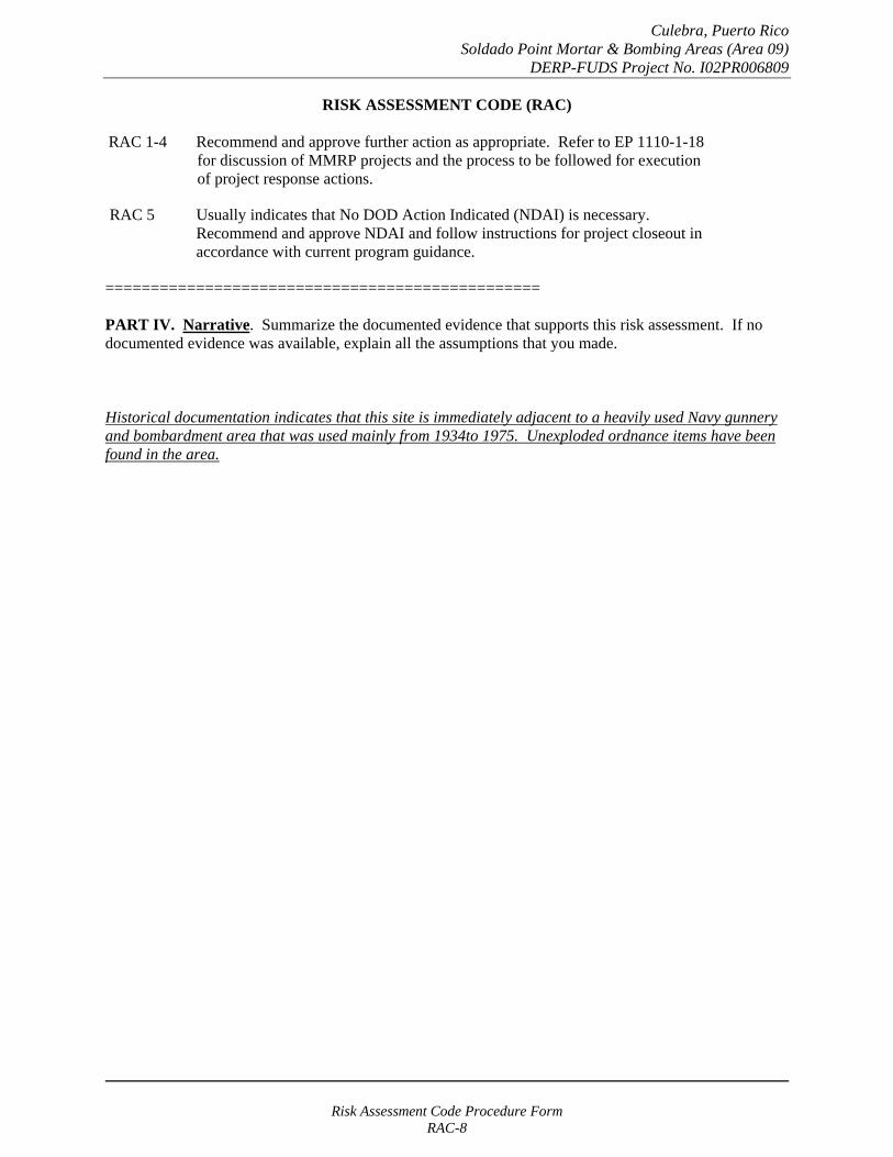
Culebra, Puerto Rico Soldado Point Mortar & Bombing Areas (Area 09)
DERP-FUDS Project No. I02PR006809
RISK ASSESSMENT CODE (RAC)
RAC 1-4 Recommend and approve further action as appropriate. Refer to EP 1110-1-18 for discussion of MMRP projects and the process to be followed for execution of project response actions.
RAC 5 Usually indicates that No DOD Action Indicated (NDAI) is necessary. Recommend and approve NDAI and follow instructions for project closeout in accordance with current program guidance.
================================================
PART IV. Narrative. Summarize the documented evidence that supports this risk assessment. If no documented evidence was available, explain all the assumptions that you made.
Historical documentation indicates that this site is immediately adjacent to a heavily used Navy gunnery and bombardment area that was used mainly from 1934to 1975. Unexploded ordnance items have been found in the area.
Risk Assessment Code Procedure Form RAC-8
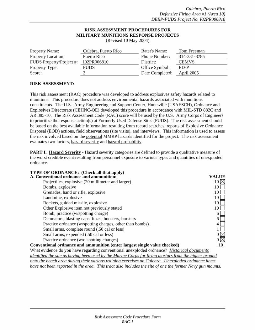
Culebra, Puerto Rico Defensive Firing Area #1 (Area 10)
DERP-FUDS Project No. I02PR006810
RISK ASSESSMENT PROCEDURES FOR MILITARY MUNITIONS RESPONSE PROJECTS
(Revised 10 May 2004)
Property Name: Culebra, Puerto Rico Rater's Name: Tom Freeman Property Location: Puerto Rico Phone Number: 314-331-8785 FUDS Property/Project #: I02PR006810 District: CEMVS Property Type: FUDS Office Symbol: ED-P Score: 2 Date Completed: April 2005
RISK ASSESSMENT:
This risk assessment (RAC) procedure was developed to address explosives safety hazards related to munitions. This procedure does not address environmental hazards associated with munitions constituents. The U.S. Army Engineering and Support Center, Huntsville (USAESCH), Ordnance and Explosives Directorate (CEHNC-OE) developed this procedure in accordance with MIL-STD 882C and AR 385-10. The Risk Assessment Code (RAC) score will be used by the U.S. Army Corps of Engineers to prioritize the response action(s) at Formerly Used Defense Sites (FUDS). The risk assessment should be based on the best available information resulting from record searches, reports of Explosive Ordnance Disposal (EOD) actions, field observations (site visits), and interviews. This information is used to assess the risk involved based on the potential MMRP hazards identified for the project. The risk assessment evaluates two factors, hazard severity and hazard probability.
PART I. Hazard Severity - Hazard severity categories are defined to provide a qualitative measure of the worst credible event resulting from personnel exposure to various types and quantities of unexploded ordnance.
TYPE OF ORDNANCE: (Check all that apply)A. Conventional ordnance and ammunition: VALUE
Projectiles, explosive (20 millimeter and larger) 10 Bombs, explosive 10
Grenades, hand or rifle, explosive 10 Landmine, explosive 10
Rockets, guided missile, explosive 10 Other Explosive item not previously stated 10 Bomb, practice (w/spotting charge) 6 Detonators, blasting caps, fuzes, boosters, bursters 6 Practice ordnance (w/spotting charges, other than bombs) 4 Small arms, complete round (.50 cal or less) 1 Small arms, expended (.50 cal or less) 0 Practice ordnance (w/o spotting charges) 0
Conventional ordnance and ammunition (enter largest single value checked) _10_ What evidence do you have regarding conventional unexploded ordnance? Historical documents identified the site as having been used by the Marine Corps for firing mortars from the higher ground onto the beach area during their various training exercises on Culebra. Unexploded ordnance items have not been reported in the area. This tract also includes the site of one the former Navy gun mounts.
Risk Assessment Code Procedure Form RAC-1

Culebra, Puerto Rico Defensive Firing Area #1 (Area 10)
DERP-FUDS Project No. I02PR006810
B. Pyrotechnics (for munitions not described above): VALUE
Munitions containing White Phosphorus (WP) 10 or other pyrophoric material (i.e., spontaneously flammable)
Munitions containing a flame or incendiary material 10 (i.e., Napalm, Triethylaluminum metal incendiaries)
Containers containing WP or other pyrophoric material or flame or 6 incendiary material
Flares, signals, simulators, screening/burning smokes (other than WP) 4
Pyrotechnics (enter the single largest value checked) _0_
What evidence do you have regarding pyrotechnics? None. The investigation team did not uncover evidence that these materials were used on this site.
C. Bulk Explosives (HE) (not an integral part of conventional ordnance; uncontainerized):
VALUE Primary or initiating explosives (Lead Styphnate, 10 Lead Azide, Nitroglycerin, Mercury Azide, Mercury Fulminate, Tetracene, etc.)
Secondary explosives (Demolition charges, PETN, Compositions A, B, C, 8 Tetryl, TNT, RDX, HMX, HBX, Black Powder, etc.)
Insensitive explosive substances (explosive contaminated soils, ammonium nitrate) 3
High explosives (enter the single largest value checked) _0_
What evidence do you have regarding bulk explosives? None. The investigation team did not uncover evidence that these materials were used on this site.
D. Bulk Propellants (not an integral part of rockets, guided missiles, or other conventional ordnance; uncontainerized):
VALUE Solid or liquid propellants 6
Bulk Propellants (select 6 or 0) _0_
What evidence do you have regarding bulk propellants? None. The investigation team did not uncover evidence that these materials were used on this site.
Risk Assessment Code Procedure Form RAC-2

Culebra, Puerto Rico Defensive Firing Area #1 (Area 10)
DERP-FUDS Project No. I02PR006810
E. Recovered Chemical Warfare Material (RCWM), Weaponized Industrial Chemicals and Radiological Material:
VALUE Toxic chemical agents (H-Mustard, G-Nerve, V-Nerve and L-Lewisite) 25
Chemical Agent Identification Sets 20
Radiological Materiel (If rad waste is identified, please call the HTRW-CX at (402) 697-2555) 15
Weaponized Industrial Chemicals (Hydrogen Cyanide AC; Cyanogen Chloride, CK; Phosgene, CG) 10
Riot Control Agents (vomiting, tear) 5
Chemical and Radiological (enter the single largest value checked) _0_
What evidence do you have regarding chemical or radiological? None. The investigation team did not uncover evidence that these materials were used on this site.
TOTAL HAZARD SEVERITY VALUE (Sum of value A through E, Maximum of 61 _10_ Apply this value to Table 1 to determine Hazard Severity Category
TABLE 1 HAZARD SEVERITY*
DESCRIPTION CATEGORY HAZARD SEVERITY VALUE
CATASTROPHIC CRITICAL MARGINAL NEGLIGIBLE **NONE
I II
III IV V
21 and/or greater 10 to 20
5 to 9 1 to 4
0
*Apply Hazard Severity Category to Table 3 and complete Part II of this form.
**If hazard severity value is 0, complete Part II of this form. Then proceed to Part III and use a RAC score of 5 to determine your appropriate action.
Risk Assessment Code Procedure Form RAC-3
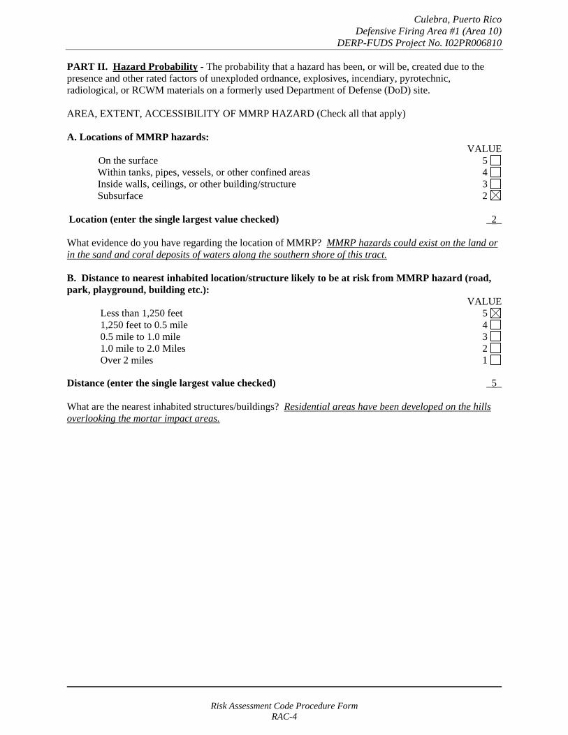
Culebra, Puerto Rico Defensive Firing Area #1 (Area 10)
DERP-FUDS Project No. I02PR006810
PART II. Hazard Probability - The probability that a hazard has been, or will be, created due to the presence and other rated factors of unexploded ordnance, explosives, incendiary, pyrotechnic, radiological, or RCWM materials on a formerly used Department of Defense (DoD) site.
AREA, EXTENT, ACCESSIBILITY OF MMRP HAZARD (Check all that apply)
A. Locations of MMRP hazards: VALUE
On the surface 5 Within tanks, pipes, vessels, or other confined areas 4 Inside walls, ceilings, or other building/structure 3 Subsurface 2
Location (enter the single largest value checked) _2_
What evidence do you have regarding the location of MMRP? MMRP hazards could exist on the land or in the sand and coral deposits of waters along the southern shore of this tract.
B. Distance to nearest inhabited location/structure likely to be at risk from MMRP hazard (road, park, playground, building etc.):
VALUE Less than 1,250 feet 5 1,250 feet to 0.5 mile 4 0.5 mile to 1.0 mile 3 1.0 mile to 2.0 Miles 2 Over 2 miles 1
Distance (enter the single largest value checked) _5_
What are the nearest inhabited structures/buildings? Residential areas have been developed on the hills overlooking the mortar impact areas.
Risk Assessment Code Procedure Form RAC-4

Culebra, Puerto Rico Defensive Firing Area #1 (Area 10)
DERP-FUDS Project No. I02PR006810
C. Number(s) of building(s) within a 2-mile radius measured from the MMRP hazard area, not the installation boundary.
VALUE 26 and over 5 16 to 25 4 11 to 15 3
6 to 10 2 1 to 5 1
0 0
Number of buildings (enter the single largest value checked) _5_
Narrative: Besides the nearby structures, the main island town of Dewey is located within two miles.
D. Types of Buildings (within 2 mile radius) VALUE
Educational, childcare, residential, hospitals, hotels, commercial, shopping centers 5 Industrial, warehouse, etc. 4 Agricultural, forestry, etc. 3
Detention, correctional 2 No buildings 0
Types of buildings (enter the single largest value checked) _5_
Describe the types of buildings: Residential and commercial areas are within two miles of the site.
Risk Assessment Code Procedure Form RAC-5

Culebra, Puerto Rico Defensive Firing Area #1 (Area 10)
DERP-FUDS Project No. I02PR006810
E. Accessibility to site refers to access by humans to ordnance and explosives. Use the following guidance:
VALUE No barrier nor security system 5
Barrier is incomplete (e.g., in disrepair or does not completely surround the site). 4 Barrier is intended to deny egress from the site, as for a barbed wire fence for grazing.
A barrier (any kind of fence in good repair) but no separate means to control entry. 3 Barrier is intended to deny access to the site.
Security Guard, but no barrier 2
A 24-hour surveillance system (e.g., television monitoring or surveillance 0 by guards or facility personnel continuously monitors and controls entry; or, an artificial or natural barrier (e.g., fence combined with a cliff) which completely surrounds the area; and, a means to control entry at all times through the gates or other entrances (e.g., an attendant, television monitors, locked entrances, or controlled roadway access to the area).
Accessibility (enter the single largest value checked) _5_
Describe the site accessibility. There are no restrictions for using the beach areas or entering the surrounding waters for recreation activities.
F. Site Dynamics. This deals with site conditions that are subject to change in the future, but may be stable at the present. Examples would be excessive soil erosion on beaches or streams, increasing land development that could reduce distances from the site to inhabited areas or otherwise increase accessibility.
VALUE
Expected 5
Not anticipated 0
Site Dynamics (enter the single largest value checked) _0
Describe the site dynamics: Seasonal surf action could cause changes in the bottoms of the surrounding waters. The water area adjacent to this shore is generally not used for recreational activities. Additional homes could be developed in the area of the firing points, but development is not expected in the impact zone.
Risk Assessment Code Procedure Form RAC-6
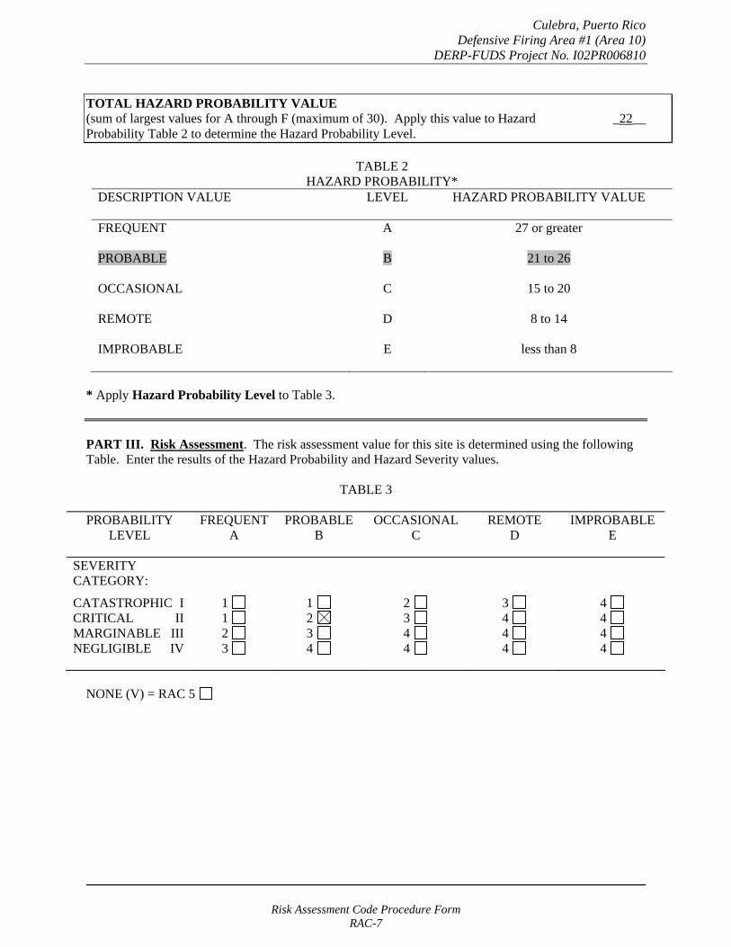
Culebra, Puerto Rico Defensive Firing Area #1 (Area 10)
DERP-FUDS Project No. I02PR006810
TOTAL HAZARD PROBABILITY VALUE (sum of largest values for A through F (maximum of 30). Apply this value to Hazard _22__ Probability Table 2 to determine the Hazard Probability Level.
TABLE 2 HAZARD PROBABILITY*
DESCRIPTION VALUE LEVEL HAZARD PROBABILITY VALUE
FREQUENT A 27 or greater
PROBABLE B 21 to 26
OCCASIONAL C 15 to 20
REMOTE D 8 to 14
IMPROBABLE E less than 8
* Apply Hazard Probability Level to Table 3.
PART III. Risk Assessment. The risk assessment value for this site is determined using the following Table. Enter the results of the Hazard Probability and Hazard Severity values.
TABLE 3
PROBABILITY LEVEL
FREQUENT A
PROBABLE B
OCCASIONAL C
REMOTE D
IMPROBABLE E
SEVERITY CATEGORY:
CATASTROPHIC I CRITICAL II MARGINABLE III NEGLIGIBLE IV
1 1 2 3
1 2 3 4
2 3 4 4
3 4 4 4
4 4 4 4
NONE (V) = RAC 5
Risk Assessment Code Procedure Form RAC-7
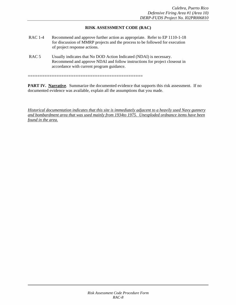
Culebra, Puerto Rico Defensive Firing Area #1 (Area 10)
DERP-FUDS Project No. I02PR006810
RISK ASSESSMENT CODE (RAC)
RAC 1-4 Recommend and approve further action as appropriate. Refer to EP 1110-1-18 for discussion of MMRP projects and the process to be followed for execution of project response actions.
RAC 5 Usually indicates that No DOD Action Indicated (NDAI) is necessary. Recommend and approve NDAI and follow instructions for project closeout in accordance with current program guidance.
================================================
PART IV. Narrative. Summarize the documented evidence that supports this risk assessment. If no documented evidence was available, explain all the assumptions that you made.
Historical documentation indicates that this site is immediately adjacent to a heavily used Navy gunnery and bombardment area that was used mainly from 1934to 1975. Unexploded ordnance items have been found in the area.
Risk Assessment Code Procedure Form RAC-8
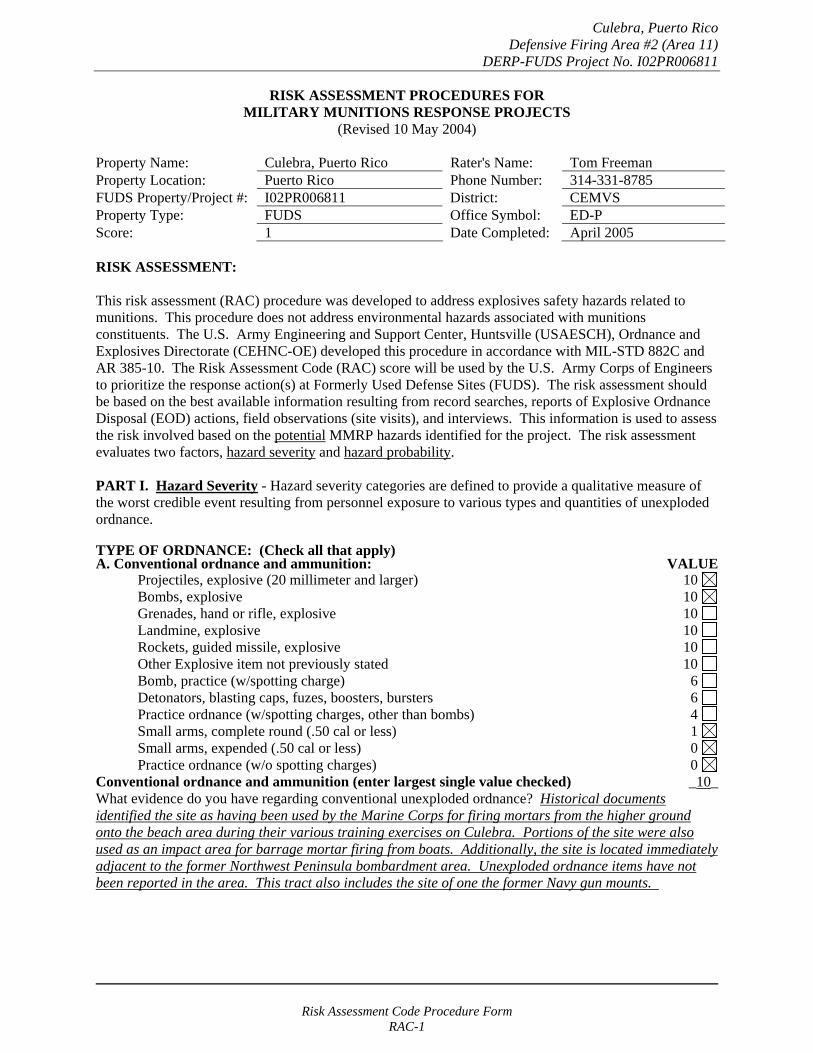
Culebra, Puerto Rico Defensive Firing Area #2 (Area 11)
DERP-FUDS Project No. I02PR006811
RISK ASSESSMENT PROCEDURES FOR MILITARY MUNITIONS RESPONSE PROJECTS
(Revised 10 May 2004)
Property Name: Culebra, Puerto Rico Rater's Name: Tom Freeman Property Location: Puerto Rico Phone Number: 314-331-8785 FUDS Property/Project #: I02PR006811 District: CEMVS Property Type: FUDS Office Symbol: ED-P Score: 1 Date Completed: April 2005
RISK ASSESSMENT:
This risk assessment (RAC) procedure was developed to address explosives safety hazards related to munitions. This procedure does not address environmental hazards associated with munitions constituents. The U.S. Army Engineering and Support Center, Huntsville (USAESCH), Ordnance and Explosives Directorate (CEHNC-OE) developed this procedure in accordance with MIL-STD 882C and AR 385-10. The Risk Assessment Code (RAC) score will be used by the U.S. Army Corps of Engineers to prioritize the response action(s) at Formerly Used Defense Sites (FUDS). The risk assessment should be based on the best available information resulting from record searches, reports of Explosive Ordnance Disposal (EOD) actions, field observations (site visits), and interviews. This information is used to assess the risk involved based on the potential MMRP hazards identified for the project. The risk assessment evaluates two factors, hazard severity and hazard probability.
PART I. Hazard Severity - Hazard severity categories are defined to provide a qualitative measure of the worst credible event resulting from personnel exposure to various types and quantities of unexploded ordnance.
TYPE OF ORDNANCE: (Check all that apply)A. Conventional ordnance and ammunition: VALUE
Projectiles, explosive (20 millimeter and larger) 10 Bombs, explosive 10
Grenades, hand or rifle, explosive 10 Landmine, explosive 10
Rockets, guided missile, explosive 10 Other Explosive item not previously stated 10 Bomb, practice (w/spotting charge) 6 Detonators, blasting caps, fuzes, boosters, bursters 6 Practice ordnance (w/spotting charges, other than bombs) 4 Small arms, complete round (.50 cal or less) 1 Small arms, expended (.50 cal or less) 0 Practice ordnance (w/o spotting charges) 0
Conventional ordnance and ammunition (enter largest single value checked) _10_ What evidence do you have regarding conventional unexploded ordnance? Historical documents identified the site as having been used by the Marine Corps for firing mortars from the higher ground onto the beach area during their various training exercises on Culebra. Portions of the site were also used as an impact area for barrage mortar firing from boats. Additionally, the site is located immediately adjacent to the former Northwest Peninsula bombardment area. Unexploded ordnance items have not been reported in the area. This tract also includes the site of one the former Navy gun mounts.
Risk Assessment Code Procedure Form RAC-1
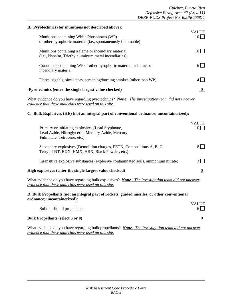
Culebra, Puerto Rico Defensive Firing Area #2 (Area 11)
DERP-FUDS Project No. I02PR006811
B. Pyrotechnics (for munitions not described above): VALUE
Munitions containing White Phosphorus (WP) 10 or other pyrophoric material (i.e., spontaneously flammable)
Munitions containing a flame or incendiary material 10 (i.e., Napalm, Triethylaluminum metal incendiaries)
Containers containing WP or other pyrophoric material or flame or 6 incendiary material
Flares, signals, simulators, screening/burning smokes (other than WP) 4
Pyrotechnics (enter the single largest value checked) _0_
What evidence do you have regarding pyrotechnics? None. The investigation team did not uncover evidence that these materials were used on this site.
C. Bulk Explosives (HE) (not an integral part of conventional ordnance; uncontainerized):
VALUE Primary or initiating explosives (Lead Styphnate, 10 Lead Azide, Nitroglycerin, Mercury Azide, Mercury Fulminate, Tetracene, etc.)
Secondary explosives (Demolition charges, PETN, Compositions A, B, C, 8 Tetryl, TNT, RDX, HMX, HBX, Black Powder, etc.)
Insensitive explosive substances (explosive contaminated soils, ammonium nitrate) 3
High explosives (enter the single largest value checked) _0_
What evidence do you have regarding bulk explosives? None. The investigation team did not uncover evidence that these materials were used on this site.
D. Bulk Propellants (not an integral part of rockets, guided missiles, or other conventional ordnance; uncontainerized):
VALUE Solid or liquid propellants 6
Bulk Propellants (select 6 or 0) _0_
What evidence do you have regarding bulk propellants? None. The investigation team did not uncover evidence that these materials were used on this site.
Risk Assessment Code Procedure Form RAC-2
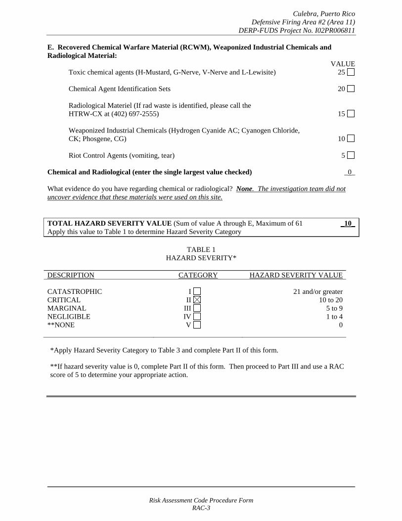
Culebra, Puerto Rico Defensive Firing Area #2 (Area 11)
DERP-FUDS Project No. I02PR006811
E. Recovered Chemical Warfare Material (RCWM), Weaponized Industrial Chemicals and Radiological Material:
VALUE Toxic chemical agents (H-Mustard, G-Nerve, V-Nerve and L-Lewisite) 25
Chemical Agent Identification Sets 20
Radiological Materiel (If rad waste is identified, please call the HTRW-CX at (402) 697-2555) 15
Weaponized Industrial Chemicals (Hydrogen Cyanide AC; Cyanogen Chloride, CK; Phosgene, CG) 10
Riot Control Agents (vomiting, tear) 5
Chemical and Radiological (enter the single largest value checked) _0_
What evidence do you have regarding chemical or radiological? None. The investigation team did not uncover evidence that these materials were used on this site.
TOTAL HAZARD SEVERITY VALUE (Sum of value A through E, Maximum of 61 _10_ Apply this value to Table 1 to determine Hazard Severity Category
TABLE 1 HAZARD SEVERITY*
DESCRIPTION CATEGORY HAZARD SEVERITY VALUE
CATASTROPHIC CRITICAL MARGINAL NEGLIGIBLE **NONE
I II
III IV V
21 and/or greater 10 to 20
5 to 9 1 to 4
0
*Apply Hazard Severity Category to Table 3 and complete Part II of this form.
**If hazard severity value is 0, complete Part II of this form. Then proceed to Part III and use a RAC score of 5 to determine your appropriate action.
Risk Assessment Code Procedure Form RAC-3

Culebra, Puerto Rico Defensive Firing Area #2 (Area 11)
DERP-FUDS Project No. I02PR006811
PART II. Hazard Probability - The probability that a hazard has been, or will be, created due to the presence and other rated factors of unexploded ordnance, explosives, incendiary, pyrotechnic, radiological, or RCWM materials on a formerly used Department of Defense (DoD) site.
AREA, EXTENT, ACCESSIBILITY OF MMRP HAZARD (Check all that apply)
A. Locations of MMRP hazards: VALUE
On the surface 5 Within tanks, pipes, vessels, or other confined areas 4 Inside walls, ceilings, or other building/structure 3 Subsurface 2
Location (enter the single largest value checked) _5_
What evidence do you have regarding the location of MMRP? MMRP hazards could exist on the land of this tract.
B. Distance to nearest inhabited location/structure likely to be at risk from MMRP hazard (road, park, playground, building etc.):
VALUE Less than 1,250 feet 5 1,250 feet to 0.5 mile 4 0.5 mile to 1.0 mile 3 1.0 mile to 2.0 Miles 2 Over 2 miles 1
Distance (enter the single largest value checked) _5_
What are the nearest inhabited structures/buildings? Residential areas have been developed on the hills overlooking the mortar impact areas.
Risk Assessment Code Procedure Form RAC-4

Culebra, Puerto Rico Defensive Firing Area #2 (Area 11)
DERP-FUDS Project No. I02PR006811
C. Number(s) of building(s) within a 2-mile radius measured from the MMRP hazard area, not the installation boundary.
VALUE 26 and over 5 16 to 25 4 11 to 15 3
6 to 10 2 1 to 5 1
0 0
Number of buildings (enter the single largest value checked) _5_
Narrative: Besides the nearby structures, the main island town of Dewey is located within two miles.
D. Types of Buildings (within 2 mile radius) VALUE
Educational, childcare, residential, hospitals, hotels, commercial, shopping centers 5 Industrial, warehouse, etc. 4 Agricultural, forestry, etc. 3
Detention, correctional 2 No buildings 0
Types of buildings (enter the single largest value checked) _5_
Describe the types of buildings: Residential and commercial areas are within two miles of the site.
Risk Assessment Code Procedure Form RAC-5
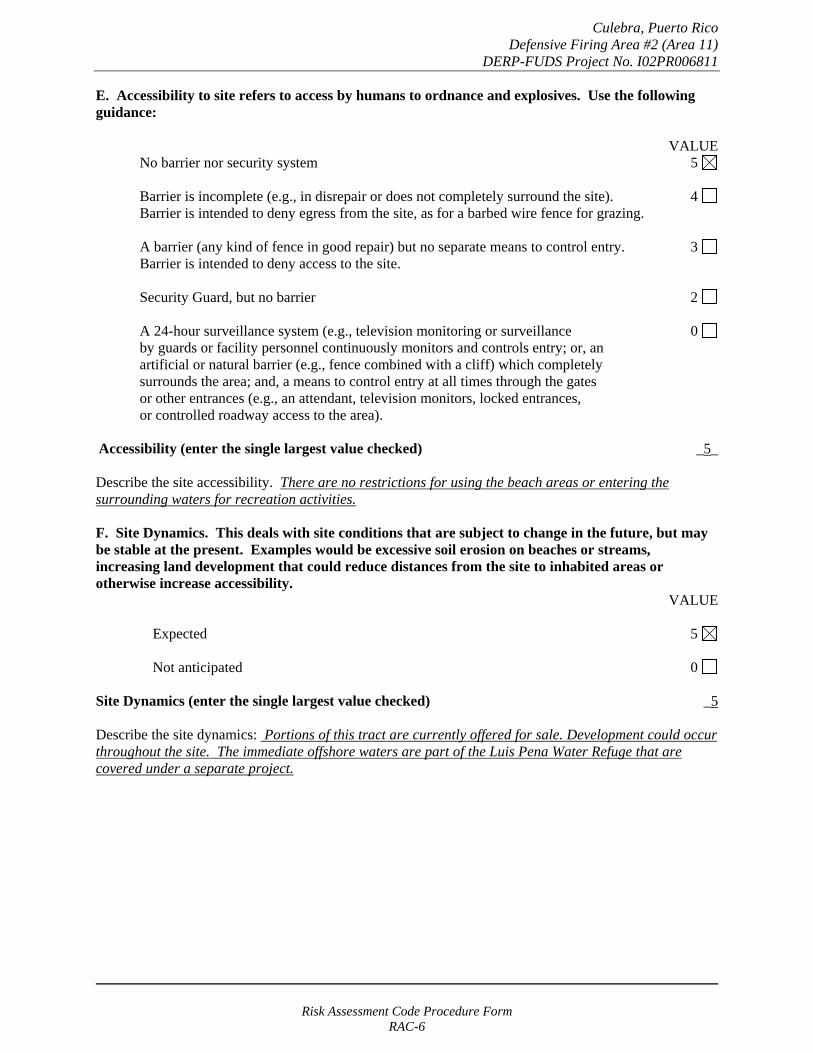
Culebra, Puerto Rico Defensive Firing Area #2 (Area 11)
DERP-FUDS Project No. I02PR006811
E. Accessibility to site refers to access by humans to ordnance and explosives. Use the following guidance:
VALUE No barrier nor security system 5
Barrier is incomplete (e.g., in disrepair or does not completely surround the site). 4 Barrier is intended to deny egress from the site, as for a barbed wire fence for grazing.
A barrier (any kind of fence in good repair) but no separate means to control entry. 3 Barrier is intended to deny access to the site.
Security Guard, but no barrier 2
A 24-hour surveillance system (e.g., television monitoring or surveillance 0 by guards or facility personnel continuously monitors and controls entry; or, an artificial or natural barrier (e.g., fence combined with a cliff) which completely surrounds the area; and, a means to control entry at all times through the gates or other entrances (e.g., an attendant, television monitors, locked entrances, or controlled roadway access to the area).
Accessibility (enter the single largest value checked) _5_
Describe the site accessibility. There are no restrictions for using the beach areas or entering the surrounding waters for recreation activities.
F. Site Dynamics. This deals with site conditions that are subject to change in the future, but may be stable at the present. Examples would be excessive soil erosion on beaches or streams, increasing land development that could reduce distances from the site to inhabited areas or otherwise increase accessibility.
VALUE
Expected 5
Not anticipated 0
Site Dynamics (enter the single largest value checked) _5
Describe the site dynamics: Portions of this tract are currently offered for sale. Development could occur throughout the site. The immediate offshore waters are part of the Luis Pena Water Refuge that are covered under a separate project.
Risk Assessment Code Procedure Form RAC-6

Culebra, Puerto Rico Defensive Firing Area #2 (Area 11)
DERP-FUDS Project No. I02PR006811
TOTAL HAZARD PROBABILITY VALUE (sum of largest values for A through F (maximum of 30). Apply this value to Hazard _30__ Probability Table 2 to determine the Hazard Probability Level.
TABLE 2 HAZARD PROBABILITY*
DESCRIPTION VALUE LEVEL HAZARD PROBABILITY VALUE
FREQUENT A 27 or greater
PROBABLE B 21 to 26
OCCASIONAL C 15 to 20
REMOTE D 8 to 14
IMPROBABLE E less than 8
* Apply Hazard Probability Level to Table 3.
PART III. Risk Assessment. The risk assessment value for this site is determined using the following Table. Enter the results of the Hazard Probability and Hazard Severity values.
TABLE 3
PROBABILITY LEVEL
FREQUENT A
PROBABLE B
OCCASIONAL C
REMOTE D
IMPROBABLE E
SEVERITY CATEGORY:
CATASTROPHIC I CRITICAL II MARGINABLE III NEGLIGIBLE IV
1 1 2 3
1 2 3 4
2 3 4 4
3 4 4 4
4 4 4 4
NONE (V) = RAC 5
Risk Assessment Code Procedure Form RAC-7
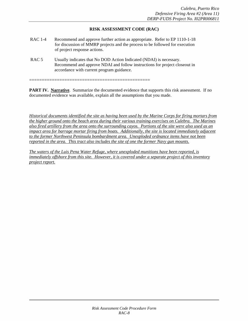
Culebra, Puerto Rico Defensive Firing Area #2 (Area 11)
DERP-FUDS Project No. I02PR006811
RISK ASSESSMENT CODE (RAC)
RAC 1-4 Recommend and approve further action as appropriate. Refer to EP 1110-1-18 for discussion of MMRP projects and the process to be followed for execution of project response actions.
RAC 5 Usually indicates that No DOD Action Indicated (NDAI) is necessary. Recommend and approve NDAI and follow instructions for project closeout in accordance with current program guidance.
================================================
PART IV. Narrative. Summarize the documented evidence that supports this risk assessment. If no documented evidence was available, explain all the assumptions that you made.
Historical documents identified the site as having been used by the Marine Corps for firing mortars from the higher ground onto the beach area during their various training exercises on Culebra. The Marines also fired artillery from the area onto the surrounding cayos. Portions of the site were also used as an impact area for barrage mortar firing from boats. Additionally, the site is located immediately adjacent to the former Northwest Peninsula bombardment area. Unexploded ordnance items have not been reported in the area. This tract also includes the site of one the former Navy gun mounts.
The waters of the Luis Pena Water Refuge, where unexploded munitions have been reported, is immediately offshore from this site. However, it is covered under a separate project of this inventory project report.
Risk Assessment Code Procedure Form RAC-8
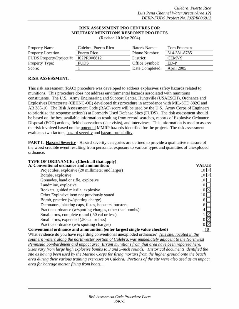
Culebra, Puerto Rico Luis Pena Channel Water Areas (Area 12)
DERP-FUDS Project No. I02PR006812
RISK ASSESSMENT PROCEDURES FOR MILITARY MUNITIONS RESPONSE PROJECTS
(Revised 10 May 2004)
Property Name: Culebra, Puerto Rico Rater's Name: Tom Freeman Property Location: Puerto Rico Phone Number: 314-331-8785 FUDS Property/Project #: I02PR006812 District: CEMVS Property Type: FUDS Office Symbol: ED-P Score: 1 Date Completed: April 2005
RISK ASSESSMENT:
This risk assessment (RAC) procedure was developed to address explosives safety hazards related to munitions. This procedure does not address environmental hazards associated with munitions constituents. The U.S. Army Engineering and Support Center, Huntsville (USAESCH), Ordnance and Explosives Directorate (CEHNC-OE) developed this procedure in accordance with MIL-STD 882C and AR 385-10. The Risk Assessment Code (RAC) score will be used by the U.S. Army Corps of Engineers to prioritize the response action(s) at Formerly Used Defense Sites (FUDS). The risk assessment should be based on the best available information resulting from record searches, reports of Explosive Ordnance Disposal (EOD) actions, field observations (site visits), and interviews. This information is used to assess the risk involved based on the potential MMRP hazards identified for the project. The risk assessment evaluates two factors, hazard severity and hazard probability.
PART I. Hazard Severity - Hazard severity categories are defined to provide a qualitative measure of the worst credible event resulting from personnel exposure to various types and quantities of unexploded ordnance.
TYPE OF ORDNANCE: (Check all that apply)A. Conventional ordnance and ammunition: VALUE
Projectiles, explosive (20 millimeter and larger) 10 Bombs, explosive 10
Grenades, hand or rifle, explosive 10 Landmine, explosive 10
Rockets, guided missile, explosive 10 Other Explosive item not previously stated 10 Bomb, practice (w/spotting charge) 6 Detonators, blasting caps, fuzes, boosters, bursters 6 Practice ordnance (w/spotting charges, other than bombs) 4 Small arms, complete round (.50 cal or less) 1 Small arms, expended (.50 cal or less) 0 Practice ordnance (w/o spotting charges) 0
Conventional ordnance and ammunition (enter largest single value checked) _10_ What evidence do you have regarding conventional unexploded ordnance? This site, located in the southern waters along the northwester portion of Culebra, was immediately adjacent to the Northwest Peninsula bombardment and impact area. Errant munitions from that area have been reported here. Sizes vary from large high explosive bombs to 3 and 5-inch rounds. Historical documents identified the site as having been used by the Marine Corps for firing mortars from the higher ground onto the beach area during their various training exercises on Culebra. Portions of the site were also used as an impact area for barrage mortar firing from boats.
Risk Assessment Code Procedure Form RAC-1

Culebra, Puerto Rico Luis Pena Channel Water Areas (Area 12)
DERP-FUDS Project No. I02PR006812
B. Pyrotechnics (for munitions not described above): VALUE
Munitions containing White Phosphorus (WP) 10 or other pyrophoric material (i.e., spontaneously flammable)
Munitions containing a flame or incendiary material 10 (i.e., Napalm, Triethylaluminum metal incendiaries)
Containers containing WP or other pyrophoric material or flame or 6 incendiary material
Flares, signals, simulators, screening/burning smokes (other than WP) 4
Pyrotechnics (enter the single largest value checked) _0_
What evidence do you have regarding pyrotechnics? None. The investigation team did not uncover evidence that these materials were used on this site.
C. Bulk Explosives (HE) (not an integral part of conventional ordnance; uncontainerized):
VALUE Primary or initiating explosives (Lead Styphnate, 10 Lead Azide, Nitroglycerin, Mercury Azide, Mercury Fulminate, Tetracene, etc.)
Secondary explosives (Demolition charges, PETN, Compositions A, B, C, 8 Tetryl, TNT, RDX, HMX, HBX, Black Powder, etc.)
Insensitive explosive substances (explosive contaminated soils, ammonium nitrate) 3
High explosives (enter the single largest value checked) _0_
What evidence do you have regarding bulk explosives? None. The investigation team did not uncover evidence that these materials were used on this site.
D. Bulk Propellants (not an integral part of rockets, guided missiles, or other conventional ordnance; uncontainerized):
VALUE Solid or liquid propellants 6
Bulk Propellants (select 6 or 0) _0_
What evidence do you have regarding bulk propellants? None. The investigation team did not uncover evidence that these materials were used on this site.
Risk Assessment Code Procedure Form RAC-2

Culebra, Puerto Rico Luis Pena Channel Water Areas (Area 12)
DERP-FUDS Project No. I02PR006812
E. Recovered Chemical Warfare Material (RCWM), Weaponized Industrial Chemicals and Radiological Material:
VALUE Toxic chemical agents (H-Mustard, G-Nerve, V-Nerve and L-Lewisite) 25
Chemical Agent Identification Sets 20
Radiological Materiel (If rad waste is identified, please call the HTRW-CX at (402) 697-2555) 15
Weaponized Industrial Chemicals (Hydrogen Cyanide AC; Cyanogen Chloride, CK; Phosgene, CG) 10
Riot Control Agents (vomiting, tear) 5
Chemical and Radiological (enter the single largest value checked) _0_
What evidence do you have regarding chemical or radiological? None. The investigation team did not uncover evidence that these materials were used on this site.
TOTAL HAZARD SEVERITY VALUE (Sum of value A through E, Maximum of 61 _10_ Apply this value to Table 1 to determine Hazard Severity Category
TABLE 1 HAZARD SEVERITY*
DESCRIPTION CATEGORY HAZARD SEVERITY VALUE
CATASTROPHIC CRITICAL MARGINAL NEGLIGIBLE **NONE
I II
III IV V
21 and/or greater 10 to 20
5 to 9 1 to 4
0
*Apply Hazard Severity Category to Table 3 and complete Part II of this form.
**If hazard severity value is 0, complete Part II of this form. Then proceed to Part III and use a RAC score of 5 to determine your appropriate action.
Risk Assessment Code Procedure Form RAC-3

Culebra, Puerto Rico Luis Pena Channel Water Areas (Area 12)
DERP-FUDS Project No. I02PR006812
PART II. Hazard Probability - The probability that a hazard has been, or will be, created due to the presence and other rated factors of unexploded ordnance, explosives, incendiary, pyrotechnic, radiological, or RCWM materials on a formerly used Department of Defense (DoD) site.
AREA, EXTENT, ACCESSIBILITY OF MMRP HAZARD (Check all that apply)
A. Locations of MMRP hazards: VALUE
On the surface 5 Within tanks, pipes, vessels, or other confined areas 4 Inside walls, ceilings, or other building/structure 3 Subsurface 2
Location (enter the single largest value checked) _5_
What evidence do you have regarding the location of MMRP? MMRP hazards could exist on or in the bottom of this channel area.
B. Distance to nearest inhabited location/structure likely to be at risk from MMRP hazard (road, park, playground, building etc.):
VALUE Less than 1,250 feet 5 1,250 feet to 0.5 mile 4 0.5 mile to 1.0 mile 3 1.0 mile to 2.0 Miles 2 Over 2 miles 1
Distance (enter the single largest value checked) _5_
What are the nearest inhabited structures/buildings? Residential areas have been developed on the hills overlooking this area. Several beaches are also located along this reach of shore.
Risk Assessment Code Procedure Form RAC-4

Culebra, Puerto Rico Luis Pena Channel Water Areas (Area 12)
DERP-FUDS Project No. I02PR006812
C. Number(s) of building(s) within a 2-mile radius measured from the MMRP hazard area, not the installation boundary.
VALUE 26 and over 5 16 to 25 4 11 to 15 3
6 to 10 2 1 to 5 1
0 0
Number of buildings (enter the single largest value checked) _5_
Narrative: Besides the nearby structures, the main island town of Dewey is located within two miles.
D. Types of Buildings (within 2 mile radius) VALUE
Educational, childcare, residential, hospitals, hotels, commercial, shopping centers 5 Industrial, warehouse, etc. 4 Agricultural, forestry, etc. 3
Detention, correctional 2 No buildings 0
Types of buildings (enter the single largest value checked) _5_
Describe the types of buildings: Residential and commercial areas are within two miles of the site.
Risk Assessment Code Procedure Form RAC-5
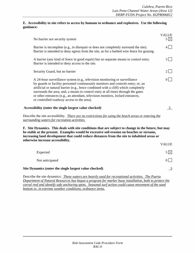
Culebra, Puerto Rico Luis Pena Channel Water Areas (Area 12)
DERP-FUDS Project No. I02PR006812
E. Accessibility to site refers to access by humans to ordnance and explosives. Use the following guidance:
VALUE No barrier nor security system 5
Barrier is incomplete (e.g., in disrepair or does not completely surround the site). 4 Barrier is intended to deny egress from the site, as for a barbed wire fence for grazing.
A barrier (any kind of fence in good repair) but no separate means to control entry. 3 Barrier is intended to deny access to the site.
Security Guard, but no barrier 2
A 24-hour surveillance system (e.g., television monitoring or surveillance 0 by guards or facility personnel continuously monitors and controls entry; or, an artificial or natural barrier (e.g., fence combined with a cliff) which completely surrounds the area; and, a means to control entry at all times through the gates or other entrances (e.g., an attendant, television monitors, locked entrances, or controlled roadway access to the area).
Accessibility (enter the single largest value checked) _5_
Describe the site accessibility. There are no restrictions for using the beach areas or entering the surrounding waters for recreation activities.
F. Site Dynamics. This deals with site conditions that are subject to change in the future, but may be stable at the present. Examples would be excessive soil erosion on beaches or streams, increasing land development that could reduce distances from the site to inhabited areas or otherwise increase accessibility.
VALUE
Expected 5
Not anticipated 0
Site Dynamics (enter the single largest value checked) _5
Describe the site dynamics: These waters are heavily used for recreational activities. The Puerto Department of Natural Resources has begun a program for marker buoy installation, both to protect the corral reef and identify safe anchoring spots. Seasonal surf action could cause movement of the sand bottom or, in extreme weather conditions, ordnance items.
Risk Assessment Code Procedure Form RAC-6

Culebra, Puerto Rico Luis Pena Channel Water Areas (Area 12)
DERP-FUDS Project No. I02PR006812
TOTAL HAZARD PROBABILITY VALUE (sum of largest values for A through F (maximum of 30). Apply this value to Hazard _30__ Probability Table 2 to determine the Hazard Probability Level.
TABLE 2 HAZARD PROBABILITY*
DESCRIPTION VALUE LEVEL HAZARD PROBABILITY VALUE
FREQUENT A 27 or greater
PROBABLE B 21 to 26
OCCASIONAL C 15 to 20
REMOTE D 8 to 14
IMPROBABLE E less than 8
* Apply Hazard Probability Level to Table 3.
PART III. Risk Assessment. The risk assessment value for this site is determined using the following Table. Enter the results of the Hazard Probability and Hazard Severity values.
TABLE 3
PROBABILITY LEVEL
FREQUENT A
PROBABLE B
OCCASIONAL C
REMOTE D
IMPROBABLE E
SEVERITY CATEGORY:
CATASTROPHIC I CRITICAL II MARGINABLE III NEGLIGIBLE IV
1 1 2 3
1 2 3 4
2 3 4 4
3 4 4 4
4 4 4 4
NONE (V) = RAC 5
Risk Assessment Code Procedure Form RAC-7
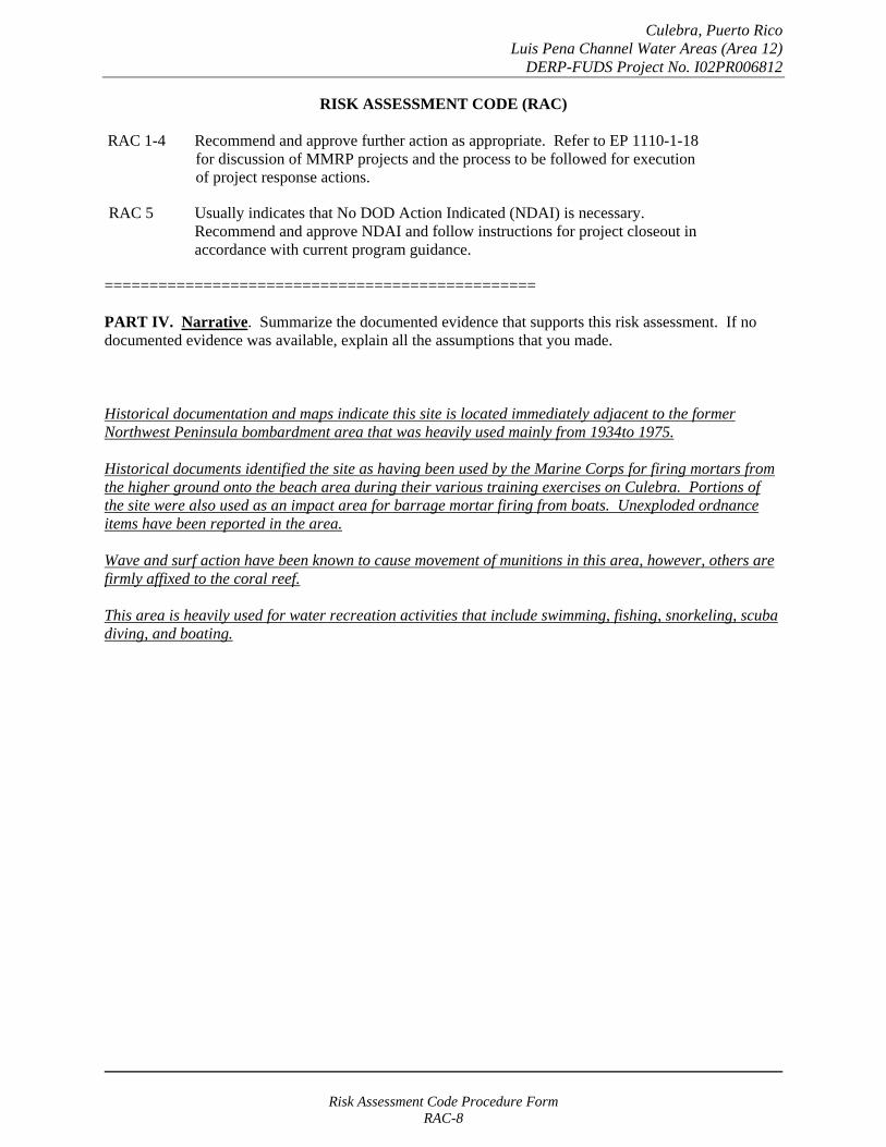
Culebra, Puerto Rico Luis Pena Channel Water Areas (Area 12)
DERP-FUDS Project No. I02PR006812
RISK ASSESSMENT CODE (RAC)
RAC 1-4 Recommend and approve further action as appropriate. Refer to EP 1110-1-18 for discussion of MMRP projects and the process to be followed for execution of project response actions.
RAC 5 Usually indicates that No DOD Action Indicated (NDAI) is necessary. Recommend and approve NDAI and follow instructions for project closeout in accordance with current program guidance.
================================================
PART IV. Narrative. Summarize the documented evidence that supports this risk assessment. If no documented evidence was available, explain all the assumptions that you made.
Historical documentation and maps indicate this site is located immediately adjacent to the former Northwest Peninsula bombardment area that was heavily used mainly from 1934to 1975.
Historical documents identified the site as having been used by the Marine Corps for firing mortars from the higher ground onto the beach area during their various training exercises on Culebra. Portions of the site were also used as an impact area for barrage mortar firing from boats. Unexploded ordnance items have been reported in the area.
Wave and surf action have been known to cause movement of munitions in this area, however, others are firmly affixed to the coral reef.
This area is heavily used for water recreation activities that include swimming, fishing, snorkeling, scuba diving, and boating.
Risk Assessment Code Procedure Form RAC-8

Culebra, Puerto Rico Cayo Luis Pena Impact Areas (Area 13) DERP-FUDS Project No. I02PR006813
RISK ASSESSMENT PROCEDURES FOR MILITARY MUNITIONS RESPONSE PROJECTS
(Revised 10 May 2004)
Property Name: Culebra, Puerto Rico Rater's Name: Tom Freeman Property Location: Puerto Rico Phone Number: 314-331-8785 FUDS Property/Project #: I02PR006813 District: CEMVS Property Type: FUDS Office Symbol: ED-P Score: 3 Date Completed: April 2005
RISK ASSESSMENT:
This risk assessment (RAC) procedure was developed to address explosives safety hazards related to munitions. This procedure does not address environmental hazards associated with munitions constituents. The U.S. Army Engineering and Support Center, Huntsville (USAESCH), Ordnance and Explosives Directorate (CEHNC-OE) developed this procedure in accordance with MIL-STD 882C and AR 385-10. The Risk Assessment Code (RAC) score will be used by the U.S. Army Corps of Engineers to prioritize the response action(s) at Formerly Used Defense Sites (FUDS). The risk assessment should be based on the best available information resulting from record searches, reports of Explosive Ordnance Disposal (EOD) actions, field observations (site visits), and interviews. This information is used to assess the risk involved based on the potential MMRP hazards identified for the project. The risk assessment evaluates two factors, hazard severity and hazard probability.
PART I. Hazard Severity - Hazard severity categories are defined to provide a qualitative measure of the worst credible event resulting from personnel exposure to various types and quantities of unexploded ordnance.
TYPE OF ORDNANCE: (Check all that apply)A. Conventional ordnance and ammunition: VALUE
Projectiles, explosive (20 millimeter and larger) 10 Bombs, explosive 10
Grenades, hand or rifle, explosive 10 Landmine, explosive 10
Rockets, guided missile, explosive 10 Other Explosive item not previously stated 10 Bomb, practice (w/spotting charge) 6 Detonators, blasting caps, fuzes, boosters, bursters 6 Practice ordnance (w/spotting charges, other than bombs) 4 Small arms, complete round (.50 cal or less) 1 Small arms, expended (.50 cal or less) 0 Practice ordnance (w/o spotting charges) 0
Conventional ordnance and ammunition (enter largest single value checked) _1_ What evidence do you have regarding conventional unexploded ordnance? Cayo Luis Pena was used a bombing and gunnery range and an artillery impact area by the Marine Corps during its various training exercises on Culebra. Additionally the cayo is located in the immediate vicinity of the Northwest Peninsula that served as the main military bombardment and impact area.
Risk Assessment Code Procedure Form RAC-1

Culebra, Puerto Rico Cayo Luis Pena Impact Areas (Area 13) DERP-FUDS Project No. I02PR006813
B. Pyrotechnics (for munitions not described above): VALUE
Munitions containing White Phosphorus (WP) 10 or other pyrophoric material (i.e., spontaneously flammable)
Munitions containing a flame or incendiary material 10 (i.e., Napalm, Triethylaluminum metal incendiaries)
Containers containing WP or other pyrophoric material or flame or 6 incendiary material
Flares, signals, simulators, screening/burning smokes (other than WP) 4
Pyrotechnics (enter the single largest value checked) _0_
What evidence do you have regarding pyrotechnics? None. The investigation team did not uncover evidence that these materials were used on this site.
C. Bulk Explosives (HE) (not an integral part of conventional ordnance; uncontainerized):
VALUE Primary or initiating explosives (Lead Styphnate, 10 Lead Azide, Nitroglycerin, Mercury Azide, Mercury Fulminate, Tetracene, etc.)
Secondary explosives (Demolition charges, PETN, Compositions A, B, C, 8 Tetryl, TNT, RDX, HMX, HBX, Black Powder, etc.)
Insensitive explosive substances (explosive contaminated soils, ammonium nitrate) 3
High explosives (enter the single largest value checked) _0_
What evidence do you have regarding bulk explosives? None. The investigation team did not uncover evidence that these materials were used on this site.
D. Bulk Propellants (not an integral part of rockets, guided missiles, or other conventional ordnance; uncontainerized):
VALUE Solid or liquid propellants 6
Bulk Propellants (select 6 or 0) _0_
What evidence do you have regarding bulk propellants? None. The investigation team did not uncover evidence that these materials were used on this site.
Risk Assessment Code Procedure Form RAC-2

Culebra, Puerto Rico Cayo Luis Pena Impact Areas (Area 13) DERP-FUDS Project No. I02PR006813
E. Recovered Chemical Warfare Material (RCWM), Weaponized Industrial Chemicals and Radiological Material:
VALUE Toxic chemical agents (H-Mustard, G-Nerve, V-Nerve and L-Lewisite) 25
Chemical Agent Identification Sets 20
Radiological Materiel (If rad waste is identified, please call the HTRW-CX at (402) 697-2555) 15
Weaponized Industrial Chemicals (Hydrogen Cyanide AC; Cyanogen Chloride, CK; Phosgene, CG) 10
Riot Control Agents (vomiting, tear) 5
Chemical and Radiological (enter the single largest value checked) _0_
What evidence do you have regarding chemical or radiological? None. The investigation team did not uncover evidence that these materials were used on this site.
TOTAL HAZARD SEVERITY VALUE (Sum of value A through E, Maximum of 61 _10_ Apply this value to Table 1 to determine Hazard Severity Category
TABLE 1 HAZARD SEVERITY*
DESCRIPTION CATEGORY HAZARD SEVERITY VALUE
CATASTROPHIC CRITICAL MARGINAL NEGLIGIBLE **NONE
I II
III IV V
21 and/or greater 10 to 20
5 to 9 1 to 4
0
*Apply Hazard Severity Category to Table 3 and complete Part II of this form.
**If hazard severity value is 0, complete Part II of this form. Then proceed to Part III and use a RAC score of 5 to determine your appropriate action.
Risk Assessment Code Procedure Form RAC-3
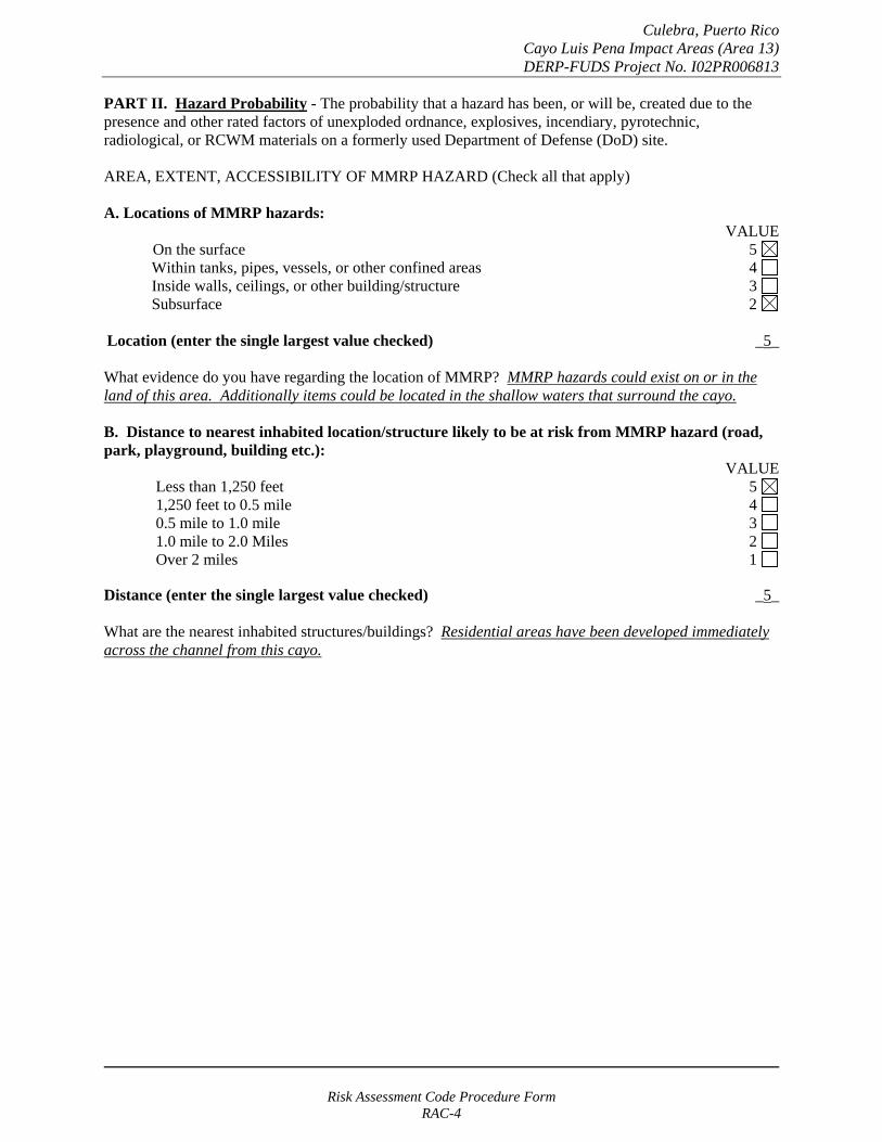
Culebra, Puerto Rico Cayo Luis Pena Impact Areas (Area 13) DERP-FUDS Project No. I02PR006813
PART II. Hazard Probability - The probability that a hazard has been, or will be, created due to the presence and other rated factors of unexploded ordnance, explosives, incendiary, pyrotechnic, radiological, or RCWM materials on a formerly used Department of Defense (DoD) site.
AREA, EXTENT, ACCESSIBILITY OF MMRP HAZARD (Check all that apply)
A. Locations of MMRP hazards: VALUE
On the surface 5 Within tanks, pipes, vessels, or other confined areas 4 Inside walls, ceilings, or other building/structure 3 Subsurface 2
Location (enter the single largest value checked) _5_
What evidence do you have regarding the location of MMRP? MMRP hazards could exist on or in the land of this area. Additionally items could be located in the shallow waters that surround the cayo.
B. Distance to nearest inhabited location/structure likely to be at risk from MMRP hazard (road, park, playground, building etc.):
VALUE Less than 1,250 feet 5 1,250 feet to 0.5 mile 4 0.5 mile to 1.0 mile 3 1.0 mile to 2.0 Miles 2 Over 2 miles 1
Distance (enter the single largest value checked) _5_
What are the nearest inhabited structures/buildings? Residential areas have been developed immediately across the channel from this cayo.
Risk Assessment Code Procedure Form RAC-4
Culebra, Puerto Rico Cayo Luis Pena Impact Areas (Area 13) DERP-FUDS Project No. I02PR006813
C. Number(s) of building(s) within a 2-mile radius measured from the MMRP hazard area, not the installation boundary.
VALUE 26 and over 5 16 to 25 4 11 to 15 3
6 to 10 2 1 to 5 1
0 0
Number of buildings (enter the single largest value checked) _5_
Narrative: Besides the nearby structures, the main island town of Dewey is located within two miles.
D. Types of Buildings (within 2 mile radius) VALUE
Educational, childcare, residential, hospitals, hotels, commercial, shopping centers 5 Industrial, warehouse, etc. 4 Agricultural, forestry, etc. 3
Detention, correctional 2 No buildings 0
Types of buildings (enter the single largest value checked) _5_
Describe the types of buildings: Residential and commercial areas are on and within two miles of the site.
Risk Assessment Code Procedure Form RAC-5
Culebra, Puerto Rico Cayo Luis Pena Impact Areas (Area 13) DERP-FUDS Project No. I02PR006813
E. Accessibility to site refers to access by humans to ordnance and explosives. Use the following guidance:
No barrier nor security system VALUE
5
Barrier is incomplete (e.g., in disrepair or does not completely surround the site). Barrier is intended to deny egress from the site, as for a barbed wire fence for grazing.
4
A barrier (any kind of fence in good repair) but no separate means to control entry. Barrier is intended to deny access to the site.
3
Security Guard, but no barrier 2
A 24-hour surveillance system (e.g., television monitoring or surveillance by guards or facility personnel continuously monitors and controls entry; or, an artificial or natural barrier (e.g., fence combined with a cliff) which completely surrounds the area; and, a means to control entry at all times through the gates or other entrances (e.g., an attendant, television monitors, locked entrances, or controlled roadway access to the area).
0
Accessibility (enter the single largest value checked) _5_
Describe the site accessibility. The site, which is under the control of the US Fish and Wildlife agency, does not have barriers for access.
F. Site Dynamics. This deals with site conditions that are subject to change in the future, but may be stable at the present. Examples would be excessive soil erosion on beaches or streams, increasing land development that could reduce distances from the site to inhabited areas or otherwise increase accessibility.
VALUE
Expected 5
Not anticipated 0
Site Dynamics (enter the single largest value checked) _5
Describe the site dynamics: US Fish and Wildlife allows recreational activities and anchorage in the waters around the cayo and may need to install additional safety and mooring buoys. Surf action could change the bottom conditions of the waters.
Additionally, hiking trails could be develop on the island.
Risk Assessment Code Procedure Form RAC-6

Culebra, Puerto Rico Cayo Luis Pena Impact Areas (Area 13) DERP-FUDS Project No. I02PR006813
TOTAL HAZARD PROBABILITY VALUE (sum of largest values for A through F (maximum of 30). Apply this value to Hazard _30__ Probability Table 2 to determine the Hazard Probability Level.
TABLE 2 HAZARD PROBABILITY*
DESCRIPTION VALUE LEVEL HAZARD PROBABILITY VALUE
FREQUENT A 27 or greater
PROBABLE B 21 to 26
OCCASIONAL C 15 to 20
REMOTE D 8 to 14
IMPROBABLE E less than 8
* Apply Hazard Probability Level to Table 3.
PART III. Risk Assessment. The risk assessment value for this site is determined using the following Table. Enter the results of the Hazard Probability and Hazard Severity values.
TABLE 3
PROBABILITY LEVEL
FREQUENT A
PROBABLE B
OCCASIONAL C
REMOTE D
IMPROBABLE E
SEVERITY CATEGORY:
CATASTROPHIC I CRITICAL II MARGINABLE III NEGLIGIBLE IV
1 1 2 3
1 2 3 4
2 3 4 4
3 4 4 4
4 4 4 4
NONE (V) = RAC 5
Risk Assessment Code Procedure Form RAC-7
Culebra, Puerto Rico Cayo Luis Pena Impact Areas (Area 13) DERP-FUDS Project No. I02PR006813
RISK ASSESSMENT CODE (RAC)
RAC 1-4 Recommend and approve further action as appropriate. Refer to EP 1110-1-18 for discussion of MMRP projects and the process to be followed for execution of project response actions.
RAC 5 Usually indicates that No DOD Action Indicated (NDAI) is necessary. Recommend and approve NDAI and follow instructions for project closeout in accordance with current program guidance.
================================================
PART IV. Narrative. Summarize the documented evidence that supports this risk assessment. If no documented evidence was available, explain all the assumptions that you made.
Historical documentation and maps indicate this area was used the Marine Corps as a bombing and gunnery range and as an artillery impact area. Additionally, it is located in the immediate vicinity of the Northwest Peninsula that was the main bombardment and impact area during the Navy and Marine training exercises. MMRP items have been reported in the waters around the cayo.
Risk Assessment Code Procedure Form RAC-8

Culebra, Puerto Rico Airport and Camp Area (Area 14)
DERP-FUDS Project No. I02PR006814
RISK ASSESSMENT PROCEDURES FOR MILITARY MUNITIONS RESPONSE PROJECTS
(Revised 10 May 2004)
Property Name: Culebra, Puerto Rico Rater's Name: Tom Freeman Property Location: Puerto Rico Phone Number: 314-331-8785 FUDS Property/Project #: I02PR006814 District: CEMVS Property Type: FUDS Office Symbol: ED-P Score: 3 Date Completed: April 2005
RISK ASSESSMENT:
This risk assessment (RAC) procedure was developed to address explosives safety hazards related to munitions. This procedure does not address environmental hazards associated with munitions constituents. The U.S. Army Engineering and Support Center, Huntsville (USAESCH), Ordnance and Explosives Directorate (CEHNC-OE) developed this procedure in accordance with MIL-STD 882C and AR 385-10. The Risk Assessment Code (RAC) score will be used by the U.S. Army Corps of Engineers to prioritize the response action(s) at Formerly Used Defense Sites (FUDS). The risk assessment should be based on the best available information resulting from record searches, reports of Explosive Ordnance Disposal (EOD) actions, field observations (site visits), and interviews. This information is used to assess the risk involved based on the potential MMRP hazards identified for the project. The risk assessment evaluates two factors, hazard severity and hazard probability.
PART I. Hazard Severity - Hazard severity categories are defined to provide a qualitative measure of the worst credible event resulting from personnel exposure to various types and quantities of unexploded ordnance.
TYPE OF ORDNANCE: (Check all that apply)A. Conventional ordnance and ammunition: VALUE
Projectiles, explosive (20 millimeter and larger) 10 Bombs, explosive 10
Grenades, hand or rifle, explosive 10 Landmine, explosive 10
Rockets, guided missile, explosive 10 Other Explosive item not previously stated 10 Bomb, practice (w/spotting charge) 6 Detonators, blasting caps, fuzes, boosters, bursters 6 Practice ordnance (w/spotting charges, other than bombs) 4 Small arms, complete round (.50 cal or less) 1 Small arms, expended (.50 cal or less) 0 Practice ordnance (w/o spotting charges) 0
Conventional ordnance and ammunition (enter largest single value checked) _1_ What evidence do you have regarding conventional unexploded ordnance? This area was the site of the Marine and Navy encampments and airport. There have been no reports of any unexploded ordnance in this area, except those that have been brought in from other areas of the island. The military did have small arms firing ranges in this area and small arms ammunition could still be present.
Risk Assessment Code Procedure Form RAC-1
Culebra, Puerto Rico Airport and Camp Area (Area 14)
DERP-FUDS Project No. I02PR006814
B. Pyrotechnics (for munitions not described above): VALUE
Munitions containing White Phosphorus (WP) 10 or other pyrophoric material (i.e., spontaneously flammable)
Munitions containing a flame or incendiary material 10 (i.e., Napalm, Triethylaluminum metal incendiaries)
Containers containing WP or other pyrophoric material or flame or 6 incendiary material
Flares, signals, simulators, screening/burning smokes (other than WP) 4
Pyrotechnics (enter the single largest value checked) _0_
What evidence do you have regarding pyrotechnics? None. The investigation team did not uncover evidence that these materials were used on this site.
C. Bulk Explosives (HE) (not an integral part of conventional ordnance; uncontainerized):
VALUE Primary or initiating explosives (Lead Styphnate, 10 Lead Azide, Nitroglycerin, Mercury Azide, Mercury Fulminate, Tetracene, etc.)
Secondary explosives (Demolition charges, PETN, Compositions A, B, C, 8 Tetryl, TNT, RDX, HMX, HBX, Black Powder, etc.)
Insensitive explosive substances (explosive contaminated soils, ammonium nitrate) 3
High explosives (enter the single largest value checked) _0_
What evidence do you have regarding bulk explosives? None. The investigation team did not uncover evidence that these materials were used on this site.
D. Bulk Propellants (not an integral part of rockets, guided missiles, or other conventional ordnance; uncontainerized):
VALUE Solid or liquid propellants 6
Bulk Propellants (select 6 or 0) _0_
What evidence do you have regarding bulk propellants? None. The investigation team did not uncover evidence that these materials were used on this site.
Risk Assessment Code Procedure Form RAC-2

Culebra, Puerto Rico Airport and Camp Area (Area 14)
DERP-FUDS Project No. I02PR006814
E. Recovered Chemical Warfare Material (RCWM), Weaponized Industrial Chemicals and Radiological Material:
VALUE Toxic chemical agents (H-Mustard, G-Nerve, V-Nerve and L-Lewisite) 25
Chemical Agent Identification Sets 20
Radiological Materiel (If rad waste is identified, please call the HTRW-CX at (402) 697-2555) 15
Weaponized Industrial Chemicals (Hydrogen Cyanide AC; Cyanogen Chloride, CK; Phosgene, CG) 10
Riot Control Agents (vomiting, tear) 5
Chemical and Radiological (enter the single largest value checked) _0_
What evidence do you have regarding chemical or radiological? None. The investigation team did not uncover evidence that these materials were used on this site.
TOTAL HAZARD SEVERITY VALUE (Sum of value A through E, Maximum of 61 _10_ Apply this value to Table 1 to determine Hazard Severity Category
TABLE 1 HAZARD SEVERITY*
DESCRIPTION CATEGORY HAZARD SEVERITY VALUE
CATASTROPHIC CRITICAL MARGINAL NEGLIGIBLE **NONE
I II
III IV V
21 and/or greater 10 to 20
5 to 9 1 to 4
0
*Apply Hazard Severity Category to Table 3 and complete Part II of this form.
**If hazard severity value is 0, complete Part II of this form. Then proceed to Part III and use a RAC score of 5 to determine your appropriate action.
Risk Assessment Code Procedure Form RAC-3
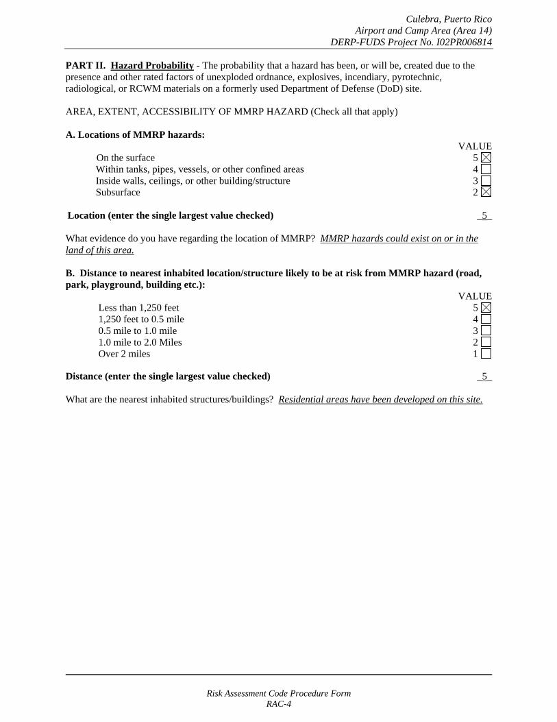
Culebra, Puerto Rico Airport and Camp Area (Area 14)
DERP-FUDS Project No. I02PR006814
PART II. Hazard Probability - The probability that a hazard has been, or will be, created due to the presence and other rated factors of unexploded ordnance, explosives, incendiary, pyrotechnic, radiological, or RCWM materials on a formerly used Department of Defense (DoD) site.
AREA, EXTENT, ACCESSIBILITY OF MMRP HAZARD (Check all that apply)
A. Locations of MMRP hazards: VALUE
On the surface 5 Within tanks, pipes, vessels, or other confined areas 4 Inside walls, ceilings, or other building/structure 3 Subsurface 2
Location (enter the single largest value checked) _5_
What evidence do you have regarding the location of MMRP? MMRP hazards could exist on or in the land of this area.
B. Distance to nearest inhabited location/structure likely to be at risk from MMRP hazard (road, park, playground, building etc.):
VALUE Less than 1,250 feet 5 1,250 feet to 0.5 mile 4 0.5 mile to 1.0 mile 3 1.0 mile to 2.0 Miles 2 Over 2 miles 1
Distance (enter the single largest value checked) _5_
What are the nearest inhabited structures/buildings? Residential areas have been developed on this site.
Risk Assessment Code Procedure Form RAC-4
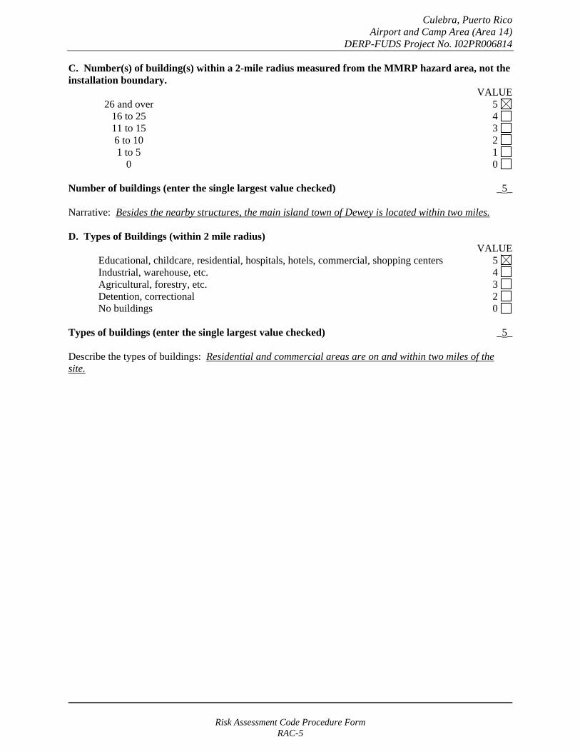
Culebra, Puerto Rico Airport and Camp Area (Area 14)
DERP-FUDS Project No. I02PR006814
C. Number(s) of building(s) within a 2-mile radius measured from the MMRP hazard area, not the installation boundary.
VALUE 26 and over 5 16 to 25 4 11 to 15 3
6 to 10 2 1 to 5 1
0 0
Number of buildings (enter the single largest value checked) _5_
Narrative: Besides the nearby structures, the main island town of Dewey is located within two miles.
D. Types of Buildings (within 2 mile radius) VALUE
Educational, childcare, residential, hospitals, hotels, commercial, shopping centers 5 Industrial, warehouse, etc. 4 Agricultural, forestry, etc. 3
Detention, correctional 2 No buildings 0
Types of buildings (enter the single largest value checked) _5_
Describe the types of buildings: Residential and commercial areas are on and within two miles of the site.
Risk Assessment Code Procedure Form RAC-5
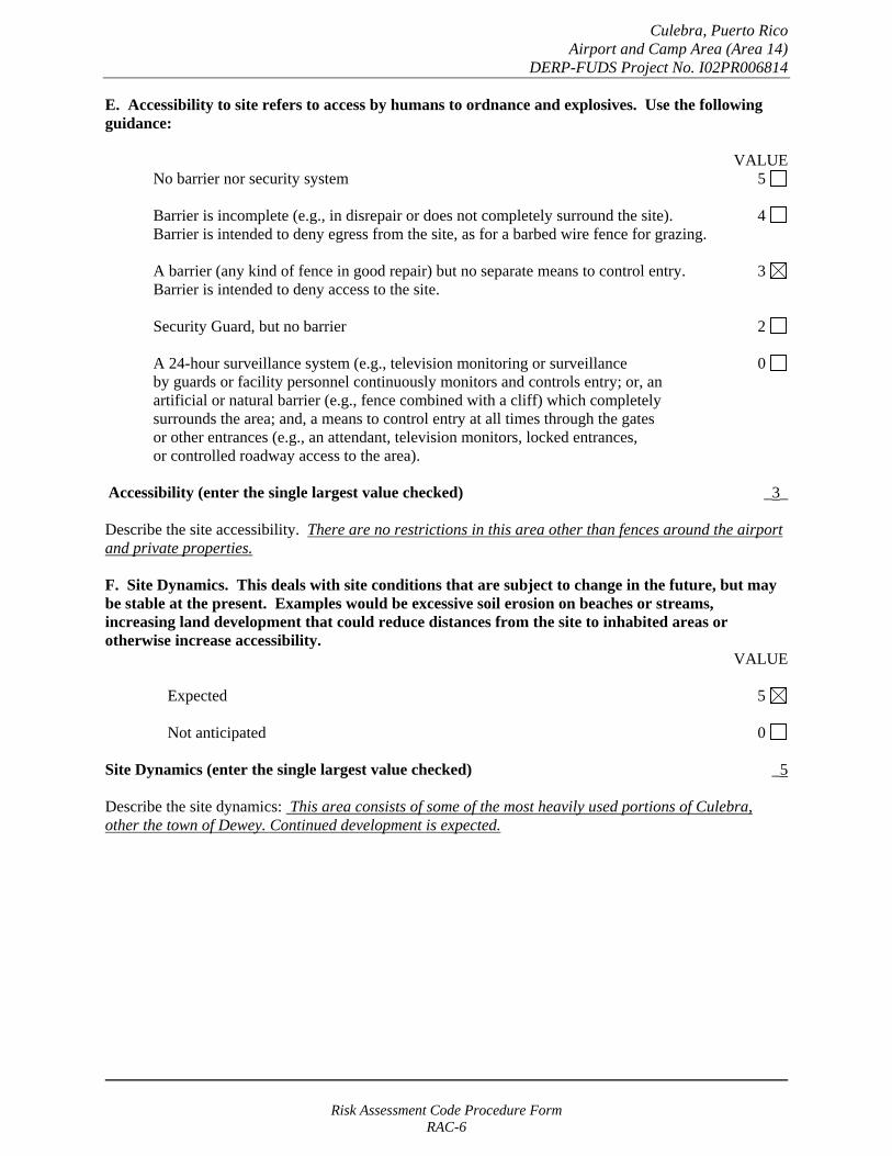
Culebra, Puerto Rico Airport and Camp Area (Area 14)
DERP-FUDS Project No. I02PR006814
E. Accessibility to site refers to access by humans to ordnance and explosives. Use the following guidance:
VALUE No barrier nor security system 5
Barrier is incomplete (e.g., in disrepair or does not completely surround the site). 4 Barrier is intended to deny egress from the site, as for a barbed wire fence for grazing.
A barrier (any kind of fence in good repair) but no separate means to control entry. 3 Barrier is intended to deny access to the site.
Security Guard, but no barrier 2
A 24-hour surveillance system (e.g., television monitoring or surveillance 0 by guards or facility personnel continuously monitors and controls entry; or, an artificial or natural barrier (e.g., fence combined with a cliff) which completely surrounds the area; and, a means to control entry at all times through the gates or other entrances (e.g., an attendant, television monitors, locked entrances, or controlled roadway access to the area).
Accessibility (enter the single largest value checked) _3_
Describe the site accessibility. There are no restrictions in this area other than fences around the airport and private properties.
F. Site Dynamics. This deals with site conditions that are subject to change in the future, but may be stable at the present. Examples would be excessive soil erosion on beaches or streams, increasing land development that could reduce distances from the site to inhabited areas or otherwise increase accessibility.
VALUE
Expected 5
Not anticipated 0
Site Dynamics (enter the single largest value checked) _5
Describe the site dynamics: This area consists of some of the most heavily used portions of Culebra, other the town of Dewey. Continued development is expected.
Risk Assessment Code Procedure Form RAC-6

Culebra, Puerto Rico Airport and Camp Area (Area 14)
DERP-FUDS Project No. I02PR006814
TOTAL HAZARD PROBABILITY VALUE (sum of largest values for A through F (maximum of 30). Apply this value to Hazard _28__ Probability Table 2 to determine the Hazard Probability Level.
TABLE 2 HAZARD PROBABILITY*
DESCRIPTION VALUE LEVEL HAZARD PROBABILITY VALUE
FREQUENT A 27 or greater
PROBABLE B 21 to 26
OCCASIONAL C 15 to 20
REMOTE D 8 to 14
IMPROBABLE E less than 8
* Apply Hazard Probability Level to Table 3.
PART III. Risk Assessment. The risk assessment value for this site is determined using the following Table. Enter the results of the Hazard Probability and Hazard Severity values.
TABLE 3
PROBABILITY LEVEL
FREQUENT A
PROBABLE B
OCCASIONAL C
REMOTE D
IMPROBABLE E
SEVERITY CATEGORY:
CATASTROPHIC I CRITICAL II MARGINABLE III NEGLIGIBLE IV
1 1 2 3
1 2 3 4
2 3 4 4
3 4 4 4
4 4 4 4
NONE (V) = RAC 5
Risk Assessment Code Procedure Form RAC-7
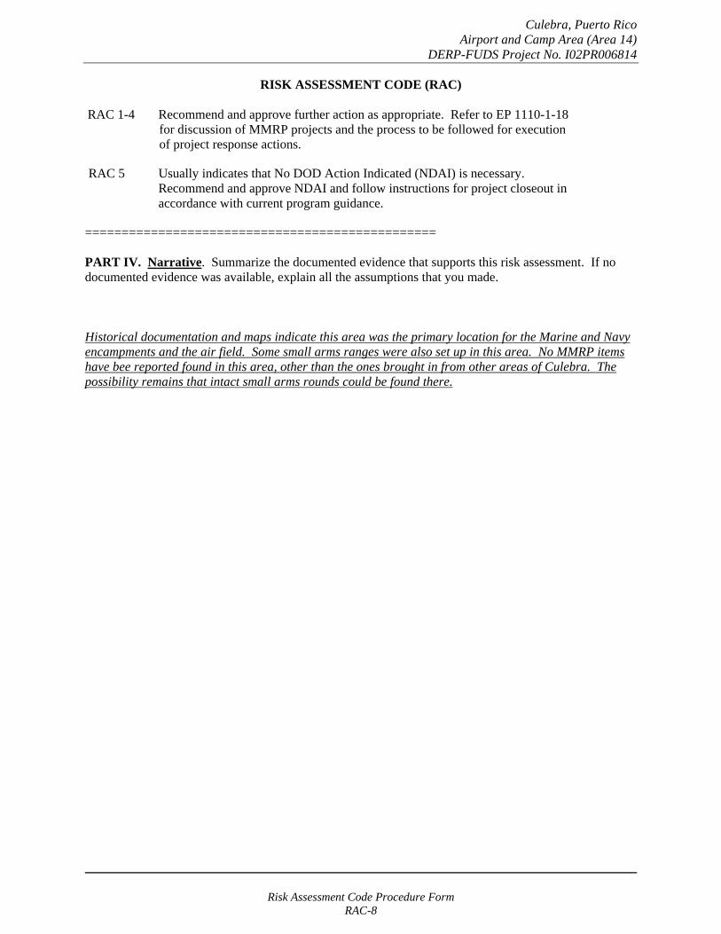
Culebra, Puerto Rico Airport and Camp Area (Area 14)
DERP-FUDS Project No. I02PR006814
RISK ASSESSMENT CODE (RAC)
RAC 1-4 Recommend and approve further action as appropriate. Refer to EP 1110-1-18 for discussion of MMRP projects and the process to be followed for execution of project response actions.
RAC 5 Usually indicates that No DOD Action Indicated (NDAI) is necessary. Recommend and approve NDAI and follow instructions for project closeout in accordance with current program guidance.
================================================
PART IV. Narrative. Summarize the documented evidence that supports this risk assessment. If no documented evidence was available, explain all the assumptions that you made.
Historical documentation and maps indicate this area was the primary location for the Marine and Navy encampments and the air field. Some small arms ranges were also set up in this area. No MMRP items have bee reported found in this area, other than the ones brought in from other areas of Culebra. The possibility remains that intact small arms rounds could be found there.
Risk Assessment Code Procedure Form RAC-8
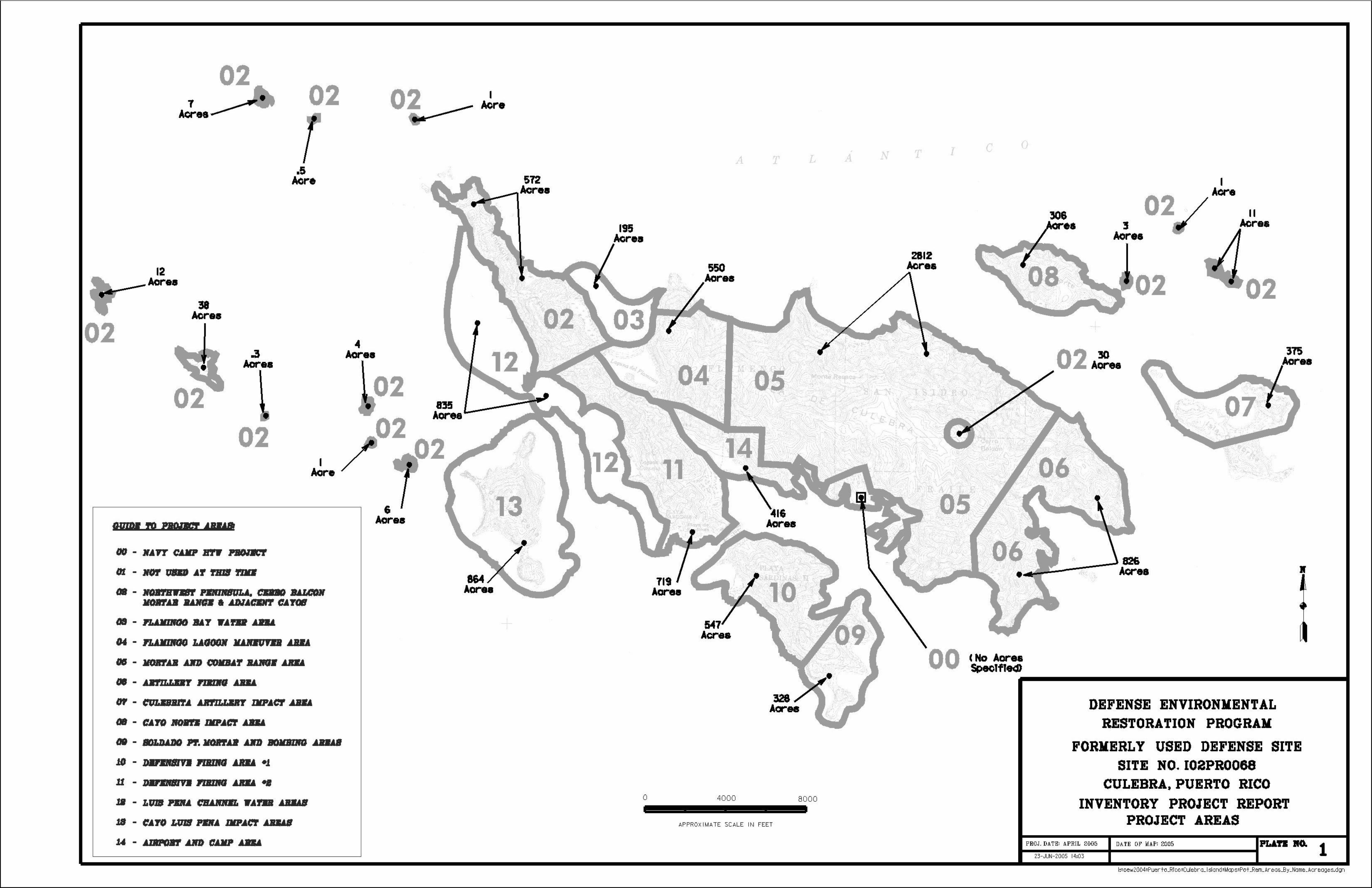
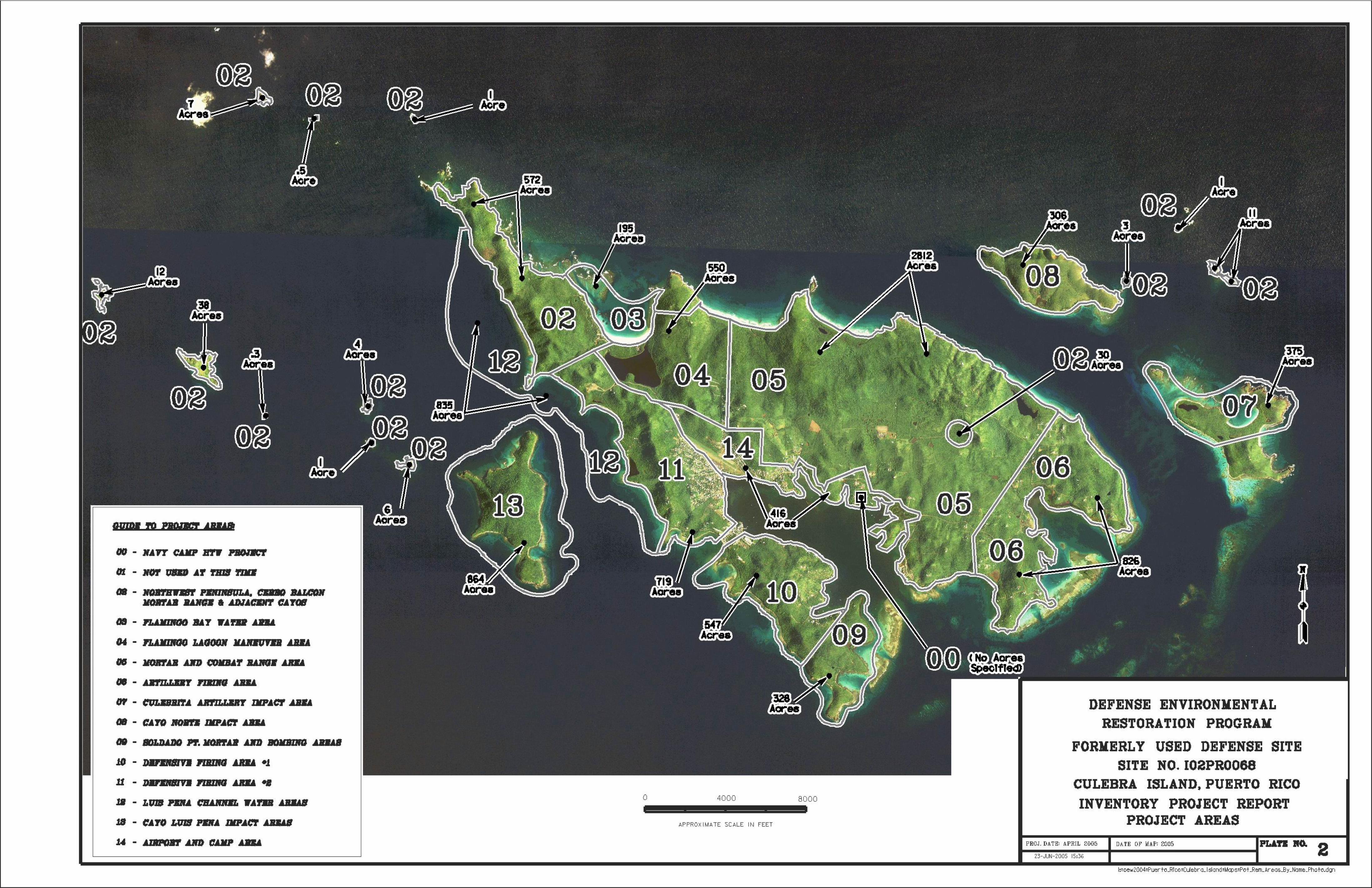
Historical Activities Report Part of the
Supplemental Archives Search Report for
Culebra, Puerto Rico
Culebra, Puerto Rico DERP-FUDS Property # - I02PR0068
Supplemental Archives Search Report (FINAL)
Supplemental Archives Search Report (FINAL) Culebra, Puerto Rico
DERP-FUDS# I02PR0068
EXECUTIVE SUMMARY
The US Army Corps of Engineers administers the Defense Environmental Restoration Program (DERP) for Formerly Used Defense Site (FUDS) program. The St. Louis District of the Corps of Engineers prepared this Military Munitions Response Program (MMRP) Supplemental Archives Search Report (ASR) for Property No. I02PR0068, Culebra, Puerto Rico in support of DERP-FUDS. This effort was coordinated with the Headquarters and Jacksonville District, US Army Corps of Engineers and the US Army Engineering and Support Center, Huntsville (USAESCH), which serves as the Military Munitions Center of Expertise (CX) and Design Center.
This ASR compiles information obtained through historical research at various archives and records holding facilities and supplements the findings of the original archives search report prepared by the Corps of Engineers in February 1995. The investigation was primarily a textual, cartographic and photographic research and analysis effort. It also makes use of site visits and interviews to gather information concerning the site. The research directed efforts towards determining presence of munitions and explosives of concern (MEC) as a result of previous use, storage, and/or disposal. The research places particular emphasis on establishing the types, quantities and areas of former ordnance and explosives (OE) and chemical warfare (CW) activities. This process obtains information for use in developing recommendations for further action on and around the island of Culebra.
This version of the Supplemental Archives Search Report is being presented at this time to provide detailed information regarding the US Marine Corps activities on Culebra and the real estate formerly used by the US Navy and in particular the “present bombardment area” mentioned in Public Law 93-166. A summary of the US Navy property transfers regarding Culebra is presented on Figure 1.0 of this report. A map showing all of the pertinent real estate areas is also included with this report as Plate No. 1. Report Plate No. 2 depicts areas on Culebra that the Marines had used over the years for ordnance and other operations. Report Plate No. 3 is a compilation of various historic photographs (more photographs are available in Appendix D). Appendix A contains the documents that are cited in the footnotes as references. Appendix B is a listing of the records that were reviewed at the various archives, offices, and records repositories. Appendix C is a collection of sketches drawn by a US Marine in 1913 showing conditions throughout the island. Appendix D contains copies of the various historic maps and photographs used in developing this report. Appendix E has historical aerial photography from 1964 and 1985. Appendix F contains all of the historical documents acquired during this research effort. Appendix G is a copy of the original 1995 Archives Search Report. A copy of this report and Appendices A through C are contained on Compact Disc #1 attached to this report. Appendices D, E, F, and G are on Compact Discs #2, #3, #4, and #5, respectively.
Executive Summary Report Page 1 of 85
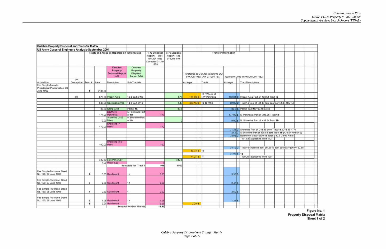
Culebra, Puerto Rico DERP-FUDS Property # - I02PR0068
Supplemental Archives Search Report (FINAL)
Culebra Property Disposal and Transfer Matrix Page 2 of 85
Culebra Property Disposal and Transfer Matrix
US Army Corps of Engineers Analysis-September 2004 Tracts and Areas as Reported on 1966 REMap
Denotes Denotes Property Property
Disposal Report Disposal 1-72 Report3-76
Lot Acquisition Description Tract# Area Description Sub-Tract #s Fee Simple-Transfer Presidential Proclamation. 26 June 1903 1 2135.00
91 572.00 Impact Area 1a & part of 1b
548.00 Operations Area 1d & part of 1c
30.50 Camp Area Partof1k Southern S Peninsula Part
177.00 Peninsula of 1m Shoreline (1.03 N Shoreline Part
9.00 Miles) of 1b
Shoreline (7 172.00 Miles)
Shoreline (9.5 190.00 Miles)
342.50 Luis Pen a Cay 7.00 Water Cav
Subtotals for Tract 1
Fee Simple-Purchase Deed No. 129, 27 June 1903 2 5.33 Gun Mount 1p
Fee Simple-Purchase Deed No. 129, 27 June 1903 3 2.50 Gun Mount 1n
Fee Simple-Purchase Deed No. 130, 28 June 1903 4 2.50 Gun Mount 1 i
Fee Simple-Purchase Deed No. 130. 28 June 1903 5 1.25 Gun Mount 1h
6 2.25 Gun Mount 1f Subtotal for Gun Mounts
1-72 Disposal 3-76 Disposal Report (RR- Report (RR-
071 204-103) 071204-110) Corrected 31 Jan
1978
572
548
30.5
177
9
172
190
342.5 7
546 1502
5.33
2.50
2.50
1.25 2.25
13.83
Transfer Information
Transferred to GSA for transfer to DOl (19 Aug 1980 (RR-071204-137) Quitclaim Deed to PR (20 Dec 1982)
Acreage Tracts Acreage
1a NW end of 163.96 s NW Peninsula 40804 c
485.15 s 1d to FWS 62.85 c
30.5 s
177.00 s
9.00 s
71.35 c 21 .5 c
78.98 c
34.12 c 53.78 s 1e
31.09 s 71.21 s 1j
5.33 s
2.47 s
2.50 s
1.25 s 2.25 s
Tract Descriptions
Impact Area Part of 438.54 Tract 1 b
I I Tract 1 c west of Lot 45 east boundary (548-485.15)
I I Part of tract 1 k 109.48 acres I
S. Peninsula Part of 248.35 Tract 1m
N. Shoreline Part of 438.54 Tract 1b
Shoreline Part of 248.35-acre Tract 1m (248.35-177) S Shoreline Part of 438.54-acre Tract 1 b (438.54-408.04-9) Balance of tract 1 k109.48 acres (-30.5 Camp Area)
171.83 (Supposed to be 172)
Tract 1c shoreline east of Lot 45 east boundary (96.97-62.85
1g 190.20 (Supposed to be 190)
Figure No.1 Property Disposal Matrix
Sheet 1 of2
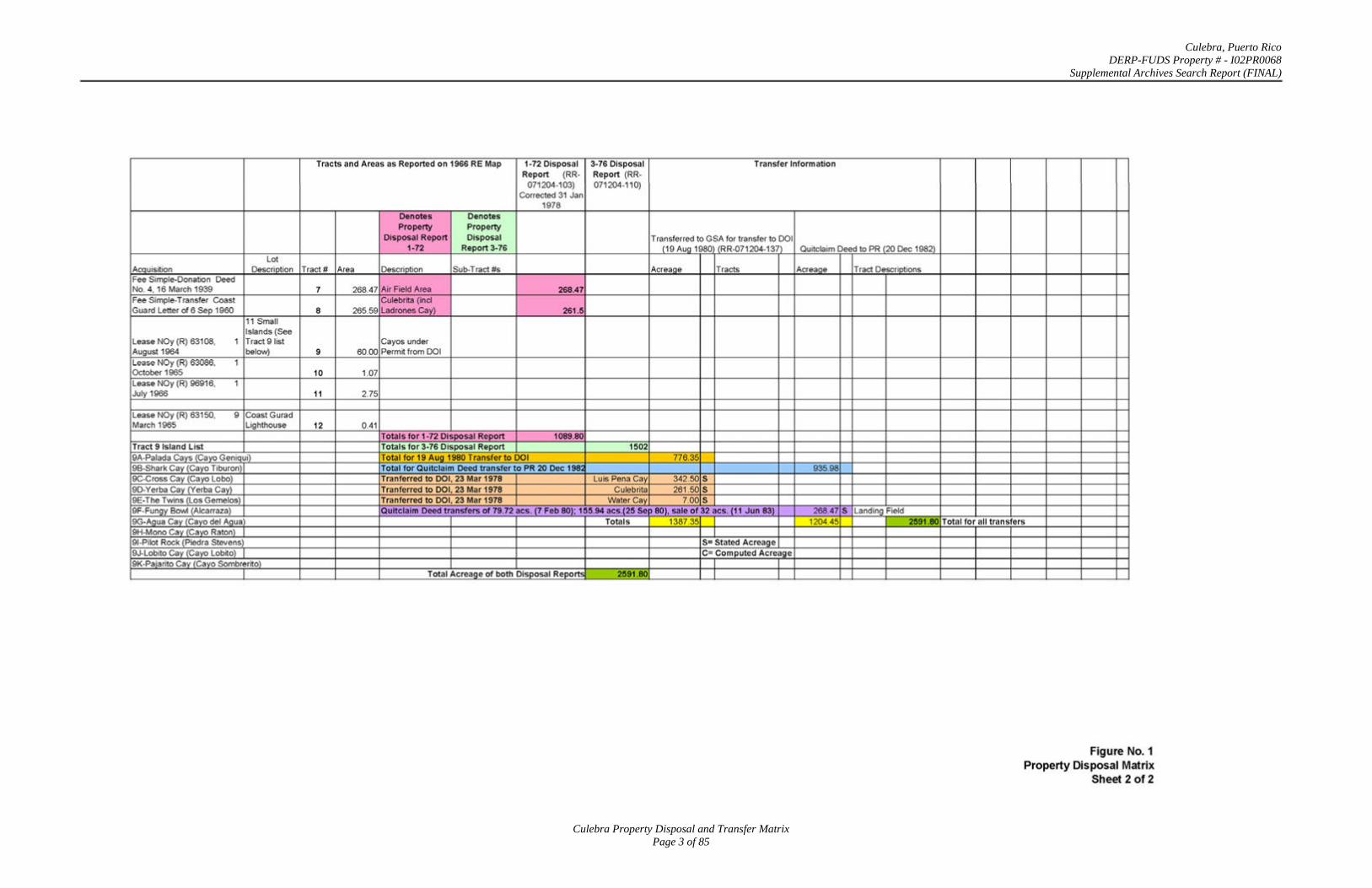
Culebra, Puerto Rico DERP-FUDS Property # - I02PR0068
Supplemental Archives Search Report (FINAL)
Culebra Property Disposal and Transfer Matrix Page 3 of 85
Lot Acouisition Description Fee Simple-Donation Deed No. 4, 16 March 1939 Fee Simple-Transfer Coast Guard Letter of 6 Sep 1960
11 Small Islands (See
Lease NOy (R) 63108, 1 Tract 91ist August 1964 below) Lease NOy (R) 63086. 1 October 1965 Lease NOy (R) 96916, 1 July 1966
Lease NOy (R) 63150, 9 Coast Gurad March 1965 Lighthouse
Tract 9 Island List 9A-Palada Cays (Cayo Geniqui) 98-Shark Cay (Cayo Tiburon) 9C-Cross Cay (Cayo Lobo) 9D-Yerba Cay (Verba Cay) 9E-The Twins (Los Gemelos) 9F-Fungy Bowl (Aicarraza) 9G-Agua Cay (Cayo del Agua) 9H-Mono Cay (Cayo Raton) 91-Pilot Rock (Piedra Stevens) 9J-Lobito Cay (Cayo Lobito) 9K-Pajarito Cay (Cayo Sombrerito)
Tracts and Areas as Reported on 1966 RE Map 1-72 Disposal 3-76 Disposal Transfer Information Report (RR- Report (RR-
071204-103) 071204-11 0) Corrected 31 Jan
1978 Denotes Denotes Property Property
Disposal Report Disposal Transferred to GSA for transfer to DOl 1-72 Report 3-76 (19 Aug 1980 (RR-071204-1 37) Quitclaim Deed to PR (20 Dec 1982)
Tract # Area Description Sub-Tract #s Acreaoe Tracts Acreaoe Tract Descriptions
7 268.47 Air Field Area 268.47 Culebrita (incl
8 265.59 Ladrones Cay) 261.5
Cayos under 9 60.00 Permit from DOl
10 1.07
11 2.75
12 0.41 Totals for 1-72 Disposal Report 1089.80 Totals for 3-76 Disposal Report 1502 Total for 19 Aug 1980 Transfer to DOl 776.35 Total for Quitclaim Deed transfer to PR 20 Dec 198 935.98 Tranferred to DOl, 23 Mar 1978 Luis Pena Cay 342.50 s Tranferred to DOl, 23 Mar 1978 Culebrita 261.50 s Tranferred to DOl, 23 Mar 1978 Water Cay 7.00 s Quitclaim Deed transfers of 79.72 acs. (7 Feb 80); 155.94 acs.(25 Sell 80), sale of 32 acs. (11 Jun 83) 268.47 s Landing Field
Totals 1387.35 I 1204.45 2591.80
I S= Stated Acreage C- Computed Acreage
I I Total Acreage of both Disposa l Reports 2591 .80 I I
Total for all transfers
Figure No.1 Property Disposal Matrix
Sheet 2 of 2
Culebra, Puerto Rico DERP-FUDS Property # - I02PR0068
Supplemental Archives Search Report (FINAL)
Supplemental Archives Search Report (Final) Culebra, Puerto Rico
DERP-FUDS # I02PR0068
Historical Activities Report Part
Section 1.0 - Introduction
1.1 BACKGROUND
The US Army Corps of Engineers developed an initial archives search report (ASR) in February 1995 that identified various areas on the Island of Culebra that had been used by the US Navy and Marine Corps. The military activities included maneuvers and training that used both high-explosive and practice munitions. Additional ordnance remediation studies were started in different sections of Culebra based on the results of this initial report.
On 13 June 2003, the Governor of Puerto Rico requested that EPA include certain areas in and around the islands of Vieques and Culebra, which the Commonwealth has identified collectively as the Atlantic Fleet Weapons Training Area (“AFWTA”), as Puerto Rico’s single highest priority site for purposes of listing on the National Priorities List (NPL) pursuant to CERCLA §105(a)(8)(B). By letters dated October 21, 2003, and July 28, 2004, Puerto Rico provided a more specific description of the lands and waters proposed for listing. These areas are outlined in red on Plate No. 1 of this report. Additional features of the property transfers are also depicted on this Plate No. 1.
The Department of the Army directed the US Army Corps of Engineers in June 2004 to re-investigate the information available concerning the military’s use of the Island of Culebra, Puerto Rico. As part of that process the Corps of Engineers has reviewed additional documents from the National Archives and Records Administration facilities and various other records depositories. Appendix A of this report contains a listing of repositories and groups of records that were researched. This listing also contains a brief summary of documents that were copied. Appendix B contains copies of the documents referenced in this report.
This Supplemental Archives Search Report is being presented at this time is to provide detailed information regarding the US Marine Corps activities on Culebra and the real estate formerly used by the US Navy and in particular the “present bombardment area” mentioned in Public Law 93-166. A summary of the US Navy property transfers regarding Culebra is presented on Figure 1.0 of this report. A map showing all of the pertinent real estate areas is also included with this report as Plate No. 1. Report Plate No. 2 depicts areas on Culebra that the Marines had used over the years for ordnance and other operations. Report Plate No. 3 is a compilation of various historic photographs (more photographs are available in Appendix D). Appendix A contains the documents that are cited in the footnotes as references. Appendix B is a listing of the records
Section 1.0 - Introduction Report Page 4 o f 85
Culebra, Puerto Rico DERP-FUDS Property # - I02PR0068
Supplemental Archives Search Report (FINAL)
that were reviewed at the various archives, offices, and records repositories. Appendix C is a collection of sketches drawn by a US Marine in 1913 showing conditions throughout the island. Appendix D contains copies of the various historic maps and photographs used in developing this report. Appendix E has historical aerial photography from 1964 and 1985. Appendix F contains all of the historical documents acquired during this research effort. Appendix F documents are listed in chronological order. Appendix G contains the 1995 Archives Search Report. A copy of this report and Appendices A through C are contained on Disc #1 attached to this report. Appendices D, E, F, and G are on Discs #2, #3, #4, and #5, respectively.
1.2 AUTHORITY
Completion of this investigation concerning the Island of Culebra, PR is supported by several Federal laws and rules, Department of Defense (DoD) Directives and Standards, and Army Regulations as outlined in the subsequent sub-paragraphs.
1.2.1 Laws
In 1980, Congress enacted the Comprehensive Environmental Response, Compensation and Liability Act (CERCLA), commonly known as Superfund, to respond to threats posed by uncontrolled releases of hazardous substances into the environment. This statute, amended in 1986 by the Superfund Amendments & Reauthorization Act (SARA), establishes the process for undertaking remedial actions at inactive waste sites containing hazardous substances, as well as reporting requirements for releases of hazardous substances.
In 1986, Congress established the Defense Environmental Restoration Program (DERP) at 10 United State Code (USC) 2701 et seq. This program directed the Secretary of Defense to “carry out a program of environmental restoration at facilities under the jurisdiction of the Secretary.” In March 1990, the Environmental Protection Agency (EPA) issued a revised National Contingency Plan (NCP). Under 40 Code of Federal Regulations (CFR) 300.120, which designates the Department of Defense (DoD) to be the removal response authority for incidents involving DoD military weapons and munitions under the jurisdiction, custody and control of DoD.
1.2.2 Military Munitions Response Program
The Senate Committee On Armed Services of the 106th Congress, 1st Session wrote Senate Report 106-50, which directed the DoD to determine the UXO liability costs at all military ranges and provide a report to Congress. As a result, the Army issued a data call to inventory all military ranges, generally referred to as the Advanced Range Survey (ARS). The DoD submitted the initial report reflecting the results of the ARS on 21 May 2001, to Congress.
In September 2001, the DoD established the Military Munitions Response Program (MMRP) within the Defense Environmental Restoration Program (DERP) in recognition of the requirements and the complexity posed at MMRP sites. In addition to defining the requirements for responses at its MMRP sites, the DoD established a requirement to identify, through an inventory, all locations other than operational ranges requiring a military munitions response.
Section 1.0 - Introduction Report Page 5 o f 85
Culebra, Puerto Rico DERP-FUDS Property # - I02PR0068
Supplemental Archives Search Report (FINAL)
This investigation supports this program and the information gathered will confirm and/or append the earlier inventory.
1.2.3 2004 Draft DoD Directive Military Munitions Policy at Other than Operational Ranges (4715.MRP)
As of the writing of this report, the DoD is drafting a policy directive in lieu of the withdrawn DoD proposed range rule. The phrase “Other than Operational Ranges” replaces the previous definitions for Closed, Transferring, or Transferred ranges. The planned policy will direct the Service Components to conduct munitions responses in accordance with CERCLA and the NCP.
1.2.4 Military Munitions Response Program Preliminary Assessment
Since the beginning of DERP, the U.S. Army Corps of Engineers acts as the agency responsible for environmental restoration at Formerly Used Defense Sites (FUDS). Beginning in 1990, the U.S. Army Engineering and Support Center, Huntsville (USAESCH) serves as the Military Munitions Center of Expertise (CX) and Design Center. In cooperation with the USAESCH, the U.S. Army Corps of Engineers, St. Louis District, began preparing Archive Search Reports (ASRs) in 1992 in support of environmental restoration at active DoD installations, Formerly Used Defense Sites (FUDS) and installation transitions under Base Realignment and Closure (BRAC) recommendations.
1.3 SUBJECT
The subject site includes areas on and around the island of Culebra, PR that may be eligible under the DERP-FUDS program.
Section 1.0 - Introduction Report Page 6 o f 85
Culebra, Puerto Rico DERP-FUDS Property # - I02PR0068
Supplemental Archives Search Report (FINAL)
Section 2.0 - Historical Site Summary
2.1 BACKGROUND INFORMATION
A 1995 Corps of Engineers Archives Search Report containing significant details concerning the military’s use of Culebra and the adjacent areas is included in Appendix G of this report. This Supplemental Archives Search Report is being prepared to augment the information presented in that report.
2.2 CHRONOLOGY OF SITE-RELATED ACTIVITIES1
This section shows a chronology of legislative and real estate activities involving the island of Culebra and the US government as they pertain to military use. The notations contained in the footnotes describe a document that was used for information. Copies of all of the referenced documents are included in Appendix A. Details of the documents can be found in the spreadsheets in Appendix B. The document designation, which is a unique identifier, can be found in the “Documents” column. The document designation is made up of three parts. The first two letters of the designation refer to the repository or source from which the document was obtained. The next six numbers are the date when the document was copied. The last three numbers indicate the sequence from that particular day. For example, a document identified as “RR-061404-121” would have been the document numbered 121 copied on 14 June 2004 at Roosevelt Roads.
10 December 1898 Treaty of Peace concluded between the United States and the Kingdom of Spain under which Spain ceded public lands in Culebra and its adjacent keys to the United States.
29 March 1899 President William McKinley in Proclamation No. 1 reserves certain land in Culebra for naval purposes.
12 April 1900 The first Puerto Rican Organic Act (Foraker Act) is enacted creating provisions of civil government in Puerto Rico under the United States.
17 December 1901 President Theodore Roosevelt, at the request of the Department of the Navy issues an Executive Order placing Culebra under the jurisdiction and control of that Department.
1 July 19022
Congress enacted Public Law 219, which authorized the President to reserve public lands and buildings on the island of Culebra for public uses and granted to the government of Puerto Rico
1 Various documents were used in developing this historical listing including the Culebra Chronology from the University of Puerto Rico (UPR-070904-101), which is referenced by this footnote. 2 HQ-051904-181
Section 2.0 – Historical Site Summary Report Page 7 o f 85
1902
Culebra, Puerto Rico DERP-FUDS Property # - I02PR0068
Supplemental Archives Search Report (FINAL)
public lands and buildings on Culebra that were not so reserved by the President within a one-year period.
The Marine advanced base battalion first deployed to Culebra in 1902 to exercise their new capabilities.3
16 February 1903 Puerto Rico enacted a law authorizing the Governor of Puerto Rico to transfer title of ownership of the public lands on Culebra and elsewhere to the United States for use by the Navy as required by the Act of July 1, 1902. Under the Foraker Act, the Puerto Rico governor was appointed by the President of the United States with the advice and consent of the US Senate. In addition, the US Congress retained the authority to amend the laws of the Puerto Rican assembly.
26 June 1903 President Theodore Roosevelt in Proclamation No. 4 reserved all lands on the island of Culebra and adjacent keys for naval purposes.
27 June 19034
The US Navy acquires by purchase Tracts 2 and 3 on the Island of Culebra consisting of 5.33 and 2.5 acres, respectively, for use as gun positions. Both of these purchases are recorded in Deed No. 129.
28 June 19035
The US Navy acquires by purchase Tracts 4, 5, and 6 on the Island of Culebra consisting of 2.5, 1.25, and 2.25 acres, respectively, for use as gun positions. All of these purchases are recorded in Deed No. 130.
27 February 1909 President Theodore Roosevelt issued Executive Order No. 1042, designating the Culebra keys as National Wildlife Refuges.
18 February 1941 President Franklin D. Roosevelt issued Executive Order No. 8684 establishing the Culebra Island Naval Defensive Sea Area and the Culebra Island Naval Airspace Reservation from which all persons were excluded unless they received the specific approval of the Secretary of the Navy.
16 June 1948 Enactment of Public Law 653, authorizing the Secretary of the Navy to acquire 1,698 acres of land on Culebra for use as a shore bombardment area.
3 MISC-080504-001 4 US Navy Real Estate Summary Map (FEC Drawing No. 1042388) Puerto Rico: US Naval Station Roosevelt Roads, 1968 (Amended) This is the map that was included with Report of Excess No. 1-72. (RR-072604-044) 5 Ibid.
Section 2.0 – Historical Site Summary Report Page 8 o f 85
Culebra, Puerto Rico DERP-FUDS Property # - I02PR0068
Supplemental Archives Search Report (FINAL)
27 January 1955 In a joint resolution, the Second Legislative Assembly of the Commonwealth of Puerto Rico authorized the Governor to acquire by forceful expropriation or by any other legal means lands on Culebra for national defense objectives and also authorized the Governor to transfer these lands to the Government of the United States.
20 November 1956 Admiral G. B. H. Hall informed Governor Luis Munoz Marin by letter of the Navy’s firm commitment to acquire the entirety of Culebra and its adjacent keys.
10 March 1958 Admiral D. V. Gallery proposed in a letter to Roberto Sanchez Vilella, Secretary of Public Works, that the Commonwealth convey to the Navy the remainder of Culebra and other lands in return for certain lands on the island of Vieques.
8 February 1959 In a letter Admiral Gallery expressed the Navy’s intention of acquiring the entire area of Culebra for military use.
16 December 1961 In a meeting at La Fortaleza, Governor Luis Munoz Marin urges President John F. Kennedy to reconsider the Defense Department’s position on Culebra.
22 May 1964 In a letter to Governor Luis Munoz Marin, Assistant Secretary of the Navy Kenneth E. BeLieu committed the Navy to limit its acquisition of land on Culebra to small sites for observation and instrumentation primarily on uninhabited islets.
1 August 1964 Enactment of Public Law No. 88-390, which includes a $4,080,000 authorization of the acquisition of Culebra.
2 September 1964 Enactment of Public Law 88-575, appropriating $30,000 for the first phase of land acquisition on Culebra.
12 December 1968 Paul R. Ignatius, Secretary of the Navy, in a memorandum to the Deputy Secretary of Defense, requests $2.8 million as an authorization in the fiscal year 1970 Military Construction Budget for the acquisition of the entirety of Culebra and for the relocation of the inhabitants of Culebra.
23 September 1969 Joseph A. Grimes, Jr., Special Assistant to the Secretary of the Navy, reported in internal memorandum the Governor Luis Ferre agreed to support the acquisition of the rest of Culebra provided that former Governors Munoz and Sanchez would also support the acquisition.
Section 2.0 – Historical Site Summary Report Page 9 o f 85
Culebra, Puerto Rico DERP-FUDS Property # - I02PR0068
Supplemental Archives Search Report (FINAL)
24 April 1970 The Navy submits an acquisition report to the Committees of Congress with respect to one-third of Culebra preparatory to the introduction of Walleye air-to-ground missiles. Admiral Matter publicly announces the Navy’s plan to acquire an additional one-third of Culebra, and Governor Ferre announces his support for this Navy decision.
25 April 1970 Culebra’s Mayor, Ramon Feliciano, publicly opposes the Navy’s plan to acquire one-third of Culebra preparatory to firing Walleye air-to-ground missiles at Culebra.
13 May 1970 The Puerto Rican Senate adopts a resolution supporting the Culebrans with regard to the Navy’s acquisition plan.
1 July 1970 Senator Henry M. Jackson requests that the Department of the Navy delay any acquisition of land on Culebra until the Department of the Navy has completed a new study on this acquisition and until such study has been considered by the Senate.
29 July 1970 Senator Charles E. Goodell introduces an amendment to HR 17123, the Military Procurement Authorization Bill for fiscal year 1971, to ensure the termination of the Culebra bombardment exercises.
7 August 1970 Former Governor Munoz Marin calls on Governor Luis A. Ferre at Fortaleza to urge the Governor to turn his attention to Culebra. As a result of this meeting, Governor Ferre and Governor Munoz announce their agreement that the United States Navy must abandon Culebra as a target range unless its is vital to the nation’s security.
10 August 1970 Resident Commissioner Jorge L. Cordova writes to Senator Charles E. Goodell expressing full agreement with the language and intent of Senator Goodell’s Culebra amendment.
20 August 1970 Dr. Robert A. Kilmarx, a military expert retained by Governor Ferre, concludes study on Culebra and announces that in his opinion the Defense Department could terminate its operations at Culebra within five years without suffering any degradation to its defense readiness.
22 September 1970 The Military Construction Sub-Committee of the Senate Armed Services Committee completed its markup of Senator Jackson’s amendment to the Military Construction Authorization Bill. This amendment would direct the Secretary of Defense to study alternatives to Culebra and to report back to Congress by 1 April 1971.
Section 2.0 – Historical Site Summary Report Page 10 o f 85
Culebra, Puerto Rico DERP-FUDS Property # - I02PR0068
Supplemental Archives Search Report (FINAL)
23 September 1970 After consideration of the Jackson amendment in a town meeting the President of the Municipal Assembly of Culebra, the Mayor of Culebra and the President of the Culebra Rescue Committee jointly signed letters to every United States Senator urging passage of the Goodell Amendment to end all shelling and bombardment of Culebra immediately.
29 September 1970 Senator Howard Baker introduced an amendment to HR 17604 that would compel the Navy to terminate all weapons range activities on Culebra and its adjacent keys by 1 January 1976. Senator Goodell’s amendment was brought to a vote on the floor of the United States Senate and was rejected. Senator Baker’s amendment was also brought to a vote in the Senate and was narrowly defeated. Senator Jackson’s amendment was enacted by the Senate. Congressman Charles E. Bennett introduced House Joint Resolution 1387 to establish the Culebran Commission for the purpose of resettling the inhabitants of Culebra.
12 October 1970 In Feliciano v. United States, 2971 F. Supp. 1356 (D.P.R. 1969), aff'd 422 F.2d 943 (1st Cir. 1970), cert. denied 400 U.S. 823 (1970), Feliciano challenged the establishment of Culebra's Naval Defensive Sea Area. The petition for a writ of certiorari was denied by the US Supreme Court. This case held that the present use of the Culebra Island Naval Defensive Area was within Congressional authorization and discretion of the President, and that such use did not constitute a taking of the plaintiff’s property or freedom of movement without due process of law.
26 October 1970 The enactment of Public Law 91-511 which included among other things, Section 611 compelling the Secretary of Defense to consider all feasible alternatives to the naval training taking place on Culebra and to report on these alternatives to the Congress by 1 April 1971.
16 November 1970 Governor Luis A. Ferre wrote to the President of the United States, informing him of the conclusions of the Kilmarx study, and asking the President to designate a personal representative to participate in the contemplated study of Culebra by the Department of Defense.
6 December 19706
The New York Times reported that members of a committee appointed by Governor Luis A. Ferre to study possible ways to bring industry and tourism to Culebra were on the island during Navy ordnance clearance operations.
7-8 December 19707
Following demolition of ordnance that destroyed significant coral formations near Culebra and destroyed large quantities of fish in the Culebran waters, a suit was filed in Federal District Court in San Juan to enjoin further demolitions pending the filing by the Navy of an Environmental
6 SAJ-052504-195L 7 Ibid. & Footnote 1 (UPR-070904-101)
Section 2.0 – Historical Site Summary Report Page 11 o f 85
Culebra, Puerto Rico DERP-FUDS Property # - I02PR0068
Supplemental Archives Search Report (FINAL)
Impact Statement as required by the National Environmental Policy Act. The Federal District Judge issued a temporary restraining order against the United States Navy and the United States Navy agreed to comply.
13 December 19708
The New York Times reported that the Mayor of the island municipality of Culebra had asked the Federal District Court to enjoin the Navy from continuing to the island as gunnery practice area.
15 December 1970 President Richard M. Nixon wrote to Governor Luis A. Ferre regarding his decision to direct the Council on Environmental Quality to act in an advisory capacity on the study of Culebra operations and alternatives being conducted by the Secretary of Defense.
11 January 19719
Following negotiations initiated by the United States Navy, an agreement was signed on Culebra by John H. Chaffee, Secretary of the Navy, Ramon Feliciano, Mayor of Culebra, Luis A. Ferre, Governor of Puerto Rico, and Rafael Hernandez Colon, President of the Puerto Rican Senate. This agreement obliged the United States Navy to terminate permanently a portion of its operations at the Culebra Complex and also obliged the Navy to continue searching for alternatives with the purpose of transferring all of its operation to an alternative site as soon as possible. The Agreement was included in Congressional Record-Extension of Remarks for HR 9299.
AGREEMENT
The dispute over the Navy’s use of Culebra and its offshore cays for weapons training has dramatically posed the problem of balancing the need to conduct the training essential for our national defense with the legitimate desires and aspirations of our private citizens. All persons of goodwill who are interested in the continued close relationship between Puerto Rico and the United States, the security of our nation, and the aspirations of the people of Culebra have hoped that this problem could be amicably resolved. Through the dedicated efforts and good will of all concerned a mutually acceptable balance has finally been found between the training needs of the Navy and the desires of the people of Culebra. We are pleased to announce the terms of that agreement, and to pledge our continuing efforts to assure that it is carried out in good faith.
1. The Navy will not shoot the Walleye missile at Culebrita or at any other target in the Culebra complex, and the Navy will not obtain the easements on the east end of Culebra that were approved by the House and Senate Armed Services Committees.
2. The targets off the east cost of Culebra will be phased out by January 1, 1972, and the lease on North Cay will be terminated on that date. Culebrita and the other target cays in the area will be declared excess as of that date except for several acres on Culebrita near
8 SAJ-052504-195P 9 CP-070904-102
Section 2.0 – Historical Site Summary Report Page 12 o f 85
Culebra, Puerto Rico DERP-FUDS Property # - I02PR0068
Supplemental Archives Search Report (FINAL)
the lighthouse where the Navy intends to establish a small electronics warfare installation (several vans) for use in training fleet units in the open ocean north of Culebra.
3. In addition to the shoreline already announced for release, the Navy will declare excess to its needs the shoreline on the east cost starting at a point immediately east of the base camp and proceeding around the east end of Culebra to the beginning of the Navy property holdings on the north coast (Swell Bay) (see attached map). The Navy will cooperate in preserving the ecology of excessed areas as requested by the Municipality and by appropriate federal and commonwealth agencies.
4. The Navy will relocate its bulls-eye target on Agua Cay to Cross Cay by January 1, 1972.
5. The north-south line bordering the northwest peninsula safety zone will be reoriented as shown on attached map. The parcel of land marked “A” on the attached map will therefore no longer be part of the naval gunfire support safety zone.
6. The Navy will initiate and support an amendment to the executive order creating the defensive sea area around Culebra so that the order will cover the safety zones for the ship-to-shore gunfire and for the west-range air-to-ground targets (see attached map).
7. Governor Ferre, Mayor Feliciano, and Senate President Hernandez Colon solemnly pledge to use all regulatory and legal devices available to the Commonwealth and the Municipality of Culebra to assure that the no dwellings or other habitable structures are constructed in the northwest safety zone for as long as the Navy uses the northwest peninsula for naval gunfire support training. If landowners in the area complain that their property is being taken without due process of law or if, despite the above-mentioned regulatory and legal devices, individual landowners take steps to construct dwellings or other habitable structures in the safety zone, then the Navy will pay such landowners the fair value of foregoing the right to construct said dwellings or other habitable structures.
8. Since the Navy is giving up a substantial number of targets, its remaining targets will become that much more important, in consideration of this action by the Navy and in recognition of the Navy’s need to schedule the use of the remaining targets more tightly, Governor Ferre, Senate President Hernandez Colon, and Mayor Feliciano will use their best efforts, including moral suasion, to obtain the cooperation of everyone in keeping the land and sea safety zones for the remaining targets clear of people during scheduled training operations.
9. No training operations around Culebra will be conducted on weekends or holidays except to meet an urgent operational commitment. In the event that this becomes necessary the Admiral commanding the Caribbean Sea Frontier, or in his absence the officer acting in that capacity, will be personally aware of and will have personally approved such operations, and the Mayor of Culebra will be personally notified by an authorized representative of the Commander of the Caribbean Sea Frontier at least twenty-four hours in advance of any such training operations.
Section 2.0 – Historical Site Summary Report Page 13 o f 85
Culebra, Puerto Rico DERP-FUDS Property # - I02PR0068
Supplemental Archives Search Report (FINAL)
10. The Navy solemnly and definitively agrees to abandon its plans to acquire easements or any other interest in land on Culebra and its adjacent cays by eminent domain or other means except as provided by paragraph 7 of this agreement.
11.There will be no time limit on the duration of this agreement, but the Navy promises to continue to investigate both technological and geographical alternatives to the training done around Culebra. The purpose of these investigations will be to find feasible alternatives that will eventually permit the transfer away from Culebra of the training that will be conducted after January 1, 1972.
Dated the 11th day of January 1971. JOHN H. CHAFEE, Secretary of the Navy. LUIS A. FERRE, Governor of Puerto Rico. RAMON FELICIANO, Mayor of Culebra. RAFEAL HERNANDEZ COLON, President of the Puerto Rican Senate.
12. It is the position of the Puerto Rican Government, Governor Ferre, Senate President Hernandez Colon and Mayor Feliciano that the Navy should terminate all training operations on Culebra and its neighboring Cays within a reasonable period. It is the hope of the Signatories listed above that the study that the Department of Defense is required by law to undertake will conclude that this is feasible.
8 February 197110
Protesters had erected a structure on US government property at Flamenco Beach. US Navy and Marine Corps personnel tear down the structure. A tear-gas Molotov Cocktail exchange ensues. Leaders of the protest are arrested, prosecuted, and imprisoned for violating applicable laws.
10 February 197111
The Puerto Rico Environmental Quality Board published its report, “An Island in Transition, Culebra 1970”, on the natural resources, developmental potential, and socio-economic aspects of Culebra. Regarding development potential the Board reported that “development of tourism will occur whether the Puerto Rican government facilitates it or not. It is only a question of controlling it (by zoning, regulating, suggesting, and preserving) in order to make the greatest number of attractive features available for as long as possible to the greatest number of people.” (Page 28)
The report further states that “ the ordnance disposal procedures in use during the course of this investigation have been demonstrated to possess the potential of totally destroying the finest reef
10 SAJ-052504-195M & Footnote 1 (UPR-070904-101) 11 RR-071204-317
Section 2.0 – Historical Site Summary Report Page 14 o f 85
Culebra, Puerto Rico DERP-FUDS Property # - I02PR0068
Supplemental Archives Search Report (FINAL)
of the island, depending on the magnitude of these operations.” (Page 50) Additionally, “great consternation was expressed at the destruction of valuable living coral reefs, which have required centuries to develop to their present state, by the methods of ordnance disposal in use by the US Navy. Although the continuation of military activities will depend on requirements for national security, much of the impact could be reduced by exclusively using dummy bombs and shells.” (Page 104)
26 February 1971 The Navy removes the barricades erected on 11 January 1971 from Flamenco Beach and agrees to leave Flamenco Beach available for public use on weekends, holidays, and at other times when naval training activities are not being conducted in the area.
19 March 197112
The Department of Interior, Bureau of Sport Fisheries and Wildlife, studied the impact of four configurations, or levels of Navy activity, on the environment and recreational values of Culebra Island and its adjoining cays. The Bureau concluded that:
“There has been irreparable damage to the coral reefs due to target practice and the demolition of unexploded ordnance. The accumulation of dummy bombs, exploded and live shells constitutes unsightly and possible dangerous debris on the sea bottom that will require difficult clean-up operation. If the Navy were to leave these area, it might be necessary to prohibit public access to them.” (Page 21)
“There has been damage, in the from of bomb craters and ordnance litter, to the lands subjected to shelling and bombardment. Clean-up will be difficult and if these lands were available for public use such use would probably have to be curtailed because of unexploded shells.” (Page 21)
The report further stated that surveys carried for the Environmental Quality Board the revealed that the level of contamination and the possible consequences of correcting it may be more serious that reported in previous Navy reports. Because of these possibilities the study decided that:
“If decontamination to safe level is not feasible two options are available: (1) Permit public activities at the user’s risk; or (2) close the hazardous areas to the public. In this case the latter option would be preferable for public safety.” (Page 53)
In a December 15, 1970 letter from the Puerto Rico Planning Board attached to the Bureau’s report the Board addresses the necessity of finding the resources for the growth and development should the Navy leave Culebra. They quote Senator Henry Jackson who said, “We will be able to resolve not only the immediate situation on Culebra, but the broader question of what course the island’s future development shall take.”
12 HQ-051904-124
Section 2.0 – Historical Site Summary Report Page 15 o f 85
Culebra, Puerto Rico DERP-FUDS Property # - I02PR0068
Supplemental Archives Search Report (FINAL)
Also attached to the Bureau’s report is the “Draft Environmental Statement on Underwater Demolition of Dud Ordnance Near the Island of Culebra, Puerto Rico”, prepared by the Navy. In it the Navy stated that a certain number of rounds of ordnance failed to operate properly and remain in an undetonated condition in the waters around Culebra. Because of the uncertain age and unknown circumstances of impact the Navy could not determine the potential for explosion of these rounds of ordnance. The Navy thought that the use of the area for commercial and recreational fishing, scuba diving, and related activities would be rendered safer by the demolition of unexploded ordnance. However, there was a degree of danger in the immediate area of this ordnance and inevitably some apprehensiveness on the part of the local population and tourists.
1 April 1971 The Department of Defense Culebra Study is completed and transmitted to congress with Secretary Laird’s announced decision to determine at the end of 1972 where the Navy would relocate its Culebra weapons training.
23 April 1971 Because of certain ambiguities in the language of the Secretary’s press release of April 1, Rafael Hernandez Colon, President of the Puerto Rican Senate, sought clarification and on this date received a letter from Mr. Jerry W. Friedheim, Deputy Assistant Secretary of Defense, assuring him that the Navy operations on Culebra will be transferred by June 1975 unless a reversal of the situation occurs.
3 June 1971 Senator Mike Gravel introduces an amendment to the Military Construction Authorization Bill which would authorize $50 million for the construction by the Navy of an artificial island in the vicinity of Puerto Rico to be used as a replacement for Culebra.
16 June 1971 The Senate Committee on Interior and Insular Affairs adopts a resolution directing the Bureau of Outdoor Recreation and the Bureau of Sport Fisheries and Wildlife of the United States Department of the Interior to conduct a study in cooperation with Puerto Rico to determine the highest and best use of Culebra’s natural resources and the most feasible means of conserving, protecting, and developing the natural scenic recreational wildlife and fish values of the island.
30 July 1971 In the Senate Report No. 92-326, the Senate reported out the Military Construction Authorization Act for Fiscal Year 1972, with an amendment to Section 205 of HR 9844 which directed the Secretary of Defense to conduct a feasibility study detailing the most advantageous alternative to the weapons training being conducted on Culebra.
5 August 1971 Senator Harold Hughes introduced an amendment to HR 9844 that would compel termination of all Navy activities on Culebra by 3 May 1975. On this same day, Mr. Hughes amendment was rejected by a vote in the United States Senate.
Section 2.0 – Historical Site Summary Report Page 16 o f 85
Culebra, Puerto Rico DERP-FUDS Property # - I02PR0068
Supplemental Archives Search Report (FINAL)
27 October 1971 Enactment of Public Law 92-145, including Section 207 that directed the Secretary of Defense to conduct a feasibility study detailing the most advantageous alternative to the weapons training being conducted on Culebra. This Section 207 was added in conference at the urging of Senator Henry M. Jackson.
18 November 1971 Enactment of Public Law 92-160, including an appropriation for the Defense Department to enable it to plan an alternative facility to Culebra.
June 197113
Resolution adopted by the Senate Committee on Interior and Insular Affairs directs the Secretary of the Interior in concert with the Governor of Puerto Rico to prepare recommendations on the use of Navy land on Culebra.
1 January 197214
The Navy ceased using the targets on the eastern end of Culebra after 1 January 1972 pursuant to an agreement entered into on 11 January 1971.
6 June 197215
President Nixon issues an Executive Order amending Executive Order No. 8684, to more narrowly redefine the Culebra Island Naval Defensive Sea Area. The order redefined the defensive area so as to cover only the safety zones for the ship-to-shore and air-to-ground targets on the western end of the island. The order had the effect of implementing paragraph 6 of the agreement of 11 January 1971, entered into by the Secretary of the Navy and Puerto Rican government officials to resolve a dispute with the people of Culebra over the Navy’s weapons training activities in the area. The agreement restricts such activities to targets on the western end of the island and nearby cays, and releases the targets on the eastern end for civilian use.
5 July 197216
Original Report of Excess Real Property No. 1-72. This report includes 1273.80 acres consisting of the Southern Peninsula, 7 miles of shoreline, 9.5 miles of shoreline, Water Cay, five gun mounts, the air field, and Culebrita (including Ladrones Cay). Later the acreage would be corrected to 1089.80 acres. The original report is shown on the following pages.
13 RR-071204-142 14 HQ-051904-109 15 Ibid. 16 RR080304-011
Section 2.0 – Historical Site Summary Report Page 17 o f 85
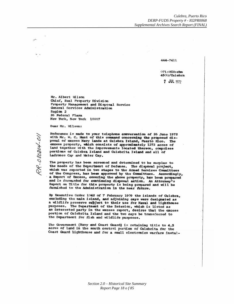
Culebra, Puerto Rico DERP-FUDS Property # - I02PR0068
Supplemental Archives Search Report (FINAL)
Section 2.0 – Historical Site Summary Report Page 18 o f 85
Mr. Albert Wl.l son Chief, Real Property Division Property ManageJIIent and Disposal Service Ganoral Services Administration Reoian ~ 26 PVd~ral Plaza New York, NEW Yorlc 10007
Dear Mr. \<li l eon:
44.4-7411
0 7 1 :ha·hcl:a 4500/Culobra
? JUL 1972
Re:terenoe is made to your telephone caaver .. tion o:t 26 J&me 1972 with Mr. w. c. Hlmt o:t this c~d ccnceftliag the proposed disposal o:t GXcess Navy laad.s at CUlebra Island, PUerto Rico. The ex~as property, Mich consists o:t apprOIId~tely 1Z73 acres o':t land together with the illprovetacmta locatecl thereon, C<lllllpd.aea portions o:t Ollebra. leland and Culebrita Ishnd end all o:t Ladranos Cs,y and ~rat.ter Cay.
The property bas been screenoo and de tendned to be eurpl\le to the needs o:f the Departaa-t o':t De':talse. Tbe disposal proj.ct, Which was reported in two a'ta98• to the Ara.ec! Sei'Vicea Cola.f.tteea o:t the Congreu, ha.s bean approved by the ~tteea. Aocord.f.·ngly .. a Report o:t Excess • oqyerl.ng the -.bove property, h•• beea prt~pared and is t'orwa.rded :tor ccntimli.ng dittpoeal actim. An Attorney's Report on Title :tor this property i s being prepared and will be :tumiahod to the Administration in the near t'Uture.
By &cecutive Order 1042 o:t 7 Fobru&ry 1909 the i s lands o':t Q.llebra, excluding the main island. and adjoining caya were designated as a wildlife preserve eu~ject to tbo!J: use :tor Naval And lighthouse purposes . The Departmaat o:t tbe Interlor, Wlbicb is listed as an interested party in the excess rGport, doeirea that the excess portion o:t CUlebrita Island and the two cays be transt'e:ired to th~ Department '£or fish and wi ldli1'e purposes.
The Government (Navy and Coast Qlardt i fl r e taining title to 4.5 acros o:t land in the south eentre l portion o:t Culebri ta :tor tbe Coa s t Giard lighthouse and for a emall e lectronics wa.rtare :!natal-
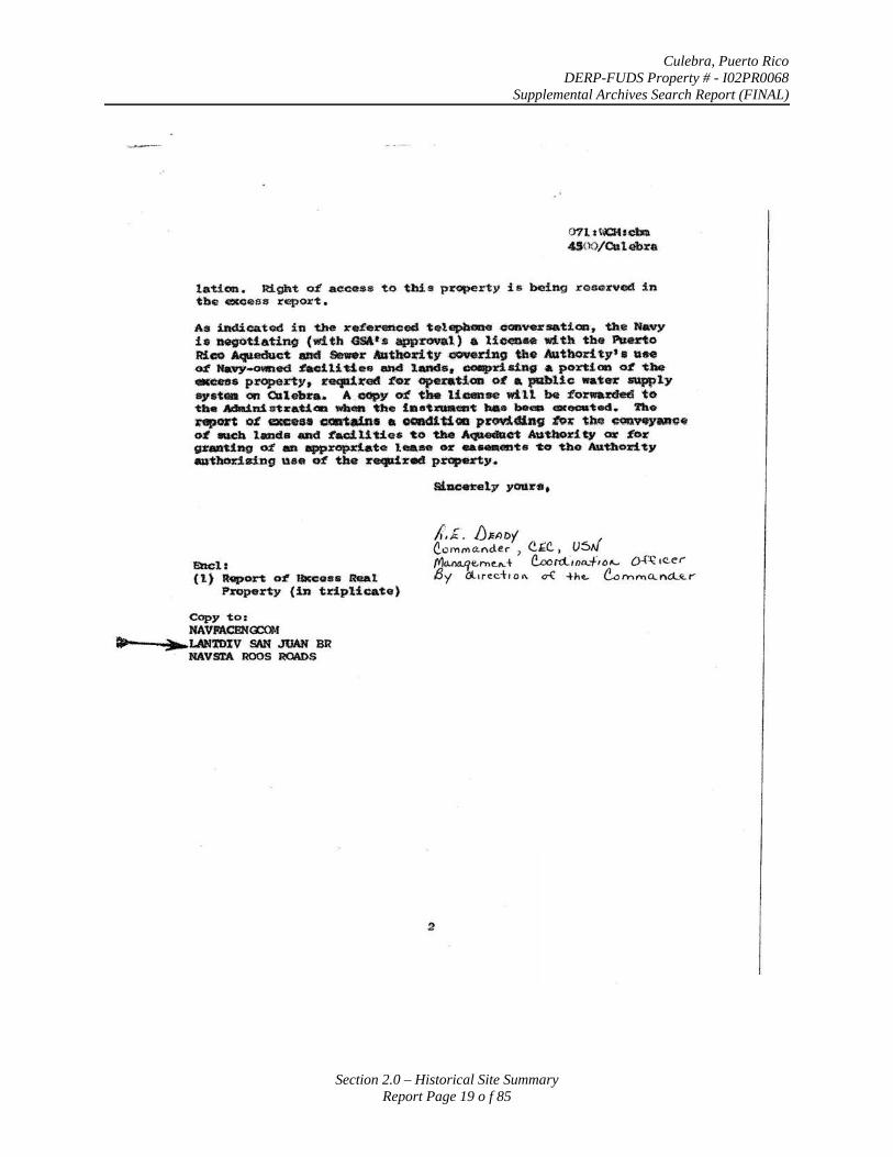
Culebra, Puerto Rico DERP-FUDS Property # - I02PR0068
Supplemental Archives Search Report (FINAL)
Section 2.0 – Historical Site Summary Report Page 19 o f 85
rnt tt\ICKrcm 4$00/Catebra
lation. Right o£ aecese to tbilt property is b<!ing x-eacu:ved in tbe «<'Ceas rapor't.
As 1adicatod in the J:'•:f•rertced telepbt»e o-oaversatiQl~ the Navy h aegottatinQ (wUh GSA·'·• app~l) a lie_.. with the ll\Jeno Rico Aqueduct and Senr A'athori ty .cJOVeriJ19 tbe Autbori. t:v' • uee ~ Ha'vy-o~W~ed :tadli •lee and 1-.ncJ•• coapr.ld:llg a port! on o:t ~be· .ens property, reqlli.re4 :t<n ope~:~&U.aD ~ a t*bUc water ~ly •.v•t• on CUlebl'th A .CC9Y O'L tlhe license wUl be :forwaJ:ded ·to ~· Adld.n.S. nza~i<ID wb-. 'th<a 1e•tma.,~ hae .,._ ---~ed. 'lho ~ o:t exceu ~•• a OCiftdtUGD provi~nv ~,; thf: cQQ'H)'Do• ~ N.Cb led• and :tac.f.UUes to tho A~C't -tllo:dty OX' ~or grantiftg M a appropdate lea:- or ••-ets to tho Au't!lority aaribm:iaing use e:f the recJd%ed pr<lpti'ty.
E'Dcl: ( 1) R~on o:t SKeen Real
Property (in triplicate)
Copy to: NAVJI'ACBN<nl-f
.. ~LAN'tDIV SAN JUAN BR NAVSl'A ROOS ROADS
2
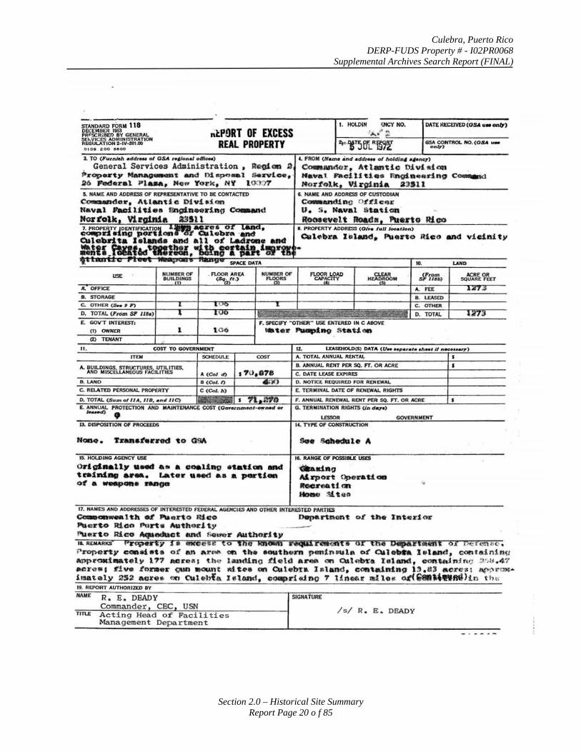
Culebra, Puerto Rico DERP-FUDS Property # - I02PR0068
Supplemental Archives Search Report (FINAL)
Section 2.0 – Historical Site Summary Report Page 20 o f 85
STANDARD FORM 118 DECEMBER 1!153 PR"SCIRIBED BY GENERAL SE,._.VICES AOMINISTRATJON REGULATION 2-IV-201.00
nlfnRT OF EXCESS REAL PROPERTY
1 TO ( ll"urnMII addreM of OSA •• • lone/ om-)
General Services Admi nistrat ion t R~<lft a P.-op ... ty ~t _, o~ fiPO-l Geavtoe , 26 Jl'oderal Mo.-. Yo1:k N 't 100!".1?' 5. NAME AND ADDRESS OF REJ'RESEHTATIVE TO BE CONTACTED
eo-.nder, At.lanti e Di• .f.•.ion Naval laoill~i•• Chgln .. r.lno ~d HOI' IUill
AGENCY
OdcrJaau,. .. .., • • a ooeltq •'laUOI'l -.ct tcalnf.ag •••• l.a'tel' •INd •• a ~tion ol a ~-· Hlt08
HANES AND ADDRESSES OF INTERESTED FEDERAL
1. HOI.Difl MO.
liSA CONTROL NO. (O.S.. ._ onq)
4. FROM (N,....• .nd add...- of holdln, .,_n<U')
o-IU'ldor. Atlantic Oivl ~don Naval. P»tc1Utt a • Enoin•erlno c~ H <JJ' Vi 1
6. NAYE AND ADDRESS OF CUSTODIAN
ec-utdino O$'t'J.o ..,.: u. s . Naval s._ti cn
16. RANG£ OF POSSIBLE USD
~ .. ., Al.xpoltt ~raUQD ltoO.H&ttm HD1MJ ~tGO
ec-oaw.atth 01 ._ .. rto Rico 04tpal"hlont or tl\e l'nt•n 1<U' PUe~rto Rico Porta Authority -l"l.urr'lo JU.c o .-...-.ct and f)(mer Autbodty II. IIENARKS PiO?•r t y s • eKCeie to 'lne tenown r~rc.wan• or ~n• bipiiitiiiiiit 6l Cl~rcns;o . ~ropeny COD!tiata of an a t"blf.l. (11'1 th acJUtbttm p tmf.nRtl&\ o~ Qalobft l a l.,d , cantsinin~r 1\pprOid.a~ely l?'t &el'OI'I J t .h4f l,anct1no .tie\cl a ll:'.- on Caleb~a Iatanct, con~.n1fu; ~,,~.47
~r~• l t'iva .te>m e r (IUD •CliWl't &l t «"• en att•bJ:• I s \ a Qd • Celft\alntn9 l , . a, acrc.c; 1.1€>:H·~· imat111ly ~-~ ac~r•• ~ C\lt•b{ .,. X ~lt.nd, cu:MIIpr.i d n o ? l h l-.tt ldlo "' G~U;M\~ftMlhn t'ht\ 19. REPORT AlTTHORIZED BY
HAM£ R. E. DEADY Commander CEC USN
1ln..E Acting Head o£ Faci li ties Management Department
SIGNATURE
Is/ R . E. DEADY
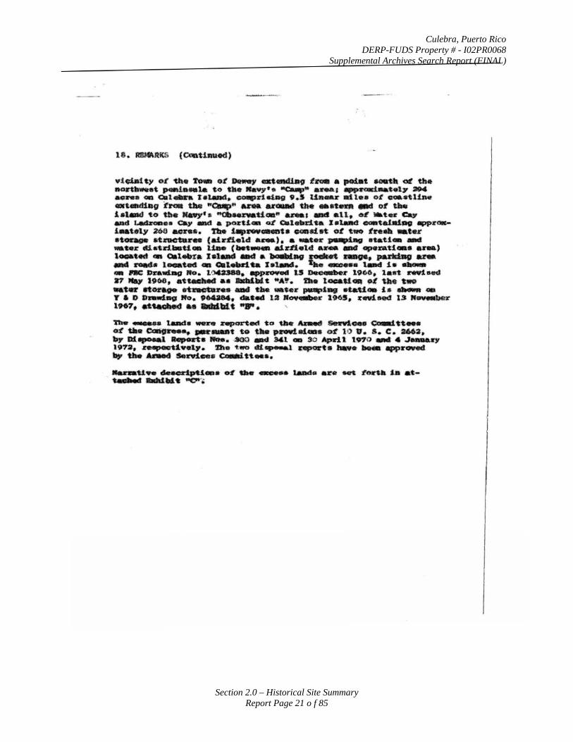
Culebra, Puerto Rico DERP-FUDS Property # - I02PR0068
Supplemental Archives Search Report (FINAL)
Section 2.0 – Historical Site Summary Report Page 21 o f 85
¥t~ty oL the ro- o~ Dlttfwy atellll1.lao ~~ • po4at acot• ott the ~at ~·•ta to ~· Navy·•• "'uup" •~a .... ~ .. ~•17 »4 ao-. Gil aat...-a leland, COIIPri~ 9.S Ult-.r lltlea ot o•ftUn. at-.diQ9 :t~ U. "c..p" A.na wGI&IIII taHt ••'-"" .-.t o~ U.. lat.d w U... Mawy' • ~Mn~&U~" anat _.all, ttL •tee c., and ~•• cay .eel a pozU.- oL C.leltd.ta lat.d .-~11100 "PP~oc-1-t:ely zoo aorc•. 'l'be illpl'OW._t• coaatet. ot t.o tna •t•r •toa~oe atnc-tar• (alldield ~). a •t.•r P•lllliiiG atau- ..,.. -.ter .U.atdllaU• lta. (bet.,... al~.ftelct ... _. ..r ~zatteaa u•) 1--.~ 4111 c.t.-na Jet.- -.t a1nalav ~ ~ .. pufl:illg ana _....,... loeat.ed ca Clalelldu lataad. '- ......-. t_. ia· ~ - ..: Dnulllag Ito. tOoCUM • ..,~ 1.5 Dec,..,_r t9o6, lan rfti•.ct ., NaJ' 19<ae, at~ aa llldalWt """' · a. looa_U~ ~Ute two .. tc etoraoe et~re.• _, u. ....... pa~pt-. n.U• i • a~MRt -r a o »...tD1ill ~to. tMaN, ••ec~ 1a a0¥4111ber 19<15, rftiHd loS It~ 1967, -~ .. addblt ...... '
'l'be _.... laada _.,. reported t o ua. Alaed &eso¥loe- ·c::c-1 tt. ... oL tile~ .. .,..._t to Uatt p....talats oL 1Q v. s. c. 2663, ...,. Dhpoeal ltlap ftta -. • .800 .-d. Ml • 30 April 1970 _. • ..J...aJry 1.9'1a, reapeottve t,.. D e ~1190 dt.-1 apoa-'t• ..... ..._ app~ _, the ...-~ ... o..~.u ....
~ .. u ... ·~-· ~ aa. ...,... !ADd• •~ 11ft L~ll la at~-....l"-t -or,
Culebra, Puerto Rico DERP-FUDS Property # - I02PR0068
Supplemental Archives Search Report (FINAL)
27 December 1972 Secretary of Defense Melvin Laird announces that the Navy will retain its training targets on Culebra and its cays at least until 1985 and possibly permanently and that air-to-ground bombardment will be increased 52 percent.
4 January 1973 Senator Howard Baker introduced S. 156, bill to require the termination of all weapons range activities conducted on or near the Culebra complex of the Atlantic Fleet Weapons Range by 1 July 1975. On the same date, Senators Baker and Humphrey sent a “Dear Colleague” letter to each of their fellow United States Senators soliciting co-sponsorship and support of S. 156.
24 January 197317
The Naval Facilities Engineering Command reported in a letter to the General Services Administration that the station (Roosevelt Roads) “has advised that survey conducted in 1970 of the water adjacent to Culebra and its nearby cays revealed moderate to heavy amounts of unexploded ordnance. A comprehensive clearance of the ordnance was initiated in November 1970. this endeavor was stopped the following month, however, when a court injunction was requested by parties outside of the Navy. Since that time no other efforts have been made to remove the unexploded ordnance from Culebra and its environs.”
28 March 1973 Governor Rafael Hernandez Colon and former Governors Luis Munoz Marin, Roberto Sanchez Vilella, and Luis A. Ferre join in signing a letter addressed to every United States Senator requesting support for Mr. Baker’s bill S. 156 to require the termination of all weapons range activities conducted on or near the Culebra complex of the Atlantic Fleet Weapons Range by 1 July 1975.
30 March 197318
On this date the Navy published the Draft Environmental Impact Statement for the Atlantic Fleet Integrated Weapons Training Ranges (Culebra Study). In Section 4.02, it stated that,
“The presence of large amounts of unexploded ordnance in both terrestrial and marine location constitutes a serious hazard if these areas were to be put to another use. Complete demolition and removal would be extremely expensive, probably impossible, and some heavily used target zones will perhaps never be fully opened to the public should naval operations cease at Culebra.”
They went on to say in Section 5.02 that,
“A complete removal of the ordnance is probably economically unfeasible as well as ecologically undesirable, since many reefs would be destroyed in the process of detonating the unexploded ordnance.”
17 RR-080304-002 18 SAJ-052504-193
Section 2.0 – Historical Site Summary Report Page 22 o f 85
Culebra, Puerto Rico DERP-FUDS Property # - I02PR0068
Supplemental Archives Search Report (FINAL)
24 May 1973 As his last official act of Secretary of Defense, Elliott L. Richardson, announced his decision to move the current Navy training activities from the Culebra complex to the uninhabited islands of Desecheo and Monito by 1 July 1975. On this same day, Secretary Richardson in a memorandum directed the Secretary of the Navy to make the necessary preparations.
16 July 1973 Navy witnesses, in testimony before a Subcommittee of Appropriations, of the House Committee on Appropriations, urge the Committee to not appropriate funds required for the relocation of Navy weapons training from Culebra to Desecheo and Monito.
23 August 1973 In a letter to the Chairman of the Senate and the Chairman of the House Armed Services Committees, Joseph Grimes, Jr. requested that the Committees refrain from authorizing and appropriating the funds necessary for the transfer of weapons training from Culebra.
11September 1973 Senator Henry M. Jackson persuaded the Armed Services Committee to accept his amendment to the Military Construction Authorization Bill providing the Navy $12 million to transfer its training operations from Culebra to the uninhabited islands of Desecheo and Monito.
29 October 1973 Governor Rafael Hernandez Colon persuaded Congressman Hebert, Chairman of the House Armed Services Committee to withdraw his opposition to the Culebra transfer.
On this same date, a Report for the Senate Interior Committee is signed by Secretary C.B. Morton (DOI) and the Governor of the Commonwealth that becomes known as the “Joint Report”. It outlines the manner in which the property will be allocated between the Culebra National Wildlife Refuge and the Commonwealth.19 The report20 prepared before the issuance of Public Law 93-166 has no references to any potential restrictions on the land due to ordnance.
04 November 197321
A New York Times article addresses the promise and problems of Culebra. The Mayor of Culebra saw the future of the island in the development of light industry and small hotel and cottage facilities. On the other hand the Navy asserted that it would cost millions of dollars and possibly some human life to move the range and to “decontaminate” the area to insure that every dud shell fired over the years is defused and removed.
29 November 1973 Enactment of Public Law 93-16622, authorizing $12 million for the transfer of the Navy’s training operations from Culebra, which also includes provisions for special restrictions, covenants, and obligations running with the land:
19 Same as Footnote 13 (RR-071204-142) 20 RR-071204-321 21 HQ-102604-001
Section 2.0 – Historical Site Summary Report Page 23 o f 85
Culebra, Puerto Rico DERP-FUDS Property # - I02PR0068
Supplemental Archives Search Report (FINAL)
PUBLIC LAW 93-166-NOV. 29, 1973
SEC. 204. (a) In order to facilitate the relocation of the ship-to-shore and other gun fire and bombing operations of the United States Navy from the island of Culebra, there is hereby authorized to be appropriated the sum of $12,000,000 for the construction and equipage of substitute facilities in support of such relocation.
(b) The relocation of such operations from the northwest peninsula of the island of Culebra is expressly conditioned upon the conclusion of a satisfactory agreement to be negotiated by the Secretary of the Navy, or his designee, with the Commonwealth of Puerto Rico and reported to the Committees on Armed Services of the Senate and the House of Representatives prior to execution of such agreement. The agreement shall provide, among other things, that the Commonwealth of Puerto Rico shall insure that (1) Commonwealth lands suitable for carrying out operations of the type referred to in subsection (a) will be made available for the long term continued use of the Atlantic Fleet Weapons Range and Fleet Marine Forces training areas by the Navy, including, but not limited to, present areas and facilities on the island of Vieques, and (2) any proposed facility or activity which would interfere with the Navy training mission will not be undertaken, including the proposed deep water super-port on the island of Mona, in the event that such agreement includes the use by the Navy of such island or the area adjacent to such island.
(c) Notwithstanding any other provision of law, the present bombardment area on the island of Culebra shall not be utilized for any purpose that would require decontamination at the expense of the United States. Any lands sold, transferred, or otherwise disposed of by the United States as a result of the relocation of the operations referred to in subsection (a) may be sold, transferred, or otherwise disposed of only for public park or public recreational purposes.
(d) The funds authorized for appropriation by this section shall remain available until expended.
Prior to the enactment of this public law, a considerable amount of Congressional action23 had taken place regarding Section 204. The House Congressional Record of 13 November 1973 contained the following statement regarding Culebra.
“The Senate include in their bill authorization for $12 million to relocate the ship-to-shore and other gunfire and bombing operations of the US Navy from the Island of Culebra. The provision was added during the Committee mark-up without any hearings or testimony being taken in support thereof. The House bill contain no such provision.
22 RR-071204-122 23 HQ-051904-115
Section 2.0 – Historical Site Summary Report Page 24 o f 85
Culebra, Puerto Rico DERP-FUDS Property # - I02PR0068
Supplemental Archives Search Report (FINAL)
This provision in the Senate bill caused much discussion and debate among the conferees regarding the feasibility of relocating this activity from Culebra to the Islands of Desecheo and Monito. This issue has been the subject of considerable concern in both the House and Senate for the last several years. The House conferees were privileged to have a conference with the Governor of Puerto Rico, the Resident Commissioner, and the Mayor of Culebra prior to the final conference with Senate conferees.
The restrictive language included in Section 204 is a result of the discussion with the Governor and others and the conferees believe provides sufficient protection to the Navy upon relocation of the ship-to-shore gunfire operations from Culebra to the other islands mentioned.”
In the Senate Congressional Record of 15 November 1973, Mr. Symington reported in the Conference Report of the Military Construction Authorization Act that
“The Navy’s use of portion of the Island of Culebra, some surrounding rocks and cays, as a part of the Atlantic Fleet Weapons Range, has been a festering sore for several years. The matter has been studied at great length by the Department of Defense, and the current Secretary of Defense, as well as his predecessor, agreed that this range should be moved. The Senate this year authorized $12 million for this purpose, in hopes of settling the issue once and for all. I am glad to advise that the conferees were able to come to an agreement on the matter, and it is believed the provision, as set forth in section 204 of the conference report, will permit the accomplishment of this move to the satisfaction of all parties concerned.”
20 December 1973 Enactment of Public Law 93-194, appropriating $12 Million for the transfer of Navy training activities from Culebra.
7 March 1974 Governor Rafael Hernandez Colon informs Secretary of the Navy by letter he has determined that Navy activities must be transferred from Culebra and its cays even if this means that superport cannot be built at the island of Mona.
8 May 1974 Discussions pursuant to the Military Construction Authorization Act of 1974 concerning the transfer of Navy training activities to other areas are suspended due to Navy concern regarding Law of the Sea considerations.
13 May 1974 Senator Henry M. Jackson questions the suspension of negotiations on Culebra in letters to William P. Clements, Jr., Deputy Secretary of Defense, President Nixon, Secretary of State Henry Kissinger, and Under Secretary of State, Kenneth Rush.
Section 2.0 – Historical Site Summary Report Page 25 o f 85
Culebra, Puerto Rico DERP-FUDS Property # - I02PR0068
Supplemental Archives Search Report (FINAL)
5 June 1974 Passage of Senator Humphrey’s amendment No. 1382 to the Military Procurements Authorization Bill for 1975, directs suspension of all naval weapons training on Culebra and its cays after 31 December 1975.
6 June 1974 The Under Secretary’s group submits its recommendations on the Culebra issue and the Law of the Sea to President Richard M. Nixon.
June 1974 The Defense Department submits a recommendation that the Humphrey amendment be amended to avoid the elimination without an alternative of the air-to-ground training conducted on the Culebra cays.
22 June 1974 In a memorandum to the Secretary of Defense and others, Henry Kissinger transmits President Nixon’s decision that all weapons training on Culebra should be terminated by 1 July 1975 and all weapons training on the Culebra cays should be terminated as soon thereafter as possible and in any event by 31 December 1975.
27 June 1974 The formation of a Joint Defense Department/Commonwealth of Puerto Rico Commission to negotiate a satisfactory alternative site to Culebra is announced by the Secretary of Defense and the Governor of Puerto Rico.
5 August 1974 Enactment of Public Law 93-365 suspends funds for any training activities at Culebra during any period of time that negotiations required by Public Law 93-166 have been ended on the initiative of the United States Government prior to the conclusion of satisfactory agreement on a new site.
22 June 197524
The Culebra Conservation and Development Authority (CCDA) is established under the Law No. 66 of 22 June 1975, known as the “Conservation and Development Law of Culebra”. The law mandates that the Board of Directors of the CCDA to eliminate not later that 1 January 1983 certain infringements to the natural conditions of Culebra. Regarding the infringements, the Board is directed to take the necessary steps to remove the explosive devices from the areas used for shooting practice by the United States Navy.
1 July 197525
Navy ceases using targets on the island of Culebra.
24 HQ-093004-001 25 HQ-051904-188
Section 2.0 – Historical Site Summary Report Page 26 o f 85
Culebra, Puerto Rico DERP-FUDS Property # - I02PR0068
Supplemental Archives Search Report (FINAL)
14 April 1975 President Ford’s National Security Council reaffirms the 22 June 1974 decision of President Nixon regarding the termination of Navy weapons training activities at Culebra.
31 July 1975 President Ford decides that all Navy weapons training at the Culebra cays will permanently terminate as of midnight, 30 September 1975.
26 September 197526
Assistant Secretary of Defense, Stuart French, discusses the need for Puerto Rico to assume responsibility for maintaining public safety in the Culebra impact area in a letter to the White House. Without having military personnel stationed on Culebra, the United States could not ensure that people would not trespass in the impact area and become injured. He cautioned that the impact area of the northwest peninsula was considered extremely hazardous because of unexploded ordnance.
30 September 197527
The Navy terminates all weapons training activities in the vicinity of Culebra.
October 1975 An Environmental Impact Assessment (EIA) was prepared for the Culebra Land License which was to issued until transfer of the property could be accomplished. This EIA stipulated that the proposed would contain several key constraining articles. Included among those were statements of use and special security for the Parcel 1, Impact Area.
02 October 197528
Memorandum from the Office of the Assistant Secretary of Defense to the Commander, Naval Facilities Engineering Command addresses the proposed disposal of land, Culebra Island and Cays, Puerto Rico.
“The disposal of approximately 1,562 acres of crown land comprising the greater portion of the Culebra Island naval bombardment area is approved as requested in your memorandum of September 24, 1975.
While recognizing the political benefits of the Culebra relinquishment, we are, nevertheless, concerned about the latent liability exposure of the United States due to the serious contamination problem. Although Section 204 of PL93-166 authorized funds for the relocation of the ship to shore and other bombardment from Culebra, and recognized the existence of ordnance contamination, the statute also directed that Culebra could not be utilized for any purpose which would require decontamination at the expense of the United States. Follow-on usage was limited by the Act to public park or public recreational purposes. Both of these alternative uses introduce people into the contaminated area thus leaving the United States open
26 HQ-051904-196 27 Same as Footnote 25 (HQ-051904-188) 28 RR-072704-022
Section 2.0 – Historical Site Summary Report Page 27 o f 85

Culebra, Puerto Rico DERP-FUDS Property # - I02PR0068
Supplemental Archives Search Report (FINAL)
to a certain degree of liability. Recognizing this fact we believe that the disposal report should address: (1) the contamination aspects; (2) the fact that the land cannot be rendered totally innocuous and (3) the fact that a residual liability may exist within the Federal government.
Further, any interim agreement for the use of the land by the Commonwealth or others should list and describe to the maximum degree possible, the extent of contamination. The agreement should also fully indemnify and hold harmless the United States against liability from all who may have occasion to be on the land during the interim or follow-on period.”
16 October 197529
License Agreement for 5 tracts of land between US and PR includes Impact, Operations, and Camp areas to be used for 1 year. This agreement included the stipulations stated in the 02 October 1975 memorandum above.
Article II of the license stipulated the following conditions for use:
“The Commonwealth shall use the licensed properties solely for public park and recreational purposes, and for purposes incidental thereto: Provided however, that the use of Parcel 1, which has been contaminated by the presence of live ammunition thereon, shall not be permitted until such time as the Secretary of the Interior shall determine Parcel 1 safe for such public park and recreational purposes.”
Article IV of the license specifically addressed the Special Security for Parcel 1, Impact Area as follows:
“The Commonwealth acknowledges that it has been fully apprised by the Government of the extremely hazardous conditions existing on Parcel 1 because of contamination of live ammunition thereon. Fully cognizant of such hazards, the Commonwealth expressly agrees to secure such parcel from unauthorized entry by any persons and expressly to assume all responsibility for death or injury to all persons which may result from any unauthorized entry on such parcel.”
17 October 197530
President Ford issues Executive Order No.11886 abolishing the Culebra Island Naval Defensive Sea Area established by Executive Order No. 8684. Executive Order No. 11886 states,
“By virtue of the authority vested in me by section 2152 of Title 18 of the United States Code, and as President of the United States of America, and as Commander-in-Chief of the Armed Forces, in order to abolish the Culebra Island Naval Defensive Sea Area, since the United States Navy ceased using targets on the island of Culebra, Puerto Rico on July 1, 1975, and terminated all weapons training activities in the vicinity of Culebra on September 30, 1975,and since the Culebra Island Naval Airspace Reservation has, at the
29 RR-071204-276 30 Same as 25 (HQ-051904-188)
Section 2.0 – Historical Site Summary Report Page 28 o f 85
Culebra, Puerto Rico DERP-FUDS Property # - I02PR0068
Supplemental Archives Search Report (FINAL)
request of the United States Navy, been revoked by the Federal Aviation Administration (14 CFR Part 73.71; 40 FR 45804), Executive Order No. 8684 of February 14, 1941, as amended, is hereby revoked.”
26 May 197631
Navy issues Report of Excess 3-76, which contains 1,502 acres made up of the following portions.
572 acres-Northwest peninsula of Culebra (Impact Area) 548 acres-Portion of the Operations Area 30.5 acres-Camp Area 9 acres-1.03 miles of coastline (below NW Peninsula) 342.5 acres-Luis Pena Cay
Report of Excess 3-76 also contains the following Restriction #1.
“The Impact Area (Lot 91) has been used as a bombardment area and may be contaminated by the presence of live ammunition above and below the surface of the ground. In addition, the other four parcels of excess land, although not in the impact area of the Weapons Training Facility, are in close proximity thereto and may contain contaminated ordnance revealed by copies of newspaper articles appearing in the Wall Street Journal on 10 June 1970 and the Virginian Pilot on 29 March 1970, attached hereto as Exhibits “D” and “E”, respectively. The United States has not made any efforts to inspect or decontaminate the excess property for the purposes of rendering it safe prior to its disposal, transfer or sale and competent authority has advised that the property cannot be rendered totally innocuous and safe. Accordingly a residual liability may exist with the United States of America. Furthermore, Section 204 of Public Law 93-166, approved 29 November 1973, provides that bombardment area shall not be utilized for any purpose that would require decontamination at the expense of the United States. Section 204 also provides “Any lands sold, transferred, or otherwise disposed of by the United States…may be sold, transferred, or otherwise disposed of only for public park or public recreational purposes.”
A Condition was also included in 3-76 as follows. “Should the property be transferred outside the United States Government, the Grantee must agree to exercise reasonable care and effort to decontaminate the property and further agree to indemnify and save harmless the United States from any liability for injury to persons or damage to property arising out of any person’s use of the property or being present thereon.”
A further Condition was added by letter, dated 17 August 1977, as stated below. “Subject to the condition that the excess lands shall be disposed of only for public park or public recreational purposes as cited in Section 204(c) of Public Law 93-166.”
A copy of the original report is included on the following pages.
31 RR-071204-110
Section 2.0 – Historical Site Summary Report Page 29 o f 85
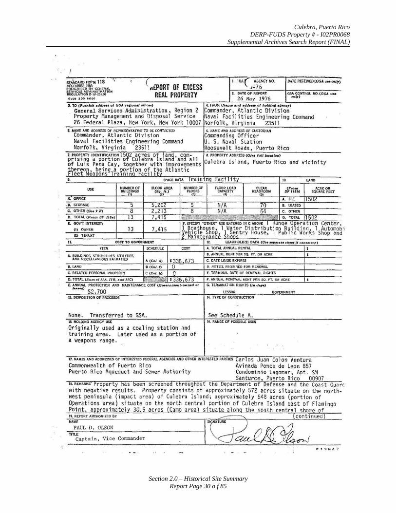
Culebra, Puerto Rico DERP-FUDS Property # - I02PR0068
Supplemental Archives Search Report (FINAL)
Section 2.0 – Historical Site Summary Report Page 30 o f 85
~ r,·
( rt£PORT l. :tuL(" AlOE/iCY 110. STA'liDARO F<fi'M 118 ,. DAT£·RECEJVED(OSA u oe on(7)
DECEMBER I~) OF EXCESS J-76 PR(SCRIOli:D BV' CCN£RAL SEitYICES AO~IN IS'HCATJON
REAL PROPERTY 2. DAn OF RV'ORT GSA COHTROL NO.(GSA uoo REGULATION 2.-IV-.201.00 O\ oe 2 oo eeoo 26 May 1976 o,.q)
J. 10 (Furnith •ddt .. , of GSA n~ion.J office•)
General Services Administration, Region 2 I. FROM (/(uno ond ddr ... of lloldln4 •l•ne.r)
Commander, Atlantic Division Property Management and Disposal Service Naval Faciliti es Engineering Command 26 Federal Plaza, New York, New York 10007 Norfolk·, Virginia 23511
S. NAME AND ADDRESS OF REPRE:S£NTATIIIE TO DE CONTI.CTEO 6. NAME A~D AODI!ESS OF CUSTODIAN Commander, Atlantic Division Commanding Officer Na val Facilities Engineering Command u. s. Naval Station Norfolk, Virginia 23511 Roosevelt Roads, Puerto Rico
7.PR0Pf.RTY IDENTIFICATION ]5~2 alres Of lan~ , COrn- .!1. PROPERTY ADDRESS (01•• fullloeotlon) prising a porti on o Cu ebra san and all Culebra Island, Puerto Rico and vicinity of Luis Pena Cay, t ogether with im~rovements Hertoa·
1g,eingTa ~oq~on of t~S At antic ee ea ons ra1n1n Fac1l1t
t. SPACE DATA 1ra101ng Faci ity 10. LAND
USE NUMBER OF FLOOR AREA NUt.IBER D~ Ft.._~RS
FI.OOR LOAD CLEAR sVim> ACRE OR BUILDINGS (S11Jtt.) CAP~CITY HEA~F"' SQUARE FEET I 1.. OFFICE A. FE£ 11502
. B. STORAGE :l 5,202 5 N/A 70 B. I.£ASED C. OTHER (S.o 9 F) 8 2,213 8 N/A 64 c. OTHER D. TOTAL (P<om SF J/8o) 13 7,415 I ~t~;~~~t~W$k1i~~JY}~7£f!f-tttriB D. TOTAL 1502 E. GOV'T INTEREST: F.SPECIFY"OTHER"USEE.NTERED IN CABOVE I ~anqe \!~erat:10:1 ~enter,
(I) OWN~R 13 7,415 1 Boafhouse, 1 Water Dis t ribution Byi dino 1 Automob CZ) TENANT [~e!ll~nf·~~ggP ~h~~~try House, l Pub ic Hods Shop and
II. COST TO CO~~NMEHT IZ. UASEHOLD(S) DATA (Un ,.P•t..ro diHt'if noe••••_..,, fT£/ol SCHEDUlE = A. TOTAL ANNUAL RENTAL s
A. BUILDINGS. STRUCTURES. ITTIUTIES. B. ANNUAL RENT PER SQ. FT. OR ACR£ s AND MISCULoiNEOUS fACILITIES A (Col tfJ $336 673 C. DATE LEASE EXPIRES
S. LAND 8 (COl. f) 0 D. NOTICE REQUIRED FOR RENEWAL C. RELATED PERSONAL PROPERTY C (COl. II) 0 E. TERMIIIAL DATE OF RENEWAL RIGHTS D. TOTAL (Sum of II A, 11 B , ond II C) IW.£.rt~~ s 336 673 F. AHt(UAI. RENEWAL RENT PER SO. FT. OR ACRE • E. ANNliAL PROTECTION AND MAINTENANCE COST (GOI'o<rtatoA<•ownod or G. TERMINATION RIGHTS (In <ioyo)
l••••d) $2' 700 LESSOR GOVERNMENT U. I>ISPOStTLON OF PROCEEDS 14. TYPE Of CONSTROCTION
..
None. Transferred to GSA. See Schedule A. IS. HOLI>!NG AGENCY USE 16. flANGE OF POSsiBLE ~
Originally used as a coaling station and train i ng area. Later used as a portion of a weapons range.
17. NAt.IES AND ADDRESSES OF INTERESTED FEDERAL AGUICIES AND OTHER INTERESTED PARTIES Carl OS Juan (O 1 On Ventura Commonwea1th of Puerto Rico Avinada Ponce de Leon 857 Puerto Rico Aqueduct and Sewer Authority Condominia Lagomar, A~t. S~
Santurce, Puerto Rico 00907 1e. REr.tARKS' Property has been screened throughout the Department of Defense and the Coast Guarc. ~lith negative r esu 1 ts. Property consists of approximate 1 y 572 acres situate on the no·,·th-wes t peninsula (impact area) of Culebra Isl and; aC)proximate1y 548 acres (portion of Operations area) situate on the north central port i on of Culebra Island eas t of Flami ngo Point, approximate! 30.5 acres Camo area situate alan the so~th central shore of 1'. RCPQRT AUTHOiliZED flY COntiniJed ----NAMF
PAUL D. OLSON Tlil.E
Captain, Vice Commander

Culebra, Puerto Rico DERP-FUDS Property # - I02PR0068
Supplemental Archives Search Report (FINAL)
Section 2.0 – Historical Site Summary Report Page 31 o f 85
... .'"' ( ( , Block 18. REMARKS (cont.)
Culebra Island and the north side of Great H~rbor; approximately 9 acres (1.03 miles of coastline) situate along the west coast of Culebra Island immediately south of the northwest peninsula; and all of Luis Pena Cay,
. ~ttuate off the west coast of Culebra Island, containing approximately 342.5 acres. The improvements, which consist of 13 buildings, 5 storage tanks, 2 helicopter landing pads, a landing craft ramp, a small craft berth, fences, roads and utilities, are located Wlthin the Impact and
.... __ camp Areas on Cul ebra and on .Luis -Pen a Cay.
The excess land is shown on FEC Drawing No. 1042388, approved 15 December 1966, last revised 27 May 1968, attached as Exhibit "A". The location of the . improvements is shown on Y&D Drawing No. 964284, dated 12 November
. .1965, revised 13 November 1967, attached as Exhibit "B" .
. The disposal of the excess property was approved by the Armed Services committees of the Congress on 21 January 1976.
Narrative descriptions of the excess lands are set forth in attached Exhibit "C".
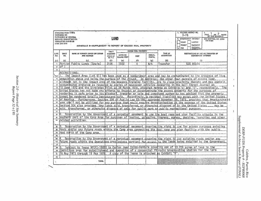
Culebra, Puerto Rico
DERP-FU
DS Property # -I02PR0068
Supplemental Archives Search Report (FIN
AL)
Section 2.0 – Historical Site Sum
mary
Report Page 32 o f 85
:---.....
STANDARD FOAM 118 b OECEMSER 19Sl PR!SCRIBED &Y GENERAL. SERVIC<S ADMINISTRATION I!EGIJLATIO.~ t·IV·201.ll0 0 109 203 B7CO
LAHD 5CNCOV1.1i: B-SUPP1.£MENT TO REP'O~ OF EXCESS RE:AI.. PROPERTY
U NE I TAACT NO. HO •
.. u
HAM~ ot f'ORI<!ER Oii'NCR OR lESSOR AIID ADDIUSS
TYPE 0." AC4UISITION
R!:STRICTIONS ON U!E OR TRANSFER OF GO,YUNIJ0\1' I.~Tti!EST
n t ~ ·
TOTAL
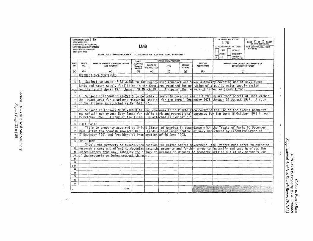
Culebra, Puerto Rico
DERP-FU
DS Property # -I02PR0068
Supplemental Archives Search Report (FIN
AL)
Section 2.0 – Historical Site Sum
mary
Report Page 33 o f 85
STAIIOARD f'Oillol 118 b ~ECEMI!(R l t$3 PRCiCR'B(O 8Y GOIEIW.. SEJIVK:lS ACioiiMISTRATIOII ~CGUlATIO~ Z·IV~.m
OIOt Z~ 11'100
U N£ I TRACT NO. NO.
NAN£ OF FORMER 0Yi'fi£.R OR U:SSOPI AND AOOittsS
TOTAL
LAHD
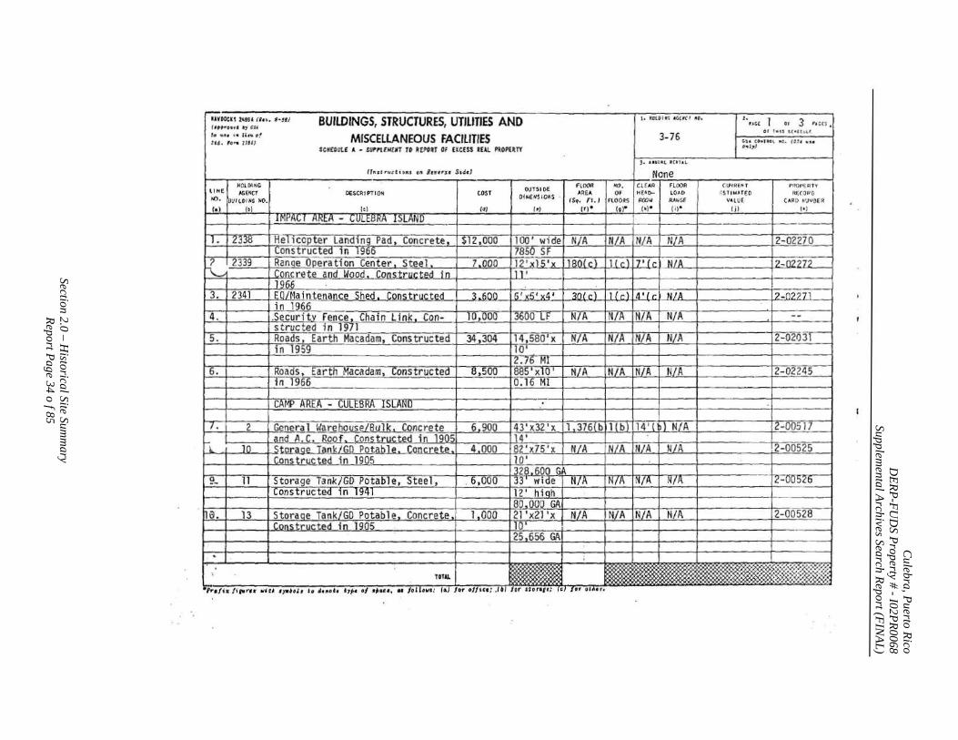
Culebra, Puerto Rico
DERP-FU
DS Property # -I02PR0068
Supplemental Archives Search Report (FIN
AL)
Section 2.0 – Historical Site Sum
mary
Report Page 34 o f 85
r-;;;.OCIIl•lil ""·Nil BUILDINGS STRUCTURES UTILITIES AND I .. ••tOII•l IGlKCI ••• I '·," l ., 3 ••:" I ,,,.Ott, • • , " ' , '
;:,:·;.~ :~;~r MISCELLANEOUS FACiliTIES 3- 76 S'K£0UL£ A • Slll'r!£N( IIT TO R[POIT Of EIC(S$ tEAL I'ROPU!Y
). t._.UAl ICI1.U
fhstt'wct•_,,.,. •" Ru~tru Sldd
o r t• u S!"l t"lf
4-54 (0•1 ttl -.c. (f.J I ~•• •"IT)
(.U4kEI'i J PRO•·•£ A Tv ll" f DESCRIPTIOM ;STIMArto R((f)PO /10. V'LUE CAR O .,,J.,B(R
I• ) 1:1 I j) I•)
1 1 I !MPA(; I AREA - CULEBRA ISLAND ,
l. 12338 Hel1copter Landing Pad, Concrete constructed in 1966 -- - ·-
[?~rt339 I Range Operation Center, Steel 1-~-=+-----'-r.C~o~n<;_J:.ete aod Wood , Construe~
1966 3. !2341 _ LEOl~laintenance Shed . Constructed
in 1966 4. I __ LSe_C~r_it_y Fence . Chain Link . Con-
structed i n- 1971 """s_=-._-1+-.-_ -_--]+_-;:B_-=-oa'""~ d;-=_s_~, .Earth Macadam, Cons tru~ ~eo
i n 1959
~6. Roads,- Earth Conftructed in 1966
CAMP A""RrA - CULEBRA ISLAND
I. 2 Genera l Warehouse/Bulk. C~ncrete and A.C. Roof. Constructed in 1905
~~.. J O S tor a oe -Tai'l.klilll__p_a_tahle_.___ti Construtt~d Jn .1905~
9_ l1 Storage -Tank/GD Potable, _Ste~el, Constructed in 1941
na 13 Storaoe Tank/GO Potable. Concrete Constructed in 1905
. TOTAl.
$l2,§Q():-Troo• widel N/A I ll/A IN/A I N/A 17850 SF
L..ODO p2• xlS'x 1 fSO<cTTI!cllf• fcl~lA 11 '
3 . 600 r6'~x5'x4 ' I 30{c) 1Hdl4'1cl N/A
10,000 )3600 LF I N/A _ IN/A_II'UAJ ~/~_
34 ,304 l14,580'x I N/A I N/A _[N~A I N/A 10'
12.76 HI a.sooaa5'x1o' I N/A IN/A JN/11 T-N/A
I Q.. l§ til
-6;900 -)43' x32-, x_ll.3}6lbl 1! b) [14' !b) N/A 11 ~
4:ooo -l82 'x75'x I N/A iN/A !H/A ) _NlA 10 '
1328 .600 G. 6,ooo -IJJ'-wiae l H/A lN"/A IN/A_ I_N/A
hiofl .000 . GP.'
1.000 l 2l '~x2J 'X I N/A IN/A IN/A I N/A
,656 GA
. , -,., ,,.-;,,.,.., , t1i U ,,..,~ , I• 4•~t•t • ty"t• oi ••d•. M JOtliWI: (•J /or o//icc; J•J lor Horttf; ('} lor 1Uc r.
12-02270
12-n227f
12-0227.1
--r-z~(f2o3r-
L2-.0224S
!z:.oo5T7
!2-_00525
1£-00~2~
12-00528
f~>.y ·':< .$(, ~~ . .-·
. 'M"'.>(
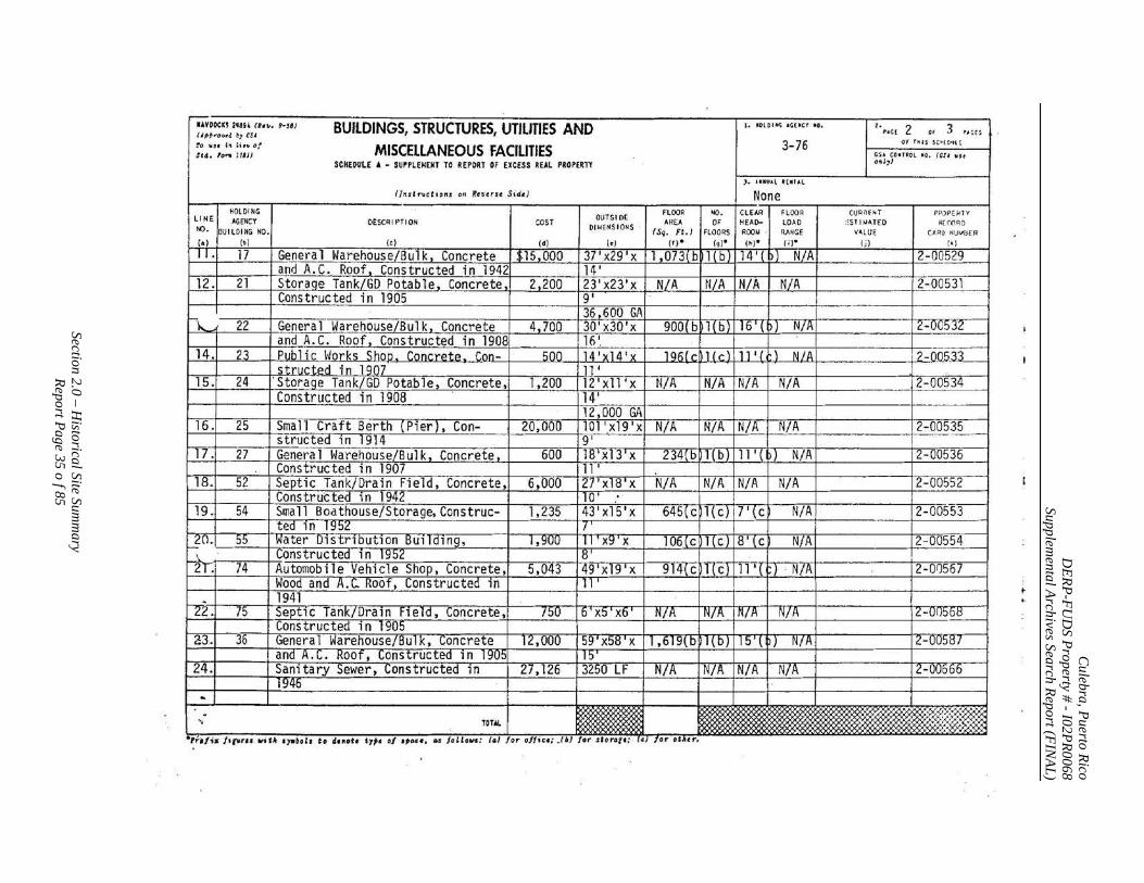
Culebra, Puerto Rico
DERP-FU
DS Property # -I02PR0068
Supplemental Archives Search Report (FIN
AL)
Section 2.0 – Historical Site Sum
mary
Report Page 35 o f 85
IAYOOCll 2'114 (t ... t•l l! ( l,~.-ql#4. ~1 tSI
to "" h ""~of Sf4. to,.. ; IIJJ
BUILDINGS, STRUCTURES, UTILITIES AND MISCELLANEOUS FACILITIES
SCHEOULE A - SUrPLENEHT TO REPORT OF EXCESS REAL PIOPUTY
flndrv,tions on Rtverst. Side)
1. MOlOUI'; 1~(-CT •o.
3- 76
). IUU&l t ( IIU.l
None
I I "!~~~G I OESCAIPTI ON I COST I OUTSIO£ I ---- I 1- .
.. ,.,{ 2 •• 3 ..... Of f il l S $(~( 0VH
CSa COITIOL 110, (CS I WH
0"'')
PPOPEJ.f TV
Rt.(OAO
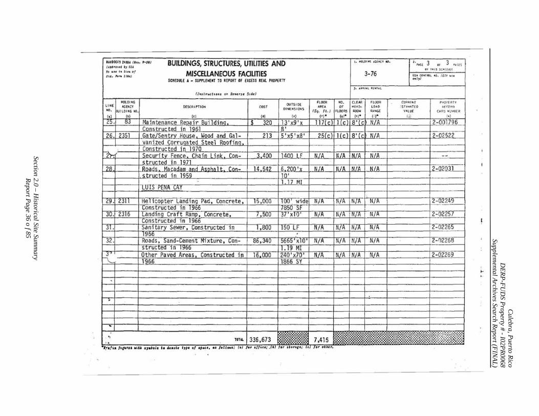
Culebra, Puerto Rico
DERP-FU
DS Property # -I02PR0068
Supplemental Archives Search Report (FIN
AL)
Section 2.0 – Historical Site Sum
mary
Report Page 36 o f 85
-UVOO((I 2•au (l n . f·JJI BUILDINGS, STRUCTURES, UTiliTIES AND l. JIOUI "'- A(;.fiCT 110. ,, ... , 3 3 .. ,._,~ ( .t,.rottl ., cs• ••
•• ••us JC •c:·~u to •u hUn •f MISCEllANEOUS FACILITIES 3- 76 '"· , .,.. , ... J ,.s• ct r.1ttL •o. t' s' ~ ..
SCMEDlll.£ A • SIJI'rt£1«1T TO RtrORT Of EXCESS IEll. riOP£1TY o..Z)/
) • .u•\fal tUillf .t.L
flt~.stn.c tlo•• on ILwu ·u St4LI
HOlOIOC OUTS I 0[
Fl.()()j! 110. CLEAA noo~ CU'Uif lrrl.l P"C)I'EA!Y liNE A(;(.IICl OESCAIPTIO• COST AR£ A or HfA()- LOAO ·s''"'"rto WHOf.IO IC), OutlOI~G NO.
OI ~~OSI~S ISq. f'l./ FlOO~ ~ RANGE Vl.lUE tARO HlJYO( R
(t) 1•1 1<1 1~1 ( •) (r) • It I" (' )" n • Iii 1•1
25. 83 ~laintenance Reoair Buildinq_ $ 320 13'x9'x 117(c) llcl 8' (c N/A 2-0017.~--Construc;.ted ill 1961 .a·
26 . 2351 GateLSentr~ House Wood and Gal- 213 fi5 'x8' ~(c) I( c) 8' (c N/A ~-Q2522 vanized CorruQated Steel RoofinQ ·-
-2).; . Constructed in 1970 Securitv Fence Chain Link Con- 3 40.0_ IJ!OO LF N/A N/A IN/A N/A --s tructed in 1971
.
~- Roads .Ma tadam and...Asoha l t Con- 14.542 .62.ttO...:..X N/A N/A N/A N/A 2-0201_1 _ , stru!::ted in 1959 JQ' -wrs- PEN'A (.;A r
1 n _MI
29 . .2311 He 1tcopter Land 1 ng ?ad . Concrete. l t>,OGO lUG'" wide N/A N/A N/A N/A 2-022~ Constructed 1n 19oo 78o0 Sf
30. £316 [anaing ~rah Ramp , loncrete, 1,500 3/ X IIJ N/ A N/A N/A N/A 2-02257 Constructed 1n 1966
31. San1 tary Sewer, Constructed 1 n J,~ l!l_{}_L_f ~- N/A N/A N/A 2-02265 19bb I
32 Roads , Sand-Cement Mixture, Con- 86,340 5665 xlO ' N/A N/A HIA N/A 2-02268 structea 10 ~o 1.19 MI I
]'' Other Paved Areas , Constructed i n 16_.000 240 'x70 ' NLA N/A N/A N/A 12-02269 '-- 1966 1866 SY !
....
'
.
.. ' ., 336,673 7,415 ::W:.~k~ ! ; ,.
TOTAL '2\0
-, . .,, lis Jtnr•a w&U awahh tt 4•••t• h i t oJ •••"• e.J Jollow•: (•l lor e//tu; .UI t r tlont• :· lc }or oU'"•
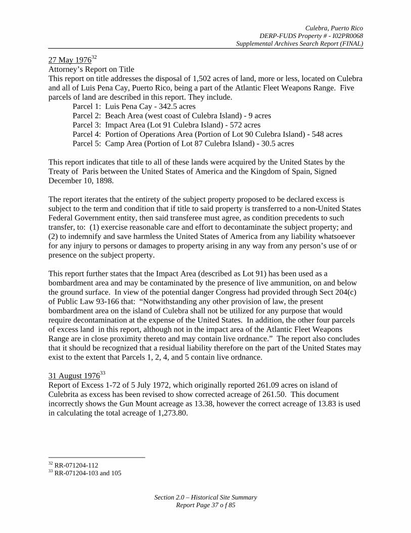
Culebra, Puerto Rico DERP-FUDS Property # - I02PR0068
Supplemental Archives Search Report (FINAL)
27 May 197632
Attorney’s Report on Title This report on title addresses the disposal of 1,502 acres of land, more or less, located on Culebra and all of Luis Pena Cay, Puerto Rico, being a part of the Atlantic Fleet Weapons Range. Five parcels of land are described in this report. They include.
Parcel 1: Luis Pena Cay - 342.5 acres Parcel 2: Beach Area (west coast of Culebra Island) - 9 acres Parcel 3: Impact Area (Lot 91 Culebra Island) - 572 acres Parcel 4: Portion of Operations Area (Portion of Lot 90 Culebra Island) - 548 acres Parcel 5: Camp Area (Portion of Lot 87 Culebra Island) - 30.5 acres
This report indicates that title to all of these lands were acquired by the United States by the Treaty of Paris between the United States of America and the Kingdom of Spain, Signed December 10, 1898.
The report iterates that the entirety of the subject property proposed to be declared excess is subject to the term and condition that if title to said property is transferred to a non-United States Federal Government entity, then said transferee must agree, as condition precedents to such transfer, to: (1) exercise reasonable care and effort to decontaminate the subject property; and (2) to indemnify and save harmless the United States of America from any liability whatsoever for any injury to persons or damages to property arising in any way from any person’s use of or presence on the subject property.
This report further states that the Impact Area (described as Lot 91) has been used as a bombardment area and may be contaminated by the presence of live ammunition, on and below the ground surface. In view of the potential danger Congress had provided through Sect 204(c) of Public Law 93-166 that: “Notwithstanding any other provision of law, the present bombardment area on the island of Culebra shall not be utilized for any purpose that would require decontamination at the expense of the United States. In addition, the other four parcels of excess land in this report, although not in the impact area of the Atlantic Fleet Weapons Range are in close proximity thereto and may contain live ordnance.” The report also concludes that it should be recognized that a residual liability therefore on the part of the United States may exist to the extent that Parcels 1, 2, 4, and 5 contain live ordnance.
31 August 197633
Report of Excess 1-72 of 5 July 1972, which originally reported 261.09 acres on island of Culebrita as excess has been revised to show corrected acreage of 261.50. This document incorrectly shows the Gun Mount acreage as 13.38, however the correct acreage of 13.83 is used in calculating the total acreage of 1,273.80.
32 RR-071204-112 33 RR-071204-103 and 105
Section 2.0 – Historical Site Summary Report Page 37 o f 85
Culebra, Puerto Rico DERP-FUDS Property # - I02PR0068
Supplemental Archives Search Report (FINAL)
Summer 197634
The Commonwealth of Puerto Rico, Department of Natural Resources produces a report on “The Culebra Segment” of the Coastal Zone Management Program. Among other issues the report addresses unexploded ordnance in former Navy target areas. Approximate locations are shown on the following map from the report.
“In the several areas formerly used as Navy targets, it should be reasonably assumed that there is unexploded ordnance on land and in the surrounding waters. Detailed information concerning the magnitude and location is not available.” (This information was provided by a letter, date 20 February 1976, from Adm. W. R. Flanagan, commander, US Naval Forces, Caribbean, to Mr. Arsenio Rodriguez, Task Force Director Coastal Zone Management Project.)
“The LCDC (Art 7 (c) (3) includes among its “general standards” a directive that the Authority will take necessary steps to explosive artifacts removed from the areas used for target practice. To minimize dangers to recreational users of these areas, these needed program elements must be given high priority for early action. These include:
First, a survey and analysis of the extent of the problem and the steps practically available to reduce or eliminate it.
Second, ordnance removal or other action in accordance with the survey. Assistance from armed forces demolition experts will presumably be needed. The cost of removal, however, is specified as a commonwealth responsibility by federal law. (Federal Law that makes Puerto Rico responsible for ordnance removal. PL93-166, Reserve Forces Facilities Authorization Act, 1974. 87 Statutes 661.)
Third, the posting of signs warning of dangers from unexploded ordnance.”
34 RR-071204-323
Section 2.0 – Historical Site Summary Report Page 38 o f 85
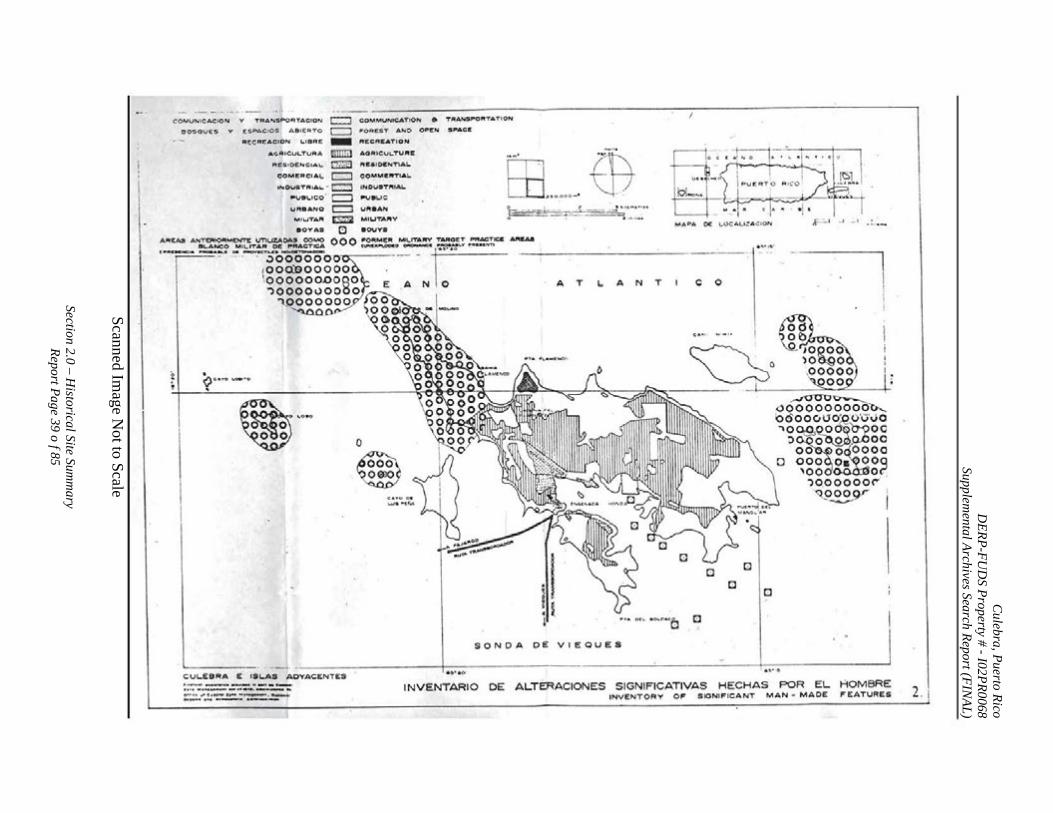
Culebra, Puerto Rico
DERP-FU
DS Property # -I02PR0068
Supplemental Archives Search Report (FIN
AL)
Scanned Image N
ot to Scale
Section 2.0 – Historical Site Sum
mary
Report Page 39 o f 85
('QMVNICA.C:ION V TqANSPoRTACION c::J c::::J
COMMUNICATION a 'ORE$T AND oPCN
ltCCRC:ATION
AOAICVLTUfltiE
fltEaiDCN'nA.L.
~O~M.CfltTIAL.
TAANSPO!ItTATIOH
S~tACI'
i .
50$0\J£$ V' (:SPACtOS ASICIII T O
lltECREACION \..18R~
A.O:.Iit i CULTUAA
llt£SIO~NCIAL
COMilRCt.t.\,.
-miiiil ::mo c:::::J
INOUSTflhAt. ... ~ INOuaTI'tlA.L.
~8\..ICO• c::J ~eue U,.BANO c::::J Vlt.Aflll
M IUTA,. ~ MIUTA,_V
aov A !I D aouva
ffi ..... -$ ~:§.:~~- -:. -·-···~~=:~··
MAPA 0( L.UCAt..I~A..:tON
MI\..IT~~~IU.~= 000 :r~"'.~oMI~ ~!.~":::z:ca ~
":" -~o'Oo"'oo~--- -~·-·· \00®00000 . OOOOOOCORO E A N 0 "')0000000~0
"\..0000000 .io()' ~.o- ~oo .
------- - ------------
A T c 0 T A N L.
~····· ~ 0
e~ ~
. ,..., ot~ •o...c-•c~
SONDA DE VIEOUES
D
D D
D
~-7-.l ....t - 1
CUI...E8RA E ISI...AS AOYACENTES
···-- .,._. --·---·---·-·---... ·---......... ~·-l- ... ___ - · .. _______ _ INVENTARIO DE ALTERACIONES S IGNIFICATIVAS HECHAS POR EL HOMBRE INVENTORY OF SIGNIFICANT MAN- MADE FEATURES 2. I
Culebra, Puerto Rico DERP-FUDS Property # - I02PR0068
Supplemental Archives Search Report (FINAL)
9 November 1976 35
In a letter to the GSA (Region 2) the Head of the Operations Branch of the Real Estate Division (Naval Facilities Engineering Command, Norfolk, VA) responded to the GSA request for information regarding contamination on the 1273 acres reported excess in Report 1-72. The attorney’s report on title indicated that the excess lands were in close proximity to the impact area of the Weapons Range and may contain live ordnance. The letter further states, “From subsequent information furnished by the using activity (Atlantic Fleet Weapons Range), it was determined that the excess land, with the exception of Ladrones Cay, contain no explosives or dangerous ordnance.” Ladrone Cay had been previously inspected (apparently in 1973) by the Explosive Ordnance Disposal Detachment and they reported that no decontamination work would be required.
16 December 197636
In a letter to the GSA (Region 2) the Head of the Operations Branch of the Real Estate Division (Naval Facilities Engineering Command, Norfolk, VA) added a condition to Report 1-72 regarding the airfield portion of the 1273 acres. The condition to be included in the deed stated.
“The Grantee shall furnish unto the Department of the Navy at its Operations Area such potable water as may be required at the lowest rate available to consumer type customers.”
7 April 197737
In a letter the Director of GSA (Region 2) requests information from the Head of the Operations Branch of the Real Estate Division (Naval Facilities Engineering Command, Norfolk, VA) regarding historically significant property and flooding hazards that might be associated with the excess lands of Report 1-72. This information was necessary per the Federal Property Management Regulations.
17 August 197738
In a letter to the GSA (Region 2) the Acting Director, Real Estate Division (Naval Facilities Engineering Command, Norfolk, VA) indicated that a further Condition was added to Report of Excess 3-76 as stated below.
“Subject to the condition that the excess lands shall be disposed of only for public park or public recreational purposes as cited in Section 204(c) of Public Law 93-166.”
01 December 197739
The GSA Director of Real Property Division (Region 2) requested advice from Director, Real Estate Division (Naval Facilities Engineering Command, Norfolk, VA) whether the Operations Area, Camp Area, and Luis Pena Cay were considered contaminated with ordnance. Additionally the GSA requested clarification if the 1,273 acres (covered in Report of Excess # 1-
35 RR-071204-116 36 RR-071204-115 37 RR-071204-117 38 RR-071204-104 39 RR-071204-126
Section 2.0 – Historical Site Summary Report Page 40 o f 85
Culebra, Puerto Rico DERP-FUDS Property # - I02PR0068
Supplemental Archives Search Report (FINAL)
72) were also not considered contaminated with regard to ordnance, “since these areas do not appear to lie within the purview of Public 93-166 with regard to the Navy not being responsible for decontamination.”
05 January 197840
Partial response from Navy to GSA to letter of 01 December 1977 indicating that there are no known flood hazards within the excess property and no history of flooding of the property. No mention is made of the questions regarding ordnance.
20 January 197841
An internal Navy memorandum indicated that the acreages listed in Report of Excess 3-76 are essentially correct (Impact Area-572 acres, portion of Operations Area-548 acres, Camp Area-30.5 acres, Luis Pena Cay-342.5 acres, 1.03 miles of coastline-9.0 acres). However, based on a review of cadastral records, the portion of Tract 1 described in Report of Excess 1-72 has been overstated by 184 acres. The two coastal strips described in 1-72 contain 172 and 190 acres respectively, in lieu of 252 and 294 acres.
31 January 197842
A corrected version of Report of Excess 1-72 is issued this date contains a total of 1,089.80 acres made up of the following acreages. A copy of that document follows below.
177 acres-Southern Peninsula of Culebra Island 268.47 acres-Landing field 13.83 acres-Five former gun mounts 172 acres-7 miles of shoreline (south side of Culebra) 190 acres-9.5 miles of shoreline (eastern and northern sides of Culebra) 261.5 acres-Culebrita and Ladrones Cay 7 acres-Water Cay
40 RR-072604-021 41 RR-071204-129 42 RR-080204-007
Section 2.0 – Historical Site Summary Report Page 41 o f 85
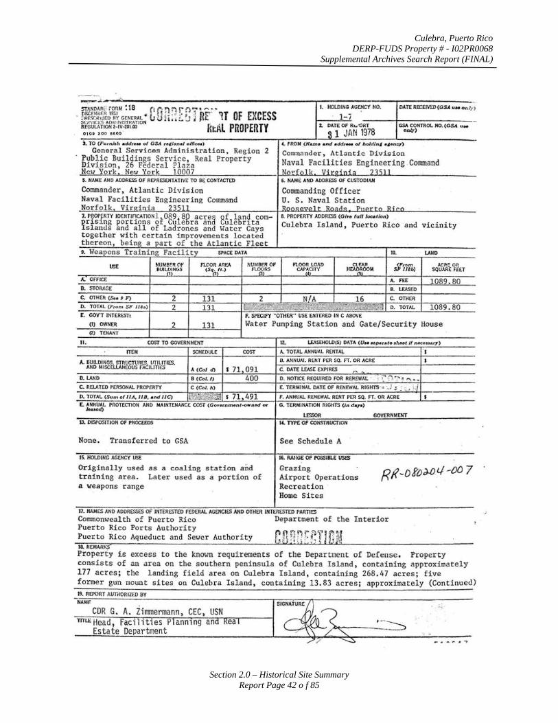
Culebra, Puerto Rico DERP-FUDS Property # - I02PR0068
Supplemental Archives Search Report (FINAL)
Section 2.0 – Historical Site Summary Report Page 42 o f 85
~-., -
STJ.NDAR(< ;ORM ~ 18 (I (1 n :"' r n - ' "' • I. IIOLDIHG AGEHCY HO. DATE RECEIVtD(OSA ., .. onJ?) llf.C£Md£R ISSJ ' J ' 1 ··
- :-Rf..V.Ilui EO RY GENERAl • tJ U! i: ~ [. ~ j RE 1J Of EXCESS 1-i Sl';jVICt:S AOMIIIISTRATION ~ 1\L PROPERTY t. DATE OF Rc..'()RT GS.\ CONTROl. HO. (Os.t u .. R£GUl.A TION l-tv:-zoi.OO {l: onq) 01 o' 200 eooo S 1 JAN 1978 ), TO (Furnhh • ddc.u ol OSA , •• ional o/fjoot) (. FROM (N~• •nd • dd,... of ho/d/nf «4•nc:r)
General Services Administration, Region 2 Co1111113nder, Atlantic Division Public Buildings Service, Real Property Division , 26 Federal Plaza Naval Facilities Engineering Command Ne'" York New York 10007 N6"fQlk, :llitg i oja 235]] 5. NAME AND ADDRESS OF Rfl'RESEHTATIVE TO BE CONTACTED 6. NAME AtlD ADDRESS OF CUSTODIAN
Commander, Atlantic Division Commanding Officer Naval Facilities Engineering Command u. s. Naval Station Norfolk Virdnia 23511 Rnn<:PVPl r Rn;,cl<: PnPrtn Ri<'n
7. P~OP~RTY IDENTlf!CATIONlt0891
8g acre a ef l~ncj COm- 8. PROPERTY ADDRESS (0/re lullloc• tlon) ¥r~s1ng port1ons o Cu e ra an ule r1ta Culebra Island, Puerto Rico and vicinity slands and all of Ladrones and Water Cays together with certain improvements located thereon, being a part of the Atlantic Fleet •· l~eapons Training Facility SPACE DATA 10. LAND
USE HUMB~R OF fl.OOR ARf.A IIUMS£R OF FlOOR LOAD ClEAP 3~ilb> ACRE on BUI~~INGS (Sqn
1tt.) FL<)gRS CN'~~I't)' HEA~~OOM SQUARE FEET
I;. OffiCE A. FEE 1089.80 B. STORAGE B. L£A5a>
C. OTHER (S.o t F) 2 131 2 NIA 16 c. OTH(R
D. TOTAL (Prom SP Jlh) 2 131 ;..,.";Ql~'"';cli"'~~.;!b;'~ .. ;W~.m,.:jl D. TOTAl 1089.80 E. GOV'T INTEREST: f. SPECIFY "OTHER" USE £NTEREO IN C ABOVE
(I) OWNER 2 131 Water Pumping Station and Gate/Security House (2) T'tHANT
11 . COST TO GOVERNMCHT 1t. li.AS£HCl.D($) DATA (UN HP..ute•hHt If l'l«:euar-T)
ITEM SCHEDULE COST A. TOTAL ANNUAL RENTAL s A. BUILDINGS. STRUCTURtS, liTILITIES. ll. ANNUAl. RENT PER SQ. FT. OR ACRE s
AND MISCELI.ANEOUS fACILITIES A (Col d) s 71 091 C, DATE lEASE EXPIRES "'. D. lAND 8 (Col./) 400 D. NOTICE REQUIRED fOR REHEWAL ~ -~ ·:"'\"~, "' .... C. RELATED PERSONAL PROf'fRTY c (Col. h) E. T£RIUtfAL DATE OF RENEWAL RIGHTS· • .J .: ; ..
1 ;,j
0. TOTAL (Sum of II A, liB, • nd liC) 1~'?.\i'£~ s 71,491 F. ANtfUAL RENEWAL RENT PER SO. FT. OR ACRE s E. ANNUAl PROTECTION AND MAINTE.HANCE COST (Go .. rnmont-o .. nod <>r
IHK>d) G. TERMINATION RIGHTS ( / n dqo)
lESSOR GOVERNMENT U. DISl'OSITION OF PROCEEDS 1'- TYPE Of CONSTRUCTION
None. Transferred to GSA See Schedule A
15. HOlDING AG£/ICY USE 16. RAilGI: OF I'OSSIBU use;
Originally used as a coaling station and Grazing Rf<-ofo:w.'-1 -oo 7 training area. Later used as a por tion of Airport Operations a weapons range Recr eation
Home Sites
11. HAMES AND ADDRESSES OF INTERESTED FEDERAl AGENCIES AND OTHER IHTERESTED PARTIES
Commonwealth of Puerto Rico Department of the Interior Puerto ~ico Ports Authority Puerto Rico Aqueduct and Sewer Authority ~nf 1&. REMARKS
Propert y is excess to the known requirements of the Department of Defense. Property consists of an area on the southern peninsula of Culebra Island, containing approximately 177 acres ; the landing field area on Culebra I sland, containing 268.47 acres ; five
-
former gun mount sites on Culebra Island, containing 13.83 acres; approximately (Continued) 19. REPORT AVTHORIZ£0 BY HAll£
CDR G. A. Zimmermann, TIT~Head, Facilit1es P ann1ng an
Estate Department
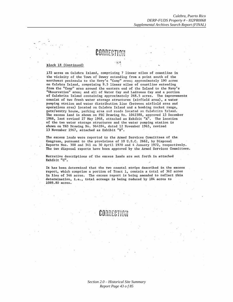
Culebra, Puerto Rico DERP-FUDS Property # - I02PR0068
Supplemental Archives Search Report (FINAL)
Section 2.0 – Historical Site Summary Report Page 43 o f 85
Block 18 (Continued)
172 acres on Culebra Island, comprising 7 linear miles of coastline in the vicinity of the Town of Dewey extending· from a point south of the northwest peninsula to the Navy's "Camp" area; approximately 190 acres on Culebra Island, comprising 9.5 linear miles of coastline extending from the "Camp" ·area around the eastern end of the Island to the Navy's "Observation" area; and all of Water Cay and Ladrones Cay and a portion of Culebrita Island containing approximately 268.5 acres. The improvements consist of two fresh water storage structures (airfield area), a water pumping station and water distribution line (between airfield area and operations area) located on Culebra Island and a bombing rocket range, gate/sentry house, parking area and roads located on Culebrita I sland. The excess land is shown on FEC Drawing No . 1042388, approved 15 December 1966, last revised 27 May 1968, attached as Exhibit "A". The location of the two water storage structures and the water pumping station is shown on Y&D Drawing No. 964284, dated 12 November 1965, revised 13 Nov.ember 1967, attached as Exhibit "B".
The excess lands were reported to the Armed Services Comn:ittees of the . Congress, pursuant to the provisions of 10 U.S . C. 2662, by Disposal Reports Nos. 300 and 341 on 30 April 1970 and 4 January 1972 , respectively. The Lvo disposal reports have been approved by the Armed Services Committees.
Narrative descriptions of the excess lands are set forth in attached Exhibit "C".
It has been determined that the two coastal strips described in the excess report, which comprise a portion of Tract 1, contain a total of 362 acres in lieu of 546 acres. The excess report is being amended to reflect this. determination, i.e., total acreage is being reduced by 184 acres to 1089.80 acres •.
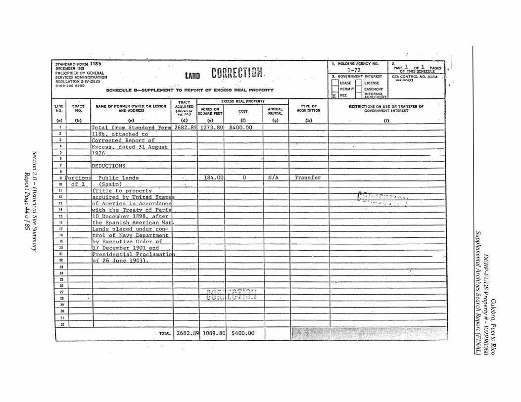
Culebra, Puerto Rico
DERP-FU
DS Property # -I02PR0068
Supplemental Archives Search Report (FIN
AL)
Section 2.0 – Historical Site Sum
mary
Report Page 44 o f 85
STANDARD I"ORM ll8b ' I. HOlDING AGENCY NO. z. ' ""T-r:
DtCEMDER 1953 conRECT.IOtJ. 1- 72 PAGE 1 OF 1 PAGES , • PRESCRIBED BY GENtRAL LAND
or nus SCHEtlUl£
SERVICES ADMINISTRATION 3. GOVERNMENT INTEREST GSA CONTRa:.. NO. (GSA . ' R£GUL.o\TION :-tV~I.DO
~ ::EIT ~ ~:~:NT u•• onlT)
OIOt 200 8700 ..... . SC:HEDUU D-SUPPL.EM£HT TO REPO~ OF EXCESS REAL ~ROPERTY 'X FU; I- ~'g'R~~~\:rr
TRAtT EXCESS R£A!. PROPERTY \.I N£ TMcT HAM£ OF I"ORMER OWNER OR U:SSOR ACQUIRED TYPE 01' R.ESTRICTIONS ON USE OR TRANSFER o r NO. NO. AND ADDRESS .(Act'•., or ACRES OR
COST ANNUAl. ACQUISITION GOVERNMENT INTEREST
•q. U.) SQUARE FEET REHTAI.
(a) (b) (c) (d) (c:) (0 (c) (h) (I)
I Total from Standard Forrr 2682.89 1273. 80 $400.00 2 1118b at tac.hed to 3 Corrected Reoort of 4 Exr.e~,:; dated 31 Au<>tJcot $ il ()71\
·-:--
6
7 DEDUCTIONS e ' . ortion Public Lands 184. 00 0 N7A Transfer
10 of 1 (Soa in) 11 I (Title to or ooertv -12 acouired bv United States I: ·~ . ; ~I ~ ' · ') -~ :t ~ ' ..
IJ of America in accordance . _,., .,- .I ... - 2 . ; j
1. with the Treatv of Paris 15 10 Dec.ernber 1898 aft~>r 16 the Soan ish American T.olar . 17 Lands olaced tmder con-18 tro1 of Navv Ueoartment
" bv Executive Order of ro 17 December 1901 and 21 Pr<'sid.,n t ia1 Pror.lam,. t in 22 of 26 June 1 Q03) 23
, .. ZA
zs . Z6
27 ,.., _, ~ -. . :.' _, .. . :-~? ~ ~ ~ ~
u U tJ ; L. t ,::J ~ ~·3 -C
29
)0
31
32 , TOTAl. 2682 . 89 1089.80 $400 . 00 ~~,J~~r:,:~;~~~,~~?~(fP:f· ·:y~r:'; :::. -~,,~(xpe~~, ';
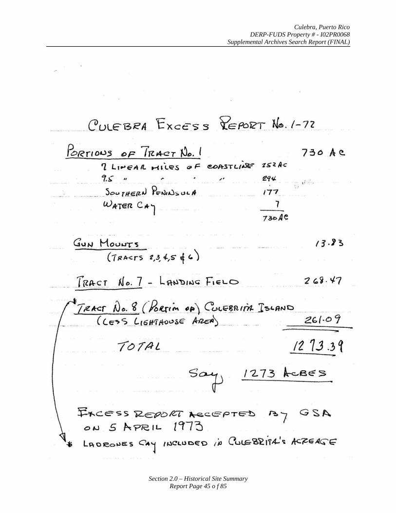
Culebra, Puerto Rico DERP-FUDS Property # - I02PR0068
Supplemental Archives Search Report (FINAL)
Section 2.0 – Historical Site Summary Report Page 45 o f 85
' '1 Lt..-E?AIL t-i&.c..es ~~= ec>PtSTLIISiif" -z~l./k
1.~ ., ,.. ' . .• l.;: . . -· . ..
. .. ........ ___ So':" rlf..~IZJ Pe:~u::;. 1.H._A : . .::
c.vA-Ten c,..1
G\JN Ho(..h.rT~ . -- ( 1 ~ ~-~;·-- -1,.3~ 4-,s ~· <.)
-. __ [g~_c;_r .. t.J o .. _] . ~ L fl-~1?·t.) ·~- _F• E_L C> 2 G.~. ¥7 . . . . ~
Tre*<=r .. N_~~ i,..(f},_~~~ -~~\ ~'-·"~~~nth.t. J'5"a"'c ..... .. .. _. ( C.~'? ... t-.r9.HJJ{-o'?SE' ~) ... .. . . Zb/·D Cf
./0//!L IZ 1J .3 ~
/2 73 ~B~S
~cess )2..~oiZ-T ~c.E"PTe==-b ~7 G ~~ o 1-J 5 ~?/C.IL [Cf/3
* Lf;\OJeot.)ES CA1 t~CL.UDE"O ,;., Cuu=<6~t.'i'4-1 ~ Ac~GAG"E'
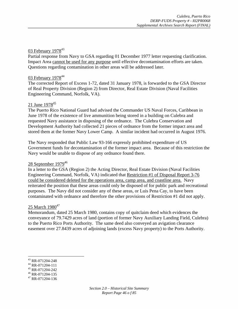
Culebra, Puerto Rico DERP-FUDS Property # - I02PR0068
Supplemental Archives Search Report (FINAL)
03 February 197843
Partial response from Navy to GSA regarding 01 December 1977 letter requesting clarification. Impact Area cannot be used for any purpose until effective decontamination efforts are taken. Questions regarding contamination in other areas will be addressed later.
03 February 197844
The corrected Report of Excess 1-72, dated 31 January 1978, is forwarded to the GSA Director of Real Property Division (Region 2) from Director, Real Estate Division (Naval Facilities Engineering Command, Norfolk, VA).
21 June 197845
The Puerto Rico National Guard had advised the Commander US Naval Forces, Caribbean in June 1978 of the existence of live ammunition being stored in a building on Culebra and requested Navy assistance in disposing of the ordnance. The Culebra Conservation and Development Authority had collected 21 pieces of ordnance from the former impact area and stored them at the former Navy Lower Camp. A similar incident had occurred in August 1976.
The Navy responded that Public Law 93-166 expressly prohibited expenditure of US Government funds for decontamination of the former impact area. Because of this restriction the Navy would be unable to dispose of any ordnance found there.
28 September 197946
In a letter to the GSA (Region 2) the Acting Director, Real Estate Division (Naval Facilities Engineering Command, Norfolk, VA) indicated that Restriction #1 of Disposal Report 3-76 could be considered deleted for the operations area, camp area, and coastline area. Navy reiterated the position that these areas could only be disposed of for public park and recreational purposes. The Navy did not consider any of these areas, or Luis Pena Cay, to have been contaminated with ordnance and therefore the other provisions of Restriction #1 did not apply.
25 March 198047
Memorandum, dated 25 March 1980, contains copy of quitclaim deed which evidences the conveyance of 79.7429 acres of land (portion of former Navy Auxiliary Landing Field, Culebra) to the Puerto Rico Ports Authority. The same deed also conveyed an avigation clearance easement over 27.8439 acres of adjoining lands (excess Navy property) to the Ports Authority.
43 RR-071204-248 44 RR-071204-111 45 RR-071204-242 46 RR-071204-135 47 RR-071204-136
Section 2.0 – Historical Site Summary Report Page 46 o f 85
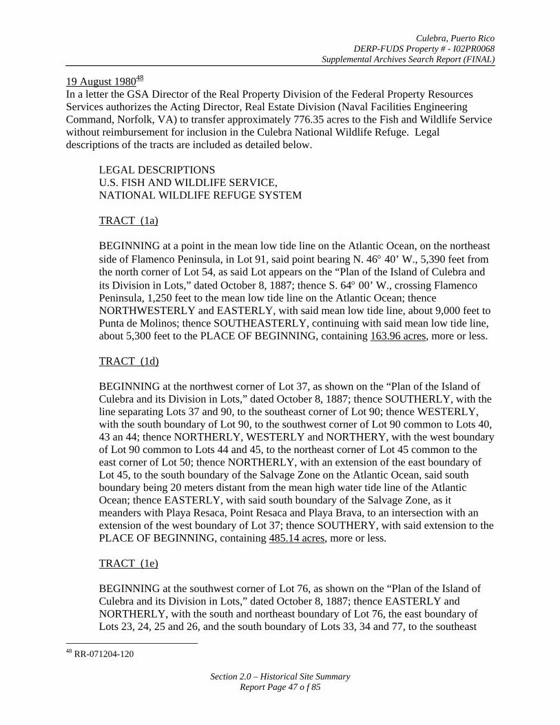
Culebra, Puerto Rico DERP-FUDS Property # - I02PR0068
Supplemental Archives Search Report (FINAL)
19 August 198048
In a letter the GSA Director of the Real Property Division of the Federal Property Resources Services authorizes the Acting Director, Real Estate Division (Naval Facilities Engineering Command, Norfolk, VA) to transfer approximately 776.35 acres to the Fish and Wildlife Service without reimbursement for inclusion in the Culebra National Wildlife Refuge. Legal descriptions of the tracts are included as detailed below.
LEGAL DESCRIPTIONS U.S. FISH AND WILDLIFE SERVICE, NATIONAL WILDLIFE REFUGE SYSTEM
TRACT (1a)
BEGINNING at a point in the mean low tide line on the Atlantic Ocean, on the northeast side of Flamenco Peninsula, in Lot 91, said point bearing N. 46° 40’ W., 5,390 feet from the north corner of Lot 54, as said Lot appears on the “Plan of the Island of Culebra and its Division in Lots,” dated October 8, 1887; thence S. 64° 00’ W., crossing Flamenco Peninsula, 1,250 feet to the mean low tide line on the Atlantic Ocean; thence NORTHWESTERLY and EASTERLY, with said mean low tide line, about 9,000 feet to Punta de Molinos; thence SOUTHEASTERLY, continuing with said mean low tide line, about 5,300 feet to the PLACE OF BEGINNING, containing 163.96 acres, more or less.
TRACT (1d)
BEGINNING at the northwest corner of Lot 37, as shown on the “Plan of the Island of Culebra and its Division in Lots,” dated October 8, 1887; thence SOUTHERLY, with the line separating Lots 37 and 90, to the southeast corner of Lot 90; thence WESTERLY, with the south boundary of Lot 90, to the southwest corner of Lot 90 common to Lots 40, 43 an 44; thence NORTHERLY, WESTERLY and NORTHERY, with the west boundary of Lot 90 common to Lots 44 and 45, to the northeast corner of Lot 45 common to the east corner of Lot 50; thence NORTHERLY, with an extension of the east boundary of Lot 45, to the south boundary of the Salvage Zone on the Atlantic Ocean, said south boundary being 20 meters distant from the mean high water tide line of the Atlantic Ocean; thence EASTERLY, with said south boundary of the Salvage Zone, as it meanders with Playa Resaca, Point Resaca and Playa Brava, to an intersection with an extension of the west boundary of Lot 37; thence SOUTHERY, with said extension to the PLACE OF BEGINNING, containing 485.14 acres, more or less.
TRACT (1e)
BEGINNING at the southwest corner of Lot 76, as shown on the “Plan of the Island of Culebra and its Division in Lots,” dated October 8, 1887; thence EASTERLY and NORTHERLY, with the south and northeast boundary of Lot 76, the east boundary of Lots 23, 24, 25 and 26, and the south boundary of Lots 33, 34 and 77, to the southeast
48 RR-071204-120
Section 2.0 – Historical Site Summary Report Page 47 o f 85
Culebra, Puerto Rico DERP-FUDS Property # - I02PR0068
Supplemental Archives Search Report (FINAL)
corner of Lot 77; thence EASTERLY, with an extension of said south boundary, to the mean low tide line on the Atlantic Ocean; thence WESTERLY and SOUTHERLY, with the mean low tide line on the Atlantic Ocean, Puerto del Manglar and Vieques Sound, to an intersection with an extension of the line separating Lots 23 and 76; thence NORTHWESTERLY, with said extension to the PLACE OF BEGINNING, containing 53.78 acres, more or less.
TRACT (1f)
A part of Lot 24, as shown on the “Plan of the Island of Culebra and its Division in Lots,” dated October 8, 1887; situate in the Ward of Fraile on the southeastern part of Culebra Island, being more particularly described as follows:
BEGINNING at a point on the beach sixty (60) feet North and ninety-seven (97) feet East of the center of the gun mount located on the North side of said Lot No. 24; thence West three hundred (300) feet; thence South three hundred (300) feet; thence East three hundred and fifty-four (354) feet and thence along the beach in a northerly direction to the POINT OF BEGINNING, containing 2.25 acres, more or less.
TRACT (1j)
BEGINNING at the southwest corner of Lot 71, as shown on the “Plan of the Island of Culebra and its Division in Lots,” dated October 8, 1887; thence SOUTHEASTERLY, with the south boundary of Lot 71, the west boundary of Lot 72 and the northwest boundary of Lot 73, to the northwest corner of Lot 73, thence WESTERLY, with an extension of said northwest boundary of Lot 73, to the mean low tide line on Ensenada Honda; thence NORTHWESTERLY, with said mean low tide line on Ensenada Honda to the PLACE OF BEGINNING, containing 71.21 acres, more or less.
15 September 198049
In a letter to the Regional Director (DOI/FWS, Atlanta, GA) the Acting Director, Real Estate Division (Naval Facilities Engineering Command, Norfolk, VA) indicated that 776.35 acres in 5 tracts (1a, 1d, 1e, 1f, and 1j) were officially transferred to US Fish and Wildlife Service as of this date. This document emphasizes that Tracts 1a (part of Impact Area) and 1d (part of Operations Area) are affected by Section 204 of Public Law 93-166 that dictated that these lands could only be used for public park or public recreational purposes. Additionally the letter reiterates that Tract 1a shall not be utilized for any purpose that would require decontamination at the expense of the United States and cautions that its use should be severely restricted until effective decontamination measures are taken.
26 September 198050
The United States of America acting through the Secretary of the Interior released by quitclaim deed some 155.9436 acres of land on Culebra Island in the vicinity of the former Naval landing
49 RR-071204-140 50 RR-080204-008
Section 2.0 – Historical Site Summary Report Page 48 o f 85
Culebra, Puerto Rico DERP-FUDS Property # - I02PR0068
Supplemental Archives Search Report (FINAL)
field to the Commonwealth of Puerto Rico. Legal descriptions of the parcels of land are detailed below. A condition of this deed stipulated that the property was granted subject to its perpetual use as a public park and public recreation area.
PARCELS 2 and 3 (QUITCLAIM DEED)
PARCEL 2
BEGINNING at the corner common to Lots 52, 53 and 57, according to the official map of Culebra Island its division in lots, dated October 8, 1887; thence with the south boundary of Lot 52, S. 81° 45’ 30” E., 910.32 feet; thence S. 37°49’ 55” E., 338.88 feet; thence S. 37° 50’ 03” E., 290.41 feet; thence S. 34°15’ 37” E., 267.02 feet; thence S. 30°18’ 00” E., 103.80 feet; thence S. 23° 37’ 30” E., 194.96 feet; thence S. 20° 07’ 23” E., 356.39 feet; thence S. 34° 53’ 16” E., 296.97 feet; thence S. 34° 53’ 04” E., 116.83 feet thence S. 46° 34’ 56” E., 98.85 feet; thence S. 57° 50’ 54” E., 780.31 feet; thence S. 44° 40’ 34” E., 473.92 feet; thence S. 40° 29’ 52” E., 243.66 feet; thence S. 44° 06’ 12” E., 571.10 feet; thence S. 23° 32’ 28” W., approximately 80.0 feet to the corner common to Lots 49, 86, 85, 61, and 60; thence with the north boundary of Lot 60, S. 89° 15’ 15” W., approximately 150 feet to the southeast corner of a tract of land consisting of two contiguous parcels containing approximately 4.08 Acres and 28.25 Acres, respectively, as shown on map of Property Line Survey of the Commonwealth of Puerto Rico, Housing Department, Social Programs Administration, prepared by Ernesto Saenz, License No. 1752 on May 27, 1976. Thence with the northeast boundary of said tract N. 36° 48’ 38” W. 613.97 feet; thence N. 36° 48’ 22” W. 147.64 feet; thence N. 51° 17’ 11” W. 1539.56 feet; thence S. 59° 36’ 08” W. 492.11 feet to the northeast boundary of Lot 59; thence with the northeast boundary of Lots 59 and 58, N. 35° 19’ 38” W., 1,163.31 feet; thence continuing with said northeast boundary of Lot 58, N. 4° 50’ 21” W., 656.16 feet; thence N. 15° 16’ 14” W., 232.82 feet; thence N. 58° 14’ 32” W., 141.07 feet; thence N. 33° 21’ 37” W., 390.25 feet to the PLACE OF BEGINNING.
PARCEL 3
BEGINNING at the corner common to Lots 52, 47, 48 and 53, according to the official map of Culebra Island and its division in lots, dated October 8, 1887; thence with the south boundary of Lot 47, S. 65° 06’ 30” E., 2,365.48 feet to the corner common to Lots 47, 43, 42 and 48; thence with the south boundary of Lot 43, NO. 89° 00’ E., 1,640.02 feet to the corner common to Lots 43, 40, 41 and 42; thence with the west boundary of Lot 41, S. 1° 00’ E., 1, 640.02 feet to the corner common to Lots 43, 41 and 49; thence with the south boundary of Lot 41, N. 89° 00’ E., 1,400.92 feet and S. 56° 10’ E., 190.29 feet to the corner common to Lots 41, 86 and 49; thence with the east and south boundaries of Lot 49, S. 33° 01’ W., 314.96 feet; S. 38° 08’ E., 787.40 feet; S. 73° 15’ W., 623.36 feet; N. 64° 49’ W., 403.54 feet; N. 37° 32’ W., 403.54 feet; N. 81° 33’ W., 636.48 feet; S. 85° 02’ 16” W., approximately 60.0 feet to the new airport boundary; thence with said airport boundary, N. 30° 55’ 06” E., 97.27 feet; N. 59° 04’ 57” W.,
Section 2.0 – Historical Site Summary Report Page 49 o f 85
Culebra, Puerto Rico DERP-FUDS Property # - I02PR0068
Supplemental Archives Search Report (FINAL)
1,785.00 feet; N. 46° 46’ 32” W., 3, 163.81 feet to the PLACE OF BEGINNING, containing 116.45 acres, more or less.
There are excepted from the conveyance a water catchment basin and storage tank located on 0.46 of an acre of land including a 20’ strip of land surrounding the catchment basin and storage tank, as shown on Exhibit B of a deed between the Grantor (acting though the Department of Health, Education, and Welfare) and the Grantee (acting through the Puerto Rico Aqueduct and Sewer Authority) dated May 2, 1979. There are also excepted from this conveyance the road easement and three water pipeline easements conveyed by said deed of May 2, 1979, as shown on Exhibit B and C thereof.
There is reserved to the Grantor and its assigns a perpetual and assignable access road and utilities easement for construction, maintenance, repair, replacement, etc. of an access road and utility lines running on, in, over and through a 25’ wide strip of land between Road No. 999 and Parcel 5 (4.08 + acre parcel as identified on the Land Use Plan for Tract 7), the exact location of which is to be decided upon by Grantee.
There is reserved to the Grantor, its successors and assigns, for the use and benefit of the public a right of flight for the passage of aircraft in the airspace above the surface of the land herein conveyed together with the right to cause in said airspace such noise as may be inherent to the operation of aircraft, and for use of said aircraft for landing on, taking off from or operating on the Culebra Airport.
There are excepted from this conveyance and reserved to the Grantor, and its assigns, all oil, gas, and other minerals in, under and upon the lands herein conveyed, together with the rights to enter upon the land for the purpose of mining and removing the same.
This conveyance is made subject to any and all existing rights-of-way, easements and covenants and agreements affecting the above described premises, whether or not the same now appear of record.
18 May 198151
The Director of the Naval Facilities Engineering Command, Puerto Rico Branch, provided information to the Mayor of Culebra regarding the status of the former Naval auxiliary land field on Culebra. The original landing field property consisted of some 268 acres comprising Lots 42, 48, 49, and 53. He indicates that the 79-acre landing strip along with avigation easements over 27.8 of adjoining lands were conveyed to the Puerto Rico Ports Authority by quitclaim deed of 7 February 1980. At this time the remainder was still under the jurisdiction of GSA, Region 2, pending disposal.
September 1981 The Final Environmental Impact Statement (FEIS) for the Proposed Disposition and Administration of Lands Declared Excess by the US Navy on the Islands of Culebra and Culebrita in Puerto prepared by the US Fish and Wildlife Service provides an analysis of the
51 RR-072904-009
Section 2.0 – Historical Site Summary Report Page 50 o f 85
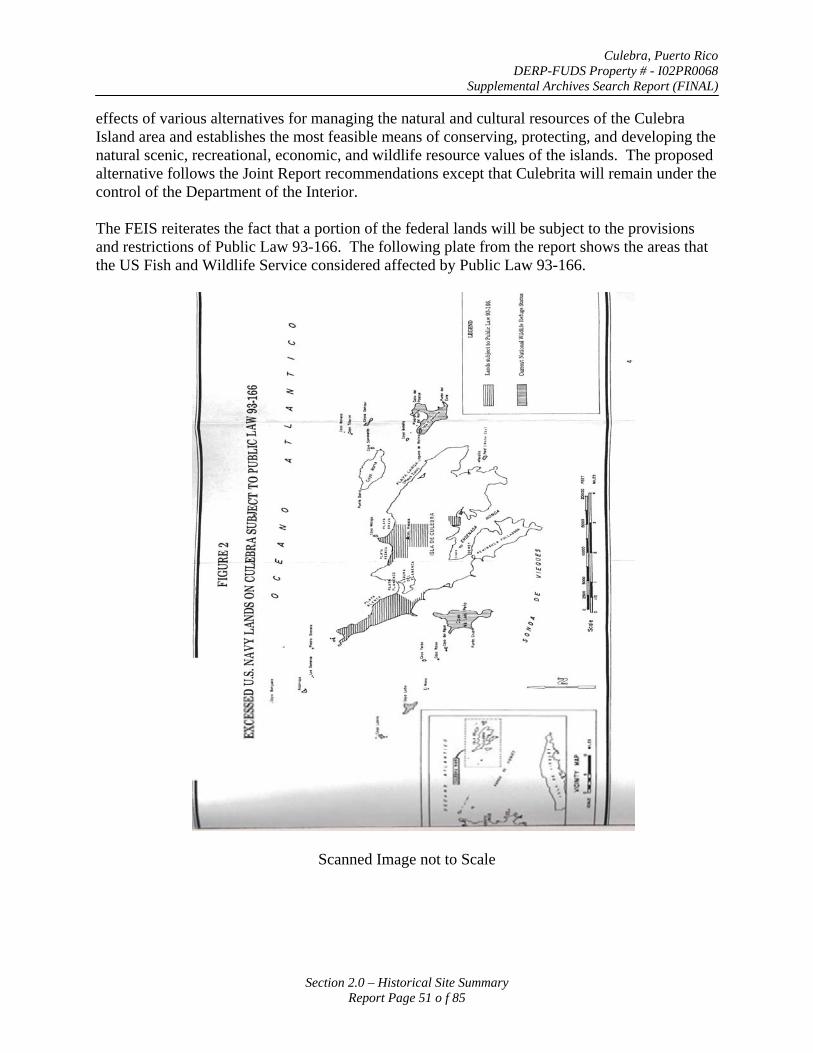
Culebra, Puerto Rico DERP-FUDS Property # - I02PR0068
Supplemental Archives Search Report (FINAL)
effects of various alternatives for managing the natural and cultural resources of the Culebra Island area and establishes the most feasible means of conserving, protecting, and developing the natural scenic, recreational, economic, and wildlife resource values of the islands. The proposed alternative follows the Joint Report recommendations except that Culebrita will remain under the control of the Department of the Interior.
The FEIS reiterates the fact that a portion of the federal lands will be subject to the provisions and restrictions of Public Law 93-166. The following plate from the report shows the areas that the US Fish and Wildlife Service considered affected by Public Law 93-166.
Scanned Image not to Scale
Section 2.0 – Historical Site Summary Report Page 51 o f 85
Culebra, Puerto Rico DERP-FUDS Property # - I02PR0068
Supplemental Archives Search Report (FINAL)
01 February 198252
A record of Decision in accordance with the Environmental Impact Statement is signed by Secretary Watt of the Department of Interior.
14 June 198253
The Director, FWS forwarded original of deed to Department of Interior Secretary to convey 935.98 acres of land on Culebra to the Commonwealth of Puerto Rico. The GSA had assigned the property to the Secretary for conveyance by letter dated 30 April 1982. Contained in the text of the deed and within a Cooperative Management Agreement for the Conversation and Development of Natural Resources o the Island of Culebra are restrictive covenants and conditions of transfer that meet the requirements of the disposing agency (Navy) and those that are required by law and by Executive Orders pertaining to the present and future use of the property. As a provision of the conveyance, the Department of Interior through the US Fish and Wildlife Service will monitor the use and development of this property.
20 December 198254
The Governor of Puerto Rico (Grantee) accepted a quitclaim deed from the US Secretary of Interior on 20 December 1982, which granted title to some 935.98 acres on the Island of Culebra.
The deed reserved for the US (1) all oil, gas, and mineral rights, (2) an easement for access to the Flamenco Point area, and (3) rights and privileges for using land in the former Camp Area. The deed also contains ten paragraphs of conditions that the Grantee acknowledged acceptance and understanding of. Paragraph 9 states that:
“The Grantee agrees in accordance with the provisions of Section 204 of Public Law 93-166, that portion of the subject property which has heretofore been used as a bombardment area by the United States Navy is hereby accepted by Grantee in its present condition and further agrees that the United States shall not in any manner be responsible for decontamination of such area, nor for the costs thereof, but the same is and shall be solely the responsibility of the Grantee. The Grantee hereby agrees to indemnify and save the Grantor harmless from any and all claims, demands, actions, liabilities, judgments, costs and attorney’s fees arising out of , claimed on account of or in any manner predicated upon loss or damage to property or injuries to or the death of any and all persons whatsoever, arising in any way from any person’s use of or presence on the subject property. Further, in accordance with said Act, the Grantee understands and agrees that Tracts 1b, 1c and 1k shall hereafter be utilized only for public park or public recreational purposes.
Legal descriptions of the all of the tracts of land conveyed by this quitclaim deed are provided below.
52 Same as Footnote 13 (RR-071204-142) 53 Same as Footnote 13 (RR-071204-142) 54 RR-072904-003
Section 2.0 – Historical Site Summary Report Page 52 o f 85
Culebra, Puerto Rico DERP-FUDS Property # - I02PR0068
Supplemental Archives Search Report (FINAL)
TRACT (1b)
BEGINNING at the most westerly corner of Lot 54, as shown on the “Plan of the Island of Culebra and its Division in Lots,” dated October 8, 1887; thence SOUTHEASTERLY, with the southwest boundary of Lots 54,55, 56, 57, 58, 59, 60, 61, and 62 to the south corner of said Lot 62, common to Lot 80; thence SOUTHWESTERLY, with an extension of the line separating Lots 62 and 80, to the mean high tide line on Bahia de Sardinas; thence NORTHWESTERLY, with the mean high tide line of Bahia de Sardinas, Vieques Sound, Bahia Tamarindo, Luis Pena Channel and the Atlantic Ocean to a point in Lot 91 on Flamenco Peninsula; thence N. 64° E., crossing said Lot 91 and Flamenco Peninsula, approximately 1,250 feet to the mean high tide line on the Atlantic Ocean, a point which bears N. 46° 40’ W., 5,390 feet from the north corner of Lot 54; thence SOUTHEASTERLY, with the mean high tide line of the Atlantic Ocean to an intersection with the extension of the line separating Lots 54 and 91; thence SOUTHWESTERLY, with said extension and with the line separating Lots 54 and 91 to the PLACE OF BEGINNING, containing 438.54 acres, more or less.
TRACT (1c)
BEGINNING at the southeast corner of Lot 77, as shown on the “Plan of the Island of Culebra and its Division in Lots,” dated October 8, 1887; thence NORTHWESTERLY, with the northeast boundary of Lots 77, 30, 29, 16, 78, 4 and 37, to the northwest corner of Lot 37; thence NORTHERLY, with an extension of the west boundary of Lot 37, to the south boundary of the Salvage Zone on the Atlantic Ocean, said south boundary being 20 meters distant from the mean high water tide line of the Atlantic Ocean; thence WESTERLY, with said south boundary of the Salvage Zone, as it meanders with Playa Brava, Point Resaca and Playa Resaca, to an intersection with a northerly extension of the east boundary of Lot 45; thence SOUTHERLY, with said extension of the east boundary of Lot 45, to the east corner of Lot 50, common to the northeast corner of Lot 45; thence NORTHWESTLY, with the north boundary of Lot 50, 638 meters to a point; hence N. 24° 00’ 00” E., approximately 70 meters to the mean high tide line on the Atlantic Ocean; thence EASTERLY and SOUTHEASTERLY, with said mean high tide line, to an intersection with the extension of the south boundary of Lot 77; thence WESTERLY, with said extension to the PLACE OF BEGINNING, containing 96.97 acres, more or less.
TRACT (1g)
BEGINNING at the northwest corner of Lot 73, as shown on the “Plan of the Island of Culebra and its Division in Lots,” dated October 8, 1887, said corner being located West, 94 meters from the corner common to Lots 72 and 73; thence SOUTHEASTERLY, with the west and south boundaries of Lots 73, 10, 22, 74, 75 and 23, to the southwest corner of Lot 76; thence SOUTHEASTERLY, with an extension of the line separating Lots 23 and 76, to the mean high tide line on the Caribbean Sea and Ensenada Honda to an intersection with an extension of the northwest boundary of Lot 73; thence EAST, with
Section 2.0 – Historical Site Summary Report Page 53 o f 85
Culebra, Puerto Rico DERP-FUDS Property # - I02PR0068
Supplemental Archives Search Report (FINAL)
said extension of the northwest boundary of Lot 73 to the PLACE OF BEGINNING, containing 31.09 acres, more or less.
TRACT (1h)
A part of Lot 73, as shown on the “Plan of the Island of Culebra and its Division in Lots,” dated October 8, 1887, situate in the Ward of Fraile near the south coast of Culebra Island, being more particularly described as follows:
BEGINNING at a point on the beach one hundred and fifteen (115) feet, eight (8) inches and forty (40) degrees West of North of the center of the gun mount for the six (6) pounder gun, now or formerly located on the western side of said Lot No. 73; thence two hundred and fifty (25) feet, forty (40) degrees North of East; thence three hundred (300) feet, forty (40) degrees East of South; thence one hundred and nineteen (119) feet, forty (40) degrees South of West to the beach and thence along the beach in a westerly direction to the POINT OF BEGINNING, containing 1.25 acres, more or less.
TRACT (1i)
A part of Lot 73, as shown on the “Plan of the Island of Culebra and its Division in Lots,” dated October 8, 1887, situation in the Ward of Fraile near the south cost of Culebra Island, being more particularly described as follows:
BEGINNING as a point one hundred and eleven (111) feet, nine (9) inches, four (4) degrees and thirty (30) minutes South of West, and one hundred and sixty-four (164) feet, four (4) degrees and thirty (30) minutes West of North of the center of the gun mount for the five (5) inch gun, now or formerly located on the western side of said Lot No. 73; thence three hundred and twenty-eight (328) feet, four (4) degrees and thirty (30) minutes East of South; thence three hundred and twenty-eight (328) feet, four (4) degrees and thirty (30) minutes North of East; thence three hundred and twenty-eight (328) feet, four (4) degrees and thirty (30) minutes West of North; thence three hundred and twenty-eight (328) feet, four (4) degrees and thirty (30) minutes South of West to the POINT OF BEGINNING, containing 2.50 acres, more or less.
TRACT (1k)
All of Lots 85, 86, 87 and those lands shown as “PUEBLO” and “Terrenos del Ramo de Guerro” as each are shown on the “Plan of the Island of Culebra and it’s Division in Lots,” dated October 8, 1887, and all more particularly described as follows:
BEGINNING at the corner common to Lots 85, 80 and 62; thence NORTHWESTERLY, with the west boundary of Lot 85 common to Lots 62 and 61 to the corner common to Lots 85, 61, 60, 49 and 86; thence EASTERLY, with the north boundary of Lot 86 common to Lots 49, 41, 38 and 70 to the south corner of said Lot 70; thence NORTHEASTERLY, with part of the west boundary of “Terreno del Ramo de Guerra,” common to Lot 70 and with the north boundary of “PUEBLO” common to Lot 70, to the
Section 2.0 – Historical Site Summary Report Page 54 o f 85
Culebra, Puerto Rico DERP-FUDS Property # - I02PR0068
Supplemental Archives Search Report (FINAL)
northeast corner of “PUEBLO”; thence SOUTHEASTERLY, with the east boundary of “PUEBLO” common to Lot 71, to the mean high tide line on Ensenada Honda; thence WESTERLY and SOUTHERLY, with the mean high tide line on Ensenada Honda to an intersection with the extension of the line separating Lots 62 and 80; thence SOUTHWESTERLY, with said extension of the line separating Lots 62 and 80 to the PLACE OF BEGINNING, containing 109.48 acres, more or less.
TRACT (1m)
BEGINNING at the northwest corner of Lot 63, according to the “Plan of the Island of Culebra and its Division in Lots,” dated October 8, 1887, a corner common to Lot 80 lying near Playa de Sardinas or Bahia de Sardinas; thence SOUTHESTERLY, wit the southwest line of Lots 63, 64, 65, 66, 67, 68 and 69, to the south corner of Lot 69; thence NORTHEASTERLY, with the line separating Lots 69 and 92, to the northeast corner of Lot 69; thence WESTERLY, NORTHERLY and NORTHWESTERLY, with the northeasterly line of Lots 69, 68, 67, 66, 65, 64 and 63, to the north corner of Lot 63 common to Lot 80; thence NORTHEASTERLY, with an extension of the line separating Lots 63 and 80, to the mean high tide line on Ensenada Honda; thence SOUTHEASTERLY, with said mean high tide line on Ensenada Honda, to Punta de Soldado; thence NORTHWESTERLY, with the mean low tide line on Vieques Sound, to an intersection with an extension of the line separating Lots 63 and 80; thence NORTHEASTERLY, with said extension of the line separating Lots 63 and 80, to the PLACE OF BEGINNING, containing 248.35 acres, more or less.
TRACT (1n)
A part in Lot 64, as shown on the “Plan of the Island of Culebra and its Division in Lots,” dated October 8, 1887, situate in the Ward of Playa Sardinas II on the southwestern part of Culebra Island, being more particularly described as follows:
BEGINNING at a point one hundred and sixty-four (164) feet, thirty-five (35) degrees North of East and one hundred and fourteen (114) feet, thirty-five (35) degrees West of North of the center of the gun mount for the five (5) inch gun, now or formerly located on the western side of said Lot No. 63; thence three hundred and twenty-eight (328) feet, thirty-five (35) degrees South of West; thence three hundred and twenty-eight (328) feet, thirty-five (35) degrees East of South; thence three hundred and twenty-eight (328) feet, thirty-five (35) degrees North of East and thence; three hundred and twenty-eight (328) feet, thirty-five (35) degrees West of North to the POINT OF BEGINNING, containing 2.47 acres, more or less.
TRACT (1p)
A part of Lot 62, as shown on the “Plan of the Island of Culebra and its Division in Lots,” dated October 8, 1887, situate in the Ward of Playa Sardinas on the southwestern part of Culebra Island, being more particularly described as follows:
Section 2.0 – Historical Site Summary Report Page 55 o f 85
Culebra, Puerto Rico DERP-FUDS Property # - I02PR0068
Supplemental Archives Search Report (FINAL)
BEGINNNING at a point on the beach thirty-seven (37) feet east and three hundred and seventy (370) feet south of the center of the gun mount for the four (4) inch gun, now or formerly located on the eastern side of said Lot No. 62, thence North four hundred and fifty-three (453) feet; thence West three hundred (300) feet; thence thirty-two (32) degrees West of South one thousand and thirty (1030) feet to the beach and thence along the beach in an easterly direction to the POINT OF BEGINNING, containing 5.33 acres, more or less.
21 January 198355
This memorandum indicates that EPA published a Proposed National Priorities List of 418 Hazardous Waste Sites under the Superfund Law dated 20 December 1982. The Commonwealth of Puerto Rico was unhappy that the Flamingo Bay area on Culebra was not included. The Navy confirmed its position that the federal government was prohibited from expending funds for decontamination of the bombardment area on the island of Culebra. The Navy believed that Public Law 93-166 would govern notwithstanding the Comprehensive Environmental Response, Compensation, and Liability Act.
In an 18 February 1983 memorandum responding to the issues brought up in the 21 January 1983 memorandum above, the Naval Facilities Engineering Command indicates that it supports the opinion expressed in the original memo. They further indicate that the CNO (OP-45) and JAG concurred with that interpretation.
26 January 1981 In the late 1970's, Puerto Rico alleged that Navy had "clandestinely" transferred training operations from Culebra to Vieques, contrary to the "clear command" of the Milcon Acts of the early 1970's. The District Court of Puerto Rico found that any evidence of an alleged "transfer" from Culebra to Vieques was "far from clear," and rejected the Commonwealth's claim. Romero-Barcelo v. Brown, 478 F. Supp. 646 at 699 (D. P.R. 1979). The Court of Appeals for the First Circuit affirmed, ruling that Puerto Rico had failed to state a claim upon which relief could be granted. Romero-Barcelo v. Brown, 643 F.2d 835 at 845 (1st Cir. 1981).
24 June 198356
Memorandum containing 10 June 1983 letter form GSA to the Puerto Rican Commission for the Transfer of Lands and Other Federal Properties indicated that the proposed sale of the 32 acres (Parcels A and B) of the former Navy Airfield Area had been cleared by the appropriate congressional committees. Commonwealth was authorized to assume possession on 11 June 1983. GSA counsel was preparing the quitclaim deed, which would included the appropriate terms and conditions contained in the Offer to Purchase.
55 RR-071204-193 56 RR-073004-015
Section 2.0 – Historical Site Summary Report Page 56 o f 85
Culebra, Puerto Rico DERP-FUDS Property # - I02PR0068
Supplemental Archives Search Report (FINAL)
21 May 198757
The Commonwealth of Puerto Rico Department of Justice (PR-DOJ) responded to a request for a legal opinion from the Puerto Rico Department of Natural Resources concerning the powers and obligations of the Board of Directors of the Culebra Conservation an Development Authority (CCDA). Among the various duties and powers of the CCDA to protect the environment was the responsibility “to mend the damage inflicted”. Listed among the damages that were to be eliminated not later than January 1, 1983 was that the CCDA was to take necessary steps to remove explosive devices from the areas used for shooting practice by the US Navy.
57 HQ-093004-001
Section 2.0 – Historical Site Summary Report Page 57 o f 85
Culebra, Puerto Rico DERP-FUDS Property #-I02PR0068
Supplemental Archives Search Report (FINAL)
Section 3.0 - Historical US Marine Corps Activity
3.1 GENERAL INFORMATION
This section shows a chronology of US Marine Corps activities involving the island of Culebra. The notations contained in the footnotes describe a document that was used for information. Copies of all of the referenced documents are included in Appendix B. Details of the documents can be found in the spreadsheets in Appendix A. The document designation, which is a unique identifier, can be found in the “Documents” column. The document designation is made up of three parts. The first two letters of the designation refer to the repository or source from which the document was obtained. The next six numbers are the date when the document was copied. The last three numbers indicate the sequence from that particular day. For example, a document identified as “RR-061404-121” would have been the 121st document copied on 14 June 2004 at Roosevelt Roads.
Appendix C contains a series of sketches that were drawn by the Marine Corps during there initial investigations of Culebra for large scale operations. They provide a good historic perspective of the land. Appendix D contains historical maps that were used in the development of the details of this report. Appendix E contains photographs from different periods of use. Report Plate No. 3 shows photographs of the various areas during the period of Marine Corps use.
Report Plate No. 2 depicts pertinent features of Marine Corps operations including among other items camps, ranges, and hill locations
3.2 US MARINE CORP ACTIVITY OVERVIEW
The Spanish-American War was a turning point in Marine Corps history, and in the relationship between the Navy and the Marines. Prior to the war, Marines were primarily used as a shipboard security force, as a source of gunners in secondary batteries aboard warships, and as light infantry in landing parties. At the end of the war, the United States (US) assumed major new defense commitments in the Caribbean and Pacific. On its southern approaches, the US looked to defend Cuba, Puerto Rico, and a potential new canal across the isthmus of Panama from attack by the battle fleets of European powers, particularly that of Germany. It fell to the General Board to determine the best employment of the Navy in the defense of America and its far-flung possessions. The General Board was an advisory panel of nine officers formed in 1900 to advise the Secretary of the Navy on questions relating to the efficient preparation of the fleet in case of war and for the naval defense of the coast. In response to the General Board’s direction in 1900, the Marine Corps established a battalion for seizing and defending advanced naval bases in forward operating areas.58
The Marine Corps fought hard for its existence in the early 20th Century, at times turning to the Congress to preserve the Corps with statutory protections. Such was the case with the Naval Appropriations Act of 1909 which returned Marines guards to sea after they had been removed
58 Excerpt from website exwar.org/Htm/8000PopC1.htm
Section 3.0 – Historical US Marine Activity Report Page 58 of 85
Culebra, Puerto Rico DERP-FUDS Property #-I02PR0068
Supplemental Archives Search Report (FINAL)
from Navy vessels by an Executive Order from President Roosevelt. By 1915, the 12th Commandant of the Marine Corps, Major General George Barnett, realized that the future health of the Marine Corps depended not on its old roles and functions, but in new, undeveloped capabilities essential for the operation of the modern fleet. It was an unpopular decision to place less emphasis on traditional roles, but General Barnett began developing an Advanced Base Force to protect the overseas coaling stations needed by the Navy for their steam propulsion systems. Eventually, as a result of the leadership of the 13th and 15th Commandants of the Marine Corps, Major Generals John Lejeune and Ben Fuller, the Advanced Base Force evolved from being a purely defensive force into the Fleet Marine Force, which had the ability to conduct offensive amphibious operations to seize forward bases in support of Fleet operations. This fundamental change redefined the Corps and created the amphibious identity that still distinguishes it.59
From the early 1900’s and continuing through the late 1950’s, the Marine Corps used the Island of Culebra extensively for amphibious landings and ground maneuver training. During this period, the Marines landed at numerous locations on the island, established boat landings, set up camps, and conducted firing exercises on land targets and water targets. These landings and exercises occurred at such locations as Seine Bay, Flamingo Bay, Soldado Point, Mosquito Bay, Firewood Bay, and Great Harbor.60
3.3 CHRONOLOGY OF MARINE CORPS RELATED ACTIVITIES
1901 In 1901 the US military arrived in Culebra to establish an area for the military to use as a firing range and to hold Marine exercises. The military set up a base where the Culebrans had established the town of San Ildefonso. The town was moved to the present location of Culebra City and was renamed Dewey after the famous Admiral, George Dewey.61 The Marine advanced base battalion first deployed to Culebra in 1902 to exercise their new capabilities.62
Undated (Apparently early 1900s) 63
Intelligence Report Number 1 on Culebra is an undated document that has a good description of physical conditions on Culebra.
8-23 November 1913 Report of a Reconnaissance Made of Culebra Island and Adjacent Cays64
This report was developed in anticipation of proposed Advance Base Maneuvers in January 1914. The report provides significant detail about the physical conditions existing on Culebra, particularly the old Naval Station and roadways. Sketches were made of the island from various vantages points. Copies of these are included in Appendix C of this report. Of particular note, although the report contains descriptions of the proposed gun batteries, there is no information
59 http://www.usmc.mil/cmcarticles 60 CP-081104-200, DC-061604-100, DC-061604-111, DC-090204-100 61 Excerpt from website Culebra-island.com/CulebraIsland/History.htm 62 Excerpt from website exwar.org/Htm/8000PopC2.htm 63 DC-111604-108 64 DC-111604-101
Section 3.0 – Historical US Marine Activity Report Page 59 of 85

Culebra, Puerto Rico DERP-FUDS Property #-I02PR0068
Supplemental Archives Search Report (FINAL)
presented concerning any guns existing at that time on Culebra. The Navy had acquired the tracts of land for the batteries at the beginning of its occupation but no record has been found indicating that guns were ever installed. A map of the old Naval base layout is included in the 1914 folder of Appendix D.
1914 Expedition
In 1914 the Marines participated in an Advance Base Expedition during which they established an encampment on Culebra to protect fleet elements that had gathered in the Great Harbor. The Marines were accompanied by a fleet of warships that anchored in Target Bay.
16 February 191465
Report of Advance Base Expedition, Culebra, January 1914 This exercise was undertaken to provide the Marines an opportunity to establish an Advance Base for the protection of fleet elements in the Great Harbor of Culebra.
As part of this exercise a 3-inch battery was established on Point Vaca in addition to a mine casement and plotting board station. A 5-inch battery had also been constructed on Point Soldado.
23 January 191466
In the Report of Chief Observer on Landing Operations by the fleet on 21 January 1914, he stated that,
“Attention is invited to the very complete outfit of the Advance Base Detachment and to the great variety of military work required of officers and men. Rifle pits and bomb proof shelters have been dug, 3” and 5” guns have been landed in transports, dragged up steep declivities and installed ready for firing. Methods for both direct and indirect fire have been perfected for both fixed and field artillery. Mine fields have been laid, and an aviation camp has been established. The problems of supply to numerous outlying camps have been well worked out in waterless country almost devoid of supplies. A very complete system of communications, including 24 miles of telephone system, a radio plant, and night and day heliograph system, and flag semaphore system have been established. “
1922 Exercises
9 January to 25 April 1922 67
Report of Advance Base Force Operating with Control Force, US Atlantic Fleet at Guantanamo Bay Cuba and Culebra PR from CO, Expeditionary Detachment, USMC. Landing was made at Seine Bay and Command was set up at the old Naval Station, including 155mm gun and 10-ton tractor. The force was transported on the USS Florida. Phones, field and buzzer, were laid with only buzzer wire on ground and precaution taken by paralleling and duplicating, running along
65 DC-111604-110 66 DC-111604-109 67 DC-061604-100
Section 3.0 – Historical US Marine Activity Report Page 60 of 85
Culebra, Puerto Rico DERP-FUDS Property #-I02PR0068
Supplemental Archives Search Report (FINAL)
fences, etc., to prevent interruption. This was absolutely necessary since Culebra is a cattle country. Comment: "It was unfortunate that there was no Air Force with the expedition, their presence would have been invaluable."
Guns available, and others desirable, for the expedition: 7" Naval gun on caterpillar mount, 8" English howitzer, 155mm GPF and new 155mm gun, 75mm French field gun and new 75mm field gun, 75mm mountain howitzer (not yet manufactured), 3" Naval gun, anti-aircraft, 37mm gun. The firing at Culebra was from the crest of 103 meter hill at Fungy Bowl, The Washer and The Right Twin. In order that the training may be continuous and proper opportunity given for target practice and fire problems for both the 155 and the 75 batteries, it is recommended that an Artillery Force be sent to Guantanamo each winter, and if possible, to Culebra. The force should consist of not less than two 155's and a battery of 75's, and if practicable, one battery of 155's and two of 75's. Farther into the document, from the HQ Blue Forces, Culebra, 19 Mar 22, the following are described: District No.1, Flamingo Bay, approach through valley NW from head of bay to valley bottom; District No. 2, North entrance Seine, westerly beaches to NW point; District No. 3, Dewey and Seine, Southerly beaches to Soldado Pt, Demerol and Conch Bays; District No. 4, Mosquito and Mangrove inlet.
1924 Maneuvers
7 November 1923 and 7 January 192468
Two leases between Jesus Nieves and the US Govt: 7 Nov 1923 - for pasture land called "Mequise" just north of residence of Jesus Nieves comprising about 70 acres also pasture land comprising old Navy target range (about 70 acres), also such hills, the property as may be selected by the Marine and Naval Forces either for artillery, aviation and infantry positions. 7 Jan 1924 - for pasture land called "Camp Delicias" just east of pasture land comprising old Navy target range and consisting of about 100 acres to be used exclusively for the following purposes: to be occupied by troops as camp grounds, aviation fields, athletic fields, together with their riding and draft animals, stores, guns, vehicles of all kinds.
January 1924 During the Winter Maneuvers of 1924, there were as many as 3,400 Marines encamped ashore Culebra.69 In addition to artillery fire, the exercises also involved the use of anti-aircraft defense,70 the release of smokes and the use of tear gas.71
During an exercise in January 1924, the Marine Corps Anti-Aircraft Company was ordered to provide defense and protection to the entrance to Great Harbor and ordered to fire harassing fire on enemy troops and boats at Seine and Skeet and on hostile troops that gain to the interior. Standing barrages were laid down when ordered at Dewey and in East and West Valleys. The
68 DC-061604-105 69 DC-061604-107 70 DC-061604-110 71 DC-061604-106, DC-090204-102
Section 3.0 – Historical US Marine Activity Report Page 61 of 85
Culebra, Puerto Rico DERP-FUDS Property #-I02PR0068
Supplemental Archives Search Report (FINAL)
orders also included direction to establish ammunition dumps for both calibers at location: 310.35-204.30, 313.00-203.00.72
Another landing exercise and ground maneuver training in January 1924 involved the Marine Expeditionary Force landing between Tamarindo Bay, south of Stream Point, and occupying the ridge of hills between Flamingo Lagoon and Point Soldado and Snug Bay, inclusive. The Force was equipped with 155mm GPF, 75mm guns, seaplanes and the objective was to capture S.W. Cay, the line of hills running close to the beach between Firewood Bay and Point Soldado, and to secure the area northwest of Great Harbor.73
On 14 January 1924, the 1st Company, 10th Regiment, Marine Corps Expeditionary Force, conducted a firing problem using as a target Mono Cay, a tiny island off the western coast of Culebra. Additional firing problems were conducted by the 13th Company on the eastern end of the island using as a target a portion of the reef at the entrance of Weather Channel and a small island to the right of the bay. During these exercises from January to February 1924, other companies and battalions of the Expeditionary Force conducted firing problems from a position at Firewood Bay using Mono Cay and designated portions of S.W. Cay as targets; from a position at Mosquito Bay at a target raft anchored 12000 yards off shore; and from a position at Camp Lejeune at a kite target 3500 yards distant. Munitions used were 75mm guns, 155mm guns, and shrapnel.74 During this same exercise, orders were provided to establish ammunition dumps at location 313.7-202.6 – 309.3-202.7 and 307.7-205.1.
Documentation was uncovered relative to the use of CWM during the Marine Corps exercises. During exercises in 1924, the Gas Company of the Chemical Warfare Troops was prepared to lay a cloud of lachrimous gas on the beach at the time the enemy reached it and to lay further gas clouds at favorable times as the enemy advanced inland.75 If the enemy were to attempt a landing at Mosquito Bay, any place from Seine Bay N.W. to Firewood Bay, etc., the Chemical Warfare Troops could made the decision to use gas or smoke to harass the enemy.76 Also during these exercises, a concentration of tear gas was put over the camp and all men had their gas masks on in about 15 seconds.77 Also in this document, it was reported that one motorboat with men of the Gas Company would patrol probable landing places. This boat would be used to harass the enemy if they attempted to land. The boat would carry 150 pounds of CN at all times. Men from the Gas Company would be positioned at locations 309.3-202.7 and 307.7-205.1 to release gas clouds if the enemy attempted to land. Enough smoke and gas would be kept in readiness along ridges of Hills 310, 164 and 450 and one man from the Gas Company would be stationed at Hills 164, 310 and 450 to assist the Infantry Commander.
72 DC-061604-109 73 DC-061604-104 74 DC-061604-110 75 DC-061604-111 76 DC-061604-103 77 DC-061604-110
Section 3.0 – Historical US Marine Activity Report Page 62 of 85
Culebra, Puerto Rico DERP-FUDS Property #-I02PR0068
Supplemental Archives Search Report (FINAL)
192478
The report, Estimate of the Black's Situation by COL Dion Williams, USMC, Commanding, Marine Corps Expeditionary (20 Jan 1924-Force, Culebra, PR), covers the forces strength and equipment (about 1600 Marines with advanced equipment). It notes that on 20 January the entire Black Culebra Force, ships and troops, is at Culebra, with the exception of 2000 mines which are at the Black Naval Base at Aux Cayes, 500 miles away. Orders had been given to mine the eastern and northern entrances to Vieques Sound and for all mine fields to be in position by noon, 25 January. A channel allowing ingress and egress for vessels to Vieques Sound and another channel to give ingress and egress for vessels to Great Harbor were also a part of the Mine Plan. By Operations Order No. 1-24 the batteries of the shore forces must be so disposed as to fulfill the following conditions: Protect all of the mine fields at the entrances to Vieques Sound and entrances to Lee and South Channels; fire on ships coming within range off the north or east shore of Culebra or upon ships approaching any of the mine fields; etc. The report stated that the Gas Company will be prepared to lay a cloud of lachrimous gas on the beach at the time the enemy reaches it, and to lay further gas clouds at favorable times as the enemy advances inland. One of the minor decisions was: "To employ non-lethal gas against the enemy landing forces if they should attempt a landing on the Lee side of Culebra Island."
21 January 192479
Chemical Warfare Annex, Annex No. 5 to Field Order No. 4, M.C.E.F., Chemical Warfare Troops, Culebra, PR. This company will be used to gas beaches SNUG to TAN inclusive and SKEET. Also lines of approach inland." The report discusses harassing the enemy if they attempt to land at Mosquito Bay, any place from Seine Bay N.W. to Firewood Bay, etc., and whether or not they will use gas or smoke if the enemy succeeds in landing.
Also attached is Annex 6, Anti Aircraft Defense, which discusses protecting the entrance to Great Harbor, Seine and Skeet, Dewey, in East Valley, West Valley, etc. Two anti-aircraft guns will be placed 100 yards east of Main Street, San Ildefonso, in bluff overlooking waterfront. Two guns of the second section will be placed in the dock at the foot of Main Street.
24 January 192480
Artillery Annex, Annex No. 2 to Field Order No. 4, M.C.E.F., 10th Regiment, Culebra, PR. The report states “This Force holds Culebra Island as an Advanced Base for operations of the Black Fleet, and will protect the mine fields by gun fire and will prevent a landing on Culebra Island." It goes on to say that the Anti-Aircraft Company will provide defense and protect the entrance to Great Harbor, will fire harassing fire on enemy troops and boats at Seine and Skeet and on hostile troops that gain to the interior. Standing barrages will be laid down when ordered at Dewey and in East and West Valleys. Ammunition dumps will be established for ammo of both calibers at: 310.35-204.30, 313.00-203.00.
78 DC-061604-111 79 DC-061604-103 80 DC-061604-109
Section 3.0 – Historical US Marine Activity Report Page 63 of 85
Culebra, Puerto Rico DERP-FUDS Property #-I02PR0068
Supplemental Archives Search Report (FINAL)
24 January 192481
Administrative Order No. 8 to accompany Field Order No. 4, M.C.E.F., Culebra, PR, provides administrative-type details in support of the expedition.
27 January 192482
Report from Commander Train, Scouting Fleet, USS Antares Flagship (at anchor Culebra, Puerto Rico), to Commander, Fleet Base Force, subject: Establishment of Fleet Base at Culebra, Vieques Region, Winter Maneuvers, 1924. Report states currently 1700 Marines on Culebra and upon the arrival of the Fleet at Culebra, there will be approx 3400 Marines encamped ashore. About 22 Feb 1924 the first contingent will leave for the U.S. and it is likely that all the Marines will have left Culebra by the first days of March 1924. For the most part the report discusses requirements of the Marines, such as water, food, lighters (barges), etc. There were landings established at Seine Bay (7 runways), Great Harbor (at the site of the old Naval Station at Ildefonso), Dewey (small boat landing at the west of Great Harbor), Canteen (small boat landing at the head of Great Harbor), aviation landing (small pontoon landing in vicinity of Maxine Aviation camp, north shore of Great Harbor), Camp Williams Landing (in vicinity of 10th Regiment Hq, north shore of Great Harbor), and Mosenito Bay Landing (small boat landing).
28 January 192483
Report, Estimate of the Situation, Fleet Problem #4--1924, submitted by BG Eli K. Cole, Commanding, Marine Corps Expeditionary Force, Mission: To Capture Enemy Base, Culebra Island. Includes description of the topography of the Island, enemy forces, artillery, Naval support, section on decision for landing operations, and a copy of Field Orders No. 6, dated 28 Jan 1924 which details landing operations. The "enemy" forces were equipped with 75mm, 155mm, GPF, 75mm AA, machine gun tank, 37mm, 8" and 6" naval guns. The Marine Expeditionary Force was equipped with 155mm GPF, 75mm guns, seaplanes. Objectives were to capture S.W. Cay, line of hills running close to the beach between Firewood Bay and Point Soldado, and to secure the area northwest of Great Harbor. Decision was made to make the main landing between Tamarindo Bay (south of Stream Point) and to occupy the ridge of hills between Flamingo Lagoon and Point Soldado and Snug Bay, inclusive.
29 January 192484
Administrative Order No. 9, Hq, M.C.E.F., US Fleet, USS Henders, provides administrative-type details of support to Culebra forces.
1 February 192485
Preliminary report of operations, US Fleet, Problem No. 4 - Black - Defense of Culebra Island by Shore Forces, M.C.E.F. Report includes a small 2-page map of the Island (map is dated January 1914). The Mission: To defend the mine fields and defend enemy landing. The report covers such details as the forces necessary for the operation, supplies, etc. The Gas Company had a supply of lachrimous gas. On page 8, Para 19, Information System, third subparagraph: "The
81 DC-061604-112 82 DC-061604-107 83 DC-061604-104 84 DC-061604-101 85 DC-061604-106
Section 3.0 – Historical US Marine Activity Report Page 64 of 85
Culebra, Puerto Rico DERP-FUDS Property #-I02PR0068
Supplemental Archives Search Report (FINAL)
Air Force instituted a system of search patrols whereby a circle 150 miles from Culebra was placed under observation at five o'clock each evening in the probable direction of advance. In this way the enemy ships would be within sight of our planes, if at five o'clock they were close enough to strike during that night." But, on page 9 under Air Activities it states: "The Aviation Division manned by Marine personnel which is a part of this force…"
1 February 192486 87
The historical map accompanying these reports was photographed at the National Archives. Those photographs are included in Appendix E, Section 1924.
The report indicates that significant portions of the island were leased for these exercises. Those properties are shown on the historic map. Camp Sites Nos. 1, 2, and 3 were located on the property of the Vieques Sugar Co. on the eastern end of the island. Camp Sites 4, 5, 6, 7, and 8 were on the property of Mr. Jesus Nieves, north of Dewey. Mr. A. Lugo leased about 1,500 acres north of the Vieques Sugar Co. for gun emplacements and other possible camp sites. NE Cay was leased from Mrs. Alma Hasselroth, widow of Lieutenant Hasselroth, US Navy deceased, for the purpose of erecting targets for artillery practice.
Summary of Events, Marine Corps Expeditionary Force, Culebra, PR, from January 2, 1924 to February 1, 1924. Provides a daily accounting of the expeditionary force, from USS Chaumont sailing from Quantico, Va., through anchoring at Great Harbor, Culebra, PR, where the old Naval Station was selected as the camp site for the Force Headquarters, on 7 Jan 1924. Also on that date the USS Sirius docked at Great Harbor.
On 14 Jan 1924, the 1st Company, 10th Regiment, conducted a firing problem using as target Mono Cay, a tiny island off the western coast. This was the first firing by the Force on Culebra Island. Additional firing problems were conducted on the eastern end of the island using as a target a portion of the reef at the entrance of Weather Channel and small island to the right of the bay by 13th Co; on 16 Jan 24, 55 rounds were fired; on 18 Jan 24 the 1st Battery (75's) conducted a firing problem from a position at Firewood Bay using Mono Cay and designated portions of S.W. Cay as targets - the results of the 6th Battery were excellent, while the firing of the 13th Co was erratic throughout - A total of 270 rounds was fired by the Battalion.
On 21 Jan 24 the 1st and 6th Co.'s conducted a firing problem from Firewood Bay, using designated portion of S.W. Cay as target. A total of 236 rounds were fired. The 9th Co (155's) from a position at Mosquito Bay fired 32 rounds at a target raft anchored 12000 yards off shore; on 22 Jan 24 the 13th Co (75's) conducted a firing problem, 154 rounds were fired and the 11th Co (155's) fired 32 rounds -- no mention of targets or firing positions for these exercises on 22 Jan 24; on 23 Jan 27 the Anti-Aircraft Co from a position at Camp Lejeune conducted a firing problem at a kite target 3500 yards distant, 1500 feet elevation - the exercise was experimental firing for testing plotting board for direct and indirect fire -- a total of 39 rounds were fired; a concentration of tear gas was put over the camp on 24 Jan 1924 and all men had gas masks on in about 15 seconds.
86 DC-061604-110 87 DC-090204-102 (Correspondence dated 24 Mar24 but contains same daily account.)
Section 3.0 – Historical US Marine Activity Report Page 65 of 85
Culebra, Puerto Rico DERP-FUDS Property #-I02PR0068
Supplemental Archives Search Report (FINAL)
Also on 24 Jan 24 the 10th Regiment conducted a firing problem. The 6th Battery (75's) took up a position near Firewood Bay and Mono Cay, a tiny island 3500 meters east, was designated as the target representing an enemy ship. A total of 49 rounds of shrapnel were fired. A new target was designated on the northern portion of S.W. Cay, 1800 meters distant, as representing entrenching machine guns -- 45 rounds were expended on this target and the area was completely swept. The 11th Battery (155's) from a position at 309.1 - 204.4, fired 12 rounds at a rock 8000 meters west designated as a ship. Indirect fire was used in all problems. The 9th Battery conducted a firing problem on the eastern end of the island, using a triangular moving target at 12000 meters -- only 8 rounds were expended because of invisibility of the target.
On 1 Feb 24, Problem 4 was officially declared over. The Marine Corps Expeditionary Force, Culebra, P.R., having been joined by the Marine Corps Expeditionary Force, US Fleet, became a part of the latter Force.
Ammunition distribution locations for the Infantry were established at four positions: Outpost No. 1 at 309.1-203.3 and 308.0-205.3 Outpost No. 2 at 313.7-202.6 Eastern defensive area at 311.5-203.8 Western defensive area at 310.4-204.3.
Ammunition distribution locations for the Artillery were sited at two positions: Eastern defensive area at 313.0-203.0 Western defensive area at 310.5-204.3.
19 March 192488
Letter from Fleet Base Force to United States Fleet, subject: Culebra, Porto Rico, Temporary Fleet Base, Disposition of property, etc. Letter was in response to letter from US Fleet concerning views on Culebra as a base for the fleet. A number of pros and cons were presented and appears that Culebra and Vieques Sound would not offer suitable conditions for defense.
24 March 192489 90
Letter from Marine Barracks, Quantico, VA, to MG Commandant, USMC, subject: Report of Operations, Marine Corps Expeditionary Force, Culebra, P.R. The report covered winter maneuvers of the US Fleet at Panama and Culebra. The USS Sirius was loaded 11-12 Dec 23 with Marine Corps property in Norfolk, VA, for transporting to Culebra.
The report covered types of equipment transported to Culebra, facilities available at Culebra, such as Camp Sites for the Second Battalion, 10th Regiment at the eastern end of the Island (Camp Sites 1, 2 and 3) on land leased from Vieques Sugar Company. Camp Sites 4, 5, 6, 7 and 8 were sites of the Fifth and Tenth Regiments and Aviation Div on property leased from Mr. Jesus Nieves. Also on this property was the recreation field. Camp Site 9 was on the old Naval
88 DC-090204-101 89 DC-090204-102 90 DC-061604-110 (Correspondence dated 1 Feb 24 but contains same daily account.)
Section 3.0 – Historical US Marine Activity Report Page 66 of 85
Culebra, Puerto Rico DERP-FUDS Property #-I02PR0068
Supplemental Archives Search Report (FINAL)
Station. Gun emplacements for 2nd Battalion, Tenth Regiment are on land leased from Mr. A. Lugo and adjoins the Vieques Sugar Company property on the north. This property comprises approx 1500 acres.
N.E. Cay was leased from Mrs. Alma Hasselroth for the purpose of erecting targets for artillery practice. There were no details of these targets. The Navy land planes used the Recreation Field at the head of Great Harbor for their landing field. Because of the cross currents and enclosing hills, this field is considered dangerous, although no accidents occurred in spite of the large number of planes using the field daily. Also included in the report is a summary of events of the expeditionary force, from 2 Jan to 1 Feb 1924. Attached to this correspondence is Encl F, Op Order 2-24, Black Mine Plan "A" (Vieques Sound), Mission: To deny Vieques Sound east of Longitude 65 degrees - 30' W to Blue. Minor Decisions: To retain submarines in Great Harbor as a striking force by day and to deploy them to guard mine fields at night.
Areas to be Mined: Area I: A rectangular area one side of which is a line running from the eastern point of N.E. Cay to the northwest point of Palada Cay. Another side of the area is a line running from the eastern point of N.E. Cay to the northwest point of Ladrone Cay.
Area II: The area between Culebra Island and N.E. Cay beginning at a line running 210 degrees from the western end of N.E. Cay to Culebra Island and extending for 1 mile in a direction of 120 degrees.
Area III: An area bounded as follows: From the northern point of S.W. Cay 283 degrees for 5-1/2 miles, thence 103 degrees to the rocks off the northwest point of Culebra Island.
Area IV: A rectangular area enclosed as follows: From a point Latitude 18 degrees 20 minutes north, Longitude 65 degrees 29 minutes 30 seconds west. Ten degrees for 2 miles, thence 100 degrees for 1-1/2 miles thence 190 degrees for 2 miles thence to point of origin. Area V: The area between Culebra and Vieques Island and the lines running 13 degrees from the eastern end of Vieques Island and the line running 193 degrees from the southeast end of S.W. Cay.
Ground Mine Area: The area within the "V" in which anchorages are laid out on United States Anchorage Chart "C" (C & GS 915). Note: Channels through mine fields for own Forces as follows: Through Cactus Cay 1000 yards to the westward a channel on course 150 and 330, a 500 yard channel as shown in sketch attached herewith.
Annex No 5, Chemical Warfare Annex, Chemical Warfare Troops, specifies that this company will be used to gas beaches Snug to Tan inclusive and Skeet. Also lines of approach inland. One section of the Gas Co will be in position at 313.7 -202.6. This section will harass the enemy if they attempt to land at Mosquito Bay. The Infantry Commander will be consulted as to the advisability of using gas or smoke if the enemy succeeds in landing. The other section of the Gas Co will harass the enemy if they attempt to land at any place from Seine Bay N.W. to Firewood Bay. One motor boat with men of the Gas Co will patrol probable landing places. This boat will be used to harass the enemy if they attempt to land. 150 pounds of C.N. will be carried at all times on this boat. A position of 4 men of the Gas Co will be established at 309.3 -
Section 3.0 – Historical US Marine Activity Report Page 67 of 85
Culebra, Puerto Rico DERP-FUDS Property #-I02PR0068
Supplemental Archives Search Report (FINAL)
202.7 to release a gas cloud toward the enemy if they attempt to land at Seine Bay. A position of 4 men of the Gas Co will be established at 307.7 - 205.1 to release a gas cloud if they attempt to land at Firewood Bay. Enough smoke and gas will be kept in readiness along ridges of Hills 310- 164, and 450. One man form the Gas Co will be stationed at Hill 164, 310, 450 to assist Infantry Commander. Ammunition dumps will be established at 313.7 -202.6 - 309.3 - 202.7 -; and 307.7 - 205.1. The P.C. of the Gas Officer will be at Hill 310.
Annex No 6, Anti Aircraft Annex, Anti Aircraft Defense: The Anti-Aircraft Co will provide anti-aircraft defense and will protect the entrance to Great Harbor. It will fire harassing fire on troops in boats at Seine and Skeet and on troops in the interior. Standing barrages will be laid down, when ordered, at Dewey, in East Valley, West Valley and in pass through which Swell Bay San Ildefonso road leads to the west of the hill. Location of Guns: Two guns of first section will be placed 100 yards east of Main Street, San Ildefonso, in bluff looking over waterfront. Two guns of second section will be placed in the dock at the foot of Main Street. All guns will be echeloned in order to cover all points of the compass.
In addition to the anti-aircraft defense, the following land and water areas will be covered: Entrance to the channel, Mouth of Mosquito Bay, Inlet behind Roosevelt, Seine Bay, East Valley, West Valley, Dewey, Narrow valley between hills 204 and 191.
In addition to the above areas, the following area marked on the accompanying map will be covered with harassing fire: Hill Areas 325-200-310-650-204-108-191 and 203 (which are shown on Report Plate No. 2.)
21 May 192491
Letter from US Fleet, Base Force, Train Squadron One, USS Antares, Flagship, Southern Drill Grounds, to Chief of Naval Operations, subject: Report on Defenses of Culebra (Vieques Region Advance Base), made by Commander Train Scouting Fleet to Commander Fleet Base Force, ComTrain file 52-66 under date of 26 March, 1924; additional photograph to be attached thereto. Letter forwards a photograph showing a section of Seine Bay, Town of Dewey, Culebra, and Great Harbor. The photograph shows the seven boat landings in Seine Bay which were built by the Train for use of the Fleet for Winter Maneuvers 1924. Also as a postscript, added a photo showing Marine aviation camp at right, with Marine planes and motor boat at anchoring Great Harbor. The 5th Regiment Camp is at left and back. These photos are included in Appendix E, Section 1924.
Fleet Landing Exercises
No further organized training activities were carried out until 1934. The following list is a brief overview of Fleet Landing and other Division Exercises carried out by the US Navy and Marines.92 All Marine activities were carried out in conjunction with Naval gunfire operations against the Northwest Peninsula.
91 DC-090204-100 92 CP-111904-130
Section 3.0 – Historical US Marine Activity Report Page 68 of 85
Culebra, Puerto Rico DERP-FUDS Property #-I02PR0068
Supplemental Archives Search Report (FINAL)
Fleet Problem XV, 5-10 May 193493
Fleet Landing Exercise #1, 13-18 February 1935, Culebra, PR Fleet Landing Exercise #2, 4 January to 24 February 1936, Culebra, PR Fleet Landing Exercise #3, 30 January to 18 February 1937, San Clemente, CA Fleet Landing Exercise #4, 13 January to 15 March 1938, Culebra, PR Fleet Landing Exercise #5, 12 January to 19 March 1939, Culebra, PR Fleet Landing Exercise #6, 11 January to 15 March 1940, Culebra, PR94
Fleet Landing Exercise #7, 4-14 February 1941, Culebra/Vieques, PR95
Second Marine Division Exercises, 1946, Culebra Marine Exercises, 1948, Culebra
Fleet Landing Problem XV
The mission of an exercise in May 1934 was for the Marines to recapture the Island of Culebra. The plans included successive landings for capture of Northwest Peninsula, Luis Pena Cay and Southern Peninsula. The second phase of the plan was for a main attack and consisted of simultaneous landings on Beaches Cast, Dog and Easy followed by landing on Beach George thirty minutes later, an advance inland and occupation of the entire island. The types of munitions used during this exercise were 30 caliber machine guns, 3” anti-aircraft guns, 6” gun batteries, 75mm batteries, and 6” Naval guns.
5 May 193496
Op Plan No. 2-34, Blue Train, XAP-One, Flagship, Colon, Mission: To land the Fleet Marine Force in order to recapture the Island of Culebra. Provides plans for recapturing the Island including successive landings for capture of Northwest Peninsula, Luis Pena Cay and Southern Peninsula--second phase will be main attack and will consist of simultaneous landing on Beaches Cast, Dog and Easy followed by landing on Beach George thirty minutes later, an advance inland and occupation of entire island. Anti-submarine screens, naval gunfire support, naval air reconnaissance, naval air support and antisubmarine aircraft patrol will be provided by Blue Commander-in-Chief. Attached was a small map of Culebra Island and approaches, Combined Situation and Operation Map. Also in the correspondence package is Op Plan 4-34, Naval Aircraft Support Group, Blue Culebra Force, CV Two, Flagship, Cristobal, Canal Zone, 3 May 1934, Mission: To support the landing by the Fleet Marine Force on Culebra Island on D day in order to capture the island area involved. Types of weapons: 30 caliber machine guns, 3" anti-aircraft guns, 6" gun batteries, 75mm batteries, 6" naval guns.
16 May 193497
Letter from the Commander-in-Chief, US Fleet, USS Pennsylvania, Flagship, Gonaives, Haiti, to the CG, Fleet Marine Force, upon the conclusion of Fleet Problem XV, congratulating the CG,
93 MCU-101904-209 94 MCU-101904-208 95 CP-072004-100 96 DC-061604-115 97 CP-081104-200
Section 3.0 – Historical US Marine Activity Report Page 69 of 85
Culebra, Puerto Rico DERP-FUDS Property #-I02PR0068
Supplemental Archives Search Report (FINAL)
officers and men of the Fleet Marine Force upon their careful preparation for and their efficient execution of the difficult landing operations against Culebra Island.
FLEX #1--February 1935
6-16 February 193598
US Fleet Landing Exercise No. 1, Special Aviation Fire Practice "C" and "F", Sketches showing the beach defense and hits as actually made, 6 and 16 Feb 1935. Exercises were conducted in the vicinity of Point Soldado.
February 193599
Special Reports submitted by Fleet Marine Force on US Fleet Landing Exercise No. 1, Culebra, PR, February 1935. Provides an index to the various sections of the reports on FLEX NO. 1. Also attached were Comments and Recommendations, US Fleet Landing Exercise No. 1, Culebra, by the Commanding General, Hq, Fleet Marine Force, dated 6 Apr 1935. Overall, the comments suggested that the exercise went well. One note regarding the Marines was that the landing operations demonstrated the necessity for annual training of the Fleet Marine Force with other units of the Fleet if it is to maintain a condition of readiness that will meet the Fleet Operating Policy. During the Exercise the Fleet Marine Force fired the following live ammunition without personnel or material casualty: 65,433 rounds of .30 caliber, 14,280 rounds of .50 caliber, 2,640 rounds of .45 caliber, 679 rounds of 37mm, 139 rounds of 3-inch T.M., 409 rounds of 75mm, and 91 rounds of 155 mm. Included in the recommendations was "That Culebra be considered a suitable area for future Exercises."
February 1935100
Orders for Firing the Various Practices Constituting US Fleet Landing Exercise No. 1, Culebra Island, February, 1935. Includes Tactical Situation describing attempts to land troops on Culebra and insurgent forces encountered. Report also included details of Naval gunfire support: Tactical Support: Insurgents have seized control of Culebra. Defenses consist of one regiment 6" guns, one regiment 75mm guns. All attempts to land troops on Culebra have been defeated, except one infantry battalion of the FMF which was landed at Firewood Bay on 10 Feb, isolated by the insurgent forces and now located between Flamingo Lagoon and Hill 387 on NW Peninsula. The disposition of the insurgents on the northwest part of NW Peninsula is: Battery 6" guns on now 200 yards NW end of improved road; Battery 6" guns 100 yards east of hill 161; battery 75mm 200 yards south Pt De Molinos; .50-caliber machine guns (anti-boat guns) 650 yards southeast of hill 161. Total Naval gunfire support included the following munitions used for counter-battery neutralization, close support and interdiction: 12" gun, 33 Armor Piercing (AP); 12" gun, 36 AP; 5" gun, 60 Flat Nose (FN); 5" gun, 60 Common (Com); 6" gun, 30-6" FN; 5" gun, 40-5" FN, 40-5" Com, 60-4" Ship; 6" gun, 30-FN; 5" gun, 40-HE, 80-Ship; 4" gun, 20-Shp; 5" gun, 60-Com; 5" gun, 20-FN.
98 DC-090204-104 99 DC-090204-105 100 DC-090204-106
Section 3.0 – Historical US Marine Activity Report Page 70 of 85
Culebra, Puerto Rico DERP-FUDS Property #-I02PR0068
Supplemental Archives Search Report (FINAL)
26 February 1935101
Report - USS Arkansas- US Fleet Landing Exercise No. 1 - General Operations, Methods of Fire and Recommendations. Comments provided were from the standpoint of the Arkansas relative to the gun practices fired by that ship in US Fleet Landing No. 1 on the Island of Culebra. Types of ammo used were: 12" high explosive, 5" common, 5" flat nose, 3" shrapnel.
26 February 1935102
Composite report of ground observers on Naval Gun Fire Practices, US Fleet Landing Exercise No. 1. Naval and Marine Corps shore observers reported from the observation post on Hill 354. Ammo used: 12" armor piercing shells with full service charge - potential destructive effect tremendous - craters average 20' by 14' by 4.2' deep were made in the rocky terrain, 6" flat nose - fragmentation was very good and personnel would have been immobilized - 3 represented machine gun nests with personnel were completely destroyed or neutralized, 5" common - potential destructive effect against material considerable through a direct hit would be required, 4" shrapnel - even when fuse range and height of burst are properly controlled has very little destructive effect except upon personnel in the open, 3" high explosive - a very effective projectile against troops in the open or in hasty entrenchments, 3" shrapnel - the height of burst was good and whenever the fuse range and height of burst are handled properly is very effective against personnel in the open, 5" flat-nose is considered one of the most desirable projectiles of any used in the practices for neutralization missions.
October 1935103
Large 2-page map, Culebra Island, West Indies, compiled by Intelligence Section Fleet Marine Force, shows approximate location of artillery markers.
1935-1936104
An undated operations map was obtained from the National Archives that showed areas on land and in the water that were used for both direct and indirect fire. The targets were listed as boats, infantry, and tanks. This is consistent with other training on Culebra that used motorized boats and rafts for water targets. The land targets were cloth, personnel silhouettes and mocked-up equipment. Details of this map are included on Report Plate No. 2. These areas were used as early as 1924 (see entry for 24 March 1924).
FLEX #2--January 1936
FLEX No. 2 was conducted in January 1936. One purpose of this exercise was to determine the effectiveness of fire of certain weapons as anti-boat guns when firing upon an advancing boat. The exercise involved firing .50 caliber machine guns, .30 caliber machine guns, stokes mortar, 75mm pack howitzers, 3” mortar, and 37mm guns. Many of the firing exercises were conducted from the Mosquito Bay area.105 Another report of this exercise indicated that property leased
101 CP-072104-007 102 CP-072104-008 103 CP-052004-125 104 DC-111704-133 105 DC-090204-107
Section 3.0 – Historical US Marine Activity Report Page 71 of 85
Culebra, Puerto Rico DERP-FUDS Property #-I02PR0068
Supplemental Archives Search Report (FINAL)
from Mrs. Alma Hasselroth on NE Cay was for erecting targets for artillery practice. This report also indicated that 30-pound and 1000-pound bombs were dropped from aircraft on targets near Point Soldado.106
During US Fleet Landing Exercise No. 2 (FLEX No. 2) in 1936, planes were equipped with whitewash filled tanks to simulate mustard gas in addition to the use of smoke bombs in the beach defense exercises.107
Operation Order 1-36 for FLEX #2 indicated that the following operations would be carried out: 155mm firing at offshore targets 37mm firing at offshore targets Machine gun firing at sleeve targets Mortar practice with 4.2-inch smoke rounds Mortar practice with 2-inch HE and smoke rounds Infantry target practice at targets on Soldado Point Aircraft strafing and dive-bombing exercises.108
Authority was requested in November 1935 to lease three areas on Culebra. These are all shown on Plate No. 2 of this report.
Pasture land comprising about 21 acres, known as Boquica, located a the head of Great Harbor for use as landing field for aircraft, artillery, and infantry positions, camp sites, target areas, and for passage to and from occupied areas.
Pasture land of at least 200 acres north of the north extremity of the Great Harbor for use as a combat, target, and sweep-of-fire range. Request include provision that additional adjacent pasture land might also be selected.
Pasture land of at least 250 acres north of San Ildefonso for use as a combat, target, and sweep-of-fire range. Request include provision that additional adjacent pasture land might also be selected.109
Document indicates that the following were to be leased for use during the Fleet Marine Force Maneuvers, tracts numbered 43, 44, 45, 46, 90, 1, 2, 3, 7, 8, 9, 13, 14, 15, 35, 36, 37, and 71.110
Special aviation dive bombing was carried out during FLEX #2 on the beach in the bay northwest of Point Soldado. The bombing was done with 180 30-pound fragmentation bombs against silhouette targets and improvised weapons. 111 Additional attacks were to be made with 48 of the 30-pound fragmentation bombs and 36 100-pound demolition bombs. Over 20,000 round of .30 caliber and 15,000 rounds of .50 caliber were also used against in this target area. Another special aviation practice was to be carried out in the same area except that the planes
106 DC-090204-103 107 DC-090204-103 108 CP-111904-110 109 CP-111904-113 110 DC-111604-106 111 CP-111904-115
Section 3.0 – Historical US Marine Activity Report Page 72 of 85
Culebra, Puerto Rico DERP-FUDS Property #-I02PR0068
Supplemental Archives Search Report (FINAL)
would be carrying 1,000-pound bombs. Observation parties would record the hits from each flight section prior to the next one making a run.112
The Chemical Company also used 4.2” chemical mortars in FLEX No. 2 in 1936 but there was no indication of the type of rounds used. Also during this exercise, planes were equipped with whitewash filled tanks to simulate mustard.113
22 January 1936114
Report on Special Exercise Q, US Fleet Landing Exercise No. 2, Battery B, 1st Bn., 10th Marines, Culebra, Jan 1936. The purpose of the exercise was to determine the effectiveness of fire of certain weapons as anti-boat guns when firing upon an advancing boat. The exercise involved firing .50 caliber machine guns - 800 rounds (700 ball - 100 tracer); .30-caliber machine guns - 2500 rounds (2000 ball - 500 tracer); stokes mortar, and 75mm pack howitzers - 25 rounds percussion shrapnel; 3-inch mortar - 25 rounds HE; 37mm guns - 20 rounds HE. Exercise conducted at Mosquito Bay.
17 February 1936115
Report on firing of the various practices constituting US Fleet Landing Exercise No. 2. This report did not provide locations of firing exercises but provided comments on efficiencies of Exercise No. 2. The overall comment was that the various practices were fired on schedule, and in general, in accordance with the procedure for the practice.
21 February 1936116
Letter from the Judge Advocate General to the Officer in Charge, Branch Hydrographic Office, San Juan, Puerto Rico, subject: Island of Culebra - Control of Certain Areas. The letter discusses the properties on Culebra reportedly under the jurisdiction of the government or Navy Dept. There are conflicting accounts provided by the Navy and the Marine Corps about property ownership, etc. There is extensive detail covering the various lots regarding ownerships, titles, etc.
11 May 1936117
Letter from US FLEET Scouting Force, Training Squadron, USS Arkansas, Flagship to Commander, Training Squadron, subject: US Fleet Landing Exercise No. 2, report on. The forces participating in the exercise held at Culebra from 4 Jan to 24 Feb 1936 were: Training Squadron (USS Arkansas, USS Wyoming, USS Taylor, USS Claxton, USS Antares, USS Woodcock), Special Service Squadron (USS Memphis, USS Manley, USS Fairfax), 1st Marine Brigade, Fleet Marine Force, which consisted of Hq and Hq Co, 1st Marine Brigade, FMF; 5th Marines, FMF; 1st Battalion, 10th Marines, FMF; 1st Battalion, Base Defense Artillery, FMF; Brigade Chemical Company, 1st Marine Brigade, FMF; Brigade Engineer Company, 1st Marine Brigade, FMF; Aircraft One, FMF. The report provides a daily account of the training exercises
112 CP-111904-121 113 DC-090204-103 114 DC-090204-107 115 CP-072104-009 116 DC-090204-118 117 DC-090204-103
Section 3.0 – Historical US Marine Activity Report Page 73 of 85
Culebra, Puerto Rico DERP-FUDS Property #-I02PR0068
Supplemental Archives Search Report (FINAL)
but does not provide specifics of locations of targets but discusses establishing camps and reconnaissance for positions.
There are some general comments regarding type of ammunition used: 2nd Battalion: Special Exercise "O", Company "H" "Firing .30 caliber machine guns against towed sleeve".
1st Battalion, Base Defense Artillery: (1) Battery "G": 37mm ex-caliber calibration fire. (2) Battery "H": Fire at balloons.
Aircraft One: VO-Wing Fire Special Aviation Practices: "H", .30 caliber fixed guns; "I" .30 caliber free guns; and "A" dive bombing at beach defense targets.
Dropping 30 lb bombs.
VO-7M VO-9M Oppose landing. Planes equipped white-wash filled tanks to simulate mustard.
B-6M Support landing by attacking beach defense with smoke bombs.
Dropping Wing Bombs, Special aviation Practice "C" Dropping 1000 lb bombs.
5th Marines: 1st Battalion: Special Exercise "O" Company "D" "Firing .30 caliber machine guns against Towed Sleeves."
1st Battalion, 10th Marines: Target practice. Targets on Point Soldado.
Chemical Company: Proof firing, 4.2" chemical mortars. Special Exercise "U" Firing the 2" Mortar with HE and smoke.
FMF, 5th Marines: 2d Battalion: Firing .50 caliber machine guns, .30 machine guns, 37mm guns, stokes mortar, and 75 mm pack howitzers against free boat.
1st Battalion, Base Defense Artillery, preparation for 155mm calibration firing, fire 155mm calibration at anchored target. Ammunition Allowance for US Fleet Landing Exercise No 2:
Practice No 1, Arkansas and Wyoming: 36 rounds A.P. projectiles and 36 three-quarter charges. Practice No 2A, Wyoming: 20 rounds A.P projectiles and 20 full charges. Practice No 2B, Arkansas: 35 12" A.P. projectiles. 35 type "B" Army projectiles, 10 full charges, 30 three-quarter charges, 30 half charges. Practices No 3A & 3B, Memphis, 40 rounds 6" Flat-nose projectiles and 40 full charges. Practices No 4A & 4B, Arkansas, 120 rounds 5" flat nose projectiles and 120 5" full charges. Practices No 5A & 5B, Taylor and Claxton, 120 rounds 4" cartridges projectiles common. Practice No 6, Arkansas: 24 rounds 12" A.P. projectiles, 24 full charges, 24
Section 3.0 – Historical US Marine Activity Report Page 74 of 85
Culebra, Puerto Rico DERP-FUDS Property #-I02PR0068
Supplemental Archives Search Report (FINAL)
three-quarter charges; Wyoming: 90 rounds 5" flat nose projectiles, 90 5" full charges; Memphis: 90 rounds 6" flat-nose projectiles, 90 6" full charges; Taylor, Claxton, Manley, Fairfax: 120 rounds 4" cartridges projectiles shrapnel.
N.E. Cay leased from Mrs. Alma Hasselroth for erecting targets for artillery practice.
June 1936118
Map of Culebra Island, compiled by Intelligence Section Fleet Marine Force. Indicates: 37mm Impact Area in East Channel near Mosquito Bay; 37mm Gun Position on shoreline in Mosquito Bay; 75mm Gun Position inland from Mangrove Harbor; 75mm Impact Area in Weather Channel near Culebrita.
June 1936119
Map of Culebra Island, compiled by Intelligence Section Fleet Marine Force, indicating Impact Area 1 in Weather Channel and Impact Area 2 in area of N.E. Cay. Map contains following notes:
1. Gun positions "A" and "B" were sandbagged for firing high explosive. 2. Areas not shaded were defiladed from OP's. 3. Recommend that all land east of 954 grid line (in blue), in addition to NE Cay and Culebrita be leased for artillery impact area. (See Par 9(a) of report)
June 1936120
Group of maps of Culebra, Vieques, compiled by Intelligence Section Fleet Marine Force, First Marine Brigade. Includes Plot Plan of Culebra.
15 June 1936121
Report on Condition of Beaches, Island of Culebra, prepared by 1st Marine Brigade, FMF. Provides detailed information on beaches at Culebra to include Location, Length, Nature of Terrain Adjoining Beach, Roads or Trails in Vicinity of Beach, etc.
Beach B, NW Peninsula extends along the western coast of Northwest Peninsula from point at (946.2-150.5) southward to the western tip of Stream Point (947.15-148.15).
Beach B-1, NW Peninsula, located at (946.52-150.15) on western coast of Northwest Peninsula, near the old radio station.
Beach “B-2” NW Peninsula, located northern limit (947.25-148.7); southern limit (947.25-148.5). This beach lies on the western side of the Northwest Peninsula about 400 yards north of Stream Point.
Beach C-1, from Tamarindo Point (948.1-147.7) to Stream Point (9447.1-148.1). Beach C-2, Firewood Bay, located on the western shore of Culebra Island.
Northwest limit Tamarindo Point (948.1-147.7), southeast limit, point at (948.67-147.23).
118 CP-070904-101 119 CP-070904-102
CP-052004-148 RG 71, SERIES I, REEL 78-80 121 DC-090204-113
Section 3.0 – Historical US Marine Activity Report Page 75 of 85
120
Culebra, Puerto Rico DERP-FUDS Property #-I02PR0068
Supplemental Archives Search Report (FINAL)
Beach D, Target Bay, located on western shore of Culebra Island from (949.38-145.54) to (948.67-147.23).
Beach D-1, Target Bay Area, located about 150 yards north of Scorpion Point. Northern limit (949.45-145.85). Southern limit (949.45-145.7).
Beach E, North Seine Bay, located in northern part of Seine Bay ;near Scorpion Point. Western limit (949.5-145.7);; Eastern limit (949.7-145.7).
Beach E-2, Seine Bay, located on the western coast of Culebra, in Seine Bay, in vicinity of the town of Dewey, also called Culebra. The portion of the beach suitable for landing lies between points at (950.15-145.7)
Beach F-1, Snug Bay is located in part of eastern shore of Snug Bay; northern limit of beach (950.64-145.13).
Beach F-2, West Coast of Southern Peninsula, is located on the western shore of the southern peninsula. Northern limit (951.17-144.42), southern limit (951.31-144.26).
Beach F-3, Southern Peninsula, located on the western side of southern end of southern peninsula. Northwestern limit (951.95-143.3). Southeastern limit (952.25-143.04).
Beach F-4, Sueno Cove, is located at the southern end of southern peninsula, well inside Sueno Cove; Northern limit at (952.35-143.4); southern limit at (952.5-143.1).
Beach F-5, Concha Cove, is located in the southern part of southern peninsula on eastern side. Northern limit (952.86-143.95); southern limit )952.82-143.4).
Beach F-6, Fulladosa Cove, Great Harbor, located on the northeastern shore of the southern peninsula, between Aloe Point at (952.27-145.06) and Point Colorado at (952.7-144.63)
Beach F-7 Missing Beach F-8, Padilla Point, Great Harbor, located on the eastern shore of Great
Harbor, located on the eastern shore of Great Harbor just inside the entrance. Northern limit (953.25-1445.15); southern limit (953.28-145.06)
Beach G-1, Mosquito Bay Area, located on northeast shore of Mosquito Bay, between hills 256 and 272. Northern limit (954.71-145.00); southern limit (954.9-144.8).
Beach H, Mangrove harbor, located between Point Vaca and Point Negra on the southeastern end of Culebra island. Western end (955.3-144.30); eastern end (956.9-145.8).
Beach G-2, Mosquito Bay Area, located on eastern shore of Mosquito Bay just north of Point Vaca; northern limit (954.92-144.49); southern limit (954.95-144.34).
Beach I, East Coast, Beach limits – Point Negra (957.15-45.87) to Duck Point (956.28-147.70)
Beach J, Northeast Coast, Beach limits – Duck Pint (956.28-147.70) to Manchita Point (955.05-148.47).
Beach K, Northeast Coast, located from Manchita Point (955.05-148.47) to Pavement Point (953.3-149.40).
Beach L, Swell Bay, North Coast, a small open bay with no protection from the sea located on the north shore of Culebra extending from Pavement Point (953.3-149.4) to Resaca Point (951.73-149.72).
Beach M, Surf Bay, North Coast, an open bay on the north coast extending from Resaca Point (9551.73-149.772) to Flamingo Point (949.6-150.1)
Section 3.0 – Historical US Marine Activity Report Page 76 of 85
Culebra, Puerto Rico DERP-FUDS Property #-I02PR0068
Supplemental Archives Search Report (FINAL)
Beach N, Flamingo Bay, located at Flamingo Point (949.5-150.1) to point at (47.74-149.99).
Beach N-1, Flamingo Bay Area, western limit (948.45-149.05); eastern limit (949.02-148.9).
Beach O, North Coast, Northwest Peninsula, located at eastern limit (947.78-149.97); western limit (945.65-151.55). Beach line broken by stretches of rocks and cliffs, largest stretch of sandy beach being not more than 300 yards in length and 10 yards in width.
30 June 1936122
Memorandum from Chief of Naval Operations to Directors, Fleet Training Div, Ship Movements, Central Div, subject: Budget 1938, US Fleet Landing Exercise No. 4. The memo stated that the progressive training in amphibious warfare should continue during the fiscal year 1938 and states "According to our war plans the Army furnishes most of the troops for the fleet in the most probable war." For the 1938 budget planning the following were to be provided for: US Fleet Landing Exercise No. 4 to be held at Culebra by following forces -- One division of heavy cruisers and one division of modern destroyers (to furnish gunnery practices in place of Arkansas and Wyoming and old destroyers in order to advance the gunnery instruction to more modern guns), Arkansas and Wyoming (to furnish transportation, quarters, and subsistence for East Coast Marines, less Artillery), One transport and two cargo ships (to furnish transportation, quarters and subsistence for West Coast Marines and artillery for East Coast Marines), and An Army transport with a contingent of Army troops from New York.
14 July 1936123
In July 1936, there had been a report of unexploded projectiles and bombs in the Culebra Island area. The Officer-in-Charge of the Branch Hydrographic Office, San Juan, Puerto Rico, reported to The Chief of the Naval Operations that the demolition of an unexploded 14-inch projectile by the wrecking mine occurred on 10 July 1936 on the Northwest Peninsula of Culebra. What was believed to be a large fragment of this projectile was thrown to the southeastward, a distance of about 800 yards, landing in the brush. This and the nature of the crater where the shell had rested convinced the Officer-in-Charge that it was detonated. Disposition of other ordnance items were also reported. On 11 July 1936 a 12-inch shell was located and because of its location and the belief that it did not thereby constitute a hazard because of the extreme difficulty in reaching it for demolition purposes, and because it did not appear to be cracked which rendered the charge ineffective, no attempt was made to destroy the shell. Also on 11 July 1936, the USCG Unalga proceeded with the destruction of a 100-pound bomb and a 3-inch trench mortar shell near Stream Point, which had already been located. The Unalga also destroyed an additional 3-inch shell pointed out to them by inhabitants of Culebra.
FLEX #4--January 1938
During exercises in January 1938, landing exercises were conducted on Beaches F7 and F8 and landing and ground maneuvers were conducted on Playa Manzanilla, Surf Bay, Northwest
122 DC-090204-117 123 DC-090204-119
Section 3.0 – Historical US Marine Activity Report Page 77 of 85
Culebra, Puerto Rico DERP-FUDS Property #-I02PR0068
Supplemental Archives Search Report (FINAL)
Peninsula, Dolphin Head and Flamingo Beach. Munitions used for these exercises were machine guns, Browning automatic rifles and 81mm mortars from boats.124 In the Report of Combat Practice Firing on Combat Range No. 2, the 1st Battalion used .30 caliber balls, 81mm mortars, .50 caliber guns and smoke. The target areas were Hill 100, Combat Range 2, Firewood Bay beach barrage firing, Tamarindo Point and Combat Range 1.125 In another report of these exercises (FLEX No. 4) it is reported that in addition to the above target areas, boat gun practice was conducted at targets on Stream Point, on Beach F-3 near Point Soldado using .50 caliber machine guns and 81mm mortar fired with practice shell and high explosive (light and heavy) shell.126 In yet another report of these exercises it is stated that .30 caliber machine guns also were used. This account also listed the following target areas: Firewood Bay, gun position Hill 485, impact area Southeast beach on Tamarindo Point; north of east-west trail and to south of high ground in southern edge of Combat Range No. 1; Stream Point; area extending onto southern slope of Dolphin Head; on slope of hill northwest of Dolphin Head; western beach on Soldado Point and on Combat Range No. 2.127
9 June 1937128
1st End from the MG Commandant, Hq USMC, to CG, 1st Marine Brigade, Fleet Marine Force, subject: Lease of property at Culebra in connection with joint Army and Navy maneuvers in 1938. Requested a response as to what properties would be needed for the forthcoming maneuvers. The correspondence listed the following two tracts of land that were leased for the last maneuver at Culebra:
(a) Juana G. de Nieves -- pasture land comprising about 21 acres of the property known as Boquica located at the head of Great Harbor, lying in a northwesterly direction for a distance of about 700 yards along the roadway leading from the head of Great Harbor toward Flamingo Beach together with such other pasture land located adjacent to shoreline or elsewhere as may be selected by the Govt. Property was to be used as a landing field for aircraft; artillery and infantry positions and camp sites; target areas; passage to and from various occupied areas -- for the period 12 Jan 1936 to 17 Feb 1936.
(b) Adele de Lugo -- pasture land comprising about 60 acres situated to the west of Dolphin Head and east of the main north-and-south road, approx 1400 yards west of Dolphin Head, and about 500 yards south of a line through the south most limits of the property owned by Mrs. Juana G. de Nieves, located to the west of Dolphin Head, together with such other pasture land located adjacent thereto or elsewhere as may be selected by the Govt. Property was to be used as artillery and infantry positions and camp sites; target areas; passage to and from various occupied areas for the period 12 Jan 1936 to 17 Feb 1936.
124 DC-090204-111 125 DC-090204-112 126 DC-090204-109 127 DC-090204-110 128 DC-090204-115
Section 3.0 – Historical US Marine Activity Report Page 78 of 85
Culebra, Puerto Rico DERP-FUDS Property #-I02PR0068
Supplemental Archives Search Report (FINAL)
19 June 1937129
2d End from 1st Marine Brigade, Fleet Marine Force, to The MG Commandant, Hq, USMC, subject: Lease of property at Culebra in connection with joint Army and Navy maneuvers in 1938. The endorsement references 2 maps of Culebra, which are not with this correspondence, and identifies "number blocked areas or lots" shown on the referenced maps as being required for the forthcoming maneuvers FLEX No. 4. The correspondence states:
"2. In the event that landing operations, including both the landing attack and defense of the Island, are to held on Culebra during the forthcoming maneuvers, the following number blocked areas or lots shown in the light or original colors of Enclosures "A" and "B" will be required: 42 to 43, inclusive; 45 to 48, inclusive; 50 to 64, inclusive; 7 to 15, inclusive; 19 to 21, inclusive; 23 to 26, inclusive; 30 to 34, inclusive; 72, 73 and 75.
3.While it is assumed that the following area or lots shown in blue and yellow are Government owned, they will also be required: 6, 17, 18, 22, 27, 29, 44, 49, 70, 71, 76, 77 and 79.
4.The two tracts noted in paragraph 1 (a) and (b) of the preceding endorsement (not with this document) will be needed and are included in the blocks noted in the preceding paragraph of this endorsement.
5. It is contemplated that in addition to using the blocks defined below for landing operations, to also employ these areas as a combat range, which is considered essential to the training of this brigade: 66 to 14, inclusive; 18 to 22, inclusive; 72 and 73, inclusive.
6. Attention is invited to the fact that if authority is obtained to use Islands X and Y noted in paragraph 7 of reference (a) (memorandum, Hq, USMC, dated 7 Apr 37, Recommendations relative to Fleet Landing Exercise No. 4), for landing operations during Fleet Landing Exercise No. 4, it will be necessary to secure leases for large tracts of land, on these islands. In the event these islands are made available, it is quite feasible to reduce the areas or tracts of lands required on Culebra. However, in any case the area noted in paragraph 5 above will be needed as a combat range."
7 January 1938130
Correspondence package, subject: Fleet Landing Exercise Number 4. The basic letter states that the government leases for all privately owned land on Culebra have been secured, with the exception of the small island, Luis Pena Cay and states that the leases are being forwarded under separate cover to the Marine Corps headquarters. The letter further states that the title to Luis Pena Cay, supposedly vested in the US, is apparently vested in one Escudero family, according to records at Humacao, P.R. Since there is no record available showing the titles held by the US at Culebra, the letter recommends the question be referred to the JAG. The 1st End refers the matter to Chief of Naval Operations (JAG). The 2d End, from JAG, states: "The records of this office clearly show that title to the Island of Luis Pena Cay, Puerto Rico, is vested in the United States and in the custody of the Navy Department."
129 DC-090204-116 130 DC-090204-114
Section 3.0 – Historical US Marine Activity Report Page 79 of 85
Culebra, Puerto Rico DERP-FUDS Property #-I02PR0068
Supplemental Archives Search Report (FINAL)
20 January 1938131
Record of Events, 2d Bn 5th Marines, 20 Jan - 7 Feb 1938. Day by day account of Marine efforts on Culebra during training exercises. USS Wyoming anchored Dewey, Culebra on 20 Jan 38, sent detail of 50 men ashore to site of Camp L.M. Little to assist 1st Marine Co in laying out camp. On 25 Jan 38 the Firewood Bay area was organized for the Beach Defense Barrage problem. Landing exercises were conducted on 26 Jan 38 on Beaches F7 and F8. One machine gun and .50 caliber section of the SW Platoon conducted boat gun firing on 28 Jan 38. Landings and/or exercises were also conducted on Playa Manzanilla, Surf Bay, Northwest Peninsula, Dolphin Head, Flamingo Beach. Other ammo used: Browning automatic rifle, 81mm mortars from boats.
26 January 1938132
Report of Combat Practice Firing on Combat Range No. 2, USMC "A" Company, 1st Battalion, 5th Marines, Camp L. M. Little, Culebra, 25 Jan - 5 Feb 1938. Types of ammo: .30 caliber balls, 81mm mortars, .50 caliber guns, smoke. Target areas: Hill 100, combat range 2; beach barrage firing, Firewood Bay; Tamarindo Point, Combat Range 1.
5 February 1938133
FLEX No. 4, Report Covering Training Period 24 January to 5 February 1938, Volume One. A consolidated report covering activities of the 5th Marines during training exercises on Culebra. Report covers training of the 1st and 2d Battalions at Culebra. The Marines were ashore during this period. Boat gun firing was held both at Stream Point and at Beach F-3 near Soldado Point. Accuracy of fire and musketry exercises at estimated ranges both on Combat Ranges Numbers 1 and 2 was astonishingly good. .30 caliber machine gun practices were held as follows: normal beach barrages at Firewood Bay; direct firing on Combat Ranges Numbers 1 and 2; indirect firing on Combat Ranges 1 and 2; boat gun practice at targets on Stream Point; boat gun practice at targets on Beach F-3 near Soldado Point. Firing exercises were also conducted with the .50 caliber machine gun; the 81mm mortar was fired with practice shell and high explosive (light and heavy) shell.
5 February 1938134
Special Weapons Platoon, Log for Two Weeks Ashore on Culebra, Hq Co, 2d Bn, 5th Marines, 1st Marine Brigade, FMF. Daily account of training exercises. Types of ammo: 81mm mortars, .50 caliber machine guns, .30 caliber machine guns. Target areas:
Firewood Bay, gun position Hill 485; impact area Southeast beach on Tamarindo Point; north of east-west trail and to south of high ground along southern edge of Combat Range #1; Stream Point;
131 DC-090204-111 132 DC-090204-112 133 DC-090204-109 134 DC-090204-110
Section 3.0 – Historical US Marine Activity Report Page 80 of 85
Culebra, Puerto Rico DERP-FUDS Property #-I02PR0068
Supplemental Archives Search Report (FINAL)
area extending onto southern slope of Dolphin Head; on slope of hill northwest of Dolphin Head; on western beach on Soldado Point; Combat Range #2.
5 March 1938135
Critique of Puerto Rican and Vieques Maneuvers held on Board USS Wyoming, Saturday, 5 Mar 1938, at Culebra. The actual gunfire at the maneuvers was greatly curtailed because the landing was a night one. Troops were ashore before daylight so supporting fire was unnecessary at the time of landing and was not called for later.
FLEX #5--January 1939
20 October 1938136
A request was made and approved for leasing land for FLEX #5 on the island of Culebra as follows,
“Lease for maneuver purposes during the period 20 January, 1939 to 15 March 1939, all the Island of Culebra, except that area now owned by the US Government and the town of Dewey. Included in the leases should be, “land will be cleared in combat and gun boat impact areas of cattle and inhabitants during firing periods”. Lease Culebrita, Ladrone Cay, Palada Cay and North East Cay for boat gun firing. Probable period in which combat and boat firing will be conducted 23 January, 1939 to 5 February, 1939 and 17 February, 1939 to 1 March, 1939.”
6 January 1939137
Landing Force General Order Number 3-39 for FLEX #5 under the section concerning “Duds” indicated that during the operations ashore on Culebra and Vieques, every precaution will be taken to prevent live ammunition falling into the hands of civilians. Additionally the commanding officers of firing units were directed to mark the locations of duds and destroy them at the earliest practicable time. Duds resulting from air bombing will be reported to and destroyed by the Engineer Company.
1 February 1939138
Memo stating 25 tracts of privately owned land on Culebra have been secured on short term leases for tactical exercises during Fleet Landing Exercises.
3 February 1939139 140
FLEX #5 was conducted in January through March 1939. Hq Landing Force, Dewey Attack Force, USS New York, Culebra, Puerto Rico, Landing Force Training Order Number 5-39, with
135 CP-072104-010 136 DC-111604-105 137 CP-111904-109 138 CP-052104-104 139 DC-090204-108 140 CP-11904-107
Section 3.0 – Historical US Marine Activity Report Page 81 of 85
Culebra, Puerto Rico DERP-FUDS Property #-I02PR0068
Supplemental Archives Search Report (FINAL)
FLEX No. 5 Schedule of Employment Ashore at Culebra and Vieques, Period 27 Feb - 7 Mar 39 contained details and schedules of the operations. During FLEX #5 the Marines used AA Range #1, Combat Ranges #s 1 and 2, Beach Defensive Areas #s 1 and 2, Defensive Areas #s 1 and 2, Artillery Range, Anti-boat Gun Firing Area, Boat Gun Firing Area. These area are all shown on Plate No. 2 of this report.
14 February 1939141
This letter references 1 Feb 39 Letter (CP-052104-104) and states that "A preliminary reconnaissance of the eastern potion of Vieques Island indicates that the terrain thereof is clearly to be preferred to the Island of Culebra for firing exercises of all units of the First Marine Brigade for maneuver and for landing exercises.
2 March 1939142
Photo of Fleet Marine Camp at San Ildefonso, Culebra, taken by USS Chicago. Several photos of the 1939 exercises are presented in Appendix E of this report.
3 March 1939143
Letter from First Marine Brigade, subject: Census of Livestock, Culebra. Letter contains data on Marine Firing Areas, combat ranges, beach defensive areas, artillery ranges, aircraft bombing and machine gun ranges inasmuch as there are cattle in the areas.
15 November 1939144
In 1939 after the Marines had evacuated the property of the Estate of Antonio de Lugo y. Suarez that had been used for training exercises, a claim was submitted for extensive repairs to fences made by the caretaker of the property. Investigations revealed that the claim was considered reasonable and a recommendation was made that the claim should be paid.
21 December 1939145
1939 FLEX #5 Artillery Firing Report This practice was held to provide training for battalion officers in preparation of data and adjustment of fire from an observation point. The firing position was located 1,000 yards northeast of Mosquito Bay. The planned impact areas were Culebrita, Whale Rock, and Northeast Cay. Forty-five problems were fired with expenditure of 660 rounds. Due to difficulties in clearing people and cattle off Northeast Cay, fire was never placed on the cay. Whale Rock, Shark Rock, Palada Cay, Ladrone Cay, and the northwest tip of Culebrita were fired on during this exercise. These locations are identified on Plate No. 2 of this report.
Also during FLEX #5 artillery firing at moving water-borne targets was carried out in the Flamingo Bay area. The firing position for the 75mm shrapnel was located on the south edge of Flamingo Lagoon (949.1-148.2) with the target at the entrance to Flamingo Bay (948.6-150.0).
141 CP-052104-120 142 CP-081104-124 143 CP-052004-114 144 CP-052104-114, CP-052104-118 145 CP-070904-100
Section 3.0 – Historical US Marine Activity Report Page 82 of 85
Culebra, Puerto Rico DERP-FUDS Property #-I02PR0068
Supplemental Archives Search Report (FINAL)
A water-borne target practice using 37mm rounds was also undertaken. The practice was fired from gun positions on the beach at Mosquito Bay (954.7-145.0) with the target being towed on course of Point Vaca (954.9-144.2) to Snapper Shoals. A total of 48 problems expending 539 rounds were fired on a 6’ by 6’ frame.
Another water-borne target, an experimental rubber boat, was anchored at Yellow Shoal (953.8-142.8) and fired upon with shrapnel rounds.
Comment was made in this report that, “The small area of Culebra and limitations of available impact and gun positions makes it unsuitable as an artillery range. This is especially true when more than one unit is firing or maneuvering on Culebra.”
FLEX #6--January 1940
19 June 1939146
In a series of correspondence which detailed problems that were arising on Culebra regarding the leasing of land on Culebra, it was recommended,
“That leases including camp sites if necessary and covering firing rights in the area used in FLEX #5 on Culebra as shown in references (j) and (k) and maneuver rights throughout the island, be obtained with a renewal option for ten years.” References (j) and (k) respectively are “Annex C to Brigade Training Order No. 18-38-Map Showing Defensive Areas Firing Ranges and Areas, and Anti-aircraft and Aircraft Bombing And Machine Gun Ranges on Culebra” and “Annex E to Brigade Training Order No. 18-38-Map showing Artillery Range and Tentative Battery Positions on Culebra.”
Concerns were raised that some of the private owners might not allow firing on their property as in the past. Solutions considered were to move all of the operations to Vieques or buy the land on Culebra.
January 1940147
Although the Marine Corps Schools had created the first manual on amphibious operations in 1935, during the early days of World War II Smith faced the unenviable task of trying to convert that paper doctrine into reality. As a brigadier general he commanded the 1st Marine Brigade in Fleet Landing Exercise 6, which took place in the Caribbean in early 1940. There he discovered that several factors, to include the lack of adequate landing craft, made it impossible to rapidly build up combat power on a hostile shore. The initial assault elements would thus be vulnerable to counterattack and defeat while most of the amphibious force remained on board its transports. As a partial response to this problem, Smith seized upon the newly developed destroyer transport. During FLEX 6, his plan called for the Manley (APD 1) to land a company of the 5th Marines via rubber boats at H-minus three hours (prior to dawn) at a point away from the primary assault beach. This force would advance inland, seize key terrain dominating the proposed beachhead, and thus protect the main landing from counterattack. A year later, during FLEX 7, Smith had three destroyer transports. He designated the three companies of the 7th
146 CP-052004-115 147 http://www.nps.gov/wapa/indepth/extContent/usmc/pcn-190-003130-00/sec1.htm
Section 3.0 – Historical US Marine Activity Report Page 83 of 85
Culebra, Puerto Rico DERP-FUDS Property #-I02PR0068
Supplemental Archives Search Report (FINAL)
Marines embarked on these ships as the Mobile Landing Group. During the exercise these units again made night landings to protect the main assault, or conducted diversionary attacks.
FLEX #7--February 1941
During 1941, FLEX No. 7 was conducted at Culebra as a joint Army-Navy (and Marine Corps) exercise. The Army troops participating in the offensive phase of the exercise were limited to approximately 2200 men. The limitation was imposed because the number of landing boats available was only sufficient for the simultaneous landing of not more than 1200 men. Also, because of inadequate space in the Culebra area for the entire Fleet Marine Force to conduct the shore training customary in these exercises, it was considered impracticable to include the entire Fleet in FLEX No. 7
15 March 1941148
Letter from Commander-in-Chief, United States Atlantic Fleet, USS Texas, Flagship, to The Chief of Naval Operations, subject: Fleet Landing Exercise Number Seven - Report on. FLEX No. 7 was conducted in the Culebra - Vieques area during the period Feb 4 to Feb 14, 1941. The mission was training of Army and Navy Forces in the amphibious operations incident to a Joint Overseas Expedition and forces participating were: All available ships of the Atlantic Fleet, three combat teams of the 1st Marine Div, together with two combat teams of the 1st Div, U.S. Army, organized into a Special Attack Force. A comment was made under Part II of the report (A) Training Facilities, that at present training of Marine Corps combat teams is limited to the inadequate facilities of Culebra. The report comments are that every effort should be made to acquire the use of additional land adjacent to the Naval Station at Guantanamo and to acquire possession of the eastern half of Vieques Island in order to provide adequate training facilities with all types of weapons for Marine Corps troops in the Caribbean area. The report covered in detail shore bombardment - Naval gunfire, simulated gunfire during landings, aerial photographs of landing beaches, etc. Attached to the report is a letter from the Chief of Naval Operations to Commander-in-Chief, U.S. Fleet, 21 May 40, subject: Joint Army-Navy Exercises, Fiscal Year 1941. This letter requests that the joint exercises be held during FLEX No. 7 in the third quarter and provides details of exercise plans and iterates the need for adequate training area. Details of ammo used: 5" anti-aircraft common projectiles, 6" flat nose projectiles firing from cruisers at beach targets to support landings at Seine Bay, Firewood Bay.
1946 and 1947 Exercises149
There are numerous photographic accounts of the Marine landing exercises in 1946 and 1947, however no textual reports were found detailing the operations. It is obvious from the photographs that the Marines continued to use Culebra for ordnance firing activities.
148 CP-072004-100 149 CP-081004-103, CP-081204-100, CP-081004-106, CP-081004-107, CP-081004-109, CP-081204-132, CP-081204-133, CP-081204-134, CP-081204-135, CP-081204-113, CP-081204-114, CP-081004-112, CP-081004-111, CP-081004-110, CP-081204-102, CP-081204-109, CP-081204-136, CP-081204-112, CP-081204-110, CP-081004-113, CP-081004-114
Section 3.0 – Historical US Marine Activity Report Page 84 of 85
Culebra, Puerto Rico DERP-FUDS Property #-I02PR0068
Supplemental Archives Search Report (FINAL)
The Marine Corps’ presence in Culebra was evident until the late 1950’s.150
June 1970151
Unexploded ordnance incidents were reported in a statement prepared for presentation before the House Armed Services Real Estate Subcommittee hearings of 10-11 June 1970. The comments are quoted: “Since 1936, Navy ships and aircraft have trained on and near Culebra. Nine Navy men were killed and one injured in 1946 when an aircraft mistakenly dropped bombs on a Navy observation post. Prior to 1936, when Culebra was used for Marine training, there was a boy reportedly killed accidentally when he allegedly played with a grenade left during the training. The Navy does not conduct aerial bombing on Culebra now. Marine operations are not conducted on Culebra now. Recently there have been reports of some Culebrans being injured prior to 1936 and one allegedly injured since 1936—but the Navy has neither knowledge of nor have any official claims been received regarding these alleged injuries.” Further on in the statement, the following is quoted: “(2) 1935 – Alberto Pena Garcia, a 15-year old schoolboy, was killed when he banged a Marine grenade (‘apparently true,’ the Navy says, ‘but there is no official record of it’).” “(9) 1969, 1 December – A bomb landed in Dewey Harbor that date, the Navy verifies, as the result of a release mechanism malfunction aboard a Marine aircraft returning from a target run on Aqua Cay (the missile was a Mark-76 25-lb smoke marker practice bomb, inert except for a shotgun-sized spotting charge; pilot turned right instead of left as instructed, CO of his squadron took appropriate disciplinary action).”
April 1971152
In a Memorandum for the President, 1 April 1971, subject: Culebra, the Secretary of Defense informed the President that he had completed a detailed review of the Culebra situation and forwarded a report required by Congress to them and to the President’s staff. In this memorandum the Secretary of Defense also stated that he had directed the Navy to stop explosive bombardment of Culebra by 1 January 1972 and to provide the option of moving by June 1975 to a suitable alternative to the target areas on Culebra. He also stated that it was his plan to reappraise the situation by the end of 1972 in order to make a final decision where to relocate the targets and whether any additional actions should be taken. The report was titled: “Culebra, Overview and Analysis, April 1, 1971, Department of Defense Study in Response to the Requirements of Section 611 of Public Law 91-544.” The study basically covered what the Navy was doing in the area. The report mentioned the importance of the Navy in providing gunfire support to the Marine Corps when they are establishing a beachhead but does not specifically mention any Marine activities still on Culebra. The report discussed the continued use of Culebra as well as alternative sites; however, all use of the island for US military weapons training was terminated in 1975.153
150 CP-052004-100, CP-052004-111, CP-052004-113, CP-052004-124, CP-072004-001, CP-072004-002, CP-072004-003, CP-072004-101, CP-072004-103, CP-081004-200, CP-081004-201, CP-081004-203, CP-081004-204151 HQ-051904-237 152 HQ-051904-125 153 CP-070904-102-A, DC-090204-120
Section 3.0 – Historical US Marine Activity Report Page 85 of 85
Report Plates of the
Supplemental Archives Search Report for
Culebra, Puerto Rico
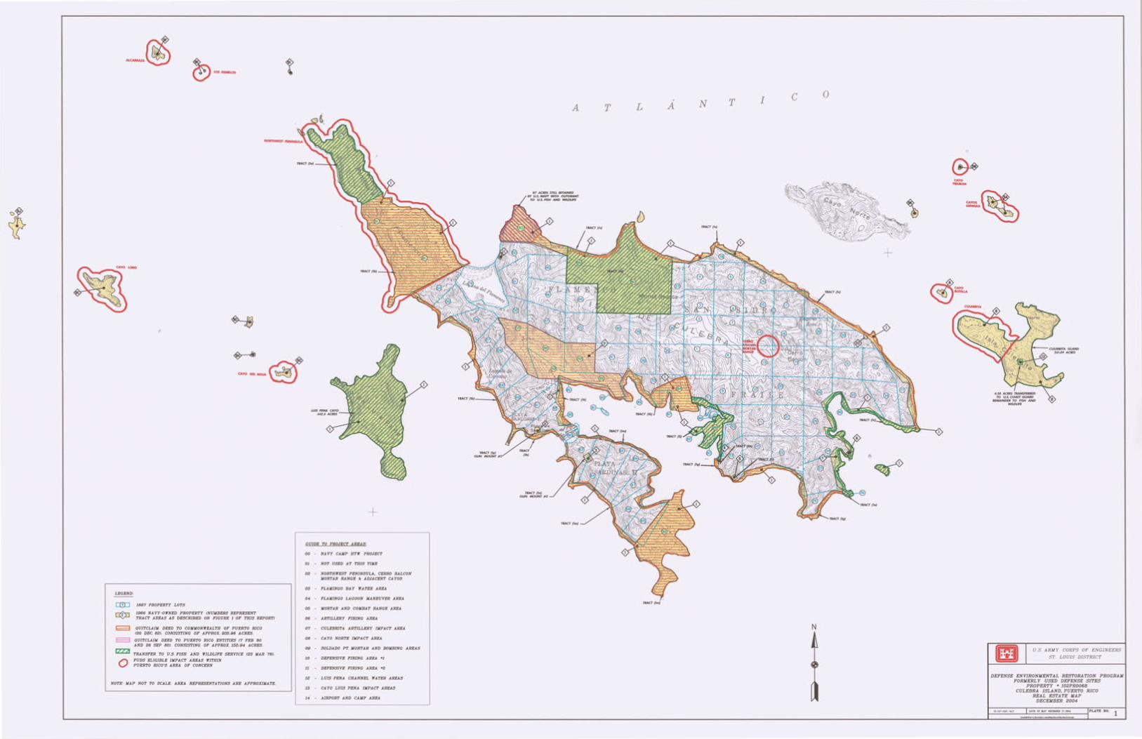
LEGEND:
1887 PROPERTY LOTS
1966 NAVY-OJfNED PROPERTY CNUJIBIRS REPRr.JINT TRACT AREAS AS DESCRIBED ON FIGURE I OF THIS REPORTJ
E:3 QUJTCLA!ll DEED TO COJIJIONW'EALTH OF PUERTO RICO
0
C20 DEC. 82J. CONSISTING OF APPROX. 9~.98 ACRES.
QUITCLAIJI DEED TO PUERTO RICO ENTITIES C? FEB 80 AND 28 SEP BOJ. CONSISTING OF APPROX. 155.94 ACRES.
TRANSFER TO U.S. FISH AND "ILDLJFE SERVICE l23 JIAR ?BJ.
PUDS ELIGIBLE IMPACT ARRAS "J'ITHIN PUERTO RICO'S AREA OP CONCERN
NOTE: JIAP NOT TO SCALE. AREA REPRESEN1'A7'10NS ARE APPROXIMATE.
+ GUIDI TO PROJrCT ARRAS:
00 NAVY CAJIP HTlf PROJECT
OJ NOT USED AT THIS TJJII
03 NORTHWEST PENINSULA, CERRO BALCON IIORTAR RANGE & ADJACENT CAYOS
03 FLAJIINGO BAY lfATBR AREA
04 FLAJIINGO LAGOON JIANEUVER AREA
06 JIORTAR AND COJIBAT RANGE AREA
08 ARTILLERY FIRING AREA
07 CULEBRITA ARTILLERY JJIPACT AREA
08 CA YO NORTE IJIPACT AREA
00 SOLDADO PT. JIORTAR AND BOJIBING AREAS
JO DEP.INSJVR FIRING AREA •J
Jl DEFENSIVE FIRING AREA •2
JZ LUIS PENA CHANNEL WAfER AREAS
13 CA YO LUIS PENA IJIPACT AREAS
AIRPORT AND CAJIP AREA
A L A N T I c T
JUCT(IMJ
N
0
+
CAYO --
U.S. ARM Y CORPS OF ENG I NEERS
ST LOUIS DISTRI CT
DEFENSE ENVIRONMENTAL RESTORATION PROGRAM FORMERLY USED DEFENSE SITES
PROPERTY • 102PR0068 CULEBRA ISLAND, PUERTO RICO
REAL ESTATE MAP DECEMBER 2004
1--'===-...L:'::m:_:M:_::":__' -==- :..:•;::·-=----IPLATI HO. 1
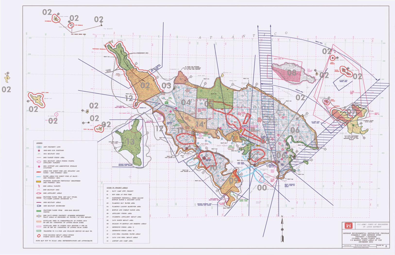
02
g 2 1922 TAAGET NNi "!r 1- --------------209 I I 1
- - - - - - - - -·-- - - - -
1 208 I . - - . - - - - - - - - -·- - --- - ~------------~---
I 207 ,----------- I I -~--- - ------r---
I 1
I 1 I . 1
: ~ass CAY
I ._, 1
I 1 I -. I
:~206 --- ~"*'
:.2050 2 ___ -i- -_ -~Np _CA~
I .,g;.
I
I
: ~ .. ·62 ~2~4- -------- f- --- --
I 1202 r ---I
I
lu IO 10
a!lJ 1887 PROPERTY LOTS
• 1902-1903 GUN POSITIONS
_ 1~0~ 1914 JIILITARY GRID
• -c:::J
\> _jl~
AD•
0
1922 TARGE'l' FIRING AREA
1924 JIILITARY AREAS t1'JRJNG POINTS, ARTILLERY TARGETSJ
1924 OUTPOST AND AJIIIUNITJON STORAGE LOCATIONS
AREAS FOR DIRBC'I' P'IRE AND INFANTRY AND rANKS - Hil36 (POSSIBLY 1924J
WATER AREAS FOR DIRECT FIRE AT BOAT'S -1936 (POSSIBLY U124J
STANDING BARRAGES PREVIOUSLY REGISTERED 1935 (POSSIBLY 19241
1935 AERIAL 'tARGETS
1936 JIILJTARY GRID
1936 ARTILLERY AREAS
FEATURES TAKEN FROJI 1937 JIAP TITLED, "U.S . FLEET LANDING EXCERCISE •4 ...
1938 JIILITARY AREAS
1939 JIILITARY EXCERCISES
FEATURES TAKEN FROJI 1936-1949 OBLIQUE PHOTOS
1966 NA VY-OJINED PROPERTY (NUJIBERS REPRKSENT TRACT AREAS AS DESCRIBED ON YIGURE J OF THIS REPORT)
QUITCLAIJI DEED TO COJIJIONJIEALTH OF PUERTO RICO f20 DEC. 82J. CONSISTING OF APPROX. 935.98 ACRES.
QUITCLAIJI DEED TO PUERTO RICO ENTITIES (7 FEB 80 AND 26 SEP 801. CONSISTING OF APPROX. 155.94 ACRES.
TRANSFER TO U.S. FISH AND WILDLIFE SERVICE (23 JIAR 78J.
FUDS ELIGIBLE IJIPACT AREAS JfiTHIN PUERTO RICO'S AREA OF CONCERN
NOTE: JIAP NOT TO SCALE. AREA REPRESENTATIONS ARE APPROXIJIATlr.
1 II I I
--- i----,- - ~-----r-
1~ I~ I
1 I
I I I I I
""'~-.r-- ~NT MEA I
I I I I I --, II I I I
I
L I l. __ _
I ( lAM JNOO i PT
I
--:-- I I I I
. - -L--- ~- - ----- - J---- ~ I t I I
I I I I I I
I -L I I I :~ I t- -;- --- - I I r-----~----~-------L----2-------~ I
·:- GUIDI TO PROJECT AREAS: --- -:------ _I_ ----:- -I I I
00 NAVY CAJIP HT'If PROJECT I I
01 NOT USED AT THIS TIJIE I I
--+--- -1 I 02 NORTHWEST PENINSULA, CERRO BALCON
-'- liORTAR RANGE & ADJACENT CAYOS
I I
•'"" 1 ·~ ---- ~:!_------ 1---- ~-~
03 FLAJIINGO BAY 'lfATER AREA
~ 04 FLAJIINGO LAGOON JIANEUVER AREA
06 JIORTAR AND COJIBAT RANGE AREA
08 ARTILLERY FIRING AREA
07 CULEBRITA ARTILLERY IJIPACT AREA
08 CA YO NORTE IJIPACT AREA
09 SOLDADO PT. JIORTAR AND BOJIBING AREAS
10 DEFENSIVE FIRING AREA •1
11 DEFENSIVE FIRING AREA •2
12 LUIS PENA CHANNEL JIATER AREAS
13 CAYO LUIS PENA IJIPACT AREAS
14 AIRPORT AND CAJIP AREA
I -- A- -- !J' l -----~------ ~ --1~ I~
0 I ~
I I
l:ll I-
I I I I I
- I--I
I I I I -,
--~------ , - -I I
I I ; I
•7AbrnSTXJ.IlEf~ 1
.,.ro""tf'~~~ I I I I
- :-----+ I SURF B AY I
--~----- --: nAt pq
.A tv T --~ ---,--
-----~----- r ---- -~-
~~ ' I IN I I I I I I I I I I
·I ~ ---~------I- --- .. ----- -t ---
I I
I I
I I I
I I I I I
_j_
I I - ~----- -r ~cr vq
I
I~
---~~-
- .,... -I
I
T
I I I I I~ ~
I
I~
I I~ 1:::
___ L ____ _ I II I
200
I I'll I
~
---r---1 a;
---~ ------- ~- -I I I I
-~1~2
11; -r--1 I I I I
151
;;; , 209
I I I
- - - - - ,_ - - - - - ~ - - - - - - -f 208
: I : I I I I
mii~~ ... _ .. ~
I
L
I I
-1 I I
- ~ ----
1 I I I II
: I : I -~------- ~ ----.J ______ -1
I I I I I
----1---1 I lu
j ____ ~: ___ _
I I I I
L - --.l-----1-: I ~~ ~~ I 1_, I
-~------ ~----~-----
I I
-I., ll:: I L
I I Jl47
I I
-1 I
-: 204
I I I
-~--- ;
I I I
-- f---- -:-- . --I I I
I I I I
1146
I I
-r I I I I I I
r---L- -J,"'s
I
-'
I I I
: I : l : 1 ------ ~ ---- -·------ _ l _--- ...J 202 I I I I t
I
L
I I I I I I I I +-"'-- - :-- ~144 ~~ :~ I l tO> I
- -~ - - - - -~- - - - - - - ~
I I I I I I I ~-- _; ___ :1<3 I I~ I , It!)
!------- L ----~------ J I I I I I I I
I
I 201 -1
203
U.S. A RM Y CORPS OF ENG I NEERS
ST. LOUIS DISTRI CT
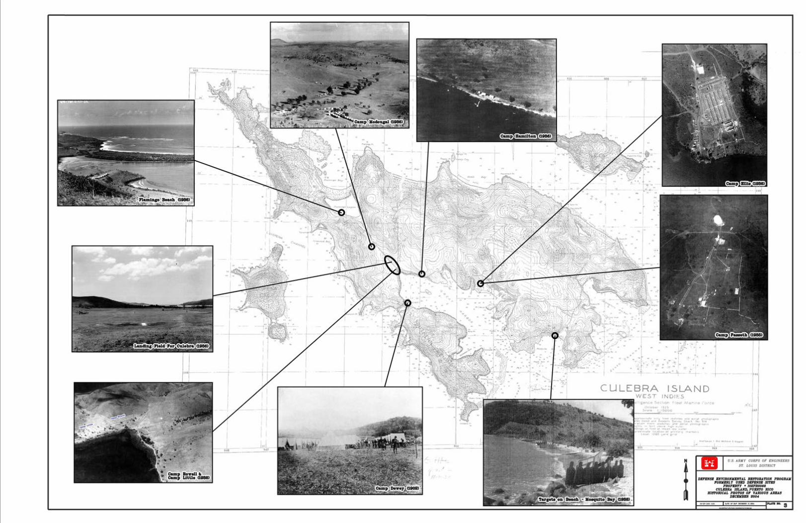
J
ISLAND INDIES
I U.S. ARMY CORPS OF' ENG I NEERS
ST. LOUIS DISTRICT
D-U lfNVIRONJim'IA£ II§'IORA'I'lON PROGRAM I'ORJaRLY USD D-U S1'11lS
PROPmrrY • IOBPROOII CUUBRA ISLAND. PU1tii'IO RICO
BIII'IORICAL PBO'fOIJ 07 VARIOUS ANUS DlfCniUR B004
......... a


![VoL 1917 XXXIV] J WETMORE, Birds of Culebra … 1917 XXXIV] J WETMORE, Birds of Culebra Island, P. R. 51 THE BIRDS OF CULEBRA ISLAND, PORTO RICO. BY ALEXANDER WETMORE. THE Island of](https://img.pdfslide.us/doc/110x75/5b2794987f8b9a68078b5ef9/vol-1917-xxxiv-j-wetmore-birds-of-culebra-1917-xxxiv-j-wetmore-birds-of-culebra.jpg)