Embed Size (px)
Citation preview
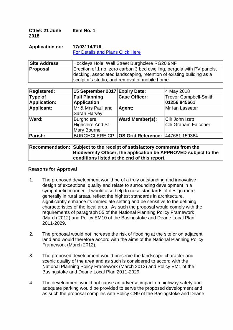
Cttee: 21 June 2018
Item No. 1
Application no: 17/03114/FUL
For Details and Plans Click Here
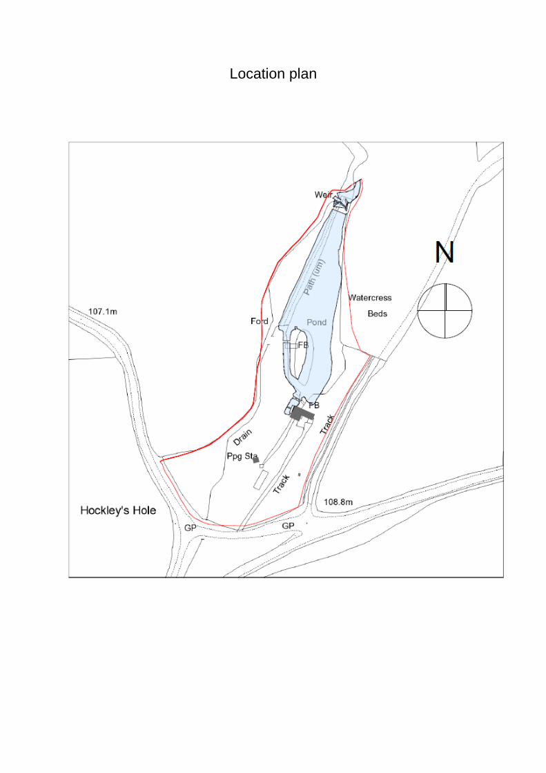
Site Address Hockleys Hole Well Street Burghclere RG20 9NF
Proposal Erection of 1 no. zero carbon 3 bed dwelling, pergola with PV panels, decking, associated landscaping, retention of existing building as a sculptor's studio, and removal of mobile home
Registered: 15 September 2017 Expiry Date: 4 May 2018
Type of Application:
Full Planning Application
Case Officer: Trevor Campbell-Smith 01256 845661
Applicant: Mr & Mrs Paul and Sarah Harvey
Agent: Mr Ian Lasseter
Ward: Burghclere, Highclere And St Mary Bourne
Ward Member(s): Cllr John Izett Cllr Graham Falconer
Parish: BURGHCLERE CP OS Grid Reference: 447681 159364
Recommendation: Subject to the receipt of satisfactory comments from the Biodiversity Officer, the application be APPROVED subject to the conditions listed at the end of this report.
Reasons for Approval
1. The proposed development would be of a truly outstanding and innovative
design of exceptional quality and relate to surrounding development in a sympathetic manner. It would also help to raise standards of design more generally in rural areas, reflect the highest standards in architecture, significantly enhance its immediate setting and be sensitive to the defining characteristics of the local area. As such the proposal would comply with the requirements of paragraph 55 of the National Planning Policy Framework (March 2012) and Policy EM10 of the Basingstoke and Deane Local Plan 2011-2029.
2. The proposal would not increase the risk of flooding at the site or on adjacent
land and would therefore accord with the aims of the National Planning Policy Framework (March 2012).
3. The proposed development would preserve the landscape character and
scenic quality of the area and as such is considered to accord with the National Planning Policy Framework (March 2012) and Policy EM1 of the Basingstoke and Deane Local Plan 2011-2029.
4. The development would not cause an adverse impact on highway safety and
adequate parking would be provided to serve the proposed development and as such the proposal complies with Policy CN9 of the Basingstoke and Deane
Local Plan 2011-2029. 5. The proposed development would not result in an undue loss of privacy or
cause undue overlooking, overshadowing, overbearing or noise and disturbance impacts to neighbouring properties and as such complies with Policy EM10 of the Basingstoke and Deane Local Plan 2011-2029.
6. The proposal would conserve the biodiversity value and nature conservation interests of the site and as such the proposal would comply with the National Planning Policy Framework (March 2012) and Policy EM4 of the Basingstoke and Deane Local Plan 2011-2029.
General Comments This application is before the committee as it is a departure from the Local Plan in accordance with the council’s scheme of delegation. Planning Policy The site lies outside any Settlement Policy Boundary and is within open countryside for the purposes of planning considerations. National Planning Policy Framework (NPPF) (March 2012) Core Principles - Achieving Sustainable Development Section 4 (Promoting Sustainable Transport) Section 6 (Delivering a Wide Choice of Quality Homes) Section 7 (Requiring Good Design) Section 11 (Conserving and Enhancing the Natural Environment) Decision Taking Basingstoke and Deane Local Plan 2011-2029 Policy SS1 (Scale and Distribution of New Housing) Policy SD1 (Sustainable Development) Policy SS6 (Housing in the countryside) Policy CN1 (Affordable Housing) Policy CN6 (Infrastructure) Policy CN9 (Transport) Policy EM1 (Landscape) Policy EM4 (Biodiversity, Geodiversity and Nature Conservation) Policy EM7 (Managing Flood Risk) Policy EM9 (Sustainable Water Use) Policy EM10 (Delivering High Quality Development) Policy EM12 (Pollution) Supplementary Planning Documents and Guidance (SPD's and SPG's) and Interim Planning Guidance Design and Sustainability SPD
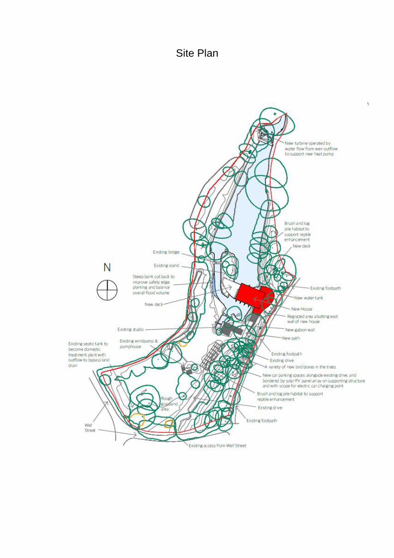
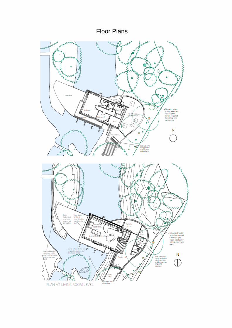
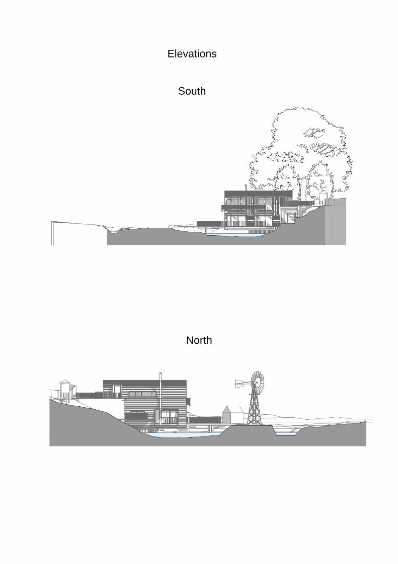
Appendix 5 - Construction Statements Appendix 6 - Waste and Recycling Appendix 7 - Places to Live Appendix 14 - Countryside Design Summary Appendix 16 - Residential Amenity Design Guidance Residential Parking Standards SPD Landscape & Biodiversity Supplementary Planning Document Landscape Character Assessment SPD Other Material Documents Planning Practice Guidance Policy SS6 e) Guidance Note 2016 Conservation of Habitats and Species Regulations 2010 (as amended) Natural Environment and Rural Communities Act 2006 The Wildlife and Countryside Act 1981 Site Description The site is located immediately to the north of the North Wessex Downs Area of Outstanding Natural Beauty lying on the east side of the fork of Well Street and comprises of a small wooded dell where the surrounding higher land converges from 3 sides to form a natural linear hollow. Hockley's Hole forms the head water of a tributary that feeds into the River Enborne. In the more distant past this source of natural, clean spring water was utilised for watercress beds that were enlarged over time. The site is enclosed with post and rail fencing and within the site is an artist's studio with an associated mobile home. Proposal The application seeks permission for the erection of a 3 bed dwelling and a pergola with photovoltaic panels. The existing artist's studio would be retained and the existing mobile home would be removed from site. The proposal would also incorporate associated landscaping and parking provision. The proposed dwelling would be a two storey architect designed modern building with a two storey arched roof main portion and a flat roofed single storey element to the eastern side. The proposed dwelling would be timber clad and would project across the pond at the site on an east to west orientation. The southern elevation would be extensively glazed with balconies at first floor level. The northern elevation would be largely wood clad with less extensive fenestration at both ground and first floor levels. A door at first floor level would give access to a roof terrace over the single storey element at the eastern elevation. To the south of the main proposed dwelling and the existing studio would be a pergola topped with photovoltaic cells which would provide covered parking and electric vehicle charging.
Consultations Burghclere Parish Council: The council feel that there may be some access issues and construction traffic management issues related to the application, although overall has no objections. Planning Policy: The proposal should be considered against Policy SS6e of the Local Plan and Para 55 of the NPPF. Environmental Health: No objection subject to conditions. Tree Officer: No objection subject to conditions. Biodiversity Officer: Objection. Landscape Officer: Objection, proposal does not significantly enhance the landscape. Urban Design: No objection subject to condition. Natural England: Natural England has no comments to make on this application. North East Hampshire Design Review Panel: No objection. Hampshire Design Panel: No objection subject to amendments. Environment Agency: No objection, subject to conditions. Public Observations None received. Relevant Planning History BDB/61989 Change of use of existing building into an
artist studio and the continued use of existing caravan as storage/office.
Refused, Appeal Allowed
28/01/05
BDB/37092 Continued siting of caravan for residential
purposes for security reasons (renewal of permission BDB/31840)
Refused 31/01/95
BDB/31840 Permission to use existing caravan for
residential purposes for security reasons Granted 13/11/91
Assessment Housing land supply position The Council is currently able to demonstrate that it has a 5 Year Housing Land
Supply (HLS) of 5.6 years. As such paragraph 49 of the National Planning Policy Framework (NPPF), which states that relevant policies for the supply of housing should not be considered up-to-date if a 5 year HLS cannot be demonstrated, is not engaged, insofar as paragraph 49 relates to housing land supply. The first part of paragraph 49 which requires housing applications to be considered in the context of the presumption of sustainable development is applicable. Principle of development The application site is located outside any Settlement Policy Boundary (SPB). It is therefore within the part of the borough which is designated as countryside as per Policy SS1 (Scale and Distribution of New Housing) of the Local Plan. New dwelling in the countryside The Local Plan is explicit in its aims as stated in paragraph 4.70: 'The aim of the Local Plan is to direct development to within the identified Settlement Policy Boundaries and specific site allocations. Within the countryside it is the intention to maintain the existing open nature of the borough's countryside, prevent the coalescence of settlements and resist the encroachment of development into rural areas. The countryside is therefore subject to a more restrictive policy'. Policy SS1 sets out a spatial strategy for the Local Authority to meet its full housing need over the Plan period. The strategy is principally based upon the development of allocated Greenfield sites and the redevelopment of land in the towns and villages. Development in the countryside is generally restricted. The most relevant Local Plan policy for this proposal is Policy SS6 (New Housing in the Countryside). The policy outlines the exceptional circumstances where it is appropriate to allow new housing development in the countryside. Policy SS6 states that development in the countryside will only be permitted if the site is (a) on previously developed land; (b) is part of a rural exception scheme; (c) is for the reuse of an existing building; (d) involves the replacement of an existing dwelling; (e) is small scale to meet a locally agreed need; (f) is required to support an existing rural business; or (g) is allocated by a Neighbourhood Plan. The applicant is of the view that the proposed site is previously developed land. The NPPF glossary defines previously developed land as the following: Land which is or was occupied by a permanent structure, including the curtilage of the developed land (although it should not be assumed that the whole of the curtilage should be developed) and any associated fixed surface infrastructure. This excludes: land that is or has been occupied by agricultural or forestry buildings; land that has been developed for minerals extraction or waste disposal by landfill purposes where provision for restoration has been made through development control procedures; land in built-up areas such as private residential gardens, parks,
recreation grounds and allotments; and land that was previously-developed but where the remains of the permanent structure or fixed surface structure have blended into the landscape in the process of time. The applicant asserts that parts of the site are previously developed including that the site once contained a pair of cottages. There is not sufficient evidence to ascertain when the historic cottages were removed from the land or the exact location on which they were sited. However, the siting of the cottages is not grounds to consider the site to be previously developed land due to the remains of the permanent structure having blended into the landscape in the process of time. Furthermore it is noted that the proposed new dwelling is located on part of the site which has not been previously developed. It is noted that in an appeal decision (dismissed) on an application (reference 16/02187/FUL) for a new dwelling in Nately Scures, the Inspector stated that "…with reference to previously developed land the Framework specifically notes that whilst the definition includes the curtilage of the land it should not be assumed that the whole of the curtilage should be developed. The Local Plan definition re-iterates that there is no presumption that land that is previously developed is necessarily suitable for housing development, nor that the whole of the curtilage should be developed." Given that it is considered that the site is not previously developed land the proposal must be considered against criterion (e) of Policy SS6. Criteria e) states that: e) Small scale (four dwellings or fewer) residential proposals of a scale and type that meet a locally agreed need provided that: ix) It is well related to the existing settlement and would not result in an isolated form of development; and x) The development will respect the qualities of the local landscape and be sympathetic to its character and visual quality; and xi) The development will respect and relate to the character, form and appearance of surrounding development, and respect the amenities of the residents of neighbouring properties. The Borough Council has published a Guidance Note in relation to Policy SS6 e) which has been prepared by officers to provide informal guidance on how the requirements of the policy should be interpreted and what information should be provided to support planning applications. This guidance note has been shared with all parish and town councils in the borough. The tests in criterion Policy SS6 (e) are in two parts. The first part (e) sets out the overall limits of the exception whilst the second part (criteria ix - xi) then sets out detailed criteria for proposals that are within that exception. Therefore, a proposal that can satisfy the first part of criterion e) will fall within the exception as a matter of principle, but the specific details then need to be considered in terms of the criteria of the second part of the policy. A proposal which does not satisfy the exception will not be policy compliant even if it might otherwise comply with the detailed criteria ix - xi.
In terms of the first part, the application is for one dwelling and therefore meets the test relating to scale (four dwellings or fewer). Proposals must also be of a scale and type that meets a locally agreed need. Applicants should provide evidence to objectively demonstrate that their proposal meets a specific and clearly-identified unmet housing need in the local area in terms of number, size type and tenure. As noted in the Guidance Note for Policy SS6 e), an individual's personal need for housing would not in itself satisfy the exception of a 'locally agreed need'. Therefore proposals should be supported by a comprehensive assessment of requirements in the local area. Based on the information submitted with the application it is considered that the applicant has not clearly and sufficiently demonstrated that this policy requirement has been met. The proposal would also not accord with SS6 e) ix. due to the proposed site being isolated. The Local Plan defines 'isolated' in the glossary as: In the context of new residential development in the countryside where there is a significant separation between the proposed dwelling and the nearest settlement. Additionally, a dwelling is considered to be isolated if it is not well served by public transport (e.g. within 500m of a bus stop or train station) or well served by services and facilities (e.g. within 1km of an SPB, which generally contains facilities such as schools, post offices, doctors surgery, etc). The Local Plan definition of isolation has two distinct dimensions: firstly whether the site is physically remote; and secondly whether it has easy access to services and facilities. The application site is located approximately 2km from Burghclere SPB, which is considered to be the nearest settlement. With regards to services and facilities, Burghclere provides the nearest facilities, albeit that these are limited. The proposed site is approximately 2km from the nearest school and approximately 2.5 km from the nearest public house. There is also no bus stop within 500m of the site. The nearest settlement with sufficient facilities is Newbury situated approximately 6km from the site. As the first part of criterion e) and e) ix. have not been satisfied it is not necessary for the proposal to be assessed against the requirements of the policy's remaining sub-criteria. It is therefore considered that the proposal fails to comply with Policy SS6 e) of the Local Plan. NPPF - paragraph 55 Design and Landscape Impact The applicant is of the view that the site should be considered as an exception under paragraph 55 of the NPPF. The paragraph states that "Local planning authorities should avoid new isolated homes in the countryside unless there are special circumstances such as… the exceptional quality or innovative nature of the design of the dwelling". The Planning Statement states that "we firmly believe that the proposal is of sufficient merit to be regarded as paragraph 55 compliant, if the proposal is considered to fall outside the scope of Policy SS6a". As identified above, the proposal would not accord with criteria a) or e) of Policy SS6 as the proposed site is likely to be considered isolated and is not considered to be previously developed
land. To meet this criteria as set out in paragraph 55 of the NPPF, the design of the proposed development should:
be truly outstanding or innovative, helping to raise standards of design more generally in rural areas;
reflect the highest standards in architecture;
significantly enhance its immediate setting; and
be sensitive to the defining characteristics of the local area. These criteria set a very high benchmark and require specialist advice on architectural matters. Advice has therefore been sought from both the North East Hampshire Design Review Panel and the Hampshire Design Review Panel. The North East Hampshire Design Review Panel provided useful comments about the proposal in respect of successful aspects of the design and where it considered there to be shortcomings. However the Panel did not conclude that the proposal met the paragraph 55 criteria. In summary, the Panel "supported a proposal like this for the site, and that the general principles were sound, but also concluded that there needed to be some refinement to the design". The Hampshire Design Review Panel has a county-wide remit and comprises the chairs of the various Design Review Panels around Hampshire together with any additional specialist advice it wishes to involve. The Panel found much to commend with the scheme. It concluded that "there are sufficient circumstances to encourage a design of this calibre on this special site under paragraph 55 of the NPPF, but subject to a slightly reduced bulk and a few relatively minor design adjustments, which would also improve the design of the building's entry". In addition to architectural matters, the consideration of a proposal against paragraph 55 criteria also requires assessing its impact on landscape. Advice has been supplied on landscape matters by the Council's Landscape Team who concluded that the proposal failed to meet the terms of paragraph 55 on the grounds that it did not 'significantly enhance' its immediate setting. The North East Hampshire and Hampshire Design Review Panels contained a landscape architect and so were also equipped to comment on whether the proposal met the full range of paragraph 55 criteria. Both Design Review Panels found much to admire about the scheme but did not conclude that it fully passed the tests of paragraph 55. The Hampshire Panel was more supportive and suggested that amendments should be made to enable the proposal to reach the exceptional quality required to meet the paragraph 55 criteria. Many of the shortcomings mentioned by the Panels are minor. In some cases, there are comments made within the Panel reports which provide a very considerable degree of support for the design themes and paragraph 55 criteria examined even though the conclusion for a particular theme may have been that amendments were sought. In some cases there are mitigating circumstances such that the proposal successfully addresses the shortcomings raised by the Panels. It is however
considered that the impact of the proposed solar panels above the parking spaces on the character of the site would be detrimental, however, it is considered that this issue can be satisfactorily addressed by condition. It is considered that the scheme does meet the paragraph 55 criteria and the proposal is considered against the Paragraph 55 criteria below taking into account themes discussed in local planning authority and appeal decisions for other paragraph 55 schemes elsewhere in the country over the last few years: Be truly outstanding or innovative, helping to raise standards of design more generally in rural areas In order to fulfil this criteria the proposal only needs to be 'truly outstanding' or 'innovative' to meet this criteria but does not need to be both in helping to raise standards of design more generally in rural areas. A scheme can be both outstanding and innovative. Incidentally, paragraph 55 contains a reference to "the exceptional quality or innovative nature of the design of the dwelling". It is considered that this reference is satisfactorily addressed through addressing the wording in the 'truly outstanding or innovative' criteria. Truly Outstanding The term 'outstanding' is defined as 'exceptionally good' or 'clearly noticeable'. Given how other local planning authorities and appeal inspectors have approached this term in judging paragraph 55 proposals, it is suggested that a 'truly outstanding' scheme should also:
Be unique.
Show excellence in relation to all the four criteria in paragraph 55.
Demonstrate how the design has evolved from a clear concept which integrates into the wider landscape and site to the architecture of the building.
Demonstrate principles which can be used as an inspiration for other schemes in rural areas which will significantly enhance the environment and be a model for future living.
The North East Hampshire Panel stated that "The panel has the view that the architectural concept is not innovative nor exceptional, but as a consequence, its low-key impact upon the immediate surroundings can be thought of as appropriate". The Hampshire Panel did not come to a specific conclusion as to whether the proposal was 'truly outstanding' although it did state in paragraph 5.2 of the report that "The design response, in terms of its setting is innovative". The test of being 'truly outstanding' is one which chiefly seeks to draw the other criteria of paragraph 55 (including potentially that of being innovative) together to enable an overall conclusion to be made on the proposal's quality. The following paragraphs reach favourable conclusions regarding each of the paragraph 55 criteria. Taking these individual conclusions, and using the themes referred to in paragraph 2.3, it is considered, therefore, that the scheme is truly outstanding:
The Urban Design Officer, taking into account the advice of the design panels considers that the scheme is unique insofar as this combination of architecture and sustainability measures with their response to a site of this nature would not appear to have been undertaken before. The following paragraphs discuss how the scheme shows excellence in relation to all the criteria in paragraph 55. The applicant has provided information that demonstrates how the design has evolved from a clear concept which integrates the wider landscape and site to the architecture of the building. The Hampshire Panel stated that "the detailed design of the building had been sensitively informed by the very particular circumstances of the site, including the presence of the water, the small wooded valley and the orientation of the site". The Panel went on to state that the approach to the design "was reflected throughout the design of the building in totality including its form, orientation, window design and cladding". It is considered that the scheme demonstrates principles which can be used as an inspiration for other schemes in rural areas which will significantly enhance the environment and be a model for future living. Reference is made to its sustainable energy design in the following paragraphs. The Hampshire Panel stated that "The Panel also noted that as a proposed dwelling that it was relatively small, compared to most proposals for houses seeking approval under Para.55 and shows how a smaller scale can employ sustainable technology and respond sensitively to a particular context". Innovative The term 'innovative’ in the Oxford dictionary is defined as the introduction of new methods or ideas. The deliberations by local planning authorities and inspectors for other paragraph 55 schemes suggest that there is no definitive view on precisely how a scheme can be judged as innovative. However, a number of themes do emerge. It is suggested here that to be 'innovative', a scheme could demonstrate at least one of the following features:
New methods of construction and engineering.
New methods of sustainable, low energy, environmentally-friendly ways of living.
New ways of using materials.
New concepts showing how a house can be lived in to provide a better residential environment.
New concepts in how a house can be integrated with the management of the wider site to provide an enhanced quality of life and improved environment.
How a design feature is used in a new way. In examining this question of innovation a further layer of themes should be given consideration: a) The types of innovation referred to above should be capable of meeting the remaining part of the test which requires them to raise standards of design more
generally in rural areas. The innovation should be inspirational and be used as a model for future development. b) A question of significance arises. One small piece of new technology which does not appear to be an integral or significant part of the concept as a whole should not be viewed as innovative. The difficulty with innovation is that the bar, and particularly in technological terms, is constantly being raised. So it can become more difficult as time goes by to prove that the scheme is genuinely innovative. There also remains an uncertainty over whether the test of innovation should be applied locally, nationally or globally. One potential way forward here is to accept that innovation may come from the way in which various elements of a scheme are combined even if the elements themselves have been used before: this could particularly be the case where this innovative combination is an inspirational model which raises standards of design more generally in rural areas. For example, weight can be attached to a proposal which seeks to combine an exciting new design with other measures such as sustainable development and which could be an inspiration for other new development. d) A new form or shape of a house by itself, in purely aesthetic or geometric terms, is not innovative. Having said that, a new form or shape of a house could be innovative if this is significantly linked to new concepts of engineering or sustainable living. The North East Hampshire Panel did not reach a conclusion regarding whether the scheme was innovative or not. The Hampshire Panel praised several aspects of the technology and architectural approach of the scheme albeit that these aspects, when taken individually, were not necessarily innovative in themselves: "The Panel appreciated the considered and detailed approach to the question of energy design being related to the uniqueness of the site and how this informed the design of the dwelling. The approach of using the incidence of water to help cool the building in summer and the potential for heating the building in winter using water from the spring which issues water at a constant temperature of 12 degrees centigrade was recognised. It was acknowledged how the detailed design of the building had been sensitively informed by the very particular circumstances of the site, including the presence of the water, the small wooded valley and the orientation of the site. The design is supported by a detailed Sustainable Energy Design Statement, which describes a considerable number of measures to be taken and which were discussed in detail by the Panel (some of which are to be applied in a unique way in this particular setting) in order to ensure that the building is zero carbon and achieves 'Passivhaus' standard". Considerable weight is given to the Sustainable Energy Design Statement accompanying the application in assessing whether it represents an innovative form of development. This describes the large number of measures taken to ensure the building is zero carbon and achieves Passivhaus standard such as: a heat pump which uses the elevated temperature of the lake to minimise heating and to passively cool air entering in summertime; how temperature swings are stabilised by the house being partly built into the bank; the east-west alignment of the house assisting
window sizing and orientation; the potential for a hydro-electric resource; the use of photo-voltaic panels; the thickness of insulation and high level of airtightness; the manner in which the curve of the roof allows a thermal and passive air movement over it facilitating a pressure differential with the ability to draw and cool air using the pool water temperature in summer; how the orientation of boarding slats with glazing changed to allow the optimum response to midday and late afternoon sun; and how the angle of some of the glazing responded to reflections coming up from the pond. One aspect of the proposal which is often referred to by the Hampshire Panel, is that the dwelling is relatively small compared with most houses seeking approval under paragraph 55 of the NPPF. The scheme has the potential to show how rural houses of this smaller scale can employ sustainable technology and respond sensitively to a site and its context. Overall it is considered that the innovation within the proposal lies in how all of the technological and architectural elements combine to create a highly sensitive response to a very particular environment. The manner in which the building responds to the water, temperature and airflow of the pond and the spring is a particular example of this and is considered to demonstrate an alternative approach to help raise design standards in rural areas. Reflect the highest standards in architecture The North East Hampshire Panel did not reach a conclusion with regard to whether the scheme reflected the highest standards in architecture. In its favour, the Panel stated that "there is a pleasing light touch to the building that gives impression of a minimal impact on the setting". The Panel did, however, consider there were several weaknesses in the design: the visualisation looking to the rear of the building "shows a slightly jumbled arrangement of materials" and "the car port looks very suburban in comparison to the dwelling design". It also commented that whilst the concept is appropriate of a pavilion in the landscape straddling across onto the island that the presented scheme did not work particularly well with the site. In particular, it stated that "the primary outlook across the lake is oddly angled towards the bank, missing the raison d'être and the building 'enclosed', and the 'diagonal view' obscured by a wall. The upper floors seem oddly inward looking on a site which is entirely private and with a beautiful outlook". The Hampshire Panel considered overall that "the design did appear to indicate a high standard of design and detailing, reflecting the latest technology and responding to its setting" and that "the concept and design approach are impressive and display an understanding of the particular qualities and attributes of the site." The Panel made a number of favourable comments relating to the architecture of the house. These included the siting of the proposed dwelling and the decision to span the water, both for aesthetic as well as sustainability reasons; and that the eventual colour of the larch cladding as a general choice of material could sit well against the backcloth of the enclosing woodland. However, the Panel considered there to be some weaknesses in the design stating in the summary that "the building would present too much of an intrusion by virtue of being on two storeys and wondered whether it might have been better in response to
the setting to develop a more extensive plan on a single level; but they appreciated that this more compact approach is in tune with the zero-carbon aspiration. There was some discussion with regard to certain details such as the way that the entrance into the building has been handled, but this perhaps a lesser matter in terms of the whole and could be improved as a matter of detail. Concern was expressed though over the visual prominence of the solar panels above the car parking area on entry to the site.” Elsewhere in the report, the Panel commented that "the eastern single storey wing appeared to be unresolved in detail. Should there be more transparency in such a position between water and woodland?" It is relevant in this regard to consider how the deliberations by local planning authorities and inspectors for other paragraph 55 schemes, and how the wider practice of architecture, can assist in an understanding of how to judge 'the highest standards of architecture". It is suggested here that the highest standards of architecture would demonstrate excellence in respect of:
How the siting and form of the building responds to the site taking account of topography, the availability of sunlight and daylight, landscape features and the relationship to surrounding buildings, opportunities and constraints.
The shape and form of the building and ancillary buildings and engineering works.
How the separate elements of the composition combine to create a harmonious whole.
Proportion.
The quality of detailing.
The suitability and quality of materials having had regard to the context of the scheme.
The quality and suitability of hard and soft landscaping.
How all aspects of the scheme combine to create a coherent whole ranging from the residential accommodation to the integration with any garden and the wider curtilage.
How a practical living environment is provided ranging from the floorplan of the house to any vehicular and pedestrian access and parking.
The creation of a sense of delight. It is considered that most of the shortcomings mentioned by the Panels are minor such as those relating to the entrance into the building and it is considered that the shortcomings of the solar panels above the car parking can be addressed by the imposition of a suitably worded condition. As such it is considered that these features do not significantly detract from how the scheme addresses this criteria. In respect of the main concern regarding the building being 'too blocky', it is considered that there are mitigating circumstances to justify the proposed 2-storey approach. Also noted are the general comment made by the Hampshire Panel referred to above that "the concept and design approach are impressive and display an understanding of the particular qualities and attributes of the site." Overall, and taking this into account, it is considered that the proposal does reflect the highest standards in architecture and does meet this particular test of paragraph 55.
It is considered that that there are several aspects to justify the 2-storey scale of the building and its proposed form and elevational treatment:
The 2-storey scale and compact form assist the achievement of a high level of energy efficiency which is a key theme in the wider concept for the building.
The visual impact of the 2-storey massing is mitigated by a number of features including: the prominent curves found in the roof and to a lesser extent in the footprint; the high void to solid ratio on the southern and western elevations; the way the outline of the building is broken up by the whalebone rib of laminated timber arches braced with the first floor and its supports; the way the house 'floats' above the water; the way the building 'tucks' into the bank; and the larch slats which face the building whose slender profile helps break up the solidity of the building and whose organic texture and colour provide a reference to the surrounding trees.
The plans for the building appear to indicate a high standard of detailing.
A single storey building would have a larger footprint and thereby increase its visual impact in that regard.
The Panel commented that the eastern single storey wing appeared to be unresolved in detail and that the building could offer more 'transparency' in such a setting. These concerns over the east wing were mentioned by the North East Hampshire Panel. Whilst there are a number of features and shapes in this wing in a limited space, the clear and curved footprint and the way that this wing is subordinate to the main bulk of the house do not significantly detract from the overall quality of the building. The North East Hampshire Panel raised concerns over how the siting and elevational treatment of the building did not facilitate views over the lake to the north. Whilst such views would be an enjoyable aspect of the house, this has to be balanced against the benefits of minimising light and activity from the house affecting the lake which will help maintain the lake's character and value as an ecological habitat. Concern was expressed by the Hampshire Panel regarding the way that the entrance into the building has been handled. Discussion at the Panel meeting referred to a desire to see a lighter looking structure. In the context of the scheme as a whole, this is a minor point and does not significantly detract from the overall quality. In any event, it is considered that the open pergola along much of the walkway's length does confer some lightness to the building. An aspect of the proposal worthy of mention is how the design allows a pedestrian route onto the island in the lake which can act as an amenity area and offers a certain charm. Overall, it is considered that the proposal comprises a harmonious composition of good proportions, with good detailing and a high level of residential amenity.
Significantly enhance its immediate setting The North East Hampshire Panel did not specifically state whether it considered that this test was met. However, it made several favourable observations in relation to this criteria commenting that "the site has qualities that can be enhanced by the introduction of a dwelling into the location. It will enable the occupants to appreciate and look after the landscape and a new building as a pavilion in the landscape can be thought of as a further manmade contribution to enhance this particular landscape". A later paragraph stated "the design of the dwelling includes proposals to enhance biodiversity which are welcome". The Hampshire Panel also did not specifically state whether it considered that this test was met. However, the Panel made several favourable comments about the how the proposal related to the setting: "The beauty and tranquillity of the site with the pond within a wooded dell poses the obvious question of how can such a setting be significantly enhanced by a new house? The site has some history of habitation (although with no dwelling on site at the present) with it evolving in recent times from the redundant watercress beds and currently includes a number of small buildings (all single storey), including a pump house and caravan adjacent to the access track with a wind vane behind and small studio at the front of the pond. Certainly, the removal of the caravan could be seen as a minor improvement to the site. Certainly any building will intrude to some extent on this small valley, but the proposal does incorporate a number of features which complement the attractiveness of the setting, such the positioning of the proposed house, with its curved roof, tucked into the 'made-up' east bank of the pond and although spanning the water still allowing views down the waterway. The scale of a low house in this position would still be subservient to the surrounding and background woodland. Expected management plans would ensure the enhancement of the ecological value of the site and its future maintenance to be safeguarded. The proposed house should be considered in the context of this man-made pond and setting". The existing site does have a tranquillity and natural beauty. However, it is considered that there are arguments, as set out by the Panels, as to why a house, with its bulk, lighting and activity, can significantly enhance the immediate setting:
The visual composition of a sensitively designed house hovering over the lake has a beauty of its own.
The lake is a fairly recent man-made feature having been watercress beds up to the late 1960s. Its value as a purely 'natural' environment is tempered by this observation.
There is existing activity associated with development on the site through the use of the artist's studio. A new house would not transform an entirely 'natural' environment into one with some urban features.
Any lack of an objection to the proposal on the grounds of this criteria assumes that various impacts on the ecological and arboricultural assets of the site can be satisfactorily mitigated.
Both Panels had concerns over the detrimental visual effect of the solar panels above the parking on the driveway. It is considered that this element of the proposal does lend a somewhat industrial aspect to this entrance which would detract from the more rural setting of the house. However, this issue can be addressed in any planning permission through a condition requiring the removal of the solar panels above the parking spaces at the entrance to the scheme and their replacement to an alternative location within the site to the satisfaction of the local planning authority. Whilst it is recognised that the energy sustainability of the proposal is an integral part of the of its exceptional and innovative design it is considered that the proposed solar panels could be accommodated elsewhere in the site without detrimental impacts upon the visual amenities of character of the site. Be sensitive to the defining characteristics of the local area The North East Hampshire Panel, in addressing this criteria, stated that "the building embraces and works well with the landscape with the opportunity for views in both directions along the waterbody, the spanning of the waterbody to provide interaction with the former land use and the integration of the dwelling with the sloping landform to the side of the site. All these assist in allowing the dwelling to be sensitive to the characteristics of the local area. There is a pleasing light touch to the building that gives impression of a minimal impact on the setting. The concept is appropriate, a pavilion in the landscape straddling across onto the island, but the presented scheme does not work particularly well with the site - the primary outlook 'across the lake' is oddly angled towards the bank, missing the raison d'être and the building 'enclosed', and the 'diagonal view' obscured by a wall. The upper floors seem oddly inward looking on a site which is entirely private and with a beautiful outlook". It is considered that this criteria chiefly aims to address how a proposal complements the wider character of the area, however it is chosen to define that. Many of the comments of the North East Hampshire Panel relate more to the specific response of the house to the site as opposed to the wider area. Therefore these issues are addressed in the second criteria relating to standards of architecture. The Hampshire Panel stated that "The site is relatively isolated being centred on a water source in a small wooded valley. There is a traditional farmstead some distance across an open field to the west. On the site, the existing small single storey buildings are of a traditional nature with plain tiled pitched roofs and timber cladding. Thus, in such an enclosed setting, the Panel accepted that an entirely different contemporary approach could be taken which respected the immediate setting. The use of a larch, or cherry as a sustainable cladding would help the building blend into the local area of the woodland and surrounding natural features". The defining characteristic of the local area is the woodland and lakeside setting which is isolated from neighbouring villages and is well hidden from the surrounding countryside. As such it is considered that a contemporary approach to the scheme with a building clad in wood is entirely appropriate and meets this criteria.
Compliance with Paragraph 55 of the NPPF overall It is considered that the proposal as a whole does meet the tests of paragraph 55 subject to a condition requiring the removal of the solar panels above the parking spaces at the entrance to the scheme and their replacement to an alternative location within the site to the satisfaction of the Local Planning Authority. Impact on Highway Network The application site is in a rural location, as defined by the Parking Standards SPD wherein a three bedroom dwelling requires three parking spaces. The plans provided show three parking spaces associated with the proposed pergola but no details of the layout of the spaces is shown. It is considered that the application site has adequate space within it to satisfactorily accommodate the required parking and manoeuvring space and as such a condition requiring the submission of a parking and turning layout plan to be approved and provided on site prior to the occupation of the proposed dwelling is considered to be both reasonable and necessary. The exiting access to the site would be utilised in association with the application proposal. It is therefore considered that the proposed development would not lead to a detrimental impact on highway safety and would be compliant with Policies EM10 and CN9 of the Local Plan and as such is acceptable in this regard. Impact on neighbouring amenity The nearest residential dwelling to the site is at Duncroft Farm and is located approximately 192 metres to the west of the proposed dwelling. Given this degree of separation and the secluded character of the site it is considered that the proposal would not be detrimental to the amenities of any neighbouring dwelling. The proposal is considered to comply with Policy EM10 of the Local Plan and is acceptable in this regard. The Environmental Health Officer has suggested conditions regarding hours of work and deliveries to the site, but given the remote location of the site relative to neighbours such conditions are not considered to be reasonable or necessary. Trees The proposal will require the removal of two mature ash trees, whilst the deck linking the dwelling to the island will require the removal of a group of trees including willow, ash and hazel. However the Tree Officer raises no objection to these element of the application. The arboricultural information initially submitted included a plan which showed the proposed dwelling house sited approximately 3 metres to the north of the position proposed in the rest of the application documents. This brought the proposed dwelling into conflict with the root protection areas of two significant trees within the site. Following clarification that this was an error and that the position of the dwelling was to comply specifically with drawing 1345:P:02 the Tree Officer
confirmed that he had no objection to the proposal. A condition requiring submission of a Tree Protection Plan to be approved prior to the commencement of development is recommended to be imposed in the interests of the amenity of the site. It is therefore considered that the proposal is acceptable in this regard and accords with Policies EM1 and EM10 of the Local Plan. Biodiversity The Biodiversity Officer has raised an objection to the proposal, requesting the submission of additional information regarding further justification on why a departure from the council and the Environment Agency’s recommendation that a buffer zone of at least 8 metres should be provided between developments and main rivers The Biodiversity Officer also requested clarification on what, if any, external lighting will be required within the final development and an assessment of any impacts any internal lighting might have on bat species known to forage and commute within the proposed development area. Furthermore, given the site’s sensitivity, the Biodiversity Officer requested further information on what will or won’t be possible to achieve in terms of habitat enhancements to improve the open water and chalk stream habitats on site to ensure proposed impacts will be fully mitigated to provide a net gain in terms of biodiversity. The applicant supplied additional information on the 1 May 2018 and the comments of the Biodiversity Officer with regard to this information is awaited and will be reported in the update paper. Flood Risk The application site falls within Flood Zones 2 and 3. It is noted from the applicants Flood Risk Assessment (FRA) that a portion of the proposed dwelling and decking is located in Flood Zone 3. It is also understood from the FRA that the new access to the development will connect to the existing driveway. The existing driveway and access to Well Street fall outside Flood Zones 2 and 3. The proposal will need to accord with Policy EM7 (Managing Flood Risk) of the Local Plan and also the detailed guidance on flood risk within the NPPF and PPG.
- Sequential Test In accordance with the NPPF paragraph 101 and Policy EM7 of the Local Plan, development should not be permitted if there are reasonably available sites appropriate for the proposed development in areas with a lower probability of flooding. As stated in the PPG (Paragraph: 034 Reference ID: 7-034-20140306) “It is for local planning authorities, taking advice from the Environment Agency as appropriate, to consider the extent to which Sequential Test considerations have been satisfied, taking into account the particular circumstances in any given case. The developer should justify with evidence to the local planning authority what area of search has been used when making the application. Ultimately the local planning

authority needs to be satisfied in all cases that the proposed development would be safe and not lead to increased flood risk elsewhere.” The NPPG (Paragraph: 033 Reference ID: 7-033-20140306) also adds that “…When applying the Sequential Test, a pragmatic approach on the availability of alternatives should be taken.” The proposal is a unique case in that the proposed dwelling has been intrinsically linked to the water features on the site. Also, the landowners currently have a studio on the site and are seeking to live and work on the site. Taking a ‘pragmatic’ view and considering the ‘particular circumstances’ it is considered that the availability of alternatives is likely to be limited and therefore in this specific case a sequential test is not required.
- Exception test The PPG requires proposals for ‘more vulnerable’ development, such as this proposal, and within Flood Zone 3a to undertake an exception test. The applicants FRA includes an Exception Test as part of the proposed dwelling is considered to be within Flood Zone 3a. Paragraph 102 of the NPPF clarifies that for the Exception Test to be passed: “it must be demonstrated that the development provides wider sustainability benefits to the community that outweigh flood risk, informed by a Strategic Flood Risk Assessment where one has been prepared; and a site-specific flood risk assessment must demonstrate that the development will be safe for its lifetime taking account of the vulnerability of its users, without increasing flood risk elsewhere, and, where possible, will reduce flood risk overall.” In respect of the first of these criteria the design is considered to be innovative and to provide a wider example of how sustainable technologies can be used to provide a sustainable and exceptionally high quality design for a sensitive site such as this As such it is considered that the wider sustainability benefits of the proposal outweigh the flood risk. The applicant provided an addendum Flood Risk assessment in support of the application which states that additional flood storage in the region of 7m3 will be provided as a result of regrading land around the existing pond. This in addition to the proposed void space beneath the new dwelling provides the Environment Agency with confidence that flood risk arising from this development has been satisfactorily addressed. With regard to the sequential approach whereby development is located to areas of lower flood risk on the proposed site the location of the proposal relative to the spring and the pond and relative to prevailing winds at the site is critical to its success in utilising these elements in the stabilisation of temperatures within the dwelling and supporting those factors that make this proposal innovative and exceptional as required by paragraph 55 of the NPPF. The condition recommended by the Environment Agency is considered to be both reasonable and necessary and is recommended to be imposed.
Water Efficiency Policy EM9 of the Local Plan sets out a requirement to ensure that water resources within new development are used sustainably through the imposition of a water efficiency standard of 110 litres or less per person per day. The proposal has not been accompanied by any information demonstrating that such levels of water consumption will be achieved within the development; therefore a planning condition would have been imposed to secure this standard. Land Contamination Given the sensitivity of the residential use proposed to the impacts of contaminated land the Environmental Health Officer has recommended conditions relating to the investigation and mitigation of potential contamination of the site. Such conditions are considered to be reasonable and necessary and are recommended to be imposed. Conditions 1 The development hereby permitted shall be carried out in accordance with the
following approved plans:
1345:P01, Location and Site Plans 1345:P02, Proposed Site Plan 1345:P03, Plan and Site Section 1345:P04, Plan and Site Section 1345:P05, Plan and Site Section 1345:P06, Plan and Site Section and Cross Section 1345:P0, Tree Context Plan and Site Sections 54HH01, Site Survey TCP210416.01, Tree Constraints Plan
REASON: For the avoidance of doubt and in the interests of proper planning.
2 The development hereby permitted shall be begun before the expiration of 3
years from the date of this planning permission. REASON: To comply with Section 91 of the Town and Country Planning Act 1990 and to prevent an accumulation of unimplemented planning permissions.
3 No development shall commence on site until details of the types and colours
of external materials to be used, including colour of mortar, together with samples, have been submitted to and approved in writing by the Local Planning Authority. The development shall be carried out and thereafter maintained in accordance with the details so approved. REASON: Details are required prior to commencement because insufficient information has been submitted with the application in this regard, in the interests of the visual amenities of the area and in accordance with Policy EM10 of the Basingstoke and Deane Local Plan 2011-2029.
4 No development shall take place until there has been submitted to and approved in writing by the Local Planning Authority a scheme of landscaping which shall specify species, planting sizes, spacing and numbers of trees/shrubs to be planted (including replacement trees where appropriate). The works approved shall be carried out in the first planting and seeding seasons following the first occupation of the building(s) or when the use hereby permitted is commenced. In addition, a maintenance programme detailing all operations to be carried out in order to allow successful establishment of planting, shall be submitted to and approved in writing by the Local Planning Authority before development commences. Any trees or plants which, within a period of 5 years from the date of planting, die, are removed or become seriously damaged or diseased shall be replaced in the next planting season with others of similar size and species, to be agreed in writing by the Local Planning Authority. REASON: Details are required prior to commencement because insufficient information has been submitted with the application in this regard, to improve the appearance of the site in the interests of visual amenity in accordance with Policy EM1 of the Basingstoke and Deane Local Plan 2011-2029.
5 No development shall take place, including any works of demolition, until a Construction Method Statement, including drawings, that demonstrates safe and coordinated systems of work affecting or likely to affect the public highway and or all motorised and or non-motorised highway users, has been submitted to, and approved in writing by, the Local Planning Authority. The approved Statement shall be adhered to throughout the construction period.
The Statement shall include for: i. means of access (temporary or permanent) to the site from the adjoining maintainable public highway, including the associated traffic management arrangements; ii. the parking and turning of vehicles of site operatives and visitors off carriageway (all to be established within one week of the commencement of development); iii. loading and unloading of plant and materials away from the maintainable public highway; iv. storage of plant and materials used in constructing the development away from the maintainable public highway; v. wheel washing facilities or an explanation why they are not necessary; vi. the erection and maintenance of security hoarding including decorative displays and facilities for public viewing, where appropriate; vii. measures to control the emission of dust and dirt during construction; viii. a scheme for recycling and disposing of waste resulting from construction work; and ix. the management and coordination of deliveries of plant and materials and the disposing of waste resulting from construction activities so as to avoid undue interference with the operation of the public highway, particularly during the Monday to Friday AM peak (08.00 to 09.00) and PM peak (16.30 to 18.00) periods.
x. the routes to be used by construction traffic to access and egress the site so as to avoid undue interference with the safety and operation of the public highway and adjacent roads, including construction traffic holding areas both on and off the site as necessary. REASON: Details are required prior to commencement because detail absent from the application and to ensure that the construction process is undertaken in a safe and convenient manner that limits impact on local roads and the amenities of nearby occupiers, the area generally and in the interests of highway safety and in accordance with Policies EM10 and CN9 of the Basingstoke and Deane Local Plan 2011-2029.
6 Notwithstanding the details submitted no development shall take place until
there has been submitted to and approved in writing by the Local Planning Authority a plan indicating the position, design, of the proposed photovoltaic panels to be erected. The approved photovoltaic panels shall be erected in accordance with the approved details before the dwelling hereby approved is first occupied and shall subsequently be maintained. REASON: Details are required prior to commencement because insufficient information has been submitted with the application in this regard, in the interests of the amenities of the area and in accordance with Policies EM1, and EM10 of the Basingstoke and Deane Local Plan 2011-2029.
7 No development including site clearance, demolition, ground preparation,
temporary access construction/widening, material storage or construction works shall commence until a scheme for tree protection, prepared in accordance with BS5837 "Trees in Relation to Design, Demolition and Construction" has been submitted to and approved in writing by the Local Planning Authority. No development or other operations shall take place other than in complete accordance with the approved tree protection scheme, unless otherwise agreed in writing by the Local Planning Authority. The tree protection scheme shall include the following information:
(a) A tree protection plan comprising a drawing at a scale of no less than 1:500 showing the position of protection zones, fencing and ground protection measures to be established for retained trees. Where applicable, two lines shall be shown demonstrating the lines of temporary tree protective fencing during the demolition phase and during the construction phase.
(b) A British Standard 5837 Tree Survey schedule with tree reference numbers corresponding with trees on the plan required by section a) of this condition.
(c) The specification for protective fencing and a timetable to show when fencing will be erected and dismantled in relation to the different phases of the development;
(d) Details of any levels changes within or adjacent to protection zones;
(e) The routing of overhead and underground services with provisions for reducing their impact on trees to an acceptable level;
(f) A specification and schedule of works for any vegetation management required, including pruning of trees and details of timing in relation to the construction programme;
(g) Provision for briefing construction personnel on compliance with the plan, including incorporation of tree protection recommendations into a construction method statement;
(h) Provision for signage of protection zones and precautionary areas;
(i) Details of contractor access during any demolition or building operations including areas designated for the storage of materials and equipment.
REASON: To ensure that reasonable measures are taken to safeguard trees in the interests of local amenity and the enhancement of the development itself, in accordance with the National Planning Policy Framework (March 2012) and Policy EM1 of the Basingstoke and Deane Local Plan 2011- 2029.
8 The development permitted by this planning application shall be carried out in
accordance with the FRA prepared by AA Environmental Ltd dated June 2016 and the Addendum FRA prepared by AA Environmental Ltd dated December 2017 and the following mitigation measures detailed within the FRA:
1. Finished floor levels and decking are set no lower than 103.75 metres above Ordnance Datum (AOD). 2. A 2m high floodable void beneath the building as described in section 3.7 of the FRA dated June 2016. This shall remain free at all times from any items which would prevent the free flow of flood water. 3. Provision of compensatory flood storage as described in section 2 of the FRA addendum and shown on drawing 163048/D/001. The mitigation measures shall be fully implemented prior to occupation and subsequently in accordance with the timing / phasing arrangements embodied within the scheme, or within any other period as may subsequently be agreed, in writing, by the Local Planning Authority. REASON: To prevent flooding elsewhere by ensuring that storage of flood water is provided; and to reduce the risk of flooding to the proposed development and future occupants for the lifetime of the development, in accordance with paragraphs 102 and 103 of the National Planning Policy Framework and Policy EM7 of the Basingstoke and Deane Local Plan 2011-2029.
9 No works pursuant to this permission shall commence until there has been
submitted to and approved in writing by the Local Planning Authority:- (a) a desk top study carried out by a competent person documenting all the previous and existing land uses of the site and adjacent land in accordance with national guidance as set out in Contaminated Land Research Report Nos. 2 and 3 and BS10175:2011; and, unless otherwise agreed in writing by the Local Planning Authority,
(b) a site investigation report documenting the ground conditions of the site and incorporating chemical and gas analysis identified as being appropriate by the desk study in accordance with BS10175:2011- Investigation of Potentially Contaminated Sites - Code of Practice; and, unless otherwise agreed in writing by the Local Planning Authority, (c) a detailed scheme for remedial works and measures to be undertaken to avoid risk from contaminants/or gases when the site is developed. The scheme must include a timetable of works and site management procedures and the nomination of a competent person to oversee the implementation of the works. The scheme must ensure that the site will not qualify as contaminated land under Part IIA of the Environmental Protection Act 1990 and if necessary proposals for future maintenance and monitoring. If during any works contamination is encountered which has not been previously identified it should be reported immediately to the Local Planning Authority. The additional contamination shall be fully assessed and an appropriate remediation scheme, agreed in writing with the Local Planning Authority. This must be conducted in accordance with DEFRA and the Environment Agency's 'Model Procedures for the Management of Land Contamination, CLR11'. REASON: To ensure that risks from land contamination to the future users of the land and neighbouring land are minimised, together with those to controlled waters, property and ecological systems, and to ensure that the development can be carried out safely without unacceptable risks to workers, neighbours and other offsite receptors in accordance with Policy EM12 of the Basingstoke and Deane Local Plan 2011-2029.
10 The development hereby permitted shall not be occupied/brought into use
until there has been submitted to the Local Planning Authority verification by the competent person approved under the provisions of condition 9(c) that any remediation scheme required and approved under the provisions of condition 9(c) has been implemented fully in accordance with the approved details (unless varied with the written agreement of the Local Planning Authority in advance of implementation). Such verification shall comprise:
as built drawings of the implemented scheme; photographs of the remediation works in progress; Certificates demonstrating that imported and/or material left in situ is free of contamination. Thereafter the scheme shall be monitored and maintained in accordance with the scheme approved under condition 9(c). REASON: To ensure that risks from land contamination to the future users of the land and neighbouring land are minimised, together with those to controlled waters, property and ecological systems, and to ensure that the development can be carried out safely without unacceptable risks to workers, neighbours and other offsite receptors in accordance Policy EM12 of the Basingstoke and Deane Local Plan 2011-2029.
11 The dwelling hereby permitted shall not be occupied until provision for the
turning of vehicles and the parking of three vehicles has been made within the
curtilage of that property and the areas of land so provided shall not be used for any purpose other than the turning and parking of vehicles. REASON: In the interests of highway safety and in accordance with Policies EM10 and CN9 of the Basingstoke and Deane Local Plan 2011-2029.
12 Notwithstanding the provisions of Article 3 of the Town and Country Planning
(General Permitted Development) Order 2015 (or any Order revoking and re-enacting that Order with or without modification) no building, structure or other alteration permitted by Classes A, B, C, D and E of Part 1 of Schedule 2 of the Order shall be erected on the application site without the prior written permission of the Local Planning Authority on an application made for that purpose. REASON: To prevent the overdevelopment of the site in the interests of the amenity of the area and to safeguard the quality of the landscape in this rural location in accordance with Policies EM1 and EM10 of the Basingstoke and Deane Local Plan 2011-2029.
13 No development shall commence on site until details of the design and
materials to be used in the construction of the proposed gabion wall, have been submitted to and approved in writing by the Local Planning Authority. The development shall be carried out and thereafter maintained in accordance with the details so approved. REASON: Details are required prior to commencement because insufficient information has been submitted with the application in this regard, in the interests of the visual amenities of the area and in accordance with Policy EM10 of the Basingstoke and Deane Local Plan 2011-2029.
14 Within three months of the first occupation of the dwelling herby approved the
mobile home at the site shall be removed from the site and the land returned to a condition to be agreed with the Local Planning Authority. REASON: In the interests of the visual amenity of the area and in accordance with Policy EM1 of the Basingstoke and Deane Local Plan 2011-2029.
Informative(s):- 1. 1.1 The applicant's attention is drawn to the fact that the above conditions (if
any), must be complied with in full, failure to do so may result in enforcement action being instigated.
1.2 This permission may contain pre-commencement conditions which require specific matters to be submitted and approved in writing by the Local Planning Authority before a specified stage in the development occurs. This means that a lawful commencement of the approved development CANNOT be made until the particular requirements of the pre-commencement conditions have been met.
1.3 The applicant's attention is drawn to the fact that the Local Planning Authority has a period of up to eight weeks to determine details submitted in respect of a condition or limitation attached to a grant of planning permission. It is likely that in most cases the determination period will be shorter than eight
weeks, however, the applicant is advised to schedule this time period into any programme of works. A fee will be required for requests for discharge of any consent, agreement, or approval required by a planning condition. The fee chargeable is £116 or £34 where the related permission was for extending or altering a dwelling house or other development in the curtilage of a dwelling house. A fee is payable for each submission made regardless of the number of conditions for which approval is sought. Requests must be made using the standard application form (available online) or set out in writing clearly identifying the relevant planning application and condition(s) which they are seeking approval for.
2. In accordance with paragraphs 186 and 187 of the National Planning Policy
Framework (NPPF) in dealing with this application, the Council has worked with the applicant in the following positive and proactive manner:-
offering a pre-application advice; considering the imposition of conditions and or the completion of a s.106 legal agreement.
In this instance:
the application was acceptable as submitted and no further assistance was required.
In such ways the Council has demonstrated a positive and proactive manner in seeking solutions to problems arising in relation to the planning application.
3. If this development will result in new postal addresses or changes in addresses,
please contact the council's Street Naming and Numbering team on 01256 845539 or email [email protected] to commence the process. Details can be found on the council's website.
4. The applicant's attention is drawn to the following advice from the Environment
Agency. If it is intended to abstract more than 20 cubic metres of water per day from a surface water source (e.g. stream or drain) or from underground strata (via borehole or well) for any particular purpose then an abstraction licence will need to be obtained from the Environment Agency. There is no guarantee that a licence will be granted as this is dependent on available water resources and existing protected rights.
Location plan
Site Plan
Floor Plans
Elevations
South
North
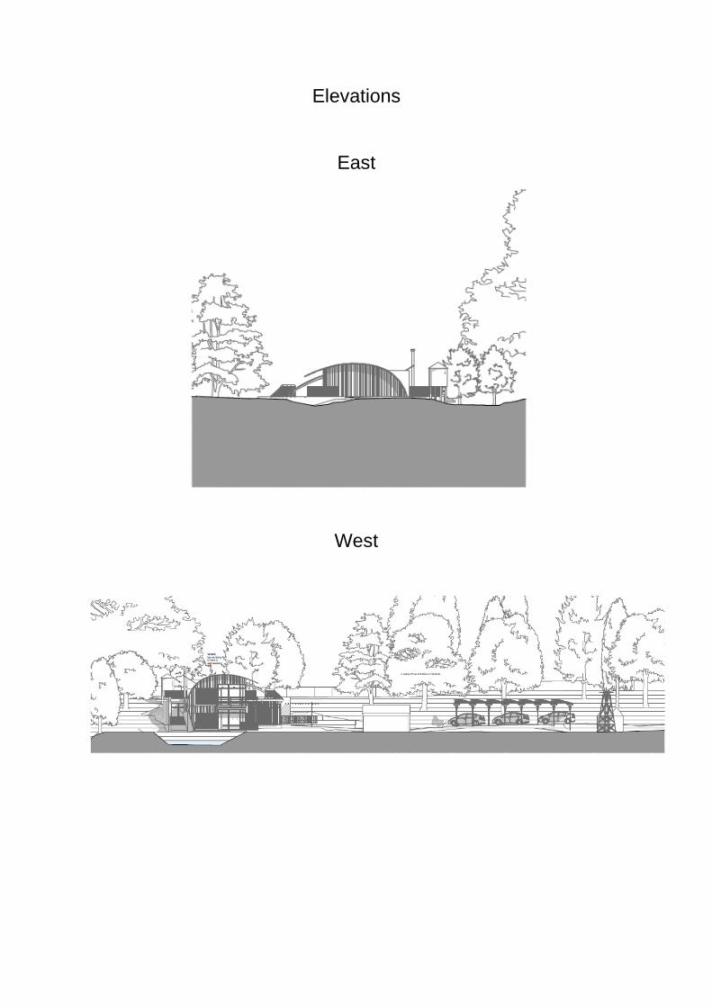
Elevations
East
West
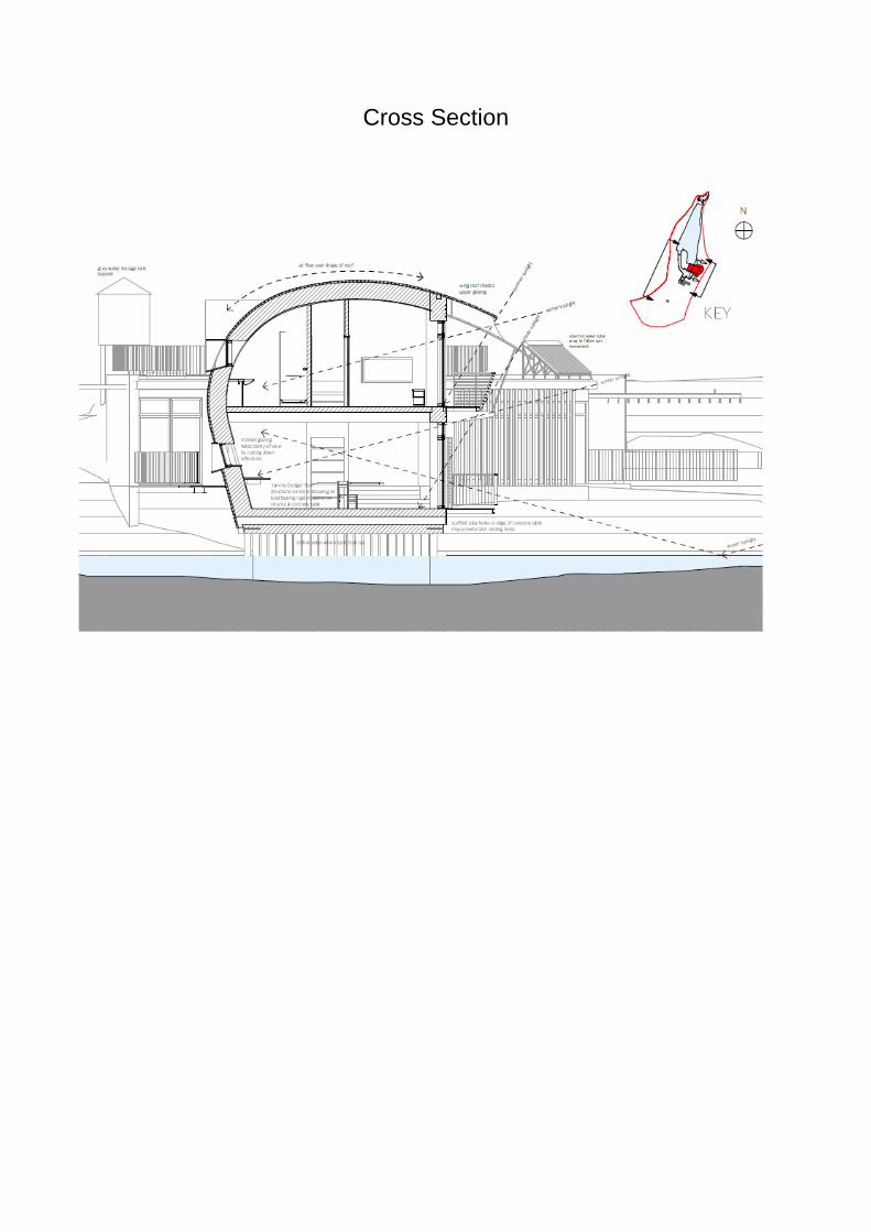
Cross Section
Cttee: 21 June 2018
Item No. 2
Application no: 18/00483/FUL
For Details and Plans Click Here
Site Address Land To The East Of Dummer Down Lane Dummer Hampshire
Proposal Erection of 1. no. 2 bed dwelling
Registered: 19 February 2018 Expiry Date: 18 June 2018
Type of Application:
Full Planning Application
Case Officer: Trevor Campbell-Smith 01256 845661
Applicant: Mr & Mrs Willats Agent: Mr Ben Kelly
Ward: Oakley And North Waltham
Ward Member(s): Cllr Diane Taylor Cllr Rob Golding Cllr Stuart Frost
Parish: DUMMER CP OS Grid Reference: 458405 145733
Recommendation: the application be APPROVED subject to the conditions listed at the end of this report.
Reasons for Approval 1. The proposed development would preserve and /or enhance the character of
the Dummer Conservation Area and as such complies with the National Planning Policy Framework (March 2012) and Policy EM11 of the Basingstoke and Deane Local Plan 2011-2029.
2. The proposed development would respect the character of its surroundings in terms of street pattern, plot size, layout and form and as such complies with the National Planning Policy Framework (March 2012) and Policy EM10 of the Basingstoke and Deane Local Plan 2011-2029.
3. The proposed development would be of an appropriate design and relate to
surrounding development in a sympathetic manner and as such complies with the National Planning Policy Framework (March 2012); Policy EM10 of the Basingstoke and Deane Local Plan 2011-2029; and Appendix 13 of the Design and Sustainability Supplementary Planning Document.
4. The proposal would conserve the biodiversity value and nature conservation
interests of the site and as such the proposal would comply with the National Planning Policy Framework (March 2012) and Policy EM4 of the Basingstoke and Deane Local Plan 2011-2029.
5. The development would not cause an adverse impact on highway safety and
adequate parking would be provided to serve the proposed development and as such the proposal complies with Policy CN9 of the Basingstoke and Deane Local Plan 2011-2029.
6. The proposed development would not result in an undue loss of privacy or
cause undue overlooking, overshadowing, overbearing or noise and disturbance impacts to neighbouring properties and as such complies with Policy EM10 of the Basingstoke and Deane Local Plan 2011-2029.
Planning Policy The site lies within the Settlement Policy Boundary of Dummer and lies such that the majority of the site (except the eastern most part) within the Dummer Conservation Area. Laurel Cottage, immediately to the south of the site is a Building of Note in the Conservation Area, while Bishops Cottage to the south west of the site is a Grade II Listed Building. National Planning Policy Framework (NPPF) National Planning Policy Guidance (NPPG) (March 2012) Core Planning Principles Section 4 (Promoting Sustainable Transport) Section 6 (Delivering a wide choice of high quality homes) Section 7 (Requiring Good Design) Section 11 (Conserving and enhancing the natural environment) Section 12 (Conserving and enhancing the historic environment) Basingstoke and Deane Local Plan 2011-2029 Policy SD1 (Sustainable development) Policy SS1 (Scale and Distribution of New Housing) Policy EM1 (Landscape) Policy EM4 (Biodiversity, Geodiversity and Nature Conservation) Policy EM9 (Sustainable Water use) Policy EM10 (Delivering High Quality Development) Policy EM11 (Historic Environment) Policy EM12 (Pollution) Policy CN9 (Transport) Policy CN1 (Affordable Housing) Supplementary Planning Documents and Guidance (SPD's and SPG's) and interim planning guidance Residential Parking Standards SPD Appendix 16 (Residential Amenity) of the Design and Sustainability SPD Dummer Conservation Area Appraisal Dummer Village Design Statement Other Material Documents The Planning (Listed Buildings and Conservation Areas) Act 1990
Description of Site The site lies to the eastern side of Dummer Down Lane and is currently an unoccupied plot. immediately to the east of the site is open countryside whilst to the south lies the residential dwelling 'Laurel Cottage' Immediately to the north of the site is a public Footpath beyond which lies the residential curtilage of Rowan House. To the opposite side of Dummer Down Lane are the dwellings and garage court of Bible Fields. The site is also located within the Dummer Conservation Area. Proposal This application seeks permission for the erection of a two storey detached 2 bedroom dwelling with associated parking and landscaping. The proposed dwelling would have a traditional design with dormer windows to the side elevations. Parking would be located to the front of the dwelling between it and Dummer Down Lane. The proposed dwelling would measure 6.9 metres in width, 11.3 metres in depth and a total of 7.1 metres in height. The proposal would utilise the existing access to the site. Consultations Dummer Parish Council: Dummer Parish Council object on the following grounds:
Inappropriate development in the Conservation Area.
Over development of the site.
Overlooking into neighbouring properties.
Overbearing on neighbouring properties.
Inappropriate development immediately adjacent to the footpath.
Intrusion in views to and across the site identified in the Dummer Conservation Appraisal.
The site is elevated above the footpath and therefore potential surface water run-off would make the path unsafe.
Access and visibility to the site is dangerous to those using the lane.
The height of the property is domineering in the street scene.
There is no public sewer and there is no indication where the septic tank would be sited.
Trees on the site are protected.
Public Transport is only provides service on 3 days a week and therefore not viable for employment.
Dummer has no street lights or footpaths making this site unsuitable for elderly residents to walk to the public house.
This is a very large two bedroom house and the price would be out of reach for young families to buy or rent.
There is no cycle path identified in the Basingstoke Cycle Network leading to the Beggarwood Post Office.
No space is identified for cycle storage.
The noise of heat pump source could affect neighbouring properties. Tree Officer: Acceptable, subject to conditions.
Biodiversity: Acceptable, subject to informatives. Environmental Health: No objection subject to conditions. Conservation: Verbal Comments - No objection subject to condition in respect of materials. HCC Archaeology: No objection. Public Observations Twenty letters of objection received raising the following concerns:
Too near Rowan House and the adjacent footpath.
Contravenes the Dummer VDS.
Will lead to loss of trees to the northern boundary and the erection of a fence to the detriment of the Conservation Area.
The dwelling is too large for the site.
The dwelling is higher than neighbours and will dominate them.
The proposal will be harmful to the Conservation Area.
The proposal would overlook Laurel Cottage.
The dwelling would be visible from a Public Right of Way and large number of dwellings.
Approval of this application would set a precedent.
The proposal is overdevelopment of the plot.
The proposal is of an inappropriate a disrespectful design.
The proposal will impact detrimentally on road safety.
Approval will lead to disturbance to neighbours in the construction phase.
The proposal would not contribute to social, economic or environmental wellbeing.
The proposal will impact on the adjacent footpath.
The dwelling will overlook and overshadow Rowan House.
Approval would lead to pressure for the development of the land to the rear of the site.
The applicants are well known for unattractive development.
The application is pure financial speculation.
Mains drainage is not achievable at the site.
The dwelling is out of keeping with the streetscene.
The dwelling will block views from Dummer Down Lane. Relevant Planning History 13/00077/FUL
Erection of replacement barn following demolition of existing (land to rear of Laurel Cottage)
Granted
10/06/13
13/01324/FUL
Erection of replacement oak framed barn following demolition of existing (land to rear
Granted
23/09/13
of Laurel Cottage) Assessment Principle of development The site is located within the Settlement Policy Boundary of Dummer, where there is a general presumption in favour of development under Policy SS1 of the Local Plan. Impact on the character of the area/ design The application site is located within the Dummer Conservation Area and in this part of Dummer Down Lane it is noted that there is a mixed character with the uniform two storey dwellings in Bible Fields significantly set back from the road to the north west and the more prevalent detached two storey dwellings of varied age and style to the south, north and south west. The site is on rising ground to the east of Dummer Down Lane and is bounded to the south by Laurel Cottage, a two storey dwelling that has recently been extended and by a footpath and Rowan House to the north. Both Rowan House and Laurel Cottage are detached two storey dwellings which front onto the highway but are set back relative to it with boundary treatments at the interface. The proposed dwelling will be a traditionally designed two storey dwelling of brick and timber construction with a tiled roof with a gable frontage and dormer windows to the northern side elevation and a single dormer to the southern side elevation. It is considered that its modest scale and traditional design would be in keeping with the character of this part of Dummer Down Lane and would not appear out of keeping in the context of the surrounding development. Whilst the plot is relatively narrow relative when compared to that of its immediate neighbours it should be noted that such narrow plots are a feature of the immediate area of the site, in particular in Bible Fields opposite the site and are also found elsewhere within the pattern of development of the village. As such it is considered that the proposal would not have a detrimental impact in terms of the character of the surrounding built form. Conditions requiring the submission of details of landscaping and materials to be approved prior to commencement are recommended in the interests of the amenity of the area. Impact upon Heritage Assets As a starting point, Local Planning Authorities have a statutory duty under Section 72 of the Planning (Listed Buildings and Conservation Areas) Act 1990 to have special regard to preserving or enhancing the character or appearance of a conservation area when considering planning applications. Section 66 of the Act also requires Local Planning Authorities to have special regard to the desirability of preserving the building or its setting or any features of special architectural or historic interest which it possesses. The NPPF states that there should be a presumption in favour of sustainable development and that when considering the impact of a proposed development on
the significance of the heritage asset, great weight should be given to the asset's conservation. Where a proposed development would lead to a substantial harm to or loss of significance of a designated heritage asset the NPPF states that LPA`s should refuse consent unless it can be demonstrated that the substantial harm or loss is necessary to achieve substantial public benefits that outweigh that harm or loss. However, where a development proposal would lead to less than substantial harm to the significance of a designated heritage asset, this harm should be weighed against the public benefits of the proposal. The Conservation Officer has commented that the existing site makes a neutral contribution to the Conservation Area and also that the proposed dwelling is of an appropriate scale and design which, with a condition to secure appropriate materials, would also make a neutral contribution to the setting and character of the Dummer Conservation Area. Having regard to the setting of the Conservation Area, Laurel Cottage, which is a Building of Note and Bishops Cottage (a Grade II Listed Building) it is considered that this proposed dwelling would not result in harm to the setting of the heritage assets or the character of the Conservation Area, which in this location is already that of a residential lane. It is further considered that the quality of the development can be ensured by way of appropriately worded conditions. The proposal is therefore deemed to result in no harm to the setting of the heritage assets and would preserve the character and appearance of the Conservation Area as required by the NPPF, the Planning (Listed Buildings and Conservation Areas) Act 1990 and Policy EM11 of the Local Plan. Impact on neighbouring amenities The proposed dwelling will be located to the north of Laurel Cottage and as such is not considered to result in a loss of light or overbearing impacts to the detriment of the occupiers of this dwelling. The proposed dwelling is designed and orientated such that the slope of the roof is angled away from the shared boundary with Laurel Cottage and it would be separated from the side elevation of Laurel Cottage by 8.7 metres. Rowan House is located to the north of the proposed dwelling and is separated from the northern boundary of the application site by approximately 14 metres. Such distances are considered to be sufficient to prevent undue loss of light or overbearing impacts to the detriment of the amenities of the occupiers of both Laurel Cottage and Rowan House. Due to the lack of development to the rear of the application site and the separation between the frontage of the site and the dwellings at Bible Fields of 52 metres it is considered that the proposed dwelling would not lead to loss of light or overbearing impacts to any other neighbouring dwelling. As previously stated, the land to the rear of the application site is open countryside and the dwellings in Bible Fields are sited in excess of 50 metres to the west of the site frontage. As such it is considered that the fenestration to the front and rear (west and east) elevations of the proposed dwelling at both ground and first floor levels would not lead to undue overlooking of neighbours. The southern side elevation has fenestration at ground and first floor levels. Views from the ground
floor fenestration to the rear of Laurel Cottage and its amenity space would be prevented by the existing close boarded timber fencing at the shared boundary. The window at first floor level would serve a stairwell in the dwelling and as such would not serve a habitable room, rather it would serve a transition space. As such it is considered that the proposed first floor fenestration would not lead to undue overlooking of Laurel Cottage to the detriment of the amenity of the occupiers of that dwelling. The northern side elevation of the proposed dwelling also features fenestration both at ground and first floor levels. It is considered that the proposed hedge to the northern boundary of the site, together with the existing hedge boundary to Rowan House will prevent undue overlooking to the detriment of the amenities of the occupiers of that dwelling. At first floor level the two dormer windows in the northern elevation would each serve en suite bathrooms. As such it is considered reasonable to impose a condition which requires these windows to be obscure glazed and this will prevent undue overlooking impacts to the detriment of the amenities of Rowan House arising from these windows. As both the northern and southern elevations of the proposed dwelling are side elevations any additional opening inserted at first floor level would need to be obscure glazed in order to meet the requirements of permitted development and as such a condition removing rights to add further fenestration is not considered to be necessary. A condition restricting the hours of onsite operations and deliveries during the construction phase is considered to be necessary due to the proximity of neighbouring dwellings. The rear garden of the proposed dwelling has a depth of 9.9 metres with is marginally below the minimum depth recommended within Appendix 16 of the Design and Sustainability SPD (Residential Amenity Design Guide) of 10 metres, however the shortfall of 0.1 of a metre in not considered to be of such significance as to lead to an inadequate level of private amenity space to serve the proposed dwelling and justify a reason for refusal on this basis. As such the proposal is considered to be in accordance with Policy EM10, of the Local Plan and is acceptable in this regard. Highways and Parking The application site is in a Rural Location wherein a two bedroom dwelling is required to provide 2 parking spaces within the curtilage of the site. The plans submitted show parking spaces for 3 vehicles, together with manoeuvring space. While this level of parking provision exceeds the requirement for a 2 bed dwelling it is considered that this would not be of detriment to highway safety and is considered to be acceptable. The application would utilise the existing access with visibility splays of 2.5 x 25 metres in each direction. A speed limit of 20 Mph came into force along this stretch of Dummer Down Lane in 2015 and the proposed visibility splays are considered to be adequate in these conditions. A condition is recommended to secure their provision and maintenance. A further condition restricting gates at the site is considered necessary and is recommended.
It is noted that no details have been provided with regard to bin and cycle storage at the proposed dwelling and accordingly conditions requiring the submission of details in these regards to be approved and implemented prior to the first occupation of the dwelling are considered both necessary and reasonable. A condition requiring the submission of a construction method statement to prevent undue inconvenience and impacts on highway safety associated with construction or deliveries at the site is recommended as is a condition securing details of the access construction and methods for preventing surface water run-off onto the highway. Trees A tree survey has been prepared in accordance with British Standard 5837: 2012 to support the application. The Tree Officer is satisfied that this has identified the crown and root constraints associated with the existing trees on and adjacent to the site. Accordingly the Tree Officer has recommended conditions that secure compliance with the measures set out in the Tree report and these conditions are considered both reasonable and necessary and are recommended to be imposed. A further condition restricting permitted development rights in respect of extensions to the property to further protect existing trees is also considered to be both reasonable and necessary. As such the proposal is considered to be acceptable in arboricultural terms and in this respect compliant with Policy EM1 of the Local Plan. Biodiversity The Biodiversity Officer confirms that the site has low biodiversity interest, except for the northern boundary which is formed by an extension of broad-leaved native woodland. It is stated in both the Ecological Appraisal and Tree Method Statement that this boundary needs to be protected during construction from any impacts on the adjacent woodland. The Biodiversity Officer also advises that the introduction of bat and bird nesting boxes along the woodland edge as stated within the Ecological Appraisal should be encouraged in order to provide enhancements for biodiversity. The Biodiversity Officer has recommended an informative advising of measures to protect nesting birds and it is recommended that this is added. It is further considered that a condition requiring development to take place in accordance with the Ecological Appraisal submitted is both reasonable and necessary and is recommended to be added. Water Efficiency Policy EM9 sets out that development for new homes will need to meet a water efficiency standard of 110 litres or less per person per day, unless clear demonstration is given that this would not be feasible. It is considered appropriate that this requirement be dealt with by way of condition.
Other matters Concern has been raised in a letter of objection with regard to the impact of the proposal on the adjacent footpath. The proposal would not intrude upon the footpath or interfere with the existing access. This part of the route of the footpath is nestled between housing to each side , albeit less intimately than would be the case under this application and it is considered that this would not lead to a detrimental impact to the setting of the footpath for the short length of the proximity of the site. Concern is also raised that the proposed dwelling would be visible both from the footpath and a number of neighbouring dwellings and will block views from Dummer Down Lane. It is acknowledged that the dwelling would be visible from neighbouring properties and the public realm but this is not in itself considered to be harmful in terms of the character of the area, the setting of heritage assets or the visual amenities of the streetscene and it should be noted that there is no right to a view enshrined within the planning legislation. Concern is also raised that the approval of his application would set a precedent for future development proposals. Applications for planning permission are assessed individually, on their own merits with regard to the material considerations at the time and it is considered that the determination of this application would not set a precedent for applications of a differing design or on different site, subject to a different setting or building relationships. Concern is also raised that approval of this application would lead to pressure for the development to the rear of the site. The land in question is outside the SPB for Dummer and in such locations the principle of residential development is subject to greater controls. As such it is considered that the development of this site does not set a precedent for the development of the land to the rear of the site. The reputation of the applicant in the community is not material to the consideration of an application for planning permission. It is also not material to the consideration of an application for planning permission if the proposal would procure a financial benefit to the applicant. With regard to drainage from the site it is noted that letters of objection advise that mains drainage is not available at the site. If this is the case then an alternative solution will be required this will be subject to control under the Building Regulations. Conditions 1 The development hereby permitted shall be carried out in accordance with the
following approved plans:
Site Location Plan. Block Plan OV/DB/JW/01 Rev A, Proposed Plans and Elevations. OV/DB/JW/02 Rev D, Proposed Site Plan. OV/DB/JW/03, Street Scene.
REASON: For the avoidance of doubt and in the interests of proper planning.
2 The development hereby permitted shall be begun before the expiration of 3
years from the date of this planning permission. REASON: To comply with Section 91 of the Town and Country Planning Act 1990 and to prevent an accumulation of unimplemented planning permissions.
3 No development shall commence on site until details of the types and colours
of external materials to be used, including colour of mortar, together with samples, have been submitted to and approved in writing by the Local Planning Authority. The development shall be carried out and thereafter maintained in accordance with the details so approved. REASON: Details are required prior to commencement because insufficient information has been submitted with the application in this regard, in the interests of the visual amenities of the area and in accordance with Policies EM11 and EM10 of the Basingstoke and Deane Local Plan 2011-2029.
4 No development above ground level shall take place until there has been
submitted to and approved in writing by the Local Planning Authority a scheme of landscaping which shall specify species, planting sizes, spacing and numbers of trees/shrubs to be planted (including replacement trees where appropriate). The works approved shall be carried out in the first planting and seeding seasons following the first occupation of the building(s) or when the use hereby permitted is commenced. In addition, a maintenance programme detailing all operations to be carried out in order to allow successful establishment of planting, shall be submitted to and approved in writing by the Local Planning Authority before development commences. Any trees or plants which, within a period of 5 years from the date of planting, die, are removed or become seriously damaged or diseased shall be replaced in the next planting season with others of similar size and species, to be agreed in writing by the Local Planning Authority. REASON: in the interests of visual amenity in accordance with Policy EM10 of the Basingstoke and Deane Local Plan 2011-2029.
5 Should any discoloured or odorous soils be encountered during development
works or should any hazardous materials or significant quantities of made ground be found, then all development works should be stopped, the Local Planning Authority contacted and a scheme to investigate the risks and / or the adoption of any required remedial measures be submitted to, agreed and approved in writing by the Local Planning Authority prior to the recommencement of development works. Following the completion of development works and prior to the first occupation of the site, sufficient information must be submitted to demonstrate that any required remedial measures were satisfactorily implemented or confirmation provided that no unexpected contamination was encountered. REASON: It is the responsibility of the developer to ensure the safe development of the site and to carry out any appropriate land contamination
investigation and remediation works. The condition is to ensure the risks from land contamination to the future users of the land and neighbouring land are minimised, together with those to controlled waters, property and ecological systems, and to ensure that the development can be carried out safely without unacceptable risks to workers, neighbours and other offsite receptors in accordance with Policy EM12 of the Basingstoke and Deane Local Plan 2011-2029.
6 No development shall take place, including any works of demolition, until a
Construction Method Statement, including drawings, that demonstrates safe and coordinated systems of work affecting or likely to affect the public highway and or all motorised and or non-motorised highway users, has been submitted to, and approved in writing by, the Local Planning Authority. The approved Statement shall be adhered to throughout the construction period. The Statement shall include for: i. means of access (temporary or permanent) to the site from the adjoining maintainable public highway, including the associated traffic management arrangements; ii. loading and unloading of plant and materials away from the maintainable public highway; iii. storage of plant and materials used in constructing the development away from the maintainable public highway; REASON: Required prior to commencement because detail absent from the application and to ensure that the construction process is undertaken in a safe and convenient manner that limits impact on local roads and the amenities of nearby occupiers, the area generally and in the interests of highway safety and in accordance with Policies CN9 and EM10 of the Basingstoke and Deane Local Plan 2011-2029 and National Planning Policy Framework (March 2012).
7 Notwithstanding the provisions of the Town and Country Planning (General
Permitted Development) (England) Order 2015 (or any Order revoking and re-enacting that Order with or without modification) fences or other means of enclosure at road junctions shall be set back to the sight lines shown on the approved plan before the development hereby permitted commences on site and these visibility splays shall thereafter be permanently kept free of obstacles. REASON: In the interests of highway safety and in accordance with Policies EM10 and CN9 of the Basingstoke and Deane Local Plan 2011-2029.
8 No development shall take place on site until details of the method of
construction of the means of access have been submitted to and approved in writing by the Local Planning Authority. The approved access details shall be constructed and fully implemented before the commencement of building and other operations on the site or the use hereby approved is commenced and shall be thereafter maintained in accordance with the approved details. REASON: Details are required prior to commencement because insufficient information has been submitted with the application in this regard, to ensure that a satisfactory means of access to the highway is constructed before the
approved buildings in the interest of highway safety and in accordance with Policies EM10 and CN9 of the Basingstoke and Deane Local Plan 2011-2029.
9 No part of the development shall be occupied until cycle parking and refuse
storage and collection facilities have been provided in accordance with detailed drawings to be submitted to and approved in writing by the Local Planning Authority, such drawings to show the position, design, materials and finishes thereof. Development shall be carried out, and thereafter maintained, in accordance with the approved details. REASON: Details are required prior to commencement because insufficient information has been submitted with the application in this regard, to improve provision for cyclists and discourage the use of the car wherever possible and to ensure adequate facilities for the storage and collection of refuse and recycling and in accordance with Policies CN9 and EM10 of the Basingstoke and Deane Local Plan 2011-2029.
10 Protective measures, including fencing, ground protection, supervision,
working procedures and special engineering solutions shall be carried out in accordance with the:
Barrell Tree Consultancy arboricultural assessment & method statement, ref: 17272-AA-AN.
Barrell Tree Consultancy tree protection plan, ref: 17272-BT1. Any deviation from the works prescribed or methods agreed in the report will require prior written approval from the Local Planning Authority. REASON: To ensure that reasonable measures are taken to safeguard trees in the interests of local amenity and the enhancement of the development itself, in accordance with the National Planning Policy Framework (March 2012) and Policy EM1 of the Basingstoke and Deane Local Plan 2011- 2029.
11 The development hereby approved shall not be occupied/brought into use
until there has been submitted to the Local Planning Authority verification that the tree protection measures have been implemented fully in accordance with the approved details (unless varied with the written agreement of the Local Planning Authority). Such verification shall comprise:
(a) Photographs demonstrating effective tree protection during development works in progress. (b) Written confirmation, provided by a source of professional arboricultural provenance, that the tree protection measures were undertaken in accordance with the recommendations made in the arboricultural report. (c) Presentation of a log book demonstrating that adequate arboricultural supervision was undertaken during critical construction operations including, but not limited to; the installation of temporary protective measures, the movement of any temporary protective measures, any work within the root protection areas of retained trees and the dismantling of temporary tree protective measures.
REASON: To ensure that reasonable measures are taken to safeguard trees in the interests of local amenity and the enhancement of the development itself, in accordance with the National Planning Policy Framework (March 2012) and Policy EM1 of the Basingstoke and Deane Local Plan 2011- 2029.
12 Notwithstanding the provisions of Article 3 of the Town and Country Planning
(General Permitted Development) Order 2015 (or any Order revoking and re-enacting that Order with or without modification) no building, structure or other alteration permitted by Classes A, B, C and E of Part 1 of Schedule 2 of the Order shall be erected on the application site without the prior written permission of the Local Planning Authority on an application made for that purpose. REASON: To prevent the overdevelopment of the site in the interests of the amenity of the area and to safeguard the important trees, in accordance with Policies EM1and EM10 of the Basingstoke and Deane Local Plan 2011-2029.
13 The development hereby approved shall be carried out in accordance with the
Ecological Appraisal by Davidson-Watts Ecology received 20/4/2018. Any deviation from the works prescribed or methods agreed in the report will require prior written approval from the Local Planning Authority. REASON: To ensure that reasonable measures are taken to safeguard the biodiversity interests of the site, in accordance with the National Planning Policy Framework (March 2012) and Policy EM4 of the Basingstoke and Deane Local Plan 2011- 2029.
14 No development above ground level shall commence on site until a
Construction Statement detailing how the new home shall meet a water efficiency standard of 110 litres or less per person per day has been submitted to and approved in writing by the Local Planning Authority, unless otherwise agreed in writing with the Local Planning Authority through a demonstration that this requirement for sustainable water use cannot be achieved on technical or viability grounds. The development shall be carried out in accordance with the approved details. REASON: In the absence of such details being provided within the planning submission, details are required to ensure that the development delivers a level of sustainable water use in accordance with Policy EM9 of the Basingstoke and Deane Local Plan 2011-2029.
15 No work relating to the construction of the development hereby approved,
including works of demolition or preparation prior to operations, shall take place before the hours of 0730 nor after 1800 Monday to Friday, before the hours of 0800 nor after 1300 Saturdays nor on Sundays or recognised public holidays. REASON: To protect the amenities of the occupiers of nearby properties during the construction period and in accordance with Policies EM10 and EM12 of the Basingstoke and Deane Local Plan 2011-2029.
16 No deliveries of construction materials or plant and machinery and no removal
of any spoil from the site shall take place before the hours of 0730 nor after
1800 Monday to Friday, before the hours of 0800 nor after 1300 Saturdays nor on Sundays or recognised public holidays. REASON: To protect the amenities of the occupiers of nearby properties during the construction period and in accordance with Policies EM10 and EM12 of the Basingstoke and Deane Local Plan 2011-2029.
Informative(s):- 1. 1.1 The applicant's attention is drawn to the fact that the above conditions (if
any), must be complied with in full, failure to do so may result in enforcement action being instigated.
1.2 This permission may contain pre-commencement conditions which require specific matters to be submitted and approved in writing by the Local Planning Authority before a specified stage in the development occurs. This means that a lawful commencement of the approved development CANNOT be made until the particular requirements of the pre-commencement conditions have been met.
1.3 The applicant's attention is drawn to the fact that the Local Planning Authority has a period of up to eight weeks to determine details submitted in respect of a condition or limitation attached to a grant of planning permission. It is likely that in most cases the determination period will be shorter than eight weeks, however, the applicant is advised to schedule this time period into any programme of works. A fee will be required for requests for discharge of any consent, agreement, or approval required by a planning condition. The fee chargeable is £116 or £34 where the related permission was for extending or altering a dwelling house or other development in the curtilage of a dwelling house. A fee is payable for each submission made regardless of the number of conditions for which approval is sought. Requests must be made using the standard application form (available online) or set out in writing clearly identifying the relevant planning application and condition(s) which they are seeking approval for.
2. In accordance with paragraphs 186 and 187 of the National Planning Policy
Framework (NPPF) in dealing with this application, the Council has worked with the applicant in the following positive and proactive manner:-
considering the imposition of conditions.
In this instance:
the application was acceptable as submitted and no further assistance was required.
In such ways the Council has demonstrated a positive and proactive manner in seeking solutions to problems arising in relation to the planning application.
3. Ideally any site clearance should take place outside of bird nesting season (March - August inclusive) to avoid impact on nesting birds protected under The Wildlife and Countryside Act 1981. If clearance works need to be undertaken during the nesting season then the area should be first inspected by a suitably qualified ecologist in order to determine if any nesting is occurring. Should this be the case then works must cease in the area of the nest until nesting has finished and fledglings have left the nest.
4. Highway Licence
Development should not commence on site until a licence has been obtained from the Highway Authority for any works which are carried out on any footway, carriageway, verge or other land forming part of the highway to ensure highway safety.
5 If this development will result in new postal addresses or changes in addresses,
please contact the council's Street Naming and Numbering team on 01256 845539 or email [email protected] to commence the process. Details can be found on the council's website.
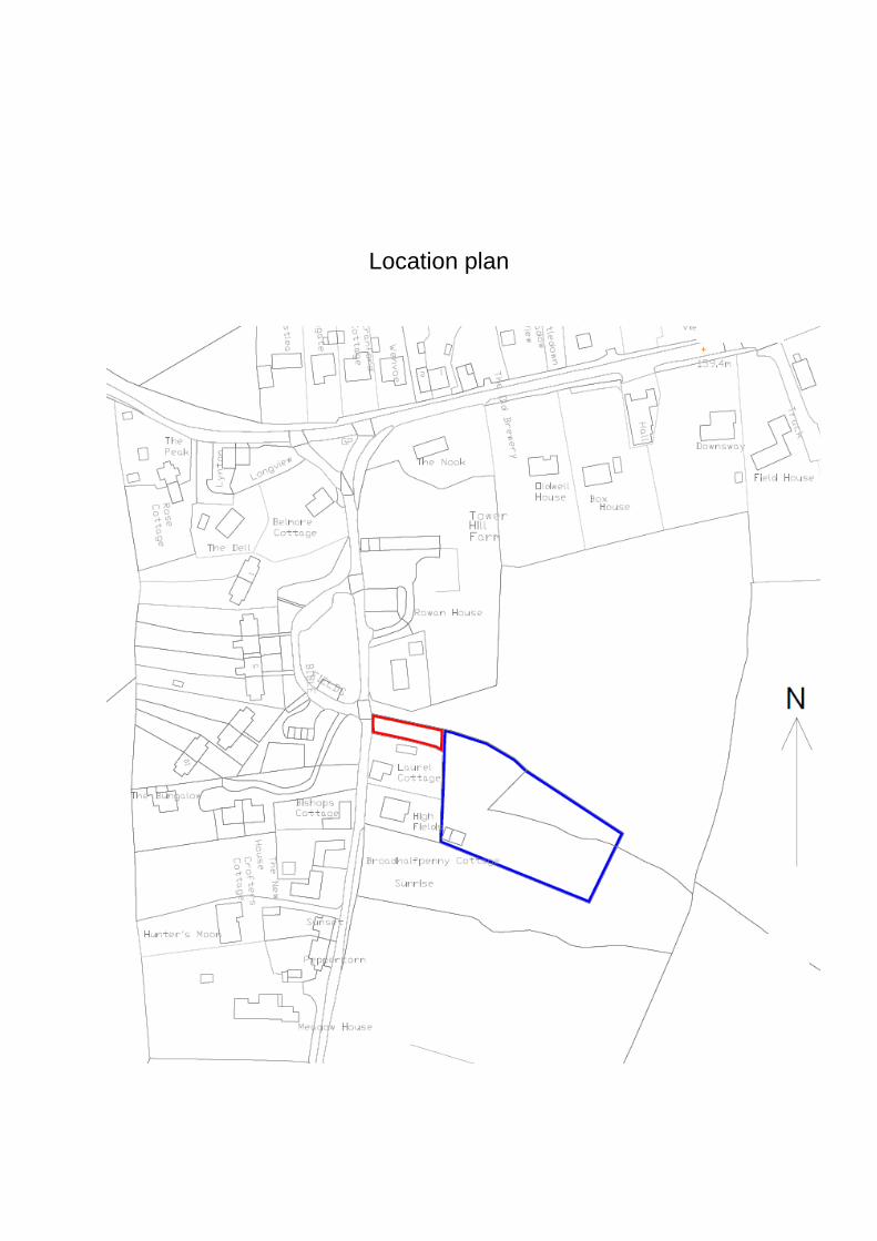
Location plan
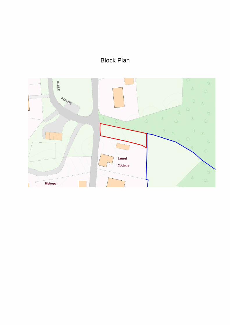
Block Plan
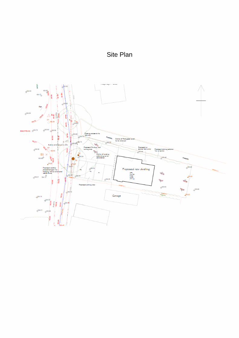
Site Plan

Floor Plans and Elevations
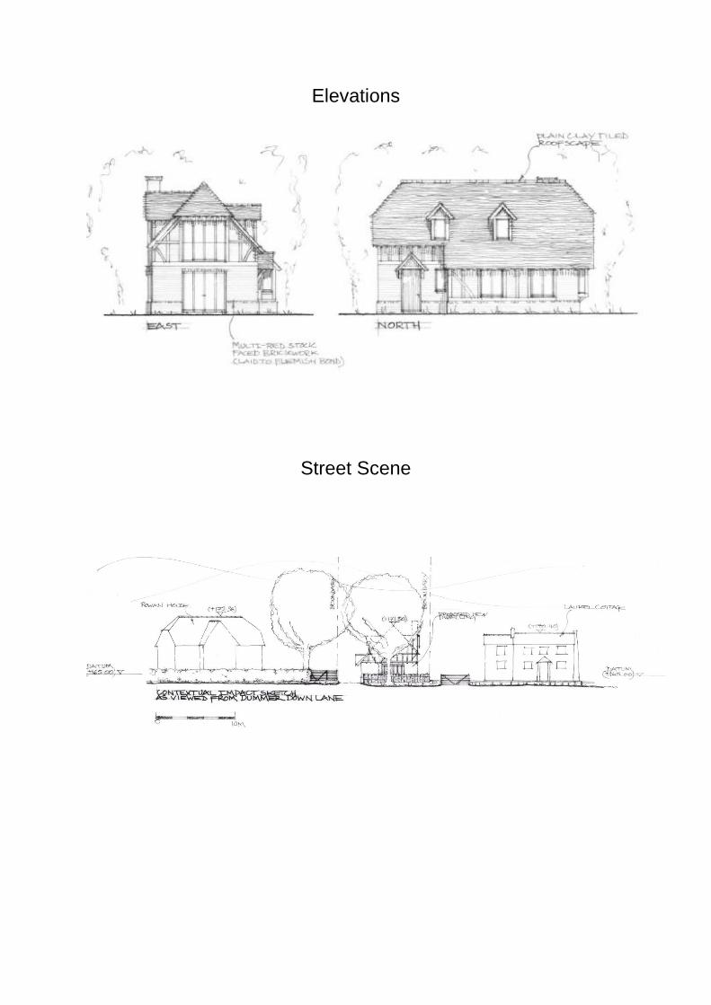
Elevations
Street Scene
Cttee: 21 June 2018
Item No. 3
Application no: 18/00612/FUL
For Details and Plans Click Here
Site Address The Courtyard At The Lychpit Centre Great Binfields Road Lychpit Basingstoke
Proposal Change of use from D1 to A3 uses (café) with ancillary A1 (shop) and A5 (hot food takeaway) uses, including the creation of an outside seating area and the installation of extractor fan with chimney
Registered: 9 March 2018 Expiry Date: 15 June 2018
Type of Application:
Full Planning Application
Case Officer: Daniel Ayre 01256 845512
Applicant: Mr Dmitry Potashnik Agent:
Ward: Basing Ward Member(s): Cllr Onnalee Cubitt Cllr Sven Godesen Cllr Paul Gaskell
Parish: OLD BASING AND LYCHPIT CP
OS Grid Reference: 465815 153433
Recommendation: the application be APPROVED subject to the conditions listed at the end of this report.
Reasons for Approval 1. The proposed development would provide an economic use and thereby
rationale for maintenance for this disused listed building, helping to prevent it from falling into disrepair and becoming a Listed Building at Risk. This is in accordance with Section 12 of the National Planning Policy Framework (March 2012); Policy EM11 of the Basingstoke and Deane Local Plan 2011-2029; and Section 66 of the Planning (Listed Buildings and Conservation Areas) Act 1990.
2. The proposed development would not result in the loss of an essential facility or service, and would therefore be in accordance with Policy CN7 of the Basingstoke and Deane Local Plan 2011-2029.
General Comments This application (in addition to the concurrent application for listed building consent) has been brought before the Development Control Committee due to the number of objections to the application and the officer's recommendation for approval, in line with the Council's scheme of delegation.
Planning Policy The Cromwell Inn is a Grade II listed building, under the entry “West Barn 20 yds NW of Lychpit Farmhouse”. The building which is the subject of this application is not individually listed in its own right, although it is physically connected to the Cromwell Inn at its western end, with the western gable wall supporting part of the roof of the Cromwell Inn. Therefore (for the purposes of this application) this building is considered to be part of the Cromwell Inn, and is therefore protected by the same listing. This is consistent with the council’s position established in application BDB/72084. The Cromwell Inn, and the building subject to this application are located within the complex of buildings formerly known as Lychpit Farm, now known as the Lychpit Centre. Statutory Legislation Section 66 of the Planning (Listed Buildings and Conservation Areas) Act 1990 National Planning Policy Framework (NPPF) (March 2012) Section 1 (Building a Strong, Competitive Economy) Section 7 (Requiring Good Design) Section 11 (Conserving and Enhancing the Natural Environment) Section 12 (Conserving and Enhancing the Historic Environment) Decision Taking Basingstoke and Deane Local Plan 2011-2029 Policy SD1 (Sustainable Development) Policy CN7 (Essential Facilities and Services) Policy CN9 (Transport) Policy EM4 (Biodiversity, Geodiversity and Nature Conservation) Policy EM10 (Delivering High Quality Development) Policy EM11 (The Historic Environment) Policy EM12 (Pollution) Policy EP3 (Town, District and Local Centres) Decision Taking Draft Old Basing and Lychpit Neighbourhood Plan Policy OB&L 6 - Protection of Historic Environment Supplementary Planning Documents and Guidance (SPDs and SPGs) The Historic Environment: Listed Buildings SPG Landscape and Biodiversity SPD
Other Material Documents Basingstoke and Deane Borough Council (2017) Marketing Guidance Note Historic England (2017) The Setting of Heritage Assets (2nd Edition) Historic England (2015) Managing Significance in Decision-Taking in the Historic Environment Description of Site The building subject to this application is a single storey, linear structure, built of brick with a slate roof. The only openings within the envelope of the building are on the North elevation, facing towards the courtyard. It is believed that this building dates to the late 18th or early 19th century, and was formerly used for informal storage, prior to its conversion to a children's centre in 2010. It is understood that this building was originally part of the former Lychpit Farm, in addition to Lychpit Farmhouse, approximately 15 metres to the South. The building sits on the southern side of a (pedestrian) courtyard, which was formerly the farmyard. There is an associated Grade II listed barn (now converted to community use) on the northern side of the courtyard, another Grade II listed barn (presently the Cromwell Inn restaurant) on the western side of the courtyard, and another 1.5 storey barn, also Grade II listed (now converted to a hair salon) on the eastern side of the courtyard. The site has pedestrian access from the East via Little Basing, an un-adopted private street, and from the North West, from the car park for the Lychpit Centre. Proposal This application seeks permission for the change of use of this building from a children's centre (use class D1), to a cafe (use class A1) with ancillary shop (A3) and hot food takeaway (A5) uses. The application was amended on the 4th of April 2018, to replace some of the proposed plans (Proposed North Elevation, Proposed Floor Plan and Proposed Chimney detail). The application was further amended on the 18th of April to clarify the application description. The original application description was: ‘Change of use from D1 to mixed A1, A3 and A5 uses, to form a shop, cafe, restaurant, and hot food take-away. Internal alterations, outside seating area and installation of extractor fan with chimney’. The amended description is ‘Change of use from D1 to A3 uses (café) with ancillary A1 (shop) and A5 (hot food takeaway) uses, including the creation of an outside seating area and the installation of extractor fan with chimney’. This was considered to be important to clarify that the proposed shop and takeaway uses would be ancillary to the main café use. Additional information was submitted on the 18th and 19th of April, to respond to requests for further information from the case officer and the Environmental Health Officer.
In association with this application, an application for Listed Building Consent seeks consent for material alterations within the building to facilitate this change of use (also on the agenda for consideration by the Development Control Committee). Consultations Cllr Godesen: (verbal comments) Expressed interest in the status of this application and raised concerns with respect of the Children’s group using Lychpit Hall. Old Basing and Lychpit Parish Council: 'Old Basing and Lychpit Parish Council wish to object for the following reasons: 1) Proposed changes in the roof will effect the amenity of the neighbours. 2) Tables and chairs will block a well-used Right of Way. 3) There are a lot of activities involving young children taking place in the adjoining hall and this might raise child protection issues. 4) Parking issues-43 spaces to cover a lot of users- (Tesco, The Cromwell, Lychpit hall) not deemed to be enough by the councillors. 5) Only sustainable in the summer as the inside area is not large enough for use as a café.' HCC Public Rights of Way Officer: No objection subject to attaching several informatives to any planning permission. Environmental Health Officer: Initial Comments: details of the type of food to be cooked required to determine the type of kitchen extract required. Final Comments: The type of food cooked is not highly odorous and the number of covers is small, it is not envisaged there being any odour or noise issues. Planning Policy Officer: No objection in principle. Biodiversity Officer: No objection subject to attaching an informative to any planning permission. Highways Officer: (Verbal comments) Clarified the status of Little Basing as a Private Street, as opposed to Private Road, and consequent inability to enforce a restriction on vehicular access to the development site by way of condition. Public Observations Three letters of objection have been received expressing the following concerns: Original Proposals:
No provision for the storage of waste was shown within the proposal.
The use of the building as a cafe is unsustainable without outdoor seating.
The potential for increased noise from the cafe in comparison to the children’s centre.
The absence of a noise assessment submitted as part of this application.
The potential for an increased likelihood of vandalism within the courtyard.
The potential for users of the proposed cafe to access it from Little Basing and consequent increase in noise and harm to the residential amenity of properties along this road.
The potential for adverse impact on the road surface of Little Basing caused by additional vehicular traffic on this road.
The potential for adverse impacts on the highways safety of Little Basing by vehicular access to the site.
Amended proposals with additional information: No comments received Six letters of objection have also been received in respect of the concurrent application for listed building consent (18/00712/LBC), these raise many of the same issues, in addition to the following:
The potential for adverse impacts on the amenity of residential properties in the area, due to odours from the café.
The potential for an increase in littering as a result of the change of use. Relevant Planning History BDB/72068 Restoration/conversion of existing former
agricultural building into children's centre, removal of existing concrete floor/ trough/new floor construction to coordinate existing roof structure to be retained, re-roof of existing building using existing plain red tiles to south elevation and replacing existing concrete tiles with natural slates to north elevation to coord lower roof pitch, insertion new full height oak windows and doors into existing/ proposed openings, new internal drylining/existing single-skin brickwalls to be retained, new underpinning to existing brick walls to coordinate new floor level
HCC Regulation 3 Application Granted
18/06/10
BDB/72071 Restoration/conversion of existing former agricultural building into children's centre, removal of existing concrete floor/trough/new floor construction to coordinate existing roof structure to be retained, re-roof of existing building using existing plain red tiles to south elevation and replacing existing concrete tiles with natural slates to north elevation to coord lower roof pitch, insertion new full height oak windows and doors into existing/proposed openings, new internal drylining/existing single-skin brickwalls to be retained, new underpinning to existing brick walls to coordinate new floor level
HCC Application for Listed Building Consent Granted
11/05/10
BDB/72083
Restoration/conversion of existing former agricultural building into children's centre, removal of existing concrete floor/trough/new floor construction to coordinate existing roof structure to be retained, re-roof of existing building using existing plain red tiles to south elevation and replacing existing concrete tiles with natural slates to north elevation to coord lower roof pitch, insertion new full height oak windows and doors into existing/proposed openings, new internal drylining/existing single-skin brickwalls to be retained, new underpinning to existing brick walls to coordinate new floor level Application No. BDB/72068
HCC Consultation associated with HCC Reg 3 Application BDB/72068 Granted
13/04/10
18/00712/LBC Internal and external alterations associated
with a change of use, including the installation of extractor fan with chimney.
Concurrent application for Listed Building Consent (also on the agenda for consideration by the Development Control Committee)
Assessment Principle of development The acceptability of proposals will depend upon their impact on the significance of the listed building and their compliance with statutory legislation, national and local planning policies, in particular: Section 66 of the Planning (Listed Buildings and Conservation Areas) Act 1990 states that in exercise of its functions under the Planning Acts, the local planning authority shall have special regard to the desirability of preserving the building or its setting or any features of special architectural or historic interest which it possesses.
Adopted Local Plan Policy CN7 sets out a variety of 'essential facilities and services' within which health care facilities and surgeries are listed. Where proposals would result in the loss of essential facilities and services, there are various requirements set out in Policy CN7 to either justify or outweigh this. The criteria for clear demonstration are one of the following:
a) The service or facility is no longer needed; or b) It is demonstrated that it is no longer practical, desirable or viable to retain
them; or c) The proposals will provide sufficient community benefit to outweigh the loss of
the existing facility or service, meeting evidence of a local need. Adopted Local Plan Policy CN9 requires development proposals to:
'integrate into existing movement networks',
'provide safe, suitable and convenient access for all potential users',
'provide an on-site movement layout compatible for all potential users with appropriate parking and servicing provision',
'not result in inappropriate traffic generation or compromise highways safety'. Adopted Local Plan Policy EM4 requires development proposals to protect biodiversity in the following ways:
'no adverse impact on the conservation status of key species',
'no adverse impact on the integrity of designated and proposed European designated sites'
'no harm to nationally or locally designated sites',
'no loss or deterioration of a key habitat site' and
'no harm to the integrity of linkages between designated sites and key habitats'.
Adopted Local Plan Policy EM10 requires development proposals to:
'positively contribute to local distinctiveness',
'provide a high quality of amenity for occupants… and neighbouring properties',
'have due regard to the density, scale, layout, appearance, architectural detailing, materials and history of the surrounding area and the relationship to neighbouring buildings' and to be
'visually attractive as a result of good architecture' Adopted Local Plan Policy EM11 requires development proposals to:
'demonstrate a thorough understanding of the significance of the heritage asset, how this has informed the proposed development and how the proposal would impact upon the assets significance',
'respect the historic form, setting, fabric and any other aspects which contribute to the significance of the host building',
'conserve or enhance the quality, distinctiveness and character of heritage assets by ensuring the use of appropriate materials, design and detailing'
Adopted Local Plan Policy EM12 requires development proposals to not result in pollution which is detrimental to quality of life, or poses unacceptable risks to health or the natural environment. Adopted Local Plan Policy EP3 aims to sustain the vitality and viability of the defined town, district and local centres within the borough thorough setting a sequential test for the acceptability of new or extended main centre uses, outside of the existing defined town, district or local centres within the borough. Policy OL&L 6 of the Draft Old Basing and Lychpit Neighbourhood Plan requires that:
‘Any designated historic heritage assets in the Parish and their settings, both above and below ground, will be conserved or enhanced for their historic and architectural significance and their importance to local distinctiveness, character and sense of place. In particular, these include, but are not limited to:
o Basing House o Olivers Battery’
Loss of essential facilities and services by virtue of the change of use The marketing report submitted in support of this application has evidenced that this building has been disused and unoccupied for over 12 months, following the closure of the previous children's centre, as part of a restructuring of the county-wide service by the service provider, Hampshire County Council. This satisfactorily illustrates that the building is no longer needed for its original purpose and so satisfies criterion (a) of Policy CN7. The marketing report also provides details of attempts to find alternative essential facilities or services to occupy the property. Although full marketing information is not provided, the unit has been vacant for 14 months and the report demonstrates that the unit was advertised via a range of channels without finding a purchaser. Furthermore, it identifies clear practical reasons that would mean that the building was not suitable for particular alternative uses (for example, as a clinic or children's nursery). This illustrates that it is no longer practical or viable to retain the building in its current use class and so satisfies criterion (b) of Policy CN7. The proposal does not comply with criterion (c) of Policy CN7 however it does not need to, as the proposal does comply with both criteria (a) and (b) of Policy CN7. Impact on the vitality and viability of designated centres The proposed use would principally be a small café and given the size/intensity of the restaurant element (as indicated by the size of the kitchen and number of seats), the proposal would not be considered to fall within the definition of a main town centre use (as defined by the NPPF glossary). It would therefore not be necessary
for the development to satisfy the sequential test, as set out in Policy EP3. Therefore it is not considered that the proposal would have an adverse impact on the vitality or viability of the designated centres within the borough. Impact on the listed buildings The proposed change of use would not change the character and nature of the courtyard at the Lychpit Centre, and would only necessitate very minor external alterations to this building; it would preserve the setting of the adjacent listed buildings. The impact of the internal works proposed for this building are beyond the scope of this application, and they will be considered under the concurrent application for Listed Building Consent. The proposed external seating and dining area would alter the character of the courtyard, but not so much so that it would obscure an ability to appreciate its historic character and former agricultural use. It is therefore considered that this seating would not cause harm to the setting of the listed building, although it is recommended that a condition is attached to any planning permission to secure full details of the external seating area and any associated paraphernalia, such as umbrellas and barriers, prior to their installation. In general terms, the proposed change of use would enable the continued occupation and use of this building, which would provide an income and therefore a rationale for the continued maintenance and upkeep of this building, which would preserve its material fabric and special interest. Therefore having due regard to Section 66 of the Planning (Listed Buildings and Conservation Areas Act 1990, it is considered that the proposed development would not harm the special interest of the listed building, and would be in compliance with Policy EM11 of the Local Plan and Policy OB&L 6 of the Draft Neighbourhood Plan. Access, Transport and Parking The Highways Officer has not raised an objection to the presently proposed change of use, given the similar nature of any potential highway impacts with the existing D1 use. In terms of pedestrian access and public transport, the site is not considered to be in an unsustainable location, being in close proximity to a large number of residential properties and other facilities and services within the Lychpit Centre. The site is also served by the no. 14 bus between Basingstoke and Tadley, on an hourly basis, and the no. 7 bus between Basingstoke and Chineham in the evenings and on Sundays. Therefore the proposals are considered to be in accordance with Policy CN9 a) and b) of the Local Plan. The concerns raised by the Parish Council and several other third parties with respect of parking are noted, but it is considered that the application site is considered to be well served in terms of parking provision, with in excess of 40
spaces provided within the Lychpit Centre car park to the North West. The proposals are therefore considered to be in in accordance with Policy CN9 c) of the Local Plan. The concerns raised by several third parties in respect of the potential for adverse impacts on Little Basing are noted and considered to be valid. It is considered that vehicular access from Little Basing would be an undesirable intensification of vehicular use of this road, although pedestrian access is ensured by the public right of way which runs past the building onto Little Basing. It is noted that the previous planning permission for the change of use of this building (reference BDB/72071) included a condition intended to prevent vehicular access to the site from Little Basing. However, as the Little Basing road is outside of the application red line delineating the land subject to this application, it is not part of the proposals. In addition, the Little Basing road has been identified as a 'Private Street' (as opposed to Private Road), by Hampshire County Council, a road which could be adopted at a future date. Therefore it would not be possible to prevent vehicular access to the application site by way of a condition attached to this planning permission. However, it is recommended that an informative be attached to this planning permission to advise against vehicular access to the development site from Little Basing road. Impact on the character of the area/ design As previously stated, it is considered that the proposals would not change the character or appearance of the area. Therefore the proposals are considered to be in accordance with Policy EM10 of the Local Plan. Impact on Neighbouring Amenities The nearest residential property to this building is Lychpit House, approximately 15 metres to the South of the development site, separated from it by the rear party wall of the building subject to this application and an attached 1.8m high brick wall. The third party comments received with respect to the potential for adverse impacts on the residential amenity of neighbouring properties due to noise and odour are noted. In this instance, it is considered necessary to defer to the professional advice of the Environmental Health Officer, they advise that as type of food cooked is not highly odorous and the number of covers is small, there would not be any unacceptable impacts on the surrounding area due to odour or noise. The third party comments have also raised concerns about the potential for increased littering and vandalism as a result of the change of use of this building. Unfortunately, these issues fall outside of the scope of this planning application, as their regulation is controlled under separate legislation. The proposed development would not overlook or overshadow any neighbouring properties. To prevent unacceptable noise impacts from the development, during both its construction phase and subsequent period of operation, it is recommended that two conditions are attached to this planning permission to regulate the hours of working during the construction work, and the hours of opening of this cafe.
Therefore, it is not considered that the proposed development would result in unacceptable adverse impacts on the residential amenities of neighbouring properties, in accordance with Policy EM10 of the Local Plan. Pollution As stated above, the Environmental Health Officer has also raised no objection to the proposed change of use. It is not considered that the proposals would result in any pollution, in accordance with Policy EM12 of the Local Plan. Impacts on the Public Right of Way The development site is adjacent to the Old Basing and Lychpit Footpath 6. The Hampshire County Council Countryside Planning Officer has advised that whilst there is no objection to the proposals, the public right of way must not be obstructed during the course of construction works and that any damage caused to the public right of way must be made good on completion of the works. It is recommended that conditions and informatives are attached to this permission to this effect. Biodiversity The Biodiversity Officer has confirmed that the roof of the property looks to be in very good repair and of negligible potential interest for roosting bats. As a consequence it is recommended that an informative is attached to this planning permission to advise against working practices which might be harmful to bats. Other Matters The concerns of the Parish Council with respect to the children's play group which uses the Lychpit Hall, on the opposite side of the courtyard, and the potential for safeguarding issues to arise are noted. It is should also be noted that the courtyard at the Lychpit Centre is a public area with a public right of way running across it. Therefore, the interior of the hall can already be seen from the public realm. It is considered that the proposed change of use and the addition of an area of external tables and chairs for the cafe would not significantly change this. It is respectfully considered that safeguarding issues fall outside of the scope of the Planning Acts, and are regulated by different legislation, outside of the planning process. One of the third party comments raised concerns about the lack of any submitted details to address the waste storage and disposal from the proposed cafe. As a result of this, an additional site plan has been submitted to demonstrate the proposed arrangements for this. No further comments were received despite re-consultation of all contributors to this application. It is recommended that storage and disposal of waste is controlled by way of an appropriately worded condition attached to this planning permission.
Conclusion In the light of the above, it is considered that the proposals would accord with policies and guidance contained within the National Planning Policy Framework (March 2012), the Adopted Local Plan Policies SD1, CN7, CN9, EM4, EM10, EM11, EM12, EP3, Policy OB&L 6 of the Draft Neighbourhood Plan, the guidance contained in the Council's Supplementary Planning Documents and Guidance and the relevant Historic England Advice. It is therefore recommended that planning permission be granted on this occasion, subject to attaching conditions and informatives. Conditions 1 The development hereby permitted shall be carried out in accordance with the
following approved plans and documents:
Location Plan, 1:1250@A4, licence no. 100035409, received 27.02.2018 Site Plan, 1:500@A3, licence no. 100035409, received 27.02.2018 North Elevation (As proposed), 1:100@A4, dwg. no. 001, received 04.04.2018 East Elevation (As proposed), 1:100@A4, dwg. no. 002, 1st revision, received 27.02.2018 Proposed removal of plaster board wall (Proposed Floor Plan), 1:100@A4, dwg. no. 003, 1st revision, received 04.04.2018 Outdoor Seating Area, 1:200@A4, dwg. no. 004, received 18.04.2018 Proposed bin location for cafe, 1:200@A4, dwg. no 005, received 19.04.2018 Removal of walls surrounding toilet facility, 1:25@A4, received 27.02.2018 Email from the applicant to the case officer, specifying inter alia waste collection and extraction vent details, received 18.04.2018
REASON: For the avoidance of doubt and in the interests of proper planning.
2 The development hereby permitted shall be begun before the expiration of 3
years from the date of this planning permission.
REASON: To comply with Section 91 of the Town and Country Planning Act 1990 and to prevent an accumulation of unimplemented planning permissions.
3 The premises shall not open before 07:00 hours or remain open after 23:00
hours on Mondays to Saturdays, and 08:00 hours to 17:00 hours on Sundays or any recognised public holidays.
REASON: To protect the amenities of the occupiers of nearby properties in accordance with Policy EM10 of the Basingstoke and Deane Local Plan 2011-2029.
4 No work relating to the construction of the development hereby approved,
including works of demolition or preparation prior to operations, or internal painting or fitting out, shall take place before the hours of 0730 nor after 1800 Monday to Friday, before the hours of 0800 nor after 1300 Saturdays nor on Sundays or recognised public holidays.
REASON: To protect the amenities of the occupiers of nearby properties during the construction period and in accordance with Policies EM10 and EM12 of the Basingstoke and Deane Local Plan 2011-2029.
5 The area of external tables and chairs hereby approved shall be located only
in the position shown on the approved plan 'Outdoor Seating Area', 1:200@A4, dwg. no. 004, received 18.04.2018.
Notwithstanding these details, no tables, chairs, barriers, umbrellas, external signage or associated cafe paraphernalia shall be located outside of the cafe until full details of those proposed features have been submitted to and approved in writing by the Local Planning Authority.
REASON: To preserve the setting of the listed buildings, in accordance with Policy EM11 of the Basingstoke and Deane Local Plan 2011-2029.
6 Notwithstanding the approved plans, the waste storage and disposal for this
development shall be carried out and thereafter maintained in accordance with the information contained within the following plans and documents:
Email from the applicant to the case officer, specifying inter alia waste collection and extraction vent details, received 18.04.2018 Proposed bin location for cafe, Teagether Ltd., 1:200@A4, dwg no. 005 rev. A 01, dated April 2018 (Received 19.04.2018)
REASON In the interests of preserving the amenity of the courtyard, the amenity of adjacent residential properties and to prevent pollution, in accordance with Policies EM10 and EM12 of the Basingstoke and Deane Local Plan 2011-2029.
7 The public right of way known as Old Basing and Lychpit Footpath 6 shall be kept open and free of obstruction throughout the construction period.
REASON: In the interests of public amenities, and the preservation of unimpeded access to the public right of way, in accordance with Policy EM10 of the Basingstoke and Deane Local Plan 2011-2029.
8 Prior to first occupation of the development hereby permitted, any damage
caused to the surface of Old Basing and Lychpit Footpath 6 caused by the construction traffic shall be made good to the satisfaction of the Rights of Way Officer, and the path shall be restored to not less than its minimum current width.
REASON: In the interests of public amenities, and the preservation of unimpeded access to the public right of way, in accordance with Policy EM10 of the Basingstoke and Deane Local Plan 2011-2029.
Informative(s):- 1. 1.1 The applicant's attention is drawn to the fact that the above conditions (if
any), must be complied with in full, failure to do so may result in enforcement action being instigated.
1.2 This permission may contain pre-commencement conditions which require specific matters to be submitted and approved in writing by the Local Planning Authority before a specified stage in the development occurs. This means that a lawful commencement of the approved development CANNOT be made until the particular requirements of the pre-commencement conditions have been met.
1.3 The applicant's attention is drawn to the fact that the Local Planning Authority has a period of up to eight weeks to determine details submitted in respect of a condition or limitation attached to a grant of planning permission. It is likely that in most cases the determination period will be shorter than eight weeks, however, the applicant is advised to schedule this time period into any programme of works. A fee will be required for requests for discharge of any consent, agreement, or approval required by a planning condition. The fee chargeable is £116 or £34 where the related permission was for extending or altering a dwelling house or other development in the curtilage of a dwelling house. A fee is payable for each submission made regardless of the number of conditions for which approval is sought. Requests must be made using the standard application form (available online) or set out in writing clearly identifying the relevant planning application and condition(s) which they are seeking approval for.
2. In accordance with paragraphs 186 and 187 of the National Planning Policy
Framework (NPPF) in dealing with this application, the Council has worked with the applicant in the following positive and proactive manner:-
offering pre-application advice; seeking further information following receipt of the application; seeking amendments to the proposed development following receipt of the application; considering the imposition of conditions.
In this instance:
the applicant was provided with pre-application advice, the applicant was updated of any issues after the initial site visit, additional information was requested of the applicant in response to issues arising.
In such ways the Council has demonstrated a positive and proactive manner in seeking solutions to problems arising in relation to the planning application.
3. There must be no surface alterations to the right of way, nor any works carried
out which affect its surface, without first seeking the permission of Hampshire
County Council, as Highway Authority for Public Rights of Way. For the purposes of this proposal that permission would be required from this department of the County Council. To carry out any such works without this permission would constitute an offence under S131 Highways Act 1980, and the applicant is encouraged to contact Hampshire County Council as soon as possible to discuss any works of this nature.
4. Nothing connected with the development or its future use should have an
adverse effect on the right of way, which must remain available for public use at all times.
5. No builders’ or contractors’ vehicles, machinery, equipment, materials,
scaffolding or anything associated with the works should be left on or near the footpath so as to obstruct, hinder or provide a hazard to walkers.
6. All vehicles, including those of contractors and deliveries, which would be
accessing the site via a right of way, should give way to public users at all times.
7. If at any time during the proposed works bats, or signs of bats, are found then
all works must stop and advice should be sought from Natural England before any further work on the building proceeds. All bats and their roost sites are protected under the Wildlife and Countryside Act 1981 and The Conservation of Habitats and Species Regulations 2010 from disturbance and harm.
8. The applicant is advised that all vehicular access to the site should be from the
Lychpit Centre Car Park, not from the Little Basing Road.
It should also be noted that it is not possible for the Local Planning Authority to restrict vehicular access to the site from Little Basing, due to the status of this road as a Private Street, which has been recognised as being capable of adoption by Hampshire County Council.
For further information, please visit: https://www.hants.gov.uk/transport/searchesrightscharges/prospectivelymaintainable
9. The applicant is reminded that this approval does not give any indication of any
consent necessary under the Town and Country Planning (Control of Advertisements) Regulations 1992 which may or may not be required nor any indication that such consent will be forthcoming. The applicant is advised to contact the Planning and Development Manager in this regard.

Location plan

Site Plan
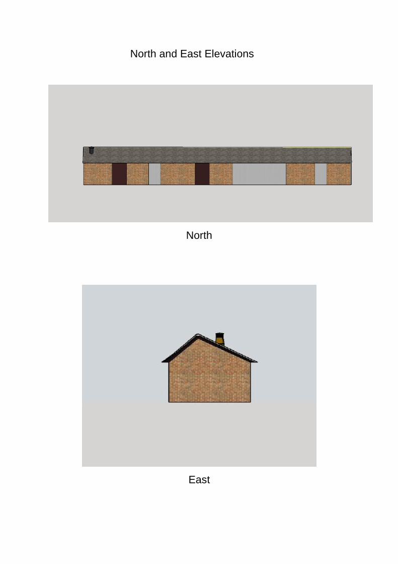
North and East Elevations
North
East
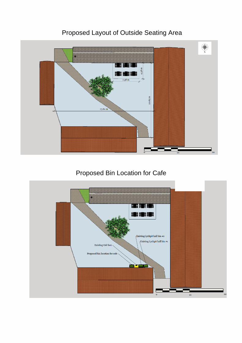
Proposed Layout of Outside Seating Area
Proposed Bin Location for Cafe
Cttee: 21 June 2018
Item No. 4
Application no: 18/00712/LBC
For Details and Plans Click Here
Site Address The Courtyard At The Lychpit Centre Great Binfields Road Lychpit Basingstoke
Proposal Internal and external alterations associated with a change of use, including the installation of extractor fan with chimney.
Registered: 9 March 2018 Expiry Date: 15 June 2018
Type of Application:
Listed Building Consent
Case Officer: Daniel Ayre 01256 845512
Applicant: Mr Dmitry Potashnik Agent:
Ward: Basing Ward Member(s): Cllr Onnalee Cubitt Cllr Sven Godesen Cllr Paul Gaskell
Parish: OLD BASING AND LYCHPIT CP
OS Grid Reference: 465815 153433
Recommendation: the application be APPROVED subject to the conditions listed at the end of this report.
Reason for Approval 1. The proposed works would preserve the special interest of the listed building, by
virtue of their small scale and impact on the historic material fabric of this listed building. This is in accordance with Section 12 of the National Planning Policy Framework (March 2012); Policy EM11 of the Basingstoke and Deane Local Plan 2011-2029; and Section 66 of the Planning (Listed Buildings and Conservation Areas) Act 1990.
General Comments This application has been brought before the Development Control Committee due to the number of objections to the application (in addition to the concurrent application for planning permission) and the officer's recommendation for approval, in line with the Council's scheme of delegation. Planning Policy The Cromwell Inn is a Grade II listed building, under the entry "West Barn 20 yds NW of Lychpit Farmhouse". The building which is the subject of this application is not individually listed in its own right, although it is physically connected to the Cromwell Inn at its western end, with the western gable wall supporting part of the roof of the Cromwell Inn. Therefore (for the purposes of this application) this building is considered to be part of the Cromwell Inn, and is therefore protected by the same
listing. This is consistent with the council's position established in application BDB/72084 The Cromwell Inn, and the building subject to this application are located within the complex of buildings formerly known as Lychpit Farm, now known as the Lychpit Centre. Statutory Legislation Sections 66 of the Planning (Listed Buildings and Conservation Areas) Act 1990 National Planning Policy Framework (NPPF) (March 2012) Section 11 (Conserving and Enhancing the Natural Environment) Section 12 (Conserving and Enhancing the Historic Environment) Basingstoke and Deane Local Plan 2011-2029 Policy SD1 (Sustainable Development) Policy EM4 (Biodiversity, Geodiversity and Nature Conservation) Policy EM10 (Delivering High Quality Development) Policy EM11 (The Historic Environment) Draft Old Basing and Lychpit Neighbourhood Plan Policy OB&L 6 - Protection of Historic Environment Supplementary Planning Documents and Guidance (SPDs and SPGs) The Historic Environment: Listed Buildings SPG Landscape and Biodiversity SPD Other Material Documents Historic England (2017) The Setting of Heritage Assets (2nd Edition) Historic England (2015) Managing Significance in Decision-Taking in the Historic Environment Description of Site The building subject to this application is a single storey, linear structure, built of brick with a slate roof. The only openings within the envelope of the building are on the North elevation, facing towards the courtyard. It is believed that this building dates to the late 18th or early 19th century, and was formerly used for informal storage, prior to its conversion to a children's centre in 2010. It is understood that this building was originally part of the former Lychpit Farm, in addition to Lychpit Farmhouse, approximately 15 metres to the South. The building sits on the southern side of a (pedestrian) courtyard, which was formerly the farmyard. There is an associated Grade II listed barn (now converted to community
use) on the northern side of the courtyard, another Grade II listed barn (now converted to a restaurant) on the western side of the courtyard, and another Grade II listed 1.5 storey barn (now converted to a hair salon) on the eastern side of the courtyard. The site has pedestrian access from the East via Little Basing, an un-adopted private street, and from the North West, from the car park for the Lychpit Centre. Proposals This application seeks consent for some alterations to this listed building, comprising the following:
The installation of a new black metal flue through the roof at the eastern end of the building.
The installation of an associated internal commercial extractor fan.
The alteration of several internal partition walls. The application was amended on the 4th of April 2018, to replace some of the proposed plans (Proposed North Elevation, Proposed Floor Plan and Proposed Chimney detail). The application was further amended on the 18th of April to clarify the application description. The original application description was ‘Change of use from D1 to mixed A1, A3 and A5 uses, to form a shop, cafe, restaurant, and hot food take-away. Internal alterations, outside seating area and installation of extractor fan with chimney’. The amended description is ‘Internal and external alterations associated with a change of use, including the installation of extractor fan with chimney’. Listed Building Consent is not needed for the change of use, only for the physical alterations to the building. In association with this application, an application for planning permission seeks permission for the change of use of this building from a children's centre (use class D1), to a cafe (use class A1) with ancillary shop (A3) and hot food takeaway (A5) uses (also on the agenda for consideration by the Development Control Committee. Consultations Old Basing and Lychpit Parish Council: 'Old Basing and Lychpit Parish Council wish to object for the following reasons;
1. Proposed changes in the roof will effect the amenity of the neighbours. 2. Tables and chairs will block a well-used Right of Way. 3. There are a lot of activities involving young children taking place in the
adjoining hall and this might raise child protection issues. 4. Parking issues-43 spaces to cover a lot of users- (Tesco, The Cromwell,
Lychpit hall) not deemed to be enough by the councillors. 5. Only sustainable in the summer as the inside area is not large enough for use
as a café.'
Biodiversity Officer: No objection subject to attaching an informative to any planning permission. Public Observations Six letters of objection have been received expressing the following concerns: Original Proposals:
No provision for the storage of waste was shown within the proposal.
The use of the building as a cafe is unsustainable without outdoor seating.
The potential for increased noise from the cafe in comparison to the children’s centre.
The absence of a noise assessment submitted as part of this application.
The potential for an increased likelihood of vandalism within the courtyard.
The potential for users of the proposed cafe to access it from Little Basing and consequent increase in noise and harm to the residential amenity of properties along this road.
The potential for adverse impact on the road surface of Little Basing caused by additional vehicular traffic on this road.
The potential for adverse impacts on the highways safety of Little Basing by vehicular access to the site.
The potential for adverse impacts on the amenity of residential properties in the area, due to odours from the café.
The potential for an increase in littering as a result of the change of use. Amended proposals with additional information: No comments received. Three letters of objection have also been received in respect of the concurrent application for planning permission (18/00612/FUL), which raise the same issues. Relevant Planning History BDB/72068 Restoration/conversion of existing former
agricultural building into children's centre, removal of existing concrete floor/trough/new floor construction to coordinate existing roof structure to be retained, re-roof of existing building using existing plain red tiles to south elevation and replacing existing concrete tiles with natural slates to north elevation to coord lower roof pitch, insertion new full height oak windows and doors into existing/proposed openings, new internal drylining/existing single-skin brickwalls to be retained, new underpinning to existing brick walls to coordinate new floor level
HCC Regulation 3 Application Granted
18/06/10
BDB/72071 Restoration/conversion of existing former agricultural building into children's centre, removal of existing concrete floor/trough/new floor construction to coordinate existing roof structure to be retained, re-roof of existing building using existing plain red tiles to south elevation and replacing existing concrete tiles with natural slates to north elevation to coord lower roof pitch, insertion new full height oak windows and doors into existing/proposed openings, new internal drylining/existing single-skin brickwalls to be retained, new underpinning to existing brick walls to coordinate new floor level
HCC Application for Listed Building Consent Granted
11/05/10
BDB/72083 Restoration/conversion of existing former
agricultural building into children's centre, removal of existing concrete floor/trough/new floor construction to coordinate existing roof structure to be retained, re-roof of existing building using existing plain red tiles to south elevation and replacing existing concrete tiles with natural slates to north elevation to coord lower roof pitch, insertion new full height oak windows and doors into existing/proposed openings, new internal drylining/existing single-skin brickwalls to be retained, new underpinning to existing brick walls to coordinate new floor level Application No. BDB/72068
HCC Consultation associated with HCC Reg 3 Application BDB/72068 Granted
13/04/10
18/00612/FUL
Change of use from D1 to A3 uses (café) with ancillary A1 (shop) and A5 (hot food takeaway) uses, including the creation of an outside seating area and the installation of extractor fan with chimney
Concurrent application for Planning Permission (also on the agenda for consideration by the Development Control Committee).
Assessment: Principle of development The acceptability of proposals will depend upon their impact on the significance of the listed building and their compliance with statutory legislation, national and local planning policies, in particular: Section 66 of the Planning (Listed Buildings and Conservation Areas) Act 1990 states that in exercise of its functions under the Planning Acts, the local planning
authority shall have special regard to the desirability of preserving the building or its setting or any features of special architectural or historic interest which it possesses. Adopted Local Plan Policy EM4 requires development proposals to protect biodiversity in the following ways:
'no adverse impact on the conservation status of key species',
'no adverse impact on the integrity of designated and proposed European designated sites'
'no harm to nationally or locally designated sites',
'no loss or deterioration of a key habitat site' and
'no harm to the integrity of linkages between designated sites and key habitats'.
Adopted Local Plan Policy EM10 requires development proposals to:
'positively contribute to local distinctiveness',
'provide a high quality of amenity for occupants… and neighbouring properties',
'have due regard to the density, scale, layout, appearance, architectural detailing, materials and history of the surrounding area and the relationship to neighbouring buildings' and to be
'visually attractive as a result of good architecture' Adopted Local Plan Policy EM11 requires development proposals to:
'demonstrate a thorough understanding of the significance of the heritage asset, how this has informed the proposed development and how the proposal would impact upon the assets significance',
'respect the historic form, setting, fabric and any other aspects which contribute to the significance of the host building',
'conserve or enhance the quality, distinctiveness and character of heritage assets by ensuring the use of appropriate materials, design and detailing'
Policy OL&L 6 of the Draft Old Basing and Lychpit Neighbourhood Plan requires that:
‘Any designated historic heritage assets in the Parish and their settings, both above and below ground, will be conserved or enhanced for their historic and architectural significance and their importance to local distinctiveness, character and sense of place. In particular, these include, but are not limited to:
o Basing House o Olivers Battery’
Impact on the listed building The proposed alterations to this building are minor in nature, and would not cause harm to the special interest of the listed building. The new flue would be of a suitably
utilitarian character so as to respond to the functional nature of this former agricultural building. The internal walls proposed to be altered were installed as part of the 2010 conversion to a children’s centre, and are therefore not valuable fabric; their alteration would not harm the special interest of this listed building. The impact of the proposed external seating area on the setting of this listed building, and the other listed buildings around the courtyard will be discussed under the concurrent application for planning permission, as this work does not require listed building consent In general terms, the proposed alterations would facilitate the currently proposed change of use. This in turn would enable the continued occupation and use of this building, which would provide an income and therefore a rationale for the continued maintenance and upkeep of this building, which would preserve its material fabric and special interest. Therefore having due regard to Section 66 of the Planning (Listed Buildings and Conservation Areas Act 1990, it is considered that the proposed development would not harm the special interest of the listed building, and would be in compliance with Policy EM11 of the Local Plan and Policy OB&L 6 of the Draft Neighbourhood Plan. Biodiversity The Biodiversity Officer has confirmed that the roof of the property looks to be in very good repair and of negligible potential interest for roosting bats. As a consequence it is recommended that an informative is attached to this planning permission to advise against working practices which might be harmful to bats. Other Matters The impacts of the proposals on the residential amenities of the surrounding properties, on highways safety and parking, on the public right of way, and in terms of pollution, have been considered in the concurrent application for planning permission 18/00612/FUL. The comments received from third parties and the Old Basing and Lychpit Parish Council are noted. As these relate to planning issues, they are beyond the scope of this application for listed building consent, which can only consider the impact of the proposals on the special interest of the listed building. These other matters have been considered in the concurrent application for planning permission 18/00612/FUL. Conclusion In the light of the above, it is considered that the proposals would accord with policies and guidance contained within the National Planning Policy Framework (March 2012), the Adopted Local Plan Policies SD1, EM4, EM10 and EM11, Policy OB&L 6 of the Draft Neighbourhood Plan, the guidance contained in the Council's Supplementary Planning Documents and Guidance and the relevant Historic
England Advice. It is therefore recommended that listed building consent be granted on this occasion, subject to attaching conditions and informatives. Conditions 1 The development hereby permitted shall be carried out in accordance with the
following approved plans:
Location Plan, 1:1250@A4, licence no. 100035409, received 27.02.2018 Site Plan, 1:500@A3, licence no. 100035409, received 27.02.2018 North Elevation (As proposed), 1:100@A4, dwg. no. 001, received 04.04.2018 East Elevation (As proposed), 1:100@A4, dwg. no. 002, 1st revision, received 27.02.2018 Proposed removal of plaster board wall (Proposed Floor Plan), 1:100@A4, dwg. no. 003, 1st revision, received 04.04.2018 Removal of walls surrounding toilet facility, 1:25@A4, received 27.02.2018 Email from the applicant to the case officer, specifying inter alia waste collection and extraction vent details, received 18.04.2018
REASON: For the avoidance of doubt and in the interests of proper planning.
2 The works to which this Listed Building Consent relate shall be begun before
the expiration of 3 years from the date of the consent.
REASON: To comply with Section 18 of the Planning (Listed Buildings and Conservation Areas) Act 1990 (as amended by Section 51(4) of the Planning and Compensation Act 2004) and to prevent an accumulation of unimplemented consents.
3 All works of repair to the surrounding fabric affected by the works hereby
approved shall match the existing in all respects. The works shall be carried out and thereafter maintained in accordance with the approved details.
REASON: To preserve the special architectural / historic interest of the listed building in accordance with the guidance contained within the National Planning Policy Framework (March 2012) and Policy EM11 of the Basingstoke and Deane Local Plan 2011-2029.
4 Notwithstanding the approved plans, the new flue hereby approved shall be
made of metal, finished black, as specified in an email from the applicant to the case officer, specifying inter alia waste collection and extraction vent details, received 18.04.2018.
REASON To preserve the special architectural / historic interest of the listed building in accordance with the guidance contained within the National Planning Policy Framework (March 2012) and Policy EM11 of the Basingstoke and Deane Local Plan 2011-2029.
Informative(s):-
1. 1.1 The applicant's attention is drawn to the fact that the above conditions (if any), must be complied with in full, failure to do so may result in enforcement action being instigated.
1.2 This permission may contain pre-commencement conditions which require specific matters to be submitted and approved in writing by the Local Planning Authority before a specified stage in the development occurs. This means that a lawful commencement of the approved development CANNOT be made until the particular requirements of the pre-commencement conditions have been met.
1.3 The applicant's attention is drawn to the fact that the Local Planning Authority has a period of up to eight weeks to determine details submitted in respect of a condition or limitation attached to a grant of planning permission. It is likely that in most cases the determination period will be shorter than eight weeks, however, the applicant is advised to schedule this time period into any programme of works.
1.4 No fees are required for the submission of details required under a condition imposed on a Listed Building Consent. Requests must however be made using the standard application form (available online) or set out in writing clearly identifying the relevant consent and condition(s) which they are seeking approval for.
2. In accordance with paragraphs 186 and 187 of the National Planning Policy
Framework (NPPF) in dealing with this application, the Council has worked with the applicant in the following positive and proactive manner:-
offering pre-application advice; seeking further information following receipt of the application; seeking amendments to the proposed development following receipt of the application; considering the imposition of conditions.
In this instance:
the applicant was provided with pre-application advice, the applicant was updated of any issues after the initial site visit, additional information and amendments were requested of the applicant, to respond to issues arising.
In such ways the Council has demonstrated a positive and proactive manner in seeking solutions to problems arising in relation to the planning application.
2. If at any time during the proposed works bats, or signs of bats, are found then all
works must stop and advice should be sought from Natural England before any further work on the building proceeds. All bats and their roost sites are protected under the Wildlife and Countryside Act 1981 and The Conservation of Habitats and Species Regulations 2010 from disturbance and harm.
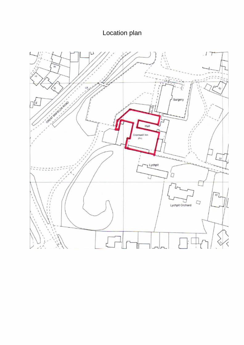
Location plan
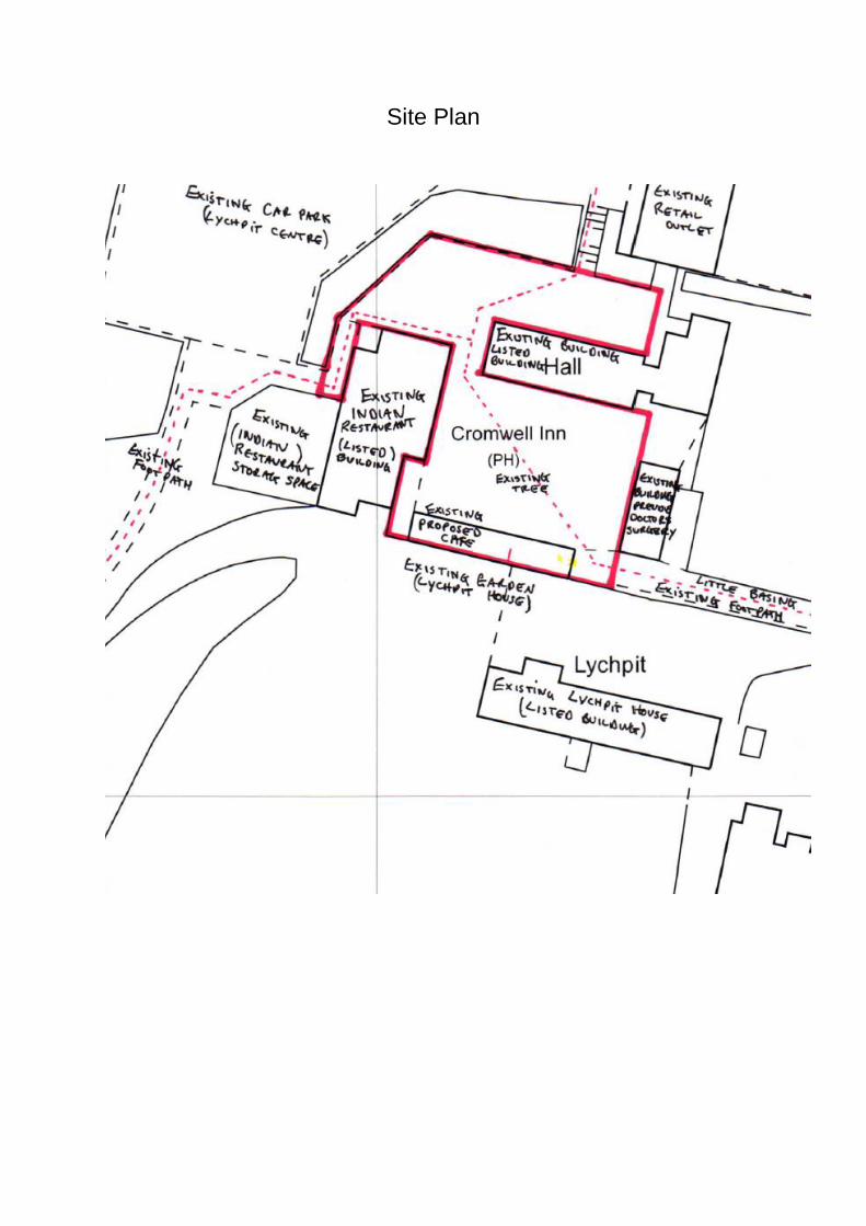
Site Plan
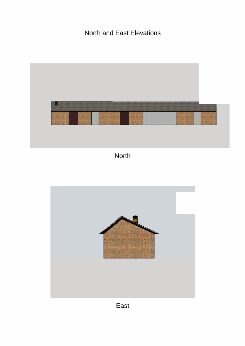
North and East Elevations
North
East
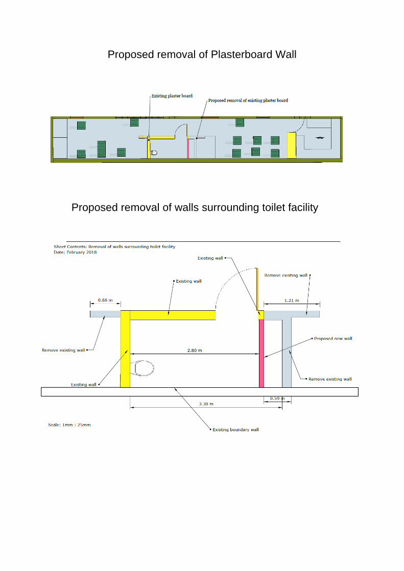
Proposed removal of Plasterboard Wall
Proposed removal of walls surrounding toilet facility
Cttee: 21 June 2018
Item No. 5
Application no: 18/00748/FUL
For Details and Plans Click Here
Site Address Pine Cottage Heath End Road Baughurst RG26 5ND
Proposal Erection of 1 no. 2 bed dwelling
Registered: 13 March 2018 Expiry Date: 20 June 2018
Type of Application:
Full Planning Application
Case Officer: Bethan Wallington 01256 845361
Applicant: Mr James Agent: Mr Steven Cottrell
Ward: Baughurst And Tadley North
Ward Member(s): Cllr Michael Bound Cllr Robert Tate
Parish: TADLEY CP OS Grid Reference: 458378 162509
Recommendation: the application be REFUSED for the following reasons:
Reasons for Refusal 1 The proposed development would result in adverse harm to the character and
appearance of the area by virtue of the cramped and discordant form of development with the proposed property sitting in a prominent position within the site forward of the existing property, Pine Cottage. The siting would appear out of keeping with the established pattern and character of the surrounding development, would not satisfactorily integrate into the street scene or positively contribute to the overall quality and visual amenity of the area. The siting would additionally not provide for appropriate private amenity space for both the proposed dwelling and Pine Cottage to the detriment of residential amenity. As such the proposal would be contrary to the National Planning Policy Framework, Policy EM10 of the Basingstoke and Deane Local Plan 2011-2029 and Appendix 16:`Residential Amenity` of the Design and Sustainability Supplementary Planning Document; and the Tadley Design Statement.
2 The application site is situated within the Detailed Emergency Planning Zone
(DEPZ) surrounding the Aldermaston Atomic Weapons Establishment (AWE). The proposed development would as a result of the associated increase in population, proximity to the centre of the DEPZ (approximately 273 metres) and location within one of the most densely populated sectors of the DEPZ (Sector L), have a detrimental impact on the Aldermaston off-site emergency planning arrangements in respect of ability to respond to an evacuation. As such the proposal would be contrary to the guidance contained within Paragraphs 120 and 172 of the National Planning Policy Framework 2012 and Policy SS7 of the Basingstoke and Deane Local Plan 2011-2029.
General Comments The application is brought to the Development Control Committee at the request of Councillor Bound for the following reason: 'Following our conversation on the phone I would like to confirm I would like the decision of the approval/refusal of the application for a dwelling at Pine Cottage, Heath End Road, Tadley to be made by DC. I brought the application to DC previously and it was refused on highway grounds. The discussions of the application, as I recollect them didn't raise issues relating to the recommendation for refusal presented by the ONR. I realise that an approval of the proposal would be contrary to policy. However, I believe that this is a very modest proposal that wouldn't cause any substantial harm to the emergency plan and so a recommendation to refuse is at least debatable.' Planning Policy The site is located within the Tadley Settlement Policy Boundary. National Planning Policy Framework (NPPF) (March 2012) Core Planning Principles Section 4 (Promoting Sustainable Transport) Section 6 (Delivering a wide choice of high quality homes) Section 7 (Requiring Good Design) Section 11 (Conserving and enhancing the natural environment) Annex A (Decision Taking) Basingstoke and Deane Local Plan 2011-2029 Policy SD1 (Sustainable development) Policy SS1 (Scale and distribution of new housing) Policy SS7 (Nuclear Installations - Aldermaston and Burghfield) Policy EM1 (Landscape) Policy EM4 (Biodiversity, Geodiversity and Nature Conservation) Policy EM9 (Sustainable Water Use) Policy EM10 (Delivering High Quality Development) Policy EM12 (Pollution) Policy CN1 (Affordable Housing) Policy CN6 (Infrastructure) Policy CN7 (Essential Facilities and Services) Policy CN8 (Community, Leisure and Cultural Facilities) Policy CN9 (Transport) Supplementary Planning Documents and Guidance (SPD's and SPG's) and interim planning guidance Residential Parking Standards SPD Tadley Design Statement (2004)
Design and Sustainability SPD - Appendix 5 (Construction Statements) - Appendix 6 (Storage and Collection of Waste and Recycling) - Appendix 7 (Places to Live) - Appendix 16 (Residential Amenity) Planning Practice Guidance Description of Site The site comprises a broadly rectangular plot containing a detached bungalow, located on the corner of Heath End Road and Pinks Lane. The bungalow has a gravelled area to the front/west of the site with a gated entrance enclosed by fencing, with a second entrance/access to the rear/east of the bungalow with a further gated entrance and parking area. Proposal The proposal is for the erection of a two bedroom bungalow located to the west of the site upon the parking/gravel area of Pine Cottage. The property would be of an 'L' shape, measuring a maximum of 12 metres in depth and 11 metres in width and rises to 4.8 metres in height. The property would be provided with a garden area to the north east of the site with access taken to the northwest corner with two parking spaces within a gravel drive and a turning area. The property would be constructed from red brick and the roof from grey tiles. Amendments A revised site location plan was received in order to address the highway concerns in relation to inadequate space for turning and it was suggested that the access was widened to allow for vehicles manoeuvring in and out of car parking space one safely and with ease. The revised site layout shows a reduction in the size of the private amenity space for the new dwelling to accommodate adequate space for turning and manoeuvring on site. Consultations Tadley Town Council: "No objection." Thames Water: No response however raised no objection to previous proposal. Environmental Health Officer: No objection subject to conditions. Office of Nuclear Regulation: Due to the scale and location of the proposed development ONR advise against this application. HCC Emergency Planner: To date no consultation response received. Local Highway Authority: No objections subjection to conditions.
Public Observations One letter of objection received raising the following concerns:
size of the resultant two dwellings;
inadequate parking and impact on highway;
construction process and where builders vehicles would park.
Relevant Planning History
17/03561/FUL Erection of 1 no. 2 bed dwelling Refused Appeal Dismissed
09/02/18
BDB/68734 Outline application for the erection of 6 no. one bedroom flats following demolition of existing bungalow including access, appearance, layout and scale
Refused Appeal Dismissed
02/10/08
BDB/67388 Outline application for the erection of 6 no.
one bedroom flats following demolition of existing bungalow including access, appearance, layout and scale
Refused 11/02/08
BDB/66902 Outline planning application for the
erection of 6 no. one bedroom flats following demolition of existing bungalow including access, appearance, layout and scale
Withdrawn 23/10/07
BDB/66312 Outline planning application for the
erection of 6 no. one bedroom flats including access, appearance, layout and scale
Withdrawn 07/08/07
BDB/18039 Erection of detached bungalow on 0.03 ha Refused 28/06/86 BDB/12015 Change of use of dwelling to restaurant Refused 04/09/81 BDB/06580 Construction of driveway Granted 30/11/78
Assessment Planning History Planning permission was refused in February 2018, under 17/03561/FUL by the Development Control Committee, for the erection of a bungalow in a slightly different location and of a different design. The reasons for refusal were (in summary): 1. The development would result in adverse harm to the character of the area by
virtue of a cramped and discordant form of development. 2. The development would have a detrimental impact on the Aldermaston off-site
emergency planning arrangements. 3. The development would give undue interference with the safety and
convenience of the users of the highway due to no turning space for vehicles on site.
Since this application, alterations to the layout and footprint of the dwelling have been amended to alleviate the reason 3 for refusal and improve the space around the site. Looking at more historic planning history of the site, planning permission was refused at the application site under BDB/18039 in 1986 for the erection of a bungalow for the following reasons (in summary): 1. The site is too small for the proposed development to provide satisfactory plot
size. 2. The proposal would detract from the amenities of "Pine Cottage" in that it would
be left with inadequate garden space. 3. The proposed development would have an adverse effect on the visual
amenities of the neighbourhood and adjoining property to the north. Whilst it is evident that the application was refused some time ago and both national and local planning policies have changed, the principle of the development in terms of the size of the plot and amenity space remains unchanged and is still a material consideration. A further two outline applications were submitted (under BDB/66312 and BDB/66902) at the application site including Pine Cottage for the erection of 6 no. 1 bedroom flats and were subsequently withdrawn on the advice of the officer due to concerns in relation to neighbouring amenity and overdevelopment of the site. Following the withdrawal of the previous applications another two applications for outline planning permission under (BDB/67388 and BDB/68734) were submitted, refused and ultimately dismissed at appeal by the Planning Inspectorate for various reasons, which also stated that this part of Heath End Road derives much of its character from space between and around the buildings. Impact on the character of the area/design The acceptability of the proposal is required to have regard to Policy EM10 of the Local Plan which states that new development should respond to its local context of buildings in terms of design, siting, spacing and respect the host dwelling. Heath End Road is generally characterised by two storey dwellings and bungalows located within generous plots with space about the properties providing reasonable sized garden/amenity areas particularly to the front as the properties are generally set either centrally or back within the plots. This current application again seeks approval for the erection of a detached two bedroom bungalow located within the front amenity area of the existing property Pine Cottage with a plot size similar to that refused under 17/03561/FUL and BDB/18039.
With no significant change to the plot size or the positioning of the proposed dwelling to the previous refusal, the proposal for a two bedroom bungalow would again appear out of keeping with the pattern of development and the space provided about dwellings in the surrounding area. The siting would also sit forward in the street scene compared to the closest neighbouring properties to which the site relates, resulting in the proposal being visually prominent and incongruous in the streetscene to the detriment of the character and appearance of the area. The proposal would therefore not deliver a high quality development that positively contributes to the local environment as required by Policy EM10 of the Local Plan, the Design and Sustainability SPD and the Tadley Design Statement. In terms of the design of the proposed two bedroom bungalow, the majority of properties located in Heath End are two storey dwellings however, there are a small minority of bungalows and the design of the dwelling by itself would be considered to be acceptable. The materials for the proposal are red brick to match the existing property (Pine Cottage) with grey roof tiles which is also acceptable. However, in terms of the scale of the development, given the size of the plot, it is considered that the proposed bungalow would appear cramped within the site and in close proximity to the existing property (Pine Cottage) contrary to the predominant character of the area. Impact on neighbouring amenities Policy EM10 of the Local Plan and guidance contained within Appendix 16 of the Residential Amenity SPD states that people can expect to enjoy a good level of residential amenity and this amenity is influenced by a range of factors such as private outdoor space, privacy, outlook and natural light. The guidance goes on to say that new dwellings should provide an appropriate amount of amenity space and new and existing dwellings should benefit from an appropriate degree of privacy and receive appropriate levels of natural light and have an appropriate outlook. Due to the position and footprint of the proposed dwelling being altered since the previous application (planning reference 17/03561/FUL), the amenity/garden for the proposed dwelling has been increased from approximately 31 metres squared to 41 metres square, therefore the proposal would not meet guidance contained within Appendix 16 of the Design and Sustainability SPD where it states the garden amenity area should be a minimum of 50 sqm. As proposed the garden area would appear cramped and of an inconsistent size when compared with neighbouring properties. The remaining amenity space for the existing property would be significantly reduced resulting in a cramped garden space to the harm of private enjoyment of the property. It is also considered that the close proximity of the proposed dwelling to Pine Cottage (approx. 4 metres) and the 1.8 metre fence between the properties would also result in a loss of outlook, with the proposal sitting prominently in relation to Pine Cottage. A loss of light would also occur particularly to Pine Cottage as the two existing windows to the west elevation are habitable rooms and would be shaded by the boundary fence. As such it is considered the proposal would not accord with Appendix 16 of the design guidance or EM10 of the Local Plan whereby the relationship of the proposal would result in harm to the amenity of occupiers of the site.
In addressing the relationship to neighbouring properties, the proposed dwelling would be sited to the south of number 48 with an intervening hedgerow. The property would be visible in the outlook from this dwelling however is not considered to result in any significant overbearing impact or result in overshadowing a loss of privacy or outlook to this neighbour. The proposed dwelling would be located approximately 14 metres from the neighbouring property to the south of the application site. Given the distance and 1.8 metre high close board fence and intervening carriageway, it is considered that the development would not have a significant impact upon the amenities of this neighbour. Highway Impacts The proposal is for the erection of a two bedroom dwelling and as such a new dwelling in a rural settlement would be expected to provide 2 car parking spaces and bin and cycle storage as suggested in the Residential Parking Standards. The site plan submitted demonstrates that two car parking spaces and bin and cycle storage can be achieved for the proposed property and that there is an existing access and adequate parking to also meet the needs of Pine Cottage. The parking for Pine Cottage would be accessed from the south via Pinks Lane. In terms of highway safety, the proposed development has been improved since the previous application, 17/03561/FUL, whereby the access has been widened and more space has been made within the site for the turning of vehicles to allow for entering and exiting the site in a forward gear. The Highways Officer has raised no objections to the proposed development and as such the proposal is acceptable in this regard and accords with Policies EM10 and CN9 of the Local Plan. It is noted that if the proposed development was considered acceptable, the Highway Officer suggested a number of conditions and an informative to be included on the decision. AWE/Emergency Planning Matters Developments proposed up to and within 8km of the Aldermaston Atomic Weapons Establishment (AWE) site are subject to consultation with the Health and Safety Executive (HSE) due to their proximity to a hazardous installation. The 8km distance is separated into inner and outer zones and represents the Detailed Emergency Planning Zone (DEPZ) surrounding the AWE. The proposal is for one new home in Sector L, sitting 273 m metres from the AWE Site Boundary. As a result of which it is considered that the proposals would have an adverse effect on the ability to respond due to the close proximity to the site boundary and the increased likelihood of the requirement for evacuation from the premises and the subsequent impact in relation to longer term recovery from an AWE Radiation Emergency. Both the ONR and Civil Contingency Officer at West Berkshire Council have raised objections in this regard. This is consistent with the emergency planners approach taken at the site immediately to the east, Hideaway,
in an application for 3 dwellings under 17/01609/FUL and for one dwelling under 17/02995/FUL. Environmental Health The Environmental Health Officer has raised no objections to the proposal subject to three conditions which would be imposed if the scheme was considered acceptable under other considerations. The site has been identified as being vulnerable if land contamination is present therefore a condition to ensure that if discoloured or odorous soils are found then would should be stop and the Local Planning Authority should be contacted. The other two conditions relate to noise and ensuring works and deliveries are carried out within appropriate hours. Informative(s):- 1. In accordance with paragraphs 186 and 187 of the National Planning Policy
Framework (NPPF) in dealing with this application, the Council has worked with the applicant in the following positive and proactive manner:-
In this instance:
- the applicant was updated of any issues after the initial site visit,
In such ways the Council has demonstrated a positive and proactive manner in seeking solutions to problems arising in relation to the planning application.
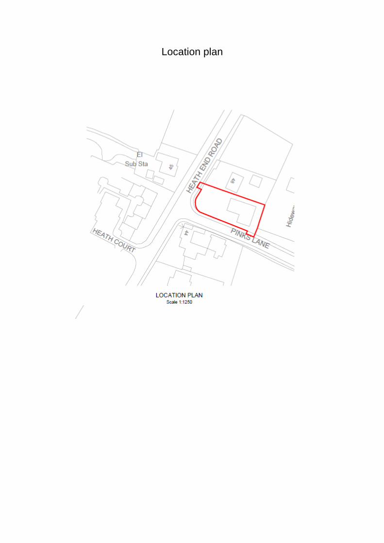
Location plan
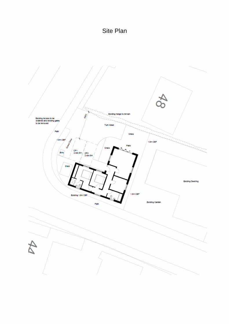
Site Plan
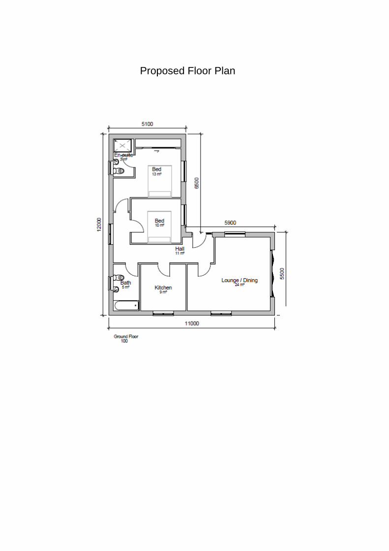
Proposed Floor Plan
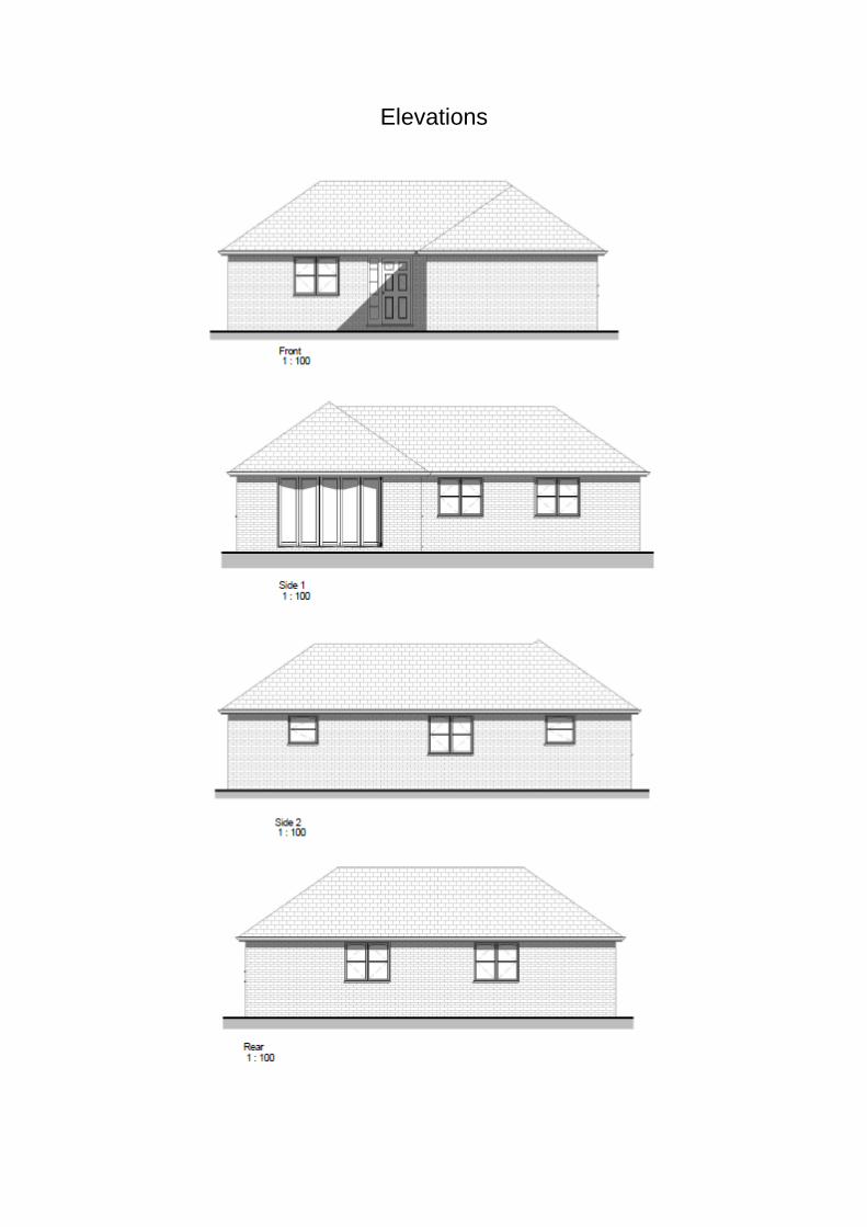
Elevations
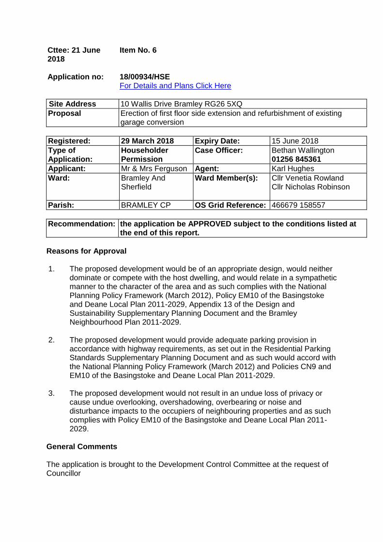
Cttee: 21 June 2018
Item No. 6
Application no: 18/00934/HSE
For Details and Plans Click Here
Site Address 10 Wallis Drive Bramley RG26 5XQ
Proposal Erection of first floor side extension and refurbishment of existing garage conversion
Registered: 29 March 2018 Expiry Date: 15 June 2018
Type of Application:
Householder Permission
Case Officer: Bethan Wallington 01256 845361
Applicant: Mr & Mrs Ferguson Agent: Karl Hughes
Ward: Bramley And Sherfield
Ward Member(s): Cllr Venetia Rowland Cllr Nicholas Robinson
Parish: BRAMLEY CP OS Grid Reference: 466679 158557
Recommendation: the application be APPROVED subject to the conditions listed at the end of this report.
Reasons for Approval 1. The proposed development would be of an appropriate design, would neither
dominate or compete with the host dwelling, and would relate in a sympathetic manner to the character of the area and as such complies with the National Planning Policy Framework (March 2012), Policy EM10 of the Basingstoke and Deane Local Plan 2011-2029, Appendix 13 of the Design and Sustainability Supplementary Planning Document and the Bramley Neighbourhood Plan 2011-2029.
2. The proposed development would provide adequate parking provision in accordance with highway requirements, as set out in the Residential Parking Standards Supplementary Planning Document and as such would accord with the National Planning Policy Framework (March 2012) and Policies CN9 and EM10 of the Basingstoke and Deane Local Plan 2011-2029.
3. The proposed development would not result in an undue loss of privacy or
cause undue overlooking, overshadowing, overbearing or noise and disturbance impacts to the occupiers of neighbouring properties and as such complies with Policy EM10 of the Basingstoke and Deane Local Plan 2011-2029.
General Comments The application is brought to the Development Control Committee at the request of Councillor
Robinson due to the issues raised from Bramley Parish Council for the following reason (in summary):
Impact on street scene
Overshadowing to neighbours property
Inadequate parking Planning Policy The site is located within the Bramley Settlement Boundary Policy. National Planning Policy Framework (NPPF) (March 2012) Section 7 (Requiring good design) Basingstoke and Deane Local Plan 2011-2029 Policy CN9 (Transport) Policy EM10 (Delivering High Quality Development) Bramley Neighbourhood Plan Policy D2 (Design of new development) Supplementary Planning Documents and Guidance (SPD's and SPG's) and interim planning guidance Extending Your Home and Replacement Dwellings (Appendix 13) of the Design and Sustainability Supplementary Planning Document 2008 Residential Parking Standards Supplementary Planning Document 2008 Description of Site The application site comprises of a two storey semi-detached dwelling, with attached single garage, located on the south side of Wallis Drive. The plot is modest in size and generally level throughout. Proposal The proposed first floor extension would extend above the existing garage (which has already been converted into a family room without planning permission). The first floor extension would measure 6.1 metres in depth and 3 metres in width and would be constructed with a gable end roof form measuring 4.8 metres in height to eaves and 6.6 metres in height overall. Consultations Bramley Parish Council - 'I can confirm that Bramley Parish Council has met to consider the above application, and would like to object to it for the following reasons:
The street scene will be significantly altered, resulting in a terracing effect that is not in keeping with the surrounding properties.
The first floor extension is likely to overshadow the neighbouring property.
The new extension will turn the residence into 4 bedroom house; however, there is only parking for only one car. BDBCs own guidance on residential parking standards suggest that a 4 bedroom dwelling should have three spaces.'
Councillor Robinson - 'In view of the objections raised by Bramley PC I would like this application referred to DC committee for decision.' Councillor Rowland - 'I have no objections'. Public Observations Three letters of objection received (two from same writer) raising the following concerns:
the inadequate parking and the highway safety implications
the tree in the rear garden Relevant Planning History Reserved matters BDB/42437 whereby Condition 5 removed rights to convert the garage into habitable space. Assessment Principle of Development Policy CN9 sets out that development should provide appropriate on-site parking and should not result in inappropriate traffic generation or compromise highway safety. Policy EM10 states that proposals will be required to respect the local environment, contribute to the streetscene, be visually attractive and provide adequate vehicular parking and cycle storage. Policy EM10 also requires developments to provide high levels of amenity for proposed occupants and neighbouring occupiers regarding privacy, amenity space and natural light. It is considered that the principle of the proposed development meets the criteria set out within Policy CN9 and EM10 of the Local Plan and the Bramley Neighbourhood Plan and is therefore acceptable subject to other material planning considerations being considered. These will be set out within the below assessment. Impact on the character of the area/design The immediate area is characterised by dwellings of a similar design and style that vary in size and detached nature.
The proposed first floor extension would be visible form the public realm however would be of a style in keeping with the area and design of the dwelling. The roof form has been set down from the main ridge height and set back from the front elevation and as a result forms a subservient relationship with the host dwelling. Bramley Parish Council raised concerns that the street scene would be significantly altered and would result in a terracing effect and as such would not be in keeping with the surrounding properties. The first floor extension would extend above the garage and to the boundary of the site however given the adjacent structure is a garage to the rear of the neighbouring property, it is considered that the development would not result in a terracing effect. Furthermore, other properties in the vicinity have extended to the side and above the garage and as such it is considered the development would not appear adversely out of keeping within the area. It is noted that the proposal includes a secondary door to the front of the property in place of the garage doors. Whilst it is usually preferred there is not a second door on a front elevation, the agent has confirmed it will act as any side door on a property would. Therefore, to avoid this area (including the first floor element above) being used as separate accommodation it is considered appropriate to impose a condition to ensure this area remains ancillary to the main dwelling at all times. The development as a whole would not result in overdevelopment of the site and the materials to be used would match the host dwelling. The proposal it is therefore considered acceptable in terms of design and as such is in accordance with Policy EM10 of the Local Plan. Impact on neighbouring amenities As a result of the developments positioning and distance between the properties, it is considered that the development would have no adverse impact upon the amenities of the occupiers of the dwellings to the north, east or south of the site by way of loss of light/overshadowing, overlooking/loss of privacy or being overbearing in nature. With regards to the impact to the occupants of 8 Wallis Drive, due to the distance and the location of No. 8's garage adjacent to the development, it is considered there would be no impact in terms of loss of light/overshadowing or having an overbearing nature on the occupants of No. 8. Furthermore no windows are proposed to the side elevation to cause any overlooking or loss of privacy to the occupants of No. 8 and a condition will be imposed to ensure that no windows on this side elevation are inserted to alleviate potential overlooking in the future. As such, the proposal would accord with Policy EM10 as it would not result in any detrimental or adverse impacts upon the neighbouring amenities and is considered acceptable in this respect. Highway Impacts The property would result in four bedrooms and is located within the 'outer urban' area, therefore three parking spaces should be provided on site as per the Residential Parking Standards SPD. There is space available on the driveway for one vehicle.
Firstly, it should be noted that the garage has already been converted and is currently being occupied as a family room and store with the garage doors being the access to the store. The works to the garage started in 2004 (under Building Control reference 04/00378/OTHBN) along with the inspection for the structural works, the works were then subsequently signed off officially by Building Control in 2011. Although these works were carried out without planning permission, it is has been completed for 7 years. It should also be noted that when this area was occupied as a garage, it was sub-standard as per the Council’s Residential Parked Standards SPD, lacking in the internal width and depth (measuring 2.6 metres in width and 5.5 metres in depth where our standards suggest 3 metres in width and 6 metres in depth). As such, the considerations would not be for the loss of a parking space, it would be for the existing parking arrangements of one vehicular space with the addition of a bedroom. Whilst it is appreciated that the provision of only one vehicular space falls below the requirements to serve a four bedroom property as per the Residential Parking Standards Supplementary Planning Document, recent appeal decisions for similar proposals are considered to be material to the consideration of this scheme. These are notably APP/H1705/D/14/2215442 - 6 Barbel Avenue (13/02318/RET) and APP/H1705/D/16/3150349 - 2 Hardys Field (16/00792/HSE), with particular reference to 6 Barbel Avenue which resulted in a four bedroom property with one parking space meeting the standards (due to the sub-standard internal garage dimensions). Whilst these sites would fall within Basingstoke Town, parking is more restricted in Basingstoke due to the lack of availability to park on the roadside in comparison to the area in Bramley surrounding the application site where there are no parking restrictions on the residential estate roads. In addition to the above, there are 37 dwellings in Wallis Drive, all of which have garages. From looking at relevant planning history since the development has been constructed, only four properties (five including 10 Wallis Drive) have converted their garages, therefore consideration must be given to the impact one further garage conversion would have on the highway. For the reasons given above, and that there are visitors bays in the immediate vicinity, good transport links and that Wallis Drive is a quiet residential road with no parking restrictions outside the application site, it is considered that the proposed development would have no adverse impact on the safety of the highway to warrant a refusal of the scheme. As such the proposal complies Policies CN9 and EM10 of the Basingstoke and Deane Local Plan 2011-2029. Other Matters One representation letter raised concerns over the tree in the rear garden and given the proposal is for a first floor extension the tree is unlikely to be impacted by the proposed development. The application is therefore considered acceptable in this regard.
Conditions 1 The development hereby permitted shall be carried out in accordance with the
following approved plans:
Location Plan and Existing Plans - 01 Proposed Plans and Elevations - 02
REASON: For the avoidance of doubt and in the interests of proper planning.
2 The development hereby permitted shall be begun before the expiration of 3
years from the date of this planning permission. REASON: To comply with Section 91 of the Town and Country Planning Act 1990 and to prevent an accumulation of unimplemented planning permissions.
3 The materials to be used in the construction of the external surfaces of the
development hereby permitted shall match, in type, colour and texture those on the existing building. REASON: In the interests of visual amenity and in accordance with Policy EM10 of the Basingstoke and Deane Local Plan 2011-2029.
4 Notwithstanding the provisions of Article 3 of the Town and Country Planning
(General Permitted Development) Order 2015 (or any Order revoking and re-enacting that Order with or without modification) no additional openings shall be inserted in the west side elevation of the building without the prior permission of the Local Planning Authority on an application made for the purpose.
REASON: To protect the amenity and privacy of the occupiers of adjoining property in accordance with Policy EM10 of the Basingstoke and Deane Local Plan 2011-2029.
5 The garage conversion and first floor accommodation hereby permitted shall not be occupied at any time other than for purposes ancillary to the residential use of the dwelling known as 10 Wallis Drive, Bramley.
REASON: The unit of accommodation has insufficient private amenity space and parking space to be occupied separately from the main dwelling and in accordance Policy EM10 of the Basingstoke and Deane Local Plan 2011-2029.
Informative(s):- 1. 1.1 The applicant's attention is drawn to the fact that the above conditions (if
any), must be complied with in full, failure to do so may result in enforcement action being instigated.
1.2 This permission may contain pre-commencement conditions which require specific matters to be submitted and approved in writing by the Local Planning Authority before a specified stage in the development occurs. This means that a lawful commencement of the approved development CANNOT be made until the particular requirements of the pre-commencement conditions have been met.
1.3 The applicant's attention is drawn to the fact that the Local Planning Authority has a period of up to eight weeks to determine details submitted in respect of a condition or limitation attached to a grant of planning permission. It is likely that in most cases the determination period will be shorter than eight weeks, however, the applicant is advised to schedule this time period into any programme of works. A fee will be required for requests for discharge of any consent, agreement, or approval required by a planning condition. The fee chargeable is £116 or £34 where the related permission was for extending or altering a dwelling house or other development in the curtilage of a dwelling house. A fee is payable for each submission made regardless of the number of conditions for which approval is sought. Requests must be made using the standard application form (available online) or set out in writing clearly identifying the relevant planning application and condition(s) which they are seeking approval for.
2. In accordance with paragraphs 186 and 187 of the National Planning Policy
Framework (NPPF) in dealing with this application, the Council has worked with the applicant in the following positive and proactive manner:-
considering the imposition of conditions.
In this instance:
the application was acceptable as submitted and no further assistance was required.
In such ways the Council has demonstrated a positive and proactive manner in seeking solutions to problems arising in relation to the planning application.
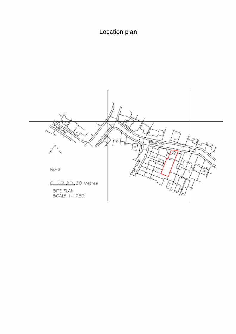
Location plan
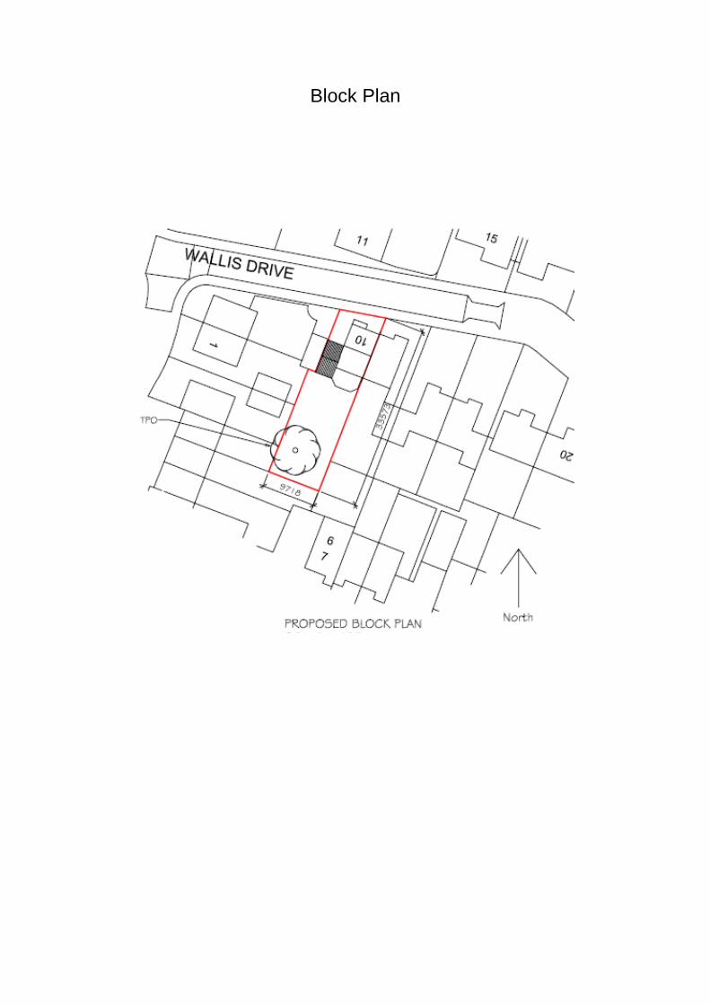
Block Plan
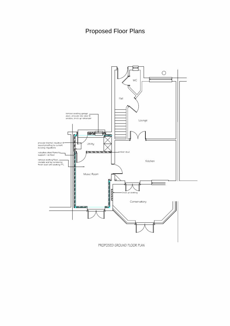
Proposed Floor Plans
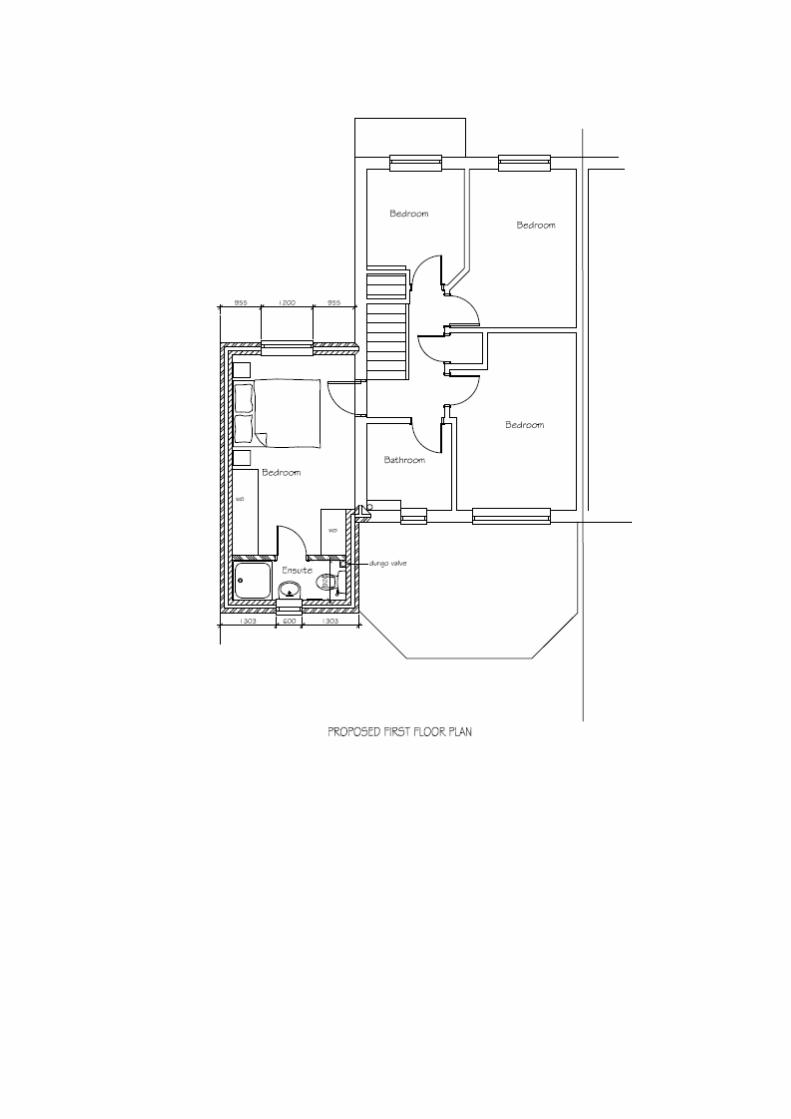
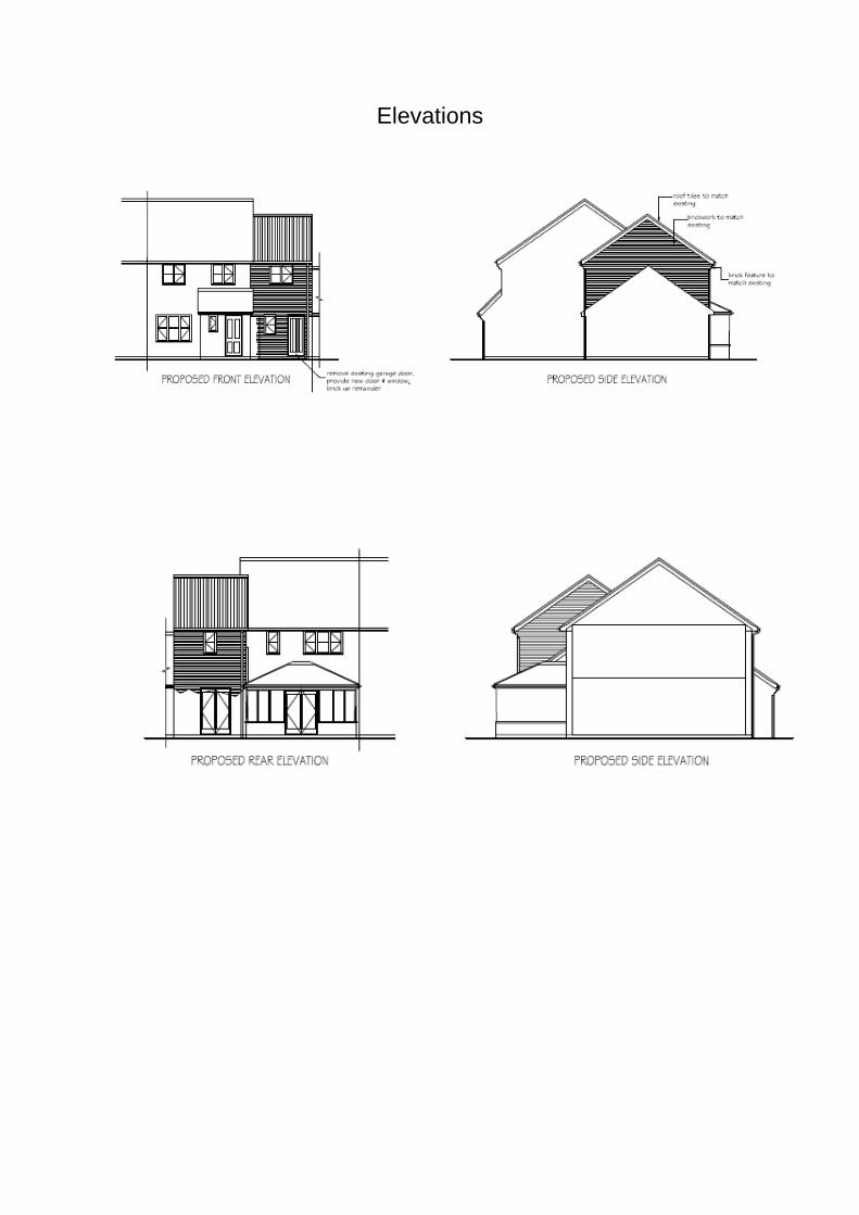
Elevations