Embed Size (px)
Citation preview
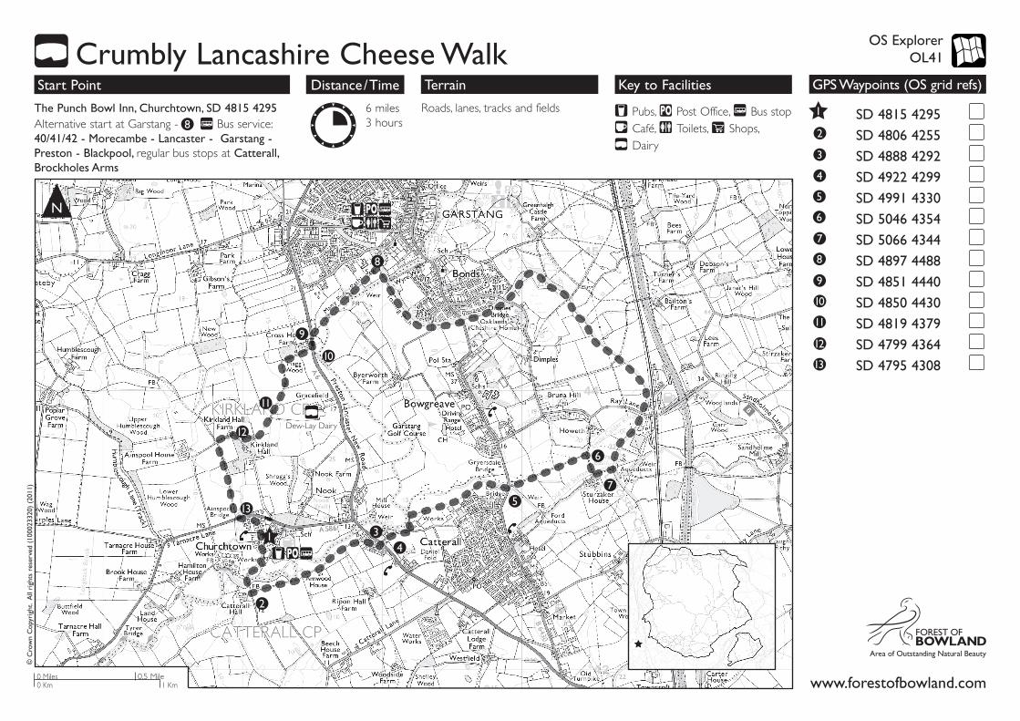
Roads, lanes, tracks and fields
N
Pubs, Post Office, Bus stop Café, Toilets, Shops, Dairy
Terrain Key to Facilities
www.forestofbowland.com
SD 4815 4295
SD 4806 4255
SD 4888 4292
SD 4922 4299
SD 4991 4330
SD 5046 4354
SD 5066 4344
SD 4897 4488
SD 4851 4440
SD 4850 4430
SD 4819 4379
SD 4799 4364
SD 4795 4308
GPS Waypoints (OS grid refs)
Crumbly Lancashire Cheese Walk
3
4
5
6
7
8
9
10
11
12
13
1
2
OS Explorer OL41
The Punch Bowl Inn, Churchtown, SD 4815 4295 Alternative start at Garstang - Bus service: 40/41/42 - Morecambe - Lancaster - Garstang - Preston - Blackpool, regular bus stops at Catterall, Brockholes Arms
6 miles 3 hours
Start Point Distance/Time
© C
row
n C
opyr
ight
. A
ll ri
ghts
res
erve
d (1
0002
3320
) (2
011)
1
34
5
6
7
8
8
9
10
11
12
13
2
0.5 Mile0 Miles0 Km 1 Km
Dew-Lay Dairy
About This Walk
The Crumbly Lancashire Cheese Trail is south of the picturesque market town of Garstang with a start in the village of Churchtown and it follows the line of both the River Wyre and the historic canal. The route circumnavigates Dew Lay, the largest of the Lancashire cheese makers, which has a small factory shop, open during working hours.
Garstang is a town full of good quality shops, teashops and pubs where you can sample and buy Lancashire cheese. This walk also passes close to several pubs which offer excellent meals and refreshments, so please ask to see their Lancashire cheese dishes.
Try the Punchbowl Inn and Horns Inn at Churchtown at the start or end of this walk. Half way round, and just a little way off the canal on Ray Lane, lies the Kenlis Arms, or before leaving the canal, walk a few extra metres to the historic Th'Owd Tithe Barn.
To assist navigation the route is “whey” marked the “Crumbly Lancashire Cheese Trail”.
Route Description
GPS: SD 4815 4295From the Inn car park turn left and down Church Street. Through the field gate into St Helen's church yard and out through the gate onto the embankment. Walk along the top of the embankment until you reach the suspension bridge. Cross over the River Wyre and then cross the stile just ahead.
GPS: SD 4806 4255Pass through a squeeze stile next to a cattle grid and turn left, passing through a field gate. Continue along the track straight ahead until you reach 'Old Lancaster Road'.
GPS: SD 4888 4292Turn right onto this road. After 115 metres turn left and onto the pavement of the A6 (cross the A6 with care). Walk down 'Tan Yard Road' away from the A6 for approx 250 metres.
GPS: SD 4922 4299Turn left onto a footpath just before “works yard”. After about 120 metres turn right (near a telegraph pole) and follow the path along a fence line and the rear of the buildings/houses. On reaching Catterall village playing fields, follow the tarmac path past the village hall up the steps to the road.
GPS: SD 4991 4330Turn left and cross the road bridge (note: there is no pavement here, so be
very careful of traffic) and turn immediately right and over a stile onto the footpath. Follow the path straight ahead, keeping an hedge to your left.
GPS: SD 5046 4354Reach a track and turn right and down to Sturzaker House. On reaching the cottages (on your right) take the track to your left towards the canal. Just before the bridge over the canal, turn right through the gate and pass down onto the towpath of the canal.
GPS: SD 5066 4344Turn left under the canal bridge and follow the canal (northwards) for approx 2 miles.
GPS: SD 4897 4488Shortly after crossing the 'Wyre Aqueduct' pass through a double set of gates on your left, into the school playing field. Follow the path straight ahead, passing between the shrubs and beech hedge, to the far side of the playing field. Leave through a kissing gate and continue straight across the field. Go through another kissing gate and continue straight across the field to a small bridge over a ditch. Continue straight ahead (with the river on your left). As the river starts to bear left follow the finger post and take a path that takes a diagonal route across the field.
GPS: SD 4851 4440Pass over the small bridge over another ditch, and up the steep embankment to the gate onto the A6 (cross over the A6 with care). Turn left and walk along A6 towards Cross House Farm.
GPS: SD 4850 4430Just past the farm buildings turn right along the farm track and continue past the rear of Dew Lay.
At this point why not take a break and visit Dew Lay Dairy
GPS: SD 4819 4379When the track bears sharp left (back towards the A6) go through a gate on your right. Walk diagonally across the field, heading towards Kirkland Hall amongst the trees. Cross the stile and bear right through a field gate and follow the track between the hedge and fence.
GPS: SD 4799 4364On reaching the building turn right and follow the track, which then bears left in front of a farmhouse. Once past all the buildings bear left along a tree-lined track and follow this out to the main A586 road.
GPS: SD 4795 4308Cross the road with care, turn left and walk into Churchtown village via Ainspool Lane.
3
4
5
6
7
8
9
10
11
12
13
1
2
Crumbly Lancashire Cheese Walk