Embed Size (px)
Citation preview
Acknowledgements The production of Cruising Lake Winnipeg with the Silver Harbour Sailing Club was a 2003/2004 winter works project for me. I like to keep busy with a number of self directed projects and hobbies over the winter months so the idea of putting together something for the club appealed to me. As it turned out, we experienced a particularly cold midwinter so it wasn’t that hard to put in some time on my personal computer. The content for this publication has been gathered from a number of sources but was primarily derived from our own experiences sailing with the club over the last two seasons. As is mentioned several times in this publication, sailors like to talk about their experiences and this became a plethora of information for me. I mentioned my winter project at the Silver Harbour Sailing Club General Meeting and was very pleased when a number of members came forward with their words of encouragement and in some instances a commitment of an article or two. In fact some had archived articles that they had written in previous years that they were willing to contribute. I thank Ron Hore (Legacy) for his excellent description of Biscuit Harbour and his personal experiences trying to find Gull Harbour in a Siren 17. Bob Howard (Azul) let me use his submission to the Porthole that recounted his experiences sailing to Princess Harbour with his thirteen year old daughter. Marvin Streik (M&M) vividly described some of his “adrenaline rush” experiences sailing back from Wells Harbour with his wife Maureen and their teenage daughter Erika. Cliff Durston (Windchaser) provided a lengthy article on his cruise with his son aboard a San Juan 21 from Silver Harbour to Little Grindstone Point. Cliff’s excellent story shows that even the best planning is still at the mercy of the elements. I subdivided this article as Cliff had included an excellent overview of Lake Winnipeg and some of its challenges for sailors. Mark Szul (Outrageous) provided me with a good description of getting into Rice River as well as a photo of club members moored in this popular but tricky to get into port of call on the lake. I make reference to Lake Winnipeg as “Sea Lake”. I picked up this term from an old friend who had produced a movie on various Lake Winnipeg communities years ago when I was sailing a Lazy E. The name stuck with me and since the lake is the third largest completely Canadian fresh water lake in our country and communities such as Gimli, Gull Harbour, Hecla Village and Matheson Island do present a maritime experience for visitors I think that it is appropriate. Other than Mark’s Rice River photo most of the other photos were taken by me using either a digital camera or a print camera. I have also used a number of professional works to help me with my descriptions of the various communities and these are referenced in the bibliography. I was fortunate to have student this year who is a very creative cartoonist. This student, Kyla Tyndal, agreed to produce a number of humorous cartoons based on situations that I described to her. I think that she did a wonderful job. Publishing this book would have been a difficult task not too many years ago but with the power of a personal computer, email for sending and retrieving articles and photos as well as some slick desktop publishing software it is something that can be handled from the comfort of your own home. This project was rather fun to do.
This book is published for entertainment and educational purposes. It should not be reproduced for profit.
Published by Craig Mackenzie, Oakbank, Manitoba, Canada R0E 1J2 Email: [email protected]
2
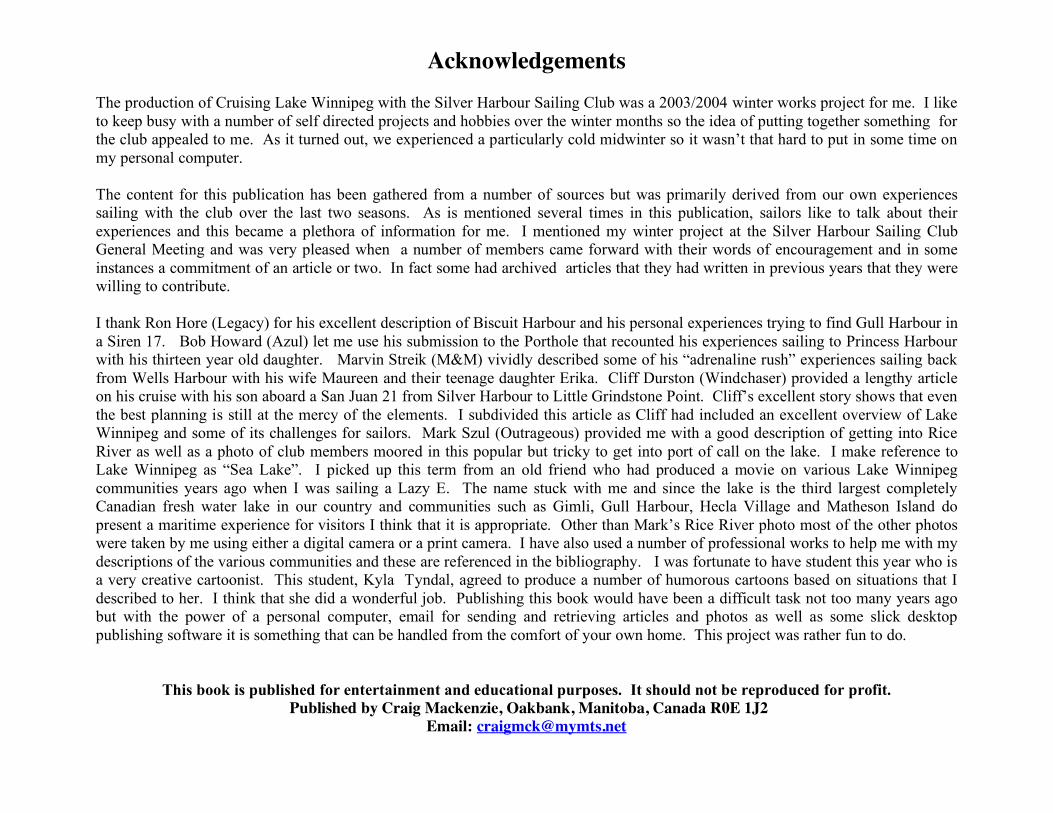
Cruising Lake Winnipeg with the Silver Harbour Sailing Club Introduction: Owning and operating a cruising sailboat is a pleasant and rewarding recreational activity. Acquiring and refining boat-handling skills is a never-ending challenge. Sailing can be both exhilarating and relaxing providing release from the trials and tribulations of our hustle and bustle world. As a member of a sailing community one is able to commune with nature as well as enjoy the social fraternity of those who share this common interest. Sailors love to talk about their boats, gear and their sailing adventures. A few years ago my wife and I re-entered this world through the purchase of an experienced but sturdy Tanzer 22 located at the Silver Harbour Marina on Lake Winnipeg. We were welcomed into the Silver Harbour Sailing Club and rapidly gained an appreciation for the expertise collectively held by the membership along with their willingness to share this with new members. I learned that the lore of sailing is actually a type of culture that is passed on through the interaction of individuals within a sailing social organization. For “newbies” this is a wonderful way to be introduced into this recreational pastime. This guide is intended as a compliment to this process. I am hoping that it will be viewed as an entertaining reference for both "newbies" and "old salts". The technical "how to" stuff is not intended to be definitive and does not replace the need for Charts and other MOT publications that are an indispensable part of a boats navigational equipment. This publication is a collection of tips based on the experiences of those who have spent time on our "sea lake" as well as interesting and entertaining anecdotes, folklore, history and photography of this large inland body of water and some of its people. Descriptions of sheltered ports of call will be of interest to those unfamiliar with Lake Winnipeg but wanting to enjoy its relative solitude and panoramic vistas .
Disclaimer: Every attempt has been made to provide accurate information but this publication is primarily for entertainment and is not considered a replacement for Nautical Charts, Small Boat Operators Guides and other official publications of the Canadian Ministry of Transport and other recognized navigations aides.
3
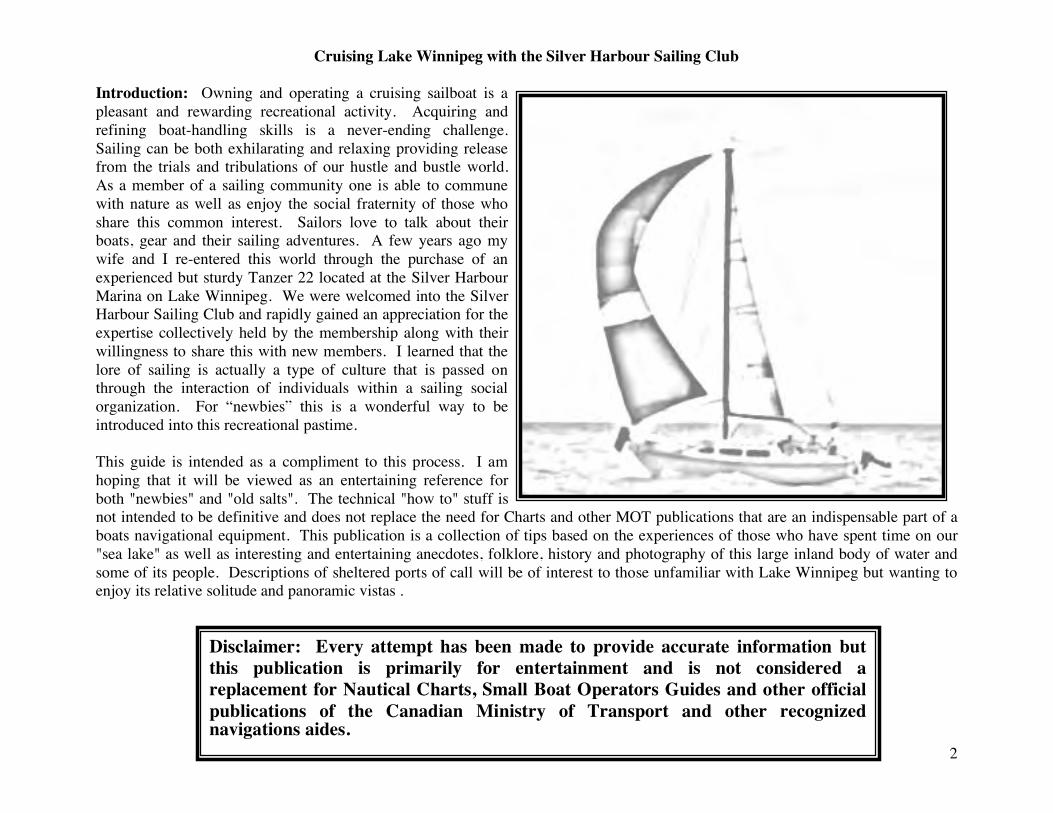
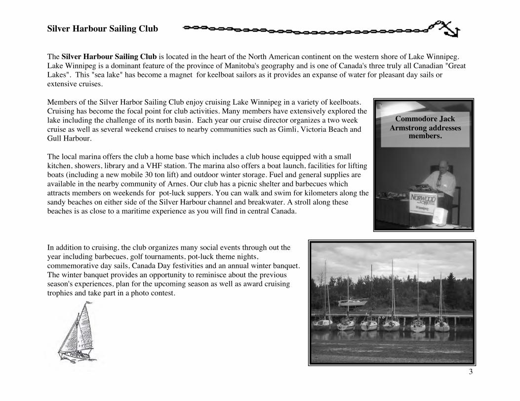
Silver Harbour Sailing Club The Silver Harbour Sailing Club is located in the heart of the North American continent on the western shore of Lake Winnipeg. Lake Winnipeg is a dominant feature of the province of Manitoba's geography and is one of Canada's three truly all Canadian "Great Lakes". This "sea lake" has become a magnet for keelboat sailors as it provides an expanse of water for pleasant day sails or extensive cruises. Members of the Silver Harbor Sailing Club enjoy cruising Lake Winnipeg in a variety of keelboats. Cruising has become the focal point for club activities. Many members have extensively explored the lake including the challenge of its north basin. Each year our cruise director organizes a two week cruise as well as several weekend cruises to nearby communities such as Gimli, Victoria Beach and Gull Harbour. The local marina offers the club a home base which includes a club house equipped with a small kitchen, showers, library and a VHF station. The marina also offers a boat launch, facilities for lifting boats (including a new mobile 30 ton lift) and outdoor winter storage. Fuel and general supplies are available in the nearby community of Arnes. Our club has a picnic shelter and barbecues which attracts members on weekends for pot-luck suppers. You can walk and swim for kilometers along the sandy beaches on either side of the Silver Harbour channel and breakwater. A stroll along these beaches is as close to a maritime experience as you will find in central Canada. In addition to cruising, the club organizes many social events through out the year including barbecues, golf tournaments, pot-luck theme nights, commemorative day sails, Canada Day festivities and an annual winter banquet. The winter banquet provides an opportunity to reminisce about the previous season's experiences, plan for the upcoming season as well as award cruising trophies and take part in a photo contest.
Commodore Jack Armstrong addresses
members.
4
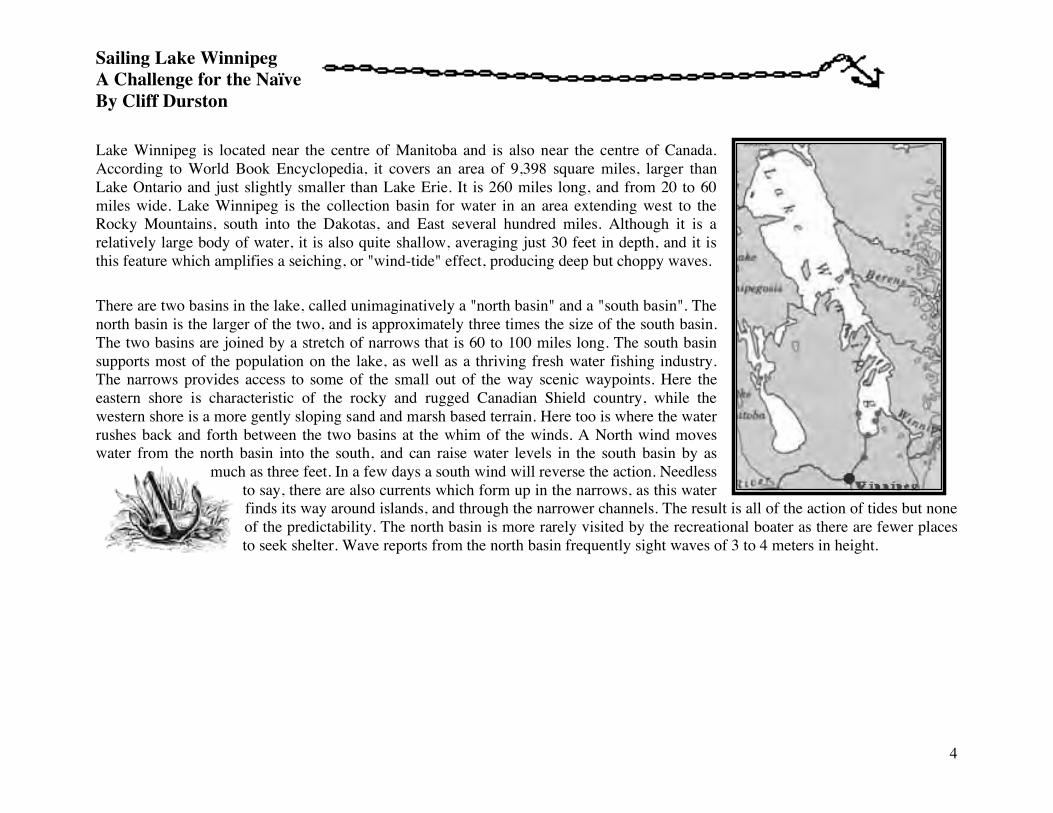
Sailing Lake Winnipeg A Challenge for the Naïve By Cliff Durston Lake Winnipeg is located near the centre of Manitoba and is also near the centre of Canada. According to World Book Encyclopedia, it covers an area of 9,398 square miles, larger than Lake Ontario and just slightly smaller than Lake Erie. It is 260 miles long, and from 20 to 60 miles wide. Lake Winnipeg is the collection basin for water in an area extending west to the Rocky Mountains, south into the Dakotas, and East several hundred miles. Although it is a relatively large body of water, it is also quite shallow, averaging just 30 feet in depth, and it is this feature which amplifies a seiching, or "wind-tide" effect, producing deep but choppy waves. There are two basins in the lake, called unimaginatively a "north basin" and a "south basin". The north basin is the larger of the two, and is approximately three times the size of the south basin. The two basins are joined by a stretch of narrows that is 60 to 100 miles long. The south basin supports most of the population on the lake, as well as a thriving fresh water fishing industry. The narrows provides access to some of the small out of the way scenic waypoints. Here the eastern shore is characteristic of the rocky and rugged Canadian Shield country, while the western shore is a more gently sloping sand and marsh based terrain. Here too is where the water rushes back and forth between the two basins at the whim of the winds. A North wind moves water from the north basin into the south, and can raise water levels in the south basin by as
much as three feet. In a few days a south wind will reverse the action. Needless to say, there are also currents which form up in the narrows, as this water finds its way around islands, and through the narrower channels. The result is all of the action of tides but none of the predictability. The north basin is more rarely visited by the recreational boater as there are fewer places to seek shelter. Wave reports from the north basin frequently sight waves of 3 to 4 meters in height.
5
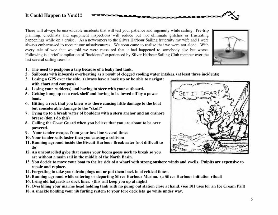
It Could Happen to You!!!! There will always be unavoidable incidents that will test your patience and ingenuity while sailing. Pre-trip planning, checklists and equipment inspections will reduce but not eliminate glitches or frustrating happenings while on a cruise. As a newcomers to the Silver Harbour Sailing fraternity my wife and I were always embarrassed to recount our misadventures. We soon came to realize that we were not alone. With every tale of woe that we told we were reassured that it had happened to somebody else but worse. Following is a brief compilation of "incidents" experienced by Silver Harbour Sailing Club member over the last several sailing seasons. 1. The need to postpone a trip because of a leaky fuel tank. 2. Sailboats with inboards overheating as a result of clogged cooling water intakes. (at least three incidents) 3. Losing a GPS over the side. (always have a back up or be able to navigate
with chart and compass) 4. Losing your rudder(s) and having to steer with your outboard. 5. Getting hung up on a rock shelf and having to be towed off by a power
boat. 6. Hitting a rock that you knew was there causing little damage to the boat
but considerable damage to the “skull” 7. Tying up to a break water of boulders with a stern anchor and an onshore
breeze (don't do this) 8. Calling the Coast Guard when you believe that you are about to be over
powered. 9. Your tender escapes from your tow line several times 10. Your tender sails faster then you causing a collision 11. Running aground inside the Biscuit Harbour Breakwater (not difficult to
do) 12. An uncontrolled gybe that causes your boom goose neck to break so you
are without a main sail in the middle of the North Basin. 13. You decide to move your boat to the lee side of a wharf with strong onshore winds and swells. Pulpits are expensive to
repair and replace. 14. Forgetting to take your drain plugs out or put them back in at critical times. 15. Running aground while entering or departing Silver Harbour Marina. (a Silver Harbour initiation ritual) 16. Using old halyards as dock lines. (this will keep you up at night) 17. Overfilling your marine head holding tank with no pump out station close at hand. (see 101 uses for an Ice Cream Pail) 18. A shackle holding your jib furling system to your fore deck lets go while under way.
6
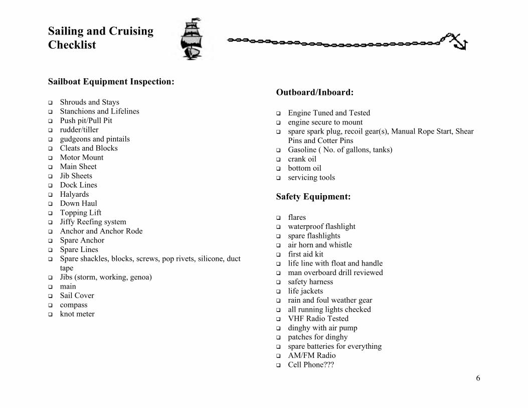
Sailing and Cruising Checklist Sailboat Equipment Inspection: Shrouds and Stays Stanchions and Lifelines Push pit/Pull Pit rudder/tiller gudgeons and pintails Cleats and Blocks Motor Mount Main Sheet Jib Sheets Dock Lines Halyards Down Haul Topping Lift Jiffy Reefing system Anchor and Anchor Rode Spare Anchor Spare Lines Spare shackles, blocks, screws, pop rivets, silicone, duct
tape Jibs (storm, working, genoa) main Sail Cover compass knot meter
Outboard/Inboard: Engine Tuned and Tested engine secure to mount spare spark plug, recoil gear(s), Manual Rope Start, Shear
Pins and Cotter Pins Gasoline ( No. of gallons, tanks) crank oil bottom oil servicing tools Safety Equipment: flares waterproof flashlight spare flashlights air horn and whistle first aid kit life line with float and handle man overboard drill reviewed safety harness life jackets rain and foul weather gear all running lights checked VHF Radio Tested dinghy with air pump patches for dinghy spare batteries for everything AM/FM Radio Cell Phone???
7
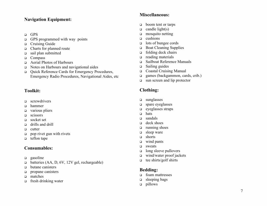
Navigation Equipment: GPS GPS programmed with way points Cruising Guide Charts for planned route sail plan submitted Compass Aerial Photos of Harbours Notes on Harbours and navigational aides Quick Reference Cards for Emergency Procedures,
Emergency Radio Procedures, Navigational Aides, etc Toolkit: screwdrivers hammer various pliers scissors socket set drills and drill cutter pop rivet gun with rivets teflon tape Consumables: gasoline batteries (AA, D, 6V, 12V gel, rechargeable) butane canisters propane canisters matches fresh drinking water
Miscellaneous: boom tent or tarps candle light(s) mosquito netting cushions lots of bungee cords Boat Cleaning Supplies folding deck chairs reading materials Sailboat Reference Manuals Sailing guides Coastal Cruising Manual games (backgammon, cards, crib.) sun screen and lip protector Clothing: sunglasses spare eyeglasses eyeglasses straps hats sandals deck shoes running shoes sleep ware shorts wind pants sweats long sleeve pullovers wind/water proof jackets tee shirts/golf shirts Bedding: foam mattresses sleeping bags pillows
8
Stay Tuned to One Six Marine Radio Operators know that Channel 16 is their distress and hailing channel. Boat and land based station operators as well as the coast guard monitor this frequency. Taking the Radio Talk Seminar to earn your VHF Operators Card is an essential requirement for boat operators. There is a protocol and language that should be adhered to while using your radio. Unnecessary chatter on “one six” will earn you a reprimand from the Coast Guard … I know! The Canadian Coast Guard is ever vigilant, always ready to provide guidance and assistance for those in critical situations. During the 2003 summer cruise we became very aware of how critical the effective use of a marine radio could be.
A number of situations experienced by members of Silver Harbour as well as other boaters on the lake could have resulted in tragedy had it not been for the VHF onboard radio and the fact that Station 16 is monitored. Incident No. 1: A sailboat being single-handed runs up on a rock off Observation Point. When attempts to kedge off fail this person has the good sense to call for help on his radio. A nearby land-based station provides continual human contact while a rescue party crosses the lake from Hecla Harbour. The steel hulled converted logging boat had ample power to drag the sailboat off the rock and tow the most appreciative sailor back to Hecla Harbour. Without this type of support on the lake it does not take much imagination to think of what could have happened. Incident No. 2: A sailboat returning from George Island in the north basin loses steering after a collision with a submerged rock near Princess Harbour. Although an anchor has been dropped it is very rough and approaching dusk. A fishing boat operator with a paramedic was standing by ready to come to the rescue of the boat because of effective communication. In this case the boat’s crew are able to make a temporary repair and limp into harbour but they did have the assurance that help was nearby. In fact several members of the Silver harbour Cruising fleet were able to provide tools and parts to help these adventurers get back underway. Incident No. 3: A couple with limited experience sailing on Lake Winnipeg encounter some heavy weather on their sail from Wells Harbour to Gull Harbour. They are capable but haven’t yet learned that their boat is tougher than they are! Anxiety set in and the Coast Guard is called. Fortunately a friendly sailing instructor happens to be monitoring this and talks the couple through some basic procedures to restore their confidence. A short while later they are enjoying a beer together in the local pub. Incident No. 4: One of the Silver Harbour members is returning from Gimli after nightfall. He has experienced crew but there is considerable concern for their safety by family and friends at the clubhouse. The radio link provided reassurance that everybody was okay. Also, several of us were able to get down to the marina to direct car headlights along the open water of the inner harbour to assist with a safe and secure landing.
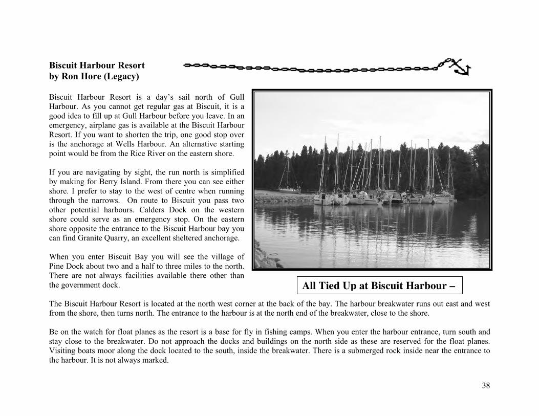
9
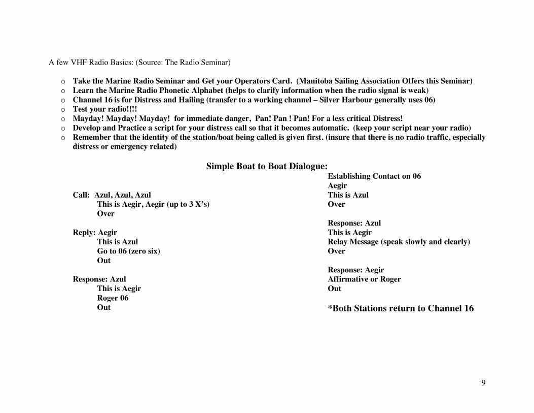
A few VHF Radio Basics: (Source: The Radio Seminar)
o Take the Marine Radio Seminar and Get your Operators Card. (Manitoba Sailing Association Offers this Seminar) o Learn the Marine Radio Phonetic Alphabet (helps to clarify information when the radio signal is weak) o Channel 16 is for Distress and Hailing (transfer to a working channel – Silver Harbour generally uses 06) o Test your radio!!!! o Mayday! Mayday! Mayday! for immediate danger, Pan! Pan ! Pan! For a less critical Distress! o Develop and Practice a script for your distress call so that it becomes automatic. (keep your script near your radio) o Remember that the identity of the station/boat being called is given first. (insure that there is no radio traffic, especially
distress or emergency related)
Simple Boat to Boat Dialogue:
Call: Azul, Azul, Azul This is Aegir, Aegir (up to 3 X’s) Over Reply: Aegir This is Azul Go to 06 (zero six) Out Response: Azul
This is Aegir Roger 06 Out
Establishing Contact on 06 Aegir
This is Azul Over Response: Azul This is Aegir Relay Message (speak slowly and clearly) Over Response: Aegir Affirmative or Roger Out *Both Stations return to Channel 16
10
Another Tanzer Tale (Published in Tanzer Talk - Spring 2003)
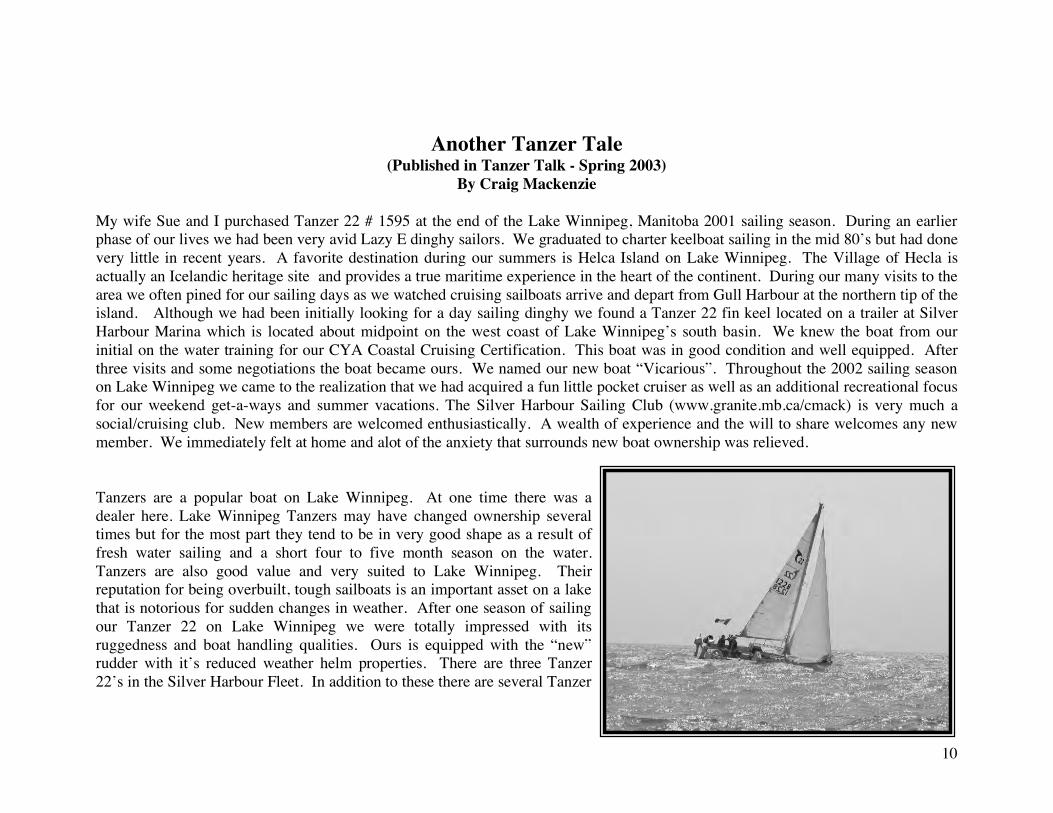
By Craig Mackenzie My wife Sue and I purchased Tanzer 22 # 1595 at the end of the Lake Winnipeg, Manitoba 2001 sailing season. During an earlier phase of our lives we had been very avid Lazy E dinghy sailors. We graduated to charter keelboat sailing in the mid 80’s but had done very little in recent years. A favorite destination during our summers is Helca Island on Lake Winnipeg. The Village of Hecla is actually an Icelandic heritage site and provides a true maritime experience in the heart of the continent. During our many visits to the area we often pined for our sailing days as we watched cruising sailboats arrive and depart from Gull Harbour at the northern tip of the island. Although we had been initially looking for a day sailing dinghy we found a Tanzer 22 fin keel located on a trailer at Silver Harbour Marina which is located about midpoint on the west coast of Lake Winnipeg’s south basin. We knew the boat from our initial on the water training for our CYA Coastal Cruising Certification. This boat was in good condition and well equipped. After three visits and some negotiations the boat became ours. We named our new boat “Vicarious”. Throughout the 2002 sailing season on Lake Winnipeg we came to the realization that we had acquired a fun little pocket cruiser as well as an additional recreational focus for our weekend get-a-ways and summer vacations. The Silver Harbour Sailing Club (www.granite.mb.ca/cmack) is very much a social/cruising club. New members are welcomed enthusiastically. A wealth of experience and the will to share welcomes any new member. We immediately felt at home and alot of the anxiety that surrounds new boat ownership was relieved. Tanzers are a popular boat on Lake Winnipeg. At one time there was a dealer here. Lake Winnipeg Tanzers may have changed ownership several times but for the most part they tend to be in very good shape as a result of fresh water sailing and a short four to five month season on the water. Tanzers are also good value and very suited to Lake Winnipeg. Their reputation for being overbuilt, tough sailboats is an important asset on a lake that is notorious for sudden changes in weather. After one season of sailing our Tanzer 22 on Lake Winnipeg we were totally impressed with its ruggedness and boat handling qualities. Ours is equipped with the “new” rudder with it’s reduced weather helm properties. There are three Tanzer 22’s in the Silver Harbour Fleet. In addition to these there are several Tanzer
11
26’s and 7.5’s. Advice and hands on help were readily available which, as mentioned, is a stress reliever for folks like ourselves. We did not intend to cruise but we did. After all, Silver Harbour is a cruising club and the chatter in the clubhouse is infectious. The harbour is a land locked dredged creek estuary protected be a limestone rock breakwater. By the end of June we had logged lots of weekend hours outside the entrance to Silver Harbour and were gaining confidence in our boat handling skills and working out the many routines common to small boat operation. So we ventured on a “short” overnight cruise across the lake. Victoria Beach is almost due east from Silver Harbour on the opposite shore of Lake Winnipeg. It provides a fairly sheltered anchorage behind a government pier and is a popular destination of the club. There is also a bakery that makes cinnamon buns to die for and it’s tradition to provision with these sticky wonders while visiting this popular cottage area. Our crossing was pleasant. Light winds all the way. A permanent weather buoy on the lake was used as a way point. We gained a real appreciation for our new Magellan GPS and its revolutionizing impact on small boat navigation. Don’t leave home without one.... or two. Later that summer one of our club members would drop one over the side and although it was recovered it was toast. This little jaunt convinced Sue and I to join the Silver fleet for their annual cruise up the lake later that month ..... and that’s another story.
12
CAN YOU FIND GULL HARBOUR? by Ron Hore It was 1986. I had a week of dingy sailing lessons and an hour of explanation on how to operate my new Siren 17. I convinced my brother Phil and his wife Sarah that a trip to Gull Harbour was a good idea. With a month of sailing the Siren around in front of the beach at Arnes, I was an expert and ready for the voyage. First, we contacted Environment Canada. They advised that we had clear weather until the evening when showers were moving in. Plenty of time to get to Gull Harbour... With an inflatable dingy tied to the stern rail, a pair of hand compasses and a hand held radio, we set off. The wind was from the northwest, the waves two to three feet, and we ran with full sail on a broad reach. This was the swiftest our Siren, the Tigger, had ever sailed. It was a great sensation. Shortly after two pm I noticed that the western shore had disappeared in a wall of darkness. White caps appeared and I told Phil to go forward. It was time to reef the main. That is when the squall dropped on us from above. The dingy blew clear out of the water, knocking me over and I let go of the tiller. With my brother clinging to the mast, wondering why I wasn’t giving him instructions, the boat heeled hard over and spun around. Sarah cut the ropes and pulled the dingy off of me and we dropped the main down into the cockpit and furled the flapping jib. The wind howled so loud I couldn’t tell when the outboard finally started. We turned into the waves and road out the storm until it passed on. This is when I discovered that it is very difficult to focus binoculars on an object on shore when you are rising and falling several feet in rolling waves. Using our compasses we decided we were either somewhere off the southern shore of Hecla Island, or somewhere in the vicinity of Hnausa. When we came to the entrance to Riverton Bay, we at least knew where we were. We didn’t have charts for Riverton, of course, not originally planning to go there, so we carefully followed the bouyed channel. As we motored across the shallow bay the sky grew dark again and lightening flashed on the western horizon. We made our way up the Icelandic River, watching out for float plane traffic. Tying up at the dock in Riverton just before night fell, we headed to the nearby motel for a beer and a steak and another beer. My brother refused to sail with me for the next eleven years. Two boats later, a twenty two and a twenty six, we all finally made it to Gull Harbour. Of course, my brother and his wife may have agreed to sail with me only because our ninety-seven year old father was along this time as crew.
13
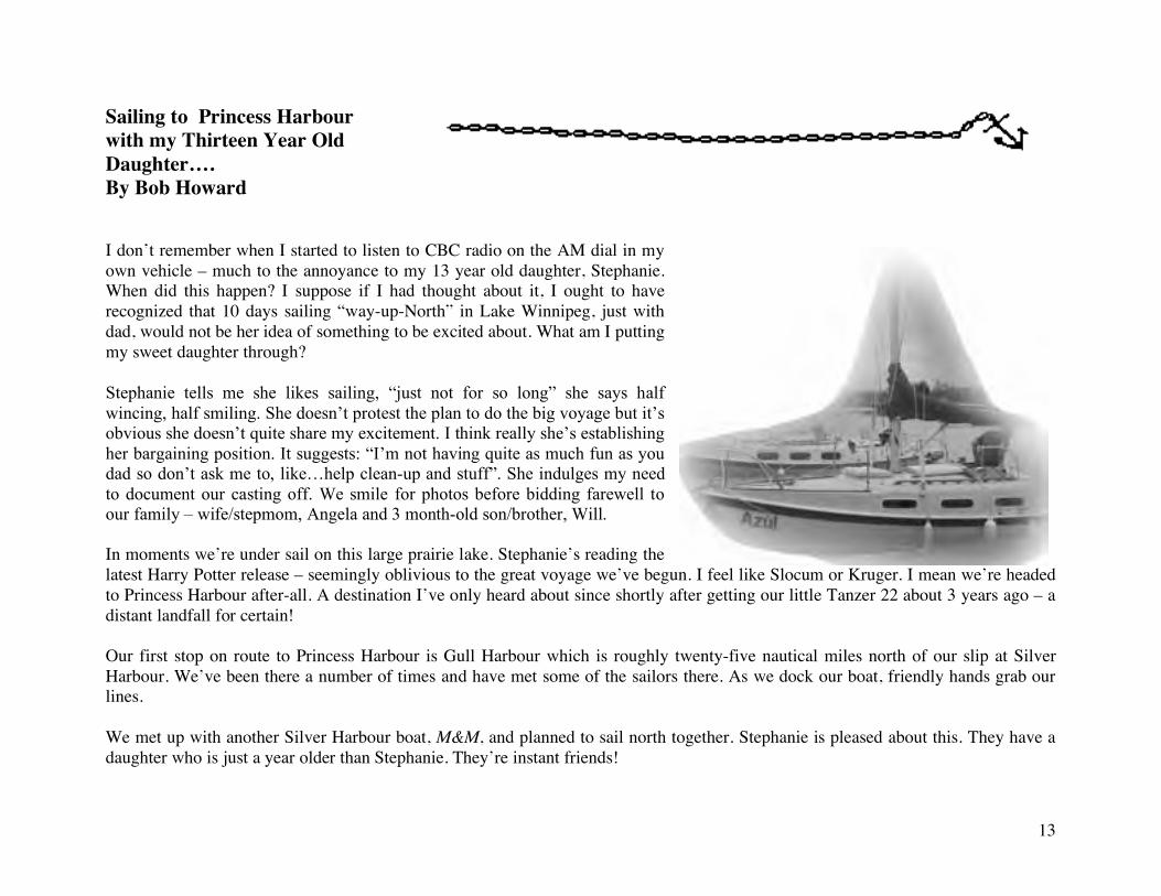
Sailing to Princess Harbour with my Thirteen Year Old Daughter…. By Bob Howard I don’t remember when I started to listen to CBC radio on the AM dial in my own vehicle – much to the annoyance to my 13 year old daughter, Stephanie. When did this happen? I suppose if I had thought about it, I ought to have recognized that 10 days sailing “way-up-North” in Lake Winnipeg, just with dad, would not be her idea of something to be excited about. What am I putting my sweet daughter through? Stephanie tells me she likes sailing, “just not for so long” she says half wincing, half smiling. She doesn’t protest the plan to do the big voyage but it’s obvious she doesn’t quite share my excitement. I think really she’s establishing her bargaining position. It suggests: “I’m not having quite as much fun as you dad so don’t ask me to, like…help clean-up and stuff”. She indulges my need to document our casting off. We smile for photos before bidding farewell to our family – wife/stepmom, Angela and 3 month-old son/brother, Will. In moments we’re under sail on this large prairie lake. Stephanie’s reading the latest Harry Potter release – seemingly oblivious to the great voyage we’ve begun. I feel like Slocum or Kruger. I mean we’re headed to Princess Harbour after-all. A destination I’ve only heard about since shortly after getting our little Tanzer 22 about 3 years ago – a distant landfall for certain! Our first stop on route to Princess Harbour is Gull Harbour which is roughly twenty-five nautical miles north of our slip at Silver Harbour. We’ve been there a number of times and have met some of the sailors there. As we dock our boat, friendly hands grab our lines. We met up with another Silver Harbour boat, M&M, and planned to sail north together. Stephanie is pleased about this. They have a daughter who is just a year older than Stephanie. They’re instant friends!
14
Late morning the next day, we cast off together and head for Well’s Harbour. Wells is an easy sail from Gull Harbour, with southerly winds. Stephanie and I have been to Well’s once before with the rest of our family/crew. We concluded the place was cursed! It was plagued by flies during the day and mosquitoes were thick as smoke as soon as the sun hit the horizon. I never thought we’d return but I’m glad that we did. We tied off behind the gravel spit that protects this harbour and were soon joined by a third sailboat, a nice couple from Gimli in their boat, Hot Chocolate. The next morning, upon Hot Chocolate’s recommendation, we visit the beach located southwest of the harbour. Our intentions to continue north this day, were forgotten as we swam and explored this incredible beach. After a day of swimming, and enjoying refreshments in the cockpit of our rafted-up boats, we motored back to the harbour and anchored for the night. The next morning, after a quick visit to the beach for a swim and morning coffee, we bid farewell to Hot Chocolate and hoist sails for Biscuit Harbour, along with M&M. This season’s low water levels, challenged even the drafts of our little Tanzer 22s. We both managed to pick our way into Biscuit Harbour and tie up at the dock. Stephanie hopes the Hot Wings here are better than at the previous stop. They are. The restaurant at this lodge and busy float-plane airport is excellent. We meet up with two more Silver Harbour sailors who traveled over-land looking to do some canoeing and enjoy their fine company for the evening as we dined in Biscuit Harbour’s excellent restaurant. (Incidentally, should you have opportunity to meet “Dixie” the resident chocolate lab, do not indulge her and throw a stick for her. She will never leave you alone afterwards.) The next day we bid farewell to M&M as they head south again and Stephanie and I steer toward Princess Harbour. Eight other Silver Harbour boats are there already, having left a week ahead of us. The strong southerly winds persist and we surf our way to Princess Harbour. At one point we slide off a crest and our speed registers 9.8 knots on our GPS – a new speed record for our little boat! We drop our sails outside the harbour entrance and steer toward friends as they wave us to a space where Azúl will fit nicely. Hard not to be just a little bit proud of Stephanie as she steered us perfectly alongside the pier as I passed lines to waiting hands. We spent two days exploring this interesting former fishing station and enjoying the hospitality of the two resident families. They seem to understand our illusion: we’ve navigated far, managing wind and braved weather on our well-provisioned ship. Well my illusion at least – Stephanie’s curled up in our cockpit finishing off the latest Harry Potter adventure.
15
Our First Year of Sailing By Marvin Streick My wife, Maureen finally gave me the, “Just Do It” authorization to buy our 22 ft. Tanzer, as I will sit on the fence forever about all decisions. Buying a boat is like any other larger ticket purchase, it becomes so much easier when you connect with and trust the people selling it. Craig and Sue Mackenzie sold us their boat, reviewed the rudiments of sailing and introduced us to the other members of the Silver Harbour Sailing Club. I sincerely mean it when I say, these are some of the finest people on the planet. We went from the purchase at the end of May, sailing every weekend through June and July to our first cruising excursion in early August of 2003. The excursion took us from Silver Harbour to Gull Harbour, Wells Harbour, Biscuit Bay and back. I hear that is not too shabby for novices. Probably nobody enjoys sailing in rough water, but almost everyone loves the story. Maureen, my daughter, Erica and I had beat our way back from Biscuit Bay to Wells Harbour against a strong south wind with 3-foot waves. We anchored off the beach at sunset and enjoyed an Italian meal. This was heavenly, as we were the only boat in the harbour and nature was presenting us with a majestic sunset coupled with a rising full moon. On the morning of Wednesday, August 13 we leisurely prepared for departure, which was probably our first mistake. We might have faired better if we had made an earlier start. We left Wells harbour and headed east to Grindstone Point. I recall Maureen asking me if I thought the conditions were the same as the previous day. I replied, “ I think something has changed!!” An important point to note is that we were unaware of a disconnected antennae wire, so when we checked the weather, through the static we thought we heard that the wind would be 20 Km. from the south. The actual forecast was for winds gusting up to 50 Km./ hour!!
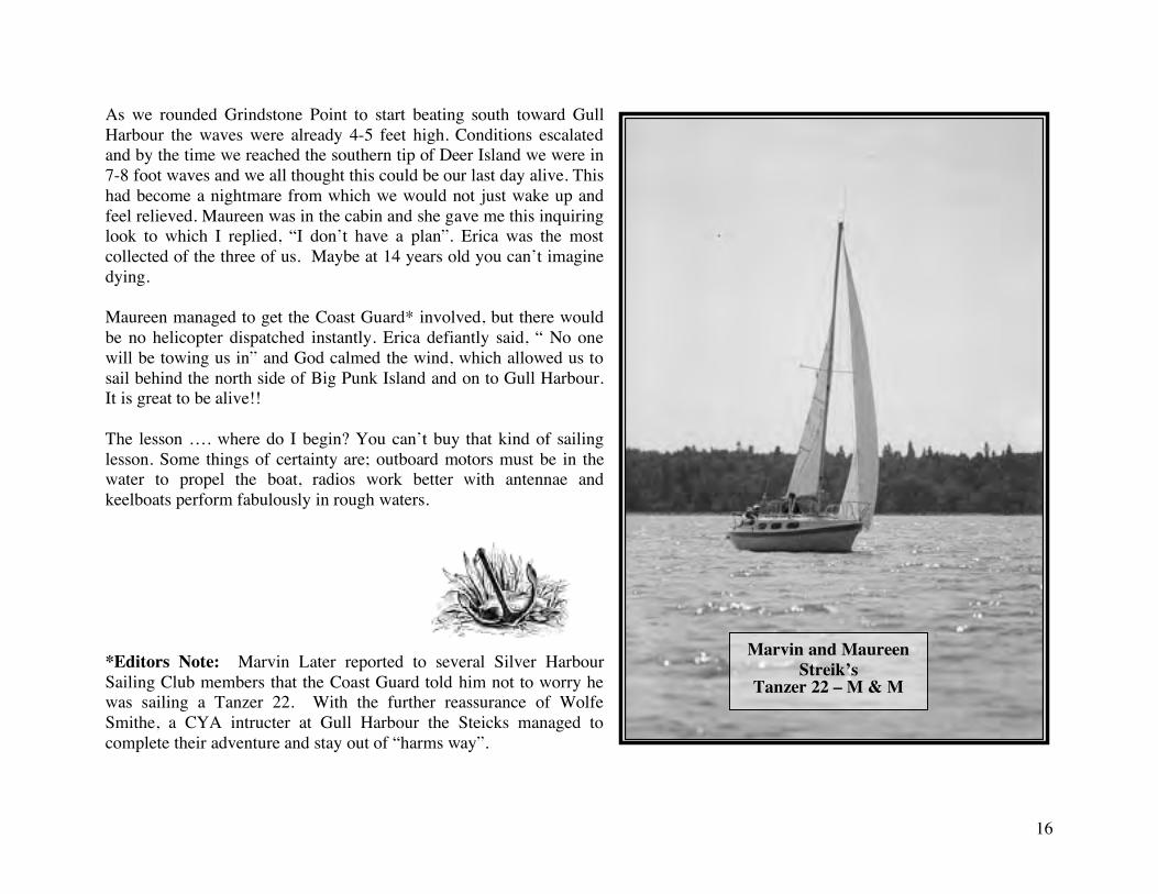
16
As we rounded Grindstone Point to start beating south toward Gull Harbour the waves were already 4-5 feet high. Conditions escalated and by the time we reached the southern tip of Deer Island we were in 7-8 foot waves and we all thought this could be our last day alive. This had become a nightmare from which we would not just wake up and feel relieved. Maureen was in the cabin and she gave me this inquiring look to which I replied, “I don’t have a plan”. Erica was the most collected of the three of us. Maybe at 14 years old you can’t imagine dying. Maureen managed to get the Coast Guard* involved, but there would be no helicopter dispatched instantly. Erica defiantly said, “ No one will be towing us in” and God calmed the wind, which allowed us to sail behind the north side of Big Punk Island and on to Gull Harbour. It is great to be alive!! The lesson …. where do I begin? You can’t buy that kind of sailing lesson. Some things of certainty are; outboard motors must be in the water to propel the boat, radios work better with antennae and keelboats perform fabulously in rough waters. *Editors Note: Marvin Later reported to several Silver Harbour Sailing Club members that the Coast Guard told him not to worry he was sailing a Tanzer 22. With the further reassurance of Wolfe Smithe, a CYA intructer at Gull Harbour the Steicks managed to complete their adventure and stay out of “harms way”.
Marvin and Maureen Streik’s
Tanzer 22 – M & M
17
There and Back Again??? (Little Grindstone in the Rain by way of Gull Harbour) By:Cliff Durston
Introduction: This sailing adventure is taken from an article written by Cliff Durtson for his website. The story is set in 1996 and represents his first overnight sail from Silver Harbour. Other excerpts from this excellent narrative are used elsewhere in this collection. The story is a wealth of information for those planning a cruise on the lake and a reminder to those with experience that even the best plans don’t always work out and that mariners are slaves to the weather.
Cruising Lake Winnipeg with the Durston’s
In 1994, the Durston family purchased Sea Urchin, a San Juan 21 Mark I. My previous sailing experience, while of many years duration, was limited to shore excursions in (or rather on) a homemade Sunfish style sailboat.. We have a summer cottage cum retirement home located on the western shore of the south basin about a half mile from a small marina known as Silver Harbour. There are other marinas on the south basin generally located at intervals of five to ten miles. For two years, we never strayed far from our home port at Silver Harbour. There are several reasons for this, but most of them have to do with Joyce's comfort level after an hour or so on board. Consequently, our sailing consists mostly of an hour's tack against the wind followed by a surf home. Early on I had fitted Sea Urchin with a Porta-Potti toilet in order to extend our cruising distance, but Joyce found that what the toilet provided in functionality, it more than made up for in lack of privacy. Installed as it is on the flat spot on the starboard side of the keel pocket, one cannot use it without opening the hatch cover and allowing one’s head to protrude above deck. Some privacy can be afforded by installing the passageway boards, but facial expressions provide entertainment for the remaining crew. Needless to say we use shore facilities except in extreme cases. In 1996 I resolved to go further afield, and broached the subject with Scott, our son of 27 years, who visits us at our lakeside cottage frequently. My plan was to travel from Silver Harbour to Gull Harbour, a distance of about thirty miles, and then use that harbour as a jumping-off point to explore some of Lake Winnipeg's beauty spots (see Gull Harbour Chapter). To increase the probabilty of his acceptance, I offered a round of golf after we sailed into Gull Harbour. He accepted and arranged vacation from his job for the first week in August. I stocked the boat with a few essentials such as camping equipment, groceries, and golf clubs. The plan was to depart Silver Harbour on the Monday, golf Tuesday, and use Wednesday and Thursday to visit places like Wells Harbour and Rice River, to name two of the beauty spots outlined in the cruising guide. Friday was to be the return day since Scott had some weekend plans that needed him to be back.
18
On Monday morning, we arose and looked out over the lake from our cottage window. The water was dead calm, as was the wind. Although it looked like it might not be a good day for sailing, we continued our plans. By 10:30, we went down to the marina to load the final few things and decided that we would go out on the water, and return if badly becalmed. By 10:50 the breeze was noticable and we had hoisted the biggest sail we have, a 130% jib and full main, and headed off on a broad reach following a compass course of 038 degrees. The charted course called for a heading of 038 degrees for 10.8 miles to a buoy near the Hnausa reef, then a change of course to 045 degrees for about five miles, after which we could head up the side of the island almost due north. The total mileage as measured on the chart was almost 30 nautical miles. At 11:50, we had been sailing towards a compass bearing, but could still not see any land in the direction we were sailing. We could, however, see our progress on the shore we were leaving, and with Scott now at the helm, I took a bearing on a small harbour called Hnausa (although we were sailing toward the Hnausa Reef, the town lay abeam). I plotted this and found that we had traveled almost 6 miles in that hour, a surprise, as I had based my calculations on a speed of 5 knots. This meant that we had to look for the open water buoy sooner than another hour, or risk going too far toward the southern shore of the island and the rocks of the reef. By 12:15 we could see the outline of the island, and found that we were steering roughly toward the eastern tip of the island. With Scott still at the helm, I began to search for the elusive buoy with the glasses, and after about 10 minutes, found it off the starboard side. We hardened the sheets to head up toward the buoy, and found that the wind had freshened to the point where, if we had any distance at that point of sail, would need to shorten sail. We passed the buoy at 12:55, noted the correct designation in accordance with the charts and changed our compass heading to 045. This heading would have taken us to another buoy on the other side of the channel, but there was no point in going the full distance, and we would only follow the course for about an hour and then turn north. I could determine when to make the turn by taking a hand bearing on a daymarker which was provided on the island, and turning at 275 degrees. At 13:55 we reached our turn point and turned north to follow the island to Gull Harbour. By now the waves had built to about three to four feet as a result of having had a south wind with a fetch of about fifty miles. The wind was almost directly behind us so we rigged a preventer for the main to guard against accidental gybes, and poled out the jib. This configuration lasted for a glorious two hours and took us into Gull Harbour All the while the waves continued to build, and gusts of wind provided momentary freedom for the hull as we surfed over the larger waves, the following seas providing lots of action on the tiller. By 14:50, we were able now to see the lighthouse at the very tip of the island, and marking the narrowest passage between Hecla Island and Black Island. Gull Harbour is immediately west of the lighthouse within a mile of the passage. With both the surf and the wind building steadily we made excellent time. Passing the lighthouse, the harbour came into view, and we rounded the corner and took down our sails, motoring into the harbour.We arrived at Gull Harbour exactly five hours after our departure from Silver harbour, an average speed made good of close to 6 knots.
19
We tied up at the main dock and I went to make arrangements for a slip. In due course we found our slip and tied up, cooked up a great meal and were just finishing up when a boat pulled in at the next dock. The skipper was a fellow sailor from Silver Harbour returning from a tour of the anchorages of the narrows. Fred is 83 years old and frequently single hands his 22 ft. Abbott around the lake. On this occasion, however he had guests - a young couple from Germany who were just winding up their visit and would be catching a plane in two days. Tuesday, we dug out our golf clubs and walked the mile or so to the golf course. The day and the outing were delightful, even if the scores were abysmal. A beer at the outdoor garden of the convention hotel overlooking the bay, and we were ready for a shower. Another walk to the campground provides this luxury. Back aboard Sea Urchin, we cooked up supper, fished a little, and turned in early hoping to explore the north on Wednesday. On Wednesday, the weather was overcast and threatening, but there are a number of places within a few miles of Gull Harbour, and we decided to set out. First, though I wanted to take some compass checks under motor. The area around Gull Harbour has ranges for North, North-East, South-East, West, and South. We spent an hour under motor checking the ship's compass, and noting the deviations. Finally, out in the bay we hoisted the main and working jib, and headed toward Little Grindstone. I planned to stop in at the harbour at Little Grindstone and eat lunch, check the weather and then continue around Grinstone point and perhaps overnight at an anchorage at Wells Harbour. As we progressed toward Little Grindstone, we began to notice pockets of rainstorm activity behind us. We passed two islands, named Little Punk and Punk Island. Little Grindstone is west of a marker on Deer Island. Within a mile of our destination, it was evident that we were about to get wet. We put on our foul weather gear, and because winds were becoming extremely gusty, furled all sails in anticipation of very high winds. We ran under motor power and fortunately the waves were low due to our proximity to Little Grindstone located deep in a bay. We motored toward the harbour on flat water, but couldn't see anything because of the heavy rainfall. Catching the occasional glimpse of trees on shore, I realized we were going too fast. I had seen the masts of sailboats in a harbour before the rain, but now feared going too far. I turned back and forth a few times, and in a few minutes the rain eased enough that I could once again see the masts of the sailboats. The harbour entrance is rather narrow, according to the guide, but is dredged and marked with starboard buoys. We entered the turning basin and docked just before another major downpour. Inside the cabin, there was nothing to do but read. Scott brought along a Robert Ludlum novel, but all I had to read were charts and guides. Thus was the afternoon spent, with rain pounding down on the cabin, an occasional respite for a trip up the hill to the rudimentary toilet facility, a walk down the dock to talk to another boater, and back under cover when it rained. I turned on the radio to get an updated weather forecast, but got nothing but static. I assumed that lightning had knocked out a transmitter, but in trying the weather channel with another boater, his came in loud and clear.......and mine didn't. About five o'clock, the rain was letting up and the western sky was lighter. We had resolved that we would go back to Gull Harbour, and, having now wasted Wednesday, concentrate on getting back to Silver Harbour by the weekend. We set sail to Gull Harbour and
20
arrived without further incident, but that night we decided we deserved a restaurant meal, there being no will to stay on board after having been cooped up all day. The revised plan was to check the forecast to get predictions for the rest of the week, and to see how favorable the winds were on Thursday. If the unfavourable weather were predicted to continue, we would either sail home then, wait until Friday, or catch a ride back by land and return with the trailer to ferry Sea Urchin home. In addition to all of this, the radio was not working. I had isolated this to wetness in the coax inside the mast, and I wasn't about to change that. However, I had a small portable antenna with a loading coil, and found a length of coax connecting cable about 10 feet long. I taped the antenna onto a spare halyard and hoisted as high as I could. Although near the shrouds, the weather channel came in loud and clear. A walk down the dock and conversation with a motor yacht resulted in a transmitter test as well. Thursday morning, the wind report from several points on the lake indicated between 15 and 18 knots. Silver Harbour was reporting 11 knots, but we knew that westerlies get some shelter at that station. Our estimate of wind at Gull Harbour was at least 15 knots. With a west wind, wave action would be manageable until we cleared the island, after which they could be a problem. To complicate matters, the wind was shifting southward again, and this meant that Friday would most likely have strong seiching currents in the channel coupled with a head-on wind, the combination of which would turn a five hour journey into ten or twelve. Scattered shower activity was also predicted. It was becoming clearer that our tour of the remote anchorages would have to wait another day, since the waves and weather seemed intent on allowing us to plan only one activity, and that would be Thursday. Wisely or otherwise, the decision was made to head south on Thursday morning. At ten o'clock, we chugged out of the harbour and hoisted sails with a reefed main and a 100% jib. Rounding the lighthouse, we set up a tack due south that was to keep us for two hours. Traveling about a mile offshore in the narrowest part, we were busy most of the time, and getting wet part of the time. We soon broke out the foul weather gear, partly because rain was threatening, but mostly because the waves hitting the bow were at such an angle that they frequently came over. After an hour we received a call from "Gator", the power boater who had given us a transmitter check. He inquired as to the wave height, and promised to check later, as he too planned to depart after lunch. We agreed to check back when we had cleared the island, and indeed we tried to raise him then, but got no response. Either my jury-rigged antenna was no longer effective, or he was away from his boat. Two hours later we cleared the island and altered course to 225 degrees. The plan was to hold this course until we found the Hnausa reef buoy and then head more southerly on a heading of 216, a course that should have taken us between two reefs with plenty of room to spare. Checkpoints were a range marker off the south tip of the island, as well as the buoy. We eventually came to the range mark, and began searching for the buoy. In the meantime the seas had built to five or six feet, and the buoy was nowhere in sight. As well, because of the extremely shallow bay where the waves were originating (3-6 feet deep), these waves were coming very close together, and from the starboard beam. We finally spotted what we determined to be the proper buoy and headed for it, but were surprised by a very slight but unmistakable grinding from the keel. We were obviously
21
on a reef which wasn't on the chart, or we were in the wrong place. Just as quickly as it had come, we were once again left in deep water, and the grounding was not enough to do damage, just a wake-up call. In reflecting on this incident, I should have turned away from the range markings sharply, a course which would have taken us away from danger. I was lulled into security by the ease with which we had spotted the correct buoy on the way up, and had expected it to be there for me again. The buoy that we had spotted was, I think, the one marking the actual reef, and I said a word of thanks for the high water condition of the lake this year. The trip across the bay was one of constant high waves, but the winds were lower than expected most of the time. About two miles from our destination, and with our point of land in sight, a sudden wind come up and caught us with too much canvas. After heeling sharply, the boat rounded up into the waves and wind, giving us a chance to get the jib on deck. By this time, the wind had picked up force until we decided to furl the main as well, and proceed under motor. This might seem like the wrong thing to do, because we still had another reef left in the main, but it turned out to be the best alternative given the wave direction and the new intensity of the wind. By this time we were almost home, and the seas were following, but with our 8 horse motor, we were able to drive the boat fast enough to keep pace. It was necessary only to set the adjustable motor bracket up a notch to keep the motor from drowning, and it didn't come out of the water except on very rare occasions. By the time we had rounded the point and the waves were no longer a factor, we simply decided to keep on going with the motor, as hoisting sails would have been a waste of time. During the sail home, we had been able to observe storm cells moving in the distance; first on the island we had recently vacated, and later to the east and west of us. Ironically, though we were never rained on ourselves even though one cell had passed close enough to give us a sudden wind scare, and we motored in with dry sails. We were soon tied up at the dock and loading the car. The return trip had taken five and one-half hours, about half hour longer than the initial trip, calculating a speed made good of almost 5.5 knots. During Friday and Saturday winds were high and from the south, confirming in our minds that we had made the right decision to return when we did, as even a shift of the winds we encountered would have given us head on waves building over a 50 mile distance, as well as stronger currents in the channel. Next year, we will have the foresight to plan our trip during the nice weather, and be able to visit a few of the anchorages, but for now, the rest of the year will probably be spent tacking and surfing.
Conclusion This trip brought on a severe case of six foot-itis, and we now sail CS 27 Windchaser which we purchased in 1997. There are many other changes in our sailing including the use of GPS and autopilot. We still try to keep a fairly careful log, though, and refer to it for lessons learned, to settle arguments (sorry……discussions), and just to relive memories at later times.
22
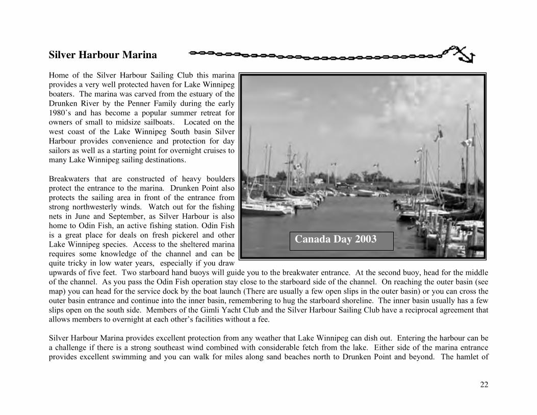
Silver Harbour Marina Home of the Silver Harbour Sailing Club this marina provides a very well protected haven for Lake Winnipeg boaters. The marina was carved from the estuary of the Drunken River by the Penner Family during the early 1980’s and has become a popular summer retreat for owners of small to midsize sailboats. Located on the west coast of the Lake Winnipeg South basin Silver Harbour provides convenience and protection for day sailors as well as a starting point for overnight cruises to many Lake Winnipeg sailing destinations. Breakwaters that are constructed of heavy boulders protect the entrance to the marina. Drunken Point also protects the sailing area in front of the entrance from strong northwesterly winds. Watch out for the fishing nets in June and September, as Silver Harbour is also home to Odin Fish, an active fishing station. Odin Fish is a great place for deals on fresh pickerel and other Lake Winnipeg species. Access to the sheltered marina requires some knowledge of the channel and can be quite tricky in low water years, especially if you draw upwards of five feet. Two starboard hand buoys will guide you to the breakwater entrance. At the second buoy, head for the middle of the channel. As you pass the Odin Fish operation stay close to the starboard side of the channel. On reaching the outer basin (see map) you can head for the service dock by the boat launch (There are usually a few open slips in the outer basin) or you can cross the outer basin entrance and continue into the inner basin, remembering to hug the starboard shoreline. The inner basin usually has a few slips open on the south side. Members of the Gimli Yacht Club and the Silver Harbour Sailing Club have a reciprocal agreement that allows members to overnight at each other’s facilities without a fee. Silver Harbour Marina provides excellent protection from any weather that Lake Winnipeg can dish out. Entering the harbour can be a challenge if there is a strong southeast wind combined with considerable fetch from the lake. Either side of the marina entrance provides excellent swimming and you can walk for miles along sand beaches north to Drunken Point and beyond. The hamlet of
Canada Day 2003
23
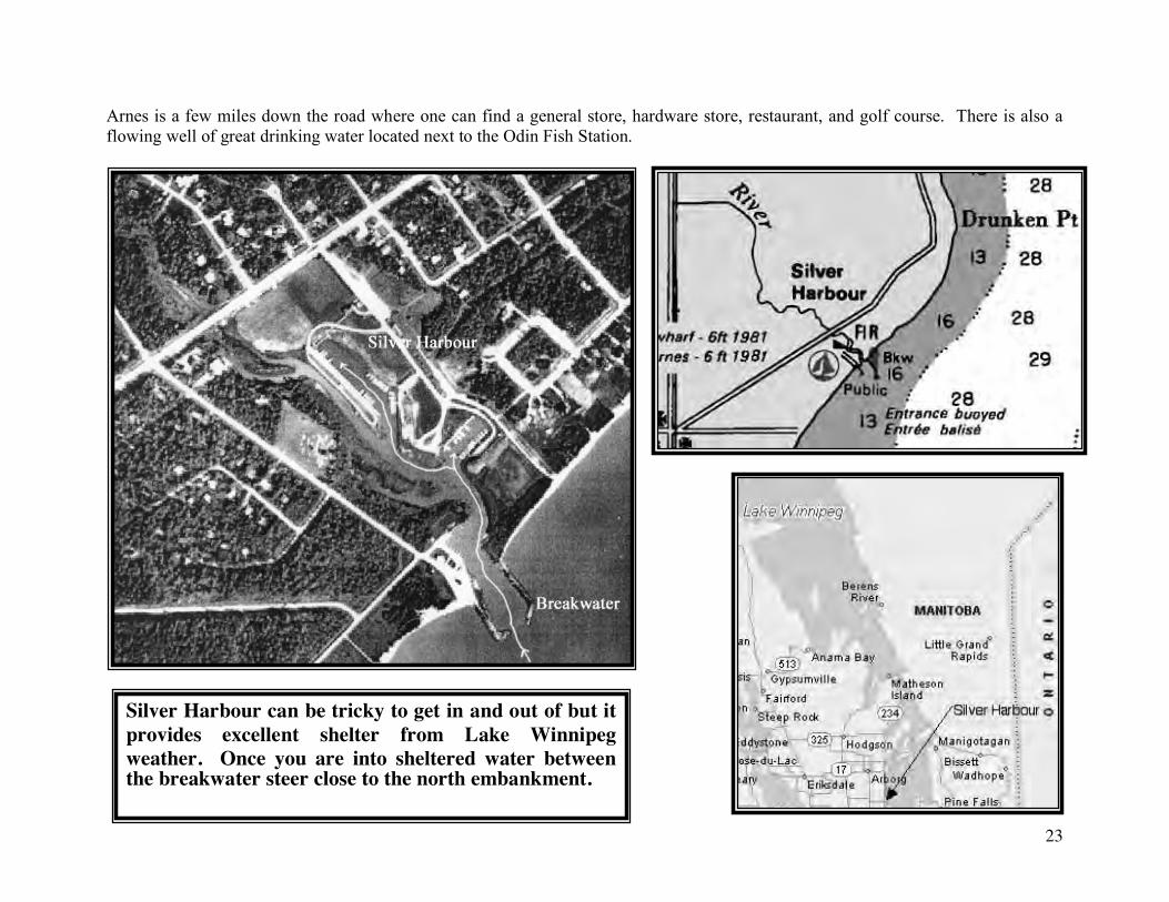
Arnes is a few miles down the road where one can find a general store, hardware store, restaurant, and golf course. There is also a flowing well of great drinking water located next to the Odin Fish Station.
Silver Harbour can be tricky to get in and out of but it provides excellent shelter from Lake Winnipeg weather. Once you are into sheltered water between the breakwater steer close to the north embankment.
24
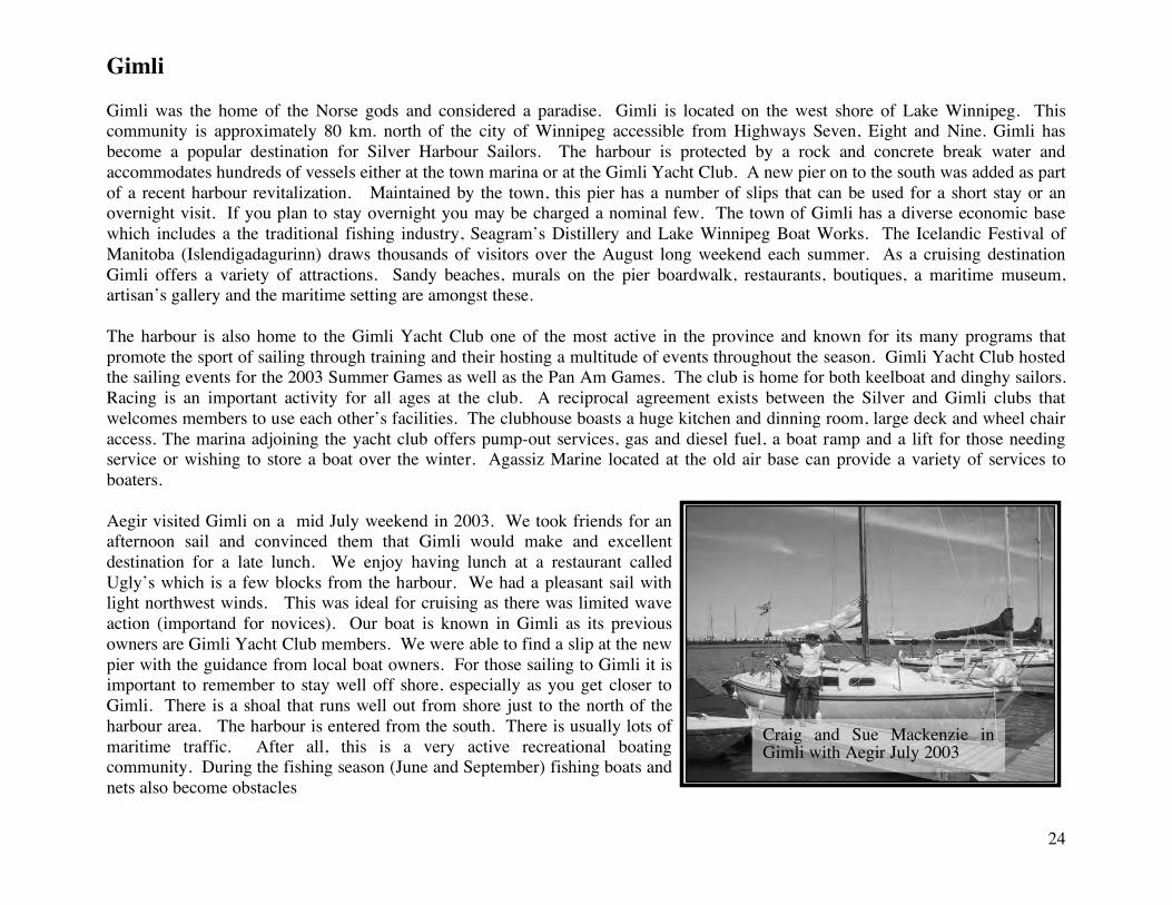
Gimli Gimli was the home of the Norse gods and considered a paradise. Gimli is located on the west shore of Lake Winnipeg. This community is approximately 80 km. north of the city of Winnipeg accessible from Highways Seven, Eight and Nine. Gimli has become a popular destination for Silver Harbour Sailors. The harbour is protected by a rock and concrete break water and accommodates hundreds of vessels either at the town marina or at the Gimli Yacht Club. A new pier on to the south was added as part of a recent harbour revitalization. Maintained by the town, this pier has a number of slips that can be used for a short stay or an overnight visit. If you plan to stay overnight you may be charged a nominal few. The town of Gimli has a diverse economic base which includes a the traditional fishing industry, Seagram’s Distillery and Lake Winnipeg Boat Works. The Icelandic Festival of Manitoba (Islendigadagurinn) draws thousands of visitors over the August long weekend each summer. As a cruising destination Gimli offers a variety of attractions. Sandy beaches, murals on the pier boardwalk, restaurants, boutiques, a maritime museum, artisan’s gallery and the maritime setting are amongst these. The harbour is also home to the Gimli Yacht Club one of the most active in the province and known for its many programs that promote the sport of sailing through training and their hosting a multitude of events throughout the season. Gimli Yacht Club hosted the sailing events for the 2003 Summer Games as well as the Pan Am Games. The club is home for both keelboat and dinghy sailors. Racing is an important activity for all ages at the club. A reciprocal agreement exists between the Silver and Gimli clubs that welcomes members to use each other’s facilities. The clubhouse boasts a huge kitchen and dinning room, large deck and wheel chair access. The marina adjoining the yacht club offers pump-out services, gas and diesel fuel, a boat ramp and a lift for those needing service or wishing to store a boat over the winter. Agassiz Marine located at the old air base can provide a variety of services to boaters. Aegir visited Gimli on a mid July weekend in 2003. We took friends for an afternoon sail and convinced them that Gimli would make and excellent destination for a late lunch. We enjoy having lunch at a restaurant called Ugly’s which is a few blocks from the harbour. We had a pleasant sail with light northwest winds. This was ideal for cruising as there was limited wave action (importand for novices). Our boat is known in Gimli as its previous owners are Gimli Yacht Club members. We were able to find a slip at the new pier with the guidance from local boat owners. For those sailing to Gimli it is important to remember to stay well off shore, especially as you get closer to Gimli. There is a shoal that runs well out from shore just to the north of the harbour area. The harbour is entered from the south. There is usually lots of maritime traffic. After all, this is a very active recreational boating community. During the fishing season (June and September) fishing boats and nets also become obstacles
Craig and Sue Mackenzie in Gimli with Aegir July 2003
25
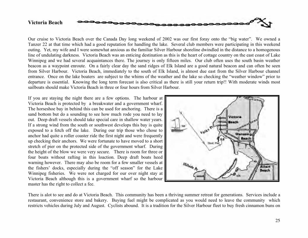
Victoria Beach
Our cruise to Victoria Beach over the Canada Day long weekend of 2002 was our first foray onto the “big water”. We owned a Tanzer 22 at that time which had a good reputation for handling the lake. Several club members were participating in this weekend outing. Yet, my wife and I were somewhat anxious as the familiar Silver Harbour shoreline dwindled in the distance to a homogenous line of undulating darkness. Victoria Beach was an enticing destination as this is the heart of cottage country on the east coast of Lake Winnipeg and we had several acquaintances there. The journey is only fifteen miles. Our club often uses the south basin weather beacon as a waypoint enroute. On a fairly clear day the sand ridges of Elk Island are a good natural beacon and can often be seen from Silver Harbour. Victoria Beach, immediately to the south of Elk Island, is almost due east from the Silver Harbour channel entrance. Once on the lake boaters are subject to the whims of the weather and the lake so checking the “weather window” prior to departure is essential. Knowing the long term forecast is also critical as there is still your return trip!! With moderate winds most sailboats should make Victoria Beach in three or four hours from Silver Harbour. If you are staying the night there are a few options. The harbour at Victoria Beach is protected by a breakwater and a government wharf. The horseshoe bay in behind this can be used for anchoring. There is a sand bottom but do a sounding to see how much rode you need to lay out. Deep draft vessels should take special care in shallow water years. If a strong wind from the south or southwest develops this bay is quite exposed to a fetch off the lake. During our trip those who chose to anchor had quite a roller coaster ride the first night and were frequently up checking their anchors. We were fortunate to have moved to a short stretch of pier on the protected side of the government wharf. During the height of the blow we were very secure. There is room for three or four boats without rafting in this loaction. Deep draft boats heed warning however. There may also be room for a few smaller vessels at the fishers’ docks, especially during the “off season” for the Lake Winnipeg fisheries. We were not charged for our over night stay at Victoria Beach although this is a government wharf so the harbour master has the right to collect a fee. There is alot to see and do at Victoria Beach. This community has been a thriving summer retreat for generations. Services include a restaurant, convenience store and bakery. Buying fuel might be complicated as you would need to leave the community which restricts vehicles during July and August. Cyclists abound. It is a tradition for the Silver Harbour fleet to buy fresh cinnamon buns on
26
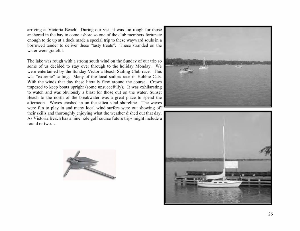
arriving at Victoria Beach. During our visit it was too rough for those anchored in the bay to come ashore so one of the club members fortunate enough to tie up at a dock made a special trip to these wayward souls in a borrowed tender to deliver these “tasty treats”. Those stranded on the water were grateful. The lake was rough with a strong south wind on the Sunday of our trip so some of us decided to stay over through to the holiday Monday. We were entertained by the Sunday Victoria Beach Sailing Club race. This was “extreme” sailing. Many of the local sailors race in Hobbie Cats. With the winds that day these literally flew around the course. Crews trapezed to keep boats upright (some unsuccefully). It was exhilarating to watch and was obviously a blast for those out on the water. Sunset Beach to the north of the breakwater was a great place to spend the afternoon. Waves crashed in on the silica sand shoreline. The waves were fun to play in and many local wind surfers were out showing off their skills and thoroughly enjoying what the weather dished out that day. As Victoria Beach has a nine hole golf course future trips might include a round or two…..
27
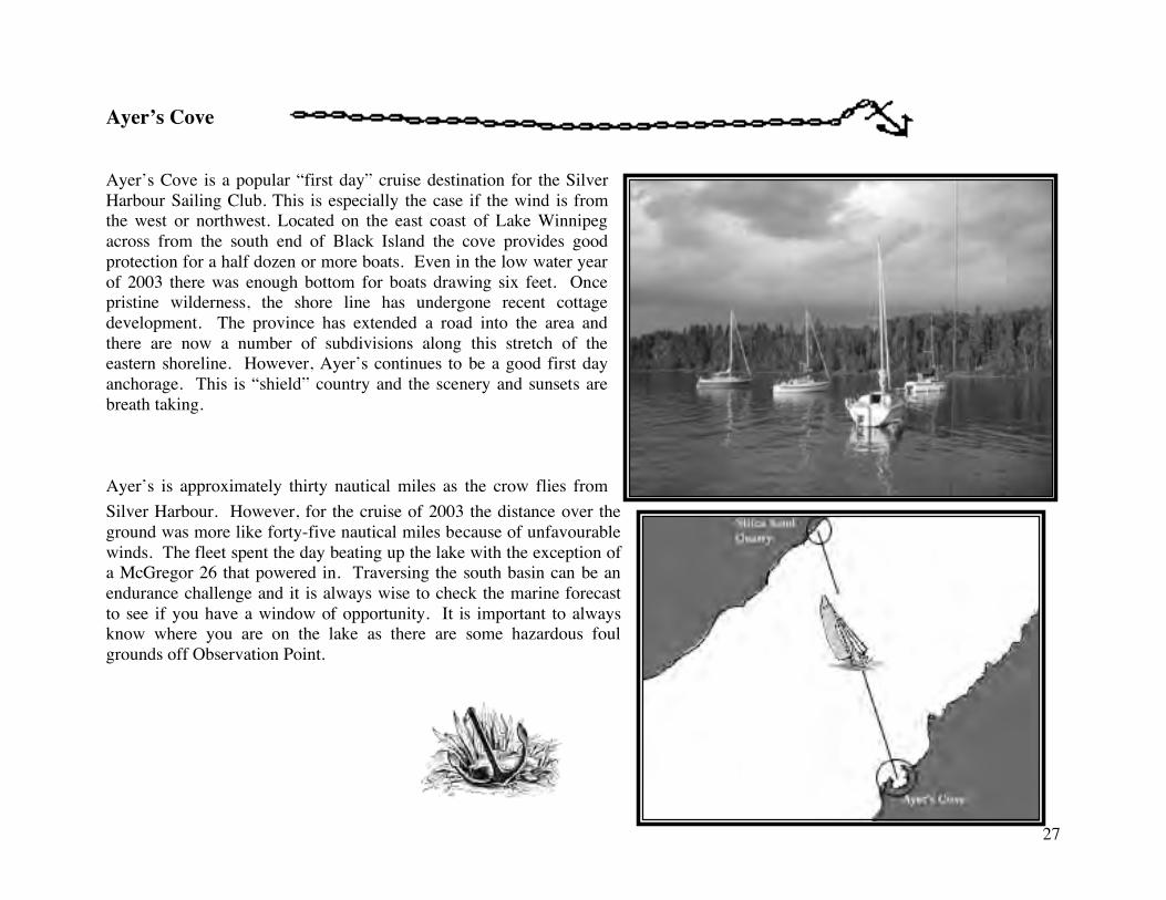
Ayer’s Cove Ayer’s Cove is a popular “first day” cruise destination for the Silver Harbour Sailing Club. This is especially the case if the wind is from the west or northwest. Located on the east coast of Lake Winnipeg across from the south end of Black Island the cove provides good protection for a half dozen or more boats. Even in the low water year of 2003 there was enough bottom for boats drawing six feet. Once pristine wilderness, the shore line has undergone recent cottage development. The province has extended a road into the area and there are now a number of subdivisions along this stretch of the eastern shoreline. However, Ayer’s continues to be a good first day anchorage. This is “shield” country and the scenery and sunsets are breath taking. Ayer’s is approximately thirty nautical miles as the crow flies from Silver Harbour. However, for the cruise of 2003 the distance over the ground was more like forty-five nautical miles because of unfavourable winds. The fleet spent the day beating up the lake with the exception of a McGregor 26 that powered in. Traversing the south basin can be an endurance challenge and it is always wise to check the marine forecast to see if you have a window of opportunity. It is important to always know where you are on the lake as there are some hazardous foul grounds off Observation Point.
28
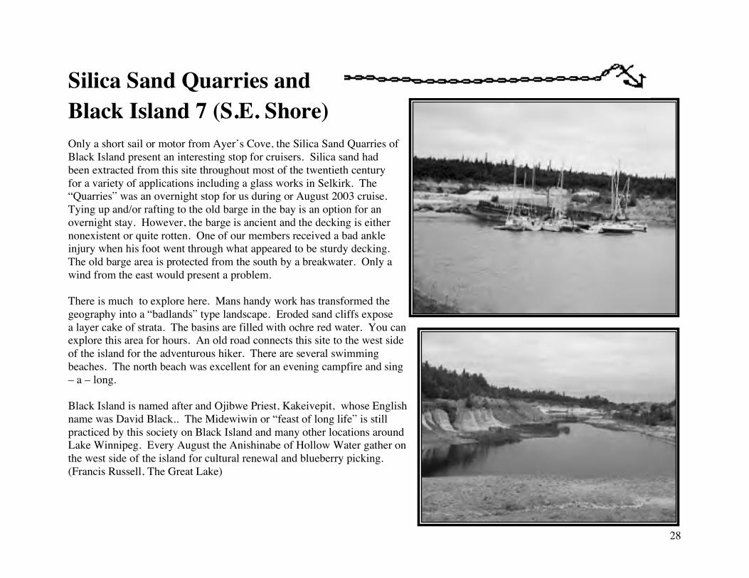
Silica Sand Quarries and Black Island 7 (S.E. Shore) Only a short sail or motor from Ayer’s Cove, the Silica Sand Quarries of Black Island present an interesting stop for cruisers. Silica sand had been extracted from this site throughout most of the twentieth century for a variety of applications including a glass works in Selkirk. The “Quarries” was an overnight stop for us during or August 2003 cruise. Tying up and/or rafting to the old barge in the bay is an option for an overnight stay. However, the barge is ancient and the decking is either nonexistent or quite rotten. One of our members received a bad ankle injury when his foot went through what appeared to be sturdy decking. The old barge area is protected from the south by a breakwater. Only a wind from the east would present a problem. There is much to explore here. Mans handy work has transformed the geography into a “badlands” type landscape. Eroded sand cliffs expose a layer cake of strata. The basins are filled with ochre red water. You can explore this area for hours. An old road connects this site to the west side of the island for the adventurous hiker. There are several swimming beaches. The north beach was excellent for an evening campfire and sing – a – long. Black Island is named after and Ojibwe Priest, Kakeivepit, whose English name was David Black.. The Midewiwin or “feast of long life” is still practiced by this society on Black Island and many other locations around Lake Winnipeg. Every August the Anishinabe of Hollow Water gather on the west side of the island for cultural renewal and blueberry picking. (Francis Russell, The Great Lake)
29
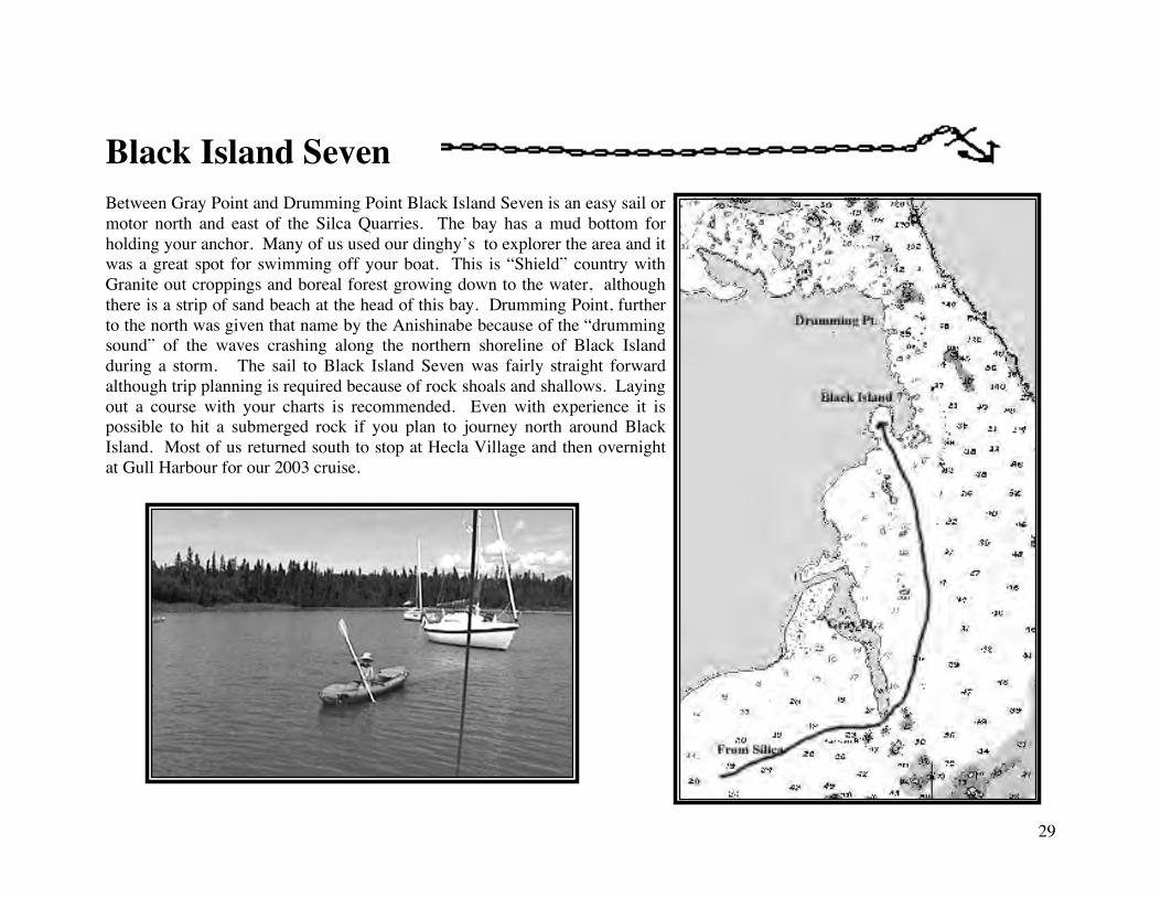
Black Island Seven Between Gray Point and Drumming Point Black Island Seven is an easy sail or motor north and east of the Silca Quarries. The bay has a mud bottom for holding your anchor. Many of us used our dinghy’s to explorer the area and it was a great spot for swimming off your boat. This is “Shield” country with Granite out croppings and boreal forest growing down to the water, although there is a strip of sand beach at the head of this bay. Drumming Point, further to the north was given that name by the Anishinabe because of the “drumming sound” of the waves crashing along the northern shoreline of Black Island during a storm. The sail to Black Island Seven was fairly straight forward although trip planning is required because of rock shoals and shallows. Laying out a course with your charts is recommended. Even with experience it is possible to hit a submerged rock if you plan to journey north around Black Island. Most of us returned south to stop at Hecla Village and then overnight at Gull Harbour for our 2003 cruise.
30
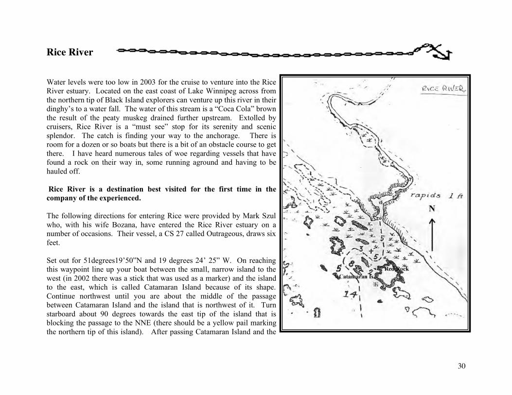
Rice River Water levels were too low in 2003 for the cruise to venture into the Rice River estuary. Located on the east coast of Lake Winnipeg across from the northern tip of Black Island explorers can venture up this river in their dinghy’s to a water fall. The water of this stream is a “Coca Cola” brown the result of the peaty muskeg drained further upstream. Extolled by cruisers, Rice River is a “must see” stop for its serenity and scenic splendor. The catch is finding your way to the anchorage. There is room for a dozen or so boats but there is a bit of an obstacle course to get there. I have heard numerous tales of woe regarding vessels that have found a rock on their way in, some running aground and having to be hauled off. Rice River is a destination best visited for the first time in the company of the experienced. The following directions for entering Rice were provided by Mark Szul who, with his wife Bozana, have entered the Rice River estuary on a number of occasions. Their vessel, a CS 27 called Outrageous, draws six feet. Set out for 51degrees19’50”N and 19 degrees 24’ 25” W. On reaching this waypoint line up your boat between the small, narrow island to the west (in 2002 there was a stick that was used as a marker) and the island to the east, which is called Catamaran Island because of its shape. Continue northwest until you are about the middle of the passage between Catamaran Island and the island that is northwest of it. Turn starboard about 90 degrees towards the east tip of the island that is blocking the passage to the NNE (there should be a yellow pail marking the northern tip of this island). After passing Catamaran Island and the
31
next island turn southeast towards the “Red Rock”. This is a larger island with a reddish tint to it above the water line. Advance towards “Red Rock” until you can see straight down the river channel. Turn to Port and proceed up the river. There are two good spots for mooring. One is just past the left bend of the river by the west shore. The second is about one hundred to one hundred and fifty yards further past the right bend along the east shore. The west shore at this point has rocks beneath the surface so stay clear. In either case you should set your stern anchor first then proceed to about two feet of the shore. Jump ashore and secure your bow line to a tree. Mark says, “ The approach to Rice river is quite tricky, especially for the novice, however it is one of the nicest places on the lake.’
32
Hecla Village The government wharf at Hecla Village provides protected berths for six or more sailboats. This is also a busy fishing port during the spring and fall seasons so accommodations can be tight. The concrete wharf is reinforced with steel and timber beams so fender boards* are in order. Located within the confines of Hecla Provincial Park this restored historical village is an interesting as well as practical stop. The store is a short walk from the harbour and is usually well stocked. In addition to gas and ice this store provides groceries, dry goods, and souvenirs. The ice cream chest offers variety and the store is also a Manitoba Liquor Commission. There is a self guided interpretive trail throughout the village providing information on the Icelandic community that once thrived on the island. The museum at the harbour showcases the history of fishing on Lake Winnipeg. Hecla Harbour is a popular layover for sailors and power boaters. During the summer of 03 we had the good fortune of meeting the owners of Gator a converted logging boat. This privately owned and operated boat is well known on the lake. With is reinforced steel hull, winches and experienced crew it has come to the rescue of more than the odd pleasure boater as one of the Silver Harbour members can attest after their cruise of 03.
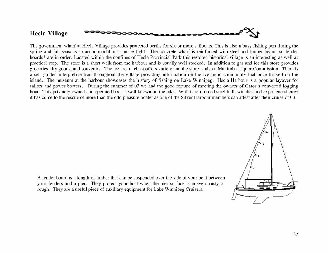
A fender board is a length of timber that can be suspended over the side of your boat between your fenders and a pier. They protect your boat when the pier surface is uneven, rusty or rough. They are a useful piece of auxiliary equipment for Lake Winnipeg Cruisers.
33
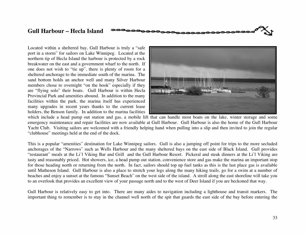
Gull Harbour – Hecla Island Located within a sheltered bay, Gull Harbour is truly a “safe port in a storm” for sailors on Lake Winnipeg. Located at the northern tip of Hecla Island the harbour is protected by a rock breakwater on the east and a government wharf to the north. If one does not wish to “tie up”, there is plenty of room for a sheltered anchorage to the immediate south of the marina. The sand bottom holds an anchor well and many Silver Harbour members chose to overnight “on the hook” especially if they are “flying solo” their boats. Gull Harbour is within Hecla Provincial Park and amenities abound. In addition to the many facilities within the park, the marina itself has experienced many upgrades in recent years thanks to the current lease holders, the Benson family. In addition to the marina facilities which include a head pump out station and gas, a mobile lift that can handle most boats on the lake, winter storage and some emergency maintenance and repair facilities are now available at Gull Harbour. Gull Harbour is also the home of the Gull Harbour Yacht Club. Visiting sailors are welcomed with a friendly helping hand when pulling into a slip and then invited to join the regular “clubhouse” meetings held at the end of the dock. This is a popular “amenities” destination for Lake Winnipeg sailors. Gull is also a jumping off point for trips to the more secluded anchorages of the “Narrows” such as Wells Harbour and the many sheltered bays on the east side of Black Island. Gull provides “restaurant” meals at the Li’l Viking Bar and Grill and the Gull Harbour Resort. Pickeral and steak dinners at the Li’l Viking are tasty and reasonably priced. Hot showers, ice, a head pump out station, convenience store and gas make the marina an important stop for those heading north or returning from the north. In fact, sailors should top up fuel tanks as this is the last place gas is available until Matheson Island. Gull Harbour is also a place to stretch your legs along the many hiking trails, go for a swim at a number of beaches and enjoy a sunset at the famous “Sunset Beach” on the west side of the island. A stroll along the east shoreline will take you to an overlook that provides an excellent view of your passage north and to the west of Deer Island if you are beckoned that way. Gull Harbour is relatively easy to get into. There are many aides to navigation including a lighthouse and transit markers. The important thing to remember is to stay in the channel well north of the spit that guards the east side of the bay before entering the
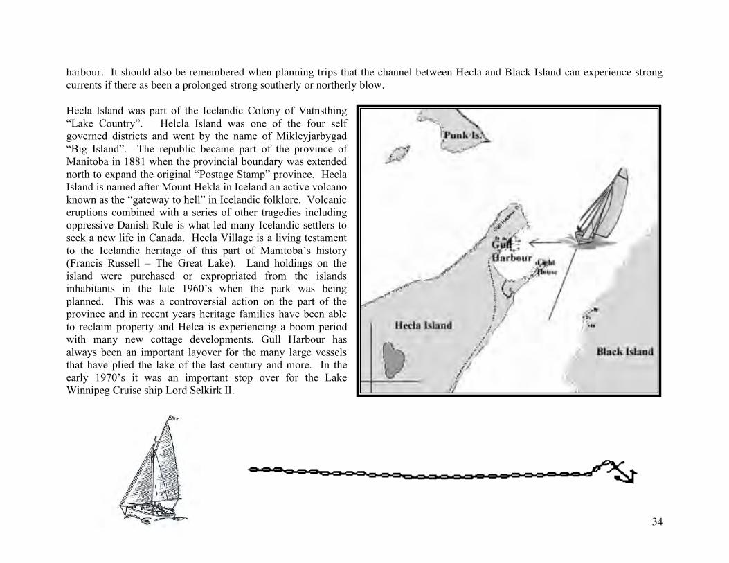
34
harbour. It should also be remembered when planning trips that the channel between Hecla and Black Island can experience strong currents if there as been a prolonged strong southerly or northerly blow. Hecla Island was part of the Icelandic Colony of Vatnsthing “Lake Country”. Helcla Island was one of the four self governed districts and went by the name of Mikleyjarbygad “Big Island”. The republic became part of the province of Manitoba in 1881 when the provincial boundary was extended north to expand the original “Postage Stamp” province. Hecla Island is named after Mount Hekla in Iceland an active volcano known as the “gateway to hell” in Icelandic folklore. Volcanic eruptions combined with a series of other tragedies including oppressive Danish Rule is what led many Icelandic settlers to seek a new life in Canada. Hecla Village is a living testament to the Icelandic heritage of this part of Manitoba’s history (Francis Russell – The Great Lake). Land holdings on the island were purchased or expropriated from the islands inhabitants in the late 1960’s when the park was being planned. This was a controversial action on the part of the province and in recent years heritage families have been able to reclaim property and Helca is experiencing a boom period with many new cottage developments. Gull Harbour has always been an important layover for the many large vessels that have plied the lake of the last century and more. In the early 1970’s it was an important stop over for the Lake Winnipeg Cruise ship Lord Selkirk II.
35
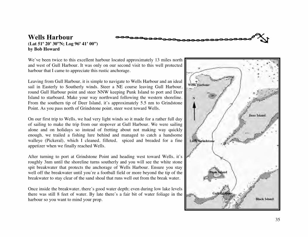
Wells Harbour (Lat 51º 20’ 30”N; Log 96º 41’ 00”) by Bob Howard We’ve been twice to this excellent harbour located approximately 13 miles north and west of Gull Harbour. It was only on our second visit to this well protected harbour that I came to appreciate this rustic anchorage. Leaving from Gull Harbour, it is simple to navigate to Wells Harbour and an ideal sail in Easterly to Southerly winds. Steer a NE course leaving Gull Harbour, round Gull Harbour point and steer NNW keeping Punk Island to port and Deer Island to starboard. Make your way northward following the western shoreline. From the southern tip of Deer Island, it’s approximately 5.5 nm to Grindstone Point. As you pass north of Grindstone point, steer west toward Wells. On our first trip to Wells, we had very light winds so it made for a rather full day of sailing to make the trip from our stopover at Gull Harbour. We were sailing alone and on holidays so instead of fretting about not making way quickly enough, we trailed a fishing lure behind and managed to catch a handsome walleye (Pickeral), which I cleaned, filleted, spiced and breaded for a fine appetizer when we finally reached Wells. After turning to port at Grindstone Point and heading west toward Wells, it’s roughly 3nm until the shoreline turns southerly and you will see the white stone spit breakwater that protects the anchorage of Wells Harbour. Ensure you stay well off the breakwater until you’re a football field or more beyond the tip of the breakwater to stay clear of the sand shoal that runs well out from the break water. Once inside the breakwater, there’s good water depth; even during low lake levels there was still 8 feet of water. By late there’s a fair bit of water foliage in the harbour so you want to mind your prop.
36
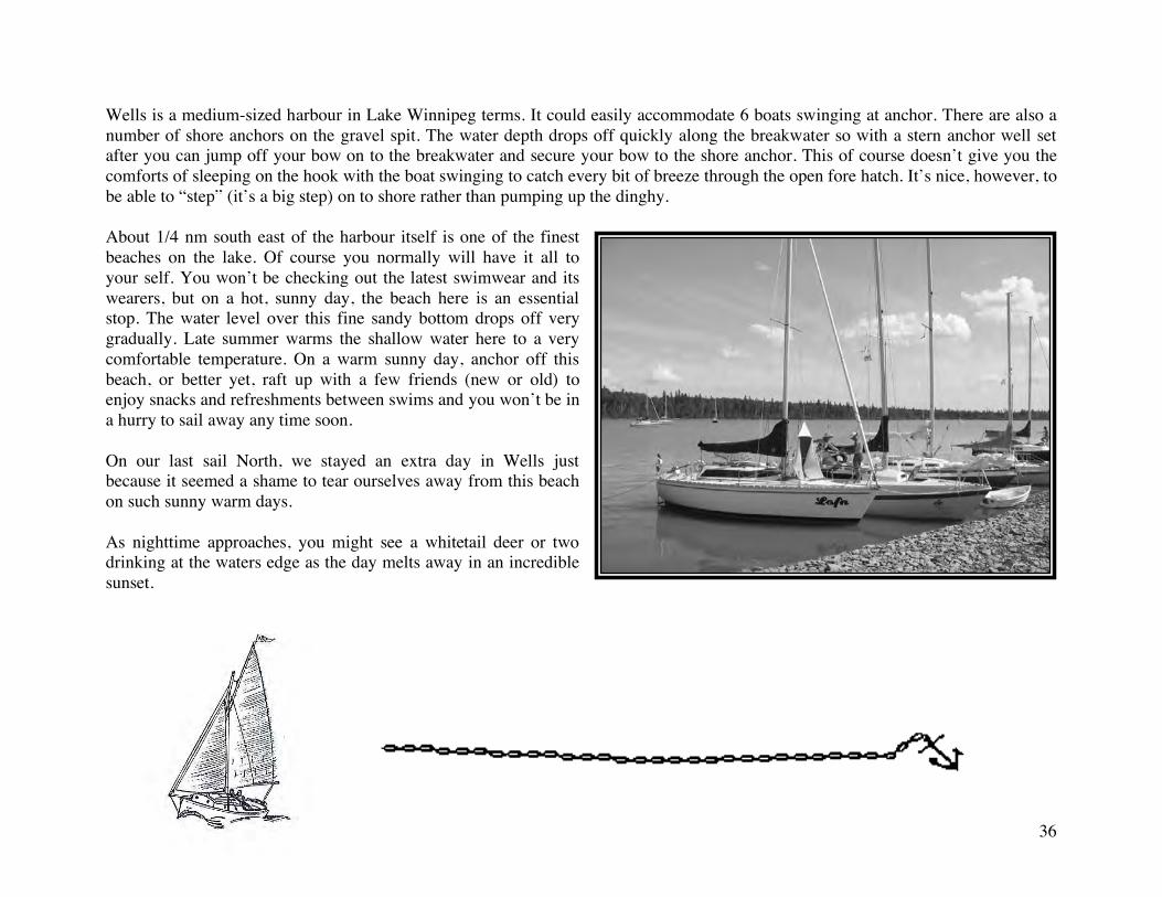
Wells is a medium-sized harbour in Lake Winnipeg terms. It could easily accommodate 6 boats swinging at anchor. There are also a number of shore anchors on the gravel spit. The water depth drops off quickly along the breakwater so with a stern anchor well set after you can jump off your bow on to the breakwater and secure your bow to the shore anchor. This of course doesn’t give you the comforts of sleeping on the hook with the boat swinging to catch every bit of breeze through the open fore hatch. It’s nice, however, to be able to “step” (it’s a big step) on to shore rather than pumping up the dinghy. About 1/4 nm south east of the harbour itself is one of the finest beaches on the lake. Of course you normally will have it all to your self. You won’t be checking out the latest swimwear and its wearers, but on a hot, sunny day, the beach here is an essential stop. The water level over this fine sandy bottom drops off very gradually. Late summer warms the shallow water here to a very comfortable temperature. On a warm sunny day, anchor off this beach, or better yet, raft up with a few friends (new or old) to enjoy snacks and refreshments between swims and you won’t be in a hurry to sail away any time soon. On our last sail North, we stayed an extra day in Wells just because it seemed a shame to tear ourselves away from this beach on such sunny warm days. As nighttime approaches, you might see a whitetail deer or two drinking at the waters edge as the day melts away in an incredible sunset.
37
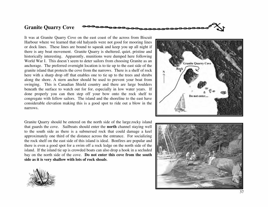
Granite Quarry Cove It was at Granite Quarry Cove on the east coast of the across from Biscuit Harbour where we learned that old halyards were not good for mooring lines or dock lines. These lines are bound to squeak and keep you up all night if there is any boat movement. Granite Quarry is sheltered, quiet, pristine and historically interesting. Apparently, munitions were dumped here following World War I. This doesn’t seem to deter sailors from choosing Granite as an anchorage. The preferred overnight location is to tie up to the east side of the granite island that protects the cove from the narrows. There is a shelf of rock here with a sharp drop off that enables one to tie up to the trees and shrubs along the shore. A stern anchor should be used to prevent your boat from swinging. This is Canadian Shield country and there are large boulders beneath the surface to watch out for for, especially in low water years. If done properly you can then step off your bow onto the rock shelf to congregate with fellow sailors. The island and the shoreline to the east have considerable elevation making this is a good spot to ride out a blow in the narrows. Granite Quarry should be entered on the north side of the large.rocky island that guards the cove. Sailboats should enter the north channel staying well to the south side as there is a submersed rock that could damage a keel approximately one third of the distance across the entrance. For socializing the rock shelf on the east side of this island is ideal. Bonfires are popular and there is even a good spot for a swim off a rock ledge on the north side of the island. If the island tie up is crowded boats can also drop a hook in a secluded bay on the north side of the cove. Do not enter this cove from the south side as it is very shallow with lots of rock shoals.
38
Biscuit Harbour Resort by Ron Hore (Legacy) Biscuit Harbour Resort is a day’s sail north of Gull Harbour. As you cannot get regular gas at Biscuit, it is a good idea to fill up at Gull Harbour before you leave. In an emergency, airplane gas is available at the Biscuit Harbour Resort. If you want to shorten the trip, one good stop over is the anchorage at Wells Harbour. An alternative starting point would be from the Rice River on the eastern shore. If you are navigating by sight, the run north is simplified by making for Berry Island. From there you can see either shore. I prefer to stay to the west of centre when running through the narrows. On route to Biscuit you pass two other potential harbours. Calders Dock on the western shore could serve as an emergency stop. On the eastern shore opposite the entrance to the Biscuit Harbour bay you can find Granite Quarry, an excellent sheltered anchorage. When you enter Biscuit Bay you will see the village of Pine Dock about two and a half to three miles to the north. There are not always facilities available there other than the government dock. The Biscuit Harbour Resort is located at the north west corner at the back of the bay. The harbour breakwater runs out east and west from the shore, then turns north. The entrance to the harbour is at the north end of the breakwater, close to the shore. Be on the watch for float planes as the resort is a base for fly in fishing camps. When you enter the harbour entrance, turn south and stay close to the breakwater. Do not approach the docks and buildings on the north side as these are reserved for the float planes. Visiting boats moor along the dock located to the south, inside the breakwater. There is a submerged rock inside near the entrance to the harbour. It is not always marked.
All Tied Up at Biscuit Harbour – August 02
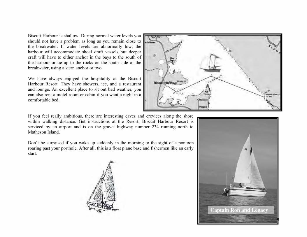
39
Biscuit Harbour is shallow. During normal water levels you should not have a problem as long as you remain close to the breakwater. If water levels are abnormally low, the harbour will accommodate shoal draft vessels but deeper craft will have to either anchor in the bays to the south of the harbour or tie up to the rocks on the south side of the breakwater, using a stern anchor or two. We have always enjoyed the hospitality at the Biscuit Harbour Resort. They have showers, ice, and a restaurant and lounge. An excellent place to sit out bad weather, you can also rent a motel room or cabin if you want a night in a comfortable bed. If you feel really ambitious, there are interesting caves and crevices along the shore within walking distance. Get instructions at the Resort. Biscuit Harbour Resort is serviced by an airport and is on the gravel highway number 234 running north to Matheson Island. Don’t be surprised if you wake up suddenly in the morning to the sight of a pontoon roaring past your porthole. After all, this is a float plane base and fishermen like an early start.
Captain Ron and Legacy
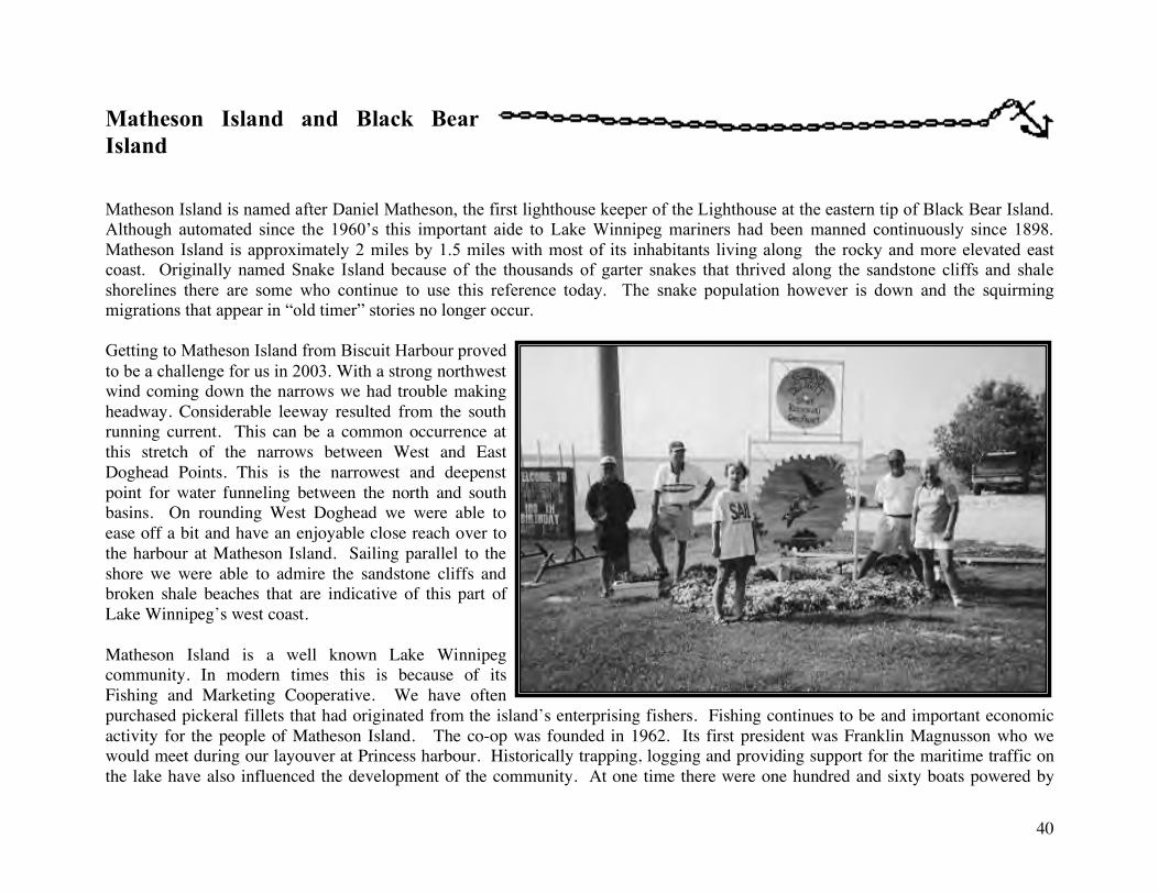
40
Matheson Island and Black Bear Island Matheson Island is named after Daniel Matheson, the first lighthouse keeper of the Lighthouse at the eastern tip of Black Bear Island. Although automated since the 1960’s this important aide to Lake Winnipeg mariners had been manned continuously since 1898. Matheson Island is approximately 2 miles by 1.5 miles with most of its inhabitants living along the rocky and more elevated east coast. Originally named Snake Island because of the thousands of garter snakes that thrived along the sandstone cliffs and shale shorelines there are some who continue to use this reference today. The snake population however is down and the squirming migrations that appear in “old timer” stories no longer occur. Getting to Matheson Island from Biscuit Harbour proved to be a challenge for us in 2003. With a strong northwest wind coming down the narrows we had trouble making headway. Considerable leeway resulted from the south running current. This can be a common occurrence at this stretch of the narrows between West and East Doghead Points. This is the narrowest and deepenst point for water funneling between the north and south basins. On rounding West Doghead we were able to ease off a bit and have an enjoyable close reach over to the harbour at Matheson Island. Sailing parallel to the shore we were able to admire the sandstone cliffs and broken shale beaches that are indicative of this part of Lake Winnipeg’s west coast. Matheson Island is a well known Lake Winnipeg community. In modern times this is because of its Fishing and Marketing Cooperative. We have often purchased pickeral fillets that had originated from the island’s enterprising fishers. Fishing continues to be and important economic activity for the people of Matheson Island. The co-op was founded in 1962. Its first president was Franklin Magnusson who we would meet during our layouver at Princess harbour. Historically trapping, logging and providing support for the maritime traffic on the lake have also influenced the development of the community. At one time there were one hundred and sixty boats powered by
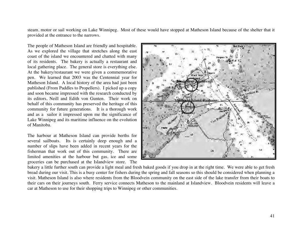
41
steam, motor or sail working on Lake Winnipeg. Most of these would have stopped at Matheson Island because of the shelter that it provided at the entrance to the narrows. The people of Matheson Island are friendly and hospitable. As we explored the village that stretches along the east coast of the island we encountered and chatted with many of its residents. The bakery is actually a restaurant and local gathering place. The general store is everything else. At the bakery/restaurant we were given a commemorative pen. We learned that 2003 was the Centennial year for Matheson Island. A local history of the area had just been published (From Paddles to Propellers). I picked up a copy and soon became impressed with the research conducted by its editors, Neill and Edith von Gunten. Their work on behalf of this community has preserved the heritage of this community for future generations. It is a thorough work and as a sailor it impressed upon me the significance of Lake Winnipeg and its maritime influence on the evolution of Manitoba. The harbour at Matheson Island can provide berths for several sailboats. Its is certainly deep enough and a number of slips have been added in recent years for the fisherman that work out of this community. There are limited amenities at the harbour but gas, ice and some groceries can be purchased at the Islandview store. The bakery a little further south can provide a light meal and fresh baked goods if you drop in at the right time. We were able to get fresh bread during our visit. This is a busy center for fishers during the spring and fall seasons so this should be considered when planning a visit. Matheson Island is also where residents from the Bloodvein community on the east side of the lake transfer from their boats to their cars on their journeys south. Ferry service connects Matheson to the mainland at Islandview. Bloodvein residents will leave a car at Matheson to use for their shopping trips to Winnipeg or other communities.
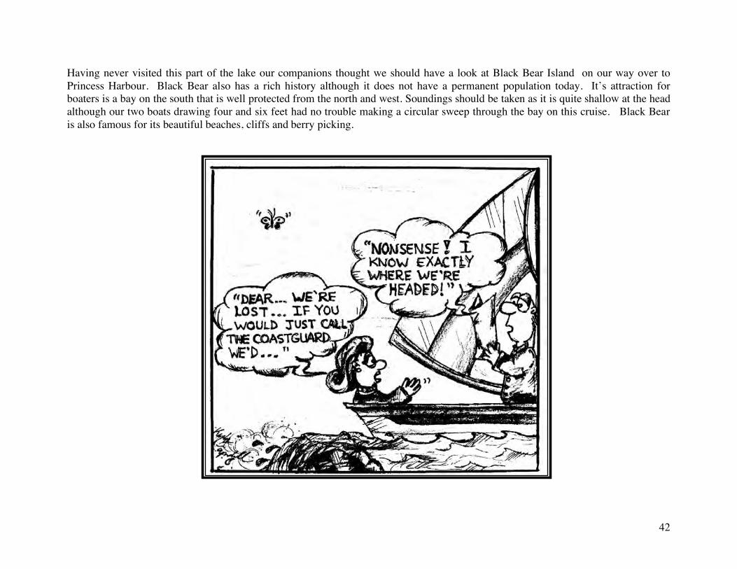
42
Having never visited this part of the lake our companions thought we should have a look at Black Bear Island on our way over to Princess Harbour. Black Bear also has a rich history although it does not have a permanent population today. It’s attraction for boaters is a bay on the south that is well protected from the north and west. Soundings should be taken as it is quite shallow at the head although our two boats drawing four and six feet had no trouble making a circular sweep through the bay on this cruise. Black Bear is also famous for its beautiful beaches, cliffs and berry picking.
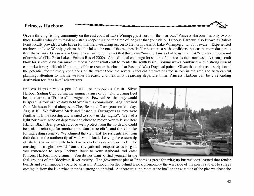
43
Princess Harbour Once a thriving fishing community on the east coast of Lake Winnipeg just north of the “narrows” Princess Harbour has only two or three families who claim residency status (depending on the time of the year that your visit). Princess Harbour, also known as Rabbit Point locally provides a safe haven for mariners venturing out on to the north basin of Lake Winnipeg …… but beware. Experienced mariners on Lake Winnipeg claim that the lake to be one of the roughest in North America with conditions that can be more dangerous than the Atlantic Ocean or the Great Lakes owing to the fact that the waves “run short instead of long” and that “storms can come out of nowhere” (The Great Lake – Francis Russel 2000). An additional challenge for sailors of this area is the “narrows”. A strong south blow for several days can make it impossible for small craft to reenter the south basin. Boiling waves combined with a strong current can make it very difficult if not impossible to reenter the channel at East and West Doghead points. Given this ominous description of the potential for unsavory conditions on the water there are several excellent destinations for sailors in the area and with careful planning, attention to marine weather forecasts and flexibility regarding departure times Princess Harbour can be a rewarding destination for “sea lake” adventurers. Princess Harbour was a port of call and rendezvous for the Silver Harbour Sailing Club during the summer cruise of 03. Our cruising fleet began to arrive at “Princess” on August 9. Few realized that they would be spending four or five days held over in this community. Aegir crossed from Matheson Island along with Chez Bear and Outrageous on Monday, August 10. We followed Mark and Bosana in Outrageous as they were familiar with the crossing and wanted to show us the ”sights”. We had a light northwest wind on departure and chose to motor over to Black Bear Island. Black Bear provides a cove well protect from the north and could be a nice anchorage for another trip. Sandstone cliffs, and forests make for interesting scenery. We admired the view that the residents had from their deck on the northern tip of Matheson Island. Leaving the eastern tip of Black Bear we were able to beat across to Princess on a port tack. The crossing is straight-forward from a navigational perspective as long as you remember to keep Thoburn Rock to your starboard and enter Princess Harbour mid channel. You do not want to find yourself in the foul grounds of the Bloodvein River estuary. The government pier at Princess is great for tying up but we soon learned that fender boards and even snubbers could be an asset. Although nestled behind a rock promontory the west side of the pier is subject to surges coming in from the lake when there is a strong south wind. As there was “no room at the inn” on the east side of the pier we chose the
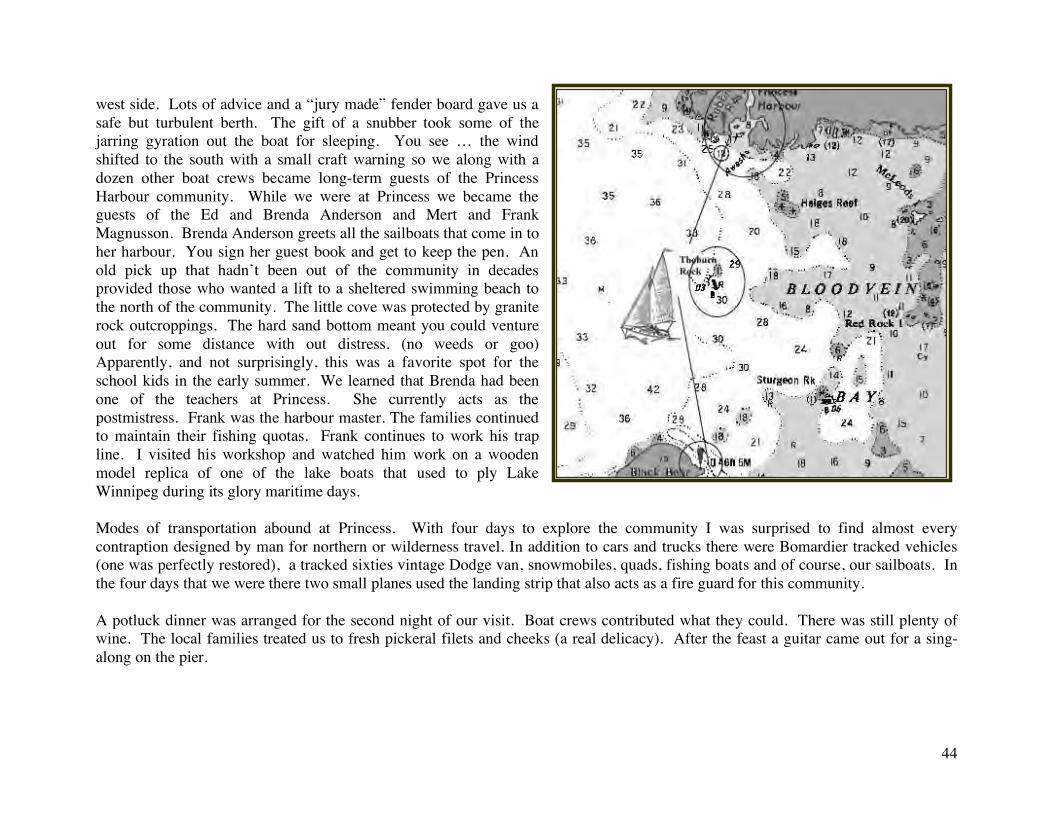
44
west side. Lots of advice and a “jury made” fender board gave us a safe but turbulent berth. The gift of a snubber took some of the jarring gyration out the boat for sleeping. You see … the wind shifted to the south with a small craft warning so we along with a dozen other boat crews became long-term guests of the Princess Harbour community. While we were at Princess we became the guests of the Ed and Brenda Anderson and Mert and Frank Magnusson. Brenda Anderson greets all the sailboats that come in to her harbour. You sign her guest book and get to keep the pen. An old pick up that hadn’t been out of the community in decades provided those who wanted a lift to a sheltered swimming beach to the north of the community. The little cove was protected by granite rock outcroppings. The hard sand bottom meant you could venture out for some distance with out distress. (no weeds or goo) Apparently, and not surprisingly, this was a favorite spot for the school kids in the early summer. We learned that Brenda had been one of the teachers at Princess. She currently acts as the postmistress. Frank was the harbour master. The families continued to maintain their fishing quotas. Frank continues to work his trap line. I visited his workshop and watched him work on a wooden model replica of one of the lake boats that used to ply Lake Winnipeg during its glory maritime days. Modes of transportation abound at Princess. With four days to explore the community I was surprised to find almost every contraption designed by man for northern or wilderness travel. In addition to cars and trucks there were Bomardier tracked vehicles (one was perfectly restored), a tracked sixties vintage Dodge van, snowmobiles, quads, fishing boats and of course, our sailboats. In the four days that we were there two small planes used the landing strip that also acts as a fire guard for this community. A potluck dinner was arranged for the second night of our visit. Boat crews contributed what they could. There was still plenty of wine. The local families treated us to fresh pickeral filets and cheeks (a real delicacy). After the feast a guitar came out for a sing-along on the pier.
45
During the evening of August 12 a distress call was received from a sailboat returning from George Island in the north basin. They were on the return leg of an endurance race. Not far off Rabbit Point they had struck a submerged rock that had damaged their rudder. That had tossed an anchor and were attempting to make a repair. As the light faded we could just see them north of the point. Ed, his son and a paramedic (Chris) prepared to launch Ed’s fishing boat for a rescue. The lake was a tempest and this was going to be a treacherous undertaking. Fortunately, the repair was successful and they were able to limp into Princess. Silver Harbour members provided assistance with more substantial repairs to the C&C 29. The gooseneck on the boom had been damaged during an uncontrolled gybe. The next morning they were on their way. We never did find out who the successful boat crew was. The incident reminded me of the fate of the Keewatin. I had recently read the account in Francis Russel’s “the Great Lake” . This Northwest Mounted Police schooner had run aground on a reef just north of the Rabbit Point area in conditions similar to what we were witnessing. A corporal and private had drowned after clinging to the boat for a day. The captain bound himself to the wreck and drifted for eight days. Although he was rescued he later died of complications from the exposure that he had endured. This was in the 1890’s.
Closing Notes: A work like this is really a work in progress. I challenged myself to have a draft completed for the February 2004 banquet and this compilation represents success. However, there are other destinations and many more experiences on Manitoba’s “Sea Lake”. Comments on weather and boat safety need to be expanded. As mentioned in the indtroduction, this is not an experts sailing reference and Lake Winnipeg sailors should enrich their skills through formal training and research. Some suggested sources for this are:
Small Boat Operators Course Marine Radio Seminar Basic Coastal Cruising Certification (CYA) Coastal Navigation Certification (CYA) Reading the Marine Guide to Local Conditions and Forecasts (Environment Canada) Using Current Charts for Lake Winnipeg Being familiar with all documentation relating to the operation of your boat and its equipment Listening to and observing experienced Lake Winnipeg Sailors (especially with regards to local conditions) Etc.
46
References Russell, Francis, “The Great Lake”, Heartland Publishers, 2000 Thorkelsson. Dean, “Lake Winnipeg Coastal Directory”, Lake Agassis Marine Inc., 1995 Von Gunten, Neil and Edith, “From Paddles to Propellers – The History of Matheson Island, Matheson Island Community Council, 2003