Embed Size (px)
Citation preview

#333 NOVEMBER 2016
ICES COOPERATIVE RESEARCH REPORT
RAPPORT DES RECHERCHESCOLLECTIVES
ICES INTERNATIONAL COUNCIL FOR THE EXPLORATION OF THE SEA CIEM CONSEIL INTERNATIONAL POUR L’EXPLORATION DE LA MER
Multidisciplinary perspectives in the use (and misuse) of science and scientific advice in marine spatial planning

ICES COOPERATIVE RESEARCH REPORT RAPPORT DES RECHERCHES COLLECTIVES
NO. 333
NOVEMBER 2016
Multidisciplinary perspectives in the use
(and misuse) of science and scientific advice in marine spatial planning
Editors
Roland Cormier • Andreas Kannen • Mel Austen • Thomas Therriault

International Council for the Exploration of the Sea
Conseil International pour l’Exploration de la Mer
H. C. Andersens Boulevard 44–46
DK‐1553 Copenhagen V
Denmark
Telephone (+45) 33 38 67 00
Telefax (+45) 33 93 42 15
www.ices.dk
Recommended format for purposes of citation:
Cormier, R., Kannen, A., Austen, M., and Therriault, T. (Eds). 2016. Multidisciplinary
perspectives in the use (and misuse) of science and scientific advice in marine spatial
planning. ICES Cooperative Research Report No. 333. 64 pp.
Series Editor: Emory D. Anderson
The material in this report may be reused for non‐commercial purposes using the rec‐
ommended citation. ICES may only grant usage rights of information, data, images,
graphs, etc. of which it has ownership. For other third‐party material cited in this re‐
port, you must contact the original copyright holder for permission. For citation of da‐
tasets or use of data to be included in other databases, please refer to the latest ICES
data policy on the ICES website. All extracts must be acknowledged. For other repro‐
duction requests please contact the General Secretary.
This document is the product of an Expert Group under the auspices of the International
Council for the Exploration of the Sea and does not necessarily represent the view of the
Council.
Cover image: © OCEANA/Carlos Suárez
ISBN 978‐87‐7482‐190‐8
ISSN 1017‐6195
© 2016 International Council for the Exploration of the Sea

Contents
1 Introduction .................................................................................................................... 1
2 Multidisciplinary considerations................................................................................ 5
2.1 Science–policy advice in MSP decision‐making processes ............................ 5
2.2 Uncertainty implications in MSP decision‐making processes ....................... 6
2.3 Geo‐spatial analysis implications in MSP decision‐making processes ........ 7
2.4 Communication implications in MSP decision‐making processes ............... 7
3 Concluding remarks ...................................................................................................... 9
4 Paper contributions ..................................................................................................... 10
4.1 Fishery vs. new concepts of the use of sea space: an example of the
Polish marine areas ........................................................................................... 10
4.2 The Trilateral Wadden Sea Cooperation: a model for transnational
cooperation in MSP and MSFD........................................................................ 11
4.2.1 Introduction ............................................................................................ 11
4.2.2 Method ..................................................................................................... 11
4.2.3 Results ...................................................................................................... 13
4.2.4 Discussion ................................................................................................ 13
4.3 Incorporating social–cultural dimensions of ecosystem services in
MSP ...................................................................................................................... 13
4.3.1 Problem context for MSP ....................................................................... 13
4.3.2 MSP as a question of values .................................................................. 14
4.3.3 Making the intangible tangible: the concept of cultural
ecosystem services .................................................................................. 15
4.3.4 The composite nature of what is valued ............................................. 17
4.3.5 Non‐material values and space ............................................................ 19
4.3.6 Tracing shifts in values and benefits.................................................... 19
4.3.7 Issues of scale in value assessments ..................................................... 21
4.3.8 The link between inner convictions and attitudes ............................. 21
4.3.9 Conclusion ............................................................................................... 22
4.4 Representation of the use of marine space by commercial fisheries in
marine spatial planning .................................................................................... 22
4.5 Science–policy interactions: between policy fragmentation,
integration, and new paradigms for planning and management ............... 24
4.6 Petroleum activities in the Lofoten area: definition of a worst‐case
scenario ............................................................................................................... 24
4.6.1 Introduction ............................................................................................ 25
4.6.2 Inherent uncertainties ............................................................................ 26
4.6.3 Issues to be discussed ............................................................................ 27
4.6.4 Acknowledgements................................................................................ 27
4.7 Shetland Marine Spatial Plan: an ecosystem‐based approach in
formulating marine policy and management options .................................. 27

4.7.1 Introduction ............................................................................................ 28
4.7.2 National and regional context in MSP ................................................. 28
4.7.3 Shetland Islands Marine Spatial Plan .................................................. 29
4.7.4 Assessing cumulative impacts using an ecosystem‐based risk
assessment ............................................................................................... 30
4.7.5 Methodology ........................................................................................... 30
4.7.6 Discussion ................................................................................................ 35
4.7.7 Acknowledgements................................................................................ 37
4.8 The science of negotiation: stakeholder engagement in discussions
about science and uncertainty in the negotiations of a fisheries
management plan for Dogger Bank under Natura 2000 .............................. 37
4.8.1 Introduction ............................................................................................ 37
4.8.2 Framework of analysis: the linear‐policy model and the role of
science in the policy‐making process ................................................... 38
4.8.3 Dogger Bank case study in the science–policy framework ............... 39
4.8.4 Conclusions ............................................................................................. 41
4.9 Mapping inshore fishing activity to inform marine planning in
Scotland: a pilot project using stakeholder data in the Pentland Firth
and Orkney waters ............................................................................................ 41
4.9.1 Introduction ............................................................................................ 42
4.9.2 Methods ................................................................................................... 42
4.9.3 Results ...................................................................................................... 45
4.9.4 Discussion ................................................................................................ 46
4.9.5 Acknowledgements................................................................................ 49
4.10 Trawl fishers’ perceptions as complementary inputs in developing
effective management plans in the context of the Mediterranean
multispecies fisheries ........................................................................................ 49
4.10.1 Introduction ............................................................................................ 49
4.10.2 Material and methods ............................................................................ 49
4.10.3 Results and discussion ........................................................................... 50
4.10.4 Conclusions ............................................................................................. 52
4.10.5 Acknowledgements................................................................................ 53
5 References ..................................................................................................................... 54
6 Author contact information ........................................................................................ 61

Multidisciplinary perspectives in the use (and misuse) of science and scientific advice in marine spatial planning | 1
1 Introduction
It is recognized that a key goal of an ecosystem‐based management approach (EBM) is
sustainable use of natural resources that provide ecosystem goods and services
(Cooper, 2013). In a marine context, EBM considers marine ecosystem health in the
management of human activities that affect marine and coastal areas. The intent is that
ecosystem components that are critical to maintaining ecosystem structure, function,
environmental quality, and ecosystem services are maintained at appropriate temporal
and spatial scales. This will ensure that these properties and functions are sustainable
over time. Thus, impacts of activities on ecosystem components need to be maintained
at levels that ensure this sustainability.
Use of marine space has increased significantly as a result of new demands for space,
such as renewable ocean energy extraction including wind farms (driven by climate‐
change policies) and aquaculture (for food security). These increasingly compete with
existing demands such as shipping and other maritime industries. This increased com‐
petition for space (e.g. between offshore wind farms, fisheries, and shipping) has re‐
sulted in increased conflict among maritime users, but also conflicting policy tar‐
gets/goals (e.g. between environmental and economic policies).
Anticipating the future consequences of these pressures and drivers of change on ma‐
rine life/resources and of adaptation and mitigation measures (such as the introduction
of new technologies and structures, new ballast‐water practices, ocean and offshore
wind energy devices, and new fishing strategies) is a prerequisite to informing the de‐
velopment and implementation of forthcoming strategies, policies, and regulations
such as marine spatial planning, the EU Marine Strategy Framework Directive (MSFD),
the IMO Ballast Water Management Convention, and the EU Integrated Maritime Pol‐
icy (IMP).
Marine/maritime spatial planning (MSP) is seen as a key tool for dealing with real and
perceived conflicting uses, the development of sustainable spatial use patterns in ma‐
rine areas, and achieving environmental targets such as the “good environmental sta‐
tus” in the MSFD. Marine spatial planning processes support operational management
by bringing together ecosystem and socio‐economic knowledge to identify manage‐
ment priorities for specific areas and providing a bridge between socio‐economic and
ecosystem‐related policy targets.
Marine/maritime spatial planning is embedded in many coastal and marine policies
such as the MSFD and the IMP and currently is being promoted at several levels, in‐
cluding HELCOM and VASAB for the Baltic Sea and OSPAR for the Northeast Atlan‐
tic.
At each stage of any MSP initiative, there is a broad range of scientific and socio‐eco‐
nomic knowledge requirements. In establishing the scope, MSP requires spatial and
temporal knowledge of existing ecosystem components in addition to comparable data
regarding human use (i.e. ecosystem goods and services) and an understanding of the
many institutional and administrative settings at several planning scales. The subse‐
quent assessment stage needs to ascertain the interactions between ecosystem compo‐
nents and existing drivers and pressures in order to develop planning and manage‐
ment strategies. Although considerable discussion has occurred regarding the need to
address science–policy gaps in decision‐making, the challenge of transforming scien‐
tific data and information into transparent and widely accepted management decisions
and measures remains. Similar challenges exist for quality assurance, transparency,

2 | ICES Cooperative Research Report No. 333
and prevention of misuse and misinterpretation of presented data, information, and
scientific advice.
Twenty‐two papers and three posters were presented at the Joint ICES/PICES Theme
Session on “Multidisciplinary perspectives in the use (and misuse) of science and sci‐
entific advice in Marine Spatial Planning”, held during the 2012 ICES Annual Science
Conference (ASC) in Bergen, Norway. They offered concepts and decision frameworks
of MSP processes, discussing specific case studies from different areas and tools to sup‐
port decision‐making in European countries, Canada, and the US. As set in the original
theme session description, the papers covered the following topics:
Multidisciplinary research approaches, which refer to the use of information
within decision‐making processes and address policies and regulations
across multiple sectors;
Natural or social science‐based approaches, which assess cumulative envi‐
ronmental impacts and aim to establish knowledge‐based management
thresholds and targets;
Research on interactions between human activities, related socio‐economic
drivers, and ecosystem changes, which refer to the resulting impacts on ma‐
rine ecosystem goods and services;
The use of ecological risk assessment as a means of setting management ob‐
jectives and providing guidance in setting cross‐sector marine spatial plan‐
ning priorities, including the application of “Good Environmental Status” to
identify risks; and
Examples, which show best practises in the use of scientific data, infor‐
mation, and advice, including quality assurance in the decision‐making pro‐
cess.
Based on inputs from several papers, there was much discussion about the role of sci‐
ence and scientific uncertainty and the difficulty in communicating these concepts with
clients/stakeholders/managers at various steps along the MSP process. The need for a
common language that bridges multiple disciplines was identified as one impediment
to communication. The role of science in the negotiation processes varies greatly de‐
pending on the governance structures of MSP processes in each of the ICES Member
Countries and the presented cases. Yet, throughout any MSP process, there are differ‐
ent scientific advice requirements that encompass a broad range of disciplines, data,
and expert knowledge/opinion. In some processes, scientists are directly involved in
the negotiation process and can sometimes end up facilitating the processes between
stakeholders and planners. The more traditional and accepted role of scientific advice
is to provide the basis for understanding ecological, social, economic, and legal con‐
straints in the development of spatial and temporal management strategies. One chal‐
lenge that is always at the forefront of these processes is related to conversion of de‐
scriptive science into spatial and temporal management strategies that meet set objec‐
tives. Impact assessments can elegantly describe potential impacts in relation to a given
driver activity and its pressures on the ecosystem. Although there are still significant
challenges, innovative methodologies are being developed and applied to identify and
describe significant ecosystem and biological components as well as any impacts upon
them; these rely on the availability of a vast array of data and knowledge. However,
when requesting that this information be couched within a management context, all of
this great science gets stranded in uncertainty. It is evident that the mandate and role
of science and scientists in an MSP process should be clarified early in the process.
When asking for advice, the question should be specific to the step of the MSP process
that will allow scientists to bind their advice. However, (normative) assumptions made
| 3
in formulating an advice request or research question need to be made transparent. On
the other hand, scientific advisory processes are key in the formulation of public policy
and should not be side‐tracked by scientific uncertainty, especially in ill‐conceived re‐
quests for scientific advice.
MSP requires the input of a multitude of disciplines throughout the process. Although
this is not an inclusive list, such disciplines typically include ecology, oceanography,
social and anthropological sciences, economics, law, management, and public policy‐
making. Governance structures and implicated stakeholders have to understand the
advice provided (including the associated uncertainty) and incorporate these in the
development of an MSP plan. However, they typically face the so‐called “debate and
jargon of the disciplines” that can create confusion and uncertainty regarding the ad‐
vice. In some cases, there may be the appearance of conflicting values and competing
interests among the experts and the type of information requested from stakeholders
which will impede trust and hamper consensus. Ideally, in the development of MSP
plans, structured and normalized definitions throughout the process would ensure
consistency and transparency, which will improve the process. These processes have
to identify priority issues that need to be managed on the basis of the current available
scientific advice. Land planning and risk management processes and tools can be used
in a management context and could provide the needed level of normalization. Such
frameworks and definitions should be developed for application in MSP.
Several papers discussed conflict resolution and geo‐spatial tools in support of deci‐
sion‐making, e.g. priority‐setting approaches, geo‐spatial approaches to documenting
fisheries and other human activities, and ecological components of the marine spatial
planning area. Conflict resolution and geo‐spatial analytical tools can be valuable inte‐
grators of specialized information that will facilitate communication to planners and
stakeholders. However, the scientific and technical underpinning of these tools must
be based on sound scientific methods where data manipulation and assumptions are
fully documented in a clear and transparent manner. This documentation is particu‐
larly important to demonstrate how and for what purpose stakeholder inputs will be
used in such tools. “Black boxes”, where stakeholders and managers do not under‐
stand how input data are transferred into the output data and advice, need to be
avoided. Given the extensive use of geo‐spatial representation of data in MSP pro‐
cesses, there is a need to normalize and document the algorithms used in generating
the maps that take into account the intended use of the map, scale, and resolution lim‐
itations, and the assumptions in the input data. Metadata should be available for each
map explaining data sources, methods used, presentation standards, and interpreta‐
tion limitations. These rules should also be considered for specific conflict‐resolution
tools such as Bayesian analysis approaches to assessing risk and priority setting of ob‐
jectives and management strategies.
The theme session highlighted the need to frame the scientific and stakeholder policy
advice for each step of the MSP process. Such requirements should be developed in the
initial planning stages of an MSP process and should be reviewed as the process un‐
folds. It would provide the basis to identify appropriate data and tools to support the
advice and would also facilitate the framing of the uncertainties.
In this report, we provide/summarize some of the presentations and posters from the
theme session. Both the session and some of the contributions stem from discussions
of the ICES Working Group on Marine Planning and Coastal Zone Management
Multidisciplinary perspectives in the use (and misuse) of science and scientific advice in marine spatial planning

4 | ICES Cooperative Research Report No. 333
(WGMPCZM). Discussions at the session also contributed to the ICES Cooperative Re‐
search Report 327 entitled “Marine Spatial Planning Quality Management System”
(Cormier et al., 2015).

| 5
2 Multidisciplinary considerations
MSP is primarily a policy‐setting social process that is informed by scientific and tech‐
nical knowledge and information. The participants represent very different constitu‐
encies and also have very different roles to play. Transparency, in such a process, is as
much a function of information sharing as it is a function of clearly understanding the
perspectives and concern of each participant as well as their roles and responsibilities.
The planner is there to lead and manage the process in relation to public‐policy objec‐
tives. Other competent authorities may be there to ensure that the plan is achievable
within legislative and administrative constraints. In terms of stakeholders, they do not
all have the same stakes – even more so, some of the stakes may be controversial in
nature. Industry, in addition to development aspirations, may participate to ensure
that economic and technical aspects are considered. Environmental NGOs may focus
on environmental and nature conservation concerns, while coastal communities and
the fishing industry may participate to ensure that access concerns and local interests
are also considered.
2.1 Science–policy advice in MSP decision-making processes
In an MSP context, decision‐making processes are related to the need to allocate space
that addresses economic development aspirations, while also addressing environmen‐
tal concerns within the scope of a given public policy setting. Scientific and technical
advice should be based on questions developed by government authorities, industry,
and stakeholders involved in the planning process in cooperation with scientific and
technical experts. This approach provides assurance that the advisory process will de‐
liver advice that is relevant to issues and objectives of the planning process. The scien‐
tific and technical advice would have been guided and derived from the requirements
of the public policy setting and the expectations of the competent authorities, industry
stakeholders, and communities of interest. Such processes integrate current data, pub‐
lished literature, and, in some cases, expert opinion in the formulation of advice to
specific questions generated during the planning process.
However, the content of the scientific advice will vary greatly in relation to the question
being asked. Science for the formulation of strategic policy decisions is often related to
the new development proposals. A question such as “is this new development a good
idea or not from a national policy‐setting perspective” would require an assessment of
potential environmental impacts, socio‐economic consequences, and legislative reper‐
cussions. In some cases, the assessment may need to include ecosystem and manage‐
ment boundaries. Science for the formulation of regulations, standard operating pro‐
cedures, or guidelines is often related to evaluation of management options to avoid
environmental effects or health and safety incidents. A question such as “how much
space needs to be set aside for…” or “when can this activity take place…” would re‐
quire a very different knowledge base that would have to consider scenarios, effective‐
ness of management approaches, and the feasibility of implementing any particular
approach. Science for the formulation of environmental advice is often related to the
“state of the environment” or “ecosystem health” concerns. For example, questions
such as “what are the significant ecosystem functions needed to support this ecosystem
service” or “what are the significant ecosystem components that need protection”
would have to combine ecosystem knowledge with the pressures generated by human
activities being planned to identify protection and restoration measures. During the
planning process, the scientific and technical policy advice should be formulated from
the questions raised by the managers and stakeholders involved in the planning. Thus,
directed from the maritime policies and the planning process.
Multidisciplinary perspectives in the use (and misuse) of science and scientific advice in marine spatial planning

6 | ICES Cooperative Research Report No. 333
2.2 Uncertainty implications in MSP decision-making processes
In MSP, uncertainty is most often perceived as the potential environmental impacts of
the various socio‐economic scenarios being contemplated during the planning process.
However, uncertainty also lies in the effectiveness of the spatial and temporal manage‐
ment measures being proposed in the plan. Uncertainty can be related to the direction
of future development as new technologies or opportunities presents themselves as
well as to the future state of the environment. It can also be related to changing values
and priorities of society and the public policy process.
Although the future is uncertain, one can assume some certainty that the intensity of
human activities in marine areas will continue to increase as a result of political, eco‐
nomic, and societal development. New activities will emerge among traditional uses
which will shift public policy processes outside traditional sectoral and environmental
management paradigms. A planning process is inherently uncertain as it has to find
solutions to address conflicting policy objectives and differing jurisdictions in order to
produce a plan that will be implementable. Working within a continuous improvement
process, the cycle of planning, implementing, monitoring, and reviewing is required
not only from an adaptive management approach, but also to adapt the plan to chang‐
ing policy and societal contexts instead of having a mainly data‐driven process. MSP
has to design a plan that addresses user‐to‐user conflicts as well as environmental con‐
cerns where scientific knowledge of environmental issues is but one of the elements to
inform the process.
In a management context, uncertainty is in relation to achieving the objectives (ISO,
2009). In MSP, the allocation of space to specific or combined uses and for conservation
measures is intended to reduce the uncertainty in achieving the objectives established
at the onset of the planning process. Although precautionary approaches may be used
in the allocation itself, it is in the implementation and the monitoring that the perfor‐
mance of the plan can be ascertained and revised. For example, scientific uncertainty
usually lies within the impact predictions, the effectiveness of the spatial allocations
intended to prevent or mitigate impacts, or in predicting the future environmental
states or trends. Environmental research improves our knowledge and understanding
of ecosystem functions and states. However, monitoring programmes need to be tai‐
lored to measure the effectiveness of the spatial allocations in the implemented plan in
relation to environmental objectives. There is also uncertainty concerning the effects of
the activities of sectors operating within their spatial allocation specified in the plan.
Surveillance and compliance verification initiatives are also needed to ensure that the
spatial allocations and related management measures are being implemented ade‐
quately. Combined with scientific research and monitoring, the implementation and
compliance play an important role in characterizing the effectiveness of the manage‐
ment measures in contrast to environmental trends being observed in monitoring. In a
review, the questions would be “are the spatial allocations effective at achieving envi‐
ronmental outcomes?” as opposed to “are environmental trends related to external fac‐
tors that are undermining the plan’s spatial allocation?”. These two aspects of uncer‐
tainty are mostly related to scientific and technical questions. Another layer of uncer‐
tainty lies in the policy and management activities of the planning, review, and imple‐
mentation processes. The uncertainty in achieving objectives may also lie in the lack of
clear or tangible policy objectives or in the presence of multiple incompatible objec‐
tives, in the communication ambiguities between science, management, and stakehold‐
ers, or in the lack of jurisdictional coordination and enforcement. Performance evalua‐
tions combined with stakeholder interviews can provide insight as to the gaps that may
lie in the planning process, implementation, and even the monitoring.

| 7
A key aim of a planning process is to characterize and educate people regarding these
uncertainties in order to reach a common understanding of what they are. The plan‐
ning process can then undertake discussions on the feasibility of managing specific
uncertainties in contrast to those that are outside the realm of the planning process or
that cannot be addressed by the plan.
2.3 Geo-spatial analysis implications in MSP decision-making processes
Geo‐spatial analysis of human activities occurring in a given management area as well
as the distribution of ecosystem functions and components provide the basis for iden‐
tifying potential user‐to‐user conflicts and environmental impacts. The additional in‐
tegration of future spatial uses resulting from development policy objectives is techni‐
cally a key use of geo‐spatial analysis in MSP. Although it is well understood that the
maps produced are static in time and space, they provide a starting point for the plan‐
ning process and play a key role in developing an understanding of user‐to‐user spatial
conflict as well as significant ecosystem functions and components.
During a planning process, maps cannot be updated continuously without providing
a full description of what is being updated and why. Assumptions based on the under‐
standing of what the map is providing form the basis for decisions made during the
process. Although updates are intended to improve the information or the reliability
of the maps, the resulting maps may create confusion among stakeholders that can
undermine the negotiations as well as credibility of the process itself. The original
maps should always be kept in the records and the updated maps should have detailed
descriptions of the changes made in the metadata that are usually attached to them.
Maps are powerful communication tools that can bridge language and technical barri‐
ers. However, the metrics and presentation colour schemes are also an important as‐
pect in the use of maps in planning processes. The presentation of a metric (e.g. num‐
bers of vessels per square kilometre, fishing effort frequencies, ware height) within a
colour scheme will communicate different things to different users of the maps. The
typical use of green to red transition to represent intensity can be interpreted as in‐
creasing risks or likelihood of a hazard or impact occurring. The harmonization of the
presentation is particularly important when comparing maps produced from different
sets or within a cross‐jurisdictional setting as each set of maps may have been produced
to inform different policy contexts.
In addition to simply mapping what occurs where and when, geo‐spatial analytical
tools can also be used to assess risk and evaluate management scenarios. Maps pro‐
duced within the specific policy context and questions resulting from the planning pro‐
cess help resolve and find spatial solutions to conflicts as well as perceived conflicts in
a multi‐stakeholder planning environment. The integration of modelling combined
with management outcomes resulting from the planning process can also prove valu‐
able in the design of monitoring and surveillance programmes.
2.4 Communication implications in MSP decision-making processes
Communication and engagement is likely the most important function of an MSP plan‐
ning process. It also plays an important function in reporting the plan implementation
and performance based on the results of monitoring. Communication is only one of the
engagement elements of the planning process. A process educates and informs external
participants, such as other competent authorities, industry sectors, and stakeholders,
concerning objectives and the decisions being made as planning progresses. It also
seeks feedback from all involved in terms of the spatial allocations being considered
Multidisciplinary perspectives in the use (and misuse) of science and scientific advice in marine spatial planning

8 | ICES Cooperative Research Report No. 333
and the potential impacts and legal implications that these may have on existing and
future users of the area. The process also seeks advice from scientific and technical
experts in relation to questions as well as questions received from stakeholders.
Effective communication involves knowing the audience, involving the scientific ex‐
perts if the discussion is of a technical nature, and differentiating between scientific
and technical information on one hand and value judgments on the other. This includes
the use of appropriate language and the avoidance of overly technical jargon. It should
position the elements of information within the marine spatial planning context. Inef‐
fective communication can be perceived as a lack of transparency and can lead to a loss
in credibility; hence, the communication should be using the appropriate language,
fora, and media.
Communication and consultation processes help to
establish the context for the planning process;
ensure that the interests and values of industry and community stakeholders
are understood and considered;
ensure that the risks resulting from one user to other users as well as envi‐
ronmental conflicts are adequately identified;
identify scientific and technical advisory needs as well as the expertise
needed to provide the advice; and
ensure that the MSP process and the resulting plan are endorsed and sup‐
ported.
The understanding and perceptions of the risks vary from one person to another be‐
cause of differences in values, objectives, assumptions, and concerns. Planning pro‐
cesses and communication activities need to avoid bias resulting from power structure
among participating parties (Flyvbjerg, 1998). A participatory approach to the plan‐
ning process facilitates an open exchange of factual information in contrast with value
judgement allowing, in particular, the recognition of differences in terms of value
judgements and concerns that may potentially undermine the engagement of a partic‐
ular group or the credulity of the process itself.

| 9
3 Concluding remarks
Although MSP is a policy‐development process for identifying conflicts and environ‐
mental issues and for allocating space for specific functions, the management of the
planning activities and decision procedures themselves are as important (Hoyle, 2011).
Whenever a consultation is initiated, advice is sought, or recommendations are being
formulated, administrative procedures and practices should ensure that:
there is consistency between the purpose of a given activity and the MSP
planning objectives and that these are consistent with the feedback, advice,
and expectations of the competent authorities, industry, and stakeholders;
there is clarity in purpose of the MSP planning objectives and process in that
people involved in the process understand what they are expected to provide
as feedback and advice as well as understand what they are trying to achieve;
the actions and decisions taken during the process are demonstrably con‐
nected to the objectives and that people involved in the process understand
the context of the decisions in addressing the objectives;
the consultation, scientific, and technical advisory processes address ques‐
tions and concerns raised in planning and that deliberations reflect views and
opinions of the constituencies represented at the table;
the process has defined steps and expected outcomes to provide certainty
and transparency as to the progress being made during the planning process;
and
periodic reviews and reporting are conducted to verify whether there is clear
line of sight between the objectives initially established and the ongoing re‐
sults of the planning, providing a forum for adjustments and improvements.
Although values may be intangible, it does not mean that they are non‐existent and
may be discarded during the planning process. These are most likely the basis of con‐
flict that can undermine engagement and trust in the process. The participation of
stakeholders is, therefore, more than a communication strategy. It should be about
identifying tangible and intangible values and integrating these in the planning pro‐
cess. In some cases, intangible values may actually be concerns of losing something or
of being impacted by the plans. Although a planning process may be inherently linear
and policy‐driven, the planning table ideally should provide a forum for discussion,
education, feedback, and understanding within an atmosphere of equity and fairness.
However, this does not necessarily mean that final decisions in a planning process are
based on consensus by all stakeholders or even please everybody. Technically, partic‐
ipation by stakeholders means increasing the information base for decision‐making
and thereby identifying potential constraints for implementation. Furthermore, politi‐
cally and socially, participation signals openness and provides transparency, which
may improve acceptance of decisions in planning processes even by those who do not
see themselves as beneficiaries and by the public.
Multidisciplinary perspectives in the use (and misuse) of science and scientific advice in marine spatial planning

10 | ICES Cooperative Research Report No. 333
4 Paper contributions
The following are summaries of papers contributed by the participants of the theme
session.
4.1 Fishery vs. new concepts of the use of sea space: an example of the Polish marine areas
Eugeniusz Andrulewicz, Wojciech Pelczarski, Emil Kuzebski, and Lena Szymanek
This presentation discusses how the fishery may coexist with the new technical devel‐
opments and with the existing and planned technical construction projects which are
going to be set up in the Polish marine areas of the Baltic Sea. The Polish fishery will
face restrictions of its activities in offshore and coastal waters due to numerous projects
for energy production (wind farms), extraction of mineral resources (oil and gas, sand
and gravel), and the laying of new pipelines and cables (Figure 4.1.1).
Figure 4.1.1. Polish marine areas of the Baltic Sea.
Valuation of the sea area used for the Polish fishery is based on a review of the mone‐
tary value of the fishery, fishing effort, and fish landings in the Polish marine areas,
with special emphasis on areas restricted for technical construction projects. The paper
also discusses how to diminish potential conflicts through the marine spatial planning
process.
The authors indicate which parts of the sea are of vital importance for preserving the
fishery and fish resources and those parts that can accommodate other activities. It is
assumed that the Polish example might be a useful case study for the other Baltic coun‐
tries.

| 11
4.2 The Trilateral Wadden Sea Cooperation: a model for transnational cooperation in MSP and MSFD
Christian Fischer and Andreas Kannen
4.2.1 Introduction
The Trilateral Wadden Sea Cooperation (TWSC) was founded by Denmark, the Neth‐
erlands, and Germany in 1978. The aim of the cooperation is to protect and conserve
the Wadden Sea, covering management, monitoring, research, and political matters
(CWSS, 2012). During its existence, important benefits for the Wadden Sea have been
achieved by TWSC (Moser and Brown, 2007; CWSS, 2010).
For this research, the TWSC was analysed along two major questions:
Which factors of cooperation played an important role in the evolution of
TWSC?
Can TWSC be regarded as a good example for transnational cooperation?
4.2.2 Method
In order to answer the central questions, three analytical steps were taken:
1 ) The TWSC was first analyzed using the Governance Baseline Method devel‐
oped by Olsen et al. (2009). This provided an overview of the institutional
development of TWSC based on document analysis” (Figure 4.2.2.1).
2 ) Second, the document analysis was cross‐checked with four expert inter‐
views to gain background information and insights not identifiable through
document analysis.
3 ) The third step outlined lessons for marine spatial planning (MSP) and the
Marine Strategy Framework Directive (MSFD).
Multidisciplinary perspectives in the use (and misuse) of science and scientific advice in marine spatial planning

Figure 4.2.2.1. Key events, processes, and results of the Trilateral Wadden Sea Cooperation (Kannen, Gee, and Fischer, 2013).
12 | IC
ES Coop
erative Research Report N
o. 333

| 13
4.2.3 Results
MSP and MSFD implementation is a resource‐binding and labour‐intensive process.
Both processes demand intensified cooperation, which is a particular challenge (Euro‐
pean Commission, 2008a, 2008b).
The following important cooperation factors influenced the transnational cooperation
of TWSC:
common interests (Joint Declaration in 1982, updated in 2010; Common Wad‐
den Sea Secretariat, 2010);
thematic limitation;
small size of group;
spatial and emotional identity with the Wadden Sea area;
responsible node of coordination (with long‐time staff);
legally non‐binding character (flexible solutions possible).
Thus, TWSC can be regarded as a good example for transnational cooperation.
4.2.4 Discussion
Transferability of the TWSC approach to other contexts is conceivable, but limited in
practice. Other areas often have more neighbouring countries and, therefore, more di‐
verse interests. Due to greater spatial variety, there may be less spatial and emotional
identity as in the TWSC case.
One suggestion for transferring the success of the TWSC to other contexts is to use
existing conventions for Europe’s regional seas as nodes of coordination. Within these
conventions, smaller groups could be built based on common interests and spatial
identity/similarity. An interesting question is whether ecological regions coincide with
regional identities.
Another suggestion is to start with non‐statutory (non‐governmental) cooperation, e.g.
Plan Bothnia.
4.3 Incorporating social–cultural dimensions of ecosystem services in MSP
Kira Gee
4.3.1 Problem context for MSP
Maritime spatial planning (MSP) has gained prominence as a holistic, place‐based ap‐
proach to marine management tasked with managing a growing range of demands
placed on the sea. Its challenge is to allocate sea space in line with the ecosystem ap‐
proach, “analysing and planning the spatial and temporal distribution of human activ‐
ities in sea areas to achieve economic, environmental and social objectives” (European
Commission, 2013 p. 1). From an ecosystem‐services perspective, MSP can also be un‐
derstood as an attempt to allocate space to the full range of ecosystem services pro‐
vided by the oceans (Lester et al., 2013) in such a way that ecological and socio‐eco‐
nomic objectives are met. In most cases, “the ultimate aim of maritime spatial planning
is to draw up plans to identify the utilization of maritime space for different sea uses”
(European Commission, 2013 p. 1).
Irrespective of the spatial scale of MSP and its statutory or non‐statutory nature, plan‐
ning is based on three main requirements:
Multidisciplinary perspectives in the use (and misuse) of science and scientific advice in marine spatial planning

14 | ICES Cooperative Research Report No. 333
getting to know the resource: what are we dealing with? (ecology, different
goods and services, new demands, trends in sea use);
establishing risks that new uses or cumulative impacts might bring to the
resource and to existing activities, goods, and services; and
setting priorities for sea use.
4.3.2 MSP as a question of values
Setting priorities for sea use implies that choices need to be made with respect to dif‐
ferent marine activities and the goods and services to be obtained from the sea. Ulti‐
mately, this is a question of values. At present, maximizing economic values is a clear
political priority and a task levelled at MSP, as indicated by the EU’s strategy for Blue
Growth (European Commission, 2012a) and the Draft EU Directive on MSP and ICZM
example (European Commission, 2013). But MSP is also recognized as a tool for pre‐
serving ecological values, as shown by the reference to spatial and temporal distribu‐
tion control measures in the Marine Strategy Framework Directive (European Com‐
mission, 2008b). Given that MSP aims to reduce conflicts of use and promote sustaina‐
ble growth, it clearly also deals with wider societal values such as fairness in the allo‐
cation of costs and benefits of sea use.
Most planners would agree that MSP should be as inclusive as possible with respect to
the values it deals with, ensuring that a broad range of ecosystem services or different
ways of valuing the sea are taken into account. Most would also probably agree that at
least some participatory element is necessary when it comes to determining the relative
importance of different services and benefits.
This contribution argues that two concepts of values are important which matter in the
MSP process in different ways. The first is the view of values as preference‐based val‐
ues; in other words, objects, goods, and services that humans choose. Classifications
commonly differentiate between the material and non‐material value assigned to ob‐
jects, which is closely related to the tangible (monetary) and intangible (non‐monetary)
benefits obtained from goods or ecosystem services. Despite calls for improvements
(Schultz‐Zehden and Gee, 2013), the knowledge base is reasonably good for some mon‐
etary values derived from the sea (e.g. fishing, ports, and shipping). There is also a
reasonable evidence base for ecological values where established scientific methods are
available to measure values such as biodiversity. However, for most other non‐mate‐
rial values, the evidence base is poor. This is especially the case for socio‐cultural values
embodied in concepts such as seascape, home, tradition, nature, beauty, or spirituality.
Accounting for these values represents both a conceptual and a methodological chal‐
lenge. For example, how can the symbolic value of the sea as expressed in legends or
stories be compared to hard economic facts such as the income derived from certain
sea use, and which value should ultimately count for more? Nevertheless, if MSP is to
encompass the entire range of values the sea provides, ways must be found to close the
“socio‐cultural values gap” and to include such non‐material values in decision‐mak‐
ing processes.
The second value concept is that of values as norms; in other words, the inner convic‐
tions and driving forces that determine why things matter to us. Inner convictions play
a role in determining how much value is assigned to different goods and services, e.g.
the belief that a beautiful sea view should count for more than an offshore wind farm.
Here, the question is how these inner convictions and beliefs drive attitudes or the way
we rate the benefits obtained from different ecosystem services.

| 15
Figure 4.3.2.1 places both value concepts in the context of the MSP process. The first
concept—intangible values as preferences—comes into play during the data‐collection
and mapping stages of MSP. Key questions relate to the precise nature of intangible
marine values, their identification for each respective context, and their location in
space relative to other marine values. As is the case with ecological and economic val‐
ues, key issues here are the identification of areas of high cultural value and assessment
of their resilience in the face of change. The second value concept matters more during
the comparative assessment of different values and the establishment of priorities. In
the context of trade‐offs, it is important to understand why particular values are con‐
sidered a priority by different stakeholders and why certain values may seem less ne‐
gotiable than others.
Figure 4.3.2.1. The role of preference‐based values and values as norms at different stages of MSP.
The following sets out some of the current challenges associated with these value con‐
cepts.
4.3.3 Making the intangible tangible: the concept of cultural ecosystem services
One of the key questions in the above context is how to translate the inherently intan‐
gible cultural values into more tangible units that will lend themselves to the type of
comparative value assessments required by MSP. A common approach has been to
break down cultural values into conceptual units. A well‐known classification system
and possible framework for capturing the wide range of non‐material values associ‐
ated with the sea is that of cultural ecosystem services (CES). CES are defined as “the
non‐material benefits people obtain from ecosystems through spiritual enrichment,
cognitive development, reflection, recreation and aesthetic experiences” (Millennium
Ecosystem Assessment, 2005 p. 40), or the “ecosystem’s contribution to the non‐mate‐
rial benefits (e.g. capabilities and experiences) that arise from human–ecosystem rela‐
tionships” (Chan et al., 2012). Intangible CES have been shown to substantially contrib‐
ute to human well‐being, and many are also linked to moral concerns, which can act as
a motivational force for people to protect ecosystems (Klain and Chan, 2012) or their
local home region (Ratter and Gee, 2012). The Millennium Ecosystem Assessment pro‐
vides the following categories of CES:
Multidisciplinary perspectives in the use (and misuse) of science and scientific advice in marine spatial planning

16 | ICES Cooperative Research Report No. 333
Cultural diversity
Spiritual and religious values
Knowledge systems (traditional and formal)
Educational values
Inspiration
Aesthetic values
Social relations
Sense of place
Cultural heritage values
Recreation and ecotourism
A wide range of literature has developed which deals with various aspects of CES at
different spatial levels. In terms of categories, recreation and aesthetic values have re‐
ceived the most attention as they are comparatively easy to elicit. Many studies have a
methodological focus, concentrating on different ways of collecting and quantifying
intangible values (e.g. Gee and Burkhard, 2010; Norton et al., 2012; van Berkel and Ver‐
burg, 2012; Hernández‐Morcillo et al., 2013; Plieninger et al., 2013). Indirect measures
of value are commonly employed, such as distribution patterns and their correlation
with particular landscape attributes (see e.g. Dalton et al., 2010; Nahuelhual et al., 2013),
as are monetary methods such as willingness to pay to estimate the value of aesthetic
experiences (e.g. Adamowicz et al., 1998; Biénabe and Hearne, 2006; García‐Llorente et
al., 2012). Authors have also pointed to the importance of deliberation in valuing eco‐
system services (Kenter et al., 2011) or the role of subjective metrics (Satterfield et al.,
2013). There has also been more general criticism of the concept of ecosystem services
for its inability to address the diversity of values and failure to recognize the ubiquity
of intangible values across CES categories (Chan et al., 2012).
Despite the strong interest in CES, few studies so far specifically focus on the marine
environment or explicitly deal with the link between CES and MSP. Exceptions include
participatory mapping exercises of coastal and marine values in Canada and Scotland
(Dalton et al., 2010; Alexander et al., 2012; Klain and Chan, 2012), attempts to establish
the value of marine biodiversity to the leisure industry and linking this to MSP (Rees
et al., 2010; Ruiz‐Frau et al., 2013), tools to assess trade‐offs between different ecosystem
services (Lester et al., 2013), or tools to assess the value of multiple services provided
by marine ecosystems (Guerry et al., 2012). Maps have also been highlighted as an im‐
portant means for assessing spatial trade‐offs among ecosystem services (Martinez‐
Harms and Balvanera, 2012). Their recent review of methods for mapping ecosystem
services found that cultural and supporting ecosystem services were the least fre‐
quently mapped, although recreation was the third most frequent of 19 different eco‐
system services mapped (Martinez‐Harms and Balvanera, 2012). The authors note that
ecosystem services critical to human welfare such as scenic beauty are rarely addressed
and that more formal research is needed to address these gaps. This seems to particu‐
larly apply to the marine context.
So, how to translate the essentially theoretical concepts of CES and intangible values
into an applied MSP context? Working with CES in practice, it can be helpful to differ‐
entiate between ecosystem services on the one hand and the benefits obtained from
these on the other. The services concept can be useful in collecting baseline information,
ensuring MSP takes account of the full range of services provided by the sea. Benefits
can offer a useful basis during the later stages of the MSP process when it comes to
weighing the relative importance of different values. However, a range of open ques‐
tions remains for working with intangible values in the specific context of MSP. Some

| 17
of the conceptual challenges and opportunities for working with CES are presented
below.
4.3.4 The composite nature of what is valued
Although the above CES categories go some way towards describing intangible values,
careful consideration must be given to what exactly is being described in each case.
Conceptually, there is a difference between “the thing itself”, appreciation of the thing,
and knowledge of the thing (Brown, 1984). The “thing itself” can be a physical object
or a service, such as elements of the physical landscape (waves, sand, wind) or a coastal
landscape. Appreciation is an expression of the benefits obtained from a service, which
can be economic, aesthetic, emotional, or moral and translated into valuation by indi‐
viduals, groups, or society. Knowledge of the thing, in turn, may be unrelated to benefit
and simply be the value of knowing that something exists (intrinsic or existence value).
Classifications, however, only go so far in describing precisely what is valued. One of
the key problems with respect to CES is that experiences consist of “bundles” of ser‐
vices, benefits, and values (Klain and Chan, 2012). Various links exist between the set‐
ting of an experience (e.g. physical landscape values), the experience itself, and other
factors. For example, aesthetic CES can be classed as a place‐based service, but the aes‐
thetic experience and thus the appreciation and value assigned to the CES depend on
other factors such as social context, societal norms, access, weather, and even the mood
of the observer. The recreational experience of fishing may involve provisioning and
aesthetic ecosystem services, yield spiritual and health benefits, and touch upon intrin‐
sic or bequest values (Klain and Chan, 2012). Classification and attempts to quantify
benefits may actually cause the essence and, therefore, the real value of such bundles
to be lost.
Even if the problem of separating services and benefits can be resolved, difficulties
remain in assessing how much benefit is created by which CES, where and when this
is created, and who obtains these benefits. In the Millennium Ecosystem Assessment
(2005), the benefits derived from ecosystem services are linked to human well‐being,
where descriptors may include economic proxies such as income or jobs generated, but
also non‐monetary proxies such as quality of life. Quite apart from the issue of compo‐
site experiences and values, weighing up the relative merit of these constituents is a
difficult task. For example, how strong is the contribution of habitat and species value
to personal well‐being, and whose well‐being should count? Different constituencies
may value CES benefits differently, causing misalignments between the value ascribed
to a habitat by local communities and wider communities of interest. Some attempts
have been made to establish qualitative links between different CES and the non‐mon‐
etary contributions to human well‐being (Millennium Ecosystem Assessment, 2005;
Busch et al., 2011; Summers et al., 2012), but quantification of these links has so far
proven elusive.
Figures 4.3.4.1 and 4.3.4.2 illustrate the problem of value bundles and the problem of
working with set CES categories. Figure 4.3.4.1 shows the results of two surveys carried
out among local residents on the western coast of Schleswig‐Holstein (Germany). An
open question “What do you spontaneously think of when you hear ‘North Sea’?” was
asked to establish spontaneous associations with the “North Sea”. Most respondents
offered a wide range of associations, consisting of objects in the environment (such as
dikes and lighthouses), composite images of the environment (such as landscape char‐
acter), experiences in the environment, benefits derived from the environment, images
of nature, symbolic meanings of the North Sea, and “Heimat” (home), a German term
Multidisciplinary perspectives in the use (and misuse) of science and scientific advice in marine spatial planning

18 | ICES Cooperative Research Report No. 333
encompassing identity, belonging, and place attachment. The range of answers re‐
ceived from each person shows that perception of the sea is never one‐dimensional,
but a composite image that only emerges in its entirety when all elements are bundled
together.
Figure 4.3.4.1. Survey results from the German North Sea coast (west coast of Schleswig‐Holstein
2005/2012): responses to the open question “What do you spontaneously think of when you hear
“North Sea”? (Each category gives the percentage of mentions out of a total of 2052) (587 respond‐
ents).
Figure 4.3.4.2 illustrates the practical difficulty of working with the Millennium Eco‐
system Assessment CES categories. In one of the surveys mentioned above (see Gee
and Burkhard, 2010 for methodological details), a second open question was asked to
establish which values were rated most highly by local residents. The fresh sea air and
the special North Sea climate emerged as the most frequently mentioned values, fol‐
lowed closely by the aesthetic qualities of the seascape and tranquillity.
Whilst seascape qualities, landscape qualities, and other aesthetic qualities can be as‐
signed to the category of “aesthetic CES” relatively easily, there are no immediately
obvious CES categories for values such as fresh air, tranquillity, or “elements of na‐
ture”, which is a collection of nature‐related values (e.g. species or habitats). “Specific
sense of place” (often linked to “home” in this example) is a classic example of a com‐
posite value that defies simple categorization because it includes aspects of recreational
value, aesthetic value, identity, the natural environment, and others. “Tranquillity and
relaxation” are not a service, but benefits obtained from experiencing the coastal envi‐
ronment, which places them into a different category altogether.
A key lesson to be drawn from these examples is that the specific categories for CES
and benefits need to be defined for each specific context. Definitions and metrics need
to emerge from interaction with stakeholders or communities, taking care that pro‐
cesses and results reflect values that are meaningful in each specific MSP context. Dif‐
ferent social science and anthropological methods are available for eliciting values and
benefits (e.g. questionnaire surveys, interviews), although care needs to be taken to
define the appropriate constituency and to attain inclusiveness. An example of opera‐
tionalizing socio‐cultural values for MSP is offered by the Canadian SECOA project
(The Southern Gulf of St Lawrence Coalition on Sustainability, 2009).

| 19
Figure 4.3.4.2. Survey results from the German Wadden Sea: responses to the open question “What
do you treasure most of all about the sea and the west coast?” (multiple answers were possible,
with each category showing the percentage of answers received from 387 respondents).
4.3.5 Non-material values and space
Decision‐making in MSP often relies on maps that visualize trends, pressures, and op‐
portunities for marine space. To increase visibility of socio‐cultural values it is, there‐
fore, helpful to include these in mapping exercises to show their spatial distribution
and density.
Place‐based cultural values can be located in space in a way that is comparable to ma‐
terial values, generating distribution maps or “hotspot maps” for socio‐cultural values
similar to the distribution of other resources. Participatory processes have been tested
in various contexts to map a broad range of place‐based values, including the wilder‐
ness value of places, their therapeutic value, biodiversity value, learning value, or cre‐
ative value (see e.g. Brown, 2005, 2012; Brown and Raymond, 2007; Alexander et al.,
2012). An advantage of GIS‐based participatory mapping is that overlays can easily be
produced and areas can be pinpointed that are valued for different or several reasons
or by particular persons or interest groups. Nevertheless, different ways of seeing may
need to be found to account for cultural values in four dimensions, and different ways
may also need to be found for representing cultural values that cannot be pictured in
two dimensions. A related difficulty lies in dealing with values that are not location‐
specific, such as the generic value attached to nature, intrinsic values, or spiritual val‐
ues not linked to particular sites. In the sea, cultural values are often associated with
particular practices (e.g. traditional fishing), where the problem of mobile resources
can create spatial and temporal shifts in the value base. The drawbacks of mapping
also include the need for “map literacy” of the participating persons and their willing‐
ness to pinpoint places in space (Klain and Chan, 2012).
4.3.6 Tracing shifts in values and benefits
Values are not static, but change over time. The outcome of priority‐setting in MSP,
therefore, not only depends on who is involved, but also when it takes place. A survey
in Germany, for example, found that the aesthetics of wind farms are valued differently
by older and younger people (GEO Magazin, 2008), pointing to a generational shift in
Multidisciplinary perspectives in the use (and misuse) of science and scientific advice in marine spatial planning

20 | ICES Cooperative Research Report No. 333
preferences. Value and benefit assessments, therefore, need to be regularly updated
much like the regular monitoring of economic and ecological developments. This, in
turn, requires a precise definition of what is being monitored and standardized meth‐
odology.
CES can be a useful framework for assessing actual or expected shifts in values. A case
study in Germany used an adaptation of the Millennium Ecosystem Assessment CES
categories for assessing the expected impacts of offshore wind farming on non‐material
marine values. Figure 4.3.6.1 shows the expected value shifts obtained from a question‐
naire survey of local residents (see Lange et al., 2010). Residents in northern Germany
almost universally expect offshore wind farming to have a negative impact on habitat
and species values, but consider the impacts on cultural heritage, seascape aesthetics,
and the overall beauty of the landscape to be less significant. A range of opinions was
expressed for the impact of offshore wind farming on recreational values, knowledge
systems, sense of place, and the image of the region, indicating uncertainty, but also a
potential value gain. Offshore wind farms were expected to increase the inspirational
value of the sea. For all categories, the expected value shifts not only depend on the
understanding and appreciation of the affected values (e.g. particular appreciation of
the “unspoilt” seascape), but also on personal beliefs about offshore wind farming (e.g.
the belief that offshore wind farms are beautiful, invisible from the shore, or detract
from the tourist image of the region as an “unspoilt” cultural landscape with a big open
sky).
Figure 4.3.6.1. Expected impacts of offshore wind farms on cultural ecosystem services as rated by
local residents (see Lange et al., 2010 for methodology). Relevant CES are shown at the edges of the
diagram. Values −2 to +2 describe the impact ratings on CES. The shaded areas visualize the impact range, i.e. the range of personal preferences. The reference state (actual condition, the North Sea
without offshore wind farms, central line) is set at 0. Results are based on the assumption that off‐
shore wind farms will not be visible from the coast (from Lange et al., 2010 p. 135).

| 21
4.3.7 Issues of scale in value assessments
There is evidence that value assessments are scale‐dependent. The above investigation
of expected impacts of offshore wind farming on CES found that local stakeholders
assess potential changes in CES differently than regional and national stakeholders
(Lange et al., 2010). In the above example, local communities are divided over their
willingness to engage in trade‐offs between benefits obtained from CES and potential
benefits associated with offshore wind farming (such as clean energy generation). In
contrast, many regional and national stakeholders almost exclusively focus on benefits
obtained from offshore wind farming, overlooking or discounting the price that would
need to be paid locally in terms of non‐material values. The reverse situation is also
conceivable: local communities may feel they receive no benefit from a CES and would
be willing to give up the service, but the same CES may be highly valued by society or
wider communities of interest such as recreational groups which push for its preserva‐
tion. This raises the question of which scale should count for more. Are local views
more important than regional views? Although one of the tasks of MSP is clearly to
balance such expectations and differing value judgements, there is no universally valid
way of resolving such dilemmas. Solutions will need to emerge from consultation and
participatory planning processes that allow for a fair representation of different views
and value perspectives.
4.3.8 The link between inner convictions and attitudes
Difficulties and opportunities for using CES in the context of MSP have been raised in
the previous sections. The main argument is that a complete range of intangible cul‐
tural values needs to be included in MSP assessments to the extent possible. Difficulties
were highlighted in defining cultural services and benefits, and mapping exercises
were suggested as a means of increasing the visibility of intangible values. Community
or stakeholder involvement was described as a key prerequisite for defining the rele‐
vant cultural values and benefits in each case.
In this section, emphasis is on the importance of the link between the preferences ex‐
pressed and the inner convictions a person holds (“held values”). Recognition of this
link is particularly important in MSP processes where understanding deeper value‐
sets and world views can contribute to better communication between stakeholders
and, ultimately, conflict resolution. Held values influence beliefs and attitudes, e.g. to
new sea uses, which is why attention should not only be given to the attitudes ex‐
pressed in particular situations (e.g. resistance to offshore wind farming), but also to
the driving forces fuelling these attitudes. The reasons for a “no” to offshore wind
farming are many, ranging from “not in my backyard” argumentation to the pragmatic
belief that better alternatives exist, or to deeply held principles and conflicting moral
values. A recent study shows that values associated with offshore wind farming (such
as the belief that renewable energies are relevant and important) and estimates of the
likely impacts of offshore wind farming are key factors in determining acceptance. At
the same time, concerns over potential impacts of offshore wind farming do not always
translate into rejection of offshore wind farming; nor do persons unconcerned about
the impacts of offshore wind farming automatically hold a positive attitude. This is due
to mental trade‐offs that occur between offshore wind values and the personal value
base, expressed in general beliefs about nature, nature ideologies, and general beliefs
about the sea, such as viewing the sea as a “last wilderness” or having a moral duty to
protect marine flora and fauna from harm (Gee, 2013).
For the purpose of planning processes such as MSP, a combined value assessment is
therefore suggested, establishing not only the preferred non‐material values, but also
Multidisciplinary perspectives in the use (and misuse) of science and scientific advice in marine spatial planning

22 | ICES Cooperative Research Report No. 333
the inner convictions of those in the community and/or stakeholders that are the key
driving forces of these preferences. Inner convictions may be about nature and the ma‐
rine environment, e.g. “it is the duty of humans to protect nature for nature’s sake”, or
about future generations, e.g. “it is the duty of humans to pass on the environment in
a certain state or to ensure a good life for the next generation”, or about particular sea
uses, e.g. “the sea should not be industrialized”. Social science methods such as in‐
depth interviews are available to elicit and assess inner beliefs and values. In cases
where contention has already sprung up, analysis of such inner beliefs and values can
help uncover the rationale behind particular argumentation, leading to better under‐
standing of opinions and helping planners to find innovative solutions.
4.3.9 Conclusion
For a meaningful and inclusive debate, decision‐making processes need to cover the
entire range of values that can be identified in a particular place. Current planning
processes in the marine environment have a tendency to use rational scientific ap‐
proaches, often excluding more meaning‐related and emotional views of place and the
values held by local communities. This particularly includes intangible sea values such
as those encompassed by socio‐cultural concepts, including nature, sense of place, and
the seascape. In order to increase local participation in planning processes as well as
transparency, local intangible values should be taken into account to broaden the value
base upon which MSP is placed. There is a particular need to incorporate “hidden”
values not readily expressed by interest groups. Initiatives to map such values by
means of participative processes are now beginning to address this problem, and con‐
cepts such as CES can help to begin eliciting values from individuals and communities.
Since the MSP process needs to allow for dialogue on the relative importance of differ‐
ent values, a combined value assessment is suggested to understand deeper value‐sets
and world views as a prerequisite to understanding conflicts.
A three‐step process is suggested to make values amenable to MSP (Figure 4.3.2.1),
tackling some of the problems outlined in a participative process. The first step is to
specify what is meant by cultural values. This step is essentially conceptual, drawing
up a framework or classification system for describing CES and clarifying what is
meant by benefits and services for the specific area and constituency involved. Ideally,
this framework will also include indicators for each category of CES. The second step
is to map the established value categories in space. This leads to the identification of
culturally important areas. Importantly, this step should also capture why these par‐
ticular areas have been identified as important; in other words, identify the personal
value bases upon which stakeholders base their judgments. The third step is to carry
out a risk or vulnerability assessment of the culturally important areas identified. MSP
decisions are made at the end of the third step.
4.4 Representation of the use of marine space by commercial fisheries in marine spatial planning
Andronikos Kafas, Gareth Jones, Robert Watret, Ian Davies, and Beth Scott
Successful marine spatial planning requires that the underlying data and process of
marine activities can gain the confidence of a wide range of stakeholders. Fishers are
major users of our seas and, therefore, are of particular importance in marine planning
consideration. Appropriate representation of fisheries in marine planning systems
needs to take account of the spatial variability in landings and fishing practices. An
understanding of the year‐to‐year stability in fisheries patterns can avoid over‐reliance
on data from short periods that may not accurately reflect longer‐term patterns.
| 23
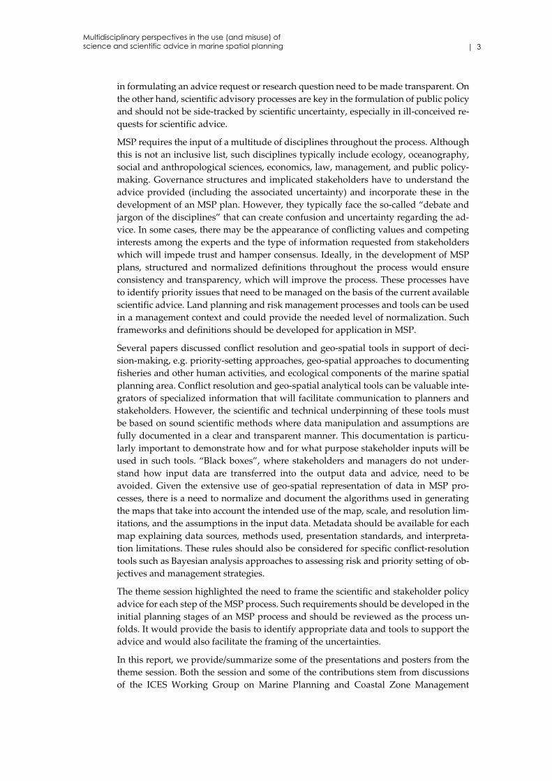
Generally, European Union (EU) Member States can obtain information relating to the
spatial distribution of fishing activity by logbooks and vessel monitoring system (VMS)
data. These data are complementary, and their coupling has already proven powerful.
While logbooks provide useful information on several aspects of fishing, data are con‐
sidered to be of low spatial resolution. The most reliable source of spatially explicit
fishing vessel data is still the European Commission (EC) Vessel Monitoring System
which provides information on the exact location and identification of all vessels ≥15 m
overall length.
In this study, anonymized VMS data for all UK vessels landing in UK ports in 2007–
2011 were combined with landings information. Fishing activity was identified by ap‐
plying a simple speed threshold (Lee et al., 2010). Weights and values have been allo‐
cated to VMS pings by applying a sophisticated approach which uses ICES rectangles,
divisions, and weights on points according to time (Holmes et al., 2011). A collection of
weight and value rules separated the data into groups representing key sectors of the
Scottish fishing fleet such as crab (Cancer pagurus), lobster (Homarus gammarus), squid
(Loligo vulgaris), Norway lobster (Nephrops norvegicus – mobile and static), demersal
(mobile: see Figure 4.4.1a; and static), scallop (Pecten maximus), pelagic, mackerel
(Scomber scombrus), and herring (Clupea harengus) fisheries.
Figure 4.4.1. (a) Amalgamated spatial variability of demersal fisheries (mobile gears) in the UK for
2007–2011. (b) The same data weighted by the value of landings.
Non‐parametric density analysis was selected over the commonly used quadrate count
to develop GIS layers describing annual distribution of fisheries. A Gaussian kernel
density estimation with a data‐driven bandwidth selection approach (smoothed cross‐
validation) was used, resulting in high quality contour maps which form a better esti‐
mate of the spatial extent of fishing activity and the underlying structure. Several years’
data have been amalgamated and effectively showed spatial patterns in higher solution
for both intensely and infrequently fished areas throughout that period. These layers
have also been weighted by landings (tonnes) and value (cash value in GBP) to repre‐
sent the most productive and economically important areas, respectively (Figure
4.4.1b).
In conclusion, a clear understanding and representation of the spatial distribution of
marine fisheries in Scottish waters was achieved, removing many of the problems as‐
sociated with the traditional gridded presentations. Spatial patterns coming from this
study were validated to be consistent with the underlying biology of the species. Areas
important to the fishing industry at a national level were identified to inform the ma‐
rine spatial planning process in Scotland.
Multidisciplinary perspectives in the use (and misuse) of science and scientific advice in marine spatial planning

24 | ICES Cooperative Research Report No. 333
4.5 Science–policy interactions: between policy fragmentation, integration, and new paradigms for planning and management
Andreas Kannen
Human activities in marine areas are increasing in number and intensity, and patterns
of sea use are changing as a result of political, economic, and societal developments.
Associated with the multitude of issues and sea uses are fragmented policy frame‐
works, not only divided by sectors, but also between environmental regimes and the
balancing approach of marine/maritime spatial planning. The implementation of re‐
sulting management plans is hampered by the potentially conflicting policy objectives
and differing jurisdictions at various levels of government in a given geographical area.
Furthermore, neither long‐term climate change impacts nor future socio‐economic and
cultural developments can be precisely predicted and put in definite numbers to offer
a definitive guide for policy development. Planning under these circumstances can be
characterized by the term “planning under uncertainty” and requires a move towards
continuous planning processes that react to changing contexts instead of mainly data‐
driven decisions. Today’s prevailing approach of scientific management seems to be
ill‐equipped to offer solutions under these circumstances, e.g. in dealing with trans‐
boundary cumulative effects or normative and value‐driven conflicts between differ‐
ent actors. This presentation will illustrate such problems and argue for a move to‐
wards adaptive, transnational, and participative modes of coastal and marine govern‐
ance based on research which analyses the particular social, cultural, and normative
context of decision‐making. It aims to link the context in which institutions act to po‐
tential contributions of research and set the stage for further discussions within the
session and beyond.
4.6 Petroleum activities in the Lofoten area: definition of a worst-case scenario
Kjellrun Hiis Hauge, Anne Blanchard, Ragnhild Boland, Jan Helge Fosså, Daniel
Howell, and Frode Vikebø
The complexity and uncertainty surrounding environmental problems can fuel heated
debates between stakeholders with conflicting interests, priorities, and agendas. Many
such debates have arisen at the “science–policy interface” relative to calls to open new
areas for petroleum activities in the Lofoten area in northern Norway. The Lofoten is a
particularly valuable and vulnerable archipelago, known for its unique landscape and
as a key spawning and nursery area for several fish stocks, also hosting the world’s
largest‐known deep‐sea coral reef. Introducing petroleum activities brings additional
competition for this valuable space and demands an assessment of the “worst‐case sce‐
nario” of an oil spill to support political decision‐making. However, such a complex
model introduces numerous uncertainties, which have become contentious both
within the scientific community and in dialogue with the petroleum industry. A com‐
prehensive worst‐case scenario must look at the possible effects on all ecosystems and
species of the area, at every stage of their lifespan, together with effects on other sectors
of activity (particularly the tourism and fishery industries), and the socio‐cultural char‐
acteristics of the region. This paper unpacks the debate surrounding the science and
uncertainties of calculating the worst‐case scenario in the Lofoten, focusing on three
key aspects: (i) whether historic oil spill events are to be used as supporting empirical
data; (ii) assessing the effects of an oil spill on the environment; and (iii) proposing
measures to be taken on the basis of the worst‐case scenario.

| 25
4.6.1 Introduction
The question of opening Norway’s northern offshore areas to petroleum production
has been a long and heated political debate in Norway. The values at stake are consid‐
erable. On one hand, having petroleum production promises to uphold Norway’s eco‐
nomic wealth and standard of living. On the other hand, it is feared that petroleum
production, and in particular a major oil spill in the Lofoten area, would disturb vul‐
nerable ecosystems and thereby damage key national fisheries and local sectors, such
as aquaculture and tourism. Norway’s identity is an essential part of the public debate,
which reflects opposite conclusions. On one hand, increased activity in the Lofoten area
might prevent picturesque coastal villages from being abandoned. On the other hand,
petroleum production in the Lofoten area, whether there be a blowout or not, might
destroy the image of Norway’s most treasured landscape.
Large areas have been opened to petroleum exploitation in Norwegian waters in recent
years, but some areas remain closed due to overlap with some of the worlds’ largest
fish stocks and bird colonies. “Opened” means that potential future oil exploration are
allowed in the area, but petroleum companies must apply for specific blocks in order
to start actual production. Decisions around the opening of new areas are contentious
and depend, among other reasons, on scientific environmental impact assessments, in‐
cluding the establishment of a “worst‐case scenario”.
Worst‐case scenarios are defined by a risk approach where the probability of a major
oil spill is multiplied by its environmental impact. However, because these assessments
are very complex, as they refer to a range of processes and species, and as they can be
used to either promote or prevent action, the quality and legitimacy of scientific advice
is at the centre of the social debates. The handling of uncertainty associated with the
probability, characteristics, and impacts of a major oil spill may influence the outcome
of risk calculations and thus the basis for political decisions on opening areas, or not,
for petroleum activity. Therefore, uncertainty plays a crucial role in the controversy by
allowing different interpretations and opinions. Uncertainties relative to the worst‐case
scenario have been emphasized by some and downplayed by others.
In 2002, Norwegian authorities, representing the Ministry of Fisheries and Coastal Af‐
fairs, the Ministry of the Environment, and the Ministry of Petroleum and Energy pro‐
duced a multisectoral management plan for the Barents Sea and the Lofoten area based
on multisectoral values and multidisciplinary research (Miljøverndepartementet,
2006). The management plan takes into account both socio‐economic and environmen‐
tal interests. On this basis, the same ministries initiated a multisectoral working group
on risk to strengthen the basis for risk evaluations associated with acute contamination
in the Barents Sea and the Lofoten area. Before this working group was created, the
petroleum sector had the sole responsibility of developing the tools for calculating
risks. Now, the petroleum sector together with the fisheries and environmental sectors
cooperate and produce consensus‐based reports on these issues. There have been sev‐
eral discussions and disagreements within the working group and in other cooperation
arenas on the choice of empirical data for calculating the relevant size and probability
of a major oil spill, and on the ecological processes to include in simulations in order
to assess environmental effects. The worst‐case scenario is not yet settled for the Lofo‐
ten area, and improvements are sought through scientific research, some in coopera‐
tion between the oil industry and marine research institutes.
A strategy for establishing a worst‐case scenario that can support decision‐making is
to fill remaining knowledge gaps. Meanwhile, awaiting a comprehensive worst‐case
scenario, marine scientists have adopted the precautionary principle in their advice
Multidisciplinary perspectives in the use (and misuse) of science and scientific advice in marine spatial planning

26 | ICES Cooperative Research Report No. 333
until adequate knowledge is acquired. The petroleum industry has accused these sci‐
entific advisors of hiding behind the precautionary principle, arguing that knowledge
gaps can always be found and that, accordingly, they should not lean towards strict
decisions regarding the opening of areas for petroleum activity.
In the academic literature, different views are expressed on the handling of uncertainty
concerning this policy issue. Hjermann et al. (2007) express confidence in appropriate
worst‐case scenarios, but only if specific knowledge gaps are filled beforehand and if
the remaining uncertainty is handled by Monte Carlo simulations. Knol (2010), on the
other hand, concludes that since the issue bears high stakes and creates tension on what
should be done, and because values and interests are embedded in the construction of
knowledge, “filling” knowledge gaps will not adequately support decision‐making.
She further argues that marine scientists construct uncertainty through this approach
(Knol, 2010). Indeed, by extending the amount of knowledge around the issue, the pos‐
sibility of encountering new, uncertain aspects of knowledge is increasing. Therefore,
what should the role of science be in these complex, highly disputed, and uncertain
issues?
It has long been argued that policy problems characterized by high stakes, uncertain
facts, and conflicting values need new approaches to science. Rather than trying to re‐
duce it, uncertainty should be at the centre of the debates by, for example, reflecting on
how, or whether, scientific questions fit the policy questions (see Funtowicz and Ra‐
vetz, 1990, 1993; Wynne, 1992; Walker et al., 2003; van der Sluijs et al., 2004; Funtowicz
and Strand, 2007). Indeed, steered by different interests, knowledge, and beliefs, some
actors might focus (consciously or unconsciously) on particular aspects of the issue that
are resilient to petroleum activities, while others might rather cast light on the most
vulnerable components of the issue, resulting in highly different outcomes in terms of
risks.
In this context, the aim of this paper, at its initial stage, is to initiate a discussion on the
handling of key uncertainties associated with defining the worst‐case scenario for the
Lofoten area from three perspectives: (i) the handling itself, (ii) whether it influences
how science fits the policy problem, and (iii) how it may affect the science–policy in‐
terface.
4.6.2 Inherent uncertainties
When establishing worst‐case scenarios, the probability of a major oil spill, its size, and
its chemical compound are determined based on previous oil spills. Previous oil spills
with comparable technical, geological, and oceanographic features have been consid‐
ered relevant. However, the question of how similar such features need to be in order
to define them as “relevant” is a matter of choice. Experts’ decision on what relevant
oil spills should be taken into account, the relevant size of an oil spill, the relevant dis‐
tribution of oil at the surface of the water, and the sites relevant for future exploration
(i.e. on the shelf or on the ridge) have indeed been questioned. An especially conten‐
tious point has been whether to rescale worst‐case scenarios for the Lofoten area ac‐
cording to the 2010 Deepwater Horizon.
Given the site, the season, the type of oil, and the size of the oil field, simulations of a
worst‐case scenario are carried out. Predicting impacts of a major oil spill is complex.
Ideally, an assessment of the impacts on the ecosystems would include every species,
impacts relative to all distances from the origin of the oil spill, short‐ and long‐term
impacts, and cascading effects on ecosystem components. This is elusive as models are
not capable of dealing with such complexity and potential emergent properties, and as

| 27
numerous knowledge gaps remain. Norway’s most economically important fish stock
is Northeast Arctic cod (Gadus morhua), which migrates from the Barents Sea to the
Lofoten area to spawn. Consequently, cod is the main focus in establishing a worst‐
case scenario, and especially cod larvae because of their vulnerability to oil spills. On‐
going research is improving the knowledge basis for assessing possible impacts on the
cod stock, but other impacts on the ecosystem remain unknown.
When we look at how uncertainty is handled in calculating the various components of
a worst‐case scenario, applied methods include error bars, safety factors, and scenarios
presenting different possible futures. In principle, these approaches are incommen‐
surable, implying that their combination gives little meaning in grasping the uncer‐
tainty in risk calculations.
4.6.3 Issues to be discussed
Science plays an important role in the policy debates on whether or not to open the
Lofoten area to petroleum production. We believe that scientific knowledge constitutes
an important basis for decision‐making and, specifically, that refining the knowledge
base for worst‐case scenarios can be helpful in discussing which sites for petroleum
production may cause less harm in case of a major oil spill. However, the relevance of
a worst‐case scenario for deciding whether to open an area should be challenged. At
present, we are discussing several facets of worst‐case scenarios. First, given the inher‐
ent uncertainties, is it possible to arrive at a certain number, which we can conclude is
the “best” one? Is this number useful for the question of whether to open the Lofoten
area for petroleum production? Second, how can we understand the concept of worst‐
case scenario and its political role in decision‐making? Third, keeping in mind the great
values at stake, what is the role of uncertainty in the policy debate? Fourth, could other
pieces of scientific knowledge be relevant for the final policy decision? And finally,
what can the above perspectives offer to the policy debate?
4.6.4 Acknowledgements
This project is financed by the Research Council of Norway. Project: Uncertainty As‐
sessments Related to Opening New Areas for Petroleum Activity. Project number:
203886.
4.7 Shetland Marine Spatial Plan: an ecosystem-based approach in formulating marine policy and management options
Christina Kelly, Lorraine Gray, Rachel Shucksmith, and Jacqueline Tweddle
Marine environmental policy is an important aspect of the current European, UK, and
Scottish environmental agenda. The development of the Shetland Marine Spatial Plan
(SMSP) was initiated by the Scottish Government and has been implemented on a vol‐
untary basis since 2008. It has been utilized successfully as a tool to guide developers
and others in proposing changes to existing uses (such as aquaculture and fishing) and
introduction of new uses (such as expansion of ports, renewable energy, and oil and
gas infrastructure). More recently, it has been used by managers to voluntarily close
areas containing sensitive habitats to scallop dredging and develop oil spill contin‐
gency planning to protect important habitats. Through policy, it provides suggestions,
proposes directions, and highlights opportunity for development. This paper demon‐
strates the benefits of spatial management with a focus on using geo‐spatial analysis to
map cumulative pressure areas around the Shetland Islands based on an ecosystem‐
based risk assessment and how this will assist in the implementation of marine policy.
Simultaneously, by ensuring the provision of clean, healthy, diverse, and productive
Multidisciplinary perspectives in the use (and misuse) of science and scientific advice in marine spatial planning
28 | ICES Cooperative Research Report No. 333
seas through sustainable marine policy, other environmental targets such as achieving
“good environmental status” under the Marine Strategy Framework Directive are also
implemented.
4.7.1 Introduction
Marine spatial planning (MSP) is recognized as an important tool in the sustainable
management of marine ecosystems (Schaefer and Barale, 2011). Until recently, govern‐
ments applied a mainly sectoral approach towards marine issues, but now realize that
a more integrated approach is required to manage increasing pressures on the marine
environment (Olsen et al., 2011). New emerging demands on marine space and re‐
sources, such as renewable energy developments, highlight the potential for user–user
conflicts (i.e. with fishing activities as well as user–environment conflicts). Tradition‐
ally, marine space has been predominantly regulated within individual economic sec‐
tors (Douvere, 2008), such as shipping channels and aquaculture sites, and there has
been little consideration of the effects of individual and multiple developments on
other human activities or the marine environment (Ehler and Douvere, 2009). Conflicts
between other users and the marine environment jeopardize the ability of the ocean to
provide the necessary ecosystem goods and services upon which many depend (Ehler
and Douvere, 2009).
On 10 October 2007, the European Commission (EC) adopted the Communication on
Integrated Maritime Policy (IMP) for the European Union (EU), also referred to as the
“Blue Book” (European Commission, 2007). This acknowledged the need to act in a
coordinated manner to respond to pressures from multiple users. The Communication
suggests a governance framework and cross‐sectoral tools necessary for an EU inte‐
grated maritime policy. Included are a set of main actions that the EC will pursue,
guided by the principles of subsidiarity and competitiveness, the ecosystem approach,
and stakeholder participation. One action includes the development of a roadmap to‐
wards MSP by EU Member States. As a consequence, the Communication titled
“Roadmap for Maritime Spatial Planning: Achieving Common Principles in the EU”
was adopted by the EC on 25 November 2008 and aims to facilitate the development
of MSP by EU Member States and to stimulate its implementation at national and EU
levels (European Commission, 2008a). The Roadmap sets out key principles for MSP
and encourages the development of a common approach among EU Member States.
In 2008, the EU also adopted the Marine Strategy Framework Directive (MSFD) which
aims to achieve or maintain good environmental status (GES) of the marine environ‐
ment by 2020 (European Commission, 2012b). The MSFD requires EU Member States
to apply an ecosystem approach and to ensure that pressure from human activities is
compatible with GES. The MSFD has been described as the environmental pillar of the
Integrated Maritime Policy (European Commission, 2008a).
An ecosystem‐based approach to MSP must consider the entire ecosystem, including
human beings. The ultimate objective of ecosystem‐based management is to maintain
an ecosystem in a healthy, productive, and resilient condition, providing the goods and
services that humans want and need (Ehler and Douvere, 2009). In this respect, ecosys‐
tem‐based management differs from traditional approaches that focus on a single spe‐
cies, sector, activity, or concern. The ecosystem approach considers the cumulative im‐
pacts of different sectors.
4.7.2 National and regional context in MSP
Presently, MSP in the UK is being implemented in England and Wales under the Ma‐
rine and Coastal Access Act, 2009, in Scotland under the Marine (Scotland) Act, 2010,

| 29
and legislation has been proposed for Northern Ireland. This legislation sets out the
framework for marine management which includes the preparation of marine plans
and marine licensing. The overall aim of the legislation is to achieve “clean, healthy,
safe, productive and biologically diverse oceans and seas” (HM Government, 2011).
Prior to any European guidance on MSP, the Scottish Government proactively insti‐
gated research in 2006 into the sustainable management of Scotland’s marine resources.
The Scottish Sustainable Marine Environment Initiative (SSMEI), led by the Scottish
Government in collaboration with local authorities and other partners, aimed to de‐
velop and test new approaches to improve the sustainable management of Scotlandʹs
marine environment through the establishment of four pilot projects (Marine Scotland,
2010). The four pilot projects were based in the Firth of Clyde, Shetland Islands, the
Sound of Mull, and the Berwickshire coast. Three of the four projects have developed
local marine plans (Clyde, Shetland, and Mull). This paper focuses on the continuing
work of the Shetland Islands Marine Spatial Plan (SMSP).
4.7.3 Shetland Islands Marine Spatial Plan
The SMSP was first developed in 2006 under the auspices of SSMEI, with the first draft
plan voluntarily adopted by the local planning authority, statutory consultees, and lo‐
cal developers in 2008. The project was guided by a national and local steering group.
Since the launch of the third edition and the end of the pilot project in 2010, the SMSP
has continued to engage regularly with key stakeholders and a local advisory group.
The SMSP continues to receive funding from the Scottish Government through Marine
Scotland and is continuously developed as part of the core work of the NAFC Marine
Centre, Shetland Islands, which is an associate partner of the University of the High‐
lands and Islands, Scotland. The SMSP represents an innovative approach to marine
planning, based on Scottish Ministersʹ commitment to making marine management
more efficient, inclusive, and accessible now and for future generations.
The SMSP, in its third edition, contains spatial data on the marine and coastal environ‐
ment and its various uses. It establishes an overarching policy framework to guide the
placement of activity from marine renewable energy to aquaculture. The primary focus
of the SMSP is to provide more information to public bodies, who have responsibilities
for marine and coastal planning functions, and to developers. It will inform decision‐
making, guide priorities, and seeks to achieve a balance between national and local
interests (NAFC Marine Centre, 2012). Notwithstanding its statutory ordnance
through the Marine (Scotland) Act, 2010, it is anticipated that the fourth edition of the
SMSP will be formally adopted through the Shetland Islands Council’s Local Develop‐
ment Plan as Supplementary Guidance in 2013. The SMSP policies and maps will be‐
come a material consideration in the determination of new applications and licences
for marine development by the local planning and regulatory authorities. This marks
a unique and significant move to standardize the approaches and responsibilities be‐
tween terrestrial and marine planning jurisdictions and reflects a more integrated ap‐
proach to coastal zone management and MSP.
As the SMSP progresses towards a fourth edition, it is being utilized for applied pro‐
jects that result in further supporting information and guidance. It has been used by
managers to successfully close sea areas to scallop dredging to preserve subtidal bio‐
genic reefs and evaluate the socio‐economic importance of the marine environment to
the local fishing industry. More recently, projects include the publication of Regional
Locational Guidance for Wave and Tidal Devices in the Shetland Islands (Tweddle et
al., 2012), monitoring and mapping invasive non‐native species around the Shetland
Multidisciplinary perspectives in the use (and misuse) of science and scientific advice in marine spatial planning

30 | ICES Cooperative Research Report No. 333
Islands, and a Review of the Marine Spatial Plan for the Shetland Islands (Kelly et al.,
2012). The Review of the SMSP is a brief report summarizing the findings of a quanti‐
tative and qualitative appraisal of the third edition of the SMSP. The Review includes
an analysis of responses from a previous SMSP consultation in 2010 and results from a
number of focused questionnaires and surveys carried out with key stakeholders. The
overall findings provide a good overview of the SMSP achievements to date, including
its successful endorsement internationally as an exemplar case study for marine spatial
planning (Kelly et al., 2012).
As the SMSP already identifies potential impacts between activities and important spe‐
cies and habitats around Shetland through a sensitivity matrix, the next phase is to
address cumulative impacts, interactions, and capacity of the marine resource to ac‐
commodate future sustainable development.
4.7.4 Assessing cumulative impacts using an ecosystem-based risk assessment
During development of their national marine plan, the Scottish Government included
an interactions matrix which provided an initial simplified view of the likely level of
interactions between a range of marine users (Scottish Government, 2011). However,
in a review of the work conducted in the MSP pilot projects funded under SSMEI, it
was acknowledged that whilst the process of identifying interactions between different
uses/activities and with the marine environment had been effectively carried out in
some cases, it would have been more relevant to test whether a more “spatially spe‐
cific” approach to this exercise would identify particular locations where specific poli‐
cies are required to resolve interactions (Marine Scotland, 2010). In this context, the
assessment of cumulative impacts using an ecosystem‐based risk assessment was
deemed a more suitable option for the SMSP. This involved using GIS to map cumula‐
tive pressure areas around Shetland based on the output scores of the ecosystem risk
assessment. This location‐specific method moved away from the generic, single‐sector‐
analysis approach of the interactions matrix and was deemed more relevant and sym‐
pathetic to local factors.
An integrated ecosystem assessment (IEA) is a synthesis and quantitative analysis of
information on relevant physical, chemical, ecological, and human processes in rela‐
tion to specific ecosystem management objectives (ESMWG, 2011). While methodolo‐
gies for the assessment of cumulative impacts are still in early development, the IEA
provides a consultative process to identify priority management issues and provide
robust decision‐support information. It is acknowledged that other methodologies are
being tested elsewhere (EOEEA, 2009; Eastwood et al., 2007; Foden et al., 2011; Farmer
et al., 2012; Stelzenmuller et al., 2012); however, none are universally recognized or ac‐
cepted. Nevertheless, some methods have influenced the SMSP approach (Levin et al.,
2009; Robinson and Knights, 2011).
4.7.5 Methodology
The integrated ecosystem‐based risk assessment (ERA) concept developed as part of
the SMSP has evolved from the original SMSP marine biodiversity risk assessment first
explored in 2008. The revised assessment incorporates the range of pressures and im‐
pacts identified in Annex III, Table 2 of the MSFD (European Commission, 2008a)
which are scored by each activity in line with a range of criteria. Following a review of
a number of cumulative impact assessments, it became apparent and logical to quan‐
tify the potential impacts as set out in the MSFD. In the UK, a number of assessments
already apply different criteria against these identified impacts (Robinson and Knights,
2011; Marshall et al., 2012). Given the MSFD requirement to report on the current state

| 31
of UK seas, detailed characteristics of GES, and associated targets and indicators by
2012, a greater focus has been placed on determining the likely impacts of human ac‐
tivities on the marine environment (Baxter et al., 2011; Defra and Marine Scotland,
2012). The SMSP ERA matrix has incorporated information from the Scottish Marine
Atlas (Baxter et al., 2011) as a foundation for identifying the pressures and impacts as‐
sociated with certain marine activities in Scottish waters. Other assessments (Defra and
Marine Scotland, 2012; Marshall et al., 2012) including OSPAR QSR2010 (OSPAR, 2010)
have also been utilized to predict impacts and outcomes from interactions.
The SMSP ERA explored the different marine activities currently regulated around
Shetland: commercial fishing, aquaculture, transport, coastal infrastructure, renewa‐
bles, dredging and disposal, tourism and recreation, oil and gas pipelines, telecommu‐
nication cables, and effluent discharges. These activities and their direct effects were
assessed; e.g. commercial fishing activities and the different types of gear used and
associated effects. A summary of these activities is included in Table 4.7.5.1. This anal‐
ysis was carried out for all marine activities around Shetland. “Direct effects” were
considered as effects that are directly linked to “driver/pressure” combinations (HEL‐
COM/VASAB et al., 2012)1.
Direct effects of each activity and associated impacts (Table 4.7.5.2) were assessed
against a set of criteria (Table 4.7.5.3), which was initially developed by members of
the local steering group (Spatial Analysis subgroup). Each of the associated impacts
was assigned scores in terms of likelihood of impact, frequency of the activity, time‐
scale to recovery, likely extent of permitted footprint, and confidence in the data used.
The scores were then added together for the latter four criteria and multiplied by the
former “likelihood” impact score. The score was assigned an index value out of a max‐
imum score of 1 and integrated into maps of different activities.
All activity data were converted into a raster using ESRI ArcGIS. The “raster calcula‐
tor” tool was used to reclassify the data. The rasters for each sector were summed using
a spatial analysis “weighted sum” tool in ArcGIS where weight = x and “x” is the cu‐
mulative score for each pressure. This resulted in a spatial overview map of cumulative
impacts. A map based on preliminary scores is included in Figure 4.7.5.1. It is acknowl‐
edged that there are many spatial analysis tools and software available (Stelzenmuller
et al., 2012) to do a similar analysis. However, for the purpose of this exercise, the
“weighted sum” tool was deemed applicable for local circumstances, being under‐
standable and relevant to non‐expert stakeholders. Advice was sought from the Spatial
Analysis subgroup which comprised members with detailed sector‐specific knowledge
in relation to the impact scores. The outcome from this session was that further consul‐
tation on the scoring and criteria is required to refine the process and ensure that the
mapping outputs are tangible and meaningful. The objective of the ongoing consulta‐
tion is to ensure a more informed and balanced assessment of the cumulative impacts
involving marine industry experts and local practitioners.
1 Direct effects form the basis for the development and implementation of operational, spatial,
and temporal management measures to reduce the risk of direct effects. Direct effects are ecosys‐
tem, social, cultural, and economic impacts. Indirect effects are considered as secondary effects
occurring once a direct effect has occurred. These would include impacts to ecosystem processes
and components as well as socio‐economics impacts. Indirect effects are difficult to model or pre‐
dict because their occurrence may also be amplified by natural variations in ecosystem processes.
Multidisciplinary perspectives in the use (and misuse) of science and scientific advice in marine spatial planning

32 | ICES Cooperative Research Report No. 333
Table 4.7.5.1. Sample of commercial fishing activities and direct effects. This analysis was carried
out for all other mapped marine activities around Shetland, i.e. aquaculture, transport, coastal in‐
frastructure, renewables, dredging and disposal, tourism and recreation, oil and gas pipelines, tel‐
ecommunication cables, and effluent discharges.
Marine activity Activity detail Direct effects (pressures)
Commercial
fishing
Creeling and potting
Gill netting
Seine netting
Hook and line (jigging)
Pelagic trawling
Whitefish trawling /demersal ot‐
ter trawling
Demersal otter trawling (twin rig
only in Shetland)
Demersal pair trawling
Pair seining
Scallop dredging
Shellfish trawling
Steaming –atmospheric emis‐
sions
Collisions
Interaction with seabed
Physical damage to seabed and
habitat
Impact on/removal of non‐target
species
Impact on/removal of target spe‐
cies
Ghostfishing (lost gear continu‐
ing to fish)
Anti‐fouling, litter, lost gear, bal‐
last water
Entanglement /by‐catch/waste
products
Table 4.7.5.2. Pressures used to determine and evaluate the potential impacts from human activities
in relation to the marine environment around Shetland waters.
Threats/pressures
Physical loss Smothering
Sealing/obstruction
Physical damage Abrasion
Extraction
Other physical
disturbance
Underwater noise
Marine litter
Interference with
hydrological
processes
Temperature change
Salinity changes
Change in pH
Change in wave exposure
Change in water flow rates
Contamination by
hazardous
substances
Introduction of synthetic compounds (e.g. pesticides, antifoulants,
pharmaceuticals)
Introduction of non‐synthetic substances and compounds (e.g.
heavy metals, hydrocarbons)
Introduction of radionuclides
Systematic and/or
intentional release
of
substances
Introduction of other substances, whether solid, liquid, or gas, in
marine waters, resulting from their systematic and/or intentional re‐
lease into the marine environment, as permitted in accordance with
other community legislation and/or international conventions
Nutrient and or‐
ganic
matter enrichment
Nitrogen and phosphorus
Inputs of organic matter

| 33
Threats/pressures
Biological
disturbance
Introduction of microbial pathogens,
Introduction of invasive non‐native species,
Selective extraction of species, including incidental non‐target
catches
Death or injury by
collision
Death or injury by collision
Barrier to species
movement
Preventing the natural movement of mobile species along a key
route of travel
Electromagnetic
changes
Change in the amount and/or distribution and/or periodicity of elec‐
tromagnetic energy emitted in a marine area (e.g. from electrical
sources such as underwater cables)
Table 4.7.5.3. (A–E). Criteria used to quantify the potential impacts of differing activities on the
marine environment.
A Rating Likelihood of
impact/certainty
Commentary
5 Definite/very high Well documented evidence of impact oc‐
curring during normal operations or >1
accidental/illegal event per year
4 Likely/high Some evidence of impact occurring under
normal operations or >1 accidental/illegal
event in 5 years
3 Possible/medium Unknown level of impact/interaction or
>1 accidental/illegal event in 10 years
2 Unlikely/low Very little interaction with habitats/spe‐
cies or >1 accidental/illegal event in 100
years
1 Remote No interaction with habitats/species
B Rating Frequency of activity
/effort
Commentary
5 Continual /very high More or less constant year‐round, lasting
through multiple years or decades
4 Regular /high Every week
3 Intermittent /moderate Approximately once a month
2 Brief /minimal One‐off event – over several days/irregu‐
lar
1 One‐off event One‐off event – up to one day dura‐
tion/infrequent
C Rating Timescale to ecosystem
recovery /stability (fol‐
lowing cessation of activ‐
ity)
Commentary
5 None Recovery unlikely
4 Low > 10 years
3 Medium Several years (3–10 years)
2 High 1–2 years
1 Very high Within 1 year
Multidisciplinary perspectives in the use (and misuse) of science and scientific advice in marine spatial planning

34 | ICES Cooperative Research Report No. 333
D Rating Extent of permitted im‐
pact / footprint
Commentary
5 Very high–widespread Serious damage to ecosystem – total loss
or very major alteration to the key ele‐
ments of the habitat
Guide: > 80% of habitat lost
4 High Major loss or major alteration to key ele‐
ments of the habitat
Guide: 21–80% of habitat lost
3 Moderate Loss or alteration to one or more key ele‐
ments of the habitat
Guide: > 6–20% of habitat lost
2 Site
specific/localized/minimal
Minor shift away from baseline condi‐
tions
Guide: > 1–5% of habitat lost
1 Negligible Very slight change from baseline condi‐
tion
Guide: <1% habitat lost
E Rating Confidence in maps Commentary
3 Low An estimated location and questionable
source or scale/extent of activity.
2 Medium A fixed location but questionable source
or scale/extent of activity. Examples in‐
clude shipwrecks, where there is point
data available, but parts may be scattered
on the seabed, and shellfish fishing
grounds within management squares
(which are to the nearest 5 km).
1 High A fixed location and of a good source or
scale/extent of activity. Examples of these
maps are oil and gas pipelines and aqua‐
culture sites where standards on locations
are required for planning purposes.

| 35
Figure 4.7.5.1. Preliminary map illustrating cumulative impacts.
4.7.6 Discussion
All European MS are contending with the assessment and reporting on the status of
their marine waters under the MSFD; this includes an analysis of the cumulative im‐
pacts of human activities (Foden et al., 2011). Varying analytical approaches, methods,
applications, and practical software tools are being developed internationally to facili‐
tate an assessment of the relationships between human uses and ecosystem compo‐
nents (Alexander et al., 2012; Stelzenmuller et al., 2012). It is widely acknowledged that
the issue is proving difficult to resolve (HELCOM/VASAB et al., 2012). For example,
some human activities can have the same or similar effects on the marine environment
and its ecosystems. Attempting to attribute or distinguish each effect to a single use in
multiuse areas has not been achieved convincingly to date. Similarly, distinguishing
the effects of human activities from natural disturbance is also proving difficult. This
is further exacerbated by a lack of empirical data and modelling methodologies to carry
Multidisciplinary perspectives in the use (and misuse) of science and scientific advice in marine spatial planning

36 | ICES Cooperative Research Report No. 333
out the required integrated assessments to manage the cumulative effects of human
activities (Eastwood et al., 2007; Leslie and McLeod, 2007; HELCOM/VASAB et al.,
2012). However, MSP is about addressing uncertainties in a practical manner that is
understandable and accessible to multiple potential users.
This paper outlines an attempt to map cumulative impacts using an integrated ERA
and, in doing so, to deal with these uncertainties at a more local level. It is hoped that
this exercise will promote discussion and debate among stakeholders and will help to
advise and formulate MSP policy in the SMSP. Testing different approaches to inte‐
grated marine planning at a local level has the potential to inform policy and manage‐
ment measures at regional and national levels. Shetland is regarded as an ideal location
to test this integrated ERA as the SMSP has been widely supported by the local com‐
munity and marine practitioners. This is evident in its pending adoption as Supple‐
mentary Guidance to the Shetland Islands Council’s Local Development Plan.
As consultation on the SMSP is ongoing with local expertise and stakeholders, there
are opportunities to identify and improve on the limitations of the methodology. Other
cumulative impact assessments (Robinson and Knights, 2011; Defra and Marine Scot‐
land, 2012; Marshall et al., 2012) have predicted likely impacts and pressures from hu‐
man activities, but have refrained from actually assigning a score or weight to the im‐
pact. This is understandable as attributing or distinguishing certain effects to a single
use in multiuse areas has not yet been achieved (HELCOM/VASAB et al., 2012). Alt‐
hough applying weights/scores to different impacts/pressures during the current study
could be perceived as subjective and, therefore, open to scrutiny, on‐going consultation
with local experts from differing backgrounds should allow for more objective out‐
comes to be achieved.
The criteria adopted in this exercise could be considered open to interpretation. More
benchmarks could have been included, such as the resilience of ecological characteris‐
tics and the persistence of the pressure (Robinson and Knights, 2011). However, the
“time‐scale to recovery” criterion used as part of this assessment was also very depend‐
ent on the type of habitat and species likely to be affected by the impact and detailed
knowledge of their ecological characteristics (e.g. sensitivity, resilience). This opens up
the number of possibilities as to how the ERA can be developed further, e.g. all of the
cumulative physical impacts on the seabed could be spatially overlain with vulnerable
seabed habitats such as maerl beds. This type of treatment of data could trigger a need
for further habitat management or policy development in the future for priority marine
features.
As more and more marine planners deal with uncertainty, differing geo‐spatial analyt‐
ical approaches, applications, and software tools are being developed in response.
Over 39 practical tools are reportedly available and have been applied in the marine
environment in Europe, US, and Australia (Stelzenmuller et al., 2012). Therefore, there
are many options available for scientists, programmers, and spatial planners to trial
and determine which are suitable to their own requirements. As part of the current
study, it was deemed that ESRI ArcGIS was suitable software to undertake the analysis,
and the spatial analysis tools available were adequate to achieve the anticipated pre‐
liminary outputs.
It is not possible to plan and manage marine ecosystems or components of ecosystems;
this is feasible only for human activities in marine areas. It is only possible for marine
planners to allocate space to human activities, e.g. development areas for aquaculture
(Ehler and Douvere, 2009). The ultimate goal of assessing cumulative impacts using

| 37
the ecosystem approach is to inform and develop marine planning policy and objec‐
tives which will safeguard the marine environment and ensure its sustainable provi‐
sion of goods and services. Therefore, a fully consulted and balanced approach, as en‐
dorsed in this ERA, will be the first step in achieving this objective for Shetland.
4.7.7 Acknowledgements
The authors thank SMSP Advisory Group members, and Dr Martin Robinson and Paul
MacDonald, NAFC Marine Centre, for their time and advice. We also thank the follow‐
ing organizations for their financial contribution towards the funding of the original
SMSP under SSMEI: Scottish Natural Heritage, Shetland Islands Council, The Crown
Estate and Leader. Finally, we also extend our thanks and gratitude to Marine Scotland
for their continuing funding towards this project and the SMSP.
4.8 The science of negotiation: stakeholder engagement in discussions about sci-ence and uncertainty in the negotiations of a fisheries management plan for Dogger Bank under Natura 2000
Ina Krueger, Liv Berner, Rüdiger Wurzel, and Henriette Otter
4.8.1 Introduction
Policy processes in marine spatial planning seek to manage a decreasing space, as new
sectors are competing with established sectors for access to the sea.
In scientific, as well as grey literature on MSP, it is a commonly accepted notion that
decision‐makers need to involve stakeholders in the decision‐making process, and that
decision‐making processes should be based on the best available scientific data.
By opening up the policy‐making arena to the broad range of interest groups com‐
monly involved in and impacted by marine spatial planning, however, the traditional
linear approach to policy‐making is being challenged. With this process, the idealized
notion of science fitting neatly into the linear policy process and providing rational and
more or less unproblematic evidence on the issue in question before the politics begin
also starts to crumble.
International negotiations on the newly appointed marine protected areas on Dogger
Bank, where emerging plans for the establishment of offshore wind parks and the tra‐
ditional fishing interests compete with national conservation goals, are a fascinating
example of how stakeholders struggle to assess and transform scientific information
into a fisheries management plan that not only provides the necessary steps to reach
the biodiversity objectives of Natura 2000, but can also be widely accepted by all inter‐
est groups involved.
Around Dogger Bank, a submerged sandbank in the North Sea, national governments
and sectoral stakeholders are trying to agree on a regulation which aims at restoring
the habitat to a better conservation state. In this novel international process, the North
Sea Regional Advisory Council (NS RAC, 2012) was invited to produce a first proposal
for a fisheries management plan. As this process unfolded, fierce negotiations took
place between state delegates, environmental NGOs, and fishers.
The present research provides a critical analysis of how, in the Dogger Bank negotia‐
tions, different stakeholder perceptions of scientific data and what role these data
should play worked to structure and shape the policy‐making process.
Multidisciplinary perspectives in the use (and misuse) of science and scientific advice in marine spatial planning

38 | ICES Cooperative Research Report No. 333
Drawing on stakeholder reflections in interviews, the way in which stakeholders make
use of scientific and lay knowledge and how they question, interpret, and apply it in
sometimes conflicting ways to build up arguments is analysed.
Conclusions are drawn from how continued disagreement about what constitutes the
problem and potential solutions, expressed through a recurring quest for more, ade‐
quate, and robust scientific evidence by different stakeholder groups has influenced
and structured the negotiation dynamics.
The traditional linear‐policy model, which assumes that policy‐making follows a clear,
step‐by‐step protocol, in which every step builds on the previous step, is criticized by
arguing that policy processes often do not follow such a linear, step‐by‐step order. In‐
stead, they are shaped by many different factors and follow a pattern that rather re‐
sembles a web of interrelated decisions which evolve over time during the process of
formulation and implementation (Hill, 1997; Keeley and Scoones, 1999). The different
stakeholder perceptions of the scientific findings underlying the negotiations can work
as an important factor in structuring the policy‐making process.
4.8.2 Framework of analysis: the linear-policy model and the role of science in the policy-making process
Traditionally, policy development is often perceived according to a linear model (e.g.
Porter and Hicks, 1995 cited in Levinson and Sutton, 2001) that can be expressed as
follows:
problem identification
policy formulation
adoption
implementation
evaluation
This model describes a simple one‐way process that presents a given policy as a coor‐
dinated and logical strategy for solving a particular problem. Advocates of this linear‐
policy model follow the assumption that decision‐makers exhibit a rational and instru‐
mental behaviour (Simon, 1957; Keeley and Scoones, 1999). This presumes that the ob‐
jectives in policy‐making are clear, evaluation and monitoring mechanisms are explicit,
and decision‐makers enjoy a highly comprehensive overview.
However, as Lindblom (1959) argues in his famous essay, “The science of muddling
through”, such a rational, linear‐policy‐making process only potentially works for such
small‐scale problems, “where the total number of variables to be considered is small
and value problems are restricted”. Therefore, more generally, it can be argued that
policies are courses of action, which are part of ongoing processes and interactions in
which multiple actors bargain and negotiate over time (Dobuzinskis, 1992; Keeley and
Scoones, 1999).
In line with this approach, polices are created in particular social contexts according to
specific historical developments and are defined by, as well as defining for, particular
possibilities for action. They are likewise embedded in particular discourses and prac‐
tices that make certain expressions of problems and solutions more or less meaningful.
In environmental policy‐making processes, where science plays an important role in
framing the debate, as Keeley and Scoones (1999) argue, “conceptions of the world
which become dominant in policy discussions are a reflection of the norms through
which people are governed”.

| 39
A linear model of environmental policy‐making also makes the use of science seem
quite straightforward, understanding scientific knowledge as a structuring element of
the policy‐making process: “scientists establish the facts about environmental realities,
and policy‐makers come up with policy options in the light of the facts”(Keeley and
Scoones, 1999).
However, with the growing distrust of stakeholders in the policy institutions associ‐
ated with science, in scientists, and even in science itself, the legitimacy and authority
of the implementation of a rational linear policy model are also being challenged (Kee‐
ley and Scoones, 1999).
As we will show in this paper, science and the use of science develops together with
the policy construction.
4.8.3 Dogger Bank case study in the science–policy framework
Dogger Bank is a large, shallow offshore sandbank area in the southern part of the
North Sea, on which Germany, the Netherlands, and recently also the UK (designation
process still ongoing) each have appointed a national marine protected area.
Active stakeholder involvement in the international negotiation of fisheries manage‐
ment measures started in May 2011 when the Dogger Bank Steering Group (DBSG), an
international body consisting of delegates from the three countries (Denmark and the
EC occupied observer roles) and entrusted with the task of negotiating a joint transna‐
tional fisheries management plan for the bank, decided to invite an international stake‐
holder group to formulate their own proposal for a fisheries management plan. Thus,
the North Sea Regional Advisory Council (NS RAC), which until then had mainly been
involved in fisheries management issues directly related to the EU’s Common Fisheries
Policy (CFP), was tasked with negotiating and putting forward to the DBSG a proposal
for a fisheries management plan which could be agreed to by the main stakeholders
with an interest in Dogger Bank either as users (i.e. fishers) or as advocates for the
protection of the environment (i.e. ENGOs).
Previously, Germany, the Netherlands, and the UK had designated national Natura
2000 sites in their parts of Dogger Bank under the habitat type 1110b (Sandbanks which
are slightly covered by sea water all the time) (European Commission, 1999), conclud‐
ing that the sites were of high ecological value and currently not in a favourable con‐
servation status. The reason for the unfavourable conservation status was the preva‐
lence of short‐lived, opportunistic species compared with long‐lived species, presum‐
ably caused by fishing pressure on the area, originating from bottom‐trawling activities
employed to catch sole (Solea solea) and plaice (Pleuronectes platessa), and, to some ex‐
tent, sandeel (Ammodytes marinus).
Contrary to the expectations of the Dogger Bank Steering Group, however, in the NS
RAC negotiations, the struggle was not just about defining the appropriate fisheries
management plan, (the relative size and location of closed zones for fishing on Dogger
Bank), i.e. the solution to a predefined problem, but as much about defining the very
problem to which the plan should provide the solution. After several extensions to the
deadline for adoption of a common proposal, the process was concluded nine months
later in April 2012 with a report in which the NS RAC expressed a joint vision on the
general management approaches and objectives. However, no common position on the
central zoning proposal for Dogger Bank could be reached, as the positions of fishers
and ENGOs on what percentage of the total area should be closed and the location of
the closed areas, were declared incompatible. Starting from the premise that the total
size of the closed area(s) should be between 25 and 55% (a range pre‐determined by
Multidisciplinary perspectives in the use (and misuse) of science and scientific advice in marine spatial planning

40 | ICES Cooperative Research Report No. 333
the Dogger Bank Steering Group), the fishers had argued for closing no more than 25%
of the area, while environmental NGOs had decided that the lowest percent of closure
they could agree to was 35%. The main reasons identified by fishers and NGOs for the
failure to reach consensus were the unbridgeable differences between them, regarding:
different perceptions of the unclear scientific base;
the lack of sufficient scientific evidence;
the lack of possibilities for the different parties to win anything by agreeing
to a lower/higher percentage of closure; and
the terms of reference to the stakeholder negotiations, which had been pre‐
scribed by the DBSG.
A national authority representative participating in the Dogger Bank Steering Group
reflected on the policy‐making process on Dogger Bank as follows:
“Normally in fisheries policy making, you would take a shared, scientifically defined
problem as your starting point and then discuss the goals and measures afterwards.
Here it is almost the contrary: you start with the goals or the framework, and after‐
wards you ask ‘what is a good ecological status?”
This quote expresses a perception of how problems should logically be solved. It re‐
flects a typical understanding of linear‐policy development.
Following a simple linear‐policy model, such a logical way to go about creating an
environmental marine conservation plan might look like the following:
discovering/defining an environmental problem in a particular place;
establishing the reasons for this problem;
defining an appropriate solution (scientifically and politically); and
implementing the solution.
With respect to the NS RAC negotiations of international fisheries management
measures for the three marine protected areas on Dogger Bank, these steps could be
operationalized in the following way:
1 ) definition and designation of the area as a valuable area in need for protec‐tion, diagnose that the area is not in a favourable conservation status;
2 ) determination that fishing pressure is the main reason for the unfavourable
conservation status;
3 ) defining fisheries management measures; and
4 ) implementing fisheries management measures.
Following this logic, the researchers in this study entered the process somewhere be‐
tween points 3 and 4, where it had been concluded by the Member States that there
was a biodiversity problem on Dogger Bank, i.e. that the bank was not in a favourable
conservation status (compare point 1). It had also been concluded that bottom touching
fisheries were the likely cause of the problem, and that, hence, there was a need for
fisheries management measures in order to bring the Dogger Bank protected areas back
to a favourable conservation status (compare point 2).
Points 1 and 2 had thus already been decided by the Member States before stakeholder
involvement started and the NS RAC had been invited to produce a proposal for man‐
agement measures.
The negotiations of the NS RAC were thus meant to produce a clear management plan
in accordance with this problem and solution. However, as our interviews revealed,

| 41
there were uncertainties and/or disagreements about almost all aspects of the defini‐
tion of the problem and potential solution (points 1–3): (i) what it is that should be
protected, (ii) whether it is worth protecting it, (iii) whether it is even damaged, (iv)
what the cause of this damage is, and finally, as the negotiations should officially be
about, (v) what kind of management plan might be an appropriate measure to solve
the problem.
As we show in this paper, stakeholders from all parties continuously struggled with
the scientific evidence on which each of the above‐mentioned steps was built. The dis‐
cussions about the definition of fisheries management measures (step 3) again and
again returned to and revolved around the problem definition (step 1) and the identi‐
fied reason for this problem (step 2), i.e. those steps which had been decided by the
Member States without the involvement of stakeholders.
4.8.4 Conclusions
By inviting the NS RAC to develop a fisheries management plan, the Dogger Bank
Steering Group opened up the decision‐making process to some extent, accommodat‐
ing the widely accepted requirement to involve stakeholders in the policy and science
arena. This can be interpreted as reflecting a general willingness to diverge from a lin‐
ear, top‐down, policy‐making process and to move to a more open type of process. As
stakeholders are involved, multiple perspectives on the problem at hand enter the de‐
bate, and, through open negotiation about goals and values, appropriate policy reac‐
tions result (compare Keeley and Scoones, 1999). Thereby, the policy process rather
resembles a web of interrelated decisions which evolve over time during the process
of formulation and implementation (Hill, 1997; Keeley and Scoones, 1999).
However, with the opportunity sought for manoeuvre in the negotiations delimited by
pre‐defined, but contested assumptions, stakeholders were arguably forced to conform
to a linear policy‐making approach. Thus, rather than a straightforward, open process,
in which stakeholders could contribute to (i) the problem definition, (ii) the search for
the reason of the problem, and finally (iii) the creation of a fisheries management plan,
stakeholders were challenging the scientific evidence, and the negotiations experi‐
enced a continued struggle to redefine the very problem to be solved and to reopen a
discussion which had already been closed by competent authorities.
4.9 Mapping inshore fishing activity to inform marine planning in Scotland: a pilot project using stakeholder data in the Pentland Firth and Orkney waters
Anne McLay, Matthew Gubbins, Gareth Jones, Robert Watret, Elisa Barreto, and
David Bruce
Marine planning relies on robust data on human uses of the sea in order to minimize
spatial conflicts and account for the cumulative effects of multiple activities in decision‐
making. Capture fisheries are major users of our seas, and it is important to account
for the activity of this sector in marine plans. Activity and value data already exist for
offshore fisheries in Scottish waters through the use of vessel monitoring systems
(VMS) on large (>15 m) vessels and have been used in sectoral planning in Scotland to
help identify areas of least conflict that may be suitable for marine renewable energy
development. However, in many areas, the competition for space is greatest in inshore
waters where most fishing is undertaken by small vessels (<15 m), which are not cur‐
rently fitted with VMS.
Multidisciplinary perspectives in the use (and misuse) of science and scientific advice in marine spatial planning

42 | ICES Cooperative Research Report No. 333
We evaluate a pilot study aimed at mapping inshore fishing activity in the Pentland
Firth and Orkney waters, an area in the north part of Scotland where there is consider‐
able interest and potential for renewable energy development. The study used an in‐
terview‐based methodology known as ScotMap. Locally‐based fishers (187) were
asked to identify the areas where they fish and provide associated information about
their fishing vessels, fishing patterns, target species, and income. All information was
recorded electronically via purpose‐designed, graphical‐user interface for GIS anal‐
yses. We describe the methodology, present examples of mapped outputs based on
aggregated, gridded data, and consider the potential for extension and further devel‐
opment of the approach.
4.9.1 Introduction
Marine planning relies on robust data on human uses of the sea in order to minimize
spatial conflicts and account for the cumulative effects of multiple activities in decision‐
making. Capture fisheries are major users of our seas, and it is important to account
for the activity of this sector in marine plans. Spatially‐resolved fishing activity data
for large fishing vessels (>15 m) can be derived from vessel monitoring systems (VMS)
and these, in combination with landings data, have already been used to inform sec‐
toral planning for the renewable energy industry in Scotland and to help identify areas
of least conflict that may be suitable for marine renewable energy development (Davies
et al., 2012a, 2012b; Kafas et al., 2012). These do not, however, represent fishing activity
of vessels <15 m in length which are not currently fitted with VMS, but which account
for a substantial proportion of landings from some inshore areas where competition
for marine space is often most intense. A more detailed understanding of the spatial
distribution and economic importance of fishing activity by this component of the fleet
in Scottish waters is required by Marine Scotland to inform decisions in various policy
areas, including marine spatial planning, sustainable development of offshore renew‐
able energy, nature conservation, and fisheries management.
A pilot study to trial an interview‐based methodology to collect information on inshore
fisheries activity directly from fisheries stakeholders was conducted in the Pentland
Firth and Orkney waters strategic area starting in June 2011. The project, known as
ScotMap, uses a questionnaire and mapping approach originally developed during the
Fishermap project and subsequently used in an electronic form in UK waters in the
Finding Sanctuary project (des Clers et al., 2008; Lieberknecht et al., 2011). The aim of
the ScotMap pilot was primarily to test the methodology and uptake and whether it
could be used to obtain detailed spatially‐resolved information on inshore fishing ac‐
tivity which would include identification of areas fished, seasonal usage, targeted spe‐
cies, fishing method and gear used, number of people employed, and the contribution
sea areas make to income from fishing.
4.9.2 Methods
Face‐to‐face interviews with individual fishers were conducted between June and Oc‐
tober 2011 by staff from Marine Scotland Compliance. The target respondents were
skippers/owners of vessels registered in the ports of Kirkwall and Scrabster who were
known to fish in the Pentland Firth and Orkney waters. During the interviews, fishers
were asked a series of questions about their fishing vessel, fishing patterns, crew, and
species targeted. They were also asked for information about vessel earnings from fish‐
ing, specifically gross vessel earnings, averaged over the past five years and the maxi‐
mum and minimum vessel gross earnings over the same period. Fishing areas or “pol‐
ygons”, as identified by each fisher, were drawn on a map, and associated information
relating to target species, fishing method, and value of each polygon, as a percentage

| 43
of average gross vessel earning, was recorded. All of the information, including the
fishing polygons, was recorded electronically via ScotMap2, which is a purpose‐de‐
signed, graphical‐user interface linked to a GIS programme ArcMap (version 9.3.1),
and written down to geodatabases.
Each fisher taking part signed a data consent form to ensure that participants under‐
stood the purpose of the study and knew how the information they contributed would
be handled. The form sets out the obligations of the data collectors and the organiza‐
tions which will use the data to ensure that commercial confidentiality is maintained
and that personal data are not disclosed.
The response to the request for information was very positive, with almost 100% of the
fishers contacted agreeing to be interviewed. The only fishers who declined to take part
did so on the grounds that they were not currently fishing. A total of 187 interviews
were conducted between May and October 2011.
Data collected during interviews were subject to a series of checks prior to analysis.
Complete records were available for 176 interviews, the majority of which were with
skippers of creel fishing vessels <15 m in length (Table 4.9.2.1). Six skippers declined to
give financial information. Various omissions, errors, or inconsistencies in the data
from five other interviews meant that these were not included in the analysis.
2 The ScotMap Graphical User Interface (GUI) is a modification of FisherMap, which was devel‐
oped by researchers at the University of Kent for the Finding Sanctuary Project, subsequently
modified for use by Marine Scotland.
Multidisciplinary perspectives in the use (and misuse) of science and scientific advice in marine spatial planning
44 | ICES Cooperative Research Report No. 333
Table 4.9.2.1. Number of interviews by vessel size category and fishing method.
Fishing method ≤9.99 m 10–14.99 m ≥15 m Total
Bottom seine 0 0 1 1
Dredge 1 1 0 2
Gillnet 1 0 0 1
Longline 1 0 0 1
Creel 109 32 5 146
Scallop diver 11 3 0 14
Towed dredge 1 1 1 3
Trawl 0 3 5 8
Total 124 40 12 176
The complete interview records consisted of 490 fishing polygons representing fishing
areas, each associated with information on fishing method, gear, target species, and
percentage contribution to vessel earnings, linked to a series of tables containing other
information on the fishers and fishing vessel. The majority of the fishing polygons (309)
related to creel fishing.
The spatial and tabulated data from all the interviews were combined and analysed to
provide datasets suitable for mapping in terms of value (i) absolute monetary value,
(ii) sum of percentage values, (iii) usage number of boats, and (iv) number of employ‐
ees. A programme code in python to grid the data was developed for the analysis.
In the case of absolute monetary value, the code calculates a value for each mapped
polygon based on its percentage contribution to vessel earnings and the vessel average
annual gross earnings data. Polygons are then associated with a grid of squares, and
the monetary value attributed to each polygon is divided equally between all the grid
squares with which the polygon overlaps. The values associated with each grid square
are then summed to produce a gridded dataset which can be mapped.
The sum of percentage values associated with each grid square were calculated simi‐
larly, based on an equal distribution of the polygon percentage value among the all
overlapping grid squares. The summed percentage values for each grid square were
standardized against the highest value, set for these purposes at 100. Treating the data
in this way allows for an assessment of “value” which is independent of gross vessel
earnings, which can vary greatly among different vessel size classes and between boats
targeting relatively high‐ and low‐value species.
To depict usage of different sea areas in terms of the number of boats, the polygons for
each vessel were again associated with a grid. Each vessel was counted once in each
overlapping grid square (partial or complete overlap), and these counts were summed
to derive the number of unique boats per grid square. Numbers employed (skipper
plus crew) recorded during the interviews were treated similarly to derive data to de‐
pict numbers employed per grid square.
Data were gridded to both coarse and fine grids, with latitude/longitude dimensions
of 0.1 x 0.1 and 0.025 x 0.025 decimal degrees, respectively. The coarse grid gives 50
grid squares per ICES statistical rectangle, and the fine grid gives 400 grid squares. The
code was applied to the entire dataset and to subsets of the data based on combinations
of vessel length (all vessels interviewed, all vessels <15 m, vessels 10–15 m, and <10 m
length), gear type, and target species. A total of 380 datasets were generated.

| 45
In relation to the gridding technique applied, it should be noted that (i) the allocation
of polygon values to grid squares are equal irrespective of the actual proportion of the
polygon which falls within the grid, (ii) the area of the grid squares based on regular
latitudinal and longitudinal intervals varies with latitude (e.g. in this case, the area
covered by a 0.025 x 0.025 degree grid is 3.7 km2 in the northern part of the study area
compared with 4.6 km2 in the southern part), and (iii) any rounding‐up of values or
potential inaccuracies associated with particular polygons will be propagated across
different grid squares.
To assess the extent to which the vessels interviewed represent fishing activity in the
Pentland Firth and Orkney waters strategic area, we extracted vessel data landings sta‐
tistics reported for statistical rectangles 47E6, 47E7, 46E6, and 46E7 in 2009 and 2010.
For vessels <15 m in length, those interviewed accounted for >80% of the landings (ton‐
nage all species) in both years. Vessels >15 m accounted for only 5–7% of the tonnage
reported for these rectangles in these years. We consider the <15‐m vessel category to
be reasonably well sampled and the larger vessel category inadequately sampled.
Mapped outputs presented below are for interviewed vessels <15 m in length. It should
be noted that these maps will not include activity by other vessels fishing, but not reg‐
istered in ports, in the study area.
4.9.3 Results
Examples of mapped outputs from the pilot study are shown in Figures 4.9.3.1–4.9.3.4.
These indicate that all of the Pentland Firth and Orkney waters are fished by <15‐m
vessels to a greater or lesser extent and allow us to distinguish areas of relatively high
fishing activity and/or value. For example, maps based on vessel numbers indicate that
some interisland waters are associated with higher levels of usage and high earnings
compared to the western part of the Pentland Firth which appears to be less intensively
fished. This could reflect poor sampling of vessels fishing in this area. Vessels fishing
in statistical rectangle 46E5 have not, to date, been well sampled.
There is a reasonably close spatial correlation between the number of boats and the
number of employees. This is to be expected as the number of employees is essentially
a function of boat. Within the interview sample, larger boats (i.e. those 10–15 m in
length) typically have more crew members than smaller <10 m vessels, many of which
are crewed by one man. Thus, care needs to be taken when interpreting spatial pat‐
terns, particularly if vessel length classes or different types of fishing activity are not
equally represented in the data. There is also some spatial correlation between absolute
monetary value and number of boats, with relatively high values mapping in interis‐
land and some coastal areas. The highest‐value areas reflect both usage (numbers of
boats) and the relatively high value of target species, such as lobster and scallops which
are important in the areas.
A slightly different representation of the value of fishing is provided by the map of the
sum of percentage value. This reflects the importance of creel fishing and its represen‐
tation in the interview sample. Creel fishing occurs over a wide sea area around the
Orkney Isles, but waters close to the coast are particularly important to smaller boats,
mostly <10 m in length, for which a large proportion of the vessels’ income comes from
grounds close inshore.
Multidisciplinary perspectives in the use (and misuse) of science and scientific advice in marine spatial planning

46 | ICES Cooperative Research Report No. 333
Figure 4.9.3.1. Relative monetary value by area for all vessels <15 m length.
Figure 4.9.3.2. Relative number of employees by area for vessels <15 m length.
4.9.4 Discussion
The fishing industry’s response to the request for information and the data collected
during the pilot study in the Pentland Firth and Orkney waters suggests that the Scot‐
Map interview‐based approach can be successfully applied to derive fine‐scale, spa‐
tially‐resolved information about fishing activity. The interview data and the analysis
method have allowed us to aggregate information provided by numerous individuals
to map fishing activity for vessels <15 m in terms of both value and usage. Numerous
datasets were generated from the analyses, and it is possible to combine and subset the
data in many different ways to investigate, for example, seasonal patterns of usage,
and to identify sea areas supporting particular fisheries, defined in terms of gear and
or target species. Any interpretation or use of these outputs needs, however, to take

| 47
account of the information on which they are based, particularly the extent to which it
represents all the relevant fishing activity within the area.
Figure 4.9.3.3. Relative number of boats (<15 m length) fishing in the study area.
Figure 4.9.3.4. Relative importance of fishing areas for vessels <15 m, expressed as a cumulative
percentage of vessel usage (non‐monetary “value”).
This pilot study targeted skippers of locally registered vessels in the ports of Kirkwall
and Orkney. Most were skippers of small boats (<15 m) which fish locally. Creel fish‐
eries for crab and lobster are particularly important. There are other larger vessels, also
based locally, that fish both inside and outside the study area for shellfish or demersal
fish species, and, equally, there will be other vessels, both large and small, that fish
within the area which are not locally based. We have used reported landings statistics
to assess the extent to which the interview sample is likely to have captured relevant
Multidisciplinary perspectives in the use (and misuse) of science and scientific advice in marine spatial planning

48 | ICES Cooperative Research Report No. 333
fishing activity within broad areas. There are no direct means to do this at the sub‐
rectangle level or to assess the accuracy of the spatial information provided by the in‐
dividuals interviewed. The information was freely given by fishers who defined their
fishing areas in different ways with varying degrees of spatial resolution, with the aim
of contributing to an overall picture. The outputs are based on what is colloquially re‐
ferred to as “soft data” (what people have told us) and should be borne in mind if they
are to be used in the planning context.
As part of the pilot, we have tried to develop means to evaluate the combined datasets
and have mapped outputs so that that fishing communities and those who might use
the data can be confident that they provide a reasonable representation of fishing ac‐
tivity and also are aware of any inconsistencies or known limitations. Various maps
have been made available to a project steering group and displayed in local fisheries
offices. Others with local knowledge, including those involved in the data collection,
also have provided comments. Looking ahead, local focus groups consisting of fisher’s
representatives and contributors to the study are being considered. It is important that
fishing stakeholders have further opportunity to comment on the maps, particularly if
additional data are collected.
In discussion with stakeholders, it has become apparent that they have concerns about
planning decisions relying solely on measures of the absolute monetary value of fish‐
ing in any given area. There are some sea areas where income from fishing has a rela‐
tively small absolute value, but nevertheless plays a critical role in supporting small
rural communities, often in remote areas. There may be limited possibilities for small
fishing vessels to fish elsewhere. Other information on vessel size and home and land‐
ing port collected during ScotMap interviews could be interrogated and used to sup‐
port a wider analysis of the socio‐economic importance of fishing and/or the effects of
fishing displacement, if used in conjunction with other information (e.g. employment
in these areas).
The maps produced as a result of the pilot are effectively summaries or snapshots,
based on fishing activity over the past five years. Spatial mapping, to some extent, as‐
sumes that distributions are reasonably stable both in space and time. For less‐mobile
shellfish species that have specific habitat requirements and are mainly caught in static
gears, the assumption of spatial stability is probably reasonable. Spatial distribution of
fishing using more mobile gears (e.g. trawling and dredging) is more likely to be more
influenced by fish distribution and abundance. Fisheries change in either the numbers
of boats fishing for different species or species combinations and the value of landings
are likely to vary over time in relation to many factors, including stock abundance,
market prices, and alternative fishing opportunities.
ScotMap is currently being rolled out to other areas of Scottish waters. Data from ad‐
ditional interviews will hopefully contribute to a more complete picture for the Pent‐
land Firth and Orkney waters and ultimately in other areas. Although labour‐intensive,
the interview‐based approach shows the potential to fill an important information gap
relatively quickly. In the future, vessel monitoring systems, which are being intro‐
duced on vessels <15 m, offer a plausible alternative for data collection. In the mean‐
time, further work on data analysis, including alternatives to the gridding approach,
and different representations of fishing activity are planned. Consideration needs to be
given as to how the data will be used and which datasets are likely to be most informa‐
tive for the purposes of marine spatial planning at both the national and regional level
and also to how information from ScotMap might be combined with that from VMS‐
monitored larger vessels to produce an integrated picture.

| 49
4.9.5 Acknowledgements
Thanks to all the skippers from Kirkwall and Scrabster for contributing information
and to Marine Scotland Compliance staff who carried out the interviews.
4.10 Trawl fishers’ perceptions as complementary inputs in developing effective management plans in the context of the Mediterranean multispecies fisheries
Vassiliki Vassilopoulou, Aikaterini Dogrammatzi, Konstantina Nantia Papado‐
poulou, Andreas Palialexis, John Haralabous, and Søren Qvist Eliasen
4.10.1 Introduction
Spatial approaches to fisheries management make use of a number of initiatives based
on spatial‐temporal limitations of fishing that range from marine reserves and no‐take
areas to temporary or permanent single‐gear restrictions. In the Mediterranean Sea, the
vast majority of fishing activities are concentrated along the continental shelf, although
the extent of this zone into the basin is relatively narrow (Lleonart and Maynou, 2003).
This results in serious concerns about overfishing the shelf‐associated resources and
destruction of their habitats (Caddy et al., 1998). Hence, in recent decades, different
types of spatial management initiatives, mainly as trawl exclusion zones, have been
established for the purpose of rebuilding depleted resources and enhancing fisheries
(Pipitone, 2012). A recent EU Regulation (1967/2006) attempted to further enhance pro‐
tection of shelf areas through the enforcement of an additional measure prohibiting
bottom trawling to a distance of 1.5 nautical miles from the coast and also minimizing
conflicts with small‐scale fisheries. Trawl fishers opposed this measure, considering it
to be excessively harsh because it considerably restricts their fishing grounds. This
study aims to provide insight into trawl fishers’ perceptions regarding the effectiveness
of the existing management system, discussing particular points related to spatial
measures. The need for a participatory approach in decision‐making, which will
strengthen compliance and promote conservation goals and sustainability of fishery
resources, is highlighted.
4.10.2 Material and methods
Questionnaires were constructed with the basic aim of contributing to the analysis of
socio‐economic and institutional drivers/incentives for discarding, as required by the
MariFish Project BADMINTON (Bycatch And Discards: Management INdicators,
Trends and locatiON). Interviews were “semi‐structured”; the questions were neither
highly structured (closed‐ended questions) nor unstructured with open‐ended ques‐
tions that encouraged interviewees to express themselves in their own way. Semi‐
structured interviews offer carefully designed topics and questions in order to elicit the
interviewee’s ideas and opinions on the topic of interest, as well as to avoid leading the
interviewee towards preconceived choices. In our case, they enabled openness and in‐
teraction with fishers who, aside from issues related to discarding, were also allowed
to talk about their major concerns relative to the status and prevailing conditions of the
trawl fishery in Greece. The interviewees were trawl fishers based in major ports in the
Ionian, Aegean, and Cretan seas and had a very good idea of practices related to mixed
demersal trawl fisheries in the area. Most interviews took place in facilities in the port
and were 1–2 hours in duration. Qualitative responses by 17 trawl fishers were rec‐
orded at eight ports (Figure 4.10.2.1), three ports in the Ionian Sea (seven interviews),
three ports in the Aegean Sea (seven interviews), and two ports in the Cretan Sea (three
interviews). During the analysis, responses were categorized to convert a qualitative
into a quantitative response. Through a scoring process, the identified issues were pri‐
oritized in each of the three areas, ranging from high‐priority issues, when mentioned
Multidisciplinary perspectives in the use (and misuse) of science and scientific advice in marine spatial planning

50 | ICES Cooperative Research Report No. 333
by >70% of the interviewees (reflecting a high unsatisfactory perception), to low‐prior‐
ity issues, when quoted by <30% of fishers. Particularly for the Cretan Sea, because of
the small number of interviewees, issues of high priority were considered to be those
mentioned by all three fishers, while low‐priority issues were those identified by only
a single fisher.
Figure 4.10.2.1. Study area with the associated ports where the interviews were conducted.
4.10.3 Results and discussion
Viewpoints on issues that were discussed during the interviews were grouped into five
categories (Figure 4.10.3.1) and were analysed on a regional basis (i.e. Aegean, Ionian,
Cretan seas) to visualize local conditions in Greek trawl fisheries and major concerns
of fishers (Table 4.10.3.1). The first category comprised problems arising from impacts
directly connected to fishing activities, including possible matters arising due to over‐
fishing, discarding, bycatch of priority species, and conflicts with foreign fleets. It is
important to note that this category attracted low attention (Table 4.10.3.1), and alt‐
hough almost all complained about declining catches, they blamed external factors
such as pollution or even overexploitation of the resources from small‐scale fisheries
operating, as they stated, without control, while the bulk of the enforced measures con‐
cerned the operation of trawl fisheries. The major issue, according to fishers, coincided
with foreign (Turkish) trawlers operating in the Aegean Sea, where Greek territorial
waters extend to 6 nautical miles. Turkish fleets exploit shared stocks in international
waters of the latter region, even during summer, when operation of Greek trawlers is
prohibited, a measure established for the protection of spawning stocks of several de‐
mersal species.

| 51
Table 4.10.3.1. Significance of the issues as revealed by fishers in the Aegean, Ionian, and Cretan
seas.
Problems
Sea
Impact from
fishing
activities
Impact from
other human
activities
Organizational
gaps
Management
measures
Financial
burdens
Ionian Low Medium Medium High High
Aegean Medium High Medium High High
Cretan Low Medium Medium High High
The second category included impacts connected with other human activities, with
pollution, particularly due to agricultural runoff, contributing to the deterioration of
estuarine coastal ecosystems and nursery habitats (e.g. sea grass meadows) in specific
areas, and marine litter, pointed out by most interviewees, being the major issues (Fig‐
ure 4.10.3.1).
Two points related to certain organizational gaps of the fishery management system
were highlighted as impediments that hinder the smooth operation of the trawlers in
Greek waters. These points were (i) the lack of service infrastructure and supplies for
surveillance equipment (i.e. VMS) in Greece, (ii) restricting the operation of a vessel for
a number of days, and (iii) the poor information/limited mapping on certain priority
for conservation habitats (Figure 4.10.3.1). For example, Posidonia oceanica meadows are
listed as priority habitats under the EU’s Habitats Directive, and Greece has banned
the operation of trawlers on these bottoms. However, illegal fishing was recorded (Kip‐
arissis et al., 2011), underlining the necessity for mapping priority sea beds and then
applying suitable spatial measures complemented by strong enforcement.
However, the two categories including respective issues arising from certain manage‐
ment measures and from financial/maintenance burdens were indicated by fishers as
issues of major concern in all areas (Table 4.10.3.1), yielding low security and unsus‐
tainable livelihoods and deserving immediate attention by management officials.
Among the issues related to various financial burdens, high fuel prices appeared to be
the most important, while gear repair costs, unfair competition due to imported
cheaper fishery products, and decreased/shifting market demand as a consequence of
the economic crisis were also highlighted in many instances.
In relation to management measures, spatial measures related to the implementation
of closed areas, banning of operations until 1.5 nautical miles offshore, and enforce‐
ment of more selective gears (i.e. the 40‐mm square mesh) were frequently mentioned.
The latter two measures resulted from the enforcement of the EC Regulation 1967/2006.
Fishers considered that the ban on trawling in areas up to 1.5 nautical miles restricted
their catches considerably and hence reduced their income, leading to their economic
deprivation. The latter seems to be consistent with the results of a study conducted in
Greek waters which demonstrated that a significant percentage (34%) of the trawl op‐
erations were accomplished within a distance of less than 1.5 nautical miles from the
coast, and that landings from those operations represented about 30% of the total bio‐
mass, suggesting that the corresponding overall catch reduction should be >45% for
certain coastal species of high commercial value (Tserpes et al., 2011). Moreover, the
aforementioned regulation imposes a modification of the previously enforced 40‐mm
diamond meshed codend to 40‐mm square or 50‐mm diamond, and fishers considered
that this change contributed to a further reduction in their already declining catches.
Multidisciplinary perspectives in the use (and misuse) of science and scientific advice in marine spatial planning

52 | ICES Cooperative Research Report No. 333
They also felt that the new gear had an increased selectivity that allowed small indi‐
viduals to escape; hence, they needed less time for sorting, and there was less discard‐
ing. Most of them complained, however, about the higher susceptibility of the new gear
to damage, since they argued that it is more easily torn while towed. Finally, spatial
closures imposed in the trawl fishery in certain areas were highlighted as unreasona‐
ble, since fishers’ impressions were that at least certain areas were declared as no‐take
zones without prior scientific evidence, and no monitoring and evaluation of their ef‐
fectiveness has taken place ever since. They suggested that measures should be taken
based only on solid research, and they were quite positive about participating in spe‐
cific targeted studies (e.g. testing new more selective gears).
Figure 4.10.3.1. The pie chart indicates the five groups of critical issues concerning the Greek trawl
fishery sector. Percentages in the pie chart reflect the proportion of fishers’ concerns relative to the
total number of issues that were discussed. The specific issues that made up each group are illus‐
trated as bar with their percentage contribution shown.
4.10.4 Conclusions
Our findings indicate that among issues of high priority reflecting a high unsatisfactory
perception and needing immediate actions are those related to certain spatial manage‐
ment measures referring to fishing grounds restrictions, which should be re‐evaluated
on the basis of solid scientific evidence. Financial burdens resulting mainly from high
fuel costs, but also gear maintenance mainly due to the increased susceptibility to dam‐
age of the recently implemented 40‐mm square net, were identified as further reducing
fishers’ incomes, leading to their economic deprivation. The fact that particular
measures were considered unfair is possibly a basic reason influencing the relatively
low compliance of the sector (Damalas and Vassilopoulou, 2013).
In general, trawl fishers perceived themselves as not being consulted or involved in the
decision‐making process, while they felt that they could offer suggestions that could
improve the state of the stocks (e.g. spatial‐temporal restrictions during spawning of
demersal species). They appeared quite positive in raising their awareness relative to

| 53
findings of solid scientific research, and they also seemed willing to participate in stud‐
ies they considered would provide knowledge that would improve the advice contrib‐
uting to the adoption of effective measures. Indeed, the involvement of fishers in the
decision‐making process is of key importance since they have unique knowledge con‐
cerning local features and needs and can provide a better understanding of the poten‐
tial impacts of measures. The latter can be used as complementary inputs to scientific
results in the integrated and iterative process of adaptive management.
4.10.5 Acknowledgements
This study was part of the MariFish project BADMINTON (Bycatch And Discards:
Management INdicators, Trends and locatiON) and was based on interviews con‐
ducted initially to gather fishers’ perceptions on discarding practices.
Multidisciplinary perspectives in the use (and misuse) of science and scientific advice in marine spatial planning

54 | ICES Cooperative Research Report No. 333
5 References
Adamowicz, W., Boxall, P., Williams, M., and Louviere, J. 1998. Stated preference approaches for
measuring passive use values: choice experiments and contingent valuation. American Jour‐
nal of Agricultural Economics, 80: 64–75.
Alexander, K., Janssen, R., Arciniegas, G., OʹHiggins, T., Eikelboom, T., and Wilding, T. 2012.
Interactive marine spatial planning: siting tidal energy arrays around the Mull of Kintyre.
Plos ONE, 7(1): 1–9. doi:10.1371/journal.pone.0030031.
Baxter, J. M., Boyd, I. L., Cox, M., Donald, A. E., Malcolm, S. J., Miles, H., and Miller, B., et al.
(Eds). 2011. Scotlandʹs Marine Atlas: Information for the National Marine Plan. Marine Scot‐
land, Edinburgh. 191 pp.
Biénabe, E., and Hearne, R. R. 2006. Public preferences for biodiversity conservation and scenic
beauty within a framework of environmental services payments. Forest Policy and Econom‐
ics, 9(4): 335–348.
Brown, G. 2005. Mapping spatial attributes in survey research for natural resource management:
Methods and applications. Society and Natural Resources, 18(1): 17–39.
Brown, G. 2012. Public Participation GIS (PPGIS) for regional and environmental planning: Re‐
flections on a decade of empirical research. URISA Journal, 25(2): 5–16.
Brown, G., and Raymond, C. 2007. The relationship between place attachment and landscape
values: Toward mapping place attachment. Applied Geography, 27(2): 89–111.
Brown, T. C. 1984. The concept of value in resource allocation. Land Economics, 60(3): 231–246.
Busch, M., Gee, K., Burkhard, B., Lange, M., and Stelljes, N. 2011. Conceptualizing the link be‐
tween marine ecosystem services and human well‐being: the case of offshore wind farming.
International Journal of Biodiversity Science, Ecosystem Services and Management, 7(3):
190–203.
Caddy, J. F., Carocci, F., and Coppola, S. 1998. Have peak fishery production levels been passed
in continental shelf areas? Some perspectives arising from historical trends in production
per shelf area. Journal of Northwest Atlantic Fishery Science, 23: 191–219.
Chan, K. M., Satterfield, T., and Goldstein, J. 2012. Rethinking ecosystem services to better ad‐
dress and navigate cultural values. Ecological Economics, 74(0): 8–18.
Common Wadden Sea Secretariat, 2010. Sylt Declaration. Ministerial Council Declaration of the
Eleventh Trilateral Governmental Conference on the Protection of the Wadden Sea. Com‐
mon Wadden Sea Secretariat, Wilhelmshaven, Germany. Available at: http://www.wad‐
densea‐secretariat.org/tgc/DocumentsSylt2010/Sylt‐MD‐complete‐final‐%2811‐02‐08%29‐
web.pdf, 08‐05‐2012.
Common Wadden Sea Secretariat (CWSS). 2012. About the Trilateral Wadden Sea Cooperation.
Available at: http://www.waddensea‐secretariat.org/trilat/brochure/brochure.html, 08‐05‐
2012.
Cooper, P. 2013. Socio‐ecological accounting: DPSWR, a modified DPSIR framework, and its ap‐
plication to marine ecosystems. Ecological Economics, 94: 106–115.
Cormier, R., Kannen, A., Elliott, M., and Hall, P. 2015. Marine Spatial Planning Quality Manage‐
ment System. ICES Cooperative Research Report No. 327. 106 pp.
Dalton, T., Thompson, R., and Jin, D. 2010. Mapping human dimensions in marine spatial plan‐
ning and management: An example from Narragansett Bay, Rhode Island. Marine Policy,
34: 309–319.
Damalas, D., and Vassilopoulou, V. 2013. Slack regulation compliance in the Mediterranean fish‐
eries: a paradigm from the Greek Aegean Sea demersal trawl fishery, modelling discard
ogives. Fisheries Management and Ecology, 20: 21–33.

| 55
Davies, I. M., Gubbins, M., and Watret, R. 2012a. Scoping study for tidal stream energy develop‐
ment in Scottish waters. Scottish Marine and Freshwater Science, 3(1). 40 pp.
Davies, I. M., Gubbins, M., and Watret, R. 2012b. Scoping study for offshore wave energy devel‐
opment in Scottish waters. Scottish Marine and Freshwater Science, 3(2). 40 pp.
Defra and Marine Scotland. 2012. Business as Usual Projections of the Marine Environment to
Inform the UK Implementation of the Marine Strategy Framework Directive. (ME5104).
des Clers, S., Lewin, S., Edwards, D., Searle, S., Lieberknecht, L., and Murphy, D. 2008. Fisher‐
Map. Mapping the Grounds: recording fishermen’s use of the seas. Final Report. A report
published for the Finding Sanctuary project. 58 pp.
Dobuzinskis, L. 1992. Modernist and postmodernist metaphors of the policy process: control and
stability vs chaos and reflexive understanding. Policy Sciences, 25: 355–380.
Douvere, F. 2008. The importance of marine spatial planning in advancing ecosystem‐based sea
use management. Marine Policy, 32(2008): 762– 771.
Eastwood, P. D., Mills, C. M., Aldridge, J. N., Houghton, C. A., and Rogers, S. I. 2007. Human
activities in UK offshore waters: an assessment of direct, physical pressure on the seabed.
ICES Journal of Marine Science, 64: 453–463.
Ecosystem Science and Management Working Group (ESMWG). 2011. Strategic advice on de‐
signing and implementing coastal and marine spatial plans. Report to the NOAA Science
Advisory Board from the Ecosystem Science and Management Working Group.
Ehler, C., and Douvere, F. 2009. Marine spatial planning: a step‐by‐step approach towards eco‐
system‐based management. Intergovernmental Oceanographic Commission and Man and
the Biosphere Programme. IOC Manual and Guides No. 53, ICAM Dossier No. 6. UNSECO,
Paris.
European Commission. 1999. Communication from the Commission to the Council and the Eu‐
ropean Parliament: Fisheries Management and Nature Conservation in the Marine Environ‐
ment. COM (1999) 363 final, Brussels, 14.07.1999. Available at: http://eur‐lex.europa.eu/Lex‐
UriServ/LexUriServ.do?uri=COM:1999:0363:FIN:EN:PDF.
European Commission. 2007. Communication from the Commission to the European Parlia‐
ment, the Council, the European Economic and Social Committee and the Committee of the
Regions. An Integrated Maritime Policy for the European Union. Commission of the Euro‐
pean Communities. COM(2007) 575 Final.
European Commission. 2008a. Communication from the Commission: Roadmap for Maritime
Spatial Planning – Achieving Common Principles in the EU. COM(2008) 791 final, Brus‐
sels, 25.11.2008. Available at: http://eur‐lex.europa.eu/LexUriServ/LexUriS‐
erv.do?uri=COM:2008:0791:FIN:EN:PDF.
European Commission. 2008b. Directive 2008/56/EC of the European Parliament and of the
Council of 17 June 2008 establishing a framework for community action in the field of ma‐
rine environmental policy (Marine Strategy Framework Directive). Official Journal of the
European Union, L 164/19. Available at: http://eur‐lex.europa.eu/legal‐con‐
tent/EN/TXT/PDF/?uri=CELEX:32008L0056&from=EN.
European Commission. 2012a. Communication from the Commission to the European Parlia‐
ment, the Council, The European Economic and Social Committee and the Committee of
Regions: Blue Growth – opportunities for marine and maritime sustainable growth.
COM(2012) 494 final, Brussels, 13.9.2012. Available at: http://ec.europa.eu/maritimeaf‐
fairs/policy/blue_growth/documents/com_2012_494_en.pdf.
European Commission. 2012b. Good Environmental Status (GES) on the Marine Environment.
European Commission. Online at http://ec.europa.eu/environment/water/marine/ges.htm.
Accessed 12 August 2012.
Multidisciplinary perspectives in the use (and misuse) of science and scientific advice in marine spatial planning

56 | ICES Cooperative Research Report No. 333
European Commission. 2013. Proposal for a Directive of the European Parliament and of the
Council establishing a framework for maritime spatial planning and integrated coastal zone
management. COM(2013) 133 final, 2013/0074 (COD), Brussels, 12.3.2013.
Executive Office of Energy and Environmental Affairs (EOEEA). 2009. Massachusetts Ocean
Management Plan. Volume 1 Management and Administration.
Farmer, A., Mee, L., Langmead, O., Cooper, P., Kannen, A., Kershaw, P., and Cherrier, V. 2012.
The Ecosystem Approach in Marine Management. EU FP7 KNOWSEAS Project. ISBN 0‐
9529089‐5‐6.
Flyvbjerg, B. 1998. Rationality and Power: Democracy in Practice. The University of Chicago
Press. 304 pp.
Foden, J., Rogers, S. I., and Jones, A. P. 2011. Human pressures on UK seabed habitats: a cumu‐
lative impact assessment. Marine Ecology Progress Series, 428: 33–47, 2011. doi:
10.3354/meps09064.
Funtowicz, S., and Strand, R. 2007. Models of science and policy. In Biosafety First: Holistic Ap‐
proaches to Risk and Uncertainty in Genetic Engineering and Genetically Modified Organ‐
isms, pp. 263–278. Ed. by T. Traavik, and L. C. Lim. Tapir Academic Press, Trondheim, Nor‐
way. 612 pp.
Funtowicz, S. O., and Ravetz, J. 1990. Uncertainty and Quality in Science for Policy (Vol. 15).
Kluwer Academic Publishers, Dordrecht, The Netherlands. 235 pp.
Funtowicz, S. O., and Ravetz, J. R. 1993. Science for the post‐normal age. Futures, 25: 739–755.
García‐Llorente, M., Martín‐López, B., Iniesta‐Arandia, I., López‐Santiago, C. A., Aguilera, P. A.,
and Montes, C. 2012. The role of multi‐functionality in social preferences toward semi‐arid
rural landscapes: An ecosystem service approach. Environmental Science and Policy, 19–20:
136–146.
Gee, K. 2013. Trade‐offs between seascape and offshore wind farming values: An analysis of
local opinions based on a cognitive belief framework. PhD Dissertation, Geographisches In‐
stitut, Universität Göttingen.
Gee, K., and Burkhard, B. 2010. Cultural ecosystem services in the context of offshore wind farm‐
ing: a case study from the west coast of Schleswig‐Holstein. Ecological Complexity, 7(3):
349–358.
GEO Magazin. 2008. Wie es uns gefällt. Umfrage Körper, Heimat, Dinge. GEO 10/2008: 146–150.
Guerry, A. D., Ruckelshaus, M. H., Arkema, K. K., Bernhardt, J. R., Guannel, G., Kim, C‐K.,
Marsik, M., et al. 2012. Modeling benefits from nature: using ecosystem services to inform
coastal and marine spatial planning. International Journal of Biodiversity Science, Ecosys‐
tem Services and Management, 8(1–2): 107–121.
HELCOM/VASAB, OSPAR and ICES. 2012. Report of the Joint HELCOM/VASAB, OSPAR and
ICES Workshop on Multi‐Disciplinary Case Studies of MSP (WKMCMSP), 2–4 November
2011, Lisbon, Portugal. Administrator. 45 pp.
Hernández‐Morcillo, M., Plieninger, T., and Bieling, C. 2013. An empirical review of cultural
ecosystem service indicators. Ecological Indicators, 29: 434–444.
Hill, M. (Ed). 1997. The Policy Process in the Modern State. Prentice Hall, London. 272 pp.
Hjermann, D. Ø., Melsom, A., Dingsør, G. E., Durant, J. M., Eikeset, A. M., Røed, L. P., Ottersen,
G., et al. 2007. Fish and oil in the Lofoten‐Barents Sea system: synoptic review of the effect
of oil spills on fish populations. Marine Ecology Progress Series, 339: 283–299.
HM Government. 2011. UK Marine Policy Statement. HM Government, Northern Ireland Exec‐
utive, Scottish Government and Welsh Assembly Government.

| 57
Holmes, S. J., Bailey, N., Campbell, N., Catarino, R., Barratt, K., Gibb, A., and Fernandes, P. G.
2011. Using fishery‐dependent data to inform the development and operation of a co‐man‐
agement initiative to reduce cod mortality and cut discards. ICES Journal of Marine Science,
68(8): 1679–1688.
Hoyle, D. 2011. Process management principles. In ISO 9000 Quality Systems Handbook: Using
the standards as a framework for business improvement, 6th edn, pp. 157–158. Routledge,
New York. 802 pp.
ISO. 2009. Risk Management Vocabulary. International Organization for Standardization. Inter‐
national Organization for Standardization. ISO GUIDE 73: 2009(E/F).
Kafas, A., Jones, G., Watret, R., and Davies, I. 2012. Representation of the use of marine space by
commercial fisheries in Marine Spatial Planning. ICES Document CM 2012/I: 23.
Kannen, A., Gee, K., and Fischer, C. (2013): Recommendations for Marine Governance in the EU.
KnowSeas Policy Brief No. 4. EU FP7 KNOWSEAS Project.
Keeley, J., and Scoones, I. 1999. Understanding Environmental Policy Processes: A Review. IDS
Working Paper 89, Brighton, UK.
Kelly, C., Gray, L., Shucksmith, R., and Tweddle, J. 2012. Review of the Marine Spatial Plan for
the Shetland Islands. NAFC Marine Centre.
Kenter, J., Hyde, T., Christie, M., and Fazey, I. 2011. The importance of deliberation in valuing
ecosystem services in developing countries – Evidence from the Solomon Islands. Global
Environmental Change, 21: 505–521.
Kiparissis, S., Fakiris, E., Papatheodorou, G., Geraga, M., Kornaros, M., Kapareliotis, A., and
Ferentinos, G. 2011. Illegal trawling and induced invasive algal spread as collaborative fac‐
tors in a Posidonia oceanica meadow degradation. Biological Invasions, 13: 669–678.
Klain, S. C., and Chan, K. M. 2012. Navigating coastal values: Participatory mapping of ecosys‐
tem services for spatial planning. Ecological Economics, 82(0): 104–113.
Knol, M. 2010. Constructing knowledge gaps in Barents Sea management: How uncertainties
become objects of risk. MAST 2010, 9(1): 61–79.
Lange, M., Burkhard, B., Garthe, S., Gee, K., Kannen, A., Lenhart, H., and Windhorst, W. 2010.
Analyzing coastal and marine changes: offshore wind farming as a case study. Zukunft
Küste – Coastal Futures Synthesis Report. LOICZ Research and Studies No. 36. Geesthacht
(Germany): GKSS Research Centre.
Lee, J., South, A. B., and Jennings, S. 2010. Developing reliable, repeatable, and accessible meth‐
ods to provide high‐resolution estimates of fishing‐effort distributions from vessel monitor‐
ing system (VMS) data. ICES Journal of Marine Science, 67: 1260–1271.
Leslie, H. M., and McLeod, K. L. 2007. Confronting the challenges of implementing marine eco‐
system‐based management. Frontiers in Ecology and Environment, 5(10): 540–548.
Lester, S., Costello, C., Halpern, B. S., Gaines, S. D., White, C., and Barth, J. A. 2013. Evaluating
trade‐offs among ecosystem services to inform marine spatial planning. Marine Policy, 38,
80–89.
Levin, P. S., Fogarty, M. J., Murawski, S. A., and Fluharty, D. 2009. Integrated ecosystem assess‐
ments: Developing the scientific basis for ecosystem‐based management of the ocean. PLoS
Biol, 7(1): e1000014. doi:10.1371/journal.pbio.1000014.
Levinson, B., and Sutton, M. 2001. Policy as/in Practice: A Sociocultural Approach to the Study
of Educational Policy. In Policy as Practice: Towards a Comparative Sociocultural Analysis
of Educational Policy. Ed. by B. Sutton, and B. A. U. Levinson. Ablex Publishing Group,
Westport, Connecticut, USA. 344 pp.
Multidisciplinary perspectives in the use (and misuse) of science and scientific advice in marine spatial planning

58 | ICES Cooperative Research Report No. 333
Lieberknecht, L. M., Hooper, T. E. J., Mullier, T. M., Murphy, A. Neilly, M., Carr, H., Haines, R.,
et al. 2011. Finding Sanctuary final report and recommendations. A report submitted by the
Finding Sanctuary stakeholder project to Defra, the Joint Nature Conservation Committee,
and Natural England. Available at http://tna.europarchive.org/.
Lindblom, C. 1959. The Science of Muddling Through. Public Administration Review, 19: 79–88.
Lleonart, J., and Maynou, F. 2003. Fish stock assessments in the Mediterranean: state of the art.
Scientia Marina, 67(Suppl. 1): 37–49.
Millennium Ecosystem Assessment. 2005. Ecosystems and human well‐being: A synthesis report
based on the findings of the Millennium Ecosystem Assessment. Washington, DC, Island
Press.
Marine Scotland. 2010. Scottish Sustainable Marine Environment Initiative. Project Evaluation.
Marshall, C., Griffiths, C., and Tyler‐Walters, H. 2012. Safeguarding Priority Marine Features –
regional pilot study. Report to Scottish Natural Heritage from the Marine Biological Asso‐
ciation of the UK. Scottish Natural Heritage Commissioned Report.
Martinez‐Harms, M. J., and Balvanera, P. 2012. Methods for mapping ecosystem service supply:
A review. International Journal of Biodiversity Science, Ecosystem Services and Manage‐
ment, 8(1,2): 17–25.
Miljøverndepartementet. 2006. Integrated Management of the Marine Environment of the Bar‐
ents Sea and the Sea Areas off the Lofoten Islands (management plan). Oslo: Miljøvernde‐
partementet (Ministry of the Environment). http://www.regjeringen.no/en/dep/md/Se‐
lected‐topics/hav‐‐og‐vannforvaltning/havforvaltning/integrated‐management‐of‐the‐bar‐
ents‐sea.html?id=87148.
Moser, M., and Brown, A. 2007. Trilateral Wadden Sea Cooperation – External Evaluation Re‐
port. Available at: http://www.waddenseasecretariat.org/news/Evaluation/Wad‐
den%20Sea%20Evaluation%20Report%20Final070621.pdf, 16‐05‐2012.
NAFC Marine Centre. 2012. A Marine Spatial Plan for the Shetland Islands (3rd edn.). Published
by NAFC Marine Centre.
Nahuelhual, L., Carmona, A., Lozada, P., Jaramillo, A., and Aguayo, M. 2013. Mapping recrea‐
tion and ecotourism as a cultural ecosystem service: An application at the local level in
Southern Chile. Applied Geography, 40: 71–82.
Norton, L. R., Inwood, H., Crowe, A., and Baker, A. 2012. Trialling a method to quantify the
‘cultural services’ of the English landscape using Countryside Survey data. Land Use Policy,
29(2): 449–455.
NS RAC. 2012. Final position paper: Fisheries management in relation to nature conservation for
the combined area of 3 national Natura 2000 sites (SACs) on the Dogger Bank.
Olsen, S. B., Olsen, E., and Schaefer, N. 2011. Governance baselines as a basis for adaptive marine
spatial planning. Journal for Coastal Conservation, 15: 313–322. doi: 10.1007/s11852‐011‐
0151‐6.
Olsen, S. B., Page, G. G., and Ochoa, E. 2009. The Analysis of Governance Responses to Ecosys‐
tem Change: A Handbook for Assembling a Baseline. LOICZ Reports & Studies No. 34.
Available at: http://www.loicz.org/imperia/md/content/loicz/print/rsreports/34_the_analy‐
sis_of_governance_responses_to_ecosystem_change.pdf, 08‐05‐2012.
OSPAR. 2010. Quality Status Report 2010. OSPAR Commission, London.
Pipitone, C. 2012. Spatial approach to fisheries management in the Mediterranean region. GFCM
FAO transversal workshop on spatial based approach to fishery management. Rome, 6‐8
February 2012.
Plieninger, T., Dijks, S., Oteros‐Rozas, E., and Bieling, C. 2013. Assessing, mapping, and quanti‐
fying cultural ecosystem services at community level. Land Use Policy, 33: 118–129.

| 59
Porter, R., and Hicks, I. 1995. Knowledge utilization and the process of policy formation. Wash‐
ington, DC, Academy for Educational Development SARA Project.
Ratter, B. M. W., and Gee, K. 2012. Heimat ‐ A German concept of regional perception and iden‐
tity as a basis for coastal management in the Wadden Sea. Ocean and Coastal Management,
68: 127–137.
Rees, S. E., Rodwell, L. D., Attrill, M. J., Austen, M. C., and Mangi, S. C. 2010. The value of marine
biodiversity to the leisure and recreation industry and its application to marine spatial plan‐
ning. Marine Policy, 34: 868–875.
Robinson, L. A., and Knights, A. M. 2011. ODEMM Pressure Assessment Userguide. ODEMM
Guidance Document Series No. 2. EC FP7 project (244273) ‘Options for Delivering Ecosys‐
tem‐based Marine Management’. University of Liverpool. ISBN: 978‐0‐906370‐62‐9.
Ruiz‐Frau, A., Hinz, H., Edwards‐Jones, G., and Kaiser, M. J. 2013. Spatially explicit economic
assessment of cultural ecosystem services: Non‐extractive recreational uses of the coastal
environment related to marine biodiversity. Marine Policy, 38: 90–98.
Satterfield, T., Gregory, R., Klain, S., Roberts, M., and Chan, K. M. 2013. Culture, intangibles and
metrics in environmental management. Journal of Environmental Management, 117: 103–
114.
Schaefer, N., and Barale, V. 2011. Maritime spatial planning: opportunities and challenges in the
framework of the EU integrated maritime policy. Journal for Coastal Conservation, 15: 237–
245. doi: 10.1007/s11852‐011‐0154‐3.
Schultz‐Zehden, A., and Gee, K. 2013. BaltSeaPlan Findings: Experiences and lessons. Berlin,
March 2013. Download from www.baltseaplan.eu.
Scottish Government. 2011. Scotland’s Pre‐Consultation Draft National Marine Plan. ISBN: 978‐
1‐78045‐084‐1.
Simon, H. 1957. Administrative Behaviour. Macmillan, New York. 259 pp.
Stelzenmuller, V., Lee, J., Sout, A., Foden, J., and Rogers, S. I. 2012. Practical tools to support
marine spatial planning: A review and some prototype tools. Marine Policy, 38: 214–227.
Summers, J. K., Smith, L. M., Case, J. L., and Linthurst, R. A. 2012. A Review of the Elements of
Human Well‐Being with an Emphasis on the Contribution of Ecosystem Services. AMBIO,
41: 327–340.
The Southern Gulf of St. Lawrence Coalition on Sustainability. 2009. Socio Economic Cultural
Overview Assessment Values project (SECOA), prepared for Fisheries and Oceans Canada,
July 2009.
Tserpes, G., Tzanatos, E., and Peristeraki, P. 2011. Spatial management of the Mediterranean
bottom‐trawl fisheries; the case of the southern Aegean Sea. Hydrobiologia, 670: 267–274.
Tweddle, J. F., Gray, L., Kelly, C., Marengo, I., and Shucksmith, R. 2012. Regional Locational
Guidance for wave and tidal energy in the Shetland Islands. NAFC Marine Centre report.
32 pp.
van Berkel, D. B., and Verburg, P. H. 2012. Spatial quantification and valuation of cultural eco‐
system services in an agricultural landscape. Ecological Indicators, DOI
10.1016/j.ecolind.2012.06.025.
van der Sluijs, J. P., Janssen, P. H. M., Petersen, A. C., Kloprogge, P., Risbey, J. S., Tuinstra, W.,
and Ravetz, J. R. 2004. RIVM/MNP Guidance for Uncertainty Assessment and Communica‐
tion: Tool Catalogue for Uncertainty Assessment. Report No. NWS‐E‐2004‐37, ISBN 90‐393‐
3797‐7, © Copernicus Institute and RIVM; Utrecht/Bilthoven, 2004.
Walker, W. E, Harremoës, P., Rotmans, J., van der Sluijs, J. P., van Asselt, M. B. A., Janssen, P.,
and Krayer vor Krauss, M. P. 2003. Defining Uncertainty – A conceptual Basis for Uncer‐
tainty in Model‐Based Decision Support. Integrated Assessment, 4(1): 5–17.
Multidisciplinary perspectives in the use (and misuse) of science and scientific advice in marine spatial planning

60 | ICES Cooperative Research Report No. 333
Wynne, B. 1992. Uncertainty and environmental learning ‐ Reconceiving science and policy in
the preventive paradigm. Global Environmental Change, June 1992: 111–126.

| 61
6 Author contact information
Editors
Roland Cormier
Helmholtz‐Zentrum Geesthacht
Centre for Materials and Coastal Research
Institute for Coastal Research
Max‐Planck‐Str. 1, 21502 Geesthacht, Germany
[email protected] or [email protected]
Andreas Kannen
Helmholtz‐Zentrum Geesthacht
Centre for Materials and Coastal Research
Institute for Coastal Research
Max‐Planck‐Str. 1, 21502 Geesthacht, Germany
Mel Austen
Plymouth Marine Laboratory
Plymouth PL11 2PJ, UK
Thomas Therriault
Fisheries and Oceans Canada
3190 Hammond Bay Road, Nanaimo, BC V9T 6N7 Canada
Thomas.Therriault@dfo‐mpo.gc.ca
Session papers contributors
Eugeniusz Andrulewicz
National Marine Fisheries Research Institute
Kołłątaja 1, 81‐332 Gdynia, Poland
Elisa Barreto
Marine Scotland, Marine Laboratory
375 Victoria Road, Aberdeen, UK. AB11 9DB United Kingdom
Liv Berner
Innovative Fisheries Management (IFM)
Aalborg University Copenhagen, AC Meyers Vænge
15, 2450 Copenhagen SV. Denmark
Anne Blanchard
Centre for the Studies of the Sciences and the Humanities
University of Bergen, Norway
Ragnhild Boland
Centre for the Studies of the Sciences and the Humanities
University of Bergen, Norway
David Bruce
RESAS–Science and Knowledge Management
Victoria Quay, Edinburgh, EH6 6QQ United Kingdom
David [email protected]
Multidisciplinary perspectives in the use (and misuse) of science and scientific advice in marine spatial planning

62 | ICES Cooperative Research Report No. 333
Ian Davies
Marine Scotland, Marine Laboratory
375 Victoria Road, Aberdeen, UK. AB11 9DB United Kingdom
Aikaterini Dogrammatzi
Hellenic Centre of Marine Research
Institute of Marine Biological Resources and Inland Waters
P.O. Box 712
P.C. 19013 Anavyssos Attiki Greece
Søren Qvist Eliasen
Copenhagen Institute of Technology Innovative Fisheries Management IFM
Department of Development and Planning
Skibbrogade 5
DK‐9000 Aalborg Denmark
Christian Fischer
Helmholtz‐Zentrum Geesthacht
Centre for Materials and Coastal Research
Institute for Coastal Research
Max‐Planck‐Str. 1, 21502 Geesthacht, Germany
Jan Helge Fosså
Institute of Marine Research
P.O. 1870 Nordnes, 5817 Bergen Norway
Kira Gee
Department of Geography and Planning
University of Liverpool
Gordon Stephenson Building
74 Bedford Street South
Liverpool L69 7ZQ United Kingdom
Lorraine Gray
Marine Atlas Consultants Ltd
43 Colsea Road, Aberdeen, AB12 3NA, United Kingdom
Matthew Gubbines
Marine Scotland, Marine Laboratory
375 Victoria Road, Aberdeen, UK. AB11 9DB United Kingdom
John Haralabous
Hellenic Centre of Marine Research
Institute of Marine Biological Resources and Inland Waters
P.O. Box 712
P.C. 19013 Anavyssos Attiki Greece
Kjellrun Hiis Hauge
Institute of Marine Research
P.O. 1870 Nordnes, 5817 Bergen Norway

| 63
Daniel Howell
Institute of Marine Research
P.O. 1870 Nordnes, 5817 Bergen Norway
Gareth Jones
Marine Scotland, Marine Laboratory
375 Victoria Road, Aberdeen, UK. AB11 9DB United Kingdom
Andronikos Kafas
Marine Scotland, Marine Laboratory
375 Victoria Road, Aberdeen, UK. AB11 9DB United Kingdom
Christina Kelly
Department of Marine Science and Technology
NAFC Marine Centre
Port Arthur, Scalloway, Shetland, ZE1 0UN, United Kingdom
Ina Krueger
Ecologic Institut
Pfalzburger Strasse 43/44
10717 Berlin, Germany
Emil Kuzebski
National Marine Fisheries Research Institute
Kołłątaja 1, 81‐332 Gdynia, Poland
Anne McLay
Marine Scotland, Marine Laboratory
375 Victoria Road, Aberdeen, AB11 9DB, United Kingdom
anne.mclayscotland.gsi.gov.uk
Henriette Otter
Deltares
P.O. Box 177, 2600 MH Delft, The Netherlands
Andreas Palialexis
Hellenic Centre of Marine Research
Institute of Marine Biological Resources and Inland Waters
P.O. Box 712
P.C. 19013 Anavyssos Attiki Greece
Konstantina Nantia Papadopoulou
Hellenic Centre of Marine Research
Institute of Marine Biological Resources and Inland Waters
P.O. Box 712
P.C. 19013 Anavyssos Attiki Greece
Wojciech Pelczarski
National Marine Fisheries Research Institute
Kołłątaja 1, 81‐332 Gdynia, Poland
Multidisciplinary perspectives in the use (and misuse) of science and scientific advice in marine spatial planning

64 | ICES Cooperative Research Report No. 333
Beth Scott
School of Biological Sciences
University of Aberdeen
Tillydrone Ave
Aberdeen, UK, AB24 2TZ United Kingdom
Rachel Shucksmith
Department of Marine Science and Technology
NAFC Marine Centre
Port Arthur, Scalloway, Shetland, ZE1 0UN, United Kingdom
Lena Szymanek
National Marine Fisheries Research Institute
Kołłątaja 1, 81‐332 Gdynia, Poland
Jacqueline Tweddle
Department of Marine Science and Technology
NAFC Marine Centre
Port Arthur, Scalloway, Shetland, ZE1 0UN, United Kingdom
Vassilopoulou Vassiliki
Hellenic Centre of Marine Research
Institute of Marine Biological Resources and Inland Waters
P.O. Box 712
P.C. 19013 Anavyssos Attiki Greece
Frode Vikebø
Institute of Marine Research
P.O. 1870 Nordnes, 5817 Bergen Norway
Robert Watret
Marine Scotland, Marine Laboratory
375 Victoria Road, Aberdeen, AB11 9DB, United Kingdom
Rüdiger Wurzel
Department of Politics and International Studies (Wilberforce Building)
University of Hull,
Cottingham Road, Hull HU67RX, United Kingdom