Embed Size (px)
Citation preview
CROWN CONTAMINATED SITES PROGRAM
2016 Biennial Report
SUSTAINABLE BENEFITS FOR BRITISH COLUMBIANS THROUGH LAND RESTORATION
CROWN CONTAMINATED SITES PROGRAM | 2016 BIENNIAL REPORT 1
CROWN CONTAMINATED SITES PROGRAM | 2016 BIENNIAL REPORT
TABLE OF CONTENTS
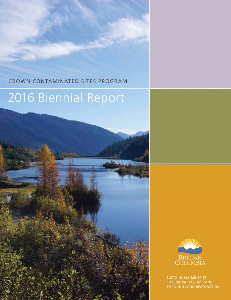
Message from the Minister 1
Introduction 2
Ministry Goals 3
Risk Ranking Methodology 4
Public Sector Accounting Standard
Section 3260: Liability for Contaminated Sites 6
Crown Contaminated Sites Secretariat 8
A Repository for Contaminated Sites: Site Registry 8
Environmental Management Act: Protocol 12 9
Crown Contaminated Sites Remediation Process 10
SITE SELECTION 12
SITE INVESTIGATION AND RISK ASSESSMENT 13
REMEDIAL PLANNING 14
REMEDIATION 17
LONG-TERM MONITORING AND MAINTENANCE 20
Program Site Statistics 24
This is the sixth biennial report of the Crown Contaminated Sites Program (CCSP) from the Ministry of Forests, Lands and Natural Resource Operations. This program review demonstrates the provincial government’s commitment to the ongoing management and protection of our land and water resources.
British Columbia is a world leader in the management of contaminated
sites and its strong leadership has been recognized by many other jurisdictions around the world that deal with similar issues. The Crown Contaminated Sites Program undertakes the important work of identifying and remediating contaminated Crown lands to ensure the health and prosperity of people and communities throughout the province.
The practice of contaminated site management continues to evolve. Changes to regulatory requirements — including the introduction of Protocol 12 (“Site Risk Classification, Reclassification and Reporting”) under the Environmental Management Act — require oversight by the Ministry of Environment to ensure that the remediation of high-risk situations proceeds as planned.
The Public Sector Accounting Standards Board serves the public interest by establishing high-quality accounting standards for public-sector entities including provincial ministries. In June 2010, the board released a document called “Section PS 3260 – Liability for Contaminated Sites”, which includes direction for how jurisdictions should account for and report any liability associated with contaminated sites.
This document has changed how all public-sector agencies recognize liabilities related to contaminated sites. As of March 31, 2016 the Ministry of Forests, Lands and Natural Resource Operations will have recognized contaminated site liabilities totalling $508 million.
Over the past two years, highlights of the Crown Contaminated Sites Program included the cleanup of the Howard Mine and Tailings site in the West Kootenays and site cleanup at the Bralorne-Takla mine in north-central B.C., begun as part of a collaborative effort with the Takla Lake First Nations. Britannia Mine and Pacific Place continue to be priorities for the program.
The B.C. government is committed to continuing this crucial work to ensure that the province’s land and water remains safe and productive.
Steve ThomsonMINISTER
MESSAGE FROM THE MINISTER
An ongoing commitment to our land and water resources
CROWN CONTAMINATED SITES PROGRAM | 2016 BIENNIAL REPORT 32
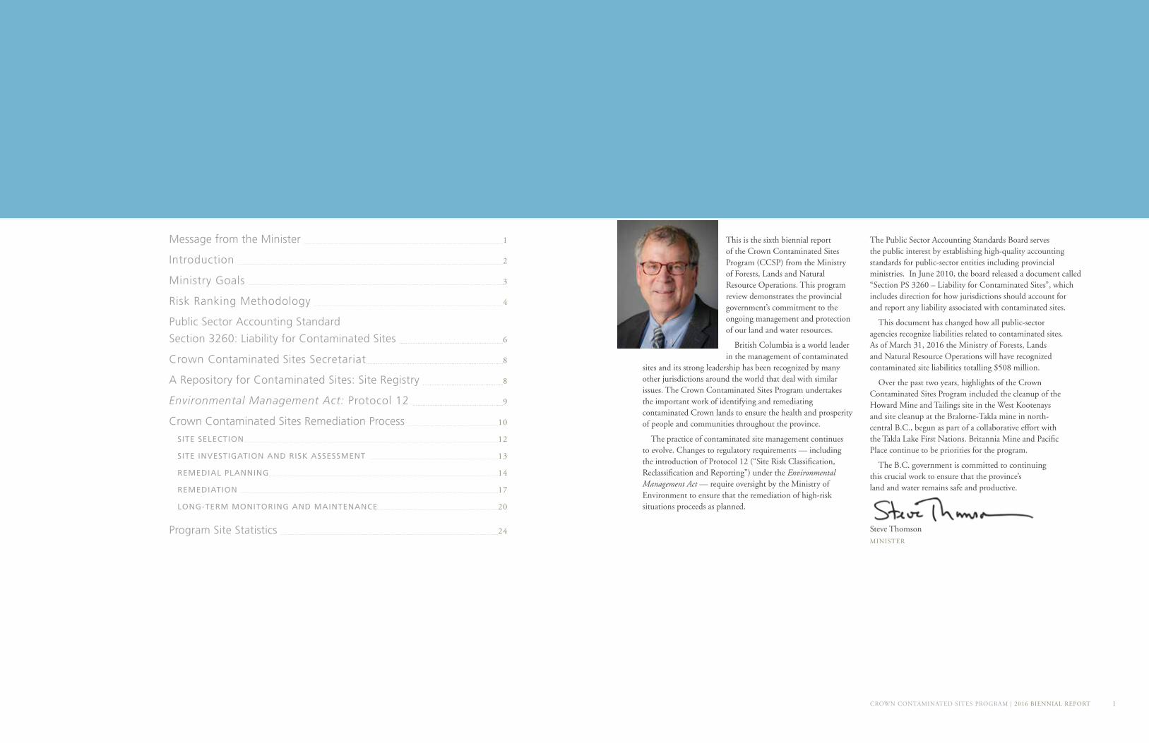
The CCSP is administered by the LNG, Crown Land Opportunities and Restoration Branch of the Ministry of Forests, Lands and Natural Resource Operations (FLNR). The ministry is responsible for developing policies and programs to ensure that forests, land, and natural resources are managed in a sustainable manner so they can continue to provide environmental, social, and economic benefits to all British Columbians now and into the future.
The ministry’s Service Plan for 2016/17-2018/19 outlines key goals, objectives and strategies that relate to the CCSP*. These include:
GOAL 2: Coordinated, sustainable management of B.C.’s natural resources This goal supports the Taxpayer Accountability Principles of Accountability, Respect and Integrity.
OBJECTIVE 2.2: Safe and environmentally responsible natural resource management practices
STRATEGY: Remediate Crown contaminated sites to ensure clean land and water for the protection of human health and the environment.
POLICYThe CCSP operates under a policy approved by cabinet, “Management of Provincial Contaminated Sites.”
This government-wide policy defines the guiding principles that underlie all actions to manage contaminated sites on Crown lands:
• Reducing and eliminating risks to human health and the environment and minimizing liabilities
• Applying standards that are cost-effective, consistent, and in keeping with the legislation
• Applying the “polluter pays principle” **
• Working cooperatively among ministries and consulting with stakeholders and First Nations
• Acting consistently and fairly
• Acting accountably and transparently
• Using innovative strategies for managing contaminated sites, such as public-private partnerships (P3s)
• Minimizing the creation of future contaminated sites
• Applying sound science and technology to guide management
COORDINATED, SUSTAINABLE MANAGEMENT OF B.C.’S NATURAL RESOURCES
Ministry of Forests, Lands and Natural
Resource Operations Service Plan
2016/17 - 2018/19
GOAL 2:
SAFE AND ENVIRONMENTALLY RESPONSIBLE NATURAL RESOURCE MANAGEMENT PRACTICES
OBJECTIVE 2.2:
REMEDIATE CROWN CONTAMINATED SITES TO ENSURE CLEAN LAND AND WATER FOR THE PROTECTION OF HUMAN HEALTH AND THE ENVIRONMENT.
STRATEGY:
The Ministry of Forests, Lands and Natural Resource Operations (FLNR) is responsible
for developing policies and programs to ensure that forests, land, and natural resources
are managed in a sustainable manner so they can continue to provide environmental,
social, and economic benefits to all British Columbians now and into the future.
British Columbia has a history of industry that includes mining, manufacturing, forestry, and other activities. These industrial activities have contributed to development, jobs and economic benefits across the province; however, they have also had some detrimental impacts on provincial land and water resources.
Some historic industrial sites are contaminated with metals, acid rock drainage, hydrocarbons and other substances harmful to human and environmental health. These sites can become the responsibility of the Government of British Columbia if they are on publicly owned land. To protect the public interest, the government undertakes activities such as removing contaminated soils, diverting watercourses away from toxic materials, capping hazardous areas with natural or synthetic materials, and replanting vegetation to create habitats for birds, animals, insects, and fish.
The Crown Contaminated Sites Program (CCSP) manages and oversees remediation of contaminated sites on Provincial Crown lands that the government is responsible for. This report describes the activities of the program between April 2014 and March 2016.
Crown lands make up 94 per cent of the total land area of British Columbia. This includes the vast majority of resource areas, wilderness, waterways, parks, and ecological reserves in the province. Remediation of contamination located on Crown land becomes the province’s responsibility if the persons or companies responsible for their cleanup cannot be found or no longer exist.
The CCSP manages high-risk contaminated sites to ensure the protection of human health and the environment. It uses a scientific risk ranking methodology to determine which sites need remediation on a priority basis.
If the organizations or individuals responsible for causing the contamination can be identified, they will be held accountable for the cost of cleanup. Public funds are used only if private parties no longer exist and the site has defaulted to the province, or if the site poses an immediate unacceptable high risk to human health or the environment.
PROGRAM SITES FALL INTO ONE OF FOUR CATEGORIES:
REMEDIATED: Crown sites where cleanup activities are completed and where long-term monitoring and maintenance is required to ensure performance of the remedial solution;
PRIORITY: Crown sites that have been identified for investigations and remedial action;
CANDIDATE: Potentially contaminated sites where the province has responsilibility for remediation but no investigations have occurred;
OTHER: Contaminated sites that the province manages in order to fulfill obligations established under legal agreements or other commitments.
Ministry Goals
Introduction
*Visit www.bcbudget.gov.bc.ca to view the Service Plan**The CCSP follows the “polluter pays principle” outlined in British Columbia’s Environmental Management Act. Under this principle, the costs associated with environmental remediation are borne by the parties responsible for the contamination, when any of those parties can be identified and are still in existence.
4
The number and variety of contaminated sites on Crown land exceeds the resources available within the CCSP to clean up all sites at once. As a result, the CCSP allocates its resources systematically to work on the highest-priority sites and identify other sites for future action. Sites that present the highest risk to human health or to the environment receive priority. Sites that pose a lower risk will receive attention as higher-risk sites are remediated.
Because of the potential for risks to human and environmental health, determining an appropriate methodology for assessing and prioritizing the risks is one of the CCSP’s key responsibilities. The methodology determines what sites will receive action, what resources each candidate site will receive, and when each site will be scheduled for attention. Sites that present a high risk to human health or to the environment receive priority in the allocation of program resources.
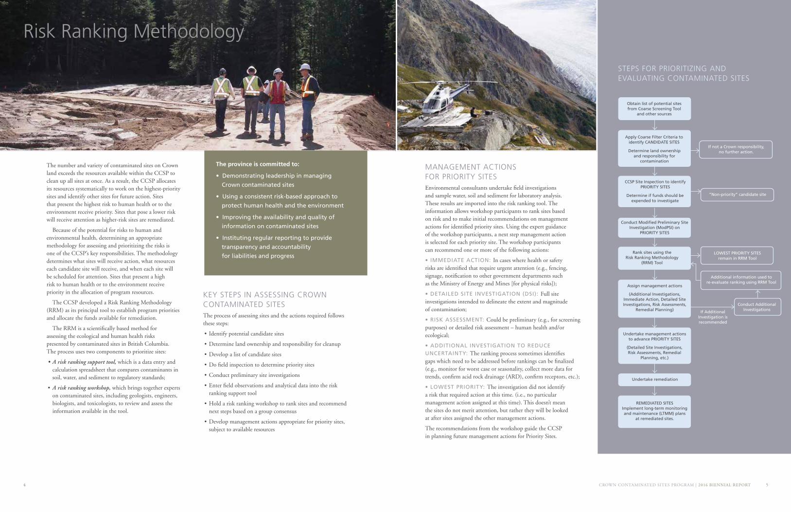
The CCSP developed a Risk Ranking Methodology (RRM) as its principal tool to establish program priorities and allocate the funds available for remediation.
The RRM is a scientifically based method for assessing the ecological and human health risks presented by contaminated sites in British Columbia. The process uses two components to prioritize sites:
• A risk ranking support tool, which is a data entry and calculation spreadsheet that compares contaminants in soil, water, and sediment to regulatory standards;
• A risk ranking workshop, which brings together experts on contaminated sites, including geologists, engineers, biologists, and toxicologists, to review and assess the information available in the tool.
KEY STEPS IN ASSESSING CROWN CONTAMINATED SITESThe process of assessing sites and the actions required follows these steps:
• Identify potential candidate sites
• Determine land ownership and responsibility for cleanup
• Develop a list of candidate sites
• Do field inspection to determine priority sites
• Conduct preliminary site investigations
• Enter field observations and analytical data into the risk ranking support tool
• Hold a risk ranking workshop to rank sites and recommend next steps based on a group consensus
• Develop management actions appropriate for priority sites, subject to available resources
Risk Ranking Methodology
MANAGEMENT ACTIONS FOR PRIORITY SITESEnvironmental consultants undertake field investigations and sample water, soil and sediment for laboratory analysis. These results are imported into the risk ranking tool. The information allows workshop participants to rank sites based on risk and to make initial recommendations on management actions for identified priority sites. Using the expert guidance of the workshop participants, a next step management action is selected for each priority site. The workshop participants can recommend one or more of the following actions:
• IMMEDIATE ACTION: In cases where health or safety risks are identified that require urgent attention (e.g., fencing, signage, notification to other government departments such as the Ministry of Energy and Mines [for physical risks]);
• DETAILED SITE INVESTIGATION (DSI): Full site investigations intended to delineate the extent and magnitude of contamination;
• RISK ASSESSMENT: Could be preliminary (e.g., for screening purposes) or detailed risk assessment – human health and/or ecological;
• ADDITIONAL INVESTIGATION TO REDUCE UNCERTAINTY: The ranking process sometimes identifies gaps which need to be addressed before rankings can be finalized (e.g., monitor for worst case or seasonality, collect more data for trends, confirm acid rock drainage (ARD), confirm receptors, etc.);
• LOWEST PRIORITY: The investigation did not identify a risk that required action at this time. (i.e., no particular management action assigned at this time). This doesn’t mean the sites do not merit attention, but rather they will be looked at after sites assigned the other management actions.
The recommendations from the workshop guide the CCSP in planning future management actions for Priority Sites.
CCSP Site Inspection to identify PRIORITY SITES
If not a Crown responsibility, no further action.
“Non-priority” candidate site
Undertake management actions to advance PRIORITY SITES
(Detailed Site Investigations, Risk Assessments, Remedial
Planning, etc.)
Undertake remediation
LOWEST PRIORITY SITES remain in RRM Tool
Apply Coarse Filter Criteria toidentify CANDIDATE SITES
Obtain list of potential sites from Coarse Screening Tool
and other sources
Determine land ownership and responsibility for
contamination
Conduct Modified Preliminary Site Investigation (ModPSI) on
PRIORITY SITES
Rank sites using the Risk Ranking Methodology
(RRM) Tool
Assign management actions
(Additional Investigations, Immediate Action, Detailed Site Investigations, Risk Assessments,
Remedial Planning) If Additional Investigation is recommended
REMEDIATED SITES Implement long-term monitoring and maintenance (LTMM) plans
at remediated sites.
STEPS FOR PRIORITIZING AND EVALUATING CONTAMINATED SITES
Determine if funds should be expended to investigate
Conduct Additional Investigations
Additional information used to re-evaluate ranking using RRM Tool
CROWN CONTAMINATED SITES PROGRAM | 2016 BIENNIAL REPORT 5
The province is committed to:
• Demonstrating leadership in managing
Crown contaminated sites
• Using a consistent risk-based approach to
protect human health and the environment
• Improving the availability and quality of
information on contaminated sites
• Instituting regular reporting to provide
transparency and accountability
for liabilities and progress
6
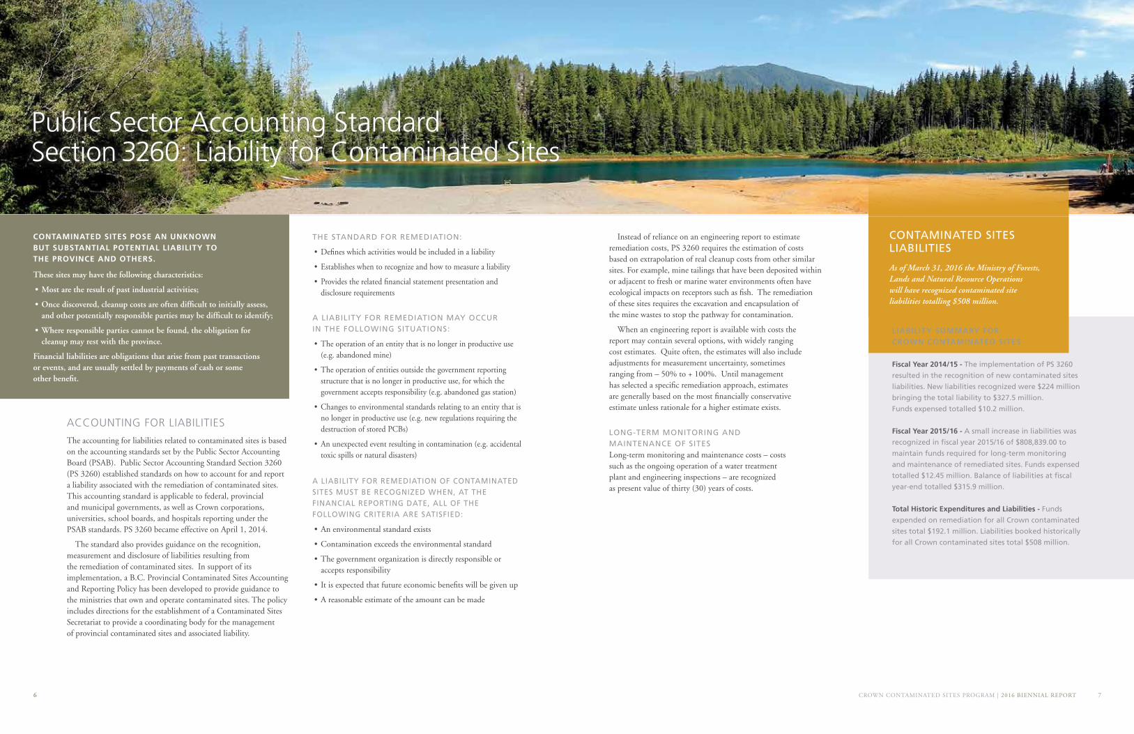
Instead of reliance on an engineering report to estimate remediation costs, PS 3260 requires the estimation of costs based on extrapolation of real cleanup costs from other similar sites. For example, mine tailings that have been deposited within or adjacent to fresh or marine water environments often have ecological impacts on receptors such as fish. The remediation of these sites requires the excavation and encapsulation of the mine wastes to stop the pathway for contamination.
When an engineering report is available with costs the report may contain several options, with widely ranging cost estimates. Quite often, the estimates will also include adjustments for measurement uncertainty, sometimes ranging from – 50% to + 100%. Until management has selected a specific remediation approach, estimates are generally based on the most financially conservative estimate unless rationale for a higher estimate exists.
CROWN CONTAMINATED SITES PROGRAM | 2016 BIENNIAL REPORT 7
LONG-TERM MONITORING AND MAINTENANCE OF SITESLong-term monitoring and maintenance costs – costs such as the ongoing operation of a water treatment plant and engineering inspections – are recognized as present value of thirty (30) years of costs.
THE STANDARD FOR REMEDIATION:
• Defines which activities would be included in a liability
• Establishes when to recognize and how to measure a liability
• Provides the related financial statement presentation and disclosure requirements
ACCOUNTING FOR LIABILITIES
The accounting for liabilities related to contaminated sites is based on the accounting standards set by the Public Sector Accounting Board (PSAB). Public Sector Accounting Standard Section 3260 (PS 3260) established standards on how to account for and report a liability associated with the remediation of contaminated sites. This accounting standard is applicable to federal, provincial and municipal governments, as well as Crown corporations, universities, school boards, and hospitals reporting under the PSAB standards. PS 3260 became effective on April 1, 2014.
The standard also provides guidance on the recognition, measurement and disclosure of liabilities resulting from the remediation of contaminated sites. In support of its implementation, a B.C. Provincial Contaminated Sites Accounting and Reporting Policy has been developed to provide guidance to the ministries that own and operate contaminated sites. The policy includes directions for the establishment of a Contaminated Sites Secretariat to provide a coordinating body for the management of provincial contaminated sites and associated liability.
A LIABILITY FOR REMEDIATION MAY OCCUR IN THE FOLLOWING SITUATIONS:
• The operation of an entity that is no longer in productive use (e.g. abandoned mine)
• The operation of entities outside the government reporting structure that is no longer in productive use, for which the government accepts responsibility (e.g. abandoned gas station)
• Changes to environmental standards relating to an entity that is no longer in productive use (e.g. new regulations requiring the destruction of stored PCBs)
• An unexpected event resulting in contamination (e.g. accidental toxic spills or natural disasters)
A LIABILITY FOR REMEDIATION OF CONTAMINATED SITES MUST BE RECOGNIZED WHEN, AT THE FINANCIAL REPORTING DATE, ALL OF THE FOLLOWING CRITERIA ARE SATISFIED:
• An environmental standard exists
• Contamination exceeds the environmental standard
• The government organization is directly responsible or accepts responsibility
• It is expected that future economic benefits will be given up
• A reasonable estimate of the amount can be made
Public Sector Accounting Standard Section 3260: Liability for Contaminated Sites
CONTAMINATED SITES POSE AN UNKNOWN BUT SUBSTANTIAL POTENTIAL LIABILITY TO THE PROVINCE AND OTHERS.
These sites may have the following characteristics:
• Most are the result of past industrial activities;
• Once discovered, cleanup costs are often difficult to initially assess, and other potentially responsible parties may be difficult to identify;
• Where responsible parties cannot be found, the obligation for cleanup may rest with the province.
Financial liabilities are obligations that arise from past transactions or events, and are usually settled by payments of cash or some other benefit.
As of March 31, 2016 the Ministry of Forests, Lands and Natural Resource Operations will have recognized contaminated site liabilities totalling $508 million.
LIABILITY SUMMARY FOR CROWN CONTAMINATED SITES
Fiscal Year 2014/15 - The implementation of PS 3260
resulted in the recognition of new contaminated sites
liabilities. New liabilities recognized were $224 million
bringing the total liability to $327.5 million.
Funds expensed totalled $10.2 million.
Fiscal Year 2015/16 - A small increase in liabilities was
recognized in fiscal year 2015/16 of $808,839.00 to
maintain funds required for long-term monitoring
and maintenance of remediated sites. Funds expensed
totalled $12.45 million. Balance of liabilities at fiscal
year-end totalled $315.9 million.
Total Historic Expenditures and Liabilities - Funds
expended on remediation for all Crown contaminated
sites total $192.1 million. Liabilities booked historically
for all Crown contaminated sites total $508 million.
CONTAMINATED SITES LIABILITIES
CROWN CONTAMINATED SITES PROGRAM | 2016 BIENNIAL REPORT 98
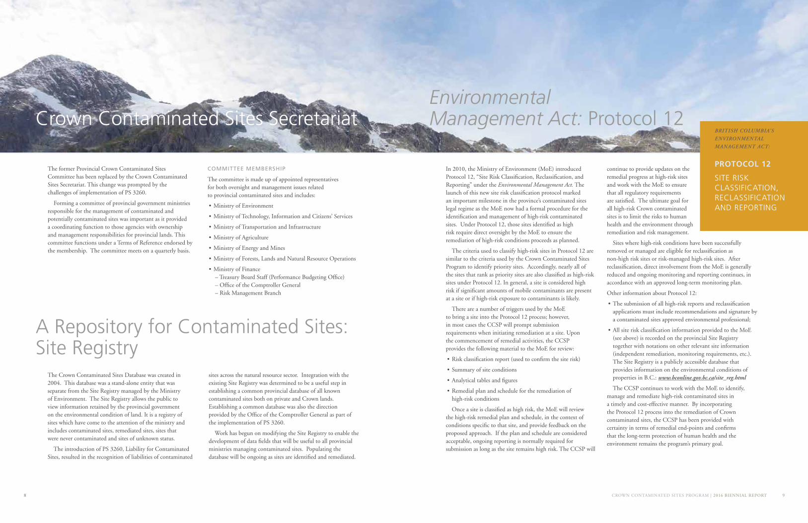
The former Provincial Crown Contaminated Sites Committee has been replaced by the Crown Contaminated Sites Secretariat. This change was prompted by the challenges of implementation of PS 3260.
Forming a committee of provincial government ministries responsible for the management of contaminated and potentially contaminated sites was important as it provided a coordinating function to those agencies with ownership and management responsibilities for provincial lands. This committee functions under a Terms of Reference endorsed by the membership. The committee meets on a quarterly basis.
COMMITTEE MEMBERSHIP
The committee is made up of appointed representatives for both oversight and management issues related to provincial contaminated sites and includes:
• Ministry of Environment
• Ministry of Technology, Information and Citizens’ Services
• Ministry of Transportation and Infrastructure
• Ministry of Agriculture
• Ministry of Energy and Mines
• Ministry of Forests, Lands and Natural Resource Operations
• Ministry of Finance – Treasury Board Staff (Performance Budgeting Office) – Office of the Comptroller General – Risk Management Branch
Crown Contaminated Sites Secretariat
In 2010, the Ministry of Environment (MoE) introduced Protocol 12, “Site Risk Classification, Reclassification, and Reporting” under the Environmental Management Act. The launch of this new site risk classification protocol marked an important milestone in the province’s contaminated sites legal regime as the MoE now had a formal procedure for the identification and management of high-risk contaminated sites. Under Protocol 12, those sites identified as high risk require direct oversight by the MoE to ensure the remediation of high-risk conditions proceeds as planned.
The criteria used to classify high-risk sites in Protocol 12 are similar to the criteria used by the Crown Contaminated Sites Program to identify priority sites. Accordingly, nearly all of the sites that rank as priority sites are also classified as high-risk sites under Protocol 12. In general, a site is considered high risk if significant amounts of mobile contaminants are present at a site or if high-risk exposure to contaminants is likely.
There are a number of triggers used by the MoE to bring a site into the Protocol 12 process; however, in most cases the CCSP will prompt submission requirements when initiating remediation at a site. Upon the commencement of remedial activities, the CCSP provides the following material to the MoE for review:
• Risk classification report (used to confirm the site risk)
• Summary of site conditions
• Analytical tables and figures
• Remedial plan and schedule for the remediation of high-risk conditions
Once a site is classified as high risk, the MoE will review the high-risk remedial plan and schedule, in the context of conditions specific to that site, and provide feedback on the proposed approach. If the plan and schedule are considered acceptable, ongoing reporting is normally required for submission as long as the site remains high risk. The CCSP will
continue to provide updates on the remedial progress at high-risk sites and work with the MoE to ensure that all regulatory requirements are satisfied. The ultimate goal for all high-risk Crown contaminated sites is to limit the risks to human health and the environment through remediation and risk management.
Sites where high-risk conditions have been successfully removed or managed are eligible for reclassification as non-high risk sites or risk-managed high-risk sites. After reclassification, direct involvement from the MoE is generally reduced and ongoing monitoring and reporting continues, in accordance with an approved long-term monitoring plan.
Other information about Protocol 12:
• The submission of all high-risk reports and reclassification applications must include recommendations and signature by a contaminated sites approved environmental professional;
• All site risk classification information provided to the MoE (see above) is recorded on the provincial Site Registry together with notations on other relevant site information (independent remediation, monitoring requirements, etc.). The Site Registry is a publicly accessible database that provides information on the environmental conditions of properties in B.C.: www.bconline.gov.bc.ca/site_reg.html
The CCSP continues to work with the MoE to identify, manage and remediate high-risk contaminated sites in a timely and cost-effective manner. By incorporating the Protocol 12 process into the remediation of Crown contaminated sites, the CCSP has been provided with certainty in terms of remedial end-points and confirms that the long-term protection of human health and the environment remains the program’s primary goal.
Environmental Management Act: Protocol 12
SITE RISK CLASSIFICATION, RECLASSIFICATION AND REPORTING
PROTOCOL 12
BRITISH COLUMBIA’S
ENVIRONMENTAL
MANAGEMENT ACT:
The Crown Contaminated Sites Database was created in 2004. This database was a stand-alone entity that was separate from the Site Registry managed by the Ministry of Environment. The Site Registry allows the public to view information retained by the provincial government on the environmental condition of land. It is a registry of sites which have come to the attention of the ministry and includes contaminated sites, remediated sites, sites that were never contaminated and sites of unknown status.
The introduction of PS 3260, Liability for Contaminated Sites, resulted in the recognition of liabilities of contaminated
sites across the natural resource sector. Integration with the existing Site Registry was determined to be a useful step in establishing a common provincial database of all known contaminated sites both on private and Crown lands. Establishing a common database was also the direction provided by the Office of the Comptroller General as part of the implementation of PS 3260.
Work has begun on modifying the Site Registry to enable the development of data fields that will be useful to all provincial ministries managing contaminated sites. Populating the database will be ongoing as sites are identified and remediated.
A Repository for Contaminated Sites: Site Registry
CROWN CONTAMINATED SITES PROGRAM | 2016 BIENNIAL REPORT 11
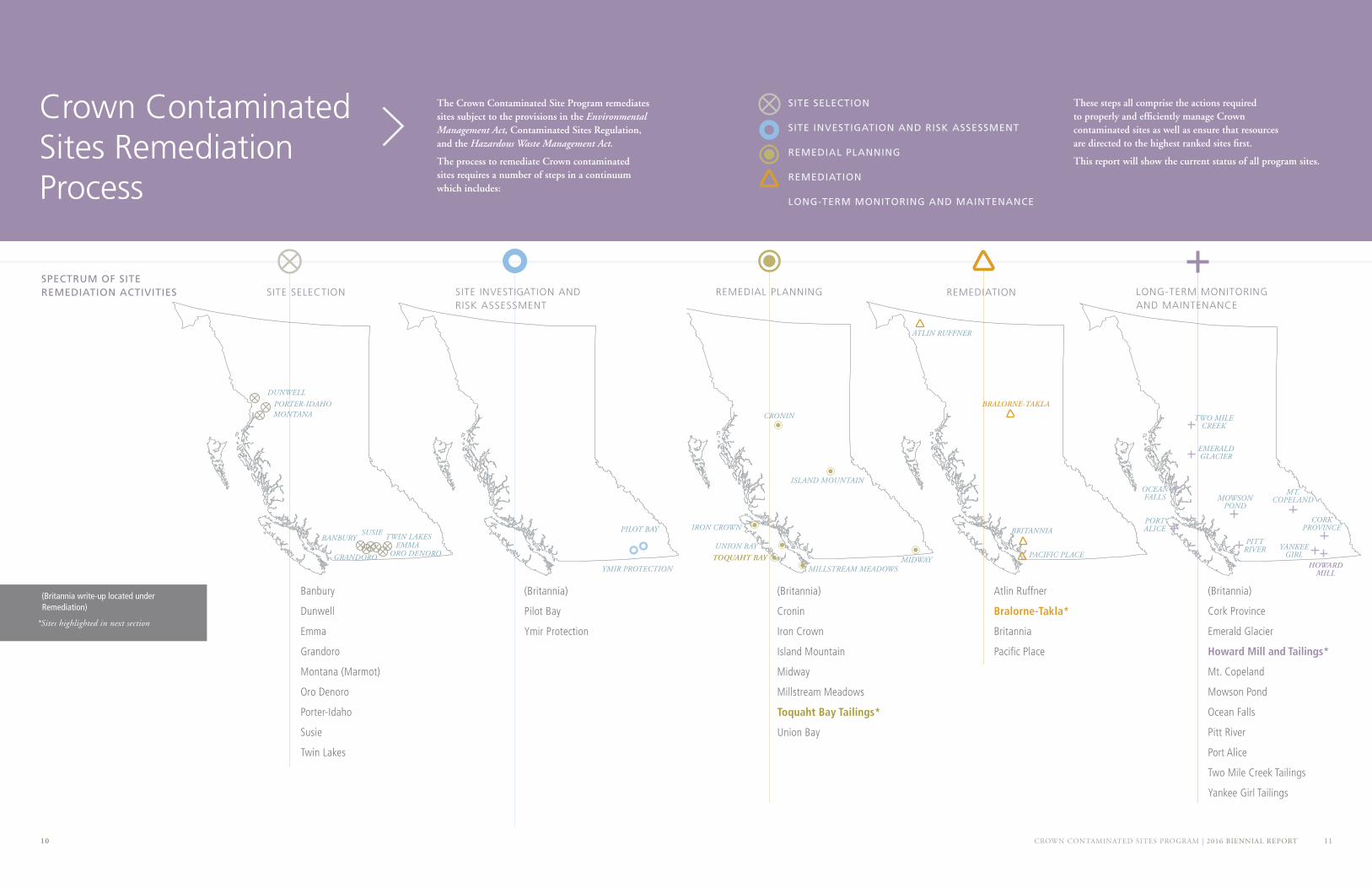
The Crown Contaminated Site Program remediates sites subject to the provisions in the Environmental Management Act, Contaminated Sites Regulation, and the Hazardous Waste Management Act.
The process to remediate Crown contaminated sites requires a number of steps in a continuum which includes:
Banbury
Dunwell
Emma
Grandoro
Montana (Marmot)
Oro Denoro
Porter-Idaho
Susie
Twin Lakes
(Britannia)
Pilot Bay
Ymir Protection
(Britannia)
Cronin
Iron Crown
Island Mountain
Midway
Millstream Meadows
Toquaht Bay Tailings*
Union Bay
Atlin Ruffner
Bralorne-Takla*
Britannia
Pacific Place
Crown Contaminated Sites Remediation Process
These steps all comprise the actions required to properly and efficiently manage Crown contaminated sites as well as ensure that resources are directed to the highest ranked sites first.
This report will show the current status of all program sites.
SITE SELECTION
SITE INVESTIGATION AND RISK ASSESSMENT
REMEDIAL PLANNING
REMEDIATION
LONG-TERM MONITORING AND MAINTENANCE
10
SPECTRUM OF SITE REMEDIATION ACTIVITIES
(Britannia write-up located under Remediation)
*Sites highlighted in next section
(Britannia)
Cork Province
Emerald Glacier
Howard Mill and Tailings*
Mt. Copeland
Mowson Pond
Ocean Falls
Pitt River
Port Alice
Two Mile Creek Tailings
Yankee Girl Tailings
SITE SELECTION
YMIR PROTECTION
BANBURY
DUNWELL
EMMA
GRANDORO
MONTANA
ORO DENORO
PORTER-IDAHO
SUSIE TWIN LAKESPILOT BAY
MILLSTREAM MEADOWSMIDWAY
UNION BAY
ISLAND MOUNTAIN
IRON CROWN
PACIFIC PLACE
TWO MILE CREEK
CORK PROVINCE
YANKEE GIRL
MT. COPELAND
PITT RIVER
MOWSON POND
EMERALD GLACIER
OCEAN FALLS
PORT ALICEBRITANNIA
ATLIN RUFFNER
TOQUAHT BAY
CRONIN
BRALORNE-TAKLA
HOWARD MILL
REMEDIAL PLANNINGSITE INVESTIGATION AND RISK ASSESSMENT
REMEDIATION LONG-TERM MONITORING AND MAINTENANCE
CROWN CONTAMINATED SITES PROGRAM | 2016 BIENNIAL REPORT 1312
SITE SELECTION
Periodically, staff from the CCSP identify and inspect candidate sites as part of the program’s risk ranking methodology. Sites are selected from a coarse screen database that ranks historic mine sites on a number of site-specific and geo-referenced factors such as the volume of ore mined or the proximity to human or ecological receptors. After confirming Crown land ownership and potential responsibility, CCSP conducts site inspections to identify suspected high-risk sites and then assigns them to approved environmental and engineering consulting firms to conduct preliminary site investigations and confirm potential risk.
In the late summer and early fall of 2015, the CCSP inspected nine potential candidate sites located within the Kootenay and Skeena regions, which included the Banbury, Dunwell, Emma, Grandoro, Montana, Oro Denoro, Porter-Idaho, Susie, and Twin Lakes mine sites. Research was conducted prior to the site inspections to understand the historic mining operations of each site, as well as to identify areas of potential environmental concern (APECs) that should be visited. The APECs typically included all of the former mine workings and waste products including adits, waste rock piles, mills and tailings. Soil and water samples were collected from key APEC locations to be assessed against provincial environmental standards. The inspection and analytical results will be evaluated to determine which sites should be identified as priority sites and investigated further.
PILOT BAY 49º 38’ 36” N, 116º 53’ 00” W
Located on the east shore of Kootenay Lake, the Pilot Bay Smelter was commissioned in 1895. During this year, 52,000 tons of ore mined from the nearby Bluebell Mine and 2,500 tons from other local mining operations was transported to the site for processing. The refining infrastructure at the Pilot Bay Smelter was subsequently shut down in 1896 due to difficulties processing ore efficiently, while the concentrator operated intermittently until 1906. Post World War I, the site was derelict and subsequently dismantled. In 1952 it was estimated that approximately 32,000 tonnes of silver, lead and zinc ore remained at the site.
The majority of the former milling and smelting buildings were located upland from the foreshore (private lands), while mine wastes generated from site operations were deposited along the foreshore and into Kootenay Lake (primarily Crown land). The Crown has conducted preliminary investigations at the site and is currently developing a plan for further site investigation in the 2016 field season.
YMIR PROTECTION 49º 19’ 19” N, 117º 10’ 17” W
The Ymir Mine and Protection Mine Tailings Site is located in the West Kootenay region of British Columbia, 4.5 kilometres east of the town of Ymir. The majority of the mining operations occurred from 1900 to 1942, and targeted a sulphide ore deposit, with the main commodities being gold, silver, lead, and zinc.
The main tailings area is located adjacent to Wildhorse (Ymir) Creek, and the crusher area is located up-gradient to the north east. Mine wastes at these two areas straddle Crown and private lands. Additional investigations are required to better understand site conditions and remediation requirements. Monitoring is ongoing in the interim.
Site Selection Site Investigation and Risk Assessment
CROWN CONTAMINATED SITES PROGRAM | 2016 BIENNIAL REPORT 1514
CRONIN 54º 55’ 30” N, 126º 48’ 56” W
The former Cronin Mine site is located approximately 30 kilometres northeast of Smithers, in a mountainous, forested, and sparsely populated area that is partially within Babine Mountains Provincial Park. The Cronin mine operated between 1917 and 1974. Investigations and risk assessments have identified impacts/risks from metal contamination in the part of the site with the mill and tailings impoundments. The main tailings impoundment is approximately 2,700 square metres in area and 10 metres from Cronin Creek. A smaller tailings impoundment is approximately 600 square metres in area and 100 metres from Cronin Creek.
Ecological impacts and risks were identified on and around the mill and tailings impoundments, including a stretch of Cronin Creek. The human health risk assessment concluded that actual health risks for recreational users of the site were minimal. Remedial options will be developed in concert with stakeholders, including users of the site, First Nations, and regulators.
MIDWAY 49° 14’ 05”N 115° 53’ 29”W
Midway Mine was an underground lead-zinc mine that operated intermittently between 1933 and 1962. The mine is located 30 kilometres west of Cranbrook on a steep forested hillside immediately adjacent to Highway 3. South across the highway is a large perennial marsh, which is separated from Moyie River by the Canadian Pacific Railway line. Mining operations left behind three waste rock piles and two adits. Acid rock drainage (ARD) slowly seeps from both of the adits and either disappears to ground or to a small ephemeral marsh located at the base of the waste rock piles.
Environmental investigations have been ongoing since 2005 to delineate the source of contamination, as well as to assess the potential for human or ecological health risks. The assessment found risks to aquatic life and wildlife to be acceptably low; however, there is a potential concern for occasional visitors to the waste rock areas of the site. To address these potential risks a remedial options analysis was completed in 2014. The recommended remedial option is to re-contour the waste rock piles to a geotechnically safe slope and then cover with non-ARD crushed rock. To address surface and groundwater transport of contaminants into the aquatic ecosystem, construction of an engineered storm water detention pond was also recommended.
IRON CROWN 50º 15’ 29” N, 126º 51’ 36” W
The former Iron Crown mine site is located near Woss on the north end of Vancouver Island. The mine operated from 1959 to 1963, with an open pit on the south side of the Nimpkish River and a mill on the north side. Tailings released from the mill have contaminated a small lake (Canyon Lake) and also the area around it with metals and acidity. Remedial options have been evaluated and will be further developed in 2016 after consultation with regulators, First Nations, and other stakeholders.
ISLAND MOUNTAIN 53º 06’ 04” N, 121º 35’ 02” W
The former Island Mountain and Cariboo Gold mine site is located in Wells. The mine operated for several decades beginning in 1933. This site has been investigated in detail. Mine wastes consisting primarily of tailings contaminated with arsenic and other metals extend over 65 hectares including beside and within Jack of Clubs Lake and the Willow River. Despite the extensive mine waste, water quality in Jack of Clubs Lake and the Willow River generally meets provincial water quality guidelines for protection of freshwater aquatic life. Remedial options under evaluation include placement of a clean fill cover over the tailings in areas where contamination poses the greatest risks. A detailed remedial design will be selected based on input from stakeholders including regulators, First Nations, and the community of Wells.
MILLSTREAM MEADOWS 48º 28’ 52” N, 123º 30’ 33” W
The Millstream Meadows site in the District of Highlands, just outside of Victoria, operated as a disposal facility for septage wastes. The liquid wastes, including oily metals, were discharged with few controls into a series of three lagoons at the site. The Capital Regional District (CRD), in the late 1980s, filled in two of the lagoons with construction debris and covered them with soil, forming the meadows. The provincial government and the CRD have conducted environmental investigation and remediation since 1995. The CRD, with the support of the B.C. government, excavated the worst of the contaminated soils from Lagoon 1 and a portion of Lagoon 2. In 2011, the excavation was filled in with clean gravel. Since the remedial excavation in 2009, the CRD has continued to monitor groundwater, surface water, and soil gas quality. Additional investigations are planned to assess the remaining site risks. The CRD and the CCSP are currently looking at innovative and cost-effective methods to locate fracture zones in bedrock that might transport contaminants. They will use this information to ensure that long-term deep perimeter monitoring wells are correctly located to identify any possible migration pathways for contaminants.
UNION BAY 49º 35’ 31” N, 124º 52’ 54” W
The Union Bay Waste Coal Pile is located south of Courtney, in the town of Union Bay. The site comprises approximately 13 hectares of Crown foreshore.
The site was used by Canadian Collieries (Dunsmuir) Ltd. as a coal washing and load out facility. The facility produced coal waste products, which have in turn been generating acid rock drainage that discharges into Bayne’s Sound. Remedial planning is currently underway. Numerous studies of the waste coal pile and the adjacent foreshore environment have been completed. The CCSP is continuing to monitor iron staining, which has been shown to be a good indicator of toxicity in the marine foreshore. Aerial photographic monitoring will continue to be undertaken annually during the summer low tide at the Union Bay site.
Remedial Planning
CROWN CONTAMINATED SITES PROGRAM | 2016 BIENNIAL REPORT 1716
Toquaht Bay Marina and Campground
The Toquaht Bay Marina and Campground is located on the west coast of Vancouver Island, approximately 16 kilometres northeast of Ucluelet on the shore of Barkley Sound. The site is made up of a campground, boat launch, and marina, as well as the foreshore and subtidal areas.
The campground is part of the Maa-Nulth Treaty lands of the Toquaht First Nation, while the boat launch and marina are part of the Crown access corridor. The Toquaht Nation operates the marina and boat launch under tenure. The treaty specifies that, if and when the Toquaht First Nation wish to pursue development of specific land parcels identified in the final agreement, the Province of British Columbia will investigate for potential contamination and remediation, if necessary, under the Environmental Management Act. In 2013, Toquaht Nation notified of their intentions to develop the campground.
During the 1960s ore from the Brynnor Iron Mine, located near Maggie Lake, was milled north of the campground before being shipped out by sea. Fine sand wastes (tailings) were deposited along the shoreline to the former Tree Island, now part of the campground, creating a sandy beach.
Preliminary investigations were completed in early 2013 and found high levels of arsenic, iron and other metals in site soil. Toquaht Nation and the province worked together to close the campground, boat launch and marina to ensure public safety as required by the Regional Public Health Officer. This closure significantly impacted the
Toquaht Nation and, the marina and campground users. The CCSP implemented risk management measures (fencing and signage) in August 2014 to allow the marina and boat launch to be reopened for public use.
Investigations have been ongoing since early 2013, and have included human health risk studies, detailed site investigations, investigation of littoral drift (the natural transport and deposit of sand and sediments), and preliminary ecological risk assessment. Geochemical reactions in groundwater are complex, particularly where freshwater and saltwater interact on the beach. Although the seawater meets regulatory standards, the porewater contained in sand on the beach was found to be toxic to some marine organisms.
Remedial planning, including engagement with stakeholders, regulatory agencies and Toquaht Nation, is currently underway. Multiple remedial options are being considered to address the complexities at the site.
HIGHLIGHTED CROWN CONTAMINATED SITE: REMEDIAL PLANNING ATLIN RUFFNER 59º 44’ 22” N, 133º 30’ 50” W
The Atlin Ruffner Mill and Tailings site is located approximately 28 kilometres northeast of Atlin. Mining operations at Atlin Ruffner commenced in 1900 and lead, zinc, silver, copper, cadmium, and gold were mined and milled intermittently until 1981. Remediation construction works were undertaken in August and September of 2012 and included building demolition and site capping with one metre of gravel cover over the contaminated areas. Final surveys occurred during the 2013 field season. Groundwater monitoring wells were installed during July 2009 and have been monitored periodically since then.
It was noted in 2013 that drainage from the former tailings area did not comply with the Hazardous Waste Regulation approval. In 2014 an action plan to address the non-compliance was developed. Additional studies were undertaken in 2015. A water diversion system for the adit drainage, a groundwater interceptor above the tailings, and a tailings cover are currently being designed. Monitoring is ongoing.
BRITANNIA 49º 36’ 40” N, 123º 08’ 28” W
Britannia Mine is located 45 kilometres north of Vancouver next to Howe Sound on the Sea-to-Sky corridor. Prior to remediation, the mine site was one of the largest point sources of metal pollution discharging to surface waters in North America. The majority of the contaminated discharge originated from the honeycomb of subsurface mine workings in the naturally occurring metal sulphide ore body. These mine workings expose the metal sulphides to air and water – conditions which allow the creation of acid rock drainage (ARD). The ARD contains metals (including copper, zinc and cadmium) and is highly acidic.
The ARD primarily discharged from the mine workings at two locations – the smaller discharge was from the 2200 portal, which entered Jane Creek and then Britannia Creek before flowing into Howe Sound. The larger discharge was from the 4100 portal which was piped to Howe Sound at depth. In 2001, a concrete plug was installed in the 2200 portal. The plug prevents discharge to Jane and Britannia Creeks, and effectively redirects the ARD to the 4100 level portal.
Since 2005, ARD from the 4100 portal has been directed to a water treatment plant that decreases metal concentrations and acidity to approved regulatory levels before it is discharged to Howe Sound. Other remedial efforts to reduce the contamination from the site include diverting clean surface water so that it does not become contaminated by entering the mine workings or contacting other contaminated materials. Contaminated groundwater near the foreshore is pumped to the water treatment plant for treatment before discharge.
Contamination is also present in soil and water elsewhere at the site, where investigations and remediation are actively progressing. Recent investigations and remedial efforts have included detailed site investigation in the upland Britannia Creek watershed, human and ecological health risk assessment in Furry Creek watershed, cleaning and repairs to a force main pipe that carries groundwater from the foreshore to the water treatment plant, and planning and preliminary design to re-inject acidic water discharging from a portal in Furry Creek back into the mine workings for eventual treatment in the plant.
Remediation
49º 01’ 08” N, 125º 21’ 32” WTOQUAHT
DURING THE 1960s ORE FROM THE
BRYNNOR IRON MINE, LOCATED
NEAR MAGGIE LAKE, WAS MILLED
NORTH OF THE CAMPGROUND
BEFORE BEING SHIPPED OUT
BY SEA. FINE SAND WASTES
(TAILINGS) WERE DEPOSITED
ALONG THE SHORELINE
CREATING A SANDY BEACH.
Highlighted Crown Contaminated Site
CROWN CONTAMINATED SITES PROGRAM | 2016 BIENNIAL REPORT 1918
PACIFIC PLACE 49° 16’ 27” N, 123° 06’ 36” W
The Pacific Place lands are located along False Creek in Vancouver, at the former location of Expo 86. Under an agreement with Concord Pacific Developments the province remediates soils as each lot is developed, eliminating the need to backfill and re-excavate each parcel. A groundwater treatment plant cleans groundwater prior to discharge into False Creek and groundwater monitoring occurs regularly. While remediation is driven by the development schedule, completion is currently estimated for the end of 2018.
Bralorne-Takla Historic Mercury Mine• Securing all mine openings;
• Removing, mitigating and managing risks to human health and the environment associated with contaminant substances present on the site;
• Returning the site to forest habitat; and
• Providing TLFN engagement and employment opportunities.
The selected remedial approach included the removal of all hazardous wastes, including leachable soils, and the construction of two covered landfills, containing contaminated soils, that will support a forest ecosystem. The two mine openings were capped with concrete covers to ensure protection of people and animals.
A joint design and build team was contracted in early 2015. The contractors were responsible for the design and construction of the contaminated soil landfills, the concrete caps on mine openings, and the surface drainage and seepage control structures, as well as the excavation and placement of non-hazardous debris and contaminated soils within two engineered on-site landfills. The team’s responsibilities also included the demolition and disposal of buildings and equipment, the mercury and asbestos abatement, the off-site disposal of metal debris and hazardous wastes, the restoration and re-vegetation of disturbed lands, the professional field review during construction, and the preparation of reports and drawings.
Upon completion of the detailed design for the landfills, construction began in early August 2015. The construction was overseen by on-site professional environmental monitors, including two members of TLFN. The construction work was not completed prior to the arrival of winter weather in 2015; therefore, the site was winterized to ensure no erosion of the contaminated soils will occur. Remediation will be completed in 2016.
The Bralorne-Takla site is located within Takla Lake First Nations (TLFN) traditional territory in the Omineca Region of British Columbia, approximately 180 kilometres north of Fort St. James, and approximately 37 kilometres east-northeast of the community of Takla Landing.
The primary contaminants of concern associated with the mine waste are mercury, antimony, arsenic and cadmium, but chromium, copper, molybdenum, nickel, selenium and zinc found in mine waste also exceed regulatory standards. Methyl mercury, which is produced from inorganic mercury by bacteria, was detected in groundwater and surface water samples at concentrations approaching or exceeding guidance values for protection of aquatic life.
After extensive investigations, a joint remedial planning process was undertaken with TLFN. The primary objectives of the remedial action were as follows:
• Ensure the site is safe for use by humans, animals and plants;
• Remove contamination at the site caused by mining activities;
• Minimize environmental impacts of remediation through sustainable cleanup and planning;
• Ensure the project is technically feasible, scientifically supported, and has timely remedial solutions;
• Ensure TLFN benefits and is involved in remediation;
• Restore TLFN use of land;
• Manage provincial responsibility in the long term; and
• Ensure the cleanup project is cost-effective and considers short and long-term costs.
These objectives were met through the following actions:
• Removing and disposing off-site all hazardous waste materials and all remaining machinery and equipment, and demolishing building superstructures;
HIGHLIGHTED CROWN CONTAMINATED SITE: REMEDIATION
Remediation
Highlighted Crown Contaminated Site
55º 34’ 07” N, 125º 23’ 26” WBRALORNE-TAKLA
THE BRALORNE-TAKLA SITE IS A HISTORIC
MERCURY MINE THAT OPERATED FOR
NINE MONTHS DURING WORLD WAR II.
IT IS THOUGHT TO BE ONE OF ONLY
THREE MERCURY MINES IN CANADA
CROWN CONTAMINATED SITES PROGRAM | 2016 BIENNIAL REPORT 2120
CORK PROVINCE 49º 54’ 29” N, 117º 04’ 30” W
The Cork Province Mine, which produced zinc, cadmium, gold, and silver from 1900 to 1966, left a mass of mine tailings near Keen Creek, a secondary potable water source for the nearby town of Kaslo, north of Nelson. The tailings impoundment was at risk of failing and endangering the Keen Creek water. In 2008 and 2009, the tailings were moved to a new location upland and away from the creek. The new tailings impoundment was then covered with a metre of soil and the entire site was replanted. Long-term monitoring and maintenance following the work continues to show that the remedial program has removed the risk of tailings release.
EMERALD GLACIER53º 42’ 46” N, 127º 14’ 26” W
The CCSP undertook remediation of the Emerald Glacier Mill and Tailings site in the summer of 2013. Areas with high metal concentrations were covered with a one-metre thick, compacted, glacial till cover. A containment berm was integrated into the cover design to isolate contaminants from a nearby fish-bearing creek. The former mill water supply reservoir was decommissioned, returning the drainage to conditions similar to pre-mining. Since 2013, post-remediation monitoring has been underway to assess the success of the remedial works. The physical condition of all features is inspected and water samples are collected from the creek and groundwater monitoring wells. Based on the inspection results, additional re-vegetation is being planned for 2016.
MT. COPELAND 51° 06’ 03”N 118° 27 57”W
The former Mt. Copeland mine, located near Revelstoke, has not operated since 1974. Inspections have been carried out since 2006 to identify environmental and geotechnical issues at the site. There is a fish-bearing creek below the tailings dam that is vulnerable should the tailings dam fail. Geotechnical upgrades and remedial works on the tailings dam have been conducted since 2008 to reduce the risk of dam failure. Over the past two years, in addition to the annual inspections, repair work was conducted. Based on the 2015 site inspection, measures are being developed to improve the long-term stability of the dam. Since the site is accessible only by helicopter and is snow-free for only a month or two each year, implementation of the improvements will be phased in over several years beginning in 2016.
Long-Term Monitoring and Maintenance
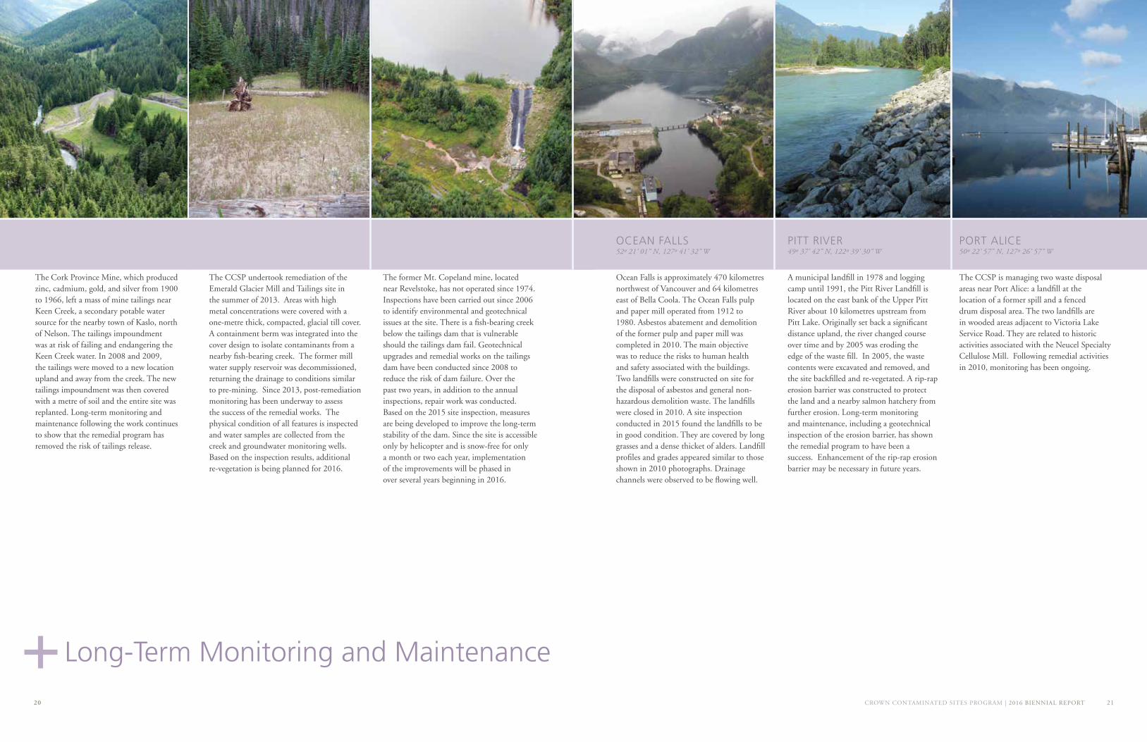
OCEAN FALLS 52º 21’ 01” N, 127º 41’ 32” W
Ocean Falls is approximately 470 kilometres northwest of Vancouver and 64 kilometres east of Bella Coola. The Ocean Falls pulp and paper mill operated from 1912 to 1980. Asbestos abatement and demolition of the former pulp and paper mill was completed in 2010. The main objective was to reduce the risks to human health and safety associated with the buildings. Two landfills were constructed on site for the disposal of asbestos and general non-hazardous demolition waste. The landfills were closed in 2010. A site inspection conducted in 2015 found the landfills to be in good condition. They are covered by long grasses and a dense thicket of alders. Landfill profiles and grades appeared similar to those shown in 2010 photographs. Drainage channels were observed to be flowing well.
PITT RIVER 49º 37’ 42” N, 122º 39’ 30” W
A municipal landfill in 1978 and logging camp until 1991, the Pitt River Landfill is located on the east bank of the Upper Pitt River about 10 kilometres upstream from Pitt Lake. Originally set back a significant distance upland, the river changed course over time and by 2005 was eroding the edge of the waste fill. In 2005, the waste contents were excavated and removed, and the site backfilled and re-vegetated. A rip-rap erosion barrier was constructed to protect the land and a nearby salmon hatchery from further erosion. Long-term monitoring and maintenance, including a geotechnical inspection of the erosion barrier, has shown the remedial program to have been a success. Enhancement of the rip-rap erosion barrier may be necessary in future years.
PORT ALICE 50º 22’ 57” N, 127º 26’ 57” W
The CCSP is managing two waste disposal areas near Port Alice: a landfill at the location of a former spill and a fenced drum disposal area. The two landfills are in wooded areas adjacent to Victoria Lake Service Road. They are related to historic activities associated with the Neucel Specialty Cellulose Mill. Following remedial activities in 2010, monitoring has been ongoing.
Replace photo?
CROWN CONTAMINATED SITES PROGRAM | 2016 BIENNIAL REPORT 2322
TWO MILE CREEK TAILINGS 55º 19’ 06” N, 127º 35’ 18” W
The Two Mile Creek tailings and associated former mill site are located along Two Mile Creek, a few kilometres from Hazelton. A preliminary environmental investigation of the tailings, sediment and surface water indicated elevated concentrations of several metals and metalloids relative to applicable environmental quality standards in samples collected from the site. During the 2006 program, Two Mile Creek was observed to be flowing over areas of exposed tailings and potentially eroding these contaminated materials into the creek. Downstream of the site, Two Mile Creek is used as a source of drinking water and irrigation water for the Village of Hazelton and Gitanmaax Band communities.
Remediation, completed in 2008, involved removal of tailings materials from the Two Mile Creek floodplain and placement into an adjacent quarry with a geotextile cover. Following completion of the remedial activities, a post-construction monitoring and sampling program was implemented to assess water quality in Two Mile Creek. Monitoring began as monthly, was reduced to annually, and will now happen periodically.
YANKEE GIRL TAILINGS 49º 17’ 31” N, 117º 11’ 04” W
The Yankee Girl Mine operated south of Nelson, near the community of Ymir, from the late 1800s until the 1950s. Tailings deposited on the banks of the Salmo River and Ymir Creek contained elevated concentrations of heavy metals including lead, zinc, cadmium, and arsenic. In 2009, the CCSP consolidated the site’s large volume of mine tailings into a single area, treated them with lime, and added an impermeable cover. Additional works included creating a flood erosion barrier, an engineered wetland that reduces metal concentrations through natural processes, and site-wide re-vegetation.
Since 2009, long-term monitoring and maintenance has found that the remedial work continues to provide a safe recreational area for the local community and that the environmental improvements continue to provide beneficial results to the area.
MOWSON POND50º 54’ 30” N, 122º 45’ 04” W
The Mowson Pond site, located near Gold Bridge, was a mercury ore processing facility operating between 1963 and 1966. In 2013, remaining structures were demolished and metal contamination, including mercury, was remediated to remove high-risk conditions. Waste rock, calcines, ore and contaminated soil were consolidated and covered. Hazardous waste and scrap metal were removed from the site and disposed at appropriate disposal facilities. The site will be inspected in 2016 to assess the condition of the cover that was placed over the consolidated waste.
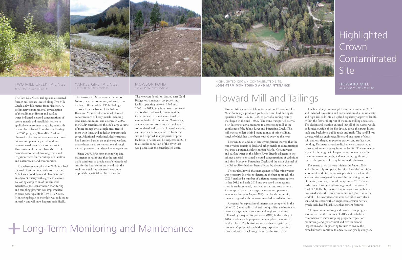
Howard Mill and Tailings Howard Mill, about 30 kilometres south of Nelson in B.C.’s West Kootenays, produced gold, silver, and lead during its operation from 1937 to 1938, as part of a mining history that began in the mid-1800s. The mine transported ore via a 7.5 kilometre aerial tramway to a processing mill at the confluence of the Salmo River and Porcupine Creek. The mill operation left behind many tonnes of mine tailings, much of which has since been washed away by the river.
Between 2009 and 2013 site investigations showed that the mine wastes contained lead and other metals at concentrations that pose a potential risk to human health. Groundwater and surface water in the Salmo River directly adjacent to the tailings deposit contained elevated concentrations of cadmium and zinc. However, Porcupine Creek and the main channel of the Salmo River had not been affected by the mine wastes.
The results showed that management of the mine wastes was necessary. In order to determine the best approach, the CCSP analyzed a number of different management options in late 2012 and early 2013 and evaluated them against specific environmental, practical, social, and cost criteria. A conceptual plan to manage the wastes was presented at an open house in August 2013, and local community members agreed with the recommended remedial option.
A request for expression of interest was completed in the fall of 2013 to establish a shortlist of qualified environmental waste management contractors and engineers, and was followed by a request for proposals (RFP) in the spring of 2014 to select a sole proponent to complete the remedial works. The RFP submissions were evaluated against each proponent’s proposed methodology, experience, project team and price, in selecting the successful contractor.
The final design was completed in the summer of 2014 and included excavation and consolidation of all mine wastes and high-risk soils into an upland regulatory approved landfill within the former footprint of the mine milling operations. The design and location ensured that all of the wastes would be located outside of the floodplain, above the groundwater table and back from public roads and trails. The landfill was covered with an engineered liner and one metre of clean soil, and was shaped to prevent erosion and surface water ponding. Perimeter diversion ditches were constructed to convey surface water away from the landfill. The cumulative effect of this design will keep water out of contact with the mine wastes and soils, and as a result, significantly restrict the potential for any future acidic drainage.
The remedial works were initiated in August 2014 and substantially completed by mid-November. A minor amount of work, including tree planting in the landfill area and site re-vegetation across the remaining portions of the site, was delayed until the spring of 2015 due to early onset of winter and frozen ground conditions. A total of 6,000 cubic metres of mine wastes and soils were excavated across the former mine site and placed into the landfill. The excavated areas were backfilled with clean soil and protected with an engineered erosion barrier, which included fish habitat enhancement features.
A long-term monitoring and maintenance program was initiated in the summer of 2015 and includes a comprehensive water sampling program, vegetation monitoring, and geotechnical and environmental inspections of all engineering features to ensure the remedial works continue to operate as originally designed.
HIGHLIGHTED CROWN CONTAMINATED SITE: LONG-TERM MONITORING AND MAINTENANCE
49º 15’ 46” N, 117º 12’ 32” WHOWARD MILL
Highlighted Crown Contaminated Site
Long-Term Monitoring and Maintenance
CROWN CONTAMINATED SITES PROGRAM | 2016 BIENNIAL REPORT 2524
Program Site StatisticsWhen it was established in 2003, British Columbia’s Crown Contaminated Sites Program (CCSP) inherited a legacy of contaminated sites – land, water, and air – from previous times when the impacts of industrial development were not well managed. Compounding the problem, information on many of these sites was wanting, opening questions such as which were the most highly contaminated, which required immediate attention, and what kinds of remediation would be needed.
This situation required two main efforts: a system for gathering information and ranking the urgency of the sites, and action on each site.
Since the initiation of the CCSP, a tremendous amount of progress has been made. To date, we have identified and managed risks to human health and the environment at sites across the province. Our innovative and flexible approach has created a comprehensive and coordinated government-wide framework for managing contaminated sites on publicly owned lands.
Since the program was established in 2003, leadership has been demonstrated in:
• Using a risk-based approach to assess and prioritize sites and protect ecological health;
• Improving the information available on contaminated sites through site research and an electronic database of sites and activities related to them;
• Reporting regularly to government and the public on the progress of work and the financial administration of contaminated sites;
• Working collaboratively with First Nations, communities, environmental organizations, and other levels of government to tackle problems together.
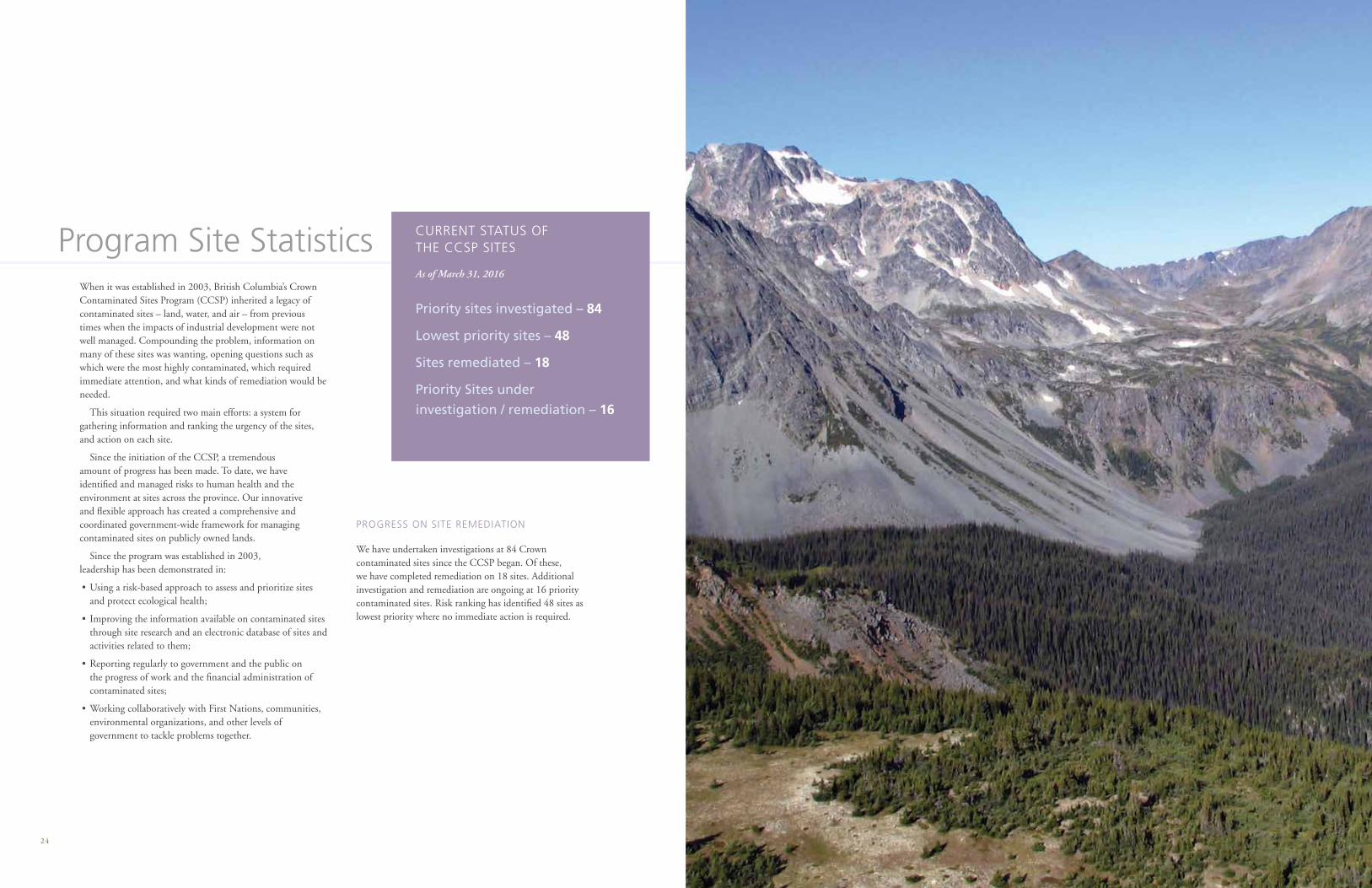
PROGRESS ON SITE REMEDIATION
We have undertaken investigations at 84 Crown contaminated sites since the CCSP began. Of these, we have completed remediation on 18 sites. Additional investigation and remediation are ongoing at 16 priority contaminated sites. Risk ranking has identified 48 sites as lowest priority where no immediate action is required.
As of March 31, 2016
CURRENT STATUS OF THE CCSP SITES
Priority sites investigated – 84
Lowest priority sites – 48
Sites remediated – 18
Priority Sites under
investigation / remediation – 16
Crown Contaminated Sites Program
LNG, Crown Land Opportunities and Restoration Branch
Ministry of Forests, Lands and Natural Resource Operations
PROTECTING HUMAN HEALTH AND THE ENVIRONMENT BY RETURNING LAND TO A CLEAN AND USABLE STATE