Embed Size (px)
Citation preview
Adv. Geosci., 30, 39–44, 2011www.adv-geosci.net/30/39/2011/doi:10.5194/adgeo-30-39-2011© Author(s) 2011. CC Attribution 3.0 License.
Advances inGeosciences
Crop evapotranspiration estimation using remote sensing and theexisting network of meteorological stations in Cyprus
G. Papadavid1,2, D. Hadjimitsis1, S. Michaelides3, and A. Nisantzi1
1Department of Civil Engineering and Geomatics, Remote Sensing Laboratory, Cyprus University of Technology,Lemesos, Cyprus2Cyprus Agricultural Research Institute, Nicosia, Cyprus3Meteorological Service, Nicosia, Cyprus
Received: 13 September 2010 – Revised: 27 January 2011 – Accepted: 10 March 2011 – Published: 9 May 2011
Abstract. Cyprus is frequently confronted with severedroughts and the need for accurate and systematic data oncrop evapotranspiration (ETc) is essential for decision mak-ing, regarding water irrigation management and scheduling.The aim of this paper is to highlight how data from meteoro-logical stations in Cyprus can be used for monitoring anddetermining the country’s irrigation demands. This papershows how daily ETc can be estimated using FAO Penman-Monteith method adapted to satellite data and auxiliary me-teorological parameters. This method is widely used in manycountries for estimating crop evapotranspiration using auxil-iary meteorological data (maximum and minimum temper-atures, relative humidity, wind speed) as inputs. Two casestudies were selected in order to determine evapotranspira-tion using meteorological and low resolution satellite data(MODIS – TERRA) and to compare it with the results ofthe reference method (FAO-56) which estimates the refer-ence evapotranspiration (ETo) by using only meteorologicaldata. The first approach corresponds to the FAO Penman-Monteith method adapted for using both meteorological andremotely sensed data. Furthermore, main automatic meteo-rological stations in Cyprus were mapped using Geograph-ical Information System (GIS). All the agricultural areas ofthe island were categorized according to the nearest meteoro-logical station which is considered as “representative” of thearea. Thiessen polygons methodology was used for this pur-pose. The intended goal was to illustrate what can happen toa crop, in terms of water requirements, if meteorological dataare retrieved from other than the representative stations. Theuse of inaccurate data can result in low yields or excessive ir-
Correspondence to:G. Papadavid([email protected])
rigation which both lead to profit reduction. The results haveshown that if inappropriate meteorological data are utilized,then deviations from correct ETc might be obtained, leadingto water losses or crop water stress.
1 Introduction
Evapotranspiration is referred to as the combination of twodifferent processes: on the one hand, water is lost from thesoil and plant surfaces by evaporation; on the other hand, wa-ter is lost from the crop by transpiration (FAO, 1998). Theactual estimation and calculation of evapotranspiration is ofvital importance in water resource management and deter-mination of irrigation demand (Boegh and Soegaard, 2004;Hoedjes et al., 2008). Reference evapotranspiration (ETo)can be calculated by using meteorological data and typicalreference crops with specialized instruments, such as lysime-ters (Courault et al., 2005; Hadjimitsis et al., 2008).
Estimation of evapotranspiration combining conventionalmeteorological ground measurements with remotely-senseddata has been also widely investigated (Allen, 1996, 2000).Several methods using various satellite data have been de-veloped, as shown by Gieske and Wouter (2005) using lowresolution NOAA images, Papadavid et al. (2009), Hafeez etal. (2002), Sobrino et al. (2004), Qin and Karnieli (2001) us-ing medium resolution Landsat/ETM+ satellite images andFrench et al. (2001) using ASTER satellite images. De-spite the variety of methods for determining the evapotran-spiration for irrigation purposes, local authorities or govern-mental offices require a simplified and quick approach. In-deed, the use of meteorological data acquired from nearbymeteorological stations can be used for such purposes, in
Published by Copernicus Publications on behalf of the European Geosciences Union.
40 G. Papadavid et al.: Crop evapotranspiration estimation
combination with other existing tools, such as satellite re-mote sensing. Currently, several researchers recommend abreadth of mathematical equations and modelling (Menentiet al., 1989; D’Urso and Menenti, 1995; Bastiaanssen et al.,1998; Bastiaanssen and Ali, 2003). The methods of esti-mating ETc are generally classified as: (a) energy balancemethods, (b) aerodynamic or mass transfer methods, (c) em-pirical or semi-empirical methods, (d) water depletion meth-ods and (e) numerical or modeling methods (Eliadis et al.,1995; Metochis, 1997). The analysis of the performance ofthese models revealed the need for formulating a standardmethod for the computation of ETo (Tsouni and Koutsogian-nis, 2003; Hoedjes et al., 2008). The FAO-56 method, whichwas derived from the Penman-Monteith equation, has re-cently been recommended as the sole standard method (Telisand Koutsogiannis, 2007); this a method with strong like-lihood of correctly predicting ETo in a wide range of loca-tions and climates (D’ Urso and Menenti, 1995; Aaron et al.,1996).
The paper has the following two objectives:
1. To highlight how meteorological data can reduce the ac-curacy in estimating ETc, if they are taken from stationsthat are located beyond a critical distance; the intendedpurpose is to show that other than the area’s meteorolog-ical data could cause problems in irrigation schedulingwhich could lead to crop health related problems.
2. To propose a methodology for choosing the nearest me-teorological station for meteorological data acquisitionregarding hydrological purpose studies and more specif-ically for estimating evapotranspiration.
2 Data and methodology
In the first part of this study, the FAO Penman-Monteithmethod adapted to satellite data is used to estimate potatoes’ETc and then compare it to FAO-56. In the second part, theaccuracy of the former method is evaluated by incorporatingmeteorological data from other meteorological stations es-tablished on the island. For this purpose, Cyprus is dividedinto five geographical areas in accordance with the distancefrom the main five meteorological stations of the island. Twocase studies are selected in order to check the impact of “non-correct” (i.e. less representative) meteorological data on ETc.
2.1 Case studies
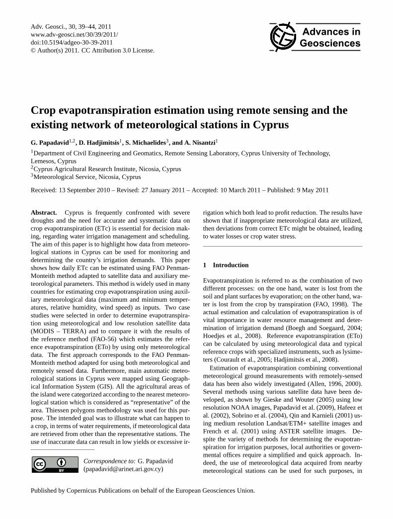
Mandria and Kokkinochoria, the main irrigated areas of theisland of Cyprus, have been used as pilot study areas (Fig. 1).For these areas crop evapotranspiration was determined us-ing both meteorological and satellite data. The selected areasare traditionally agricultural with a diversity of annual culti-vations. The areas are flat and at almost sea level, while thesurface can be considered as homogenous.
1
2
3
4
5
6
7
Fig 1. Landsat TM image of Cyprus: Mandria (left) and Kokkinochoria (right) area.
Fig 2. Crop evapotranspiration using meteorological and satellite data.
12
Fig. 1. Landsat TM image of Cyprus: Mandria (left) andKokkinochoria (right) area.
2.2 Resources
In order to estimate evapotranspiration using FAO Penman-Monteith method adapted to satellite data, auxiliary meteoro-logical data from Paphos’s airport automatic meteorologicalstation were used. The data include air temperature, atmo-spheric pressure, wind speed, among other meteorologicalparameters. Moreover, 14 low resolution MODIS Terra im-ages were used, dating from 25 January 2009 to 9 May 2009.These data were used to retrieve the surface albedo (MODISalbedo maps) from surface reflectance bands of MODIS. De-spite the fact that these images have very low spatial reso-lution, MODIS images pass over Cyprus every day and canassist in the estimation of evapotranspiration on a regular ba-sis.
For the second objective of the paper, three Landsat TMand ETM+ images have been used. ETc was calculatedfor Mandria and Kokkinochoria area using data from the“proper” (implying the closest to the area) and “non-proper”meteorological stations, in order to test the reliability of us-ing data from any meteorological station.
2.3 Methodology
FAO method adapted to satellite data was used to estimateETc. The use of both satellite and meteorological data arerequired to employ the method. The specific equation whichis used to estimate ETc, under certain conditions (see below),is based on the direct application of the Penman-Monteithequation with canopy parameters estimated from satellite im-agery. Air temperature, atmospheric pressure, wind speedand other data were collected from meteorological stationslocated next to areas of interest. Equation (1) shows howETc can be estimated using the mentioned above method.
ETc= (1)
86 400
λ
[s(1−0.4e−0.5 LAI
)(1−a)(K ↓ +L∗)+cppa (es −ea)U/124
s +γ (1+U/0.62 LAI)
]
Adv. Geosci., 30, 39–44, 2011 www.adv-geosci.net/30/39/2011/

G. Papadavid et al.: Crop evapotranspiration estimation 41
1
2
3
4
5
6
7
Fig 1. Landsat TM image of Cyprus: Mandria (left) and Kokkinochoria (right) area.
Fig 2. Crop evapotranspiration using meteorological and satellite data.
12
Fig. 2. Crop evapotranspiration using meteorological and satellitedata.
whereK ↓ is the incoming solar radiation andU the windspeed; the other variables, namelyL∗ (net longwave radia-tion), cp (air specific heat),ρa (air density),(es-ea) (vapourpressure deficit),λ (latent heat of vaporisation of water)α isthe albedo derived directly from MODIS maps,s is the slopevapour pressure curve andγ (thermodynamic psychrometricconstant) are calculated from air temperature and humidityat 2.0 m reference height. This equation is valid under con-ditions of high solar irradiance (typical summer condition inMediterranean climate) and for LAI>0.5 (LAI is the LeafArea Index), which is the case for Cyprus’ annual crops. Forthe calculation of LAI, an empirical exponential equation forCyprus’ conditions and especially for annual crops was used:
LAI = 0.004e11.8×WDVI (2)
where WDVI is the Weighted Difference Vegetation Index(Clevers, 1988). The equation is proposed by Papadavidand Hadjimitsis (2009), after correlating LAI to many veg-etation indices and choosing the one with the strongest de-termination coefficient (r2). Satellite data, such as LAI andalbedo maps, have been derived from satellite imagery fromLandsat, using simplified methods (D’Urso and Menenti,1995). For deriving albedo, Liang’s equation was used(Liang, 2000).
After inferring the necessary inputs for the FAO modeladapted to satellite data, the model is applied for retrievingETc values from the satellite data. Cetris paribus, but chang-ing the albedo value and the value of WDVI, ETc values foreach date were estimated and compared.
Thiessen polygons can be used to describe the area of in-fluence of a point against other points. If one takes a setof points and connects each point to its nearest neighbour,then a triangulated irregular network is obtained (Collins andBolstad, 1996); closed polygons are created by generatingperpendicular bisectors for each triangle edge. The locationsat which of the bisectors intersect determine the locations ofthe Thiessen polygon vertices. The area contained in eachpolygon is closer to the point on which the polygon is based
1
2
3
4
5
6
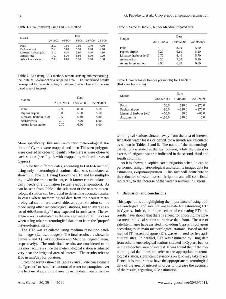
Fig 3. Cyprus division according to Thiessen methodology.
Table 1. ETo (mm/day) using FAO-56 method.
Date
Station 20/11/03 05/8/04 13/8/08 23/7/09 25/9/09
Polis 2.50 7.50 7.50 7.40 4.50
Paphos airport 2.60 5.80 5.50 6.70 4.60
Limassol harbour (old) 2.10 6.10 5.90 6.40 4.90
Astromeritis 1.60 6.30 6.60 8.10 5.20
Achna forest station 2.30 6.00 5.90 8.10 5.30
7
8
13
Fig. 3. Cyprus division according to Thiessen methodology.
than to any other point in the dataset (Burrough, 1986). Forthe purposes of this study, Thiessen methodology was em-ployed to divide Cyprus geographically according to the dis-tance from the five main meteorological stations situated inthe territory of the island.
Finally, after dividing Cyprus in five territories, two pi-lot study areas were considered. In both areas, the analy-sis used data from all the meteorological stations situated allover the island of Cyprus and assesses the accuracy of themethod when meteorological data from distance stations areincluded.
3 Results
3.1 ETc comparison
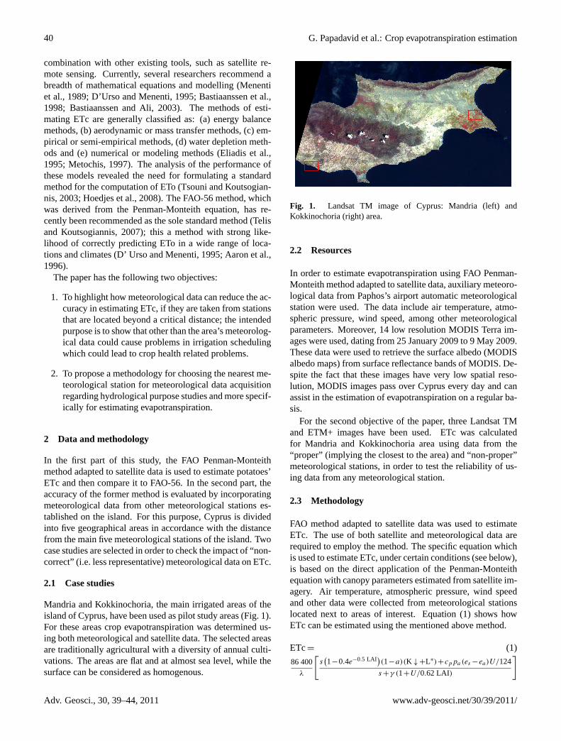
FAO Penman-Monteith method for estimating crop evapo-transpiration (ETc), has been applied using MODIS satellitedata and meteorological records. The final results have beentabulated and shown in Fig. 2. These results were comparedto the FAO-56 method using only meteorological data andusing a single crop coefficient for potatoes (Kc). It is ob-vious that ETc sourcing from MODIS and meteorologicaldata is always less than that of the FAO. The reason for thiscould be the low resolution of MODIS pixel. The differenceis insignificant but to increase accuracy of the methodologythe FAO-56 (using only meteorological data and crop coeffi-cient) method will be used when estimating ETc, for the restof the study.
3.2 Thiessen polygons
In order to determine the suitability of the meteorological sta-tions for estimating ETc, a spatial analysis called Thiessenpolygons was applied (Burrough and McDonnell, 1998).
www.adv-geosci.net/30/39/2011/ Adv. Geosci., 30, 39–44, 2011
42 G. Papadavid et al.: Crop evapotranspiration estimation
Table 1. ETo (mm/day) using FAO-56 method.
StationDate
20/11/03 05/8/04 13/8/08 23/7/09 25/9/09
Polis 2.50 7.50 7.50 7.40 4.50Paphos airport 2.60 5.80 5.50 6.70 4.60Limassol harbour (old) 2.10 6.10 5.90 6.40 4.90Astromeritis 1.60 6.30 6.60 8.10 5.20Achna forest station 2.30 6.00 5.90 8.10 5.30
Table 2. ETc using FAO method, remote sensing and meteorolog-ical data at Kokkinochoria irrigated area. The underlined resultscorrespond to the meteorological station that is closest to the irri-gated area of interest.
StationDate
20/11/2003 13/08/2008 25/09/2009
Polis 2.90 8.00 5.10Paphos airport 3.00 5.90 5.10Limassol harbour (old) 2.50 6.40 5.80Astromeritis 2.10 7.20 6.00Achna forest station 2.70 6.30 6.00
More specifically, five main automatic meteorological sta-tions of Cyprus were mapped and then Thiessen polygonswere created in order to identify which areas were closer toeach station (see Fig. 3 with mapped agricultural areas ofCyprus)
ETo for five different dates, according to FAO-56 method,using only meteorological stations’ data was calculated asshown in Table 1. Having known the ETo and by multiply-ing it with the crop coefficient, each farmer can calculate thedaily needs of a cultivation (actual evapotranspiration). Ascan be seen from Table 1 the selection of the nearest meteo-rological station can be crucial to determine accurate results.In cases where meteorological data from the nearest mete-orological station are unavailable, an approximation can bemade using other meteorological stations, but an average er-ror of ±0.45 mm day−1 may expected in such cases. The av-erage error is estimated as the average value of all the caseswhen using other meteorological data than from the ‘proper’meteorological station.
The ETc was calculated using medium resolution satel-lite images (Landsat images). The final results are shown inTables 2 and 3 (Kokkinochoria and Mandria irrigated areas,respectively). The underlined results are considered to bethe most accurate since the meteorological station is situatedvery near the irrigated area of interest. The results refer toETc in mm/day for potatoes.
From the results shown in Tables 2 and 3, one can estimatethe “greater” or ‘smaller’ amount of water consumption overone hectare of agricultural area by using data from other me-
Table 3. Same as Table 2, but for Mandria irrigated area.
StationDate
20/11/2003 13/08/2008 25/09/2009
Polis 3.10 8.00 5.00Paphos airport 3.20 6.10 5.10Limassol harbour (old) 2.70 6.40 5.70Astromeritis 2.30 7.20 5.90Achna forest station 2.90 6.30 6.00
Table 4. Water losses (tonnes per month) for 1 hectare(Kokkinochoria area).
StationDate
20/11/2003 13/8/2008 25/9/2009
Polis 60.0 510.0 −270.0Paphos airport 90.0 −120.0 −270.0Limassol harbour (old) −60.0 30.0 −60.0Astromeritis −180.0 270.0 0.0
teorological stations situated away from the area of interest.Irrigation water losses or deficit for a month are calculatedas shown in Tables 4 and 5. The name of the meteorologi-cal stations is stated in the first column, while the deficit orexcess of irrigated water is indicated in the second, third andfourth columns.
As it is shown, a sophisticated irrigation schedule can beperformed using meteorological and satellite images data forestimating evapotranspiration. This fact will contribute tothe reduction of water losses in irrigation and will contribute,indirectly, to the increase of the water reservoirs in Cyprus.
4 Discussion and conclusions
This paper aims at highlighting the importance of using bothmeteorological and satellite image data for estimating ETcin Cyprus. Indeed, in the procedure of estimating ETc, theresults have shown that there is a need for choosing the clos-est meteorological station to retrieve data from. The use ofsatellite images have assisted in dividing Cyprus in polygonsaccording to its main meteorological stations. Based on thismethod (Thiessen polygons) ETc was estimated for five agri-cultural sites. In parallel, ETc was estimated by using datafrom other meteorological stations situated in Cyprus, but notin the respective area of interest. It was found that if the me-teorological data does not refer to the appropriate meteoro-logical station, significant deviations on ETc may take place.Hence, it is important to have the appropriate meteorologicaldata of the area of interest in order to increase the accuracyof the results, regarding ETc estimation.
Adv. Geosci., 30, 39–44, 2011 www.adv-geosci.net/30/39/2011/

G. Papadavid et al.: Crop evapotranspiration estimation 43
Table 5. Water losses (tonnes per month) for 1 hectare (Mandriaarea).
StationDate
20/11/2003 13/8/2008 25/9/2009
Polis 60.0 510.0 −270.0Paphos airport 90.0 −120.0 −270.0Limassol harbour (old) −60.0 30.0 −60.0Astromeritis −180.0 270.0 0.0
Determination of evapotranspiration using both meteoro-logical and satellite remote sensing data is planned for furtherfuture research. Furthermore, other methods for estimatingirrigation demand will be evaluated in the near future.
Acknowledgements.The authors would like to express theirappreciation to Cyprus Research Promotion Foundation(www.research.org.cy), the European Union and the CyprusUniversity of Technology for their funding support. Thanks aregiven to the Remote Sensing Laboratory of the Department of CivilEngineering & Geomatics at the Cyprus University of Technology(www.cut.ac.cy).
Edited by: S. AthanasatosReviewed by: two anonymous referees
References
Aaron, M., Beutler, B.S., and Keller, A.: Implementation of FAO-56 Penman-Monteith evapotranspiration in a large scale irriga-tion scheduling, Water and Environmental Resources Congress,Alaska, 1996.
Allen, R. G.: Assessing integrity of weather data for use in referenceevapotranspiration estimation, Irrig. Drain., ASCE 122, 97-106,1996.
Allen, R. G., Pereira, L. S., Raes, D., and Smith, M.: Crop evapo-transpiration, Irrig. Drain. 56, 2000.
Bastiaanssen, W. G. M., Menenti, M., Feddes, R. A., and Holtslag,A. A. M.: A remote sensing surface energy balance algorithm forland (SEBAL), Part 1: formulation, J. Hydrol., 212–213, 198–212, 1998.
Bastiaanssen, W. G. M. and Ali, S.: A new crop yield forecastingmodel based on satellite measurements applied across the IndusBasin, Pakistan, Agriculture, Ecosystems and Environment, 94,321–340, 2003.
Boegh, E. and Soegaard, H.: Remote Sensing based estimation ofEvapotranspiration rates, Int. J. Remote Sens., 25, 2535–2551,2004.
Burrough, P. A.: Principles of Geographical Information Systemsfor Land Resource Assessment, New York, Oxford UniversityPress, 1986.
Burrough, P. A. and McDonnell, R. A.: Principles of GeographicalInformation Systems, New York, Oxford University Press, 1998.
Clevers, J. G. P. W.: The derivation of a simplified reflectance modelfor the estimation of leaf area index, Remote Sens. Environ., 35,53–70, 1988.
Collins, F. C. and Bolstad, P. V.: A comparison of spatial inter-polation techniques in temperature estimation, in: Proceedingsof the Third International Conference/Workshop on IntegratingGIS and Environmental Modeling, Santa Fe, New Mexico, 21–25 January, 1996.
Courault, D., Seguin, B., and Olioso, A.: Review on estimation ofEvapotranspiration from remote sensing data: from empirical tomodeling approaches, Irrig. Drain., 19, 223–249, 2005.
D’Urso, G. and Menenti, M.: Mapping crop coefficients in irrigatedareas from Landsat TM images; Proceed, Opt. Eng., 2585, 41–47, 1995.
Eliadis, G., Metochis, C., and Papachristodoulou, S.: Technoe-conomic analysis of irrigation in Cyprus, Cyprus AgriculturalResearch Institute Series, Ministry of Agriculture, Natural Re-sources and Environment Publications, Cyprus, Nicosia, 1995.
FAO: Crop evapotranspiration, Guidelines for computing crop wa-ter requirements, FAO Irrigation and Drainage Paper No. 56,Food and Agriculture Organization of the United Nations, 1998.
French, A. N., Schmugge, T. J., and Kustas, W. P.: Estimating evap-otranspiration with ASTER thermal infrared imagery, Journal ofGeoscience and Remote Sensing Symposium, 2, 718–720, 2001.
French, A. N., Hunsaker, D., Thorp, K., and Clarke, T.: Evapotran-spiration over a camelina crop at Maricopa, Arizona, INDCRO5170, 2008.
Gieske, A. and Wouter M.: High density NOAA time series of ETin the Gediz Basin, Turkey, Journal of Irrigation and DrainageSystems, 19, 285–299, 2005.
Hadjimitsis, D. G., Papadavid, G., and Kounoudes, A.: Integratedmethod for monitoring irrigation demand in agricultural fields inCyprus using satellite remote sensing and wireless sensor net-work, 4th International Conference on Information & Commu-nication Technologies in Bio & Earth Sciences, Athens, Greece,2008.
Hafeez, M. M., Chemin, Y., Van De Giesen, N., Bouman, B. A. M.:Field Evapotranspiration Estimation in Central Luzon, Philip-pines, Using Different Sensors: Landsat 7 ETM+, Terra Modisand Aster, In Proc. Symposium on Geospatial Theory, Process-ing and Applications, Ottawa, 2002.
Hoedjes, J. C. B., Chehbouni, A., Jacob, F., Ezzahar, J., and Boulet,G.: Deriving daily Evapotranspiration from remotely sensedevaporative fraction over olive orchard in Morocco, J. Hydrol.,53–64, 2008.
Liang S.: Narrowband to broadband conversions of land surfacealbedo: I Algorithms, Remote Sens. Environ., 78, 213–238,2000.
Menenti, M., Visser, T. N. M., Morabito, J. A., and Drovandi, A.:Appraisal of irrigation performance with satellite data and geo-referenced information, Irrigation Theory and Practice, 785–801,1989.
Metochis, C.: Assessment of irrigation water needs of main crops ofCyprus., Cyprus Agricultural Research Institute Series, Ministryof Agriculture, Natural Resources and Environment, Nicosia,1997.
Papadavid, G., Agapiou, A., Hadjimitsis, D., Themistocleous,K.: Estimating Evapotranspiration of spring potatoes in Paphos,Cyprus using remote sensing, spectroradiometric and meteoro-
www.adv-geosci.net/30/39/2011/ Adv. Geosci., 30, 39–44, 2011

44 G. Papadavid et al.: Crop evapotranspiration estimation
logical data, Remote Sensing and Photogrammetry Society An-nual Conference 2009, “New Dimensions in Earth Observation”,Leicester, 8–11 September 2009, 2009.
Qin, Z. and Karnieli, A.: A mono-window algorithm for retrievingland surface temperature from Landsat TM data and its applica-tion to the Israel-Egypt border region, Int. J. Remote Sens., 22,3719–3746, 2001.
Sobrino, J. A., Jimenez-Munoz, J. C., and Paolini, L.: Land surfacetemperature retrieval from LANDSAT TM 5, J. Remote Sens.Environ., 90, 434–440, 2004.
Telis, A. and Koutsogiannis, D.: Estimation of Evapotranspirationin Greece, PhD Thesis, Univ. of Athens, 2007.
Tsouni, A. and Koutsogiannis, D.: The contribution of remote sens-ing techniques to the estimation of Evapotranspiration: the caseof Greece, PhD Thesis, Univ. of Athens, 2003.
Adv. Geosci., 30, 39–44, 2011 www.adv-geosci.net/30/39/2011/