Embed Size (px)
Citation preview
Crook Hill Wind Farm Archaeological Works
Written Scheme of Investigation
(Prehistoric)
Initial Draft for Comment
CFA ARCHAEOLOGY LTD
Unit 22 Moorlands Business Centre
Balme Road Cleckheaton BD19 4EZ
Tel: 01274 864 245 Fax 01274 878 494
email: [email protected]
web: www.cfa-archaeology.co.uk
Crook Hill Wind Farm Archaeological Works
Written Scheme of Investigation (Prehistoric)
Initial Draft for Comment
Author Martin Lightfoot BA MA MIfA Date issued March 2013 Version 1.2 Draft Planning Applications D54145 (Rochdale) 2011/0030 (Rossendale) 1100080/WDF (Calderdale) Grid Ref. SD 9245 1941 (centered)
Crookhill Wind Farm: Archaeological Evaluation
CROK/WSI1/1.2 2 CFA
21 March 2013 Contents 1. INTRODUCTION .............................................................................................. 3
2. PROJECT BACKGROUND .............................................................................. 3
3. OBJECTIVES ..................................................................................................... 6
4. PROPOSED ARCHAEOLOGICAL WORK ..................................................... 6
5. METHOD STATEMENT ................................................................................... 8
6. RESOURCES ................................................................................................... 11
7. REFERENCES ................................................................................................. 13
Appendix: Project Brief Figures 1-3: Site location and proposed layout
Crookhill Wind Farm: Archaeological Evaluation
CROK/WSI1/1.2 3 CFA
1. INTRODUCTION A programme of archaeological works is required as a condition of planning prior to the construction of a wind farm at Crook Hill. This written scheme of investigation (WSI) deals with archaeological remains relating to the prehistoric and in particular the Mesolithic period. The medieval and later elements is be dealt with by separate WSI. All work will be undertaken in accordance with relevant standards and guidance; method statements for the work appear below. 2. PROJECT BACKGROUND 2.1 Planning Background The development scheme is for 12 turbines; 7 located within Rochdale (Greater Manchester), and 5 within Calderdale (West Yorkshire), a temporary construction compound, crane hard standing, new access tracks, an anemometry mast and permanent switchgear/control substation. Access is from the A671 at Shawforth, along Landgate, through ‘Middle Hill Quarry’ and over ‘Rough Hill’ (Rossendale). It is not as shown on the figure accompanying the brief (Appendix) rather as figures 1-3 of this WSI. The work described below relates to those figures. Planning permission D54145 (Rochdale) was granted on 23 June 2011, subject to planning conditions which included archaeology (Condition 17). Planning permission 1100080/WDF (Calderdale) was granted on20 October 2011, subject to planning conditions which included archaeology (Condition 14). Planning permission 2011/0030 (Rossendale) was granted on 1 November 2011, subject to planning conditions which included archaeology (Condition 12). The wording for all three archaeological conditions was as follows.
‘No development shall take place until the applicant has secured the implementation of a programme of archaeological work in accordance with a written scheme of investigation which has been submitted by the applicant and approved in writing by the loca1 planning authority. -In the event of any previously unidentified or disclosed archaeological remains being found during the course of the development, any works that may affect those said remains shall cease until an archaeological recording/preserving programme has been approved in writing with the local planning authority. The development shall then only proceed in accordance with the details of that approved recording/preserving programme.’
Greater Manchester Archaeological Advisory Service (GMAAS) were approached by West Yorkshire Archaeological Advisory Service (WYAAS) to lead on the provision of an archaeological evaluation brief for the development area in both authorities. The brief outlined a required programme of archaeological works. This written scheme of investigation is a response to the brief which seeks to satisfy the terms of the planning condition and the National Planning Policy Framework (NPPF). Relevant paragraphs of the NPPF are: 128: ‘In determining applications, local planning authorities should require an
applicant to describe the significance of any heritage assets affected, including
Crookhill Wind Farm: Archaeological Evaluation
CROK/WSI1/1.2 4 CFA
any contribution made by their setting. The level of detail should be proportionate to the assets’ importance and no more than is sufficient to understand the potential impact of the proposal on their significance. As a minimum the relevant historic environment record should have been consulted and the heritage assets assessed using appropriate expertise where necessary. Where a site on which development is proposed includes or has the potential to include heritage assets with archaeological interest, local planning authorities should require developers to submit an appropriate desk-based assessment and, where necessary, a field evaluation.’
and;
141: ‘Local planning authorities should make information about the significance of the
historic environment gathered as part of plan making or development management publicly accessible. They should also require developers to record and advance understanding of the significance of any heritage assets to be lost (wholly or in part) in a manner proportionate to their importance and the impact, and to make this evidence (and any archive generated) publicly accessible.’
2.2 Site Description The proposed wind farm development site lies within the Metropolitan Boroughs of Rochdale, Rossendale and Calderdale (Fig. 1, centred on NGR SD 9245 1941), on upland hills with areas of boggy peat moorland. The site is generally hilly to the north with steep slopes to the, between 350 and 400m above the Ordnance Datum (AOD), with a high point at Rough Hill in the north-west at 435m AOD. 2.3 Geology and Soils The underlying solid geology is Pennine Lower Coal Measures Formation consisting of ‘Mudstone, Siltstone and Sandstone’ (BGS 2013). The soils covering the development area comprise predominantly soils of the Wilcocks 1 Association (SSEW 1983, 712c) on the lower ground in the south of the site (marked by a peaty upper horizon) and raised bog peat of the Longmoss Association in the hilly north; the north of the site is covered by blanket peat Largely undrained and perennially wet. Many areas area cut over or partly burnt. (SSEW 1983, 1011a). 2.4 Archaeological and Historical Background The following is a brief summary of the archaeological and historical background of the site and the immediate surrounding area relating to prehistoric periods: more detailed background information may be found in the environmental statement (Dulas 2008 and 2011) and the brief. Sites referred to are those from the environmental statement. Mesolithic Period (8000 - 3500 BC) The Mesolithic in Britain covers approximately the period 8000 – 3500 BC, starting broadly from the end of the glacial Pleistocene Epoch and the beginning of the more temperate Holocene. As the climate changed so did the range of animals hunted by humans change and flint tools changed to reflect this, with microliths being developed
Crookhill Wind Farm: Archaeological Evaluation
CROK/WSI1/1.2 5 CFA
for hafting onto weapons such as harpoons and arrows. The manufacture of flint tools produced waste material and once the tools became redundant, they were discarded onto the contemporary ground surface. Mesolithic settlements are generally considered to have been seasonal and usually occupied for a short period of time. The development area contains flint findspots suggesting activity from the Mesolithic period onwards (Sites 1-7, 9, 10, 13, 15 and 41). The Mesolithic artefacts derive from horizons, dated c. 8300-5000 BC, sealed under the blanket peat, which has its origins in major vegetation changes in later prehistory. The updated environmental statement (DULAS 2011) records 19 Mesolithic flint scatters, located within the redline boundary of the development area. It states that:
‘Individually these find spots are of local importance, however given the relative density of these sites and the fact that they represent flint scatters as opposed to single flint finds, these sites have a Group Value which is at least of regional and potentially national importance. In the wider context the Central Pennine uplands play a key role in the study of the Mesolithic and the clusters of sites in the region shows the highest density of known upland Mesolithic sites in the world (Spikins 2010, 2).’
The environmental statement goes on to note that Mesolithic material is known close to the proposed locations of Turbine 1 (Site 1), Turbine 4 (Site 41), Turbine 6 (Site 211) and that should major deep excavation (greater than 2 m) be necessary on the peat-covered upland areas, it is possible that evidence of Mesolithic activity evidence may be disturbed. Neolithic Period (3500 - 2000 BC) The Neolithic period was characterised by increasing sophistication of farming techniques, land clearance and the construction of substantial earthwork monuments such as causewayed enclosures and earthen and stone long barrows. There are also findspots of arrowheads of Neolithic and Bronze Age date at Shore Moor (Site 14) and Middle Hill (Site 76). Bronze Age (2000 – 700 BC) This period is characterised by increasingly large-scale agriculture and social organisation, with distinctive pottery such as Beaker pottery forms. The land began to be cleared and exploited more intensively, particularly along the rivers, with increasingly recognisable land divisions, droveways and trackways. There are remains of a Bronze Age barrow at Hades Hill (Site 78) on the western edge of the proposed wind farm. Fragments of shale rings have been recovered from Snoddle Hill (Site 111) and Flint Hill (Site 113). Iron Age (700 BC – AD 71) and Romano-British (AD 71 – 410) There are no recorded findspot of Iron Age or Romano-British date in the area
Crookhill Wind Farm: Archaeological Evaluation
CROK/WSI1/1.2 6 CFA
2.5 Previous Archaeological Work The cultural heritage chapter of the environmental statement consisted of desk-based research and a walkover survey. Peat depth studies undertaken by SKM (2008) have indicated that the main peat region is to be found along the ridgeline from Crook Moor in the west to Great Hill in the east which corresponds with the greatest concentration of Mesolithic findspots. Peat probing was also carried out around the sites of the proposed wind turbines in order to assess the depth of these deposits, which may overlie prehistoric occupation surfaces. The depth of the peat was reported to be generally between 2.0 and 3.5m, though in some areas it had suffered erosion.
Turbine 4 – 2.45-2.55m; Turbine 6 – 2.2-2.8m; Turbine 7 – 2.9m; Turbine 8 – 2.0m; Intermediate point (SD 927 194) – 2.8m; Vicinity of Turbine 10 (SD928194) – 3.4m; Intermediate point (SD 929 191) – 0.3m; Intermediate point (SD 927 187) – 0.05m, and; Peat erosion area (SD 919 197) – 0.7 m+.
3. OBJECTIVES In accordance with the brief, the evaluation should be ‘...sufficient to assess...age, form, condition, significance and the impact of the proposals upon... significance’ (Appendix Section 3.2). Research objectives will be informed by the relevant research agendas and frameworks (e.g. EH 2010, Spikins 2010, Roskams and Whyman 2007 and Hodgson and Brennand 2007). The specific aims are to:
establish whether there are any archaeological deposits at the site and to ascertain the extent, depth below ground surface, depth of deposit, character, significance and condition of such deposits;
place any remains exposed in their wider setting and contribute to our understanding of the history of the region;
4. PROPOSED ARCHAEOLOGICAL WORK The following section summarises the further works proposed by the environmental statement (DULAS 2008 and 2011) and the brief (Appendix 1) and proposes work which will satisfy the terms of the planning condition (Section 2.1), current planning guidance (NPPF) and the objectives of the brief. In proposing further assessment the environmental statement draws from the ‘Research Agenda for Palaeolithic and Mesolithic West Yorkshire’ (Spikins 2010), suggesting that
Crookhill Wind Farm: Archaeological Evaluation
CROK/WSI1/1.2 7 CFA
‘efforts be concentrated’ on ‘south facing slopes on the plateau edge at 380-430m elevation’ and that these areas have ‘high probabilities for Mesolithic sites’. In her Palaeolithic and Mesolithic research agenda for West Yorkshire, Penny Spikins (2010, 23) makes the following observations on ‘upland sites’:
‘In locations where early prehistoric sites are known locally or are likely sampling should be intensive in order to generate a reasonable probability of encountering sites ... Sampling should include wet sieving for very tiny pieces of flint (microdebitage) as successfully used with large bore auger surveys to define the limits of sites at March Hill (Spikins 2002). A 10% sample is usually recommended. It may be recommendable to take large-scale samples and wet sieve industrially over large areas in order to define potential sites.’
The research agenda further states that ‘It is known that that Mesolithic flint scatters occur in the area at the base of peat (to a maximum of 10cm either side)’ and that ‘Given the possibility of very high integrity assemblages all finds should be piece plotted’ and that ‘Particular attention should be paid to burnt finds and their location and to any ephemeral traces of burning and its plotting. The environmental statement suggests ‘additional archaeological assessment’ of potential Mesolithic sites in areas where deep excavation (>2m) is necessary i.e. the turbine bases. It is suggested this assessment would take the form of ‘reconnaissance coring and palaeoenvironmental assessment’ or geophysical survey as appropriate. The brief (Appendix 1) suggests that that further work should not be confined to ‘areas of high probability for Mesolithic sites’ as suggested by the environmental statement (para. 10.9.1) and goes on to largely discount the usefulness of geophysical survey in identifying Mesolithic sites (para. 2.5). Section 3.2 (ii) of the brief states that:
‘Given the uncertainty inherent in the site grid references each site should be subject to a grid of hand-augered samples (150mm diameter), one in every m2 . This should allow the targeting of areas of concentration and define their extent. At least one test-pit should then be hand excavated to assess the artefact concentration.’
The brief goes on to recommend (3.2 iii):
‘Wider area evaluation sampling of the areas of development impact (1.3) should also be undertaken through test-pits located following the use of augering (150 mm diameter) on a 1m2 grid interval. Any proposals for structured sub-sampling of topographic / altitudinal zones would need to be specified in detail, discussed with and agreed by GMAAS as part of the written scheme of investigation.
The brief also recommends coring and palaeoenvironmental assessment of deep peats/ mineral soil (3.2 iv). Mesolithic Flint scatters
Crookhill Wind Farm: Archaeological Evaluation
CROK/WSI1/1.2 8 CFA
Such is the general lack of accuracy in the location of findspots of Mesolithic flint and the bias in the record towards prospection where peat has eroded (e.g. plateau edges), there is no meaningful distinction between ‘known findspots’ and ‘potential findspots’ in the context of the development footprint. The brief recognises this and treats both the same in proposing work (Section 3.2). Therefore they are treated the same in the following. It is known that the depth of peat at the locations of the turbine bases and along much of the access track is in excess of 2m and up to 3.5m deep. Potential Mesolithic flint scatters will not be affected by excavation within this depth, this includes for the majority; the crane pads and the access tracks. The only areas where deep excavation is proposed that is likely to affect sites below the blanket peat is at the turbine bases themselves. It is proposed therefore that no augering, test pitting or trenching will be undertaken in areas where construction will be comfortably within the peat layers. This is to ensure that potentially significant Mesolithic flint scatters (should they exist) are preserved in situ. 5. METHOD STATEMENT The following is an outline of a programme of proposed works designed to identify archaeological remains which may be directly affected by the development. Should further work be required in specific areas of the site then this would be governed by an addendum to this WSI, with supporting figures where necessary. 5.1 Stage 1: Peat Probing There is a need to more accurately understand the depth of peat across the whole development footprint in order to judge the potential effect of the construction on potential buried Mesolithic sites. Therefore a programme of peat probing would be undertaken to accurately model the depth of peat along the access roads, crane pads and at the turbine bases. A transect along each axis of the turbine bases and the crane pads and along the centre of access roads would be undertaken at an agreed interval. Geotechnical data would also be used in forming a model of the depths of peat across the site. 5.2 Stage 2: Further evaluation and Preservation in situ Once the detailed construction methodology and the depths to which the machine stripping is known, areas will be excluded from further archaeological work, allowing the preservation in situ of potential Mesolithic sites (i.e. where the overlying peat is thick enough to preserve potential archaeological layers should they exist). In areas where the peat is not thick enough to protect potential underlying Mesolithic sites then further evaluation may be necessary, for example where overlying peat coverage is thin or has eroded out. This may take the form of test pitting, or possibly geophysical survey, Ground Penetrating Radar (GPR) or augering should areas be determined to be suitable for these techniques. Such further work would be specific to defined areas, subject to agreement between the client, GMAAS and WYAAS and governed by an addendum to this WSI.
Crookhill Wind Farm: Archaeological Evaluation
CROK/WSI1/1.2 9 CFA
5.3 Stage 3: Strip and Record The depth of peat in some areas may be so great that evaluation in the form of test pits, augering or geophysics may not be possible. This may mainly be the case at the turbine bases themselves where peat is known to be deep (for example at turbines 4-8 where the depth of peat is 2-3m deep). All groundworks undertaken in association with the development in areas agreed between the client, GMAAS and WYAAS will be subject to a programme of ‘strip and record’ in line with the methodology outlined below. Specific areas of strip and record will be defined, with the methodology agreed with the client’s engineer and be governed by an addendum to this WSI. Soil Stripping Topsoil will be removed mechanically by a machine using a wide toothless ditching bucket, under continuous archaeological supervision no deeper than the formation level and down to the first significant archaeological horizon in successive level spits. No machinery will track over areas that have previously been stripped. The full nature and extent of archaeological features and deposits will be exposed within the working area. Areas containing archaeological features and deposits will be recorded on a pre-excavation plan within the Strip and Record area. Recording and Excavation All features exposed will be fully mapped and a full site plan prepared before decisions regarding the appropriate level of excavation are made. The aim of the strip and record exercise is to record all and any archaeological features present on the site and to undertake sufficient intrusive excavation to enable the date, character, form and stratigraphic relationships of archaeological features to be understood. All archaeological features and deposits will be excavated by hand. All excavation and on-site recording will be carried out according to standard CFA procedures, principally by drawing, by photography and by completing standard CFA record forms. Photographs will be taken of all archaeological contexts and a register of all photographs will be kept. In general sampling will be targeted upon potentially significant archaeological deposits or features and should predominantly examine sealed contexts. Sample size will take into account the frequency with which material appropriate for sampling will occur but bulk samples of dry deposits will normally be 20-40 litres and waterlogged samples will be 10-12 litres. Where deposits with a high palaeoenvironmental potential are identified advice will be sought from the English Heritage Regional Science Advisor and from the County Archaeologist on the need to extract, process and further examine environmental samples. Bulk sampling may also be used to collect charcoal for C14 dating where appropriate. All artefacts and animal bones will be recorded, collected and labelled according to their individual stratigraphic context. Artefacts of clearly modern date will be recorded but not retained for off-site assessment. Finds from each archaeological context will be allocated individual finds bag and waterproof labels will be used for each bag to identify unique individual contexts. The location of flint making up will be individually and 3 dimensionally recorded. All finds and samples will be exposed, lifted, cleaned, conserved, marked, bagged and boxed according to relevant guidance. In the event of the discovery of human remains, including cremation burials, these will be left in situ and not be further examined until GMAAS and the
Crookhill Wind Farm: Archaeological Evaluation
CROK/WSI1/1.2 10 CFA
client has been contacted and an appropriate licence has been issued by the Ministry of Justice. 5.5 Standards and Guidance CFA Archaeology is a registered organisation (RO) with the Institute for Archaeologists (IfA). All work will be conducted in accordance with relevant IfA Standards and Guidance documents (IfA 1995, 2001), English Heritage guidance (EH 2001, 2005, 2006, 2007, 2008a, 2008b 2008c and 2011) and CFA’s standard methodology. 5.6 Monitoring The archaeological work will be open to monitoring by GMAAS and WYAAS, who will be informed (at least 2 weeks) in advance of the works taking place and updated as to progress and any significant archaeological discoveries. Important or unexpected discoveries will be communicated to the client and to GMAAS. Monitoring visits will be arranged to allow inspection of the site and any archaeological records produced. Contact numbers for the site will be forwarded in advance of the work starting. 5.7 Analysis and reporting An Illustrated report will be prepared, summarising the methods and detailing the results of the work. The results will be considered in the wider historic and archaeological context of the area and relevant research frameworks or Strategies. The post-excavation programme will include the results of analysis of artefacts, faunal remains and palaeoenvironmental work. CFA would discuss the results of the work within the wider context of the archaeology of this area. In the event that the results of the investigation are of sufficient significance to merit full publication, CFA would proceed to this stage subject to the approval of the client and in consultation with GMAAS and WYAAS. All finds and samples will be processed and assessed for significance. A summary of the results of the archaeological works will be submitted for inclusion in OASIS. A copy of the report will be deposited with the Greater Manchester and West Yorkshire HERs including a digital copy on CD. The report will include the following sections
Non-technical summary Introductory statement Aims and purpose of the project Methodology Detailed account of the work and its results. Significance of archaeological heritage assets and impact upon significance of the
development Conclusion, including a confidence statement Supporting drawn site illustrations at appropriate scales (site plan, evaluation
trench locations, plans of deposits and features, site sections [to include deposit

Crookhill Wind Farm: Archaeological Evaluation
CROK/WSI1/1.2 11 CFA
relationships to ground surface], feature plans and sections) all CAD sections and plans must include a drawn scale
Selected site photographs Drawn finds illustrations – of representative and/ or key finds to support the
interpretation of date/ site function – at appropriate scales Supporting data – including a basic quantification of artefacts, ecofacts and
structural data tabulated and full specialist reports Index to archive and details of archive location References Copy of the brief
5.8 Archiving The project archive, comprising all CFA record sheets, finds, plans and reports, will ordered in accordance with current guidelines (Brown 2011) and deposited at a suitable repository. 5.9 Health and Safety CFA is a Constructionline, Achilles and CHAS registered company. All CFA staff have been inducted into CFA’s Health and Safety Policy and all site staff have current CSCS cards (Archaeological Technician). All work for the project will be subject to Risk Assessment procedures. 5.10 Outreach Suitable avenues for outreach and the publicity of results will be explored, subject to the agreement of the client. Such outreach may take the form of a short summary in an appropriate archaeological journal, popular publication or talks to local groups and societies. 6. RESOURCES 6.1 Statement of Experience CFA Archaeology Ltd (CFA) is a professional cultural heritage consulting and contracting organisation operating throughout the UK. The company was formed in 2000 with the spinning-out from the University of Edinburgh of the Centre for Field Archaeology, which had been trading since 1990. Many of CFA’s senior staff have been with the company since its earliest days. CFA is an Institute for Archaeologists (IfA) Registered Organisation (RO). This status is a form of quality assurance conferred by the IfA and is a sign of our commitment to provide the highest standard of professional service. CFA’s main archaeological contracting services include watching briefs, field evaluations, set-piece excavations and standing building recording. We also carry out desk-based assessments, geophysical survey and topographic earthwork surveys. CFA carries out a large number of archaeological excavations a year, ranging from small single trenches to large-scale open area excavations; including urban redevelopment schemes,
Crookhill Wind Farm: Archaeological Evaluation
CROK/WSI1/1.2 12 CFA
rural green field developments and major infrastructure projects such as roads and pipelines. CFA also provides post-excavation services, in support of our own archaeological services and as specialist sub-contractors to others. CFA has its own in-house post-excavation facilities that include on-site storage facilities for artefacts and samples, wet-sieving facilities and a fully equipped laboratory. CFA provides in-house services including assessment and analysis of artefacts; palaeobotanical and biological material including human remains; and, palaeoenvironmental reconstruction. CFA also has access to a number of other acknowledged specialists for other aspects of post excavation analysis not currently carried out in-house, such as metalworking residues, soil micro-morphology and geochemical analyses. CFA’s publication record ranges from short notes in journals to papers in refereed national and specialist journals and includes monographs and specialist reference books. CFA also provides a range of illustrative and design services including: AutoCad and GIS mapping, 3D archaeological reconstruction, photographic rectification, and exhibition/display materials and book cover design. 6.2 Key Staff The day to day management of the project would be the responsibility of Martin Lightfoot, who would ensure that the project was completed in accordance with recognised standards and guidance, the brief and this WSI. Project Management: Martin Lightfoot BA MA MIfA (Regional Manager) Graphics and GIS: Leeanne Whitlelaw BA FSA Scot MIfA (Graphics Manager) Post-Excavation: Sue Anderson BA MPhil PGDip MIFA FSA Scot (Head of Post-Excavation Services) Ceramics Specialist: Melanie Johnson MA PhD FSA Scot MIfA (Project Manager) Palaeoenvironmental Specialist: Mike Cressey HND BA MSc PhD MIfA (Project Manager) 6.3 List of Specialists Geophysics Chris Gaffney (Bradford University) Osteoarchaeology Sue Anderson BA MPhil PGDip MIFA FSA Scot
Conservation Laboratory The Scottish Conservation Studio (Will Murray BSc PGDip ACR)
Palaeoenvironmental Scientist Mike Cressey HND BA MSc PhD MIfA (CFA Archaeology)
Archaeobotany Mhairi Hastie BSc MSc AIfA (CFA Archaeology) Archaeozoology Sean Bell BA MSc Soil Micromorphology Clare Ellis BA PhD MIfA
Lithics Paul Preston BSc M.Phil D.Phil Martin Lightfoot BA MA MIfA
Prehistoric pottery Melanie Johnson MA PhD FSA Scot MIfA (CFA Archaeology) Elaine Morris BSc PhD FSA
Palynology Robert McCulloch BA PhD (University of Stirling)
Crookhill Wind Farm: Archaeological Evaluation
CROK/WSI1/1.2 13 CFA
Industrial and domestic waste analysis, archaeological materials and residue analysis
David Starley BSc PhD
The above list is not exhaustive: should unusual or locally specific archaeological materials be discovered, then appropriate specialists will be sought on the advice of the Regional English Heritage Scientific Advisor. CVs and examples of work for all specialists may be supplied on request. 6.4 Quality Assurance CFA works to the highest achievable standards across the range of its archaeological activities and employs best archaeological practices. CFA is a Registered Organisation (RO) of the Institute for Archaeologists (IfA) and operates according to the appropriate codes and standards. A quality system has been produced to fulfil the requirements of best archaeological practice. This system comprises the Quality Policy, Quality Manual, project specific Quality Plans, and a series of Standard Operating Procedures, copies all of which may be supplied on request. CFA staff are instructed in the requirements of the quality system. All staff working on projects are inducted in CFA working practices, including quality responsibilities. Every member of staff is made aware of their individual responsibilities within the project and within the Quality Plan. CFA ensures that all staff are qualified, experienced archaeologists, and that training is conducted in appropriate areas of CFA work procedures and in developing uses of new technologies. All staff are encouraged to apply for membership of the IfA, the recognised professional body for field archaeology, at an appropriate level and are encouraged and assisted through an appraisal system to maintain continuing professional development documentation. 7. REFERENCES BGS, 2013, British Geological Survey http://www.bgs.ac.uk (accessed 4/03/13) Brown, DH, 2011, Archaeological Archives: A guide to best practice in creation, compilation, transfer and curation, Institute for Archaeologists Dulas 2008, Crook Hill Wind Farm, Environmental Statement, July 2008 Dulas 2011, Crook Hill 12 Wind Farm Infrastructure Refinement with Access Route via Hades Quarry, January 2011 EH, 2001, Managing Lithics Scatters: Archaeological Guidance for Planning Authorities and Developers, English Heritage EH 2005, Management of Research Projects in the Historic Environment, (MoRPHE), English Heritage EH 2006, Management of Research Projects in the Historic Environment (MoRPHE): Project Managers’ Guide, English Heritage
Crookhill Wind Farm: Archaeological Evaluation
CROK/WSI1/1.2 14 CFA
EH, 2007, Understanding the Archaeology of Landscapes: A Guide to Good Recording Practice, English Heritage EH, 2008a, Conservation Principles: Policies and Guidance for the Sustainable Management of the Historic Environment, English Heritage EH, 2008b, Management of Research Projects in the Historic Environment, Development of Procedural Standards and Guidelines for the Historic Environment, English Heritage PPN 6 EH, 2008c, Management of Research Projects in the Historic Environment: Archaeological Excavation, English Heritage PPN3 EH, 2010, Draft Research Strategy for Prehistory, English Heritage EH, 2011, Environmental Archaeology; A Guide to the Theory and Practice of Methods, from Sampling and Recovery to Post-excavation, English Heritage, (2nd edition) Hodgson, J. and Brennand M., 2007, The Prehistoric Period Research Agenda in Brennand, M., 2007 (ed.) Research and Archaeology in North West England, An Archaeological Research Framework for, North West England, Volume 2, 31-54 IfA, 1995, Standards and Guidance for Archaeological Excavation, Institute for Archaeologists, Revised October 2011 IfA, 2001, Standard and Guidance for the collection, documentation, conservation and research of archaeological materials, Institute for Archaeologists, Revised October 2008 Roskams, S. and Whyman M., 2007, Yorkshire Archaeological Research Framework: Research Agenda, Yorkshire Archaeological Research Framework Forum and English Heritage, ref. 2936 RFRA , University of York, May, 2007 Spikins, P., 2010, Research Agenda: Palaeolithic and Mesolithic, West Yorkshire Archaeology Advisory Service, 1 May 2010 SSEW, 1983, Soil Survey of England and Wales

Appendix
1
Brief for an Archaeological Evaluation: Crookhill 12 Wind Farm Site Name: Land at Crook Hill
Grid Reference: SD 9245 1941 Applications: 11/D54095 & D54145 Issued by: A. Myers (Senior Planning Archaeologist, Greater Manchester Archaeological Advisory Service) Issued to: Date: 19th October 2012
1.0 Introduction
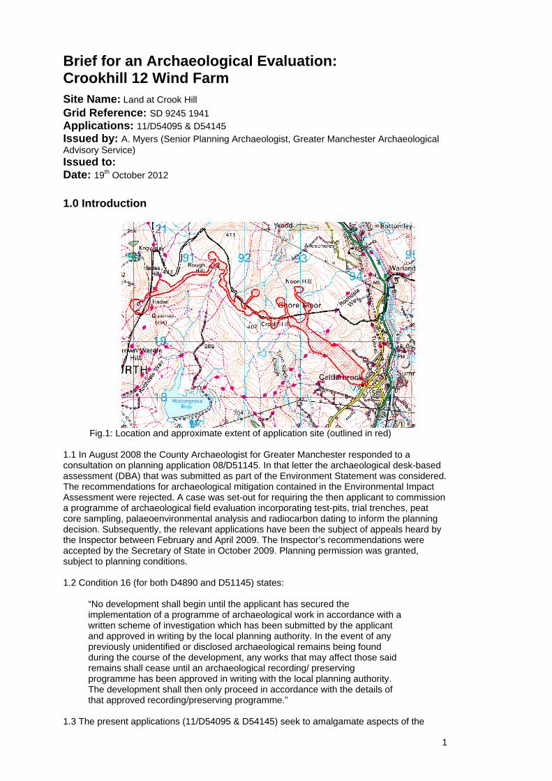
Fig.1: Location and approximate extent of application site (outlined in red)
1.1 In August 2008 the County Archaeologist for Greater Manchester responded to a consultation on planning application 08/D51145. In that letter the archaeological desk-based assessment (DBA) that was submitted as part of the Environment Statement was considered. The recommendations for archaeological mitigation contained in the Environmental Impact Assessment were rejected. A case was set-out for requiring the then applicant to commission a programme of archaeological field evaluation incorporating test-pits, trial trenches, peat core sampling, palaeoenvironmental analysis and radiocarbon dating to inform the planning decision. Subsequently, the relevant applications have been the subject of appeals heard by the Inspector between February and April 2009. The Inspector’s recommendations were accepted by the Secretary of State in October 2009. Planning permission was granted, subject to planning conditions. 1.2 Condition 16 (for both D4890 and D51145) states:
“No development shall begin until the applicant has secured the implementation of a programme of archaeological work in accordance with a written scheme of investigation which has been submitted by the applicant and approved in writing by the local planning authority. In the event of any previously unidentified or disclosed archaeological remains being found during the course of the development, any works that may affect those said remains shall cease until an archaeological recording/ preserving programme has been approved in writing with the local planning authority. The development shall then only proceed in accordance with the details of that approved recording/preserving programme.”
1.3 The present applications (11/D54095 & D54145) seek to amalgamate aspects of the
2
applications granted permission at the planning appeal. The present scheme will see seven turbines located within Rochdale MBC, and five within Calderdale (West Yorkshire). The access tracks will run from the east side (Greater Manchester) and from the west (Lancashire) (fig.1). The development includes the erection of 12 wind turbines (c.3MW – height to nacelle 80m), construction of a temporary construction compound, construction of hardstanding for erection cranes, new access tracks, erection of anemometry mast, construction of permanent switchgear/ control substation. 1.4 AOC Archaeology have been commissioned by Dulas Ltd, on behalf of the applicants Coronation Power to undertake a Cultural Heritage reassessment as part of a new EIA, having regard to the original EIA findings, the decision of the public inquiry and the inspector’s recommendations . This has been completed and submitted. 1.5 Greater Manchester Archaeological Advisory Service (GMAAS) has been approached by West Yorkshire Archaeological Advisory Service (WYAAS) to lead on the provision of an archaeological evaluation brief for the development area in both authorities. The present document is a brief for the required programme of archaeological works. Drawing upon this brief and the information contained in the AOC report a written Scheme of Investigation (WSI) should be drafted by the appointed archaeological contractor for prior agreement with GMAAS. 2.0 Archaeological Background and Considerations 2.1 The AOC report drew together data from the relevant HERs, historic documentary and cartographic sources together with the results of a walkover survey in an attempt to look at the direct impact upon known archaeological heritage interests. The report recognises that the locational accuracy of findspot data recorded on HERs may well be variable. Nonetheless, an attempt has been made to identify which recorded or identified sites may be impacted upon directly by the proposals. These include (10.10.1) 9 prehistoric (mainly Mesolithic) flint findspots, a medieval trackway, a post-medieval enclosure, a post-medieval building or enclosure, three nineteenth century boundary stones and (10.10.2) three instances of past mining and/or quarrying activity. 2.2 The AOC report offers suggestions as to the mitigation of the various heritage impacts. For all but the latter noted quarrying/ mining it notes that “a programme of archaeological works may be required to investigate and fully determine the nature and extent of any remains associated with these sites”. The AOC report proposes that the known or suspected sites are subject to “a programme of archaeological works…to investigate and fully determine the nature and extent of remains associated with these sites” (10.10.1). For the mining/ and or quarrying sites it is proposed that groundworks in their vicinity be subject to an archaeological watching brief (10.10.2). For the other sites the programme of archaeological works will need to vary according to their character. 2.3 The AOC report also recognises (10.10.4) that in addition to the above known remains unknown buried remains might be disturbed by development activity and that archaeological evaluation be undertaken in areas where ground disturbances associated with the development might take place. This concern is explicitly directed towards the presence in the area of large numbers of Mesolithic sites (10.9.1). It recognises that further work in the form of coring and palaeoenvironmental assessment along with geophysical survey might assist in identifying areas of high Mesolithic potential. 2.4 The AOC report refers a report by Penny Spikens and the existence of a “general agreement” that the areas of upland with high probabilities for Mesolithic sites to be found “include south facing slopes on the plateau edge at 380-430m elevation and this is where efforts should be concentrated” (my emphasis). Certainly, the distribution of known sites would suggest that such locations have a relatively high probability of producing sites. However, such locations are not the only locations that produce significant Mesolithic evidence. There are three considerations that lead me to reject the AOC report’s inference concerning where fieldwork should be directed. Firstly, just because such locations have a high probability of producing evidence it does not follow that other locations may not also have a similarly high probability. On-going work with extensive lithic collections from the moors above Glossop demonstrates that other topographic positions in these upland environments can also produce large numbers of Mesolithic sites. Secondly, on what basis
3
are we to ignore certain topographic locations deemed as having only a moderate or slight possibility of encountering sites? It should be remembered that sites located in different topographic positions may inform about different activities. Sites in less favoured locations may prove highly significant in the differences they reveal when compared with the more heavily populated plateau edge, south facing 380-430m locations. Thirdly, we must not forget that the primary purpose of evaluation is not to follow some notional balance of probabilities for encountering evidence, but rather to produce evidence relevant to the assessment of heritage asset significance (NPPF paragraph 128). 2.5 In considering the applicability of geophysical survey (10.9.3) it recognises that magnetometry may be applicable where significant cut features, hearth or burnt material survives. One problem here is that very few Mesolithic upland sites are associated with large cut features. Fire pits, hearths or burnt lithic spreads could provide valuable targets. However, the frequency of upland moor fires, whether deliberately set for estate management purposes or accidentally set, renders questionable the utility of targets identified through such techniques. Furthermore, Mesolithic evidence tends to sit at the interface of the underlying mineral soil with the overlying peat. Much of this moorland is buried beneath deep peat (>1m) and magnetometry tends to work only where peat depth is less than 1m. such techniques may only be applicable in those limited, identifiable areas of the proposed development with sufficiently shallow peat (10.9.3). . 3.0 Programme of Archaeological Works: Approach 3.1 Based upon the mitigation recommendations offered in the AOC report the programme of archaeological works will require fieldwork tailored to the nature of the archaeological interest. The work will be phased. Evaluation needs to deal with both ‘known’ or potential archaeological heritage assets covering a variety of types of archaeological asset. 3.2 The initial ‘evaluation’ phase involves a range of fieldwork approaches:
i) Those known or suspected sites retaining a visible above-ground component (earthworks/ stone/ walling) (medieval trackway, post-medieval enclosure, post-medieval building or enclosure, three nineteenth century boundary stones and evidence of past mining and/or quarrying activity) will initially need to be surveyed, planned and recorded. With the exception of the past mining/ quarrying sites they should then be subject to evaluation trenching and/ or test-pitting sufficient to assess their age, form, condition, significance and the impact of the proposals upon their significance. ii) Those known or suspected sites without an above ground component need to be subject to evaluation test-pitting. Where it can be shown – supported by augering samples - that a site is suited to the application of magnetometer survey then such a survey should be undertaken in advance of the test-pitting and the results considered for targeting selected test-pits, subject to the concerns raised in 2.5. The test-pits should be excavated in a manner appropriate to the recovery of Mesolithic or later Prehistoric flintwork (i.e. hand excavated from level close to the peat/ mineral soil interface and including sample sieving). Given the uncertainty inherent in the site grid references each site should be subject to a grid of hand-augered samples (150mm diameter), one in every m2 . This should allow the targeting of areas of concentration and define their extent. At least one test-pit should then be hand excavated to assess the artefact concentration. This suggests that in calculating the numbers of test-pits required initially a contingency will need to be built-in. iii) Wider area evaluation sampling of the areas of development impact (1.3) should also be undertaken through test-pits located following the use of augering (150 mm diameter) on a 1m2 grid interval. Any proposals for structured sub-sampling of topographic / altitudinal zones would need to be specified in detail, discussed with and agreed by GMAAS as part of the written scheme of investigation.
4
iv) Coring and palaeoenvironmental assessment of deep peats/ mineral soil should be undertaken.
3.3 The inspection of augering samples for worked lithics must be undertaken by staff who are competent in the identification of prehistoric lithic debitage. The excavation of test-pits must also involve staff competent in the identification of prehistoric lithic debitage and small cut features. 3.4 Following the initial evaluation phase of fieldwork decisions will need to be taken as to the need for further targeted archaeological work in the form of open area excavation, watching brief or detailed analysis of palaeoenvironmental samples. 3.5 An archaeological watching brief should be maintained during development groundwork in the vicinity of the known past mining/ quarrying. 4.0 Health and Safety
4.1 Those visiting and working on the site will naturally operate with due regard to health and safety regulations.
4.2 The appointed archaeologist should undertake a site risk assessment. 5.0 Monitoring 5.1 The work should be undertaken by suitably qualified and experienced staff. Details of staff and their relevant experience should be supplied in the WSI to the Senior Planning Archaeologist (GMAAS) and agreed prior to the commencement of the project.
5.2 The Senior Planning Archaeologist (GMAAS) will wish to visit the site and monitor the fieldwork. Curatorial staff from West Yorkshire Archaeological Advisory Service (WYAAS) may also wish to be present. Arrangements for this will require at least two week’s advanced notice of the commencement of fieldwork. 6.0 Report Preparation 6.1 It is anticipated that the results of the evaluation will form the basis of a report. Copies should be provided for the interested parties including the client, the local planning authorities, GMAAS and WYAAS. 6.2 A bound hard copy and a digital copy of the report including illustrations and photographs (PDF Format) should be submitted to GMAAS on CD (with the project title, date and author noted on the CD) for inclusion in the HER. 6.3 The report should include as a minimum, Non-technical summary Introductory statement Aims and purpose of the project Methodology Detailed account of the work and its results. Significance of archaeological heritage assets and impact upon significance of the development Conclusion, including a confidence statement Supporting drawn site illustrations at appropriate scales (site plan, evaluation trench locations, plans of deposits and features, site sections [to include deposit relationships to ground surface], feature plans and sections) Note: all CAD sections and plans must include a drawn scale Selected site photographs (laser printer quality) Drawn finds illustrations – of representative and/ or key finds to support the interpretation of date/ site function – at appropriate scales
5
Supporting data – including a basic quantification of artefacts, ecofacts and structural data tabulated and full specialist reports in appendices. Index to archive and details of archive location References Copy of this brief
8.4 Discharge of the relevant condition will only normally be recommended once all reports on the conditioned programme of archaeological work have been submitted and accepted. Any proposed departure from this arrangement should be discussed with the relevant planning authorities as soon as is possible. 8.0 Submission and Deposition of Project Archive 8.1 From the outset of the project arrangements should be made for the archive, consisting of record sheets, original drawings, drawn plans, photographs, notes, copies of the all reports along with an index to the archive to be deposited with the appropriate archive repository. 9.0 Publicity
9.1 The results of the work should be made public. This may, dependant upon the results of the project, take the form of a full definitive report or a short summary published in an appropriate archaeological journal.

Figures 1-3
[
�
��
��
�
�
�
�
�
�
�T5
T3
T9
T1
T2
T8
T7
T6
T4
T12
T11
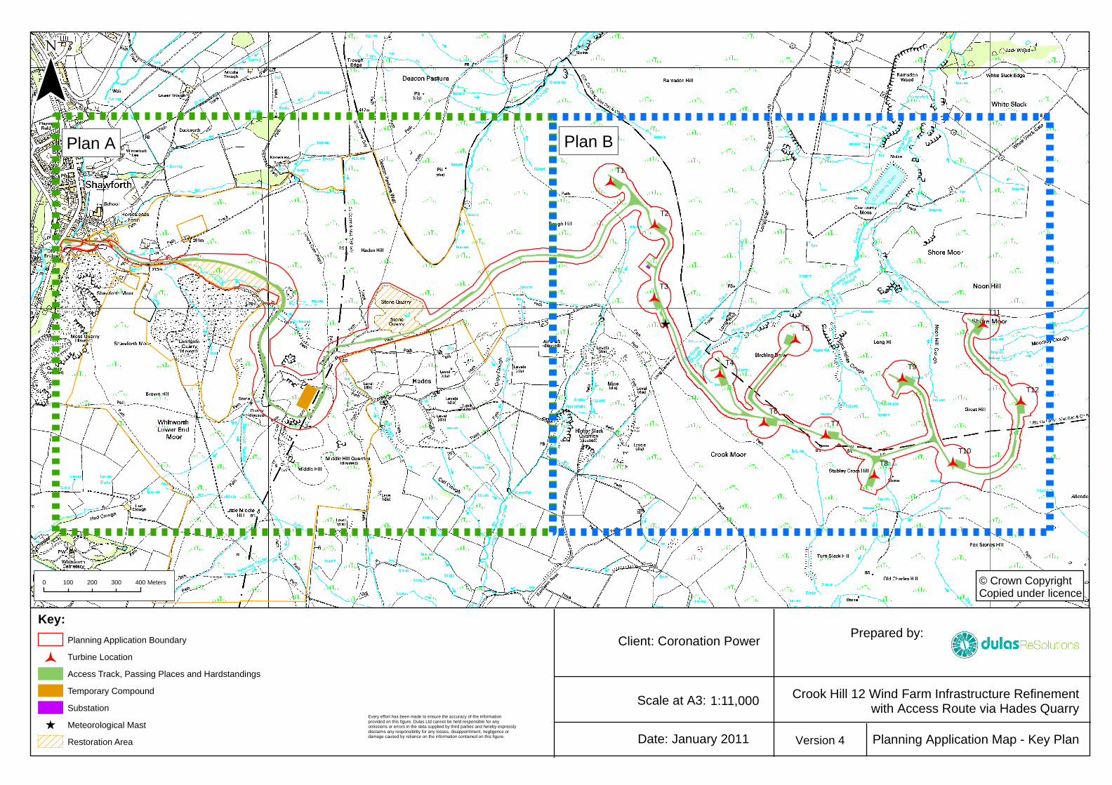
T10
¯
Prepared by:Client: Coronation Power
Crook Hill 12 Wind Farm Infrastructure Refinementwith Access Route via Hades Quarry
Planning Application Map - Key PlanDate: January 2011
Scale at A3: 1:11,000
Key:
Planning Application Boundary
� Turbine Location
Access Track, Passing Places and Hardstandings
Temporary Compound
Substation
[ Meteorological Mast
Restoration Area
0 400100 200 300 Meters © Crown CopyrightCopied under licence
Version 4
Plan A Plan B
Every effort has been made to ensure the accuracy of the informationprovided on this figure. Dulas Ltd cannot be held responsible for anyomissions or errors in the data supplied by third parties and hereby expresslydisclaims any responsibility for any losses, disappointment, negligence ordamage caused by reliance on the information contained on this figure.
[
�
�
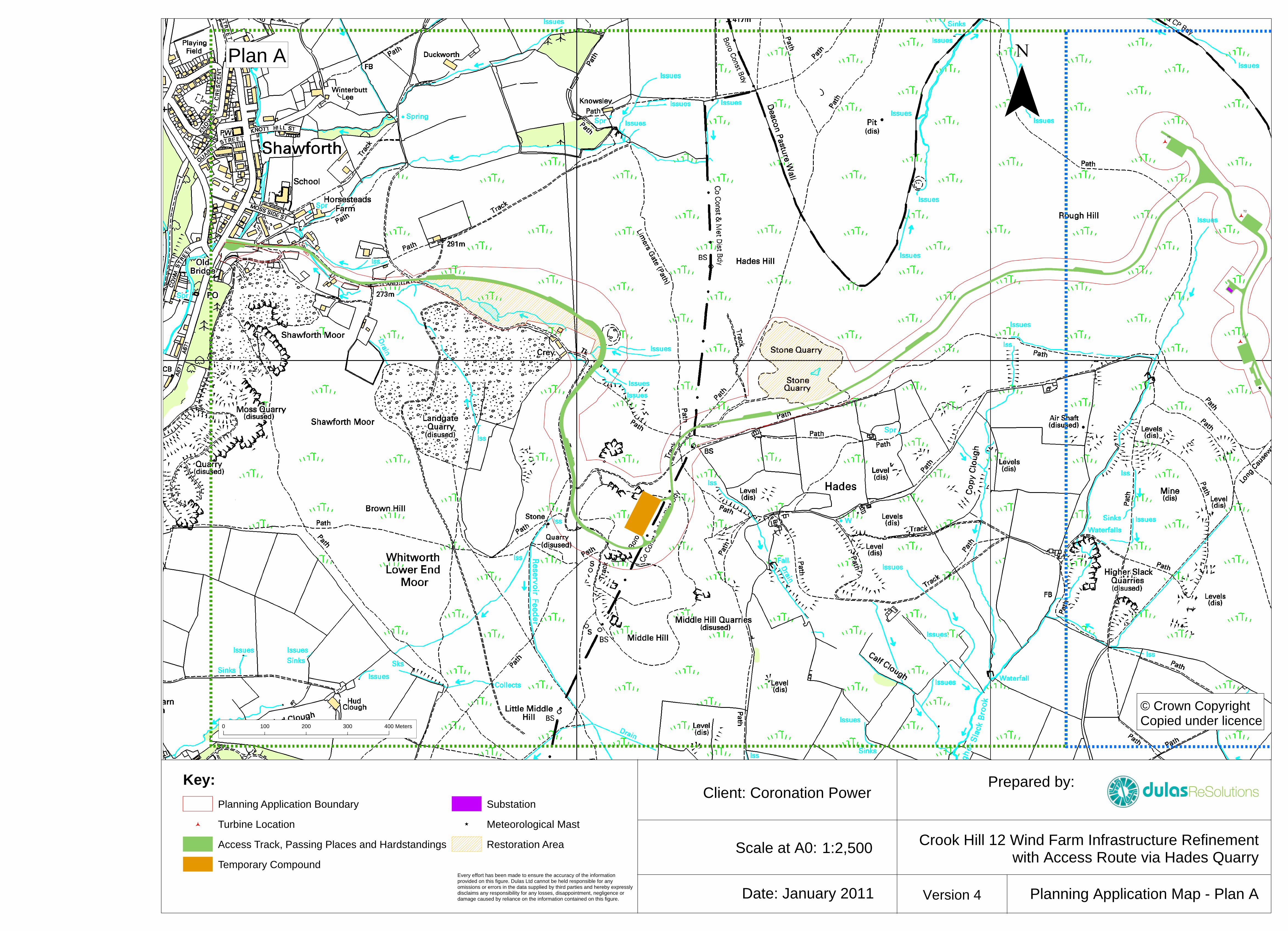
�T3
T1
T2
Prepared by:Client: Coronation Power
Crook Hill 12 Wind Farm Infrastructure Refinementwith Access Route via Hades Quarry
Planning Application Map - Plan ADate: January 2011
Scale at A0: 1:2,500
Key:
Planning Application Boundary
� Turbine Location
Access Track, Passing Places and Hardstandings
Temporary Compound
Substation
[ Meteorological Mast
Restoration Area
0 400100 200 300 Meters
© Crown CopyrightCopied under licence
Version 4
Plan A
Every effort has been made to ensure the accuracy of the informationprovided on this figure. Dulas Ltd cannot be held responsible for anyomissions or errors in the data supplied by third parties and hereby expresslydisclaims any responsibility for any losses, disappointment, negligence ordamage caused by reliance on the information contained on this figure.
[
�
�
�
�
�
�
�
�
�
�
�
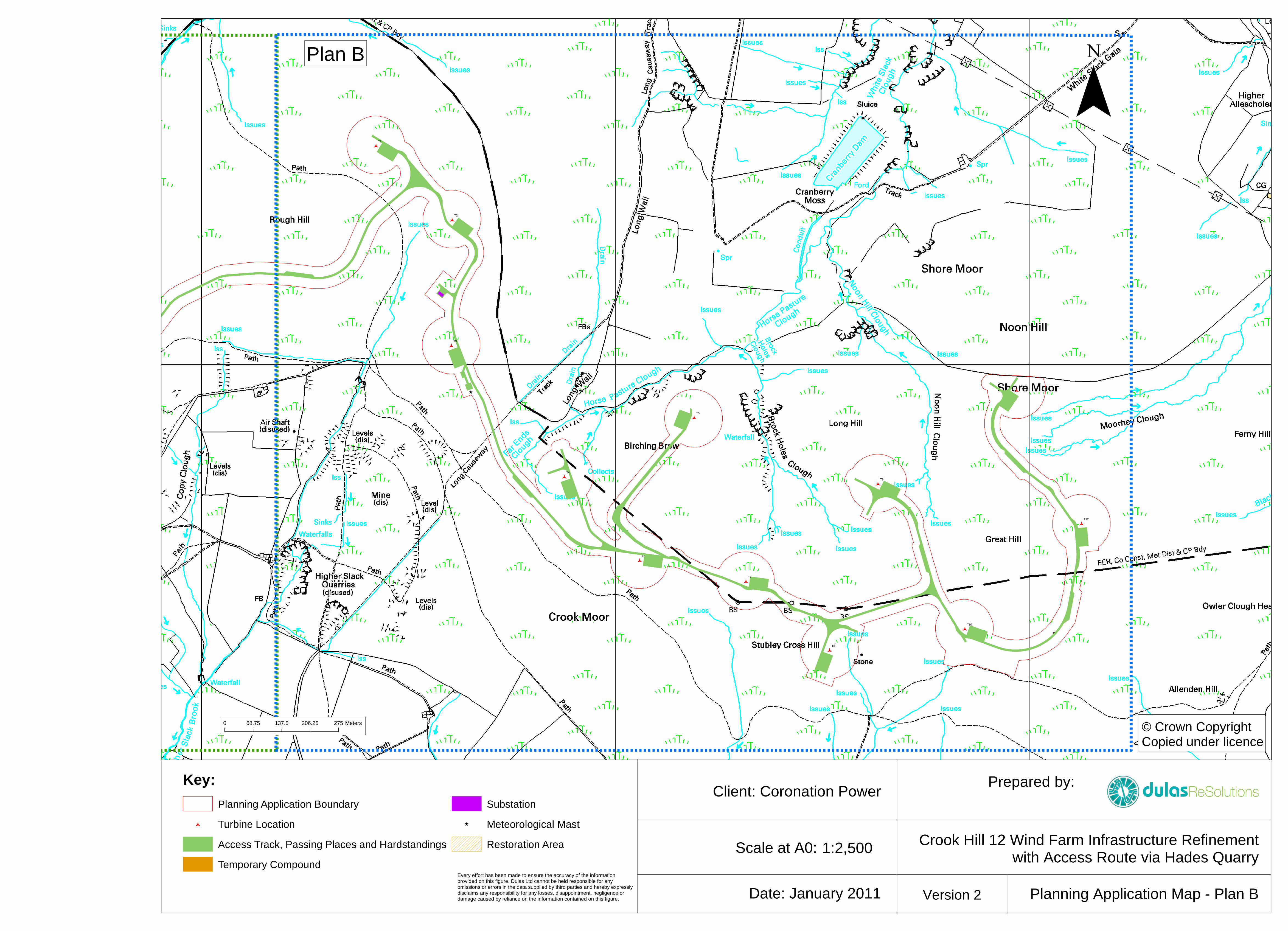
�T5
T3
T9
T1
T2
T8
T7
T6
T4
T12
T11
T10
Prepared by:Client: Coronation Power
Crook Hill 12 Wind Farm Infrastructure Refinementwith Access Route via Hades Quarry
Planning Application Map - Plan BDate: January 2011
Scale at A0: 1:2,500
Key:
Planning Application Boundary
� Turbine Location
Access Track, Passing Places and Hardstandings
Temporary Compound
Substation
[ Meteorological Mast
Restoration Area
0 27568.75 137.5 206.25 Meters © Crown CopyrightCopied under licence
Version 2
Plan B
Every effort has been made to ensure the accuracy of the informationprovided on this figure. Dulas Ltd cannot be held responsible for anyomissions or errors in the data supplied by third parties and hereby expresslydisclaims any responsibility for any losses, disappointment, negligence ordamage caused by reliance on the information contained on this figure.