Embed Size (px)
Citation preview

J. Meek
FromTo
RP 996/0This drawing and its contents arethe property of Opus InternationalConsultants Limited.Any unauthorised employment orreproduction, in full or in part, isforbidden.
PROJECT/TASK: 6xt072.40/a46gx
Cadastral Information derived fromLand Information New Zealand's DigitalCadastral Database (DCDB). CROWNCOPYRIGHT RESERVED. Approved for
FILE NAME: g:\transit\6XT07240\A46gx\LAR_sh6_frankton_wye_creek
RP 1011/0reproduction by OPUS INTERNATIONALCONSULTANTS LIMITED.
DIPS NO. 7/50/42/7714/1
DRAWN:
SHEET 1 OF 12
SURVEY DATE: 18-1-2002
SCALE: 1:40 000
CHECKED: PRINCIPAL: Authorised crossing place2 =LEGEND:
LAR A3 BORDER
SH6 REGION 13 RS 996FRANKTON TO WYE CREEK LA/13/006/996/A/01
KEY PLAN
1211
10
98
765
4
32
Wye Cr
eek
Drift Bay
SH6
Kingston
Woolshed RoadFRANKTON
Cromwell
Quee
nstow
n
SH6A
SH6
Lumb
erbo
x Cre
ek
LAKE WAKATIPU
LIMITED ACCESSROADING
REVISION NUMBER: 1 (JUNE 2015)
112

J. Meek
FromTo
RP 996/0This drawing and its contents arethe property of Opus InternationalConsultants Limited.Any unauthorised employment orreproduction, in full or in part, isforbidden.
PROJECT/TASK: 6xt072.40/a46gx
Cadastral Information derived fromLand Information New Zealand's DigitalCadastral Database (DCDB). CROWNCOPYRIGHT RESERVED. Approved for
FILE NAME: g:\transit\6XT07240\A46gx\LAR_sh6_frankton_wye_creek
RP 1011/0reproduction by OPUS INTERNATIONALCONSULTANTS LIMITED.
DIPS NO. 7/50/42/7714/2
DRAWN:
SHEET 2 OF 12
SURVEY DATE: 18-1-2002
SCALE: 1:4000
CHECKED: PRINCIPAL: Authorised crossing place2 =LEGEND:
LAR A3 BORDER
SH6 REGION 13 RS 996FRANKTON TO WYE CREEK LA/13/006/996/A/02
TOWN OF FRANKTON
Douglas Street
Lucas Place
Mcbride Street
SH6
LAKE WAKATIPU
SH6
SH6A
KawarauFallsBridge
Cromwell
START OF L.A.R.RS 996
Quee
nstow
n
Gray
St.
Ross
St.
Hump
hrey
St.
SH6
South
berg
Av.
Sec 6Block 33
Pt Sec 6Block 34
Sec 12, Block 20 Sec 17, Block 12
(Golf Course)Pt Sec 9Block 22(3D/531)
Robe
rtson
St.
Bridge St.
Boyes Cr.
Wilmot Av.
(Remarkables Park)
See Sheet 2A
Sec 14, Block 20
LIMITED ACCESSROADING
RP 996/0.70
QueenstownAirport
REVISION NUMBER: 1 (JUNE 2015)
112

J. Meek
FromTo
RP 996/0This drawing and its contents arethe property of Opus InternationalConsultants Limited.Any unauthorised employment orreproduction, in full or in part, isforbidden.
PROJECT/TASK: 6xt072.40/a46gx
Cadastral Information derived fromLand Information New Zealand's DigitalCadastral Database (DCDB). CROWNCOPYRIGHT RESERVED. Approved for
FILE NAME: g:\transit\6XT07240\A46gx\LAR_sh6_frankton_wye_creek
RP 1011/0reproduction by OPUS INTERNATIONALCONSULTANTS LIMITED.
DIPS NO. 7/50/42/7714/2
DRAWN:
SHEET 2A OF 12
SURVEY DATE: 18-1-2002
SCALE: 1:2000
CHECKED: PRINCIPAL: Authorised crossing place2 =LEGEND:
LAR A3 BORDER
SH6 REGION 13 RS 996FRANKTON TO WYE CREEK LA/13/006/996/A/02A
Douglas Street
McBride Street
Lake
Av.
Hump
hrey
Stre
et
SH6
South
berg
Av.
Sec 24, Block 12
Robe
rtson
Stre
et
Bridge St.
Boyes Cr.
Wilmot Av.Bo
yes C
r.
Boye
s Cr.
Sec 1
3
Sec 1
4
Sec 9
Sec 5
Sec 6
Block 5Sec 18, Block 11
Sec 26, Block 1
Pt Sec 5
Sec 6
Lot 2, DP 26846
Luca
s Plac
e
Sec 18, Block 12, Tn of Frankton
Sec 19, Block 12, Tn of Frankton
Pt Sec 3
Pt Sec 2Pt Sec 24
DP 24
395Se
c 19
Sec 2
0
Block 1
Block 18
Sec 3Sec 4
Pt S
ec 4
Sec 2
5, Bl
k 9
Pt Sec 24
Sec 6,Blk 8
Pt Sec 22,Blk 8
Pt Sec 23
Pt Sec 7
Pt Sec 25
Pt Sec 21
Sec 1, SO 24824
(not formed)
(not formed)
LIMITED ACCESSROADING
KawarauFallsBridge
REVISION NUMBER: 1 (JUNE 2015)
112

J. Meek
FromTo
RP 996/0This drawing and its contents arethe property of Opus InternationalConsultants Limited.Any unauthorised employment orreproduction, in full or in part, isforbidden.
PROJECT/TASK: 6xt072.40/a46gx
Cadastral Information derived fromLand Information New Zealand's DigitalCadastral Database (DCDB). CROWNCOPYRIGHT RESERVED. Approved for
FILE NAME: g:\transit\6XT07240\A46gx\LAR_sh6_frankton_wye_creek
RP 1011/0reproduction by OPUS INTERNATIONALCONSULTANTS LIMITED.
DIPS NO. 7/50/42/7714/3
DRAWN:
SHEET 3 OF 12
SURVEY DATE: 18-1-2002
SCALE: 1:4000
CHECKED: PRINCIPAL: Authorised crossing place2 =LEGEND:
LAR A3 BORDER
SH6 REGION 13 RS 996FRANKTON TO WYE CREEK LA/13/006/996/A/03
CONEBURN SURVEY DISTRICT
Kawarau River
SH6
KawarauFallsBridge
Pt Res B
Block 1, Coneburn SD
Peninsu
la Road
Pt Sec 1Block 1, Coneburn SD (19C/104)
Block 1, Coneburn SDSec 23
Sec 44Block 12, Coneburn SD
(2D/1161)DP 10732
Lot 1DP 300236
Lot 1
DP 24
791
Crown Land
Block 1, Coneburn SD
King
ston
BLOCK 1
BLOCK 12
(3B/94)
(19A/284)
Lot 1
(16C/
1187
)
(5B/507)
LIMITED ACCESSROADING
Crown LandBlock 1
Coneburn SD
Pt Sec 45Block 12
Coneburn SD(5B/511)
Pt Sec 38Block 12
Coneburn SD(16D/923)
Pt Sec 41Block 12
Coneburn SD(5B/507)
Pt Sec 40Block 12
Coneburn SD(5B/511)
Pt Sec 45Block 12
Coneburn SD(5B/511)
RP 996/2.47
RP 996/1.41
REVISION NUMBER: 1 (JUNE 2015)
112

J. Meek
FromTo
RP 996/0This drawing and its contents arethe property of Opus InternationalConsultants Limited.Any unauthorised employment orreproduction, in full or in part, isforbidden.
PROJECT/TASK: 6xt072.40/a46gx
Cadastral Information derived fromLand Information New Zealand's DigitalCadastral Database (DCDB). CROWNCOPYRIGHT RESERVED. Approved for
FILE NAME: g:\transit\6XT07240\A46gx\LAR_sh6_frankton_wye_creek
RP 1011/0reproduction by OPUS INTERNATIONALCONSULTANTS LIMITED.
DIPS NO. 7/50/42/7714/4
DRAWN:
SHEET 4 OF 12
SURVEY DATE: 18-1-2002
SCALE: 1:4000
CHECKED: PRINCIPAL: Authorised crossing place2 =LEGEND:
LAR A3 BORDER
SH6 REGION 13 RS 996FRANKTON TO WYE CREEK LA/13/006/996/A/04
CONEBURN SURVEY DISTRICT
Pt Lot 1DP 20511
Lot 1
DP 24
791
Pt Lot 1DP 2986
Boyd Road
Lot 2DP 26733
Lot 1DP 15081
Lot 4DP 15081
Lot 2DP 15081
Lot 1DP 26733
SH6
BLOCK 12
KingstonFran
kton
DP 26733Lot 1
ROW
to Lo
ts 1&
2, DP
2535
0
(16C/1188)
(16C/
1187
)
(8D/385)
(8D/386)
(6B/220)
(6B/221)
(6B/220)
"Rem
arkab
les S
ki Fie
ld"
(8D/385)
Kawarau Rd
(unformed)
LIMITED ACCESSROADING
Pt Sec 41Block 12
Coneburn SD(5B/507)
Pt Sec 40Block 12
Coneburn SD(5B/511)
Sec 49Block 12
Coneburn SD(6B/221)
Pt Sec 38Block 12
Coneburn SD(16D/923)
Sec 33Block 12
Coneburn SD(5B/512)
RP 996/4.10
RP 996/3.70 Lot 2DP 17411(8C/1489)
Lot 1DP 17411(8C/1490)
Lot 3DP 15081(6B/221)
Lot 1DP 26996(18D/1018)
REVISION NUMBER: 1 (JUNE 2015)
112

J. Meek
FromTo
RP 996/0This drawing and its contents arethe property of Opus InternationalConsultants Limited.Any unauthorised employment orreproduction, in full or in part, isforbidden.
PROJECT/TASK: 6xt072.40/a46gx
Cadastral Information derived fromLand Information New Zealand's DigitalCadastral Database (DCDB). CROWNCOPYRIGHT RESERVED. Approved for
FILE NAME: g:\transit\6XT07240\A46gx\LAR_sh6_frankton_wye_creek
RP 1011/0reproduction by OPUS INTERNATIONALCONSULTANTS LIMITED.
DIPS NO. 7/50/42/7714/5
DRAWN:
SHEET 5 OF 12
SURVEY DATE: 18-1-2002
SCALE: 1:4000
CHECKED: PRINCIPAL: Authorised crossing place2 =LEGEND:
LAR A3 BORDER
SH6 REGION 13 RS 996FRANKTON TO WYE CREEK LA/13/006/996/A/05
CONEBURN SURVEY DISTRICTBLOCK 12
Lot 1DP 26996 Lot 2
DP 26996
Pt Lot 1DP 20511
Lot 1DP 19857
Pt Lot 5DP 19857
Lot 3DP 26996
DP 26261Pt Lot 1
Woolshed Road
Lot 1DP 25597
SH6Frankton
Kingston
Lot 4DP 26996
Lot 5DP 26996
(18D/1018)
(16C/1188)
(17C/864)
(18D/1019)
(18D/1021)
(18D/1022)
(18D/1020)
(18D/1023)
(17C/863)
(17C/864)
LIMITED ACCESSROADING
RP 996/5.65
REVISION NUMBER: 1 (JUNE 2015)
112

J. Meek
FromTo
RP 996/0This drawing and its contents arethe property of Opus InternationalConsultants Limited.Any unauthorised employment orreproduction, in full or in part, isforbidden.
PROJECT/TASK: 6xt072.40/a46gx
Cadastral Information derived fromLand Information New Zealand's DigitalCadastral Database (DCDB). CROWNCOPYRIGHT RESERVED. Approved for
FILE NAME: g:\transit\6XT07240\A46gx\LAR_sh6_frankton_wye_creek
RP 1011/0reproduction by OPUS INTERNATIONALCONSULTANTS LIMITED.
DIPS NO. 7/50/42/7714/6
DRAWN:
SHEET 6 OF 12
SURVEY DATE: 18-1-2002
SCALE: 1:4000
CHECKED: PRINCIPAL: Authorised crossing place2 =LEGEND:
LAR A3 BORDER
SH6 REGION 13 RS 996FRANKTON TO WYE CREEK LA/13/006/996/A/06
CONEBURN SURVEY DISTRICT
25
Lot 2DP 24792
Pt Lot 1DP 26261
Lot 2DP 20512
Lot 3DP 24792
Lot 1DP 22658
Lot 3DP 26261
Pt Lot 5DP 19857
BLOCK 12
SH6
Kingston
Frankton
BLOCK 3CONEBURN SURVEY DISTRICT
(18D/1023)
(16C/1189)
(12A/1403)
(17C/864)
(18B/410)
(16C/1190)(14D/45)
LIMITED ACCESSROADING
26 27 2829
5556
5758
59
2122
23 24
REVISION NUMBER: 1 (JUNE 2015)
112

J. Meek
FromTo
RP 996/0This drawing and its contents arethe property of Opus InternationalConsultants Limited.Any unauthorised employment orreproduction, in full or in part, isforbidden.
PROJECT/TASK: 6xt072.40/a46gx
Cadastral Information derived fromLand Information New Zealand's DigitalCadastral Database (DCDB). CROWNCOPYRIGHT RESERVED. Approved for
FILE NAME: g:\transit\6XT07240\A46gx\LAR_sh6_frankton_wye_creek
RP 1011/0reproduction by OPUS INTERNATIONALCONSULTANTS LIMITED.
DIPS NO. 7/50/42/7714/7
DRAWN:
SHEET 7 OF 12
SURVEY DATE: 18-1-2002
SCALE: 1:4000
CHECKED: PRINCIPAL: Authorised crossing place2 =LEGEND:
LAR A3 BORDER
SH6 REGION 13 RS 996FRANKTON TO WYE CREEK LA/13/006/996/A/07
CONEBURN SURVEY DISTRICT
31
SH6
BLOCK 3
30
Frankton
Kingston
LIMITED ACCESSROADING
Pt Lot 1DP 26261
(18D/1023)
Lot 3DP 26261(18B/410)
REVISION NUMBER: 1 (JUNE 2015)
112

J. Meek
FromTo
RP 996/0This drawing and its contents arethe property of Opus InternationalConsultants Limited.Any unauthorised employment orreproduction, in full or in part, isforbidden.
PROJECT/TASK: 6xt072.40/a46gx
Cadastral Information derived fromLand Information New Zealand's DigitalCadastral Database (DCDB). CROWNCOPYRIGHT RESERVED. Approved for
FILE NAME: g:\transit\6XT07240\A46gx\LAR_sh6_frankton_wye_creek
RP 1011/0reproduction by OPUS INTERNATIONALCONSULTANTS LIMITED.
DIPS NO. 7/50/42/7714/8
DRAWN:
SHEET 8 OF 12
SURVEY DATE: 18-1-2002
SCALE: 1:4000
CHECKED: PRINCIPAL: Authorised crossing place2 =LEGEND:
LAR A3 BORDER
SH6 REGION 13 RS 996FRANKTON TO WYE CREEK LA/13/006/996/A/08
CONEBURN SURVEY DISTRICT
BLOCK 3
SH632
33
Frankton
Kingston
Lot 4
(19A/977)
Lot 3
(19A/976)
(19A/975)Lot 2
(19A/974)Lot 1
LIMITED ACCESSROADING
Pt Lot 1DP 26261
(18D/1023)
Lot 3DP 26261(18B/410)
REVISION NUMBER: 1 (JUNE 2015)
112

J. Meek
FromTo
RP 996/0This drawing and its contents arethe property of Opus InternationalConsultants Limited.Any unauthorised employment orreproduction, in full or in part, isforbidden.
PROJECT/TASK: 6xt072.40/a46gx
Cadastral Information derived fromLand Information New Zealand's DigitalCadastral Database (DCDB). CROWNCOPYRIGHT RESERVED. Approved for
FILE NAME: g:\transit\6XT07240\A46gx\LAR_sh6_frankton_wye_creek
RP 1011/0reproduction by OPUS INTERNATIONALCONSULTANTS LIMITED.
DIPS NO. 7/50/42/7714/9
DRAWN:
SHEET 9 OF 12
SURVEY DATE: 18-1-2002
SCALE: 1:4000
CHECKED: PRINCIPAL: Authorised crossing place2 =LEGEND:
LAR A3 BORDER
SH6 REGION 13 RS 996FRANKTON TO WYE CREEK LA/13/006/996/A/09
CONEBURN SURVEY DISTRICTBLOCK 3
Sec 8
Block 5, Coneburn SD
Sec 1
SO 16995
Lot 5
7
Lot 4
0
Lot 2
3
Lot 2
2
Lot 2
1
Lot 50
Lot 4
Lot 3
Lot 2
Lot 1
D P 2 7 5 2 0
Pt Lot 1DP 26261
Lot 2
, DP
2626
1
Lumberbox Creek
LAKE WAKATIPU
35
34
36
Kingston
Frankton
SH6
Sec 10, Block 5, Coneburn SD
BLOCK 5
(18D/1023)
(14B/1124)
(18D
/1023
)
(GN866676)
(19A
/994)
(19A
/995)
(19A
/996)
(19A
/1014
)
(19A
/977)
(19A
/976)
(19A
/975)
(19A
/974)
(19A/1000-1010)
Lakeside Reserve (C
rown Land)
ROWLot 41
LAKESIDE ESTATES
(19A/978)Lot 5
Lot 6(19A/979)
Lot 11(19A/984)
Lot 12
(19A/985)
Lot 1
3(1
9A/98
6)
Lot 7
(19A
/980)
Lot 8(19A/981)Lot 9(19A/982)
Lot 10(19A/983)
Lot 15
(19A/988)Lot 14
(19A/987)
Lot 16
(19A/989)
Lot 60(19A/1000-1010)
(19A/990)Lot 17
(19A/991)Lot 18
(19A/992)Lot 19
Lot 20(19A/993)
(19A/1010)Lot 37
Lot 33(19A/1006)
(19A/1005)Lot 32
Lot 31(19A/1004)
Lot 30(19A/1003)
(19A/1008)Lot 35
Lot 38(19A/1011)
Lot 34(19A/1007)
(19A/1009)
Lot 36
Lot 39(19A/1012)
Lot 24(19A/997)
Lot 25
(19A/998)
Lot 29
(19A/1002)
Lot 28
(19A/1001)
Lot 27
(19A/1000)
Lot 26
(19A/99
9)
LIMITED ACCESSROADING
RP 996/11.93
RP 996/10.67
REVISION NUMBER: 1 (JUNE 2015)
112

J. Meek
FromTo
RP 996/0This drawing and its contents arethe property of Opus InternationalConsultants Limited.Any unauthorised employment orreproduction, in full or in part, isforbidden.
PROJECT/TASK: 6xt072.40/a46gx
Cadastral Information derived fromLand Information New Zealand's DigitalCadastral Database (DCDB). CROWNCOPYRIGHT RESERVED. Approved for
FILE NAME: g:\transit\6XT07240\A46gx\LAR_sh6_frankton_wye_creek
RP 1011/0reproduction by OPUS INTERNATIONALCONSULTANTS LIMITED.
DIPS NO. 7/50/42/7714/10
DRAWN:
REVISION NUMBER: 1 (6-15)
SHEET 10 OF 12
SURVEY DATE: 18-1-2002
SCALE: 1:4000
CHECKED: PRINCIPAL: Authorised crossing place2 =LEGEND:
LAR A3 BORDER
SH6 REGION 13 RS 996FRANKTON TO WYE CREEK LA/13/006/996/A/10
CONEBURN SURVEY DISTRICT
Pt Run 764
SH6
BLOCK 5
LAKE WAKATIPU
Lumberbox Creek
Kingston
Frankton
Gaz1971p247 (Better utilisation)
LIMITED ACCESSROADING
Lot 2DP 26261
(18D/1023)
RP 996/11.93
112

J. Meek
FromTo
RP 996/0This drawing and its contents arethe property of Opus InternationalConsultants Limited.Any unauthorised employment orreproduction, in full or in part, isforbidden.
PROJECT/TASK: 6xt072.40/a46gx
Cadastral Information derived fromLand Information New Zealand's DigitalCadastral Database (DCDB). CROWNCOPYRIGHT RESERVED. Approved for
FILE NAME: g:\transit\6XT07240\A46gx\LAR_sh6_frankton_wye_creek
RP 1011/0reproduction by OPUS INTERNATIONALCONSULTANTS LIMITED.
DIPS NO. 7/50/42/7714/11
DRAWN:
REVISION NUMBER: 1 (6-15)
SHEET 11 OF 12
SURVEY DATE: 18-1-2002
SCALE: 1:4000
CHECKED: PRINCIPAL: Authorised crossing place2 =LEGEND:
LAR A3 BORDER
SH6 REGION 13 RS 996FRANKTON TO WYE CREEK LA/13/006/996/A/11
CONEBURN SURVEY DISTRICTBLOCK 5
SH6
Pt Run 764
LAKE WAKATIPU
39
Drift Bay Road Vista Terrace
Frankton Kingston
LIMITED ACCESSROADING
Lot 2DP 26261
(18D/1023)
Crown LandBlock 5
Coneburn SD
Sec 13Block 5
Coneburn SD
Lot 16DP 26157
Lot 16DP 26157(18A/1058)
RP 996/14.81
112
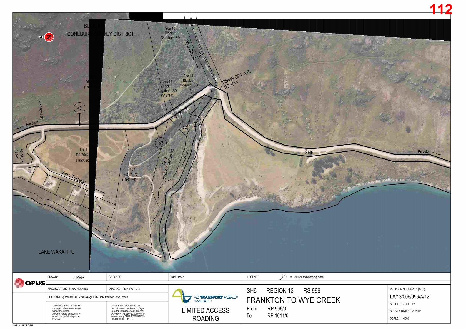
J. Meek
FromTo
RP 996/0This drawing and its contents arethe property of Opus InternationalConsultants Limited.Any unauthorised employment orreproduction, in full or in part, isforbidden.
PROJECT/TASK: 6xt072.40/a46gx
Cadastral Information derived fromLand Information New Zealand's DigitalCadastral Database (DCDB). CROWNCOPYRIGHT RESERVED. Approved for
FILE NAME: g:\transit\6XT07240\A46gx\LAR_sh6_frankton_wye_creek
RP 1011/0reproduction by OPUS INTERNATIONALCONSULTANTS LIMITED.
DIPS NO. 7/50/42/7714/12
DRAWN:
REVISION NUMBER: 1 (6-15)
SHEET 12 OF 12
SURVEY DATE: 18-1-2002
SCALE: 1:4000
CHECKED: PRINCIPAL: Authorised crossing place2 =LEGEND:
LAR A3 BORDER
SH6 REGION 13 RS 996LA/13/006/996/A/12
CONEBURN SURVEY DISTRICT
RS 1011FINISH OF L.A.R.
BLOCK 5
SH6
Wye Creek
40
Lot 2DP 26261
Lot 1DP 26425
Sec 1SO 21572
Sec 9
Bloc
k 5, C
oneb
urn S
D
Lot 1
6DP
2615
7
Vista Terrace
LAKE WAKATIPU
Kingston
Frankton
Crow
n Lan
d
C.L.
(15B/636)
(18B/920)
(18D/1023)
LIMITED ACCESSROADING
Sec 14Block 5
Coneburn SDSec 11Block 5
Coneburn SD(11B/14)
Sec 10Block 5
Coneburn SD
RP 996/14.81
112

J. Meek
FromTo
RP 956/4.45This drawing and its contents arethe property of Opus InternationalConsultants Limited.Any unauthorised employment orreproduction, in full or in part, isforbidden.
PROJECT/TASK: 6xt00030/256gx
Cadastral Information derived fromLand Information New Zealand's DigitalCadastral Database (DCDB). CROWNCOPYRIGHT RESERVED. Approved for
FILE NAME: g:/transit/6xt00030/256gx/LAR_sh6_gentle_annie_nevis
RP 956/12.96reproduction by OPUS INTERNATIONALCONSULTANTS LIMITED.
DIPS NO. 7/47/54/7714/1
DRAWN:
REVISION NUMBER: 2 (JUNE 2015)
SHEET 1 OF 7
SURVEY DATE: 2-12-2002
SCALE: 1:40 000
CHECKED: PRINCIPAL: Authorised crossing place2 =LEGEND:
LAR A3 BORDER
SH6 REGION 13 RS 956GENTLE ANNIE TO NEVIS BLUFF LA/13/006/956/B/1
KEY PLAN
Roaring Meg
7
Nevis River
4
3
2
5
6
WaitiriPeninsula
Gibbston
Kawarau RiverCromwell
Queenstown
SH6
SH6
GENTLE
ANNIE
BRIDGE
NEVIS
BLUFF
112

J. Meek
FromTo
RP 956/4.45This drawing and its contents arethe property of Opus InternationalConsultants Limited.Any unauthorised employment orreproduction, in full or in part, isforbidden.
PROJECT/TASK: 6xt00030/256gx
Cadastral Information derived fromLand Information New Zealand's DigitalCadastral Database (DCDB). CROWNCOPYRIGHT RESERVED. Approved for
FILE NAME: g:/transit/6xt00030/256gx/LAR_sh6_gentle_annie_nevis
RP 956/12.96reproduction by OPUS INTERNATIONALCONSULTANTS LIMITED.
DIPS NO. 7/47/54/7714/2
DRAWN:
REVISION NUMBER: 3 (JUNE 2015)
SHEET 1a OF 7
SURVEY DATE: 2-12-2002
SCALE: 1:4000
CHECKED: PRINCIPAL: Authorised crossing place2 =LEGEND:
LAR A3 BORDER
SH6 REGION 13 RS 956GENTLE ANNIE TO NEVIS BLUFF LA/13/006/956/B/2
112

J. Meek
FromTo
RP 956/4.45This drawing and its contents arethe property of Opus InternationalConsultants Limited.Any unauthorised employment orreproduction, in full or in part, isforbidden.
PROJECT/TASK: 6xt00030/256gx
Cadastral Information derived fromLand Information New Zealand's DigitalCadastral Database (DCDB). CROWNCOPYRIGHT RESERVED. Approved for
FILE NAME: g:/transit/6xt00030/256gx/LAR_sh6_gentle_annie_nevis
RP 956/12.96reproduction by OPUS INTERNATIONALCONSULTANTS LIMITED.
DIPS NO. 7/47/54/7714/2
DRAWN:
SHEET 2 OF 7
SURVEY DATE: 2-12-2002
SCALE: 1:4000
CHECKED: PRINCIPAL: Authorised crossing place2 =LEGEND:
LAR A3 BORDER
SH6 REGION 13 RS 956GENTLE ANNIE TO NEVIS BLUFF LA/13/006/956/B/2
KAWARAU SURVEY DISTRICT
BLOCK 2
SH6
Queenstown
Cromwell
GENTLEANNIEBRIDGE
RP 956/4.45START OF L.A.R.
1
Kawarau River
26
3
2
27
BLOCK 2CROMWELL SURVEY DISTRICT
Sec 9
SO 342162
(222416)
Pt Sec 51
Block 2
Cromwell SD
Sec 11
SO 342162
(222416)
Crown Land
Block 2
Kawarau SD
REVISION NUMBER: 2 (JUNE 2015)
112

J. Meek
FromTo
RP 956/4.45This drawing and its contents arethe property of Opus InternationalConsultants Limited.Any unauthorised employment orreproduction, in full or in part, isforbidden.
PROJECT/TASK: 6xt00030/256gx
Cadastral Information derived fromLand Information New Zealand's DigitalCadastral Database (DCDB). CROWNCOPYRIGHT RESERVED. Approved for
FILE NAME: g:/transit/6xt00030/256gx/LAR_sh6_gentle_annie_nevis
RP 956/12.96reproduction by OPUS INTERNATIONALCONSULTANTS LIMITED.
DIPS NO. 7/47/54/7714/3
DRAWN:
SHEET 3 OF 7
SURVEY DATE: 2-12-2002
SCALE: 1:4000
CHECKED: PRINCIPAL: Authorised crossing place2 =LEGEND:
LAR A3 BORDER
SH6 REGION 13 RS 956GENTLE ANNIE TO NEVIS BLUFF LA/13/006/956/B/3
KAWARAU SURVEY DISTRICT
BLOCK 2
SH6
Queenstown
Cromwell
Kawarau River
3
2
Waitiri Road
BLOCK 2CROMWELL SURVEY DISTRICT
Crown Land
Block 2
Kawarau SD
Sec 13
SO 342162
(222416)
Sec 9
SO 342162
(222416)
Sec 14
SO 342162
(222416)
Pt Sec 51
Block 2
Cromwell SD
3A
REVISION NUMBER: 2 (JUNE 2015)
112

J. Meek
FromTo
RP 956/4.45This drawing and its contents arethe property of Opus InternationalConsultants Limited.Any unauthorised employment orreproduction, in full or in part, isforbidden.
PROJECT/TASK: 6xt00030/256gx
Cadastral Information derived fromLand Information New Zealand's DigitalCadastral Database (DCDB). CROWNCOPYRIGHT RESERVED. Approved for
FILE NAME: g:/transit/6xt00030/256gx/LAR_sh6_gentle_annie_nevis
RP 956/12.96reproduction by OPUS INTERNATIONALCONSULTANTS LIMITED.
DIPS NO. 7/47/54/7714/4
DRAWN:
REVISION NUMBER: 3 (JUNE 2015)
SHEET 4 OF 7
SURVEY DATE: 2-12-2002
SCALE: 1:4000
CHECKED: PRINCIPAL: Authorised crossing place2 =LEGEND:
LAR A3 BORDER
SH6 REGION 13 RS 956GENTLE ANNIE TO NEVIS BLUFF LA/13/006/956/B/4
KAWARAU SURVEY DISTRICT
BLOCK 2
SH6Queenstown
Crom
well
Kawarau River Nevis
Rive
r
5
24
4
Sec 13
SO 342162
(222416)
Sec 15
SO 342162
(222416)
Crown Land
Block 2
Kawarau SD
112

J. Meek
FromTo
RP 956/4.45This drawing and its contents arethe property of Opus InternationalConsultants Limited.Any unauthorised employment orreproduction, in full or in part, isforbidden.
PROJECT/TASK: 6xt00030/256gx
Cadastral Information derived fromLand Information New Zealand's DigitalCadastral Database (DCDB). CROWNCOPYRIGHT RESERVED. Approved for
FILE NAME: g:/transit/6xt00030/256gx/LAR_sh6_gentle_annie_nevis
RP 956/12.96reproduction by OPUS INTERNATIONALCONSULTANTS LIMITED.
DIPS NO. 7/47/54/7714/5
DRAWN:
SHEET 5 OF 7
SURVEY DATE: 2-12-2002
SCALE: 1:4000
CHECKED: PRINCIPAL: Authorised crossing place2 =LEGEND:
LAR A3 BORDER
SH6 REGION 13 RS 956GENTLE ANNIE TO NEVIS BLUFF LA/13/006/956/B/5
KAWARAU SURVEY DISTRICT
BLOCK 2
SH6
Quee
nstow
n
Cromwell
VICTORIABRIDGE
Kawarau River
9
8
21
7
6
Victoria
Flats Road
LegalRoad
Legal Road
Kawarau SDBlock 2
Crown Land
Legal Road
Sec 13
SO 342162
(222416)
Sec 15
SO 342162
(222416)
Crown Land Block
5 Kawarau SD
Pt Lot 3 DP
27395
(OT19A/733)
Pt Lot 5
DP 27395
(OT19A/735)
Sec 4
SO 24512
(OT18C/580)
Sec 8
Block 2
Kawarau SD (OT76/190)
Sec 2 (CL)
Block 2
Kawarau SD23
REVISION NUMBER: 2 (JUNE 2015)
112

J. Meek
FromTo
RP 956/4.45This drawing and its contents arethe property of Opus InternationalConsultants Limited.Any unauthorised employment orreproduction, in full or in part, isforbidden.
PROJECT/TASK: 6xt00030/256gx
Cadastral Information derived fromLand Information New Zealand's DigitalCadastral Database (DCDB). CROWNCOPYRIGHT RESERVED. Approved for
FILE NAME: g:/transit/6xt00030/256gx/LAR_sh6_gentle_annie_nevis
RP 956/12.96reproduction by OPUS INTERNATIONALCONSULTANTS LIMITED.
DIPS NO. 7/47/54/7714/6
DRAWN:
REVISION NUMBER: 3 (JUNE 2015)
SHEET 6 OF 7
SURVEY DATE: 2-12-2002
SCALE: 1:4000
CHECKED: PRINCIPAL: Authorised crossing place2 =LEGEND:
LAR A3 BORDER
SH6 REGION 13 RS 956GENTLE ANNIE TO NEVIS BLUFF LA/13/006/956/B/6
KAWARAU SURVEY DISTRICT
BLOCK 2
SH6
Queenstown
Cromwell
Kawarau River
21
11
12
13
Legal Road
DOC access
Victoria Flats Road
Pt Lot 3
DP 27395
(OT19A/733)
Lot 4
DP 27395
(OT19A/734)
Sec 3
SO 24743
(14730)
Lot 3
DP 303681
(14730)
Lot 7
DP 27395
(OT19A/735)
Sec 4
SO 24512
(OT18C/580)
L
o
t 2
D
P
2
7
3
9
5
(O
T
1
9
A
/7
3
2
)
Pt Lot 5
DP 27395
(OT19A/735)
19
20
17
18
19A
CP19 and CP20 to be
permanently closed if
and when consent
RM060059 is activated.
Closed
21A
To be closed
To be closed
112

J. Meek
FromTo
RP 956/4.45This drawing and its contents arethe property of Opus InternationalConsultants Limited.Any unauthorised employment orreproduction, in full or in part, isforbidden.
PROJECT/TASK: 6xt00030/256gx
Cadastral Information derived fromLand Information New Zealand's DigitalCadastral Database (DCDB). CROWNCOPYRIGHT RESERVED. Approved for
FILE NAME: g:/transit/6xt00030/256gx/LAR_sh6_gentle_annie_nevis
RP 956/12.96reproduction by OPUS INTERNATIONALCONSULTANTS LIMITED.
DIPS NO. 7/47/54/7714/7
DRAWN:
SHEET 7 OF 7
SURVEY DATE: 2-12-2002
SCALE: 1:4000
CHECKED: PRINCIPAL: Authorised crossing place2 =LEGEND:
LAR A3 BORDER
SH6 REGION 13 RS 956GENTLE ANNIE TO NEVIS BLUFF LA/13/006/956/B/7
KAWARAU SURVEY DISTRICT
BLOCK 2
SH6
Queenstown
Cromwell
NEVIS BLUFFRP 956/12.96FINISH OF L.A.R.
Kawarau River
13
16A
14
15
Legal Road
Pt Sec 4
SO 24743
(2528)
Lot 3
DP 03681
(14730)
Sec 3
SO 24743
(14730)
16
17
To be closed
REVISION NUMBER: 2 (JUNE 2015)
112

J. Meek
FromTo
RP 956/12.96This drawing and its contents arethe property of Opus InternationalConsultants Limited.Any unauthorised employment orreproduction, in full or in part, isforbidden.
PROJECT/TASK: 6XT00030/256GX
Cadastral Information derived fromLand Information New Zealand's DigitalCadastral Database (DCDB). CROWNCOPYRIGHT RESERVED. Approved for
FILE NAME: LAR_SH6_NEVIS_BUNGY.dwg
RP 956/21.78reproduction by OPUS INTERNATIONALCONSULTANTS LIMITED.
LIMITED ACCESSROADING
DIPS NO. 7/47/33/7714/1
DRAWN:
REVISION NUMBER: 4 (JUNE 2015)
SHEET 1 of 8
SURVEY DATE: 15-10-1998
SCALE: 1:30000
CHECKED: PRINCIPAL: Authorised crossing place2 =LEGEND:
LAR A3 BORDER
SH6 REGION 13 RS 956NEVIS BLUFF TO BUNGY BRIDGE
KEY PLAN
LA/13/006/956/A/1
0 200 400 600 800 1000 1200 14001:30000 m
2
3
4
56
7 8
Cromwell
NEVIS BLUFF
BUNGY BRIDGE
Queenstown
Gibbston Back Road
Resta Road
Chard Road
Coal
Pit R
oad
SH6
Kawarau River
112

Pt Sec 4SO 24743
Sec 7 Block 3Kawarau SD
DP 341475Lot 13
Sec 6 Block 3
Lot 12DP 25190
Lot 35DP 341475
Lot 36DP 25190 DP 25190
Lot 11
DP 303681Lot 3
Sec 2SO 24743
8584 83
4
79
2
(14730)
(14730)
(OT12D/592)
(170663)
(170664)
(OT17B/27)
(OT17B/30)(OT17B/26)
(OT7D/953)Kawarau SD
DP 25190Lot 48
(OT17B/33)
Lot 37DP 341475
(170665)
A
0 20 40 60 80 100 120 140 160 180 2001:4000 m
J. Meek
FromTo
RP 956/12.96This drawing and its contents arethe property of Opus InternationalConsultants Limited.Any unauthorised employment orreproduction, in full or in part, isforbidden.
PROJECT/TASK: 6XT00030/256GX
Cadastral Information derived fromLand Information New Zealand's DigitalCadastral Database (DCDB). CROWNCOPYRIGHT RESERVED. Approved for
FILE NAME: LAR_SH6_NEVIS_BUNGY.dwg
RP 956/21.78reproduction by OPUS INTERNATIONALCONSULTANTS LIMITED.
DIPS NO. 7/47/33/7714/2
DRAWN:
REVISION NUMBER: 5 (JUNE 2015)
SHEET 2 OF 8
SURVEY DATE: 15-10-1998
SCALE: 1:4000
CHECKED: PRINCIPAL: Authorised crossing place2 =LEGEND:
LAR A3 BORDER
SH6 REGION 13 RS 956NEVIS BLUFF TO BUNGY BRIDGE LA/13/006/956/A/2
Cromwell
NEVIS BLUFF
Queenstown
Gibb
ston B
ack R
oad
SH6
Kawarau River
Sec 5
Bloc
k 3SO
735
(OT1
0B/19
2)
KAWARAU SURVEY DISTRICT14.27
RN 86
,109,1
77RN
2405
,2407
START OF L.A.R. RP
956/12.96
LIMITED ACCESSROADING
BLOCK 3
112

Sec 5 Block 3Kawarau SD
Sec 15 Block 3
DP 25190Lot 48
DP 309024(35093)
Lot 18DP 23708
Lot 2
DP 25190Lot 11
DP 341475Lot 38
Lot 10DP 23706
DP 23
706
Lot 9
Lot 1DP 301261
CL (Water Race)
DP 23705Lot 7
Lot 6DP 23705
Lot 5DP 23705
water race79
5 6
7574
8
73
9 10
72
13
71
70
12
(OT17B/26)
Lot 12DP 25190
(OT17B/27)
(OT17B/33)
(170666)
(OT10B/192)Kawarau SD(OT10D/306)
(5510)
(OT1
5D/42
2)
(OT15D/423)
(8375)(OT15D/419) (OT15D/418)
Lot 2DP 309024
(35093)
Lot 1 (OT15D/431)
DP 24857
Lot 2DP 301261
(5511)
(160838)
Lot 70DP 339082(160838)
Lot 67DP 339082(160837)
Sec 1Block 5
Kawarau SD
Sec 44Block 5
Kawarau SD
Sec 8Block 3
Kawarau SD(OT7D/1037)
Sec 1SO 300170
J. Meek
FromTo
RP 956/12.96This drawing and its contents arethe property of Opus InternationalConsultants Limited.Any unauthorised employment orreproduction, in full or in part, isforbidden.
PROJECT/TASK: 6XT00030/256GX
Cadastral Information derived fromLand Information New Zealand's DigitalCadastral Database (DCDB). CROWNCOPYRIGHT RESERVED. Approved for
FILE NAME: LAR_SH6_NEVIS_BUNGY.dwg
RP 956/21.78reproduction by OPUS INTERNATIONALCONSULTANTS LIMITED.
DIPS NO. 7/47/33/7714/3
DRAWN:
SHEET 3 OF 8
SURVEY DATE: 15-10-1998
SCALE: 1:4000
CHECKED: PRINCIPAL: Authorised crossing place2 =LEGEND:
LAR A3 BORDER
SH6 REGION 13 RS 956NEVIS BLUFF TO BUNGY BRIDGE LA/13/006/956/A/3
CromwellQueenstown
Gibb
ston B
ack R
oad
SH6
0 20 40 60 80 100 120 140 160 180 2001:4000 m
KAWARAU SURVEY DISTRICT
Chur
ch La
ne(W
aitiri
Cree
k Wine
ry)
RN 24
04
14.27
RN 2385
RN 23
48
RN 24
03,23
67Fo
rmed
Lega
l Roa
d
RN 24
05,24
07RN
86,10
9,177
RN 23
2315
.28
LIMITED ACCESSROADING
BLOCK 5
KAWARAU SURVEY DISTRICTBLOCK 3
REVISION NUMBER: 4 (JUNE 2015)
112

(160838)
Lot 1DP 24857
Lot 23DP 23708
Lot 2DP 23705
Lot 3DP 23705
Lot 4DP 23705
Lot 1DP 23705 Lot 43
DP 24521
Lot 4
4DP
2452
1
Sec 53 Bk 5Kawarau SD
Lot 2DP 300339
Lot 1DP 300339
Lot 2
DP 300510
DP 24209Lot 42
Lot 41DP 24521
SO 30
0487
Sec 2
Lot 4
0DP
2452
1
Lot 3DP 11834
Lot 2DP 11834
Lot 1DP 300510
water race13
71
70
67
16 17a
6665
19 22
64
23
63
25
61
JOIN
LINE
Lot 14DP 300561
Lot 2DP 27121
Lot 17
DP 27121
DP 27121Lot 16
Lot 15
DP 300561Lot 70
SO 735Sec 29
Pt Sec 27SO 735
Sec 13SO 735
Sec 36SO 735
Sec 37SO 735
26a
Lot 2DP 24857
(202332)
(OT19A/242)
(126711)
(OT16D/564)
(OT15D/417)(OT15D/416)
(OT15D/415) (OT15D/414)
(2213)
(OT16C/878)
(2214)
(OT16B/213)(OT16C/116)
(OT16C/115)
Sec 3SO 24038
(OT16C/901)
Sec 1SO 24038
(OT16C/901)
(OT1
6C/11
5)
(OT1
6C/11
6)
Lot 23DP 23708
(OT15D/433)
(233
95)
Lot 1DP 27121(202329)
(2743)
(315890)
(OT3C/1411) (2742)
(OT19A/249)
(126713)DP 339082
DP 30
0561
Lot 2
4
(126
712)
Lot 58DP 300728
Lot 59DP 300728
Lot 49DP 300728
(3590)
20
(160838)
Sec 1SO 325489
(2213)
Sec 3SO 369853
(2742)
Sec 1SO 369853
(315890)
16.51
Pt Sec 8Block 5
Kawarau SD(OT16C/117)
Sec 54Block 5
Kawarau SD(OT15C/366)
Lot 3DP 346899(192755)
Pt Sec 11Block 5
Kawarau SD(OT17A/257)
J. Meek
FromTo
RP 956/12.96This drawing and its contents arethe property of Opus InternationalConsultants Limited.Any unauthorised employment orreproduction, in full or in part, isforbidden.
PROJECT/TASK: 6XT00030/256GX
Cadastral Information derived fromLand Information New Zealand's DigitalCadastral Database (DCDB). CROWNCOPYRIGHT RESERVED. Approved for
FILE NAME: LAR_SH6_NEVIS_BUNGY.dwg
RP 956/21.78reproduction by OPUS INTERNATIONALCONSULTANTS LIMITED.
DIPS NO. 7/47/33/7714/4
DRAWN:
SHEET 4 OF 8
SURVEY DATE: 15-10-1998
SCALE: 1:4000
CHECKED: PRINCIPAL: Authorised crossing place2 =LEGEND:
LAR A3 BORDER
SH6 REGION 13 RS 956NEVIS BLUFF TO BUNGY BRIDGE LA/13/006/956/A/4
Cromwell
Queenstown
Coal Pit RoadSH6
0 20 40 60 80 100 120 140 160 180 2001:4000 m
Rafte
rs Ro
adKAWARAU SURVEY DISTRICT
RN 2209RN 2177
RN 2188
RN 2260
RN 2282
LIMITED ACCESSROADING
BLOCK 5
KAWARAU SURVEY DISTRICTBLOCK 5
REVISION NUMBER: 4 (JUNE 2015)
112

DP 27121Lot 3
Pt Sec 2SO 24636
JOIN
LINE
60
27 28
59 5857
Lot 11DP 27121
Lot 12DP 27121
Lot 13DP 27121
Lot 14DP 300561
Lot 4DP 27121 Lot 5
DP 27121
Lot 2DP 27121
Lot 23DP 27121
Lot 21DP 27121
DP 27121Lot 19
Lot 18
DP 27121
Lot 17
DP 27121
Lot 20DP 27121
DP 27312Lot 2
(76752)(149031)
(OT19A/246)
(OT19A/247)(20830)
(OT19A/251)(OT19A/251)
(OT19A/249)
(19A/251)
(OT19A/247)(202332)
(OT19A/244)(OT19A/243)
(OT19A/242)
Lot 7DP 302492
(48533)Lot 9
DP 302492(48537)
Lot 2DP 27586
(OT19A/1180)
(28285)
Lot 6DP 302492(48531)
Lot 2DP 327909(113342)
(126711)
Sec 73Block 1
Kawarau SD(OT9B/1476)
Sec 72Block 1
Kawarau SD(OT19A/1180)
Sec 45Block 1
Kawarau SD
Lot 8DP 302492
(48535)
Lot 10DP 27121
(OT19A/246)
J. Meek
FromTo
RP 956/12.96This drawing and its contents arethe property of Opus InternationalConsultants Limited.Any unauthorised employment orreproduction, in full or in part, isforbidden.
PROJECT/TASK: 6XT00030/256GX
Cadastral Information derived fromLand Information New Zealand's DigitalCadastral Database (DCDB). CROWNCOPYRIGHT RESERVED. Approved for
FILE NAME: LAR_SH6_NEVIS_BUNGY.dwg
RP 956/21.78reproduction by OPUS INTERNATIONALCONSULTANTS LIMITED.
DIPS NO. 7/47/33/7714/5
DRAWN:
SHEET 5 OF 8
SURVEY DATE: 15-10-1998
SCALE: 1:4000
CHECKED: PRINCIPAL: Authorised crossing place2 =LEGEND:
LAR A3 BORDER
SH6 REGION 13 RS 956NEVIS BLUFF TO BUNGY BRIDGE LA/13/006/956/A/5
Cromwell
Queenstown
Resta Road
SH6
0 20 40 60 80 100 120 140 160 180 2001:4000 m
Legal Road
Kawarau River
KAWARAU SURVEY DISTRICT
18.31
RN 2125-2137
LIMITED ACCESSROADING
REVISION NUMBER: 4 (JUNE 2015)
112

water race
57
29 30a
55
31
54Pt Sec 2
(149031)
Lot 2DP 327909(113342)
Lot 1DP 27312(76751)
Sec 72, Block 1
Kawarau SD
(OT19A/1180)
Sec 73, Block 1
Kawarau SD
(OT9B/1476)
SO 24636
Sec 45Block 1
Kawarau SD
Sec 38Block 1
Kawarau SD
Sec 56Block 1
Kawarau SD(OT7C/1166)
Pt Sec 17Block 1
Kawarau SD(OT244/27)
Sec 58Block 1
Kawarau SD(OT7C/1167)
Sec 38Block 1
Kawarau SD
Sec 39Block 1
Kawarau SD
Sec 45Block 1
Kawarau SD
J. Meek
FromTo
RP 956/12.96This drawing and its contents arethe property of Opus InternationalConsultants Limited.Any unauthorised employment orreproduction, in full or in part, isforbidden.
PROJECT/TASK: 6XT00030/256GX
Cadastral Information derived fromLand Information New Zealand's DigitalCadastral Database (DCDB). CROWNCOPYRIGHT RESERVED. Approved for
FILE NAME: LAR_SH6_NEVIS_BUNGY.dwg
RP 956/21.78reproduction by OPUS INTERNATIONALCONSULTANTS LIMITED.
DIPS NO. 7/47/33/7714/6
DRAWN:
SHEET 6 OF 8
SURVEY DATE: 15-10-1998
SCALE: 1:4000
CHECKED: PRINCIPAL: Authorised crossing place2 =LEGEND:
LAR A3 BORDER
SH6 REGION 13 RS 956NEVIS BLUFF TO BUNGY BRIDGE LA/13/006/956/A/6
Cromwell
QueenstownSH6
0 20 40 60 80 100 120 140 160 180 2001:4000 m
Kawarau River
KAWARAU SURVEY DISTRICT
RN 1926
LIMITED ACCESSROADING
BLOCK 1
REVISION NUMBER: 4 (JUNE 2015)
112

Kaw. SDPt Sec 17 Block 1
Lot 1DP 25497
Pt Lot 1DP 9947
Lot 1DP 20334
Lot 1DP 332820
SO 24636Sec 13
DP 327909Lot 2
33a
50
3840 41 42
47
(134487)
DP 332820Lot 2
(134488)
(OT17C/427)
(2529)
(113342)
(OT17C/427)
SO 300818Sec 3
(27698)Lot 1
DP 327909(113341)
Sec 2SO 300818(OTA1/1289)
Sec 1SO 300818
(OT17C/427)
DP 327909Lot 2
(113342)
Lot 2DP 332820(134487)
Pt Sec 43Block 1
Kawarau SD(27698)
Pt Sec 7Block 1SO 729(244/27)
Sec 55Block 1
Kawarau SD(OT7C/1165)
J. Meek
FromTo
RP 956/12.96This drawing and its contents arethe property of Opus InternationalConsultants Limited.Any unauthorised employment orreproduction, in full or in part, isforbidden.
PROJECT/TASK: 6XT00030/256GX
Cadastral Information derived fromLand Information New Zealand's DigitalCadastral Database (DCDB). CROWNCOPYRIGHT RESERVED. Approved for
FILE NAME: LAR_SH6_NEVIS_BUNGY.dwg
RP 956/21.78reproduction by OPUS INTERNATIONALCONSULTANTS LIMITED.
DIPS NO. 7/47/33/7714/7
DRAWN:
SHEET 7 OF 8
SURVEY DATE: 15-10-1998
SCALE: 1:4000
CHECKED: PRINCIPAL: Authorised crossing place2 =LEGEND:
LAR A3 BORDER
SH6 REGION 13 RS 956NEVIS BLUFF TO BUNGY BRIDGE LA/13/006/956/A/7
Cromwell
Queenstown
SH6
0 20 40 60 80 100 120 140 160 180 2001:4000 m
Kawarau River
KAWARAU SURVEY DISTRICT
Chard Road
Sec 14SO 24636
(GN 977426.1)
21.26
20.43
RN 1786RN 1820 RN 1802
RN 1800
LIMITED ACCESSROADING
BLOCK 1
REVISION NUMBER: 4 (JUNE 2015)
112

Lot 1DP 332820(134487)
Pt Run 632SO 1167
SO 1167Pt Run 632
45 44
SO 24636Sec 14
(GN 977426.1)
Sec 64Block 1
Kawarau SD(87392)
Sec 15SO 24636
(GN977426.1)
Sec 13SO 24636
(GN977426.1)
J. Meek P. Trochon G. Saul
FromTo
RP 956/12.96This drawing and its contents arethe property of Opus InternationalConsultants Limited.Any unauthorised employment orreproduction, in full or in part, isforbidden.
PROJECT/TASK: 6XT00030/256GX
Cadastral Information derived fromLand Information New Zealand's DigitalCadastral Database (DCDB). CROWNCOPYRIGHT RESERVED. Approved for
FILE NAME: LAR_SH6_NEVIS_BUNGY.dwg
RP 956/21.78reproduction by OPUS INTERNATIONALCONSULTANTS LIMITED.
DIPS NO. 7/47/33/7714/8
DRAWN:
SHEET 8 OF 8
SURVEY DATE: 15-10-1998
SCALE: 1:4000
CHECKED: PRINCIPAL: Authorised crossing place2 =LEGEND:
LAR A3 BORDER
SH6 REGION 13 RS 956NEVIS BLUFF TO BUNGY BRIDGE LA/13/006/956/A/8
Cromwell
Queenstown
SH6
0 20 40 60 80 100 120 140 160 180 2001:4000 m
Kawarau River
Chard Road
FINISH OF L.A.R.RP 956/21.78Kawarau Bridge abutment
KAWARAU SURVEY DISTRICT
Chard Road
LIMITED ACCESSROADING
BLOCK 1
REVISION NUMBER: 4 (JUNE 2015)
112