Embed Size (px)
Citation preview
Critical Line Buffer Ordinances:Guidance For Coastal Communities
Water Quality Improvement andCommunity Enhancement Series

This document was prepared under award number NA03NOS4190101 from the National Oceanic and Atmospheric Administration,U.S. Department of Commerce. The statements, findings, conclusions, and recommendations are those of the author(s) and do notnecessarily reflect the views of the National Oceanic and Atmospheric Administration or the Department of Commerce.
Angela Halfacre-Hitchcock, Ph.D.
and Daniel R. Hitchcock, Ph.D.
with Contributions by
Katherine Zimmerman, M.S.
and Zachary Hart, M.S.
Financial assistance provided by the Coastal Zone Management Act of 1972,
as amended, administered through SCDHEC/OCRM by the
Office of Ocean and Coastal Resource Management,
National Oceanic and Atmospheric Administration.
Critical Line Buffer Ordinances:Guidance for Coastal Communities
Water QualityImprovement and CommunityEnhancement Series
-2-
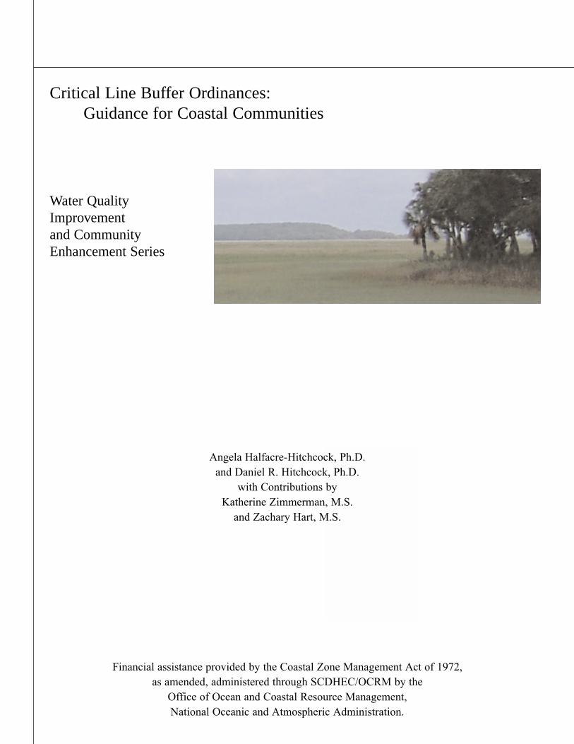
TABLE OF CONTENTS
ACKNOWLEDGEMENTS
EXECUTIVE SUMMARY
1.0 INTRODUCTION 1.1 Manual Purpose 1.2 The Lowcountry Landscape1.3. Defining a Wetland 1.4 Why Protect Wetlands and Other Critical Areas?1.5 What is a Wetland Buffer?1.7 Why Wetland Buffers?1.8 An Overview of Wetland Buffer Ordinances
2.0 CRITICAL LINE BUFFER ORDINANCE CASE STUDIES2.1 Case Study Data and Methodology2.2 The Town of Mount Pleasant, South Carolina Case Study2.3 The City of Charleston, South Carolina Case Study2.4 Overview And Comparison Of The Two Case Study Ordinances2.5 Stakeholder Interview Findings
2.5.1 Community Climate2.5.2 Ordinance Creation2.5.3 Ordinance Implementation2.5.4 Ordinance Evaluation2.5.5 Ordinance Outreach and Education Experiences
3.0 PRIMARY CRITICAL LINE BUFFER ORDINANCE LESSONS Checklist of Considerations for Effective Enactment and Implementation of Critical Line Buffer Ordinances
4.0 STEP-BY-STEP GUIDANCE FOR THE CREATION OF MUNICIPALCRITICAL LINE BUFFER ORDINANCES (CLBOs)
REFERENCES
APPENDICESAppendix A: Wetland Buffer Resources, Documents, and Contacts (Academic,
Government, Interest Group, Online, and Model Language)Appendix B: Lowcountry Native Species for Vegetative Critical Line
Buffer Use Appendix C: Inventory of Municipal Buffer Ordinances in the Southeastern
United StatesAppendix D: Glossary
Page5Page7Page9
Page17
Page29Page41Page45Page47
-3-
LIST OF TABLES AND FIGURES
Table 1-1. The Benefits of Wetlands
Table 1-2. Benefits of Buffers
Table 2-1. Comparison of Case Study Ordinances
Table 2-2. Case Study Community Climate: Summary of Predominant Responses
Table 2-3. Case Study Ordinance Creation: Summary of Predominant Responses
Table 2-4. Case Study Ordinance Implementation: Summary of Predominant Responses
Table 2-5. Case Study Ordinance Evaluation: Summary of Predominant Responses
Table 2-6. Case Study Ordinance Outreach and Education: Summary of Predominant Responses
Figure 1-1. Map of South Carolina Coastal Counties and Critical Line
Figure 1-2. Basic Traits of All Wetlands
Figure 2-1. Sequence of Events Leading to Passage of the Critical Line Buffer Ordinance in the Town of Mount Pleasant
Figure 2-2. Sequence of Events Leading to Passage of the Critical Line Buffer Ordinance in the City of Charleston
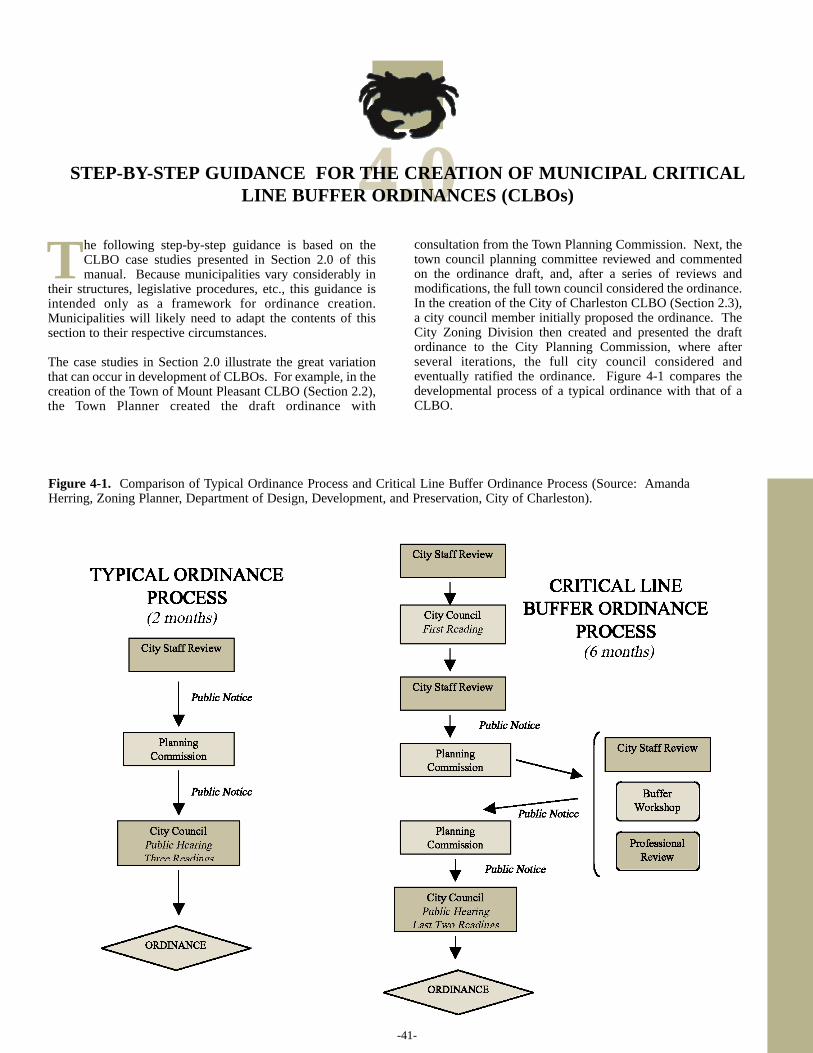
Figure 4-1. Comparison of Typical Ordinance Process and Critical Line Buffer Ordinance Process
Figure 4-2. Diagram Demonstrating the 12-Step Process in the Creation and Implementation of a Critical Line Buffer Ordinance (CLBO)
page 13
page 15
page 21
page 23
page 24
page 25
page 26
page 27
page 11
page 12
page 18
page 20
page 41
page 44
LIST OF ACRONYMS
-4-
CLBO: Critical Line Buffer Ordinance
CWP: The Center for Watershed Protection
GIS: Geographic Information Systems
IRB: Institutional Review Board
NOAA: National Oceanographic and Atmospheric Administration
NPS: Nonpoint source pollution
SC DHEC-OCRM: South Carolina Department of Health and Environmental ControlOffice of Coastal Resource Management
SCCCL: South Carolina Coastal Conservation League
SC DNR: South Carolina Department of Natural Resources
US ACE: United States Army Corps of Engineers
US EPA: United States Environmental Protection Agency
USES: Urbanization and Southeastern Estuarine Systems Project
US FWS: United States Fish and Wildlife Service
WBO: Wetland Buffer Ordinance
ACKNOWLEDGEMENTS
-5-
The South Carolina Department of Health and Environmental Control Office of Coastal ResourceManagement (SC DHEC-OCRM) funded the research included in and the preparation and
printing of this manual. The University of South Carolina/National Oceanographic andAtmospheric Administration (USC/NOAA) Urbanization and Southeastern Estuarine Systems
(USES) project supported components of manual data collection efforts (specifically regarding theCity of Charleston case study). The College of Charleston and South Carolina Sea Grant
Extension Program provided significant in-kind resource support.
Two consultants, funded by SC DHEC-OCRM, contributed significantly to this manual.Katherine Zimmerman spearheaded data collection efforts and wrote significant portions of the
text of the manual. Zachary Hart edited the entire manuscript and provided thoughtfulsuggestions and comments for improvements. Megan Barkes, College of Charleston Master of
Environmental Studies (MES) student and USES Research Assistant, deserves special recognitionfor her efforts in data collection and assistance in data analysis. Barkes also assisted with
creation of figures and appendices used in this manual.
Many other individuals helped with this project. Amanda Herring, City of Charleston, wasinstrumental in the compilation of research materials, development of the case study design, and
the origination of the manual format. Ward Reynolds, Denise Sanger, and Marian Page, SCDHEC-OCRM, and Lisa Vandiver, Hollings Marine Lab, provided important information to guide
the research. Diane Lauritsen also served as a valuable resource. Mitchell Colgan, College ofCharleston, provided additional photographs used in the manual. Norman Levine, College of
Charleston, provided assistance in developing Geographic Information Systems (GIS) mapping ofthe coastal counties and OCRM critical line. Kristan McKinne, College of Charleston Master ofEnvironmental Studies (MES) student, supplied important resources and provided comments on
portions of the manual drafts.
Other staff from the following entities also assisted with the creation of this manual: BaruchInstitute, City of Charleston, College of Charleston, Hollings Marine Laboratory, South CarolinaSea Grant Consortium, SC DHEC-OCRM, SC DNR, Town of Mount Pleasant, and University of
South Carolina Norman J. Arnold School of Public Health.
The researchers particularly appreciate the participation of the case study interview respondents.Their insight, honesty, and involvement were vital to creating appropriate guidance for other
communities.
Without the contributions of time, energy, and expertise of the individuals who participated in thisstudy and assisted with manual preparation, this project would not have been possible.
MANUAL RESEARCHER CONTACT INFORMATION:
-6-
Dr. Angela Halfacre-HitchcockAssociate Professor of Political Science66 George StreetCollege of CharlestonCharleston, South Carolina [email protected]
Dr. Daniel R. Hitchcock Coastal Environmental Quality SpecialistSC Sea Grant Extension Program259 Meeting St.Charleston, SC [email protected]
-7-
EXECUTIVE SUMMARY
In coastal areas, localities are consistently faced with important decisions that will affect theshort- and long-term quality of life in their communities. What to promote? Where to plan? Whento preserve? How to prosper? Why protect? Residents often ask these questions and wonder how
they can, or if they should be, involved with these debates. Coastal community citizens areseeking quality growth that balances economic development, human health, conservation, andenvironmental protection. The sustainable management of resources is one set of practices to
address the changes spurred by growth while maintaining quality lifestyles for residents.
The population in coastal South Carolina is expanding at a rapid rate, and natural, cultural, andeconomic resources draw newcomers and keep long-term residents. Individuals are attracted to
the South Carolina Lowcountry for its many appealing traits, including recreational opportunities(e.g. fishing, birding, boating) and the quality of the area resources. Water is key to these
recreational activities and is vital for the health of coastal communities. Promoting good waterquality, environmental health, and community involvement are the goals of this Water Quality
Improvement and Community Enhancement Series. “Critical Line Buffer Ordinances: Guidancefor Coastal Municipalities”, a manual in the series, provides specific mechanisms to address these
goals.
Significant scientific research, such as the Urbanization and Southeastern Estuarine Systems(USES) project conducted in the South Carolina Lowcountry, has provided many results about the
current state of water quality (and its impact on flora and fauna). These scientific results haveprovided recommendations that promote consistent protection of coastal water quality for humanhealth. Several of these recommendations point to the use of wetland buffer ordinances (WBOs)
to protect and improve water quality.
One type of WBO is particularly useful for coastal communities to consider: critical line bufferordinance (CLBO). This manual is a detailed guidance document examining the experiences of
two South Carolina Lowcountry municipalities (the Town of Mount Pleasant and the City ofCharleston) that have successfully enacted CLBOs. Generalizations drawn from the case studies
presented in this manual provide a step-by-step model for CLBO creation, enactment, andimplementation. Inherent in the manual approach is the recognition that cultural, environmental,
and political variability exists from one community to another. Community case analysisprovides lessons learned for localities to enhance their protection of water quality and the
involvement of stakeholders. Our approach captures stakeholder sentiment about the process andthe level of success about the use of CLBOs.
This manual provides practical insight for communities that are seeking to devise strategies forthe protection or improvement of water quality. The use of CLBOs is one way that local
residents, especially those in the eight coastal South Carolina counties, can directly participate inprocesses that not only improve water quality, but also enhance their community.

-9-
Recent scientific researchconducted in the South CarolinaLowcountry has provided many
results and recommendations supportingthe use of wetland buffer ordinances(WBOs). For example, theUrbanization and SoutheasternEstuarine Systems (USES) project,which began in 1990, was designed to (1)assess the impacts of urban developmentpractices on small, high salinity estuariesin the southeastern United States, and (2)develop tools to aid in environmentalmanagement decision-making andplanning in the coastal zone of SouthCarolina (2005). Two of the mostimportant recommendations based onUSES results were that South Carolina
coastal communities should (1) maintainnatural buffers between developed areasand waterways, and (2) create bufferstrips around areas of impervioussurfaces where vegetation had beenremoved (2005). Research findings suchas these, along with the demonstratedbenefits of existing WBOs, clearlyevidenced the need for creation andimplementation of municipal wetlandbuffer ordinances. Moreover, the Officeof Ocean and Coastal ResourceManagement within the South CarolinaDepartment of Health and EnvironmentalControl (SC DHEC-OCRM) encouragesthe development and implementation ofwetland buffer ordinances (also knownas vegetative and riparian buffers).
Lowcountry Landscape (Photo by: Hitchcock)
1.0INTRODUCTION
W
I
I
1.1 Manual Purpose
“…I don’t want to destroy the earth…I want us to have water. I want my kids to have water and my grandchildren to have water.” —Real Estate Broker
“…in Charleston, you know, you’re here for not only a lot of other good quality of life things, but you’re here for the water.So we need to protect our water.” —Town of Mount Pleasant Staff Member
“…water quality affects all of us.” —Town of Mount Pleasant Council Member
Urban Municipal Buffer (Photo by: Zimmerman)
-10-
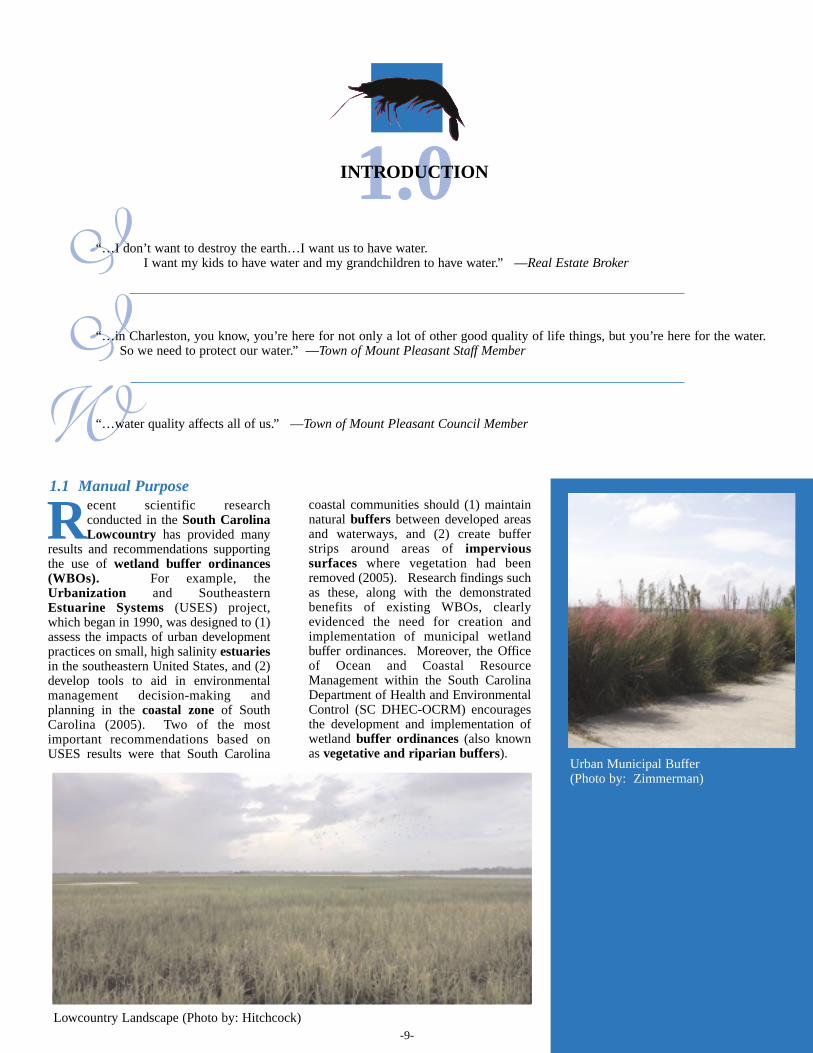
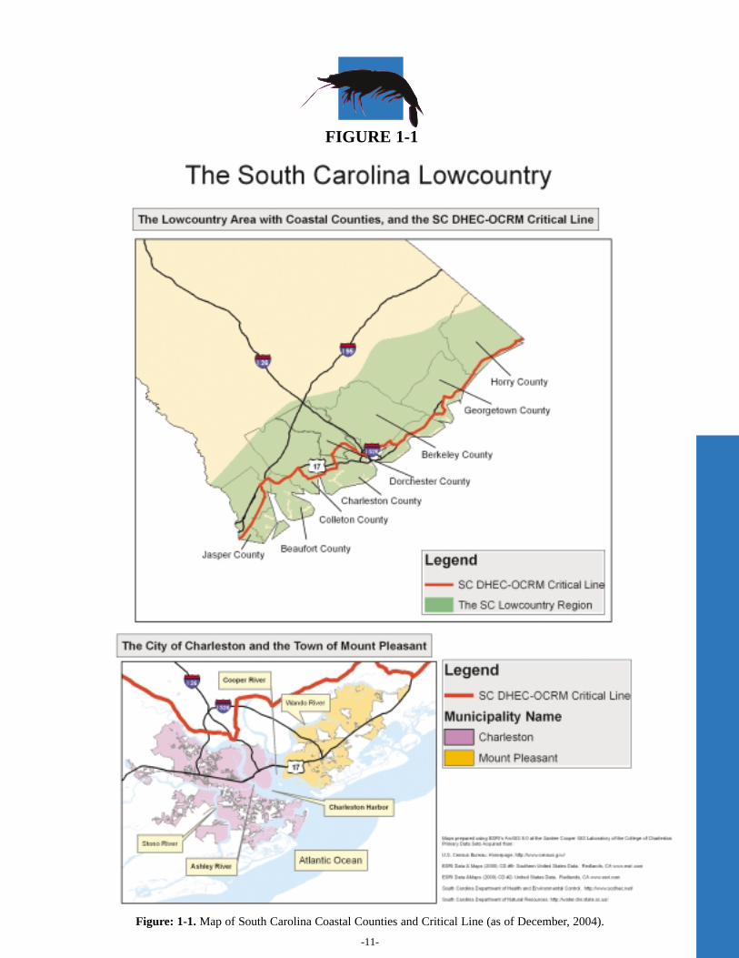
The purpose of this manual is to provide guidance for criticalline buffer ordinance (CLBO) development andimplementation based on two successful cases from the SouthCarolina Lowcountry: the City of Charleston, SC, and theTown of Mount Pleasant, SC. This guidance targets, but is notlimited to, municipalities along the South Carolina coast,including those in the eight coastal counties: Beaufort,Berkeley, Charleston, Colleton, Dorchester, Georgetown,Horry, and Jasper counties (Fig. 1-1). Overall, CLBOs aredesigned to protect coastal water quality. Generalizationsdrawn from the case studies presented in this manual helpprovide a step-by-step model for CLBO creation, enactment,and implementation, while recognizing that cultural,environmental, and political variability exists from onecommunity to another, given the nature of the communitycontemplating an ordinance and its surrounding environment.While this manual serves as a guidance tool, it also capturesthe comments, opinions, and sentiments from a variety ofstakeholders throughout the ordinance creation process in thetwo case study communities. Examination of the Charlestonand Mount Pleasant cases from political, socio-cultural,economic, and other perspectives provides communities withguidance on addressing this variability and lessons foreffective CLBO implementation.
1.2 The Lowcountry Landscape
The attraction of new residents to coastal South Carolinacan be attributed to its mild climate, fascinating history,diverse culture, and abundant natural resources, among
other qualities. Population growth in the South CarolinaLowcountry, along with the associated development of land,has been particularly pronounced in recent decades. Forexample, the total population of Berkeley, Charleston, andDorchester Counties has doubled between 1960 and 1990(United States Census Bureau, 1990), and the number of totalCharleston County residents increased by five percentbetween 1990 and 2000 (United States Census Bureau, 2000).While population growth fuels the local economy and bolstersthe reputation of the Lowcountry as an appealing place to beand to live, the associated development simultaneouslythreatens some of the same natural resources that initiallyattracted new residents.
Few dispute that water is one of our most precious naturalresources. The beaches, marshes, rivers, and creeks that areidentifiable with the South Carolina Lowcountry also providean economic engine for the tourism, recreation, shipping, andcommercial fishing industries. The continued growth anddevelopment of the Lowcountry, however, has the potential toimpact the Lowcountry landscape in two ways: (1) theaddition of roads, driveways, parking lots, and rooftopsincreases the overall area of impervious surfaces anddecreases the area of vegetated buffers adjacent to wetlands,and (2) higher human population density may lead toincreased pollution sources. The combination of increasedimpervious surfaces, decreased vegetated buffers, and morepollutant sources creates the perfect scenario for increasednonpoint source (NPS) pollution. The addition ofimpervious surfaces detracts from the opportunity forstormwater to infiltrate naturally into the soil. Stormwaterthen bypasses any natural treatment opportunities and isrouted directly into a creek, river, lake, or ocean throughdrains, culverts, underground pipe networks, and outfalls.Similarly, decreased vegetated buffer area minimizes theopportunity for stormwater treatment before entering a waterbody. Nonpoint pollution sources are typically difficult toidentify and, therefore, difficult to regulate. Stormwater andnonpoint source pollution can drastically impact waterquality, but the public is often unaware or not understandingof the potential contribution that their daily activities mayhave on this type of pollution. An effective way to protectwater quality is through stormwater management andpollution prevention. In general, water quality protectioninvolves restoring and maintaining the chemical, physical,and biological integrity of water resources.
T
T“…the Lowcountry…has barrier islands thatyou don’t see in other parts of the countryand…marshland…we have to protect it for thefuture.”
—City of Charleston Council Member
“…the unique thing about our…community isthe fact that you got so much [critical area]…itjust affects a large segment of thepopulation…”
—Land Owner Organization Representative
-11-
FIGURE 1-1
Figure: 1-1. Map of South Carolina Coastal Counties and Critical Line (as of December, 2004).
-12-
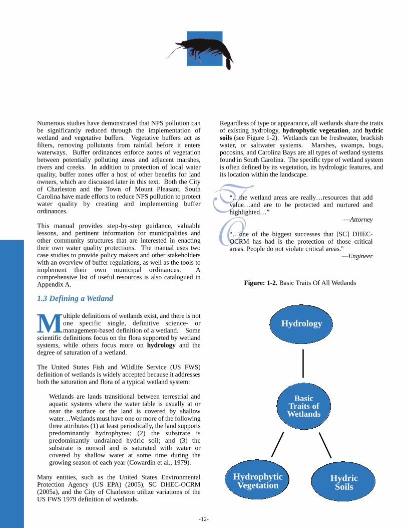
Figure: 1-2. Basic Traits Of All Wetlands
Numerous studies have demonstrated that NPS pollution canbe significantly reduced through the implementation ofwetland and vegetative buffers. Vegetative buffers act asfilters, removing pollutants from rainfall before it enterswaterways. Buffer ordinances enforce zones of vegetationbetween potentially polluting areas and adjacent marshes,rivers and creeks. In addition to protection of local waterquality, buffer zones offer a host of other benefits for landowners, which are discussed later in this text. Both the Cityof Charleston and the Town of Mount Pleasant, SouthCarolina have made efforts to reduce NPS pollution to protectwater quality by creating and implementing bufferordinances.
This manual provides step-by-step guidance, valuablelessons, and pertinent information for municipalities andother community structures that are interested in enactingtheir own water quality protections. The manual uses twocase studies to provide policy makers and other stakeholderswith an overview of buffer regulations, as well as the tools toimplement their own municipal ordinances. Acomprehensive list of useful resources is also catalogued inAppendix A.
1.3 Defining a Wetland
Multiple definitions of wetlands exist, and there is notone specific single, definitive science- ormanagement-based definition of a wetland. Some
scientific definitions focus on the flora supported by wetlandsystems, while others focus more on hydrology and thedegree of saturation of a wetland.
The United States Fish and Wildlife Service (US FWS)definition of wetlands is widely accepted because it addressesboth the saturation and flora of a typical wetland system:
Wetlands are lands transitional between terrestrial andaquatic systems where the water table is usually at ornear the surface or the land is covered by shallowwater…Wetlands must have one or more of the followingthree attributes (1) at least periodically, the land supportspredominantly hydrophytes; (2) the substrate ispredominantly undrained hydric soil; and (3) thesubstrate is nonsoil and is saturated with water orcovered by shallow water at some time during thegrowing season of each year (Cowardin et al., 1979).
Many entities, such as the United States EnvironmentalProtection Agency (US EPA) (2005), SC DHEC-OCRM(2005a), and the City of Charleston utilize variations of theUS FWS 1979 definition of wetlands.
Regardless of type or appearance, all wetlands share the traitsof existing hydrology, hydrophytic vegetation, and hydricsoils (see Figure 1-2). Wetlands can be freshwater, brackishwater, or saltwater systems. Marshes, swamps, bogs,pocosins, and Carolina Bays are all types of wetland systemsfound in South Carolina. The specific type of wetland systemis often defined by its vegetation, its hydrologic features, andits location within the landscape.
T O
“…the wetland areas are really…resources that addvalue…and are to be protected and nurtured andhighlighted…”
—Attorney
“…one of the biggest successes that [SC] DHEC-OCRM has had is the protection of those criticalareas. People do not violate critical areas.”
—Engineer
BasicTraits ofWetlands
HydricSoils
Hydrophytic Vegetation
Hydrology
-13-
Generally, wetlands occupy the natural transitional zonebetween upland and aquatic systems. Wetland structure,including vegetation, soils, and hydrology, determines thefunctionality of a wetland system. Unimpaired and properly-functioning wetlands are among the most ecologically richecosystems in the world. Wetlands provide many importantservices (Table 1-1), including removal of pollutants fromwater and containment of floodwaters (SC DHEC-OCRM,2005b).
1.4 Why Protect Wetlands and Other CriticalAreas?
Wetlands play a crucial role in the overall health of awatershed. “Wetlands are sometimes described as‘the kidneys of the landscape’ because they
function as the downstream receivers of water and waste fromboth natural and human sources” (Mitsch and Gosselink,2000). These “critical areas” also provide vital wildlifehabitat, nursery grounds for many species of fish and birds,and flood control during major storms. Table 1 summarizesmany of the functional benefits of wetlands. Because of theireconomic and environmental importance, coastal wetlands inthe United States are protected by Federal, State, and in manycases, local law.
The concept of the “critical line” is commonly associated withcoastal wetland regulations in South Carolina. The criticalline is determined by SC DHEC-OCRM and delineates theboundaries of coastal wetland systems, which comprise oneof multiple “critical areas.” State and Federal permits must beacquired for any alteration of any critical area (SC DHEC-OCRM, 2005b). Critical lines should be updatedapproximately every three years by county or other localmunicipal government to accommodate changes in thetopography by erosion or other events (Reynolds, 2005).While freshwater wetlands in the coastal zone currently arenot included in the critical area, SC DHEC-OCRM alsomakes efforts to minimize impacts to these important systems.
Y
I
“…you’re dealing with a lot of wetlands issues…you gota lot of different issues in South Carolina, I meanCharleston area especially…you want to protect thewetlands...”
—Homebuilders Association Representative
“…it just makes common sense. If the guy’s changing theoil in his car…or putting gas in his lawnmower, or thefertilizer he puts on the grass, [it will] get out there if youdon’t have something to stop it.”
—Real Estate Broker
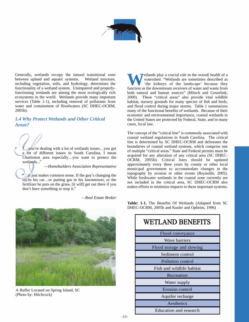
A Buffer Located on Spring Island, SC(Photo by: Hitchcock)
WWEETTLLAANNDD BBEENNEEFFIITTSS
Flood conveyance
Wave barriers
Flood storage and slowing
Sediment control
Pollution control
Fish and wildlife habitat
Recreation
Water supply
Erosion control
Aquifer recharge
Aesthetics
Education and research
Table: 1-1. The Benefits Of Wetlands (Adapted from SCDHEC-OCRM, 2005b and Kusler and Opheim, 1996)
-14-
1.5 What is a Wetland Buffer?
Wetland buffers vary greatly in their width,composition, appearance, and use. For example, ariparian buffer can buffer either freshwater or
saltwater, depending on whether the buffer is placed along aninland river or stream, as in municipalities in the state ofRhode Island, or along a tidal wetland (estuary), as in the Cityof Charleston, South Carolina. Other types of freshwaterbuffers affect only waters that are not connected to coastalwaters through watersheds, such as those in the states ofNorth Carolina, New Jersey, and Maryland. In general, acritical line buffer, as implemented in coastal South Carolina,is a corridor of vegetation that lies landward of the wetlandcritical line on a person’s property.
Despite their differences, the purpose of all wetland bufferzones is the same—to minimize the potentially harmfuleffects of development or agriculture on adjacent waterways.Other amenities often include the provision of wildlife habitatand aesthetically-pleasing scenery.
Unlike those of wetlands, definitions of wetland buffers arerather straightforward and are quite consistent from onedefinition to another. Below are two definitions that similarlydescribe the basic form and purpose of wetland buffers:
…Shoreline or riparian buffers are corridors of nativevegetation along rivers, streams, and tidal wetlands thatprotect waterways by providing a transition zonebetween upland development and adjoining surfacewaters (SC DHEC-OCRM, 2002b). A vegetated area, including trees, shrubs and herbaceousvegetation, which exists or is established to protect astream system, lake, reservoir or coastal estuarine area.Alteration of this natural area is strictly limited (Centerfor Watershed Protection, 2005).
Various factors determine how effective a given wetlandbuffer will be at reducing nonpoint source pollution andproviding other buffer benefits. These factors include:
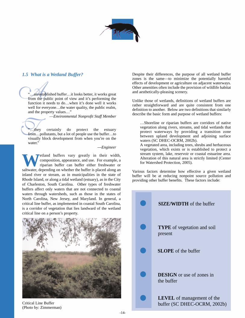
Critical Line Buffer(Photo by: Zimmerman)
A
T
“…an established buffer…it looks better, it works greatfrom the public point of view and it’s performing thefunction it needs to do…when it’s done well it workswell for everyone…the water quality, the public realm,and the property values…”
—Environmental Nonprofit Staff Member
“…they certainly do protect the estuaryfrom…pollutants, but a lot of people use the buffer…tovisually block development from when you’re on thewater.”
—Engineer
•••••
SIZE/WIDTH of the buffer
TYPE of vegetation and soilpresent
SLOPE of the buffer
DESIGN or use of zones inthe buffer
LEVEL of management of thebuffer (SC DHEC-OCRM, 2002b)
-15-
1.6 Why Wetland Buffers?
Vegetative buffers are one of the most effective andcost-efficient ways to protect wetlands and other waterbodies (SC DHEC-OCRM, 2002a). When properly
constructed and/or maintained, vegetated wetland buffers canprovide land owners with a host of environmental andeconomic benefits. In addition to improving local anddownstream water quality by reducing NPS pollution,wetland buffers can benefit a land owner or developer in manyways (Table 1-2), such as reducing erosion, reducing heatingof waterways, creating privacy, reducing flooding and flooddamage, preserving natural habitat, and saving money forhomeowners through reduced maintenance costs (SC DHEC-OCRM, 2002a). A critical component to implementing a successful bufferordinance is educating the public about buffer benefits. Withthoughtful outreach and educational efforts, land owners anddevelopers may realize how wetland buffers actually add tothe value of a home rather than detract from it.
T
I
“…the state has said that we have this critical line andwe don’t want to build, you know, beyond theline…why would we want to buffer that? The line, itseems to me, indicates that…that’s the point where westop…buffering of the critical line…wastes land areathat could otherwise be developed more efficiently…”
—Realtors Association Representative
“I am an advocate of buffers, but…they need to beproperly sized to address the concern [versusspeculation]…”
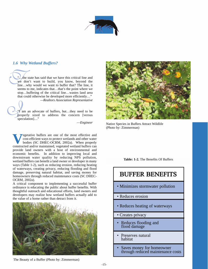
—Engineer Native Species in Buffers Attract Wildlife(Photo by: Zimmerman)
Table: 1-2. The Benefits Of Buffers
BBUUFFFFEERR BBEENNEEFFIITTSS
• Minimizes stormwater pollution
• Reduces erosion
• Reduces heating of waterways
• Creates privacy
• Reduces flooding and flood damage
• Preserves natural habitat
• Saves money for homeowner through reduced maintenance costs
The Beauty of a Buffer (Photo by: Zimmerman)
-16-
1.7 An Overview of Wetland Buffer Ordinances
WBOs have been implemented in localities all overthe nation, such as in Rhode Island, New York,Maryland, and Florida. These ordinances vary
considerably according to the goals and desires of theirrespective communities. Ordinance details, such as minimumbuffer width and provisions for ordinance flexibility, must bedetermined through thorough public debate so that theordinances are politically feasible and publicly accepted.
In the southeastern region, several municipalities haveimplemented requirements for various types of buffersincluding critical line buffers, freshwater wetland buffers, andriparian (river) buffers. South Carolina buffer ordinancesinclude those in Beaufort County, Georgetown County,Pickens County, the city of North Charleston in CharlestonCounty, the City of Charleston in Charleston County, and theTown of Mount Pleasant in Charleston County. A moreelaborate list is located in Appendix C.
The US EPA suggests the following outline as a modelorganizational structure for an aquatic buffer ordinance(http://www.epa.gov/owow/nps/ordinance/mol1.htm):
Critical line buffers augment state protection of critical areas,which are designated and monitored by SC DHEC-OCRM.Although buffer ordinances vary, the primary purpose of eachis to protect the quality of waterways that are impacted bynearby development or agriculture. Many homes andcommercial districts are placed along critical areas, andvegetated buffers can help prevent nonpoint source pollutioncreated by these developments. Growth and development areinevitable, particularly in areas that offer great quality of life,but the effects of growth can be successfully mitigated withmeasures such as WBOs and, specifically for the coast,CLBOs.
In the next section, we discuss in detail the experiences ofCLBO development and implementation in the City ofCharleston, SC, and the Town of Mount Pleasant, SC toprovide useful information, tips, and lessons for othermunicipalities that are considering implementing these typesof ordinances.
Buffers Maintain Water Quality (Photo by: Hitchcock)
T
S
“[the ordinance is] pretty easy to follow, it’spretty easy to understand, and…there’s a goodpurpose behind it. The majority of the peopleare…pretty understanding of why it’s there.”
—Town of Mount Pleasant Staff Member
“…so many people have made…their living asshrimpers, fishermen, and we all enjoy thefruits of that, and if we don’t have a good bufferordinance that could certainly affect the qualityof the seafood that we have here…”
—City of Charleston Council Member
Section 1: BackgroundSection 2: IntentSection 3: DefinitionsSection 4: ApplicationsSection 5: Plan RequirementsSection 6: Design Standards for Forest BuffersSection 7: Buffer Management and MaintenanceSection 8: Enforcement ProceduresSection 9: Waivers/VariancesSection 10: Conflict with other Regulations
References
-17-
2.1 Case Study Data and Methodology
The purpose of this manual is to help policy makers andresource managers anticipate and address challengesthat they may face in implementing critical line buffer
ordinances (CLBOs). The content of the manual is derivedprimarily from case studies of the Town of Mount Pleasantand City of Charleston’s CLBOs, including personalinterviews with stakeholders involved in the passage of theseordinances. Additionally, the manual presents contextualinformation on water quality, buffers, and buffer ordinancescollected from peer-reviewed journals, official websites anddatabases, and outreach materials published by universities,government agencies, and collaborative research institutions.
This section of the manual presents case study findings aswell as the results of content analysis (Berg, 2004) ofinterviews with 24 local stakeholders, includingrepresentatives of the private sector, the nonprofit sector, andthe governmental sector, who were involved with ordinancedevelopment or who have worked extensively with theCLBOs.
To identify interviewees, the researchers initially consultedone stakeholder who was involved with the completeevolution of each CLBO. During these interviews, theresearchers identified further interview subjects throughsnowball sampling (Berg, 2004) by asking interviewees “Canyou name others (planners, legislators, developers, citizens,nonprofit groups, etc.) who we should interview about criticalline buffer ordinances?” Interviews were conducted in-person with the exception of one interview via telephoneconference call. Interviews were semi-standardized, using aninterview instrument developed by the research team andapproved by the College of Charleston’s Institutional ReviewBoard (IRB) (IRB05-002).
The interview instrument included five categories ofquestions: personal background, role in/perspective ofordinance creation, knowledge of ordinance, evaluation ofordinance, and perceptions of ordinance outreach.Interviewees could respond to interview questions withrespect to either or both municipal ordinances. The followingis a breakdown of how interviewees in each of the threesectors (private, nonprofit, and governmental) addressedinterview questions: Government sector (Out of 13, twodiscuss both Mount Pleasant and City of Charleston; fourdiscuss Mount Pleasant only; seven discuss City ofCharleston only); Nonprofit sector (All eight discuss bothMount Pleasant and City of Charleston); and Private sector(Eight of nine discuss both Mount Pleasant and City ofCharleston; one of the nine discusses Mount Pleasant only).
The researchers utilized manifest and latent content analysis(Berg, 2004) to identify common themes in respondents’answers. Qualitative data was supplemented with quantitativedata collected when respondents were asked to rate theiranswers on a scale. Results in this section are reported withrespect to each of the three sectors represented in theinterviewee pool and are summarized in Tables 2-2 through 2-6. Some interviewees were included in multiple sectors basedon their past work experience, their current positions, andhow they framed their perspectives—12 public sectorrespondents, nine private sector respondents, and eightnonprofit sector respondents were identified, with seveninterviewees overlapping sectors.
2.2 The Town Of Mount Pleasant, SouthCarolina Case Study
The Town of Mount Pleasant is situated between severalbeaches and the downtown Charleston area. MountPleasant’s total population is 47, 609 residents, and the
majority of those residents are white, in their late-thirties, owntheir homes, and live in family households (United StatesCensus Bureau, 2000).
The town has a part-time mayor with a full-time electedcouncil (eight members), one of the three structural options asmandated by the State of South Carolina Legislature. Thetown council that considered the ordinance was elected in2000, and the planning department had placed emphasis onsmart growth and low impact development techniques inaccordance with the town’s 1998-1999 Comprehensive Plan(required by the South Carolina Legislature) and in responseto citizen reaction to the area’s rapid development. The towncontinues to be challenged by great pressure for developmentbut has implemented growth moratoriums and building permitallocation programs with the intentions of limiting growth.
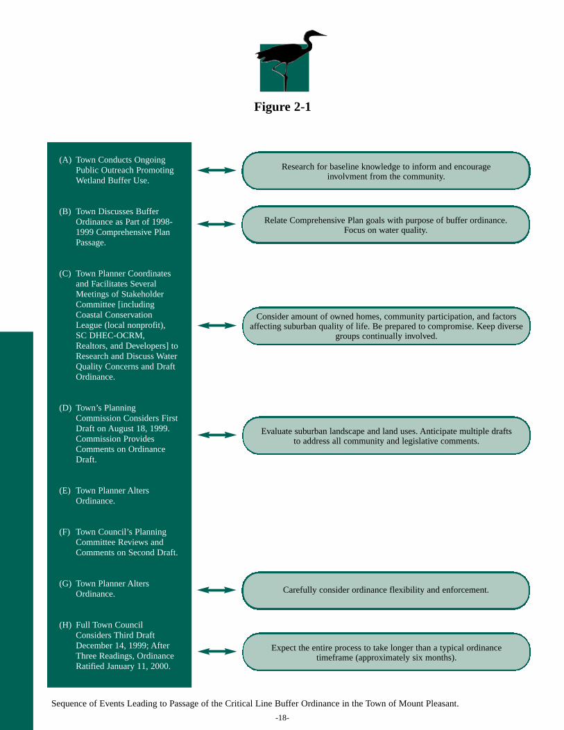
Figure 2-1 overviews the primary events that led to passage ofMount Pleasant’s CLBO and offers preparatory notes formanual readers. Several aspects of this table warrantmention—in particular, key to ordinance passage was the helpof the Town Planner in facilitating stakeholder involvement,and the participation of those stakeholders in drafting thedocument. With the participation of stakeholders, planningstaff, and the Planning Committee, the town altered theordinance to address concerns and foster compromise. TheTown of Mount Pleasant passed its CLBO in early 2000.
2.0CRITICAL LINE BUFFER ORDINANCE CASE STUDIES
-18-
Figure 2-1
(A) Town Conducts OngoingPublic Outreach PromotingWetland Buffer Use.
(B) Town Discusses BufferOrdinance as Part of 1998-1999 Comprehensive PlanPassage.
(C) Town Planner Coordinatesand Facilitates SeveralMeetings of StakeholderCommittee [includingCoastal ConservationLeague (local nonprofit),SC DHEC-OCRM,Realtors, and Developers] toResearch and Discuss WaterQuality Concerns and DraftOrdinance.
(D) Town’s PlanningCommission Considers FirstDraft on August 18, 1999.Commission ProvidesComments on OrdinanceDraft.
(E) Town Planner AltersOrdinance.
(F) Town Council’s PlanningCommittee Reviews andComments on Second Draft.
(G) Town Planner AltersOrdinance.
(H) Full Town CouncilConsiders Third DraftDecember 14, 1999; AfterThree Readings, OrdinanceRatified January 11, 2000.
Sequence of Events Leading to Passage of the Critical Line Buffer Ordinance in the Town of Mount Pleasant.
Research for baseline knowledge to inform and encourage involvment from the community.
Relate Comprehensive Plan goals with purpose of buffer ordinance.Focus on water quality.
Consider amount of owned homes, community participation, and factors affecting suburban quality of life. Be prepared to compromise. Keep diverse
groups continually involved.
Evaluate suburban landscape and land uses. Anticipate multiple draftsto address all community and legislative comments.
Carefully consider ordinance flexibility and enforcement.
Expect the entire process to take longer than a typical ordinance timeframe (approximately six months).
-19-
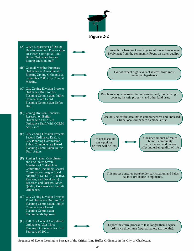
2.3 The City of Charleston, South Carolina CaseStudy
The City of Charleston includes historic peninsularCharleston, the West Ashley community, and annexedportions of James Island, Daniel Island, Johns Island,
and Wadmalaw Island, among others. The peninsular area isconsidered developed to its full capacity, but it is constantlyevolving, and zoning may be adapted in the future toaccommodate growth. West Ashley, especially in certainannexed portions, is experiencing further development. TheCity of Charleston’s total population is 96,650 residents, andthe majority of those residents are white, in their early-thirties(though statistics are very close between ages twenty andfifty-four), homeowners (although slightly less than half rent),and living in family households (although a close percentagelive alone) (United States Census Bureau, 2000).
The political structure of the City is a full-time mayor andfull-time elected council (12 members). Figure 2-2 providesan overview for the primary events that led to passage of theCharleston Critical Line Buffer Ordinance and offerspreparatory notes for manual readers. As with the Town ofMount Pleasant, the Planning and Zoning staff of the City wasvital in facilitating passage of the ordinance. Additionally,City Council members were integral to development andpassage of the ordinance, and the use of a diverse stakeholdercommittee was important for soliciting community input.
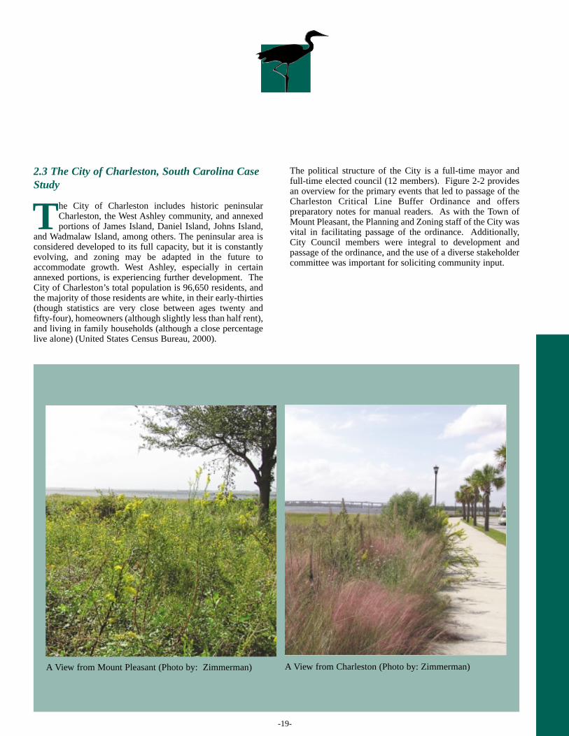
A View from Mount Pleasant (Photo by: Zimmerman) A View from Charleston (Photo by: Zimmerman)
-20-
Figure 2-2
Sequence of Events Leading to Passage of the Critical Line Buffer Ordinance in the City of Charleston.
Research for baseline knowledge to inform and encourage involvment from the community. Focus on water quality.
Problems may arise regarding university land, municipal golfcourses, historic property, and other land uses.
Do not expect high levels of interest from mostmunicipal legislators.
Use only scientific data that is comprehensive and unbiased.Utilize local ordinances as models first.
Do not discount any opinions,
or trust will be lost.
Consider amount of rented homes, community
participation, and factorsaffecting urban quality of life.
This process ensures stakeholder participation and helpsbalance ordinance components.
Expect the entire process to take longer than a typical ordinance timeframe (approximately six months).
(A) City’s Department of Design,Development and PreservationDiscusses Conceptual LineBuffer Ordinance AmongZoning Division Staff.
(B) Council Member ProposesOrdinance as Amendment toExisting Zoning Ordinance atSeptember 2000 City CouncilMeeting.
(C) City Zoning Division PresentsOrdinance Draft to CityPlanning Commission. PublicComments are Heard.Planning Commission DefersDraft.
(D) Zoning Division ConductsResearch on BufferOrdinances and AltersOrdinance Draft With OCRMAssistance.
(E) City Zoning Division PresentsSecond Ordinance Draft toCity Planning Commission.Public Comments are Heard.Planning Commission DefersDraft Again.
(F) Zoning Planner Coordinatesand Facilitates SeveralMeetings of StakeholderCommittee [including CoastalConservation League (localnonprofit), SC DHEC-OCRM,Realtors, and Developers] toResearch and Discuss WaterQuality Concerns and RedraftOrdinance.
(G) City Zoning Division PresentsThird Ordinance Draft to CityPlanning Commission. PublicComments are Heard.Planning CommissionRecommends Approval.
(H) Full City Council ConsideredOrdinance; After ThreeReadings, Ordinance RatifiedFebruary of 2001.
-21-
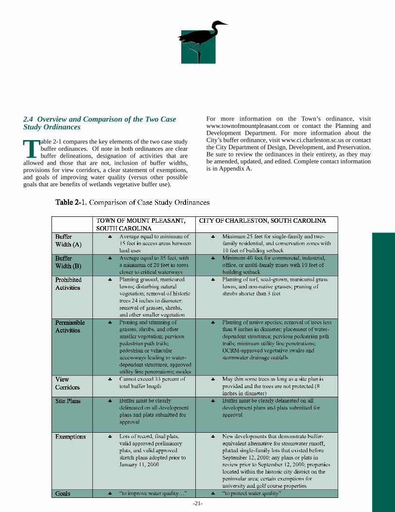
2.4 Overview and Comparison of the Two CaseStudy Ordinances
Table 2-1 compares the key elements of the two case studybuffer ordinances. Of note in both ordinances are clearbuffer delineations, designation of activities that are
allowed and those that are not, inclusion of buffer widths,provisions for view corridors, a clear statement of exemptions,and goals of improving water quality (versus other possiblegoals that are benefits of wetlands vegetative buffer use).
For more information on the Town’s ordinance, visitwww.townofmountpleasant.com or contact the Planning andDevelopment Department. For more information about theCity’s buffer ordinance, visit www.ci.charleston.sc.us or contactthe City Department of Design, Development, and Preservation.Be sure to review the ordinances in their entirety, as they maybe amended, updated, and edited. Complete contact informationis in Appendix A.
-22-
2.5 Stakeholder Interview Findings
To assess stakeholder perspectives on ordinanceimplementation in the two case study municipalities,various members of the private, nonprofit, and
government sectors were interviewed. Intervieweesrepresented the following professions:
The respondents divulged opinions on community climate,creation of the CLBOs, implementation of the ordinances,evaluation of the ordinances, as well as experiences with anyordinance outreach that may have occurred. The trends intheir responses are summarized in the following sections, withcorresponding tables.
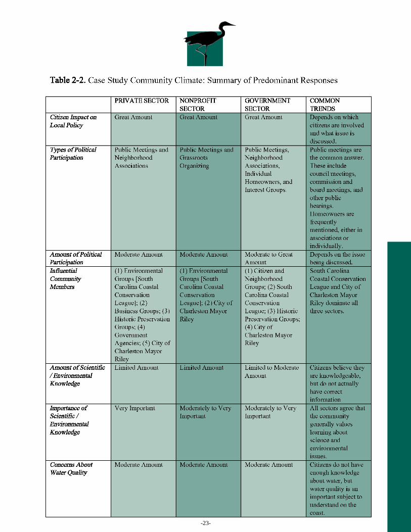
2.5.1 Community Climate
Respondents were asked how much impact communitymembers have on local political issues, what types ofcommunity political participation exist, how much politicalparticipation there actually is by community members, andwho the most influential people (types of people, groups ofpeople, or specific individuals) are within the community. Therespondents were also asked to reflect on the level of thecommunity’s general scientific and environmentalknowledge, on whether or not this knowledge is important tothe general community, and if there are general concernsabout water quality within the community. The majorityresponses are summarized in Table 2-2.
Private professions: development,engineering, law, real estate brokerage,real estate appraisal, surveying, landscapearchitecture
Nonprofit affiliations: Charleston MetroChamber of Commerce DevelopersCouncil; Charleston Trident Associationof Realtors; Charleston TridentHomebuilders Association; SouthCarolina Association of Realtors; SouthCarolina Coastal Conservation League;South Carolina Landowners Association;South Carolina Tourism Council
Government offices: City of CharlestonDepartment of Design, Development andPreservation; Charleston City Council; SCDHEC-OCRM; Town of Mount PleasantCouncil; Town of Mount PleasantPlanning Department; Town of MountPleasant Waterworks Commission
“…it is clear to me that there is a very activegroup of people…in the Mount Pleasant area,in local government, and ….they’ve becomemore involved…at other levels….”
—Realtors Association Representative
I
I “…in many cases, youtake a hundred peopleinto a…city council,and you get theirattention…they dolisten to community…sometimes they listento the loudest voice,unfortunately…”
—Real Estate Broker
-23-
-24-
2.5.2 Ordinance Creation
Respondents were questioned on the role they played duringcreation and passage of each municipality’s ordinance, and ontheir perspectives of the process. Interview questions assessed
identities of primary ordinance opponents and proponents,resource use in ordinance development, and impediments andsuccesses related to ordinance creation. The majority responsesare summarized in Table 2-3.
-25-
2.5.3 Ordinance Implementation
Respondents were asked various questions regarding specificcomponents of the CLBOs. Respondents who “know theordinance well” provided correct information for the majority ofthe questions asked. Correct answers are interpreted as animpressive amount of baseline knowledge of the ordinance orthe ability to cite specific numbers. Respondents who “know theordinance somewhat” provided answers with uncertainty orstated that they would have to check the ordinance, but still
managed to provide a moderate amount of baseline knowledgeor cite specific numbers. Respondents who “do not know theordinance” openly stated that they could not provide answers,did not answer any questions correctly, or could not answer atall without reading directly from the ordinance. For thegovernment sector, respondents generally answered interviewquestions in reference to their own municipality’s ordinancerather than both. The majority responses are summarized inTable 2-4.
-26-
2.5.4 Ordinance Evaluation
Respondents were asked to evaluate the CLBOs since their implementation. Interview questions assess whether or not there areenough resources to properly enforce the ordinance, whether or not trends exist with enforcement, which community factorsencourage the success of buffer ordinances, how stringent a CLBO should be, whether there are unique aspects of the ordinances,and whether there are similar aspects to the ordinances that other municipalities can model. Answers are summarized in Table 2-5.
-27-
2.5.5 Ordinance Outreach and Education Experiences
Respondents were asked if they knew of outreach efforts for theCLBOs and whether or not that outreach has been successful.They were also asked to provide recommendations onimproving ordinance outreach and to describe what groups orindividuals in the community would ideally be involved withimplementation and outreach efforts. Responses aresummarized in Table 2-6.
I “I don’t think we’ve done a good job of educating people.”
—Town of Mount Pleasant Council Member
-28-
I “…I wouldn’t personally recommend, you know, going about tryingto…teach people the science, but what I would do is…have an educationprogram that teaches them…the practical parts of…being a good stewardof our water resources. Things like: don’t dump your grass clippings…onthe curb, you know? Don’t drain your radiator on your driveway, youknow, things like that.”
—Realtors Association Representative
Y “…you want to protect yournatural resources, but you alsodon’t want to infringe onpeople’s property rights...”
—Landscape Architect
A “…a lot of times there’s disinformation. People only tell one side ofthe story. And they tell it loud and often.” —Attorney
T“There are enough resources to…implement it.There’s not enough to enforce it.”
—Engineer
I “…I think that other folks could take ourordinance, look at it, and…incorporate that intotheir…standards, or even improve it…they can usethat as a guideline, and then mold it to fit theircommunity…make it better to fit their own.”
—City of Charleston Staff Member
-29-
The case studies narrated in Section 2.0 of this manualprovide a keen insight into the development of twospecific Lowcountry CLBOs. Additionally, analysis of
the 24 stakeholder interviews conducted in the case studiesprovides overarching lessons and themes for othermunicipalities considering implementation of similarordinances. Section 3.0 summarizes these lessons and themes
in “checklist” form, and offers supplemental recommendationson ordinance development and implementation. Although thefollowing guidance is based primarily on the results ofinterviews conducted for production of this manual, weanticipate that the lessons presented in this section will beextremely useful to a great variety of communities andmunicipalities.
3.0PRIMARY CRITICAL LINE BUFFER ORDINANCE LESSONS
CHECKLIST OF CONSIDERATIONS FOR EFFECTIVE ENACTMENT ANDIMPLEMENTATION OF CRITICAL LINE BUFFER ORDINANCES (CLBOS):
M“…meaningful input has to bedone in a timely fashionwhere…there’s adequateopportunity to…make yourpoints…[and] to react to them…”
—Attorney
1. Involve community stakeholders from the beginning.
2. Opposition to ordinances is likely to come from the
development community. Pay special attention to this
community.
3. Compromise among stakeholders is key.
4. Be clear about scientific information used to justify buffer
ordinances.
5. Be consistent with stakeholder outreach.
6. Include flexibility in ordinance stipulations.
7. Enforcement and monitoring resources are crucial for the
success of the ordinance.
8. To avoid CLBO violations, homeowners should be the focus of
educational campaigns.
9. Outreach and education on critical line buffers should take
varied formats.
10. Promoting water quality is the most agreeable and least
controversial goal of buffer ordinances.
❏❏
❏
❏
❏❏
❏
❏
❏
❏
-30-
Issue: Community constituents such asneighborhood and homeownerassociation members, local legislators,and interest group members have a greatdeal of influence. If these individuals orgroups become involved in an issue orprocess, the results can be powerful. Casestudy interview respondents, particularlydevelopers and interest group members,asserted that official ordinancenotification to the community came lateor was underscored, therefore detractingfrom private sector and interest groupacceptance and understanding of theordinances. Many respondents reflectedthat only the most involved citizens
understood the rationale for buffers, andthat media coverage and greatercommunity involvement in the earlystages of ordinance creation would havestreamlined the process.
Resolution: Notify stakeholders,particularly private sector stakeholders,early and often to involve them in theprocess and incorporate their input.Utilize the media as often as possible,going above and beyond basic publicnotice requirements. Begin outreach onthe importance of buffers early in theordinance creation process.
✔ 11.. Involve community stakeholders from the beginning.
“…that’s why our input on these ordinances was critical, because…if you say you got to have a…thirty-five footsetback, or a fifty-foot setback, it really doesn’t matter what the number is. Whatever the number is, I promise you,it’s an arbitrary number…Because it’s all different. It depends on the topography, it depends on the elevation, itdepends on the nature of the wetland or the marshes of which the runoff may be going…”
—Land Owners Association Representative
T
A Flourishing Buffer(Photo by: Hitchcock)
-31-
Issue: Professionals directly affected bybuffer ordinances (such as developers,engineers, and realtors) and members ofinterest groups promoting property rightswere generally opposed to the case studyordinances. Most were more opposed tospecific ordinance elements than thebroader idea of mandating buffer use.Therefore, it is wise to involve thesegroups early in the process andthroughout ordinance evolution. Duringinterviews, respondents from the abovegroups felt ignored, and stressed that theywould have liked to be more involvedwith ordinance development andoutreach. In particular, real estate brokersstated that municipal staff should utilizethe private sector as a vehicle foroutreach, for example as a distributor ofbrochures on buffers.
Resolution: Involve the developmentcommunity throughout the ordinanceprocess, particularly to incorporate theirsuggestions on flexibility in theordinance. Case study interviewrespondents typically stated that theywere appeased by the inclusion of certainalternatives and exemptions in theordinances. Examples include: variablebuffer width requirements based on landarea; allowance of buffer alternatives thatare equally effective at curbing runoff(such as drainage ponds and swales); andmethods of compensating land ownersand developers for meeting bufferrequirements.
✔ 2. Opposition to ordinances is likely to come from the development community. Payspecial attention to this community.
I “…if for any reason it’s ruled that [buffer ordinances] takes [property] away, [property owners] just should becompensated, that’s all…if this buffer is for the good of the people in the waterways so that they can have a nice view,who benefits from that? The people on the waterway, and that’s the public, and maybe the public should be paying forthat buffer.”
—Realtors Association Representative
T“…[the planners try] to develop relationships with developersso that you get good development…it’s not opposed todevelopment, but we are opposed to bad development…we arereally trying to orient developers towards doing betterthings…we’re open to them if it’s good. And creative.”
—City of Charleston Staff Member
-32-
Issue: Balance and compromise amongall stakeholders is critical, and allcommunity stakeholders must beinvolved. Every interview respondentmentioned the need for opposing sides tomeet in the middle, and all mentioned thedistrust that sides have of one another.Some interviewees analogizedcompromise to opposite poles needing tobend, and some analogized failure ofcompromise to pendulums swinging toofar in one direction. Others mentionedbargaining skills and the expectation thatcompromise will always result“somewhere in the middle.” Not a singlerespondent asserted that their views werethe correct ones, and all recognized theneed to compromise and to be honest.
Resolution: Not only does communityinvolvement and compromise open thediscussion to differing perspectives, but italso helps the community become bettersatisfied with the end result. Balance,compromise, and the opportunity forinvolvement contribute to greaterknowledge of specific issues/ordinancesas well as local governmental processes.Additionally, balance, compromise, andcommunity involvement nurture trust andrespect among stakeholder groups. Beopen about research sources, use mediato widely advertise all public meetings,invite all stakeholders, and offerflexibility and alternative solutions.
✔ 3. Compromise among stakeholders is key.
Y “…you have to balance conservation with property rights, and you have to do conservation that, in my opinion,is founded on real science as opposed to speculation…”
—Engineer
O“Our concern, from the realtor side, is that we always like to bea part of the stakeholder group, just let us participate. Manytimes there is this…polarization, you know, theenvironmentalists over here and those bad developers and thoserealtors…over there… Well, that’s not the way to do it. I mean,you’ve got to work it out and meet somewhere in the middle.”
—Real Estate Broker

-33-
Issue: The source and presentation ofscientific data used in discussing bufferordinances is important. Manyrespondents in the private sector and indevelopment interest groups believe thatgovernment and environmentalistsselectively choose which science issalient and that they misinterpret ormisrepresent the research when relayingit to the public.
Resolution: Stakeholders should beprovided with a reference list of allsources used in WBO discussions, as wellas instructions on accessing thosesources. In this way, all stakeholders canread and interpret the research on theirown and have an open and informeddiscussion without suspicion of theopposing side. This action reinforcestrust between stakeholders andgovernment or other groups that maysupport wetland buffers.
✔ 4. Be clear about scientific information used to justify buffer ordinances.
M“…most of the environmental…propaganda that we have…is based on lies. So most people are misled by what we read in the newspaper…junk science reigns”
—Developer
P“…people are beginning to go back now and say ‘was this real science? Or did somebody have an agenda that they are trying to promote?’… ”
—Developer
-34-
Issue: Outreach is pivotal if amunicipality approves a buffer ordinance.Communication with the general publicand especially the private sector duringordinance development and after theordinance passes is critical to stakeholderunderstanding. A municipality shouldneither stop nor curb communication andoutreach on a buffer ordinance after thatordinance takes effect. Interviewrespondents identified buffer violationsprimarily as a mistake by uninformedhomeowners, or a failure of ordinanceoutreach, rather than blatant disregard forthe ordinance.
Resolution: Respondents mentioned thatoutreach must be adapted, updated, and
performed often. Government sectorrespondents asserted that workshops andpublic displays were successful but mustbe performed on a regular basis toeffectively educate homeowners on localbuffer ordinances and their benefits.Many private sector respondents eitherdid not know about or did not recalloutreach on case study ordinances.Continuous outreach on buffers broadensunderstanding and helps potentialviolators keep the ordinance in mind.Real estate brokers’ offers to becomeinvolved with outreach can be extremelyhelpful and should be capitalized on bygovernments, because new homeownersneed reminders to check plats, determinebuffer boundaries, and maintain buffers.
✔ 5. Be consistent with stakeholder outreach.
M“…Mount Pleasant definitely said…‘well, we’re going to implement an education program just to educate homeowners about it, you know, it’s going to be on their stamp, they’re going to get a pamphlet about it,that’s going to be on their plat…’”
—Environmental Nonprofit Staff Member
O“…[outreach should consist] of workshop types…seminars thatare available and discussion that…actually could generateresults…[during which] the ordinance is available and…we talkabout…what can be changed, what’s working, what’s notworking, what’s hurting our clients, what’s helping…whatwe’ve seen needs to be done more…that sort of thing.”
—Landscape Architect
-35-
✔ 6. Include flexibility in ordinance stipulations.
T“…these rules ought to have enough flexibility to where…a land owner or a developer has some optionsand not just put into a box where you got to do it this way or you can’t do it at all.”
—Attorney
I“…I think most of our developers say they don’t mind…planting buffers and things like that to protect it, just so there’s some flexibility in dealing with the issues of when you develop the property.”
—Realtors Association Representative
Issue: Ordinance components should beflexible enough to meet manystakeholder needs and to appropriatelymatch the municipality’s landscape.Many private sector respondents believethat set minimum widths in bufferordinances are arbitrary, inappropriate,and ineffective, and that widths should bebased on individual land use andlandscape. Many developers also contendthat the use of swales, ditches, anddrainage ponds are effective and shouldbe incorporated as options in bufferordinances.
Resolution: Much of the buffer researchpromotes minimum buffer widths to filtera set amount of pollutants, butstakeholders must understand theinformation and be provided withflexibility on buffer width. If alternativesor exemptions are appropriate for thecommunity and acceptable to improvewater quality, then they certainly shouldbe a part of the discussion. Additionalcomponents of typical buffer ordinancesmay simply be unfeasible orunacceptable to certain communities, andpublic officials should embrace this.
-36-
Issue: Respondents from all sectorsemphasized that enforcement of bufferordinances is difficult and that theinability to enforce the ordinance iscounteractive to promoting buffers. Mostrespondents mentioned that there are notenough resources to properly enforce theCLBO, and some respondents reflectedthat it reinforces a notion thatgovernment adds regulations but cannotsecure the resources with which toenforce them.
Resolution: Enforcement and resourcesshould not be lacking, though allgovernments face budget issues. A
municipality needs a proper method ofmonitoring critical areas, for example,using Geographic Information Systems(GIS) to map and compare annual aerialphotography of the landscape, orassigning an enforcement officer toperiodically check critical area property.Relying on citizens to report theirneighbors may be somewhat effective,but has its drawbacks and should not bethe sole means of identifying violations.Proper enforcement is time-consuming,and extra staff is ideal, but a basic abilityto photograph buffer areas and comparephotos over time is a great start.
✔ 7. Enforcement and monitoring resources are crucial for the success of the ordinance.
T“…they’re definitely short of people…to continue to enforce new regulations on top of regulations that already exist,they don’t have the…people to do it. Neither one of the municipalities.”
—Engineer
E“…every time we identify a problem…we thinkthat…the solution is more rules and we neverreally quite get down to enforcing the rules that wehave in place. We just make up more rules to solvethe problem, and…I honestly don’t think there’s agreat deal of enforcement.”
—Realtors Association Representative
-37-
✔ 8. To avoid CLBO violations, homeowners should be the focus of educationalcampaigns.
I “It’s not the developer. The developer does it right, sells the lot, and then the lot owner goes in with his chainsaw and cuts things down, and plants grass down to the edge of the marsh, [and] he just claims ‘well, I didn’t know any better.’”
—Attorney
P“…probably the people that aren’t[aware of the ordinance] are moreindividual property owners…that aren’tpart of the development process…thisisn’t something they do all the time.”
—City of Charleston Staff Member
Issue: According to all three sectorsinterviewed, homeowners are the culpritsof most CLBO violations. Intervieweesattribute this to limited general scientificknowledge and the fact that someprofessionals and government staff workwith the ordinance daily while thegeneral citizenry does not. Theseviolations and the lack of knowledgeassociated with them are not a result ofmalicious intent or apathy; all threesectors agree that science andenvironmental knowledge are moderatelyto very important to community membersbut that this knowledge is largely absentfrom the community.
Resolution: Substantial and thoughtfuloutreach to the general citizenry isimperative and should occur throughoutordinance creation, implementation, andenforcement. Specific outreachopportunities include outreach toneighborhood associations (and evenincluding the ordinance in theneighborhood’s covenants), showing newhomeowners their plats with the bufferdelineated, and using private sectoroffices as places to distribute brochures.
-38-
Issue: The public is generally notinformed about water quality, wetlandsand other coastal resources, buffers,buffer ordinances, and land use issues.The interview respondents agreed thatthere is limited to no knowledge of theseissues among most citizens.
Resolution: Though each sector hadvarying ideas on the best methods formaking buffer ordinance informationmore accessible, the outreach suggestions
that all three sectors shared are: (1)producing a web site that has a condensedor summarized version of the ordinanceand explains why the municipality choseto put a buffer ordinance in place; (2)developing a brochure that is available atgovernment offices, private sectoroffices, and public areas that outlines thebuffer ordinance and buffer information;and (3) conducting public meetings andworkshops on buffers and bufferordinances.
✔ 9. Outreach and education on critical line buffers should take varied formats.
I“…I think there’s got to be some forum somewhere to get that information out. Is it the municipalities’ responsibility? Absolutely. And do they use the realtors to get that information out? They could.”
—Real Estate Broker
P“Put it online. You could have an executivesummary of it [the ordinance] so…you don’t
have to read the…whole document, but you could just get an executive summary for laypeople, just so you could have a general understanding.”
—Real Estate Broker

-39-
✔ 10. Promoting water quality is the most agreeable and least controversial goal of buffer ordinances.
A“…and that’s what setbacks are really all about, it trying to protect that fragile border…of marshland around our Lowcountry property.”
—Attorney
P“…providing buffers along… criticalareas [and] salt water wetlands…trapspollutants, and so…prevents nonpointsource pollution from getting to theestuaries. So in that regard, buffers area good thing.”
—Engineer
Issue: Because of so many variedinterests among stakeholders, plannersand other municipal staff have a difficulttime determining a community’s goalswith respect to buffers—Are aestheticsimportant? Is wildlife habitat important?Is sprawl an issue? Some goals seem toreflect narrow interests and views, andthe development communityinterviewees in particular feel thatgovernment typically sides withenvironmentalists. Of all the questionsand concerns that stakeholders siftthrough, there is one common concernfor all members of a community,including the private sector—improving
or maintaining water quality. Resolution: Regardless of an interviewrespondent’s background, perspective,profession, or level of involvement withthe ordinances, all respondentsrecognized the importance of preservingwater quality and the need for buffers ofsome type in the critical area. The debatebetween sectors in our case studies isfocused more on ordinance details, not onthe need for buffers. Most respondentsrecognized the importance of keepingwater clean for posterity anddemonstrated an understanding that theirenjoyment of coastal resources dependslargely on the health of those resources.

-41-
The following step-by-step guidance is based on theCLBO case studies presented in Section 2.0 of thismanual. Because municipalities vary considerably in
their structures, legislative procedures, etc., this guidance isintended only as a framework for ordinance creation.Municipalities will likely need to adapt the contents of thissection to their respective circumstances.
The case studies in Section 2.0 illustrate the great variationthat can occur in development of CLBOs. For example, in thecreation of the Town of Mount Pleasant CLBO (Section 2.2),the Town Planner created the draft ordinance with
consultation from the Town Planning Commission. Next, thetown council planning committee reviewed and commentedon the ordinance draft, and, after a series of reviews andmodifications, the full town council considered the ordinance.In the creation of the City of Charleston CLBO (Section 2.3),a city council member initially proposed the ordinance. TheCity Zoning Division then created and presented the draftordinance to the City Planning Commission, where afterseveral iterations, the full city council considered andeventually ratified the ordinance. Figure 4-1 compares thedevelopmental process of a typical ordinance with that of aCLBO.
4.0STEP-BY-STEP GUIDANCE FOR THE CREATION OF MUNICIPAL CRITICALLINE BUFFER ORDINANCES (CLBOs)
Figure 4-1. Comparison of Typical Ordinance Process and Critical Line Buffer Ordinance Process (Source: AmandaHerring, Zoning Planner, Department of Design, Development, and Preservation, City of Charleston).
-42-
The following is a 12-step CLBO development andimplementation guide, derived from the case studiespresented in this manual. The guide includes
recommendations and considerations pertinent to CLBOdevelopment, as well as real-life examples from the casestudies in Section 2.0. Figure 4-2 (below) provides a diagramof the 12-step CLBO development and implementationprocess.
Step 1: Municipal planning/zoning staff initiates discussionon drafting CLBO…
Recommendation: Initial brainstorming and fact-findingsessions should prepare staff through organizing informationand exploring existing CLBO models. Utilize local outreachand extension specialists who may be familiar with existingCLBO models.
Example: The Town of Mount Pleasant utilized informationfrom SC DHEC-OCRM, University of Georgia, the Center forWatershed Protection, and Beaufort County’s existingordinance, among other sources. The City of Charlestonlearned from the Town of Mount Pleasant, using both theTown and Beaufort County’s ordinances as models. The Cityalso used research from SC DHEC-OCRM, University ofGeorgia, and the Center for Watershed Protection, amongother sources.
Step 2: New ordinance should be proposed as either part ofComprehensive Plan creation/modification or as anamendment to an existing zoning ordinance…
Recommendation: Expect to coordinate Comprehensive Plangoals with goals of CLBO. Focus on water quality andcommunity enhancement.
Example: The Town of Mount Pleasant debated the purposesof the Comprehensive Plan and the related CLBO. Staffultimately decided to focus on improving water quality, ratherthan on protecting wildlife habitat and preserving aesthetics,because of the setting of the coastal community and becauseof citizens’ vocal support of quality of life. Feasibility of goalswas important in this decision-making process—wildlifehabitat protection was not an end goal for the communitybecause of existing development patterns and the fact thatthere is no space for a buffer large enough to attract andsupport large marsh wildlife. Through the overarching goal ofwater quality, protection of habitat for smaller wildlife canexist as a sub-goal.
Step 3: Proposed CLBO is created with guidance fromstakeholder committee meetings (Step 4 below) and a reviewof scientific research and existing CLBO models (Step 5below).
Consideration: The creation of the CLBO will most likely bean iterative process, specifically through Steps 3-9. Specificordinance requirements, including buffer widths, structuralsetbacks, tree diameter criteria, allowable species, andapproved buffer modifications and enhancements will bedeveloped during this process. Deciding on thesespecifications will require input from stakeholders and anassessment of available information.
Step 4: Municipal planner coordinates and facilitatesstakeholder committee meetings, which include regulatoryagencies (e.g. SC DHEC-OCRM), realtors, developers, not-for-profit organizations (e.g. Coastal Conservation League,SC Sea Grant Extension), and others to research and discusswater quality concerns and to draft the ordinance…
Recommendation: Be prepared to compromise withstakeholders. Keep a diverse group continually involved. Donot discount any opinions, or trust will be questioned or lost.This part of the process helps to ensure fair stakeholderparticipation and to balance the ordinance. Utilize localoutreach and extension specialists to assist in convening theappropriate stakeholders.
Example: Both case study municipalities created diversestakeholder committees to discuss the CLBOs during theirdevelopment. Participating stakeholders drafted language andprovided feedback throughout ordinance creation. Thestakeholder committees supplemented the public commentperiods during Planning Commission meetings for eachsubmitted draft. Further, the stakeholder committees werecomposed of representatives from environmental nonprofits,the development community, and the general citizenry.
Step 5: Municipal planning commission explores scientificresearch on buffer ordinances with regulatory agencyassistance (e.g. SC DHEC-OCRM)…
Recommendation: Ensure that scientific data iscomprehensive and unbiased. Utilize nearby ordinances asmodels first. Consult local outreach and extension specialistswho may be familiar with scientific knowledge on buffers andCLBOs.
Example: The development community members interviewedfor the case studies felt that most of the data presented bymunicipal staff came from OCRM and environmental groups,and therefore that buffer ordinances are based on “junkscience.” They also felt that even if quality data is used,government staff and environmental advocates interpret thescience differently, conveying false information to the generalpublic. Though the basis for this assertion is incorrect(municipal staff utilized academic sources, research fromcollaborative think tanks, and other reliable data studies), the
-43-
theme is significant—in order to encourage open and truthfuldiscussion, data must be reliable and provided to stakeholdersfor their own review.
Step 6: Municipal planning staff presents ordinance draft tomunicipal council planning commission…
Consideration: Anticipate iterative work on several drafts toincorporate and address all community and legislative input.
Example: The municipalities composed several drafts toaddress various concerns. For the City of Charleston, concernarose over whether the Citadel (a local military school) wouldhave to implement the CLBO and the potential complicationsthat would ensue. Concerns about municipal golf courses andexisting development were also pinpointed and addressed. Inthese instances, discussion among several stakeholders andreworking of many drafts became necessary.
Example: To determine the appropriate buffer widths for thecase study municipalities, planners examined the land use andzoning of the local coastal areas affected by the proposedCLBO. Utilizing studies that examine runoff filtration perfoot of buffer, and then matching those studies to land use andcommunity input, municipalities determined different widthsfor each area. For Mount Pleasant, areas home to moreenvironmentally sensitive zones or areas that contained lessdevelopment were protected with wider buffer widths. Areasthat already contained a fair amount of development requiredless buffer width. The intent was to protect water quality nearfragile and less developed land and “sacrifice” alreadydeveloped areas. For the City of Charleston, the urban settingcalled for a different approach, and officials chose to exemptcertain existing land uses (ports, institutions of higherlearning, etc.) while buffering those areas still underdevelopment and with greater impervious surface area.
Step 7: An opportunity for public comment on the draftordinance is provided…
Recommendation: Notice the public on the public commentperiod via local newspaper and posting on municipal websites. Make hard copies available upon request and electronicversions available on the web site. Ensure that instructionsfor providing comments are clear. Utilize local outreach andextension specialists to facilitate the comment period.
Example: When interviewed, members of interest groupsrepresenting the development community often remarked thatthe public notice is only done because of Federal requirement,and that reading elaborate ordinances is time-consuming.Well-advertised public comment periods that exceed federalstandards will help foster trust between groups, and offeringeasily accessible copies of the drafts is important. The same
interview respondents above mentioned that paying to receivea copy of an approved ordinance is often a hurdle, and onlineexecutive summaries would be useful. Apply the same theoryto the public comment opportunities during ordinancedrafting.
Example: Case study interviewees, particularly those in thedevelopment community, indicated distrust towardsgovernment staff and “environmentalists.” These respondentsdid not believe their opinions were valued during publiccomment periods, particularly their requests for ordinanceflexibility.
Step 8: Municipal planning commission reviews andcomments on draft ordinance…
Step 9: If necessary, planning staff reworks, modifies, oralters draft ordinance based on comments by council andpublic…if necessary, return to Step 6…
Step 10: Full city council considers ordinance; ordinancerevised if necessary; after three readings ordinance ratified…
Consideration: Expect the entire process to take longer thana typical ordinance timeframe (~ 6 months).
Example: For both of the case study municipalities, plannersemphasized that much of the extra time was needed to takevarious stakeholder concerns into account and for theplanners to collect adequate research and buffer ordinanceinformation. The process is therefore more elaborate anddifficult than that of a typical ordinance, but the result is abetter product that is representative of the municipality. Theplanners interviewed were comfortable that the end result metthe needs of stakeholders.
Step 11: Implement the CLBO…
Recommendation: Utilize local outreach and extensionspecialists to facilitate implementation of the ordinance in thefield.
Example: Planners interviewed in the case studiesemphasized that implementation was complicated. Reviewingplats to ensure that designs included an identified, approvedbuffer was necessary until the process became ingrained in thedevelopment community’s procedures. Outreach materialswere created and distributed at government offices and publicevents to alert the homeowners in the community.
Step 12: Perform CLBO evaluations and assessments…
Recommendation: An evaluation of the ordinance in terms of(1) protected acres of critical area, (2) buffered lengths of
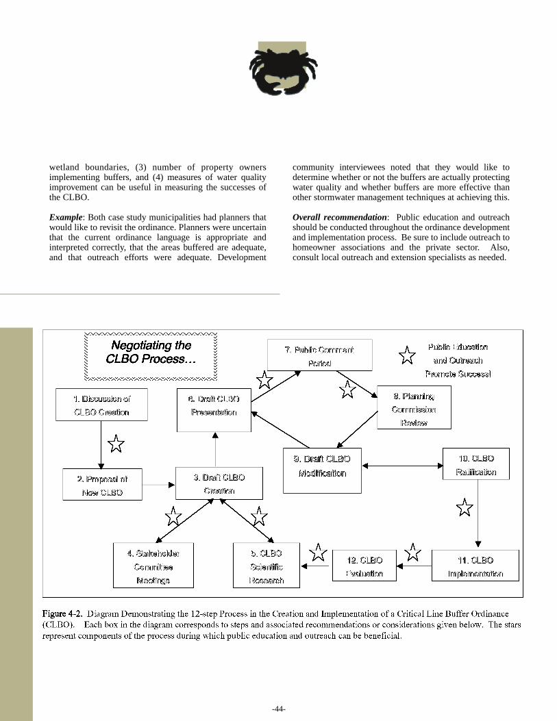
-44-
wetland boundaries, (3) number of property ownersimplementing buffers, and (4) measures of water qualityimprovement can be useful in measuring the successes ofthe CLBO.
Example: Both case study municipalities had planners thatwould like to revisit the ordinance. Planners were uncertainthat the current ordinance language is appropriate andinterpreted correctly, that the areas buffered are adequate,and that outreach efforts were adequate. Development
community interviewees noted that they would like todetermine whether or not the buffers are actually protectingwater quality and whether buffers are more effective thanother stormwater management techniques at achieving this.
Overall recommendation: Public education and outreachshould be conducted throughout the ordinance developmentand implementation process. Be sure to include outreach tohomeowner associations and the private sector. Also,consult local outreach and extension specialists as needed.
REFERENCES
Berg, B.L. (2004) Qualitative Research Methods. (5th ed.)Boston: Pearson Education.
Center for Watershed Protection (CWP). (2005) Homepage.http://www.cwp.org/
Cowardin, L.M., Carter, V., Goley, F.C., & LaRoe, E.T.(1979) Classification of Wetlands and Deepwater Habitats ofthe United States. (FWS/OBS-79/31).Washington, DC: US Fish and Wildlife Service, 103.
Kusler, J. & Opheim, T. (1996) Our National WetlandHeritage: A Protection Guide. (2nd ed.) Washington, DC: Environmental Law Institute.
Mitsch, W.J. & Gosselink, G.J. (2000) Wetlands. New York:John Wiley & Sons.
Reynolds, W. (2005) Email to authors. January 18.
South Carolina Department of Health and EnvironmentalControl-Office of Ocean and Coastal Resource Management.(2005a) Frequently Asked Questions.http://www.scdhec.net/ocrm/html/faq.html.
South Carolina Department of Health and EnvironmentalControl. (2005b) Guide to Wetlands Permitting.www.scdhec.net/eqc/water/pubs/401guide.pdf.
South Carolina Department of Health and EnvironmentalControl-Office of Coastal Resource Management (SC DHEC-OCRM). 2002a. Backyard Buffers for theSouth Carolina Lowcountry. Columbia, South Carolina: SC DHEC-OCRM.
South Carolina Department of Health and EnvironmentalControl-Office of Coastal Resource Management (SC DHEC-OCRM). 2002b. Vegetated Riparian Buffersand Buffer Ordinances. Columbia, South Carolina: SC DHEC-OCRM.
Urbanization and Southeastern Estuarine Systems Project(USES). (2005) Homepage.http://www.urbanestuary.org/
US Census Bureau. (2000)http://quickfacts.census.gov/qfd/states/45000.html
US Census Bureau. (1990)http://quickfacts.census.gov/qfd/states/45000.html
US EPA. (2004) Wetland Homepage.http://www.epa.gov/owow/wetlands/
-45-

-47-
The following are general references that may beuseful to those wishing to learn more about buffers.These citations are organized by type: academic
sources and documents; government documents; interestgroup documents, online sources and documents;documents containing model ordinance language.Following the list is a chart of contacts helpful for theLowcountry area. For sources directly cited in the manualtext, see the reference page.
ACADEMIC SOURCES
Arnold, C.L, & Gibbons, C.J. (1996) Impervious surfacecoverage: the emergence of a key environmental indicator.Journal of the American Planning Association,62(2), 243-259.
Bryan, E.H. (1972) Quality of stormwater drainage fromurban land. Water Resources Bulletin, 8(3), 578-588.
Burke, V.J., & Gibbos, J.W. (1995) Terrestrial buffer zonesand wetland conservation: a case study of freshwater turtlesin a Carolina Bay. Conservation Biology, 9(6), 1365-1369.
Carpenter, S.R., Caraco, N.F., Correll, D.L., Howarth,R.W., Sharpley A.N., & Smith, V.H. (1998) Nonpointpollution of surface waters with phosphorus as nitrogen.Ecological Applications, 8(3), 559-568.
Castelle, A. J., Johnson, A.W., & Conolly, C. (1994)Wetland and stream buffer size requirements- a review.Journal of Environmental Quality, 23, 878-882.
Corbett, C.W., Wahl, W., Porter, D.E., Edwards, D., &Moise, C. (1997) Nonpoint source runoff modeling acomparison of a forested watershed and an urban watershedon the South Carolina coast. Journal of ExperimentalMarine Biology and Ecology, 213, 113-149.
Desbonnet, A., Pogue, P., Lee, V., & Wolff, N. (1994)Vegetated Buffers in the Coastal Zone- A Summary Reviewand Bibliography. University of Rhode Island: CoastalResource Center, Rhode Island Sea Grant.
Heimlich, R.E., Wiebe, K.D., Claassen, R., & House, R.M.(1997) Recent evolution of environmental policy: lessonsfrom wetlands. Journal of Soil and Water Conservation,52(3), 157-165.
Holland, A.F., Sanger, D.M., Gawle, C.P., Lerberg, S.B.,Santiago, M.S., Riekerk, G.H.M., Zimmerman, L.E., &Scott, G.I. (2004) Linkages between tidal creek ecosystemsand the landscape and demographic attributes of theirwatersheds. Journal of Experimental Marine Biology andEcology, 298, 151-178.
Kennish, M.J. (2002) Environmental threats andenvironmental future of estuaries. EnvironmentalConservation, 29(1), 78-107.
Kramer, R.A. & Shabman, L. (1993) The Effects ofagriculture and tax policy reform on the economic return towetland drainage in the Mississippi Delta region. LandEconomics, 69(3), 249-62.
Lant, C.L. & Roberts, R.S. (1990) Greenbelts in thecornbelt: riparian wetland, intrinsic, values, and marketfailure. Environment and Planning A, 22, 1375-1388.
Lerberg, S.B., Holland, A.F., & Sanger, D.M. (2000)Responses of tidal creek macrobenthic communities to theeffects of watershed development. Estuaries,23(6), 838-853.
Livingston, R.L. (1991) Historical relationships betweenresearch and resource management in the ApalachicolaRiver estuary. Ecological Applications, 1(4), 361-382.
Maddock, T.A. (2001) Fragmenting regimes: how waterquality regulation is changing political-economiclandscapes. Geoforum, 35(2), 217-230.
Mahan, B.L., Polasky, S., & Adams, R.M. (2000) Valuingurban wetland: a property price approach. LandEconomics, 76(1), 100-113.
McCutcheon, S.C., Hayes, J.C., Williams, C.A., Weisskopf,C.P., & Klaine, S.J. (1999) Evaluation of vegetative filterstrips to control urban runoff into Charleston harbor.Columbia, South Carolina: Charleston Harbor Project.
AppendixA: Wetland Buffer Resources, Documents, and Contacts
◗
◗
◗
◗
◗
◗
◗
◗
◗
◗
◗
◗
◗
◗
◗
◗
◗
-48-
Nichols, D.S. (1983) Capacity of natural wetlands toremove nutrients from wastewater. Journal of the WaterPollution Control Federation, 55(5), 495-502.
Roth, L. (2004). Life at the Water’s Edge: A ShorelineResidence’s Guide to Natural Lakeshore and StreamsideBuffers for Water Quality Protection in South Carolina.Clemson, SC: Clemson Public Service, ClemsonUniversity.
Sanger, D.M., Holland, A.F., & Scott, G.I. (1999) Tidalcreek and salt marsh sediments in South Carolina coastalestuaries: I. Distribution of trace metals. Archives ofEnvironmental Contamination and Toxicology, 37, 445-457.
Sanger, D.M., Holland, A.F., & Scott, G.I. (1999) Tidalcreek and salt marsh sediments in South Carolina coastalestuaries: II. Distribution of organic contaminants. Archivesof Environmental Contamination and Toxicology, 37, 458-471.
Semlitsch, R.D. (1998) Biological delineation of terrestrialbuffer zones for pond-breeding salamanders. ConservationBiology, 12(5), 1113-1119.
Spray, S.L. & McGlothlin, K.L. (2004) Wetlands. Lanham:Rowman & Littlefield Publishers.
Tiner, R. W. (1999) In Search of Swampland: a WetlandSourcebook and Field Guide. New Brunswick: RutgersUniversity Press.
Weller, D.E., Jordan, T.E., & Correll, D.L. (1998) Heuristicmodels for material discharge from landscapes withriparian buffers. Ecological Applications, 8(4), 1156-1169.
Wenger, S. (1995) A Review of the Scientific Literature onRiparian Buffer Width, Extent and Vegetation. Athens:Office of Public Service & Outreach, Institute of Ecology,University of Georgia.
Wenger, S. & Fowler, L. (1999) Guidebook for DevelopingLocal Riparian Buffer Ordinances. Athens: Office of PublicService & Outreach, Institute of Ecology, University ofGeorgia.
Williams, C. A., Weisskopf, C.P., McCutcheon, S.C.,Hayes, J.C., & Klaine, S.J. (1996) Evaluation of VegetatedFilter Strips to Control Nonpoint Source Pollution ontoCharleston Harbor and Other Coastal Waters. Clemson,South Carolina: Clemson University, [Draft].
GOVERNMENT DOCUMENTS
American Public Health Association (APHA). (1995)Standard methods for the examination of water andwastewater. Washington, DC: APHA.
Herring, M. (2002) Creating and conserving critical linebuffers. Charleston, SC: City of Charleston Department ofDesign, Development & Preservation.
South Carolina Department of Health and EnvironmentalControl-Office of Coastal Resource Management (SC DHEC-OCRM). (2000). CHP: The Citizen’s Guide tothe Charleston Harbor Project. Columbia, SC: SCDHEC-OCRM.
United States Army Corps of Engineers (US ACE). (1991)Buffer strips for riparian management (a literature review).Waltham, MA: USACE – New England Division.
United States Environmental Protection Agency (US EPA).(1993) Guidance specifying management measure forsources of nonpoint pollution in coastal waters. (EPA Doc# 840-B-92-002.) Washington, DC: Office of Water.
INTEREST GROUP DOCUMENTS
National Research Council. (2000) Clean coastal waters:understanding and reducing the effects of nutrient pollution.Washington, DC: National Academy Press.
South Carolina Coastal Conservation League. (2002)Coastal Sprawl-The Effects of Urban Design on AquaticEcosystems in the United States. Charleston, SC: PewOceans Commission.
South Carolina Department of Health and EnvironmentalControl-Office of Coastal Resource Management (SC DHEC-OCRM). (2002) Post Development BMPDesign Aid Manual. Columbia, South Carolina: SCDHEC-OCRM.
AppendixA: Wetland Buffer Resources, Documents, and Contacts
◗
◗
◗
◗
◗
◗
◗
◗
◗
◗
◗
◗
◗
◗
◗
◗
◗
◗
◗
-49-
ONLINE
SC DHEC-OCRM. Backyard Buffers for the SouthCarolina Lowcountry. (2004) pdf version of manual online.http://www.scdhec.net/ocrm/pubs/backyard.pdf/
College of Charleston Campus Sustainability. (2005)Homepage. http://www.cofc.edu/sustainability/
CWP: The Stormwater Manager’s Resource Center. (2004)Homepage. http://www.stormwatercenter.net/
Low Impact Development Center. (2005) Homepage. http://www.lowimpactdevelopment.org/
Municode website. (2005) Homepage.http://www.municode.com/resources/online_codes.asp/
South Carolina Native Plant Society. (2004) Homepage.http://www.scnps.org/
MODEL ORDINANCE LANGUAGE
Center for Watershed Protection. (2004) The StormwaterManager’s Resource Center. Buffer Model Ordinance.http://www.stormwatercenter.net/Model%20Ordinances/buffer_model_ordinance.htm
South Carolina Department of Health and EnvironmentalControl-Office of Ocean and Coastal ResourceManagement (2004) Model Vegetated Buffer Ordinance:http://www.scdhec.com/eqc/ocrm/pubs/model.pdf
U.S. EPA. (2004) Model Ordinance Language for streambuffers.http://www.epa.gov/owow/nps/ordinance/mol1.htm/
AppendixA: Wetland Buffer Resources, Documents, and Contacts
◗
◗
◗
◗
◗
◗
◗
◗
◗
-50-
AppendixA: Wetland Buffer Resources, Documents, and Contacts
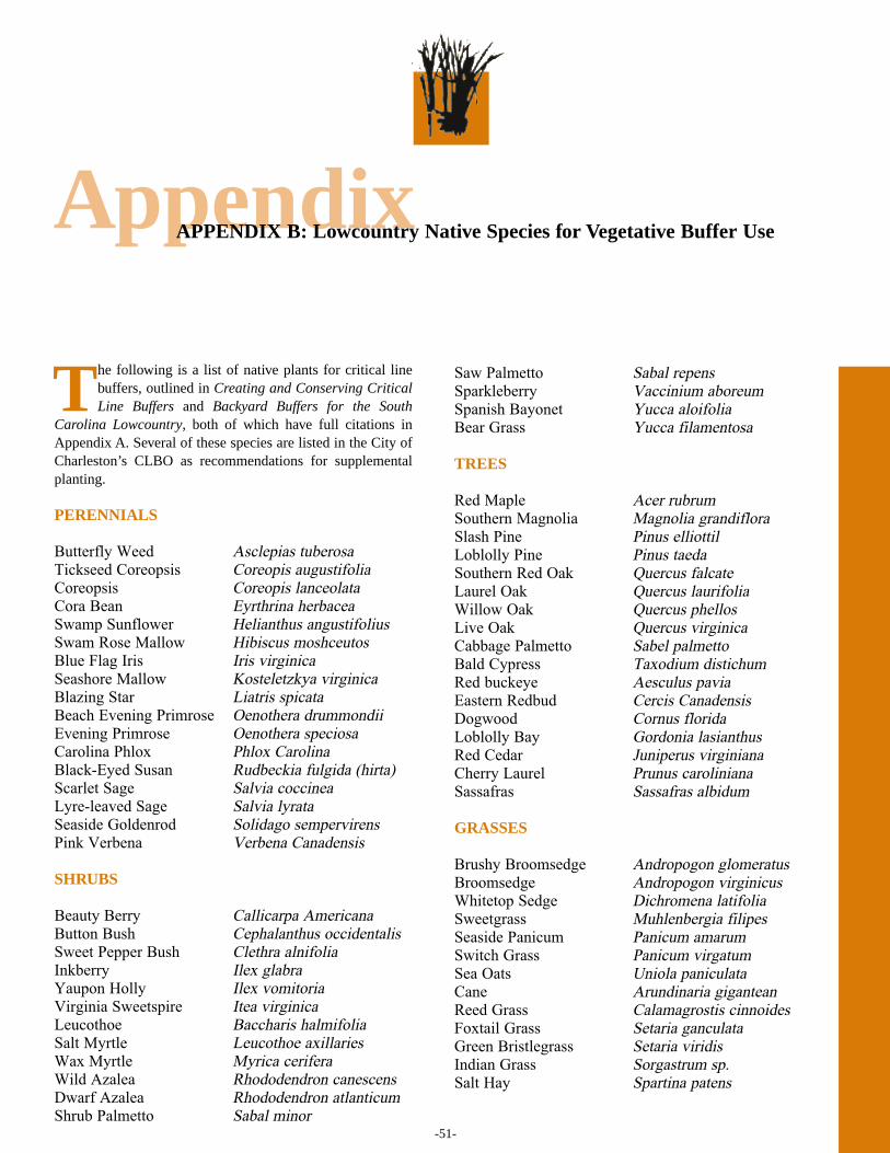
-51-
AppendixAPPENDIX B: Lowcountry Native Species for Vegetative Buffer Use
The following is a list of native plants for critical linebuffers, outlined in Creating and Conserving CriticalLine Buffers and Backyard Buffers for the South
Carolina Lowcountry, both of which have full citations inAppendix A. Several of these species are listed in the City ofCharleston’s CLBO as recommendations for supplementalplanting.
PERENNIALS
Butterfly Weed Asclepias tuberosa
Tickseed Coreopsis Coreopis augustifolia
Coreopsis Coreopis lanceolata
Cora Bean Eyrthrina herbacea
Swamp Sunflower Helianthus angustifolius
Swam Rose Mallow Hibiscus moshceutos
Blue Flag Iris Iris virginica
Seashore Mallow Kosteletzkya virginica
Blazing Star Liatris spicata
Beach Evening Primrose Oenothera drummondii
Evening Primrose Oenothera speciosa
Carolina Phlox Phlox Carolina
Black-Eyed Susan Rudbeckia fulgida (hirta)
Scarlet Sage Salvia coccinea
Lyre-leaved Sage Salvia lyrata
Seaside Goldenrod Solidago sempervirens
Pink Verbena Verbena Canadensis
SHRUBS
Beauty Berry Callicarpa Americana
Button Bush Cephalanthus occidentalis
Sweet Pepper Bush Clethra alnifolia
Inkberry Ilex glabra
Yaupon Holly Ilex vomitoria
Virginia Sweetspire Itea virginica
Leucothoe Baccharis halmifolia
Salt Myrtle Leucothoe axillaries
Wax Myrtle Myrica cerifera
Wild Azalea Rhododendron canescens
Dwarf Azalea Rhododendron atlanticum
Shrub Palmetto Sabal minor
Saw Palmetto Sabal repens
Sparkleberry Vaccinium aboreum
Spanish Bayonet Yucca aloifolia
Bear Grass Yucca filamentosa
TREES
Red Maple Acer rubrum
Southern Magnolia Magnolia grandiflora
Slash Pine Pinus elliottil
Loblolly Pine Pinus taeda
Southern Red Oak Quercus falcate
Laurel Oak Quercus laurifolia
Willow Oak Quercus phellos
Live Oak Quercus virginica
Cabbage Palmetto Sabel palmetto
Bald Cypress Taxodium distichum
Red buckeye Aesculus pavia
Eastern Redbud Cercis Canadensis
Dogwood Cornus florida
Loblolly Bay Gordonia lasianthus
Red Cedar Juniperus virginiana
Cherry Laurel Prunus caroliniana
Sassafras Sassafras albidum
GRASSES
Brushy Broomsedge Andropogon glomeratus
Broomsedge Andropogon virginicus
Whitetop Sedge Dichromena latifolia
Sweetgrass Muhlenbergia filipes
Seaside Panicum Panicum amarum
Switch Grass Panicum virgatum
Sea Oats Uniola paniculata
Cane Arundinaria gigantean
Reed Grass Calamagrostis cinnoides
Foxtail Grass Setaria ganculata
Green Bristlegrass Setaria viridis
Indian Grass Sorgastrum sp.
Salt Hay Spartina patens
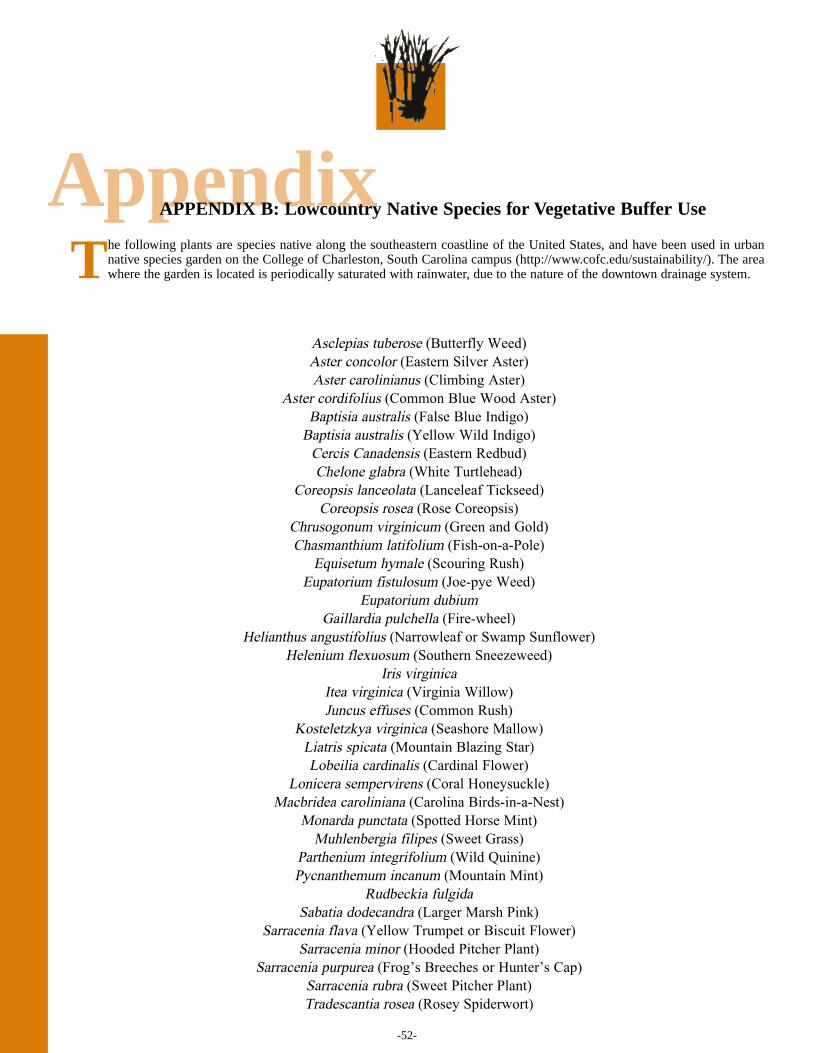
-52-
AppendixAPPENDIX B: Lowcountry Native Species for Vegetative Buffer Use
The following plants are species native along the southeastern coastline of the United States, and have been used in urbannative species garden on the College of Charleston, South Carolina campus (http://www.cofc.edu/sustainability/). The areawhere the garden is located is periodically saturated with rainwater, due to the nature of the downtown drainage system.
Asclepias tuberose (Butterfly Weed)
Aster concolor (Eastern Silver Aster)
Aster carolinianus (Climbing Aster)
Aster cordifolius (Common Blue Wood Aster)
Baptisia australis (False Blue Indigo)
Baptisia australis (Yellow Wild Indigo)
Cercis Canadensis (Eastern Redbud)
Chelone glabra (White Turtlehead)
Coreopsis lanceolata (Lanceleaf Tickseed)
Coreopsis rosea (Rose Coreopsis)
Chrusogonum virginicum (Green and Gold)
Chasmanthium latifolium (Fish-on-a-Pole)
Equisetum hymale (Scouring Rush)
Eupatorium fistulosum (Joe-pye Weed)
Eupatorium dubium
Gaillardia pulchella (Fire-wheel)
Helianthus angustifolius (Narrowleaf or Swamp Sunflower)
Helenium flexuosum (Southern Sneezeweed)
Iris virginica
Itea virginica (Virginia Willow)
Juncus effuses (Common Rush)
Kosteletzkya virginica (Seashore Mallow)
Liatris spicata (Mountain Blazing Star)
Lobeilia cardinalis (Cardinal Flower)
Lonicera sempervirens (Coral Honeysuckle)
Macbridea caroliniana (Carolina Birds-in-a-Nest)
Monarda punctata (Spotted Horse Mint)
Muhlenbergia filipes (Sweet Grass)
Parthenium integrifolium (Wild Quinine)
Pycnanthemum incanum (Mountain Mint)
Rudbeckia fulgida
Sabatia dodecandra (Larger Marsh Pink)
Sarracenia flava (Yellow Trumpet or Biscuit Flower)
Sarracenia minor (Hooded Pitcher Plant)
Sarracenia purpurea (Frog’s Breeches or Hunter’s Cap)
Sarracenia rubra (Sweet Pitcher Plant)
Tradescantia rosea (Rosey Spiderwort)
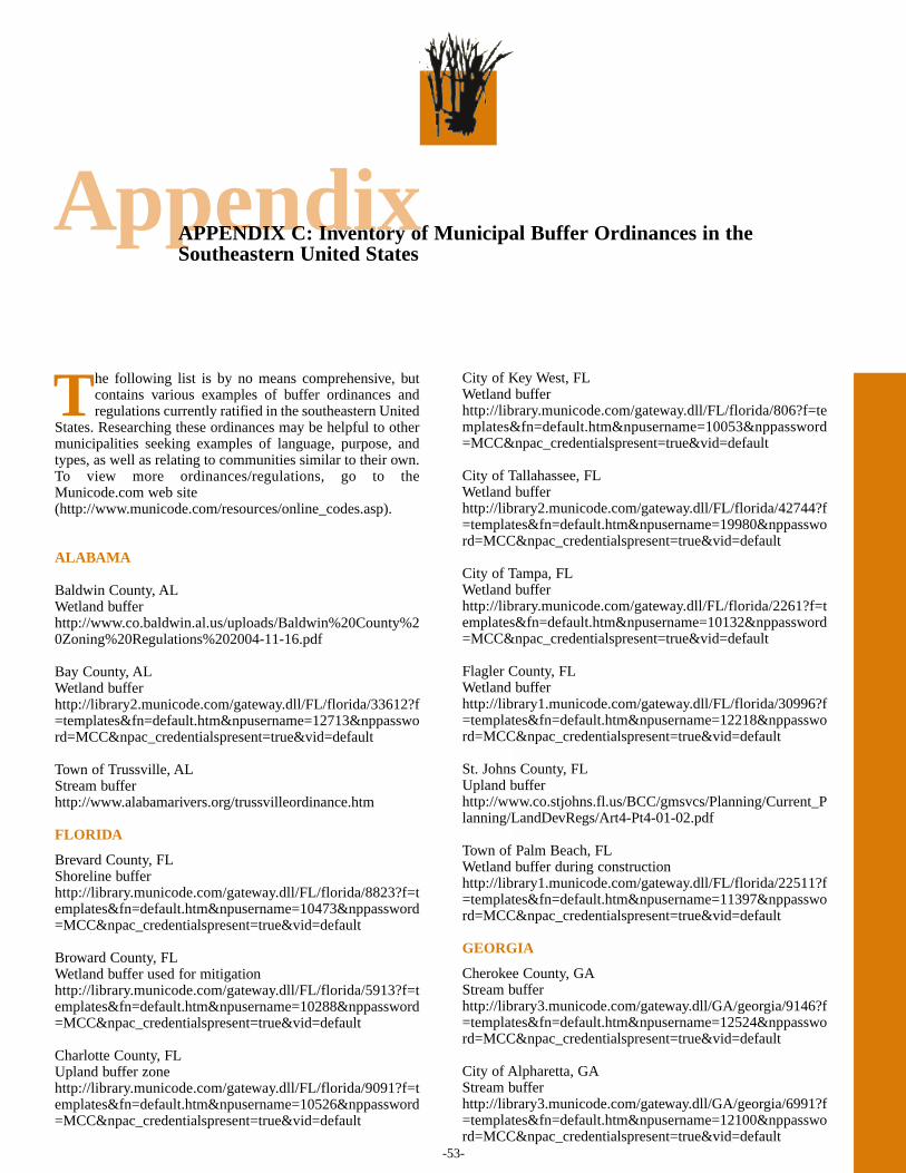
-53-
AppendixAPPENDIX C: Inventory of Municipal Buffer Ordinances in theSoutheastern United States
The following list is by no means comprehensive, butcontains various examples of buffer ordinances andregulations currently ratified in the southeastern United
States. Researching these ordinances may be helpful to othermunicipalities seeking examples of language, purpose, andtypes, as well as relating to communities similar to their own.To view more ordinances/regulations, go to theMunicode.com web site(http://www.municode.com/resources/online_codes.asp).
ALABAMA
Baldwin County, ALWetland bufferhttp://www.co.baldwin.al.us/uploads/Baldwin%20County%20Zoning%20Regulations%202004-11-16.pdf
Bay County, ALWetland bufferhttp://library2.municode.com/gateway.dll/FL/florida/33612?f=templates&fn=default.htm&npusername=12713&nppassword=MCC&npac_credentialspresent=true&vid=default
Town of Trussville, ALStream buffer http://www.alabamarivers.org/trussvilleordinance.htm
FLORIDA
Brevard County, FLShoreline bufferhttp://library.municode.com/gateway.dll/FL/florida/8823?f=templates&fn=default.htm&npusername=10473&nppassword=MCC&npac_credentialspresent=true&vid=default
Broward County, FLWetland buffer used for mitigationhttp://library.municode.com/gateway.dll/FL/florida/5913?f=templates&fn=default.htm&npusername=10288&nppassword=MCC&npac_credentialspresent=true&vid=default
Charlotte County, FLUpland buffer zonehttp://library.municode.com/gateway.dll/FL/florida/9091?f=templates&fn=default.htm&npusername=10526&nppassword=MCC&npac_credentialspresent=true&vid=default
City of Key West, FLWetland buffer http://library.municode.com/gateway.dll/FL/florida/806?f=templates&fn=default.htm&npusername=10053&nppassword=MCC&npac_credentialspresent=true&vid=default
City of Tallahassee, FLWetland bufferhttp://library2.municode.com/gateway.dll/FL/florida/42744?f=templates&fn=default.htm&npusername=19980&nppassword=MCC&npac_credentialspresent=true&vid=default
City of Tampa, FLWetland bufferhttp://library.municode.com/gateway.dll/FL/florida/2261?f=templates&fn=default.htm&npusername=10132&nppassword=MCC&npac_credentialspresent=true&vid=default
Flagler County, FLWetland bufferhttp://library1.municode.com/gateway.dll/FL/florida/30996?f=templates&fn=default.htm&npusername=12218&nppassword=MCC&npac_credentialspresent=true&vid=default
St. Johns County, FLUpland buffer http://www.co.stjohns.fl.us/BCC/gmsvcs/Planning/Current_Planning/LandDevRegs/Art4-Pt4-01-02.pdf
Town of Palm Beach, FLWetland buffer during constructionhttp://library1.municode.com/gateway.dll/FL/florida/22511?f=templates&fn=default.htm&npusername=11397&nppassword=MCC&npac_credentialspresent=true&vid=default
GEORGIA
Cherokee County, GAStream bufferhttp://library3.municode.com/gateway.dll/GA/georgia/9146?f=templates&fn=default.htm&npusername=12524&nppassword=MCC&npac_credentialspresent=true&vid=default
City of Alpharetta, GAStream bufferhttp://library3.municode.com/gateway.dll/GA/georgia/6991?f=templates&fn=default.htm&npusername=12100&nppassword=MCC&npac_credentialspresent=true&vid=default
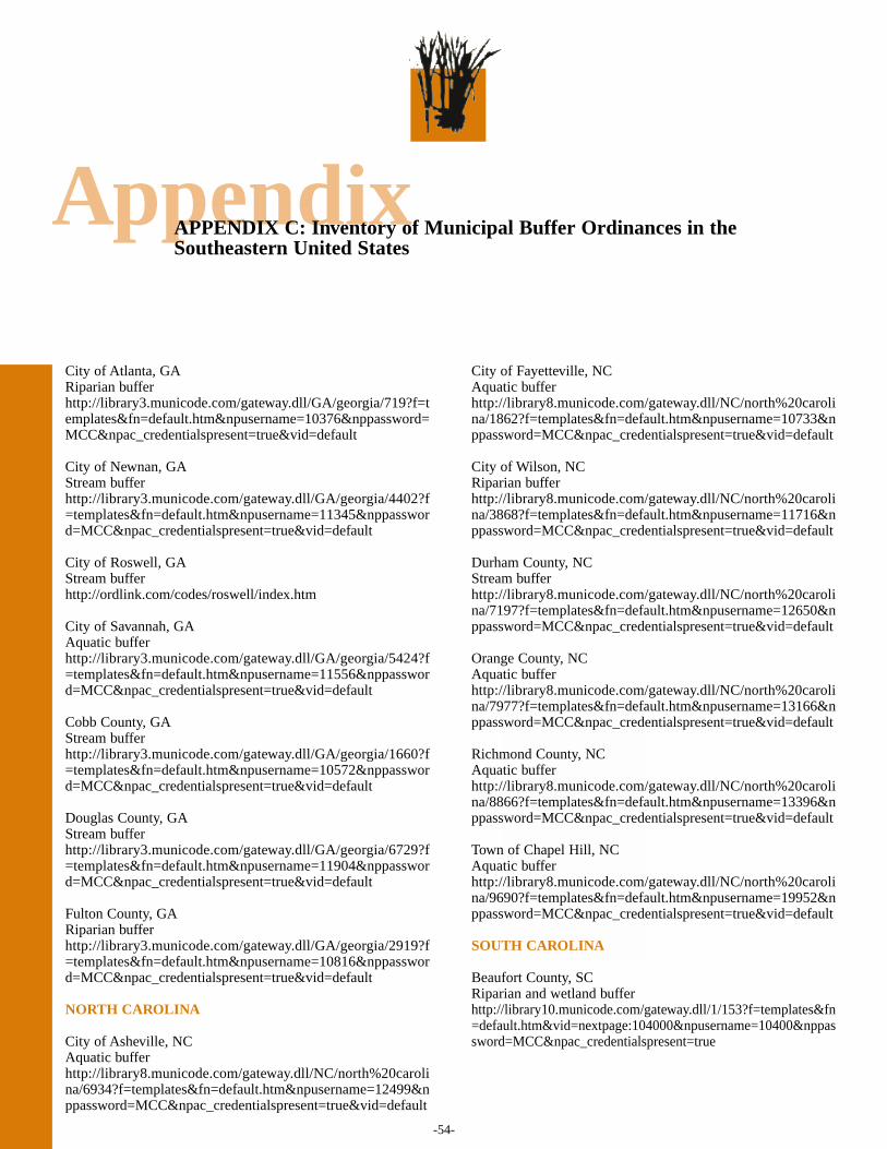
-54-
AppendixAPPENDIX C: Inventory of Municipal Buffer Ordinances in theSoutheastern United States
City of Atlanta, GARiparian buffer http://library3.municode.com/gateway.dll/GA/georgia/719?f=templates&fn=default.htm&npusername=10376&nppassword=MCC&npac_credentialspresent=true&vid=default
City of Newnan, GAStream bufferhttp://library3.municode.com/gateway.dll/GA/georgia/4402?f=templates&fn=default.htm&npusername=11345&nppassword=MCC&npac_credentialspresent=true&vid=default
City of Roswell, GAStream bufferhttp://ordlink.com/codes/roswell/index.htm
City of Savannah, GAAquatic bufferhttp://library3.municode.com/gateway.dll/GA/georgia/5424?f=templates&fn=default.htm&npusername=11556&nppassword=MCC&npac_credentialspresent=true&vid=default
Cobb County, GAStream bufferhttp://library3.municode.com/gateway.dll/GA/georgia/1660?f=templates&fn=default.htm&npusername=10572&nppassword=MCC&npac_credentialspresent=true&vid=default
Douglas County, GAStream bufferhttp://library3.municode.com/gateway.dll/GA/georgia/6729?f=templates&fn=default.htm&npusername=11904&nppassword=MCC&npac_credentialspresent=true&vid=default
Fulton County, GARiparian bufferhttp://library3.municode.com/gateway.dll/GA/georgia/2919?f=templates&fn=default.htm&npusername=10816&nppassword=MCC&npac_credentialspresent=true&vid=default
NORTH CAROLINA
City of Asheville, NCAquatic buffer http://library8.municode.com/gateway.dll/NC/north%20carolina/6934?f=templates&fn=default.htm&npusername=12499&nppassword=MCC&npac_credentialspresent=true&vid=default
City of Fayetteville, NCAquatic bufferhttp://library8.municode.com/gateway.dll/NC/north%20carolina/1862?f=templates&fn=default.htm&npusername=10733&nppassword=MCC&npac_credentialspresent=true&vid=default
City of Wilson, NCRiparian bufferhttp://library8.municode.com/gateway.dll/NC/north%20carolina/3868?f=templates&fn=default.htm&npusername=11716&nppassword=MCC&npac_credentialspresent=true&vid=default
Durham County, NCStream bufferhttp://library8.municode.com/gateway.dll/NC/north%20carolina/7197?f=templates&fn=default.htm&npusername=12650&nppassword=MCC&npac_credentialspresent=true&vid=default
Orange County, NCAquatic bufferhttp://library8.municode.com/gateway.dll/NC/north%20carolina/7977?f=templates&fn=default.htm&npusername=13166&nppassword=MCC&npac_credentialspresent=true&vid=default
Richmond County, NCAquatic bufferhttp://library8.municode.com/gateway.dll/NC/north%20carolina/8866?f=templates&fn=default.htm&npusername=13396&nppassword=MCC&npac_credentialspresent=true&vid=default
Town of Chapel Hill, NCAquatic bufferhttp://library8.municode.com/gateway.dll/NC/north%20carolina/9690?f=templates&fn=default.htm&npusername=19952&nppassword=MCC&npac_credentialspresent=true&vid=default
SOUTH CAROLINA
Beaufort County, SCRiparian and wetland bufferhttp://library10.municode.com/gateway.dll/1/153?f=templates&fn=default.htm&vid=nextpage:104000&npusername=10400&nppassword=MCC&npac_credentialspresent=true
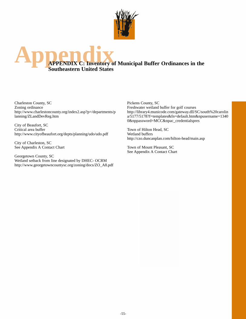
-55-
AppendixAPPENDIX C: Inventory of Municipal Buffer Ordinances in theSoutheastern United States
Charleston County, SCZoning ordinancehttp://www.charlestoncounty.org/index2.asp?p=/departments/planning/ZLandDevReg.htm
City of Beaufort, SCCritical area bufferhttp://www.cityofbeaufort.org/depts/planning/udo/udo.pdf
City of Charleston, SCSee Appendix A Contact Chart
Georgetown County, SCWetland setback from line designated by DHEC- OCRM http://www.georgetowncountysc.org/zoning/docs/ZO_A8.pdf
Pickens County, SC Freshwater wetland buffer for golf courses http://library4.municode.com/gateway.dll/SC/south%20carolina/5177/5178?f=templates&fn=default.htm&npusername=13400&nppassword=MCC&npac_credentialspres
Town of Hilton Head, SCWetland buffershttp://czo.duncanplan.com/hilton-head/main.asp
Town of Mount Pleasant, SCSee Appendix A Contact Chart
-56-
AppendixAppendix D: Glossary
Unless noted otherwise, the definitions in this glossary were taken from The Citizens Guide to the Charleston Harbor Project, fullycited in Appendix A.
Best Management Practices: practices determined to be themost effective and feasible means of preventing or reducingpollution from point and nonpoint sources in order to protectwater quality.
Buffer: strips of land between a waterway and a developedarea that are left undeveloped to protect the waterway frompollution by filtering runoff water.
Buffer Ordinances: regulations that enforce zones ofvegetation between potentially polluting areas and adjacentmarshes, rivers and creeks.
Coastal Zone: the term ‘coastal zone’ means the coastalwaters (including the lands therein and thereunder) and theadjacent shorelands (including the waters therein andthereunder), strongly influenced by each other and inproximity to the shorelines of the several coastal states, andincludes islands, transitional and intertidal areas, salt marshes,wetlands, and beaches (from section 304 of the Coastal ZoneManagement Act).
Critical Area: the area delineated by critical lines asdetermined by the South Carolina Department of Health andEnvironmental Control’s Office of Ocean and CoastalResource Management (SC DHEC-OCRM). State andFederal permits must be acquired for any alteration of anycritical area.
Critical Line: determined by the South Carolina Departmentof Health and Environmental Control’s Office of Ocean andCoastal Resource Management (SC DHEC-OCRM), and itdelineates the boundaries of coastal wetland systems, one ofmultiple critical areas.
Critical Line Buffer: a corridor of vegetation that lieslandward of the wetland critical line on a person’s property.Wetland buffers vary greatly in their width, composition,appearance, and use.
Critical Line Buffer Ordinance (CLBO): regulations thatenforce zones of vegetation between potentially pollutingareas and adjacent designated critical areas in the coastalzone.
Erosion: the group of natural processes, includingweathering, dissolution, abrasion, corrosion, andtransportation, by which material is worn away from theearth’s surface.
Estuarine System: the interconnected network of streams,creeks, rivers, salt marshes, forests and their inhabitants thatsurround an estuary.
Estuary: a body of water where inflowing salt water from theocean mixes with fresh water from streams, rivers, rainwaterand runoff.
Eutrophication: excessive nutrient enrichment of waterbodies, frequently the result of human activities, that causesan explosive growth or “bloom” of algae and other aquaticplants. The respiration of the additional plant life depletes thewater of dissolved oxygen which can be detrimental to theplant and animal inhabitants of the water body.
Fecal Coliform Bacteria (FCB): total coliform bacteria arethe group of bacteria that are commonly associated with thedigestive tract of warm and cold blooded organisms includinghumans. A subset of the total coliform bacteria is the fecalcoliform bacteria (FCB). This subset is distinguished by itsability to survive at elevated temperatures and are associatedonly with the fecal material of warm blooded animals.
Freshwater Buffer: strips of land that act as filters, removingpollutants from rainfall before it enters freshwater systems.
Geographic Information System (GIS): a computerizeddata management system created by geographers for thecapture, storage, analysis and display of data, most often onmaps. Different “data layers” can be placed on top of oneanother on maps (for instance, the distribution of docks can beplaced on top of the distribution of grass shrimp) to examineand analyze relationships between the layers.
Groundwater: water that normally is located below theground surface (Kusler and Opheim, 1986).
High Marsh: areas of marsh characterized by higherelevation, less frequent tidal flooding and plant species suchas black needle rush and salt meadow cordgrass.

-57-
AppendixAppendix D: Glossary
High Salinity Estuary: an estuary with limited fresh waterinput often only from rain and runoff characterized by highersalt content in the water.
Hydric Soil: a soil that is saturated, flooded, or ponded longenough during the growing season to develop anaerobicconditions that favor the growth and regeneration ofhydrophytic vegetation (Kusler and Opheim, 1996).
Hydrology: the study of the properties, location andmovement of inland waters both above and below ground.The hydrologic cycle is the cycle of water movement from theatmosphere to the earth and back to the atmosphere throughvarious processes including rain, runoff, infiltration, andevaporation.
Hydrophyte: any plant growing in water or on a substratethat is at least periodically deficient in oxygen as a result ofexcessive water; plants typically found in wetland habitats(Kusler and Opheim, 1996).
Hydrophytic Vegetation: the sum total of macrophytic plantlife growing in water or on a substrate that is at leastperiodically deficient in oxygen as a result of excessive watercontent (Kusler and Opheim, 1996).
Impervious Surface: ground cover such as roofs, drivewaysand roadways that does not allow water to sink into (infiltrate)the soil. Impervious surfaces increase the volume and speedof runoff after rainfall.
Infiltration: the penetration of water through the groundsurface and into the soil.
Intertidal or Tidal: pertaining to the region above the lowwater mark of low tide and below the high water mark of hightide. This region is covered by water for a portion of every dayand is above water for the remainder of every day.
Load: the quantity of a material that enters a body of waterover a given time period.
Marsh: low, wet grassland without trees, periodicallycovered by water.
Native Species: those plant species believed to live in thisarea before the arrival of Europeans to North America.Provide food and shelter for an assortment of native wildlife(South Carolina Native Plant Society, 2005).
Nonpoint Source Pollution (NPS): pollution from diffusesources that cannot be attributed to one identifiable point,such as a discharge pipe.
Permeable: capable of being penetrated or passed through.
Permits: regulatory permission to perform or allow anactivity.
Phosphorous: an inorganic nutrient essential for plant growthand reproduction; excess can cause eutrophication; problemsare usually associated with farmland runoff, sewage, anddetergents.
Point Source Pollution: pollution from a definable source,such as an outfall pipe.
Pollution: the addition of a substance(s) to an environment ingreater than natural concentrations as a result of humanactivity producing a net detrimental effect on theenvironment.
Polycyclic Aromatic Hydrocarbons (PAH): a class ofchemicals which are by-products of the combustion ofpetroleum products that can cause lethal and sub-lethalimpacts on estuarine organisms.
Retention Basin: man made ponds built in or neardevelopments to retain storm water and runoff from thedevelopment.
Riparian: situated on the bank of a river or other body ofwater.
Riparian Buffer: corridors of native vegetation along riversand streams…that protect waterways by providing atransition zone between upland development and adjoiningsurface waters (SC DHEC-OCRM, 2002a).
Runoff: rain water that does not penetrate the ground’ssurface and therefore flows off into creeks and streams, oftencarrying with it sediment and sediment bound contaminants.
-58-
AppendixAppendix D: Glossary
Salt Marsh: a low-lying tract of soft wetland that is tidallyflooded with salt water and is often dominated by a few plantspecies such as Spartina alterniflora and other grasses.
Sediment: particles which accumulate on the bottom of awaterway.
Smooth Cord Grass or Marsh Grass (Spartinaalterniflora): the predominant plant species in salt marsheson the east coast.
South Carolina Lowcountry: the coastal area of the state ofSouth Carolina characterized by lowland topography andunique history and culture.
Stakeholders: individuals or organizations with an interest or“stake” in the outcome of policies.
Stormwater: water resulting from a rain event that cantypically move quickly to water bodies due to impervioussurfaces; also known as “runoff.”
Turbidity: the measurement of water cloudiness; it may beaffected by sediment and plankton concentrations.
Urbanization: the process by which an area becomesdeveloped for residential, commercial and industrial use.
Vegetative Buffer: strips of land that act as filters, removingpollutants from rainfall before it enters waterways.
Water Quality: the condition of water based on its physical,chemical, and biological integrity in regard to a specificdesignated use.
Watershed: an area of land that is drained by a river or otherbody of water.
Wetland: lands transitional between terrestrial and aquaticsystems where the water table is usually at or near the surfaceor the land is covered by shallow water…Wetlands must haveone or more of the following three attributes (1) at leastperiodically, the land supports predominantly hydrophytes;(2) the substrate is predominantly undrained hydric soil; and(3) the substrate is nonsoil and is saturated with water orcovered by shallow water at some time during the growingseason of each year (Cowadin et al., 1979).
Wetland Buffer: strips of land that act as filters, removingpollutants from rainfall before it enters wetland.
Wetland Buffer Ordinance (WBO): regulations thatenforce zones of vegetation between potentially pollutingareas and adjacent designated wetlands.
Please NOTE: This is the current ordinance as of Fall 2004. Please contact the Town of Mount Pleasant Planning Department for current ordinance. ORDINANCE NO. 99069 STATE OF SOUTH CAROLINA AN ORDINANCE TO AMEND PARAGRAPH
(J) OF SECTION 156.047 OF CHAPTER 156 COUNTY OF CHARLESTON OF THE MOUNT PLEASANT CODE OF
ORDINANCES, PROVIDING FOR A TOWN OF MOUNT PLEASANT CRITICAL LINE BUFFER
WHEREAS, Mount Pleasant Town Council is desirous of providing a buffer
along the marsh edge of property in an effort to improve the water quality of the
adjoining waterways by reducing the negative effects of fertilizers, pesticides and pet
waste from stormwater runoff and preserve wildlife habitat and protect scenic vistas
pursuant to recommendations and implementation strategies from the Resources element
of the Town of Mount Pleasant 1998-1999 Comprehensive Plan; and
WHEREAS, the Mount Pleasant Planning Commission held a public hearing on
August 18, 1999, pursuant to the applicable requirements of the Mount Pleasant Code
of Ordinances pertaining to the text amendment referenced herein; and
WHEREAS, as an incident to the adoption of this Ordinance, Mount Pleasant
Town Council makes the following findings of fact:
a) The land development regulations proposed herein are not in conflict with
the laws or land development regulations governing property subject to any
adopted development agreement and do not prevent the development set forth in the
same.
b) Substantial changes have occurred in pertinent conditions which are
essential to the public health, safety and general welfare and require Town
Council action in order to alleviate threats to the same.
WHEREAS, Mount Pleasant Town Council is empowered with the authority to
make amendments/changes to the Mount Pleasant Code of Ordinances and believes it is in
the best interest of the Town to so act with respect to the matters described herein.
NOW, THEREFORE, BE IT ORDAINED by the Mayor and Councilmembers
of the Municipality of Mount Pleasant, in Council assembled, that for the purposes
stated herein, Paragraph (J) of Section 156.047 of Chapter 156 of the Mount Pleasant
Code of Ordinances, shall be and is hereby amended by adding a new paragraph (2),
along with subparagraphs (a) through (k), to read specifically as follows:
Chapter 156 ZONING CODE
Section 156.047 BUFFERYARDS
(J) Special bufferyards
(2) Critical Line Buffer.
(a) A vegetated buffer shall be established along areas designated as tidally influenced "critical line" by SCDHEC-OCRM. The entire buffer shall remain as an undeveloped vegetated area. The intent of this ordinance is to disallow grassed, manicured lawns within this buffer area.
(b) The natural vegetation in the buffer shall remain undisturbed. (c) Vision corridors may be established through the critical line buffer, provided
that they may not exceed 33 percent of the total buffer length. Within the vision corridor historic trees with a dbh of 24 inches or greater are never
removed while grasses, shrubs and other smaller vegetation may be appropriately pruned and trimmed, but not removed. The effect of this should be a vertical corridor cut through the buffer, allowing a view of the marsh from the yard and house.
(d) No uses shall be allowed in the critical line buffer except the following: 1) A pedestrian access foot trail of pervious material parallel to the
critical line. 2) Pedestrian or vehicular accessways leading to such water
dependent uses as docks, piers, bridges and boat landings. These accessways must be elevated above grade to avoid channelization. Such uses must be the minimum necessary to provide access.
3) Minimum utility line penetrations as specifically and previously approved on development plans.
4) Use of swales or other means rather than drainage pipes shall be required.
(e) The required width of the natural buffer shall be based on the location of the property. This width shall be an average equal to the following: 1) Between the Cooper River Bridge and the Ben Sawyer Bridge
- 15 feet. (Minimum width of 15 feet) 2) From the Cooper River Bridge eastward up the Wando River
and from the Ben Sawyer Bridge northward along the Intracoastal Waterway - 35 feet (Minimum width of 20 feet)
(f) The boundaries of the critical line buffer shall be clearly delineated and identified on all development plans and plats submitted for approval.
(g) Buffer limits shall be staked in the field in a manner approved by planning staff prior to and remaining through construction activities.
(h) The following are exceptions to these requirements: 1) lots of record and final plats; 2) valid approved preliminary plats; and 3) valid approved sketch plans adopted prior to the date of this
ordinance shall be exempt for a period of two years from the date of approval of said sketch plan by the Town. Subsequent preliminary plats must accurately reflect said sketch plan; otherwise, compliance with this ordinance will be required.
(i) Violation of section 156.047 (J)(2) or failure to comply with any of the requirements hereof shall be classified as a misdemeanor punishable by a fine in the amount of up to $500 or imprisonment for not more than 30 days or both. However, no penalty shall exceed the penalty provided by state law for a similar offense. A separate offense shall be deemed committed for each tree and/or separate plant or shrub identified in this Code which is removed, and for each day that the violation occurs or continues. Any person, firm, organization, society, association, partnership, corporation, or like entity, or any agent or representative thereof who commits, participates in, or assists in
such violation may each be found guilty of a separate offense and suffer the penalties herein provided.
(j) Full restoration to a condition comparable to that which was destroyed or payment to the Town for the removal of all or any portion of a buffer shall be required within a specified period. If restoration is to be accomplished by the offending party, it shall include posting an acceptable financial guarantee with the Town for the full amount of restoration required until the same is completed.
(k) Failure to comply with the terms stated herein shall also be subject to enforcement in a circuit court of competent jurisdiction.
(The preceding Subparagraph (1) with (a) through (d) thereunder remains unchanged)
BE IT FURTHER ORDAINED that the new land development regulations as
specified herein shall also apply to the development of property subject to any such.
adopted development agreement.
THIS ORDINANCE SHALL BE EFFECTIVE IMMEDIATELY UPON FINAL
READING.
SIGNED, SEALED AND DELIVERED THIS 11th DAY OF January, 2000.
Please NOTE: This is the current ordinance as of Fall 2004. Please contact the City of Charleston Planning Department for current ordinance.
CITY OF CHARLESTON ZONING ORDINANCE
ARTICLE 3
SITE REGULATIONS
Part 8 Landscape Buffer Requirements
Sec. 54-347.1. Critical line buffer requirements.
Critical line buffers are naturally vegetated areas of specific widths, adjacent to all SCDHEC-OCRM critical lines. The primary purpose for critical line buffers is to protect water quality.
a. Generally:
1. Buffers which satisfy the requirements for a Type L Buffer as listed in Section 54-348, shall be located on all property within the zoning districts listed below in subsection 2.
2. Buffers shall vary in width according to the zoning of the lot as listed below:
(a) Within the C, RR-1, SR-1 through SR-7, STR, DR-3, DR-6, DR 9 zoning districts, each buffer shall maintain a minimum width of 25 feet.
(b) Within the DR-4, DR-12, DR-1, DR-1F, DR-2, DR-2F, RO, GO, CT, LB, GB, UC, MU-1, MU-2, GP, BP, LI, and HI, zoning districts and all properties zoned or developed under the Neighborhood District regulations, each buffer shall maintain a minimum width of 0 feet.
(c) Within the CY zoning district, the provisions of subsection 2 (a) and (b) shall apply based on designated uses in the development plan.
3. All buildings shall be setback a minimum of ten feet from the required Critical Line buffer.
4. Buffers shall be located adjacent to the Critical Line and extend the entire length of the Critical Line.
5. The boundaries of the SCDHEC-OCRM certified Critical Line and Critical Line Buffer
shall be clearly delineated and identified on all development plans and plats submitted for
approval and notes shall be placed on all development plan and plats which read as follows: "The Critical Line Buffer shown hereon is under a jurisdiction and permitting authority of the City of Charleston."
b. Exemptions. In addition to the exemptions provided in Section 54-344, the following exemptions shall apply.
1. Platted single family lots of record as of September 12, 2000.
2. Approved valid, preliminary subdivision plats as of September 12, 2000, and any project submitted to the Technical Review Committee as of September 12, 2000, shall be exempt from this ordinance.
3. Properties located within the Old City District or Old and Historic District and located on the peninsula south of Line Street extended from the Ashley River to the Cooper River or West of the Ashley River in an area bounded by the Ashley River on the east, the Highway 61 Connector and Merritt Road on the south, Albemarle Road on the west, and Folly Road/Highway 17 on the north.
4. Existing developed portions of The Citadel campus, and water-dependent maritimeshipping and cargo handling facilities or terminals. 5. Golf courses shall only be exempt from tree removal restrictions of Section 54-348 in areas of the required Critical Line Buffer that fall within golf corridors when a tree or trees would obstruct play as shown on plans approved by the Technical Review Committee. Tree protection requirements of Article 3, Part 6, including requirements to protect grand trees, shall still apply.
c. Violations. The Board of Zoning Appeals--Site Design is authorized, upon a violation of the buffer regulations set forth herein, to require restoration of the buffer area using Best Management Practices to a condition deemed by the Board to be comparable to that which existed prior to the damage and/or destruction of the protected vegetation within the buffer.
(Ord. No. 2001-14, § 1, 2-27-01; Ord. No. 2002-84, § 6, 8-13-02; Ord. No. 2003-69, §§ 11, 15, 8-19-03)
Sec. 54-348. Buffer types.
Buffer Type A Required for properties which abut Class I roads. Buffer must maintain an average depth of fifteen feet, not to go below ten feet, and contain specified vegetation selected from Appendix A. The intent of this buffer type is to provide street frontage landscaping along Class I roads. Required minimum plantings per one hundred feet: 2 recommended trees 3 understory trees 40 ornamental shrubs ARTICLE 5
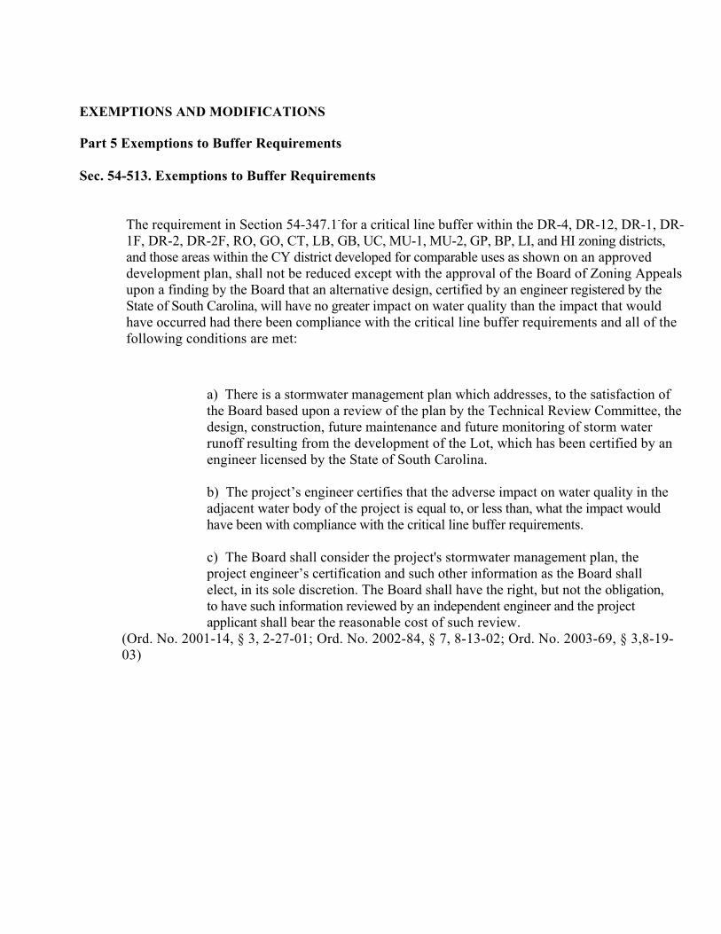
EXEMPTIONS AND MODIFICATIONS Part 5 Exemptions to Buffer Requirements Sec. 54-513. Exemptions to Buffer Requirements
The requirement in Section 54-347.1-for a critical line buffer within the DR-4, DR-12, DR-1, DR-1F, DR-2, DR-2F, RO, GO, CT, LB, GB, UC, MU-1, MU-2, GP, BP, LI, and HI zoning districts, and those areas within the CY district developed for comparable uses as shown on an approved development plan, shall not be reduced except with the approval of the Board of Zoning Appeals upon a finding by the Board that an alternative design, certified by an engineer registered by the State of South Carolina, will have no greater impact on water quality than the impact that would have occurred had there been compliance with the critical line buffer requirements and all of the following conditions are met:
a) There is a stormwater management plan which addresses, to the satisfaction of the Board based upon a review of the plan by the Technical Review Committee, the design, construction, future maintenance and future monitoring of storm water runoff resulting from the development of the Lot, which has been certified by an engineer licensed by the State of South Carolina.
b) The project’s engineer certifies that the adverse impact on water quality in the adjacent water body of the project is equal to, or less than, what the impact would have been with compliance with the critical line buffer requirements.
c) The Board shall consider the project's stormwater management plan, the project engineer’s certification and such other information as the Board shall elect, in its sole discretion. The Board shall have the right, but not the obligation, to have such information reviewed by an independent engineer and the project applicant shall bear the reasonable cost of such review.
(Ord. No. 2001-14, § 3, 2-27-01; Ord. No. 2002-84, § 7, 8-13-02; Ord. No. 2003-69, § 3,8-19-03)
Interview Instrument:
Critical Line Wetlands Buffer Ordinance Experiences and Lessons Learned City of Charleston and Town of Mount Pleasant
South Carolina This consent form is for the College of Charleston, standard procedure to ensure that interview respondents are treated with the utmost respect/ethically. It’s to make sure you, as the respondent, understand the purpose of the interview questions and feel as comfortable as possible, and also for you to have contact information for any questions you may have in the future. Please read the form before we start, and sign at the end of the interview if you are comfortable. Introduction Thank you for taking the time to meet with us today. We have several questions relating to your experience with the process of implementing critical line wetland buffer ordinances in the City of Charleston and/or Town of Mount Pleasant area. When reporting the information we collect from your responses in this interview, we will not use any identifiable information (i.e. your name will not be used).
A. Respondent Background / Community 1. Name 2. Affiliation / Profession? For how long? 3. What other types of employment have you had? 4. How long have you lived and worked as a (whatever profession) in the
(Town of Mount Pleasant or City of Charleston) area? 5. How long have you lived and worked as a (whatever profession) in other
regions outside of Mount Pleasant / Charleston? 6. Have you ever worked with any types of wetland buffers and ordinances
for you current position and / or past jobs? 7. Are you familiar with any other wetland buffer ordinances (freshwater,
riparian, critical line) in the state of South Carolina? 8. What are your general impressions of the (City of Charleston or Town of
Mount Pleasant) political climate? (with regard to the buffer ordinance, your professional responsibilities, legislative structure of city / town, or anything else)
9. Do you think that community members have an impact on local political issues? If so, how much impact:
(1) little to no impact (2) moderate impact (3) great amount of impact
10. What kind of political participation is there by community members? (town meetings, attendance at city council meetings, etc.)
(1) little to no participation (2) moderate participation (3) great amount of participation
11. Who are the most influential persons within the community? (income level, titles, profession, location of residence)
12. What is the city / town’s general approach to development? 13. What would you say is the level of the community’s general scientific and
environmental knowledge? (1) limited or no knowledge (2) moderate knowledge (3) great amount of knowledge
Do these subjects seem to be very important, moderately important, or not really important to the community as a whole?
14. Are there concerns about water quality among the community? (1) little or no concern (2) moderate concern (3) great concern
B. Process of Ordinance Creation 15. What was your role (principle planner / advisor) in the process and actual
passage of the municipality’s critical line buffer ordinance? 16. Can you tell us about the process of developing and passing the critical
line buffer ordinance? a. Who were the stakeholders involved? (municipal, other
political, environmental, individual citizens, construction or other business, chamber of commerce, etc.)
b. What stakeholders played major roles supporting the ordinance?
c. What stakeholders played major roles challenging / opposing the ordinance?
d. What level of interest / involvement did the city / town have?
e. What level of interest / involvement did the mayor have? f. Were there other political figures involved / interested /
opposed? g. What was the role of the development community and
who represented this sector? h. What resources were utilized to develop the ordinance? i. How many drafts were created before the final ordinance
was approved? j. What were the impediments / difficulties in the process? k. What were the successes / easy parts? l. What was the time frame of the process? m. Were components on freshwater wetlands or riparian
areas considered as well? C. Ordinance Components
17. What are the buffer width requirements and do those requirements vary based on land use and / or zoning?
18. What can and cannot be removed in a buffer? What activities or improvements are prohibited within the required buffer?
19. What can you plant in a buffer? What activities or improvements are allowed within the required buffer?
20. Are view corridors permitted, and if so, what are the requirements for creating such corridors?
21. Are there any exemptions or exceptions to the critical line buffer ordinance?
D. Implementation of the Critical Line Buffer Ordinance 22. How did the municipality start to implement the ordinance, once passed?
a. How were citizens / developers educated about the new ordinance?
b. What staff resources were designated? (e.g. departments created?, who is in charge of it, etc.)
23. What were the initial difficulties to implementation? How have these challenges changed over time?
24. How is the buffer ordinance enforced? 25. How do you determine where there are buffer violations and how are
violations managed? E. Evaluation of the Ordinance
26. Are there currently enough resources to properly implement the buffer ordinance? If not, what resources are needed?
27. Do you notice any trends in the enforcement of the critical line buffer ordinance? (e.g. certain demographics against / for buffers; certain areas in the Lowcountry that receive ordinances in a positive manner)
28. Are there any changes planned for the ordinance (regarding amendments, adding riparian or freshwater wetland components, adding resources, or furthering outreach efforts)?
29. What aspects of a community do you think encourage the success of critical line buffer ordinances?
a. Political climate? b. Organization of political structure? (e.g. strong mayor
with city council) c. Environmental groups / knowledge? d. Development? e. Knowledge level of community? f. Current water quality? g. Recreational use? h. Amount of new residents? i. Rate of new resident influx?
30. How stringent does an ordinance for a community like (City of Charleston or Town of Mount Pleasant) need to be? Why?
31. What aspects to implementing a critical line buffer ordinance in the (City of Charleston or Town of Mount Pleasant) are unique to the area? And what aspects can be utilized by other similar communities?
F. Education / Outreach 32. How successful has the education and outreach effort on the ordinance
been since implementation? 33. What suggestions do you have to make information on buffers better
accessible or easier to understand for people in the community and your profession?
34. What types of people are most likely to be involved with implementation and outreach?
G. Conclusion

35. Can you name others (planners, legislators, developers, citizens, nonprofit groups, etc.) who we should interview about wetland buffer ordinances?
36. When compiling summaries of our findings, may we use quotations that would indicate your profession (by title)?
Thank you very much for your time. If you have any questions, please contact Dr. Angela Halfacre (953.5825), Katie Zimmerman ([email protected]), or Megan Barkes ([email protected]).
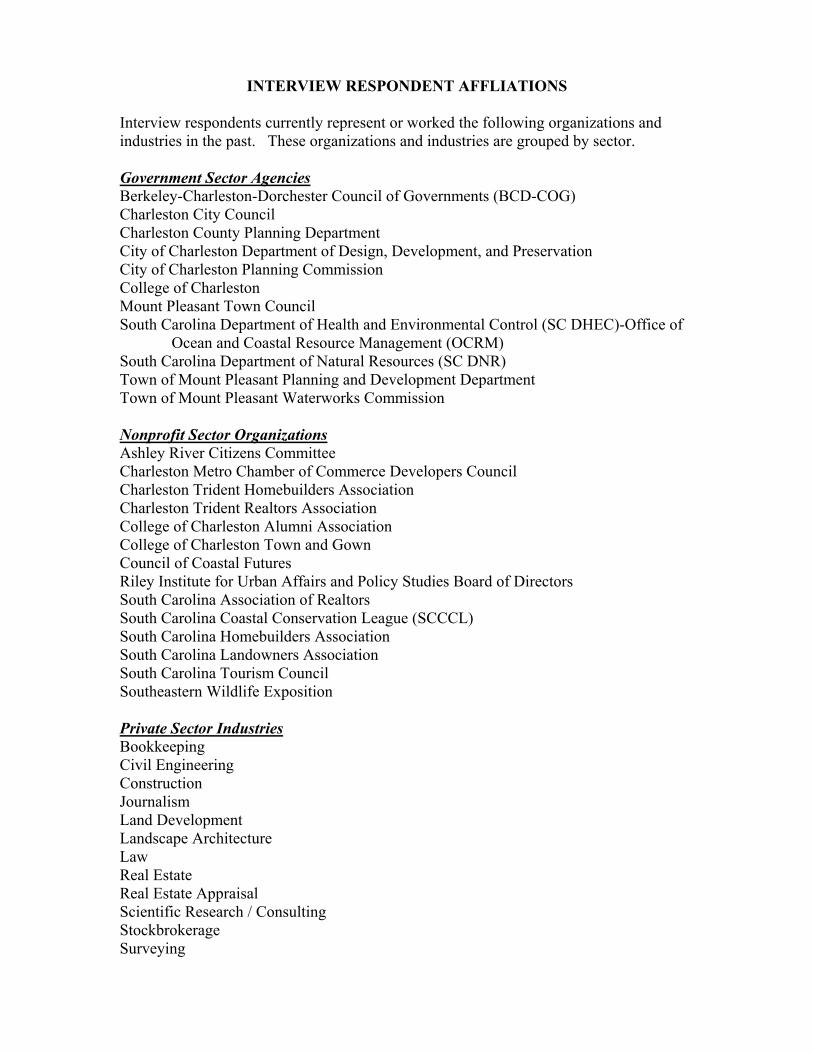
INTERVIEW RESPONDENT AFFLIATIONS Interview respondents currently represent or worked the following organizations and industries in the past. These organizations and industries are grouped by sector. Government Sector Agencies Berkeley-Charleston-Dorchester Council of Governments (BCD-COG) Charleston City Council Charleston County Planning Department City of Charleston Department of Design, Development, and Preservation City of Charleston Planning Commission College of Charleston Mount Pleasant Town Council South Carolina Department of Health and Environmental Control (SC DHEC)-Office of
Ocean and Coastal Resource Management (OCRM) South Carolina Department of Natural Resources (SC DNR) Town of Mount Pleasant Planning and Development Department Town of Mount Pleasant Waterworks Commission Nonprofit Sector Organizations Ashley River Citizens Committee Charleston Metro Chamber of Commerce Developers Council Charleston Trident Homebuilders Association Charleston Trident Realtors Association College of Charleston Alumni Association College of Charleston Town and Gown Council of Coastal Futures Riley Institute for Urban Affairs and Policy Studies Board of Directors South Carolina Association of Realtors South Carolina Coastal Conservation League (SCCCL) South Carolina Homebuilders Association South Carolina Landowners Association South Carolina Tourism Council Southeastern Wildlife Exposition Private Sector Industries Bookkeeping Civil Engineering Construction Journalism Land Development Landscape Architecture Law Real Estate Real Estate Appraisal Scientific Research / Consulting Stockbrokerage Surveying